geological investigations in the rail lake–sewell lake ... · pdf fileprevious...
TRANSCRIPT

95Report of Activities 2013
Geological investigations in the Rail Lake–Sewell Lake area, Flin Flon–Snow Lake greenstone belt, west-central Manitoba
(parts of NTS 63K10, 15)by S. Gagné
GS-8
Gagné, S. 2013: Geological investigations in the Rail Lake–Sewell Lake area, Flin Flon–Snow Lake greenstone belt, west-central Manitoba (parts of NTS 63K10, 15); in Report of Activities 2013, Manitoba Mineral Resources, Manitoba Geological Survey, p. 95–105.
SummaryIn June and July 2013, a four-week geological-
mapping program was conducted in the Rail Lake–Sewell Lake area. The project region consists mainly of bimodal volcanic rocks of arc affinity, belonging to the Fourmile Island assemblage1, that are host to five known volcano-genic massive-sulphide deposits and one orogenic gold deposit. Objectives of the geological investigations are to gain a better understanding of the geology of arc-related volcanic rocks, in order to provide insight for base-metal and gold exploration. Supracrustal rocks in the area trend north and are strongly overprinted by a north-trending subvertical foliation associated with the West Reed–North Star shear zone. To the west, the map area is bounded by a granodiorite intrusion. The central part of the map area is dominated by mafic volcanic rocks and synvolcanic gabbro dikes that are succeeded to the east by a sequence of felsic volcanic and volcaniclastic rocks. The eastern part of the map area is bounded by the extensive, north-trending, differentiated Josland sills. Within the West Reed–North Star shear zone, the rocks are strongly tec-tonized. Metamorphic grade increases northward from upper-greenschist facies to lower-amphibolite facies in supracrustal rocks.
IntroductionThe central part of the Flin Flon belt is a collage com-
posed of Paleoproterozoic (1.92–1.88 Ga) tectonostrati-graphic assemblages and minor Archean crustal slices that were juxtaposed during a period of 1.88–1.87 Ga intraoceanic accretion (Lucas and Stern, 1994; Stern and Lucas, 1994) to form the ‘Amisk collage’ (Lucas et al., 1996). Paleoproterozoic assemblages within the Amisk collage are subdivided into juvenile arc, juvenile ocean floor, ocean-plateau/ocean-island basalt and evolved arc (Syme and Bailes, 1993; David and Syme, 1994; Reilly et al., 1994; Stern et al., 1995a, b; Lucas et al., 1996; Figure GS-8-1). The Amisk collage was basement to postaccretion magmatism, between 1.87 and 1.83 Ga, which produced voluminous calcalkaline plutons and rarely preserved calcalkaline to alkaline volcanic rocks (Lucas et al., 1996). Younger sedimentary and subordi-nate volcaniclastic and volcanic rocks (1.85–1.83 Ga
Missi and Burntwood groups) may represent depositional basins that formed contemporaneous with postaccretion (‘suc-cessor’) arc magmatism and deformation (Ansdell et al., 1995; Lucas et al., 1996).
Significant stratigraphic, geochemical and isotopic differences between the arc rocks in the Flin Flon and Snow Lake areas (Stern et al., 1995a) suggest that the two segments of the Flin Flon belt formed in distinct tectonic settings (Lucas et al., 1996). The Reed Lake region rep-resents a critical area of the Flin Flon belt, as it lies at the boundary between the Amisk collage sensu stricto and the Snow Lake segment. The Reed Lake area also includes the Fourmile Island assemblage, an arc-type bimodal suc-cession of volcanic and volcaniclastic rocks that hosts five significant volcanogenic massive-sulphide (VMS) depos-its, including the recently discovered Reed Lake Cu-Zn deposit. Previous geological work (Leclair et al., 1997; Leclair and Viljoen, 1997) and geophysical data show that arc-related volcanic rocks extend south of Reed Lake beneath the Phanerozoic cover for a distance of more than 50 km. Therefore, gaining a better understanding of the geology of arc-related volcanic rocks of the exposed basement in the Reed Lake area will provide insight for base-metal exploration in the Reed Lake area and in the sub-Phanerozoic basement immediately south of Reed Lake. The Reed Lake area was the focus a four-week reconnaissance study (Figure GS-8-1) in the summer of 1995 (Syme et al., 1995b, a). The study enabled signifi-cant improvement in our understanding of the geology of the Reed Lake area. However, the geological investiga-tion was limited to shoreline exposure on Reed Lake and roadcuts along the abandoned Chisel railbed, with some inland 1:50 000 scale bedrock mapping on the west side of Reed Lake (Morrison et al., 1996).
In order to increase our current knowledge of the geology of the Reed Lake area, a new multiyear proj-ect was initiated by the Manitoba Geological Survey in 2013. This project will include a compilation of earlier data and new detailed mapping of critical areas, with an emphasis on the volcanic rocks. The project also entails the acquisition of new whole-rock geochemical analy-ses, Sm-Nd isotopic data and U-Pb geochronology. In
1 For the sake of consistency, the Manitoba Geological Survey has opted to make a universal change from capitalized to noncapitalized for the generic part of lithostructural feature names (formal stratigraphic and biostratigraphic nomenclature being the exceptions).

96 Manitoba Geological Survey
SB
Fels
ic a
nd m
afic p
luto
ns
Juvenile
-arc
assem
bla
ges
Majo
r fa
ult (
<1840 M
a)
West R
eed–N
ort
h S
tar
shear
zone
Evolv
ed-a
rc a
ssem
bla
ges
Ocean-isla
nd a
ssem
bla
ge
Turb
idite d
eposits
Ocean-f
loor
assem
bla
ges
Ocean-p
late
au a
ssem
bla
ge
Pre
accre
tio
n a
ssem
bla
ges
(1.8
7–1.9
2 G
a)
Syn
- o
r p
osta
ccre
tio
n r
ocks
(<
1.8
8 G
a)
To
wn
of
Flin
Flo
n
To
wn
of
Sn
ow
La
ke
Vo
lca
no
ge
nic
ma
ssiv
e-
Ha
ns
on
Lak
e
blo
ck
Ha
ns
on
La
ke
b
loc
k
F
lin
Flo
na
ss
em
bla
ge
Ath
apapuskow
Lake
Am
isk
La
ke
Ath
apapuskow
Lake
Re
ed
FF
FF
A
MIS
KC
OL
LA
GE
S
20
km
Elb
ow
-Ath
ap
ap
us
ko
wa
ss
em
bla
ge
Sn
ow
La
ke
as
se
mb
lag
e
Fo
urm
ile
Is
lan
da
ss
em
bla
ge
No
rth
east
Reed
assem
bla
ge
We
st
Am
isk
as
se
mb
lag
e
KIS
SE
YN
EW
B
EL
T
CO
RE
Z
ON
EK
ISS
EY
NE
W B
EL
T
SO
UT
H F
LA
NK
La
ke
Kis
sis
sin
g
La
ke
Kis
se
yn
ew
L
ake
Ph
an
ero
zo
ic c
ov
er
99°3
0’ 55°15’
54°1
5’
103°15’
>1840 M
a
<1840 M
a
Successor-
arc
and -
basin
deposits
N
onm
arine s
edim
enta
ry a
nd v
olc
anic
rocks
S
F S
Ma
p a
rea
su
lph
ide
min
e
Sask
atc
hew
an M
anito
ba
Figu
re G
S-8-
1: G
eolo
gy o
f the
Flin
Flo
n be
lt, s
how
ing
maj
or te
cton
ostra
tigra
phic
ass
embl
ages
and
plu
tons
(mod
ified
from
Sym
e et
al.,
199
8). T
he lo
catio
n of
the
Rai
l Lak
e–S
ewel
l Lak
e ar
ea is
indi
cate
d by
the
heav
y re
d re
ctan
gle.
97Report of Activities 2013
the first summer of the project, four weeks were spent mapping in the Rail Lake–Sewell Lake area (Figure GS-8-2).
The results from this geological mapping are pre-sented as a 1:10 000 scale geological map (Gagné, 2013). This paper summarizes the preliminary results of the mapping program.
Previous workReconnaissance mapping was completed at 1:50 000
scale during a joint Manitoba–Geological Survey of Can-ada project in the summer of 1995 (Syme et al., 1995b), and follow-up geochemical and structural studies were presented by Syme and Bailes (1996). Prior to 1995, the supracrustal rocks on Reed Lake were simply subdivided into mafic volcanic, volcaniclastic and sedimentary types (Stanton, 1945; Rousell, 1970).
Preliminary Map 1995F-1 (Syme et al., 1995b) was compiled from older maps and new data from the 1995 field season. The geology was based on Rousell (1970) and Stanton (1945), with extensive upgrades to the geol-ogy of the supracrustal rocks. Morrison and Whalen (1995) reported on mapping of the granitoid rocks in NTS 63K10, west of Reed Lake; a simplified version of their map was included in Preliminary Map 1995F-1 (Syme et al., 1995b) and their complete work was presented in Morrison et al. (1996). The inland area north and east of Reed Lake was not mapped.
Regional geologyThe exposed Flin Flon belt contains several distinct
juvenile-arc assemblages, which are separated by major faults or intervening ocean-floor rocks, Burntwood Group sedimentary or plutonic rocks, or a combination of these (Figure GS-8-1). These assemblages are internally com-plex, comprising numerous fault-bounded and folded volcanic suites (e.g., Bailes and Syme, 1989) that are typi-cally bimodal, with dominantly andesite/basalt and rhyo-lite/dacite flows, and include a wide range of arc-related volcanic, volcaniclastic and intrusive rocks (Bailes and Syme, 1989; Syme and Bailes, 1993; Stern et al., 1995a; Lucas et al., 1996; Bailes and Galley, 2007). The juve-nile ocean-floor assemblages are composed mainly of mid-ocean-ridge basalt (MORB)–like basalt and related kilometre-scale, layered, mafic–ultramafic plutonic com-plexes (Syme and Bailes, 1993; Stern et al., 1995b). Ura-nium-lead zircon ages for the ocean-floor assemblages in the exposed portion of the Flin Flon belt indicate that the ocean-floor magmatism was coeval with tholeiitic-arc volcanism at ca. 1.9 Ga (David et al., 1993; Stern et al., 1995b).
Voluminous plutons and coeval volcanism and depo-sition of sedimentary rocks of the successor arcs took place between 1.88 and 1.83 Ga. Large plutons, emplaced throughout the belt during three distinct magmatic stages,
are highly variable lithologically and geochemically. Vol-canic, volcaniclastic and sedimentary rocks with dates of ca. 1.88–1.83 Ga have been documented across the central and eastern parts of the exposed Flin Flon belt, and are termed successor-basin deposits. They include the Schist-Wekusko assemblage, the Missi group and the Burntwood group. The fluvial-alluvial Missi group sedi-mentary deposits are characterized by thick packages of conglomerate, pebbly sandstone and massive sandstone. The marine turbidites of the Burntwood group include greywacke, siltstone, mudstone and rare conglomerate. In the low-grade metamorphic Flin Flon belt, these sedi-mentary rocks are generally in fault contact with other units.
The Reed Lake region is characterized by a major (kilometres wide), regionally extensive tectonite belt, exposed on western Reed Lake (the West Reed–North Star shear zone; WRNS), that juxtaposes rocks of oce-anic affinity on the west (Reed Lake mafic–ultramafic complex) with rocks of arc affinity on the east (Fourmile Island assemblage). The rocks east of the WRNS are fur-ther divided into two domains by the Morton Lake fault zone, which juxtaposes Fourmile Island assemblage in the footwall with the Northeast Reed assemblage, the com-posite Reed Lake pluton and the Snow Lake arc assem-blage (Syme et al., 1995a, b; Syme and Bailes, 1996) in the hangingwall. The fault zone itself includes a slice of Burntwood group turbidites.
The Flin Flon belt records a broad range of peak metamorphic conditions. In the Rail Lake–Sewell Lake area, mineral assemblages indicate upper-greenschist– to lower-amphibolite–facies metamorphism. However, in the interest of brevity, the prefix ‘meta-’ is not used in this report and the rocks are described in terms of their protoliths.
Local geologyThe geology of the Rail Lake–Sewell Lake area is
characterized by a thick sequence of bimodal volcanic and volcaniclastic rocks of the Fourmile Island assem-blage (FIA). To the west, the FIA is strongly affected by deformation associated with the WRNS to the extent that protolith recognition is not possible. Outside the WRNS, the FIA consists of a succession of mafic, intermediate and felsic flows and volcaniclastic rocks intruded by various small subordinate igneous gabbroic and granitic phases. A granodiorite pluton intrudes the WRNS along the western portion of the map area, and the FIA is intruded by the Josland sills, a regionally extensive sequence of layered gabbro sills.
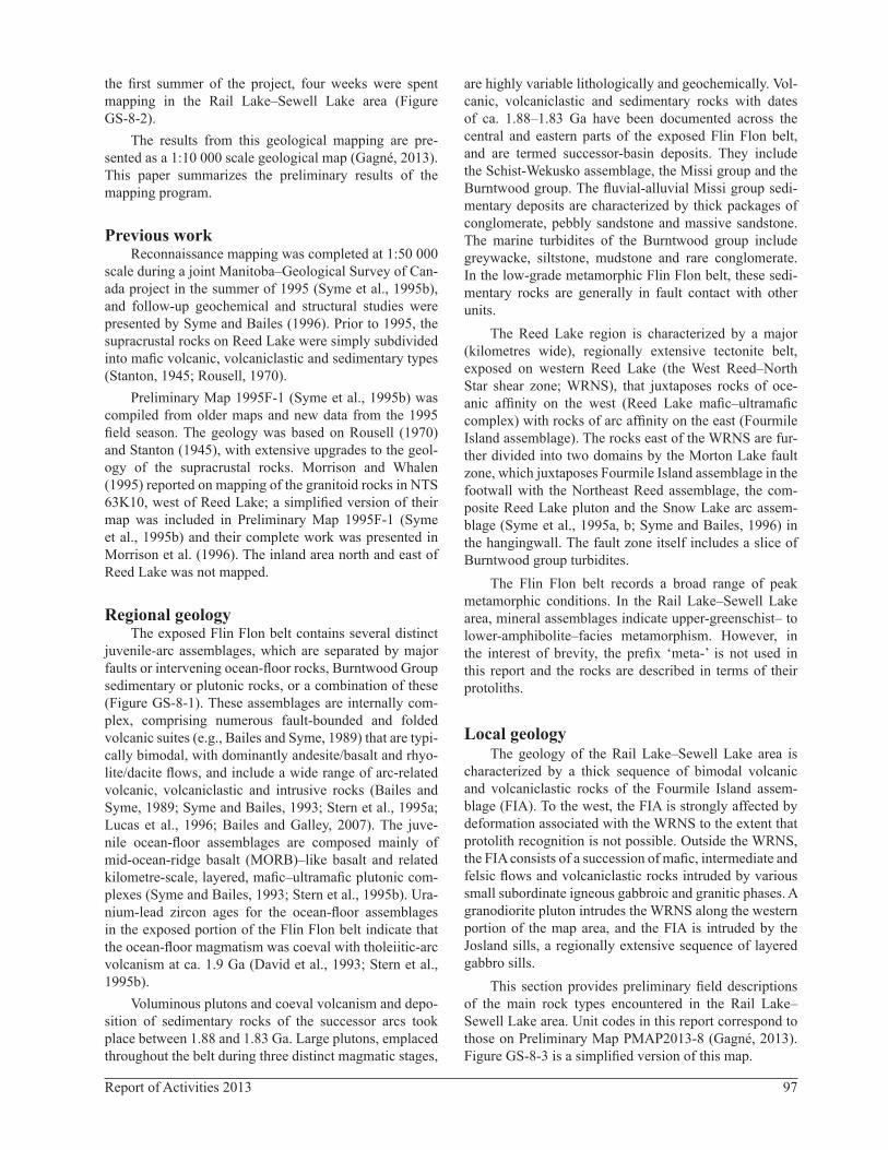
This section provides preliminary field descriptions of the main rock types encountered in the Rail Lake–Sewell Lake area. Unit codes in this report correspond to those on Preliminary Map PMAP2013-8 (Gagné, 2013). Figure GS-8-3 is a simplified version of this map.

98 Manitoba Geological Survey
Figure GS-8-2: Generalized geology of the Reed Lake–Morton Lake–Tramping Lake area (Syme et al., 1995a). The ex-tent of the multiyear Reed lake project is outlined in purple and the location of the Rail Lake–Sewell Lake area is outlined in red. Intrusive rocks: GLB, Gants Lake batholith; RLC, Reed Lake mafic–ultramafic complex; JLS, Josland Lake sills; LSLP, Little Swan Lake pluton; NLP, Norris Lake pluton; RLP, Reed Lake pluton; HLP, Ham Lake pluton; WLP, Wekusko Lake pluton. Structural feature: MLFZ, Morton Lake fault zone. Mines (active or closed) and deposits: A, Anderson; B, Bomber; C, Chisel; CN, Chisel North; Di, Dickstone; FI, Fourmile Island; G, Ghost; Ja, Jackfish; Jn, Joannie; L, Lost; La, Lalor; M, Morgan; NS, North Star; P, Photo; Pn, Pen; Pt, Pot; Ra, Rail; Rd, Raindrop; Re, Reed; S, Spruce Point; Wi, Wine. Other: VMS, volcanogenic massive sulphide.
Tram
ping
Lake
0 10 km
C
Ra
Re
Di
NS
Wi
CN
G
Rd
BPn
LaP
PtM
Ja
A
Jn
L
S
Fi
WLP
ML
FZ
RLC
FourmileIsland
LSLP
GLB
NLP
ZONE
CREEK
BERRY
Lake
Reed
FAULT
RLP
LakeWoosey
LakeFile
HLP
39
??
Felsic, mafic
Burntwood group turbidites
Josland Lake gabbro sills
Granodiorite
Snow Lake arc assemblage
Fourmile Island arc assemblage
Synvolcanic felsic plutons
Northeast Reed ocean-floor basalt(Reed basalt / File-Morton-Woosey basalt)
Reed Lake mafic–ultramafic complex(layered gabbro-peridotite, massive gabbro)
West Reed–North Starshear zone
Shear-zone boundary
Fault
Morton Lake thrust
2013 mapped area
VMS mine
Ordovician cover
Edge of Phanerozoic cover
1.9 Ga ARC ASSEMBLAGES
>1.845 Ga PLUTONS
1.9 Ga OCEAN-FLOOR ASSEMBLAGE
1.84 Ga SUCCESSOR-BASIN DEPOSITS
<1.845 Ga PLUTONS
Missi group sandstone, conglomerate
VMS deposit
Gold deposit
Ni-Cu showing
Reed Lake project area
JLS
43
54
25
E
6081925N
6046900N
38
74
50
E
99Report of Activities 2013
Fourmile Island assemblageVolcanic rocks of the Fourmile Island assemblage
occur on western Reed Lake. They are bounded to the west by a wide zone of heterogeneous tectonite (West Reed–North Star shear zone, WRNS). The FIA within the map area includes at least 2000 m of subaqueous volcanic stratigraphy, which mostly corresponds to the lower sequence. The younging direction throughout the sequence is to the east.
Andesitic flows and volcaniclastic rocks (unit 1)Unit 1 consists mostly of a thick succession of andes-
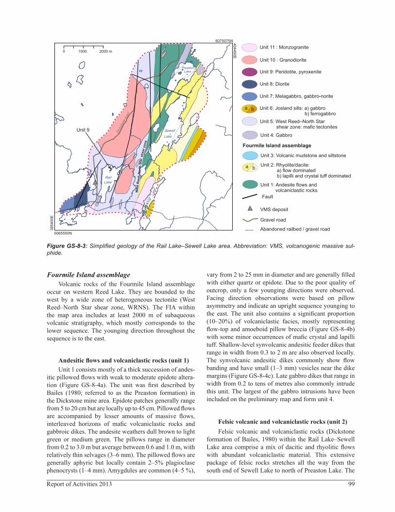
itic pillowed flows with weak to moderate epidote altera-tion (Figure GS-8-4a). The unit was first described by Bailes (1980; referred to as the Preaston formation) in the Dickstone mine area. Epidote patches generally range from 5 to 20 cm but are locally up to 45 cm. Pillowed flows are accompanied by lesser amounts of massive flows, interleaved horizons of mafic volcaniclastic rocks and gabbroic dikes. The andesite weathers dull brown to light green or medium green. The pillows range in diameter from 0.2 to 3.0 m but average between 0.6 and 1.0 m, with relatively thin selvages (3–6 mm). The pillowed flows are generally aphyric but locally contain 2–5% plagioclase phenocrysts (1–4 mm). Amygdules are common (4–5 %),
vary from 2 to 25 mm in diameter and are generally filled with either quartz or epidote. Due to the poor quality of outcrop, only a few younging directions were observed. Facing direction observations were based on pillow asymmetry and indicate an upright sequence younging to the east. The unit also contains a significant proportion (10–20%) of volcaniclastic facies, mostly representing flow-top and amoeboid pillow breccia (Figure GS-8-4b) with some minor occurrences of mafic crystal and lapilli tuff. Shallow-level synvolcanic andesitic feeder dikes that range in width from 0.3 to 2 m are also observed locally. The synvolcanic andesitic dikes commonly show flow banding and have small (1–3 mm) vesicles near the dike margins (Figure GS-8-4c). Late gabbro dikes that range in width from 0.2 to tens of metres also commonly intrude this unit. The largest of the gabbro intrusions have been included on the preliminary map and form unit 4.
Felsic volcanic and volcaniclastic rocks (unit 2)Felsic volcanic and volcaniclastic rocks (Dickstone
formation of Bailes, 1980) within the Rail Lake–Sewell Lake area comprise a mix of dacitic and rhyolitic flows with abundant volcaniclastic material. This extensive package of felsic rocks stretches all the way from the south end of Sewell Lake to north of Preaston Lake. The
Figure GS-8-3: Simplified geology of the Rail Lake–Sewell Lake area. Abbreviation: VMS, volcanogenic massive sul-phide.
Unit 9: Peridotite, pyroxenite
Unit 10 : Granodiorite
Unit 11 : Monzogranite
Unit 8: Diorite
Unit 3: Volcanic mudstone and siltstone
Unit 6: Josland sills: a) gabbro b) ferrogabbro
Unit 7: Melagabbro, gabbro-norite
Unit 4: Gabbro
Unit 5: West Reed–North Star shear zone: mafic tectonites
Unit 1: Andesite flows and volcaniclastic rocks
Fault
Fourmile Island assemblage
VMS deposit
Gravel road
Abandoned railbed / gravel road
a b
ba
Unit 2: Rhyolite/dacite: a) flow dominated b) lapilli and crystal tuff dominated
0
6075075N
6065550N
40
44
50
E
39
54
00
E1000 2000 m
LakePreaston
Lake
Sewell
Lake
Kru
g
Lake
Rail
Dickstone ro
ad
West
Reed
–N
ort
h S
tar
sh
ear
zon
e
Unit 9
100 Manitoba Geological Survey
Figure GS-8-4: Outcrop photographs of representative rock types from the Rail Lake–Sewell Lake area: a) andesitic pil-lows with 7-10% epidote patches up to 25 cm in diameter, unit 1, 600 m northwest of Preaston Lake (Brunton® compass is 7 cm); b) andesitic amoeboid pillow breccia with 3% quartz-epidote–filled amygdules, unit 1, north shore of Preaston Lake (pen is 13 cm); c) synvolcanic andesitic dike with flow banding and small vesicles along margin, cutting through a horizon of flow-top breccia, unit 1, north shore of Preaston Lake (pen is 13 cm); d) small lobe of aphyric dacite (lower portion of photo; contact parallel to pen) and associated dacitic breccia, unit 2a, west shore of Preaston Lake (pen is 13 cm); e) thinly bedded felsic tuff showing normal grading, unit 2c, 450 m east of Sewell Lake (pen is 13 cm); f) quartz- and plagioclase-rich felsic crystal tuff with hollowed amygdules, unit 2c, northeast shore of Sewell Lake (pen is 13 cm); g) laminated mafic mylonite, unit 5, 150 m west of Rail Lake (pen 13 cm); h) medium-grained, homogeneous, equigranu-lar granodiorite, unit 10, km 5.0 on the Dickstone road (grey bar is 4 cm).
a b
c d
e f
g h

101Report of Activities 2013
felsic volcanic and volcaniclastic rocks have been sub-divided into two subunits based on facies. Subunit 2a consists mostly of massive to flow-banded dacite and rhyolite flows. The dacite is commonly aphyric to locally plagioclase phyric, whereas the rhyolite is typically pla-gioclase and quartz phyric. Lobe and tongue facies with 0.3–1.5 m thick lobes of felsic volcanic and associated breccia are also commonly observed within unit 2a (Fig-ure GS-8-4d).
Subunit 2b consists of plagioclase- and quartz-phyric dacitic to rhyolitic tuff and lapilli tuff. These rocks vary from massive horizons of crystal-rich felsic tuff (Figure GS-8-4e) to thinly bedded ash tuff with 5–10% lithic lapilli (Figure GS-8-4f).
Volcanic mudstone and siltstone (unit 3)This thin sequence of volcanic mudstone and siltstone
(the Yakymiw formation of Bailes, 1980a) comprises laminated mudstone, siltstone and fine-grained sandstone, with interbeds of pebbly greywacke. Within the map area, only mudstone and the siltstone horizon where observed in outcrop due to thick lichen cover and scarce outcrop. At a regional scale, this unit forms a tight synformal structure that is intruded along its core by differentiated Josland sills. The contact between unit 3 and the underlying felsic volcaniclastic rocks was not observed.
Mafic tectonite: West Reed–North Star shear zone (unit 5)Along the western margin of the map area, the WRNS
consists of a wide zone of laminated, mylonitic mafic tec-tonite (Figure GS-8-4g). The transition from intact mafic volcanic rocks of unit 1 to laminated mafic tectonite is fairly abrupt and generally occurs over 50–100 m. Intense deformation within the shear zone makes determination of protolith difficult. In lower strain domains, possible remnant pillow selvages indicate that the protolith for this unit was, at least locally, mafic flows. It is likely that at least some of the mafic tectonite was derived from unit 1 along its eastern margin. Although the tectonite is domi-nantly mafic, horizons (0.3–10 m) of highly deformed fel-sic rocks are common (10%).
Intrusive rocks
Gabbro (unit 4)Unit 4 consists of medium-grained (2–4 mm) and
equigranular gabbro that shows a granoblastic texture and varies from massive to weakly foliated, except near the WRNS, where it shows well-developed mineral foliation. It locally has a weakly to moderately developed mineral lineation. The gabbro clearly intrudes rocks from both units 1 and 2. In the western part of the map area, the gab-bro is tectonized by the WRNS.
Layered gabbro sills; Josland sills (unit 6)Unit 3 is intruded by a thick, compositionally zoned
and highly fractionated mafic sill. The sill is part of the 1886 ±3 Ma Josland Lake suite (Zwanzig et al., 2001), described in detail by Bailes (1980). This intrusion rep-resents the along-strike extension of the >17 km long Josland Lake sill mapped in the File Lake–Morton Lake area. The Josland Lake intrusions are a distinctive suite of zoned, strongly fractionated, tholeiitic gabbro sills displaying extreme iron enrichment (Bailes, 1980). In the File Lake area, Bailes (1980) described three later-ally continuous zones: a lower gabbro zone, a middle fer-rogabbro zone and an upper granophyric to porphyritic quartz ferrodiorite and tonalite zone. In the eastern por-tion of the Rail Lake–Sewell Lake area, only the lower and middle zones of the Josland sill were encountered.
Melagabbro to gabbronorite (unit 7)This unit is found in the southwestern portion of
the map area and consists mostly of melagabbro to gabbronorite. The rock is generally medium grained (2–4 mm) and equigranular, has a granoblastic texture and varies from massive to weakly foliated. It locally contains small segregations of plagioclase crystals.
Diorite (unit 8)This unit consist mostly of medium- to coarse-
grained, equigranular, massive to weakly foliated diorite with a few angular inclusions of fine-grained mafic rock (basalt?). Its occurrence is restricted to the southwest cor-ner of the map area.
Peridotite and pyroxenite (unit 9)This unit is only found in the northern part of Rail
Lake. The pyroxenite was observed at a few locations along the northeast shore of Rail Lake, whereas the peri-dotite was recognized on a few small islands and a pen-insula on the north shore of Rail Lake. The pyroxenite is generally massive to weakly foliated, equigranular and medium to coarse grained. The peridotite has a distinc-tive red-brown weathered surface and is intensely altered, with olivine almost completely replaced by serpentine pseudomorphs, and pyroxene almost completely altered to chlorite.
Granodiorite (unit 10)This unit defines a homogeneous pluton along the
west side of the map area. The granodiorite intrudes the WRNS and clearly postdates the bulk of the deforma-tion. The rock is generally homogeneous, equigranular and medium to coarse grained, and varies from mas-sive to weakly foliated (Figure GS-8-4h). It is light to medium grey on fresh surfaces and weathers light grey to buff. Biotite is the main mafic mineral (2–7%; 1–3 mm),

102 Manitoba Geological Survey
although it commonly contains up to 10 % hornblende (1–5 mm). Magnetite locally occurs as an accessory min-eral (1%). Along its margin, the granodiorite commonly contains xenoliths of the host WRNS mafic tectonite and foliated gabbro.
Monzogranite (unit 11)A buff to light grey monzogranite, weathering beige
to grey-brown, is exposed on the west shore of Krug Lake. The monzogranite is generally homogeneous, equi-granular and medium to coarse grained, with minor biotite (1–4%; 1–2 mm in size). The rock varies from massive to weakly foliated. No xenoliths were observed.
Structural geology and metamorphismThe Rail Lake–Sewell Lake area is a polydeformed,
low-grade part of the Flin Flon belt. Further field and laboratory study of the area’s structures, as well as tar-geted U-Pb geochronology, are required to correlate local structures and deformation events with the regional tec-tonic framework. The sequence of deformation presented here is based largely on crosscutting relations observed on outcrops.
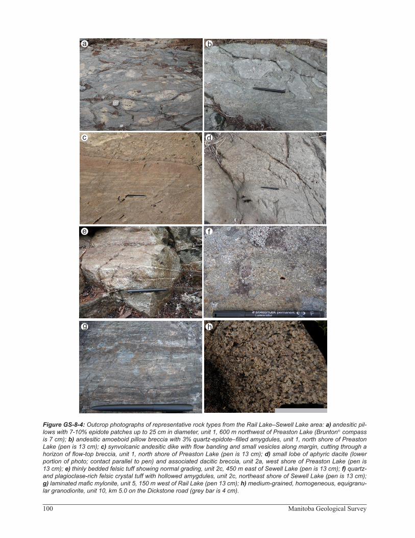
Abundant moss and lichen cover in the map area hin-dered recognition of primary features in the FIA metavol-canic and volcaniclastic rocks. Due to the poor exposure, only a few bedding and pillow-facing directions could be observed. However, graded beds and pillow asymmetry consistently indicate an overall easterly upright facing direction for the rocks of the FIA. This is in agreement with the interpretation of Bailes (1980) for the vicinity of the Dickstone mine, which lies along strike a few kilo-metres north of the mapped area. The FIA represents an east-facing homoclinal sequence.
The oldest deformation structure observed in the map area is a weak to moderately developed mineral foliation (S1) that also represents a plane of flattening (Figure GS-8-5a). Elongated clasts from volcaniclastic horizons gen-erally lie parallel to the foliation plane. The S1 foliation is recognized outside the WRNS in the eastern portion of the map area, where it typically trends north-northeast (020–035°N) with a steep dip (70–85°). This early fabric is axial planar to a large syncline that folds the FIA rocks along the east side of Morton Lake. Where bedding can be identified, it shows a broader range of dip (50–85°) than S1, probably as a result of parasitic folding on the limb of a regional syncline. A down-dip lineation in the FIA rocks generally lies parallel to S1. The lineation is defined by elongated lapilli and stretched amygdules, as well as aligned amphibole. A maximum age for the D1 event is provided by the 1886 Ma age of the Josland sill, which intruded along the axial plane of the Morton Lake syncline but was unaffected by folding (Zwanzig et al., 2001).
The second episode of deformation (D2) was a strong ductile deformation that led to the formation of the WRNS and is characterized by a protomylonitic to mylonitic fabric (S2) that consistently strikes north with subverti-cal dip (Figure GS-8-5b, c, d). Although best developed within the WRNS, the S2 fabric is also developed in rocks near Sewell Lake and to the west, outside the WRNS, and forms a weak to moderate, north-striking, subverti-cal mineral foliation that overprints S1 (20–30° degrees counter-clockwise) and becomes more prominent west-ward (Figure GS-8-5c). Inside the WRNS, the mineral and stretching lineations are shallower (50–70°) and typi-cally plunge to the south. The S1 fabric is interpreted to have been transposed parallel to S2 within the limits of the WRNS because, close to the shear zone, it is deflected in an anticlockwise sense into the shear-zone trend. Shear-sense indicators indicate mainly dextral movement along the shear zone, although there are many indications of later sinistral slip. The maximum age of the formation of the WRNS can be constrained by the crosscutting rela-tion of the granodiorite pluton along the Dickstone road, a sample of which has been collected for U-Pb dating.
The WRNS was reactivated during D3 deformation, resulting in local Z-folds (Figure GS-8-5d) that vary from tight chevron to isoclinal and do not have an axial-planar penetrative fabric. The D3 deformation appears to record sinistral transpression along the north-northeast-trending WRNS.
A series of late, narrow brittle faults (D4) developed parallel to the WRNS in the map area (Figure GS-8-5e). These brittle faults are not overprinted by a penetrative foliation and clearly cut S1 and S2 foliations. The north-trending faults shown on Figure GS-8-3 are interpreted to be D4 brittle features. Chloritic alteration is locally observed along the walls of the larger brittle faults.
Later, northwest-trending, subvertical spaced cleav-age (S5; Figure GS-8-5f) represents the last episode of deformation (D5) recognized in the Rail Lake–Sewell Lake area. This spaced cleavage is observed throughout the area both within and outside the WRNS, and offsets D1 to D4 deformation structures. It does not have an asso-ciated penetrative fabric and varies from closely (3–5 cm) to widely (20–30 cm) spaced, with a dextral offset.
Economic considerationsThe Fourmile Island assemblage hosts five signifi-
cant VMS deposits within the Reed Lake area. The Rail deposit occurs near the south end of the area and the Dick-stone deposit is found 5 km north of the area. The precise geological setting of the Rail deposit is unclear because it sits in the middle of the WRNS; however, the Dickstone deposit is known to occur near the contact between the Preaston and Dickstone formations (units 1 and 2 in this report). The presence of the Rail deposit and the fact that the host horizon of the Dickstone deposit can be traced
103Report of Activities 2013
Figure GS-8-5: Outcrop photographs of structures from the Rail Lake–Sewell Lake area: a) andesitic flow-top breccia with moderate S1 fabric, unit 1, northwest shoreline of Preaston Lake (pen is 13 cm); b) dacitic tuff with S1 and oblique S2 fabric, unit 2b, west shore of Sewell Lake (pen is 13 cm); c) mylonitic foliation (S2) and asymmetric quartz boudins show-ing sinistral shear along foliation, unit 4, 200 m northwest of Rail Lake (pen is 13 cm); d) mylonitic foliation (S2) and F3 Z-folds, unit 5, 500 m north of Rail Lake (pen is 13 cm); e) mylonitic foliation (S2) and late-foliation parallel brittle faulting (S4), unit 5, 600 m west of Sewell Lake (pen cap is 4 cm); f) mylonitic foliation (S2) and late spaced cleavage (S5), unit 5, west shore of Rail Lake (pen is 13 cm).
S1 S2
S1
S2
S3
S2
S2
S4
S5
S2
a b
e f
c d
104 Manitoba Geological Survey
uninterrupted from the Dickstone mine through most of the map area suggest that the Rail Lake–Sewell Lake region has significant potential for discovery of further VMS deposits. Weak to moderate sericite-chlorite altera-tion was observed within felsic volcanic rocks along the shoreline of Sewell Lake and on some small islands, with alteration being strongest in the island exposures.
Although no gold occurrences have been reported from the Rail Lake–Sewell Lake area, the WRNS hosts several significant gold showings in the North Star Lake area, 3 km north of the map area. Because the same struc-tures that host gold mineralization in the North Star Lake area straddle the Rail Lake–Sewell Lake region, it likely also has significant potential for shear-hosted (i.e., oro-genic) gold mineralization.
AcknowledgmentsThe author thanks S. Bawden for providing enthu-
siastic field assistance, as well as N. Brandson and E. Anderson for thorough logistical support.
ReferencesAnsdell, K.M., Lucas, S B., Connors, K.A. and Stern, R.A.
1995: Kisseynew metasedimentary gneiss belt, Trans-Hud-son orogen (Canada): back-arc origin and collisional inver-sion; Geology, v. 23, no. 11, p. 1039–1043.
Bailes, A.H. 1980: Geology of the File Lake area; Manitoba Energy and Mines, Mineral Resources Division, Geologi-cal Report GR78-1, 134 p.
Bailes, A.H. and Galley, A.G. 2007: Geology of the Chisel–Anderson lakes area, Snow Lake, Manitoba (NTS areas 63K16SW and west half of 63J13SE); Manitoba Science, Technology, Energy and Mines, Manitoba Geological Sur-vey, Geoscientific Map MAP2007-1, scale 1:20 000.
Bailes, A.H. and Syme, E.C. 1989: Geology of the Flin Flon–White Lake area; Manitoba Energy and Mines, Geological Services, Geological Report GR87-1, 313 p.
David, J. and Syme, E.C. 1994: U-Pb geochronology of late Neoarchean tonalites in the Flin Flon belt, Trans-Hudson orogen: surprise at surface; Canadian Journal of Earth Sci-ences, v. 31, p. 1790–1785.
David, J., Machado, N. and Bailes, A.H. 1993: U-Pb geochro-nology of the Proterozoic Flin Flon belt, Snow Lake area, Manitoba; Geological Association of Canada–Mineralogi-cal Association of Canada, Joint Annual Meeting, Edmon-ton, Alberta, May 17–19, 1993, Program with Abstracts, v. 18, p. 22.
Gagné, S. 2013: Geology of the Rail Lake–Sewell Lake area, Flin Flon–Snow Lake greenstone belt, west-central Manitoba (parts of NTS 63K10, 15); Manitoba Mineral Resources, Manitoba Geological Survey, Preliminary Map PMAP2013-8, scale 1:10 000.
Leclair, A.D. and Viljoen, D. 1997: Geology of Precambrian basement beneath Phanerozoic cover, Flin Flon belt, Mani-toba and Saskatchewan; Geological Survey of Canada, Open File 3427, scale 1:250 000.
Leclair, A.D., Lucas, S.B., Broome, H.J., Viljoen, D.W. and Weber, W. 1997: Regional mapping of Precambrian base-ment beneath Phanerozoic cover in southeastern Trans-Hudson orogen, Manitoba and Saskatchewan; Canadian Journal of Earth Sciences, v. 34, p. 618–634.
Lucas, S.B. and Stern, R.A. 1994: Significance of accretion and melting processes for the development of Paleoproterozoic continental lithosphere; Geological Association of Can-ada–Mineralogical Association of Canada, Joint Annual Meeting, Waterloo, Ontario, vol. 19, p. 67.
Lucas, S.B., Stern, R.A., Syme, E.C., Reilly, B.A. and Thomas, D.J. 1996: Intraoceanic tectonics and the development of continental crust: 1.92–1.84 Ga evolution of the Flin Flon belt, Canada; Geological Society of America Bulletin, v. 108, no. 5, p. 602–629.
Morrisson, D.W. and Whalen, J.B. 1995: Granitoid plutons and major structures in the Iskwasum Lake sheet, Manitoba: a portion of the Flin Flon domain of the Trans-Hudson oro-gen; in Current Research 1995-C, Geological Survey of Canada, p. 225–234.
Morrison, D.W., Syme, E.C. and Whalen, D. 1996: Geology, Iskwasum Lake, Manitoba (part of 63K10); Geological Survey of Canada, Open File 2971, scale 1:50 000.
Reilly, B.A., Slimmon, W.L., Harper, C.T., Heaman, L.M. and Watters, B.R. 1994: Contrasting lithotectonic assemblages from the western Flin Flon Domain; in LITHOPROBE: Trans-Hudson Orogen Transect Workshop, LITHOPROBE Secretariat, University of British Columbia, Vancouver, British Columbia, Report 38, p. 105–111.
Rousell, D.H. 1970: Geology of the Iskwasum Lake area (east half); Manitoba Department of Mines and Natural Resources, Mines Branch, Geological Survey, Publication 66-3, 26 p.
Stanton, M.S. 1945: Tramping Lake; Geological Survey of Can-ada, Map 906A, scale 1:63 630.
Stern, R.A. and Lucas, S.B. 1994: U-Pb zircon age constraints on the early tectonic history of the Flin Flon accretionary collage, Saskatchewan; in Current Research 1994-F, Geo-logical Survey of Canada, p. 75–86.
Stern, R.A., Syme, E.C., Bailes, A.H. and Lucas, S.B. 1995a: Paleoproterozoic (1.90–1.86 Ga) arc volcanism in the Flin Flon belt, Trans-Hudson orogen, Canada; Contributions to Mineralogy and Petrology, v. 119, no. 2–3, p. 117–141.
Stern, R.A., Syme, E.C. and Lucas, S.B. 1995b: Geochemistry of 1.9 Ga MORB- and OIB-like basalts from the Amisk collage, Flin Flon belt, Canada; evidence for an intra-oceanic origin; Geochimica et Cosmochimica Acta, v. 59, no. 15, p. 3131–3154.
Syme, E.C. and Bailes, A.H. 1993: Stratigraphic and tectonic setting of volcanogenic massive sulfide deposits, Flin Flon, Manitoba; Economic Geology, v. 88, p. 566–589.
Syme, E. C. and Bailes, A. H. 1996: Geochemistry of arc and ocean-floor metavolcanic rocks in the Reed Lake area, Flin Flon belt; in Report of Activities 1996, Manitoba Energy and Mines, Geological Services, p. 52–65.
Syme, E.C., Bailes, A.H. and Lucas, S.B. 1995a: Geology of the Reed Lake area (parts of NTS 63K/9 and 10); in Report of Activities 1995, Manitoba Energy and Mines, Geological Services, p. 42–60.

105Report of Activities 2013
Syme, E.C., Bailes, A.H. and Lucas, S.B. 1995b: Reed Lake, N.T.S. parts of 63K/9, 63K/10; Manitoba Energy and Mines, Preliminary Map 1995F-1, scale 1:50 000.
Syme, E.C., Lucas, S.B., Zwanzig, H.V., Bailes, A.H., Ashton, K.E. and Haidl, F.M. 1998: Geology, NATMAP Shield Margin Project area (Flin Flon belt), Manitoba/Saskatche-wan; Geological Survey of Canada, Map 1968A, Manitoba Energy and Mines, Map A-98-2, Saskatchewan Energy and Mines, Map 258A, 54 p., scale 1:100 000.
Zwanzig, H.V., Bailes, A.H. and Böhm, C.O. 2001: Josland Lake sills: U-Pb age and tectonostratigraphic implications (parts of NTS 63K and 63N); in Report of Activities 2001, Manitoba Industry, Trade and Mines, Manitoba Geological Survey, p. 28–32.