geography paper 1 1996 - atika school
TRANSCRIPT
GEOGRAPHY PAPER 1 1996
SECTION A
Answer all the questions in this section in the spaces provided.
1. a) List two features resulting from extrusive volcanic activity.(2mks)
b) State four ways in which volcanicity has influenced human activities in
Kenya. (4mks)
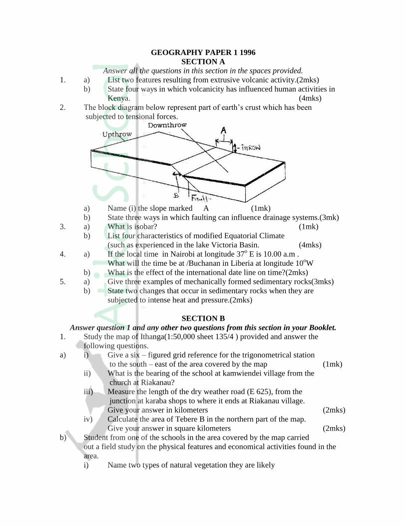
2. The block diagram below represent part of earth’s crust which has been
subjected to tensional forces.
a) Name (i) the slope marked A (1mk)
b) State three ways in which faulting can influence drainage systems.(3mk)
3. a) What is isobar? (1mk)
b) List four characteristics of modified Equatorial Climate
(such as experienced in the lake Victoria Basin. (4mks)
4. a) If the local time in Nairobi at longitude 37o E is 10.00 a.m .
What will the time be at /Buchanan in Liberia at longitude 10oW
b) What is the effect of the international date line on time?(2mks)
5. a) Give three examples of mechanically formed sedimentary rocks(3mks)
b) State two changes that occur in sedimentary rocks when they are
subjected to intense heat and pressure.(2mks)
SECTION B
Answer question 1 and any other two questions from this section in your Booklet.
1. Study the map of Ithanga(1:50,000 sheet 135/4 ) provided and answer the
following questions.
a) i) Give a six – figured grid reference for the trigonometrical station
to the south – east of the area covered by the map (1mk)
ii) What is the bearing of the school at kamwiendei village from the
church at Riakanau?
iii) Measure the length of the dry weather road (E 625), from the
junction at karaba shops to where it ends at Riakanau village.
Give your answer in kilometers (2mks)
iv) Calculate the area of Tebere B in the northern part of the map.
Give your answer in square kilometers (2mks)
b) Student from one of the schools in the area covered by the map carried
out a field study on the physical features and economical activities found in the
area.
i) Name two types of natural vegetation they are likely
to have identified (2mks)
ii) Citing evidence from the map, name three economic activities the students
are likely to have identified during their study (3mks)
iii) Citing evidence from map, name two methods the students are likely to
have used to cross River Tana. (2mks)
c) Describe the drainage of the area covered by the map. (4mks)
d) Describe the distribution of settlements in the area covered by the map (3mks)
e) Draw a rectangle 15cm by 10cm to represent the area west of Easting 20 and
south of northing 00. On the rectangle, mark and name:
i) The provincial boundary
ii) Ithanga hills
iii) The sisal plantation to the south west of the area (4mks)
2 a)i) What is river divide? (6mks)
ii) Describe three ways by which a river transports its load (6mks)
b) Describe the characteristics of a river in its old age (7mks)
c) Describe each of the following drainage patterns
i) Superimposed drainage pattern (3mks)
ii) Centripetal drainage pattern (2mks)
d) You have planned to carry out a study of a river in its youthful stage
i) State two ways in which you would prepare for the study (2mks)
ii) Name two feature you are likely to study (2mks)
iii) List two problems you are likely to experience during the study (2mks)
3. a) List four processes through which costs are eroded (4mks)
b) Using well-labeled diagram, explain how each of the following features is
used formed.
i) A spit (4mks)
ii) A blow hole (2mks)
iii) An a toll (5mks)
c) Some student carried out a field study on the coastal features found along
the coast of Kenya.
i) List three features formed as a result of coastal emergence that they are
likely to have studied (3mks)
ii) State three methods tha student may have used to record their data (2mks)
iii) Describe two ways in which features resulting from coastal emergence are
of significance of Kenya (2mks)
4. a) List
i) Four characteristics of desert soil (4mks)
ii) Two factors that contribute to soil leaching (2mks)
b) Explain how each of the following factors influences the formation of soil:
i) Parent rock (2mks)
ii) Living organisms (2mks)
iii) Topography (2mks)
c) Draw a well labelled profile of mature soil (5mks)
d) Explain four ways in which human activities contribute to soil erosion. (8mks)
GEOGRAPHY PAPER 2 1996
Answer all the question in this section in the spaces provided.\
1. a) Name two horticultural crops grown in Kenya (2mks)
b) State three reasons why horticulture is more developed in the
Netherlands than in Kenya. (3mks)
2. Give five reasons why the government of Kenya encourages the
establishment of jua kali industries. (5mks)
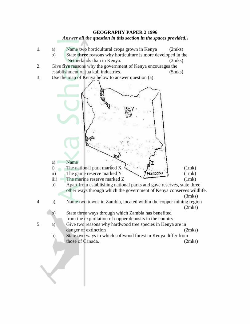
3. Use the map of Kenya below to answer question (a)
a) Name
i) The national park marked X (1mk)
ii) The game reserve marked Y (1mk)
iii) The marine reserve marked Z (1mk)
b) Apart from establishing national parks and gave reserves, state three
other ways through which the government of Kenya conserves wildlife.
(3mks)
4 a) Name two towns in Zambia, located within the copper mining region
(2mks)
b) State three ways through which Zambia has benefited
from the exploitation of copper deposits in the country.
5. a) Give two reasons why hardwood tree species in Kenya are in
danger of extinction (2mks)
b) State two ways in which softwood forest in Kenya differ from
those of Canada. (2mks)

SECTION B
Answer question 1 and any other two questions from this section in
your answer booklet.
1. The table below shows the number of passengers that used railway transport in
the selected countries in 1966 and 1977. Use it to answer question (a) and (b)
COUNTRY PASSENGERS IN MILLIONS
1966 1977
Canada 4,200 3,000
U.S.A 27,700 16,600
Argentina 14,100 12,000
India 96,800 163,800
Japan 258,400 311,900
a) i) Using a scale of 1cm to represent 20,000 millions passengers ,
draw comparative bar graphs based on the data above (9mks)
ii) State two advantages of using bar graphs in presenting data
b) Calculate the percentage decline in railway passenger transport in Canada
between 1966 and 1977. (2mks)
c) Explain why there are few railway links among African countries (6mks)
d) Explain three ways through which Kenya has benefited from her
international airports. (6mks)
2 a) State four factors that led to the development of kisumu town(4mks)
b) List five functions of New York city (5mks)
c) Explain five problems facing urban cenjeramaga76tres in Kenya (10mks)
d) Explain three ways in which a country benefits from urbanization (6mks)
3. a) Draw a sketch map of Ghana (1mk)
On the sketch map,
i) Shade the cocoa growing (1mk)
ii) Mark and name kumasi town (1mk)
b)i) Outline the stages involved in the processing of cocoa from harvesting
to the time it is ready for export. (6mks)
ii) List four problems experienced by cocoa farmers in Ghana (4mks)
c) Describe four physical conditions necessary for growing of oil palm.
(8mks)
d) List four uses of oil palm.
4. a) Explain what is meant by overpopulation? (2mks)
b) How does Kenya’s population differ from that of Sweden? (4mks)
c) Explain four factors that influence population distribution in Kenya(4mks)
d)i) A part from rural – rural migration, list three other types of migrations
in Kenya. (3mks)
ii) Explain four causes of rural – rural migration in Kenya (8mks)
GEOGRAPHY PAPER 312/ 1 K.C.S.E 1997
SECTION A
Answer all the questions in this section.
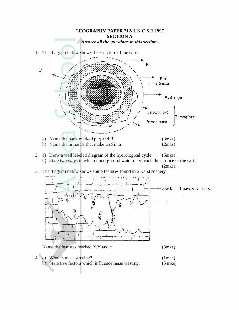
1. The diagram below shows the structure of the earth.
a) Name the parts marked p, q and R (3mks)
b) Name the minerals that make up Sima (2mks)
2 a) Draw a well labeled diagram of the hydrological cycle (5mks)
b) State two ways in which underground water may reach the surface of the earth
(2mks)
3. The diagram below shows some features found in a Karst scenery
Name the features marked X,Y and z (3mks)
4. a) What is mass wasting? (1mks)
b) State five factors which influence mass wasting. (5 mks)
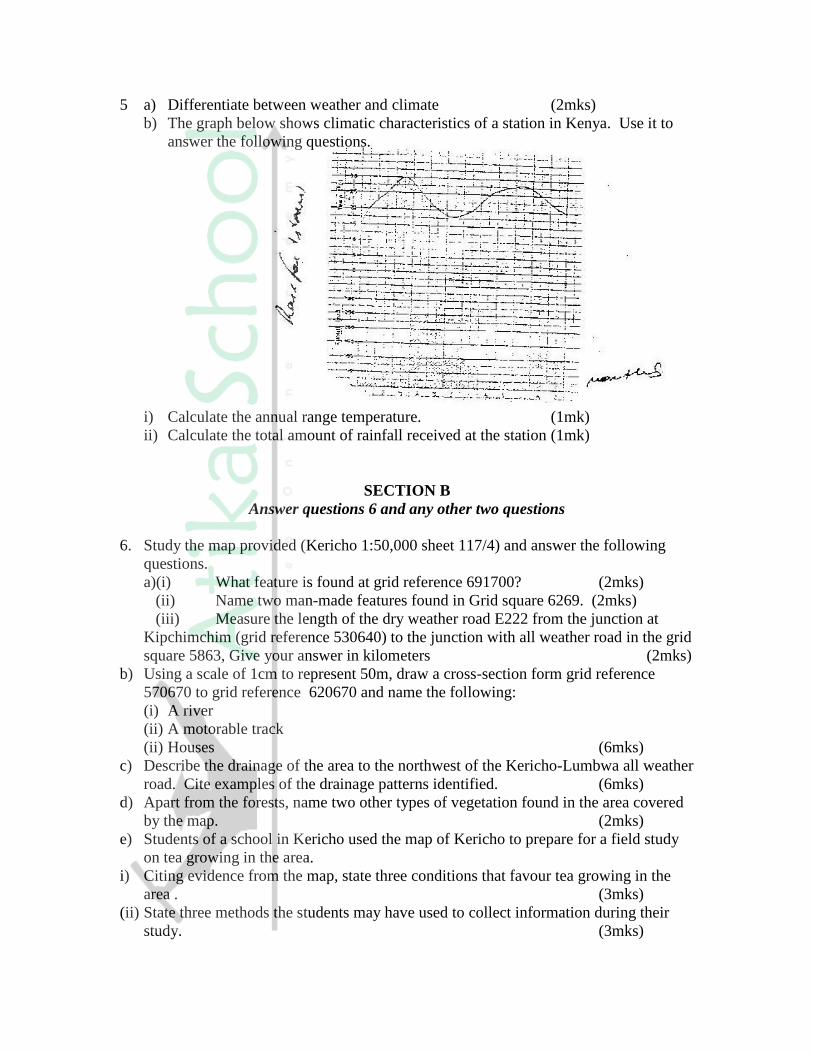
5 a) Differentiate between weather and climate (2mks)
b) The graph below shows climatic characteristics of a station in Kenya. Use it to
answer the following questions.
i) Calculate the annual range temperature. (1mk)
ii) Calculate the total amount of rainfall received at the station (1mk)
SECTION B
Answer questions 6 and any other two questions
6. Study the map provided (Kericho 1:50,000 sheet 117/4) and answer the following
questions.
a)(i) What feature is found at grid reference 691700? (2mks)
(ii) Name two man-made features found in Grid square 6269. (2mks)
(iii) Measure the length of the dry weather road E222 from the junction at
Kipchimchim (grid reference 530640) to the junction with all weather road in the grid
square 5863, Give your answer in kilometers (2mks)
b) Using a scale of 1cm to represent 50m, draw a cross-section form grid reference
570670 to grid reference 620670 and name the following:
(i) A river
(ii) A motorable track
(ii) Houses (6mks)
c) Describe the drainage of the area to the northwest of the Kericho-Lumbwa all weather
road. Cite examples of the drainage patterns identified. (6mks)
d) Apart from the forests, name two other types of vegetation found in the area covered
by the map. (2mks)
e) Students of a school in Kericho used the map of Kericho to prepare for a field study
on tea growing in the area.
i) Citing evidence from the map, state three conditions that favour tea growing in the
area . (3mks)
(ii) State three methods the students may have used to collect information during their
study. (3mks)
7a) Draw sketch map of Kenya on it, mark and name the
(i) Lake Turkana (1mk)
(ii) River Athi (1mk)
(iii) Mount Kenya (1mk)
(iv) The equator (1mk)
b) Describe the climate conditions experienced in the Kenya highlands.
c) Explain four ways in which vegetation in the Nyika region of Kenya has adapted
to the climate conditions experienced in the area. (8mks)
d) Explain how the presence of a cold ocean current influences the climate of the
adjacent coastlands. (4mks)
8 a) With the aid of well labeled diagrams, describe the processes involved in the
formation of a corrie lake. (8mks)
b) Explain four ways in which a glaciated landscape is of significance to human
activities. (8mks)
c) Suppose students were to carry out a field study on glaciations on Mt. Kenya.
(i) Give two reasons why they would need a route map (2mks)
(ii) Name two types of moraines they are likely to study (2mks)
(iii) State two problems they are likely to experience during the field study.
(2mks)
9 a) Give three examples of chemically formed sedimentary rocks. (3mks)
b) (i) State three conditions necessary for the growth of coral. (3mks)
(ii) Describe how coral racks are formed. (4mks)
c) Explain four ways in which rocks contribute to the economy of Kenya (8mks)
d) Some students are planning to carry out a field study on rock weathering around
their school.
(i) List three secondary sources of information they are likely to use as they
prepare for the field study. (3mks)
(ii) a part from using secondary sources, state four other ways in which the
students would prepare themselves for the field study.(4mks)

GEOGRAPHY PAPER 312/2 K.C.S.E 1997
SECTION A
Answer all the questions in this section
1. a) Name two breeds of dairy cattle reared in Kenya(2mks)
b) State three factors which favour dairy farming in Denmark (3mks)
2. a) State three physical factors which influence the location
of settlements. (3mks)
b) Use the sketch map below to answer questions (i) and (ii)
Name the main settlement pattern in:
i) The northern part of the area represented by the map.
ii) The southern part of the area represented by the map.
3. a) State three reasons why marine fisheries in Kenya are underdeveloped.
b) State three ways through which fish farming contributes to the
economy of Kenya.
4. a) Name two conditions that are necessary for the formation of petroleum
b) List three ways in which opencast mining affects the environment.
5. State four factors that have influenced the development of industries in Eldoret
town.
6. Study the photograph below and use it to answer the question (a)
a) i) Name the type of photograph given above.
ii) Draw a rectangle measuring 17cm by 12cm to represent the area of
the photograph. On it sketch and label the main features shown on
the photograph.
iii) Describe the landscape of the area represented by the photograph
b) i) Name two rivers in Kenya which cause large scale flooding
ii) Explain four ways in which people are affected by floods
c) Explain three methods which floods can be controlled.
7 a) Apart from Mea, name three large irrigation schemes in Kenya.
b) Explain four conditions that made Mea a suitable location for irrigation
scheme
c) Explain three problems experienced by farmers in the Gezira irrigation
scheme.
d) Explain three problems experienced by farmers in the Gezira irrigation
scheme.
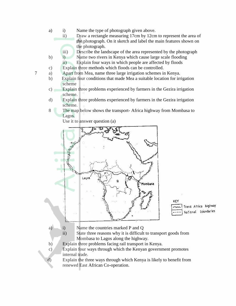
8 The map below shows the transport- Africa highway from Mombasa to
Lagos.
Use it to answer question (a)
a) i) Name the countries marked P and Q
ii) State three reasons why it is difficult to transport goods from
Mombasa to Lagos along the highway.
b) Explain three problems facing rail transport in Kenya.
c) Explain four ways through which the Kenyan government promotes
internal trade.
d) Explain the three ways through which Kenya is likely to benefit from
renewed East African Co-operation.
9. a)(i) Define the term tourism.
(ii) Name two tourist attraction found in the Rift valley province of
Kenya.
b) Explain four factors which hindered the development of domestic
tourism in Kenya.
c) Explain three problems experienced by the Kenya government in
its effort to conserve wildlife.
d) Explain four factors which have made Switzerland a major tourist
destination in Europe .

GEOGRAPHY PAPER 312/1 K.C.S.E 1998
SECTION A
Answer all the questions in this section
1. The diagram below represents the earth on its axis. Use it to answer question
(a)
(a) (i) Name the latitude marked G
(ii) What is the angle of inclination of the earth’s axis from it orbit?
(b) State two effects of the rotation of the earth
2. (a) What is magma?
(b) Differentiate between a sill and a dyke
(c) The diagram below represents a composite volcano. Name the features
marked P,Q, and R
3. (a) Sate three causes of earthquakes
(b) Give two effects of earthquakes in built up areas
4. (a) name the type of delta found at the mouth of
(i) River Nile
(ii) River Omo
(b) State three conditions that are necessary for the formation of delta
5. (a) name three external land forming processes that leads to the formation of
lakes
(b) State two ways in which lakes influence the natural environment
SECTION B
Answer questions 6 and any other two questions from this section
6. Study the map of Mariakani (1:50,000 sheet 197/4) provided and answer the
following questions
(a) (i) What type of map is Mariakani sheet?

(ii) From the marginal information, identify the two districts covered
by the map
(iii) Calculate the area of Mavirivirini sub- location. Give your answer
in square kilometers.
(b) Citing evidence from the map, explain three factors that favour cattle
rearing in Mariakani area.
(c) Citing evidence, state three functions of Samburu town
(d) Some students are required to carry out a field study on water supply in
south Samburu Division.
(i) State four problems they are likely to encounter in
administering questionnaires to residents of the area.
(ii) Measure the length of a water pipeline proposed by the
students from existing line at grid reference 303796 to
Mwandoni settlement at grid reference 325720. Give your
answer in Kilometers.
(iii) Calculate the vertical rise (amplitude of relief) of the
proposed pipeline.
7. (a) (i) What is the difference between weathering and mass wasting
(ii) List Five process involved in chemical weathering
(b) Explain five ways in which soil creep occurs
(c) Describe three effects of soil creep
8. The graph below represents the climate of a station in Africa. Use it to answer
question
(a)
(i) Describe the characteristics of the climate represented by the graph
(ii) Describe the type of natural vegetation likely to be found in an area
with the type of climate represented by the graph.
(b) Explain four factors that influence climate.
(c) You intend to carry a field study on the weather experienced in the
locality of your school
(i) State three ways in which you would prepare for the study
(ii) Describe how you would use the following instruments
during the study
A rain gauge (Used to collect rain water)
Maximum and minimum thermometer
(iii) State three advantages of studying the weather through
fieldwork
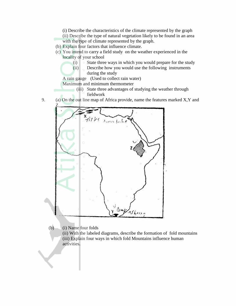
9. (a) On the out line map of Africa provide, name the features marked X,Y and
Z
(b) (i) Name four folds
(ii) With the labeled diagrams, describe the formation of fold mountains
(iii) Explain four ways in which fold Mountains influence human
activities.
GEOGRAPHY PAPER 312/2 K.C.S.E 1998
SECTION A
Answer all the questions in this section
1. (a) what is urbanization?
(b) State three factors which have led to the development of Mombasa as a major
sea port in the region
2. (a) State three physical conditions necessary for the location of hydroelectric
power dam
(b) Apart from production of hydro- electric power, name two other benefits of
Kariba dam
3. (a) Give three reasons why road transport is used more than air transport in East
Africa
(b) In what three ways does Kenya benefit from air links with the rest of the
World?
4. List for problems that are experienced in pyrethrum farming in Kenya
5. (a) What is soil conservation
(b) State three farming methods that assist in soil conservation
SECTION B
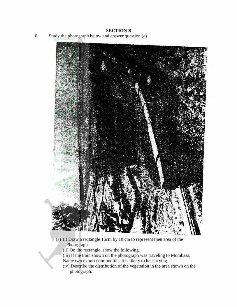
6. Study the photograph below and answer question (a)
(a) (i) Draw a rectangle 16cm by 10 cm to represent then area of the
Photograph
(ii) On the rectangle, show the following
(iii) If the train shown on the photograph was traveling to Mombasa,
Name two export commodities it is likely to be carrying
(iv) Describe the distribution of the vegetation in the area shown on the
photograph.

(b) Explain five factors that limit the exploitation of tropical rain forest in
Africa.
(c) Explain three measures being taken to conserve forests in Kenya
7. Use the map of Africa below to answer questions (a)
(a) name:
(i) The main minerals mined in the shaded area marked L,M,N (3mks)
(ii) The mining town marked P ( 1mk)
(b) (i) Apart from deep shaft mining, name three other mining methods (3mks)
(ii) Describe how shaft mining is carried out (6mks)
(c) Explain four ways in which mining contributes to the economy of Kenya
(8mks)
(d) State four negative effects of mining on the environment (4mks)
8. (a) (i) What is industrialization (2mks)
(ii) Name a town in Kenya where each of the following industries are located
Oil refining ( 1mk)
Paper manufacturing ( 1mk)
Motor vehicle assembly ( 1mk)
(b) Explain five factors which influenced the location of iron and steel industry
in the Ruhr region of Germany
(c) Give five reasons why the development of the Jua Kali industry is encouraged
in Kenya.
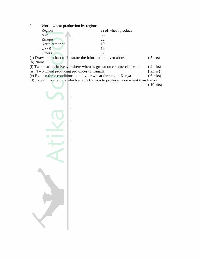
9. World wheat production by regions
Region % of wheat produce
Asia 35
Europe 22
North America 19
USSR 16
Others 8
(a) Draw a pie chart to illustrate the information given above. ( 5mks)
(b) Name
(i) Two districts in Kenya where wheat is grown on commercial scale ( 2 mks)
(ii) Two wheat producing provinces of Canada ( 2mks)
(c) Explain three conditions that favour wheat farming in Kenya ( 6 mks)
(d) Explain five factors which enable Canada to produce more wheat than Kenya
( 10mks)
GEOGRAPHY PAPER 312/1 K.C.S.E 1999
SECTION A
Answer all the questions in this section
1. Give four proofs that the earth is spherical
2. (a) State two conditions considered in choosing a suitable site for a weather
station
(b) Name two weather recording instruments that are placed in a stevenso’s screen
(c) Give two reasons why weather forecasting is important
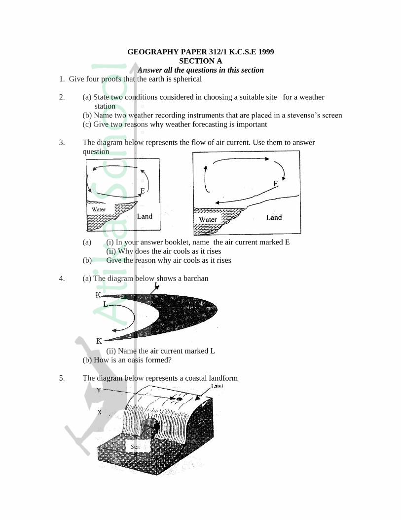
3. The diagram below represents the flow of air current. Use them to answer
question
(a) (i) In your answer booklet, name the air current marked E
(ii) Why does the air cools as it rises
(b) Give the reason why air cools as it rises
4. (a) The diagram below shows a barchan
(ii) Name the air current marked L
(b) How is an oasis formed?
5. The diagram below represents a coastal landform
(a) Name the features marked X and Y
(b) State three conditions necessary for the formation of a sand spit.
SECTION B
Answer questions 6 and two other questions from this section
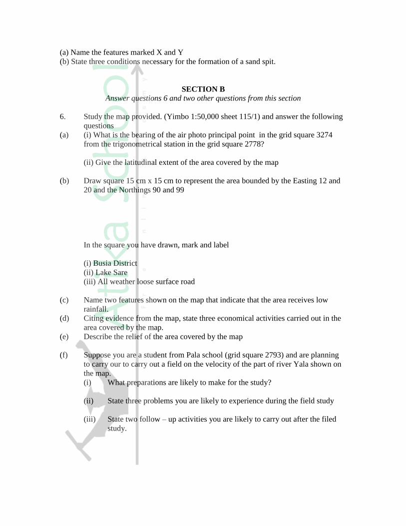
6. Study the map provided. (Yimbo 1:50,000 sheet 115/1) and answer the following
questions
(a) (i) What is the bearing of the air photo principal point in the grid square 3274
from the trigonometrical station in the grid square 2778?
(ii) Give the latitudinal extent of the area covered by the map
(b) Draw square 15 cm x 15 cm to represent the area bounded by the Easting 12 and
20 and the Northings 90 and 99
In the square you have drawn, mark and label
(i) Busia District
(ii) Lake Sare
(iii) All weather loose surface road
(c) Name two features shown on the map that indicate that the area receives low
rainfall.
(d) Citing evidence from the map, state three economical activities carried out in the
area covered by the map.
(e) Describe the relief of the area covered by the map
(f) Suppose you are a student from Pala school (grid square 2793) and are planning
to carry our to carry out a field on the velocity of the part of river Yala shown on
the map.
(i) What preparations are likely to make for the study?
(ii) State three problems you are likely to experience during the field study
(iii) State two follow – up activities you are likely to carry out after the filed
study.

7. The block diagram below shows the feature resulting from glaciating in a lowland
region. Use it to answer questions (a)
(a) In your answer booklet, name the features marked R, S, and V
(b) Explain three conditions that may lead to glacial deposition in lowlands
(c) Describe the process involved in the formation of
(i) Moraine dammed lake
(ii) Outwash plain
(d) Suppose you were to carry out field study of land use in glaciated lowland.
(i) Apart from conducting oral interviews, state four other methods you
would use to collect information
(ii) State three advantages of using oral interview to collect information
during a field study.
(iii) State three possible land uses you are likely to identify during the field study
8. (a) describe how a river erodes its channels by the following process.
(i) Hydraulic action
(ii) Abrasion
(b) (i) Explain three factors that lead to rejuvenation of a river
(ii) Describe the process of a river capture.
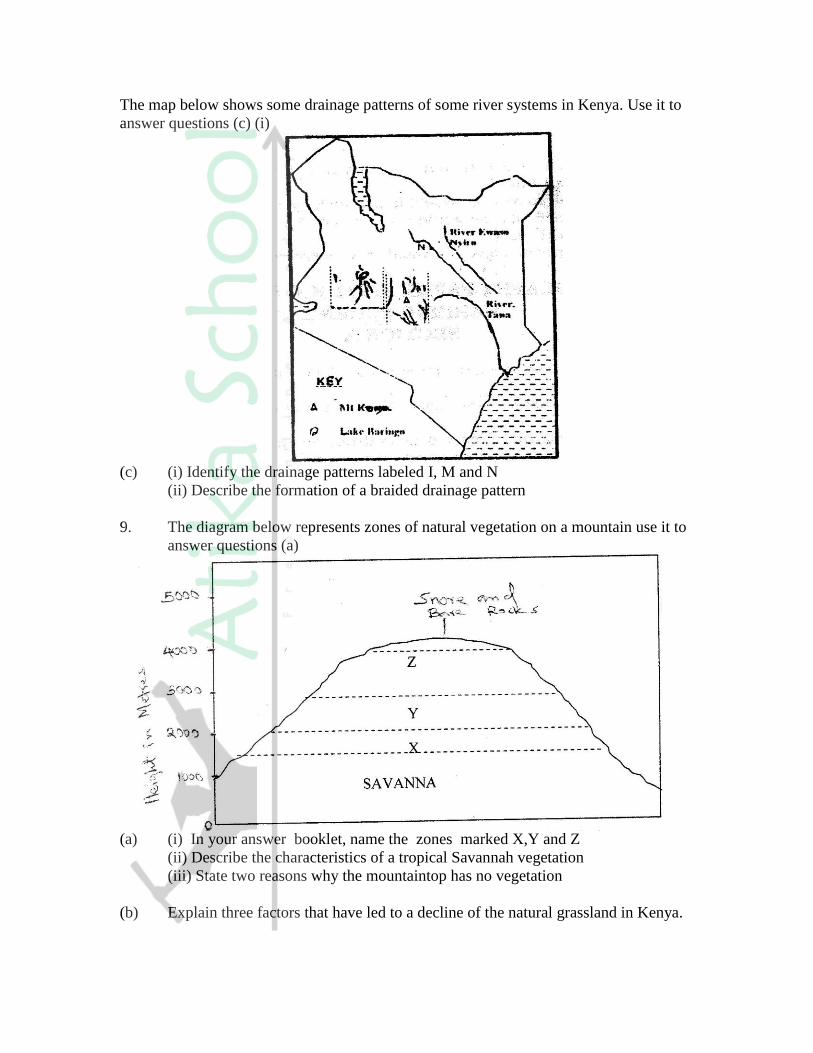
The map below shows some drainage patterns of some river systems in Kenya. Use it to
answer questions (c) (i)
(c) (i) Identify the drainage patterns labeled I, M and N
(ii) Describe the formation of a braided drainage pattern
9. The diagram below represents zones of natural vegetation on a mountain use it to
answer questions (a)
(a) (i) In your answer booklet, name the zones marked X,Y and Z
(ii) Describe the characteristics of a tropical Savannah vegetation
(iii) State two reasons why the mountaintop has no vegetation
(b) Explain three factors that have led to a decline of the natural grassland in Kenya.
(c) Suppose you were to carry out a field study on the relationship between
vegetation and altitude
(i) State three objectives you would formulate for your study
(ii) State three methods you would use to record the information collected during the
field study
(iii) Name two types of maps you would draw to present your findings.
GEOGRAPHY PAPER 312/2 K.C.S.E 1999
SECTION A
Answer all the questions in this section
1. Give four reasons why wildlife conservation is encouraged in Kenya
2. State three problems facing commercial poultry farming in Kenya
3. (a) (i) Apart from providing power state three other benefits of the dams
along river Tana
(ii) State two problems that affect hydroelectric power production
along river Tana
(b) State two factors that hinder the expansion of geothermal power
production in Kenya
4. (a) Give three advantages of railway over road transport
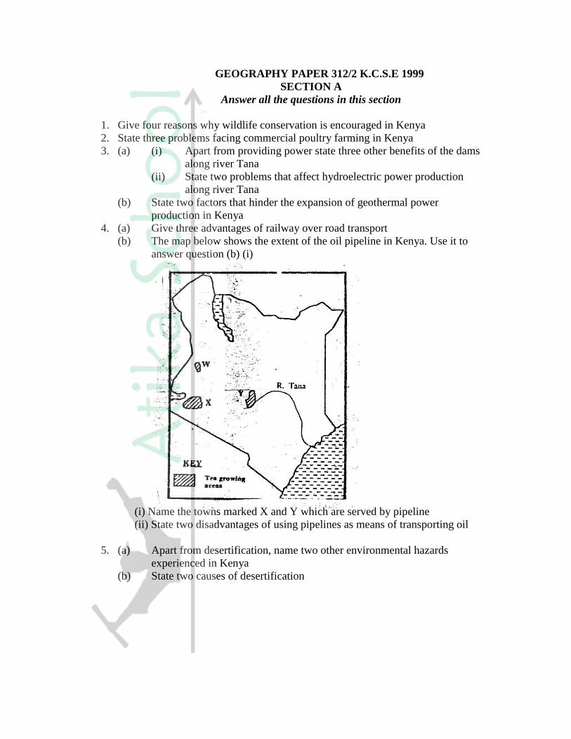
(b) The map below shows the extent of the oil pipeline in Kenya. Use it to
answer question (b) (i)
(i) Name the towns marked X and Y which are served by pipeline
(ii) State two disadvantages of using pipelines as means of transporting oil
5. (a) Apart from desertification, name two other environmental hazards
experienced in Kenya
(b) State two causes of desertification
SECTION B
Answer question 6 and any other questions from this section
6. The table below shows total number of livestock in Kenya in 1986
Type of livestock Number in millions
Cattle ( excluding dairy cattle)
Dairy cattle
Sheep
Goats
Pigs
Chicken
7.0
2.0
7.0
8.5
0.1
20.0
Total 44.6
Source: Central Bureau of Statistics
(a) Using a radius of 5cm, draw a pie chart to represent the information given in the
table above
(b) Explain why the population of sheep is higher than that of dairy cattle
(c) Explain four ways in which the government of Kenya assist nomadic pastoralist
to improve the quality of their livestock
(d) Explain three factors that favour beef farming in Argentina.
7. The pyramid below represents the population structure of country X. Use it to
answer question (a)
(a) Describe the characteristic of the population represented by the pyramid (5mks)
(b) Explain three problems which may result from high population growth rate
(6mks)
(c) Describe three measures that have taken in Kenya to reduce infant mortality
(6mks)
(d) Explain four factors that have led to a high population density in the lake victoria
basin (8mks)

8. The map below shows some major fishing grounds in the world. Use it to answer
question (a)
(a) (i) Name the countries marked P and Q (2mks)
(ii) Explain four conditions that favour fishing in the shaded coastal waters
(8mks)
(b) The diagrams below represent some fishing methods
(i) Name the methods R and S
(ii) Describe how each of the two methods is used in fishing
(c) Explain three measures used to conserve fish in Kenya
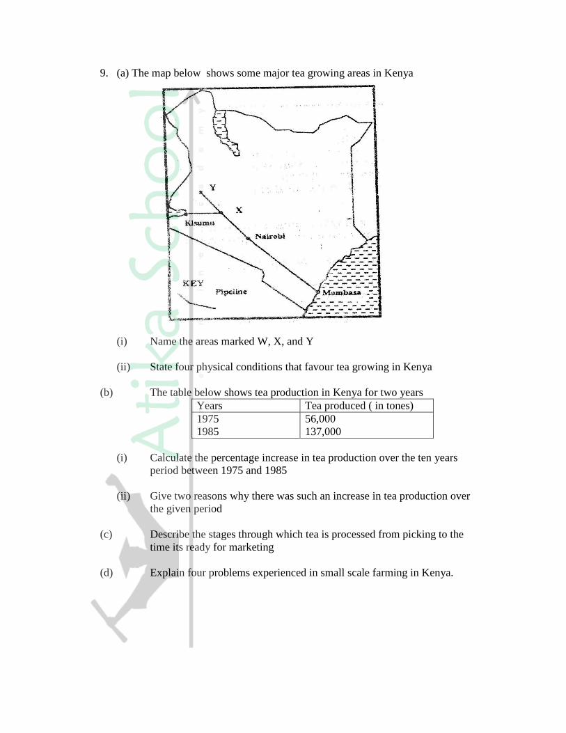
9. (a) The map below shows some major tea growing areas in Kenya
(i) Name the areas marked W, X, and Y
(ii) State four physical conditions that favour tea growing in Kenya
(b) The table below shows tea production in Kenya for two years
Years Tea produced ( in tones)
1975
1985
56,000
137,000
(i) Calculate the percentage increase in tea production over the ten years
period between 1975 and 1985
(ii) Give two reasons why there was such an increase in tea production over
the given period
(c) Describe the stages through which tea is processed from picking to the
time its ready for marketing
(d) Explain four problems experienced in small scale farming in Kenya.
GEOGRAPHY PAPER 311/2 K.C.S.E 2000
Section A
Answer all the questions in this section
1. (a) Name two elements of weather that can be recorded at a school weather station
(b) Give three reasons why the recording of data at a school weather station may be
inaccurate
2. (a) State two factors which influence the occurrence of surface run- off
(b) The diagram below shows a waterfall. Name the feature marked X, Y and Z
3. (a) State two causes of submergence of coasts
(b) Name two features that form as a result of submergence of coasts
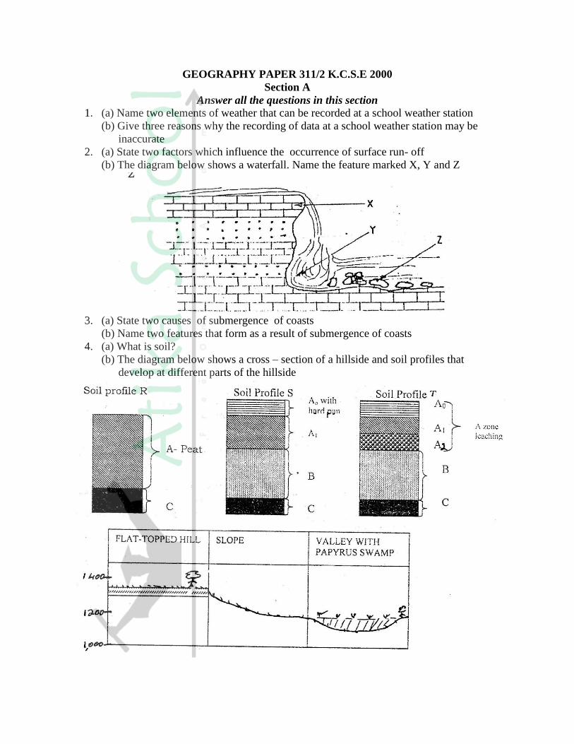
4. (a) What is soil?
(b) The diagram below shows a cross – section of a hillside and soil profiles that
develop at different parts of the hillside
Match the soil profiles with the corresponding parts of the hillside where each profile
is likely to develop
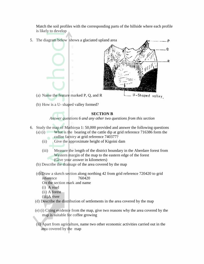
5. The diagram below shows a glaciated upland area
(a) Name the feature marked P, Q, and R
(b) How is a U- shaped valley formed?
SECTION B
Answer questions 6 and any other two questions from this section
6. Study the map of Mathioya 1: 50,000 provided and answer the following questions
(a) (i) What is the bearing of the cattle dip at grid reference 716386 form the
coffee factory at grid reference 740377?
(ii) Give the approximate height of Kigoini dam
(iii) Measure the length of the district boundary in the Aberdare forest from
Western margin of the map to the eastern edge of the forest
(Give your answer in kilometers)
(b) Describe the drainage of the area covered by the map
(c) Draw a sketch section along northing 42 from grid reference 720420 to grid
reference 760420
On the section mark and name
(i) A road
(ii) A forest
(iii)A river
(d) Describe the distribution of settlements in the area covered by the map
(e) (i) Citing evidence from the map, give two reasons why the area covered by the
map is suitable for coffee growing
(ii) Apart from agriculture, name two other economic activities carried out in the
area covered by the map

7. (a) Differentiate between plutonic rocks and volcanic rocks
(b) Describe how lava plateau is formed
(c) (i) Name three volcanic features found in the rift valley of Kenya
(ii) Explain four negative effects of vulcanicity in Kenya
(d) You intend to carry out a field study of a volcanic landscape
(i) State four reasons why it is necessary to conduct a reconnaissance of the area
of study.
(ii) During your field work, you intend to study volcanic rocks, state why you
would need the following items
8. (a) State three characteristics of the inter-tropical convergence zone
(b) With the aid of a labeled diagram, describe how relief rainfall is formed
(c) State five characteristics of the hot desert climate
(d) You are required to carry out a field study to determine the relationship between
climate and vegetation in your district
(i) Give three reasons why you would need the map of the district
(ii) Name two sampling techniques you are likely to use during the field study
(iii)Give two reasons why sampling would be appropriate for this study
(iv) State four methods you would use to record data during the filed study
9. (a) (i) Describe how lake Victoria was formed
(ii) Explain how Lake Victoria has modified the climate of the surrounding
(b) Explain why some lakes in the rift valley have fresh water
(c) State five economic uses of lakes
(d) Explain how each of the following have affected lakes in Kenya
(i) Deforestation
(ii) Industrialization
(iii) Water weeds
GEOGRAPHY PAPER 312/2 K.C.S.E 2000
SECTION A
Answer all the questions in this section
1. State four characteristics of softwood forest in Canada.
2. (a) State two human activities that may be lead to soil erosion
(b) Give four reasons why it is necessary for Kenya to conserve her environment
3. (a) State three physical conditions that favour sugar cane growing in the lake
Victoria basin in Kenya
(b) State three problems experienced in sugar cane farming in Kenya
4. (a) Which are the three functional zones of an ideal urban centre?
(b) What two benefits would there be if more commuters in urban centers in
Kenya used public transport?
5. (a) Name two renewable sources of energy which are exploited in Kenya
(b) Give two reasons why the coal resources in Tanzania have not been exploited
SECTION B
Answer question 6 and any other two questions from this section
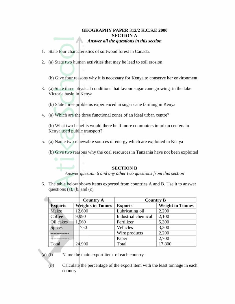
6. The table below shows items exported from countries A and B. Use it to answer
questions (a), (b, and (c)
Country A Country B
Exports Weights in Tonnes Exports Weight in Tonnes
Maize 12,600 Lubricating oil 2,200
Coffee 9,990 Industrial chemical 2,100
Oil cakes 1,560 Fertilizer 5,300
Spices 750 Vehicles 3,300
------------ Wire products 2,200
------------ Paper 2,700
Total 24,900 Total 17,800
(a) (i) Name the main export item of each country
(ii) Calculate the percentage of the export item with the least tonnage in each
country
(b) (i) draw a divide rectangle 15cm long to represent the export items for country A
Country A
Maize: Coffee: Oilcakes: Spices:
(ii) State three advantages of using divided rectangles to represent geographical data.
(c) How would countries A and B benefit from trading with each other?
(d) State five characteristics of bar graph
7. (a) Describe the stages in the reclamation of land from the sea in the Netherlands
(b) Explain four benefits of land reclamation in the Netherlands
(c) (i) Explain three conditions that favour irrigation farming in Kenya
(ii) State five problems experienced in irrigation farming in Kenya
8. (a) Give four reasons why Kenya should become an industrialized country
(b) Explain why some industries are located near sources of water
(c) (i) State five benefits of decentralizing industries in Kenya
(ii) Explain three problems hindering decentralization of industries in
Kenya
(d) State four characteristics of the cottage industry in India
9. (a) (i) Apart from cotton, name two other fibre crops
(ii) State two climatic conditions that are ideal for cotton farming
(b) State three differences between cotton growing in Kenya and U.S.A
Kenya U.S.A
(c) Explain three ways in which the government of Kenya encourages cotton
farming
(d) (i) apart from making textiles, state three other uses of cotton wool
(ii) Explain three problems faced by the textile industry in Kenya
GEOGRAPHY PAPER 312 /1 K.C.S.E 2001
SECTION A
Answer all the questions in this section
1. (a) (i) Give the two dates in a year during which the number of hours of
darkness is equal in both the north and south poles.
(ii) Why do the lengths of days and nights vary from one part of the
earth to another?
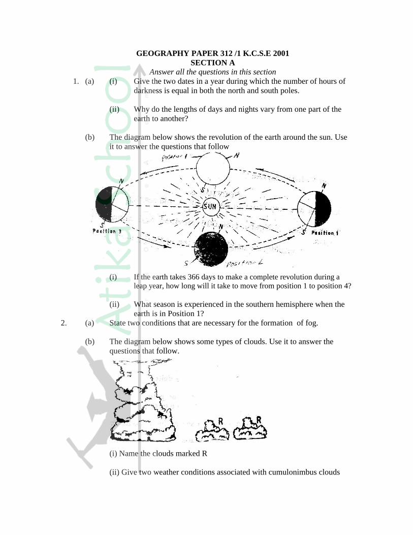
(b) The diagram below shows the revolution of the earth around the sun. Use
it to answer the questions that follow
(i) If the earth takes 366 days to make a complete revolution during a
leap year, how long will it take to move from position 1 to position 4?
(ii) What season is experienced in the southern hemisphere when the
earth is in Position 1?
2. (a) State two conditions that are necessary for the formation of fog.
(b) The diagram below shows some types of clouds. Use it to answer the
questions that follow.
(i) Name the clouds marked R
(ii) Give two weather conditions associated with cumulonimbus clouds
3. (a) What is mechanical weathering?
(b) How is an exfoliation dome formed?
4. (a) State three climatic conditions experienced in the Sahara desert
(b)State three ways in which plants adapt to hot desert conditions
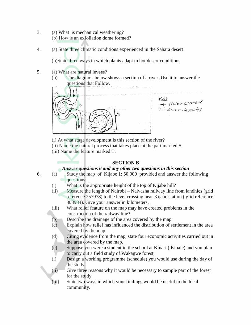
5. (a) What are natural levees?
(b) The diagrams below shows a section of a river. Use it to answer the
questions that Follow.
(i) At what stage development is this section of the river?
(ii) Name the natural process that takes place at the part marked S
(iii) Name the feature marked T.
SECTION B
Answer questions 6 and any other two questions in this section
6. (a) Study the map of Kijabe 1: 50,000 provided and answer the following
questions:
(i) What is the appropriate height of the top of Kijabe hill?
(ii) Measure the length of Nairobi – Naivasha railway line from landhies (grid
reference 257978) to the level crossing near Kijabe station ( grid reference
308984). Give your answer in kilometers.
(iii) What relief feature on the map may have created problems in the
construction of the railway line?
(b) Describe the drainage of the area covered by the map
(c) Explain how relief has influenced the distribution of settlement in the area
covered by the map.
(d) Citing evidence from the map, state four economic activities carried out in
the area covered by the map.
(e) Suppose you were a student in the school at Kinari ( Kinale) and you plan
to carry out a field study of Wakagwe forest,
(i) Design a working programme (schedule) you would use during the day of
the study
(ii) Give three reasons why it would be necessary to sample part of the forest
for the study
(iii) State two ways in which your findings would be useful to the local
community.
7. (a)
(i) What is a rock?
(ii) Describe three ways through which sedimentary rocks are formed
- Mechanically formed
- Organically formed
- Chemically formed
(b) Describe two process through which sedimentary rocks changer into
metamorphic rocks
(c) Give an example of each of the following types of igneous rocks
(i) Plutonic rocks
(ii) Hypabyssal rocks
(iii) Volcanic rocks
(e) Suppose you were to carry out a field study of rocks within the vicinity of your
school
(i) Name three secondary sources of information you would use to prepare
for the field study
(ii) State four activities you would carry during the filed study
(iii) State three problems you are likely to experience during the field study
8. (a) Name two types of submerge coasts
(b) Explain how the following factors determine the effectiveness of wave
erosion along a coast
(i) Nature of the material transported by waves
(ii) Nature of the coastal rocks
(c) With the aid of labeled diagrams, describe the process through which a
stack is formed
(d) (i) State four conditions that favour the growth of coral
(ii) Explain three ways in which coral contributes to the economic
development of Kenya.
9. (a) Name three components of soil
(b) Explain how the following factors influence the formation of soil
(i) Climate
(ii) Topography
(c)
(i) State two economic uses of soil
(ii) Explain four ways in which human activities contribute to soil erosion
(d) Describe how the following types of erosion occur
(i) Sheet erosion
(ii) Gully erosion
GEOGRAPHY PAPER 312/2 K.C.S.E 2001
QUESTIONS
SECTION A
Answer all the questions in this section
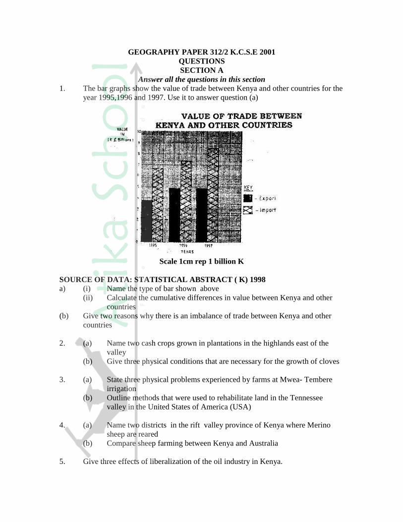
1. The bar graphs show the value of trade between Kenya and other countries for the
year 1995,1996 and 1997. Use it to answer question (a)
Scale 1cm rep 1 billion K
SOURCE OF DATA: STATISTICAL ABSTRACT ( K) 1998
a) (i) Name the type of bar shown above
(ii) Calculate the cumulative differences in value between Kenya and other
countries
(b) Give two reasons why there is an imbalance of trade between Kenya and other
countries
2. (a) Name two cash crops grown in plantations in the highlands east of the
valley
(b) Give three physical conditions that are necessary for the growth of cloves
3. (a) State three physical problems experienced by farms at Mwea- Tembere
irrigation
(b) Outline methods that were used to rehabilitate land in the Tennessee
valley in the United States of America (USA)
4. (a) Name two districts in the rift valley province of Kenya where Merino
sheep are reared
(b) Compare sheep farming between Kenya and Australia
5. Give three effects of liberalization of the oil industry in Kenya.

SECTION B
Answer question 6 and any other questions from this section
6. Study the photograph below and use it to answer questions (a)
(a) (i) Name the type of photograph shown
(ii) Draw a rectangle measuring 15cm to 10cm to represent the area of
photograph
(iii) On the rectangle draw a sketch of the photograph and label three physical
features
(iv) Explain two physical conditions that would discourage setting up of a
game park in the area shown on the photograph
(b) Apart from national parks, outline four other ways in which wildlife in conserved
in Kenya
(c) Give four reasons why domestic tourism is being encouraged in Kenya
(d) Explain four factors which Switzerland receive more tourists than Kenya
7. Use the map of East Africa below to answer questions
(a) Name the towns marked P,Q and R
(b) (i) Explain three physical factors that influence the location of Mombasa
(ii) Explain four problems that Mombasa experiences as it grows
(c) Compare the ports of Mombasa and Rotterdam under the following subheadings
(i) Transport links to the interior
(ii) Mechanization of the ports
(iii) Size of the ports
(iv) Climate experienced at the ports
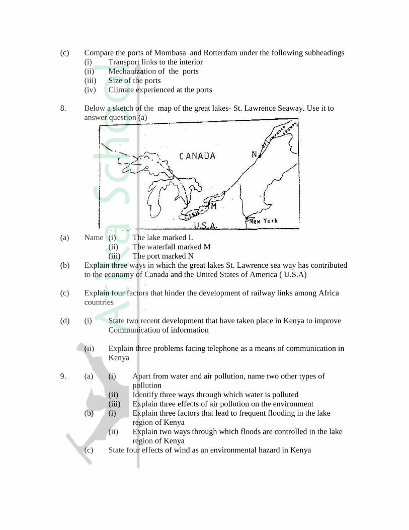
8. Below a sketch of the map of the great lakes- St. Lawrence Seaway. Use it to
answer question (a)
(a) Name (i) The lake marked L
(ii) The waterfall marked M
(iii) The port marked N
(b) Explain three ways in which the great lakes St. Lawrence sea way has contributed
to the economy of Canada and the United States of America ( U.S.A)
(c) Explain four factors that hinder the development of railway links among Africa
countries
(d) (i) State two recent development that have taken place in Kenya to improve
Communication of information
(ii) Explain three problems facing telephone as a means of communication in
Kenya
9. (a) (i) Apart from water and air pollution, name two other types of
pollution
(ii) Identify three ways through which water is polluted
(iii) Explain three effects of air pollution on the environment
(b) (i) Explain three factors that lead to frequent flooding in the lake
region of Kenya
(ii) Explain two ways through which floods are controlled in the lake
region of Kenya
(c) State four effects of wind as an environmental hazard in Kenya

GEOGRAPHY PAPER 312 / 1 K.C.S.E 2002
SECTION A
Answer all the questions in this section
1. The diagram below represents features produced by faulting.
Use it to answer questions that follow.
a) Name the features marked P,Q, and R
b) Differentiate between a normal faulty and a reverse fault.
2. Use the diagram below to answer question (a)
a) i) What type of a delta is represented by the diagram?
ii) Name the features marked E,F, and G.
c) State two conditions necessary for the formation of a delta.
3. a) what is desertification?
b) State two negative effects of desertification.
4 a) The table below shows climatic data of a station in Kenya.
Use it to answer question(a)
Month Jan Feb Mar April May June Jul Aug Sep Oct Nov Dec
Temp
in oC
28.9 29.7 30.3 29.9 29.7 29.2 28.4 28.7 29.6 30.1 29.2 28.7
Rainfall
in mm
9.0 8.0 21.0 49.0 25.0 9.0 20.0 10.0 4.0 10.0 17.0 11.0
i) What is the annual range of temperature at the station?
ii) Calculate the total rainfall for the station.
b) State three factors that influence climate.
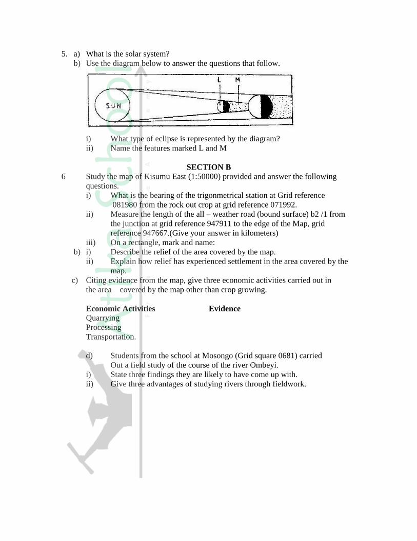
5. a) What is the solar system?
b) Use the diagram below to answer the questions that follow.
i) What type of eclipse is represented by the diagram?
ii) Name the features marked L and M
SECTION B
6 Study the map of Kisumu East (1:50000) provided and answer the following
questions.
i) What is the bearing of the trigonmetrical station at Grid reference
081980 from the rock out crop at grid reference 071992.
ii) Measure the length of the all – weather road (bound surface) b2 /1 from
the junction at grid reference 947911 to the edge of the Map, grid
reference 947667.(Give your answer in kilometers)
iii) On a rectangle, mark and name:
b) i) Describe the relief of the area covered by the map.
ii) Explain how relief has experienced settlement in the area covered by the
map.
c) Citing evidence from the map, give three economic activities carried out in
the area covered by the map other than crop growing.
Economic Activities Evidence
Quarrying
Processing
Transportation.
d) Students from the school at Mosongo (Grid square 0681) carried
Out a field study of the course of the river Ombeyi.
i) State three findings they are likely to have come up with.
ii) Give three advantages of studying rivers through fieldwork.

7. The map below shows the physical regions of Kenya. Use it to answer
the questions that follow.
a) i) Name the regions marked.
ii) Give the major economic importance of each of the lakes
marked S and T.S
iii) Describe how Mt.kenya was formed.
iv) State three ways through which Mt.kenya has influenced
the drainage of the area.
c) Suppose students are to carry out a field study of the soils
found in the Nyika plateau.
i) State three methods they are likely to use to collect data.
ii) The students identity the soils for further analysis. Give three
characteristics of the desert soils that they are likely to study.
8. The map below shows some vegetation regions of the world.
Use it to answer questions (a) to (c).
a) Name the temperate grasslands marked H, J and K.
b) Describe the characteristics of the natural vegetation found in the shaded
area marked N.
c) i) Explain four ways in which the vegetation found in the area
marked M adapts to the environment conditions of the region.
d) You are required to carry out a field study of the vegetation within the
local environment:
i) a part from identifying the different types of plants, state three
other activities you will carry out during the field study.
ii) How will you identify the different types of plants?
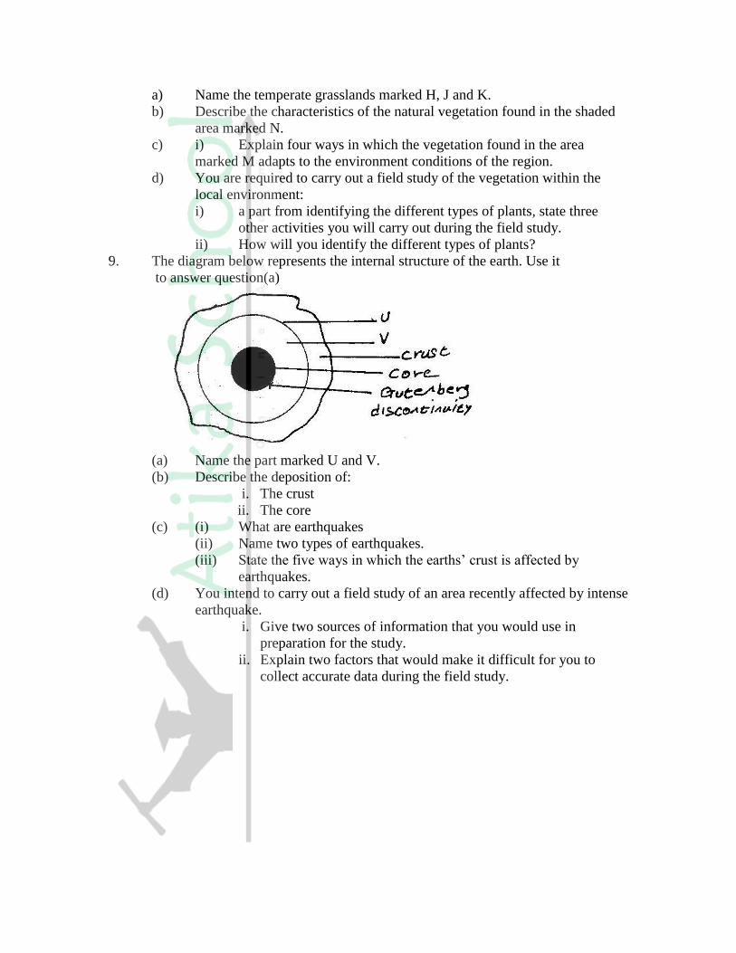
9. The diagram below represents the internal structure of the earth. Use it
to answer question(a)
(a) Name the part marked U and V.
(b) Describe the deposition of:
i. The crust
ii. The core
(c) (i) What are earthquakes
(ii) Name two types of earthquakes.
(iii) State the five ways in which the earths’ crust is affected by
earthquakes.
(d) You intend to carry out a field study of an area recently affected by intense
earthquake.
i. Give two sources of information that you would use in
preparation for the study.
ii. Explain two factors that would make it difficult for you to
collect accurate data during the field study.
GEOGRAPHY PAPER 311/2 K.C.S.E 2002
SECTION A
Answer all the questions in this section
1. State four reasons why the northern parts of Kenya are sparsely populated.
2. a) Give three problems experienced in the implementation of the National
Food Policy.
3. a) State three measures that have been taken to conserve fisheries in Kenya.
b) Give four reasons why Norway is a great fishing nation.
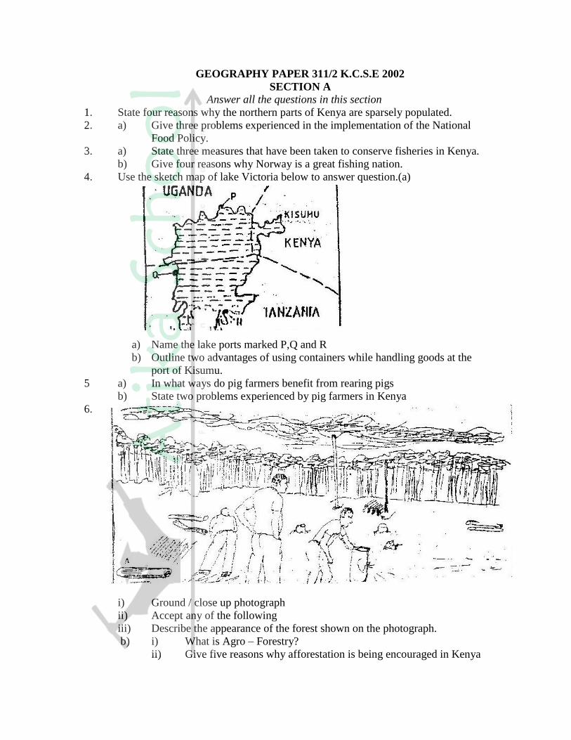
4. Use the sketch map of lake Victoria below to answer question.(a)
a) Name the lake ports marked P,Q and R
b) Outline two advantages of using containers while handling goods at the
port of Kisumu.
5 a) In what ways do pig farmers benefit from rearing pigs
b) State two problems experienced by pig farmers in Kenya
6.
i) Ground / close up photograph
ii) Accept any of the following
iii) Describe the appearance of the forest shown on the photograph.
b) i) What is Agro – Forestry?
ii) Give five reasons why afforestation is being encouraged in Kenya

c) Compare forestry in Canada and Kenya under the following sub –
headings.
i) Tree harvesting
ii) Transportation of logs.
d) Explain two problems that affect forestry in Canada.
7. a) Draw an outline map of Nigeria
- On the map shade the main oil palm growing area.
- Mark and name Lagos
b) State five physical conditions necessary for the growing of pal moil.
c) i) Describe the commercial production of palm oil in Nigeria.
ii) A part from making oil , give four other uses of palm oil
iii) Name three crops grown in Kenya that are processed to produce
vegetable oil.
8 a ( i) Name two non – renewable sources of energy.
(ii) Explain four physical factors that influence the location of a
hydroelectric power station.
b) A part from generating H.E.), give three other benefits that have resulted
from the construction of Masing Dam.
c) Explain three benefits that would result form rural electrification in
Kenya.
d) In what three ways did the power shortages resulting from the
drought of the years 1999 and 2000 affect the industrial sector in Kenya.
9. Use the map of Africa to answer question (a) (i)
i) Name the minerals mined in the areas marked S, T and V.
ii) State two formation in which mineral ores occur.
b) Explain four problems, which Zambia experiences in the exportation
of copper.
c) Explain three ways in which coal contributes to the economy
of Zimbabwe.
d) Describe three negative effects of open cast mining on the environment.

GEOGRAPHY PAPER 312/1 K. C. S. E, 2003
SECTION A
Answer all the questions in this section
1. a) State TWO factors that influence the rate of erosion by the river in its
upper course.
b) (i) Define river rejuvenation
Name two features that result from river rejuvenation
2. a) State three conditions necessary for the development of a Karst scenery
b) Give two reasons why there are few settlements in Karst landscapes
3 a) State two conditions which may influence the occurrence of landslides
b) Using the diagram (in question paper), name
(i) The type of mass movement shown
(ii) The features marked P and Q
4. a) i) In your answer booklet draw a diagram to show a simple fold and
on it mark and name
b) Name two fold mountains in Africa
5. a) Name the type of rocks which results from the metamorphism of:
(i) Granite
(ii) Clay
b) Give two reasons why sedimentary rocks are widespread in the coastal
plain of Kenya.
6. Study the map of Menu (1: 50,000, sheet 108/3) provided and answer the
following questions
a) i) What is the height of Njorivola hill at grid square 4117
ii) Give two methods used in representing religion the map contract
iii) Measure the bearing of the peak of Kanjai hill form the peak of
Kieru hill to the north east of the map extract.
b) Citing evidence from the map, explain:
(i) Two factors trading in the area covered by the map
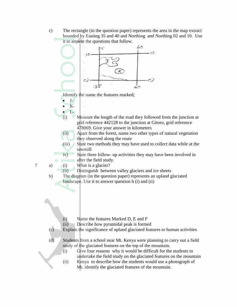
c) The rectangle (in the question paper) represents the area in the map extract
bounded by Easting 35 and 40 and Northing and Northing 02 and 10. Use
it to answer the questions that follow.
Identify the name the features marked;
J-
K-
L-
(i) Measure the length of the road they followed from the junction at
grid reference 442128 to the junction at Gitoro, grid reference
478069. Give your answer in kilometers
(ii) Apart from the forest, name two other types of natural vegetation
they observed along the route
(iii) State two methods they may have used to collect data while at the
sawmill
iv) State three follow- up activities they may have been involved in
after the field study.
7 a) (i) What is a glacier?
(ii) Distinguish between valley glaciers and ice sheets
b) The diagram (in the question paper) represents an upland glaciated
landscape. Use it to answer question b (i) and (ii)
(i) Name the features Marked D, E and F
(ii) Describe how pyramidal peak is formed
(c) Explain the significance of upland glaciated features to human activities
(d) Students from a school near Mt. Kenya were planning to carry out a field
study of the glaciated features on the top of the mountain.
(i) Give four reasons why it would be difficult for the students to
undertake the field study on the glaciated features on the mountain
(ii) Kenya to describe how the students would use a photograph of
Mt. identify the glaciated features of the mountain.
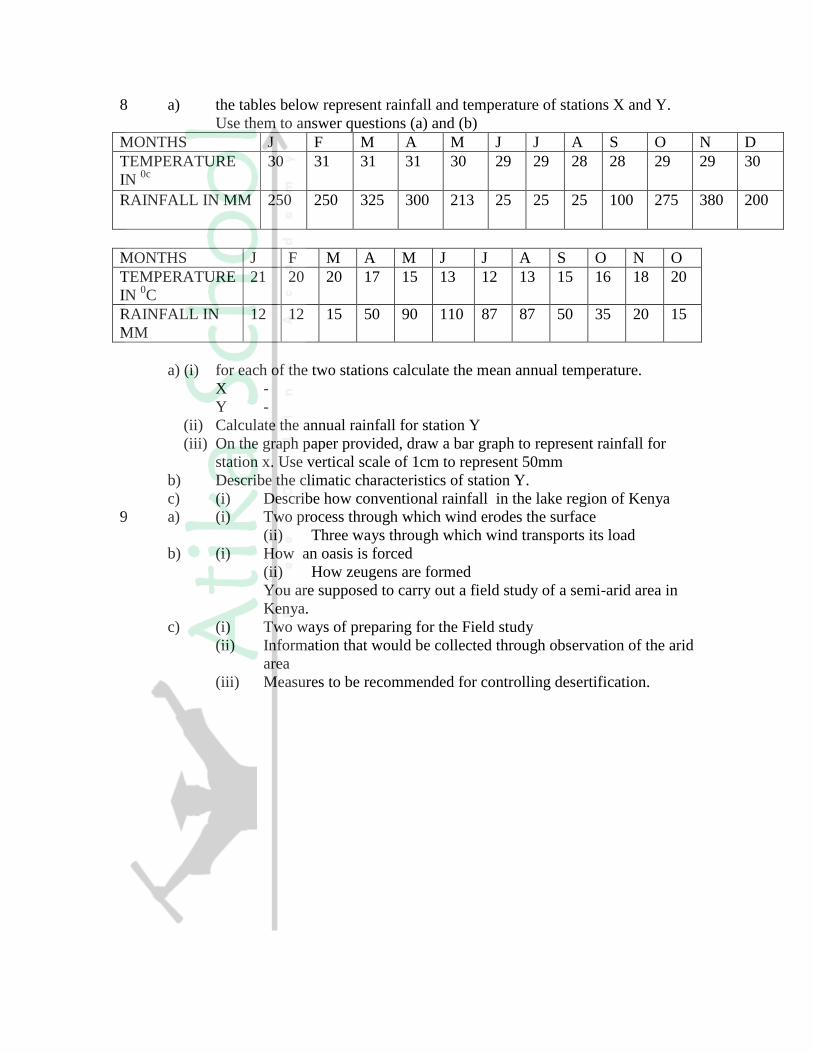
8 a) the tables below represent rainfall and temperature of stations X and Y.
Use them to answer questions (a) and (b)
MONTHS J F M A M J J A S O N D
TEMPERATURE
IN 0c
30 31 31 31 30 29 29 28 28 29 29 30
RAINFALL IN MM 250 250 325 300 213 25 25 25 100 275 380 200
MONTHS J F M A M J J A S O N O
TEMPERATURE
IN 0C
21 20 20 17 15 13 12 13 15 16 18 20
RAINFALL IN
MM
12 12 15 50 90 110 87 87 50 35 20 15
a) (i) for each of the two stations calculate the mean annual temperature.
X -
Y -
(ii) Calculate the annual rainfall for station Y
(iii) On the graph paper provided, draw a bar graph to represent rainfall for
station x. Use vertical scale of 1cm to represent 50mm
b) Describe the climatic characteristics of station Y.
c) (i) Describe how conventional rainfall in the lake region of Kenya
9 a) (i) Two process through which wind erodes the surface
(ii) Three ways through which wind transports its load
b) (i) How an oasis is forced
(ii) How zeugens are formed
You are supposed to carry out a field study of a semi-arid area in
Kenya.
c) (i) Two ways of preparing for the Field study
(ii) Information that would be collected through observation of the arid
area
(iii) Measures to be recommended for controlling desertification.
GEOGRAPHY PAPER 312/2 K.C.S.E 2003 SECTION A
Answer all the questions in this section
1. a) What is urbanization?
b) Give two differences in the function of New York and
Nairobi cities.
New York Nairobi
2. a) A part from draining swamps, state two other methods
used in reclaiming land in Kenya.
b) State three benefits that resulted from reclamation of the
Yata swamp
3. a) Give three physical factors that favour coffee growing
in Kenya highlands.
b) State two problems facing coffee farming in Kenya
4. a) Why is it necessary to conserve water?
b) How does terracing help in water conservation?
5. a) State three reasons why National parks have been established
in Kenya.
b) A part from marine parks, give two other tourist attractions
found at the coast of Kenya.
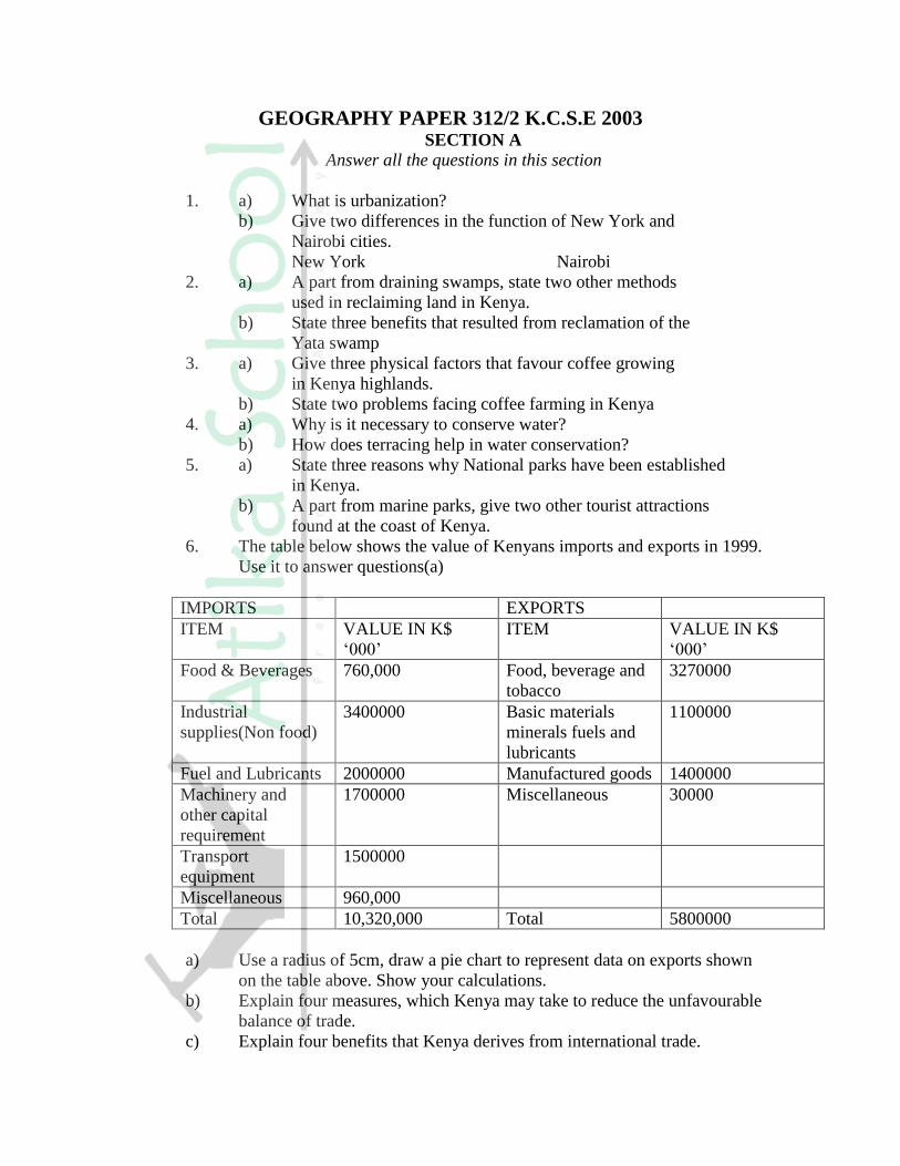
6. The table below shows the value of Kenyans imports and exports in 1999.
Use it to answer questions(a)
IMPORTS EXPORTS
ITEM VALUE IN K$
‘000’
ITEM VALUE IN K$
‘000’
Food & Beverages 760,000 Food, beverage and
tobacco
3270000
Industrial
supplies(Non food)
3400000 Basic materials
minerals fuels and
lubricants
1100000
Fuel and Lubricants 2000000 Manufactured goods 1400000
Machinery and
other capital
requirement
1700000 Miscellaneous 30000
Transport
equipment
1500000
Miscellaneous 960,000
Total 10,320,000 Total 5800000
a) Use a radius of 5cm, draw a pie chart to represent data on exports shown
on the table above. Show your calculations.
b) Explain four measures, which Kenya may take to reduce the unfavourable
balance of trade.
c) Explain four benefits that Kenya derives from international trade.

7. a) i) Give two primary sources of population on data.
ii) What information can be derived from a population pyramid?
b) Describe three ways in which the population of Kenya differs
from that of Sweden.
c) Explain four reasons of rural migration in Kenya.
d) Explain three problems, which result from the high
population growth rate in the East African countries.
8. a) Name three agricultural non food manufacturing industries
in Kenya.
b)i) Draw outline map of Kenya (map should have a frame / outline
correct).
ii) On the outline map, mark and name two towns where motor
vehicles are assembled.
c)i) Explain three causes of the decline in the textile industry in Kenya.
ii) Describe the measures that should be taken to control the following
effects of industrialization.
Water pollution
Rural urban migration.
d) Explain four factors, which have favoured the development
of the electronics industry in Japan.
9. Use the map of North America (in question paper) to answer question (a)
a)i) Name two methods of fishing used in the shaded areas,
ii) Name two types of fish caught along the west coast of Canada
iii) Explain how the following factors favour fishing in the
shaded areas. Indented coastline.
b) Explain four ways in which marine fisheries in Kenya
can be conserved.
c) i) Give three methods used to preserve fish
ii) Explain three problems experience by fishermen while
fishing in Lake Victoria.

K..C.S.E 2004 GEOGRAPHY PAPER 1
SECTION A
Answer all the questions in this section
1. a) Name two types of soil according to texture (2mks)
b) State two ways in which humus improves the quality of soil (2mks)
2. a) What is latitude?
b) What is the time at Hola on 400 E when the time at Tema on 0
0 longitude
is 12.00 noon? (2mks)
3. The diagram below show some features of a Karst scenery. Use it to answer
questions (a)
a) Name the features marked P, Q, and R. (5mks)
b) Describe carbonation as a process of Chemical weathering (3mks)
4 a) What do you understand by:
(i) Microclimate?
(ii) Green house effect?
b) Name three instruments to match three elements of weather that can be
measured at a school weather station (3mks)
5 a) What is a lake?
b) State three ways through which lakes are formed? (3mks)
SECTION B
Answer question questions 6 and any other two questions from this section
6. Study the map of Kipkabus (1:50,000, sheet 104/4 provided and answer the
following questions.
a) (i) give the latitude and longitude of the South west corner of the map
extract. (2mks)
(ii) What is the area of Tingwa Hill Forest? (2mks)
b) (i) name the planted vegetation in the area covered by the map (1mk)
(ii) Explain how relief and human activities have influenced the
distribution of natural vegetation in the area covered by the map
(4mks)
c) i) Using a vertical scale of 1 cm to represent 100 meters draw a cross
section Along the line marked X-Y (5mks)
ii) On the cross section mark and label the following:-
A steep slope
A hill
A col
A river valley (4Mks)
iii) Calculate the vertical exaggeration of the cross section (2mks)
d) Student of Chepketert school carried out a field study of Kipkabus town.
i) Name two types of roads they used to travel to Kipkabus
(2mks)
ii) State three functions of Kipkabus that they identified (3mks)
7. a) i) A part from the Rift Valley name two other relief features that
were formed as result of faulting.
(2mks)
ii) With the aid of a well labeled diagram, describe how a Rift Valley
is formed by tensional forces. (8mks)
b) Explain four effects of faulting (8mks)
c) Students are planning to carry out a field study of an area affected by
faulting
i) State four reasons why it is important for the students to have a
pre-visit of the area (4mks)
ii) One of the ways they would use to collect data is through direct
observation. Give three disadvantages of direct observation in the
study of such an area. (3mks)
8. a) State four factors that determine the amount of surface run off (4mks)
b) Describe three ways in which a river transports its load (6mks)
c) Using a diagrams, describe the following drainage patterns
i) Dendritic (2mks)
ii) Trellis (2mks)
iii) Centripetal (2mks)
d) A form four class is planning to carry out a field study of a waterfall.
i) State five ways in which they would prepare for the study (5mks)
ii) Give four methods they would use to collect information at the
waterfall (4mks)
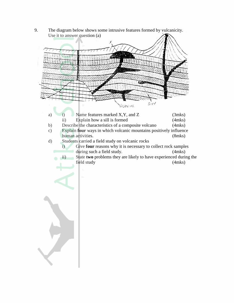
9. The diagram below shows some intrusive features formed by vulcanicity.
Use it to answer question (a)
a) i) Name features marked X,Y, and Z (3mks)
ii) Explain how a sill is formed (4mks)
b) Describe the characteristics of a composite volcano (4mks)
c) Explain four ways in which volcanic mountains positively influence
human activities. (8mks)
d) Students carried a field study on volcanic rocks
i) Give four reasons why it is necessary to collect rock samples
during such a field study. (4mks)
ii) State two problems they are likely to have experienced during the
field study (4mks)
KCSE 2004 GEOGRAPHY PAPER 2
SECTION A
Answer all the questions in this section
1. a) List two factors that determine the distribution of forests in Kenya. (2mks)
b) Give three economic uses of mangrove forests (2mks)
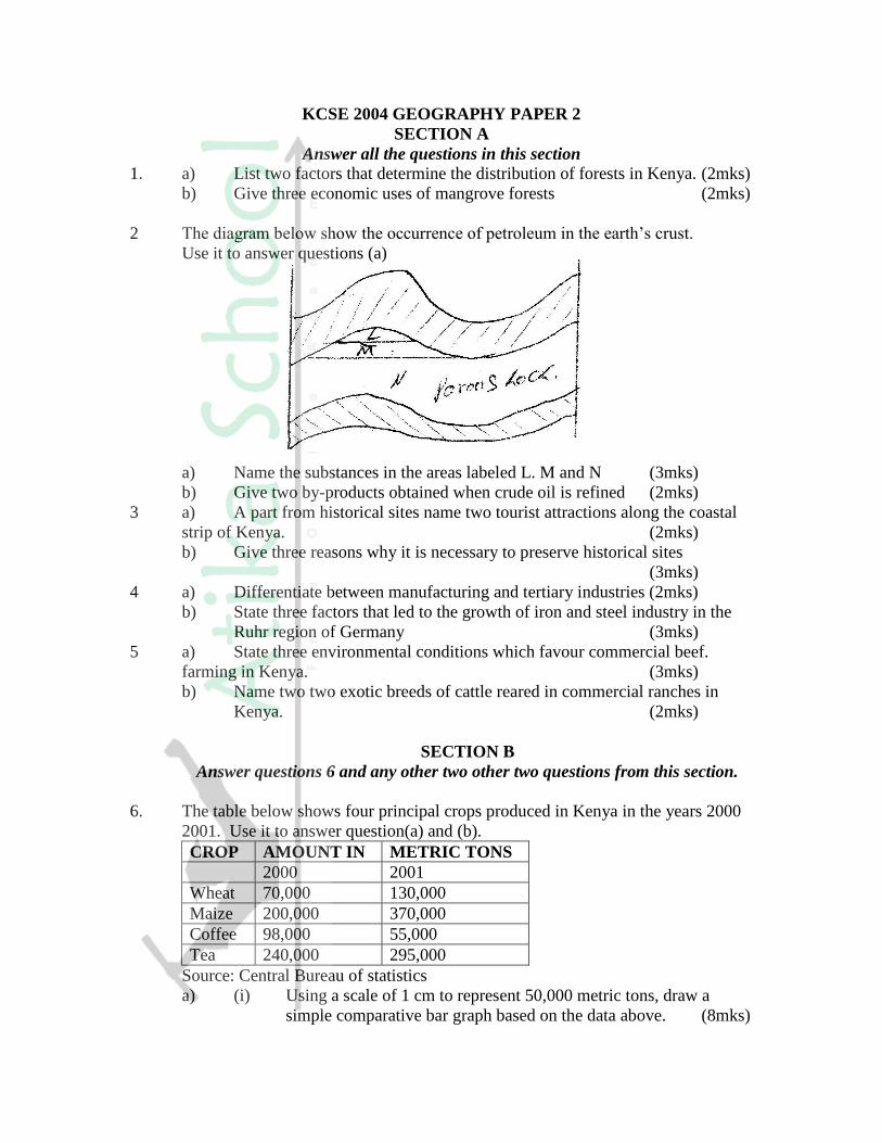
2 The diagram below show the occurrence of petroleum in the earth’s crust.
Use it to answer questions (a)
a) Name the substances in the areas labeled L. M and N (3mks)
b) Give two by-products obtained when crude oil is refined (2mks)
3 a) A part from historical sites name two tourist attractions along the coastal
strip of Kenya. (2mks)
b) Give three reasons why it is necessary to preserve historical sites
(3mks)
4 a) Differentiate between manufacturing and tertiary industries (2mks)
b) State three factors that led to the growth of iron and steel industry in the
Ruhr region of Germany (3mks)
5 a) State three environmental conditions which favour commercial beef.
farming in Kenya. (3mks)
b) Name two two exotic breeds of cattle reared in commercial ranches in
Kenya. (2mks)
SECTION B
Answer questions 6 and any other two other two questions from this section.
6. The table below shows four principal crops produced in Kenya in the years 2000
2001. Use it to answer question(a) and (b).
CROP AMOUNT IN METRIC TONS
2000 2001
Wheat 70,000 130,000
Maize 200,000 370,000
Coffee 98,000 55,000
Tea 240,000 295,000
Source: Central Bureau of statistics
a) (i) Using a scale of 1 cm to represent 50,000 metric tons, draw a
simple comparative bar graph based on the data above. (8mks)
(ii) State two advantages of using comparative bar graphs (2mks)
b) Calculate the percentage increase in wheat production between the years
2000 and 2001. (2mks)
c) State five physical conditions required for the growing of tea in Kenya
(5mks)
d) Explain four problems experienced in small scale tea farming in Kenya
(8mks)
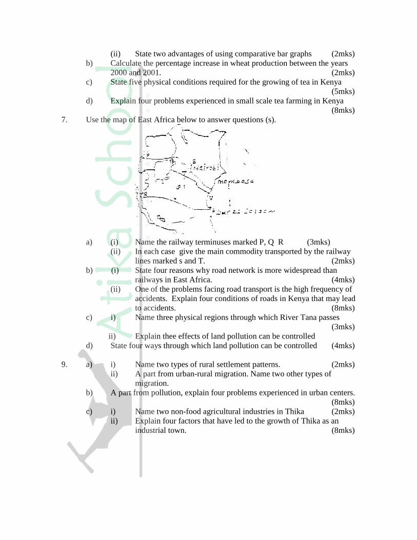
7. Use the map of East Africa below to answer questions (s).
a) (i) Name the railway terminuses marked P, Q R (3mks)
(ii) In each case give the main commodity transported by the railway
lines marked s and T. (2mks)
b) (i) State four reasons why road network is more widespread than
railways in East Africa. (4mks)
(ii) One of the problems facing road transport is the high frequency of
accidents. Explain four conditions of roads in Kenya that may lead
to accidents. (8mks)
c) i) Name three physical regions through which River Tana passes
(3mks)
ii) Explain thee effects of land pollution can be controlled
d) State four ways through which land pollution can be controlled (4mks)
9. a) i) Name two types of rural settlement patterns. (2mks)
ii) A part from urban-rural migration. Name two other types of
migration.
b) A part from pollution, explain four problems experienced in urban centers.
(8mks)
c) i) Name two non-food agricultural industries in Thika (2mks)
ii) Explain four factors that have led to the growth of Thika as an
industrial town. (8mks)

GEOGRAPHY PAPER 1 2005
Answer all the questions in this section
SECTION A
1. (a) Name two theories of the origin of the earth ( 2 mks)
(b) Name four layers of the earth’s atmosphere ( 4 mks)
2. (a) The diagram below shows the hydrological cycle. Name the stages marked
E, F, and G (3mks)
(b) Differentiate between watershed and a catchments area ( 2 mks)
3. (a) State two characteristics of sedimentary rocks ( 2mks)
(b) Give two examples of chemically formed sedimentary rocks ( 2mks)
4. (a) Name a place in Kenya where tarns are found ( 1mk)
(b) Describe how a tarn is formed ( 4 mks)
5. (a) What is a natural vegetation? ( 2mks)
(b) State three characteristics of Mediterranean vegetation ( 3 mks)
SECTION B
Answer questions 6 and any other two questions in this section
6. Study the map of SILALONI (1:50,000) provided and answer the following
questions
(a) (i) Convert the ratio scale of the map extract into a statement scale
( 1 mk)
(ii) Give the six – figure grid reference of the point where the power
line crosses the Samburu – Silaloni dry weather road ( 1 mk)
(iii) Give three types of natural vegetation shown in the area covered
by the map ( 2 mks)

(b) (i) Identify two sources of water in the area covered by the map (2mks)
(ii) Using evidence from the map, suggest four functions of Tsangatsini
township. (4mks)
(c) Using a vertical scale of 1 cm to represent 20m:
(i) draw a cross section from grid reference 400915 to 500915 ( 3 mks)
(ii) On the cross section, mark and name the following:
A river
A road
A quarry
(iii) Calculate the vertical exaggeration of the section you have drawn
( 2 mks)
(d) Students at Silaloni school (grid square 3199) carried out a field study on
the soils around the school
(i) Give four reasons why a reconnaissance was necessary for the field
study (4mks)
(ii) Name two types of soils they collected ( 2mk)
7. Use the diagram below to answer question (a)
(a) Name the coastal features marked H,J,K,L and M (5mks)
(b) (i) state four conditions necessary for the formation of a beach (4mks)
(ii) Describe three processes involved in marine erosion (6mks)
(b) You are planning to carry out a field study on the depositional features
along the coast of Kenya
(i) State five objectives you would formulate for your study (5mks)
(ii) Give five methods you would use to record the information collected
(5mks)
8. (a) Name one fold mountain in:
(i) Asia ( 1mk)
(ii) North America ( 1mk)
(iii) South Africa ( 1 mk)
(b) (i) Apart from fold mountains, name three other features resulting
from folding (3mks)
(ii) With the aid of a labeled diagram, describe the formation of an
thrust fold
(c) Explain four effects of fold mountains on human activities (8mks)
(d) Students are planning to carry out a field study on landforms in their
strict.
(i) State three ways in which the students would prepare themselves
for the filed study (3mks)
(ii) Give two advantages of studying landforms through field work
(2mks)
9. Use the map below to answer questions (a) and (b)
(a) Name:
(i) The type of climate found in the shaded area marked Q ( 1 mk)
(ii) The ocean current marked R and S ( 2 mks)
(b) Describe the characteristics of the type of climate found in the shaded area
marked T ( 8 mks)
(c) Explain how the following factors influence climate
(i) Altitude ( 4 mks)
(ii) Distance from the sea ( 4 mks)
(c) (i) Describe a suitable site where you would locate a weather station in
your School ( 2 mks)
(ii) Give reasons why a Stevenson’s screen is:
- Painted White ( 2 mks)
- Has louvers ( 2 mks)
GEOGRAPHY PAPER 2 2005
Answer all questions in section A. In section B answers question 6 and any other two
questions
SECTION A
1. (a) Name the two types of human settlements ( 2 mks)
Use the sketch map below to answer questions (b)
(b) Identify the settlement pattern marked Q and R ( 2 mks)
2. (a) State three characteristics of Jua Kali industries in Kenya ( 3 mks)
(b) Give three problems facing the Jua Kali Industries in Kenya ( 3 mks)
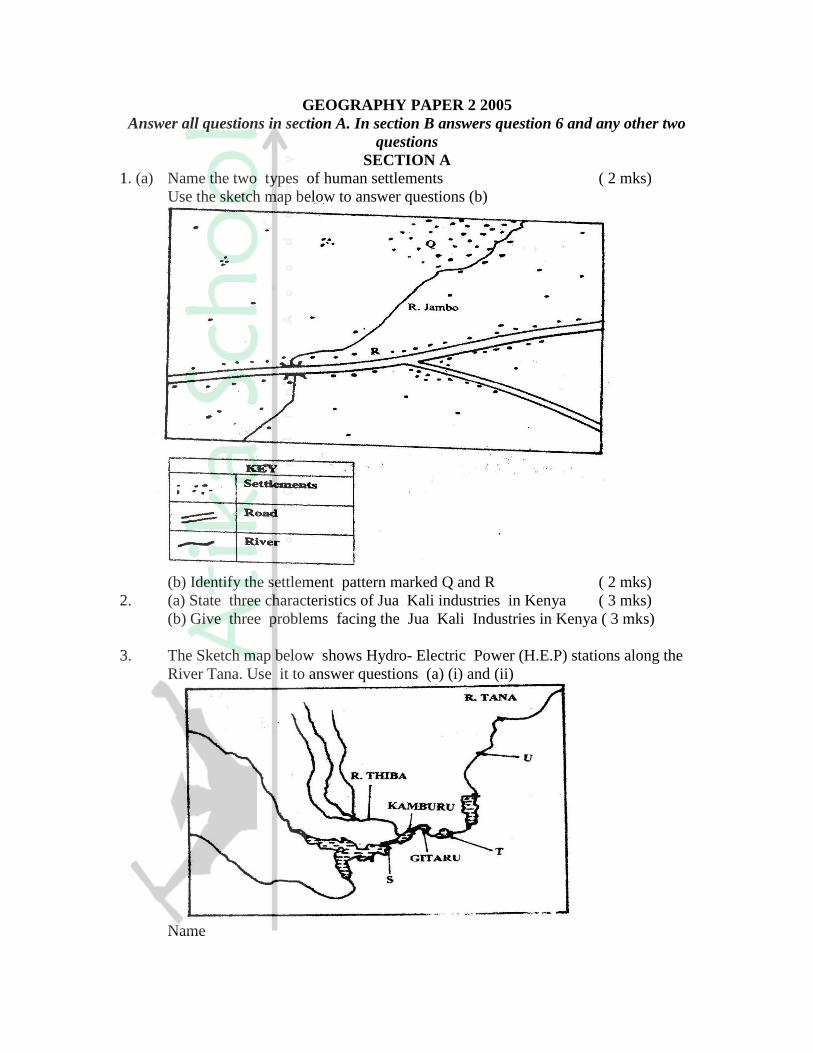
3. The Sketch map below shows Hydro- Electric Power (H.E.P) stations along the
River Tana. Use it to answer questions (a) (i) and (ii)
Name
(i) The HJ.E.P station marked S and T ( 2 mks)
(ii) The proposed H.E.P station marked U ( 1 mk)
(b) Apart from water. Give two renewable sources of industries energy
(2mks)
4. State four ways in which drought affects the agricultural sector in Kenya
( 4 mks)
5. (a) Give three conditions that are necessary for bee keeping ( 4 mks)
(b) State three reasons why the government of Kenya is encouraging
bee keeping in the country ( 3 mks)
SECTION B
Answer question 6 and any other two questions in this section
6. The table below shows the approximation of four districts in central province in
1999. Use it to answer question (a)
POPULATION FOR DISTRICTS IN CENTRAL PROVINCE
DISTRICT POPULATION
Murang’a 350,000
Maragua 390,000
Nyandarua 470,000
Thika 650,000
Total 1,860,000
(a) (i) Suggest two possible reasons why the population of Thika is higher than
that of Murang’a (2mks)
(ii) Using a radius of 5 cm, draw a pie chart to represent the data above(9mks)
(iii) A part from pie charts, name two other statistical methods that can be
used to represent the data in the table. (2mks)
b) i) Give three advantages of using a pie chart to represent data (3mks)
ii) State three reasons why it is necessary for a country to carry our
population census. (3mks)
c) Explain how the following factors have led to the population increase in Kenya.
i) Early marriages (2mks)
ii) Improved medical facilities (2 mks)
iii) Cultural beliefs (2mks)
7. Use the map of East Africa below to answer question (a) (i)
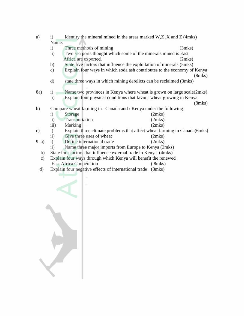
a) i) Identity the mineral mined in the areas marked W,Z ,X and Z (4mks)
Name:
i) Three methods of mining (3mks)
ii) Two sea ports thought which some of the minerals mined is East
Africa are exported. (2mks)
b) State five factors that influence the exploitation of minerals (5mks)
c) Explain four ways in which soda ash contributes to the economy of Kenya
(8mks)
d) state three ways in which mining derelicts can be reclaimed (3mks)
8a) i) Name two provinces in Kenya where wheat is grown on large scale(2mks)
ii) Explain four physical conditions that favour wheat growing in Kenya
(8mks)
b) Compare wheat farming in Canada and / Kenya under the following
i) Storage (2mks)
ii) Transportation (2mks)
iii) Marking (2mks)
c) i) Explain three climate problems that affect wheat farming in Canada(6mks)
ii) Give three uses of wheat (2mks)
9. a) i) Define international trade (2mks)
ii) Name three major imports from Europe to Kenya (3mks)
b) State four factors that influence external trade in Kenya (4mks)
c) Explain four ways through which Kenya will benefit the renewed
East Africa Cooperation ( 8mks)
d) Explain four negative effects of international trade (8mks)

GEOGRAPHY PAPER 1 2006
Answer all the questions in this section
SECTION A
1. (a) How does a sea breeze occur? ( 2 mks)
(b) Use the map of Africa below to answer questions (b) (i)
(i) Name the ocean currents marked H,J, and K ( 3 mks)
(ii) State two effects of a warm ocean current on the adjacent coastlands
( 2 mks)
2. Give two processes involved in each of the following types of weathering
(a) Physical weathering ( 2 mks)
(b) Chemical weathering ( 2mks)
3. The diagram below shows the composition of the solar system
(a) Name the planets marked F and G ( 2 mks)
(b) State three effects of the rotation of the earth on its axis ( 3 mks)
4. (a) Name two scales used to measure the intensity of an earthquake ( 2 mks)
(b) Give three causes of earthquakes ( 3 mks)
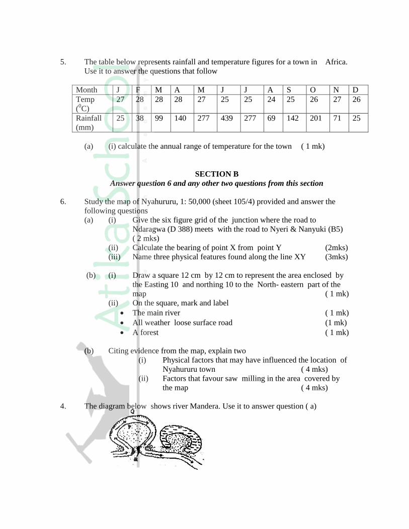
5. The table below represents rainfall and temperature figures for a town in Africa.
Use it to answer the questions that follow
Month J F M A M J J A S O N D
Temp
(0C)
27 28 28 28 27 25 25 24 25 26 27 26
Rainfall
(mm)
25 38 99 140 277 439 277 69 142 201 71 25
(a) (i) calculate the annual range of temperature for the town ( 1 mk)
SECTION B
Answer question 6 and any other two questions from this section
6. Study the map of Nyahururu, 1: 50,000 (sheet 105/4) provided and answer the
following questions
(a) (i) Give the six figure grid of the junction where the road to
Ndaragwa (D 388) meets with the road to Nyeri & Nanyuki (B5)
( 2 mks)
(ii) Calculate the bearing of point X from point Y (2mks)
(iii) Name three physical features found along the line XY (3mks)
(b) (i) Draw a square 12 cm by 12 cm to represent the area enclosed by
the Easting 10 and northing 10 to the North- eastern part of the
map ( 1 mk)
(ii) On the square, mark and label
The main river ( 1 mk)
All weather loose surface road (1 mk)
A forest ( 1 mk)
(b) Citing evidence from the map, explain two
(i) Physical factors that may have influenced the location of
Nyahururu town ( 4 mks)
(ii) Factors that favour saw milling in the area covered by
the map ( 4 mks)
4. The diagram below shows river Mandera. Use it to answer question ( a)

(a) (i) Name the process that take place at each of the points marked P
and Q. ( 2mks)
(ii) Name the feature formed at the point marked R ( 1mk)
(iii) Describe how an Ox- bow lake is formed ( 5 mks)
(b) State five characteristics of a flood plain ( 5 mks)
(c) Explain three causes of river rejuvenation ( 6 mks)
(c) Your class is required to carry out a field study of a river
(i) What would be the advantages of dividing the class into groups
according to the stages of the long profile of a river? (4mks)
(ii) What would be the disadvantage of using secondary data in this
kind of a field study? (2mks)
8. (a) (i) What is an ice sheet? (2mks)
(ii) Give two reasons why there are no ice sheets in Kenya (2mks)
(iii) Explain three factors that influence the movement of the ice from
the place where it has accumulated (6mks)
(b) Describe how an arête is formed (4mks)
(b) The diagram below shows types of moraines in a valley glacier
(i) Name the type of moraines marked S, T and V (3mks)
(ii) Explain four positive effects of glaciation in lowland
areas. (8mks)
9. The diagram below represents zones of natural vegetation on a mountain in
Africa. Use it to answer question (a) (i) and (ii)

a) (i) Name the vegetation zones marked W, X and Y. (3mks)
(ii) Describe the characteristics of the savanna vegetation. (6mks)
(iii) Name the temperate grasslands found in the following countries:
Canada (1mk)
Russia (1mk)
Australia (1mk)
b) Explain three causes of the decline of the areas under forest in Kenya.
(6mks)
c) You are supposed to carry out a field study on the uses of vegetation in the
area your school.
(i) State three reasons why it would be necessary to visit the area
before the day of the study. (3mks)
(ii) Give four uses of you are likely to identify during the study (4mks)
10. a) (i) What is soil catena? (ii) Draw a labeled diagram to show a well developed soil profile. (5mks)
(iii) State three characteristics of the soils found in the arid regions of
Kenya. (3mks)
b) Give three factors that determine the colour of soil.
c) Describe how laterization occurs. (6mks)
d) Explain how the following farming practices cause soil erosion.
(i) Burning (2mks)
(ii) Continuous application of fertilizer on farm lands. (2mks)
(iii) Monocultures. (2mks)
GEOGRAPHY PAPER II 2006
Answer all the questions in this section
SECTION A
1. (a) Differentiate between transport and communication ( 2 mks)
(b) State three causes of the decline in the use of letter writing as means of
communication in Kenya ( 3 mks)
2. (a) Give two methods used to reclaim land in Kenya ( 2 mks)
(b) Outline the stages through which land is reclaimed from the sea in the
Netherlands ( 3 mks)
3. The table below represents information on population change in Kenya by
province between years 2000 and 2005
Province Population in Millions
Years
2000 2005
Nairobi 2.229 2.751
Central 3.882 4.038
Coast 2.662 2.927
Eastern 4.840 5.120
North- Eastern 1.054 1.438
Nyanza 4.598 4.916
Rift valley 7.386 8.366
Western 5.532 3.885
Total 30.183 33.441
(a) Which province had the highest change in population between 2000 and
2005? (2mks)
(b) Calculate the percentage increase in population in Kenya between 2000
and 2005 (2mks)
4. (a) state three physical conditions that are necessary for the growing of cocoa
(3mks)
(b) Give three economic problems experienced in cocoa farming in Ghana (3mks)
5. (a) State two reasons why some industries are located near the sources of
raw materials (2mks)
(b) Give three characteristics of the cottage industry in India (3mks)
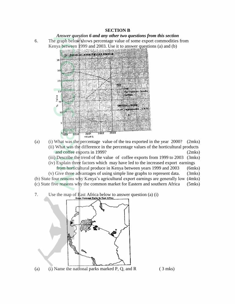
SECTION B
Answer question 6 and any other two questions from this section
6. The graph below shows percentage value of some export commodities from
Kenya between 1999 and 2003. Use it to answer questions (a) and (b)
(a) (i) What was the percentage value of the tea exported in the year 2000? (2mks)
(ii) What was the difference in the percentage values of the horticultural products
and coffee exports in 1999? (2mks)
(iii) Describe the trend of the value of coffee exports from 1999 to 2003 (3mks)
(iv) Explain three factors which may have led to the increased export earnings
from horticultural produce in Kenya between years 1999 and 2003 (6mks)
(v) Give three advantages of using simple line graphs to represent data. (3mks)
(b) State four reasons why Kenya’s agricultural export earnings are generally low (4mks)
(c) State five reasons why the common market for Eastern and southern Africa (5mks)
7. Use the map of East Africa below to answer question (a) (i)
(a) (i) Name the national parks marked P, Q, and R ( 3 mks)

(ii) Explain the difference between the tourist attractions in East Africa
and Switzerland under the following sub- headings.
Climate (2mks)
Culture (2mks)
(b) Explain five benefits that Kenya derives from tourism
(c) Explain four measures that Kenya should take in order to attract more
tourists (8mks)
8. The diagram below represents the functional zones of urban centre. Use it to
answer question (a)
(a) Name the zones marked x and y
(ii) List three functions of the central Business District (3mks)
(iii) State two ways in which the residents of the zone labeled
AGRICULTURAL LAND benefit from the urban centre (2mks)
(b) State four factors that contribute to the emergence of slums in urban centers
(4mks)
(c) Explain the measures that could be taken to control the following problems in
urban centers in Kenya
(i) High rate of crime (2mks)
(ii) water pollution (2mks)
(d) Explain five factors that led to the growth of Kisumu town (10ms)
9. Use the map of Africa below to answer question (a) (i)
(a) (i) Name the power dams marked J,K and L (3mks)

(ii) Explain four ways in which Kenya has benefited from the development
of the seven forks hydro- electric power scheme. (8mks)
(b) (i) Apart from oil, name two other non-renewable sources of energy (2mks)
(ii) Explain four effects that the increase in oil prices has had on the economies of
the oil- importing countries of Africa. (8mks)
(c) State four ways in which Kenya reduce the use of petroleum as a source of energy
(4mks)
10. (a) (i) Define the tem fisheries (2mks)
(ii) Name two countries in Southern Africa that are important for
marine fish production (2mks)
(b) Explain four factors that favour the fishing industry in Japan (8mks)
(c) Describe purse seining as a method of fishing (6mks)
(d) (i) state four problems experienced in the marketing of fish in Kenya
(4mks)
(ii) State three ways in which the Kenya Government is promoting the
fishing industry in the country (3mks)
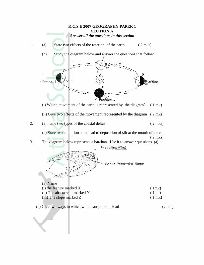
K.C.S.E 2007 GEOGRAPHY PAPER 1
SECTION A
Answer all the questions in this section
1. (a) State two effects of the rotation of the earth ( 2 mks)
(b) Study the diagram below and answer the questions that follow
(i) Which movement of the earth is represented by the diagram? ( 1 mk)
(ii) Give two effects of the movement represented by the diagram ( 2 mks)
2. (a) name two types of the coastal deltas ( 2 mks)
(b) State two conditions that lead to deposition of silt at the mouth of a river
( 2 mks)
3. The diagram below represents a barchan. Use it to answer questions (a)
(a) Name
(i) the feature marked X ( 1mk)
(ii) The air current marked Y ( 1mk)
(iii) The slope marked Z ( 1 mk)
(b) Give two ways in which wind transports its load (2mks)
4. The diagram below represents the structure of the earth. Use it to answer question
(a) Name
(i) The parts marked P and Q (2mks)
(ii) The discontinuity marked R ( 1 mk)
(b) State three characteristics of the mantle ( 3 mks)
5. (a) Name the two types of earth movements that occur within the earth’s crust
( 2 mks)
(b) Describe the origin of the continents according to the Theory of continental Drift
( 3 mks)
SECTION B
Answer questions 6 and any other two questions in this following
6. Study the map of Taita Hills (1:50,000) sheet 189/4 provided and answer the
following questions
(a) (i) What is the bearing of the peak of Mwatunga hill in grid square
3214 from the water tank in grid square 2619? ( 2 mks)
(ii) What is the length in kilometers of the section of the Mwatate –
Voi railway line in the south – eastern part of the map? (2mks)
(b) Draw a rectangle measuring 16cm by 12 cm to represents the area
enclosed by the Eastings 24 and 40 and Northings 20 and 30 ( 1 mk)
On the rectangle, mark and name the following features:
- Mgange hills ( 1 mk)
- A rock out crop ( 1 mk)
- All weather road, bound surface ( 1 mk)
- River Ruhia ( 1 mk)
- Ronge forest ( 1 mk)

(c) Using evidence from the map, explain three factors that have favoured the
establishment of the Teita sisal Estates in the Southern part of the area
covered by the map ( 6 mks)
(d) (i) Describe the distribution of settlement in the area covered by the map (5mks)
(ii) Citing evidence from the map, give two economic activities carried out in the
area covered by the map other than sisal farming (4mks)
7. (a) Describe the following characteristics of minerals
(i) Colour (2mks)
(ii) Cleavage (2mks)
(iii) Hardness (2mks)
(b) (i) Give two types of igneous rocks (2mks)
(ii) Explain three conditions necessary fro the growth of coral polyps
(6mks)
(c) State four uses of rocks (4mks)
(d) You are planning to carry out a field study on the rocks within your school
environment
(i) Give two secondary sources of information you would use to
prepare for the field study (2mks)
(ii) State why you would need the following items during the field
study:
A fork jembe (1mk)
A polythene bag (1mk)
(iii) Suppose during the field study you collected marble, sandastone
and granite, classify each of these samples according to its mode
of formation (3mks)
8. (a) (i) What is climate? (2mks)
(ii) Explain two effects of climate change on the physical environment
(4mks)
(b) The table below shows rainfall and temperature figures of station in
Africa
Month J F M A M J J A S O N D
Temp
in 0C
24 24 23 22 19 17 17 18 19 20 22 23
Rainfall
in mm
109 122 130 76 52 34 28 38 70 108 121 120
(i) On the graph paper provided, draw a bar graph to represent the rainfall
figure. ( Use a vertical scale of 1 cm to represent 10mm) (5mks)
(ii) Describe the rainfall pattern of the station (4mks)
(iii) Calculate the average monthly temperature for the station (Show your
calculations) (2mks)
(c) You are supposed to carry out study on the weather within your school compound
(i) Describe how you would use the following instruments during the field study
- The hygrometer ( 3 mks)
- The rain gauge ( 3 mks)
(ii) State two ways in which the information collected during the field study
would be useful to the local community ( 2 mks)
9. (a) Give three processes that lead to formation of lakes ( 3 mks)
(b) (i) Describe how lake Victoria was formed ( 4 mks)
(ii) Explain how lake Victoria influences the climate of the surrounding areas
( 6 mks)
(c) (i) Apart from Lake Magadi name two other lakes within the rift valley in
Kenya that have a high level of salinity ( 2 mks)
(ii) Explain three causes of salinity in Lake Magadi ( 6 mks)
(d) Give four economic uses of lakes other than mining ( 4 mks)
10. (a) (i) What is the difference between weathering and mass wasting?
(ii) Apart from plants, give three other factors that influence the rate of
weathering
(iii) Explain two ways in which plants cause weathering (4mks)
(b) (i) List two types of mass wasting other than soil creep (2mks)
(ii) Explain three factors that cause soil creep. (6mks)
(c) Explain four effects of mass wasting on the environment. (8mks)
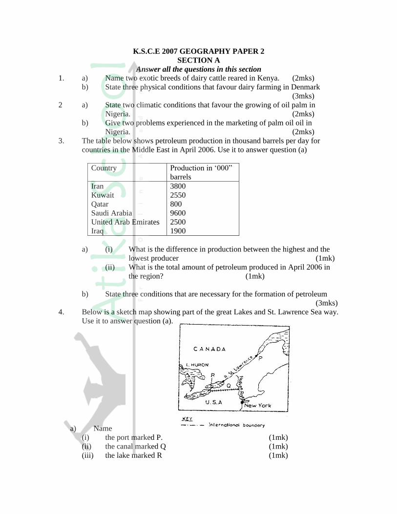
K.S.C.E 2007 GEOGRAPHY PAPER 2
SECTION A
Answer all the questions in this section
1. a) Name two exotic breeds of dairy cattle reared in Kenya. (2mks)
b) State three physical conditions that favour dairy farming in Denmark
(3mks)
2 a) State two climatic conditions that favour the growing of oil palm in
Nigeria. (2mks)
b) Give two problems experienced in the marketing of palm oil oil in
Nigeria. (2mks)
3. The table below shows petroleum production in thousand barrels per day for
countries in the Middle East in April 2006. Use it to answer question (a)
Country Production in ‘000”
barrels
Iran
Kuwait
Qatar
Saudi Arabia
United Arab Emirates
Iraq
3800
2550
800
9600
2500
1900
a) (i) What is the difference in production between the highest and the
lowest producer (1mk)
(ii) What is the total amount of petroleum produced in April 2006 in
the region? (1mk)
b) State three conditions that are necessary for the formation of petroleum
(3mks)
4. Below is a sketch map showing part of the great Lakes and St. Lawrence Sea way.
Use it to answer question (a).
a) Name
(i) the port marked P. (1mk)
(ii) the canal marked Q (1mk)
(iii) the lake marked R (1mk)

b) State three ways in which the great lakes and st. Lawrence Sea way has
contributed to the growth of industries in the region. (3mks)
5. a) Apart from HIV and AIDS. Give two other causes of mortality in East Africa.
(2mks)
b) State two ways in which the spread of HIV and AIDS in Kenya may slow down
economic development. (2mks)
SECTION B
1. The photograph provided shows a tea growing area in Kenya. Use it to answer
questions (a) and (b)
a) (i) What evidence in the photograph shows that this is a ground
genera-view type of photograph? (2mks)
(ii) Draw a rectangle measuring 15cm by 10cm to represent the area
of the photograph. On it sketch and label the main features shown
on the photograph. (5mks)
(iii) Identify two features from the photograph that show that this is a
small scale tea farm. (2mks)
b) Describe the stages involved in the cultivation of tea from land preparation to
the stage shown on the photograph.
c) (i) Name two districts in the Eastern province where tea is grown. (2mks)
(ii) Explain four ways in which the Kenya Tea development agency (KTDA)
assists small scale tea farmers in Kenya (8mks)
7 a) Name three agricultural food processing industries in Kenya. (3mks)
b) Explain how the following factors have favoured the development of
industries in Thika town:
(i) Proximity to Nairobi; (2mks)

(ii) Availability of water; (2mks)
(iii) The hinterland. (2mks)
c) Explain four ways in which Kenya has benefited from industrialization.
(8mks)
d) (i) Name two towns in Kenya where moto-vehicle assembling plants
are located. (2mks)
(ii) Explain three factors which have favoured the development of car
manufacturing industry in Japan. (6mks)
8 a) i) What is forestry? (2mks)
ii) Explain three factors that favour the growth of natural forests on
the slopes of Mt. Kenya. (6mks)
iii) State five factors that have led to the reduction of the area under
forest on the slopes of Mt Kenya. (5mks)
b) Explain four measures that the government of Kenya is taking to conserve
forests in the country. (8mks)
c) Give the differences in the exploitation of softwood forests in Kenya and
Canada under the following sub-headings;
i) Period of harvesting; (2mks)
ii) Transportation (2mks)
9 a) (i) Name three international airports in Kenya. (3mks)
(ii) Give four advantages of air transport over road transport. (4mks)
b) Explain four measures that should be taken to improve road transport in
Kenya (8mks)
c) Explain why there are few rail links among African countries. (6mks)
d) Give four reasons why there is limited use of river transport in Africa.
(4mks)
10. a) i) State two causes of water pollution. (4mks)
ii) Give two effects of water pollution on the environment (2mks)
b) Explain four methods used to control floods on rivers in Kenya. (8mks)
c) Explain how the following soil conservation methods improve the quality
of soil:
(i) Contour farming; (2mks)
(ii) Mulching; (2mks)
(iii) Crop rotation. (2mks)
d) You intend to carry out a field study on pollution in the local open air market.
(i) State three reasons why it would be necessary for you to visit the market
before the actual study. (3mks)
(ii) Give two methods that would to collect information on pollution (2mks)
(iii)Give two follow-up activities you would carry out after the field. (2mks)

2008 KCSE GEOGRAPHY QUESTIONS
PAPER 1 312/1
SECTION A
Answer all the questions in this section
1 a) Give three reasons why it is necessary to study the plate tectonics theory.
(3mks)
b) Name two types of tectonic plate boundaries (2mks)
2. a) The diagram below shows a Six’s Thermometer. Name the parts marked
P, Q and R. (3mks)
b) The table below shows temperature readings at a weather station for one
week
Temp/Day Mon Tue Wed Thur Fri Sat Sun
Max. 0C 28 27 28 29 29 29 26
Min. 0C 18 18 20 16 22 21 19
Calculate the following:
i) The diurnal range of temperature for Tuesday: (1mk)
ii) The mean temperature for Saturday. (1mk)
3. a) Give two examples of non-metallic minerals. (2mks)
b) Why is industrial diamond used in shaping hard stones and metals? (1mk)
4. a) Apart from water vapour, name two other substances that are suspended in
the atmosphere.
b) i) Give two factors that are considered when classifying clouds. (2mks)
ii) Name two types of clouds that give rise to rainfall in the tropical
regions. (2mks)
5. a) The diagram below shows an eclipse. Name the features marked V and
W. (2mks)

b) State four proofs that the shape of the earth is spherical. (4mks)
SECTION B
Answer question 6 and any other Two questions from this section
6. a) Study the map of Kericho 1:50,000 provided and answer the following
questions.
i) Give the longitudinal extent of the area covered by the map.
(1mk)
ii) Convert the scale of the map into a statement scale. (2mks)
iii) What is the approximate height of the hill in the grid squire 6770?
(2mks)
iv) Calculate the area of Kericho Municipality. Give your answer in
square kilometers. (2mks)
b) i) Give three types of natural vegetation found to the west of Easting
53 (3mks)
ii) What is the bearing of the trigonometrical station at grid reference
554668 from the factory at grid reference 610626? (2mks)
iii) Identify three forms of land transport found to the north of
Northing 68 and west of Easting 53? (3mks)
c) Describe the distribution of settlements in the are covered by the map.
(4mks)
d) Citing evidence from the map, explain three factors that favour the
establishment of tea estates in the area covered by the map. (6mks)
7. a) Differentiate between magna and lava. (2mks)
b) The diagram below shows some intrusive volcanic features.
Name the features marked E, f and G. (3mks)
c) Describe how the following features are formed and for each give and
example from Kenya:
i) A crater (3mks)
ii) A geyser (5mks)
iii) A lava plateau (4mks)
d) Explain four ways in which volcanic features influence human activities.
(8mks)
8. a) i) Name two sources of rivers. (2mks)

ii) The diagram below shows the three stages of the long profile of a
river.
Give two features formed by the rivers in each of the three stages.
(6mks)
b) Describe the processes by which a river transports its load. (6mks)
c) Describe each of the following drainage patterns;
i) State two methods you would use to collect data. (3mks)
ii) State three advantages of studying the work of rivers through
fieldwork. (3mks)
9. a) i) Describe how ice is formed on a high mountain. (3mks)
ii) Apart from a valley glacier, name two types of ice masses found
on Mountains in East Africa.
b) Explain how the movement of a valley glacier is influenced by the
following factors:
i) Temperature (2mks)
ii) Width of a glacier channel. (2mks)
c) Describe the distinctive characteristics of the following features resulting
from glacial erosion:
i) A corrie (3mks)
ii) A pyramidal peak (3mks)
iii) a fiord (fjord) (3mks)
d) i) The diagram below shows a glaciated upland area
Name the features marked M, N, and P.
ii) Describe the process through which a crag and tail is formed
(4mks)
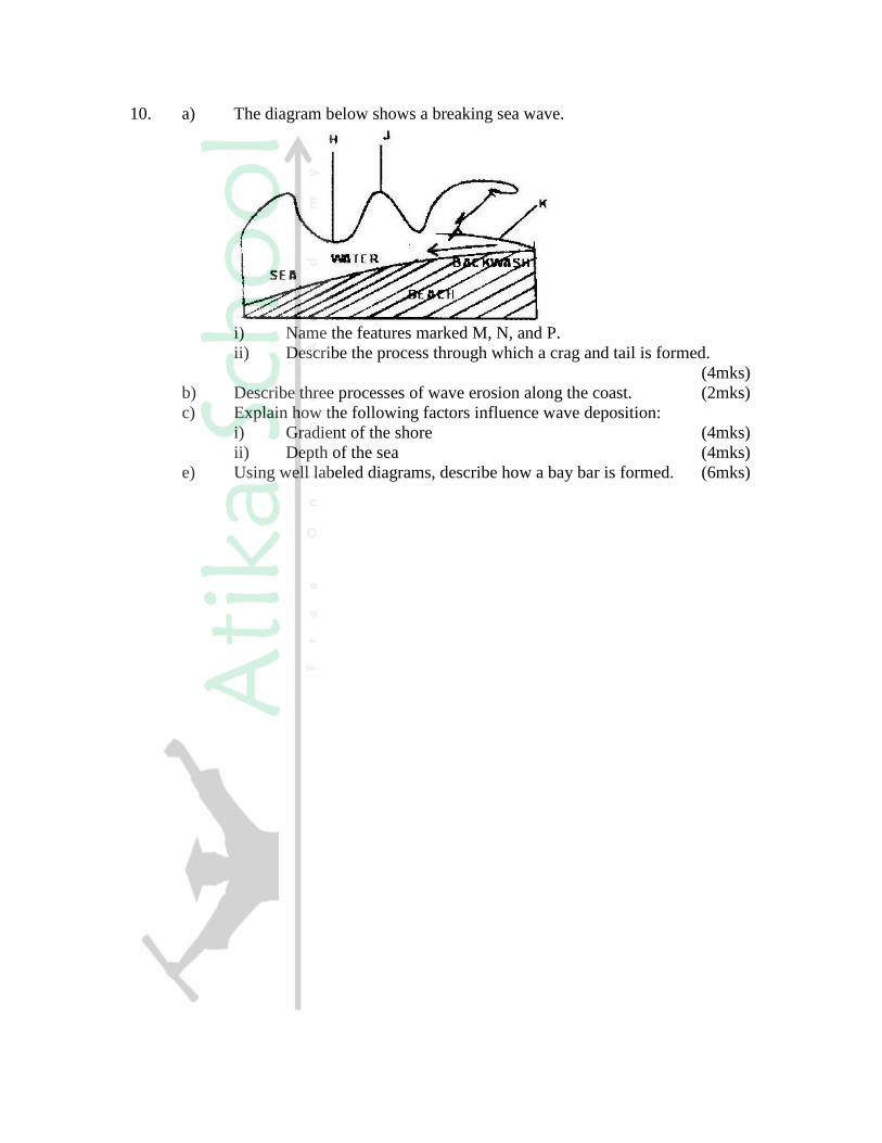
10. a) The diagram below shows a breaking sea wave.
i) Name the features marked M, N, and P.
ii) Describe the process through which a crag and tail is formed.
(4mks)
b) Describe three processes of wave erosion along the coast. (2mks)
c) Explain how the following factors influence wave deposition:
i) Gradient of the shore (4mks)
ii) Depth of the sea (4mks)
e) Using well labeled diagrams, describe how a bay bar is formed. (6mks)
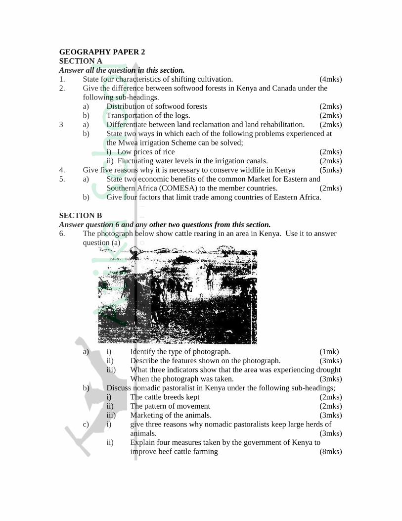
GEOGRAPHY PAPER 2
SECTION A
Answer all the question in this section.
1. State four characteristics of shifting cultivation. (4mks)
2. Give the difference between softwood forests in Kenya and Canada under the
following sub-headings.
a) Distribution of softwood forests (2mks)
b) Transportation of the logs. (2mks)
3 a) Differentiate between land reclamation and land rehabilitation. (2mks)
b) State two ways in which each of the following problems experienced at
the Mwea irrigation Scheme can be solved;
i) Low prices of rice (2mks)
ii) Fluctuating water levels in the irrigation canals. (2mks)
4. Give five reasons why it is necessary to conserve wildlife in Kenya (5mks)
5. a) State two economic benefits of the common Market for Eastern and
Southern Africa (COMESA) to the member countries. (2mks)
b) Give four factors that limit trade among countries of Eastern Africa.
SECTION B
Answer question 6 and any other two questions from this section.
6. The photograph below show cattle rearing in an area in Kenya. Use it to answer
question (a)
a) i) Identify the type of photograph. (1mk)
ii) Describe the features shown on the photograph. (3mks)
iii) What three indicators show that the area was experiencing drought
When the photograph was taken. (3mks)
b) Discuss nomadic pastoralist in Kenya under the following sub-headings;
i) The cattle breeds kept (2mks)
ii) The pattern of movement (2mks)
iii) Marketing of the animals. (3mks)
c) i) give three reasons why nomadic pastoralists keep large herds of
animals. (3mks)
ii) Explain four measures taken by the government of Kenya to
improve beef cattle farming (8mks)

7. a) i) Give two documents from where information on population data is
obtained (2mks)
ii) The pyramid below represents population structure Kenya.
Describe the characteristics of the population as represented by the
pyramid. (3mks)
b) i) In 1989 Kenya population was 21.4 million while in 1999 it was
28.7 million. Calculate the population was 21.4 million. Calculate
the population growth rate over the 10 year period. (Show your
calculations) (2mks)
ii) Explain two factors which may have led to the large population
increase between 1989 and 1999. (4mks)
c) Explain three consequences of high population growth rate. (6mks)
d) Explain four physical factors that influence population distribution in East
Africa. (8mks)
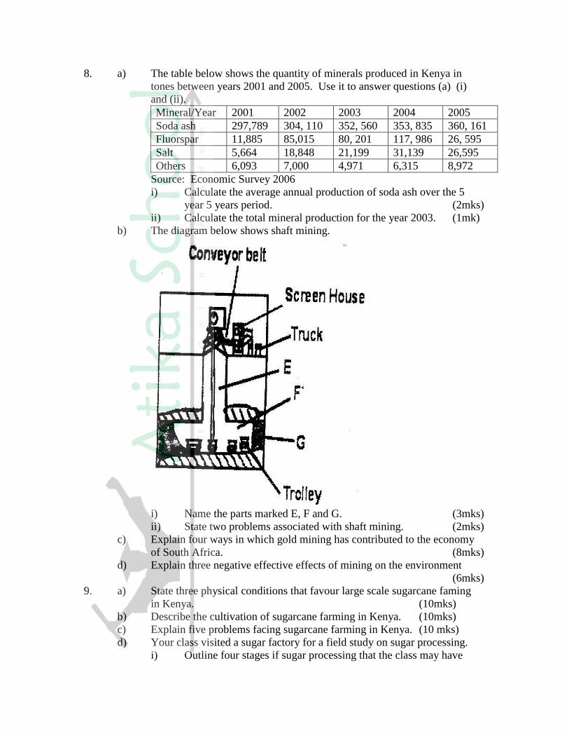
8. a) The table below shows the quantity of minerals produced in Kenya in
tones between years 2001 and 2005. Use it to answer questions (a) (i)
and (ii).
Mineral/Year 2001 2002 2003 2004 2005
Soda ash 297,789 304, 110 352, 560 353, 835 360, 161
Fluorspar 11,885 85,015 80, 201 117, 986 26, 595
Salt 5,664 18,848 21,199 31,139 26,595
Others 6,093 7,000 4,971 6,315 8,972
Source: Economic Survey 2006
i) Calculate the average annual production of soda ash over the 5
year 5 years period. (2mks)
ii) Calculate the total mineral production for the year 2003. (1mk)
b) The diagram below shows shaft mining.
i) Name the parts marked E, F and G. (3mks)
ii) State two problems associated with shaft mining. (2mks)
c) Explain four ways in which gold mining has contributed to the economy
of South Africa. (8mks)
d) Explain three negative effective effects of mining on the environment
(6mks)
9. a) State three physical conditions that favour large scale sugarcane faming
in Kenya. (10mks)
b) Describe the cultivation of sugarcane farming in Kenya. (10mks)
c) Explain five problems facing sugarcane farming in Kenya. (10 mks)
d) Your class visited a sugar factory for a field study on sugar processing.
i) Outline four stages if sugar processing that the class may have

observed. (4mks)
ii) Name two by-products of sugar that the class may have identified
during the study. (2mks)
10. Use the map of North-West Atlantic below to answer questions (a) and (b).
NORTH –WEST ATLANTIC FISHING GROUNDS
a) i) Name the country
ii) Explain how the two ocean currents shown on the map influence
fishing in the area shaded on the map other than ocean currents.
(6mks)
b) Explain three factors that favour fishing in the area shaded on the map
other than ocean currents (6mks)
c) Explain why in East Africa, fresh water fishing water in the area shaded
on the map other than ocean currents. (6mks)
d) The diagram below shows a fishing method
i) Describe how the method is used in catching fish. (5mks)
ii) List three methods used to preserve fish. (3mks)

K.C.S.E YEAR 2009 GEOGRAPHY PAPER 1
SECTION A
Answer ALL the questions in this section
1. (a) Differentiate between the processes of the formation of plutonic rocks and
volcanic rocks ( 2 mks)
(b) For each of the following sedimentary rocks, name the resultant rock that
forms after metamorphism:
(i) Sandstone
(ii) Limestone
(iii) Clay
2. Use the diagram below to answer the questions that follows
Outline the process though which the moist winds shown go through to eventually
become dry winds ( 5 mks)
3. (a) What is a line of longitude? ( 2 mks)

(b) What is the local time at Alexandra 300E when the local time at Malindi 40
0 E
is 12.00 noon? ( 2 mks)
4. (a) Outline the steps followed when measuring humidity using a hygrometer
( 3 mks)
(b) Give two factors that influence relative humidity ( 2 mks)
5. The diagram below shows some types of folds. Use it to answer question (a)
(a) Name the type of folds marked E, F, and G ( 3 mks)
(b) In which countries are the following fold mountains found?
(i) Andes (1 mk)
(ii) Cape Ranges (1 mk)
(iii) Alps (1 mk)
6. The diagram below shows a hydrological cycle.
(a) (i) What do the arrows labeled K, L, and M on the cycle represent?
( 3 mks)
(ii) Explain three factors that influence the occurrence of surface run- off
(6 mks)
(b) (i) What is mass wasting? (2 mks)
(ii) Give two processes of slow mass movement (2 mks)
(iii) State two physical conditions that may influence landslides
( 2 mks)
(c) Describe the following processes of mass wasting
(i) Rock fall (2 mks)
(ii) Subsidence (2 mks)
(iii) Mud flows ( 2 mks)
(d) Explain the effect of mass wasting on the following
(i) Tourism ( 2 mks)
(ii) Soil fertility ( 2 mks)
7. (a) (i) Name three types of faults ( 3 mks)
(ii) Apart from compressional forces, explain two other processes that may cause
faulting ( 4 mks)
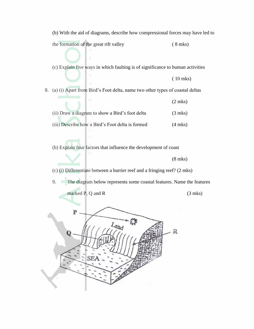
(b) With the aid of diagrams, describe how compressional forces may have led to
the formation of the great rift valley ( 8 mks)
(c) Explain five ways in which faulting is of significance to human activities
( 10 mks)
8. (a) (i) Apart from Bird’s Foot delta, name two other types of coastal deltas
(2 mks)
(ii) Draw a diagram to show a Bird’s foot delta (3 mks)
(iii) Describe how a Bird’s Foot delta is formed (4 mks)
(b) Explain four factors that influence the development of coast
(8 mks)
(c) (i) Differentiate between a barrier reef and a fringing reef? (2 mks)
9. The diagram below represents some coastal features. Name the features
marked P, Q and R (3 mks)
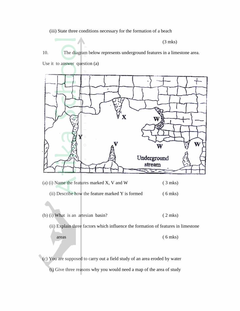
(iii) State three conditions necessary for the formation of a beach
(3 mks)
10. The diagram below represents underground features in a limestone area.
Use it to answer question (a)
(a) (i) Name the features marked X, V and W ( 3 mks)
(ii) Describe how the feature marked Y is formed ( 6 mks)
(b) (i) What is an artesian basin? ( 2 mks)
(ii) Explain three factors which influence the formation of features in limestone
areas ( 6 mks)
(c) You are supposed to carry out a field study of an area eroded by water
(i) Give three reasons why you would need a map of the area of study
( 3 mks)
(ii) Name two erosional features you are likely to identify during the field study
( 2 mks)
(iii) State three recommendations that you would make from your study to assist
the local community to rehabilitate the eroded area (3 mks)
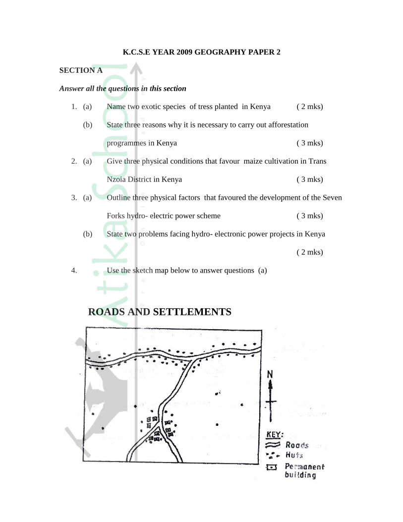
K.C.S.E YEAR 2009 GEOGRAPHY PAPER 2
SECTION A
Answer all the questions in this section
1. (a) Name two exotic species of tress planted in Kenya ( 2 mks)
(b) State three reasons why it is necessary to carry out afforestation
programmes in Kenya ( 3 mks)
2. (a) Give three physical conditions that favour maize cultivation in Trans
Nzoia District in Kenya ( 3 mks)
3. (a) Outline three physical factors that favoured the development of the Seven
Forks hydro- electric power scheme ( 3 mks)
(b) State two problems facing hydro- electronic power projects in Kenya
( 2 mks)
4. Use the sketch map below to answer questions (a)
ROADS AND SETTLEMENTS
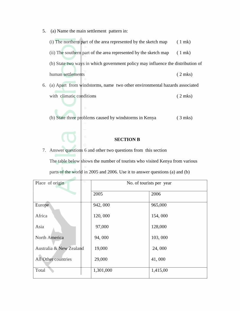
5. (a) Name the main settlement pattern in:
(i) The northern part of the area represented by the sketch map ( 1 mk)
(ii) The southern part of the area represented by the sketch map ( 1 mk)
(b) State two ways in which government policy may influence the distribution of
human settlements ( 2 mks)
6. (a) Apart from windstorms, name two other environmental hazards associated
with climatic conditions ( 2 mks)
(b) State three problems caused by windstorms in Kenya ( 3 mks)
SECTION B
7. Answer questions 6 and other two questions from this section
The table below shows the number of tourists who visited Kenya from various
parts of the world in 2005 and 2006. Use it to answer questions (a) and (b)
Place of origin
No. of tourists per year
2005 2006
Europe
Africa
Asia
North America
Australia & New Zealand
All Other countries
942, 000
120, 000
97,000
94, 000
19,000
29,000
965,000
154, 000
128,000
103, 000
24, 000
41, 000
Total 1,301,000 1,415,00

(a) (i) Which continent had the highest increase in the number of tourists visiting Kenya
between 2005 and 2006? (2 mks)
(ii) Calculate the percentage increase of tourist from Australia & New Zealand between
2005 and 2006 (2 mks)
(iii) Draw a divided rectangle 15 cm long to represent the number of tourists that visited
Kenya in 2006
Show your calculations (10 mks)
(b) (i) state two advantages of using divided rectangles to represent geographical data
(2 mks)
(ii) Give four reasons why in 2005 and 2006 there were more tourists visiting Kenya
from Europe compared to those from other parts of the world ( 4 mks)
(c) Give five reasons why domestic tourism is being encouraged in Kenya
(5 mks)
8. (a) State three physical conditions that favour coffee growing in the central
highlands of Kenya. ( 3 mks)
(b) Describe the stages involved in coffee production from picking to marketing
(8 mks)
(c) Explain four problems facing coffee farming in Brazil (8 mks)

(d) Your geography class carried out a field study on a coffee farm
(i) State four methods the class may have used to collect data
( 4 mks)
(ii) During the field study the class collected data on quantities of coffee produced
from the farm in the last five years
State two methods that the class may have used to present the data
( 2 mks)
9. (a) (i) What is visible trade? ( 2 mks)
(ii) List three major imports to Kenya from Japan ( 3 mks)
(b) Explain four factors that influence internal trade in Kenya (8 mks)
(c) State four ways in which trade is of significance to Kenya (4 mks)
(c) Explain four benefits which members states of ECOWAS derive from the
Formation of the trading bloc ( 8 mks)
10. (a) (i) Name three agricultural non- food processing industries in Kenya

(3 mks)
(ii) State four ways in which Kenya has benefited from the motor- vehicle
Assembly industry (4 mks)
(b) Explain three problems arising from industrialization in Kenya
( 6 mks)
(c) Explain three factors which influenced the location of iron and steel
industry in the Ruhr region of Germany in the 19th
century ( 6 mks)
(d) You intend to carry out a field study of furniture – making industry in the
local market centre
(i) State two reasons why it would be necessary for you to visit the area of
study in advance ( 2 mks)
(ii) For your field study you have prepared a work schedule. State two items
you would include in the schedule ( 2 mks)
(iii) Give two advantages of studying about furniture making through
fieldwork.
The map below shows the location of some urban centres in East Africa

(a) (i) Name the towns marked P, Q and R ( 3 mks)
(ii) Name the minerals that influenced the growth of the towns marked X and Y.
( 2 mks)
(b) Explain four factors that have led to the growth of Eldoret as a major town
in Kenya. ( 8 mks)
(c) Compare the ports of Mombasa and Rotterdam under the following sub-
headings:
(i) Site ( 2 mks)
(ii) Transport links to the interior ( 2 mks)
(iii) The hinterland ( 2 mks)
(iv) Port facilities ( 2 mks)
(d) Explain two ways in which urbanization negatively affects the
surrounding agricultural areas (4 mks)