geography 40301h (specification a) - revisionworld...carboniferous permian tertiary cretaceous chalk...
TRANSCRIPT
General Certificate of Secondary EducationHigher TierJune 2010
Geography 40301H(Specification A)Unit 1 Physical Geography
Insert
Page 3 is a perforated sheet showing the legend for the OS map extracts.Detach page 3 and use when referring to the OS map extracts.
Insert to June 2010/40301H 6/6/6/ M/40301H

2
INSERT TO M/Jun10/40301H
Figure 2
Figure 2 is not reproduced here due to third-party copyright constraints.
3
INSERT TO M/Jun10/40301H Turn over
s
OS Map Extract Key
4
INSERT TO M/Jun10/40301H
This page is intentionally blank
5
INSERT TO M/Jun10/40301H Turn over
s
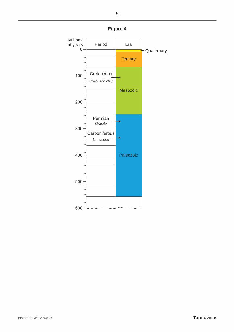
Figure 4
Millionsof years Period Era
0
100
200
300
400
500
600
Paleozoic
Mesozoic
Quaternary
Carboniferous
Permian
Tertiary
Cretaceous
Chalk and clay
Granite
Limestone
6
INSERT TO M/Jun10/40301H
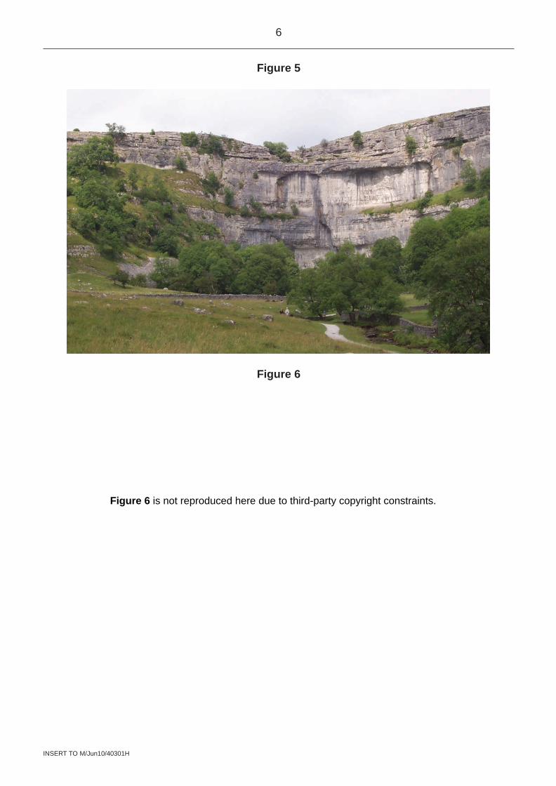
Figure 5
Figure 6
Figure 6 is not reproduced here due to third-party copyright constraints.
7
INSERT TO M/Jun10/40301H Turn over
s
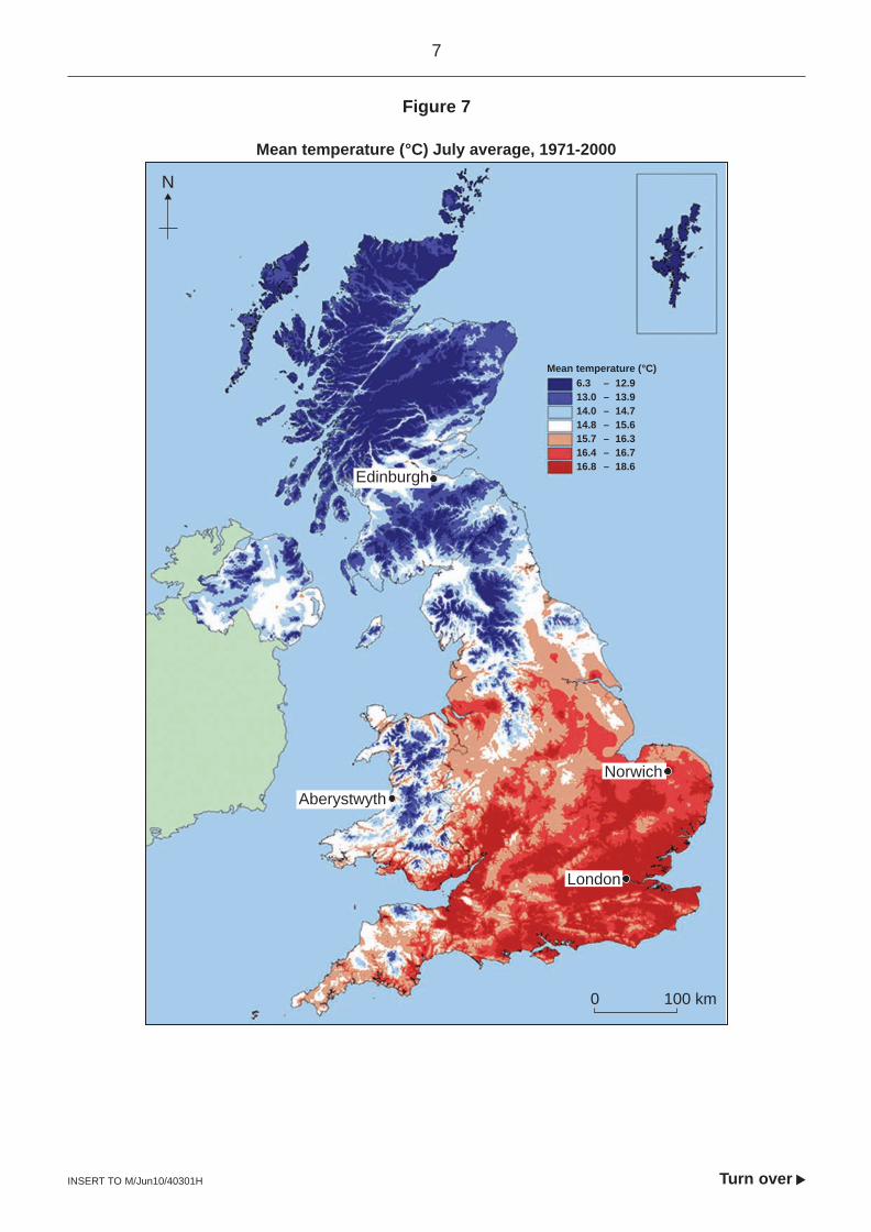
Figure 7
Mean temperature (°C) July average, 1971-2000
Mean temperature (°C)6.3 – 12.913.0 – 13.914.0 – 14.714.8 – 15.615.7 – 16.316.4 – 16.716.8 – 18.6
N
0 100 km
London
Edinburgh
Norwich
Aberystwyth
8
INSERT TO M/Jun10/40301H
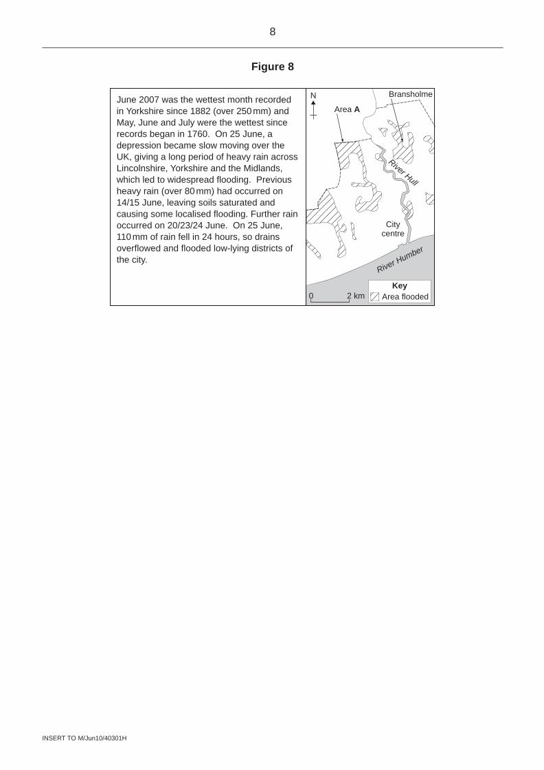
Figure 8
June 2007 was the wettest month recorded in Yorkshire since 1882 (over 250 mm) and May, June and July were the wettest since records began in 1760. On 25 June, a depression became slow moving over the UK, giving a long period of heavy rain across Lincolnshire, Yorkshire and the Midlands, which led to widespread flooding. Previous heavy rain (over 80 mm) had occurred on 14/15 June, leaving soils saturated and causing some localised flooding. Further rain occurred on 20/23/24 June. On 25 June, 110 mm of rain fell in 24 hours, so drains overflowed and flooded low-lying districts of the city.
0 2 km
Citycentre
Area A
Bransholme
River Hull
River Humber
N
Area floodedKey
9
INSERT TO M/Jun10/40301H Turn over
s
Figure 9
Figure 9 is not reproduced here due to third-party copyright constraints.
10
INSERT TO M/Jun10/40301H
Figure 12
Figure 12 is not reproduced here due to third-party copyright constraints.
11
INSERT TO M/Jun10/40301H Turn over
s
Figure 13a
Figure 13b
Figure 13a is not reproduced here due to third-party copyright constraints.
Figure 13b is not reproduced here due to third-party copyright constraints.
12
INSERT TO M/Jun10/40301H
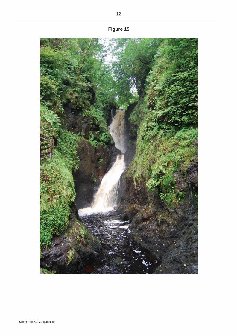
Figure 15
13
INSERT TO M/Jun10/40301H Turn over
s
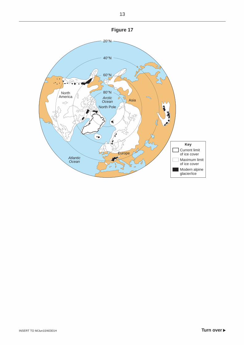
Figure 17
20°N
40°N
60°N
80°NNorthAmerica
AtlanticOcean
ArcticOcean
North Pole
Asia
Current limitof ice cover
Key
Europe
Maximum limitof ice coverModern alpineglacier/ice
14
INSERT TO M/Jun10/40301H
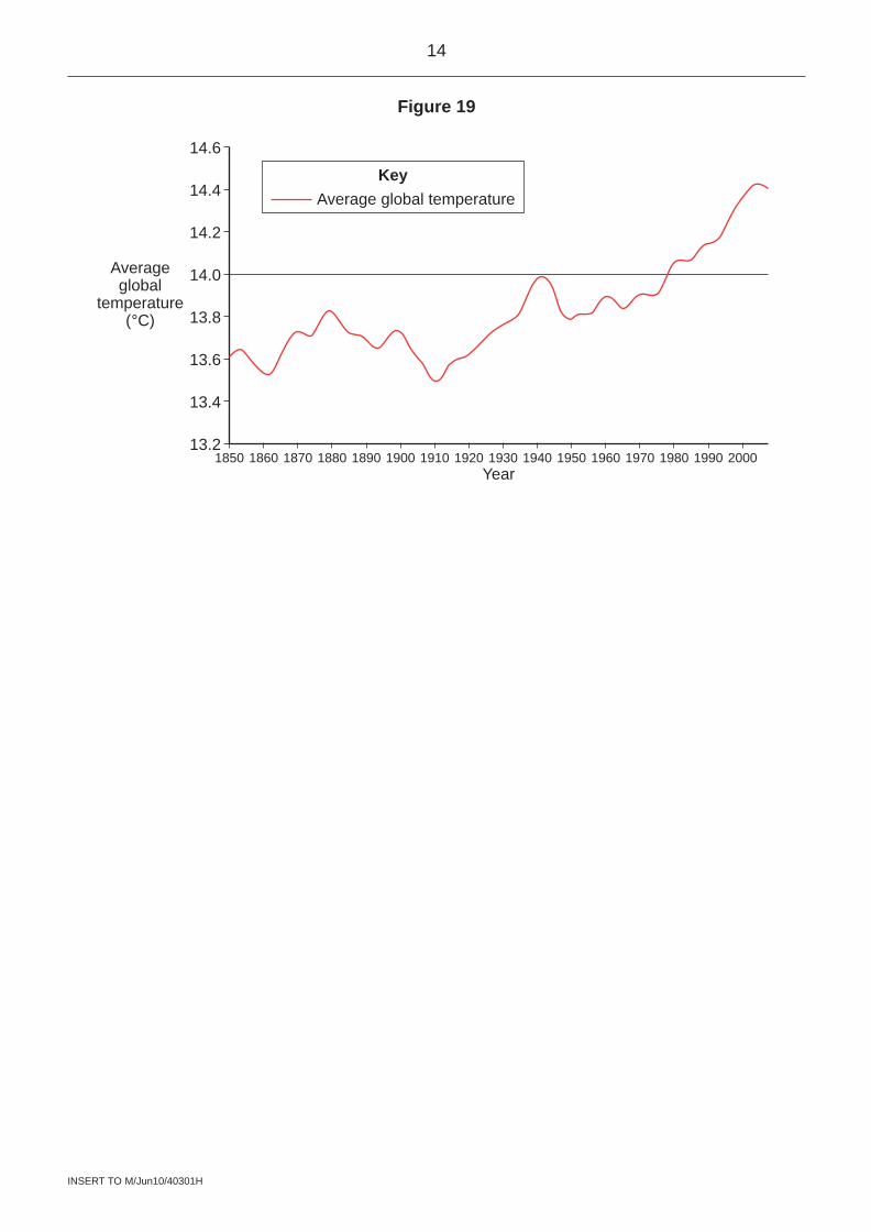
Figure 19
1850 1860 1870 1880 1890 1910 1920 1930 1940 1960 1970 1980 199013.2
13.4
13.6
13.8
14.0
14.2
14.4
14.6
1900Year
Averageglobal
temperature(°C)
1950 2000
Average global temperatureKey
15
INSERT TO M/Jun10/40301H Turn over
s
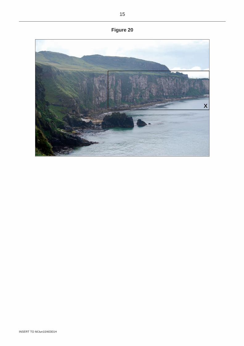
Figure 20
X
16
INSERT TO M/Jun10/40301H
There is no source material printed on this page
aCkNOwlEDGEMENT Of COPyRIGHT-HOlDERS aND PublISHERS
Permission to reproduce all copyright material has been applied for. In some cases, efforts to contact copyright-holders have been unsuccessful and aQa will be happy to rectify any omissions of acknowledgements in future papers if notified.
figure 2: figure 6, figure 9, figure 12: Reproduced by kind permission of Ordnance Survey on behalf of HMSO. © Crown copyright 2009. all rights reserved. Ordnance Survey licence number 100041328figure 5: J Canavan
Figure 7: © Crown copyright 2000, the Met Officefigure 8: Reproduced with the permission of Nelson Thornes ltd from Geofile Online, Geofile 27, Issue 1, first published September 2008.figure 13a: www.outdoor-weblog.com/imgname--death_valley_land_of_extremes_part_fourfigure 13b: www.spleen-me.com/gallery2/v/DeathValley08/ubehebe/DSC_2030.jpg.htmlfigure 15: J Canavan
Figure 17: DaviD Briggs
figure 19: adapted from Crown copyright information supplied by the Met Officefigure 20: J Canavan
Copyright © 2010 aQa and its licensors. all rights reserved.