geo subsea fibre optic cable cable installation report ireland · geo subsea fibre optic cable...
TRANSCRIPT

Geo Subsea Fibre Optic cable Cable Installation Report Ireland
26 May 2011

CONFIDENTIAL Geo Subsea Fibre Optic Cable
Issue Date 11/05/11 Page i
Contents page
1. Document Control 2
1.1 Purpose of document 2
1.2 Record of modifications 2
1.3 Sign-off / Approval 2
1.4 Document distribution 2
1.5 Filename and location Error! Bookmark not defined.
2. Introduction 3
2.1 Proposed Route 3
3. Background 4
4. Proposed Works 5
4.1 Shore End Cable Installation 5
4.2 Near Shore Cable Installation 7
4.3 Off Shore Cable Installation 7
5. Mitigation Measures 9
6. Environmental Review 12
6.1 Review Conclusion 12
7. Archaeological Assessment 13
Appendix A – Eire Inshore Survey Results 14
Éire Inshore Survey (0-20m) 14
Appendix B – Eire Topographic Survey 21
Éire Topographic Survey (BMH to LAT) 21
Appendix C – Environmental Review 25
Appendix D – Archaeological Reports 26
Appendix E – Charts and RPL 27
Appendix F – Vibrocore Results 28
Appendix G – CPT Results 30

CONFIDENTIAL Geo Subsea Fibre Optic Cable
1. Document Control
Document Name Geo installation report – Foreshore Licence _UK
Owner Andrew Harrington
1.1 Purpose of document
This document has been produced to provide information on the Installation of the subsea fibre optic cable in support the Foreshore Licence application.
1.2 Record of modifications
Revision status Date Amended by Summary of Changes
Issue 1 11/05/2011 Andrew Harrington
First release issued for comments
1.3 Sign-off / Approval
Name Date Job Title/Position
Joe Barrett 26th May 2011 Project Director
1.4 Document distribution
Name Title
DEHLG
Bernard Nolan Foreshore Unit, Planning Policy and Legislation
Geo
Joe Barrett Project Director
Andrew Harrington Senior Project Manager
Louise Keogh Licencing Manager
CONFIDENTIAL Geo Subsea Fibre Optic Cable
2. Introduction
Geo Networks Ltd and ESB Telecom Ltd are forming a joint venture for the installation and operation of a subsea fibre optic cable between Portmarnock, Dublin and Porth Dafarch, Holyhead. This will provide a brand new, high fibre count optic connection from Ireland into the United Kingdom facilitating fibre services for customers from Dublin to London.
2.1 Proposed Route
The objectives of the proposed route are as follows:
• To facilitate the most reliable route so as to minimise potential faults on the future cable
• To ensure the lowest environment impact overall
• To allow for the most efficient distances to support fibre optic connection without repeaters
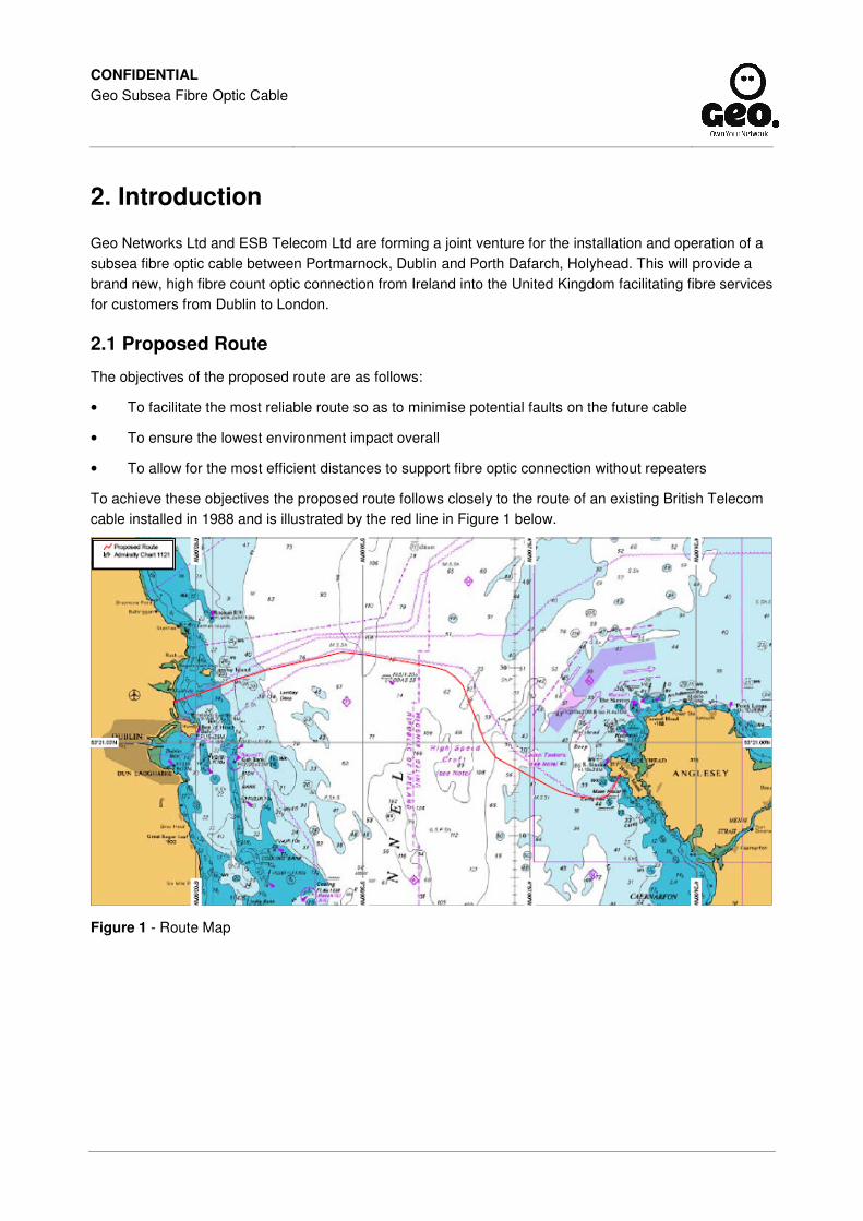
To achieve these objectives the proposed route follows closely to the route of an existing British Telecom cable installed in 1988 and is illustrated by the red line in Figure 1 below.
Figure 1 - Route Map

CONFIDENTIAL Geo Subsea Fibre Optic Cable
3. Background
On the 08 September 2010 a licence was granted to Geo by DEHLG along with the respective UK survey permits to carry out a Marine Survey between Portmarnock, ROI and Porth Dafarch, UK. Between the 11th March 2011 Noordhoek Survey B.V. was contracted on behalf of Geo Networks Limited to undertake a cable route survey in the Irish Sea. The offshore aspect of the survey was conducted by the ‘Noordheok Pathfinder’ over the period 13th to the 21st of March 2011. The nearshore survey works (inside the 20m contour) were completed separately by smaller vessels.
The offshore scope of work included:
1. Multibeam echo-sounding over a 500m wide corridor;
2. Sidescan sonar, sub-bottom profiling and magnetometry along 5 parallel lines;
3. Vibrocoring (VC) every 4km along the route centreline;
4. Cone penetrometer (CPT) probing every 1km along the route centreline.
The survey successfully collected some 518km of multibeam, sidescan sonar, sub-bottom profiler and magnetometer data. In addition 28 vibrocores were recovered and 106 CPT probe measurements were achieved.
The nearshore scope of work included:
1. A 500m wide survey corridor using Sidescan sonar, sub-bottom profiling and magnetometry comprising of 50m line spacing.
2. Beach Survey up to BMH by way of RTK walk over, magnetometer survey and bar probing;
3. Cone penetrometer (CPT) probing every 1km along the route centreline.
All aspects of the Marine Survey work were successfully completed as intended. Archaeology and Environmental assessments were carried out as part of the Marine Survey and reports produced.

CONFIDENTIAL Geo Subsea Fibre Optic Cable
4. Proposed Works
It is proposed that the main lay installation activity take place between November and December 2011 and take approximately 16 – 20 days.
The following sections detail the proposed works for each element of the cable installation.
4.1 Shore End Cable Installation
The land-based cable installation activities will comprise of the prior construction of a jointing chamber in the highway in Strand Road and the minor excavation of a single trench from there to the Low Water Mark (LWM) by mechanical and manual methods as suitable. Figure 5-1 illustrates the cable route onto Portmarnock beach, the blue dotted line indicates the best route onto the beach to avoid the rocky outcrops.
Figure 5-1 Nearshore cable route
Prior to excavation works, the site will be barricaded using appropriate warning signs and safety barriers and existing services located and marked for avoidance.
The chamber area (approximately 2m2) shall be cordoned off then excavated and where required shored to prevent fall of materials. Generally a concrete base is constructed with a brickwork surround then fitted with a level frame cover. The area around the chamber will be backfilled to ambient conditions and the area left clean and tidy
The cable will be buried by digging a trench generally with an excavator. It is expected that the trench will be approximately 150 meters in length from the jointing chamber to the LWM. Articulated pipe is clamped over the cable and placed in the trench for additional protection and once installed inside the trench is back filled using excavated material and the beach is graded back to its original condition. The cable shall be buried to a depth of 2 metre wherever possible. The trench is likely to be 1/2-2m wide depending on

CONFIDENTIAL Geo Subsea Fibre Optic Cable
ground consistency. On completion of the cable installation phase, the beach equipment and any waste materials will be removed from the site and it will be restored to as close to its original condition as is reasonably possible. The narrow trench in the grassed area will be reinstated such that grass growth shall be quickly re-established.
It is expected that the trench section will take 1-3 days to complete. If the works are left uncompleted overnight then suitable security and illumination shall be provided. The safety of personnel and onlookers will be given priority over any other installation requirements at all times. The management of safety will be provided by a specified and appropriate officer. Detailed working methods and safety plans will be agreed as appropriate with the relevant local authorities.

CONFIDENTIAL Geo Subsea Fibre Optic Cable
4.2 Near Shore Cable Installation
At Portmarnock the sea bed shelves gently, and the 12m contour is approximately 6200m from shore. Refer to Figure 5-2 below.
Figure 5-2 Portmarnock inshore longitudinal profile
This is too far for a direct pull-in, and at this landing it will be necessary to install a pre-laid shore end. A shallow draught vessel (barge) together with onshore personnel will float the short section of cable from the shore to a depth at which the cableship can safely anchor. Once significant cable has been established, divers will sink the cable and using high pressure water jetting to bury the cable to the target 1m depth.
The sea cable end will be fitted with a buoy to facilitate retrieval by the cableship. Once the cableship is anchored near to the buoy, it will retrieve the cable end, splice it to the end of the main cable and commence main lay operations.
4.3 Off Shore Cable Installation
Prior to commencing operations, the Cableship upon arrival will set up Dynamic Positioning, assess the weather, current, tidal and traffic conditions to ensure a safe and correct vessel orientation. The ship’s personnel will also prepare for cable operations and prepare the Plough and ROV for deployment.
4.3.1 Pre Lay Grapnel Run (PLGR) A pre-lay grapnel run shall be carried out as close as is reasonably practicable to commencement of burial operations to remove any seabed hazards such as ropes fishing gear and other debris. The whole cable route centreline shall be covered with the exception of protected areas particularly those (500m) near in-service cables, pipelines and other sensitive locations. Any recovered debris will be held on the vessel until it can be discharged in port and disposed of in accordance with relevant national/environmental legislation.
4.3.2 Main-lay Operation The main cable section is proposed to be laid and buried as a continuous operation by plough. Ploughing operations are planned to commence at approximately the 12m contour with a target 1m minimum burial depth.
Ploughs are equipped with a cable tracking system, and forward obstacle avoidance sonar. The plough will be deployed and recovered by means of an ‘A’ frame located at the stern of the cable ship. Once
CONFIDENTIAL Geo Subsea Fibre Optic Cable
launched the vessel proceeds along the proposed cable route, at a speed around 0.7km/hr to 1.8km/hr dependent on factors such as seabed conditions, weather, tide and current.
Ploughing will be terminated upon completion of work, equipment failure, cable and pipeline crossings and un-ploughable ground. Then the plough is recovered to deck or “flown” over small sections of un-ploughable ground. Un-ploughable ground maybe rock, granite and other hard seabed, extremely hard soil, extremely soft seabed, mega ripples and areas of steep seabed slopes.
4.3.3 Post Lay Inspection and Burial Once main lay operations have been completed the route will be inspected and where necessary additional attempts made to bury the cable. This may be carried out by divers in shallow water or by free-swimming or tracked ROVs equipped with jetting or trenching tools. The inspection shall check cable slack and the condition of reinstatement
4.3.4 Cable and Pipeline Crossings There are four other cables that are in the vicinity of the proposed cable and no pipelines; the out of service Eircom/BT-TE 1, Virgin Media Sirius South Cable, which also lands at Portmarnock, Hibernia segment C and BT/ESAT 2.
Prior to the commencement of any Cable Operations, crossing agreements will be secured from the system owners who have already been consulted. Subject to the final crossing agreements it is anticipated that no towed equipment shall be used within 500m without such agreement. In depths of water greater than 500m, this shall be extended to the water depth away from the other plant.
4.3.5 In Operation Under normal circumstances, the cable will operate without any subsea works or routine maintenance. Should the cable be damaged or develop a physical fault, marine repair work may be required. Generally this will require a cable ship to grapnel and pull on board the cable to allow cutting and the insertion of a new cable section and jointing operations on the vessel taking 1-3 days.
The proposed cable has a theoretical design life of 25-40 years. Given the inert nature of the cable, leaving it in place once out of service will have the least environmental impact than removing. Depending on the legislative requirements at the time, environmental and economic factors, decommissioning options in the future may include, leaving in situ, recovery and/or dismantling, with the preference for leaving in situ.

CONFIDENTIAL Geo Subsea Fibre Optic Cable
5. Mitigation Measures
Ecological, Archaeological or Construction considerations are listed in the below table with the proposed mitigation measures. For a more detailed analysis of the mitigations please refer to Annex C containing the Environmental Review and Annex D containing the Archaeological Assessments.
Issue Impact Proposed mitigation
H1130 – Estuaries There will be No Direct Impact on the estuary habitat which is approximately 1.3km to the north. The cable within the intertidal area will be buried at low water thereby generating minimal suspended solids. With this and the distance to the receptor, No Indirect Impact is anticipated.
Intertidal cable section buried at low water to reduce production of suspended solids.
Fine area of rocky shore south-east of Malahide and extending towards Portmarnock.
There will be No Direct Impact on the rocky shore habitat which is approximately 250m to the north. As the cable trench will be excavated, the cable laid and backfilled at low water the potential impact from suspended solids on the surrounding area will be significantly reduced. With the distance of the rocky shore of the cSAC from the proposed works (+250m), and the natural background levels of suspended solids as a result of wave action and offshore fishing activities, the indirect impact on the rocky areas is assessed to be within the natural tolerance of the habitat and therefore No Indirect Impact is anticipated.
Burial of cable in intertidal area during low water.
Upper Beach Area The construction of the beach manhole, trenching on the amenity grassed area, accessing the shore at the raised beach interface and storage of materials has the potential to cause a temporary and Minor Impact to this area of Local level.
Employ good construction practice in particular in terms of storage and handling of fuels, temporary storage of materials. Appropriate method statements and risk assessments to be carried out prior to the commencement of works.
Care taken to minimise damage to the surrounding grassed area. Re-seed any damaged areas.
Fence work area for health and safety reasons. Provision of appropriate security if any trench/hole left open overnight.
If conditions permit, a trenchless technology would be considered for the beach interface. Discussions would be held with the Local Council in advance of the beach interface work, and the timbers would be reinstated to their existing condition.
Intertidal Area On the beach the proposed cable trench will result in a localised ecological impact. The sand excavated will be backfilled and therefore any marine fauna will be able to re-colonise the area. With the works being undertaken at low water, suspended solid will be kept to a minimum thereby maintaining them within natural background levels. Overall the direct and indirect impacts from the
Cable on intertidal shore area to be laid and buried at low water. Backfill trench with excavated sand and reinstate beach along cable route.

CONFIDENTIAL Geo Subsea Fibre Optic Cable
cable laying will be Minor to Neutral as they will be short term, temporary and localised. As such the impact is assessed to be Insignificant to No Impact.
Marine Mammals Cable laying will take approximately 16 to 20 days along the entire route between Ireland and Wales and as such disturbance in terms of noise/visual impact will be short-term. The presence of the cable laying vessel should be no more disturbing that other fishing vessels which operate in the immediate area.
In terms of potential interaction with the cable laying gear, the vessels will be slow moving with minimal underwater moving parts. The activity would be similar to a vessel laying lobster pots and has been assessed as a lesser risk to marine mammals compared with, for instance, trawling. As such the potential impact to marine mammals during cable installation is assessed to be Neutral and therefore there should be No Impact overall.
A member of the ships staff shall be a trained marine mammal observer (MMO) and they will monitor for marine mammals and ensure the exclusion Zone is clear.
Vessel shall be fully compliant with international safety standards as specified by the SOLAS convention and all relevant local and national regulations.
Fish, Commercial Fisheries, Recreational fishing
There should be no direct impact to fish, as the vessel will be slow moving and fish will be able to move away from the area. Fish will also be able to avoid the temporary localised increase in suspended sediments during cable laying. Once the cable laying vessel has passed over an area the fish will be able to move back resulting in No Impact.
In terms of fish spawning grounds and nurseries, the proposed cable laying works will only affect a narrow area of seabed and the works will be short in duration. Although there may be direct and indirect impacts to spawning or juvenile fish, the impact from the cable laying vessel will be much less than that experienced from current fishing practices in the area. The magnitude of potential impact on fish spawning and nursery ground during cable laying is therefore assessed as Neutral giving an overall assessment of No Impact.
With respect to commercial fishing, during installation the cable laying vessel will not be able to move off its given route and therefore good communication will be required to ensure that there is no interaction between fishing vessels and the cable vessel. The works will be confined to a narrow corridor and with an appropriate safety distance suction dredging for shellfish could continue. With the short duration and small area of work, the magnitude of potential impact on commercial fishing during cable laying is assessed as Minor to Neutral, giving an overall assessment of Minor Adverse to Insignificant Impact.
Good communication with local fishermen and notice to mariners in advance of offshore works.
Vessel shall be fully compliant with international safety standards as specified by the SOLAS convention and all relevant local and national regulations.
A notice to mariners will be issued so that any recreational vessels will be aware of the proposed short duration works.
Landscape and Tourism
Access to the working area around the manhole and along the cable route will be restricted when it is being
Time proposed works to be outside bathing season (mid May to September) and
CONFIDENTIAL Geo Subsea Fibre Optic Cable
laid and buried. These works will be for a short period (approximately 5 days).
If the works are time to be outside the main tourist season, avoid holidays and possibly weekends (depending on weather and offshore timing) the short-term temporary impact on landscape and tourism during the construction phase is assessed to be Minor to Neutral which would result in Minor Adverse Impact to No Impact.
holidays. Avoid weekends if possible.
Position beach manhole works to avoid interference with the tarmac footpath. Discussions to be held in advance with the Local Councils concerning the works.
Employ good construction practice and fence work area for health and safety reasons. Appropriate method statements and risk assessments to be carried out prior to the commencement of works. Provision of appropriate security if any trench/hole left open overnight.
Archaeological Artifacts and find’s
Potential archaeology find during shore end activities is assessed to be Low when appropriate strategies are in place for the retrieval of any artefacts.
Further mitigations detailed in Archaeology report in Annex D.
A suitably qualified archaeologist will carry out archaeological monitoring of the works as specified by the UAU.
Scaled monitoring and a find’s retrieval strategy shall be agreed in advance by the archaeologist and the UAU of the DEHLG.
The monitoring archaeologist will suspend any land works if any potential archaeology is impacted until it has been fully resolved and will advise the UAU of the resolution.
All receptors Operational design life is 25-40 years. There will be no surface structure associated with the manhole. The intertidal cable will be buried to a depth of approximately 2m and offshore around 1m if possible. Under normal circumstances, the cable will operate without any sub-sea works or routine maintenance. If maintenance work is required this would result in similar effects to those identified for installation.
The proposed cable system is short length fibre optic cables, without repeaters. As such there would be no associated electric or magnetic fields and no impact on the marine ecology offshore.
Decommissioning of the cable would be reviewed at the appropriate time and the most appropriate option, including leaving in-situ would be considered.
Undertake appropriate consultation in advance of any maintenance/ decommissioning works. Impact and mitigation to be reviewed at time of works.

CONFIDENTIAL Geo Subsea Fibre Optic Cable
6. Environmental Review
Annex C contains a detailed Environmental Review conducted by Titan Environmental Surveys Ltd. in the Portmarnock area. To assess the impacts of the proposed cable route on the inter-tidal and subtidal flora and fauna, guidelines of the Institute of Ecology and Environmental Management (IEEM) 2010 have been used. The method firstly determines the value of the receiving receptor (site/feature/species) and secondly, the magnitude of the potential impact on the receptor, in order to provide an overall impact score and therefore, the predicted impact significance. The value of each receptor of nature conservation interest has been based on the biodiversity evaluation methods identified in the Guidelines for Ecological Impact Assessment in the Britain and Ireland, Marine and Coastal (IEEM, 2010).
The main issues identified with the project are linked to the ecology associated with the designations in the vicinity of the landfall and fishing activity offshore. The environmental review report has been structured in the following way:
1. Introduction – A brief project summary has been provided, the permitting requirements and the objective of environmental report. Information has also been given on the early cable route desk study consultation as well as additional consultation associated with the project to date. Finally the assessment methods used to determine the potential impacts of the project are presented.
2. Project Description – A brief overview has been provided of the cable route selection process and the proposed route corridor between the two landfall points.
3. Baseline at Portmarnock – The baseline situation includes a review of the key ecological designations in the area; determination of the ecological baseline of intertidal route corridor and surrounding beach; an overview of offshore ecology extending out to 12nm, marine mammals and commercial fisheries. In addition to this information on other issues such as landscape and tourism within the local area is provided.
4. Assessment of Impacts – An assessment of potential effects during construction, operation/maintenance and decommissioning has been undertaken. Where appropriate, mitigation measures have been provided.
5. Summary – the results of the assessment within the environmental review report and mitigation measures proposed have been summarised in tabular format.
6. Conclusion – the overall conclusions of the report have been presented
6.1 Review Conclusion
The route selection process has been undertaken to identify the least sensitive alignment for the cable. In addition, the plough and lay deployment technique which is to be used is considered to offer the fastest and least destructive method of undertaking the work. Seasonal timing, as well as a work schedule to coincide with tides, will also mitigate potential localised impact. Sensitive ecological receptors including designated sites are present within the vicinity of the landfall works and careful construction practices are proposed to ensure avoidable impacts do not take place. Consideration of timing with regard to recreational use of the beach will also be an important factor in minimising disruption to the area, as will good communication to minimise disruption to offshore commercial fisheries in the area. Overall the laying of a proposed fibre-optic cable at Portmarnock near Dublin, Ireland does not appear to be constrained by ecological, landscape or tourism factors. In part this is due to the small diameter size of the cable as well as its inherently inert properties. With mitigation, the temporary disturbance of the dynamic coastal environment by the proposals is considered to comprise an insignificant impact.

CONFIDENTIAL Geo Subsea Fibre Optic Cable
7. Archaeological Assessment
Annex D contains detailed Archaeological reports in three volumes, these include
Volume 2 – Maritime Cultural Heritage Assessment – Irish Waters
Volume 3 – Archaeological Assessment of Marine Geophysical Survey Data
Volume 4 – Archaeological Assessment of Marine Geotechnical Survey Data

CONFIDENTIAL Geo Subsea Fibre Optic Cable
Appendix A – Eire Inshore Survey Results
Éire Inshore Survey (0-20m)
Bathymetry The inshore section at Portmarnock is considerably long, with shallow slopes. The ‘steepest’ alongtrack slopes are to be found at the offshore side, where the seabed deepens steadily from 15m to 20m, but no slopes exceeding 2° are encountered. The 20m contour is encountered at KP 106.15.
Slopes are summarised in Table 1. Note that the inshore survey was performed using a singlebeam echosounder, so analysis of across-track slopes would not be meaningful due to the spacing of the soundings in this direction. Only along-track slopes are described here.
Table 1: Summary of along-track slopes within Portmarnock nearshore section
From KP To KP Min depth (m) Max depth (m) Typical slope Maximum slope
106.160 106.600 15 20 0.9° 1.0°
106.600 109.700 14 16.5 <0.2° <0.2°
109.700 110.800 12.3 16.5 0.3° 0.3°
110.800 112.910 ~12.3 ~12.3 <0.1° <0.1°
112.910 116.200 0 12.3 0.2° 0.6°
The seabed profile along the route is shown below in Figure 1.
Figure 1: Longitudinal profile from inshore survey at Portmarnock landfall
Seabed Features and Shallow Geology The seabed within the whole of the Irish nearshore section is composed of silty, fine sand with some shell fragments underlain by similar sediments, as evidenced by VC-01 to VC-03. The occurrence of megaripples in parts of the area and abundant trawl marks in other parts suggest a varying clay content, as shown in Figure 2 and Figure 3.
Between KP 110.7 and KP 114.5, shallow outcrops of cobbles and/or small boulders were observed. The outcrops are isolated and sometimes elongated, as shown in Figure 4 and Figure 5.
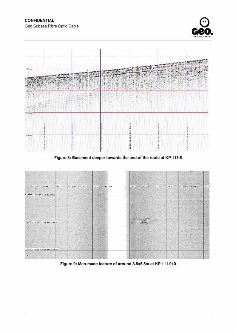
The SBP data show that the cobbles are actually outcrops of the basement which comes very close to the surface in this area. Generally the cover is 1-2m, but it is sometimes less as shown in Figure 6. The

CONFIDENTIAL Geo Subsea Fibre Optic Cable
basement comes up quickly before KP 110 and subsides slowly after KP 114 as shown in Figure 7 and Figure 8 respectively. The composition of the basement is not clear. It can be very irregular (suggesting the presence of rock), but sometimes is well penetrated by the SBP and shows internal layering, indicating soft material. Possibly, it is a rocky paleo-relief, filled in with clayey deposits. Also clays with a carpet of cobbles could be possible.
As of approximately KP 115, black dots can be seen on the SSS records. They have no height and are believed to represent marine growth.
Just outside the survey corridor (around 250m from the proposed route), and at the extreme north-west point of the surveyed area, outcrops with abundant marine growth appear to be present.
The live BT-TE1 cable (fibre-optic) is believed to cross the proposed route at KP 116.347, according to the desktop study. However, this cable was not seen on the SSS records, nor was anything picked up on the magnetometer records at this location.
At KP 111.910 (296983E, 5926193N) DCC -3.3, a clearly man-made feature of 8.5x5.5m was observed, with little height and as shown in Figure 9. It could be the remains of a wooden boat, as the magnetometer readings do not show an anomaly here.
There is a magnetometer anomaly present at KP 112.279, DCC 248m (296560E, 5926335N), but nothing is visible from the SSS data. This suggests that it may be a buried metallic object. Human activity is clear in this area, as evident from features such as that shown in Figure 10, which appears to be a large seabed scar.
Figure 2: Fine sandy seabed with megaripples at KP 107.5

CONFIDENTIAL Geo Subsea Fibre Optic Cable
Figure 3: Abundant, well conserved trawl marks in clayey sand at KP 115.5

CONFIDENTIAL Geo Subsea Fibre Optic Cable
Figure 4: Outcrop of cobbles and/or small boulders at KP 110.9
Figure 5: Outcrop of cobbles and/or small boulders at KP 113.6

CONFIDENTIAL Geo Subsea Fibre Optic Cable
Figure 6: Basement coming very close to the surface at KP 113.5
Figure 7: Basement coming up quickly at KP 111, with partial blanking to the left
CONFIDENTIAL Geo Subsea Fibre Optic Cable
Figure 8: Basement deeper towards the end of the route at KP 115.5
Figure 9: Man-made feature of around 8.5x5.5m at KP 111.910

CONFIDENTIAL Geo Subsea Fibre Optic Cable
Figure 10: Linear seabed disturbance at KP 114.6

CONFIDENTIAL Geo Subsea Fibre Optic Cable
Appendix B – Eire Topographic Survey
Éire Topographic Survey (BMH to LAT)
Topography and Features The Éire BMH is at the following position, as found using kinematic GPS:
Easting: 292511.40 Northing: 5925088.78 Elevation: 10.02 (LAT)
This position is 46cm from the target coordinates (292511.01 E, 5925088.53 N), with the discrepancy being the difference between target and observed positions. The as-found coordinates were derived from 1.5 hours of GPS readings, post-processed to yield a high-accuracy position.
The BMH position is based on eastern side of the foot path which runs along the beach front leading away from the road R106 as shown in Figure B1 and B2.
Figure B1: Portmarnock BMH location
Figure B2: BMH location on satellite map

CONFIDENTIAL Geo Subsea Fibre Optic Cable
A longitudinal profile along the route from the BMH to LAT is shown below in Figure 11 with LAT being recorded at approximately KP 116.2.
Figure 11: Longitudinal profile from topographic survey at Portmarnock landfall
Bar Probing Bar probing was carried out along the route across the beach, by pushing a probe into the ground and measuring the depth to which it would penetrate. Probing was initially conducted along the proposed route, but additional measurements were taken to either side in order to identify more favourable conditions due to limited penetration on the proposed route. In total, forty-five measurements were taken.
The bar probe results are provided numerically in Table B1 below. The penetration depths achieved are shown below in Figure 12. In this illustration, penetration depths of less than a metre are circled in magenta. Along the proposed route, penetration values as low as 0.23m were observed. More favourable results were achieved to the northern side.
Figure 12: Annotated chart excerpt showing bar probe results for Portmarnock landfall

CONFIDENTIAL Geo Subsea Fibre Optic Cable
Table B1: Portmarnock – Bar probing results
Date Time Easting Northing KP Elevation (m,
LAT) Probe Depth
(m)
22/03/11 16:25 292567.19 5925090.20 116.476 5.08 0.23
22/03/11 16:31 292579.04 5925090.49 116.464 4.33 0.65
22/03/11 16:33 292589.25 5925090.97 116.454 4.05 0.82
22/03/11 16:34 292598.90 5925091.29 116.444 3.58 0.51
22/03/11 16:37 292608.21 5925091.51 116.435 3.08 0.88
22/03/11 16:39 292618.76 5925091.68 116.424 2.91 0.57
22/03/11 16:40 292628.10 5925091.82 116.415 2.99 0.53
22/03/11 16:44 292638.14 5925092.20 116.405 2.85 0.98
22/03/11 16:48 292648.55 5925092.45 116.394 2.59 1.28
22/03/11 16:53 292658.94 5925092.69 116.384 2.26 1.39
22/03/11 16:57 292669.52 5925092.90 116.373 1.87 1.12
22/03/11 17:00 292679.15 5925093.40 116.364 1.84 1.15
22/03/11 17:06 292688.78 5925093.47 116.354 1.78 1.42
22/03/11 17:16 292699.48 5925093.53 116.343 1.62 2.00
22/03/11 17:21 292709.14 5925093.84 116.334 1.71 2.00
22/03/11 17:27 292718.58 5925094.15 116.324 1.54 2.00
22/03/11 17:40 292728.33 5925094.40 116.315 1.21 0.99
22/03/11 17:57 292738.85 5925094.74 116.304 0.86 1.08
22/03/11 18:02 292804.79 5925096.40 116.238 0.43 2.00
22/03/11 18:09 292795.03 5925096.21 116.248 0.51 2.00
22/03/2011 18:17 292784.73 5925095.85 116.258 0.49 2.00
22/03/2011 18:20 292772.44 5925095.53 116.271 0.59 2.00
22/03/2011 18:25 292761.58 5925095.26 116.281 0.72 2.00
22/03/2011 18:28 292751.56 5925094.93 116.291 0.76 2.00
31/03/2011 11:33 292567.05 5925101.42 116.476 5.16 1.31
31/03/2011 11:38 292587.93 5925102.77 116.455 4.20 0.65
31/03/2011 11:47 292578.47 5925113.28 116.464 4.40 1.32
31/03/2011 11:56 292568.98 5925126.16 116.473 5.10 2.00

CONFIDENTIAL Geo Subsea Fibre Optic Cable
Date Time Easting Northing KP Elevation (m,
LAT) Probe Depth
(m)
31/03/2011 12:03 292588.28 5925125.25 116.454 4.26 1.50
31/03/2011 12:17 292596.74 5925114.41 116.446 3.82 1.20
31/03/2011 12:26 292608.91 5925125.18 116.433 3.08 2.00
31/03/2011 12:30 292616.87 5925112.48 116.426 3.07 0.50
31/03/2011 12:33 292627.87 5925123.97 116.414 3.03 2.00
31/03/2011 12:49 292635.79 5925111.07 116.407 2.93 2.00
31/03/2011 13:11 292647.77 5925123.17 116.394 2.70 2.00
31/03/2011 13:33 292658.20 5925110.74 116.384 2.32 2.00
31/03/2011 14:11 292658.27 5925122.77 116.384 2.33 2.00
31/03/2011 14:22 292675.22 5925122.52 116.367 1.91 2.00
31/03/2011 14:28 292696.67 5925121.19 116.346 1.77 2.00
31/03/2011 15:01 292618.65 5925125.23 116.423 3.19 1.40
31/03/2011 15:09 292562.50 5925006.53 116.483 5.23 0.57
31/03/2011 15:11 292579.50 5925004.87 116.466 4.47 2.00
31/03/2011 15:15 292601.42 5925003.53 116.444 3.26 2.00
31/03/2011 15:19 292611.60 5925002.93 116.434 3.33 2.00
31/03/2011 15:30 292552.89 5925089.88 116.490 8.96 2.00

CONFIDENTIAL Geo Subsea Fibre Optic Cable
Appendix C – Environmental Review
See attached Environmental Report

CONFIDENTIAL Geo Subsea Fibre Optic Cable
Appendix D – Archaeological Reports
See attached Reports:
Volume 2 – Maritime Cultural Heritage Assessment – Irish Waters
Volume 3 – Archaeological Assessment of Marine Geophysical Survey Data
Volume 4 – Archaeological Assessment of Marine Geotechnical Survey Data

CONFIDENTIAL Geo Subsea Fibre Optic Cable
Appendix E – Charts and RPL
See charts attached. The Route position list of the cable is as follows:
Easting Northing KP (grid) Easting Northing KP (grid)
390074.13 5905780.71 0.000 355987.52 5926171.71 50.170
389801.46 5905458.02 0.422 355125.69 5927266.79 51.564
389711.97 5905227.44 0.670 354025.20 5928337.82 53.100
388880.65 5903905.14 2.232 352392.10 5929578.11 55.150
388656.17 5903086.59 3.080 349930.21 5930388.67 57.742
388086.00 5901977.02 4.328 334909.58 5933588.49 73.100
387556.92 5901468.66 5.062 333630.83 5933772.13 74.392
387328.26 5901006.26 5.578 333433.82 5933784.36 74.589
386869.56 5900743.49 6.106 333236.74 5933828.73 74.791
385237.96 5900283.11 7.801 332374.25 5933952.59 75.662
384777.41 5900254.78 8.263 329969.31 5934298.32 78.092
383939.64 5900397.99 9.113 329622.99 5934287.46 78.439
383294.14 5900590.06 9.786 323752.57 5933064.02 84.435
383120.22 5900685.88 9.985 319732.16 5932230.21 88.541
379547.70 5901233.57 13.599 312830.77 5930976.54 95.555
378937.06 5901456.91 14.249 311630.98 5930624.09 96.806
378547.23 5901533.55 14.647 311186.38 5930355.63 97.325
376794.95 5902058.95 16.476 310397.70 5930186.19 98.132
371943.95 5904832.32 22.064 307212.67 5929501.92 101.390
367623.09 5907309.68 27.044 306731.09 5929399.06 101.882
366111.88 5908075.87 28.739 304483.59 5928525.00 104.294
364439.97 5909095.76 30.697 304312.13 5928422.34 104.493
364015.68 5909378.69 31.207 304110.82 5928380.03 104.699
363079.05 5909917.26 32.288 302521.13 5927761.01 106.405
362756.54 5910213.21 32.725 301653.75 5927477.84 107.318
362221.91 5910938.96 33.627 301388.52 5927440.80 107.585
361432.40 5912161.70 35.082 298418.10 5926601.01 110.672
360646.02 5913248.33 36.424 297367.12 5926304.72 111.764
359562.57 5916253.98 39.619 297015.19 5926087.57 112.178
359432.35 5916554.69 39.946 296597.17 5926087.65 112.596
359382.37 5916753.89 40.152 293876.13 5925320.54 115.423
357994.91 5920602.92 44.243 293106.88 5925104.26 116.222
357950.84 5920839.88 44.484 292511.40 5925088.78 116.818
357858.65 5920980.91 44.653

CONFIDENTIAL Geo Subsea Fibre Optic Cable
Issue Date 11/05/11 Page 28
Appendix F – Vibrocore Results
See attached Laboratory Reports.
The coordinates for the vibrocore locations listed in below are mean values derived from 30 observations. This list has been sorted so that the vibrocore locations are presented in ascending KP order (east to west) so are not necessarily in the order in which they were collected.
Date Time Sample
No. Sample ID
Water Depth
Easting Northing Original
KP Recalculated
KP Recalculated
DCC Comment
15/03/2011 17:58 28 VC28 KP1.822A 28 389253.23 5904159.57 1.818 1.855 -108.73 Changed position due to rocks
15/03/2011 17:15 27 VC27 KP5.822A 39 387176.56 5901088.98 5.562 5.589 -27.82 Changed position due to rocks
15/03/2011 16:23 26 VC26 KP9.852A 45 383010.29 5900707.43 9.852 9.881 4.64 Changed position due to wreck
15/03/2011 15:30 25 VC25 KP13.822A 47 379100.05 5901369.50 13.822 13.851 1.64
15/03/2011 14:39 24 VC24 KP17.822A 46 375413.04 5902853.00 17.821 17.851 3.47
15/03/2011 13.51 23 VC23 KP21.822A 49 371937.37 5904836.40 21.825 21.853 0.27
15/03/2011 13:20 22 VC22 KP24.822A 52 368468.84 5906827.05 25.823 25.852 1.98 No position report - forgot to print
15/03/2011 12:30 21 VC21 KP29.822A 67 364999.66 5908815.68 29.821 29.850 1.61
15/03/2011 11:43 20 VC20 KP33.822A 110 361987.36 5911319.32 33.821 33.850 0.09
15/03/2011 10:48 19 VC19 KP37.822A 110 360085.21 5914803.45 37.823 37.852 -0.22
15/03/2011 10:01 18 VC18 KP41.822A 115 358730.92 5918566.54 41.822 41.852 1.84
15/03/2011 09:11 17 VC17 KP45.822A 110 357373.60 5922327.31 45.821 45.850 0.27
15/03/2011 08:23 16 VC16 KP49.822A 88 356015.38 5926092.86 49.824 49.853 -0.53
15/03/2011 07:33 15 VC15 KP53.822A 78 353245.26 5928929.11 53.823 53.852 -0.84
15/03/2011 06:42 14 VC14 KP57.822A 81 349600.97 5930460.23 57.824 57.853 1.39
15/03/2011 05:43 13 VC13 KP61.822A 80 345692.81 5931291.52 61.820 61.849 0.16
15/03/2011 04:46 12 VC12 KP 65.822A 82 341779.00 5932123.81 65.822 65.850 -1.27
15/03/2011 00:46 11 VC11 KP69.823A 100 337864.46 5932961.08 69.823 69.853 2.02
14/03/2011 23:49 10 VC10 KP73.824A 105 333940.37 5933726.81 73.824 73.853 -0.86

CONFIDENTIAL Geo Subsea Fibre Optic Cable
Issue Date 11/05/11 Page 29
Date Time Sample
No. Sample ID
Water Depth
Easting Northing Original
KP Recalculated
KP Recalculated
DCC Comment
14/03/2011 22:28 9 VC9 KP77.822A 99 329982.58 5934297.56 77.822 77.852 1.14
14/03/2011 21:24 8 VC8 KP81.823A 93 326059.09 5933544.41 81.823 81.852 -0.30
14/03/2011 20:32 7 VC7 KP85.823A 82 322142.59 5932728.81 85.823 85.852 -1.28
14/03/2011 19:40 6 VC6 KP89.822A 66 318219.40 5931954.18 89.823 89.852 -1.21
14/03/2011 18:41 5 VC5 KP93.822A 78 314281.95 5931239.10 93.823 93.854 -1.04
14/03/2011 17:32 4 VC4 KP97.822A 52 310428.54 5930195.80 97.825 97.854 -0.47
14/03/2011 16:39 3 VC3 KP101.822A 43 306532.94 5929321.43 101.820 101.849 -0.53
14/03/2011 15:44 2 VC2 KP105.822A 24 302804.62 5927873.58 105.820 105.849 1.44
14/03/2011 14:30 1 VC1 KP 111.740A 14 297103.00 5926229.00 111.740 111.785 -1.21 No position report - bad USBL

CONFIDENTIAL Geo Subsea Fibre Optic Cable
Issue Date 11/05/11 Page 30
Appendix G – CPT Results
See attached CPT Reports.
The coordinates for the CPT locations listed in below are mean values derived from 110 observations. The list has been sorted so that the CPT locations are presented in ascending KP order (east to west) so are not necessarily in the order in which they were collected. For charting purposes the sample IDs are shown with only the CPT number without the original (target) KPs or attempt suffixes (A or B) for reasons of clarity. At the four locations where two tests were made, these are indicated as A and B respectively.
Date Time Sample
No. Sample ID
Water Depth
Easting Northing Original
KP Recalculated
KP Recalculated
DCC Comment
21/03/2011 06:17 110 CPT1 KP 1.250 22 389474.00 5904682.23 1.253 1.288 -123.13
21/03/2011 05:47 109 CPT2 KP1.822 25 389253.83 5904157.53 1.820 1.857 -110.03
21/03/2011 05:16 108 CPT3 KP3.872 34 388279.53 5902351.99 3.871 3.901 -0.75
21/03/2011 04:52 107 CPT4 KP4.822 36 387707.10 5901610.52 4.822 4.850 -1.76
21/03/2011 04.32 106 CPT5 KP5.822A 37 387178.48 5901094.12 5.556 5.585 -24.31
21/03/2011 04:04 105 CPT6 KP6.900A 41 385910.76 5900659.76 6.900 6.929 4.79
21/03/2011 03:25 104 CPT7 KP7.822A 43 385019.43 5900441.15 7.821 7.850 -3.84
21/03/2011 02:44 103 CPT8 KP8.875A 43 383969.83 5900532.72 8.877 8.906 -22.65
21/03/2011 01:12 102 CPT9 KP9.822A 46 383041.94 5900688.22 9.816 9.847 -9.55
21/03/2011 00:32 101 CPT10 KP10.822A 47 382050.95 5900843.70 10.821 10.850 -6.04
20/03/2011 23:56 100 CPT11 KP11.822A 53 381060.84 5901001.01 11.823 11.852 -0.58
20/03/2011 23:35 99 CPT12 KP12.822A 53 380071.82 5901154.54 12.824 12.853 1.31
20/03/2011 23:10 98 CPT13 KP13.822A 49 379099.55 5901371.71 13.822 13.852 3.61
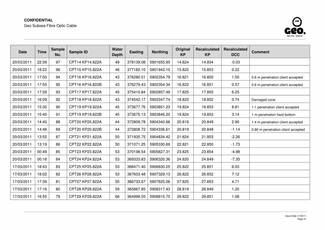
CONFIDENTIAL Geo Subsea Fibre Optic Cable
Issue Date 11/05/11 Page 31
Date Time Sample
No. Sample ID
Water Depth
Easting Northing Original
KP Recalculated
KP Recalculated
DCC Comment
20/03/2011 22:39 97 CPT14 KP14.822A 49 378139.08 5901655.90 14.824 14.854 -0.03
20/03/2011 18:22 96 CPT15 KP15.822A 46 377182.10 5901943.10 15.822 15.853 0.22
20/03/2011 17:50 94 CPT16 KP16.822A 43 376280.51 5902354.79 16.821 16.850 1.50 0.6 m penetration client accepted
20/03/2011 17:55 95 CPT16 KP16.822B 43 376279.43 5902354.34 16.822 16.851 0.57 0.6 m penetration client accepted
20/03/2011 17:28 93 CPT17 KP17.822A 45 375410.84 5902857.46 17.825 17.855 6.25
20/03/2011 16:09 92 CPT18 KP18.822A 43 374542.17 5903347.74 18.823 18.852 0.74 Damaged cone
20/03/2011 15:30 90 CPT19 KP19.822A 45 373677.76 5903851.23 19.824 19.853 8.81 1.1 penetration client accepted
20/03/2011 15:40 91 CPT19 KP19.822B 45 373675.13 5903846.20 19.824 19.853 3.14 1 m penetration hard bottom
20/03/2011 14:40 88 CPT20 KP20.822A 44 372809.78 5904340.66 20.819 20.849 2.90 1.4 m penetration client accepted
20/03/2011 14:48 89 CPT20 KP20.822B 44 372808.72 5904336.61 20.819 20.848 -1.14 0.80 m penetration client accepted
20/03/2011 13:55 87 CPT21 KP21.822A 50 371935.75 5904834.42 21.824 21.853 -2.26
20/03/2011 13:19 86 CPT22 KP22.822A 50 371071.25 5905330.69 22.821 22.850 -1.73
20/03/2011 00:49 85 CPT23 KP23.822A 53 370198.54 5905827.31 23.825 23.854 -4.98
20/03/2011 00:18 84 CPT24 KP24.822A 53 369333.83 5906320.36 24.820 24.849 -7.35
17/03/2011 18:43 83 CPT25 KP25.822A 53 368471.40 5906830.25 25.822 25.851 6.03
17/03/2011 18:02 82 CPT26 KP26.822A 53 367603.48 5907329.13 26.822 26.852 7.12
17/03/2011 17:39 81 CPT27 KP27.822A 55 366733.67 5907825.06 27.825 27.853 4.71
17/03/2011 17:16 80 CPT28 KP28.822A 59 365867.85 5908317.43 28.819 28.849 1.20
17/03/2011 16:55 79 CPT29 KP29.822A 66 364998.55 5908815.70 29.822 29.851 1.08

CONFIDENTIAL Geo Subsea Fibre Optic Cable
Issue Date 11/05/11 Page 32
Date Time Sample
No. Sample ID
Water Depth
Easting Northing Original
KP Recalculated
KP Recalculated
DCC Comment
17/03/2011 16:30 78 CPT30 KP30.822A 75 364132.79 5909315.65 30.822 30.851 3.73
17/03/2011 16:09 77 CPT31 KP31.822A 105 363268.20 5909813.39 31.820 31.849 4.24
17/03/2011 00:01 4 CPT32 KP32.822A 101 362553.23 5910497.22 32.823 32.852 -4.76
16/03/2011 23:25 3 CPT33 KP33.822A 112 361984.07 5911317.35 33.821 33.850 -3.73
16/03/2011 22:50 2 CPT34 KP34.822A 118 361411.23 5912133.37 34.818 34.847 -8.15 No report because poor USBL
16/03/2011 11:45 1 CPT35 KP35.822A 123 360843.02 5912956.32 35.818 35.847 -4.94
19/03/2011 15:15 76 CPT36 KP36.822A 117 360423.46 5913858.50 36.819 36.849 -2.46
19/03/2011 14:50 75 CPT37 KP37.822A 107 360089.02 5914799.91 37.818 37.848 2.16
19/03/2011 14:23 74 CPT38 KP38.822A 105 359745.44 5915735.58 38.816 38.844 -3.76
19/03/2011 13:57 73 CPT39 KP39.822A 100 359406.96 5916678.09 39.817 39.846 -2.57
19/03/2011 13:04 72 CPT40 KP40.822A 106 359069.88 5917625.87 40.822 40.852 1.73
19/03/2011 12:33 71 CPT41 KP41.822A 112 358730.24 5918565.67 41.822 41.851 0.91
19/03/2011 11:42 70 CPT42 KP42.822A 110 358385.90 5919500.47 42.818 42.847 -6.03
19/03/2011 11:21 69 CPT43 KP43.822A 100 358050.20 5920446.01 43.822 43.851 -1.19
19/03/2011 10:58 68 CPT44 KP44.822A 100 357711.39 5921386.81 44.821 44.851 -0.89
19/03/2011 10:32 67 CPT45 KP45.822A 106 357370.50 5922327.39 45.821 45.851 -2.62
19/03/2011 10:06 66 CPT46 KP46.822A 110 357033.81 5923266.12 46.819 46.848 -1.03
19/03/2011 09:35 65 CPT47 KP47.822A 130 356690.64 5924207.39 47.821 47.850 -4.67
19/03/2011 09:05 64 CPT48 KP48.822A 103 356354.81 5925155.38 48.827 48.856 0.88

CONFIDENTIAL Geo Subsea Fibre Optic Cable
Issue Date 11/05/11 Page 33
Date Time Sample
No. Sample ID
Water Depth
Easting Northing Original
KP Recalculated
KP Recalculated
DCC Comment
19/03/2011 08:33 63 CPT49 KP49.822A 88 356014.95 5926093.48 49.824 49.854 -0.72
19/03/2011 08:02 62 CPT50 KP50.822A 80 355414.57 5926883.87 50.821 50.850 5.19
19/03/2011 07:29 61 CPT51 KP51.822A 76 354777.82 5927661.19 51.826 51.855 2.03
19/03/2011 07:02 60 CPT52 KP52.822B 71 354061.74 5928316.20 52.802 52.831 4.88 0.8m penetration client accepted
19/03/2011 06:42 59 CPT52 KP52.822A 70 354045.64 5928328.27 52.822 52.852 4.76 1.6m penetration client accepted
19/03/2011 06:19 58 CPT53 KP53.822A 75 353251.37 5928933.96 53.821 53.850 6.72
19/03/2011 05:41 57 CPT54 KP54.822A 75 352454.49 5929540.21 54.822 54.852 7.55
19/03/2011 05:15 56 CPT55 KP55.822A 76 351511.26 5929869.12 55.823 55.852 0.95
19/03/2011 04:47 55 CPT56 KP56.822A 73 350561.61 5930180.28 56.822 56.851 -0.48
19/03/2011 04:25 54 CPT57 KP57.822A 78 349608.02 5930463.51 57.818 57.847 6.07
19/03/2011 03:58 53 CPT58 KP58.822A 78 348624.62 5930671.12 58.823 58.852 4.23
19/03/2011 03:31 52 CPT59 KP59.822A 80 347650.00 5930873.33 59.818 59.847 -1.07
19/03/2011 03:04 51 CPT60 KP60.822A 77 346670.84 5931080.93 60.819 60.848 -2.03
19/03/2011 02:37 50 CPT61 KP61.822A 78 345689.12 5931290.39 61.823 61.852 -1.71
19/03/2011 02:08 49 CPT62 KP62.822A 79 344712.86 5931497.58 62.821 62.850 -2.48
19/03/2011 01:41 48 CPT63 KP63.822A 78 343734.25 5931704.15 63.822 63.850 -4.34
19/03/2011 01:14 47 CPT64 KP64.822A 80 342756.77 5931914.91 64.821 64.850 -1.86
19/03/2011 00:45 46 CPT65 KP65.822A 81 341780.57 5932124.24 65.820 65.849 -0.52
19/03/2011 00:14 45 CPT66 KP66.822A 80 340798.95 5932330.85 66.822 66.852 -2.97
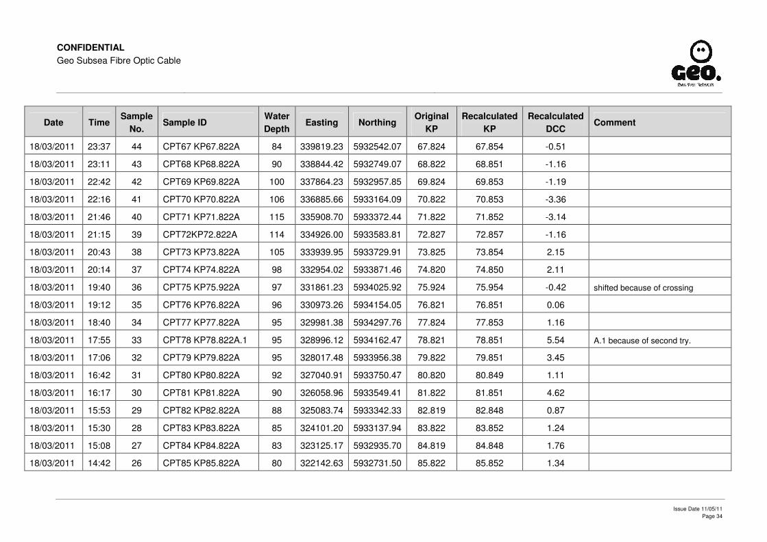
CONFIDENTIAL Geo Subsea Fibre Optic Cable
Issue Date 11/05/11 Page 34
Date Time Sample
No. Sample ID
Water Depth
Easting Northing Original
KP Recalculated
KP Recalculated
DCC Comment
18/03/2011 23:37 44 CPT67 KP67.822A 84 339819.23 5932542.07 67.824 67.854 -0.51
18/03/2011 23:11 43 CPT68 KP68.822A 90 338844.42 5932749.07 68.822 68.851 -1.16
18/03/2011 22:42 42 CPT69 KP69.822A 100 337864.23 5932957.85 69.824 69.853 -1.19
18/03/2011 22:16 41 CPT70 KP70.822A 106 336885.66 5933164.09 70.822 70.853 -3.36
18/03/2011 21:46 40 CPT71 KP71.822A 115 335908.70 5933372.44 71.822 71.852 -3.14
18/03/2011 21:15 39 CPT72KP72.822A 114 334926.00 5933583.81 72.827 72.857 -1.16
18/03/2011 20:43 38 CPT73 KP73.822A 105 333939.95 5933729.91 73.825 73.854 2.15
18/03/2011 20:14 37 CPT74 KP74.822A 98 332954.02 5933871.46 74.820 74.850 2.11
18/03/2011 19:40 36 CPT75 KP75.922A 97 331861.23 5934025.92 75.924 75.954 -0.42 shifted because of crossing
18/03/2011 19:12 35 CPT76 KP76.822A 96 330973.26 5934154.05 76.821 76.851 0.06
18/03/2011 18:40 34 CPT77 KP77.822A 95 329981.38 5934297.76 77.824 77.853 1.16
18/03/2011 17:55 33 CPT78 KP78.822A.1 95 328996.12 5934162.47 78.821 78.851 5.54 A.1 because of second try.
18/03/2011 17:06 32 CPT79 KP79.822A 95 328017.48 5933956.38 79.822 79.851 3.45
18/03/2011 16:42 31 CPT80 KP80.822A 92 327040.91 5933750.47 80.820 80.849 1.11
18/03/2011 16:17 30 CPT81 KP81.822A 90 326058.96 5933549.41 81.822 81.851 4.62
18/03/2011 15:53 29 CPT82 KP82.822A 88 325083.74 5933342.33 82.819 82.848 0.87
18/03/2011 15:30 28 CPT83 KP83.822A 85 324101.20 5933137.94 83.822 83.852 1.24
18/03/2011 15:08 27 CPT84 KP84.822A 83 323125.17 5932935.70 84.819 84.848 1.76
18/03/2011 14:42 26 CPT85 KP85.822A 80 322142.63 5932731.50 85.822 85.852 1.34

CONFIDENTIAL Geo Subsea Fibre Optic Cable
Issue Date 11/05/11 Page 35
Date Time Sample
No. Sample ID
Water Depth
Easting Northing Original
KP Recalculated
KP Recalculated
DCC Comment
18/03/2011 14:17 25 CPT86 KP86.822A 75 321166.63 5932529.69 86.820 86.849 1.94
18/03/2011 13:55 24 CPT87 KP87.822A 70 320184.82 5932322.00 87.823 87.852 -2.05
18/03/2011 13:32 23 CPT88 KP88.822A 68 319205.80 5932133.52 88.820 88.849 -1.06
18/03/2011 13:10 22 CPT89 KP89.822A 62 318217.48 5931954.29 89.824 89.854 -0.76
18/03/2011 12:48 21 CPT90 KP90.822A 60 317233.78 5931775.14 90.824 90.853 -1.21
18/03/2011 12:21 20 CPT91 KP91.822A 66 316252.13 5931597.82 91.822 91.851 -0.22
18/03/2011 11:53 19 CPT92 KP92.822A 76 315270.62 5931416.86 92.820 92.849 -2.84
18/03/2011 11:28 18 CPT93 KP93.822A 77 314284.48 5931233.47 93.822 93.852 -7.03
18/03/2011 11:05 17 CPT94 KP94.822A 69 313300.83 5931058.82 94.822 94.851 -3.06
18/03/2011 10:41 16 CPT95 KP95.822A 56 312332.59 5930813.71 95.823 95.852 -1.00
18/03/2011 10:21 15 CPT96 KP96.822A 54 311382.18 5930504.00 96.823 96.852 -2.03
18/03/2011 10:01 14 CPT97 KP97.822A 53 310431.82 5930195.71 97.822 97.851 -1.57
18/03/2011 09:42 13 CPT98 KP98.822A 42 309453.16 5929981.50 98.824 98.853 -1.73
18/03/2011 09:23 12 CPT99 KP99.822A 43 308476.32 5929772.09 99.823 99.852 -1.28
18/03/2011 09:04 11 CPT100 KP100.600A 43 307715.72 5929608.86 100.600 100.630 -1.11 Shifted due to crossing
18/03/2011 08:40 10 CPT101 KP101.822A 42 306531.22 5929321.80 101.822 101.851 0.44
18/03/2011 08:20 9 CPT102 KP102.822A 35 305598.75 5928957.14 102.823 102.852 -1.44
18/03/2011 07:58 8 CPT103 KP103.822A 32 304668.39 5928599.19 103.819 103.849 2.17
18/03/2011 07:38 7 CPT104 KP104.822A 30 303735.71 5928234.61 104.822 104.850 0.44
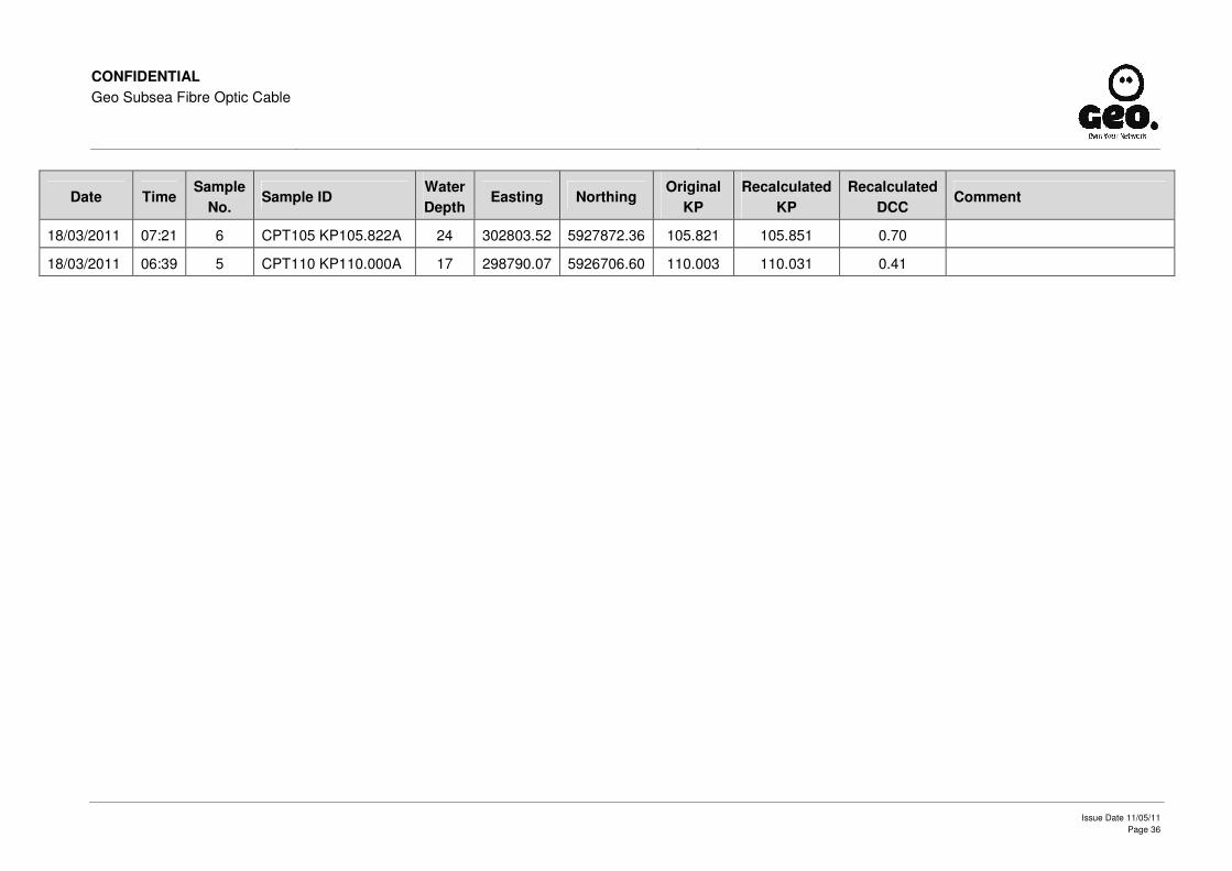
CONFIDENTIAL Geo Subsea Fibre Optic Cable
Issue Date 11/05/11 Page 36
Date Time Sample
No. Sample ID
Water Depth
Easting Northing Original
KP Recalculated
KP Recalculated
DCC Comment
18/03/2011 07:21 6 CPT105 KP105.822A 24 302803.52 5927872.36 105.821 105.851 0.70
18/03/2011 06:39 5 CPT110 KP110.000A 17 298790.07 5926706.60 110.003 110.031 0.41