gcse coasts. 1a constructive destructive waves 1b coastal erosion
TRANSCRIPT

GCSE COASTS

1a CONSTRUCTIVEDESTRUCTIVE
WAVES

1b COASTAL EROSION

EG COASTLINE

Erosion Processes p63 BP1.Corrasion / Abrasion2.Scouring3.Hydraulic Action4.Solution5.Attrition

Coastal erosion processes create a number of significant landforms. There are a number of factors which affect the rate of this erosion:i) Rock Type – A more resistant rock, such as granite, will be eroded slowly, whilst a less resistant rock, such as clay or mud, can be eroded very quickly.ii) Jointing / Faulting – The more faults and joints a rock has the more susceptible it is to erosion, both from coastal and sub-aerial processes.

Coastal Rock Arrangement – A coastline with rocks that run parallel to the coast is called a concordant or “Pacific” coastline. One that has rocks running at right angles to the coast is called a discordant or “Atlantic” coastline.


HARD ROCK
HARD
SOFT ROCK
SOFT
HEADLAND
HEADLAND
BAY
DISCORDANT COASTLINERocks are at right angles to the sea

Discordant Coastline

Headlands and Bays- Formed on an Atlantic (discordant) coastline due to the softer rock being eroded quicker than the harder rock.- Beaches form in the bays where the soft rock has been eroded away.- Headlands of more resistant, hard rock are left behind.

Concordant Coastline
OFT ROCK
ARD ROCK
OFT ROCK
ARD ROCK
ARD ROCK
BAYBAY
ROCKS ARE PARALLEL TO THE SEA
EG Lulworth Cove, Dorset

The sea uses its four erosion methods during high and low tide to create a notch. This means the cliff above is unsupported and collapses – retreating inland. This process is called ‘UNDERCUTTING’. The cliff is vertical and steep.
Wave Cut Platform FormationFig 18.4 p301Add in the Retreating clifflines

Cliffs & Wave Cut Platforms- Cliffs are formed when destructive waves attack the bottom of the rock face between high and low water mark.- The area under attack is eroded using the major processes of coastal erosion.- Points of weakness, such as faults and joints are attacked most, and eventually a wave-cut notch is gouged out.

The rock above overhangs the notch, and as it is cut deeper into the rock, gravity causes the overhanging rock to collapse.- The loose rocks are removed by the sea and transported along the coast by long shore drift.- The whole process of undercutting the cliff begins again.- As the cliff is eroded backwards it leaves behind a wave-cut platform, at the level of the low water mark.- This platform is rarely eroded, as the waves energy is concentrated on eroding the area between the high and low water mark, and not the rock that is underneath them.


Model Answer Erosion Headland FormationA cave is formed in the rock as various processes of coastal erosion operate on it. Hydraulic action (which involved mini explosions of air under water) eats out the notch to form a cave. A cave is eroded further by the processes of attrition, corrosion (solution) abrasion and scouring. This eventually forms an arch. Over time the arch weakens and collapses leaving an stack. The stack erodes over time to form a stump.


Caves, Arches, Stacks and Stumps- Mainly seen on headlands.- Waves start by attacking the main points of weakness in the rock: the joints and faults.- A point of weakness is increased in size until it becomes a cave.- The waves continue to attack the cave, which finally results in an arch being formed through the headland.- The arch is attacked both by coastal erosion and sub-aerial erosion and finally the roof of the arch falls into the sea.- This leaves behind a stack, which is then slowly eroded down to become a stump.

OLD HARRY

Model Answers Rock Types Sheet1a) The slate rock must be harder (more resistant) than the sandstone as it sticks out on the coastline as headlands (2)1b) The limestone must be harder than the sands and clays because although the limestone is closer to the sea, and therefore more easily eroded, the sands and clays have been eroded BEHIND the limestone to form coves – eg Lulworth cove (2)2a) Headlands are sections of rock jutting out into the sea – whereas bays are indentations into the coastline where the sea has eaten it away (2)2b) Arches look like headlands except they have a hole at the base and stumps are large towers or columns of rock sticking out of the sea3a) Erosion occurs in both headlands and bays. As the headlands are made up of hard rock they are eroded more slowly. Processes such as hydraulic action and abrasion will be important in their formation. Bays will be eroded more quickly as they are made of softer rock. Material eroded at the headland cliffs will also be transported to the bays3 b) First of all hydraulic action attacks small notches in the cliff face. Over time – this is enlarged

..to form an arch. The arch is then eroded until the top collapses away forming a stack. Erosion from the sea then leads to the stack collapsing forming a stump. (6)4. In Devon = DISCORDANT COASTLINE = the rocks lie at right angles to the sea. This forms headlands (on the resistant rock - SLATE) and bays (on the weaker rock - SANDSTONE). In Dorset = CONCORDANT COASTLINE = rocks lie parallel to the sea. This forms isolated parallel rock features in the limestone and coves behind in the weaker sands and clays. (9)
5. Devon = headlands will get more PRONOUNCED as the bays will be eroded at a quicker rate
Dorset = the weak rock behind the limestone (sands and clays) will be eaten out even more to form very large coves. Some of the coves may join up with each other too. The limestone (which is more resistant) will slowly get eaten away and will end up as isolated rock outcrops in the sea – standing alone (5)

1c COASTAL TRANSPORTATION

EG COASTLINE
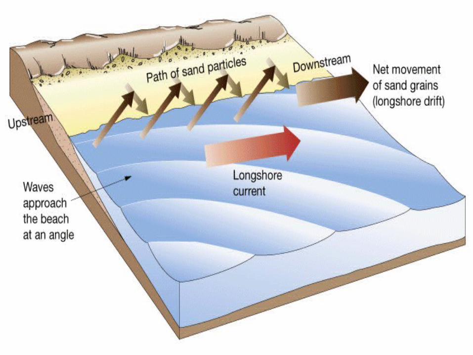


Groynes are used to stop LSD

Q3 Advantages•It stops the beach from being eroded away – eg tourist towns such as Bournemouth have constructed groyne systems• By trapping beach material (through groyne construction) this protects the cliff from being erodedDisadvantages of groynes•Look horrible and costs at lot of money•Divide the beach up into unnatural sections•Towns further down the coast may suffer because there is no sediment coming along as it has been trapped further up by groynes

1d COASTALDEPOSITION

SALTMARSH
Spurn Head Spit SEA
LSD


Spits- A long, narrow ridge of sand attached at one end to the coast.- Built up by long shore drift transporting material along the coast.- At a bend or break (for an estuary) in the coastline the material being carried is dropped. However it is deposited away from the coastline.- As the spit builds out to sea the end is affected more by the wind and by wave currents, causing the end to curve towards the shore, to create a hook end.- Material often accumulates in the area of standing water that occurs behind a spit, and this can lead to the formation of salt marshes.- Spits can be areas where large sand dunes build up, nearer the back of it.


Beaches -Created by constructive waves depositing material (sand, shingle and pebbles) that has been transported from further along the coast.-LSD also transports and deposits material from and to them- They lie between high and low watermark and are gently sloping, towards the sea.-A constantly changing feature, beaches may be built up at certain times of the year, and eroded away at others, depending on the type of waves hitting them at the time. Often this change can be seasonal. -The best natural coastal defence feature

TOMBOLO

Tombolos-A bar of deposited material linking the mainland to an island.
-Draw Fig 1.68 p47

Bars- A ridge of sand that blocks off a bay or river mouth. It will create a lagoon behind if it is across a non-river bay.

1e OS MAP WORK

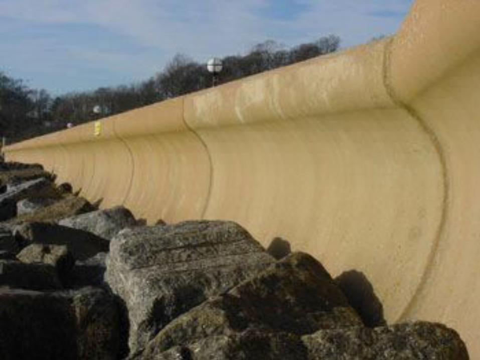
2 COASTALMANAGEMENT


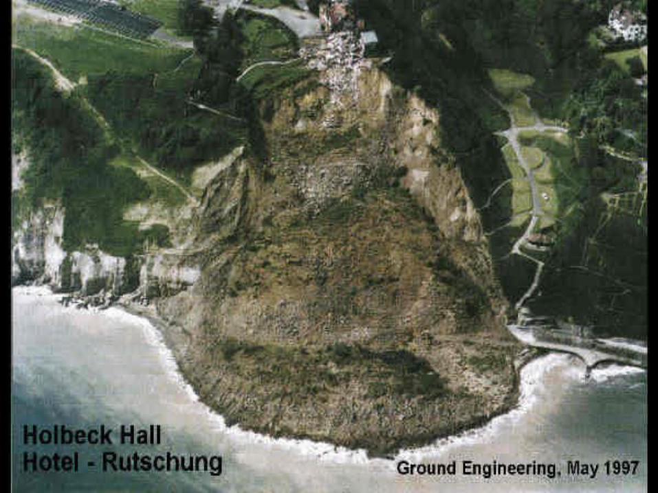

Unfortunately, the sea defences stop the erosion, but this allows mass movement time to takeover. Rainwater seeps into the porous TILL and causes ROTATIONAL SLUMPING.


BEACHNOURISHMENT

Humans are affected by the retreat of the cliff (loss of land, housing, etc.) They erect sea defences which stop the erosion (groynes, revetments, gabion cages and anti-tank blocks.


Holderness Coast

Weak Boulder Clay


A(i) Lulworth Cove is a circular shaped hollow in the coast. It is steeper towards the back and the gradient drops off towards sea level. It is made of 3 types of rock: limestone at the front, followed by sand and clay then chalk. The mouth of the cove is 50m wide and the maximum width of the cove is 350m. (3)
A (ii) This stretch of coastline is a concordant coastline – where the rocks are lying parallel to the sea. The limestone is eventually eroded and breached and the sea attacks the weaker sands and clays until it hits the resistant layer of chalk at the back of the cove. (3)

b) HOLDERNESS COAST
Physical environment – the coasts here are made of weak rocks – called boulder clay which have been carried by the icesheets at the end of the last glacial period (= Devensian 10,000 yrs ago). The cliffs around Mappleton have been affected – eg Mr Cross and Sue Earle’s farm, Easington Gas Terminal in danger of falling into the sea.
Human Environment – Groynes have been added to Mappleton which have prevented LSD from taking sediment further down the coastline. This has meant that the coast has been built up at one point but attacked at other places. Dairies have been affected and gas terminals as well as people’s property. (7)

c) For:•It protects the coastline and preserves peoples: property (Mr Cross), businesses (Sue Earle) , industry (gas terminal)•Groyne encourage a beach to grow which can help tourism and bring money to the areaAgainst:•Looks very ugly•Very expensive to build•No guarantee it will last forever•Some people suffer if groynes are built and sediment is trapped – eg Mr Cross (who was cross!) (6)d) SPIT = eg Spurn Head – is a hooked shaped landform which typically runs along a coastline with a hooked shaped end often where a river estuary meets the coast. It is formed by the process of Longshore Drift bringing material along the coastline in a zig-zag fashion. A saltmarsh often forms behind the spit as the sediment can build up here in shallower waters. (6)