gbp 2008 05 rpt mscthesistestinglandscapemodelingapproachesforenvironmentalimpactassessmentofminingl
DESCRIPTION
http://foothillsri.ca/sites/default/files/null/GBP_2008_05_Rpt_MScThesisTestingLandscapeModelingApproachesforEnvironmentalImpactAssessmentofMiningLandUseonGBinFoothillsRegion.pdfTRANSCRIPT

Testing Landscape Modeling Approaches for Environmental Impact Assessment of
Mining Land Use on Grizzly Bears (Ursus arctos horribilis) in the Foothills Region of
West Central Alberta
By
Marc Daniel Symbaluk PAg
A thesis submitted in partial fulfillment of the requirements for the degree of
MASTER OF SCIENCE
in ENVIRONMENT AND MANAGEMENT
We accept this thesis as conforming
to the required standard
…………………………………………….. Dr. Charles Krusekopf, MEM Program Head
School of Environment and Sustainability
…………………………………………….. Gordon B. Stenhouse MSc, Thesis Supervisor
Adjunct Professor, University of Saskatchewan
…………………………………………….. John L. Kansas MSc, Thesis Advisor URSUS Ecosystem Management Ltd.
…………………………………………….. Mark Pearson PEng, Thesis Sponsor
Cardinal River Operations, EVC
Royal Roads University March 24, 2008
© Marc Daniel Symbaluk, 2008

Grizzly Bears and Effects of Mining ii
Abstract
The grizzly bear habitat effectiveness model (HEM) was used in west-central Alberta for
Cumulative Environmental Assessments (1996 and 1999) of the Cheviot open pit coal mine
project. This thesis tested HEM predictions regarding the Cheviot mine with empirical data. The
HEM outputs were disproved for grizzly bear response to mining land use. Further, when tested
at the mining land use scale, current Resource Selection Function (RSF) modelling is not
predictive of grizzly bear occurrence. Grizzly bear movement paths prior to and during mine
disturbance determined that mining land use does not present significant landscape or regional
barriers to grizzly bears. This study examined regional and mining land use opportunities and
risks pertaining to grizzly bears. I provide a critical review of the Cheviot CEA process and the
implications of commitments made by governments and conclude with recommendations for
mining land use and regional planning for grizzly bear protection.
Keywords: Grizzly bear, Ursus arctos horribilis, Habitat effectiveness model, Resource selection function, Models, Cheviot mine, Mining, Land Use, FMFGRP, Environmental impact assessment, Cumulative environmental assessment, Alberta “The role of model testing is not to prove the truth of a model, which is impossible because models are never a perfect description of reality. Rather, testing should help identify the weakest aspects of models so they can be improved”. (McCarthy, M.A., Possingham, H.P., Day, J.R., and Tyre, A.J., 2001).

Grizzly Bears and Effects of Mining iii
Acknowledgements
Maturana states that “the journey is the destiny”. This journey has been one at times
seemingly very private and introvert. At other junctures, I have felt hands around me; supporting,
encouraging, and coaching. To many individuals I am very grateful. My wife, Francine: recently
and gracefully earning your own Masters; I owe you thanks for showing me how it can be done
and inspiring me. Hannah, Mathieu, and Luke: you are the greatest kids that a Dad could have. I
have learned how much I long to be with you and will never take you for granted. Mom and Dad:
always with your words of love and optimism; you are truly appreciated.
I am grateful to Elk Valley Coal’s Cardinal River Operations (CRO). This is the ‘little mine
on the front range of the Rockies’ that has stirred my passion in pursuing this study among many
others. Of course this organization is the sum of its people: fine individuals and friends. Nick
Burt, whose immediate enthusiasm and endorsement was the catalyst in this endeavor. Mark
Pearson, a great mentor for me to work along side. Your sponsorship helped to buffer me so that
I might keep focus. To our environment team, Greg Ross, Curtis Brinker, Christian Weik, Devon
Walker and Derek Elliot and all the ‘Coop Kids’: this is a project that could not have been
completed without your commitment to keeping all other initiatives moving ahead. To John
Kansas, my advisor: our professional paths have crossed for over ten years. It was my privilege
to have you to brainstorm with and to seek understanding. Gord Stenhouse, thank you! Your
timely, patient, and steady guidance and keen insights were very much appreciated.
I am very aware that these and many other unnamed supporters collectively made a
meaningful contribution through this journey. My dependence has been humbling. I am grateful.

Grizzly Bears and Effects of Mining iv
Table of Contents
Abstract ........................................................................................................................................... ii Acknowledgements........................................................................................................................ iii Table of Contents........................................................................................................................... iv List of Figures ................................................................................................................................ vi List of Tables ............................................................................................................................... viii List of Acronyms ........................................................................................................................... ix Chapter One: Introduction .............................................................................................................. 1
The Grizzly Bear as a Valued Ecosystem Component ............................................................... 1 Case Study: Grizzly Bear and the Cheviot Open Pit Coal Mine ................................................ 1
Cheviot Project Regulatory Background ................................................................................ 1 Study Area .............................................................................................................................. 5 Mine Land Use and Reclamation............................................................................................ 7
Foothills Model Forest Grizzly Bear Research Program.......................................................... 12 Interrelationships Between Resource Development, Human Access, and Grizzly Bears ........ 14 Thesis Hypothesis and Objectives ............................................................................................ 18
Research Problem ................................................................................................................. 18 Thesis Objectives .................................................................................................................. 18 Research Hypothesis............................................................................................................. 19 Research Questions............................................................................................................... 19
Chapter Two: Testing of the Cheviot 1996 Grizzly Bear CEA Model: Habitat Effectiveness for Mining Land Use .......................................................................................................................... 21
HEM and its use in Cheviot CEA for Grizzly Bears ................................................................ 22 Modeled Disturbance Routine for Mining Land Use ........................................................... 24 Foothills Model Forest Grizzly Research Program: Five Years of Field Study ................... 28
Methodology for Testing HEM Outputs for 1996 Cheviot CEA ............................................. 30 Results....................................................................................................................................... 32 Discussion and Conclusion ....................................................................................................... 34
HEM and its Use for Modeling Grizzly Bear Response to Disturbance .............................. 34 HEM and its Use in Cheviot CEA for Grizzly Bears ........................................................... 35
Chapter Three: Testing New Modeling Tools Developed for Grizzly Bears: RSF Applicability for Mining Land Use..................................................................................................................... 38
Testing the Resource Selection Function Model ...................................................................... 38 RSF and its Use in Regional Planning for Grizzly Bears ..................................................... 39
Methodology for Testing RSF on Mining Land Use ................................................................ 41 Results: RSF and its Use in Predicting Grizzly Bear Occurrence in Mining Land Use........... 43 Conclusion and Recommendations........................................................................................... 45
Chapter Four: Case Study of Grizzly Bears and Mining Land Use.............................................. 47 Grizzly Bear Home Range and Mining Land Use .................................................................... 47 G008 & G040 Research Methodology ..................................................................................... 48 Results of Grizzly Bear Occurrence and Mining Land Use Analysis ...................................... 51
Grizzly Bear G008 Occurrence and Mining Land Use......................................................... 51 Grizzly Bear G040 Occurrence and Mining Land Use......................................................... 54
Results of Grizzly Bear Movement and Mining Land Use Analysis........................................ 56

Grizzly Bears and Effects of Mining v
Grizzly Bear G008 Movement and Mining Land Use.......................................................... 56 Grizzly Bear G040 Movement and Mining Land Use.......................................................... 59
Discussion................................................................................................................................. 61 Grizzly Bear Occurrence....................................................................................................... 61 Grizzly Bear Movement........................................................................................................ 61
Conclusion ................................................................................................................................ 62 Chapter Five: Implications of Research Results and Recommendations for Mining Land Use and Regional Grizzly Bear Management............................................................................................. 66
Managing Human-Caused Mortality ........................................................................................ 67 Human-caused grizzly bear mortality: State of the science.................................................. 68 Alberta................................................................................................................................... 70 NES Region .......................................................................................................................... 71
Managing Human-Caused Mortality to Optimize Mining Land Use Gains............................. 72 Fate of Grizzly Bear G040 and Cubs in 2006....................................................................... 72 Mining Land Use and Regional Grizzly Bear Protection ..................................................... 73 Path Forward for Grizzly Bear Management: Post-Mining Land Use Closure Planning..... 77
Development and Implementation of Alberta Yellowhead Strategic Framework.................... 85 Implications of Cheviot Case Study for EIA and Follow Up: Lessons Learned. ..................... 91 Recommendations for Mine Land Use and Regional Planning for Grizzly Bear Conservation................................................................................................................................................... 92
Mining Industry .................................................................................................................... 92 Government........................................................................................................................... 93 Partnerships........................................................................................................................... 95
References..................................................................................................................................... 98 Appendix 1: Animal Welfare and Research Permits 2006 ......................................................... 108 Appendix 2: Animal Welfare and Research Permits 2007 ......................................................... 118

Grizzly Bears and Effects of Mining vi
List of Figures
Figure 1. Cheviot CEA Study Area ................................................................................................ 3
Figure 2. Cheviot Project Area, Luscar & Gregg River Mines ...................................................... 6
Figure 3. Cheviot Mining Land Use ............................................................................................... 8
Figure 4. Luscar & Gregg River Mining Land Use ...................................................................... 11
Figure 5. FMFGRP Study Area (1999-2004) ............................................................................... 14
Figure 6. Cheviot CEA Study Area with BMU ............................................................................ 23
Figure 7. Cheviot Project Planned Disturbance and CEM Zone of Influence.............................. 26
Figure 8. FMFGRP All GPS Points.............................................................................................. 29
Figure 9. Grizzly Bear GPS Points Occupancy Within Luscar and Gregg River Mines Disturbance Footprint + ZOI ................................................................................ 31
Figure 10. Regional Grizzly Bear RSF (Phase 6 Version) ........................................................... 40
Figure 11. All Grizzly Bear Points within Luscar and Gregg River Mine MSLs with RSF Assigned Values (1-10)......................................................................................... 42
Figure 12. Percent Grizzly Bear Occurrence by RSF Habitat Class within MSL ........................ 43
Figure 13. Author with Collared Grizzly Bear ............................................................................. 49
Figure 14. G008 Occurrence Before and With Cheviot Mining Land Use................................... 52
Figure 15. G008: Percentage of Grizzly Bear Occurrence (GPS Points) Within Mining Land Use and Cheviot Permit Area ...................................................................... 53
Figure 16. G040: All GPS Points by Year.................................................................................... 54
Figure 17. G040: Percentage of Grizzly Bear Occurrence within Mining Land Use by Year....................................................................................................................... 55
Figure 18. G008: All Recorded GPS Locations and Interpolated Movements and Mining Land Use Areas..................................................................................................... 57
Figure 19. G008: Interpolated Movements Before and With Cheviot Mining Land Use ............. 58
Figure 20. G040 Movement Within and Adjacent to Luscar/Gregg River Mining Land Use (2006)............................................................................................................. 60

Grizzly Bears and Effects of Mining vii
Figure 21. Summary of Known Mortalities (1999-2005) of Grizzly Bears within the Yellowhead Ecosystem......................................................................................... 76
Figure 22. Locations of Known Grizzly Bear Mortality Locations (1999-2004)......................... 77
Figure 23. G008 Movement Corridors in Whitehorse Wildland Park and Public Recreation Trails................................................................................................... 81
Figure 24. Northern East Slopes Region of Alberta ..................................................................... 88

Grizzly Bears and Effects of Mining viii
List of Tables
Table 1. CEA Model (1996) Disturbance Coefficients and Zones of Influence for Land Use Activities in the Grizzly Bear ........................................................................ 25
Table 2: Individual Grizzly Bear Occurrence Within Luscar and Gregg River Mines Disturbance ........................................................................................................... 33
Table 3. Occurrence of Grizzly Bear Locations within RSF Assigned Values on MSLs ............ 43
Table 4: Capture Information for Grizzly Bears G008 and G040 ................................................ 51
Table 5: G008: Percentage of Grizzly Bear Occurrence Within Mining Land Use ..................... 53
Table 6: G040: Percentage of Grizzly Bear Occurrence Within Mining Land Use ..................... 55
Table 7: Summary of Known Mortalities (1999-2005) of Grizzly Bears Within the Yellowhead Ecosystem......................................................................................... 75
Grizzly Bears and Effects of Mining ix
List of Acronyms
AEUB: Alberta Energy & Utilities Board
AENV: Alberta Environment
AEP: Alberta Environmental Protection
BMA: Bear management area
CRC: Cardinal River Coals Limited
CEA: Cumulative effects assessment
CEM: Cumulative effects model
Cheviot Project: Cheviot open pit coal mine project
DC: Disturbance coefficient
EIA: Environmental Impact Assessment
FMFGRP: Foothills Model Forest Grizzly Research Program
GIS: Geographic information system
GPS: Geographic positioning system
HEM: Habitat effectiveness model
JNP: Jasper National Park
NESERC: Northern East Slopes Environmental Resources Committee
RSF: Resource selection function
ZOI: Zone of influence
Grizzly Bears and Mining Land Use 1
Chapter One: Introduction
The Grizzly Bear as a Valued Ecosystem Component
Understanding factors that influence and predict grizzly bear distribution and abundance is
fundamental to their conservation (Apps, McLellan, Woods, & Proctor, 2004). Like many large
mammalian carnivores, grizzly bears have been considered to be sensitive to human-induced
landscape change due to their low population density, low fecundity, limited ability to disperse
across open or developed habitat, and other traits that may lower their ecological resilience
(Weaver, Paquet, & Ruggiero, 1996). This makes this animal a potential focal species for use in
regional wildlife conservation planning. As such the grizzly bear has been used throughout North
America as an umbrella species for the management of multiple land use impacts on regional
landscapes (Carroll, Paquet, Noss, & Strittholt, 1998). Conditions necessary for the long-term
persistence of grizzly bears have potential to form the framework within which other elements of
regional-scale conservation planning may be efficiently addressed and human land uses and
activities effectively evaluated (Carroll, Noss, & Paquet, n.d.).
Case Study: Grizzly Bear and the Cheviot Open Pit Coal Mine
Cheviot Project Regulatory Background
The Cheviot open pit coal mine project [Cheviot project] is located on the front range of the
Rocky Mountains, within the Coal Branch Forest Land Use Zone approximately 60 km south of
the town of Hinton, in west-central Alberta. It was originally proposed as a 20 year, metallurgical
coal mining development by project proponent, Cardinal River Coals Limited (CRC). The
regulatory process was initiated in 1994 with the preparation of draft terms of reference for an
environmental impact assessment (EIA) by the proponent. Following public input, the EIA terms

Grizzly Bears and Mining Land Use 2
of reference were finalized in 1995 by Alberta Environmental Protection (AEP) with federal
agency agreement. EIA is required under the Alberta Environmental Protection and
Enhancement Act (EPEA) and applicable federal legislation for all major industrial projects in
Alberta, and is prepared by major industrial project proponents to assist the government and
public in understanding the environmental consequences of a proposed project (AEP, 1995).
Project-specific effects are a major focus of EIA. Decision makers responsible for issuing project
approvals must be convinced that the direct environmental effects of projects and the resulting
impacts on valued ecosystem components (VEC) have been adequately addressed (Kennett,
2002).
The EIA requirements for the Cheviot project included an assessment of cumulative
environmental effects (CEA), consistent with the federal Canadian Environmental Assessment
Act [CEAA] and EPEA. CEA criteria required the proponent to gather and evaluate not only the
proposed Cheviot project’s impacts, but also to consider cumulatively the past, existing, and
“imminent” activities in the defined CEA 3,040 km2 study area which radiated approximately 25
km around the proposed Cheviot project area.

Grizzly Bears and Mining Land Use 3
Figure 1. Cheviot CEA Study Area
Following extensive public consultation, the project application was filed in 1996 (Cardinal
River Coals Ltd., 1996; Logan & Ferster, 2002). Environmental issues raised by the Cheviot
project included the loss and fragmentation of aquatic and terrestrial habitat and the disruption of
wildlife movement corridors. Further, given the range and intensity of other land uses in the
surrounding region, cumulative environmental effects emerged as a major focus of public,
regulatory and judicial attention (Kennett, 2002). The EIA addressed project and cumulative
effects for 99 VECs. The grizzly bear was identified as the flagship VEC for assessing the
regional, cumulative effects of the proposed Cheviot project in conjunction with other existing
and planned land uses.

Grizzly Bears and Mining Land Use 4
At the time of the EIA in 1996, provincial and federal regulators, environmental advocacy
groups, and the project proponent all consistently agreed that this species was particularly well
suited as a focal species for CEA. This was due to the existence of what was deemed an
established, quantitative methodology for CEA for grizzly bear, which had been developed and
employed in the United Stated (Christenson, 1986; United States Department of Agriculture
(USDA), 1990; Weaver, Escano, Mattson, Puchlerz, & Despain, 1986). Further, as a wide
ranging carnivore species, the grizzly bear would serve as an indicator and umbrella species for
measuring and managing impacts on other large carnivores (BIOS Environmental Research and
Planning Associates Ltd. [BIOS], 1996; Logan & Ferster, 2002; Paquet & Hackman, 1995;
Stenhouse & Munro, 2000). It was proposed that, “if the grizzly survives in the region, then most
other carnivores, most of which have significant range overlap with the grizzly, would also likely
survive” (BIOS, 1996).
The history of the regulatory and judicial review of the Cheviot project is both lengthy and
complex. It has served as a case study concerning CEA (Hegmann et al., 1999) and cumulative
environmental management (Jeffrey & Duinker, 2002; Kennett, 2002; Logan & Ferster, 2002).
In summation, since the original EIA, the Cheviot project has been the subject of two Alberta
Energy & Utilities Board – Canadian Environmental Assessment Agency (AEUB-CEAA) joint
review panel hearings, two judicial reviews, including a Supreme Court of Canada challenge,
and several judicial challenges before the Alberta Environmental Appeals Board (AEAB)
(AEAB 2003, 2004a, 2004b, 2004c, 2005a; 2005b, 2007).
The Cheviot project development plan was modified in its 2003 EPEA applications. This
included construction of a twenty kilometer haul road to deliver raw coal back to the Luscar
mine site’s existing coal processing plant, rail system, and other required infrastructure. This

Grizzly Bears and Mining Land Use 5
modification eliminated the project’s requirement for a high speed public road, rail, and higher
voltage transmission line within the McLeod River corridor to the Cheviot project area. It further
reduced the requirement to construct a coal processing plant and associated infrastructure in the
Cheviot project area. Nearly a decade since the original EIA, following lengthy regulatory and
judicial processes, a pause by the proponent due to global coal market conditions, and
consolidation of ownership, all project permitting was affirmed and the Cheviot project began
development in late 2004. The Cheviot project is currently operated by Elk Valley Coal (EVC)’s
Cardinal River Operations. EVC is owned by Teck Cominco and Fording Canadian Coal Trust.
Study Area
The Cheviot project is located within the front range of the Rocky Mountains of west-central
Alberta. Historically, coal mining in the Cheviot project area began in 1911, when the small
town (~1000 people) of Mountain Park was established. Mining activities continued until the
industry and town succumbed to the coal depression following World War II, forcing the closure
of operations by 1950 (MacCallum, 2005).
The Cheviot coal mine permit area is approximately 7,150 hectares (ha) (71.5 km2) with
topographic elevation ranging from 1,640 m to 2,500 masl. It is bounded to the north and east by
Cadomin Mountain and RedCap Mountain range; to the south and west are Cheviot Mountain,
Cardinal Divide, Tripoli Mountain and Prospect Creek (Figure 2). Sub-alpine and alpine
ecological regions characterize the Cheviot mine permit area, and vegetation varies from forests
of Lodgepole pine (Pinus contorta) to mixed willow (Salix spp.), grasslands, alpine vegetation
and rock (MacCallum, 2005). At its most westerly point, the mine permit area is approximately
3km from Jasper National Park (JNP), including one mountain range located within the

Grizzly Bears and Mining Land Use 6
provincial Whitehorse Wildland Park. At its nearest proximity, the Cheviot mine development
plan will remain approximately 4.7 km from the JNP boundary.
Figure 2. Cheviot Project Area, Luscar & Gregg River Mines
The Gregg River and Luscar mines are located approximately 20 km to the north of Cheviot
and 40 km south of the town of Hinton. At their most westerly point, these are approximately 3.7
km from JNP. These two mines are immediately adjacent to each other (Figure 2) and are
separated by the Gregg River. The total Luscar MSL area is 4,425 ha and the Gregg River MSL
2,675 ha, for a combined 7,100 ha under disposition of the mines. Both mines are located in the
sub-alpine ecological region with elevations ranging between 1,540 m and 2,080 masl.
Undisturbed areas within the adjacent mine lease boundaries currently comprise approximately

Grizzly Bears and Mining Land Use 7
3,700 ha. These are vegetated predominantly by coniferous forests, with small amounts of shrub
riparian habitat and sub-alpine grasslands (MacCallum, 2005).
Mine Land Use and Reclamation
In 2000, the AEUB-CEAA joint review panel issued approval for the Cheviot project. This
provided approval of the conceptual project plan within the defined Cheviot permit area over the
life of the project. Within the approved permit area, the planned Cheviot project consists of
seven phased pit developments over the 20 year life of the project. Each phase of development
requires specific project plan submissions, detailing all activities and areas planned for
development to exploit the coal reserve and reclamation. Upon attaining all provincial and
federal approvals to extract each of these specific coal reserves (or project phases), a surface
disposition is obtained to carry out these activities. This is referred to as the mineral surface lease
[MSL]. The MSL is a surface disposition granted to the proponent by the Crown to conduct land
development activities on a specific land base to extract the coal reserves.
From October 2004 until present, the Cheviot project operates within an MSL to develop the
Cheviot creek pit. The current Cheviot project mineral surface lease is located within a 1,100ha
area in the westerly portion of the greater 7,150 ha Cheviot permit area. Outside of the existing
MSL, but within the Cheviot permit area, there exists no surface disposition and no continuous
mine related activity. The exception to this is for periodic exploration drilling programs to refine
planned mine development. Otherwise, public access continues to be managed within the
Cheviot permit area under provincial jurisdiction, which permits other land use activities,
including motorized recreation use.
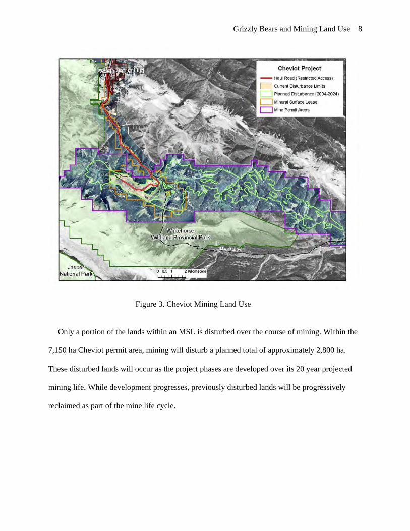
Grizzly Bears and Mining Land Use 8
Figure 3. Cheviot Mining Land Use
Only a portion of the lands within an MSL is disturbed over the course of mining. Within the
7,150 ha Cheviot permit area, mining will disturb a planned total of approximately 2,800 ha.
These disturbed lands will occur as the project phases are developed over its 20 year projected
mining life. While development progresses, previously disturbed lands will be progressively
reclaimed as part of the mine life cycle.
Grizzly Bears and Mining Land Use 9
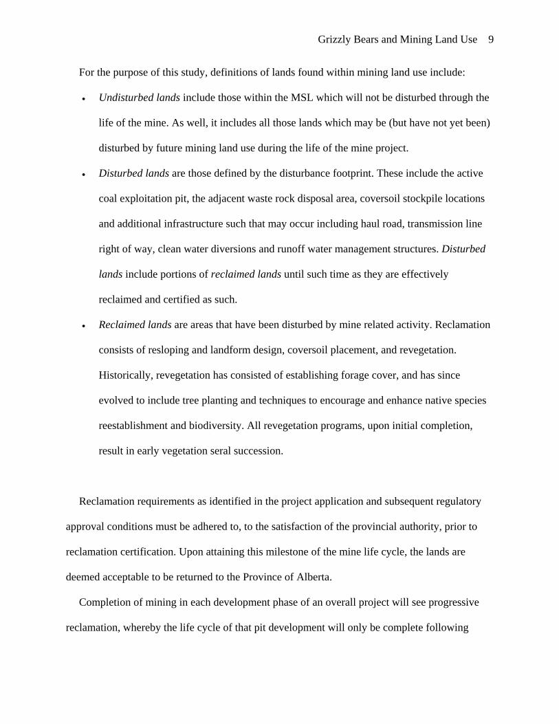
For the purpose of this study, definitions of lands found within mining land use include:
• Undisturbed lands include those within the MSL which will not be disturbed through the
life of the mine. As well, it includes all those lands which may be (but have not yet been)
disturbed by future mining land use during the life of the mine project.
• Disturbed lands are those defined by the disturbance footprint. These include the active
coal exploitation pit, the adjacent waste rock disposal area, coversoil stockpile locations
and additional infrastructure such that may occur including haul road, transmission line
right of way, clean water diversions and runoff water management structures. Disturbed
lands include portions of reclaimed lands until such time as they are effectively
reclaimed and certified as such.
• Reclaimed lands are areas that have been disturbed by mine related activity. Reclamation
consists of resloping and landform design, coversoil placement, and revegetation.
Historically, revegetation has consisted of establishing forage cover, and has since
evolved to include tree planting and techniques to encourage and enhance native species
reestablishment and biodiversity. All revegetation programs, upon initial completion,
result in early vegetation seral succession.
Reclamation requirements as identified in the project application and subsequent regulatory
approval conditions must be adhered to, to the satisfaction of the provincial authority, prior to
reclamation certification. Upon attaining this milestone of the mine life cycle, the lands are
deemed acceptable to be returned to the Province of Alberta.
Completion of mining in each development phase of an overall project will see progressive
reclamation, whereby the life cycle of that pit development will only be complete following

Grizzly Bears and Mining Land Use 10
reclamation. This will be accomplished through the phased progress of the Cheviot project,
whereby outstanding disturbance areas will be progressively reclaimed. Completed pits and
associated out of pit disturbances will be reclaimed following the optimization of integrated
material handling between successive phases, such that backfilling of completed pits will be
accomplished with waste rock from new adjacent active pit development. The result would be
similar to that of the Gregg River mine. The Gregg River mine began mining in 1981 and
completed coal extraction in 2000, at which time extensive reclamation programs were carried
out. By 2004, reclamation was 95% complete (MacCallum, 2005) on the 1,350 ha of disturbance.
This would, however differ from the Luscar mine, within which mining was initiated in 1969 and
mining largely completed by 2004. Although approximately 1,100 ha of disturbed land have
been reclaimed throughout the life of the mine, there currently remains some 900 ha of disturbed
lands with reclamation activities still outstanding. Further, a portion of the Luscar mine will
remain as disturbed land through the mine life of the Cheviot project to support coal handling,
processing, and rail loading for the Cheviot project.

Grizzly Bears and Mining Land Use 11
Figure 4. Luscar & Gregg River Mining Land Use

Grizzly Bears and Mining Land Use 12
The lands adjacent to these existing mine operations, including within the Cheviot mine
permit area outside of the existing MSL, are subject to multiple industrial and recreational land
uses. These include forestry, oil and gas development, coal mining, hunting, hiking, off-highway
vehicle (OHV) and equestrian use. Within each of these mines’ respective MSLs, public access
is only permitted by designated access trails which permits public access by designated means
only, such as OHV or other, but does not permit hunting. These MSLs are anthropogenic
boundaries which define the approved mining areas. They also create opportunities for unique
public access management while the MSLs remain under active disposition. Because of this
resultant access management, in combination with undisturbed, disturbed, and reclaimed lands,
and the mining activities found within, all lands occurring within MSL are considered mining
land use.
Foothills Model Forest Grizzly Bear Research Program
The lack of suitable regional grizzly bear data was identified in the Cheviot CEA (AEUB-
CEAA, 1997). As a result of CEA conclusions regarding projected impacts to grizzly bears with
or without the Cheviot project, the proponent proposed a Carnivore Compensation Program. This
program proposed that a regional, multi-stakeholder approach to studying, managing, and
monitoring human land use effects on carnivores in the region be developed (Cardinal River
Coals Ltd., 1996). As a condition of project approval, the proponent was to “act as a catalyst in
generating multi-stakeholder support for the implementation of the carnivore compensation plan”
(AEUB-CEAA, 1997). The outcome of this initiative, along with other Cheviot joint review
panel recommendations resulted in: provincial and federal governments devising cooperative

Grizzly Bears and Mining Land Use 13
agreements for grizzly bear conservation (Parks Canada, 1997); development of a regional
strategic framework (Northern East Slopes Environmental Resource Committee, 2000), and;
development of a comprehensive grizzly bear research program. This research program was
initiated through the Foothills Model Forest as the Grizzly Bear Research Project [FMFGRP].
The FMFGRP has since expanded to become provincial in scope. It has resulted in several
published academic and research studies. These are cited in annual FMFGRP reports for public
review (Foothills Model Forest, 2008).
The Foothills Model Forest [FMF] is a not-for-profit corporation conducting research into
sustainable forest management. Established in 1992, the FMF is one of a network of 11 model
forests across Canada. Located in west central Alberta, the FMF encompasses 2.75 million
hectares of alpine and boreal forest on the eastern slopes of the Canadian Rockies, and includes
Jasper National Park, Wilmore Wilderness Park, Whitehorse Wildland Park, West Fraser’s
Hinton Division’s Forest Management Area, and other crown lands (Cranston, 2006). The
FMFGRP is one of the primary research initiatives at the FMF. Now in its eighth year, the long
term goal of this $11 million study, funded jointly by industry and government, is to provide new
knowledge and planning tools to assist managers with the conservation of grizzly bears in
Alberta (Stenhouse & Graham, 2006).

Grizzly Bears and Mining Land Use 14
Figure 5. FMFGRP Study Area (1999-2004)
Interrelationships Between Resource Development, Human Access, and Grizzly Bears
Research shows that behavioral response to roads by grizzly bears is variable (Roever, 2007).
Several benchmark field studies in the mid-1980s began to explore the relationships between
roads, human settlement, and grizzly bears. Although conclusions differed among studies, each
of these early investigations documented situations under which grizzly bears responded
negatively to road traffic. Differing conclusions among these studies have been attributed to both
different methods used and probable differences in nature and intensity of human land use and
associated bear behavior among study areas (Mace, 2004). In northwestern Montana, Waller and
Servheen (2005) found that grizzly bears strongly avoided areas within 500 m of highways and

Grizzly Bears and Mining Land Use 15
that most highway crossings occurred at night when highway traffic volume was lowest. Other
researchers concluded that most grizzly bears used habitats within 100m of roads less than
expected. Avoidance of roads was independent of traffic volume, suggesting that even a few
vehicles can displace bears. (McLellan, & Shackleton, 1988). Still, research in the Swan
Mountains, Montana, suggested that most grizzly bears exhibited either neutral or positive
selection for buffers surrounding closed roads and roads receiving less than 10 vehicles per day
but avoided buffers surrounding roads having greater than 10 vehicles per day (Mace, Waller,
Manley, Lyon, & Zuuring, 1996).
Further, several studies have attempted to predict probability of grizzly bear occurrence and
habitat effectiveness, which is the potential usefulness of a habitat given the negative impacts of
human activity, such as those adjacent to roadways. Several outcomes have been concluded. In
the protected areas of Banff National Park and surrounding areas, researchers examined grizzly
bears’ spatial response to roads, road-crossing behaviour, crossing-location attributes, and habitat
and temporal patterns of cross-road movements. They found that grizzly bears used areas close
to roads more than expected, particularly roads with low traffic volume (Chrusczcz, Clevenger,
Gunson, & Gibeau, 2003).
In the eastern foothills of the Rocky Mountains, within the FMFGRP study area, it has been
observed that grizzly bears are closely associated with roads. Grizzly bears are selecting roads
for roadside vegetation, their association with riparian habitat and cutblocks, or their spatial
orientation on the regional landscape (Roever, 2007). Neilsen (2005) found that contrary to
previous studies, in west-central Alberta, grizzly bears selected clearcuts for critical food
resources. These provide an attractive alternative to natural openings and young seral forests that

Grizzly Bears and Mining Land Use 16
are less prominent within the foothills. There are, however strong correlations between landscape
disturbance and road development.
The grizzly bear populations in the FMFGRP appear unique in that they occupy both
mountainous and foothill (boreal) environments. They exhibit notable differences in diet when
compared to other populations, whereby the diet of grizzly bears in the foothills have nearly 2.5
times the amount of animal matter than that in the diets of grizzly bears in the mountains. It is
suspected that this results from the differences in ungulate availability (Munro, Nielsen, Price,
Stenhouse, & Boyce, 2006). Grizzly bears also feed on agronomic and pioneering forbs and
legumes such as Melilotus sp. (clovers), Lathyrus venosus (wild peavine), Taraxacum
ceratophorum (dandelion), and Medicago sp. (alfalfa). These species are associated with recently
disturbed sites such as clear-cuts, roadsides, abandoned gas and oil well pads, and reclaimed
landscapes of open pit coal mines. As a result, researchers have surmised that the use of such
disturbance-evolved forbs may be indicative of the large amount of resource development
activity within the FMFGRP study area.
Although forestry and oil and gas development is concentrated northeast of the Cheviot
project area, there exists an annual average 5 to 10% increase among all recreation uses in the
Coal Branch Forest Land Use Zone (Equus Consulting Group Inc., 1999). However, despite high
levels of human activity, especially in the foothills, grizzly bears are most active during diurnal
and crepuscular periods, with bedding occurring most frequently at night (Munro et al., 2006).
This contradicts studies that have shown grizzly bears to be more nocturnal in areas where
human activity is high. This also suggests that the level of human activity in the foothills and
mountains of west-central Alberta is not high enough to disrupt the typical daylight activity
pattern of grizzly bears (Munro et al., 2006).

Grizzly Bears and Mining Land Use 17
Some permanent habitat loss has occurred in grizzly bear habitats east of the Rocky
Mountains in Alberta due to settlement and agricultural development, however a major influence
on grizzly bears results from habitat alteration, primarily due to forest harvest, oil and gas
development, and utilities development (Kansas, 2002a). Open pit mining land use, operating
typically in a phased (temporal and spatial) development also results in temporary habitat loss
specifically during active pit mining, followed by an altered, early seral succession habitat. These
habitat alterations can either result in negative, positive or neutral affects for grizzly bears. Not
all anthropogenic activities are detrimental to grizzly bears. Some have been shown to be
beneficial (Roever, 2007). For example, there exists evidence that temporary modifications such
as forestry clear cuts can be positive for grizzly bear from a habitat perspective (Kansas, 2002a;
Neilsen, 2005). However, though cutblocks and other anthropogenic disturbance appear to
increase bear foods, their association with open roads may be creating an attractive sink (Delibes,
Gaona, & Ferreras, 2001; McLellan et al., 1999; Neilson, Boyce, & Stenhouse, 2004) due to
human-caused mortality.
Relatively little field study has been conducted specifically evaluating the response of grizzly
bears to open pit coal mining and land reclamation. Yet scientists and decision makers alike have
relied extensively on landscape modeling outputs to predict the effects of the Cheviot project on
grizzly bears, to guide impact significance ratings (BIOS, 1996; Cardinal River Coals Ltd.,
1996a; Herrero, 2000; Natural Resources Canada, 2000), and to influence policy or management
processes. Thereby modeled predictions have resulted in significant regulatory, stakeholder, and
ecological management implications.

Grizzly Bears and Mining Land Use 18
Thesis Hypothesis and Objectives
Research Problem
Industrial projects rely upon EIA to identify and assess the significance of impacts under
specific, proposed development scenarios. As identified in the Cheviot project, often these
environmental assessments rely on models which may be supported by only limited field study
(BIOS, 1996) or by expert opinion. The implications of using either inductive or empirical
models to make management decisions regarding grizzly bears must be considered. Alone,
neither might be appropriate assessment tools to adequately express habitat use, mortality risk,
nor regional grizzly bear population persistence.
Thesis Objectives
This thesis will test the Cheviot CEA model assumptions and outputs for mining land use by
examining empirical data collected from grizzly bears using the Luscar/Gregg River mine sites.
These were both active mining land use areas during the 1996 and 1999 Cheviot CEA
assessments. Data was collected by the FMFGRP program (1999-2004), and a 2006 and 2007
grizzly bear radio-telemetry program to determine grizzly bear use within, and adjacent to, areas
of mining land use. These findings will then be discussed in relation to the use of inductive
models to evaluate predicted impacts of the Cheviot project.
By testing the Cheviot project assessment conclusions, this research will:
• determine the ability of the tools employed in CEA to predict effects in this case study;
• test subsequently developed regional modeling tools to empirical results at the project
scale;
• determine the importance of empirical (and modeled) approaches to EIA in general;
• provide context for these findings to a regional grizzly bear management perspective, and;

Grizzly Bears and Mining Land Use 19
• discuss potential opportunities and risks to persistence of grizzly bears in Alberta’s
Yellowhead Ecosystem.
Finally, it is critical to discuss integration of this research for both mine land use planning,
regional management and policy decisions for grizzly bear conservation given our current state
of knowledge.
Research Hypothesis
This thesis is specifically designed to review CEA model inputs selected for the Cheviot
project and evaluate the predictive capability of the grizzly bear CEM model used to determine
habitat effectiveness of mining land uses by comparing its predicted grizzly bear use against
empirical grizzly bear use from field data.
Ho: There is a significant difference in grizzly bear use on, and adjacent to, mining land use areas
than predicted using HEM.
Ha: There is no significant difference in grizzly bear use on, and adjacent to, mining land use
areas than predicted using HEM.
Research Questions
The thesis objectives will be met by addressing the following research questions:
Chapter 2.
• What did we think prior to collecting FMFGRP empirical data about grizzly bear occurrence
and movement around mines based on CEA modeling?
• What (modeling) predictions are made in the Cheviot CEA and what conclusions were
drawn?
Chapter 3.
• Are there risks to the application of inductive modeling tools for EIA designed for regional
scale, threshold-based land use planning? What might be the management decision making
implications?
Chapter 4.

Grizzly Bears and Mining Land Use 20
• What have we learned from GPS collar data regarding grizzly bear occurrence and
movement within and adjacent to active mining land use areas?
Chapter 5.
• How might mining land use be applied to the current state of science for grizzly bear
conservation from a regional context?
• What opportunities exist for current and post mining landscapes to serve as long term grizzly
bear safe harbour areas?

Grizzly Bears and Mining Land Use 21
Chapter Two: Testing of the Cheviot 1996 Grizzly Bear CEA Model: Habitat Effectiveness for
Mining Land Use
In 1996, the Cheviot Project application used cumulative effects modeling to analyze and
predict the proposed mine’s impacts on grizzly bears (BIOS, 1996). The cumulative effects
model’s (CEM) primary outputs included a description of current and predicted habitat quality
and habitat effectiveness. Habitat quality is a measure of how inherently suitable an area is for a
species, whereas habitat effectiveness is a measure of an area’s potential usefulness to a species
given the predicted negative impacts of human activity and development (BIOS, 1996). It
assesses the quantitative and qualitative effects of human actions on grizzly bears and their
habitat. The habitat effective model (HEM) routine relates habitat quality with human activities
to estimate overall grizzly bear habitat effectiveness (Gibeau, Herrero, Kansas, Benn, 1996;
Purves & Doering, 1998). Use of the grizzly bear HEM is said to offer a predictive tool for more
detailed planning of current and proposed developments in areas containing grizzly bear habitats
(Hood & Parket, 2001).
Habitat effectiveness is the major component of early grizzly bear cumulative effects models
(CEM). United States-based CEMs have been adopted by Canadian researchers since the early
1990s. They have been applied in environmental impact assessment (EIA) on several industrial
or resource development projects in Alberta and have been regularly used in the last 15 years to
predict impacts and guide land management and decision-making (Kansas, 2002b).
This Chapter will review previous assumptions regarding grizzly bear movement and use in
and adjacent to mining land use, define how these assumptions were applied in modeling, and
define how these provided HEM modeling predictions. It then introduces subsequent empirical
grizzly bear data collected in and adjacent to active mining land use and evaluates model

Grizzly Bears and Mining Land Use 22
predictions based upon analysis of empirical data. Finally, it will discuss the subsequent CEA
conclusions for the Cheviot project, and the implications of model use in EIA.
HEM and its use in Cheviot CEA for Grizzly Bears
CEM for grizzly bears are designed to quantify both individual industrial projects and
collective effects of other land uses and activities in time and space. They provide resource
managers with an analytical tool for evaluating alternative decisions relative to grizzly bear
conservation goals and objectives (Weaver, 2000). Standardized CEM was pioneered in the early
1980s in the contiguous United States (USDA, 1990) in an effort to assess cumulative land use
effects on grizzly bears (Christensen, 1986). These were originally developed for use in the
Northern Continental Divide (East) ecosystem (Apps, 1993; URSUS Ecosystem Management
Ltd. (URSUS), 1999). Since that time, it has been used as a planning and management tool
(BIOS, 1996; Kansas, 2003; Logan & Ferster, 2002; Stenhouse, Dugas, Boulanger, Hobson, &
Purves, 2003).
The original Cheviot project specific and cumulative effects assessment regarding grizzly
bears utilized an inductive CEM over the 3,040 km2 Cumulative Effects Analysis (CEA) study
area. This boundary was established by forming a polygon whose perimeter extended
approximately 25 km outward from the proposed Cheviot project area, then adjusted to conform
to watershed divides and watercourses. At the time, the size of the study area was defined in part
by the maximum published diameter of a grizzly bear’s home range in the region (URSUS,
1999). To analyze existing habitat conditions and developments, the grizzly bear CEA study area
was divided into Bear Management Units (BMUs), which were further divided into Bear
Management Sub-Units (BMSU). These were approximately the size of female grizzly bear
annual home ranges.
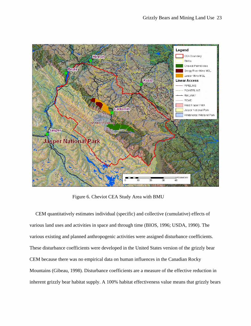
Grizzly Bears and Mining Land Use 23
Figure 6. Cheviot CEA Study Area with BMU
CEM quantitatively estimates individual (specific) and collective (cumulative) effects of
various land uses and activities in space and through time (BIOS, 1996; USDA, 1990). The
various existing and planned anthropogenic activities were assigned disturbance coefficients.
These disturbance coefficients were developed in the United States version of the grizzly bear
CEM because there was no empirical data on human influences in the Canadian Rocky
Mountains (Gibeau, 1998). Disturbance coefficients are a measure of the effective reduction in
inherent grizzly bear habitat supply. A 100% habitat effectiveness value means that grizzly bears

Grizzly Bears and Mining Land Use 24
are not deterred from using that available habitat due to human factors. The CEM is composed of
the following three routines:
1. Habitat routine: a given landscape/habitat area or unit has an inherent value for grizzly bears.
2. Disturbance routine: quantitatively considers human use factors that subtracts from this
inherent habitat value (USFWS, 1993). Disturbance layers were buffered using zones of
influence based in the values in Table 1.
3. Mortality routine: This routine of the CEA model was not used because of inherent difficulties
with the model (Weaver, Escano, Mattson, & Puchlerz, 1986). Instead, for CEA purposes, areas
of high habitat effectiveness were assigned a low mortality risk. Inversely, areas of determined
low habitat effectiveness were assigned a high mortality risk.
Modeled Disturbance Routine for Mining Land Use
Specific to this study’s analysis, the proposed Cheviot mine was treated as a “special case” for
definition of both a disturbance coefficient and zone of influence for the disturbance routine. A
disturbance coefficient is an assignment that identifies reduced habitat effectiveness to an area as
a result of human disturbance from what it would otherwise be. This disturbance coefficient is
specific to the human activity type. The zone of influence is the spatial assignment of that
disturbance coefficient. The zone of influence defines the adjacent area whose habitat
effectiveness would be adversely impacted or degraded as a result of human disturbance or
activity.

Grizzly Bears and Mining Land Use 25
Table 1. CEA Model (1996) Disturbance Coefficients and Zones of Influence for Land Use Activities in the Grizzly Bear
*Zone of Influence
(m)
Activity Type
Activity Code
Use Duration
Use Level
Disturbance Coefficient
(Cover)
Disturbance Coefficient
(Non-Cover)
Linear - High 0.25 0.05 1000 - Low 0.67 0.25 1000 Point, Polygon
Diurnal High 0.12 0.05 1000
Diurnal Low 0.31 0.1 1000 24 hr - 0.06 0 1000 Dispersed - High 0.2 0.1 N/A - Low 0.9 0.8 N/A
Motorized
Linear - High 0.75 0.25 1000 - Low 1 0.4 500 Poly, Point
Diurnal - 0.75 0.2 500
24 hr - 0.03 0.05 500 Dispersed - High 0.3 0.1 N/A - Low 0.1 1 N/A
Non-Motorized
* assumed 1000m = 0.50 mile (adapted from BIOS, 1996, p.22)
All current and planned mining land uses, based on expert opinion and available knowledge
of the day, were assigned a motorized, polygon, 24 hour activity classification code. This
assignment included a 1 km (0.5 mile) zone of influence around their respective disturbance
footprints within which little or no grizzly bear use was expected (Table 1). This defined a mask
over the entire 20 year planned mine disturbance area plus a 1 km buffer all around this. It
defined the area as being under continuous (24 hour) motorized activity. For the Cheviot project,
features within the McLeod River corridor originally planned as a high voltage transmission line,
high speed public road, and rail line were assigned a motorized, linear, high classification, which
defines a 1 km zone of influence on either side, adjacent to this approximate 10 km access to the

Grizzly Bears and Mining Land Use 26
Cheviot project where the corresponding disturbance coefficient is 0.25. These rules imply that
grizzly bear use of the adjacent 2 km zone of influence (1km on either side) would be impacted
such that resultant likelihood of grizzly bear use would decrease by 75%. Where mine area and
linear disturbance buffers overlapped, the disturbance coefficients were multiplied, resulting in
very low probability of grizzly bear occurrence.
Figure 7. Cheviot Project Planned Disturbance and CEM Zone of Influence
It was, therefore concluded, based upon CEA modeling, that impacts to grizzly bear habitat
effectiveness would result in essentially no grizzly bear use of mining areas, nor within adjacent

Grizzly Bears and Mining Land Use 27
undisturbed areas within 1 km of the entire proposed mining disturbance footprint during the
entire life cycle of the Cheviot project. The habitat effectiveness model was rerun again to
support an updated grizzly bear cumulative impact assessment for the 2000 AEUB-CEAA joint
review panel hearings (AEUB-CEAA, 2000; Herrero, S., 2000; URSUS, 1999). Again for this
modeling run, the human use features were classified and their assigned zones of influence were
based on standards developed by the USDA (1990) for CEM and were the same as those used by
BIOS (1996). This 1999 re-assessment however differed through use of a more rigorous human
use inventory process, rather than subjective opinion of authors concerning the use of the area
and informal discussions with land users. As a result, it used slightly different human use ratings
to reflect minor differences in expert opinion as well as improvements in knowledge of human
use in the area (URSUS, 1999). While this review was conducted for cumulative effects features,
zone of influence and disturbance coefficients associated with mining land use were not revised.
URSUS (1999) concluded that changes increased the degree of certainty associated with
understanding and evaluation of cumulative impacts, however it also cautioned that these models
nonetheless still would require validation through empirical testing.
While these modeling assumptions were used to predict impacts for the proposed Cheviot
project, they were also applied to Luscar and Gregg River mines. Both of these mines were
existing operations located twenty kilometers north of the Cheviot Project and within the
cumulative effects study area (Alberta Environmental Protection, 1995). These provide the
opportunity for testing of these model assumptions and predictions of grizzly bear habitat
effectiveness using empirical data collected after the CEA model predictions were made.

Grizzly Bears and Mining Land Use 28
Foothills Model Forest Grizzly Research Program: Five Years of Field Study
Between 1999 and 2004, the FMF conducted an intensive field study of grizzly bears within
the 10,000 ha FMFGRP study area (Figure 6) that included the Cheviot CEA study area. Field
data was obtained through the use of extensive GPS collaring and DNA census efforts. FMF
personnel captured 78 grizzly bears and radio-collared and monitored 64 individuals (Stenhouse,
Munro, Graham, 2004). Grizzly bears were captured using aerial darting or leg hold snares
during the spring capture periods (Stenhouse, Munro, Graham, 2004). Male and female grizzly
bears that were suitably large enough were fitted with radio collars equipped with GPS.
Alternatively, some small sub-adult grizzly bears were instead fitted with a VHF ear tag
transmitter. All grizzly bears were processed to obtain information including a premolar for
aging, as well as hair and blood samples for DNA and blood chemistry analysis. Individual
weight and standard morphological measurements were also documented (Stenhouse & Munro,
2000). The deployment of these GPS radio collars on grizzly bears allowed researchers to collect
detailed movement data, where point data was collected at a maximum 4 hour intervals on a 24-
hour basis over a 9-10 month period (Stenhouse & Munro, 2000). Some limitations to GPS
collaring occurred, including grizzly bears successfully slipping off their collars because of poor
fit, mechanical failure of the collar, or poor quality GPS signal depending on vegetation cover
and landscape topography. An average of 4 locations per day was acquired from deployed radio
collars. When opportunity allowed, individual grizzly bear re-capturing, and replacing battery-
expired GPS collars with new collars, permitted multi-annual location data to be collected
(Stenhouse & Munro, 2000).
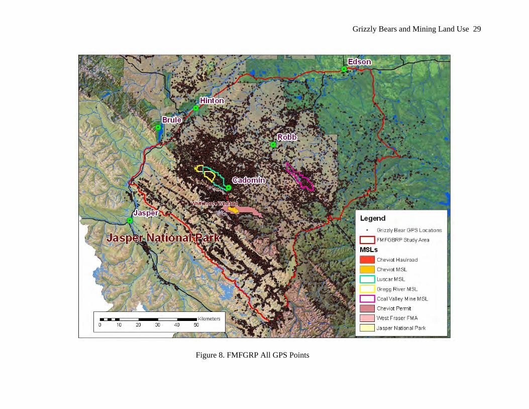
Grizzly Bears and Mining Land Use 29
Figure 8. FMFGRP All GPS Points

Grizzly Bears and Mining Land Use 30
Location data was stored in the individual GPS collar and retrieved by different methods.
Data could either be uploaded monthly by helicopter circling in the vicinity of the grizzly bear or
data would be stored within the collar unit’s memory until the collar could be recovered and
downloaded. Collars were either equipped with a remote drop off system, allowing researchers to
remotely trigger the collar to release from the grizzly bear, or the individual was re-captured to
have the collar removed. All collars were designed with a canvas “rot-off” to ensure the collar
dropped off the grizzly bear at some point in time (Stenhouse & Munro, 2000).
Methodology for Testing HEM Outputs for 1996 Cheviot CEA
Several methods exist to define home range. Home range polygons may be calculated using
Minimum Convex Polygon (MCP), which is a simple polygon enclosing the outermost points of
a set. While it identifies extent of an animal’s range, it does not identify intensity of occurrence.
Another method is using a fixed kernel density estimator. The kernel is a contour on a point
density surface within which is a specific probability of finding a point (Cranston, 2004). This
author has chosen not to apply interpolation or modeling tools to define range. Rather analysis is
conducted of empirical, field collected GPS locations of grizzly bears.

Grizzly Bears and Mining Land Use 31
Figure 9. Grizzly Bear GPS Points Occupancy Within Luscar and Gregg River Mines Disturbance Footprint + ZOI

Grizzly Bears and Mining Land Use 32
Results
Using HEM in the Cheviot CEA modeling, the response by grizzly bears to mining land use
was predicted to be decreased habitat effectiveness, and therefore significant (almost complete)
avoidance.
GIS was used to overlay the Luscar and Gregg River mines with all grizzly bear GPS location
from the 1999-2004 FMFGRP field program. These were two active mining operations during
that period. Fourteen grizzly bears provided a total of 36 individual annual ranges which
occurred within the mines’ disturbance and zone of influence in the 5 year period (Table 2). It is
important to note that these 36 grizzly bear ranges are only from those bears that were
successfully collared in the 1999-2004 field program, and serves only as a subset of the regional
grizzly bear population. Further, the dataset includes only locations collected when a grizzly was
equipped with an active GPS collar. It does not include cubs of the year, nor any other individual
grizzly bears that used these areas that were not collared. The dataset is used in this study to
understand grizzly bear occurrence. A consistent and continued occurrence of grizzly bears
within the mine disturbance and zone of influence is evident. Of the 19,942 total point locations,
23.8% occurred within the Luscar and Gregg disturbance ZOI. The percentage of locations
occurring for individual home ranges were from 0.1% to 82.9% (mean 23.2%, n=36). Given the
prediction of no grizzly bear use of these mines, haul roads and associated buffers, this analysis
has proven the hypothesis that modeling employed for both the 1996 and 1999 grizzly bear CEA
was not predictive of actual grizzly bear use or movement within mining land use areas.

Grizzly Bears and Mining Land Use 33
Table 2: Individual Grizzly Bear Occurrence Within Luscar and Gregg River Mines Disturbance
Grizzly Bear ID Year
Total GPS
points
GPS points within Luscar & Gregg River Mines Disturbance +
ZOI
GPS points within Luscar & Gregg River Mines Disturbance +
ZOI (%) G004 1999 793 1 0.1G004 2001 542 15 2.8G008 1999 393 39 9.9G008 2002 851 53 6.2G008 2007 1048 121 11.5G014 2000 283 11 3.9G017 1999 66 10 15.2G017 2000 77 3 3.9G017 2001 150 29 19.3G017 2002 869 24 2.8G020 1999 683 138 20.2G020 2000 453 17 3.8G020 2001 649 43 6.6G020 2002 410 10 2.4G023 2000 623 149 23.9G023 2001 716 433 60.5G023 2002 349 81 23.2G023 2003 399 236 59.1G024 2000 586 11 1.9G024 2001 1052 14 1.3G029 1999 481 190 39.5G029 2000 442 63 14.3G029 2001 1525 131 8.6G037 2002 459 81 17.6G037 2003 35 29 82.9G038 2001 438 36 8.2G040 2001 173 141 81.5G040 2002 689 332 48.2G040 2003 665 510 76.7G040 2006 1919 1511 78.7G054 2002 124 5 4.0G055 2003 443 45 10.2G100 2001 760 109 14.3G100 2002 128 63 49.2G100 2003 516 38 7.4G100 2004 153 25 16.3

Grizzly Bears and Mining Land Use 34
Discussion and Conclusion
HEM and its Use for Modeling Grizzly Bear Response to Disturbance
A study by Stenhouse, Dugas, Boulanger, Hobson, & Purves (2003) supports the preceding
Luscar/Gregg River mining land use analysis. Those authors tested modeling outputs at a
regional scale in the FMFGRP study area. Results suggested that the HEM runs were not
predictive of actual bear distribution. Based on comparisons between model outputs and
FMFGRP data, Habitat Effectiveness outputs were not significantly correlated to the distribution
of bears from DNA data. These outputs were not correlated to level of use by GPS collared bears
and were negatively correlated to the distribution of GPS collared bears. The authors concluded
that this failure did not necessarily mean that the model lacked validity. The model’s ability to
predict grizzly bear use of bear management units may be enhanced through improvements to the
base mapping or by reassessing the assumptions used (Stenhouse, Dugas, Boulanger, Hobson, &
Purves, 2003).
Past projects in Alberta have calculated habitat effectiveness outputs using GIS technologies
and USDA Forest Service (1990) formulas (Kansas, 2003). Results of these CEM assessments
have been used as tools for regional land use planning and single industrial project assessment.
While HEMs are being utilized to assess project affects on grizzly bear, changes to, and
assumptions applied to inputs can result in noteworthy changes to outputs. There are currently no
Canadian-based grizzly bear HEM standards, therefore most CEA practitioners in Alberta have
adopted those model coefficients and formulas developed in the United States.
Testing of the sensitivity of CEA output, depending on changes to input variables, has
received little attention. (Kansas, 2002). Yet, as a result, if accuracy of the HEM (disturbance
coefficients and/or assumptions) exercise is incorrect for given conditions, subsequent local and
Grizzly Bears and Mining Land Use 35
regional decision-making and management based on these modeled predictions of grizzly bear
impacts may be dramatically affected. This has been demonstrated by noteworthy difference
between predicted grizzly bear impacts due to mining land use used based on CEM modeling
runs for the Cheviot project and actual empirical testing of grizzly bear occurrence.
HEM and its Use in Cheviot CEA for Grizzly Bears
At the time of the Cheviot Project’s environmental assessment in 1996, comparatively little
was known regarding regional grizzly bear population dynamics and response to human
disturbance. Holling (1973) defines resilience as the ability of systems to absorb disturbance and
still maintain the same relationships between populations or state variables, and still persist”.
Researchers suggested that grizzly bears have little resiliency (Weaver, Paquet, & Ruggierp,
1996) and Herrero (2000) suggested that grizzly bears appear highly vulnerable to human-caused
sensory disturbance. Because the Cheviot Project impact assessment had to be completed in less
than one year, extensive, original field research was not possible (BIOS, 1996). As a result, the
HEM model was not empirically validated.
Limited research on HEM has been focused on the ability of the model to accurately predict
habitat utilization compared to predicted effectiveness (Stenhouse et al., 2003) or testing the
significance of its outputs (Kansas, 2003). Little to no testing of HEM has been conducted of an
actual mining life cycle that includes aspects of undisturbed, disturbed, and reclaimed lands
within mining land use. This is most notable in consideration of the spatial and temporal
components of a phased mine development life cycle within a greater mine permit area, and this
mine land use’s effects on grizzly bear habitat and its effectiveness. Modeling assumptions for
the Cheviot mine were based on 100% of the proposed disturbance area being under 100% active
mining activity for 20 years, the duration the project life. The Cheviot project grizzly bear HEM

Grizzly Bears and Mining Land Use 36
assumption was that upon project start-up, the total 2,800 ha planned disturbance, plus the
additional one km zone of influence, for a total area of 12,710 ha (127.1 km2), would have a HE
rating of zero over the planned 20 years of the mine project.
Comparatively, following more than 3 years of active mining, the Cheviot project disturbance
footprint is less than 300 hectares, within which reclamation and revegetation has been
conducted on 15 hectares. This disturbance footprint is within the current 1,100 ha (11 km2)
Cheviot MSL. Of the 7,150 ha Cheviot permit area, 1,100 ha is currently within MSL, or mining
land use. Of this, less than 300 ha of the planned 2,800 ha have been disturbed. This temporal
component, omitted in the CEA assessment of mining land use is important. Not only does
mining not extend to the planned development footprint immediately, but all lands within the
Cheviot permit area not under MSL remain susceptible to multiple land use activities (pressures)
under provincial jurisdiction.
Based on the model outputs and expert opinion in the original Cheviot project application, it
was concluded that the entire Cheviot mine area would become lost to grizzly bears by the end of
the mine’s 20 years of operation. Further, it was predicted that “grizzly bear habitat
effectiveness, due to the effects of the extensive development [within the modeled mature mining
disturbance footprint], was so low that [it] predicted only occasional use of this area by grizzly
bears” (BIOS, 1996); and “effective mitigation is improbable, even within a 100 year post-
mining framework” (BIOS, 1996).
These HEM outputs were referred to extensively to predict the effects of the Cheviot project
on grizzly bears, and to guide impact significance ratings (BIOS, 1996; Cardinal River Coals
Ltd, 1996a; Herrero, 2000; Natural Resources Canada, 2000). This thesis research concludes that
disturbance coefficients assigned for mining land use for the Cheviot project CEA, as tested

Grizzly Bears and Mining Land Use 37
empirically in this study, were not valid and model assumptions for mining land use were
erroneous.

Grizzly Bears and Mining Land Use 38
Chapter Three: Testing New Modeling Tools Developed for Grizzly Bears: RSF Applicability
for Mining Land Use
Testing the Resource Selection Function Model
Scientists have developed new predictive and probabilistic modeling tools through the
innovation of the FMFGRP and other grizzly bear research programs in North America. Many
researchers have used GIS data and satellite remote sensing imagery to classify grizzly bear
habitats (Bechtold, Havlick, Stockmann, 1996; Cranston, 2006; Gibeau, 2000; Mace, Waller,
Manley, Ake, Wittinger, 1999; McDermid, 2004; Montgomery, 2004; Neilson, Munro,
Bainbridge, Stenhouse, Boyce, 2004; Schwab, 2004). Land cover and landscape attributes are
classified from GIS and remote sensing sources, then grizzly bear selection for these attributes is
modeled to reflect the probability of use of a resource unit (Nielsen, 2005) using Resource
Selection Function (RSF). Habitat use can be characterized by RSFs that are proportional to the
probability of an area being used by an animal (Boyce & McDonald, 1999). A RSF model has
been developed within this grizzly bear population unit to document population level grizzly
bear habitat selection (Nielsen, 2004) and this output may then be utilized as an input parameter
for the identification of movement corridors across landscapes (Schwab, 2004).
Empirically-based habitat map products have been used to create RSF probability models that
are deemed the most current, best available tools and have proven better at predicting relative
occurrence of grizzly bears than traditional HEMs (Nielsen, Boyce, Stenhouse, Munroe, 2003).
The FMFGRP 1999-2004 GPS location data provided empirical input to the creation of the RSF
(2004) in the FMF study area. The grizzly bear RSF is a population level, probability of

Grizzly Bears and Mining Land Use 39
occurrence surface model. This Chapter tests whether this modeling tool provides an accurate
surrogate for predicting grizzly bear use within mining land use areas.
RSF and its Use in Regional Planning for Grizzly Bears
RSF habitat models may be developed in part using Landsat satellite imagery to classify
landcover. In the FMFGRP study area, McDermid (2004) created the Integrated Decision Tree
(IDT) map by classifying the raw imagery into 13 land cover classes. The IDT map is then
combined with grizzly bear points to create the RSF surface (Nielsen, 2004). The RSF raster is a
probability surface that reflects the relative attraction of a particular location to a bear. Seasonal
grizzly bear habitat RSFs were produced for the FMF based on 30,616 animal use locations from
29 GPS collared female grizzly bears, 16 environmental predictor variables, and 4 mask
variables (Nielsen, 2007).

Grizzly Bears and Mining Land Use 40
Figure 10. Regional Grizzly Bear RSF (Phase 6 Version)
The RSF subdivides land cover classes according to aspect, elevation, proximity to land use
features, etc. and assigns a selection coefficient to each polygon based on a comparison of the
number of points predicted to randomly fall inside it, with the actual distribution of bear points
(Cranston, 2006). It is not a habitat map per se, as the term “resource” refers to any natural
features used by a bear, whether a berry patch selected for food, a fallen tree used for denning, or
a forest canopy cover (Nielsen, 2004). Since resource selection varies widely by age, sex, and
season (Nielsen, 2004), RSF maps are generated separately for each sex-age group (adult male,
adult female, and sub adult) and season (spring, summer and fall) (Cranston, 2006). RSF output
values range from 0 (no probability) to 10 (highest probability).

Grizzly Bears and Mining Land Use 41
Methodology for Testing RSF on Mining Land Use
Testing RSF for mining land use was conducted by overlaying the current version of RSF
(2007) onto Luscar and Gregg River mines. The Phase 6 RSF version was used for this testing. It
is based on 2005 conditions and was released in 2007. The result is the predicted grizzly bear
occurrence by RSF class within mining land use areas. This was then overlaid with occurrence of
grizzly bear GPS locations for a measure of grizzly bear occurrence per RSF class.

Grizzly Bears and Mining Land Use 42
Figure 11. All Grizzly Bear Points within Luscar and Gregg River Mine MSLs with RSF Assigned Values (1-10)

Grizzly Bears and Mining Land Use 43
Results: RSF and its Use in Predicting Grizzly Bear Occurrence in Mining Land Use
Table 3. Occurrence of Grizzly Bear Locations within RSF Assigned Values on MSLs
RSF Class
Area (ha)
% of Area
GPS locations
(#)
% Occurrence
by RSF Class
% Occurrence
per unit area
0 2,935 41.37% 1,140 36.35% 14.9 2 10 0.14% 0 0.00% 0.0 3 26 0.37% 1 0.03% 1.5 4 75 1.06% 5 0.16% 2.6 5 104 1.47% 12 0.38% 4.4 6 208 2.93% 54 1.72% 9.9 7 393 5.54% 141 4.50% 13.7 8 655 9.23% 186 5.93% 10.9 9 944 13.31% 376 11.99% 15.3 10 1,745 24.59% 1,221 38.93% 26.8 Total 7,095 100.00% 3,136 100.00% 100.0
0%
5%
10%
15%
20%
25%
30%
35%
40%
45%
0 2 3 4 5 6 7 8 9 10
RSF Class
Perc
ent O
ccur
renc
e
Figure 12. Percent Grizzly Bear Occurrence by RSF Habitat Class within MSL
Grizzly Bears and Mining Land Use 44
This RSF model for grizzly bear habitat quality within the boundaries of the Luscar & Gregg
River MSLs is significantly limited in its capacity to accurately predict probability of bear
occurrence within the mining land use features which include the undisturbed, disturbed and
reclaimed lands. Over 1/3 of all grizzly bear locations occurred within RSF class 0. This class is
rated as the least probable location that a grizzly bear would use. Its actual level of use however,
was similar to that of class 10 (Table 3), which is the highest probability classification.
Nominally, the class 0 is assigned to disturbed lands, while higher ranking is provided to
undisturbed lands. Figures 11 and 12 suggest that there may be correlation of grizzly bear
distribution with other variables. These might include distance to forest cover, ungulate
abundance, herbaceous plant production, or other habitat selection feature within mining land use
areas. Grizzly bear occurrence on mining land use areas is not incidental but most likely
purposeful and methodical. While much of these areas are characterized by RSF with a no
habitat value mask, they are infact adjacent to portions of undisturbed lands which provide
secure forest cover. These open, early succession reclaimed landscapes offer herbaceous forage
and abundant ungulate populations in what is otherwise largely a closed forest environment with
limited forage resources. Stevens & Duval (2005) found that grizzly bears with home ranges
overlapping the Luscar and Gregg River mine land use areas support higher body condition
indices than grizzlies with home ranges overlapping the un-mined Cheviot permit area. This is
particularly significant for female bears. Grizzly bears with home ranges overlapping the existing
Luscar and Gregg River mine land use areas return to previously used home ranges at least as
regularly as bears in the un-mined Cheviot area. This implies regular as opposed to sporadic use
of the mined lands (Kansas, 2005).

Grizzly Bears and Mining Land Use 45
Conclusion and Recommendations
Within mining land use, there is a phased life cycle of development and reclamation. This life
cycle, over years or decades, maintains a portion of undisturbed, disturbed, and reclaimed lands
accessible to wildlife, under restricted public access. Habitat quality within mining land use areas
is misrepresented by the assigned low RSF score within the model, likely resulting from an issue
of process in scale with mining land use within the application of this tool for regional mapping
or assumptions applied upon interpolation within mining land use areas.
Neilsen (2005) assigned a low RSF score (low probability of bear occurrence) when
developing the regional scale model for landcovers with similar vegetative cover, bare ground
and greenness values as mining land use (McDermid, 2004). While this may be appropriate at a
regional scale resolution, the RSF model fails specifically to provide reasonable predictive
relative occurrence of grizzly bears on mine land use landscapes, and rather arbitrarily assigns
these areas with a low score. The IDT map developed by McDermid (2004) utilizes 13 land
cover classes. No class has been developed specific to mining land use. Contrary to actual
empirical data, a ‘mask’ has been applied to disturbed areas within the mining land use areas to
further discount their probability of grizzly bear occurrence. Grizzly bear occurrence may result
from reclamation forage, ungulate utilization, or public access management on mining land use
areas. Assigning a cover class similar to that done for regenerating clearcuts may be entirely
logical for reclaimed mine lands.
In spite of the intensive and long-term nature of the regional grizzly bear research by the
FMFGRP, little specific information on grizzly bear response to mine development and
reclamation has been conducted. In fact, assumptions made in the construction and applications
of RSF and other models, including the mortality risk model and habitat states analysis,

Grizzly Bears and Mining Land Use 46
constructed on a regional scale, currently consider areas associated with mining and reclamation
to be largely unavailable to grizzly bears and of high and even very high mortality risk (Stevens
& Duval, 2005). Given their regional significance for grizzly bear use, areas within active MSLs,
with their specific public access designation and habitat value, should be reflected accordingly
by RSF. End land use planning opportunities and risks are discussed further in Chapter 5. The
next Chapter examines two grizzly bears as case studies relating to their occurrence and
movement within mining land use areas.

Grizzly Bears and Mining Land Use 47
Chapter Four: Case Study of Grizzly Bears and Mining Land Use
Since the 1996 and 1999 Cheviot grizzly bear CEAs, significant knowledge has been gained
regarding grizzly bears within the Yellowhead Ecosystem. As well, Chapters 2 and 3 of this
thesis have confirmed that grizzly bears routinely use mining land use areas. This Chapter shifts
to case studies of two grizzly bears to determine finer scale grizzly bear movement and
occurrence within and adjacent to mining land use areas. The first grizzly bear, G008 an adult
male, was twenty two years old in 2007. Data was collected on movements and habitat selection
through the use of GPS radio collars during two years of pre-disturbance and two years of
concurrent active mining land use within the Cheviot project area. The second, G040, was 8
years old in 2006. She is an adult female that provides 4 years of data collected on movements
and habitat within and adjacent to existing mining land use of the Luscar and Gregg River mines.
Data from these 2 bears is considered within a regional grizzly bear management context.
Grizzly Bear Home Range and Mining Land Use
Home range is a term that has been defined as “that area traversed by the individual in its
normal activities of food gathering, mating and caring for young. Occasional sallies outside the
area, perhaps exploratory in nature, should not be considered as part of the home range” (Burt,
1943). Rather, it is where an animal goes during its day-to-day activities. The area defined as a
home range is dependent on the size of the animal and its requirements for food, water, mates
and refuge or den sites (Busch, 2000). Chapters 3 and 4 of this thesis have demonstrated regular
grizzly bear occurrence within active mining land use areas. This Chapter explores the impact of
mine development on grizzly bears and their subsequent use of these landscapes at a fine scale.
Further, this thesis will focus on specific interactions between grizzly bears and mining land

Grizzly Bears and Mining Land Use 48
uses. This Chapter examines grizzly bears’ use of mining land use areas within part of their
range.
Researchers may estimate home range polygons using several methods. Minimum Convex
Polygon (MCP), generated by the Animal Movement extension of ArcView GIS, is a simple
polygon enclosing the outermost GPS points of a set to generate a utilization-distribution. Fixed
kernel density estimator is a method of estimation which has been increasingly selected over
other methods such as the MCP. MCPs have been found to over-estimate home range size as
they include all those unused areas between the outermost locations, and generally increase in
area with increasing sample size. Kernel home range estimation is dependent upon percent of
fixed kernel and on assigned smoothing factor (Hooge & Eichenlaub, 1997). This study
purposefully opted to use only empirical data without home range modeling. As such, grizzly
bear movement and use associated with mining land use is determined using GPS locations and
the continuous movement paths collected from the collar sensors. For GPS locations collected,
grizzly bears are either within the active coal mine MSLs, which are defined as mining land use
areas, or they occur outside these areas.
G008 & G040 Research Methodology
Empirical data of grizzly bear movement was collected for this thesis research in 2006 and
2007. In 2006, using helicopter reconnaissance, two grizzly bears were located, tranquilized, and
fitted with GPS, camera and sensor equipped collars. This was repeated in 2007 for the
successful re-collaring of one of the individual grizzly bears. G040 was translocated in 2006 and
thus unavailable for recapture in 2007.

Grizzly Bears and Mining Land Use 49
Figure 13. Author with Collared Grizzly Bear
This was part of a joint project between this thesis study and a geomatics engineering
technology doctoral thesis project, both supported through cooperative partnership with the
FMFGRP, Elk Valley Coal, and NSERC/CRD. GPS and sensor data was remote-downloaded
monthly using a helicopter. Camera pictures were to be retrieved with collars prior to winter
denning in November 2006, although G008’s collar was retrieved (and replaced) in spring 2007.
(Sept 7 2007)

Grizzly Bears and Mining Land Use 50
Each collar had sensors programmed to collect 26 GPS locations per day at 30 minute intervals
during the early morning and early evening, one hour intervals during the remainder of the
daylight hours, and two hour intervals during the night. Additional sensor data recorded
continuous movement paths, along with digital pictures taken at approximately 15-minute
intervals. GPS and sensor data can be used to determine movement, habitat selection and
behavioral patterns. Each bear provided large data sets for analysis of grizzly bear movement and
human disturbance.
This study recognizes that data collection may begin at some point following den emergence,
and may or may not capture all annual movement of grizzly bears collared. For example, G040
was collared on April 15. Her collar was subsequently removed on July 27 2006, when she was
captured by government agency. In 2007, G008 was collared on April 25. His collar failed to
collect data following August 2007. Understandably, caution should be applied regarding
definition of home range size and point distribution based on datasets.
All capture and collaring efforts (1999-2004, 2006-2007) followed procedures outlined by the
Canadian Council on Animal Care for the safe handling of bears. Research protocols were
further approved by the Animal Care Committee at the Western College of Veterinary Medicine
in Saskatoon, Saskatchewan. All capture and handling methods were consistent with the
guidelines of the American Society of Mammalogists (Animal Care and Use Committee 1998)
(See Appendices 1 & 2).

Grizzly Bears and Mining Land Use 51
Table 4: Capture Information for Grizzly Bears G008 and G040 Grizzly Bear
ID Capture
Date General Location Age
(Year)Capture Method
G008 14-May-99 Drummond Creek 14 heli dart G008 9-May-02 Whitehorse/Drummond 17 heli dart G008 19-Apr-06 Headwaters
Whitehorse Creek-Fiddle Pass area
21 heli dart
G008 25-Apr-07 Whitehorse Creek 22 heli dart G040 17-May-01 Highway 40 near
Luscar MSL 3 Snare
G040 30-Apr-02 Gregg River MSL 4 heli dart G040 15-Apr-06 Gregg River MSL 8 heli dart G040 27-Jul-06 Hamlet of Cadomin 8 Culvert trap
Results of Grizzly Bear Occurrence and Mining Land Use Analysis
Although the sample size of individual grizzly bears presented is small (n=2), they
contributed a large amount of occurrence and movement data over 8 years, reducing GPS collar
bias (Frair et al., 2004). The two grizzly bears collared in this thesis study have been previously
collared over multiple years (Table 4). The FMFGRP (1999-2004) dataset for these grizzly bear
occurrences was also utilized to augment the statistical power of the analysis, to conduct analysis
including multiple annual datasets, and assess shifts in grizzly bear occurrence over time and
with mining land use.
Grizzly Bear G008 Occurrence and Mining Land Use
Grizzly bear G008 occurrence and his association with mining land use between years
allowed the assessment of changes in grizzly bear use and movement between years with and
without the presence of mine related development activity.

Grizzly Bears and Mining Land Use 52
Figure 14. G008 Occurrence Before and With Cheviot Mining Land Use

Grizzly Bears and Mining Land Use 53
Table 5: G008: Percentage of Grizzly Bear Occurrence Within Mining Land Use
Grizzly Bear G008
Total GPS points
GPS points within Cheviot Permit
% GPS Locations within Cheviot Permit
GPS points within Cheviot MSL (Mine & Haul Road)
GPS points within Luscar & Gregg River Mines MSL
GPS points within all active MSL
GPS Locations within Mining Land Use (% within active MSL)
1999 393 29 7.4 4 14 14 3.6 2002 851 83 9.8 6 16 16 1.9 2006 3,777 223 5.9 47 0 47 1.2 2007 1,048 126 12.0 6 77 83 7.9
` ` before Cheviot project with Cheviot project
0.0
2.0
4.0
6.0
8.0
10.0
12.0
14.0
*1999 *2002 **2006 **2007
Year
Occ
urre
nce
by G
PS
loca
tions
(%)
% GPS Locations withinCheviot Permit
% GPS Locations withinMining Land Use
Figure 15. G008: Percentage of Grizzly Bear Occurrence (GPS Points) Within Mining
Land Use and Cheviot Permit Area
An occurrence distribution of each year for G008 compared between years before (1999 &
2002) and with (2006 & 2007) mine related land use in the Cheviot project area.
*before Cheviot project **with Cheviot project

Grizzly Bears and Mining Land Use 54
Grizzly Bear G040 Occurrence and Mining Land Use
Figure 16. G040: All GPS Points by Year
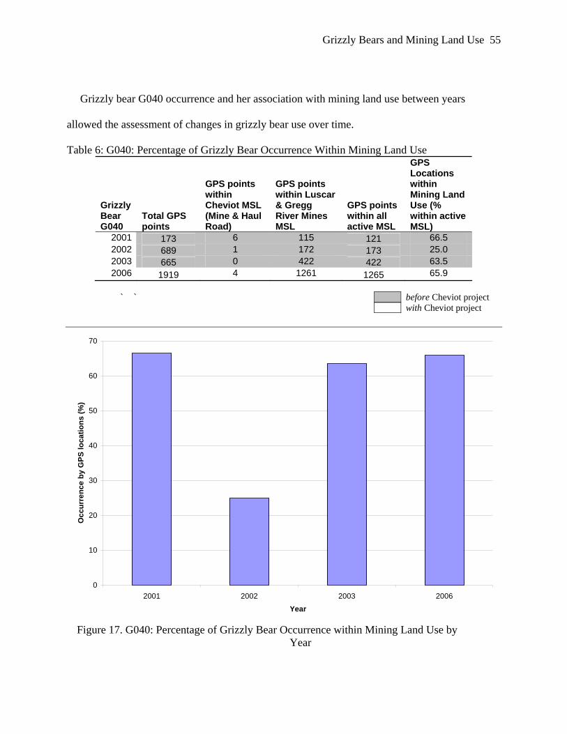
Grizzly Bears and Mining Land Use 55
Grizzly bear G040 occurrence and her association with mining land use between years
allowed the assessment of changes in grizzly bear use over time.
Table 6: G040: Percentage of Grizzly Bear Occurrence Within Mining Land Use
Grizzly Bear G040
Total GPS points
GPS points within Cheviot MSL (Mine & Haul Road)
GPS points within Luscar & Gregg River Mines MSL
GPS points within all active MSL
GPS Locations within Mining Land Use (% within active MSL)
2001 173 6 115 121 66.5 2002 689 1 172 173 25.0 2003 665 0 422 422 63.5 2006 1919 4 1261 1265 65.9
` ` before Cheviot project with Cheviot project
0
10
20
30
40
50
60
70
2001 2002 2003 2006
Year
Occ
urre
nce
by G
PS lo
catio
ns (%
)
Figure 17. G040: Percentage of Grizzly Bear Occurrence within Mining Land Use by
Year

Grizzly Bears and Mining Land Use 56
An occurrence distribution of each of 4 years (2001-2003, 2006) for G040 compared her
occurrence within active mine land use over this period of time.
Results of Grizzly Bear Movement and Mining Land Use Analysis
Grizzly Bear G008 Movement and Mining Land Use
GPS locations and their spatial orientation were used to determine grizzly bear
occurrence within mining land use areas based on a percentage of total number of GPS
locations collected. G008 GPS point data is identified from the FMFGRP 1999-2004
dataset (before Cheviot project) to compare to repeated G008 GPS data collected
through this 2006 and 2007 (with Cheviot project) thesis research collection period.

Grizzly Bears and Mining Land Use 57
Figure 18. G008: All Recorded GPS Locations and Interpolated Movements and Mining Land Use Areas

Grizzly Bears and Mining Land Use 58
Figure 19. G008: Interpolated Movements Before and With Cheviot Mining Land Use

Grizzly Bears and Mining Land Use 59
Extracting movement paths within and adjacent to this mining land use demonstrates actual
grizzly bear movement patterns. GIS overlay of mining land use is used to identify actual grizzly
bear movement corridors in and adjacent to active mining land uses.
Additionally, by joining GPS points (4 hour interval) to coarsely identify pre-Cheviot
movement paths, we can examine shift or consistency in grizzly bear movement corridors with
the addition of the Cheviot mining land use. Figures 18 and 19 identify grizzly bear G008
movement corridors prior to and during active Cheviot mining operations. Movements of G008
are overlaid with mining land use features, including the Cheviot coal transportation haul road.
Grizzly Bear G040 Movement and Mining Land Use
Four years of G40’s GPS location data were used to determine use of Luscar and Gregg River
mining land use areas as portion of this grizzly bear’s annual range. From 2001-2006, G040’s
locations (Figure 14) occurred within the mining land use area of the Luscar and Gregg River
MSL over 55% of all locations (range 25%-66.5%, n=4 years).
For G040, using the multiple per day collected GPS points along with sensor data which
records continuous movement path, grizzly bear movement within and adjacent to mining land
use was examined at finer scale.

Grizzly Bears and Mining Land Use 60
Figure 20. G040 Movement Within and Adjacent to Luscar/Gregg River Mining Land Use (2006)

Grizzly Bears and Mining Land Use 61
This continuous movement path was processed for a two week period, from April 15 to May 1
2006. Extracting continuous movement paths within and adjacent to the Luscar and Gregg River
Mines demonstrates actual spatial and temporally correct grizzly bear movements within mining
land use.
Discussion
Grizzly Bear Occurrence
Grizzly bear G008 has been referred to as a ‘Cheviot bear’, due to his use of the Cheviot
permit area prior to, and now during the development and operation of the Cheviot project area
as a portion of his home range. Interestingly, empirical analysis of his GPS locations prior to the
Cheviot project also indicate an average of 2.7% (3.6% and 1.9%, 2 years) of his annual
locations occurring within the Luscar and Gregg River mining land use areas. His average use of
the Cheviot mine permit area in relation to total GPS locations collected per year increased
slightly following the start-up of the Cheviot project (8.6%, n=2 years; 9.0%, n=2 years).
Grizzly Bear Movement
Eight (8) grizzly bear annual ranges for 2 grizzly bears were analyzed. This offered recent
data and reduced potential bias of limited sample size given individual bear behavior variability
(Mueller, 2001). It is acknowledged that correlation of grizzly bear movement and mining land
use features is weaker for the 1999-2004 FMFGRP dataset as GPS (typically collected at 4 hour
point intervals) alone may not provide resolution for studying behavior or understanding use
within the zone of influence of specific mining land use activity.
Actual movement of grizzly bears within mining land use was examined at a fine resolution
and scale using the 2006 and 2007 data. Multiple per day collected GPS points along with sensor
Grizzly Bears and Mining Land Use 62
data which records continuous movement path within and adjacent to active open pit mining had
been intended for this analysis. This new geomatics technology development, however,
presented data processing challenges requiring further effort to resolve. This thesis analysis thus
proceeded primarily using GPS locations and interpolation between these points based on time
sequence.
The frequency of point intervals meaningfully increased for the 2006 and 2007 grizzly bear
program. This has increased the capacity of the analysis to initiate definition of actual movement
paths. Availability of continuous movement data was limited to G040 over a two week period in
2006. This technology demonstrates a marked and significant improvement in resolution of
monitoring of actual grizzly bear movement from which behavior and habitat selection may be
researched empirically. This study does serve to augment a robust empirical dataset for
association of bear use and mining land use features. Further outputs of the continuous
movement sensors will greatly enhance the ability to examine individual grizzly bear behavior
based on movement, activity and habitat selection.
Conclusion
How a grizzly bear reacts to human activity depends on many variables including the type and
intensity of human activity, where the interaction occurs, the distance between the activity and
the grizzly bear, the amount of cover, inherited tolerance, age and sex class and individual
personality and experience (Mueller, 2001). Wielgus, Vernier, & Schivatcheva (2002) studied
grizzly bear selection of use of open, closed and restricted forestry roads and suggest that
cessation of all resource development activity in grizzly occupied areas may not be necessary to
maintain habitat effectiveness. Grizzly bears did not select against restricted roads, and no
grizzly bears were shot from restricted roads. This thesis supports similar findings. Although

Grizzly Bears and Mining Land Use 63
active mining may present inherent temporary habitat loss and episodic local movement barrier,
such as active mining pits, the analysis conducted suggests that mining land use has not resulted
in landscape level movement barriers for grizzly bears within the current Cheviot or
Luscar/Gregg River mine areas. Continued use of adjacent high quality habitat indicates no sign
of displacement. Repeated grizzly bear crossings have occurred across the active Cheviot haul
road. Based on continuous movement data (Figure 20), these crossings have been during diurnal
grizzly bear activity, occurring in routinely as late morning (ie. G040, 2006-04-24, 09:15) or mid
afternoon (ie. G040, 2006-04-23, 16:38).
Aside from the active Cheviot haul road, it is important to qualify the mining activity
occurring within active mining land use areas. Figure 18 identifies G008 movement within and
adjacent to the active Cheviot project. Within the Cheviot MSL is intensive land alteration as the
mine is in its early development phase of coal extraction in its life cycle. Large areas of landform
re-development and reclamation have not yet been fully initiated. During this pit development,
vehicular traffic of mine support equipment and coal hauling are underway on the Cheviot haul
road, generally on a 24 hour/day basis. Further, these mining land uses within the Cheviot area
were only initiated in late 2004. Construction of the Cheviot haul road, pit development and
operation: these are all recent activities within the area. There is no significant shift of movement
or avoidance observed.
Figure 20 identifies G040 movement primarily within the Luscar and Gregg River MSLs.
Active coal mining occurred over 30 years on these MSLs until 2004. Although not currently
under active coal development, the Luscar mine site still supports industrial activity through the
site, including explosives manufacturing, electrical substations, maintenance shops, main office
complex and site access, and 10 km of the Cheviot haul road. It also features Highway 40 which

Grizzly Bears and Mining Land Use 64
provides public travel through the site. While much of the reclamation of the Gregg River site
was completed by 2006, a large portion of the Luscar site currently remains in a disturbed state,
without yet having been fully reclaimed.
Maintaining movement connections across fragmented landscapes is important for the long-
term conservation of grizzly bear populations (Schwab, 2004). In mining land use or timber
harvest areas, fragmentation may be caused by human disturbances, such as a network of highly
used roads that can disrupt the ability of individual bears to efficiently move between feeding
areas. At the regional scale, fragmentation may occur when movements along or across major
valley systems are blocked, and interbreeding populations are cut off from each other (Kansas,
2002a). This thesis research indicates no significant observed barriers to grizzly bear movement
as a result of mining land use such that their use of areas is impeded. G040 moves through
reclaimed, unreclaimed, and undisturbed areas within mining land use areas. This includes
occurrence in unreclaimed disturbed areas with active mine activity including active mine haul
roads
Caution must be applied when examining the effects of this specific land use on grizzly bears
in isolation. Prior to the Cheviot project, and within the future development footprint, there exist
multiple other lands uses. It is important to ensure that researchers remain cognizant of these
existing human uses within adjacent areas and not engage in project level impact assessment
without due consideration of regional influences on grizzly bears. Finally, this Chapter has
affirmed with empirical research that the inductive models used to predict mining land use
effects on grizzly bears are erroneous. Grizzly bear occurrence on active mining land use areas,
as demonstrated, may serve for projection of effects due to planned mining projects.

Grizzly Bears and Mining Land Use 65
Although we are uncertain of her mother’s identity, it is known that G040’s father, G017, had
used portions of the Luscar and Gregg River mines as part of his range. During G040’s use of
public lands away from these mining land use areas in 2006, like her father before her, G040 was
removed from the regional grizzly bear population. In fact, along with her removal were both her
male and female cubs. One cub was suspected to have been shot prior to G040’s capture and
translocation along with her remaining female cub. Studying grizzly bear occurrence and
movement in one type of human land use, especially at a mining project scale, is not sufficient to
ensure persistence of grizzly bears. The regrettable fate of G040, both of her cubs, her father, and
many other grizzly bears in the region warrant further exploration in Chapter Five.

Grizzly Bears and Mining Land Use 66
Chapter Five: Implications of Research Results and Recommendations for Mining Land Use and
Regional Grizzly Bear Management
Results of empirical testing of grizzly bear occurrence and mining activity demonstrate
regular grizzly bear use of mining land use areas and its resultant landscape development. This
Chapter will review the state of knowledge regarding managing human-caused grizzly bear
mortality and explore opportunities for regional post mining landscapes that would be supportive
of safe, long term grizzly bear conservation areas. The Cheviot project application raised issues,
which resulted specifically from scientific uncertainty regarding regional grizzly bear response to
mining and regional human land use influences. This discussion will suggest that grizzly bear
conservation is not a project specific endeavor, but rather a regional commitment. This is
especially important in retrospect of the Cheviot project CEA. This Chapter offers a brief
retrospective of that CEA process, reviews the policy and framework development, and
commitments made and their current status.
Nielsen et al. (2006) defines safe-harbours as those which are source-like or secure. This
review will consider how the Cheviot project, predicted to contribute to regional adverse impacts
to grizzly bear, may infact, with the other nearby existing mining land use areas, provide
opportunity for long term safe-harbours for grizzly bear conservation in a region undergoing
rapidly increasing resource and recreational land use pressures. Finally, this Chapter will
conclude with Recommendations for Mining Land Use and Regional Planning for Grizzly Bear
Protection. These are based on these research findings, the current state of knowledge for
protection of grizzly bears, and my own experiences. These recommendations may serve
industry, governments, and public by providing detail to augment the existing Alberta Grizzly
Bear Recovery Plan. My recommendations focus on potential opportunities that exemplify

Grizzly Bears and Mining Land Use 67
sustainable mining by exploring post mining land use areas as potential critical long term
conservation areas for grizzly bears. An important component to this is attentive accommodation
and integration of recreation and other land uses.
Managing Human-Caused Mortality
Grizzly bears, because of their omnivorous food habits and ability to move long distances,
will likely find any permanent human habituation within their home range and obtain food there
if possible. Often when this occurs they usually are removed by appropriate authorities as
“nuisance bears”. Management removals of "nuisance" grizzly bears are a leading cause of death
in many populations. Whether these bears are killed or simply removed from the population unit,
they must be viewed as a reduction to the existing population. Management is typically invasive
and often includes translocation of these animals to remote areas and sometimes even their
destruction (Kloppers, St. Clair, & Hurd, 2005). These sites may become “population sinks”;
sites that bring grizzly bears into contact with humans (by food attractants) and often result in
removal of grizzly bears from the population (Knight, Blanchard, & Eberhardt, 1988).
Horejsi (1989) provides a critical commentary regarding Alberta’s provincial grizzly bear
management, suggesting “Fish & Wildlife Division of Alberta has managed the grizzly bear in
isolation, has manipulated the ecosystem’s population on behalf of people’s needs, ... bear
management continues with almost no input from the public, and land use decisions strongly
maintain the status quo.” Nearly twenty years following his comments, Alberta is developing
new initiatives and policy for grizzly bear conservation. Many of the initiatives for enhancing
knowledge and conservation measures for grizzly bears in the region resulted from the 1996
CEA for the Cheviot project and its conclusions regarding impacts to grizzly bears. This
included development of A Strategic Framework for Grizzly Bear Conservation in the

Grizzly Bears and Mining Land Use 68
Yellowhead Ecosystem (2000). New policies based on regional DNA inventory data, 10 years of
mapping and modeling work, coupled with unsustainable regional grizzly bear mortality rates
resulted in the Draft Alberta Grizzly Bear Recovery Plan (2005). This thesis has shown that
some of the predictions regarding mining land use impacts were not only inaccurate, but were
erroneous. It is, however, valuable to understand the state of science for grizzly bear protection
and what implications and opportunities might exist for mining land use in the region that might
support grizzly bear conservation.
Human-caused grizzly bear mortality: State of the science
Conservation biologists have studied grizzly bear human caused mortality throughout North
America for several decades. Without reductions in human-caused mortality after 1970, there
would have been no chance that core grizzly bear range would be as extensive as it is now
(Mattson & Merrill, 2002). Although rarely considered under the perspective of source-sink
theory, there is the possibility of ecological sinks resulting from high mortality in otherwise good
habitats, where resources are abundant and reproduction could be high (Delibes, Gaona, &
Ferreras, 2001). Mortality rates and causes in the interior mountains of British Columbia,
Alberta, Montana, Washington, and Idaho identify that trends of grizzly bear populations are
found to be most sensitive to female survival; thus understanding rates and causes of grizzly bear
mortality is critical for their conservation. Servheen & Sandstrom (1993) found that accidental
killing was most often the result of collisions between grizzly bears and motor vehicles or trains.
Intentional human-caused mortality can include legal hunting, control killing for being close to
human habitation or property, self-defense, and malicious killings. (McLellan et al., 1999).
The sex and age distribution of deaths and the magnitude of losses in relation to
recruitment are key issues in evaluating populations (Knight, Blanchard, & Eberhardt,

Grizzly Bears and Mining Land Use 69
1988). Human-caused mortality, especially of adult females, is the primary factor
limiting grizzly bear populations (Knight, Blanchard, & Eberhardt, 1988; Mace &
Waller, 1998; McLellan et al., 1999). The best prospect of reversing downward trend
in grizzly bear populations is by reducing mortality, particularly that of adult females
(Knight et al., 1988).
Human-caused mortality increases significantly for areas with open public roads (Benn &
Herrero, 2002; Mace et al., 1996). Roads increase access for legal and illegal hunters, the major
source of adult grizzly mortality (Alberta Grizzly Bear Recovery Team [AGBRT], 2005). When
roads are developed for resource industries in grizzly bear habitat, the bear population becomes
highly vulnerable unless access and people with firearms are controlled (McLellan &
Shackleton, 1988). Even within protected and largely unhunted areas, such as Banff National
Park and Kananaskis, humans caused 75% of female mortality and 86% of male mortality
(Garshelis, Gibeau, &Herrero, 2005).
In the Swan Mountains, Montana, Mace and Waller (1998) found that from 1987-1996, the
annual mortality rates for grizzly bears utilizing the rural and wilderness zones was 21 and 15
times higher, respectively, than for bears using only multiple-use lands. Their mortality,
movement, and occupancy data suggest that the multiple land use zone was a population source
area, and that wilderness and rural zones are sink areas. Mortalities in the wilderness zone were
from mistaken identification during the black bear (Ursus americanus) hunting season and self-
defence kills, primarily by ungulate hunters. In the rural zone, mortalities were from malicious
killing and the management removal of habituated or food-conditioned bears (Mace & Waller,
1998).

Grizzly Bears and Mining Land Use 70
An ecological trap (or “attractive sink”) is a habitat that is preferred over other available, high
quality habitats, but is low in quality for reproduction and survival and cannot sustain a
population (Battin, 2004). Human-caused mortality can transform high quality habitats into traps
by increasing adult mortality. Such traps may be masked by immigration from adjacent, less-
preferred areas, maintaining high densities in preferred habitats even as the population as a
whole declines (Battin, 2004). Habitat degradation can have rapid and severe impacts on
population dynamics and traditional monitoring programs may not be adequate to detect the
consequences of degradation (Doak, 1995).
Alberta
Grizzly bear populations in Alberta are threatened by permanent habitat loss and high rates of
human-caused mortality (Benn & Herrero, 2002). Human-caused mortalities account for 90% of
all known grizzly bear deaths in Alberta. Of those, with known locations, all occurred within
500m of a road or 200m of a trail (Benn & Herrero, 2002). Intentional killing in Alberta includes
illegal forms of mortality such as poaching, malicious killing, mistaking grizzly bears for legal
game. It also includes removal of nuisance grizzly bears by management agencies and bears
killed by individuals in defense of life or property (AGBRT, 2005).
Human-caused mortalities account for 90% of all known grizzly bear deaths in Alberta (Benn
& Herrero, 2002). Modeling the spatial distribution of human-caused grizzly bear mortalities in
the Central Rockies ecosystem of Canada reveals that overall, relatively little of the system is
secure from human-caused mortality for grizzly bears. Researchers suggest that this might be
most directly remedied by controlling human access (Neilson et al., 2004).

Grizzly Bears and Mining Land Use 71
NES Region
Selected areas within the FMFGRP area have concentrated high and very high categories of
attractive sink, indicating a co-occurrence of high mortality risk and highly probable animal
occupancy. Even where occurrence of these high and very high risk areas are fewer, such as
Banff and Yoho National Parks, rates of human caused mortality within these protected areas
which lack hunting and industrial resource development, are high. Human-caused mortalities
combined with natural causes of death can be a significant conservation concern (Nielsen,
Stenhouse, & Boyce, 2006). Boulanger’s (2005) analysis of empirical data suggests declining
grizzly bear survival rates over the course of the 1999-2004 FMFGRP study area. The FMFGRP
data suggests that within the study area high quality habitats (as indicated by RSF score) also
display higher road densities. Survival rates decrease in proportion to increasing human access
and associated mortality. Mortality rates in non-protected roaded areas are higher than protected
non-roaded areas. Mostly younger grizzly bears are found in non-protected roaded areas. Older
bears are generally found in lower road density habitats, which also have lower habitat quality.
Boulanger (2005) suggests that either older bears are selecting for protected, lower quality
habitats, or historic mortality has removed older aged bears from areas of higher road density.
Boulanger (2005) determined that a large proportion of females live in highly protected areas
compared to males and the majority of grizzly bear fatalities occur to those that have a low
percentage of their home range protected.
As roadless lands decrease, secure habitat for grizzly bears and other wildlife species sensitive
to roads decreases as well (Bechtold, Havlick, & Stockmann, 1996). Spatial models of human-
caused mortality risk suggest that the use of clearcuts and similar habitat in west-central Alberta

Grizzly Bears and Mining Land Use 72
result in an ecological trap situation, where animals lack the cues necessary to distinguish the
high-risk condition (Nielsen, 2005).
Neilsen (2005) modeled forest resource development scenarios, including road density and
clearcuts over a predicted 100 year period for different development scenarios. Despite a
potential 10% increase in animal density and potential carrying capacity, effective (secure)
territory units will decline by over 50%. All effective territories, even by year 30, will be located
within or adjacent to protected mountain parks, suggesting a substantial decline in foothills
populations. Without addressing habitat occupancy and mortality concurrently, attractive sink
conditions may be developing where animals are drawn to locations where survival is low
(Knight, Blanchard, & Eberhardt, 1988). This low survival is due primarily to human-caused
mortality. To be effective, a grizzly conservation strategy must consider the status of the entire
regional metapopulation over an area that encompasses both the source and sink populations
(Carroll, Noss, & Paquet, n.d.).
Managing Human-Caused Mortality to Optimize Mining Land Use Gains
Fate of Grizzly Bear G040 and Cubs in 2006.
Gibeau (2000) examined movement patterns of adult female grizzly bears in the Bow River
Watershed, Alberta and concluded that bears within an area of restricted human access used
higher quality habitat and traveled less than bears in unregulated areas. While G040
demonstrated high annual fidelity to mining land use areas (average 71% of all GPS locations,
n=4 years), she and her two cubs did also venture into public lands. In the Spring of 2006, G040
and her two cubs discovered dog food at a private residence on the outer fringe of the Hamlet of
Cadomin. Later, her male cub was killed along Highway 40. In the early summer, having found
this food source, G040 and her remaining female cub were repeatedly returning to the Cadomin

Grizzly Bears and Mining Land Use 73
residence to consume dog food. With this repeat behavior, based upon the provincial bear
response matrix, the government agency deemed that she presented a human safety risk and
intervention was warranted. She and her female cub were therefore captured by Alberta Fish &
Wildlife and translocated; and thus extracted from the regional grizzly bear population. G040
had spent 8 years on this landscape within the same vicinity without prior concern or adverse
human interaction. Arguably, this food conditioning in 2006 might have been most readily
mediated by alternate means of intervention, such as ensuring proper storage of dog food, rather
than removal of the two grizzly bears. G040’s fate, and that of both of her cubs, was similar in
nature to that of her father, G017, who was illegally killed in 2003; furthering the loss of mature
grizzly bears to the population. Wilson (2003) found that grizzly bear deaths in the U.S. tend to
be concentrated on the periphery of core habitats. While not necessarily on the periphery of these
mining land use areas, this is a similar fate for many bears within the region. Schwartz et al
(2006) demonstrated that humans are the single greatest cause of grizzly bear deaths and suggest
that efforts to minimize conflicts between people and bears represent a major component of any
management program directed at long-term conservation.
Mining Land Use and Regional Grizzly Bear Protection
A key mining land use attribute, independent of habitat quality, is public access management.
Currently, all existing and recent mining land use areas in this case study remain under existing
MSL disposition; thus restricting public access and prohibiting hunting. In the thirty five years of
continuous open pit mining in the area, there is no record of any human-caused grizzly bear
mortality (vehicular or other) as a direct result of mining activity. Although human-caused
mortality has not occurred within mining land use areas, some grizzly bears whose home ranges
included the Luscar and Gregg River mines studied from 1999 to 2004, have been killed. These

Grizzly Bears and Mining Land Use 74
consisted of 2 females and 5 male grizzly bears. All grizzly bears were killed outside of the
MSLs and on public lands under provincial jurisdiction.

Grizzly Bears and Mining Land Use 75
Table 7: Summary of Known Mortalities (1999-2005) of Grizzly Bears Within the Yellowhead Ecosystem
Grizzly Bear ID
Sex (Male/
Female) Age Date Season
Nearest Road (m) Cause of Death
GUNK011 F adult 24-Sep-99 fall 430 Illegal GUNK004 M coy 24-May-00 spring 111 Illegal GUNK005 F adult 24-May-00 spring 16 Illegal GUNK003 F adult 01-Oct-00 fall 2,134 Illegal G024 M adult 23-Jan-02 spring 224 Illegal G105 F subadult 30-Sep-02 fall 6 Illegal G020 F adult 20-Sep-02 fall 56 Illegal GUNK001 F adult 11-Sep-99 fall 44 Illegal na M adult 17-Sep-01 fall 7,765 Illegal na M na 03-May-99 spring 6,285 Legal Harvest na M subadult 24-May-00 spring 10,722 Legal Harvest na M adult 25-May-01 spring 26,456 Legal Harvest GUNK022 F adult 02-May-05 spring 138 Legal Harvest na M subadult 08-May-05 spring 914 Legal Harvest na F na 12-May-05 spring 10,744 Legal Harvest G102 F subadult 16-May-01 spring 211 Legal Harvest na F adult 22-Apr-03 spring 978 Legal Harvest na M na 23-Apr-05 spring 194 Legal Harvest na M subadult 04-May-04 spring 1,377 Legal Harvest GUNK012 M subadult 31-May-00 spring 541 Legal Harvest na F subadult 31-May-00 spring 14,407 Legal Harvest G021 M adult 31-May-01 spring 21,935 Legal Harvest na M adult 02-May-02 spring 1,377 Legal Harvest na M adult 20-Apr-03 spring 5,562 Legal Harvest na F subadult 15-May-04 spring 2,295 Legal Harvest G036 F subadult 27-May-02 spring 8 Legal Harvest G029 M adult 28-May-02 spring 3 Legal Harvest G027 F adult 14-May-05 spring 1,514 Legal Harvest G046 F subadult 27-May-01 spring 321 Natural G208 M adult 01-Sep-05 fall 66 Problem Wildlife G032 F subadult 31-May-00 spring 9,523 Research G015 M adult 16-May-99 spring 160 Research G011 F adult 30-Jul-02 summer 93 Research GUNK002 F coy 21-Oct-99 fall 69 Road Kill G054 M subadult 09-Oct-02 fall 357 Road Kill na M na 09-Oct-99 fall 24,927 Self-Defense G026 F subadult 19-Oct-00 fall 28 Unknown G057 F adult 17-Jul-03 summer 4 Unknown G017 M adult 13-Sep-03 fall 227 Unknown

Grizzly Bears and Mining Land Use 76
0
2
4
6
8
10
12
14
16
18
20
Illegal LegalHarvest
Natural ProblemWildlife
Research Road Kill Self-Defense
Unknown
Num
ber o
f Kno
wn
Hum
an C
ause
d M
orta
litie
s (1
999-
2005
)
Figure 21. Summary of Known Mortalities (1999-2005) of Grizzly Bears within the Yellowhead Ecosystem
This known illegal mortality is under-stated as many of these deaths go unreported (McLellan
et al., 1999). It is believed that illegally killed grizzly bears account for the greatest percentage of
known mortalities. The highest rates of known illegal kills in the region occur during the fall
ungulate hunting season (AGBRT, 2005).

Grizzly Bears and Mining Land Use 77
Figure 22. Locations of Known Grizzly Bear Mortality Locations (1999-2004)
Some grizzly bears forage within close proximity to human developments such as roads.
These bears suffer much higher mortality rates (Mace & Waller, 1998). It is of critical
importance to review the current state of knowledge regarding human-caused grizzly bear
mortality and its implications to the persistence of this species within the region.
Path Forward for Grizzly Bear Management: Post-Mining Land Use Closure Planning
The Cheviot 1996 and 1999 CEAs employed what was deemed fitting and scientifically
appropriate tools of the day. Since that time, there has been an evolution of knowledge and tools
appropriate for use in conservation of grizzly bear populations in the region. We now know that

Grizzly Bears and Mining Land Use 78
the reclaimed portions of mining land use areas are attractive food sources for grizzly bears
(Stevens & Duval, 2005; Kansas, 2005). Grizzly bears forage routinely on abundant high-energy
food sources (ungulates and herbaceous forage) available on the reclaimed mine areas. Stevens
& Duval (2005) and Kansas (2005) identified that grizzly bears ingest significantly greater
amounts (2.5 times more) of animal protein and herbaceous forage in the Luscar and Gregg
River MSL area than in the un-mined Cheviot project area.
It has been learned that the greatest human-caused effect on grizzly bears is mortality. It is
imperative from a regional conservation perspective that appropriate recognition of grizzly bear
values within mining land use areas be garnered by decision makers. Existing and future public
access management must be considered within local and regional context, for protection of
habitat effectiveness, and for long term management of human-caused mortality. It is especially
pertinent for post-mine closure planning of the Luscar and Gregg River mines as these mature
operations complete reclamation and approach mine closure. It is also valuable for the mining
proponent to incorporate desired landscape features for a clearly identified post-mining land use
plan.
Throughout the life cycle of mining land use, these lands remain under a specific public
access management regime. Under private disposition by the mining company, public access is
limited to the use of specific designated access trails for recreational use, with the entire MSL
area closed to hunting. The resulting mining use activities have not resulted in direct mortalities,
and have prevented illegal or vehicular incidents by public. However, upon completion of the
mining life cycle, these lands once again revert to the Province of Alberta. Management of
access and development are key to grizzly bear population persistence in the region (Gibeau,
2000). The challenge then becomes: can grizzly bears persist with re-establishment of open

Grizzly Bears and Mining Land Use 79
access to the public? Is prevention of grizzly bear and human interaction, such as through public
access restriction, the only solution to protecting grizzly bears?
Protecting continued grizzly bear habitat use and managing human caused mortality should be
a critical consideration for post-mining land use closure planning. Reclaimed lands typically
have regulatory objectives to provide both wildlife and recreation uses. While literature may
suggest that the most effective ways to protect grizzly bears is to impose continued access
closure, I suggest that other creative tools exist to achieve the same objective. The post mining
land use planning exercise, engaged as early as possible within the mining life cycle, affords the
opportunity to consider desirable physical landform design within reclamation planning. This can
include re-establishment of key wildlife movement corridors, development of line of sight
breaks, intentional land surface roughness and funneling to discourage or direct motorized use,
and vegetation community selection. Depending on site-specific feasibility, these considerations
can be considered by the mining proponent. However, closure planning requires a critical
component: access management planning. Limiting human access to high-quality sites helps
address risk of human-caused mortality (Neilson, Boyce, & Stenhouse, 2004). Limiting,
however, does not necessarily infer restricting human access.
Much of the literature cited suggests that a key component to reducing human caused grizzly
bear mortality requires public access restriction and area closures. Weaver, Paquet, and Ruggierp
(1996) affirm that for large carnivores to persist, human disturbance must be constrained within
the bounds of the species’ resilience. Mining land use does not test the threshold of grizzly bear
species resilience. We know that safe-harbours are most common to the front slopes of the
Rocky Mountains (Nielsen, Stenhouse, & Boyce, 2006). Adjacent to the Luscar and Gregg River
mines, the Whitehorse Wildland Park (WP) has been identified as a high-valued safe-harbour

Grizzly Bears and Mining Land Use 80
habitat for grizzly bears. The protected Whitehorse WP averages the highest safe-harbour values
for management zones, indicating the significance of this park for grizzly bear conservation
(Nielsen, Stenhouse, & Boyce, 2006). I selected data collected for this thesis research to
determine potential occurrences of the overlapping non-motorized recreation trails within the
Whitehorse WP with my case study grizzly bear’s (G008) movement data.

Grizzly Bears and Mining Land Use 81
Figure 23. G008 Movement Corridors in Whitehorse Wildland Park and Public Recreation Trails

Grizzly Bears and Mining Land Use 82
The annual 2006 and 2007 movement data clearly identifies that G008’s movement paths
frequent corridors of high recreation use. Despite occasional interactions, this 22 year old grizzly
bear has not been killed, nor has he been engaged in any documented significant adverse
encounters. This is encouraging from a post-mining land use closure planning perspective,
primarily for two primary reasons:
• Firearms and hunting are permitted within the Whitehorse WP;
• It is a high use non-motorized recreation area.
To reduce risk of encounters, park officials provide in the field education, awareness, and
enforcement. In 2006, Alberta Tourism, Parks, Recreation and Culture (ATPRC) and EVC
partnered to establish bear safe recreational campsites within the WWP.
The challenge with access management planning is that creative, costly and resource intensive
measures may be required outside of provincial parks and protected areas, along with new policy
development, endorsement and long term commitment of provincial land managers and multiple
land users. I suggest that scenario development must recognize trade-offs, and can accommodate
long term, multiple land uses within these unique post mining land use landscapes. It is
imperative that endorsed closure land use plans are effectively resourced. The importance of
well-managed, multiple use land to grizzly bear conservation should be recognized (McLellan et
al., 1999). There are several tools that have been used successfully to mitigate recreational
activities (Gaines, Singleton, & Ross, 2003) that include:
• Temporal separation of humans and wildlife at key critical periods
• Human behaviors that reduce the effects of recreation on wildlife
• Identification of wildlife habitat issues in the early stages of scenario developments that
may help address habitat issues proactively through project design.

Grizzly Bears and Mining Land Use 83
Recreational and educational activities, such as grizzly bear and other wildlife viewing, may
be a desirable land use. Recently, EVC has accommodated requests of commercial ecotourism
operators to provide reclamation and wildlife viewing ecotours for their international clientele.
Further, both photographers and cinematographers from throughout North America currently
visit the mining land use areas for opportunities to view grizzly bear, wolves, elk, rocky
mountain bighorn sheep, and even marmots and picas. Grizzly bear viewing is most often being
done under conditions that offer acceptable safety to both people and bears. Grizzly bear
viewing, where appropriate, may promote conservation of bear populations, habitats, and
ecosystems as it instills respect and concern for those who participate (Herrero, Smith, DeBruyn,
Gunther, & Matt, 2005).
Illegal mortalities can only be reduced with meaningful education, awareness and active
enforcement measures. These must be mandatory requirements with public access and post
mining land use closure planning. Managers and policy-makers must develop site-specific plans
that identify the extent to which bear-to-human tolerance will be permitted (Herrero et al., 2005).
This is especially significant during periods of early vegetation succession, prior to forest cover
re-establishment. Under creative and actively managed scenarios; recreational uses, such as legal
ungulate harvest, may be accommodated through modification of harvest periods. Late season
hunting may greatly reduce potential misidentification or defense of life or property grizzly bear
mortalities. Such interactions are least likely when grizzly bears are denning.
Provincial objectives have recently been identified to address threats to grizzly bear
populations, and to provide ways to measure recovery success (AGBRT, 2005). These include
limiting the rate of human-caused mortality and reducing the rate of human/grizzly bear
conflicts. The AGBRT considers these both equally critical and recommends strategies and

Grizzly Bears and Mining Land Use 84
actions related to these two objectives which should be implemented immediately and
concurrently throughout grizzly bear prime protection areas.
Without creative, effective, long term, public access management and in field enforcement
that considers grizzly bear protection, it is reasonable to assume that introduced incidents of
human-caused mortality could result in this mining land use area becoming another grizzly bear
population sink. In some jurisdictions, attempts to employ grizzly bear conservation policy have
been fraught with challenges. The US Forest Service's management of its roads system has been
found to be inadequate, either due to unidentified travel ways that exist on the ground but not in
agency inventories, ineffective road closures, or both (Bechtold, Havlick, & Stockmann, 1996).
While under active mining land use disposition, these lands can be managed by the mine
proponent. However, following their return to the Crown, these lands must be managed
responsibly and effectively by the Province. While this is specific to mine lands, such policy is
required from a regional perspective to manage the persistence of grizzly bears in a region of
multiple and often competing land uses.
The results of this study provide the current state of knowledge for grizzly bear use and
mining land use in the front range of Alberta’s Rocky Mountains. Mining land use is temporary;
ultimately these lands will all return to the Crown. It is therefore critical to the viability of these
areas as effective grizzly bear habitat, with low mortality, that land use plans be carefully
considered by the Province, who as land manager, is responsible for land use planning and
policy, with input from Jasper National Park.
Finally, the chronology of Cheviot EIA for grizzly bear is lengthy and arduous. It has
included CEA, and therefore it is important to view results of this study within a regional
context. The Cheviot project has certainly increased awareness and attention to grizzly bear

Grizzly Bears and Mining Land Use 85
conservation. It has served as a catalyst to the world class research in the NES region by the
FMFGRP. This study has resulted in new assessment and planning tools and a better
understanding of grizzly bears. Further, as a result of the 2000 AEUB-CEAA joint review panel
decision (AEUB-CEAA, 2000), federal and provincial agencies formalized agreements to work
together and implement effective policy for grizzly bear management in the region. Below, I
provide a critical review of the Cheviot CEA: the process, outcomes, and commitments by the
project proponent and both provincial and federal government agencies.
Development and Implementation of Alberta Yellowhead Strategic Framework
Land use planning controls generally focus on the effects of an individual development
project rather than an evaluation of the effects arising from multiple developments proceeding
within the same general time and regional setting (Damman, 2002). Each individual project
proponent does not have adequate regional influence, and the regulatory approvals required
usually do not affect those surrounding activities (Creasey, 2002). A project proponent is
generally best placed to respond to concerns regarding project-specific effects that are identified
during the review process, however the onus should be on government to address, within the
environmental assessment process, any issues relating to mitigation, monitoring and cumulative
effects management that are identified in the CEA that cannot be dealt with through the project-
specific measures. CRC affirmed this position on several occasions through both the 1997 and
2000 AEUB-CEAA joint review panel hearings. Regarding access management and recreational
use of public lands, “CRC stated that it viewed recreation as falling into the category of ‘induced
actions’, which it considered ‘unregulated, uncertain, dispersed, regional and the responsibility
of regional land management agencies’” (AEUB-CEAA, 2000). The measures required to
address these issues are generally not within the direct control of the proponent. Actions by other

Grizzly Bears and Mining Land Use 86
parties are required (Kennett, 2002). In the case of the Cheviot Project, the 1997 and 2000
AEUB-CEAA joint review panels refrained from clearly and unequivocally assigning
responsibility for mitigating regional cumulative effects post-Cheviot where it belongs: to
government land and resource managers (Kennett, 2002). This position is mostly evident by
grizzly bear study and the regional conservation measures required.
Government land and resource managers are ultimately responsible for ensuring that the
multitude of human activities on the land base results in acceptable cumulative impacts (Kennett,
2002). Ogilvie and Johnston (2002) suggest that the application of adaptive management
measures on a regional scale (versus project-specific scale) is a key element in CEM framework,
which should be viewed as a consensus, non-confrontational approach delivered through existing
regulatory instruments as well as other non-regulatory, collaborative efforts by affected and
interested groups. Further, AXYS Environmental Consulting Ltd.(2000) identifies that a critical
component in developing a framework for the assessment of regional cumulative effects is
government agencies working in partnership to develop a management strategy in areas where
future development will likely occur.
The Northern East Slopes (NES) region of Alberta, which lies immediately adjacent to Jasper
National Park, is under heavy resource development pressures. It includes 8 FMA, 5 coal mining
operations, numerous oil and gas leases and exploration activities, 4 major communities and an
extensive network of roads and linear infrastructure including the Yellowhead Highway and the
CN Railway line. The area is popular for tourism and recreation and includes parks and protected
areas. As a direct result of the 1997 Cheviot project AEUB-CEAA joint panel hearings, the
governments of Alberta and Canada undertook to establish a joint management strategy to ensure
the long-term persistence of a healthy grizzly bear population (Northern East Slopes

Grizzly Bears and Mining Land Use 87
Environmental Resources Committee [NESERC], 2000). A Strategic Framework for Grizzly
Bear Conservation in the Yellowhead Ecosystem (2000) [Strategic Framework] was subsequently
developed. The Strategic Framework encompasses Alberta’s Northern East Slopes [NES] region,
covering an area of about 41,000 km2 and provides the greatest opportunity for this region of
Alberta to increase grizzly bear populations.

Grizzly Bears and Mining Land Use 88
Figure 24. Northern East Slopes Region of Alberta

Grizzly Bears and Mining Land Use 89
The work to develop the Strategic Framework was guided by the NESERC of the Alberta
government, comprised of regional directors for the NES region. The Strategic Framework was
approved by the NESERC on February 17, 2000. It was based on the premise that conservation
of grizzly bears requires a cooperative, integrated approach by all land and resource managers
and land use stakeholders. Further, it was to serve as an agreement between AENV and JNP on
how they intend to work together with key stakeholders to achieve grizzly bear conservation.
The Strategic Framework was the product of a government-led initiative and included, as its first
guiding principle, the statement that “government agencies must provide the necessary
leadership through mutual commitment to sustainable and integrated land use management with
the regional ecosystem” (NESERC, 2000). The federal government committed to federal-
provincial cooperation to develop a regional plan to restore landscape conditions in order to
maintain habitat and travel corridors for grizzly bear and to reduce human-caused grizzly bear
mortality (AEUB-CEAA, 2000). While this commitment was made by the federal government,
the jurisdiction of all lands east of JNP, including the Cheviot and Luscar/Gregg River mines and
all adjacent Crown lands, falls under jurisdiction of the provincial government. Acting as land
manager, the Alberta government has no obligation to consult with any parties for land use
designation.
During the 1997 Cheviot project AEUB-CEAA joint panel hearings, it was noted that
substantial progress had been made since 1996 towards understanding grizzly bear persistence,
and establishing conditions for persistence in the Yellowhead Region; a region undergoing
substantial industrial activity. The AEUB-CEAA joint panel also accepted evidence that the
grizzly bear’s future in the Yellowhead ecosystem hinged significantly on the successful
implementation of the (then) proposed Strategic Framework (AEUB-CEAA, 1997). The panel

Grizzly Bears and Mining Land Use 90
stated that both the AEUB and AEP (now AENV) may need to re-examine the process by which
new licences are granted to other regional industry players for developments which may also
have a cumulative effect on carnivores (AEUB-CEAA, 1997). While private resource developers
and other stakeholders are involved in the process, leadership of the Strategic Framework and
ultimate responsibility for managing cumulative effects clearly reside with government (Kennett,
S., 2002).
Grizzly bear conservation must be part of an overall integrated resource management strategy
(Skrenek, Hodgins, & Stenhouse, 2002). Results of scientific studies rarely lend themselves
directly and unequivocally to precise management direction or actions, especially for low-density
species such as grizzly bears. (Mace, 2004). However, it was determined that the best scientific
information available would be used in application of the Strategic Framework along with
adaptive management (Skrenek, Hodgins, & Stenhouse, 2002). Adaptive management and
monitoring designed to lead to greater understanding would greatly facilitate management goals
of conserving these ecosystem processes and functions (Gaines, Singleton, & Ross, 2003).
In the Government of Canada (Canada)’s response to the 2000 Cheviot Project AEUB-CEAA
joint review panel decision, Canada committed that it would continue to collaborate with
provincial land use agencies to ensure effective, long-term protection of grizzly bear habitat
values through the Strategic Framework and other joint land use initiatives (Fisheries and Ocean
Canada (2000). Canada would pursue the development of appropriate public accountability
mechanisms to report on the progress of the Strategic Framework and related initiatives. Canada
declared that this interagency collaboration would be a key tool in the protection of the
conservation values of JNP. Given the scale of current and projected future land use activities
identified by the joint review panel, Canada affirmed that timely implementation of

Grizzly Bears and Mining Land Use 91
scientifically-based landscape condition targets were required with or without a Cheviot Project
(Fisheries and Ocean Canada, 2000).
Implications of Cheviot Case Study for EIA and Follow Up: Lessons Learned.
Persistence and the maintenance of the current distribution of grizzly bears throughout the
region will require managing human caused grizzly bear mortality. Further, inductive modeling
for the purposes of project-specific impact assessment continues to be used (Kansas, 2002b) and,
as such, may have significant land use management implications. The use of inductive modeling
often requires the use of datasets and/or assumptions determined elsewhere, and approaches that
are forced to utilize and stress the precautionary principle. Even empirically and regionally
specific based RSF models are prone to potentially erroneous assumptions and simplifications
made in the modeling process (Kansas, 2003). It is imperative that use of both accurate data and
rigorous predictive tools to inform management decisions be utilized. Grizzly bear habitat
effectiveness, or implied utilization, alone is not a valid measure of a proposed industrial
development’s impacts on local or regional grizzly bear populations. Limitations exist in
applying these models at a scale which approximates an individual bear management unit
(BMU). Care must be taken in the application of these models for single project EIA (Kansas,
2003). The models are more predictive to indicate overall condition of a larger landscape within
and among BMUs. Notably however, the models are not sensitive to small-scale development
changes within a single BMU (Cardiff, 2002). This thesis has concluded that the CEA model
disturbance coefficients for mining land use were incorrect and thus render the issue of scale of
analysis secondary.
It is important for conservation biologists and managers to incorporate into conservation
planning an explicit understanding of the relationship between habitat selection and habitat

Grizzly Bears and Mining Land Use 92
quality (Battin, 2004). The nature of mining land use and subsequent features offers a unique
example of how various modeling methods may fall short. Application of science demands that
predictions be purposefully tested. Incorporation of the models, followed by comprehensive field
studies and model review are exemplary of successful implementation of adaptive management
(Jeffrey, & Duinker, 2002).
Recommendations for Mine Land Use and Regional Planning for Grizzly Bear
Conservation
Mining Industry
• For project EIA, aside from engaging qualified professionals and experts in their field of
environmental assessment, ensure that these individuals appropriately understand mining
land use, mining life cycles, and can clearly display expertise to identify precautionary, yet
reasonable prediction of impacts under proposed development scenarios.
• Although only one of 99 VEC in the Cheviot EIA, the grizzly bear served as an umbrella
species for cumulative environmental effects assessment. Caution should be employed by
practitioners during impact assessment when assigning single species as indicators, and
further recognize that single species management is not a surrogate for all other ecological
values.
• Seldom are impact predictions from project EIAs tested. Retrospective and follow-up, as per
the FMFGRP and this study, is an important component of adaptive management. Testing
and validation of prediction tools can serve to provide meaningful projection tools for future
impact assessments.
• Efforts should be made to develop empirically-based resource selection functions that
provide direct evidence of the probability of occurrence of grizzly bears in a given study area

Grizzly Bears and Mining Land Use 93
of specific cultural and ecological conditions and the behavioral adaptations of grizzly bears
given these conditions. Arbitrary suitability ratings of habitat types should be avoided.
• Throughout an industrial project life cycle, the proponent should regularly engage in a review
process and given current state of knowledge, measure performance metrics, and improve
plans as appropriate based on the premise of adaptive management.
• Resource development proponents have the shared responsibility to promote the evolution of
knowledge and tools to mitigate grizzly bear impacts. Innovation, validation, and application
of new tools should be pursued. Partnerships with government agencies, academia, and
communities of interest should be encouraged and fostered.
• Share gained knowledge and embrace input from communities of interest. Engage these in
planning processes and scenario development. Regulators, academics, and the public at large
need to understand the mining life cycle. Awareness dispels myth and allows informed
dialogue.
Government
Specific grizzly bear conservation measures
• AGBRT recommendations, as included with the Alberta Grizzly Bear Recovery Plan, should
be implemented. Regional programs to reduce human caused mortality in grizzly bear prime
protection areas should capitalized. As identified and explored in this research, specific
opportunities for mining land use areas are available for highly productive grizzly bear safe-
harbours, and should be vigorously pursued.
• Regional enforcement tools and awareness programs should be implemented rather than wide
spread public access restrictions and area closures. Enforcement tools should include

Grizzly Bears and Mining Land Use 94
meaningfully increased penalties for violation, sufficient resources for preventative measures
and investigation, and adequately staffed in field grizzly bear protection stewardship (ie. bear
protection wardens).
• Creative measures to reduce human caused mortalities, such as modified late season hunting
for ungulates, should apply to areas of grizzly bear conservation and areas of demonstrated
firearm mortality. At a minimum, this should be considered in areas surrounding mining land
use areas and high fall season grizzly bear use habitats along the Rocky Mountain front
ranges.
• Communities, such as the Hamlet of Cadomin, within grizzly bear use areas, should be
resourced with appropriate mandatory tools: signage, education, awareness, waste
management practices. These should be supported and enforced with legislation. Similar
awareness signage should be posted on all roads entering grizzly bear conservation areas, for
the benefit of recreation and industry land users.
Land use policy & planning
• Post-mining land use planning should include scenario development which optimizes wildlife
values, including grizzly bear conservation, while accommodating future land uses, such as
recreational uses.
• Land use plans, mining or regional, will not be successful without adequate enforcement and
in-field stewardship to prevent human caused mortality of grizzly bears. Policy is not
sufficient to protect wildlife values or the environment. Measurable, in field enforcement,
plan stewardship, education, and awareness programs are critical tools to the success of
policy objectives.

Grizzly Bears and Mining Land Use 95
• A regional focus for data collection and analysis and for ongoing monitoring can provide the
continuity in information and the institutional oversight of land and resource use that are
required for cumulative effects management. CEA predictions should be reviewed
periodically by provincial agencies. Regulatory industrial approvals and provincial land use
policy should be amended to reflect results.
• The Cheviot CEA demonstrates that the proponent is only able to manage at a project level;
CEA responsibilities require continued commitment of regulatory agencies. Provincial and
federal governments must ensure that their commitments to grizzly bear conservation
through the Strategic Framework are pursued. The Northern East Slopes Environmental
Resource Committee must continue to fulfill its terms of reference, or revise them as deemed
appropriate through adaptive management.
Partnerships
• Innovative grizzly bear movement tools, such as those applied in this thesis study, should be
directed to specific grizzly bear use within areas of high recreation use in the region, such as
within Whitehorse Wildland Park. Similarly, such study could include grizzly bear response
to other land uses, including motorized OHV recreational uses.
• Enforcement effort may reduce grizzly bear mortality in areas of open public access. This
should be studied to determine if there are key metrics that might then be applied for regional
planning. This might include assigned enforcement resources per unit, road density, or
grizzly bear mortality risk. Access management and enforcement (or other surrogate
programs) may be applied in tools such as RSF and security area analysis.

Grizzly Bears and Mining Land Use 96
• Inductive modeling tools should be applied only at appropriate scales and validated using site
specific empirical data. These tools may apply assumptions developed and tested elsewhere
that do not apply in specific EIA conditions. These models are relatively well standardized
and outputs are easily interpreted, making them valuable tools for decision makers and for
communication. Caution should be used in their application to ensure that project parameters
are well understood by the modeler and that assumptions are appropriate for site specific
conditions. These should be supported with empirical data.
• Further technology development for long term empirical monitoring of grizzly bear
movements should be encouraged. Monitoring technologies which are less invasive and
minimize direct human-grizzly bear interaction should be pursued. These may include multi-
year, robust equipment with fully remote data downloading capability.
• The Cheviot project was the catalyst to a world class grizzly bear research program. The
FMFGRP has since continued to evolve and expand across the province. This partnership of
governments, industry, and academia exemplifies the outstanding innovation and knowledge,
and development and application of tools that can result from enterprise with common
purpose. Focused research should be based on prioritization of needs by these partners.
Restricting public access into grizzly bear range is presented by many conservation biologists
as a cause-effect relationship to reduce human caused mortality. Such a recommendation is not
necessarily responsive to the people of Alberta. As a management solution, it may be detrimental
to the grizzly bear conservation initiative. Closing areas will not modify human behavior –
required to reduce intentional human caused grizzly bear mortality; allowing people to use and
respect these areas provide formative opportunities to endorse and encourage support for
conservation measures, while promoting education opportunities. This thesis has demonstrated

Grizzly Bears and Mining Land Use 97
that under mining land use, human industrial activity co-exists within grizzly bear range. The key
is regional management of human-caused grizzly bear mortality. Responsible, regional land
managers need to balance resource development, public access management, and protection of
the environment. Results must be measurable. Land and resource managers must be accountable.
Grizzly bear conservation initiatives that lack creativity and supporting resources will lose
societal will. These will subsequently fail. This is the regional challenge for grizzly bear
conservation.
It is ever important that we ensure that our decision makers consider existing and future
conservation or protection of values that society views as important. It is particularly important
in endeavors such as land use planning, access management planning, and policies for education,
awareness, and enforcement. Creativity and ingenuity is required to find balance, and sustainable
outcomes between the competing multiple land use interests.
Our increasing knowledge of mining land use effects on ecological values, the development
and application of tools, and the continued testing and evaluation ensure that we learn through
adaptive management at Cheviot and continually improve. This framework will ensure continued
benefit of the economy and our community, while minimizing impacts to the environment. This
exemplifies my learned belief in sustainable mining and sustainable resource management.

Grizzly Bears and Mining Land Use 98
References Alberta Energy and Utilities Board - Canadian Environmental Assessment Agency (AEUB- CEAA). (1997). Decision 97-8 Report of the EUB-CEAA Joint Review Panel, Cheviot Coal Project, Mountain Park Area, Alberta, Cardinal River Coals Ltd. Calgary, AB/Hull, ON: Author. Retrieved September 1, 2007 from http://www.eub.ca/docs/documents/decisions/1997/D97-08.pdf Alberta Energy and Utilities Board - Canadian Environmental Assessment Agency (AEUB- CEAA). (2000). Decision 2000-59 Report of the EUB-CEAA Joint Review Panel, Cheviot Coal Project, Mountain Park Area, Alberta, Cardinal River Coals Ltd. Calgary, AB/Hull, ON: Author. Retrieved September 1, 2007 from http://www.eub.ca/docs/documents/decisions/2000/2000-59.pdf Alberta Environmental Appeals Board. (January, 1999). Parry et. al. vs. Regional Director, Northern East Slopes Region, Alberta Environmental Protection, Re: Cardinal River Coals Ltd.(18 January, 1999). Calgary, AB: Author. December 8, 2007 from http://www.eab.gov.ab.ca/dec/98-246%20and%2098-248.htm Alberta Environmental Appeals Board. (2003, May 16). Gadd vs. Director, Central Region, Regional Services, Alberta Environment Re: Cardinal River Coal, Cheviot and Luscar Mine. (Appeal No. 03-004-DOP). Calgary, AB: Author. Retrieved December 8, 2007 from http://www.eab.gov.ab.ca/dec/03-004-DOP.pdf Alberta Environmental Appeals Board. (2004a). Gadd vs. Director, Central Region, Regional Services, Alberta Environment Re: Cardinal River Coals Ltd. (8 October, 2004) (Preliminary Motions, Appeal Nos. 03-150, 03-151 and 03-152ID1). Calgary, AB: Author. Retrieved December 8, 2007 from http://www.eab.gov.ab.ca/dec/03-150-152-ID1-Cardinal%20River- Oct%208,%202004.pdf Alberta Environmental Appeals Board. (2004b). Gadd vs. Director, Central Region, Regional Services, Alberta Environment Re: Cardinal River Coals Ltd. (12 October, 2004). (Appeal Nos. 03-150, 03-151 and 03-152-ID2). Calgary, Ab: Author. Retrieved December 8, 2007 from http://www.eab.gov.ab.ca/dec/03-150-152-ID2-Oct%2012,%202004.pdf Alberta Environmental Appeals Board. (2004c). Higgins vs. Director, Central Region, Regional Services, Alberta Environment Re Cardinal River Coals Ltd. (27 October, 2004). (Appeal No. 04-053-D). Calgary, AB: Author. Retrieved December 8, 2007 from http://www.eab.gov.ab.ca/dec/04-053-D-Oct%2027,%202004.pdf Alberta Environmental Appeals Board. (2005a). Higgins vs. Director, Central Region, Regional Services, Alberta Environment Re Cardinal River Coals Ltd. (11 January, 2005). (Appeal No. 04-053-RD). Calgary, AB: Author. Retrieved December 8, 2007 from http://www.eab.gov.ab.ca/dec/04-053-RD-Jan%2011,%202005.pdf

Grizzly Bears and Mining Land Use 99
Alberta Environmental Appeals Board. (2005b). Higgins vs. Director, Central Region, Regional Services, Alberta Environment Re Cardinal River Coals Ltd. (26 August, 2005). (Appeal No. 04-054-D). Calgary, AB: Author. Retrieved December 8, 2007 from http://www.eab.gov.ab.ca/dec/04-054-D.pdf Alberta Environmental Appeals Board. (2007). Higgins vs. Director, Central Region, Regional Services, Alberta Environment re Cardinal River Coals Ltd. (30 March, 2007). (Appeal No. 04-054-D2). December 8, 2007 from http://www.eab.gov.ab.ca/dec/04-054-D2.pdf Alberta Environmental Protection (EPA). (1995). Cardinal River Coals Ltd. terms of reference for the proposed Cheviot Mine development environmental impact assessment. Edmonton, AB: Author. Alberta Grizzly Bear Recovery Team. (2005). Draft Alberta grizzly bear recovery plan. (Alberta Species Risk Recovery Plan No. x). Edmonton, AB: Alberta Sustainable Resource Development, Fish and Wildlife Division. Apps, C. D. (1993). Cumulative effects assessment for large carnivores: A literature review and development strategy for the Canadian Rockies. Ottawa, ON: Canadian Parks Service. Apps, C. D., McLellan, B. N., Woods, J. G., & Proctor, M. F. (2004). Estimating grizzly bear distribution and abundance relative to habitat and human influence. Journal of Wildlife Management, 68(1), 138-152. AXYS Environmental Consulting Ltd. (2000). Regional approaches to managing cumulative effects in Canada’s north. Yellowknife, NWT: Department of the Environment, Government of Canada. Battin, J. (2004). When good animals love bad habitats: Ecological traps and the conservation of animal populations. Conservation Biology, 18(6), 1482-1491. Bechtold, T., Havlick, D., & Stockmann, K. (1996). Analysis of road densities in selected grizzly bear management units in the northern Rockies. In Proceedings of the Sixteenth Annual ESRI Annual User Conference, 2006. Retrieved September 10, 2007 from http://training.esri.com/campus/library/Bibliography/RecordDetail.cfm?ID=10973&startr ow=1&hidpage=1&browseonly=0 Benn, B., & Herrero, S. (2002). Grizzly bear mortality and human access in Banff and Yoho National Parks, 1971-1998. Ursus 13, 213-221. BIOS Environmental Research and Planning Associates Ltd. (1996). Cheviot Mine Project: Specific and cumulative environmental effects analysis of mammalian carnivores. In Cardinal River Coals Ltd. Cheviot Mine Project application, February, 1996 (Appendix 34). Hinton, AB: Cardinal River Coals Ltd.

Grizzly Bears and Mining Land Use 100
Boulanger, J., Stenhouse, G., & Munro, R. (2004). Sources of heterogeneity bias when DNA mark-recapture sampling methods are applied to grizzly bears (Ursus arctos) populations. Journal of Mammalogy, 85, 618-624. Boulanger, J., Stenhouse, G., Proctor, M., Himmer, S., Paetkau, D., & Cranston, J. (2005). 2004 population inventory and density estimates for the Alberta 3B and 4B grizzly bear management area. Report prepared for Alberta Sustainable Resource Development, Fish and Wildlife Division. Hinton, AB: Author. Retrieved October 8 2007 from http://srd.alberta.ca/fishwildlife/wildlifeinalberta/grizzlybearmanagement/default.aspx Boulanger, J. (2005). Demography of Foothills Model Forest grizzly bears: 1999-2003. Edmonton, AB: Foothills Model Forest Grizzly Bear Project. Boyce, M. & McDonald, L. (1999). Relating populations to habitats using resource selection functions. Trends in Ecology and Evolution, 14 (7). 268-272. Burt, W. H. (1943). Territoriality and home range concepts as applied to mammals. Journal of Mammalogy, 24, 346-352. Busch, R. H. (2000). The grizzly almanac. Markham, ON: The Lyons Press. Cardiff, S. (2002). Managing cumulative effects. In A. Kennedy (Ed.), Alberta Society of Professional Biologists Symposium 2000. Cumulative environmental effects management Tools and Approaches. (pp. 247-265). Edmonton, AB: Alberta Society of Professional Biologists. Cardinal River Coals Ltd. (1996). Cheviot mine project application. Hinton, AB: Author. Carroll, C., Noss, R. F., & Paquet, P. C. (n.d.). Carnivores as focal species for conservation planning in the rocky mountain region. Rocky Mountain Carnivore Conservation Project, World Wildlife Fund. Carroll, C., Paquet, R., Noss, R., & Strittholt, J. (1998). Modeling carnivore habitat in the Rocky Mountain region: A literature review and suggested strategy. (Draft report to World Wildlife Fund). Corvallis, OR: Conservation Biology Institute. Christensen, A.G. (1986). Cumulative effects analysis: Origins, acceptance and value to grizzly bear management. In: G. P. Contreras, & K. E. Evans (Eds.), Grizzly Bear Habitat Symposium (pp. 213-216). Inter. Res. Sta., General. Technical Report. INT-207.252. Chrusczcz, B., Clevenger, A. P., Gunson, K. E., & Gibeau, M. L. (2003). Relationships among grizzly bears, highways, and habitat in the Bow Valley, Alberta, Canada. Canadian Journal of Zoology, 81,1378-1391.

Grizzly Bears and Mining Land Use 101
Cranston, J. (2006). Predicting changes in grizzly bear habitat quality using geoprocessing scripts. In Proceedings of the Twenty-Sixth Annual ESRI Annual User Conference, 2006. Retrieved September 10, 2007 from http://training.esri.com/campus/library/Bibliography/RecordDetail.cfm?ID=45514&startr ow=1&hidpage=1&browseonly=0 Cranston, J. (2004). Understanding grizzly bears using GIS. Hinton, AB: Foothills Model Forest. Retrieved February 15, 2008 from http://gis.esri.com/library/userconf/proc04/docs/pap1230.pdf Creasey, R. (2002). Moving from project-based cumulative effects assessment to regional environmental management. In A. Kennedy (Ed.), Alberta Society of Professional Biologists Symposium 2000. Cumulative environmental effects management –Tools and approaches (pp. 3-16). Edmonton, AB: Alberta Society of Professional Biologists. Damman, D. C. (2002). The challenges of developing regional frameworks for cumulative effects assessment. In A. Kennedy (Ed.), Alberta Society of Professional Biologists Symposium 2000. Cumulative environmental effects management –Tools and approaches (pp. 247-265). Edmonton, AB: Alberta Society of Professional Biologists. Delibes, M., Gaona, P., & Ferreras, P. (2001). Effects of an attractive sink leading into maladaptive habitat selection. The American Naturalist, 158,(3). 277-285. Doak, D. F. (1995). Source-sink models and the problem of habitat degradation: General models and application to the Yellowstone grizzly. Conservation Biology, 9(6).1370-1379. Equus Consulting Group Inc. (1999). Cheviot Mine cumulative effects assessment: Public Access – Recreation. In Cardinal River Coals Ltd. Cheviot Mine Cumulative Effects Assessment, November, 1999 (Appendix 11). Hinton, AB: Cardinal River Coals Ltd. Fisheries and Ocean Canada (2000). Federal Government response to the September 12, 2000 environmental assessment report of the EUB-CEAA: Joint review panel on the Cheviot coal project. Ottawa, ON: Author. Retrieved September 7, 2007 from http://www.dfo- mpo.gc.ca/media/backgrou/2001/hq-ac29_e.htm Foothills Model Forest (2008). Grizzly bear program publications. Retrieved January 24, 2008 from http://www.fmf.ca/publications.html#GrizzlyBear Frair, J. L., Nielsen, S. E., Merrill, E. H., Lele, S. R., Boyce, M. S., & Munro, R. H. M. (2004). Removing GPS collar bias in habitat selection studies. Journal of Applied Ecology, 41(2), 201-212.

Grizzly Bears and Mining Land Use 102
Gaines, W. L., Singleton, P. H., & Ross, R. C. (2003). Assessing the cumulative effects of linear recreation routes on wildlife habitats on the Okanogan and Wenatchee National Forests (General Technical Report), Washington, D.C: United States Forest Service. Garshelis, D. L., Gibeau, M. L., & Herrero, S. (2005). Grizzly bear demographics in and around Banff National Park and Kananaskis Country, Alberta. Journal of Wildlife Management, 69(1), 277-297. Gibeau, M. L. (2000). A conservation biology approach to management of grizzly bears in Banff National Park, Alberta. Unpublished doctoral dissertation, University of Calgary, Calgary, Alberta, Canada. Gibeau, M. L. (1998). Grizzly bear habitat effectiveness model for Banff, Yoho and Kootenay National Parks, Canada. Ursus 10, 235-241. Gibeau, M. L., Herrero, S., Kansas, J. L., & Benn, B. (1996). Grizzly bear populations and habitat status in Banff National Park (Report No. xx, p.61). Report presented to the Banff Bow-Valley Task Force, Calgary, AB. Hegmann, G., Cocklin, C., Creasey, R., Dupuis, S., Kennedy, A., Kingsley, L., Ross, W., Spaling, H., & Stalker, D. (1999). Cumulative Effects Assessment Practitioners Guide. Hull, QB: AXYS Environmental Consulting Ltd. and the CEA Working Group for the Canadian Environmental Assessment Agency. Herrero, S., Smith, T., DeBruyn, T. D., Gunther, K., & Matt, C. (2005). From the field: Brown bear habituation to people: Safety, risks, and benefits. Wildlife Society Bulletin, 33(1), 362- 373. Herrero, S. (2000). The proposed Cheviot mine: cumulative effects, conservation and management issues regarding grizzly bears. Report prepared for Cardinal River Coals Ltd., Hinton, AB. Holling, C. S. (1973). Resilience and stability of ecological systems. Annual Review of Ecology and Systematics, 4, 1-23. Hood, G. A., & Parket, K. L. (2001). Impact of human activities on grizzly bear habitat in Jasper National Park. Wildlife Society Bulletin, 29(2), 626-641. Hooge, P., & Eichenlaub, B. (1997). Animal movement extension to ArcView version 1.1. Alaska Biological Science Centre. Anchorage, AK: U.S.Geological Survey. Horejsi, B. L. (1989). Uncontrolled land-use threatens an international grizzly bear population. Conservation Biology 3(3), 220-226. Jeffrey, B., & Duinker, P. (2002). A comparative analysis of cumulative impact assessments involving mining developments and species at risk. In A. Kennedy (Ed.), Alberta Society of

Grizzly Bears and Mining Land Use 103
Professional Biologists Symposium 2000. Cumulative environmental effects management – Tools and Approaches (pp. 77-96). Edmonton, AB: Alberta Society of Professional Biologists. Kansas, J.L. (2002a). Status of the grizzly bear (Ursus arctos) in Alberta. Alberta Status Report
No. 37. Alberta Conservation Association and Alberta Sustainable Resource Development. Edmonton, AB.
Kansas, J. L. (2002b). Critical review of methods to evaluate grizzly bear cumulative effects. In A. Kennedy (Ed.), Alberta Society of Professional Biologists Symposium 2000. Cumulative environmental effects management –Tools and Approaches (pp. 247-265). Edmonton, AB: Alberta Society of Professional Biologists. Kansas, J. L. (2003). Effects of mapping scale, disturbance coefficients and season on grizzly bear habitat effectiveness models in Kananaskis country, Alberta. Unpublished Master’s thesis, University of Calgary, Calgary, AB. Kansas, J. L. (2005). Grizzly bears and mining in the Cheviot region: Retrospective analysis (Report Prepared for Cardinal River Operations). Calgary, AB: URSUS Ecosystem Management Ltd. Kennett, S. (1999). Cumulative effects assessment and the Cheviot project: What’s wrong with this picture? (Report No. 68). Newsletter of the Canadian Institute of Resource Law, Report No. 68. Calgary, AB: University of Calgary. Kennett, S. (2002). Lessons from Cheviot: Redefining government’s role in cumulative effects assessment. In A. Kennedy (Ed.), Proceedings from Alberta Society of Professional Biologists Symposium 2000. Cumulative environmental effects management –Tools and Approaches (pp. 17-30). Edmonton, AB: Alberta Society of Professional Biologists. Kloppers, E. L., Cassady St. Clair, C., & Hurd, T. E. (2005). Predator-resembling aversive conditioning for managing habituated wildlife. Ecology and Society, 10(1), 31. Knight, R. B., Blanchard, B. M., & Eberhardt, L. L. (1988). Mortality patterns and population sinks for Yellowstone grizzly bears, 1973-1985. Wildlife Society Bulletin, 16,121-125. Logan, B., & Ferster, R. (2002). Cumulative environmental effects assessment and management: the Cheviot mine experience. In A. Kennedy (Ed.), Proceedings from Alberta Society of Professional Biologists Symposium 2000. Cumulative environmental effects management- Tools and Approaches (pp. 17-30). Edmonton, AB: Alberta Society of Professional Biologists. Mace, R. D., & Waller, J. S. (1998). Demography and population trend of grizzly bears in the Swan Mountains, Montana. Conservation Biology, 12(5), 1005-1016.
Grizzly Bears and Mining Land Use 104
Mace, R. D. (2004). Integrating science and road access management: lessons from the Northern Continental Divide Ecosystem. Ursus, 15(1), 129-136. Mace, R. D., Waller, J. S., Manley, T. L., Ake, K., & Wittinger, W. T. (1999). Landscape evaluation of grizzly bear habitat in western Montana. Journal of Conservation Biology, 13(2), 367-377 Mace, R. D., Waller, J. S., Manley, T. L., Lyon, L. J., & Zuuring, H. (1996). Relationships among grizzly bears, roads and habitat in the Swan Mountains, Montana. Journal of Applied Ecology, 33, 1395-1406. Mattson, D. J. & Merrill, T. (2002). Extirpations of grizzly bears in the contiguous United States 1850 – 2000. Conservation Biology, 16(4), 1123-1136. MacCallum, B. (2005). Site and activity description for Elk Valley Coal Corporation, Cardinal River Operations (Luscar and Cheviot mines) and Luscar Ltd.’s Gregg River mine. Hinton, AB: Bighorn Environmental Design. McCarthy, M. A., Possingham, H. P., Day, J. R., & Tyre, A. J. (2001). Testing the accuracy of population viability analysis. Conservation Biology 15(4), 1030–1038. McDermid, G. (2004). Geospatial tools for large-area, multi-jurisdiction habitat mapping. Unpublished doctoral dissertation, Department of Geography, University of Waterloo. Waterloo, ON, Canada. McLellan, B. N., & Shackleton, D. M. (1988). Grizzly bears and resource extraction industries: Effects of roads on behaviour, habitat use and demography. Journal of Applied Ecology, 25, 451-460. McLellan, B. N., Hovey, F. W., Mace, R. D, Woods, J. G., Carney, D. W.,Gibeau, M. L., Wakkinen, W. L., & Kasworm, W.F. (1999). Rates and causes of grizzly bear mortality in the interior mountains of British Columbia, Alberta, Montana, Washington, and Idaho. Journal of Wildlife Management, 63(3), 911-920. Montgomery, P. K. (2004). Quantifying landscape change in the Alberta Yellowhead ecosystem using multitemporal remote sensing: application to grizzly bear habitat analysis. Unpublished master’s thesis, University of Calgary, Calgary, AB, Canada. Mueller, C. M. (2001). Distribution of subadult and adult grizzly bears in relation to human development and human activity in the Bow river watershed, Alberta. Unpublished master’s thesis, University of Calgary, Calgary, Alberta, Canada. Munro, R. H. M., Nielsen, S. E., Price, M. H., Stenhouse, G. B., & Boyce, M. S. (2006). Seasonal and diet patterns of grizzly bear diet and activity in west-central Alberta. Journal of Mammology, 87(6), 1112-1121.
Grizzly Bears and Mining Land Use 105
Natural Resources Canada. (1997). Federal Government responds to Cheviot panel recommendations. Ottawa, ON: Author. Retrieved February 24, 2007 from http://www.rncan.gc.ca/media/archives/newsreleases/1997/1997hq41_e.htm Nielsen, S. E. (2005). Habitat ecology, conservation, and projected population viability of grizzly bears in west-central Alberta. Unpublished doctoral dissertation, University of Alberta. Edmonton, Alberta, Canada. Nielsen, S.E. (2007). Seasonal resource selection function (RSF) models for grizzly bears in the Foothills Model Forest region of Alberta. Edmonton, AB: Conservation Analytics. Neilson, S. E., Boyce, M. S., & Stenhouse, G. B. (2004). Grizzly bears and forestry I. Selection of clearcuts by grizzly bears in west-central Alberta, Canada. Forest Ecology and Management, 199, 51-65. Nielsen, S. E., Boyce, M. S., Stenhouse, G. B., & Munroe, R. H. M. (2003). Development and testing of phonologically driven grizzly bear habitat models. Ecoscience, 10, 1-10. Neilson, S. E., Herrero, S., Boyce, M. S., Mace, R. D., Benn, B., Gibeau, M. L., & Jevons, S. (2004). Modeling the spatial distribution of human-caused grizzly bear mortalities in the Central Rockies ecosystem of Canada. Biological Conservation, 120, 101-113. Neilson, S. E., Munro, R. H. M., Bainbridge, E. L., Stenhouse, G. B., & Boyce, M. S. (2004). Grizzly bears and forestry II. Distribution of grizzly bear foods in clearcuts of west- central Alberta Canada. Forest Ecology and Management, 199, 67-82. Nielsen, S. E., Stenhouse, G. B., & Boyce, M. S. (2006). A habitat-based framework for grizzly bear conservation in Alberta. Biological Conservation, 130(2), 217-229. Northern East Slopes Environmental Resource Committee (2000) Grizzly bear conservation in the Alberta Yellowhead Ecosystem: A strategic framework. Publication No.T/519. Edmonton, AB: Alberta Environment. Ogilvie, C., & Johnston, L. (2002). Cumulative effects management framework project. In A. Kennedy (Ed.), Alberta Society of Professional Biologists Symposium 2000.Cumulative Environmental Effects Management –Tools and Approaches. (pp. 247-265). Edmonton, AB: Alberta Society of Professional Biologists. Paquet, P., & Hackman, A. (1995). Large carnivore conservation in the Rocky Mountains. World Wildlife Fund. Toronto, ON. Parks Canada. (1997). Parks Canada submission to the Alberta Energy & Utilities Board – Cheviot mine project (January, 1997). Ottawa, ON: Author.

Grizzly Bears and Mining Land Use 106
Purves, H., & Doering, C. (1998). Grizzly bear habitat effectiveness: assessing cumulative effects of human use in Jasper National Park. Retrieved September 3, 2007 from http://gis.esri.com/library/userconf/proc98/PROCEED/TO200/PAP164/P164.HTM Ritson-Bennett, R. A. (2003). Assessing the effects of a heli-portable 3D seismic survey on grizzly bear distribution. Unpublished master’s thesis, University of Calgary, Calgary, Alberta, Canada. Roever, C. (2007). Grizzly bear selection of roaded habitats in a multi-use landscape. Published master’s thesis, University of Alberta, Edmonton, Alberta, Canada. Schwab, B. L. (2004). Graph theoretic methods for examining landscape connectivity and spatial movement patterns application to the FMF grizzly bear research project. Ottawa, ON: National Library of Canada. Schwartz, C. C., Harris, R. B., & Haroldson, M. A. (2006). Impacts of spatial and environmental heterogeneity on grizzly bear demographics in the Greater Yellowstone Ecosystem: A source-sink dynamic and management consequences. Wildlife Monographs, 161. Servheen, C., & Sandstrom, P. (1993). Human activities and linkage zones for grizzly bears in the Swan-Clearwater Valleys, Montana. In Proceedings of the 2001 International Conference on Ecology and Transportation. Missoula, MT: US F&W Service. Skrenek, J. M., Hodgins, D., & Stenhouse, G. B. (2002). Managing cumulative effects on grizzly bears: an inter-agency and multi-stakeholder strategic framework for the Alberta- Yellowhead ecosystem. In A. Kennedy (Ed.), Alberta Society of Professional Biologists Symposium 2000. Cumulative Environmental Effects Management –Tools and Approaches. (pp. 247-265). Edmonton, AB: Alberta Society of Professional Biologists. Stenhouse, G. B., Dugas, J., Boulanger, J., Hobson, D., & Purves, H. (2003). Grizzly bear cumulative effects model review for the Regional Carnivore Management Group. Edmonton, AB: Foothills Model Forest Grizzly Bear Project. Stenhouse, G. B., & Graham, K. (2006). Foothills Model Forest Grizzly Bear Research Program 2005 Annual Report. Hinton, AB: Foothills Model Forest Grizzly Bear Project. Stenhouse, G. B., & Munro, R. (2000). Foothills Model Forest Grizzly Bear Research Program 1999 Annual Report. Hinton, AB: Foothills Model Forest Grizzly Bear Project. Stenhouse, G. B., Munro, R., & Graham, K. (2004). Foothills Model Forest Grizzly Bear Research Program 2003 Annual Report. Hinton, AB: Foothills Model Forest Grizzly Bear Project.

Grizzly Bears and Mining Land Use 107
Stevens, S., & Duval, J. (2005). Ecology of grizzly bears in the Cheviot, Luscar and Gregg River mine areas (1999-2004). Hinton, AB: Cardinal River Operations and Foothills Model Forest Grizzly Bear Research Project. United States Department of Agriculture (USDA). (1990). Cumulative effects model: A model for effects on grizzly bears. Missoula, MT: USDA Forest Service. United States Fish and Wildlife Service (USFWS) (1993). Grizzly Bear Recovery Plan. Missoula, MT: Author. URSUS Ecosystem Management Ltd. (1999).Cheviot Mine cumulative effects assessment; Cumulative Effects Assessment for Grizzly Bear. In Cardinal River Coals Ltd. Cheviot Mine Cumulative effects assessment, November, 1999. (Appendix 10). Hinton, AB: Cardinal River Coals Ltd. Waller, J. S., & Servheen, C. (2005). Effects of transportation infrastructure on grizzly bears in northwestern Montana. Journal of Wildlife Management 69(3), 985-1000. Weaver, J. L., Escano, R., Mattson, D., & Puchlerz, T. (1986). A cumulative effects assessment model for grizzly bear management in Yellowstone ecosystem. In G. P. Contreras & E. K. Evans (Eds.). Proceedings of the Grizzly Bear Habitat Symposium, (pp. 234-246). (Inter. Resource Station, General Technical. Report. INT-207). U.S. Forest Service. Weaver, J. L., Escano, R. E. F., & Winn, D. S. (1987). A framework for assessing cumulative effects on grizzly bears. North American Wildlife & Natural Resources Conference. Transcript. 52: 364-376. Weaver, J. L. (2000). Proposed Cheviot mine development: singular and cumulative effects on grizzly bears. Report prepared for Parks Canada. Jasper, AB: Parks Canada. Weaver, J. L., Paquet, P. C., & Ruggierp, L.F. (1996). Resilience and conservation of large carnivores in the Rocky Mountains. Conservation Biology, 10(4), 964-976. Wielgus, R. B., Vernier, P. R., & Schivatcheva, T. (2002). Grizzly bear use of open, closed, and restricted forestry roads. Canadian Journal of Forest Resources, 32(9), 1597-1606. Wilson, S. M. (2003). Landscape features and attractants that predispose grizzly bears to risk of conflicts with humans: a spatial and temporal analysis on privately owner agricultural land [Abstract]. Unpublished doctoral dissertation, University of Montana, Missoula, MT, USA.Retrieved September 10, 2007 from http://training.esri.com/campus/library/Bibliography/RecordDetail.cfm?ID=43141&startrow= 1&hidpage=1&browseonly=0

Grizzly Bears and Mining Land Use 108
Appendix 1: Animal Welfare and Research Permits 2006

Grizzly Bears and Mining Land Use 109

Grizzly Bears and Mining Land Use 110

Grizzly Bears and Mining Land Use 111

Grizzly Bears and Mining Land Use 112

Grizzly Bears and Mining Land Use 113

Grizzly Bears and Mining Land Use 114

Grizzly Bears and Mining Land Use 115

Grizzly Bears and Mining Land Use 116

Grizzly Bears and Mining Land Use 117

Grizzly Bears and Mining Land Use 118
Appendix 2: Animal Welfare and Research Permits 2007

Grizzly Bears and Mining Land Use 119

Grizzly Bears and Mining Land Use 120

Grizzly Bears and Mining Land Use 121