gastineau channel formation, a composite glaciomarine...
TRANSCRIPT

Gastineau Channel Formation, a Composite Glaciomarine Deposit Near Juneau, Alaska By ROBERT D. MILLER
C O N T R I B U T I O N S T O S T R A T I G R A P H Y
G E O L O G I C A L S U R V E Y B U L L E T I N 1 3 9 4 - C
A description of the depositional environment and lithology of diamictons of late Pleistocene and early Holocene age,
UNITED STATES GOVERNMENT PRINTING OFFICE, WASHINGTON : 1973
UNITED STATES DEPARTMENT OF THE INTERIOR
ROGERS C. B. MORTON, Secretary
GEOLOGICAL SURVEY
V. E. McKelvey, Director
Library of Congress catalog-card No. 73-600290
For sale by the Superintendent of Documents. U.S. Government Printing Office Washington, D.C. 20402 -Price 35 cents (paper cover)
Stock Number 2401-02438

CONTENTS
Abstract ....................................................... Introduction ------------- - ------ - ---- - ---- - -- -- - -------- ---- -- -- Definition ...................................................... Typical exposures ............................................... Fossils ......................................................... Environment ................................................... Age ........................................................... Depositional history ............................................ References cited ................................................
Page C1 1 2 3 9
11 13 15 20
ILLUSTRATIONS
Page FIGURE 1. Map showing the known distribution of the Gastineau
Channel Formation ................................. C8 2. Diagrammatic sketches showing interpretations of the
manner of glaciomarine deposition and accumulation of related deposits during the three depositional facies of the Gastineau Channel Formation ------ --- --- ----- 18
TABLES
Page TABLE 1. Typical exposures of Gastineau Channel Formation and re-
sults of laboratory tests of selected samples ----------- C4 2. Fossils collected from selected outcrops of the three facies
of the Gastineau Channel Formation, Juneau area, Alaska ............................................. 10
3. Foraminifera collected from outcrops in the Juneau area, Alaska, and assigned to facies of the Gastineau Channel Formation ........................................ 12


CONTRIBUTIONS T O STRATIGRAPHY
GASTINEAU CHANNEL FORMATION, A COMPOSITE GLACIOMARINE DEPOSIT NEAR
JUNEAU, ALASKA
ABSTRACT
The Gastineau Channel Formation is a heterogeneous sequence of glacio- marine materials exposed in the Juneau area, Alaska, that consist of pebbles and larger clasta dispersed through a fine-grained matrix of silt and sand. The age of the formation is late Pleistocene and early Holocene. The forma. tion is named after Gastineau Channel, a fiord that separates the Juneau mainland from Douglas Island and along which exposures of the formation are especially common; the type area for the formation is the low-lying land along Gastineau Channel on the Juneau mainland and Douglas Island.
Three facies constitute the formation; the first facies, considered to be generally the oldest, is a stone-rich diamicton that is a till-like mixture of clasts within a matrix that is predominantly silt and sand; the second is a gravel-rich diamicton that is very hard and dense; the third facies is a sand-rich diamioton, the finest grained and least dense deposit of the three facies. Marine mollusks, barnacles, and Foraminifera are found in all facies of the formation.
Coarse fragments in the finer grained matrix in all three facies apparently were transported outward from shores by seasonal accumulations of sea ice and by berg ice broken from glaciers outside the immediate Juneau area. There is no evidence that large glaciers reached tidewater along Gastineau Channel or the other fiords for some considerable distance to the north of Juneau within a t least the last 10,000 years.
On the basis of numerous radiocarbon determinations on shells of marine fauna in the three facies of the formation, the Gastineau Channel Formation is considered to be late Pleistocene and early Holocene in age.
INTRODUCTION This report results from a geologic study of surficial deposits,
in and near the Juneau urban area, as part of an earthquake haz- ards study of Alaskan coastal communities. Diamictons previously grouped as till or marine till were found to consist of mappable glaciomarine deposits traceable as a continuous unit over a con- siderable area.
c2 CONTRIBUTIONS TO STRATIGRAPHY
DEFINITION The Gastineau Channel Formation is here defined as that se-
quence of heterogeneous glaciomarine deposits of late Pleistocene and early Holocene age, consisting of pebbles and larger clasts dis- persed through a fine-grained matrix of predominantly silt and sand, that is exposed in the Juneau area. Formal stratigraphic names have not previously been applied to unconsolidated deposits in the Juneau area of Alaska. Surficial deposits of various origins lie along the lower slopes of the mountains bounding the fiords and bays, and these deposits were studied in the Juneau area during the summers of 1965,1966,1968, and 1971.
The Gastineau Channel Formation is named after Gastineau Channel, a fiord that separates the Juneau mainland from Douglas Island and along which exposures of the formation are especially common. The formation is also well exposed along Montana Creek, a tributary of the Mendenhall River northwest of Juneau. The known extent of the Gastineau Channel Formation is shown in figure 1; the regional extent of the formation is not known, but apparently similar deposits are widespread in southeastern Alaska and southward into northwestern Washington (Armstrong and Brown, 1954 ; Easterbrook, 1963).
Three facies constitute the Gastineau Channel Formation. These facies are envisioned as having accumulated for the most part sequentially from the oldest to the youngest facies, but also as having accumulated in part simultaneously. The first facies, con- sidered to be generally the oldest, is a gray to dark-bluish-gray stone-rich diamicton that is a till-like mixture of clasta within a generally compact and massive fine-grained matrix. The matrix consists of a heterogeneous accumulation of sand, silt, gravel, and clay-sized particles, in order of predominance. Cobbles and boul- ders, some as large as 10 feet across, are scattered through the deposit. Weakly developed lenticular and tabular layers or part- ings occur locally; shells of marine mollusks, barnacles, and Fora- minifera are common. The second facies is a gray to dark-bluish- gray gravel-rich diamicton that consists mostly of closely packed angular to subangular pebble-sized fragments in a predominantly sandy matrix. This facies is low in silt and clay-sized particles, but is very hard and dense. Boulders as large as 15 inches in diameter are scattered throughout the facies; tests of Foraminifera and broken shells of mollusks and barnacles are present in the deposit, but are less common than in the other two facies. The third facies is a gray to dark-bluish-gray sand-rich diamicton. It is a mixture
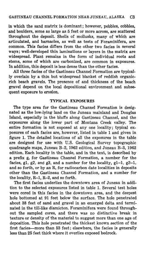
GASTINEAU CHANNEL FORMATION NEAR JUNEAU, ALASKA C3
in which the sand matrix is dominant; however, pebbles, cobbles, and boulders, some as large a s 5 feet or more across, are scattered throughout the deposit. Shells of mollusks, many of which are articulated, and barnacles, as well as tests of Foraminifera, are common. This facies differs from the other two facies in several ways ; well-developed thin laminations or layers in the matrix are widespread. Plant remains in the form of individual roots and stems, some of which are carbonized, are common in exposures. In addition, this deposit is less dense than the other facies.
All three facies of the Gastineau Channel Formation are typical- ly overlain by a thin but widespread blanket of reddish organic- rich beach gravels. The presence of and thickness of the beach gravel depend on the local depositional environment and subse- quent exposure to erosion.
TYPICAL EXPOSURES
The type area for the Gastineau Channel Formation is desig- nated as the low-lying land on the Juneau mainland and Douglas Island, especially in the bluffs along Gastineau Channel, and the exposures along the lower part of Montana Creek valley. The entire formation is not exposed a t any one locality; typical ex- posures of each facies are, however, listed in table 1 and given in figure 1. The detailed locations of all the exposures in the table are designed for use with U.S. Geological Survey topographic quadrangle maps, Juneau B-2, 1962 edition, and Juneau B-3, 1962 edition. Each locality in the table, and in the text, is described by a prefix g, for Gastineau Channel Formation, a number for the facies, g l , g2, and g3, and a number for the locality, gl-1, g2-1, and so forth, or by an R, for radiocarbon date localities in deposits other than the Gastineau Channel Formation, and a number for the locality, R-1, R-2, and so forth.
The first facies underlies the downtown area of Juneau in addi- tion to the selected exposures listed in table 1. Several test holes were cored in this facies in the downtown area, and the deepest hole bottomed a t 91 feet below the surface. The hole penetrated about 38 feet of sand and gravel in an emerged delta and termi- nated in the till-like diamicton. Foraminifera were found through- out the sampled cores, and there was no distinctive break in texture or density of the material to suggest more than one age of deposition. This hole penetrated the thickest known section of the first facies-more than 53 feet; elsewhere, the facies is generally less than 25 feet thick where i t overlies exposed bedrock.

T m 1.-Typical s#posures of Gastineau Channel Formation and results of laboratory tests of selected samples [Bulk densiiv determined by Proctor compaction test. U, undated; N.b, not determined]
Loeation Altitude above
L o d - Type of Age mean ity Lithologic dated (years Bulk 8- Remarks no. Section T. (9. ) R. (E.) character material B.P.) density level
(feet)
67----Stony Mollusks --111,920+1,110 N.d. diamicton. (W-2396).
In landslide scarp; highest dated sample in Gastineau Channel For- mation. Where trail to Salmon Creek Reser- voir crosses scarp.
Overlies glacially striated bed- rock; shells in Bft-thick zone. Opposite park- ing lot a t Auke Lake.
3 ----SWWSW%NE% 2 40 66 do ----,-Peak ------ 939,000 N.d. k375 Dated peat; pre- 5 (W-2721). dates deposi- $
tion of Gasti- neau Channel 5 Formation.
4 ,---NW%SEWSE% 16 41 67 -------do ------ Mdlusks --110,760~500 N.d. 80 In floor of gravel (W-2394). pit; beneath
delta a t mouth of Eagle Creek, Douglas Island.
---do ----- '9,150&800 N.d. 106 From diamicton (W-2395). above deltaic ,.
deposit.
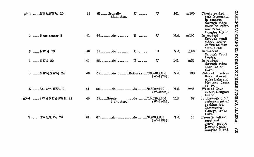
2 ----Near center 6
6 ----SE. mr. SE?4 9
g3-1 ----SW%NE%SWVa 23
%----Gravelly U ,---- U diamicton.
66-,--Sandy ---do ----- '10,630+500 diamicton. (W-2263).
Closely packed rock fragments, in roadcut through ridge north of Peter- san Creek, Douglas Island.
In roadcut through small ridge, locally known as Van- derbilt Hill.
In roadcut through Point Louisa.
In roadcut through ridge near Indian Cove.
Roadcut in inter- fluve between Auke Lake and Montana Creek valley.
West of Cove Creek. Douglas - island.
In drainage ditch embankment of parking lot, Community College, Auke Lake.
Beneath deltaic sand and gravel, mouth Kowee Creek, Douglas Island.

TABLE 1.-Typical exposures of Gastineau Channel Fomnatwn and results of laboratory tests of selected samples-Continued
Location Altitude
IrOCB1- i 9 no. Section
Type of Age mean Lithologic dated (Wars Bulk sea
T. (S.) R. (E.) character Remarks
material B.P.) density level (feet)
4 ---- NE. cor. NW%SW% 26 40 65 -------do ---------do ----- U
R-1 ----SEW 21 40 66----Diamicton Barnacles, 12,730+600 layer in life (W-1830). within position. deltaic deposits.
Diamicton Mdlusks --'12,880%500 layer. (W-1831).
Sand in ---do ----- '12,300iz350 delta. (W-1839).
- -
N.d. 80 Excavation- for apartment house, west side Douglas Road, Douglas Island; un- broken, articu- lated mollusks.
Ned. 60 Along Fritz Cove Road, Menden- hall Peninsula.
N.d. 102 Diamicton layers alternate with sand and gravel. W-1831 determined
N.d. 60 from diamicton layer within
N.d. 52 higher deltaic deposit over- lying eroded surface on lower deltaic beds.
N.d. 190 Foreset beds in delta, mouth of Gold Creek, Juneau.
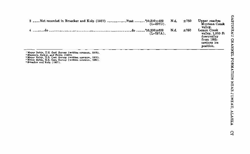
3 ----Not recorded in Broecker and Kulp (1967) -----------Peat ------ K10,300k400 N.d. 2760 Upper reaches (G297D). Montana Creek
valley. 4 -------do - - - - - - - - - - - - - - - - - - - - - - - - - - - - - - - - - - - - - - - -do --,-- 610,300k600 N.d. 2750 Lemon Creek
(L-297A). valley, 1,000 f t downvalley from 18th- century ice position.
1 Meyer Rubin, U.S. Geol. Survey (written commun.. 1910). 2 Marsters. Spiker. and Rubin ( 1969). 8 Meyer Rubin, U.S. Geol. Survey (written commun., 1912).
Meyer Rubin, U.S. Geol. Survey (written commun., 1969). 6 Broecker and K u l ~ (1957).
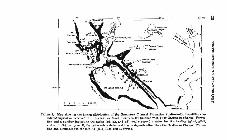
FIGURE 1.-Map showing the known distribution of the Gastineau Channel Formation (patterned). Localities con- sidered typical or referred to in the text as fossil Ic calities are prefixed with g for Gastineau Channel Forma- tion and a number indicating the facies (gl, g2, and g3) and a second number for the locality (gl-l, 82-3, and so forth), or by an R, for radiocarbon date localities in deposits other than the Gastineau Channel Forma- tion and a number for the locality (R-l, R-2, and so forth).
GASTINEAU CHANNEL FORMATION NEAR JUNEAU, ALASKA C9
The second facies is less widespread than the other two facies along Grtstineau Channel ; i t occurs in isolated mounds and ridges a t altitudes of less than 250 feet above mean sea level. Exposure g2-1 (table I ) , in a roadcut through a small ridge north of Peter- son Creek on Douglss Island best typifies the texture and density common to this facies. This particular deposit is so closely packed with rock fragments that a railroad pick bounced from the surface of the material with but slight penetration. The thickness of the facies seems to be variable, depending on local depositional en- vironments; most exposures reveal less than 20 feet of material, but the base of the material has not been exposed.
The third facies crops out intermittently along both sides of Gastineau Channel, along Fritz Cove, Auke Bay, Lena Cove, Tee Harbor, and the lower reaches of Montana Creek valley near the confluence with the Mendenhall River. These deposits generally veneer preexisting surfaces that slope upward a t about 10°-150 from the modern beaches or sea bluffs to the mountainsides. Scarps that are generally no more than 10 feet high commonly separate the sand-rich diamicton of the third facies from the somewhat older, higher, and more extensive stone-rich till-like diamicton of the first facies. The third facies is known to reach an altitude of a t least 200 feet above mean sea level, but may ex- tend considerably higher on the mountain slopes. One locality, g3-2 (fig. I ) , is overlain by an emerged delta ; elsewhere, most of the other localities lie nearer the surface beneath muskeg and thin beach deposits. The third facies is the thinnest of the three facies in the formation, and generally ranges in thickness from 4 to 12 feet,
FOSSIIS
Marine fossils occur in all three facies of the formation. Bar- nacle shells, Foraminifera tests, and unbroken and broken shells of pelecypods, gastropods, and scattered brachiopods have been recovered from all facies, although fragments are dominant in the dense deposits of the gravel-rich diamicton of the second facies of the Gastineau Channel Formation. Molluscan faunas collected from selected localities in the Juneau area are listed in table 2, and Foraminifera from selected sites are listed in table 3. Interpre- tation of the life environment of the mollusks suggests relatively shallow water, ranging in depth from 60 to 150 feet (W. 0. Addi- cott and J. W. Miller, written commun., 1972). Samples of Fora- minifera collected in 1958 by the late Don J. Miller were examined

c10 CONTRIBUTIONS TO STRATIGRAPHY
and the fossils identified by Ruth Todd (table 3). Interpretations of fossils collected during the study in and around Juneau seemed to indicate a maximum water depth of about 300 feet (Ruth Todd and Doris Low, written commun., 1967). A more restrictive inter- pretation of the water depth is provided by Roberta K. Smith (1971, p. 692), who, as a result of her regional study of Foramini- fera in southeastern Alaska and British Columbia, Canada, con- cludes that the water was "probably less than 30 meters [about 98 feet] deep." On the basis of these paleontological evaluations, I believe that all three of the facies of the Gastineau Channel For- mation probably accumulated in water that was less than 150 feet deep and perhaps less than 100 feet deep.
TABLE 2.-Fossils collected from selected outcrops of the three facies of the Gastineau Channel Formation, Juneau area, Alaska
[Locality numbers prefixed with g are shown in figure 1 and the locations are described in table 1; numbera prefixed with M are U.S. Geological Survey Cenozoic locality num- bers asaigned to faunas collected from the g-numbered localities and on file with the U.S. Geological Survey. Identification from USGS Cenozoic loc. M2661 by W. 0. Addicott (written oommun.. 1966). and 3. W. Miller (written wmmun., 1972). Other identifications by W. 0. Addicottl
Localities
Pelecypods : Astarte alaskensis Dall -- ,---- ---- ---- -,-- ---- X X ---- Chlamys rubida hindsi
(Carpenter) ------------------- ? ---- X X X X cf. C. rubida (Hinds)
MacNei1.(1967) ------- ---- ---- ---- X ---- ---- ---- Clinocardium czliatum
(Fabricus) -------------- -- X ---- ---- X X X ---- Cyclocardia ventricosa (Gould)- ---- ---- ---- X X X X Hiatella arctioa (Linnk) ------ X X X X X ---- X
calcarea Gmelin ---------- ---- ---- ---- ---- X X ---, Macoma brota Dall ,-----, ---- ? ---- ---- ---- ---- ---- X
calcarea Gmelin -----,---- X X ---- X X ---- X obliquu (Sowerby) [M.
incongrua of earlier reports] ---------,----- X -,-- ---- ---- X X X
Mya truncata Linn6 ---------- ---- X X X X X X Mytilus edulis Linn6 ---------- X -,-- ---- --,- ---- ---- ---- Nuculana fossa (Baird) ------ ---- 'X ---- ---- ---- X X Panomya ampla Dall ---------- ---- ---- ---- ---- ---- X X Protothaca stamivzea (Conrad) - ---- -,-- X ---- ,--- ---- ---, Serripes groenlandicwr
(Bruguiere) -------,,,----- X X --,- ---- X X X Gastropods :
Acmeasp------------------- ---- ---- - - ---- ---- ---- X Bzcccinum sp ----------------- ---- ---- ---- X ---- ---- ---- Colus halli Dall -------------- ---- ---- ---- 'X ---- ---- ---- Cryptonatica clausa (Broderip
and Sowerby) ------,-,--- ---- X ---- ---- ---- ---- ----

GASTINEAU CHANNEL FORMATION NEAR JUNEAU, ALASKA C11
TABLE 2.-Fossils collected from selected outcrops of the three facies of the Gastineau Channel Formation, Juneau area, AZasku-Continued
Localities
Gastropods-Continued : Lepeta concentha
(Middendorff) ------------ - ---- ---- ---- X ---- ---- ---- Neptunea lirata Gmelin ------- ---- ? ---- X X X X Polinices pallidus ( Broderip
and Sowerby) ------------- ---- X ---- ---- ---- ---- ---- Puncturella major Dall ------- ---- ---- ---- ---- ---- ---- X Propebela sp ----------------- ---- ---- ---- X ---- ---- ---- Trochotropis cancellata Hinds - ---- ---- ---- X ---- ---- ----
Brachiopods : Hemithyris sp ---------------- ---- ---- ---- ---- ---- X ----
Barnacles : Balanua cf. B. nubilus Darwin - X - - - - X ---- ---- ---- Balanus sp ------------------ X x ---- X X X X
Fragments.
ENVIRONMENT
Deposits included within the Gastineau Channel Formation have been called by others shell-bearing boulder-clay, till, marine till, or terrace deposits (Twenhofel, 1952, p. 528; C. L. Sainsbury, written commun., 1953; Don J. Miller, written commun., 1958; and field notes). These earlier descriptions have related most of the glacio- marine deposits in the Juneau area to a glacial environment where glacial ice either filled the fiords or pieces of ice discharged from glaciers into Gastineau Channel in the immediate vicinity of Juneau ; some of these deposits were considered to be marine ter- races of postglacial age. The results of my field studies in and around Juneau led me to believe that all three facies composing the deposits in the Gastineau Channel Formation accumulated when the Gastineau Channel area and adjacent low-lying regions were free of fiord-filling glaciers (Miller, 1972).
That such an environment existed is based in part on the radio- carbon dates obtained for shells in emerged deltas lying along the mountain slopes bounding Gastineau Channel, in part on the radio- carbon dates obtained for shells in the glaciomarine materials in the Gastineau Channel Formation, in part on the radiocarbon dates obtained by others from samples of basal peat in nonmarine mus- kegs in mountain valleys, and in part on the interrelationship between the Gastineau Channel Formation and the emerged delta deposits in the Juneau area.

c1z CONTRIBUTIONS TO STRATIGRAPHY
TABLE 3.-Foraminifera collected from outcrops in the Juneau area, Alaska, bg Don J. Miller, in 1958, and assigned to facies of the Gastineau Channel Formation by Robert D. Miller
[Fossil identifications by Ruth Todd, written commun., 19591
Localities 1
Benthonie - --
Astrorhizidae: Genus? ------------------ --- --- --- --- --- --- --- --- --- x
Miliolidae : Qumqueloculina agglutinata
Cushman --------------- --- --- --- --- --- --- --- --- X --- akneriana d'orbigny --- --- X X --- X --- --- --- X --- f r i g i d ~ Parker --,------ --- X X --- --- --- --- --- --- --- stalkeri Loeblich and
Tappan -,----------- --- X X X X --- --- X --- X Triloculina tm'carinata
d'orbigny -------------- --- --- --- --- X --- --- --- --- ,-- Pyrgo lucernula (Schwager) --- --- X --- X --- --- --- --- X
Lagenidae : Lagena gracillima
(Sequenza) ,----------,- --- --- --- ,-- --- --- X --- --- --- Buliminidae :
Buliminella elegantissima (d'orbjgny) ----------,- --- --- --- ,-- --- --- -,- --- --- X
Globobulzmana auriculata (Bailey) -------------,- --- --- --- ,-- --- --- --- --- --- X
Virgulina fusif o m i s (Williamson) ----------, --- X X X --- --- X X X X
Bolivina decussata Brady --- --- --- --- --- --- --- --- --- --- X pacifica Cushman and
McCulloch ---------- --- --- --- X --- --- --- --- X X Fissurina sp. (globular, slit
aperture) --------------- X --- --- ,-- --- --- --- --- --- --- Rotaliidae :
Buccellafrigida (Cushman)- X X X X X --- X X X X Elphidiidae :
Elphidium bartletti Cushman --------------, --- --- X --- X --- X X --- X
clavatumCushman----- X X X X X X X X X X frigidurn Cashman ----- X X X X X --- --- --- X ---
Ebhidiella nitida Cushman - --- --- --- --- --- --- --- --- --- X ~nomal in idae :
Cibiddes lobatulus (Walker and Jacob) ------------- --- --- --- --- X --- --- --- --- X
Dyocibicides biserialis Cushman and Valentine-- --- --- --- --- --- --- --- --- X X
Nonionidae: Nonion labradorieum
(Dawson) -------------- --- X X X --- --- X X X X Nonionella turgida
Williamson, var. digitata N0rvang --------------- --- --- --- --- --- --- --- X --- ---

GASTINEAU CHANNEL FORMATION NEAR JUNEAU, ALASKA C13
TABLE 3.-Foraminifera collected from outcrops in the Juneau area, Alaska, b y Don J . Miller, in 1958, and assigned to facies of the Gastineau Channel Formation by Robert D. Miller-Continued
Localities
Nanionidae-Continued : Pseudononion auricuh
(Heron-Allen and Earland --,-------,----- X --- X X --- --- --- --- X X
Astrononion gallowayi Loeblich and Tappan ---- --- --- --- --- --- --- --- --- X ---
stelligerum (d'orbigny) --- --- --- X --- --- --- --- --- -- - Cassidulinidae:
Cassidulina ishndica NGrvang ---------,----- --- X X X X --- X X --- ---
teretia Tappan -------- X X X X --- --- X X X X Epistominelh exigua
(Brady) ---------,----- --- --- --- --- --- --- --- --- X ---
Planktonic
Globigerinidae : Globigerina bullokdes
d'orbigny -------------- --- --- X --- --- --- --- X --- --- ILocality numbem prefixed with g are shown in figure 1; those prefixed with f .are
USGS numbers given to collections of Don J. Miller, to which the g-numbered localit~es were matched on the basis of descriptions of fossil locations in Miller's field notebooks. Lo-
W%SW% see. 2. T. 41 S.. R. 66 :
3WYLNWU ;ec. 18. T. 40 S.. 8. fi.5 E g3-7 sE.'&r. sws sic. 2, ~ : 4 1 S.. ~ . . 6 6 E; -
AGE
Shells in the formation were collected for radiocarbon determi- nation from the highest exposed shell-bearing deposits of diamic- ton, but shells were not available in amounts sufficient for radiocarbon determination in outcrops a t altitudes believed to be near the upper limits of the Gastineau Channel Formation. Conse- quently, i t can be inferred that the formation is somewhat older than the oldest dates obtained from the diamictons in the formation,

C14 CONTRIBUTIONS TO STRATIGRAPHY
Such an inference has some support from the dates obtained for shells within deltaic deposits. Beds within the emerged deltas consist of sand and gravel, for the most part, but interlayered with these beds are layers of shell-bearing diamicton. Several radio- carbon dates for shells in these beds are slightly older than the oldest date obtained from diamicton in the Gastineau Channel For- mation, although other dates fall within the age range determined for shells in the diamicton of the formation. Dates of 12,7301 500, 12,880+. 500, and 12,300+.350 years B.P. obtained from mollusks and barnacles in an emerged delta near Auke Bay, locality R-1 (fig. 1) (W-1830, W-1831, W-1839, respectively; Marsters and others, 1969, p. 222-223), suggest that the oldest part of the di- amicton in the formation has not yet been sampled for radiocar- bon determination. An example of a somewhat younger age deter- mination, 10,880 +. 340 years B.P. (W-1829 ; Marsters and others, 1969, p. 222), was obtained a t locality R-2 (fig. 1) for barnacle fragments in the foreset beds, nearly 190 feet above mean sea level, within the emerged delta near the mouth of Gold Creek in Juneau.
Dates of shells in the diamictons in the Gastineau Channel For- mation, listed in table 1, partly overlap the ages of shells in the deltas. Dates that range from 11,920+ 1,000 years B.P. (W-2396) to 9,700f 800 years B.P. (W-2393; Meyer Rubin, written commun., 1970), lend support to the concept that the now-emerged deltas and the deposits of the Gastineau Channel Formation accumulated during the same interval.
Ages of basal nonmarine peats now about 750 feet above mean sea level in mountain valleys adjacent to Gastineau Channel also lie within the 12,000- to 9,700-years-B.P. range. Peat from the base of a muskeg lying in the upper part of Montana Creek valley, locality R-3 (fig. I ) , was dated at 10,3001400 years B.P. (T- 297D ; Broecker and Kulp, 1957 ; Heusser, 1960, p. 97), and a simi- lar peat, also a t the base of a muskeg, in the valley of Lemon Creek, locality R-4 (fig. I ) , was dated a t 10,300+600 years B.P. (G297A; Broecker and Kulp, 1957; Heusser, 1960, p. 96-97). Interpretation of the pollen in the muskeg above the dated layers indicates that the climate during the pollen accumulation was more moderate than would be expected during glacial time and that ice
GASTINEAU CHANNEL FORMATION NEAR JUNEAU, ALASKA
was absent from the dated sites after the peats began to accumu- late (Heusser, 1960, table 5, fig. 24) and did not readvance over that site a t a later time.
That the ages of the dated basal peats in Montana Creek and Lemon Creek valleys lie within the age span obtained for the deltas and deposits of the Gastineau Channel Formation suggests that the lower parts of the mountain valleys were ice-free, and that i t is likely that all the glaciers were withdrawn from the immediate Juneau area during the deposition of the glaciomarine demsits that constitute the Gastineau Channel Formation. Nevertheless, an effective process by which sand, pebbles, cobbles, and large boulders can be transported and deposited in marine waters to be incorporated into a fine- to medium-grained matrix material and which results in a regionally distributed deposit must be available throughout the Juneau region. Though seemingly in conflict with an open-water marine environment, ice seems to be the most likely means of transport to accomplish this feat.
DEPOSITIONAL HISTORY
Origin of glaciomarine diamictons in British Columbia and northwestern Washington has been discussed in the literature. Diamictons similar to those around Juneau are widespread a t alti- tudes of less than 700 feet above sea level along the coasts of southeastern Alaska, British Columbia, and Washington. Arm- strong and Brown (1954) and Easterbrook (1963), among others, have discussed the possible origins for these deposits. Several of their possible hypotheses include those of plowing of the sea floor by glacial ice, deposition of debris from floating ice, such as shelf ice, berg ice, and sea ice, and submarine landslides, slopewash, and turbidity currents. Shelf ice, berg ice, and sea ice were decided upon by Armstrong and Brown (1954, p. 358-359) as acceptable methods of transport and deposition, and Easterbrook (1963, p. 1474) believes that shelf ice and berg ice were the means applicable to the northern Puget Sound lowland in Washington. After evalu- ation of these theories, I believe that sea ice, supplemented by berg ice, provides the means of accumulating, transporting, and mixing the coarse debris with the fines to produce diamicton such as that found in the Gastineau Channel Formation (Miller, 1972, p. 83-

C16 CONTRIBUTIONS TO STRATIGRAPHY
85). Sea ice is ice that builds outward from the shores each winter season; such ice could provide transport of the coarse material deposited by streams on the sea ice during the early spring run- off. Transport is provided as the ice floats away during spring breakup, and deposition occurs as the debris is dropped from the melting ice into the continually accumulating soft and saturated finer grained deposits on the bottom of the fiord.
In addition, contributions from berg ice from outside the im- mediate Juneau area might have supplemented the sea ice and helped provide the extremely coarse particles found scattered throughout much of the glaciomarine deposits. The presence of berg ice, however, requires the termination of valley glaciers in the region into the open waters of the fiords. The large glaciated valleys that reach present water level north of Juneau do not con- tain any geomorphic evidence on the slopes higher than 500-600 feet above sea level that these valleys contained glaciers that could have been sources for berg ice 10,000 to 12,000 years ago. The presently active Taku and Norris Glaciers, to name but two, reach, or reached, the tidewaters in Taku Inlet, southeast of Juneau, in historical time. These and other valley glaciers outside the Juneau area may have been actively providing berg ice during accumulation of the Gastineau Channel Formation.
The hypothesis of transport of coarse debris by either sea ice or berg ice, or both, is not free of problems. The principal problem with each type of ice for transport and deposition is the seasonal and therefore cyclic nature of the deposition of the coarse frag- ments. Sea ice would probably drop its load during late spring and summer; subsequent deposition would tend to be relatively free of coarse fragments. Berg ice would probably drop its load as local- ized piles of coarse material, especially where the bergs capsized. Neither depositional situation is reflected in either the texture or distribution of the coarse material within the diamicton in the Juneau area. At the present time, however, there seems to be no better explanation for the presence of the coarse fragments than transport and deposition by sea and berg ice.
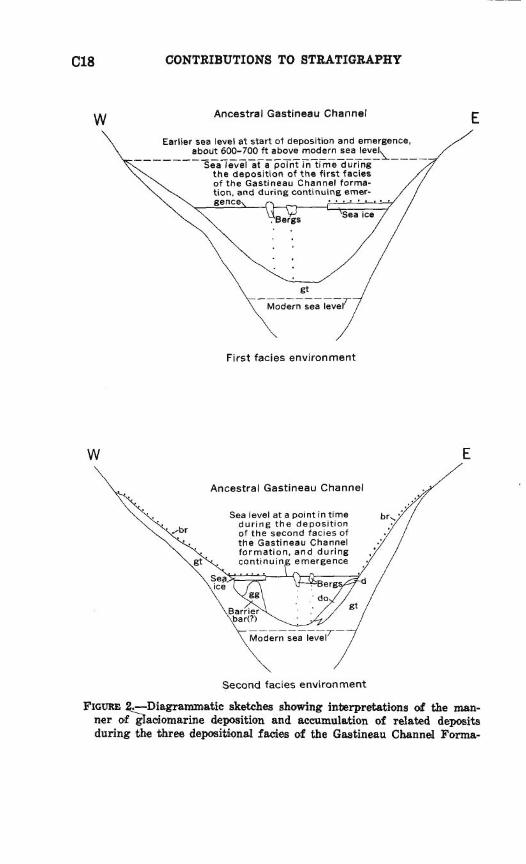
Judging from available field and laboratory data, I currently visualize the Gastineau Channel Formation as being composed of different facies that accumulated during depositional cycles; the
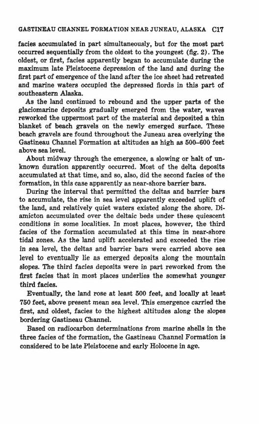
GASTINEAU CHANNEL FORMATION NEAR JUNEAU, ALASKA C17
facies accumulated in part simultaneously, but for the most part occurred sequentially from the oldest to the youngest (fig. 2). The oldest, or first, facies apparently began to accumulate during the maximum late Pleistocene depression of the land and during the first part of emergence of the land after the ice sheet had retreated and marine waters occupied the depressed fiords in this part of southeastern Alaska.
As the land continued to rebound and the upper parts of the glaciomarine deposits gradually emerged from the water, waves reworked the uppermost part of the material and deposited a thin blanket of beach gravels on the newly emerged surface. These beach gravels are found throughout the Juneau area overlying the Gastineau Channel Formation a t altitudes as high as 500-600 feet above sea level.
About midway through the emergence, a slowing or halt of un- known duration apparently occurred. Most of the delta deposits accumulated a t that time, and so, also, did the second facies of the formation, in this case apparently as near-shore barrier bars.
During the interval that permitted the deltas and barrier bars to accumulate, the rise in sea level apparently exceeded uplift of the land, and relatively quiet waters existed along the shore. Di- amicton accumulated over the deltaic beds under these quiescent conditions in some localities. In most places, however, the third facies of the formation accumulated a t this time in near-shore tidal zones. As the land uplift accelerated and exceeded the rise in sea level, the deltas and barrier bars were carried above sea level to eventually lie as emerged deposits along the mountain slopes. The third facies deposits were in part reworked from the first facies that in most places underlies the somewhat younger third facies.
Eventually, the land rose a t least 500 feet, and locally a t least 760 feet, above present mean sea level. This emergence carried the first, and oldest, facies to the highest altitudes along the slopes bordering Gastineau Channel.
Based on radiocarbon determinations from marine shells in the three facies of the formation, the Gastineau Channel Formation is considered to be late Pleistocene and early Holocene in age.
c18 CONTRIBUTIONS TO STRATIGRAPHY
W Ancestral Gastineau Channel E
\ Earlier sea level at start of deposition and emergence, about 600-700 f t above modern sea level,
t h e deposi t ion o f t h e f i r s t facies of the Gastineau Channel forma-
- - - - - - - - - Modern sea l e v e r
First facies environment
\. Ancestral Gastineau Channel
Sea level at a point in t ime d u r i n g t h e deposi t ion of the second facies of the Gastineau Channel format ion, a n d dur ing \b uinfn;gen&/
Sea tce . Berg
k g ' dn
Second facies environment
-Diagrammatic sketches showing interpretations of the man- \ ner of g aciomarins deposition and accumulation of related deposits during the three depositional fades of the Gastineau Channd Forma-

W Ancestral Gastineau Channel
\ i n emergencg a
Modern sea level' \ / Third facies environment
\Modernxa level' /
Present time
tion. gt, Gastineau Channel Formation, first facies; gg, Gastineau Channel Fomtiion, s e m d facies; gs, Gastineau Channel Formation, third faeies; do, emerged delta deposits; d, diamicton layer on top of delta deposits; br, raised beach deposits.
CONTRIBUTIONS TO STRATIGRAPHY
REFERENCES CITED
Armstrong, J. E., and Brown, W. L., 1964, Late Wismsin marine drift and aamiated sediments of the Lower Fraser Valley, British Columbia, Chada : Geol. Soc. America Bull., v. 65, no. 4, p. 349-363.
Bmecker, W. S., and Kulp, J. L., 1957, Lamont natural radiocarbon measure menbs, [&I 4: Soience, v. 126, no. 3287, p. 1324-1334.
Easterbmk, D. J., 1963, Lah Pleistocene glacial evenhs m d relative sea-level uhmgea in the northern Puget Lowland, Washington: Geol. Soc. America Bull., v. 74, no. 12, p. 1465-1483.
Heusser, C. J., 1960, Late-Plektucene environments of North Pacific North Amerioa- an elaboration of late-glacial and postglacial climatic, physio- graphic, and biotic changes: Am. OecFg. Sm. Spec. Pub. 36, 308 p.
M W e r s , Beverly, Spiker, Elliott, and Rubin, Meyer, 1969, U.S. Geological Survey radiocarbon d a t a X: Radiocarbon, v. 11, no. 1, p. 210-227.
Miller, R. D., 1972, Surficial geology of the Juneau urban area and viciniky, Alaaka, with emphaeis on earthquake and other geologic hazards: U.S. Geol. Survey open-file report, 108 p.
Smith, R. K., 1971, Late glacial Foraminifera from mtheaa t Alaaka and B r i t i l Columbia and a world-wide high northern latitude shallow-water faunal province: Archives Sci., v. 23 (1970), no. 3, p. 676-701.
Twenhofel, W. S., 1962, Recent &ore-line changes along the Paoiflc c o a t of Alaska: Am. Jour. Sci., v. 260, no. 7, p. 623-648.
* U.S. GOVERNMENT PRINTING OFFICE: 1973 0-543-878/38