game lands map book legend - north carolina · pdf filegame lands map book legend sandhills...
TRANSCRIPT
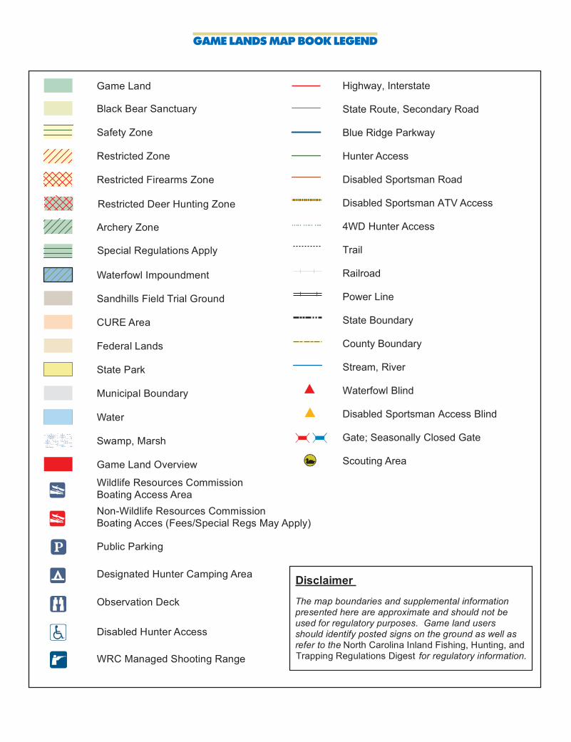
GAME LANDS MAP BOOK LEGEND
Sandhills Field Trial Ground
Safety Zone
Waterfowl Impoundment
Water
Black Bear Sanctuary
Game Land
Municipal Boundary
CURE Area
Archery Zone
State Park
Swamp, Marsh
Restricted Zone
Designated Hunter Camping Area
Disabled Hunter Access
Public Parking
Wildlife Resources CommissionBoating Access Area
Federal Lands
Restricted Firearms Zone
Game Land Overview
Non-Wildlife Resources CommissionBoating Acces (Fees/Special Regs May Apply)
Special Regulations Apply
Highway, Interstate
State Route, Secondary Road
Blue Ridge Parkway
Hunter Access
Disabled Sportsman Road
Disabled Sportsman ATV Access
4WD Hunter Access
Trail
Railroad
Power Line
State Boundary
County Boundary
Stream, River
Waterfowl Blind
Disabled Sportsman Access Blind
Gate; Seasonally Closed Gate
Scouting Area
Observation Deck
Disclaimer
The map boundaries and supplemental information presented here are approximate and should not be used for regulatory purposes. Game land users should identify posted signs on the ground as well as refer to the for regulatory information. North Carolina Inland Fishing, Hunting, and Trapping Regulations Digest
Restricted Deer Hunting Zone
WRC Managed Shooting Range
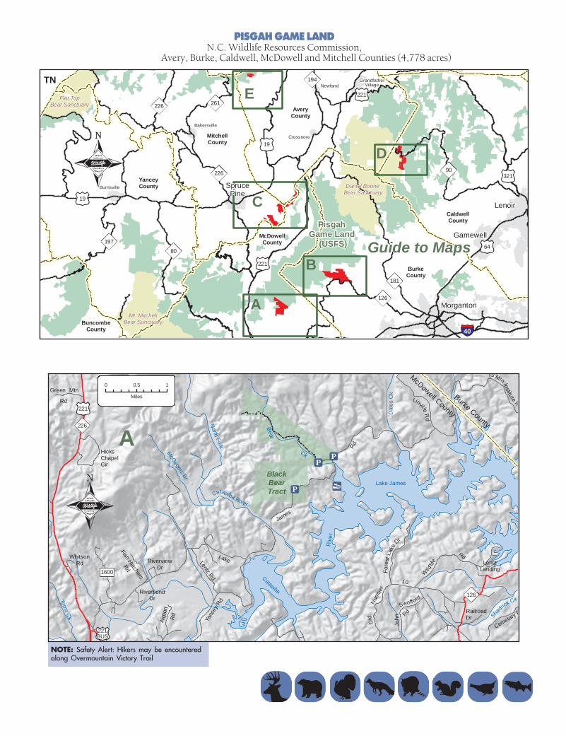
PISGAH GAME LANDN.C. Wildlife Resources Commission,
Avery, Burke, Caldwell, McDowell and Mitchell Counties (4,778 acres)
SprucePine
MitchellCounty
McDowellCounty
AveryCounty
BurkeCounty
A
B
Daniel Boone Bear Sanctuary
Pisgah Game Land
(USFS)
C
181
126
221
226
19
DYanceyCounty
90
CaldwellCounty
80
Morganton
Gamewell
E
Lenoir
BuncombeCounty
Crossnore
Burnsville
Bakersville
GrandfatherVillageNewland
TN221
194
19
226 261
321
40
Mt. MitchellBear Sanctuary
Flat TopBear Sanctuary
Guide to Maps19764
NOTE: Safety Alert: Hikers may be encounteredalong Overmountain Victory Trail
Wild
life
Rd
Old
Num
ber
10
Fore
stLa
ke
Dr
RailroadDr
HicksChapelCir
LentzLanding
John
Swoff ord
Rd
Airp
ort
Rd
RiverviewDr
WhitsonRd
Green Mtn
Rd
BlackBearTract
Lake James
Catawba
Riv
er
Toms Ck
Catawba River
North
Fork
Bear
Ck
Yanc
ey R
d
Lentz Rd
221
226
1600
Fish Hatchers
Rd
Lake
James
Rd
LinvilleR
d
221BUS
S Mtn Institute Rd
McDowell County
126
Shadrick Ck
RiverbendDr
McGegers Br
Dal
es C
k
A
Cemetary R
Burke County
0 0.5 1
Miles

NOTE: Safety Alert: Hikers may be encountered along Overmountain Victory Trail
Washburn
Rd
Hump Back Mountain Rd
Cabin Rd
Vaughn Rd
FranklintownR
d
Tempie
Mtn
Rd
Halltow
nR
d
BarneyMcKinney Rd
Avery County
Harris Ck
North Toe
River
Cathis Ck
RoseCk
North
Toe
Riv
er
W hite Oak Br
Honey
cutt C
k
Rose
Ck
Smith
Br
Orc
hard
St
McKinney Gap
11231129
1258
1127
1238
1124
Little
Ro seCk
221
226
HumpbackMountain
LittleTablerock
MtnTract
Spruce Pine
Ridge
Carters
Altapa
ss
Hwy
Forest Fisher Rd Rid
ge R
d
Middle
RidgeBr
Gouge'sCreek
Rd
Biggerstaff Rd
Holley Branch
Rose Creek Tract
Pepp
ers
Cre
ek Rd
Ch. of God Rd
1126
RdDale
Rd
McD
owe
llC
ount
y
Mitchell County
C 19
Blue
Ridge
Parkway
0 0.5 1
Miles
PISGAH GAME LAND (continued)N.C. Wildlife Resources Commission,
Avery, Burke, Caldwell, McDowell and Mitchell Counties
NOTE: Safety Alert: Hikers may be encountered along Mountains-to-Sea connector trail.
FishHatchery
Rd
Pea
Ridge
RdWolf
Pit
RdBrowning View Rd
Oak Leaf Ln
Adventist Cir
Parks Dr
OldN
CHwy 105
Padd
ysC
reek
Rd
Linville River Tract
Sandy
Branch
Paddy
Ck
White
Ck
Shooks
Ck
Canoe
Ck
Linville
River
Russell
Ck
LakeJames
126
B
Linville
0 0.5 1
Miles
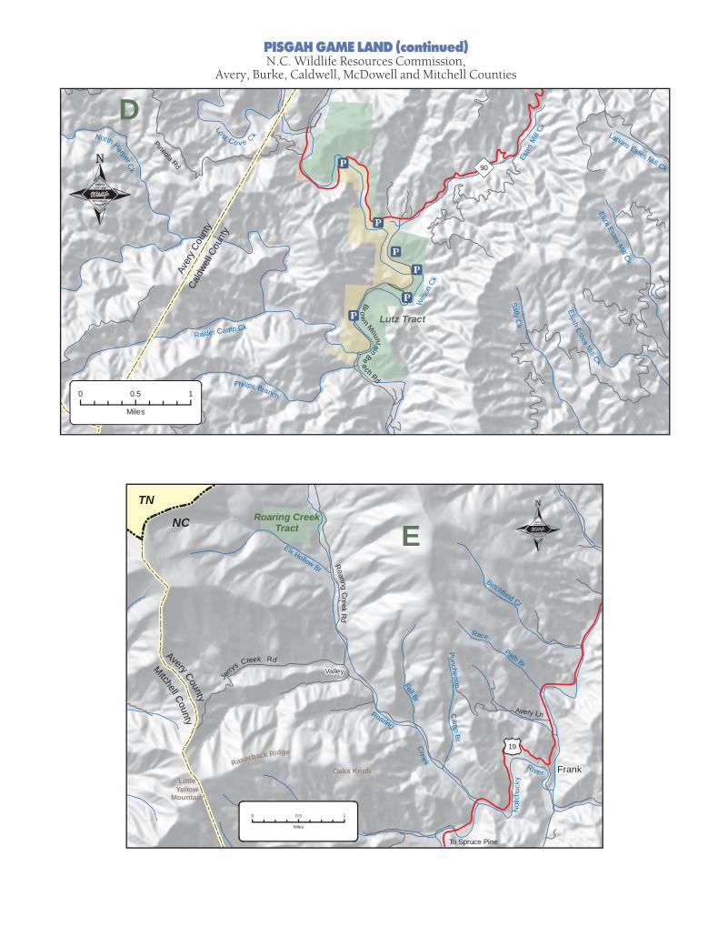
PISGAH GAME LAND (continued)N.C. Wildlife Resources Commission,
Avery, Burke, Caldwell, McDowell and Mitchell Counties
Cald
well C
ount
y
Aver
y Co
unty
Pineola Rd
Lost Cov e CkNorth Harper Ck
Sally Ck
ElijahEstes
Mill Ck
Eliza Estes Mill Ck
Este
s M
ill Ck
Raider Camp Ck
Philips Branch
Wils
on C
k
Lutz Tract
D
90
Larkins Estes Mill Ck
Brow
n MountainBea
ch Rd
0 0.5 1
Miles
19
Fall Br
Puncheoon
Path Br
Oaks Knob
ERoaring Creek
Tract
Elk Hollow Br
RoaringC
reekR
d
Valley
NC
Mitchell County
Avery County
Je
rrys Creek Rd
Raxorback Ridge
Creek
Cam
p Br
Roaring
River
Avery Ln
Frank
Nol
ich u
cky
Race
Birtchfield Cr
TN
LittleYellow
Mountain
To Spruce Pine
0 0.5 1
Miles