galileo overview and status alexandre steciw cracow-23 september 2004
Post on 19-Dec-2015
217 views
TRANSCRIPT

GALILEO OVERVIEW AND STATUSAlexandre Steciw
Cracow-23 September 2004

2
The European Approach (1)
EGNOS
- Civil augmentation to military GPS and GLONASS
- Signals distributed through 2 Inmarsat / 1 Artemis Geo Transponders
- Interoperable with WAAS and MSAS (ICAO standard, seamless service)
- Pre-operational EGNOS Signals already available through EGNOS Testbed since early 2000 – used for tests and demonstrations
- Fully Operational Signal in 2004
- Initiative of the European Commission, Eurocontrol and ESA
EGNOS is the first contribution of Europe into GNSS and the first step towards Galileo

3
The European Approach (2)
Galileo
- Global Navigation Satellite System
- Under Civil Control
- Independent but compatible and interoperablewith GPS and GLONASS
- With service guarantees
- Target Date to be operational - 2008
- Initiative of the European Commission and ESA

4
Galileo Services
•Galileo Satellite-only Navigation, Positioning & Timing Services (through the Galileo Signal-In-Space):
Open Service (OS) –free and available to the public Commercial Service (CS) – under commercial conditions Safety of Life Service (SoL)- for safety-of life applications & users Public Regulated Service (PRS)- for government authorised users
•Support to the Search and Rescue Service (SAR):
406/1544.1 MHz transparent Forward Link for COSPAS/SARSAT compatible distress beacons localisation in the COSPAS/SARSAT ground segment
SAR Return Link Messages (Acknowledgement & Coordination) through Galileo Signal in Space

5
Galileo Services
•Galileo Locally Assisted Services:
Network Assisted/ Location Based Services Indoor Positioning Services High Precision Navigation & Positioning Services
•Galileo SIS plus Local Augmentations:
Improved safety-of life applications, e.g. for trains & railways, port navigation, precision landing approach etc.
Road applications (predicted adaptive cruise control, tolling etc.)

6
Galileo Services
•Galileo Combined Services
Galileo + other satellite navigation system (SBAS, GPS, GLONASS,...) Galileo + other non-satellite navigation systems (LORAN C, mobile
systems,…) Galileo + communications systems (GSM, GPRS, UMTS,…)
EGNOS Services augmenting GPS and complementing Galileo services
Wide area differential corrections for GPS over ECAC region Real-time Integrity messages for GPS-based Safety-of Life applications Ionosphere corrections for single-frequency users Complementary GPS-like ranging signals for improved availability

7
GALILEO Open Services Performance
Open Service Carriers Single Frequency Dual-
Frequency Type of Receiver Ionospheric
correction Based on simple model
Based on dual-frequency measurements
Coverage Global Accuracy (95%) H: 15 m
V: 35 m H: 4 m V: 8m
Timing Accuracy wrt UTC/TAI 30 nsec Availability 99.8 %

8
Safety-Of-Life Service
Carriers Three Frequencies
Computes Integrity
Yes Type of Receiver
Ionospheric correction
Based on dual-frequency measurements
Coverage Global Critical level Non-critical level Accuracy (95%) H: 4 m
V: 8 m H: 220 m
Alarm Limit H: 12 V 20 m H: 556 m Time-To-Alarm 6 seconds 10 seconds
Integrity
Integrity risk 3.5x10⁻⁷ / 150 s 10-7/hour Continuity Risk 10-5/15 s 10-4/hour – 10-8/hour
Certification/Liability Yes Availability of integrity 99.5%
Availability of accuracy 99.8 %
GALILEO SOL Performance

9
GALILEO + GPS Combined Performance Galileo OS
(10° m.a.) single frequency receiver
Galileo OS + GPS (10° m.a.) single frequency receiver
Galileo OS (10° m.a.) dual frequency receiver
Galileo OS +GPS (10° m.a.) dual frequency receiver
Galileo OS (30° m.a.) single frequency receiver
Galileo OS + GPS (30° m.a.) single frequency receiver
Horizontal accuracy
15 7-11 4 3-4 14-54 11-21
Vertical accuracy
35 13-26 8 6-8 21-81 17-32
Galileo OS and GPS combined service performances (illustrative)
Receiver elevation masking angle
Number of visible GALILEO satellites
Number of visible GPS satellites
Total
5° 13 12 25 10° 11 10 21 15° 9 8 17
Maximum number of visible satellites for various masking angles
Combined use provides increased performance and availability (RAIM) for high masking angle, e.g. urban canyons

10
GALILEO Frequency Plan, L-Band
GALILEO Bands (Navigation)
GALILEO SAR Downlink
GPS Bands
E5a/L5 E5b E6 L1E2 E1
1164
MH
z
1214
MH
z
1260
MH
z
1300
MH
z
(*) 1
176.
45 M
Hz
1278
.75
MH
z
1544
MH
z15
45 M
Hz
1559
MH
z
1587
MH
z
1591
MH
z
1563
MH
z
1575
.42
MH
z
1215
MH
z
1237
MH
z
(*) 1
207.
140
MH
z
SARL2
RNSS Bands RNSS Bands
ARNS Bands ARNS Bands

11
FrequencyFrequency
GALILEO Signals
1278.75 MH
z
E6
G/Nav Signal:BOC(10,5) mod.Rc=5.115 Mcps
G/Nav Signal:BOC(10,5) mod.Rc=5.115 Mcps
C/Nav Signal:Data + PilotBPSK mod.Rc=5.115 McpsRs=1000 sps
C/Nav Signal:Data + PilotBPSK mod.Rc=5.115 McpsRs=1000 sps
1575.42 MH
z
L1E2 E1
G/Nav Signal:BOC(n,m) mod.G/Nav Signal:BOC(n,m) mod.
I/Nav Signal:Data + PilotBOC(2,2) mod.Rc=2.046 McpsRs=250 sps
I/Nav Signal:Data + PilotBOC(2,2) mod.Rc=2.046 McpsRs=250 sps
1176.45 MH
z
L5/E5a E5b
F/Nav Signal:Data+PilotBPSK mod.Rc=10.23 McpsRs=50 sps
F/Nav Signal:Data+PilotBPSK mod.Rc=10.23 McpsRs=50 sps
I/Nav Signal:Data+PilotBPSK mod.Rc=10.23 McpsRs=250 sps
I/Nav Signal:Data+PilotBPSK mod.Rc=10.23 McpsRs=250 sps
(MHz)PILOT CHANNELS
DATA CHANNELS
1207.140 MH
z

12
GALILEO Signal Parameters
Bands E5a E5b E6 E2-L1-E1
Services OS/SOL/CS OS/SOL PRS CS PRS OS/SOL/CS
Channels Data Pilot Data Pilot Data Pilot Data Pilot
Ranging Code Rate(Mcps)
10.23 10.23 10.23 10.23 10.23 5.115 5.115 m 2.048 2.048
Modulation Type
AltBOC
BOC(10,5)
BPSK(5)
BPSK(5)
BOC(n,m)
BOC(2,2)
BOC(2,2)
Symbol Rates (Bd)
50 N/A 250 N/A --- 1000 N/A ---- 250 N/A
Minimum Received Power on Ground at 10o elevation in dBW
-158 -158 -158 -158 -155 -158 -158 -155-160to-158
-160to-158

13
GALILEO Architecture
Space Segment
User Receiver Demonstrators
Local Component Demonstrator Local Components
External RegionalIntegrity Systems
User Receivers
Search&
Rescue
Service Providers
MEO-LUT
COSPAS-SARSAT
Ground Segment
DistressBeacons
RLSP

14
The GALILEO Satellite
Mass at Launch (incl. Propellant)
Power Consumption
Dimensions:
Main Body
Length (with deployed solar arrays)
Lifetime
Ca.680 kg
Ca. 1.6 kW
2700 x 1200 x 1100 mm
13 m
12 years

15
The GALILEO Ground Segment
•The Galileo Ground Segment comprises the Ground Control Segment (GCS) and the Ground Mission Segment (GMS) and includes:
•A global network of Galileo Sensor Stations (GSS)
•A global real-time oriented network of Up-link Stations (ULS) for mission data up-link in C-Band
•A global network of Telemetry, Telecommand and Ranging Stations (TT&C) for control of the satellites in S-Band
•An interconnecting high performance communication network and
•2 geographically redundant Galileo Control Centres (GCC) for all the centralised processing, monitoring & control.

16
The GALILEO Ground Segment Architecture

17
Considered TT&C & ULS Station Sites
Svalbardor

18
Locations considered for Sensor Stations

19
GALILEO Master Schedule
1 Test Satellite & 4 Operational Satellites
Ground Infrastructure
26 Satellites
Ground Infrastructure
Routine Operations and Replenishment
Development and Validation Deployment Operations and Maintenance
48 months 24 months 20 years

The European Commission 6th Framework Programme
Complementing the Development of the Galileo System
21
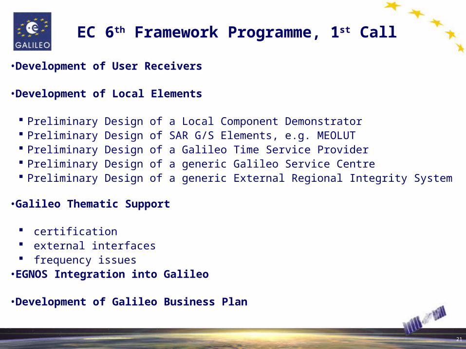
EC 6th Framework Programme, 1st Call
•Development of User Receivers
•Development of Local Elements
Preliminary Design of a Local Component Demonstrator Preliminary Design of SAR G/S Elements, e.g. MEOLUT Preliminary Design of a Galileo Time Service Provider Preliminary Design of a generic Galileo Service Centre Preliminary Design of a generic External Regional Integrity System
•Galileo Thematic Support
certification external interfaces frequency issues
•EGNOS Integration into Galileo
•Development of Galileo Business Plan

The European Space Agency Galileo System Test Bed Programme
Mitigating the Technical Risk for the Development of the Galileo System

23
ESA GSTB Activities
•GSTB V.1:
Design and Verification Tool for the mitigation of the Galileo risks related to algorithms Experimentation framework convoying the experience from European industries,
institutes and agencies towards common objectivesA GSTB V1 Processing Centre set-up at ESA/ESTEC, Noordwijk with access to 1-sec
observed GPS dual-frequency data from 25 sensor stations worldwide
•GSTB V.2:
Protection of GALILEO frequency filings In orbit atomic clocks experimentation MEO environment characterisation Signal experimentation Two independent contracts are placed with European Industry (GAIN & SSTL) to
launch two Experimental Satellites by end of 2005Experimentation activities are planned to be performed in the frame of the Galileo IOV
programme

24
Conclusions
Galileo after EGNOS will provide a further European Contribution into Global Navigation
Satellite Systems
Galileo will ensure interoperability with existing systems for the benefits of the users
Galileo will be open for partnerships in other regions
With the approval of the IOV Program for Galileo - Galileo is becoming a reality
Thank you for your attention!