future bikeways public meeting 2015-rev.ppt - … 1, 2015 king street ... converted to two-way may...
TRANSCRIPT

1
WELCOME
6:00 p.m. View Displays and Talk with Staff6:30 p.m. Public Meeting
• Presentation• Q & A’s
Schedule
Background
2013 Mayor’s Vision
Chicago
End of 2013 – Commitment to Protected Bike Lanes
These are not just bike projects . . . they are policystatements reflecting the City’s commitment to CompleteStreets and Multimodalism.
It’s about giving people a choice on how to commute –safely.

2
Protected Bike Lanesin Honolulu
Department of Transportation Services
City & County of Honolulu
Public Meeting – Neal Blaisdell Center
September 1, 2015
King Street Protected Bike Lane
Opened one-wayDecember 2014
Converted to two-way May 2015
2 year pilot project

3
Goals of the Pilot Project
Add multi-modal options toKing Street
Provide bicyclists withprotection from traffic
Encourage bicyclingby all types of riders
Move bicyclistsoff sidewalk
Collect data
BEFORE
AFTER

4
Changes Since Opening
Installed bike signalsfor Ewa-boundbicyclists
Installed “Look BothWays For Bikes” signsat driveways
Removed 11 parkingstalls near driveways toincrease visibility formotorists and bicyclists
Restricted AM peakparking betweenKealamakai St andWard Ave to easemorning congestion
Changes Since Opening
Installed dedicatedADA parking spacenear Thomas Square
10 more planned ADAparking spaces on ornear South King Street

5
Studies and Data Gathering Gathering data
throughout pilot period
Before and After BicycleCounts
Before and After MotorVehicle Travel Times
Before and after TrafficVolume Counts
Business Feedback
Ongoing Manual Bicycle Counts Count bicyclists in the right-of-way (including sidewalks)
Both directions: Ewa and Diamond Head
Are they on the Sidewalk, Travel Lane or Bike Lane?
12 hours (6:30 a.m. to 6:30 p.m.) in 15 minute increments
Other users of the bike lane
Counts also completed by Professor Prevedouros’ students
Traffic Camera On-site
6
0
100
200
300
400
500
600
700
800
8/26
/2014
8/27
/2014
2/10
/ 201
4
2/11
/2015
3/4/
2015
3/5/
2015
4/8/
2015
4/9/
2015
5/5/
2015
5/6/
2015
5/7/
2015
6/2/
2015
6/3/
2015
6/4/
2015
Date
Nu
mb
er
of
Pe
op
leB
icy
clin
g
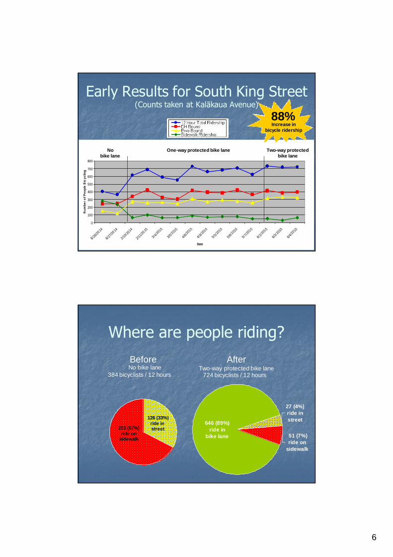
Nobike lane
One-way protected bike lane Two-way protectedbike lane
Early Results for South King Street(Counts taken at Kalākaua Avenue)
88%Increase in
bicycle ridership
646 (89%)
ride in
bike lane 51 (7%)
ride on
sidewalk
27 (4%)
ride in
street
BeforeNo bike lane
AfterTwo-way protected bike lane
384 bicyclists / 12 hours 724 bicyclists / 12 hours
Where are people riding?
258 (67%)ride on
sidewalk
126 (33%)ride instreet

7
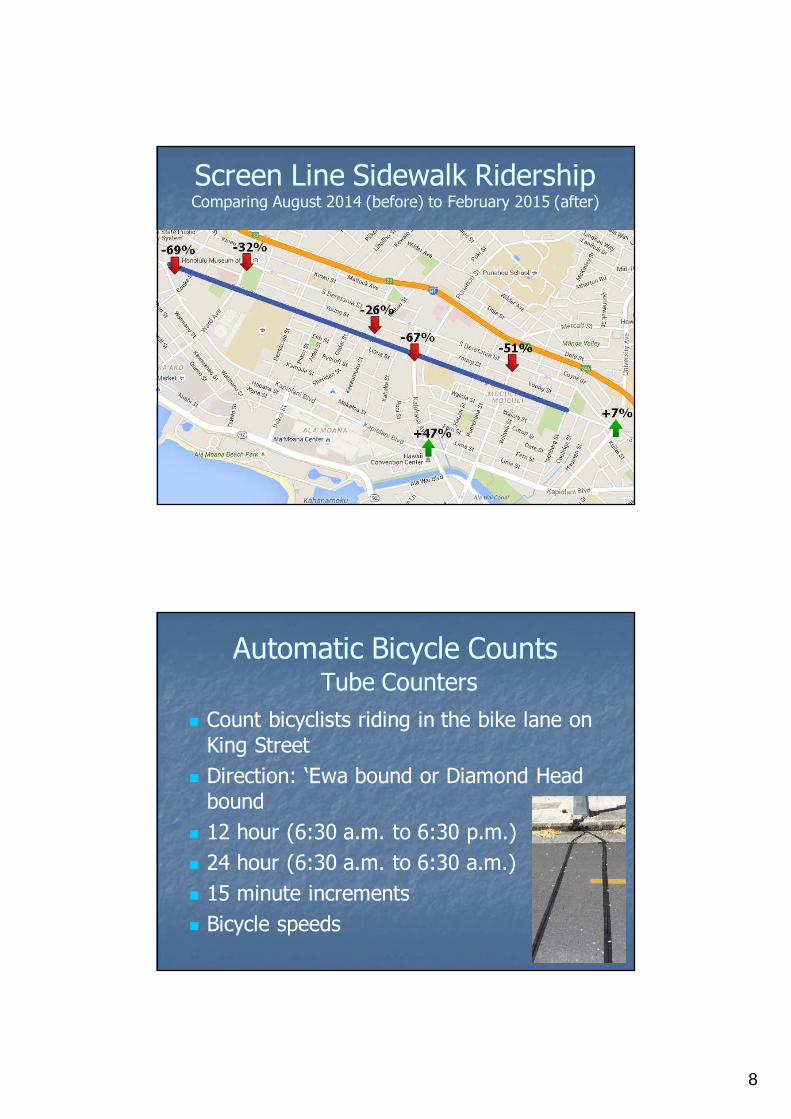
Screen line counts7 Locations
Traffic Camera
On-site
King Street Protected Bike Lane
Screen Line ResultsComparing August 2014 (before) to February 2015 (after)
8
Screen Line Sidewalk RidershipComparing August 2014 (before) to February 2015 (after)
Automatic Bicycle CountsTube Counters
Count bicyclists riding in the bike lane onKing Street
Direction: ‘Ewa bound or Diamond Headbound
12 hour (6:30 a.m. to 6:30 p.m.)
24 hour (6:30 a.m. to 6:30 a.m.)
15 minute increments
Bicycle speeds
9
0
100
200
300
400
500
600
700
800
900
1000
4/7/2015
5/5/201
5
6/2/2015
7/9/201
5
8/5/2
015
Date
Nu
mber
of
Peo
ple
Bic
yclin
g
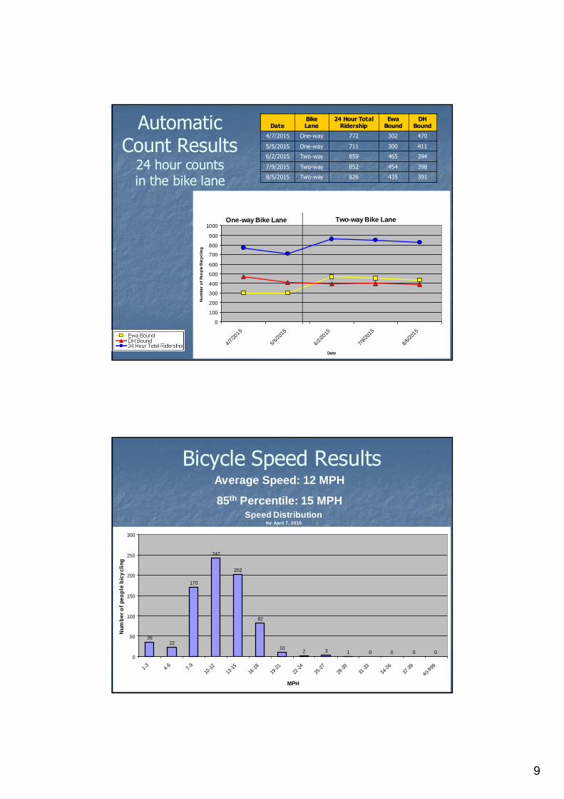
AutomaticCount Results
24 hour countsin the bike lane
DateBikeLane
24 Hour TotalRidership
EwaBound
DHBound
4/7/2015 One-way 772 302 470
5/5/2015 One-way 711 300 411
6/2/2015 Two-way 859 465 394
7/9/2015 Two-way 852 454 398
8/5/2015 Two-way 826 435 391
One-way Bike Lane Two-way Bike Lane
Bicycle Speed ResultsAverage Speed: 12 MPH
85th Percentile: 15 MPH
3622
170
242
202
82
102 3 1 0 0 0 0
0
50
100
150
200
250
300
1-3 4-6 7-9
10-1
2
13-1
5
16-1
8
19-2
1
22-2
4
25-2
7
28-3
0
31-3
3
34-36
37-3
9
40-999
MPH
Nu
mb
er
of
pe
op
leb
icy
cli
ng
Speed Distributionfor April 7, 2015
10
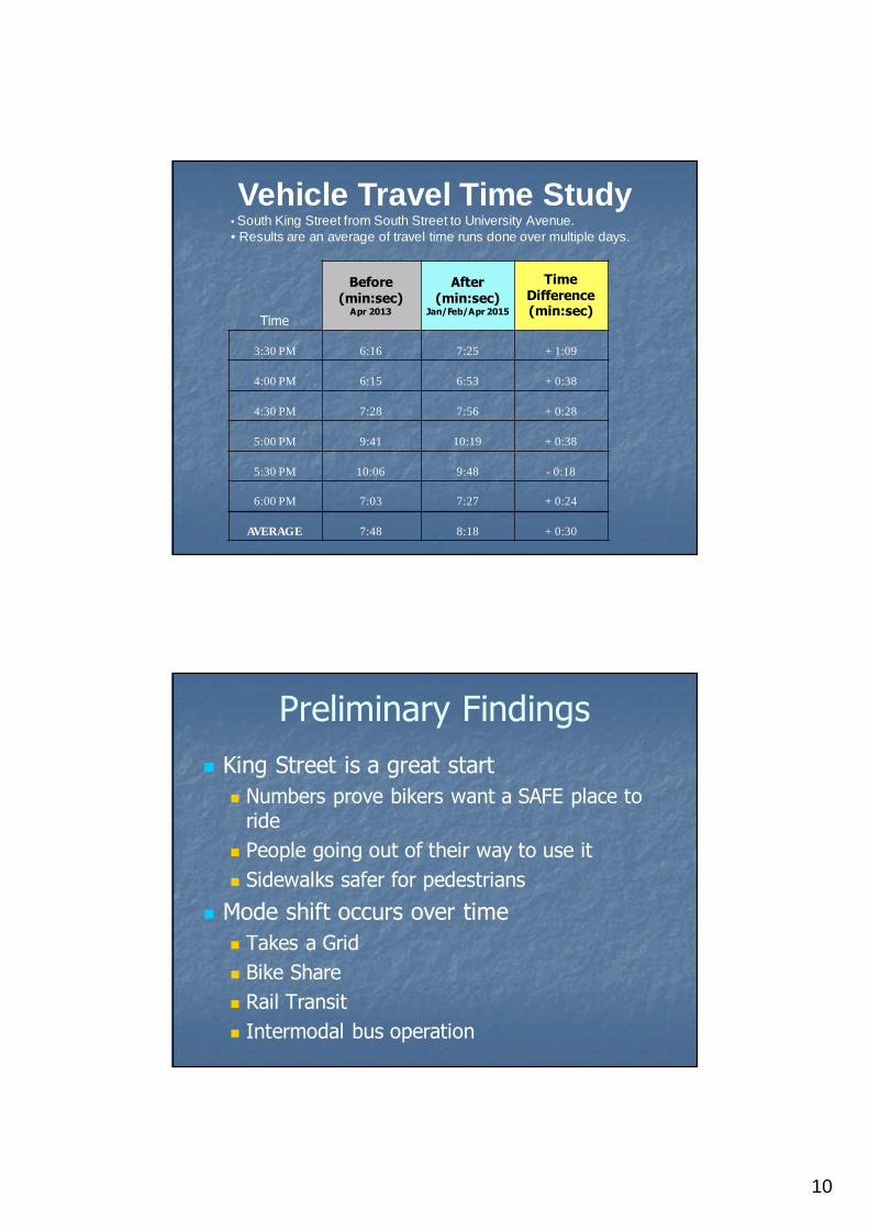
Vehicle Travel Time Study• South King Street from South Street to University Avenue.• Results are an average of travel time runs done over multiple days.
Time
Before(min:sec)
Apr 2013
After(min:sec)
Jan/Feb/Apr 2015
TimeDifference(min:sec)
3:30 PM 6:16 7:25 + 1:09
4:00 PM 6:15 6:53 + 0:38
4:30 PM 7:28 7:56 + 0:28
5:00 PM 9:41 10:19 + 0:38
5:30 PM 10:06 9:48 - 0:18
6:00 PM 7:03 7:27 + 0:24
AVERAGE 7:48 8:18 + 0:30
Preliminary Findings
King Street is a great start
Numbers prove bikers want a SAFE place toride
People going out of their way to use it
Sidewalks safer for pedestrians
Mode shift occurs over time
Takes a Grid
Bike Share
Rail Transit
Intermodal bus operation

11
Next Steps
Network (Grid) is needed for best results
Mauka-Makai connections to King Street
Need to connect to destinations (e.g. Waikiki, AlaMoana Park, UH Manoa, Chinatown, etc)
Possible Future Routes
South Street, Piikoi, Ward, Pensacola, McCully,Keeaumoku, Bishop/Alakea, Kapiolani…
Protected Bike Lane Network

12
Mauka/Makai Routes
Connect to the King Street protected bikelane to create a network or grid
Many routes will connect to future railstations
Goal is to construct South Street protectedbike lane by the end of 2015 (no berms)
One new protected bike lane each year
13
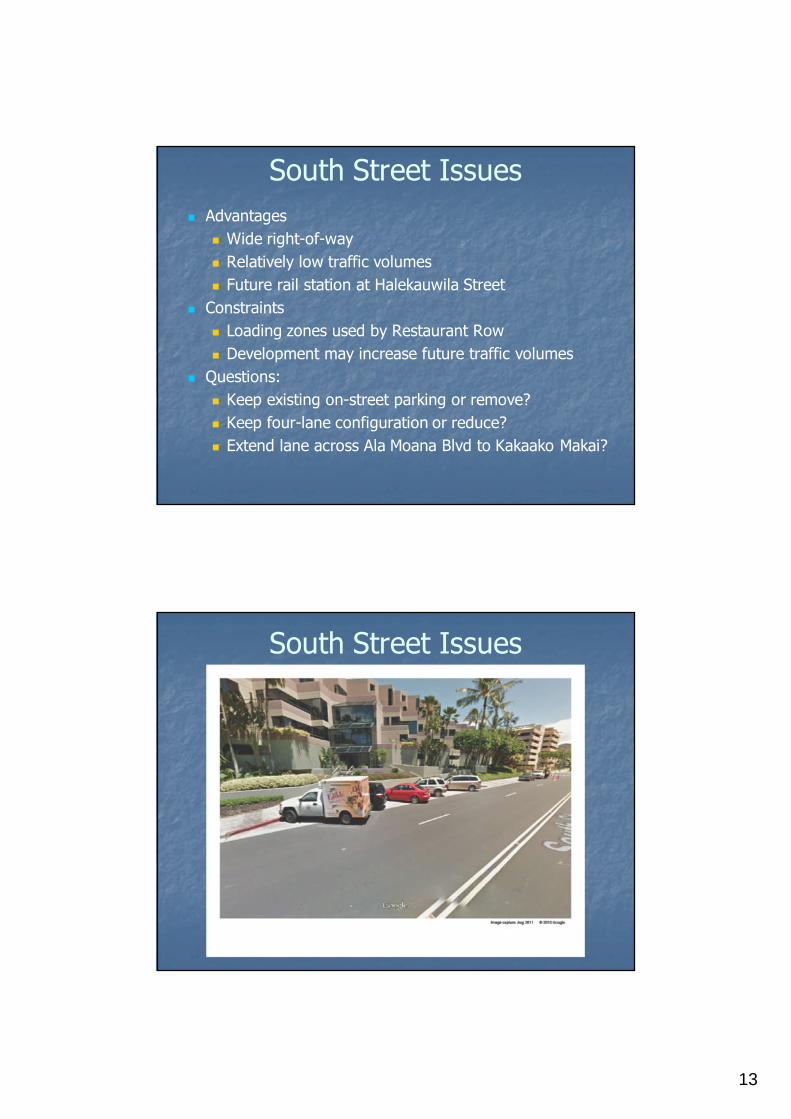
South Street Issues
Advantages
Wide right-of-way
Relatively low traffic volumes
Future rail station at Halekauwila Street
Constraints
Loading zones used by Restaurant Row
Development may increase future traffic volumes
Questions:
Keep existing on-street parking or remove?
Keep four-lane configuration or reduce?
Extend lane across Ala Moana Blvd to Kakaako Makai?
South Street Issues

14
South Street Issues
What about after South Street?
Mauka-Makai Streets?
Ward Avenue
Piikoi
Pensacola
McCully
Keeaumoku
Extend to other neighborhoods?
Downtown/Chinatown
Kaimuki/University
Waikiki

15
McCully Street Bike Lanes
Connection from Waikiki to the King Streetprotected bike lane and the UH-Manoa Area
Limited ROW allows for conventional bike lanes
16
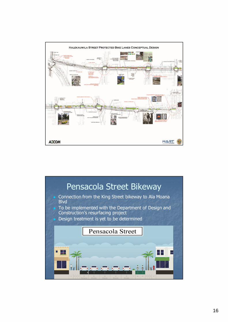
Pensacola Street Bikeway Connection from the King Street bikeway to Ala Moana
Blvd
To be implemented with the Department of Design andConstruction’s resurfacing project
Design treatment is yet to be determined

17
Summary
King Street is a great start – preliminary findingsare positive and encouraging
Need a connected network or grid for bestresults
Keep momentum going
Rail and Bike Share will generate furtherdemand for protected bike lanes
South Street is the best next step
One new protected bike lane each year
HBL: 20 by 20
Mahalo!Honolulu Bicycle Program