full citation details: rivett, l.j. 1980. the
TRANSCRIPT

Australian Archaeology
Archived at Flinders University: dspace.flinders.edu.au Full Citation Details: Rivett, L.J. 1980. The photogrammetric recording of rock art in the Kakadu National Park, Australia. 'Australian Archaeology', no.10, 38-51.
THE PHOTOGRAMMETRIC RECORDING OF ROCK ART IN THE KAKADU NATIONAL PARK, AUSTRALIA
L.J. Rivett
An important feature of the recently declared Kakadu National Park is its archaeological resources, in particular the rock art galleries which are among the oldest and most extensive in the world. Situated in the remote Alligator River region some 250km east of Darwin, the Park covers an area of approximately 6500 sq.km and will be progressively increased to almost double this area.
In recent years there has been a growing awareness of the cultural, physiographic and biological resources of this region and the declaration of the National Park has resulted in the preparation by the Australian National Parks and Wildlife Service of management programs to protect these resources in the climate of increasing activities in mineral exploration and tourism. The imminent exploitation of the large deposits of uranium in this locality has lent a sense of urgency to this task.
The protection and scientific investigation of these rock art sites necessitates a systematic identification and recording program which will provide information for immediate conservation and management schemes and also archival records for future ec ient if ic study. As there are an estimated 1000 rock art sites in the park area, this presents a daunting task for any systematic recording program. Faced with this task, the Australian National Parks and Wildlife Service requested the Department of Surveying at the University of Melbourne to investigate the potential of photogrametry in the recording, interpretation and conservation of the rock art sites in the Park.
REQUIREMENTS FOR ROCK ART RECORDING
One of the first aspects to be considered was the requirement of archaeological recording. The reasons for which recording is required are varied and it is unlikely that all possible requirements can be satisfied by a single recording procedure. However, any routine recording program must be as broadly based as possible within the practical constraints of time and resources. Considering rock art in particular, although this may apply to other aspects of archaeological recording, the rearons for recording are likely to fall within the following categories:
1. for immediate rcientific research in ethnology and related dircipliner ;
Archived at Flinders University: dspace.flinders.edu.au
2. as part of a general inventory of national 'cultural heritage' resources, i.e. as archival material;
3. for conservation and management purposes - i.e. to monitor deterioration rates, design site protection measures, etc.
Each of these categories will have special requirements and there may be considerable overlap between them. Decisions concerning what to record and to what accuracy should it be recorded are naturally often influenced by the availability of time and resources. Thus the philosophy and techniques of recording have become somewhat interdependent, although the difficulties involved in the physical process of recording would appear to restrict many scientific investigations.
Ideally the recording process should be objective and provide source data from which future investigators may make individual interpretations. The extent and scale of the recording should also take into account possible future requirements although these can be difficult or even impossible to predict.
Conventional recording techniques such as sketching, photography, tracing etc., may have been adequate for the investigation of a single site but would be hard pressed to fulfil1 the variety of requirements for a routine recording program and the field time required would be prohibitive.
TERRESTRIAL PHOTOGRAMMETRY
In theory, terrestrial photogrammetry would appear to have several attractive characteristics when applied to archaeological recording. In photogrammetry, . the recording and data extraction stages are separated. The field recording involves the acquisition of stereo survey photography and associated control measurements. This stage can be accomplished in a relatively short time on site and the results of this provide a permanent objective archival record from which data may be extracted whenever required in the future. The survey photography provides a three-dimensional visual record from which individuals in the future may make their own interpretations. Quantitative data in the form of scale plots of elevations, profiles, contours etc. or as three-dimensional coordinates of discrete points, may also be derived with predictable precision whenever required.
It is not claimed that photogrammetry provides the perfect solution to the recording problem and Rosenfeld (1978) cites the expense and lack of flexibility of equipment together with the need for specialist expertise in photogramnetry as disadvantages in its application. However, while accepting these and other limitations of the technique, experience at a number of Australian rock art sites suggests that the disadvantages of photogrammetry can be minimised if there is thorough knowledge and experience relating to both the photogramnetry field equipment and the laboratory procedures which may follow. This, if combined with an appreciation of the rock art and the recording requirements, will enable each site to be assessed independently and the most appropriate and efficient techniques employed.
Archived at Flinders University: dspace.flinders.edu.au
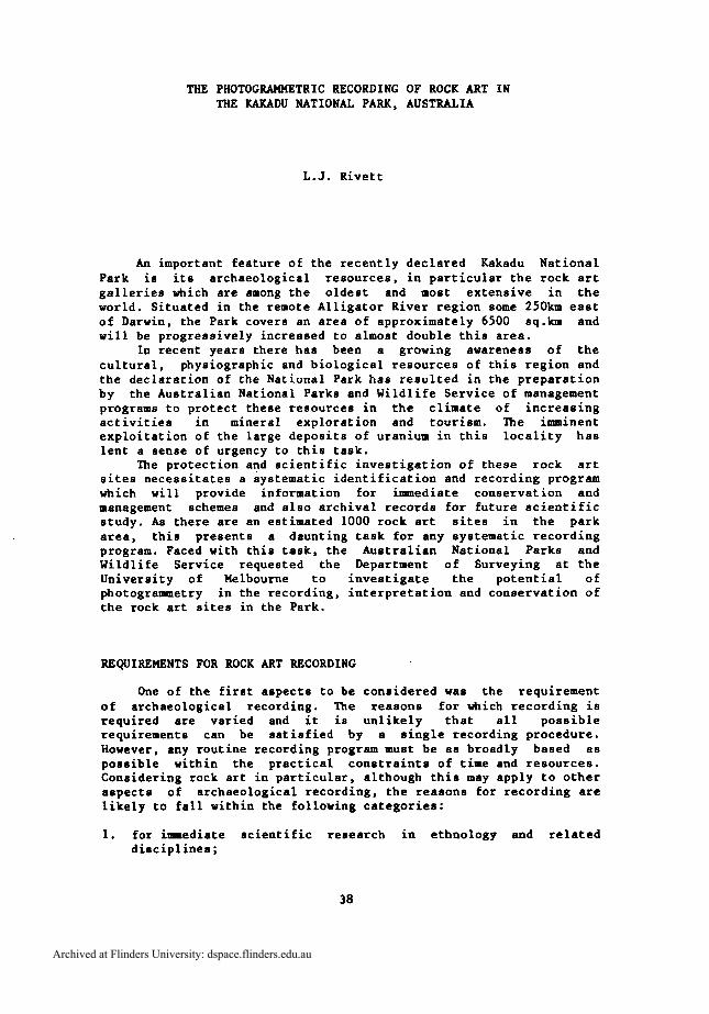
Figure 1 The Kakadu National Park. Locality map showing stages 1 and 2.
ARAFURA SEA
ARNHEM
1 I
0 U) l00 200 300
SCALE OF KILOMETRES
Archived at Flinders University: dspace.flinders.edu.au
VAN DIEMEN GULF
12.-
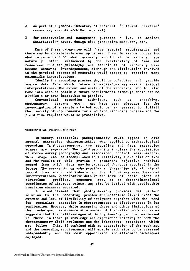
Figure 2 Site location map
'i'
Archived at Flinders University: dspace.flinders.edu.au
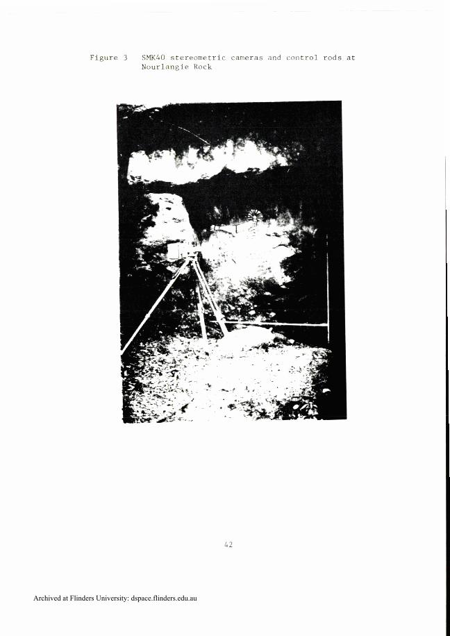
Figure 3 SMK40 stereometric cameras and control rods at Nourlangie Rock
Archived at Flinders University: dspace.flinders.edu.au

In considering the application of terrestrial photogrammetry to the recording of rock art, the following classification of scales of recording may be appropriate:
1. general site record - i.e. topography of art gallery and environs ;
2. general art record - possibly in units of 10-20 sq .m of rock surface area from which plots at 1:20 or 1: 10 scale could be prepared if required;
3. close-range record - i.e. detailed recording of invididual figures when required, recording faint paintings and engravings, deterioration studies etc.
FIELD RECORDING IN THE KAKADU NATIONAL PARK
During the five-day field excursion a number of sites typical of the general situation in the Park were visited (Fig. l) in order to gain a general appreciation of the archaeological recording problems. From among the sites visited, four were selected (~ig.2) for pilot photogrammetric recording.
The equipment used consisted of a Wild P32 survey camera, a Wild T2 theodolite and Zeiss Oberkochen SMK 40 stereometric cameras (Fig.3). The Wild P32 camera is the smallest and most versatile of the available survey cameras and has the desirable characteristic for this field of application of accepting 120 roll film with some loss of accuracy in addition to glass plates.
The weight of the stereometric cameras was greatly reduced by the use of a specially designed remote control unit and a camera mounting spindle compatible with a Wild type tribrach. This enabled the cameras to be used on a conventional light weight telescopic theodolite tripod or supported by other means, thus eliminating the need for the massive metal tripod which incorporates a battery, control unit and cranking device for elevating the camera. A pair of No.4 lens attachments was available for use with the stereometric cameras, permitting photography in a closer range zone (0.75-1.0m) than the normal minimum taking distance of 2.5m.
Photographic material used with the P32 camera consisted of Agfa-Gevaert Pan 33 glass plates (65 X 9Om) and Kodak Ektachrome 64 and 200 and Ilford FP4 120 roll films. The SMK40 cameras were restricted to Agfa-Gevaert Pan 33 glass plates (90 X 120mm).
Control for all field photography from a taking distance of less than 10m was provided by four lm sections of graduated aluminium tubing which were set up with horizontal and vertical components in the object area. For more distant photography three or four natural or targetted points in the object area were coordinated by theodolite intersections from a measured base.
A detailed description of the sites visited is outside the scope of this paper. The archaeology and rock art of these sites is documented in reports of the Alligator River Region Environmental Fact Finding Study by Edwards (Rock Art) and Kamminga and Allen (Archaeology). mere is as yet no standard nomenclature or code references for sites in this area and the identifiers employed here
Archived at Flinders University: dspace.flinders.edu.au
were t h o s e i n l o c a l u s e .
O b i r i
Among t h e t h r e e s i t e s photographed a t t h i s l o c a t i o n was t h e ' ~ o u n t f o r d ~ r i e z e ' , an i m p r e s s i v e compos i t i o n o f a h u n t i n g s c e n e which i s p a i n t e d on t h e back w a l l o f an open s h e l t e r and e x t e n d s f o r a p p r o x i m a t e l y 4m. T h i s s i t e was r e c o r d e d w i t h d u p l i c a t e SMK40 and P32 photography, r e q u i r i n g two s t e r e o p a i r s from each a t a t a k i n g d i s t a n c e o f 3.5m from t h e r o c k f a c e .
C o n t a c t Cave, Hawk Dreaming
T h i s s i t e c o n s i s t s o f a low s h e l t e r ( F i g . 4 ) a t t h e b a s e of a 20m h igh r o c k o u t c r o p . The c e i l i n g o f t h e s h e l t e r c o n s i s t s o f a g e n t l y s l o p i n g rock s u r f a c e , 2m above t h e ground , and i s c o v e r e d w i t h a v a r i e t y o f s t e n c i l s and p a i n t i n g s , some o f which a r e post-European c o n t a c t . T h i s s i t e was chosen because i t p r e s e n t e d a d i f f e r e n t s i t u a t i o n t o t h e n e a r v e r t i c a l g a l l e r y s u r f a c e s which a r e more o b v i o u s l y s u i t e d t o photogrammetr ic r e c o r d i n g .
Two l e v e l s o f r e c o r d i n g were adopted f o r t h i s s i t e . A r e c o r d o f t h e g e n e r a l s i t e topography was o b t a i n e d by a p a i r o f P32 photographs on a 4m b a s e some 25m from t h e s h e l t e r . C l o s e r r a n g e r e c o r d i n g of t h e a r t on t h e c e i l i n g ( F i g . 5 ) was c h a l l e n g i n g b u t demons t ra ted t h e i n c r e a s e d f l e x i b i l i t y o f t h e m o d i f i e d SMK40 cameras . The cameras were s u p p o r t e d a l m o s t a t ground l e v e l and aimed upwards towards t h e c e i l i n g . The r e s u l t s proved t o b e most s a t i s f a c t o r y . The t i m e occupied a t t h i s s i t e wi th photography and s u r v e y c o n t r o l measurements amounted t o a p p r o x i m a t e l y two h o u r s .
Balawuru ( L e i c h h a r d t ~ a l l e r y ) - Deaf Adder Gorge
One of t h e most s p e c t a c u l a r s i t e s i n Arnhem Land, t h i s g a l l e r y c o n t a i n s hundreds of p a i n t e d d e s i g n s , p redominant ly an imal and human f i g u r e s i n X-ray s t y l e . The a r t e x t e n d s some 40m a l o n g t h e b a s e o f a n e a r v e r t i c a l rock f a c e from a l m o s t ground l e v e l t o an a v e r a g e h e i g h t o f 3m.
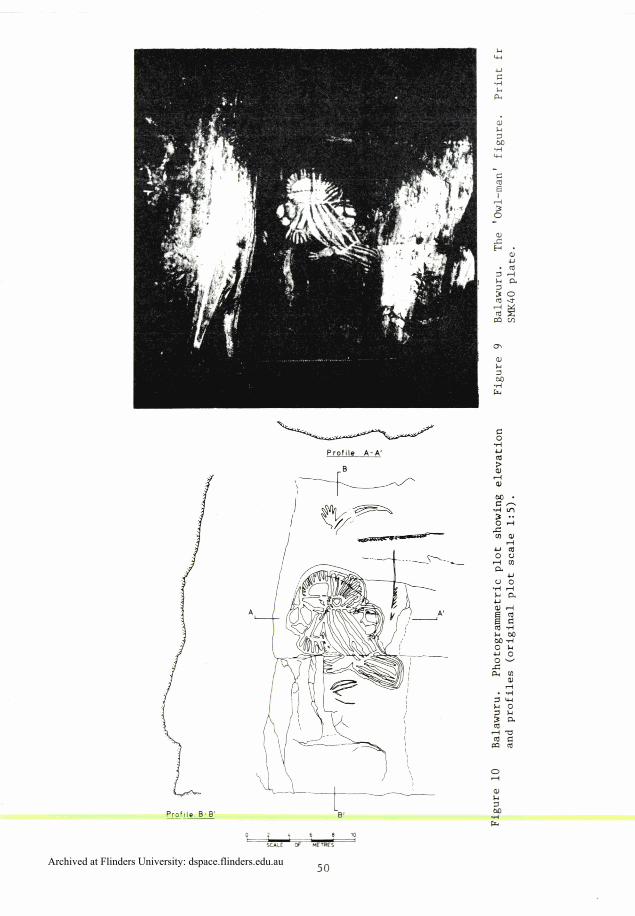
The whole of t h e g a l l e r y was r e c o r d e d by photography from a b a s e l i n e approximate ly 5.5m from t h e b a s e o f t h e r o c k f a c e . Photography was d u p l i c a t e d w i t h t h e P32 camera ( p a n p l a t e s and c o l o u r r e v e r s a l f i l m ) u s i n g a b a s e o f 0.5m and t h e SMK40 s t e r e o m e t r i c cameras (pan p l a t e s ) , w i t h seven s t e r e o p a i r s r e q u i r e d t o cover t h e main g a l l e r y ( F i g s 7-10). The SMK4O cameras were a l s o used t o r e c o r d an i m p r e s s i v e 'owl man' f i g u r e s i t u a t e d i n a r e c e s s i n t h e rock f a c e a t t h e s o u t h w e s t e r n end o f t h e main r o c k f a c e p l u s one ' c l o s e - r a n g e ' s t e r e o p a i r from a t a k i n g d i s t a n c e o f 0.9m o f a t y p i c a l p o r t i o n o f t h e main g a l l e r y .
T h i s impor tan t s i t e proved t o be i d e a l l y s u i t e d t o photograntmetr ic r e c o r d i n g and t h e e f f i c i e n c y o f t h i s t e c h n i q u e i s demons t ra ted by t h e f a c t t h a t a p p r o x i m a t e l y 120 sq.m o f d e n s e a r t was recorded i n l e s s t h a n e i g h t h o u r s on s i t e .
Archived at Flinders University: dspace.flinders.edu.au

Figure 4 Contact Cave, Hawk Dreaming. Print from P32 camera plate showing general view of s i t e .
Figure 5 Contact Cave. Print from S M K 4 0 camera showing a r t on the s h e l t e r roof .
Archived at Flinders University: dspace.flinders.edu.au
Nourlangie Rock
The final site recorded in this study was the impressive gallery at the base of Nourlangie Rock. The paintings here depict a group of male and female spirit figures surrounded by a number of polychrome images of legendary heroes and fish in X-ray style. Although last re-painted less than 20 years ago, this art is already suffering considerable deterioration from water, animals and increased tourist activity in this area. This main gallery and the single figure adjacent to the main gallery were each recorded with a single stereo pair using the SMK40 cameras.
The equipment performed well under difficult conditions and the field results generally were moat encouraging considering the limited time available, the geographical separation of the sites and the fact that no preliminary reconnaissance was possible.
EVALUATION OF THE SURVEY PHOTOGRAPHY
In all cases, three-dimensional viewing of the stereo survey photography using a mirror stereoscope was most informative and visually quite spectacular. The exaggeration of depth produced when viewing the stereo photographs provides a realistic appreciation of the topography of the art gallery, rock face and even the surface texture of the rock and art figures. The reaction of experienced art recorders to stereo viewing of the survey photography was most enthusiastic and there was general agreement of the value of this three-dimensional visual record for interpretive studies, museum displays and as a general archival record. Notwithstanding the drawings and measurements which can be derived from the survey photography, this objective three-dimensional visual aspect is a most valuable characteristic of photogrammetric recording.
A number of stereo pairs were chosen for photograametric plotting to demonstrate the potential of this technique in a variety of situations. The plotting was undertaken on the department's Zeiss Jena Topocart B plotter and the operator, who had no previous experience with rock art, was instructed to plot the art detail as he saw it. Thus no claims are made regarding expert interpretation of the art, the intention merely being to demonstrate the output of photogrammetric plotting. In an actual production situation, the rock art specialist would specify the requirements for each particular project and preferably indicate, by marking on an enlarged print of the survey photography, the actual lines to be plotted.
The Hawk Dreaming site provides an example of different scales of plotting for one site. A 1:50 scale plot was prepared showing a general view of the rock shelter (elevation and two vertical profiles) from the P32 photography and a 1:10 plot was prepared from the close range SklK40 photography showing the art on the low ceiling of the shelter. A total of seven hours was required to produce these two plots.
Two models were plotted from the Balawuru site photography. A 1:10 scale elevation plot was prepared of a typical section of the main gallery showing examples of the X-ray and mimi styles of art. The 'owl-man'' figure at the southwestern extremity of the gallery was chosen to demonstrate large scale plotting of a single feature.
Archived at Flinders University: dspace.flinders.edu.au
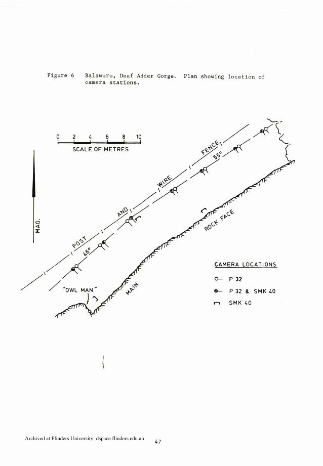
Figure 6 Balawuru, Deaf Adder Gorge. Plan showing location of camera stations.
0 2 L 6 8 1 0
SCALE OF METRES
CAMERA LOCATIONS
0- P 3 2
* P 32 (L SMK L0
n SMK CO
Archived at Flinders University: dspace.flinders.edu.au
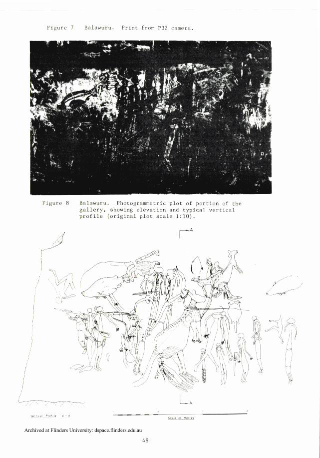
Figure 7 Balawuru. Print from P32 camera.
Balawuru. Photogrammetric F--- -- ,-rtion of the gallery. showing elevation and typical vertical profile (original plot scale 1:lO).
Archived at Flinders University: dspace.flinders.edu.au

A scale of 1:5 was selected for an elevation plus horizontal and vertical profiles. This figure is a good example of the artwork being influenced by the topography of the rock surface. This is, of course, very evident when viewing the stereo pair in three dimensions. As an example of how the surface undulations may be quantified by other than horizontal or vertical profiles, a 'contour' overlay was plotted showing lines of constant distance from the vertical plane through the camera base, at intervals of 20mn.
Initial experiments have been conducted in extracting data in numerical form from the stereo photographs as an alternative to the output of graphical information. Several profiles were measured from the pair of photographs taken at the Balawuru site with the SMK40 cameras using close-up lens attachments. The stereocomparator observations were transformed into three-dimensional coordinates with a precision 20.2mm and the profiles plotted at a scale of two times enlargement via a small computer plotter. This technique has been successfully applied to the recording of weathered engravings in soft sandstone or limestone at sites elsewhere in Australia.
There are differing requirements for plots of rock art and consequently the demands placed on photogrammetric plotting will vary considerably. An investigator undertaking a detailed study of rock art at a site would be greatly aided by an elevation plot at a scale of 1:20 or 1:10 showing outlines of individual art figures. More detailed plots, assisted by expert interpretation, might be a useful asset in studies of comparative art styles. Those whose interest is in site management and art conservation may find the profile plots an aid in the investigation of the effectiveness of driplines or the design of protective structures, while repeated close-range recording may be one method of monitorin deterioration rates of the art.
However impressive the products of photogrammetry may appear, it is important that the significance of the primary record, i.e. the stereoscopic viewing of the survey photographs, is not overlooked. This characteristic of photogrammetric recording may also find useful application in museums and tourist displays. The three-dimensional image provides a more realistic 'feeling' for the art in its natural setting and would be one way of providing a representative sample of the spectacular art of Kakadu at a tourist focal point in the Park or in more distant localities around Australia and abroad.
CONCLUS ION
The vast number of rock art sites in the Kakadu National Park presents a virtually impossible recording task using conventional methods. Although the photogrammetric approach would undoubtedly not satisfy all the possible requirements for detailed recording, it does provide an efficient method for a systematic recording program. The fieldwork during this project demonstrated the viability of terrestrial photograumetry as an efficient field recording technique and the initial laboratory work has shown the potential of the visual record and metric data available from the survey photography. If properly managed, the disadvantages of specialist equipment and expertise which are associated with photogranmetric techniques can
Archived at Flinders University: dspace.flinders.edu.au
Profile A-A'
1;-
Archived at Flinders University: dspace.flinders.edu.au

be more than compensated for by the speed and efficiency of the field recording and the accuracy and objectivity of the permanent record.
ACKNOWLEDGEMENT
This project was initiated and funded by the Australian National Parks and Wildlife Service and approval to publish details from the project report prepared for that organisation is gratefully acknowledged.
Department of Surveying University of Melbourne
BIBLIOGRAPHY
Brandl, E.J. 1973 Australian Aboriginal Paintings in Western and Central Arnhem Land. Canberra: Australian Institute of Aboriginal Studies
Chaloupka, G. 1978 Rock Art Deterioration and Conservation in the 'Top ~ n d ' of the Northern Territory. Conservation of Rock Art, pp.75-88. Canberra: ICCM
Clouten, N.H. 1974 The Application of Photogrammetry to Recording Rock Art. Australian Institute of Aboriginal Studies Newsletter 1:33-34
Edwards, R. 1974 The Art of the Alligator River Region. Alligator River Region Environmental Fact Finding Study. Canberra
Kaminga, J. and H. Allen 1973 Report of the Archaeological Survey. Alligator River Region Environmental Fact Finding Study. Canberra
Rivet t ,
Rivet t ,
L . J . 1978 Heritage Photogrametry - Applications in Australian Archaeology. Proceedings, the V International Symposium for Photogrametry in Architecture ,a& Conservation of Monuments and Sites, Sibenik, Yugoslavia
L.J. 1979 The Application of Photogrannnetry to the Recording of Rock Art and Archaeological Sites in the Kakadu National Park. Report to the Director. Canberra: Australian National Parks and W~ldlife Service
Rosenfeld, A. 1978 Recording Rock Art - A Conflict of Purpose? Conservation of Rock Art, pp.6-14. Canberra: ICCM
Archived at Flinders University: dspace.flinders.edu.au