fourteen locks walk - bbcdownloads.bbc.co.uk/tv/weatherman-walking/walks/fourteen-locks... ·...
TRANSCRIPT

1
Weatherman Walking Fourteen Locks
bbc.co.uk/weathermanwalking © 2015
1
Reproduced by permission of Ordnance Survey on behalf of HMSO. © Crown copyright and database right 2009.All rights reserved. Ordnance Survey Licence number 100019855
The Weatherman Walking maps are intended as a guide to help you walk the route. We recommend using an OS map of the area in conjunction with this guide. Routes and conditions may have changed since this guide was written. The BBC takes no responsibility for any accident or injury that may occur while following the route. Always wear appropriate clothing and footwear and check weather conditions before heading out.
Approximate distance: 3.7 milesFor this walk we’ve included OS grid references should you wish to use them.
N
S
W E
2
3
4
5
6
7
EndStart

Weatherman Walking Fourteen Locks
bbc.co.uk/weathermanwalking © 2015
2
Start: Fourteen Locks Visitor Centre, Rogerstone, Newport Starting ref: ST 280 885Distance: 3.7 milesGrade: Easy / moderateWalk time : Allow 2 hours (1.5 hours + stops)
Just a stone’s throw from the city centre yet in a picturesque and peaceful setting, this walk on the outskirts
of Newport heads through an ever-changing landscape. Starting at the popular and historic Fourteen Locks
centre in Rogerstone, Newport, the route follows the canal towpath under the M4 motorway, through the
spectacular Allt-yr-Yn woodland nature reserve and across the open expanse around Tredegar Park Golf
Club. And, if you want to discover your artistic side, this is the trail on which to do it!
The peaceful and secluded Allt-yr-Yn nature reserve is at the heart of this lovely walk
Fourteen Locks Visitor Centre and ‘pound’ makes a pretty start and fi nish to the walk
Fourteen Locks Visitor Centre
The visitor centre tells the story of Fourteen Locks, a series of locks also known as the Cefn Flight and
one of the most ingenious pieces of canal engineering. Completed in 1799, the fl ight drops 169 feet
in just half a mile, one of the steepest series of locks in the UK. The Cefn Flight was the work of the
engineer Thomas Dadford Jnr, and today you can visit the Dadford Tearooms at the visitor centre, from
where you can take in the view and admire his work.
This waterway was a branch of the Monmouthshire Canal, built to transport coal and iron from the
valleys down to Newport, as well as serving the purpose of moving goods such as potatoes and pit
props upstream. In those days, Newport’s coal exports were four times larger than Cardiff ’s, due to it
not charging coal duty!
The coming of the railways rendered redundant the canal as a means of trade, with the last toll being
charged in 1935. Aft er this, the stretch of water between Locks 21 and 8 (the ‘Fourteen’
fell into disrepair and became fi lled with rubbish, but a Millennium project between
Newport City Council and the Canals Trust has seen much of it cleared and restored.
)
1
Weatherman Walking Fourteen Locks
bbc.co.uk/weathermanwalking © 2015
3
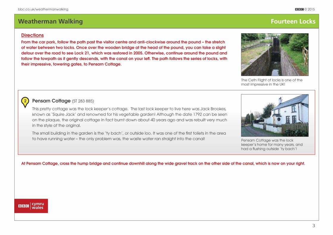
DirectionsFrom the car park, follow the path past the visitor centre and anti-clockwise around the pound – the stretch of water between two locks. Once over the wooden bridge at the head of the pound, you can take a slight detour over the road to see Lock 21, which was restored in 2005. Otherwise, continue around the pound and follow the towpath as it gently descends, with the canal on your left . The path follows the series of locks, with their impressive, towering gates, to Pensarn Cottage.
The Cefn Flight of locks is one of the most impressive in the UK!
Pensarn Cottage was the lock keeper’s home for many years, and had a fl ushing outside ‘ty bach’!
Pensarn Cottage (ST 283 885)
This pretty cottage was the lock keeper’s cottage. The last lock keeper to live here was Jack Brookes,
known as ‘Squire Jack’ and renowned for his vegetable garden! Although the date 1792 can be seen
on the plaque, the original cottage in fact burnt down about 40 years ago and was rebuilt very much
in the style of the original.
The small building in the garden is the ‘ty bach’, or outside loo. It was one of the fi rst toilets in the area
to have running water – the only problem was, the waste water ran straight into the canal!
2
At Pensarn Cottage, cross the hump bridge and continue downhill along the wide gravel track on the other side of the canal, which is now on your right.

Weatherman Walking Fourteen Locks
bbc.co.uk/weathermanwalking © 2015
4
Derek and walking guide Joseph ponder what the ‘mystery lock’ could possibly have been designed for.
The Mystery Lock (ST 284 885)
Soon you come to Lock 11, an extra-wide lock with shelves running below and along the sides. What
they were for is a mystery! The stone this lock was built with diff ers from that of the other locks and it’s
thought to have been added post 1880, ie: aft er the canal’s heyday.
One suggestion is that it was a dry dock, with the shelves built for repairing boats on, but there would
only have been a few minutes between boats coming through and the lock re-fl ooding with water,
leaving very little time to carry out repairs! Another idea is that it was a loading bay – but with no
evidence of a road connection or warehouses, this also seems unlikely. It is, indeed, a mystery!
3
Derek and Joseph take shelter from the rain under the M4 – and use the time for a spot of art!
Continue from the Mystery Lock towards the M4 and through the underpass.
Motorway underpass (ST 286 884)
The swish of the traffi c overhead contrasts harshly with the tranquillity of the towpath yet the canal
was, in fact, the ‘motorway’ of its day! Built to meet the demands of the Industrial Revolution, the
canal would have been a bustling thoroughfare until the railways took over as the quickest way to
transport goods.
4

Weatherman Walking Fourteen Locks
bbc.co.uk/weathermanwalking © 2015
5
Once through the underpass, follow the towpath left for a short distance until you reach the hump bridge. Cross the bridge and follow the footpath sign pointing straight ahead, through the metal gate. The signs are waymarked the Sirhowy Valley Walk and, yes, our route goes straight up the steep hill!
At the top of this fi eld, go through the wooden gate, where the waymarker points slightly left , passing several wooden posts. Follow this fi eld uphill, through the small, sign-posted gap in the hedge and keep going! The path passes to the left of the large yellow house, via a smaller metal gate next to a larger, padlocked gate. This brings you out onto Ridgeway, where a series of benches are just the place for a rest and to admire the views! Our route goes through the gate and
up the steep hill.
You’ll be pleased to know it’s all downhill from here!
The climb is well worth it for the spectacular views from Ridgeway.
Little Switzerland (ST 293 882)
It is sometimes thought that this area gained the nickname of ‘Little Switzerland’ from the style
of the houses, with their large, overhanging eaves. But actually it’s due to the spectacular view
north, towards the tree-covered hills of Mynydd Machen and Twmbarlwm. Paintings with title ‘Little
Switzerland’ show that the area has been called this for more than 150 years!
5
Walk across the ‘green’, past the benches, towards the transmitter ahead. At the transmitter, turn left along Allt-yr-Yn View and follow this lane as it runs downhill. You’ll pass Allt-yr-Yn Heights on the right hand side and, not much further along the lane, is the entrance on the left to Allt-yr-Yn Local Nature Reserve. Don’t take the tarmac road but follow the parallel track marked by the big green sign.

Weatherman Walking Fourteen Locks
bbc.co.uk/weathermanwalking © 2015
6
At the pond, follow the steps to the right.
Take the left -hand track into the nature reserve.
Allt-yr-Yn Lodge (ST 299 888)
This beautiful, peaceful nature reserve was once the grounds of Allt-yr-Yn House, a large country home
now sadly reduced to a ruin hidden in the trees, and Allt-yr-Yn Lodge is one of the few reminders of this
once-great estate.
Although Newport’s English-speaking population pronounce the reserve’s name as ‘Olt-er-reen’, it
should have a Welsh pronunciation. The name means ‘the slope of the ash trees’ and the ‘Yn’ at the
end should be spelt with two ‘n’s as ‘ynn’ is the plural of ‘onnen’ – the Welsh for ash tree.
As well as ash trees, the reserve has other species including oak and beech, as well as woodland
fl owers such as snowdrops and golden saxifrage. In summer, the south-facing meadows are covered
with fl owers such as common spotted orchid and vetchling, whilst birds such as woodpeckers,
kingfi shers and warblers make their home here.
6
Continue downhill until you reach a pond on your left hand side. The path continues around a bend to the right, whilst rising ahead is a pretty meadow, but we’re going through the wooden gate on the right, down a couple of steps and along the woodland path to another pond, which seems innocuous yet in fact has a surprising history!

Weatherman Walking Fourteen Locks
bbc.co.uk/weathermanwalking © 2015
7
Through the gate and over the bridge.
The crew fi lm Derek and Joseph walking around Wern Ddu Wood.
It’s hard to believe this was once a popular outdoor swimming pool!
Allt-yr-Yn Lido (ST 296 887)
It’s hard to believe but this pond was once a lido! It opened in the 1930s and the people of Newport
fl ocked to swim here until the pool closed in the 1960s. It was subsequently demolished and there’s
hardly any indication left now that this was an outdoor swimming pool, although a lump of concrete
remains from when the concrete sides of the pool were broken up.
The lido was built where the spring and ornamental pools of Allt-yr-Yn House once stood. It had an
unusual design, with its changing boxes housed in a circular building which left the baths open to the
parkland and woods behind, rather than being enclosed by them. The changing rooms stood on the
slope overlooking the ponds, a spot now used an open-air classroom for schoolchildren!
The ponds are now full of insects such as water boatmen, beetles and pond skaters, whilst marsh-
marigold grows around the pond edges.
7
Cross the narrow ‘bridge’ to the other side of the pond, turn right and follow the path as it leads away from the pond, slightly uphill. It quickly levels out and reaches a wooden gate next to an ornamental stone wall. Go through the gate, cross the canal at the hump bridge and turn briefl y left , before taking the path on your right past the kennels and cattery.
This tarmac path winds left then through another underpass below the motorway. On the other side, follow it for a short distance as it curves left then starts to veer right, towards farm buildings. Don’t head for the buildings but leave the tarmac at the wooden signpost and walk between two fences to the gate. Head into the next fi eld and aim for the top right corner; the fi eld fi rst rises then drops towards a wooden stile before the trees. Go over the stile; the path appears to enter the wood but it quickly exits the trees and skirts the edge of Wern Ddu Wood.

Weatherman Walking Fourteen Locks
bbc.co.uk/weathermanwalking © 2015
8
Follow the wood to the far corner where, to the right, you can see the club house of Tredegar Park Golf Course. Walk towards the club house, fi rst keeping as close to the trees as you can and then following the thin blue guide rope, being mindful of golfers teeing off as you go! Join the road behind the club house and follow it as it curves around two sides of a ‘triangle’.
When the road again draws fairly level with the club house, look for the track leading to the left , with a house roof visible. It’s a clear path, yet it’s easy to continue along the tarmac road if you’re not concentrating, so don’t miss it! This path takes you past Ynysyfro Farm and onto another tarmac lane, which is our route back to Fourteen Locks. Follow the lane between the two Ynysyfro reservoirs, another popular beauty spot, and onwards to Cwm Lane, where the visitor centre and car park are just on the left hand side.
A view of the 19th hole!
The beautiful Ynysyfro reservoirs make the perfect end to this walk.