format, font and stylingdocs.brisbane.qld.gov.au/city plan/v09_00_20180216/text... · web viewa...
TRANSCRIPT
8.2.5 Bushfire overlay code
8.2.5.1 Application
(1) This code applies to assessing development in the Bushfire overlay, if:
(a) accepted development subject to compliance with identified requirements, where acceptable outcomes of this code are identified requirements in a table of assessment for an overlay (section 5.10); or
(b) assessable development where this code is an applicable code identified in the assessment benchmarks column of a table of assessment for an overlay (section 5.10); or
(c) impact assessable development.
Note—This code may also be used in assessing other at-risk impact assessable uses within the bushfire overlay, including uses which involve significant numbers of persons regularly congregating on the site, or any use that may be difficult to evacuate or vulnerable during or after a bushfire due the characteristics of the population including age, health, mobility impairment, or requiring supervision or support.
(2) Land in the Bushfire overlay is identified on the Bushfire overlay map and is included in the following sub-categories:
(a) High hazard area sub-category;
(b) Medium hazard area sub-category;
(c) High hazard buffer area sub-category;
(d) Medium hazard buffer area sub-category.
Note—For the purposes of section 12 of the Building Regulation 2006, the land identified within the Bushfire overlay on the Bushfire overlay map are 'designated bushfire prone areas'. AS 3959-2009 Construction of buildings in bushfire-prone areas applies within the 'designated bushfire prone areas' identified on the Bushfire overlay map.
(3) When using this code, reference should be made to section 1.5 and section 5.3.3.
Note—The following purpose, overall outcomes, performance outcomes and acceptable outcomes comprise the assessment benchmarks of this code.
Note—Where this code includes performance outcomes or acceptable outcomes that relate to:
a bushfire management plan and a site specific bushfire hazard assessment, guidance is provided in the Bushfire planning scheme policy;
a bushfire management plan pertaining to hazardous chemicals , guidance is provided in the Bushfire planning scheme policy and the Industrial hazard and risk assessment planning scheme policy.
Editor’s note—For a proposal to be accepted development subject to compliance with identified requirements, it must meet all the identified acceptable outcomes of this code that relate to the applicable sub-category and any other applicable code. Where it does not meet all identified acceptable outcomes, the proposal becomes assessable development and a development application is required. Where a development application is triggered, only the specific acceptable outcomes that the proposal fails to meet need to be assessed against the corresponding assessable acceptable outcomes or performance outcomes and relevant overall outcomes. Other identified acceptable outcomes that are met are not assessed as part of the development application.
Part 8 — Overlay Codes (Bushfire) Effective 3 July 2017

8.2.5.2 Purpose
(1) The purpose of the Bushfire overlay code is to:
(a) Implement the policy direction in the Strategic framework, in particular:
(i) Theme 2: Brisbane’s outstanding lifestyle, and Element 2.3 – Brisbane’s healthy and safe communities;
(ii) Theme 4: Brisbane’s highly effective transport and infrastructure networks, and Element 4.3 – Brisbane’s coordinated infrastructure planning and delivery.
(b) Provide for the assessment of the suitability of development in the Bushfire overlay.
(2) The purpose of this code will be achieved through the following overall outcomes:
(a) Development maintains the safety of people and property by not exposing them to an unacceptable risk from bushfire.
(b) Development does not increase the exposure of people and property to an unacceptable bushfire risk.
(c) Development involving new premises for vulnerable uses, difficult to evacuate uses and assembly uses is not located in an area of bushfire risk.
(d) Development which would increase the number of people living, working on or visiting the site is not exposed to an unacceptable risk from bushfire.
(e) Development incorporates appropriate siting, design and management measures to avoid areas at risk of bushfire and mitigate risk from bushfire.
(f) Development for essential community infrastructure and its function during a bushfire event is protected from bushfire risk.
(g) Development involving the storage and handling of hazardous chemicals in the Bushfire overlay does not pose an unacceptable risk to public safety or the environment.
(h) Development provides access and evacuation routes for both private and emergency service vehicles which are appropriate to the nature of the development and the level of bushfire risk.
(i) Development provides for fire-fighting requirements.
(j) Development is sited and includes design and building treatments to avoid impacts on biodiversity values, ecological features and ecological processes.
(k) Development for reconfiguring a lot does not result in an area of future bushfire hazard from revegetation or future vegetation corridors.
8.2.5.3 Performance outcomes and acceptable outcomes
Table 8.2.5.3.A—Performance outcomes and acceptable outcomesPerformance outcomes Acceptable outcomes
Section A—If for accepted development subject to compliance with identified
Part 8 — Overlay Codes (Bushfire) Effective 3 July 2017
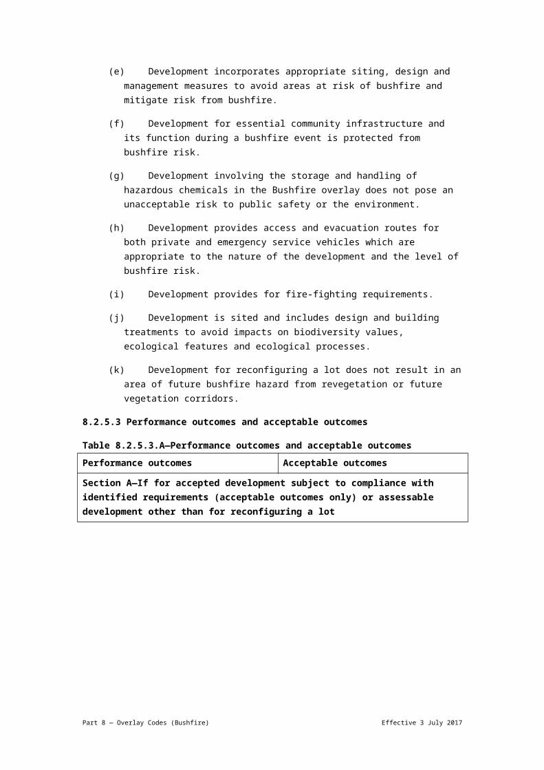
requirements (acceptable outcomes only) or assessable development other than for reconfiguring a lot
PO1Development addresses the bushfire hazard determined by a site-specific bushfire hazard assessment.
Note—Bushfire hazard is assessed based on the vegetation existing on site, adjacent and nearby to the site at the time of application, except where reconfiguring a lot, when the level of bushfire hazard posed by any areas subject to revegetation is assessed as if that area had reached its mature state.
AO1Development is designed and sited in compliance with:
(a) a current approved bushfire management plan relevant to the full nature of the uses, which identifies the level of bushfire hazard and the location of hazardous vegetation affecting the development; or
(b) a building protection zone approved as part of the reconfiguring of a lot; or
(c) for a lot less than or equal to 2,500m2, a site-specific bushfire hazard assessment prepared in accordance with the Bushfire planning scheme policy which:
(i) is undertaken by a person suitably qualified and experienced with technical expertise in the field of bushfire hazard identification and mitigation, including protection of biodiversity values;
(ii) determines the relevant bushfire attack level for that part of the site in which development is proposed;
(iii) identifies the location of hazardous vegetation that poses a bushfire risk to the development; or
(d) for a lot greater than 2,500m2, a site-specific bushfire hazard assessment prepared in accordance with the Bushfire planning scheme policy which:
(i) confirms the level of bushfire hazard for the part of the site which development is proposed;
(ii) identifies the location of hazardous vegetation that poses a bushfire risk to the development.
Note—Where a bushfire hazard assessment determines that the bushfire hazard for the part of the site in which development is proposed is 'low', no further assessment against this code is required.
PO2Development is sited, designed and maintained taking account of all relevant factors affecting the bushfire hazard on the site, including site topography, aspect, location
AO2.1Development other than an extension to an existing building is:
(a) sited in a building protection zone where
Part 8 — Overlay Codes (Bushfire) Effective 3 July 2017

and type and structure of vegetation to:
(a) minimise the number of buildings and people working, living or visiting a site exposed to bushfire risk;
(b) protect life during bushfire;
(c) increase the survival of buildings and structures during a bushfire;
(d) minimise bushfire risk from build-up of fuels around buildings and structures.
Note—A bushfire management plan prepared in accordance with the Bushfire planning scheme policy can assist in demonstrating achievement of this performance outcome.
approved as part of reconfiguring a lot stage; or
(b) sited in compliance with an approved bushfire management plan relevant to the full nature of the use; or
(c) if there is no approved building protection zone and no approved bushfire management plan, where on a lot great than 10ha, located in the area of lowest risk from bushfire on the site; and
(d) if there is no approved building protection zone and no approved bushfire management plan, where on a lot greater than 2,500m2:
(i) located away from ridgelines in compliance with Figure a;
(ii) located on land with a gradient less than 15%;
(iii) preferably located on east- to south-facing slopes and avoiding north- to west-facing slopes unless the slope is clear of vegetation and is not located in the High hazard buffer area sub-category or the Medium hazard buffer area sub-category;
(iv) with setbacks to hazardous vegetation 1.5 times the predominant mature canopy height, or 20m whichever is greater so that vegetation does not overhang a building.
AO2.2Development other than an extension to an existing building is sited within a building protection zone extending a minimum of 20m from the outermost projection of the main building or any habitable structure or to the maximum extent possible on sites less than 2500m2 where a building protection zone would extend into neighbouring properties; and
(a) clusters buildings and structures in the building protection zone;
(b) designs the inner 10m of the building protection zone to maintain a very low fuel state in the first 10m, and a fuel-reduced state to the extent of the building protection zone, in compliance
Part 8 — Overlay Codes (Bushfire) Effective 3 July 2017

with Figure b and Figure c.
Note—The building protection zone includes the dwelling and all ancillary structures and may extend to a road or a building protection zone in an adjoining site.
PO3Development utilises fencing that:
(a) does not contribute to the spread of bushfire;
(b) in an urban area or in proximity to accommodation uses, contributes to reducing bushfire hazard to a building;
(c) facilitates the safe movement of fauna.
AO3.1Development for a fence within 20m of any building used for accommodation comprises non-combustible or fire retardant materials.
AO3.2Development for a fence:
(a) incorporates gaps and spacing to allow the safe movement of fauna; or
(b) is designed to enable fauna to climb the fence.
PO4Development ensures that the location, siting, and design of development and associated driveways and access routes:
(a) avoid potential for entrapment during a bushfire;
(b) facilitate safe and efficient emergency services to access and egress the site during a bushfire;
(c) enables safe evacuation of the site during a bushfire for site occupants.
Note—A bushfire management plan prepared in accordance with the Bushfire planning scheme policy can assist in demonstrating compliance with this performance outcome.
AO4Development ensures that:
(a) the length of driveways or access routes does not exceed 70m between the most distant part of any occupied building and the nearest part of the public road; or
(b) where the length of the driveway or access route exceeds 70m:
(i) the driveway or private access route design meets the requirements of emergency vehicles in compliance with Table 8.2.5.3.C;
(ii) the driveway or access route provides all weather access for two-wheel-drive vehicles;
(iii) where relying on a private access route or driveway longer than 200m to reach a public road, a safe alternative access and egress route is provided.
PO5Development has adequate road access to the site for emergency vehicles and safe evacuation in a bushfire.
AO5Development has frontage to a constructed, all-weather public road capable of carrying emergency service vehicles.
PO6Development makes adequate provision for fire-fighting requirements, including water supply.
AO6Development ensures that:
(a) a reliable reticulated water supply and water pressure is available for fire-fighting requirements with water supply and pressure, which is in compliance
Part 8 — Overlay Codes (Bushfire) Effective 3 July 2017

with the standards specified by the relevant utilities provider; or:
(b) where sufficient reticulated water supply is not available for:
(i) residential lots, there is a minimum water supply available and retained for fire-fighting purposes in compliance with Table 8.2.5.3.B, which may be in the form of a separate tank or a reserve section as part of a main water supply tank; or
(ii) development other than for residential lots involving new premises or an existing premises with a gross floor area greater than 50m2, on-site water storage is provided which is appropriate to the use, according to the standards specified by the relevant emergency services agency and is not less than 5,000L.
Note—Water supply for fire fighting is in addition to water supply for household use. Where a non-reticulated supply of water is required, swimming pools, creeks and dams should not be used as a substitute for a dedicated static supply as these sources of water are not reliable during drought conditions.
PO7Development ensures that the water supply provided for fire-fighting is safely located and freely accessible for fire-fighting purposes at all times.
AO7Development, for which sufficient reticulated water supply is not available, provides:
(a) a water supply outlet located away from any potential fire hazards, such as gas bottles;
(b) a hardstand area of 11m by 3.5m for fire-fighting vehicles within 2m of the water supply outlet;
(c) tanks on the bushfire hazard side of the buildings with adequate shielding for the protection of fire fighters;
(d) pumps which are shielded from bushfire hazard;
(e) an outlet pipe which is 50mm in diameter and fitted with a 50mm male camlock (standard rural fire brigade fitting);
(f) that any underground tank for fire-fighting purposes has an access hole of 200mm to allow a tanker to refill direct
Part 8 — Overlay Codes (Bushfire) Effective 3 July 2017

from the tank;
(g) that any above-ground water tank is made of concrete or metal and its stand is protected from bushfire hazard;
(h) that all above-ground water pipes external to the building are metal, including and up to any taps.
Note—Plastic tanks are not to be used.
Additional performance outcomes and acceptable outcomes for all development in the Biodiversity areas overlay if on a site larger than 2,500m2
PO8Development through the siting, design, and construction of buildings, access routes and fire maintenance trails, and ongoing site management:
(a) provides effective separation from sources of bushfire risk;
(b) responds to the bushfire risk in that location;
(c) maintains the safety and protection of people and property over time;
(d) maximises the protection of vegetation in areas of high biodiversity value.
Note—A bushfire management plan prepared in accordance with the Bushfire planning scheme policy can assist in demonstrating compliance with this performance outcome that ensures:
ongoing site management, such as the bushfire risk to buildings, does not increase beyond the standard to which they have been designed and constructed;
appropriate design and maintenance of the site, and access routes and driveways.
AO8Development locates building protection zones as shown on Figure b and Figure c, driveways and access routes and any fire maintenance trails:
(a) outside of the Biodiversity areas overlay; or
(b) within the existing disturbed, degraded or cleared areas, using natural fire breaks to avoid vegetation clearing and to avoid or otherwise minimise fragmentation or incursions into a habitat area, fauna movement corridor or remnant vegetation.
Section B—If for assessable development other than reconfiguring a lot
PO9Development ensures that the following uses avoid being located in the bushfire overlay area and otherwise support safe and efficient evacuation and emergency services access to the site during a bushfire:
(a) the introduction of significant worker or resident populations in a bushfire hazard area;
(b) the location of vulnerable uses;
(c) the introduction or expansion of difficult to
AO9.1Development:
(a) does not increase the number of people living, working on or visiting the site by more than 10%; or
(b) increasing the number of people living, working on or visiting the site, or vulnerable, difficult to evacuate or assembly uses by more than 10%, implements the recommendations of an approved bushfire management plan, which identifies measures that address
Part 8 — Overlay Codes (Bushfire) Effective 3 July 2017

evacuate uses;
(d) the congregation of large numbers of people in a bushfire hazard area including assembly uses.
Note—This includes consideration of appropriate alternative shelter for vulnerable uses, management of health and wellbeing requirements during evacuation, safe site operation, and access and egress arrangements in bushfire events.
Note—A bushfire management plan prepared in accordance with the Bushfire planning scheme policy can assist in demonstrating compliance with this performance outcome.
the identified bushfire risk relevant to the development.
AO9.2Development provides alternative access routes that meet the road design requirements of items 1–7 in Table 8.2.5.3.C, for the following:
(a) an extension to existing premises which increases the number of people living, working on or visiting the site by more than 10%;
(b) the introduction of vulnerable, difficult to evacuate or assembly uses.
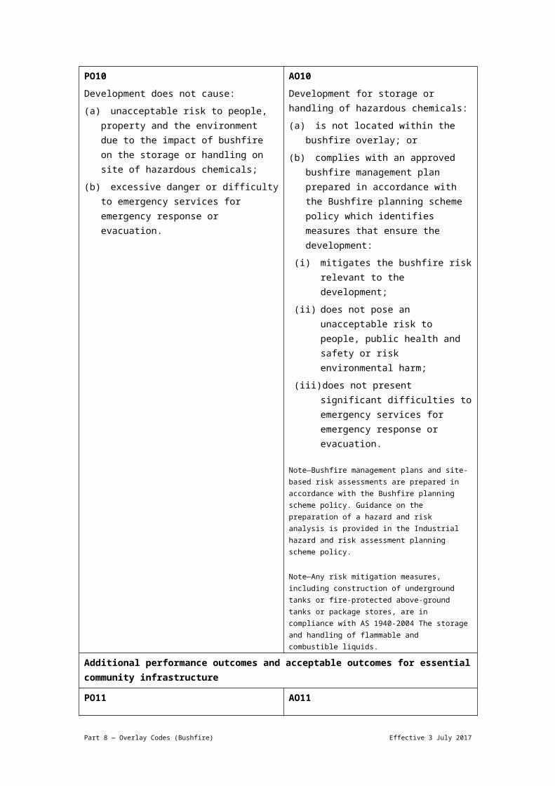
Additional performance outcomes and acceptable outcomes if involving storage or handling on site of hazardous chemicals in quantities that would be equivalent to or exceed the threshold quantities set out in Table 8.2.5.3.D
PO10Development does not cause:
(a) unacceptable risk to people, property and the environment due to the impact of bushfire on the storage or handling on site of hazardous chemicals;
(b) excessive danger or difficulty to emergency services for emergency response or evacuation.
AO10Development for storage or handling of hazardous chemicals:
(a) is not located within the bushfire overlay; or
(b) complies with an approved bushfire management plan prepared in accordance with the Bushfire planning scheme policy which identifies measures that ensure the development:
(i) mitigates the bushfire risk relevant to the development;
(ii) does not pose an unacceptable risk to people, public health and safety or risk environmental harm;
(iii) does not present significant difficulties to emergency services for emergency response or evacuation.
Note—Bushfire management plans and site-based risk assessments are prepared in accordance with the Bushfire planning scheme policy. Guidance on the preparation of a hazard and risk analysis is provided in the Industrial hazard and risk assessment planning scheme policy.
Note—Any risk mitigation measures, including construction of underground tanks or fire-protected above-ground tanks or package stores, are in compliance with AS 1940-2004 The storage and handling of flammable and combustible liquids.
Additional performance outcomes and acceptable outcomes for essential community infrastructure
PO11 AO11
Part 8 — Overlay Codes (Bushfire) Effective 3 July 2017

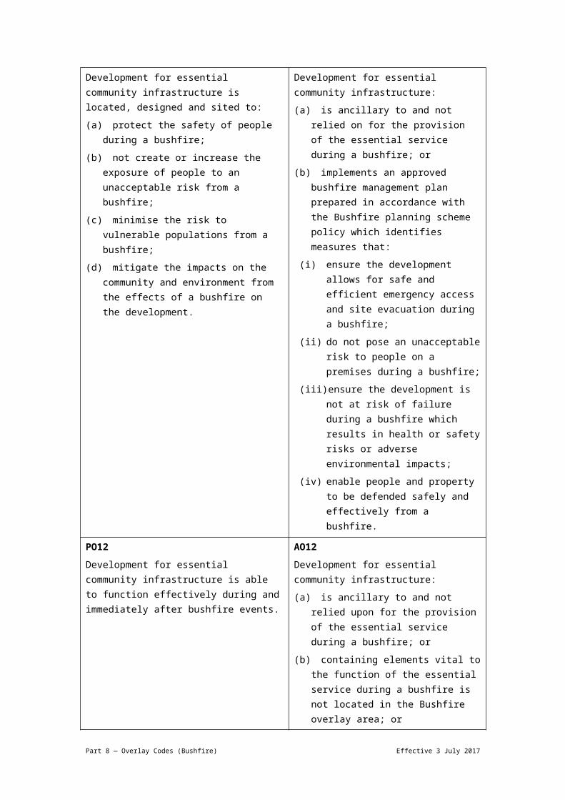
Development for essential community infrastructure is located, designed and sited to:
(a) protect the safety of people during a bushfire;
(b) not create or increase the exposure of people to an unacceptable risk from a bushfire;
(c) minimise the risk to vulnerable populations from a bushfire;
(d) mitigate the impacts on the community and environment from the effects of a bushfire on the development.
Development for essential community infrastructure:
(a) is ancillary to and not relied on for the provision of the essential service during a bushfire; or
(b) implements an approved bushfire management plan prepared in accordance with the Bushfire planning scheme policy which identifies measures that:
(i) ensure the development allows for safe and efficient emergency access and site evacuation during a bushfire;
(ii) do not pose an unacceptable risk to people on a premises during a bushfire;
(iii) ensure the development is not at risk of failure during a bushfire which results in health or safety risks or adverse environmental impacts;
(iv) enable people and property to be defended safely and effectively from a bushfire.
PO12Development for essential community infrastructure is able to function effectively during and immediately after bushfire events.
AO12Development for essential community infrastructure:
(a) is ancillary to and not relied upon for the provision of the essential service during a bushfire; or
(b) containing elements vital to the function of the essential service during a bushfire is not located in the Bushfire overlay area; or
(c) implements an approved bushfire management plan prepared in accordance with the Bushfire planning scheme policy which identifies measures that ensure that:
(i) essential community infrastructure is able to function during bushfire events;
(ii) access necessary to maintain safety or function of the development is not compromised by a bushfire;
(iii) mitigation measures are not unduly reliant on human activation to respond to a bushfire;
Part 8 — Overlay Codes (Bushfire) Effective 3 July 2017

(iv) the safe storage of valuable records or items of cultural or historical significance, including storage of public records under the Public Records Act 2002, is able to be maintained during a bushfire event.
Additional performance outcomes and acceptable outcomes if for landscaping or a park landscape plan is a requirement for development
PO13Development provides landscaping that does not create an unacceptable risk to people or property and provides for ongoing management of risk to the development and people from a bushfire.
AO13Development is in compliance with a landscaping plan which:
(a) is prepared in compliance with an approved bushfire management plan;
(b) preserves the requirements of any building protection zone;
(c) does not increase the exposure of a habitable building not located in a building protection zone to a bushfire hazard.
Note—The requirements of a building protection zone are shown in Figure b and Figure c.
PO14Development for a park is designed so that the park:
(a) is practical to maintain and requires minimal resources to be restored to its designed function and condition after a bushfire;
(b) provides for safe and efficient site evacuation and efficient emergency services access avoiding potential for entrapment during a bushfire;
(c) does not place unacceptable bushfire risk on an adjoining or nearby site, people and assets;
(d) provides efficient access for fire fighting;
(e) provides ongoing protection from bushfire for major park assets and buildings.
Note—A bushfire management plan prepared in accordance with the Bushfire planning scheme policy can assist in demonstrating compliance with this performance outcome.
AO14Development provides a park landscape plan that complies with a bushfire management plan prepared in accordance with the Bushfire planning scheme policy.
Section C—If for reconfiguring a lot
Note—The following performance outcomes and acceptable outcomes only apply to the following categories of reconfiguring a lot:
Part 8 — Overlay Codes (Bushfire) Effective 3 July 2017

Rural: Reconfiguring a lot in a non-urban setting.
Urban (7 or more lots): Reconfiguring a lot in an urban or emerging community area which creates 7 or more lots, or involves the opening of a new road.
Urban (fewer than 7 lots): Reconfiguring a lot in urban areas which creates 6 or fewer new lots and does not involve the opening of a new road.
PO15Development addresses the bushfire hazard determined by a site-specific bushfire hazard assessment.
Note—Bushfire hazard is assessed based on the vegetation existing on site, adjacent and nearby to the site at the time of application, except where reconfiguring a lot, when the level of bushfire hazard posed by any areas subject to revegetation is assessed as if that area had reached its mature state.
AO15Development addresses the level of bushfire hazard identified in a site-specific bushfire hazard assessment undertaken in accordance with the Bushfire planning scheme policy, which confirms the level of bushfire hazard for the part of the site in which development is proposed, and the location of hazardous vegetation posing a risk to the development in a bushfire.
Note—Where a bushfire hazard assessment determines that the bushfire hazard for the part of the site in which development is proposed is ‘low’, no further assessment against this code is required.
PO16Development does not materially increase the number of premises exposed to unacceptable risk during bushfire events.
AO16Development does not materially increase the number of people living or working in the Bushfire overlay area.
PO17Development is designed to:
(a) mitigate the risk of bushfire hazard to each lot;
(b) limit the spread of bushfire within the reconfiguration;
(c) achieve and maintain sufficient separation distance between development and hazardous vegetation to minimise bushfire hazard to future buildings during a bushfire;
(d) allow for emergency services access.
(e) locate buildings within a building protection zone
Note—Lot size, location, configuration, dimensions and building measures are balanced to achieve an acceptable level of risk to future occupants.
Note—A bushfire management plan prepared in accordance with the Bushfire planning scheme policy can assist in demonstrating compliance with this performance outcome.
AO17.1Development requires that lot number, size, shape and layout allow for the siting of future buildings within the lowest hazard locations on the site being located:
(a) within a building protection zone in accordance with Figure b and Figure c;
(b) to achieve separation distances between the development and hazardous vegetation of at least 1.5 times the predominant mature tree canopy height;
(c) away from ridgelines and hilltop sites in compliance with Figure a;
(d) on land with a gradient less than 15%;
(e) preferably on east to south facing slopes and avoiding north to west facing slopes unless the slope is clear of vegetation and is not located in the High hazard buffers sub-category or Medium hazard sub-category.
AO17.2Development ensures that the bushfire attack level of the nominated development
Part 8 — Overlay Codes (Bushfire) Effective 3 July 2017
footprint plan does not exceed:
(a) in a rural category, bushfire attack level 19 (calculated in accordance with AS 3959-2009 Construction of buildings in bushfire-prone areas);
(b) in an urban category, bushfire attack level 12.5 (calculated in accordance with AS 3959-2009 Construction of buildings in bushfire-prone areas).
PO18Development promotes safe site access, avoids creating a potential entrapment situation and supports accessibility and manoeuvring for fire fighting during bushfires.
Note—This includes easements and boundary realignments.
Note—A bushfire management plan prepared in accordance with the Bushfire planning scheme policy can assist in demonstrating compliance with this performance outcome.
AO18Development provides a lot layout which:
(a) provides direct road access and egress for new lots to public roads, rather than the creation of easements;
(b) in an urban category, avoids creating a new lot less than or equal to 2,500m2 which directly adjoins hazardous vegetation;
(c) in an urban category, locates a future building protection zone to avoid a driveway of longer than 70m from the road frontage to a habitable building;
(d) in a rural category, provides for an alternative access where the private access roads or driveways are longer than 200m to reach a public road.
PO19Development ensures that the road layout and design provides:
(a) efficient emergency services access to sites and manoeuvring within the subdivision;
(b) safe and efficient movement of residents, workers and visitors out of the subdivision and away from an approaching bushfire;
(c) safe and efficient movement of emergency services into the subdivision;
(d) alternative egress routes considering the most likely bushfire scenarios;
(e) ongoing availability and maintenance of access and egress routes for the purposes of evacuation and emergency services access.
Note—A bushfire management plan prepared in accordance with the Bushfire planning scheme policy can assist in demonstrating compliance with this performance outcome.
AO19.1Development involving a new road or fire maintenance trail is designed and constructed in compliance with:
(a) Table 8.2.5.3.C; or
(b) an approved bushfire management plan.
AO19.2Development has a road layout and design which:
(a) provides for alternative access routes to the subdivision, by public roads that meet the requirements in Table 8.2.5.3.C and are able to access the arterial road network;
(b) excludes cul-de-sacs, except where a perimeter road with a cleared width of 20m isolates the development from hazardous vegetation;
(c) does not include dead-end roads or if a dead-end road is unavoidable, it is a maximum of 60m long, or 200m where
Part 8 — Overlay Codes (Bushfire) Effective 3 July 2017
located in the Environmental management zone, Conservation zone, Rural zone, or Rural residential zone, and an alternative emergency evacuation and egress route away from the most likely source of bushfire risk is provided for lots where multiple road access or exit points are not possible;
(d) links road within the subdivision to, or provides for future links to roads in adjacent subdivisions.
Note—Where staged development occurs or development is in accordance with an approved master plan, a temporary perimeter road may be considered, subject to availability of reticulated water supply.
PO20Development involving new premises provides adequate infrastructure to support fire fighting.
AO20.1Development involving new premises ensures that:
(a) lots have access to reticulated water supply and water pressure available for fire-fighting requirements with water supply and pressure that accord with the standards specified by the relevant utilities provider; or
(b) where reticulated water supply is not available for:
(i) residential lots, there is a minimum water supply available and retained for fire-fighting purposes in compliance with Table 8.2.5.3.B, which may be in the form of a separate tank or a reserve section as part of a main water supply tank;
(ii) development other than residential lots, onsite water storage is provided which is appropriate to the proposed future use according to the standards specified by the relevant emergency services agency and is not less than 5,000L.
Note—Water supply for fire-fighting is in addition to water supply for household use. Where a non-reticulated supply of water is required, swimming pools, creeks and dams should not be used as a substitute for a dedicated static supply as these sources of water are not reliable during drought conditions.
AO20.2Development provides fire hydrants in accordance with Central SEQ Distributor-Retailer Authority, Queensland Urban
Part 8 — Overlay Codes (Bushfire) Effective 3 July 2017

Utilities (incorporating Water Services Association of Australia) Standards.
Table 8.2.5.3.B—Dedicated water supply requirements for residential lots without access to reticulated water supplyDevelopment type Water requirement
Lot less than 1,000m2 5,000L per lot
Residential lot between 1,000m2 and 9,999m2
10,000L per lot
Residential lot greater than 1ha 20,000L per lot
Multiple dwelling 5,000L per unit up to a maximum of 20,000L
Table 8.2.5.3.C—Road design requirements for emergency vehicle accessItem Requirements Public road Private access
roads or driveways
Fire maintenance trails
1 Horizontal clearance
6m total: minimum carriage way width of 4m with additional 1m wide strip on each side (clear of bushes and long grass)
Note—Roads should provide sufficient width to allow fire-fighting vehicle crews to work around the vehicle with fire-fighting equipment.
A minimum formed width of 4m.
Note—Gates must also provide for this clearance.
A minimum clearance width of 6m.
A minimum formed width of 4m.
2 Vertical clearance
Minimum vertical clearance of 4m to any overhanging obstructions including tree branches.
Minimum vertical clearance of 4m to any overhanging obstructions including tree branches.
5m clearance to all powerlines
3 Vegetation clearing
Maintained cleared vegetation 10m on either side of centre-line
Maintained cleared vegetation with minimum 6m cleared width
4 Maximum grade
Maximum gradient of 12.5%
A maximum gradient of 12.5% where exceeding a distance of 70m from the road
A maximum gradient of 12.5% with adequate drainage to prevent soil erosion and minimise ongoing trail maintenance
5 Cross fall Cross fall does not exceed 10 degrees
— —
6 Surface rating Minimum 15t rated surface for urban appliances, which do not operate on unsealed roads or trails;
Minimum 6.5t rating for rural fire-fighting appliances.
7 Pavement type All weather
Part 8 — Overlay Codes (Bushfire) Effective 3 July 2017

8 Turning For both public and private roads and fire maintenance trails:
6m inner radius
12m outer radius
9 Access, passing and reversing
Reversing bays using the access to properties to reverse fire tankers, which are 6m wide and 8m deep to any gates, meeting above turning requirements; and/or
A passing bay every 200m, 20m long by 3m wide, making a minimum trafficable width of 7m at the passing bay.
Note—Some short constrictions in the access may be accepted where they are not less than the minimum 3.5m and extend for no more than 30m and where obstruction cannot be reasonably avoided or removed.
Fire maintenance trails provide areas for vehicles to pass or turn at intervals of not more than 400m with a maximum grade of 5%.
Fire maintenance trails have vehicular access at each end.
Fire maintenance trails are either located on public land or within an access easement that is granted in favour of Brisbane City Council and Queensland Fire and Rescue Service.
Note—Urban appliances do not operate on unsealed roads or trails. Urban appliances require 15 tonne rated surfaces. Rural appliances are typically 6.5t Gross Vehicle Mass (GVM)(4x4)
Table 8.2.5.3.D—Threshold quantities for hazardous chemicalsItem Description of hazardous chemical Threshold
quantity
1 Flammable gases Category 1 5,000L
2 Gases under pressure With acute toxicity, categories 1, 2, 3 or 4
500L
3 With skin corrosion categories 1A, 1B or 1C
500L
4 Aerosols 10,000L
5 Not stated elsewhere in this table 10,000L
6 Flammable liquids Category 1 500L
7 Category 2 2,500L
8 Category 3 10,000L
9 Any combination of chemicals from items 6 to 8 where none of the items exceeds the threshold quantities on their own
10,000L
10 Category 4 100,000L
11 Self-reactive substances
Type A 50kg or 50L
Part 8 — Overlay Codes (Bushfire) Effective 3 July 2017

12 Type B 500kg or 500L
13 Type C to F 2,500kg or 2,500L
14 Flammable solids Category 1 2,500kg
15 Category 2 10,000kg
16 Any combination of chemicals from items 12 to 15 where none of the items exceeds the threshold quantities on their own
10,000kg or 10,000L
17 Pyrophoric liquids and pyrophoric solids
Category 1 500kg or 500L
18 Self-heating substances and mixtures
Category 1 2,500kg or 2,500L
19 Category 2 10,000kg or 10,000L
20 Any combination of chemicals from items 17 to 19 where none of the items exceeds the threshold quantities on their own
10,000kg or 10,000L
21 Substances which in contact with water emit flammable gas
Category 1 500kg or 500L
22 Category 2 2,500kg or 2,500L
23 Category 3 10,000kg or 10,000L
24 Any combination of chemicals from items 21 to 23 where none of the items exceeds the threshold quantities on their own
10,000kg or 10,000L
25 Oxidising liquids and oxidising solids
Category 1 500kg or 500L
26 Category 2 2,500kg or 2,500L
27 Category 3 10,000kg or 10,000L
28 Any combination of chemicals from items 25 to 27 where none of the items exceeds the threshold quantities on their own
10,000kg or 10,000L
29 Organic peroxides Type A 50kg or 50L
30 Type B 500kg or 500L
Part 8 — Overlay Codes (Bushfire) Effective 3 July 2017

31 Type C to F 2,500kg or 2,500L
32 Any combination of chemicals from items 30 and 31 where none of the items exceeds the threshold quantities on their own
10,000kg or 10,000L
33 Acute toxicity Category 1 500kg or 500L
34 Category 2 2,500kg or 2,500L
35 Category 3 10,000kg or 10,000L
36 Any combination of chemicals from items 33 to 35 where none of the items exceeds the threshold quantities on their own
10,000kg or 10,000L
37 Skin corrosion Category 1A 500kg or 500L
38 Category 1B 2,500kg or 2,500L
39 Category 1C 10,000kg or 10,000L
40 Corrosive to metals Category 1 10,000kg or 10,000L
41 Any combination of chemicals from items 37 to 40 where none of the items exceeds the threshold quantities on their own
10,000kg or 10,000L
Notes—
In item 2, gases under pressure with acute toxicity, category 4, only applies up to a LC50 of 5000ppmv. This is equivalent to dangerous goods of Division 2.3 as defined in the Australian code for the transport of dangerous goods by road and rail.
Item 4 includes flammable aerosols.
If a flammable liquid category 4 is used, handled or stored in the same spill compound as 1 or more flammable liquids of categories 1, 2 or 3, the total quantity of flammable liquids categories 1, 2 or 3 must be determined as if the flammable liquid category 4 had the same classification as the flammable liquid in the spill compound with the lowest flash point. Example: For placarding and manifest purposes, a spill compound containing 1000L of flammable liquid category 1 and 1000L of flammable liquid category 4 is considered to contain 2000L of flammable liquid category.
Part 8 — Overlay Codes (Bushfire) Effective 3 July 2017
Part 8 — Overlay Codes (Bushfire) Effective 3 July 2017

Note—Building Protection Zone (minimum 20m):
The building protection zone may contain roads, bushfire management trails, cleared road verges, and on a site less than or equal to 2,500m2 the building protection zone on a neighbouring site where the land use is compatible. The building protection zone includes all buildings and ancillary structures. Trees should be at least their mature canopy height away from buildings and not overhang the roof.
Inner 10m—Very low fuel area:
The inner 10m of the building protection zone directly adjacent to any building or structure is kept free of litter and may be paved or concreted, gravel or lawn. This zone prevents continuity of fuel such as shrubs, leaf litter build up, extending to the building. Trees are retained or planted as individual specimens and are a distance equal to their mature canopy height away from buildings. Trees do not overhang buildings.
Outer 10m—Reduced fuel area:
The outer 10m of the building protection zone may contain shrubs where not under trees, and trees may be retained or planted where spaced to avoid a continuous canopy across or into a site. This area is designed to reduce bushfire intensity, shield buildings from radiant heat, and prevent flames transferring from ground fuels to the canopy of trees. Trees are retained or planted sparsely or in small clumps to avoid providing a continuous canopy towards the building. Shrubs are not planted beneath trees as these act as a ‘fuel ladder’ to the tree canopy. Trees maintain a minimum of a distance equal to their mature canopy height away from buildings, and do not overhang buildings.
Part 8 — Overlay Codes (Bushfire) Effective 3 July 2017