forest management guide for conserving biodiversity at the ... · omnr. 2010. forest management...
TRANSCRIPT

Forest Management Guide for Conserving Biodiversity at the Stand and Site Scales 2010 Cette publication spécialisée n’est disponible qu’en anglais en vertu du Règlement 411/97, qui en exempte l’application de la Loi sur les services en français.

Forest Management Guide for Conserving Biodiversity at the Stand and Site Scales
ii
2010, Queen’s Printer for Ontario Printed in Ontario, Canada Current publications of the Ontario Ministry of Natural Resources and price lists are available from this office. Natural Resources Information Centre: 300 Water Street P.O. Box 7000 Peterborough, ON K9J 8M5 1-800-667-1940 Telephone inquiries about ministry programs and services should be directed to the Service Ontario Contact Centre: General Inquiry 1-800-667-1940 Renseignements en Francais 1-800-667-1840 FAX (705) 755-1677 www.publications.serviceontario.ca Other government publications are available from: Publications Ontario, Main Floor, 777 Bay St., Toronto Visit the Ontario’s Forests website at: http://ontario.ca/forests Visit the Ontario Ministry of Natural Resources website at: http://ontario.ca/mnr Cover photos provide by: Claude Thibeault, MNR (Dryden District Office), Daryl Coulson, Rob MacGregor and Nicki Butala, and Lyn Thompson. How to cite this manual: OMNR. 2010. Forest Management Guide for Conserving Biodiversity at the Stand and Site Scales. Toronto: Queen’s Printer for Ontario. 211 pp. ISBN 978-1-4435-3268-6 Print “Imprimer” ISBN 978-1-4435-3269-3 Portable Document Format (PDF)

Forest Management Guide for Conserving Biodiversity at the Stand and Site Scales
iii
Dedication This publication is dedicated to all past and present members of the Provincial Forest Technical Committee for their knowledgeable and constructive input and enthusiastic support and encouragement during all stages of the development of the Landscape and Stand & Site Guides, as well as numerous other forest management guides developed since the Committee’s inception in 1995.

Forest Management Guide for Conserving Biodiversity at the Stand and Site Scales
iv
Table of Contents List of Figures .................................................................................................................................. vi List of Tables .................................................................................................................................. vii Acknowledgements ......................................................................................................................... ix Executive Summary .......................................................................................................................... x 1.0 INTRODUCTION ....................................................................................................................... 1
1.1 Purpose of the Stand and Site Guide .................................................................................... 1 1.2 Content of the Stand and Site Guide ..................................................................................... 1
1.2.1 Organization ................................................................................................................ 1 1.2.2 Definitions – standards, guidelines, and best management practices ........................ 2
1.3 Conserving Forest Biodiversity .............................................................................................. 3 1.3.1 The coarse and fine filters ........................................................................................... 3 1.3.2 Learning from the past and preparing for the future .................................................... 5
1.4 Legislative and Policy Context ............................................................................................... 5 1.5 Pilot Testing ........................................................................................................................... 7 1.6 Socio-Economic Impact Analysis ........................................................................................... 8 1.7 Ministry of Natural Resources’ Statement of Environmental Values ..................................... 9
2.0 INTEGRATION AND IMPLEMENTATION .............................................................................. 10
2.1 Integration ............................................................................................................................ 10 2.2 Implementation .................................................................................................................... 10 2.3 Previous Guides Replaced by the Stand and Site Guide .................................................... 11
3.0 CONSERVING BIODIVERSITY - Management at the stand, multi-stand, and meso-landscape
scales ..................................................................................................................................... 12 3.1 Introduction and Linkage to Landscape-level Direction ....................................................... 12 3.2 Applying the Coarse Filter .................................................................................................... 13
3.2.1 Composition ............................................................................................................... 13 3.2.2 Pattern ....................................................................................................................... 14 3.2.3 Structure .................................................................................................................... 19
3.3 Fine Filter Adjustments ........................................................................................................ 25 3.3.1 Marten and pileated woodpecker .............................................................................. 25 3.3.2 Wolverine ................................................................................................................... 26 3.3.3 White-tailed deer ........................................................................................................ 26 3.3.4 Moose ........................................................................................................................ 29 3.3.5 Other species ............................................................................................................. 33
4.0 CONSERVING BIODIVERSITY - Management of Site-specific Habitats ............................... 35
4.1 Maintaining Ecological Functions of Aquatic and Wetland Ecosystems and Shoreline Forest Including Habitat Suitability and Productive Capacity ........................................................ 36 4.1.1 Standing waters: lakes and ponds ............................................................................. 37 4.1.2 Flowing waters: rivers and streams ........................................................................... 47 4.1.3 Wetlands .................................................................................................................... 55
4.2 Special Habitat Features ...................................................................................................... 61 4.2.1 Groundwater recharge areas associated with brook trout spawning sites ................ 61 4.2.2 Bird nest sites ............................................................................................................ 62 4.2.3 Beaver habitat ............................................................................................................ 90 4.2.4 Moose aquatic feeding areas and mineral licks ........................................................ 91 4.2.5 Dens........................................................................................................................... 93 4.2.6 Bat hibernacula .......................................................................................................... 98
4.3 Protection of Species at Risk ............................................................................................. 100 4.3.1 Non-woody plants .................................................................................................... 102 4.3.2 Woody plants ........................................................................................................... 108

Forest Management Guide for Conserving Biodiversity at the Stand and Site Scales
v
4.3.3 Invertebrates ............................................................................................................ 110 4.3.4 Fish .......................................................................................................................... 111 4.3.5 Amphibians and reptiles .......................................................................................... 112 4.3.6 Birds ......................................................................................................................... 121 4.3.7 Mammals ................................................................................................................. 126
5.0 OPERATIONAL CONSIDERATIONS ................................................................................... 130
5.1 Roads and Water Crossings .............................................................................................. 130 5.1.1 Roads....................................................................................................................... 130 5.1.2 Water crossings ....................................................................................................... 136
5.2 Soil and Water Conservation ............................................................................................. 145 5.2.1 Rutting and compaction ........................................................................................... 148 5.2.2 Erosion ..................................................................................................................... 152 5.2.3 Nutrient loss ............................................................................................................. 154 5.2.4 Loss of productive land ............................................................................................ 156 5.2.5 Hydrological impacts ................................................................................................ 157
5.3 Spread of Invasive Species ............................................................................................... 159 6.0 SALVAGE AND BIOFIBRE HARVEST ................................................................................. 160
6.1 Salvage Harvest ................................................................................................................. 160 6.2 Biofibre Harvest ................................................................................................................. 161
7.0 EFFECTIVENESS MONITORING......................................................................................... 162
7.1 Effectiveness Monitoring Principles ................................................................................... 162 7.2 What to Evaluate – Identifying Key Uncertainties .............................................................. 165 7.3 Delivering Effectiveness Monitoring: Acquiring New Knowledge ...................................... 168
LITERATURE CITED .................................................................................................................. 170 APPENDICES .............................................................................................................................. 171
Appendix 1a – Contributors ..................................................................................................... 172 Appendix 1b – Scientific names of species mentioned in the Stand & Site Guide .................. 177 Appendix 3.2a – Example of the implementation of the 5 ha patch size requirement in Section
3.2.2.2. .............................................................................................................................. 181 Appendix 3.2b – Graphical examples of post-harvest stand structure created by application of
the wildlife tree direction in Section 3.2.3.1. (Tables 3.2d, 3.2e, 3.2f) .............................. 182 Appendix 3.3 – Stand level direction for .................................................................................. 189 Appendix 4.2 – Assessing the potential impact of forest management operations on nesting
birds. ................................................................................................................................. 192 Appendix 5.2a – Measuring ruts .............................................................................................. 194 Appendix 5.2b – Site disturbance susceptibility tables ............................................................ 196 Appendix 5.2c – Suggested strategies and techniques to minimize site disturbance during
harvest, renewal, and tending operations ......................................................................... 198 Background and Rationale for Direction ...................................................................................... 202 GLOSSARY ................................................................................................................................. 203

Forest Management Guide for Conserving Biodiversity at the Stand and Site Scales
vi
List of Figures Figure 1a. A conceptual model showing the relationship between coarse and fine filters in habitat management. ................................................................................................................. 4 Figure 3.2a. Conceptual portrayal of acceptable and unacceptable sub-stand patterns associated with residual forest. ................................................................................................... 16 Figure 3.3a. Deer Winter Concentration Area. ............................................................................ 27 Figure 4.1a. Layout of areas of concern (AOC) and 15 m no rut or significant mineral soil exposure zones around lakes, ponds, and streams. ................................................................... 45 Figure 4.1b. Selecting shoreline forest for retention as residual. ................................................ 46 Figure 4.1c. Examples of shoreline forest retention around streams. ......................................... 54 Figure 4.2a. Typical layout of the AOC around primary, alternate, and inactive bald eagle nests in a boreal forest management unit ................................................................. 72 Figure 5.1a. Typical slope grades used to stabilize erosion. .................................................... 131 Figure 5.1b. Fitting a culvert to the creek alignment to minimize change in stream morphology. ............................................................................................................................... 139 Figure 5.1c. An example of how a perched culvert can be corrected to allow fish passage..... 140 Figure 5.1d. An example of a temporary winter snowfill crossing. ............................................ 141 Figure 5.1e. Typical features of a ford. ...................................................................................... 144 Figure 5.1f. A depression beside the culvert allows water to spill over the road in the event of a flood or culvert blockage. .................................................................................................... 145 Figure 5.2a. Stylized overview depicting hypothetical areas susceptible to various forms of site disturbance resulting from forest management operations. ............................................... 146 Figure 5.2b. Graphical representation of a rut. .......................................................................... 148 Figure 5.2c. Susceptible sites like this wet organic soil are normally harvested while the ground is frozen or using high floatation equipment to avoid rutting. ........................................ 151 Figure 5.2d. Example of a topographic index map used to predict relative wetness. ............... 151 Figure 5.2e. Large areas of ’blow sand’ can be difficult to stabilize and regenerate once exposed. .................................................................................................................................... 152 Figure 5.2f. Rehabilitating main skid trails by stabilizing crossings, installing water bars on slopes, and other means can reduce the risk of future erosion. ............................................... 154 Figure 5.2g. Shallow soil site with potentially limited nutrient capital. ....................................... 155 Figure 5.2h. A cut-to-length harvester can be used to de-limb and slash trees at the stump to avoid moving nutrients associated with unutilized fibre to roadside...................................... 156 Figure 5.2i. Unutilized woody material that accumulates at roadside can be piled (and burned) to maximize the area available for regeneration. ......................................................... 157 Figure 5.2j. Using machinery with low ground pressure options, such as these high floatation tires, can help to minimize damage and may expand the range of sites on which operations can occur in unfrozen conditions. ............................................................................ 159 Figure 7.1a. Components of the guide development process. .................................................. 163

Forest Management Guide for Conserving Biodiversity at the Stand and Site Scales
vii
List of Tables Table 3.2a Standards, guidelines, and best management practices – composition. .................. 13 Table 3.2b. Quantifiable definition of residual forest. .................................................................. 15 Table 3.2c Standards, guidelines, and best management practices – coarse filter pattern. ...... 17 Table 3.2d Standards, guidelines, and best management practices – wildlife tree retention in areas of clearcut silviculture. ................................................................................................... 20 Table 3.2e Standards, guidelines, and best management practices – wildlife tree retention in areas of selection harvest and shelterwood preparatory and regeneration harvest. .............. 22 Table 3.2f Standards, guidelines, and best management practices – wildlife tree retention in areas of shelterwood removal harvest and white/red pine seed tree harvest. ........................ 23 Table 3.2g Standards, guidelines, and best management practices – downed woody material. ....................................................................................................................................... 24 Table 3.3a Standards, guidelines, and best management practices – white tailed deer emphasis areas. .......................................................................................................................... 27 Table 3.3b Standards, guidelines, and best management practices – moose emphasis areas. ........................................................................................................................................... 30 Table 4.1a. Standards, guidelines, and best management practices for lakes and ponds and associated shoreline forest. .................................................................................................. 39 Table 4.1b. Standards, guidelines, and best management practices for rivers, streams, and associated shoreline forest. .................................................................................................. 48 Table 4.1c. Standards, guidelines, and best management practices for provincially significant wetlands, rich lowland hardwood-dominated forest, mapped permanent non-forested wetlands, and woodland pools. .............................................................................. 56 Table 4.2a. Standards and guidelines for recharge areas associated with brook trout spawning sites. ............................................................................................................................ 62 Table 4.2b. Standards and guidelines for bald eagle and osprey nest sites. .............................. 64 Table 4.2c. Standards and guidelines for nest sites of colonial birds. ........................................ 73 Table 4.2d. Standards and guidelines for uncommon stick-nesting bird nest sites. ................... 77 Table 4.2e. Standards and guidelines for common stick-nesting bird nest sites and unknown stick nests. ................................................................................................................... 82 Table 4.2f. Standards, guidelines, and best management practices for cavities used by nesting raptors or nesting/ communally-roosting chimney swifts. ............................................... 85 Table 4.2g. Standards and guidelines for ground-nesting raptor nest sites. ............................... 87 Table 4.2h. Standards, guidelines, and best management practices for known bird nests containing eggs or young encountered during forest management operations that are not covered by direction in Sections 4.2.2.1 to 4.2.2.7...................................................................... 89 Table 4.2i. Guidelines and best management practices for beaver ponds and beaver meadows requiring special management to regenerate food supply. ......................................... 91 Table 4.2j. Standards, guidelines, and best management practices for moose aquatic feeding areas and mineral licks. .................................................................................................. 92 Table 4.2k. Standards, guidelines, and best management practices for den sites of black bears, grey foxes, cougars, wolves, and other furbearing mammals. ......................................... 94 Table 4.2l. Standards and guidelines for known bat hibernacula. ............................................... 99 Table 4.3a. Standards and guidelines for the flooded jellyskin, Ogden’s pondweed, American ginseng, broad beech fern, natural grassland plant communities, Atlantic coastal plain plant communities, and shorelines or wetlands supporting plants that are species at risk. .............................................................................................................................................. 103 Table 4.3b. Standards, guidelines, and best management practices for the butternut. .............. 109 Table 4.3c. Standards and guidelines for the West Virginia white. ............................................. 111 Table 4.3d. Standards and guidelines for hibernacula and gestation/oviposition sites of the eastern foxsnake, eastern hog-nosed snake, eastern ratsnake, eastern ribbonsnake, massasauga, and milksnake. ...................................................................................................... 113 Table 4.3e. Standards, guidelines and best management practices for the Blanding’s turtle, northern map turtle, spiny softshell, spotted turtle, and eastern musk turtle turtle. ..................... 117

Forest Management Guide for Conserving Biodiversity at the Stand and Site Scales
viii
Table 4.3f. Standards and guidelines for the cerulean warbler, Kirtland’s warbler, Louisiana waterthrush, red-headed woodpecker, black tern, golden-winged warbler, least bittern, and yellow rail. .................................................................................................................................... 122 Table 4.3g. Standards and guidelines for den sites of the wolverine. ......................................... 127 Table 4.3h. Standards and guidelines for traditional rendezvous sites of the eastern wolf. ....... 128 Table 5.1a. Standards, guidelines, and best management practices for the planning, construction, and maintenance of roads outside areas of concern. ............................................ 131 Table 5.1b. Standards, guidelines, and best management practices for the planning, construction, and maintenance of roads outside areas of concern. ............................................ 133 Table 5.1c. Standards, guidelines, and best management practices for decommissioning of roads. ....................................................................................................................................... 134 Table 5.1d. Standards, guidelines, and best management practices for the design and location of water crossings. ......................................................................................................... 136 Table 5.1e. Standards, guidelines, and best management practices for the installation and maintenance of water crossings. ................................................................................................. 136 Table 5.1f Timing restrictions for in-water work to protect fish and fish habitat. ......................... 142 Table 5.1g. Standards, guidelines, and best management practices for the decommissioning and rehabilitation of water crossings. .......................................................................................... 142 Table 5.2a. Standards and guidelines identifying when direction in Section 5.2 applies.. .......... 146 Table 5.2b. Definition of terms associated with site disturbance.. .............................................. 147 Table 5.2c. Standards, guidelines, and best management practices - rutting and compaction. ................................................................................................................................. 148 Table 5.2d. Standards, guidelines, and best management practices – erosion. ........................ 152 Table 5.2e. Standards, guidelines, and best management practices – nutrient loss. ................. 155 Table 5.2f. Standards, guidelines, and best management practices – loss of productive land .............................................................................................................................................. 156 Table 5.2g. Standards, guidelines, and best management practices – hydrological impacts..... 157 Table 6.1a. Standards, guidelines, and best management practices for natural disturbance salvage. ....................................................................................................................................... 160 Table 6.2a. Standards and guidelines clarifying applicability of forest management guides and availability of various sources of fibre and organic matter from all harvest areas. ............... 161

Forest Management Guide for Conserving Biodiversity at the Stand and Site Scales
ix
Acknowledgements The Stand and Site Guide writing team was comprised of the following individuals: Mike Brienesse, MNR, FPS Joe Churcher, MNR, FPS Brian Naylor, MNR, SSI Bruce Ranta, MNR, Kenora The following individuals provided special assistance during various stages of development: Aude Fournier, MNR, FPS Brian Hillier, MNR, FPS Frank Kennedy, MNR, SIRD Rob Mackereth, MNR, CNFER Kevin Predon, MNR, FPS Dan Puddister, MNR, FPS Jim Rice, MNR, FPS Jim Saunders, MNR, FPS Sandra Wawryszyn, MNR, OFRI The following members of the Stand and Site Guide Development Team spent countless hours reviewing drafts and providing constructive advice: Cathy Cavalier, MNR, NWR Norm Cottam, MNR, SR Dan Duckert, MNR, CNFER Keith Ley, Domtar Inc. Greg Lucking, MNR, NER Peter Nitschke, Bancroft Minden Forest Co. Inc. Howard Noseworthy, Ontario Fur Managers Federation Jennifer Simard, Mushkegowuk Environmental Research Centre Matt Wilkie, Weyerhaeuser Ryan Zimmerling, Bird Studies Canada The Provincial Forest Technical Committee helped steer this project through all stages of development and provided invaluable advice and support.
Illustrations were provided by Mandy Saile (Bijou’s Whimsy) and Wayne Kestevan (Kestevan Design).
Photographs were provided by Bancroft Minden Forest Company Inc, Mike Brienesse, Mike Curran, Dan Duckert, Joe Maure, Scott McPherson, Brian Naylor, Bruce Ranta, Kandyd Szuba, and Larry Watkins.
Technical edit provided by Diana Callaghan.
Logistical support provided by Fran Paterson and Gloria Vidal.
An expanded list of contributors can be found in Appendix 1a.
To all the individuals who have contributed to the development of this guide, the writing team expresses its sincere thanks.
MNR=Ministry of Natural Resources; FPS=Forest Policy Section; SSI=Southern Science and Information Section; SIRD=Science and Information Resources Division; CNFER=Center for Northern Forest Ecosystem Research; OFRI=Ontario Forest Research Institute; NWR=Northwest Region; NER=Northeast Region; SR=Southern Region

Forest Management Guide for Conserving Biodiversity at the Stand and Site Scales
x
Executive Summary The Forest Management Guide for Conserving Biodiversity at the Stand and Site Scales (the Stand and Site Guide) is one of a series of guides used by forest managers when planning and implementing operations involving harvest, renewal, tending, or the construction and use of roads, and landings on crown land in Ontario. The overall objective of this guide is to contribute to the sustainable management of Crown forests through the maintenance of their long term health. A key aspect of this objective is the conservation of biodiversity. The Stand and Site Guide uses a combination of coarse and fine filters (with consideration for adverse impacts on other values, silvicultural limitations, and efficiency of implementation) to address the conservation of biodiversity. Coarse filters create a diversity of ecosystem conditions through space and time, based on the concept of emulating natural patterns and processes, to provide habitat for the majority of native species of plants and animals. Fine filters are applied when the ecological requirements of particular species may not be adequately addressed by coarse filters alone, or when societal and/or economic aspects of sustainable development require more or less habitat than coarse filters alone would provide. Both coarse and fine filter direction is based on a strong foundation of scientific knowledge and operational experience. The best available information was compiled from thorough review of relevant literature and discussions with experienced researchers and practitioners. This information, and how it was used in the development of the guide, is summarized in a companion document (Background and Rationale for Direction). Where information was incomplete and/or ambiguous, a conservative approach was taken through judicious application of the precautionary principle. The direction in the guide can be thought of as an informed hypothesis. Direction associated with a high degree of uncertainty is identified as a high priority for testing within an effectiveness monitoring program that is an integral part of an adaptive management framework. Direction within this document is characterized as a standard, guideline, or best management practice. Standards must be followed as written; there is no room for interpretation on the part of forest managers. Guidelines are also mandatory and must be followed, but require professional expertise and local knowledge in order to be implemented. Best management practices are not mandatory direction, but rather are examples of practices that the forest managers may wish to use to achieve objectives associated with a standard or guideline. The direction applies to a wide variety of forest management operations including harvest, renewal, tending, and access. The bulk of the direction is applied during operational planning and/or implementation with some notable linkages to strategic decision making. Sections 1 and 2 provide an introduction to the guide, an explanation of the relationship between this guide and other forest management guides, and a description of how this guide will be implemented over the coming years. Section 3 provides coarse and fine filter direction that addresses habitat composition and pattern at stand to multi-stand scales. Section 4 addresses site-specific values that require fine filter direction to mitigate potentially adverse effects of regular forest operations. Aquatic, wetland and shoreline forest values, special habitat features, and habitat for species at risk are addressed through the development of area of concern prescriptions or conditions on regular operations. Section 5 addresses the construction of access roads and water crossings, soil and water conservation, and the spread of exotic species. Section 6 provides applicable direction for salvage and biofibre harvests. Section 7 describes MNR’s approach to effectiveness monitoring.

Forest Management Guide for Conserving Biodiversity at the Stand and Site Scales
1
1.0 INTRODUCTION 1.1 Purpose of the Stand and Site Guide The Forest Management Guide for Conserving Biodiversity at the Stand and Site Scales (the Stand and Site Guide) is one of a series of forest management guides used by forest managers when planning and implementing forest management operations. In order to protect or enhance environmental, recreational, and cultural heritage values, the series of guides provides direction to assist forest managers to decide, for example, what areas of forest to harvest (and equally important, what areas not to harvest), how large the harvest areas should be, and what harvesting and regeneration practices to use. Consistent with the Crown Forest Sustainability Act, 1994, the overall objective of this guide is to contribute to the sustainable management of Crown forests through the maintenance of their long-term health. A key aspect of this objective is the conservation of biodiversity. Conservation has been defined as the preservation, maintenance, sustainable utilization, restoration, and enhancement (World Conservation Strategy 1980, as cited in MNR 1992) or the protection and/or sustainable use (Ontario Biodiversity Strategy, Anon. 2005) of biological resources. The purpose of the Stand and Site Guide is to provide direction on planning and conducting forest operations at the stand and site level (i.e., 10s of m2 to 100s of km2) so that forest biodiversity will be conserved and Ontario’s forests will remain healthy and sustainable. The Forest Management Guides for Landscapes (the Landscape Guide) provides direction on conserving biodiversity, and hence sustaining forest health, at the landscape scale (i.e. 10,000s of km2). These two guides are linked, both philosophically and literally within the text of each guide. The Landscape Guide is applied at the beginning of the forest management planning process and helps planning teams set the strategic direction for the entire forest management unit, in the context of surrounding forest management units. This strategic direction provides the background when planning teams develop operations specific to the forest management unit, through the implementation of the Stand and Site Guide. An overview of the complete set of forest management guides and their role in the sustainable management of Ontario’s forests is provided in Ontario’s Forest Management Guides: An Introduction (MNR 2006). Similar to all forest management guides, the mandate of this document is limited to Crown forests within the Area of the Undertaking (AOU) of Ontario and for any Crown forests outside the AOU for which MNR has Environmental Assessment approval to undertake forestry activities. The direction provided may also be helpful when managing other Crown forests outside of the AOU and private forest lands. 1.2 Content of the Stand and Site Guide 1.2.1 Organization Section 1 describes the organization of the guide, defines commonly used terms, describes the Ministry of Natural Resources (MNR) broad approach to the conservation of biodiversity, provides an overview of the guide’s legislative and policy context, and discusses pilot testing and a socio-economic impact analysis. Section 2 provides an explanation of the relationship between this guide and other forest management guides, and how this guide will be implemented over the coming years. Included in Section 2 is a list of the forest management guides that have been replaced by this guide.

Forest Management Guide for Conserving Biodiversity at the Stand and Site Scales
2
Section 3 serves as the link to the Landscape Guide, beginning where the Landscape Guide ends and dealing with management considerations at the stand, multi-stand, and meso-landscape scales. Specific details include consideration of coarse filters (Section 3.2) and fine filters (Section 3.3). The coarse filter direction builds on concepts introduced in the Landscape Guide, most notably, that the diversity of habitats required by a broad range of species can be produced by manipulating composition, pattern, and structure. Section 3 also describes how the coarse filter provides, or needs to be modified to provide (fine filters), habitat for species such as marten, pileated woodpecker, wolverine, white-tailed deer, moose, and other species (e.g., elk). Section 4 addresses site-specific values that require fine filter direction to mitigate potentially adverse effects of regular forest operations. This direction could require the development of an operational prescription to be implemented within an area of concern (AOC), or simply modifications to regular operations. Aquatic, wetland and shoreline forest values are addressed in Section 4.1, other special habitats (e.g., bird nests, aquatic feeding areas) are included in Section 4.2, and species at risk are discussed in Section 4.3. Section 5 discusses the construction of access roads and water crossings (Section 5.1), soil and water conservation (including rutting, soil compaction, erosion, nutrient loss, loss of productive land, and hydrological impacts) (Section 5.2), and the spread of invasive species (Section 5.3). Where recent natural disturbance areas will be harvested, Section 6.1 provides applicable direction for salvage operations. Restrictions on biofibre harvesting are addressed in Section 6.2. Section 7 discusses MNR’s approach to monitoring the effectiveness of the Stand and Site Guide, a legal requirement under MNR’s EA approval (Declaration Order MNR-71 as amended by MNR-71/2, conditions 31 and 38(f), respectively). A number of appendices provide further detail or an explanation of the concepts or directions included in Sections 3 to 6. A glossary of selected terms used in this document is included. A separate document (Background and Rationale for Direction) provides the scientific background and rationale supporting the standards, guidelines, and best management practices. This document is available in electronic format (see page 202 for details). 1.2.2 Definitions – standards, guidelines, and best management practices Direction within this guide is characterized as a standard, a guideline, or a best management practice. It is important to understand the differences between these three terms since they have different implications with respect to writing a forest management plan. standard: a component of a guide that provides mandatory direction guideline: a component of a guide that provides mandatory direction, but requires
professional judgment for it to be applied appropriately at the local level best management practice: a component of a guide that suggests a practice or strategy to
help implement the overall purpose of the standards and guidelines Standards must be followed as written; there is no room for interpretation on the part of the forest managers. Guidelines are also mandatory and must be followed, but require professional expertise and local knowledge in order to be implemented. They may be expressed as a range of values or may need to be implemented in different ways based on the site conditions or circumstances encountered. Best management practices are not mandatory direction, but rather are examples of practices that forest manager may wish to use. The list of best management practices is not intended to be exhaustive; forest managers may think of and implement other ideas or strategies. There is no requirement to use any of these best management practices, and a specific best management practice may not be applicable to local circumstances.

Forest Management Guide for Conserving Biodiversity at the Stand and Site Scales
3
In some cases, guidelines include words or phrases such as ‘normally’, ‘reasonable efforts’, and ‘extraordinary circumstances’ to reflect the authors’ appreciation that situations may be encountered when the guideline cannot be implemented exactly as written. The last two phrases are explained in the glossary. The word ‘normally’ is used to indicate that the authors believe the guideline can be applied in the vast majority of situations. These standards, guidelines and best management practices will be used by planning teams to assist them as they develop operational prescriptions specific for their management unit and circumstances. They are not necessarily intended to be copied directly from the guide into a forest management plan. 1.3 Conserving Forest Biodiversity 1.3.1 The coarse and fine filters There are hundreds of species of vertebrates in the boreal and Great Lakes-St. Lawrence forest regions of Ontario (see Holloway et al. 2004) and invertebrate species are likely to number in the tens of thousands. Thus, a species-by-species approach to the provision of wildlife habitat and the conservation of biodiversity is impossible in the context of forest management. However, this might be achieved through the hierarchical application of standards and guidelines that are judiciously selected to act as coarse and fine filters. The concept of coarse and fine filters was popularized by Hunter (1990) and is illustrated in Figure 1a. In order to manage Ontario’s forests to reflect society’s ecological, social, and economic expectations, Ontario has, over the last ten years, begun to rely on a nested coarse and fine filter approach to meet wildlife habitat needs and provide healthy forests (see Hunter 1990 and Naylor 1998). The Stand and Site Guide builds upon this approach. The coarse filter component creates a diversity of ecosystem conditions through space and time, in turn providing habitat for the majority of native species. A series of fine filters is then used, if necessary, to modify the results of applying the coarse filter. A fine filter may be required for one of two reasons: 1) the societal and/or economic aspects of sustainable development require more or less habitat than would be provided by nature, or 2) the ecological requirements of a particular species or value are not addressed or accommodated sufficiently through application of only the coarse filter, in some cases because the proposed actions cannot completely mimic natural events. The extent to which the first type of fine filter is applied will vary across the province, depending on local forest conditions and societal expectations. Both the coarse and fine filters are applied at all scales, from the landscape to the site level. In designing a coarse filter, the most desirable mix of ecosystem conditions to include must be determined. One of the principles of the CFSA provides direction on what to consider as the coarse filter (i.e., a mix based on nature), as well as what fine filters to develop.
The long term health and vigor of Crown forests should be provided for by using forest practices that, within the limits of silvicultural requirements, emulate natural disturbances and landscape patterns [coarse filter] while minimizing adverse effects on plant life, animal life, water, soil, air and social and economic values, including recreational values and heritage values [fine filters] (CFSA s. 2(3)2).
In Ontario, the emulation of natural disturbances and landscape patterns is used as the basis of the coarse filter. The many values that a forest provides, as identified in this principle (e.g., plant life, animal life, water, soil, etc.), are the topics of the series of fine filters.

Forest Management Guide for Conserving Biodiversity at the Stand and Site Scales
4
Figure 1a. A conceptual model showing the relationship between coarse and fine filters in habitat management. A coarse filter operates at a variety of spatial scales to: provide habitat for a very broad range of wildlife, to support interactions among species, and to facilitate ecosystem processes. A fine filter may be required for species whose needs are not captured by the coarse filter. Biodiversity is most likely to be conserved by hierarchical application of both filters on the landscape. (Figure by K. Szuba, reproduced from MNR 2001)
The predominant natural disturbance in Ontario’s boreal forest is wildfire, while a combination of fire, wind, and insect outbreaks play a role in the development of the Great Lakes – St. Lawrence forest region. In the Landscape Guide, Ontario’s forest landscape is designed through application of the coarse filter by addressing three key prescriptive indicators: pattern, composition, and structure. At this scale, only a few fine filters are applied to provide for or evaluate the landscape-scale habitat requirements of one or more species such as woodland caribou, white-tailed deer, moose, marten, and pileated woodpecker. While the direction in the Stand and Site Guide is also based on the emulation of natural disturbances as the coarse filter, it contains many more fine filters that are used at the stand and site scales to address the forest conditions and habitat needs of a number of species as expected by society and directed by the CFSA. The fine filter direction in this guide primarily addresses the habitat needs of individual species. This is not to suggest that habitat is the predominant or only limiting factor for these species. For instance, the guide also includes timing restrictions intended to minimize disturbance of animals during key phases of their life cycle. Other programs within MNR address other factors that may influence the health and size of wildlife populations. Further, not all species require a fine filter to ensure their continued existence. For example, based on recent research, it is believed that southern flying squirrel habitat (mature tolerant hardwood forests) can be maintained by application of the coarse filter at the landscape scale. Applying the stand-scale coarse filter provides a sufficient quantity of cavity trees and mast trees without any further species-specific fine filter direction.

Forest Management Guide for Conserving Biodiversity at the Stand and Site Scales
5
Similarly, the general habitat needs of moose can normally be addressed through the landscape-scale coarse filter, sufficiently maintaining moose populations at natural densities. Because of their value to society, however, and to help meet targets from other MNR programs, moose may require fine filter direction at the stand scale to ensure that the correct type, amount, and quality of habitat (e.g., winter thermal cover, aquatic feeding areas) is available in the proper location. Forest management does have some impacts and effects that do not occur in nature and these are also addressed through fine filters. For instance, rutting and soil compaction can occur during forest management operations on some sites in some conditions. They do not emulate a natural disturbance and cannot be prevented through the coarse filter. Fine filter direction, however, can be used to minimize or mitigate their impact on the forest ecosystem. The coarse and fine filter approach to wildlife habitat management has existed for some time and has gradually been introduced and, at least partially, implemented in most parts of Ontario. It is, however, quite different from the featured species approach used extensively in the past and it will take some time before all forest planners and operators are entirely familiar with it and understand it fully. A list of the scientific name of species referred to in the stand and site guide can be found in Appendix 1b. 1.3.2 Learning from the past and preparing for the future Direction in the SSG was based on a thorough review of the scientific literature as well as the advice and expert opinion of researchers and resource managers. When information was limited or opinions varied, conservative direction was prescribed. This approach is consistent with one of the resource stewardship principles of the MNR, as explained in its strategic directions document, Our Sustainable Future (MNR 2005):
As our understanding of the way the natural world works and how our actions affect it is often incomplete, MNR staff should exercise caution and special concern for natural values in the face of such uncertainty.
This could be considered as following the precautionary principle. In all cases, the direction in the Stand and Site Guide represents a series of predictions or hypotheses. Those with a high degree of uncertainty have been identified as a high priority for testing through an effectiveness monitoring program (see Section 7). The results of this monitoring program, along with other sources of information, will be used during periodic reviews of the Stand and Site Guide to help determine when the guide needs to be revised. 1.4 Legislative and Policy Context The two key pieces of legislation that govern forest management on Crown land in Ontario are the Crown Forest Sustainability Act, 1994 (CFSA) and the Environmental Assessment (EA) Act, 1990. As noted in the discussion of coarse and fine filters, the direction to emulate natural disturbances and landscape patterns is based on one of the principles of the CFSA. The CFSA also requires the development and distribution of four regulated manuals, two of which give legal context to the forest management guides. The Forest Management Planning Manual (FMPM) requires that forest management guides be used during the preparation of a forest management plan. Similarly, the Forest Operations and Silviculture Manual lists the various policies, including the forest management guides, that relate to forest operations on Crown land. The CFSA, through its regulated manuals, requires that forest management guides be used in the preparation of a forest management plan. For purposes of monitoring compliance, it is important

Forest Management Guide for Conserving Biodiversity at the Stand and Site Scales
6
to realize that the approved forest management plan is the legal instrument against which forest operations are compared. What occurs on the ground is compared to what is written in the approved plan, not what is found in the Stand and Site Guide. Therefore, the FMPM requires that direction from this guide that is relevant to particular locations and operations is incorporated into the appropriate portions of the forest management plan. Using the forest management guides during the planning and implementation of forest management activities is also a legal requirement under MNR`s class environmental assessment approval for forest management on Crown lands in Ontario as set out in Declaration Order MNR-71, as amended by MNR-71/2, under the Environmental Assessment Act, 1990 (Condition 38a). Other parts of Condition 38 include posting the status of current guides on the internet; reviewing and, where necessary, revising each guide at least every five years; reflecting up-to-date scientific knowledge in the guides; where feasible, and with the advice of the Provincial Forest Technical Committee, pilot testing new direction before it is finalized; describing the approach to the effectiveness monitoring program that will be implemented for the new guide; and providing opportunities for public review of draft guides, through the Environmental Bill of Rights Registry, and access to final guides, through MNR`s internet site. Other conditions of the declaration order relate indirectly to forest management guides, most notably Condition 31 (the continuation of a program of scientific studies to assess the effectiveness of the guides) and Condition 37 (the maintenance of the Provincial Forest Technical Committee as a public advisory committee to the Assistant Deputy Minister, Forests Division with respect to content of, and changes to, forest management guides). There is also other provincial and federal legislation that must be followed during forest operations. Only those that are most relevant to the direction in this guide will be mentioned in the remainder of this section. These pieces of legislation formed part of the rationale behind the development of the specific direction in this guide. If there are inconsistencies or gaps between federal or provincial legislation and the direction in the Stand and Site Guide, however, the legislation will always take precedence. Direction on the protection of those species at risk that are most likely to be encountered during, and adversely affected by, forest operations in Ontario is included in Section 4.3. A list of all species at risk (at the time of writing this guide) is included in the Background and Rationale for Direction. However, the Endangered Species Act, 2007, its regulations, and the statements of actions identified in the government responses to recovery strategies must be referred to for the most current direction, legal requirements, and list of species that require protection. The provincial Fish and Wildlife Conservation Act, 1997 contains requirements related to similar topics covered in various sections of this guide (e.g., the protection of bird nests and bear dens). The direction in this guide is not intended to replace or address all of the legal requirements of the Fish and Wildlife Conservation Act, 1997. The Occupational Health and Safety Act, 1979 must be followed by all employers and employees in Ontario. The section of this guide that is most relevant to this act is Section 3.2.3.1, relating to direction on leaving wildlife trees. Direction in this section focuses on the retention of wildlife trees that will normally not be a worker safety hazard as defined in the Act. However, given the variability in operating conditions across the province, forest workers must ultimately use their judgment to identify potential safety hazards and work in a manner that complies with the requirements of the Act. The Aggregate Resources Act, 1990 applies to the development and use of gravel pits and aggregate extraction. Restrictions on the construction and use of aggregate pits are described for site-specific values in Section 4 of this guide. The federal Fisheries Act is addressed by direction covered in Section 4.1 (aquatic and wetland habitats and shoreline forests), and Section 5.1 (access roads and water crossings) of this guide.

Forest Management Guide for Conserving Biodiversity at the Stand and Site Scales
7
The topic of bird nest sites is covered in Section 4.2.2 of this guide, and is designed to address the provisions of the federal Migratory Birds Convention Act (1970) and the provincial Fish and Wildlife Conservation Act, 1997. The direction in this guide reflects the principles and concepts of various strategic policy documents, such as MNR’s strategic direction Our Sustainable Future, its science strategy Science for our Sustainable Future, the Ontario Biodiversity Strategy, and the Policy Framework for Sustainable Forests. The guide is based on scientific knowledge of the forests and our understanding of sustainable forest management, and relies on the precautionary principle as described in Our Sustainable Future. This guide also incorporates considerations from other ‘policy’ documents, to the extent appropriate, that represent advice to government. For example, the guide provides direction that addresses the stand and site level habitat objectives identified for forest-dwelling priority species in the draft Ontario Landbird Conservation Plans developed for Bird Conservation Regions 8 and 12 by Ontario Partners in Flight. 1.5 Pilot Testing Condition 38e of Declaration Order MNR-71 Regarding MNR’s Class Environmental Assessment Approval for Forest Management on Crown lands in Ontario requires that, where feasible and with the advice of the Provincial Forest Technical Committee, proposed new and revised forest management guides should be pilot tested prior to their approval for implementation. Pilot testing was intended to assess effectiveness of proposed guides and efficiency in application. Five forest management planning teams, the Provincial Tree Marking Committee and a forest industry operations unit participated in pilot testing of the draft Stand and Site Guide. The forest management planning teams that participated were from the Black Spruce Forest, Ottawa Valley Forest, Kenogami Forest, Dryden Forest, and Pineland Forest. The forest management planning teams for the Black Spruce Forest and the Ottawa Valley Forest participated in testing the relevant portions of the entire guide. The Kenogami Forest planning team pilot tested the wildlife tree direction, including practicality of field application. The Dryden Forest planning team pilot tested the moose guidelines and operations in shoreline areas. The Pineland Forest planning team pilot tested the moose guidelines and the composition and pattern direction in areas where there was no species-specific emphasis for habitat (e.g., moose, deer). The Provincial Tree Marking Committee examined the wildlife tree direction, particularly in relation to tree marking in the Great Lakes – St. Lawrence forest. In the Timiskaming Forest, a field trial to assess harvesting in shoreline AOCs was carried out, which included some clearcutting to the shore of two small lakes. Each planning team participated in a simulated training module delivered by the guide authors using teleconference and WEBEX technology. The training module consisted of an overview of the guide and an explanation of what was expected from pilot-testing. Planning teams were instructed to use the guide, or portions of the guide, and apply it as they would during the development of a forest management plan. The exercise focused on whether the direction in the guide was understandable, made sense, and was clear and unambiguous. Comments received from the planning teams and the Provincial Tree Marking Committee were examined, tabulated, and categorized based on the required responses. The categories were i) substantive, ii) editorial, and iii) questions/clarification. Substantive changes were made to the direction for moose habitat and provision of wildlife trees. The moose habitat direction was modified to simplify and clarify the methodology used to identify the appropriate size and location of areas where the moose habitat direction should be applied.

Forest Management Guide for Conserving Biodiversity at the Stand and Site Scales
8
The direction for the provision of wildlife trees was modified to direct planning teams to choose appropriate objectives for wildlife tree retention in areas where clearcut silviculture is practised, rather than the uniform prescriptive direction which had been proposed. Editorial comments helped to improve grammar and consistency with terminology throughout the guide. Questions and comments related to clarification will be used to help in the training of planning teams in the use of the guide, including definitions of terms, how to use the Appendices, the Background and Rationale for Direction, and information related to the conceptual changes in philosophy and management direction incorporated into the guide. The direction permitting harvesting within shoreline AOCs was field tested around a number of small lakes and streams in the Timiskaming Forest during the summer of 2008. Results of the trial suggested that clearcutting and partial harvesting within shoreline AOCs could be conducted to meet the stand structure objectives of the guide without apparent impact on the aquatic environment and with minimal training of operators. Some lessons were learned that resulted in changes to this direction. First, in trying to lay out harvest designs it quickly became apparent that an early draft of the direction that permitted travel corridors along streams to alternate sides of the stream was overly complicated and almost impossible to implement in the field. This direction was simplified to make it easier to implement without compromising the intent of the direction. Second, partial harvest to the shore of lakes could produce a pattern that fragmented the residual shoreline forest more than had been intended. Thus, the direction was modified to ensure the residual shoreline forest would function (and appear) as a more continuous travel corridor. In summary, the pilot testing exercise resulted in a substantial number of changes and improvements to the effectiveness and efficiency of the direction provided by the Stand and Site Guide. 1.6 Socio-Economic Impact Analysis Prior to the approval of the Stand and Site Guide, a social and economic impact analysis was undertaken. The analysis was intended to quantify changes in wood supply and wood costs associated with the proposed new direction compared to the existing direction. Wood supply impacts were explored on 15 forest management units using the Strategic Forest Management Model (SFMM) and for ecoregion 3W using Patchworks. Application of the Stand and Site Guide direction was related to either a change in the available area or the available volume. A range of potential implementation scenarios were explored, including those above and below expected implementation of the guide. The baseline for comparison was a status quo run that represented implementation of the current guides. Modeling suggests that wood supply impacts will generally be positive (2% in 100 years) with variation between management units, species, and planning terms. Increases are more likely in the short term (4% in 20 years) and in management units that do not currently practice a significant amount of selection, shelterwood, or partial harvest management. Negative impacts are possible in southern management units, particularly those with multiple species at risk. Removal of the accumulating reserve estimate associated with typical implementation of the Forest Management Guide for Natural Disturbance Pattern Emulation (NDPEG) was responsible for the greatest potential increase in wood volume, particularly for intolerant hardwood volume. Changes to prescriptions for water features, nests, and moose aquatic feeding areas also contributed positively. Increased volume retention associated with enhanced wildlife tree requirements tempered the potential gains.
Forest Management Guide for Conserving Biodiversity at the Stand and Site Scales
9
Impacts on operational efficiency and wood costs may be initially negative, as practitioners move up the learning curve, but should become neutral in the long-term as planning documents begin to get re-used and innovative approaches to implementation, compliance, and reporting are developed. Operational efficiency and wood supply impacts are often linked. In some cases the increase in operational complexity may be justified by increased flexibility, reduced wood cost, or an increase in wood supply. In many cases the planning team will be able to choose the appropriate balance between complexity and flexibility. While this socio-economic analysis focused on wood supply and wood costs for the forest industry, the social and economic ramifications to non-timber values and other forest-dependent industries were considered throughout the development of the guide. Similarly, other factors such as the reduction of the land base and operational restrictions were part of the task of creating effective, yet efficient, direction. Impacts on other sectors of the economy are also considered as part of the forest management planning process. 1.7 Ministry of Natural Resources’ Statement of Environmental Values The MNR is the steward of Ontario’s provincial parks, forests, fisheries, wildlife, mineral aggregates, and the Crown lands and waters that make up 87% of the province. This is a major responsibility which MNR manages through a diverse legislative mandate and an array of programs aimed at meeting the needs of a broad client base. The MNR envisions a healthy environment that is naturally diverse and supports a high quality of life for the people of Ontario through sustainable development. The MNR’s mission is to manage Ontario’s natural resources in an ecologically sustainable way to ensure that they are available for the enjoyment and use of future generations. The MNR is committed to the conservation of biodiversity and the use of natural resources in a sustainable manner.
In 2008 the MNR revised its Statement of Environmental Values under the Environmental Bill of Rights. The Statement of Environmental Values is a document that describes how the purposes of the Environmental Bill of Rights are to be considered whenever decisions that might significantly affect the environment are made by the MNR. The MNR has considered its Statement of Environmental Values during the development of the Stand and Site Guide. This document is intended to reflect the direction set out in the Statement of Environmental Values and to further the objectives of managing Ontario’s natural resources on a sustainable basis.

Forest Management Guide for Conserving Biodiversity at the Stand and Site Scales
10
2.0 INTEGRATION AND IMPLEMENTATION 2.1 Integration The Stand and Site Guide is part of a series of forest management guides that collectively direct sustainable forest management practices. It is necessary to consider the direction in the other guides while implementing this guide. This is particularly valid for the Landscape Guide. In general, the Landscape Guide provides direction to assist with strategic objective setting for a forest management plan; it also provides context for the Stand and Site Guide, which addresses more operational topics. For some topics, however, the implementation of these two guides during forest management planning requires a more iterative approach. For instance, the identification of some forest values and the steps required to protect or enhance them (as described in Section 4) provides important context for the most effective implementation of the Landscape Guide (i.e., identification and placement of large landscape patches (LLPs)) and Section 3 of the Stand and Site Guide. Similarly, transition from strategic to operational planning is facilitated in Section 3 of this guide by using the same terminology introduced in the Landscape Guide. Links between these two guides are included within the text of each document. The Stand and Site Guide also contains references to information provided in the silviculture guides (including the Ontario Tree Marking Guide); the Forest Management Guide for Cultural Heritage Values; and the Management Guidelines for Forestry and Resource-based Tourism - the remaining three forest management guides used during forest management planning. With respect to the silviculture guides, the implementation of the direction in this guide in a particular location may need to consider the planned silvicultural treatment(s) for that same area. This is most likely to occur when implementing a guideline, in which professional expertise and local circumstances will determine exactly how the mandatory requirement will be met, or deciding whether to follow one or more of the best management practices. 2.2 Implementation The Stand and Site Guide must be used in the preparation of ten-year forest management plans beginning with plans that come into effect on or after April 1, 2011 and for planned operations for the second five-year term beginning with planned operations scheduled for implementation in 2012, in accordance with the requirements of the Forest Management Planning Manual. Amendments to the current five-year term of twenty-year forest management plans, or the first five-year term of ten-year forest management plans that are in effect prior to April 1, 2011, may choose to use the direction in this guide. The decision to use this guide or continue to follow the direction used when the plan was originally written will be made locally to reflect the circumstances, scale, and reason for the proposed amendment. Contingency plans that come into effect on or after April 1, 2011 will be prepared in accordance with this guide. Where direction in this guide overlaps with direction included in the existing silviculture guides or the Ontario Tree Marking Guide produced between 1997 and 2004 (e.g., wildlife tree and cavity tree retention), this guide takes precedence. The direction in this guide reflects more recent scientific findings, current knowledge of sustainable forest management, and the direction in other more recent guides (e.g., the Landscape Guide).

Forest Management Guide for Conserving Biodiversity at the Stand and Site Scales
11
2.3 Previous Guides Replaced by the Stand and Site Guide Direction in the Stand and Site Guide reflects the most recent relevant scientific knowledge and replaces forest management-related direction in the following guides and resource manuals: • Bald eagle habitat management guidelines, 1987 • Code of practice for timber management operations in riparian areas, 1991, amended 1998 • Environmental guidelines for access roads and water crossings, 1990 1 • Forest management guide for the protection of osprey nests, 2006 • Forest management guidelines for the protection of the physical environment, 1997 • Forest management guidelines for the provision of white-tailed deer habitat, 1997 • Forest raptors and their nests in central Ontario, 1998 • Golden eagle habitat management guidelines, 1987 • Guidelines for providing furbearer habitat in timber management, 1986 • Habitat management guidelines for bats in Ontario, 1984 • Habitat management guidelines for birds of Ontario wetlands including marshes, swamps,
and fens or bogs of various types, 1985 • Habitat management guidelines for cavity nesting birds in Ontario, 1984 • Habitat management guidelines for Ontario’s forest nesting accipiters, buteos and eagles,
1984 • Habitat management guidelines for warblers of Ontario’s northern coniferous forests, mixed
forests or southern hardwood forests, 1984 • Habitat management guidelines for waterfowl in Ontario, 1985 • Management guidelines for the protection of heronries in Ontario, 1984 • Peregrine falcon habitat management guidelines, 1987 • Timber management guidelines for the protection of fish habitat, 1988 • Timber management guidelines for the provision of moose habitat, 1988 The Stand and Site Guide also replaces the stand-level direction found in the following forest management guides: • Forest management guide for natural disturbance pattern emulation, 2001 • Forest management guidelines for the provision of marten habitat, 1996 • Forest management guidelines for the provision of pileated woodpecker habitat, 1996
1 This document will be retained and updated as required, since it provides helpful technical advice on the construction and maintenance of access roads and water crossings, but it will no longer be considered as a forest management guide.

Forest Management Guide for Conserving Biodiversity at the Stand and Site Scales
12
3.0 CONSERVING BIODIVERSITY - Management at the stand, multi-stand, and meso-landscape scales 3.1 Introduction and Linkage to Landscape-level Direction The goal of Section 3 is to provide complimentary direction that conserves biodiversity at all spatial scales. The direction is complimentary in that this is one of many sources of direction related to the achievement of this goal. As described in Section 1, the coarse and fine filter approach forms the basis for conserving ecosystems and their related biodiversity. Application of the coarse and fine filter approach requires consideration of composition, structure, and function at a variety of spatial scales ranging from large landscapes (10,000s km2) to individual sites (10s m2). Although an individual piece of direction may be applied at a specific scale, it is difficult to assign the effect to a single scale. The aggregation of actions at the smallest scale affects achievement at the largest scale. Similarly, objectives for the largest scale provide important context for actions at the smallest scale. The direction in this section is meant to provide context to, and nest within, strategic direction resulting from applying landscape level guides and objectives. In some cases (e.g., Section 3.3) the direction in this guide is only applied after a specific decision has been made at the landscape scale. While the direction in this guide has been integrated (e.g., scale of pattern assessment) into landscape scale direction, it is critical that the practitioner maintain this integrative thinking in all decision making. A lack of integrative thinking, particularly during operational implementation, could easily lead to decisions at one scale that limit or even preclude achievement at another scale. For example, silvicultural decision-making starts with a prescription for the site. The prescription is selected from a range of treatment combinations that are suitable to the site. It is the job of the professional forester to select a combination of treatments that is not only suitable for the site (soils, basal area, competition, seed source, etc.) but also contributes to the achievement of targets and objectives specified in the long-term management direction. For example, site level conditions in a tolerant hardwood stand may support either a selection harvest (uneven-aged management) or a shelterwood harvest (even-aged management). Deciding on a silvicultural system for this site will require consideration of broad objectives such as the desired amount of even and uneven-aged forest as well as strategies to deliver on diversity objectives such as encouraging regeneration of mid-tolerant species. This integrative thought process is applied not only to the initial harvest decision but all silvicultural stages including tending. For example, a recently planted conifer site may be experiencing some competition from naturally regenerating intolerant hardwood stems. There are several treatment options at this stage that can each have a unique outcome. Leaving the site as it is would likely result in an intolerant hardwood stand; moderately reducing the competition would likely result in a mixedwood stand; and a significant reduction in competition would likely create a pure conifer stand. Integrative thinking requires treatment selection in the context of landscape objectives for each forest type (i.e., what is the forest level target for hardwood, mixedwood, and conifer), the contribution of previous treated sites to these targets, and the amount and characteristics of remaining sites where similar decisions are yet to be made. Section 3 includes direction related to the composition, structure, and function of forested ecosystems. Composition refers to the different elements, or groups of elements, represented in an ecosystem, and their relative abundance. Structure is driven by the composition, the arrangement, and the proportion of different elements. Function refers to how each element in the ecosystem interacts based on its life-cycle events. Section 3.2 addresses composition and structure (including pattern), while Section 3.3 provides fine filter direction related to function as wildlife habitat.

Forest Management Guide for Conserving Biodiversity at the Stand and Site Scales
13
3.2 Applying the Coarse Filter 3.2.1 Composition To be able to describe the composition of an ecosystem it is necessary to develop classes, or groupings, of various elements. For forested ecosystems, a very coarse classification might be land and water. A slight complication might be forested land, non-forested land, wetlands, and open water. The Landscape Guide provides direction based on a classification defined by forest type (i.e., species and associations), age, and the combination of the two. Age is based on ecosystem development stages (e.g., Holloway et al. 2004) and forest type is based on aggregations of forest units. A forest unit is a classification system that aggregates forest stands for management purposes that will normally have similar species composition, will develop in a similar manner (both naturally and in response to silvicultural treatments), and will be managed under the same silvicultural system. Forest stands are an aggregation of trees occupying a specific area that are sufficiently uniform in species, age, and arrangement to be distinguishable from an adjacent aggregation of trees. The composition indicators in the Landscape Guide are at an appropriate resolution for planning composition at the strategic landscape scale and will generally provide for the conservation of all common forest types. At the stand and site scale, there may be uncommon forest types that are not well represented by the forest unit classification, and thus require individual consideration. As well, the diversity of species within a forest unit may change over time while the overall forest unit area stays within the desired range. A change in species diversity within a forest unit, or a reduction in area by forest type, is not necessarily negative if the trend is in a desirable direction. The desirable direction is based on strategic decisions (e.g., increase white pine in mixedwood forest types). The direction below (Table 3.2a) is intended to complement landscape level direction by addressing composition at a finer resolution. For forest management plans for which the Landscape Guide is not available, Figure A-5 in the FMPM (2004) includes a similar indicator that serves the same strategic composition role. Table 3.2a Standards, guidelines, and best management practices – composition
Standards • When developing long-term management direction, develop an objective and desired level for each individual forest unit. The sum of desired levels for all forest units will be consistent with any grouped composition targets (e.g., upland conifer).
Guidelines • Where there is not a strategic decision to do otherwise, select harvest, renewal, and tending treatments that maintain existing tree species diversity at the forest unit level.
• Develop conditions on regular operations to maintain S1, S2, and S3 Natural Heritage Information Centre vegetation communities, or other uncommon vegetation communities identified by MNR, which are likely to occur in areas of planned operations. A list of any additional uncommon vegetation communities will be provided by MNR prior to completion of the long-term management direction.
Best Management Practices
• Develop strategies to maintain or move average species composition by forest unit in a desirable direction. For example:
o Consider the effect of typical silvicultural prescriptions on future species composition and include that information in

Forest Management Guide for Conserving Biodiversity at the Stand and Site Scales
14
site-level prescription setting.
o Ensure the silviculture ground rules include options to create the full range of observed/desirable species composition by forest unit.
o When selecting stands for harvest, ensure the average species composition of allocated stands does not deviate significantly from the forest unit average.
3.2.2 Pattern Sections 3.2.2.2 and 3.3 provide stand level pattern direction to be applied when completing detailed harvest area planning and implementation. Detailed harvest area planning (i.e., cutblock design) includes determining the shape of the outer boundary and delineating or describing any areas within the harvest boundary where modified harvest or no harvest will occur. Included in this process is the identification of AOCs, which may influence the amount and location of harvested, unharvested, or modified harvest areas. Implementation is the actual cutting of trees where local decisions about where to harvest (or not) can be made within the confines of the harvest boundary and the prescription for the site. The pattern direction to be applied to a specific harvest area depends on the management intent for the area and the silviculture systems used. Direction in Section 3.3 will apply when an area with a species-specific emphasis has been identified (normally through development of the long-term management direction). Section 3.2.2.2 applies where a species-specific emphasis has not been identified. Identification of any areas with species-specific emphasis is an iterative process involving application of both landscape-level direction and the direction in Section 3.3 of this guide. Forest management plans written without the Landscape Guide (including the second five-year term of a 2007, 2008, 2009, or 2010 forest management plan) will identify areas where species-specific, fine filter direction will be considered (Section 3.3). Areas where species-specific, fine filter direction is applied should only be chosen from candidate areas as described in the introductory paragraphs of Sections 3.3.3, 3.3.4, or 3.3.5, and will be consistent with the long-term management direction. 3.2.2.1 Defining residual forest The term residual forest is used in several places in the Stand and Site Guide (e.g., Sections 3.2.2.2., 4.1). To understand the various pieces of direction that refer to residual forest, it is important to first understand the definition of residual forest and how it is used in this guide. Conceptual definition: Residual forest is a forested patch that generally functions more as habitat for wildlife that inhabit older forest than as habitat for wildlife that inhabit younger forest. In the description above, the words older and younger are used in a relative sense. Residual forest is not synonymous with mature, old, or old growth forest. Residual forest can also include some immature (i.e., neither young nor old) forest. Other sources (e.g., the Landscape Guide) provide specific direction related to the pattern and amount of mature, old, and old growth forest. Quantifiable definition: Table 3.2b provides the quantifiable definition of residual forest that can be used to determine if an existing stand, or the result of a planned harvest, can be considered residual. There are six criteria used to assess residual forest. The criteria vary depending on the status of the stand being evaluated. For example, recently harvested stands and stands planned for harvest require

Forest Management Guide for Conserving Biodiversity at the Stand and Site Scales
15
a higher canopy closure than stands that have not been recently harvested or are of natural origin. Table 3.2b. Quantifiable definition of residual forest (each of the six criteria will be met for an area to be considered residual forest). Status (a stand will fit into one of three categories)
Criteria
Not planned for harvest Planned for harvest
Natural origin or ≥20 yrs since harvest
Recent harvest (<20 years)
Condition
Crown1 productive forest (i.e. Polytype = FOR) and free-to-grow
Age/Height
≥ 35 years or ≥10m
Minimum patch size
0.1 ha
Canopy closure
n/a
≥50% based on dominant/codominant trees
Sub-stand pattern
n/a The sub-stand pattern will resemble an older forest with small gaps, rather than a mixture of discrete young and old forest patches. Ideally trees will be uniformly spaced. However moderate concentration to facilitate operations is acceptable. Refer to Figure 3.2a for a conceptual portrayal of acceptable and unacceptable sub-stand patterns.
Composition n/a n/a Unless otherwise specified in the FMP (e.g., SGR for the general harvest area, prescription for the AOC, conditions on regular operations), harvested residual forest will normally have a species composition, average stem diameter, and average stem quality similar to that found in the stand before harvest.
1 – Includes both available and unavailable crown forest. The criteria presented in Table 3.2b allow the user to determine if an existing stand (unharvested or recently harvested) or the result of a planned harvest will meet the definition of residual forest. In the case of a planned harvest, these criteria do not determine if the planned prescription is silviculturally appropriate or will create a future forest condition that is consistent with broader composition objectives. Refer to the FMPM and silviculture guides for further direction on acceptable treatments and applicability of SGRs. Canopy closure is used to define residual forest (this section) and desirable stand structure for many AOC prescriptions (Section 4) because it is a good reflection of habitat suitability for many forest-dwelling species of wildlife. However, canopy closure is generally more difficult to assess in the field than many standard mensurative parameters such as basal area. Thus, to assist in both implementation of the direction and compliance monitoring, planning teams may wish to develop locally-appropriate translations between canopy closure and more easily measured attributes of stand structure. For example, in marked selection or shelterwood harvests, canopy closure targets can be translated into a basal area prescription (e.g., a residual basal area of 16 m2/ha

Forest Management Guide for Conserving Biodiversity at the Stand and Site Scales
16
will produce a canopy closure of about 50% in a typical white pine regeneration cut). For unmarked partial harvests, canopy closure targets can be translated into a prescription outlining the spacing of trails and the intensity of stem removal between trails (e.g., in upland forests, 7 m wide machine trails spaced 30 m apart with removal of 1 in 4 stems within a boom’s reach of the trail will normally produce a 50% canopy closure if initial stocking is ≥ 80%).
Figure 3.2a. Conceptual portrayal of acceptable (uniform and concentrated) and unacceptable (patch/strip) sub-stand patterns associated with residual forest (Note: this figure is not necessarily to scale and should not be construed as providing specific advice on maximum opening size or any other spatial metric). 3.2.2.2 Coarse filter pattern emulation and finalizing the harvest area boundary during operational planning Although the process is more iterative than linear, this section is normally applied after the spatial delineation of AOCs for planned harvest areas. The goal of this section is to create a stand and multi-stand harvest pattern similar to that created by natural disturbances and consistent with strategic objectives (including a natural landscape pattern). Previous guides (e.g., NDPEG) directed stand and multi-stand pattern from a disturbance boundary perspective. In this section, pattern is not based on a disturbance boundary but rather a zonal approach (e.g., 500 ha circle) that does not depend on defining a disturbance event. The guidelines in this section (Table 3.2c) only apply to areas harvested using the clearcut silviculture system. Clearcut harvest areas where the forest immediately following harvest is greater than 3m and free-to-grow are exempt. All stages of selection and shelterwood management are exempt. Where the inventory does not contain sufficient data to assess the applicability of this exemption, verification will be required prior to completing the harvest. Section 3.2.2.2 will be applied in areas where a species-specific emphasis has not been identified. When operating within a defined area with a species-specific emphasis (caribou mosaic, deer yard, moose LLP, etc.) refer to Section 3.3, or other approved direction, for operational planning direction in these areas.
Uniform Concentrated Patch / Strip

Forest Management Guide for Conserving Biodiversity at the Stand and Site Scales
17
The direction in this section will be implemented using regular FMP products (e.g., selection of harvest, renewal, and tending areas) and conditions on regular operations. Table 3.2c Standards, guidelines, and best management practices – coarse filter pattern.
Standards • Implementation of the guidelines in this section will be consistent with the achievement of biodiversity objectives.
Guidelines • Operational planning will normally follow stand boundaries and/or natural features.
• Operational planning will ensure that any point within a planned clearcut harvest area will have at least 25 ha of mapped residual forest within a 500 ha circle (or hexagon) about that point.
o Mapped residual forest includes;
unallocated stands or portions of stands that meet the definition of residual forest,
stands or portions of stands scheduled for harvest that will retain residual forest,
residual forest within AOCs associated with known values.
o Normally, additional mapped residual forest that is required during operational planning will be preferentially retained so it is connected to the shoreline of a lake, pond, river, or stream that is within, or directly adjacent (<200m) to, the planned harvest area with a preference for areas of hydrological linkage (e.g., ephemeral streams, springs, seeps, groundwater discharge, etc). Otherwise, additional mapped residual may be connected to known values, located to encompass uncommon forest types, or located consistent with expected disturbance behavior.
o A minimum of 5 ha of the mapped residual within any 500 ha circle (or hexagon) will belong to a patch greater than 5 ha1 (see Appendix 3.2a for examples).
• Implementation of the harvest plan will ensure that any point within a new clearcut harvest area will have at least 0.5 ha of residual within a 50 ha circle (or hexagon) about that point. Develop a condition on regular operations for areas where this residual is not mapped in advance.
• Mapped residual that is not serving any other purpose (AOC, specific habitat function, etc), and would otherwise be available for harvest, can be moved during operational implementation provided;
o The guidelines in this section are respected.
o The planned harvest area is not exceeded.
o The FMP (map, data product, etc.) specifically identifies those mapped residual polygons that are eligible for movement.
o Appropriate conditions on regular operations are developed to facilitate movement.

Forest Management Guide for Conserving Biodiversity at the Stand and Site Scales
18
Movement of mapped residual that is identified in the FMP as movable will not normally require an amendment, revision, or special reporting.
• In the event that implementation of any of the guidelines in this section will compromise achievement of geographically specific (e.g., habitat) or broad landscape level (e.g., pattern) biodiversity objectives, the achievement of biodiversity objectives will take priority over the guidelines. Any required modification of these guidelines to ensure consistency with biodiversity objectives will be described in the FMP. The degree and geographic scope of modification will be limited to that required for consistency with biodiversity objectives.
Additional direction for forest management plans written without the Landscape Guide:
• Operational planning will ensure the area of residual forest averaged over all planned clearcut harvest areas where Section 3.2.2.2 applies, using a 500 ha moving window assessment, is greater than or equal to 20% of the crown forested area.
Best Management Practices
• When measuring achievement of direction requiring a 50 ha or 500 ha moving window analysis, use a point spacing or grid cell size of no more than 50 m.
• When locating unmapped residual forest (i.e., 50 ha), give preference to locations connected to habitat features encountered during operations such as bird nests, furbearer dens, woodland pools, etc. When additional habitat features are not encountered, give preference to uncommon forest types, locations connected to known values (water, nests, etc), or located consistent with expected disturbance behavior.
1 The 5 ha requirement can be satisfied by a single 5+ ha patch completely contained within the 500 ha assessment area, a single 5+ ha patch partially within the circle with at least 5 ha within the assessment area, or several 5+ ha patches partially within the 500 ha assessment area whose combined area within the assessment area is at least 5 ha. Refer to appendix 3.2a for graphic examples. 3.2.2.3 Catchment considerations A catchment is the area of land that drains water to a given point. The term catchment is somewhat vague as it could describe an area of a few hectares that drains into a small intermittent stream or several thousand km2 that feeds a large river. The removal of forest cover, by either a natural disturbance or as a result of forest management, has the potential to cause catchment scale hydrological effects such as changes in water yield and chemistry. The amount of cover removed, the pattern of removal, and the characteristics of the catchment can influence the magnitude of these effects and the subsequent response by the biological communities. During the development of the Stand and Site Guide, careful consideration was given to catchment scale effects of forest management and the need for additional direction. Given current understanding of these effects, the cumulative application of related coarse and fine filter direction (natural landscape pattern, minimizing site damage, retention of residual forest, protection of hydrological linkages, etc.) was thought to adequately address catchment scale effects and therefore explicit catchment direction is not prescribed. This hypothesis will be

Forest Management Guide for Conserving Biodiversity at the Stand and Site Scales
19
examined through guide effectiveness monitoring (Section 7) and is further explained in the Background and Rationale for Direction that accompanies this guide. 3.2.3 Structure Section 3.2.3 provides direction related to the amount and distribution of wildlife trees (3.2.3.1) and downed woody material (3.2.3.2). 3.2.3.1 Wildlife trees Following a fire or other natural disturbance (e.g., windstorm), or as a result of natural forest succession, a combination of live, dead, and dying trees provides structure and special habitat features for wildlife. The structures and special habitat features preferred by wildlife varies widely. Trees retained during forest operations, with the intent to provide structure and features beneficial to wildlife in general, and for specific species, groups or communities, are collectively referred to as wildlife trees. Wildlife trees can include standing healthy, dead, or dying trees, including trees killed by stubbing or tending operations. While it is sometimes desirable to retain standing dead trees as wildlife trees, such trees will only be kept if it is deemed safe to do so. Much of the direction is presented in the context of retention of an ‘average’ number of wildlife trees. In this section, unless otherwise specified, the average number of wildlife trees, or specific type of wildlife trees, will be in reference to any given 20 ha area within an operational block where harvest has occurred, or for the entire operational block when the operational block is less than 20 ha. When following the direction in this section, note that the direction excludes the physical area taken up by roads, landings, and roadside work areas. Standing dead or dying trees are sometimes referred to as snags (or snag trees). However, this term is not used in the Stand and Site Guide, except in the supporting documentation, because it is defined very differently in ecological and health and safety contexts. Trees that are lowered to the ground for safety considerations will not contribute to the achievement of wildlife tree direction. Wildlife trees must be ≥10 cm dbh and ≥3m in height unless:
• The direction specifies that ‘large’ stems or stubs are to be retained. In this case, the minimum dbh is ≥25 cm; or
• The direction specifies that cavity trees, mast trees, scattered conifers, veteran trees, or supercanopy trees are to be retained. In this case the minimum dbh is normally ≥25 cm. However, mast trees as small as 10 cm dbh may be retained if only ironwood mast trees are available. Moreover, supercanopy trees will generally be ≥60 cm dbh.
Normally, only trees considered to be windfirm should be selected as wildlife trees. Some wildlife trees have labels (they are a ‘type’ of wildlife tree) based on special attributes. Wildlife tree types include cavity trees, supercanopy trees, veteran trees, mast trees, diversity trees, or stubs. Cavity trees have existing cavities in the trunk or on main limbs, or characteristics suggesting they may develop cavities in the near future (e.g., fungal conks). Supercanopy trees are large, living, individual trees that tower over the forest canopy. Veteran trees are living trees retained during all phases of forest operations that are likely to grow and become supercanopy trees. Mast trees produce crops of acorns or other edible fruits. Diversity trees are tree species that occur infrequently or are uncommon (for the forest type). Stubs are trees cut at least 3 m up the trunk.

Forest Management Guide for Conserving Biodiversity at the Stand and Site Scales
20
Definitions and further information on each category and/or attribute of a wildlife tree used in the standards, guidelines, and best management practices are provided in the Background and Rationale for Direction, which includes illustrative examples of different types of wildlife trees. For additional information on identifying and choosing wildlife trees, refer to the Ontario Tree Marking Guide. To account for stubs, safe dead trees, trees that fork below breast height, and coppice growth, the direction often refers to wildlife trees as ‘stems’. When ≥10 stems occur over an area <0.1 ha this will be considered a clump and the stems will count for no more than 10 wildlife trees, regardless of how many there actually are. In a clearcut harvest area, any uncut or partially cut area greater than or equal to 0.1 ha that meets the definition of residual forest (3.2.2.2) will not contribute to individual wildlife tree requirements. A single wildlife tree with more than one special attribute can be counted and used to achieve multiple standards and guidelines. For example, a large oak tree could be identified and counted as a mast tree, a cavity tree, and a supercanopy tree, provided it has the appropriate characteristics. However, a wildlife tree with multiple special attributes only counts as one tree with respect to the numbers of wildlife trees required for retention (e.g., the 25 stems/ha standard for the clearcut silvicultural system). During operations, trees may be encountered that contain or are adjacent to transient habitat features (e.g., occupied bird nests). Such trees can be retained as wildlife trees. For further direction on bird nests, see Section 4.2.2. The direction as provided will be applied in any given area based on the silvicultural system in use and/or a particular stage of management. Note that commercial thinning follows the direction for clearcuts, except in the Great Lakes – St. Lawrence forest where tree markers are used. In this case, follow direction in Table 3.2e. Appendix 3.2B includes graphical examples of post-harvest stand structure created by application of the wildlife tree direction in tables 3.2d, 3.2e, and 3.2f. The direction in this section will be implemented using conditions on regular operations. i) Clearcut silvicultural system In the clearcut silvicultural system, the majority of trees on site are removed during the harvest operation. Usually, this occurs as a ‘one-pass’ operation, but additional ‘passes’ can occur. Under the clearcut silvicultural system, the direction pertaining to wildlife trees (Table 3.2d) is applicable primarily during harvest operations. Table 3.2d Standards, guidelines, and best management practices – wildlife tree retention in areas of clearcut silviculture.
Standards1 • Retain an average of ≥25 stems/ha.
• Retain an average of ≥10 large stems or large stubs/ha with a minimum of 5 large living trees on each hectare.
• Except in extraordinary circumstances, wildlife trees that fall to the ground, or are purposely felled for worker safety reasons, become downed woody material (see Section 3.2.3.2).
Guidelines1 • Large wildlife trees will be a mix of living cavity trees, stubs, supercanopy trees, veteran trees, mast trees, diversity trees, and safe dead trees. The appropriate mix of large wildlife trees will be identified

Forest Management Guide for Conserving Biodiversity at the Stand and Site Scales
21
in the forest management plan and will be consistent with objectives established for the planning unit or area (e.g., management unit, LLP).
• When the number of large wildlife trees averages <25/ha, additional wildlife tree requirements may be met by retaining small safe standing dead trees, small stubs, or any other living trees.
• Wildlife trees will generally be well dispersed. Retain an average of at least 15 individual stems/ha; the remaining stems may occur in clumps.
• Reasonable efforts will be made to avoid knocking down standing wildlife trees during renewal and tending treatments.
Best Management Practices
• ‘Stub’ some wildlife trees (all tree species can be stubbed, but in boreal forests, the preferred species to be stubbed are jack pine and black spruce):
i. to a height of ≥3 m (5 m is preferred);
ii. generally, do not stub existing cavity trees (however, it is acceptable to stub a tree with cavities below the stubbing height);
iii. do not stub trees being relied upon as a seed source; and
iv. do not stub wildlife trees if they are better suited for other wildlife tree functions (e.g., mast trees; fire resistant species like white pine, red pine [and hemlock, if available] are generally more appropriate to help achieve veteran and supercanopy direction).
• In areas that are predominantly stands of jack pine and/or black spruce, stub ≥20 jack pine or black spruce per hectare.
• When stubbing, try to have stubs scattered throughout the clearcut.
• Each planning unit or area (e.g., management unit, LLP) should identify which species are best suited for retention to achieve the large tree targets. Generally, trembling aspen, white pine, red pine, and white spruce are preferred species; white birch is also a suitable component of the wildlife tree mix.
• Where they occur, oaks and hemlock are also good wildlife tree choices.
• Diversity trees of any size are usually a good choice for retention.
• When large wildlife trees are specified, stems ≥38 cm dbh are preferred.
• Large hollow trees and those providing existing nesting or denning sites are preferred as cavity trees (see also the Ontario Tree Marking Guide).
Because the trees or stems desirable as wildlife trees may not always be present, all of the standards and guidelines in this section include the provision ‘when available’. In situations where the trees or stems available for retention are too small to meet the standards or guidelines, trees or stems representing the larger diameters in any given harvest location can used as a substitute.

Forest Management Guide for Conserving Biodiversity at the Stand and Site Scales
22
ii) Selection silvicultural system; shelterwood silvicultural system (preparatory and regeneration cuts)
Selection and shelterwood preparatory and regeneration cuts leave dozens to hundreds of trees/ha. Thus, there is no requirement to retain 25 stems/ha. Instead, wildlife tree retention focuses on trees of special value to wildlife such as cavity trees, mast trees, scattered coniferous trees, and supercanopy trees. Selection of individual trees will generally follow direction in the Ontario Tree Marking Guide. Table 3.2e Standards, guidelines, and best management practices – wildlife tree retention in areas of selection harvest and shelterwood preparatory and regeneration harvest.
Standards1 • Retain an average of ≥10 living cavity trees or large stubs/ha with a minimum of 5 living cavity trees on each ha.
• Except in extraordinary circumstances, wildlife trees that fall to the ground, or are purposely felled for worker safety reasons, become downed woody material (see Section 3.2.3.2).
Guidelines1 • Wildlife trees will generally be well dispersed. Retain at least half as individual stems; the remaining wildlife trees may occur in clumps.
• Retain an average of ≥10 mast trees/ha.
• Retain an average of ≥10 scattered coniferous trees/ha.
• Retain an average of ≥1 supercanopy tree/4 ha.
• Reasonable efforts will be made to avoid knocking down standing wildlife trees during renewal and tending treatments.
Best Management Practices
• ‘Stub’ some wildlife trees (all tree species can be stubbed):
i) to a height of ≥3 m (5 m is preferred);
ii) generally, do not stub existing cavity trees (however, it is acceptable to stub a tree with cavities below the stubbing height);
iii) do not stub trees being relied upon as a seed source; and
iv) do not stub wildlife trees if they are better suited for other wildlife tree functions (e.g., mast trees; fire resistant species like white pine, red pine, and hemlock are generally more appropriate to help achieve supercanopy direction).
• Stub up to 5 trees/ha.
• Mast trees, living cavity trees, large stubs, and scattered conifers should be ≥38 cm dbh whenever possible.
• Supercanopy trees ≥60 cm dbh are preferred.
• Large hollow trees and those providing existing nesting or denning sites are preferred as cavity trees (see also the Ontario Tree Marking Guide).
Because the trees or stems desirable as wildlife trees may not always be present, all of the standards and guidelines in this section include the provision ‘when available’. In situations where the trees or stems available for retention are too small to meet the standards or guidelines, trees or stems representing the larger diameters in any given harvest location can used as a substitute.

Forest Management Guide for Conserving Biodiversity at the Stand and Site Scales
23
iii) Shelterwood removal cuts; white/red pine seed tree cuts Shelterwood removal cuts and white/red pine seed tree cuts leave fewer residual trees/ha than selection or shelterwood preparatory or regeneration cuts. Thus, a minimum density of wildlife trees is prescribed. In addition, retention focuses on trees of special value to wildlife such as cavity trees, veteran trees, and supercanopy trees. Selection of individual trees will generally follow direction in the Ontario Tree Marking Guide. Table 3.2f Standards, guidelines, and best management practices – wildlife tree retention in areas of shelterwood removal harvest and white/red pine seed tree harvest.
Standard1 • Retain an average of ≥25 stems/ha
• Retain an average of ≥10 living cavity trees or large stubs/ha with a minimum of 5 living cavity trees on each ha.
• Retain an average of ≥10 veteran trees/ha; a minimum of 5 veteran trees will be retained on each ha.
• Except in extraordinary circumstances, wildlife trees that fall to the ground, or are purposely felled for worker safety reasons, become downed woody material (see Section 3.2.3.2).
Guidelines1 • Wildlife trees will generally be well dispersed. Retain an average of at least 15 individual stems/ha; the remaining wildlife trees may occur in clumps.
• Retain an average ≥1 supercanopy tree/4 ha.
• When the number of large living cavity trees, large stubs, veteran trees, and supercanopy trees averages <25/ha, additional wildlife tree requirements may be met by retaining safe standing dead trees, small stubs, or any other living trees.
• Reasonable efforts will be made to avoid knocking down standing wildlife trees during renewal and tending treatments.
Best Management Practices
• ‘Stub’ some wildlife trees (all tree species can be stubbed):
i) to a height of ≥3 m (5 m is preferred);
ii) generally, do not stub existing cavity trees (however, it is acceptable to stub a tree with cavities below the stubbing height);
iii) do not stub trees being relied upon as a seed source; and
iv) do not stub wildlife trees if they are better suited for other wildlife tree functions (e.g., mast trees; fire resistant species like white pine, red pine and hemlock are generally more appropriate to help achieve supercanopy direction).
• Stub 5 trees/ha.
• Living cavity trees, large stubs, and veteran trees should be ≥38 cm dbh whenever possible.
• Supercanopy trees ≥60 cm dbh are preferred.
• Large hollow trees and those providing existing nesting or denning sites are preferred as cavity trees (see also the Ontario Tree Marking Guide).

Forest Management Guide for Conserving Biodiversity at the Stand and Site Scales
24
Because the trees or stems desirable as wildlife trees may not always be present, all of the standards and guidelines in this section include the provision ‘when available’. In situations where the trees or stems available for retention are too small to meet the standards or guidelines, trees or stems representing the larger diameters in any given harvest location can used as a substitute. 3.2.3.2 Downed Woody Material In the Stand and Site Guide, the term downed woody material is used to describe material that was traditionally referred to as downed woody debris. The role of downed woody material is closely linked in form and function to ‘wildlife trees’ (Section 3.2.3.1). In the managed forest, some or much of the downed woody material will come from fallen wildlife trees. Downed woody material has previously been categorized as a combination of coarse woody material and fine woody material (MNR 2001). For the purposes of this guide, downed woody material refers to wood above the soil and on the ground: coarse woody material will be used to refer to sound and rotting branches, boles, logs, and stumps, generally ≥ 7.5 cm in diameter at the small end; fine woody material will be used to refer to stems and twigs generally < 7.5 cm in diameter at the small end. The direction in this section will be implemented using conditions on regular operations. The direction in this section (Table 3.2g) does not apply to salvage harvest (see Section 6.1). Table 3.2g Standards, guidelines, and best management practices – downed woody material.
Standards • Stems retained as wildlife trees (Section 3.2.3.1) that fall down, or are felled for worker safety reasons, become downed woody material and, except in extraordinary circumstances, will be left on site. Moving such trees for silvicultural purposes is permitted.
Guidelines • Downed trees (or pieces of trees) present prior to harvest will be left on site (moving such trees for silvicultural purposes is permitted); where windstorms or other natural events (e.g., snow, ice) have recently caused damage to stands, trees leaning and downed by the recent disturbance, which normally would have been available for harvest, may be harvested and utilized.
Best Management Practices
• During all stages of forest operations, consideration should be given to the potential effects of operational prescriptions on downed woody material which is left on site. Mitigative measures should be used to:
i) Minimize the crushing of large, downed logs;
ii) Minimize the smothering of coarse woody material by fine woody material or soil; and
iii) Minimize the windrowing of downed woody material. Where long windrows do occur, breaks should be provided to allow animals, other forest users, and operations unobstructed access routes. A 10 m break for every 100 m of windrow is a good target.
• Piles of woody material which are not forecast to be utilized can be burned.
• Where compatible with logging methods, unmerchantable logs, or
Forest Management Guide for Conserving Biodiversity at the Stand and Site Scales
25
portions of logs, should be left on site, at the stump.
• Dead trees present prior to harvest, including those lowered to the ground for safety considerations, should be left on site (only safe dead trees will remain standing).
3.3 Fine Filter Adjustments The management of some species of wildlife requires special consideration at a landscape scale as well as at stand and site scales. These species, particularly the cervids, also tend to have high socioeconomic value and have historically been the focus of specific habitat management strategies in Ontario and other jurisdictions. For these species, general principles regarding their habitat requirements will be applied at landscape and/or stand and site scales in specific, identified portion(s) of a management unit. Other relevant planning or administrative boundaries (e.g., wildlife management units) will also be considered. In the Landscape Guide, direction is provided on how planning teams will identify areas of the management unit that are required to meet targets for landscape guide pattern indicators. These areas may be identified as large landscape patches (LLPs), which are an appropriate scale and will normally be used when a decision has been made to emphasize habitat management for species addressed in this section. The coarse filter indicators (pattern, structure, composition, and abundance), the long-term management direction, and the directional statements will normally be the basic information used to help identify an area (e.g., LLPs) where an emphasis on habitat management for species in this section will be applied. With respect to the cervids, it will usually be appropriate to consider applying direction for a single species; however, in some areas it may be appropriate to manage and provide habitat for more than one species. Such decisions will normally be based on an assessment of ecological conditions of the local landscape, including the present and desired forest condition. To achieve habitat objectives for the species in this section, habitat may be maintained (while still allowing forest operations to occur), retained (which generally implies a deferral of forest operations), or created (through the application of silvicultural practices to change the existing pattern or structure). Application of the direction in sections 3.3.3, 3.3.4, and 3.3.5 will be documented in a forest management plan as part of regular planning products (e.g., selection of areas for harvest, renewal, and tending) and through the development of conditions on regular operations specific to the maintenance, retention, or creation of habitat. In this section, the reference to ‘stands’ generally implies a ‘patch’, or a grouping of forest stands, that may have different cover typing but are intended to meet the intent of the direction. Forest operations and habitat management for cervids and other large mammals are often intricately linked to forest roads. The specific linkages between the FMPM requirements for a use management strategy for each existing and new road or road network, and the objectives and management direction used to emphasize habitat for a species, will be considered when implementing the standards, guidelines, and best management practices in this section. In addition, the planning, construction, maintenance, and decommissioning activities described in Section 5.1 will also be considered. 3.3.1 Marten and pileated woodpecker Martens and pileated woodpeckers were previously identified as ‘provincially featured species’ that required special habitat management as part of the forest management planning process. In general, the habitat attributes of both species include components at the landscape and stand level. The main features of martens and pileated woodpeckers habitat include mature and old

Forest Management Guide for Conserving Biodiversity at the Stand and Site Scales
26
forests, cavity trees, and coarse woody material. In general, these are components of the forest upon which other species that have been provincially featured are not as dependent. Martens were featured primarily in the boreal forest, while pileated woodpeckers were featured in the Great Lakes – St. Lawrence forest of central Ontario. At the landscape level, the habitat requirements of martens and pileated woodpeckers will be accommodated by implementation of the Landscape Guide. The Landscape Guide coarse filter direction will provide pileated woodpeckers with a sufficient amount of mature and old forest, while the 500 and 5000 ha pattern indicators for mature and older forest will accommodate the marten’s habitat requirements. See the Landscape Guide for further information and direction. This section provides no direction to identify LLPs or areas where habitat for martens or pileated woodpeckers will be emphasized. Section 3.2.3, particularly Sections 3.2.3.1 and 3.2.3.2, will provide the stand level attributes (wildlife trees and downed woody material) required by martens and pileated woodpeckers, and will apply wherever forest operations occur. The direction in these sections addresses the requirements for suitable numbers, sizes, and characteristics of trees and logs required by a wide range of species, including martens and pileated woodpeckers. For further information refer to Sections 3.2.3.1 and 3.2.3.2 of the Background and Rationale for Direction. 3.3.2 Wolverine Wolverines are categorized as a threatened species in Ontario. Large, remote landscapes with abundant prey populations (mainly woodland caribou and/or moose) are primary considerations for managing viable populations of wolverines. Wolverines have low reproductive potential and are sensitive to human disturbance, especially with respect to den site selection. Natal and maternal dens are selected, in part, to avoid humans and predators during the denning and kit-rearing periods. In general, there is a lack of information and knowledge regarding specific wolverine habitat requirements in Ontario. Ontario has the most eastern viable wolverine population in Canada, believed to be concentrated in northwestern Ontario, roughly from Red Lake – Sioux Lookout north to Fort Severn – Peawanuck. The habitat needs of wolverines, including their need for large remote wilderness areas and abundant food supply, will be addressed in forest management planning primarily by: providing appropriate landscapes through application of landscape level guides; implementing the appropriate fine filter ungulate habitat adjustments found in landscape level guides and this guide; and, applying fine-filter protection to known denning sites. For direction on the management of wolverine dens, see Section 4.3.7.1. 3.3.3 White-tailed deer Areas of the management unit with an objective(s) to emphasize white-tailed deer (also referred to in this guide simply as ‘deer’) habitat will be identified, normally as LLPs, through application of the Landscape Guide. These areas will normally be deer winter concentration areas (or yards) and may encompass a single yard or a number of yards. Areas which are not yards and have strategic importance to local deer populations (e.g., large stands or concentrations of mast trees; high-quality summer habitat) may also be identified as having an objective for deer habitat. The standards, guidelines, and best management practices in this section (Table 3.3a) will apply only in LLPs and areas with an objective(s) to emphasize deer habitat management, unless otherwise specified. In LLPs, or areas with an objective(s) to emphasize deer habitat management which do not encompass yarding areas, only the non-winter habitat fine-filter direction will apply. The direction in this section will be implemented using regular FMP products (e.g. selection of harvest, renewal, and tending areas) and conditions on regular operations.

Forest Management Guide for Conserving Biodiversity at the Stand and Site Scales
27
Table 3.3a Standards, guidelines, and best management practices – white tailed deer emphasis areas.
Standard • Silvicultural prescriptions will be consistent with deer habitat management objectives.
Guidelines
• Deer winter concentration areas can be maintained or enhanced using the following general principles to disperse harvest operations.
(Note: It is assumed deer winter concentration areas (Figure 3.3a) have been mapped using the methodology described by Buss et al. (1998). Stratum I is the ‘core’ of a deer concentration area or ‘yard’. Stratum II is the ‘yarding area’. Stratum III is year-round deer range. Stratums I and II are generally delineated using information on deer track density from a number of surveys flown over a time period of several years. If trend through time information is unavailable, a single survey flown in late winter in a ‘typical snow year’ (i.e., a winter with at least average snow cover and with minimal crusting) can be used to delineate Stratum I (Broadfoot pers. com.).
Figure 3.3a. Deer Winter Concentration Area
i) for stands within the deer winter LLP, mapped as Stratum I, and managed using the clearcut silvicultural system, harvest in cutblock sizes of 30-60 ha, or in configurations where conifer stand cover-to-cover distances do not exceed 200 m;
ii) if available:
a) maintain at least 10-30% of Stratum I area as critical thermal cover (conifer-dominated stands with specific characteristics – see Appendix 3.3) dispersed throughout the stratum. The percentage of critical thermal cover within the stratum will be a target associated with the deer habitat management strategies applicable for the management unit; or,
b) where an assessment of critical thermal cover has not been done, maintain a minimum of 30% of Stratum I area as a critical threshold of conifer-dominated stands, with the conifers providing a minimum canopy closure of 60% and a minimum average height of 10 m; and
iii) where practical and feasible, and where it is consistent with the applicable silvicultural ground rules (SGR), schedule harvest operations within Stratum I and II for the winter season.
• When harvesting stands within Stratum I identified as critical thermal cover, follow the direction in Appendix 3.3. Where the information required to implement the direction in Appendix 3.3 is lacking;
o maintain a minimum conifer canopy closure of 60% and a height of the conifer component of at least 10 m, or
o other prescriptions approved by MNR.

Forest Management Guide for Conserving Biodiversity at the Stand and Site Scales
28
• When harvesting stands within Stratum l that are not identified as critical thermal cover, but are an important source of browse, follow the direction for maintaining access cover in Appendix 3.3.
• If the amount of critical thermal cover in Stratum I is less than 10%, the long-term silvicultural objective will include increasing the conifer component to at least the minimal requirement (i.e., 10%), provided the increase in conifer cover is consistent with:
i) site conditions;
ii) the long-term management direction for the management unit; and
iii) the applicable deer management strategy (e.g., associated wildlife management unit targets).
• Where deer over-abundance has been identified as a chronic occurrence, and:
i. eco-regional analysis has identified deer winter habitat as abundant (e.g., >15% of the summer range; this analysis is an MNR responsibility); and
ii. a reduction in the amount of deer winter cover can be achieved while keeping within the applicable Simulated Ranges of Natural Variation (SRNV) for Landscape Guide indicators; then consider reducing the amount of suitable winter deer habitat. Where feasible and desirable, this long-term objective can be accomplished by scheduling clear cutting of conifer stands to reduce the conifer component of Strata I and II to below 10%, with mature conifer stands also reduced to <60% canopy closure.
• In northwestern Ontario, if operations are proposed in bur oak stands, or in stands which contain bur oak trees, maintain the bur oak component. These forest stands may also be remnant patches of natural grassland habitat (see Section 4.3.1).
• The development of use management strategies for roads in areas where there is an objective to emphasize deer habitat will:
i) consider deer management goals; and
ii) avoid building primary (permanent) roads in the core of a deer winter concentration area (i.e., Stratum I).
Best Management Practices
Within Strata I and II, to the extent possible:
• Maintain conifer canopy closure along known travel routes and in, or adjacent to, suitable night and day bedding areas, such as hemlock ridges and ’knobs’ with south-facing slopes. In these areas, maintenance of conifer canopy closure of 80% is desirable, although 60% is often adequate when the conifer species are cedar or hemlock, and trees are 10 m or more in height; clusters of 3-5 conifers with branches touching is desirable.
• Maintenance of conifer canopy closure along known travel routes and in, or adjacent to, suitable night and day bedding areas should be prioritized to areas in Stratum II immediately adjacent to Stratum I to account for shifts in deer use patterns (i.e., the area of the yard identified as Stratum I will likely change over time).
• Considerations for the management of critical thermal cover should include

Forest Management Guide for Conserving Biodiversity at the Stand and Site Scales
29
the maintenance of mature species of conifer trees and stands over time, based in part on their snow interception capabilities (see Table 2 in Section 3.3.4).
• When canopy closure information is not available in the inventory, develop an acceptable relationship using other information (e.g., stocking).
• Schedule similar levels of harvest and chemical tending operations for each year of the 10-year plan.
Within Stratum III (this direction can be applied within or outside areas with an objective(s) to emphasize deer habitat management):
• maintain a shifting mosaic of 10-15% of the summer range as openings by:
i) managing and including clearings, fields, hydro and pipeline corridors, and early succession forest stages;
ii) managing beaver ponds with the objective to achieve a continuous supply of semi-permanent openings (see Section 4.1);
iii) not regenerating roadbeds and log landings to woody vegetation; and
iv) seeding roadbeds and log landings with suitable grasses and forbs.
3.3.4 Moose Moose are habitat generalists and can use a broad range of forest conditions to meet their needs, though some habitats are preferred over others and habitat preferences change during the year. To achieve forest conditions in a managed forest that are similar to the conditions moose prefer and would encounter in a natural forest ecosystem, it may be desirable to apply the fine filter moose habitat management direction described in this section in some portions of moose range. The standards, guidelines, and best management practices in this section (Table 3.3b) will be applied in some specific areas (e.g., LLPs) depending on local, regional, or provincial moose management objectives. Potential areas where moose habitat management may be emphasized should be selected based on information from the strategic landscape map. Where a strategic landscape map is not available, similar information associated with the long-term management direction (e.g., NDPEG disturbance map) should be used as a guide. Specific areas where moose habitat will be emphasized will have objectives and targets associated with the achievement of;
a) a relatively fine-textured landscape (i.e., young forest interspersed with older forest at the
50-500 ha scale); b) a range of young forest patch sizes (10-500 ha); and c) a relatively high-proportion of the area managed as mixedwoods
Areas of the management unit that could be managed for these outcomes are candidate areas where the fine filter moose habitat management direction can be applied without compromising achievement of the strategic landscape pattern (i.e., mature and old forest texture) and landscape class composition targets. The specific areas where the moose standards and guidelines (Table 3.3b) will be applied, and where there will be an emphasis on moose habitat management, will normally be candidate areas with the following characteristics:
a) 5-10% of the area will be comprised of wetlands, including moose aquatic feeding areas (MAFAs);
b) productive, nutrient rich sites predominate; and

Forest Management Guide for Conserving Biodiversity at the Stand and Site Scales
30
c) modeling suggests a high probability of achieving at least moderately high moose densities (for information on the moose model used, including biogeoclimatic and other inputs considered; see Ontario’s Landscape Tool, Science and Information Package “M” [from the Landscape Guide] and Section 3.3.4 in the Background and Rationale for Direction).
The direction in this section will be implemented using regular FMP products (e.g. selection of harvest, renewal, and tending areas) and conditions on regular operations. Situations can occur when information required for the identification of summer cover and/or winter cover is not available (e.g., canopy closure or stocking information may not be provided by the Forest Resource Inventory). In these situations, the Guidelines will be considered to be met when other data, intended to address the information gap, is established and followed. Table 3.3b Standards, guidelines, and best management practices – moose emphasis areas.
Standards • Silvicultural prescriptions will be consistent with moose habitat management objectives.
Guidelines General
• Within each LLP or area, manage the productive forest such that:
i. 5-30% of the forest is browse-producing habitat (generally stands < 35 years old and <10 m tall; or stands that have received a selection cut within 10 years or a shelterwood regeneration cut within 20 years);
ii. 15-35% of the forest is mature conifer-dominated forest; and
iii. 20-55% of the forest is hardwood-dominated or mixedwood forest ≥35 years old or ≥10 m tall, or recent partial harvest areas that meet the definition of residual forest.
A stand will only be attributed to one of the three criteria (e.g. a recent partial harvest in a conifer stand may count towards criteria ii) or criteria iii), but not both).
• Normally, an area or LLP with an objective to emphasize moose habitat management will be ≥2,000 ha and, preferably, ≥10,000 ha.
• Renewal and tending practices will have regard for the availability and abundance of moose browse over the short and long-term.
• Adopt use management strategies for branch and operational roads consistent with moose management objectives.
Summer Cover
• To manage for summer cover in areas where forest operations are planned, maintain suitable patches of habitat (stands or parts of stands) using the following criteria:
Amount: ≥3% (15 ha) in any given 500 ha.
Size and Distribution: minimum 2 ha, 10+ ha preferred, in at least 2 distinct patches within any given 500 ha.
Location: Summer cover habitat will normally be adjacent to MAFAs moose are most likely to use (i.e., ≤ 200 m, measured from the edge of
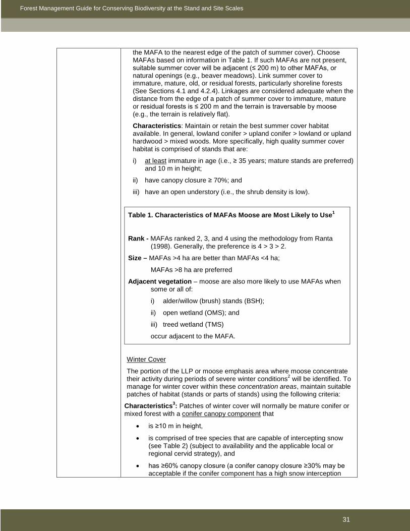
Forest Management Guide for Conserving Biodiversity at the Stand and Site Scales
31
the MAFA to the nearest edge of the patch of summer cover). Choose MAFAs based on information in Table 1. If such MAFAs are not present, suitable summer cover will be adjacent (≤ 200 m) to other MAFAs, or natural openings (e.g., beaver meadows). Link summer cover to immature, mature, old, or residual forests, particularly shoreline forests (See Sections 4.1 and 4.2.4). Linkages are considered adequate when the distance from the edge of a patch of summer cover to immature, mature or residual forests is ≤ 200 m and the terrain is traversable by moose (e.g., the terrain is relatively flat).
Characteristics: Maintain or retain the best summer cover habitat available. In general, lowland conifer > upland conifer > lowland or upland hardwood > mixed woods. More specifically, high quality summer cover habitat is comprised of stands that are:
i) at least immature in age (i.e., ≥ 35 years; mature stands are preferred) and 10 m in height;
ii) have canopy closure ≥ 70%; and
iii) have an open understory (i.e., the shrub density is low).
Table 1. Characteristics of MAFAs Moose are Most Likely to Use1
Rank - MAFAs ranked 2, 3, and 4 using the methodology from Ranta (1998). Generally, the preference is 4 > 3 > 2.
Size – MAFAs >4 ha are better than MAFAs <4 ha;
MAFAs >8 ha are preferred
Adjacent vegetation – moose are also more likely to use MAFAs when some or all of:
i) alder/willow (brush) stands (BSH);
ii) open wetland (OMS); and
iii) treed wetland (TMS)
occur adjacent to the MAFA.
Winter Cover
The portion of the LLP or moose emphasis area where moose concentrate their activity during periods of severe winter conditions2 will be identified. To manage for winter cover within these concentration areas, maintain suitable patches of habitat (stands or parts of stands) using the following criteria:
Characteristics3: Patches of winter cover will normally be mature conifer or mixed forest with a conifer canopy component that
• is ≥10 m in height,
• is comprised of tree species that are capable of intercepting snow (see Table 2) (subject to availability and the applicable local or regional cervid strategy), and
• has ≥60% canopy closure (a conifer canopy closure ≥30% may be acceptable if the conifer component has a high snow interception

Forest Management Guide for Conserving Biodiversity at the Stand and Site Scales
32
capability (see Table 2) and tends to occur in clumps (i.e., ≥3-5 trees with interlocking crowns)). A conifer canopy closure of 60-80% is optimal so some partial harvest may be acceptable where appropriate; if partial harvest is conducted, clumping of residual trees is preferable to uniform spacing of residual trees.
Table 2. Snow Interception Capability of Conifer Trees4
High Moderate Low
hemlock white spruce lowland black spruce
red spruce balsam fir red pine
cedar white pine jack pine
upland black spruce
Patch size and distribution: Patches of winter cover will be distributed within concentration areas so that
• any point within productive forest that does not meet the definition of residual will be <200 m from a patch of winter cover (i.e., 400 m cover-to-cover distance) that is ≥5 ha in size (≥10 ha preferred), and
• any point within productive forest that does meet the definition of residual will be <500 m from a patch of winter cover (i.e., 1000 m cover-to-cover distance) that is ≥2 ha in size (≥5 ha preferred).
Amount: The size and distribution criteria noted above should result in approximately the following amount of winter cover within concentration areas
• ≥15% winter cover in areas where the dominant silvicultural systems used create forest that does not meet the definition of residual (e.g., conventional clearcut), and
• ≥2% winter cover in areas where the dominant silvicultural systems used create forest that does meet the definition of residual (e.g., single tree selection).
Best Management Practices
• When suitable summer cover occurs in stands <10 ha in size, retain residual forest contiguous with the summer cover to increase the total stand size retained to at least 10 ha.
• Stands that are retained in harvest areas for summer cover should be well-spaced, with a regular distribution pattern.
• Stands retained or maintained for suitable summer thermal shelter and/or winter cover, should have moderately high stocking (e.g., 70-80%). Stands with low or very high stem densities are not desirable.
• Develop forest operation prescriptions for feeding habitat, such as along the edges of areas of operations where ‘feathering’ has occurred, and manage these sites as high-browse production sites.
• Even shallow soiled, nutrient-poor sites are of value to moose as feeding habitat during early successional stages following disturbance. The most common and acceptable alternative silvicultural treatments on such sites

Forest Management Guide for Conserving Biodiversity at the Stand and Site Scales
33
will be to provide for a hardwood component of >10% in the early development stages of the stand (i.e., for the 20-year period following harvest).
• When applying herbicides on rich mixedwood sites use hand application methods (i.e. backpack sprayer) to avoid spraying shrubs that are preferred by moose as browse (e.g., dogwood, willow, mountain ash) and are not directly competing for resources with crop trees.
• When planning aerial chemical tending operations (where there is either an objective(s) to emphasize moose habitat management, or where moose are the primary cervid) do not treat more than 500 contiguous ha in any given year. A five-year time frame between commencement and completion of tending operations in large, contiguous clearcuts (e.g., 000s ha) is recommended.
• In concert with provincial, regional, or local moose management programs, the development of use management strategies for roads or road networks should consider:
i) MNR policies and directives for access provisions or restrictions to public and commercial travel on forestry roads and road networks; and
ii) the temporal and spatial aspects of road decommissioning.
• Roads should be planned and constructed to avoid:
i) the splitting of stands retained as winter or summer cover; and
ii) high-quality MAFAs (e.g., roads should be ≥120 m away from MAFAs ranked 3 or 4 that are ≥4 ha in size).
1 Information obtained from the Moose Guidelines Effectiveness Evaluation Program 2 Typically described as late winter habitat in past direction. 3 Where habitat with these characteristics does not exist, retain the best available cover to meet the patch size and distribution criteria. 4 Note that hemlock, red spruce, and cedar are also favored by deer for cover and food. In areas where deer and moose objectives are not compatible, use of these tree species for moose winter cover is not advised. 3.3.5 Other species Generally, special strategies and operational prescriptions to address unique objectives will be applied to areas that have been identified and delineated as LLPs through application of the Landscape Guide. Planning teams can then select the specific strategies and forest operation prescriptions that will apply to these LLPs or other identified areas with unique objectives. Unique objectives regarding forest cover at the landscape scale will usually modify: the patterns of composition and structure of harvest and retention patches (Sections 3.2.1 and 3.2.2); maintenance and creation of structure within areas of operations (Section 3.2.3); and other operational considerations (Section 5). Situations may arise when planning teams identify areas of the management unit that require special and specific direction to address unique objectives. These areas may be for a species or community (wildlife or vegetation) and where use of AOC prescriptions are inadequate or inappropriate because of scale. When existing forest management guides do not provide direction on how to manage forest cover to address such unique objectives, planning teams may choose to craft special strategic and operational strategies and prescriptions. For example, in

Forest Management Guide for Conserving Biodiversity at the Stand and Site Scales
34
areas where elk occur, planning teams may identify management objectives for elk habitat in some LLPs or emphasis areas. For each LLP or other area identified as having unique management objectives, a brief synopsis of the effects of forest management on the feature, land use, or value being managed should be prepared and available as resource information.

Forest Management Guide for Conserving Biodiversity at the Stand and Site Scales
35
4.0 CONSERVING BIODIVERSITY - Management of Site-specific Habitats Section 4.0 provides direction designed to assist in the conservation of biodiversity by maintaining the suitability of habitats and habitat features that are used by numerous animal and plant species and that are associated with specific geographic locations. Aquatic and wetland habitats and associated shoreline forest are addressed in Section 4.1. Special habitat features such as birds’ nests and bat hibernacula are considered in Section 4.2. Section 4.3 provides direction for the habitat of species at risk that is not already covered by direction in the Landscape Guide or other sections of the Stand and Site Guide. In Sections 4.1 to 4.3, when forest management activities may adversely affect a habitat value or feature, mitigative direction is prescribed. For values, direction is addressed through Prescriptions for Areas of Concern (AOCs). Values will be documented and reported following the process outlined in the Forest Information Manual (2007). For features, mitigation is addressed through conditions on regular operations in Prescriptions for Harvest, Renewal, and Tending Areas. Features addressed by conditions on regular operations do not have to be documented and reported following the process outlined in the Forest Information Manual. Values or features considered in this section may be identified and reported by MNR or other government staff, licensees and their operators, non-government organizations, third parties, other resource users, or the public. For values addressed through Prescriptions for Areas of Concern, it is the responsibility of the MNR to confirm that the information about any new value is accurate and meets the standards outlined in the Forest Information Manual before it is considered to be a known value and subject to the direction in this section. For features addressed through conditions on regular operations, it is the responsibility of the operator that encounters the feature to confirm the identity of the feature and apply the appropriate direction in this section. Many values, such as permanent streams and osprey nests, will be known in advance of operations and will be identified on values maps. Application of the direction in this section for these known values is relatively straightforward. However, many features and values, such as woodland pools and hawk nests, will typically be discovered during operations. In some cases, despite due diligence, these features and values may not be identified until some operations have been conducted within their vicinity in a manner that may not be consistent with prescribed direction. In these cases, reasonable efforts will be made to ensure that subsequent activities comply with the direction in this section. In some situations, AOCs for multiple values may overlap. In these cases, the most restrictive direction will be applied unless MNR approves otherwise. Direction in Sections 4.1 to 4.3 frequently places restrictions on the construction of new roads. In the context of this guide, existing roads that are rebuilt so they can support an increased volume of traffic (e.g., an overgrown operational road supporting ATV traffic rebuilt to facilitate hauling, a winter road upgraded to an all season road, a branch road upgraded to a primary road) are considered to be new roads. Direction in Sections 4.1 to 4.3 frequently places restrictions on hauling or other forestry-related traffic. Unless otherwise specified, this direction applies to operational roads and any other roads that are used primarily by the forest industry. It is not intended to be applied to municipal roads or provincial highways. Direction in Sections 4.1 to 4.3 often specifies the forest structure to be retained within AOCs to protect the associated value. Harvest, renewal, and tending operations used to generate this structure will, to the extent practical and feasible, emulate the natural dynamics of the forest type within the AOC while acknowledging silvicultural limitations, the scale of application, and other overriding ecological considerations such as objectives for forest composition (see Section 3.2.1).

Forest Management Guide for Conserving Biodiversity at the Stand and Site Scales
36
4.1 Maintaining Ecological Functions of Aquatic and Wetland Ecosystems and Shoreline Forest Including Habitat Suitability and Productive Capacity Within the AOU, lakes, ponds, rivers, streams, wetlands, and associated shoreline forest represent habitat for about 100 species of fish, more than 200 species of birds, mammals, reptiles, and amphibians, and thousands of species of invertebrates and vascular and non-vascular plants. Moreover, about two-thirds of all species at risk that occur within the AOU use aquatic and wetland habitats. From a social and economic perspective, these ecosystems are especially significant because they, or the species that occupy them, support commercial, recreational, and Aboriginal fisheries, trapping, waterfowl hunting, and other water-based recreation and tourism. Forest management operations can potentially change the composition or structure, and thus ultimately the function, of aquatic ecosystems, either through direct physical disturbance (e.g., installation of water-crossing structures) or by altering the linkage between terrestrial and aquatic ecosystems (e.g., altering the amount of, or pathways for, surface runoff). Such changes may reduce the suitability of aquatic and wetland ecosystems for a wide range of aquatic and semi-aquatic plants and animals. At a watershed- or catchment-scale, forest management operations can influence the quantity and quality of water entering aquatic ecosystems. The extent to which these hydrological changes adversely affect the ecological function of aquatic ecosystems is quite variable, depending largely on the characteristics of individual catchments. Catchment-scale effects are addressed in Section 3.2.2.3. At a finer scale, operations within or adjacent to aquatic and wetland ecosystems may potentially result in sediment entering aquatic features, damage to shorelines or stream banks, modification of the hydrological regime, changes to thermal regime, obstruction of fish passage, or alteration of inputs of coarse and fine organic material, with subsequent effects on fish and other species. The federal Fisheries Act (1985) prohibits any “work or undertaking that results in the harmful alteration, disruption or destruction of fish habitat” (Section 35(1)) and stipulates that “no person shall deposit or permit the deposit of a deleterious substance of any type in water frequented by fish” (Section 36(3))2. Thus, while the following sections address a broad range of ecological functions, much of the focus is on mitigating potential effects of forest management operations in shoreline areas on water quality, fish, and fish habitat, especially those associated with input of sediment. The Fisheries Act defines fish (includes crustaceans and some types of molluscs) and fish habitat (areas that fish directly or indirectly depend on to carry out their life processes) very broadly. Thus, this guide adopts a conservative approach and provides protection to all flowing and standing waters, as well as the features that provide hydrological connections to terrestrial habitats (i.e., ephemeral streams, springs, seeps, and other areas of groundwater discharge). The federal Department of Fisheries and Oceans (DFO) has adopted a risk management approach to guide efforts to mitigate the effects of development on fish and fish habitat (see Practitioner’s Guide to the Risk Management Framework for DFO Habitat Management Staff (2007)). Under this approach, appropriate mitigation is a function of risk, where risk is defined by the scale of potential negative effects and the sensitivity of fish and fish habitats. Direction in Section 4.1 adopts these guiding principles. Direction is more restrictive when operations have a higher potential for negative effects or when fish or fish habitats are likely to be more sensitive to potential effects. The potential for negative effects is based largely on the amount of site disturbance (e.g., road construction normally has a greater potential for negative effects than timber harvesting) and the amount of canopy removal (e.g., clearcutting has a greater potential for negative effects than selection cutting) associated with operations. When inventory data are available, the sensitivity of fish or fish habitat will be defined based on the resilience of species to 2 The Fisheries Act also prohibits the obstruction of fish passage. Section 5.1.2 provides direction on the design of water crossings to facilitate fish movement.
Forest Management Guide for Conserving Biodiversity at the Stand and Site Scales
37
perturbation, habitat dependency, species or habitat rarity, and habitat resiliency (see Table 5 in Practitioner’s Guide to the Risk Management Framework for DFO Habitat Management Staff). When inventory data are not available, sensitivity will be based on characteristics of the aquatic feature that are assumed to reflect many of the criteria noted above, such as size, upstream catchment area, flow regime, and/or connection to other features known to support, or that potentially support, a fishery. Use of the term sensitivity in this context should not be confused with sensitive information about values as defined in the Forest Information Manual. Forest management operations adjacent to aquatic and wetland ecosystems may also alter the composition or structure of associated shoreline forest. Harvesting may have negative consequences for wildlife species such as bald eagles, wood ducks, and moose that use mature shoreline forest that provides food, cover, or travel corridors. In contrast, harvesting may have positive consequences for wildlife species such as common yellowthroats, eastern kingbirds, and Beavers that use early to mid-successional shoreline forest (dozens of other species also benefit from the wetlands created by beavers). Thus, at a landscape scale, the habitat requirements of the greatest number of shoreline-inhabiting species will be met when shoreline forest occurs in a variety of ages and patterns. Sections 4.1.1 and 4.1.2 provide direction to create a mosaic of shoreline forest conditions that will sustain these many ecological functions. In contrast to the Timber Management Guidelines for the Protection of Fish Habitat (1988), direction in this guide not only permits, but encourages, management in shoreline areas, primarily to meet the ecological objectives noted above. However, in some situations, socio-economic considerations may override this direction and result in different prescriptions for shoreline areas. For example, archaeological sites and other areas of high cultural value are frequently associated with shorelines. These values may be protected by reserves up to 200 m in width (see the Forest Management Guide for Cultural Heritage Values (2007)). Moreover, large lakes and rivers are often associated with resource-based tourism. Planning teams may decide to retain unharvested forest along shorelines to maintain visual aesthetics (see the Management Guidelines for Forestry and Resource-based Tourism (2001)). Direction in this guide, including restrictions on roads, focuses on maintaining various ecological functions of aquatic ecosystems, including the productive capacity that supports commercial, recreational, or Aboriginal fisheries (i.e., protection of fish habitat). In addition to their potential effects on the productive capacity of aquatic ecosystems, roads constructed during forest management operations may increase access to specific fisheries. In some cases, increased access may be consistent with management objectives for these fisheries. In other cases, increased access may not be consistent with management objectives if there is a potential for local over-harvest or introduction of invasive species. Lakes containing self-sustaining populations of brook trout or lake trout may be especially sensitive. In some circumstances, other policy documents such as the Crown Land Use Policy Atlas may specify, or planning teams may choose to place, additional restrictions on the construction, use, or decommissioning of roads around some aquatic features (see discussion on strategic road planning in Section 5.1.1). However, these decisions should be made within the context of zone-wide fisheries management objectives and strategies developed with the advice of Fisheries Management Zone councils. Depending on the spatial and temporal scale of new restrictions imposed, MNR may also consider documenting this direction through amendments to the Crown Land Use Policy Atlas. The following sections provide direction for standing waters (lakes and ponds), flowing waters (rivers and streams), and wetlands. 4.1.1 Standing waters: lakes and ponds Standing waters include lakes and ponds. Lakes are bodies of moderate-to-deep standing water typically characterized by relatively stable shorelines, limited deposition of sediments, low turbidity, stable water levels, and long flushing rates. Lakes are defined by the Ontario Wetland Evaluation System (2002) as areas of open water greater than 8 ha in size and, at some point,

Forest Management Guide for Conserving Biodiversity at the Stand and Site Scales
38
greater than 2 m deep. All lakes are considered to have high potential sensitivity to forest management operations. Ponds are defined here as bodies of shallow (generally <2 m deep), open water (≤25% of surface area covered by emergent vegetation) between ≥0.5 ha and <8 ha in size. Ponds are considered shallow open water wetlands by the Canadian Wetland Classification System (1988) and marshes by the Ontario Wetland Evaluation System. The potential sensitivity to forest management operations of ponds ranges from high to low. Bodies of open water <0.5 ha that are connected to streams are treated as part of the streams (Section 4.1.2). Bodies of open water <0.5 ha associated with mapped wetlands are treated as part of the mapped wetlands (Section 4.1.3). Temporary bodies of open water <0.5 ha not associated with streams or mapped wetlands are considered to be woodland pools (Section 4.1.3). Lakes and ponds represent important habitat for thousands of species of aquatic and semi-aquatic plants and animals. This includes more than 80 species of mammals, birds, reptiles, and amphibians, ranging from numerous species of turtles and waterfowl to aquatic furbearers, such as beavers and river otters, and more than 80 species of fish. Deep oligothrophic lakes are especially important for cold water fish such as lake trout. Because of their shallow depth, ponds are extremely productive habitats, especially for aquatic furbearers and waterfowl, including numerous species of conservation priority.
Direction For operational simplicity, polygons identified as open water on operations maps that are ≥8 ha in size are classified as lakes. Polygons identified as open water on operations maps and unmapped bodies of open water (≤25% of surface area covered by emergent vegetation) encountered during operations that are ≥0.5 and <8 ha in size are classified as ponds. All standing waters are important components of fish habitat and receive consideration. Habitat suitability and productive capacity of lakes and ponds with high or moderate potential sensitivity to forest management operations are addressed by prescriptions for AOCs. Ponds with low potential sensitivity to forest management operations are addressed through conditions on regular operations. Direction for maintaining habitat suitability and productive capacity of lakes and ponds and associated shoreline forest is described in Table 4.1a and focuses on:
• Minimizing the risk of sedimentation. • Providing future inputs of coarse woody material. • Mitigating the effects of harvesting on water temperature, water circulation, and inputs of
fine organic material. • Mitigating the effects of forest management operations on hydrological linkages between
aquatic and terrestrial ecosystems. • Maintaining some shoreline forest as residual habitat and dispersal corridors. • Managing some shoreline forest to create some early to mid-successional riparian
habitat. Hydrological linkages (i.e., small permanent, intermittent, and ephemeral streams, springs, seeps, and other areas of groundwater discharge) make an important contribution to the productive capacity of fish habitat. While many of these features may be unmapped and difficult to identify in the field under certain operating conditions, it is expected that due diligence will be exercised in identifying and protecting these features. Due diligence begins with providing operators with training that will permit them to identify unmapped features and take appropriate mitigative action. In addition, when working within shoreline AOCs during seasons when operations have the potential to adversely affect hydrological linkages, reasonable efforts will be made to identify unmapped features in advance of operations. The following are two examples (but not an exhaustive list) of activities that may constitute reasonable efforts:

Forest Management Guide for Conserving Biodiversity at the Stand and Site Scales
39
• In the Great Lakes – St. Lawrence forest, tree markers are trained and instructed to identify unmapped hydrological linkages encountered during marking operations in shoreline AOCs.
• In the boreal forest, line markers are trained and instructed to: i) identify unmapped hydrological linkages encountered when marking AOC boundaries, and ii) check sites within the AOC that have a high potential for these features (based on terrain encountered in the field, aerial photographs, or hydrological models).
Table 4.1a. Standards, guidelines, and best management practices for lakes and ponds and associated shoreline forest (see Figures 4.1a and 4.1b).
Value Description and Direction
Large lakes
Medium lakes
Small lakes
Ponds - high or moderate potential sensitivity to forest management operations
Description
Lakes
All lakes have a high potential sensitivity to forest management operations and are defined as either
• Large lakes are mapped open water polygons (polygon type = WAT) that are ≥1000 ha in size and are not rivers (i.e., mnrcode not 152).
• Medium lakes are mapped open water polygons (polygon type = WAT) that are ≥100 and <1000 ha in size and are not rivers (i.e., mnrcode not 152).
• Small lakes are mapped open water polygons (polygon type = WAT) that are ≥8 and <100 ha in size and are not rivers (i.e., mnrcode not 152).
Ponds with high potential sensitivity to forest management operations (HPS ponds)
When inventory data are available, HPS ponds are those with one or more of the following characteristics:
• Ponds known to contain fish species that are highly sensitive to perturbations (e.g., brook trout).
• Ponds known to provide components of fish habitat for which there is a high degree of species’ dependence.
• Ponds known to contain rare habitats or fish that are species at risk.
• Ponds with low habitat resiliency.
• Ponds identified as significant habitat by specific fisheries management plans.
When inventory data are not available, HPS ponds are those with the following characteristics:
• Mapped open water polygons (polygon type = WAT) or unmapped open water features (≤25% of surface area covered by emergent vegetation) encountered during operations that are ≥0.5 ha and <8 ha in size, are not rivers (i.e., mnrcode not 152), and are connected to 1 or more HPS streams (see Table 4.1b).
Ponds with moderate potential sensitivity to forest management operations (MPS ponds)
When inventory data are available, MPS ponds are those with one or more of the following characteristics:

Forest Management Guide for Conserving Biodiversity at the Stand and Site Scales
40
Value Description and Direction
• Ponds known to contain fish species that are moderately resilient to perturbations (e.g., northern pike, walleye).
• Ponds known to provide components of fish habitat for which there is a moderate degree of species’ dependence.
• Ponds known to contain habitats or fish that have a limited distribution.
• Ponds with moderate habitat resiliency.
When inventory data are not available, MPS ponds are those with the following characteristics:
• Mapped open water polygons (polygon type = WAT) or unmapped open water features (≤25% of surface area covered by emergent vegetation) encountered during operations that are ≥0.5 ha and <8 ha in size, are not rivers (i.e., mnrcode not 152), and are connected to 1 or more MPS streams (see Table 4.1b).
Operational Prescription for the AOC
Standards
• The AOC is measured in the field from the edge of vegetation communities capable of providing an effective barrier to the movement of sediment. This will normally be those communities with ≥25% canopy cover of trees, tall (≥1 m high) woody shrubs such as alder or willow, or low (<1 m high) woody evergreen shrubs such as Labrador tea or leatherleaf. For mapping purposes, the AOC may be measured from the edge of polygons identified as FOR, TMS, or BSH. If the inner edge of the AOC will be ≥300 m from the shoreline of a lake or pond when these criteria are used, an AOC is not required adjacent to those sections of shoreline, unless the intervening wetland is known to provide components of fish habitat for which there is a high species’ dependence (e.g., spawning habitat).
• No harvest, renewal, or tending operations are permitted within the AOC that will result in damage to littoral zones or shorelines and associated stabilizing vegetation, or deposition of sediment within lakes or ponds. Operations specifically prohibited within the AOC include:
o Machine travel within the inner 3 m of the AOC.
o Felling of trees into lakes or ponds or the inner 3 m of the AOC. Trees accidentally felled into lakes or ponds will be left where they fall.
• For large lakes, medium lakes, small lakes, and HPS ponds, 30 to 90 m AOC based on slope as follows:
Slope (%) Slope (degrees) Width of AOC 0 –15 0 – 8.5 30 m
>15 – 30 8.6 –16.7 50 m >30 – 45 16.8 – 24.2 70 m
>45 >24.2 90 m
• For MPS ponds, 30 m AOC

Forest Management Guide for Conserving Biodiversity at the Stand and Site Scales
41
Value Description and Direction
o Excessive removal or damage of sapling-sized trees (<10 cm dbh) and shrubs within the inner 3 m of the AOC.
o Disturbance of the forest floor that leaves ruts or a significant area of exposed mineral soil within the inner 15 m of the AOC (see Section 5.2). Ruts and significant patches of exposed mineral soil will be promptly rehabilitated to prevent sediment from entering a water feature. Patches of mineral soil exposed by natural events are excluded.
o Disturbance of the forest floor that disrupts hydrological function (i.e., impedes, accelerates, or diverts water movement; see Section 5.2) within recognizable ephemeral streams, springs, seeps, and other areas of groundwater discharge connected to lakes or ponds.
• Harvest is permitted within the AOC subject to the following conditions:
o ≥50% of the area of the AOC (based on delineation of the AOC around the entire water feature, both inside and outside the harvest area) associated with small lakes, HPS ponds, and MPS ponds, ≥75% of the area of the AOC associated with medium lakes, and ≥90% of the area of the AOC associated with large lakes will be retained as forest that meets the definition of residual (see Section 3.2.2).
o When retaining residual shoreline forest, the inner 15 m will be mature forest with a relatively uniform canopy closure ≥60% (canopy openings not to exceed individual tree crowns) unless the adjacent harvest area outside the AOC meets the definition of residual forest.
o Harvest that retains forest that does not meet the definition of residual (e.g., conventional clearcutting) is permitted within the AOC only where slope is ≤30%.
o For each ha of shoreline forest harvested that does not meet the definition of residual (e.g., conventionally clearcut) 1 ha of residual shoreline forest will be retained that has not been harvested within 20 years.
o Within the AOC, direction for the retention of downed woody material (see Section 3.2.3) will be followed.
• No contamination of lakes or ponds by foreign materials is permitted. Specifically,
o The use and storage of fuels will be carried out in accordance with the Liquid Fuels Handling Code.
o No equipment maintenance (e.g., washing or changing oil) is permitted within 30 m of lakes or ponds.
o Aerial application of pesticides for renewal, tending, or protection is permitted within the AOC but will follow spray buffer zones for significant areas or sensitive areas (as appropriate) as prescribed in the Ontario Ministry of Environment/Ontario Ministry of Natural Resources Buffer Zone Guidelines for Aerial Application of Pesticides in Crown Forests of Ontario (1992). Machine-based ground application of herbicides (e.g., air-blast sprayers mounted on skidders) is permitted within the AOC; spray buffer zones will be 30 m for significant areas and 60 m for sensitive areas. Hand-based ground

Forest Management Guide for Conserving Biodiversity at the Stand and Site Scales
42
Value Description and Direction
application of herbicides (e.g., back-pack sprayers) is permitted within the AOC; spray buffer zones will be 3 m. All spray buffer zones will be measured from the inner boundary of the AOC.
Guidelines
• Harvest, renewal, and tending operations will follow appropriate operating practices to minimize rutting, compaction, and mineral soil exposure that could lead to erosion and subsequent transport and deposition of sediment in lakes or ponds (see Section 5.2). Particularly,
o Reasonable efforts will be made to ensure that extraction trails will not cross recognizable ephemeral streams, springs, seeps, and other areas of groundwater discharge when not solidly frozen. When these features are crossed, special care will be taken; temporary crossing structures that do not impede, accelerate, or divert water movement will be used when appropriate.
• Harvest, renewal, and tending operations will, to the extent practical and feasible, encourage perpetuation of the distinctive character of the shoreline forest while emulating natural disturbances and/or succession (unless conversion is required to meet other ecological objectives).
• Some or all of the requirements for the retention of residual forest within the AOC may be met by residual shoreline forest outside the harvest area, residual shoreline forest retained in overlapping AOCs, or residual shoreline forest retained in areas with steep slopes (>30%). Additional requirements for residual shoreline forest may be met by:
o Retaining residual shoreline forest to maintain the suitability of special habitats associated with lakes and ponds. For example:
Preferentially retaining residual shoreline forest associated with recharge areas on brook trout lakes (see Section 4.2.1).
Preferentially retaining residual shoreline forest adjacent to moose aquatic feeding areas (MAFAs), especially in specific areas (e.g., LLPs) identified for enhanced moose management (see Section 4.2.4).
Preferentially retaining residual shoreline forest where there is a high potential for ephemeral streams, springs, seeps, and other areas of groundwater discharge (see Section 5.2).
o Retaining residual shoreline forest to maintain internal and external connectivity. To the extent practical and feasible within the AOC, a relatively continuous corridor (average width of gaps <50 m; maximum width of gaps <200 m) of residual forest at least 30 m wide will be retained along at least 1 side of each lake or pond to connect special habitat features (e.g., osprey nests, MAFAs) associated with the lake or pond and link with residual forest on connected lakes, ponds, rivers, and streams.
o Retaining residual shoreline forest to emulate natural patterns. For example:
Preferentially retaining residual shoreline forest on the leeward side of a lake or pond.
Preferentially retaining residual shoreline forest comprised of less

Forest Management Guide for Conserving Biodiversity at the Stand and Site Scales
43
Value Description and Direction
flammable forest types (e.g., hardwood, lowland conifer).
Preferentially retaining residual shoreline forest where there is an opportunity to incorporate it into a larger patch of residual forest (see Section 3.2.2).
o Retaining residual shoreline forest that has the highest likelihood of being windfirm.
• Within the inner 15 m of the AOC, at least 10 trees/100 m of shoreline spaced about 10 m apart will be retained as a potential source of future aquatic coarse woody material. Living trees with the following characteristics will be preferentially retained:
o At least 15 m tall (or the tallest of those available).
o Close to the shoreline (ideally within ½ the height of the tree).
o Leaning toward the shoreline.
o Coniferous supercanopy trees, scattered conifers, and veterans, especially large cedars, white pines, red pines, hemlocks, white spruces, red spruces, and jack pines.
• Within the remainder of the AOC, the general direction for retention of wildlife trees in harvest areas (see Section 3.2.3) will be followed. However, the focus will be on living trees with preferential retention of windfirm trees that provide the following special habitat features for wildlife:
o Supercanopy trees (all forest units) of value to eagles and ospreys such as white and red pines (and poplars in the boreal forest).
o Large living hardwood trees with existing cavities or the potential to develop cavities (all forest units).
o Scattered coniferous trees (selection forest units) or veteran trees (clearcut and shelterwood forest units).
Best management practices
• Machine travel should be minimized within the inner 15 m of the AOC.
• Felled trees should not be piled within the inner 15 m of the AOC.
• Prescribed burns should be considered as an option for renewing shoreline forest.
Conditions on Roads, Landings, and Aggregate Pits
Standards
• No landings or aggregate pits are permitted within the AOC.
Guidelines
• New roads that are not associated with an approved crossing are not permitted within the AOC unless no practical or feasible alternative exists, appropriate mitigative measures are taken to minimize the risk of sediment entering lakes or ponds (see Section 5.1), and the road, including specific location, is identified and justified through the FMP AOC planning process.
• New roads that traverse the AOC will be planned to avoid areas with a high

Forest Management Guide for Conserving Biodiversity at the Stand and Site Scales
44
Value Description and Direction
potential to contain ephemeral streams, springs, seeps, and other areas of groundwater discharge. Crossings of recognizable ephemeral streams, springs, seeps, and other areas of groundwater discharge will consider the design principles in Section 5.1 to minimize the risk of sediment delivery and disruption of hydrological function.
• When new roads traverse residual forest within the AOC, the width of the cleared corridor will be as narrow as practical and feasible, and will not exceed 20 m.
Ponds – low potential sensitivity to forest management operations
Description
Ponds with low potential sensitivity to forest management operations (LPS ponds)
• Any pond that does not meet the criteria for an HPS or MPS pond.
Conditions on Regular Operations, Roads, Landings, and Aggregate Pits
Standards
• No harvest, renewal, or tending operations are permitted that will result in damage to littoral zones or shorelines and associated stabilizing vegetation, or the deposition of sediment within ponds. Operations specifically prohibited include:
o Machine travel within 3 m of ponds.
o Excessive removal or damage of sapling-sized trees (<10 cm dbh) and shrubs within 3 m of ponds.
o Felling of trees into ponds or within 3 m of ponds. Trees accidentally felled into ponds will be left where they fall.
o Disturbance of the forest floor that leaves ruts or a significant area of exposed mineral soil within 15 m of ponds (see Section 5.2). Ruts and significant patches of exposed mineral soil will be promptly rehabilitated to prevent sediment from entering a pond. Patches of mineral soil exposed by natural events are excluded.
• No contamination of ponds by foreign materials is permitted. Specifically,
o The use and storage of fuels will be carried out in accordance with the Liquid Fuels Handling Code.
o No equipment maintenance (e.g., washing or changing oil) is permitted within 15 m of ponds.
• Landings and aggregate pits are not permitted within 15 m of ponds.
Guidelines
• New roads will not be located within 15 m of ponds unless there is no practical or feasible alternative and appropriate mitigative measures are taken to minimize the risk of sediment entering ponds and disruption of hydrological function (see Section 5.1).

Forest Management Guide for Conserving Biodiversity at the Stand and Site Scales
45
Figure 4.1a. Layout of areas of concern (AOC) and 15 m no rut or significant mineral soil exposure (MSE) zones around lakes, ponds, and streams. Ponds/streams with high (HPS), moderate (MPS), or low (LPS) potential sensitivity to forest management operations are identified (see Sections 4.1.1 and 4.1.2). (Illustration by Mandy Saille).

Forest Management Guide for Conserving Biodiversity at the Stand and Site Scales
46
Figure 4.1b. Selecting shoreline forest for retention as residual. In this example, portions of the shoreline AOC labeled 1 through 6 would be preferentially retained in the following order of priority: include shoreline forest in overlapping AOCs (1); retain forest on steep slopes (2); retain forest adjacent to special habitats such as moose aquatic feeding areas (MAFAs) (3); retain forest to link (1), (2) and (3) (internal connectivity)(4); retain forest to link with other water features (external connectivity)(5); and retain forest along shorelines with the lowest likelihood of being disturbed by natural agents such as wildfire (6). On this lake, shoreline labeled ‘7’ would be the preferable choice for harvest that does not retain residual forest. (Illustration by Mandy Saille).
Forest Management Guide for Conserving Biodiversity at the Stand and Site Scales
47
4.1.2 Flowing waters: rivers and streams Flowing waters include rivers and streams. Rivers and streams are relatively shallow linear bodies of unidirectional flowing water typically characterized by constantly changing shorelines, highly variable deposition of sediments, high and variable turbidity, large fluctuations in water level, and rapid flushing rates. Streams may flow throughout the year (permanent streams) or primarily during wet seasons (intermittent streams). All rivers are considered to have a high potential sensitivity to forest management operations. The potential sensitivity to forest management operations of streams ranges from high to low. Rivers and permanent or intermittent streams provide habitat for a wide diversity of aquatic and semi-aquatic plants and animals. This includes more than 60 species of mammals, birds, reptiles, and amphibians, ranging from turtles to waterfowl to aquatic furbearers such as beavers, muskrats, and river otters. Rivers and streams also support about 40 and 50 species of fish, respectively. This list includes game fish such as the brook trout and four species at risk, including the northern brook lamprey. Direction All flowing waters are important components of fish habitat and receive consideration. Habitat suitability and productive capacity of rivers and permanent or intermittent streams with high or moderate potential sensitivity to forest management operations are maintained by prescriptions for AOCs. Streams with low potential sensitivity to forest management operations are addressed through conditions on regular operations. Direction for maintaining habitat suitability and productive capacity of rivers, streams, and associated shoreline forest is described in Table 4.1b and focuses on:
• Protecting beds, banks, and shorelines. • Minimizing the risk of sedimentation. • Mitigating the effects of harvesting on water temperature and inputs of fine organic
material. • Mitigating the effects of forest management operations on hydrological linkages between
aquatic and terrestrial ecosystems. • Providing future inputs of coarse woody material. • Maintaining some shoreline forest as residual habitat and dispersal corridors. • Managing some shoreline forest to create some early to mid-successional riparian
habitat. Hydrological linkages (i.e., small permanent, intermittent, and ephemeral streams, springs, seeps, and other areas of groundwater discharge) make an important contribution to the productive capacity of fish habitat. While many of these features may be unmapped and difficult to identify in the field under certain operating conditions, it is expected that due diligence will be exercised in identifying and protecting these features. Due diligence begins with providing operators with training that will permit them to identify unmapped features and take appropriate mitigative action. In addition, when working within shoreline AOCs during seasons when operations have the potential to adversely affect hydrological linkages, reasonable efforts will be made to identify unmapped features in advance of operations. The following are two examples (but not an exhaustive list) of activities that may constitute reasonable efforts:
• In the Great Lakes – St. Lawrence forest, tree markers are trained and instructed to identify unmapped hydrological linkages encountered during marking operations in shoreline AOCs.
• In the boreal forest, line markers are trained and instructed to: i) identify unmapped hydrological linkages encountered when marking AOC boundaries, and ii) check sites within the AOC that have a high potential for these features (based on terrain encountered in the field, aerial photographs, or hydrological models).

Forest Management Guide for Conserving Biodiversity at the Stand and Site Scales
48
Table 4.1b. Standards, guidelines, and best management practices for rivers, streams, and associated shoreline forest (see Figures 4.1a and 4.1c).
Value Description and Direction
Rivers
Stream segments -high or moderate potential sensitivity to forest management operations
Description
Rivers (high potential sensitivity to forest management operations)
All rivers have a high potential sensitivity and are defined as either
• Mapped open water polygons (polygon type = WAT) with mnrcode = 152 or
• Mapped permanent stream segments (mnrcode = 104 or 271) with catchment area ≥50 km2. Catchment area is defined as the upstream contributing area at any point along a stream.
Streams with high potential sensitivity to forest management operations (HPS streams)
When inventory data are available, HPS streams are those with one or more of the following characteristics:
• Stream segments known to contain fish species that are highly sensitive to perturbations (e.g., brook trout).
• Stream segments known to provide components of fish habitat for which there is a high degree of species’ dependence.
• Stream segments known to contain rare habitats or fish that are species at risk.
• Stream segments with low habitat resiliency.
• Stream segments identified as significant habitat by specific fisheries management plans.
When inventory data are not available, HPS streams are those with one of the following characteristics:
• Mapped large permanent stream segments (catchment area ≥3 and <50 km2).
• Mapped small permanent stream segments (catchment area <3 km2) <500 m (stream distance) from lakes, rivers, mapped large permanent stream segments, or other water features identified as HPS based on inventory data.
• Recognizable unmapped permanent stream segments <500 m from lakes, rivers, mapped large permanent stream segments, or other water features identified as HPS based on inventory data.
Streams with moderate potential sensitivity to forest management operations (MPS streams)
When inventory data are available, MPS streams are those with one or more of the following characteristics:
• Stream segments known to contain fish species that are moderately resilient to perturbations (e.g., northern pike, walleye).
• Stream segments known to provide components of fish habitat for which there is a moderate degree of species’ dependence.

Forest Management Guide for Conserving Biodiversity at the Stand and Site Scales
49
Value Description and Direction
• Stream segments known to contain habitats or fish that have a limited distribution.
• Stream segments with moderate habitat resiliency.
When inventory data are not available, MPS streams are those with one of the following characteristics:
• Mapped small permanent stream segments that are ≥500 m (stream distance) from lakes, rivers, mapped large permanent stream segments, and other water features identified as HPS based on inventory data.
• Recognizable unmapped permanent stream segments that are ≥500 m from lakes, rivers, mapped large permanent stream segments, and other water features identified as HPS based on inventory data.
• Mapped or recognizable unmapped intermittent stream segments (mnrcode = 105 or 272) <500 m from water features known to support brook trout.
Operational Prescription for the AOC
Standards
• The AOC is measured in the field from the edge of vegetation communities capable of providing an effective barrier to the movement of sediment. This will normally be those communities with ≥25% canopy cover of trees, tall (≥1 m high) woody shrubs such as alder or willow, or low (<1 m high) woody evergreen shrubs such as Labrador tea or leatherleaf. For mapping purposes, the AOC may be measured from the edge of polygons identified as FOR, TMS, or BSH. If the inner edge of the AOC will be ≥300 m from the river shoreline or stream edge when these criteria are used, an AOC is not required adjacent to those sections of river shoreline or stream edge, unless the intervening wetland is known to provide components of fish habitat for which there is a high species’ dependence (e.g., spawning habitat).
• No harvest, renewal, or tending operations are permitted within the AOC that will result in damage to river or stream beds or banks and associated stabilizing vegetation, or deposition of sediment within rivers or streams. Operations specifically prohibited within the AOC include:
o Machine travel within the inner 3 m of the AOC.
o Felling of trees into rivers or streams or the inner 3 m of the AOC.
• For rivers and HPS streams, 30-90 m AOC based on slope as follows:
Slope (%) Slope (degrees) Width of AOC 0 –15 0 – 8.5 30 m
>15 – 30 8.6 –16.7 50 m >30 – 45 16.8 – 24.2 70 m
>45 >24.2 90 m
• For MPS streams, 30 m AOC

Forest Management Guide for Conserving Biodiversity at the Stand and Site Scales
50
Value Description and Direction
Trees accidentally felled into rivers or streams will be left where they fall.
o Excessive removal or damage of sapling-sized trees (<10 cm dbh) and shrubs within the inner 3 m of the AOC.
o Disturbance of the forest floor that leaves ruts or a significant area of exposed mineral soil within the inner 15 m of the AOC (see Section 5.2). Ruts and significant patches of exposed mineral soil will be promptly rehabilitated to prevent sediment from entering a water feature. Patches of mineral soil exposed by natural events are excluded.
o Disturbance of the forest floor that disrupts hydrological function (i.e., impedes, accelerates, or diverts water movement; see Section 5.2) within recognizable ephemeral streams, springs, seeps, and other areas of groundwater discharge connected to rivers or streams.
• Harvest is permitted within the AOC subject to the following conditions:
o Forest that meets the definition of residual (see Section 3.2.2) must be retained within the AOC (based on delineation of the AOC along the entire water feature, both within and outside the harvest area) on at least 1 side of rivers, HPS streams, and MPS streams to provide a travel corridor.
o Mature forest with relatively uniform canopy closure ≥60% (canopy openings not to exceed individual tree crowns) must be retained within the inner 15 m of the AOC on both sides of HPS and MPS streams to provide shade, unless the inner boundary of the AOC is >15 m from the active channel. If forest is not mature or does not have an initial canopy closure ≥60%, no harvest is permitted.
o Harvest that retains forest that does not meet the definition of residual (e.g., conventional clearcutting) is permitted within the AOC only where slope is ≤30%.
o Within the AOC, direction for the retention of downed woody material (see Section 3.2.3) will be followed.
• No contamination of rivers or streams by foreign materials is permitted. Specifically,
o The use and storage of fuels will be carried out in accordance with the Liquid Fuels Handling Code.
o No equipment maintenance (e.g., washing or changing oil) is permitted within 30 m of rivers or streams.
o Aerial application of pesticides for renewal, tending, or protection is permitted within the AOC but will follow spray buffer zones for significant areas or sensitive areas (as appropriate) as prescribed in the Ontario Ministry of Environment/Ontario Ministry of Natural Resources Buffer Zone Guidelines for Aerial Application of Pesticides in Crown Forests of Ontario (1992). Machine-based ground application of herbicides (e.g., air-blast sprayers mounted on skidders) is permitted within the AOC; spray buffer zones will be 30 m for significant areas and 60 m for sensitive areas. Hand-based ground application of herbicides (e.g., back-pack sprayers) is permitted within

Forest Management Guide for Conserving Biodiversity at the Stand and Site Scales
51
Value Description and Direction
the AOC; spray buffer zones will be 3 m. All spray buffer zones will be measured from the inner boundary of the AOC.
Guidelines
• Harvest, renewal, and tending operations will follow appropriate operating practices to minimize rutting, compaction, and mineral soil exposure that could lead to erosion and subsequent transport and deposition of sediment in rivers and streams (see Section 5.2). Particularly,
o Reasonable efforts will be made to ensure that extraction trails will not cross recognizable ephemeral streams, springs, seeps, and other areas of groundwater discharge when not solidly frozen. When these features are crossed, special care will be taken; temporary crossing structures that do not impede, accelerate, or divert water movement will be used when appropriate.
• Harvest, renewal, and tending operations will, to the extent practical and feasible, encourage perpetuation of the distinctive character of the shoreline forest while emulating natural disturbances and/or succession (unless conversion is required to meet other ecological objectives - see below).
• Some or all of the requirements for retention of residual forest within the AOC may be met by residual shoreline forest outside the harvest area, residual shoreline forest retained in overlapping AOCs, or residual shoreline forest retained in areas with steep slopes (>30%). Additional requirements for residual shoreline forest may be met by:
o Retaining residual shoreline forest that meets the special habitat requirements of wildlife associated with rivers and streams as described in Section 4.2. For example,
Preferentially retaining residual shoreline forest associated with recharge areas on brook trout streams (see Section 4.2.1).
Preferentially retaining residual shoreline forest adjacent to moose aquatic feeding areas (MAFAs), especially in specific areas (e.g., LLPs) identified for enhanced moose management (see Section 4.2.4).
Preferentially retaining residual shoreline forest where there is a high potential for ephemeral streams, springs, seeps, and other areas of groundwater discharge (see Section 5.2).
o Retaining residual shoreline forest that maintains internal and external connectivity. To the extent practical and feasible within the AOC, a relatively continuous corridor (average width of gaps <50 m; maximum width of gaps <200 m) of residual forest at least 30 m wide will be retained along the length of rivers and streams to connect special habitat features (e.g., osprey nests, MAFAs) associated with the river or stream and link with residual forest on connected lakes, ponds, rivers, and streams.
o Retaining residual shoreline forest that has the highest likelihood of escaping natural disturbances such as wildfire. For example:
Preferentially retaining residual shoreline forest on the leeward side of a river.

Forest Management Guide for Conserving Biodiversity at the Stand and Site Scales
52
Value Description and Direction
Preferentially retaining residual shoreline forest comprised of less flammable forest types (e.g., hardwood, lowland conifer).
Preferentially retaining residual shoreline forest where there is an opportunity to incorporate it into a larger patch of residual forest (see Section 3.2.2).
o Retaining residual shoreline forest that has the highest likelihood of being windfirm.
• Within the inner 15 m of the AOC, at least 10 trees/100 m of shoreline spaced about 10 m apart will be retained as a potential source of future aquatic coarse woody material. Living trees with the following characteristics will be preferentially retained:
o At least 15 m tall (or the tallest of those available).
o Close to the active channel (ideally within ½ the height of the tree).
o Leaning toward the river or stream.
o Coniferous supercanopy trees, scattered conifers, and veterans, especially large cedars, white pines, red pines, hemlocks, white spruces, red spruces, and jack pines.
• Within the remainder of the AOC, the general direction for retention of wildlife trees in harvest areas (see Section 3.2.3) will be followed. However, the focus will be on living trees with preferential retention of windfirm trees that provide the following special habitat features for wildlife:
o Supercanopy trees (all forest units) of value to eagles and ospreys such as white and red pines (and poplars in the boreal forest).
o Large living hardwood trees with existing cavities or the potential to develop cavities (all forest units).
o Scattered coniferous trees (selection forest units) or veteran trees (clearcut and shelterwood forest units).
Best management practices
• Machine travel should be minimized within the inner 15 m of the AOC.
• Felled trees should not be piled within the inner 15 m of the AOC.
• Prescribed burns should be considered as an option for renewing shoreline forest.
Conditions on Roads, Landings, and Aggregate Pits
Standards
• No landings or aggregate pits are permitted within the AOC.
Guidelines
• New roads that are not associated with an approved crossing are not permitted within the AOC unless no practical or feasible alternative exists, appropriate mitigative measures are taken to minimize the risk of sediment entering rivers or streams (see Section 5.1), and the road, including specific location, is identified and justified through the FMP AOC planning process.

Forest Management Guide for Conserving Biodiversity at the Stand and Site Scales
53
Value Description and Direction
• New roads that traverse the AOC will be planned to avoid areas with a high potential to contain ephemeral streams, springs, seeps, and other areas of groundwater discharge. Crossings of recognizable ephemeral streams, springs, seeps, and other areas of groundwater discharge will consider the design principles in Section 5.1 to minimize the risk of sediment delivery and disruption of hydrological function.
• When new roads traverse residual forest within the AOC, the width of the cleared corridor will be as narrow as practical and feasible, and will not exceed 20 m.
Stream segments - low potential sensitivity to forest management operations
Description
Streams with low potential sensitivity to forest management operations (LPS streams)
• Any stream segment that does not meet the criteria for an HPS or MPS stream.
Conditions on Regular Operations, Roads, Landings, and Aggregate Pits
Standards
• No harvest, renewal, or tending operations are permitted that will result in damage to stream channels or banks and stabilizing vegetation, or deposition of sediment within streams. Operations specifically prohibited include:
o Machine travel within 3 m of the active channel (except at appropriate extraction trail crossings – see below).
o Excessive removal or damage of sapling-sized trees (<10 cm dbh) and shrubs within 3 m of the active channel.
o Felling of trees into streams or within 3 m of the active channel. Trees accidentally felled into streams will be left where they fall.
o Disturbance of the forest floor which leaves ruts or a significant area of exposed mineral soil within 15 m of the active channel (see Section 5.2). Ruts and significant patches of exposed mineral soil will be promptly rehabilitated to prevent sediment from entering a water feature. Patches of mineral soil exposed by natural events are excluded.
• No contamination of streams by foreign materials is permitted. Specifically,
o The use and storage of fuels will be carried out in accordance with the Liquid Fuels Handling Code.
o No equipment maintenance (e.g., washing or changing oil) is permitted within 15 m of the active channel.
• Landings and aggregate pits are not permitted within 15 m of the active channel.
Guidelines
• Extraction trails may cross LPS streams. However, crossings will be minimized and will follow the operating practices described in Section 5.2 to minimize rutting, compaction, and mineral soil exposure that could lead to erosion and subsequent transport and deposition of sediment in

Forest Management Guide for Conserving Biodiversity at the Stand and Site Scales
54
Value Description and Direction
streams. Temporary crossing structures will be used when appropriate and construction will follow the principles described in Section 5.1.
• New roads will not be located within 15 m of the active channel unless there is no feasible alternative and appropriate mitigative measures are taken to minimize the risk of sediment entering streams and disruption of hydrological function (see Section 5.1).
Figure 4.1c. Examples of shoreline forest retention around streams. All scenarios assume a 50 m wide AOC on both sides of the stream (slope not to scale). All scenarios retained residual forest as a travel corridor along the left side of the stream. A) In scenario A, mature forest occurred to the edge of the stream on both sides. During harvest, dense mature forest was retained within the inner 15 m of the AOC on both sides of the stream to provide shade. B) In scenario B, mature forest occurred to the edge of the stream on one side only, with 15 m of brush and alder on the other side. During harvest, dense mature forest was retained within the inner 15 m of the AOC on the left side of the stream to provide shade. No dense mature forest was retained on the right side of the stream because there was none within the inner 15 m of the AOC. C) In scenario C, brush and alder occurred within 15 m of the stream on both sides. During harvest, no dense mature forest was retained because none occurred within the inner 15 m of the AOC on either side of the stream. D) In scenario D, there was 15 m of open wetland separating the stream and mature forest on both sides. Although there was mature forest within the inner 15 m of the AOC on both sides of the stream, no dense mature forest was retained during harvest because the closest mature forest was >15 m from the edge of the stream (and thus provided little shade). (Illustration by Mandy Saille).

Forest Management Guide for Conserving Biodiversity at the Stand and Site Scales
55
4.1.3 Wetlands Wetlands are lands that are seasonally or permanently flooded by shallow water as well as lands where the water table is close to the surface; in both cases the presence of abundant water results in the formation of hydric soils that favor the dominance of either hydrophytic or water tolerant plants. There are four main types of permanent wetlands: marshes, swamps, bogs, and fens. Permanent wetlands provide many ecological services including regulating water flow, cycling of nutrients, and absorption of toxic compounds. Within a forest management context, permanent wetlands may represent hydrological linkages between aquatic and terrestrial habitats, ‘hotspots’ for methylation of mercury, and may play a significant role in mitigating catchment-scale effects of harvesting on water quality. Permanent non-forested wetlands are important habitats for a wide diversity of plants and animals. They provide spawning, nursery, or feeding habitat for at least 40 species of fish, and nest sites, breeding sites, or feeding habitat for over 30 species of reptiles and amphibians, more than 100 species of birds, and more than 40 species of mammals. They are especially important habitat for many species at risk, from the Blanding’s turtle and spotted turtle to the least bittern and yellow rail. Permanent forested wetlands (i.e., treed swamps) are also important habitats for a diversity of plants and animals. For example, black ash-dominated swamps support a diverse array of herbaceous plants, sedges, and bryophytes, including some species at risk such as the flooded jellyskin (a threatened lichen). These sites are also important components of the habitat of moose and black bears. Some permanent wetlands or wetland complexes are identified as Provincially Significant Wetlands (PSWs) based on the presence of outstanding biological, social, or hydrological values or other special features. Seasonal wetlands or woodland pools are generally small, isolated, open-water wetlands and include ephemeral pools, vernal pools, and autumnal pools. They typically have hydrological regimes characterized by alternating periods of flooding and drying. At the extremes, woodland pools may contain water for only a few weeks during spring each year, or may be continuously flooded through most years but then dry completely once every 5 to 10 years. They typically occur in, or next to, forests or other treed areas. When dry, they can be recognized as depressions with compacted leaves (often darkened by water stains) and watermarks on trees, downed woody material, rocks, or plants in the depression or along the edge. Because woodland pools are isolated and typically have an intermittent hydrological regime, they generally do not support fish. However, because fish are absent, woodland pools provide unique habitats for a wide range of both vertebrates and invertebrates. The diversity of species using woodland pools is generally related to the length of the hydroperiod. Woodland pools with intermediate hydroperiods are especially important for pool-breeding amphibians. Alternating periods of flooding and drying in woodland pools also create unique growing conditions for a variety of organisms, including the flooded jellyskin. Forest management operations within, or adjacent to, wetlands can affect the composition, structure, and/or function of wetlands, including their physical and chemical properties. Direction PSWs are addressed through prescriptions for AOCs. Non-forested wetlands capable of providing habitat for fish because they have substantial open water will typically be defined as ponds and thus addressed by direction in Section 4.1.1. Those potentially providing fish habitat

Forest Management Guide for Conserving Biodiversity at the Stand and Site Scales
56
because they are directly connected to lakes, ponds, rivers, or streams will generally be encompassed by the AOCs for those aquatic features (see Sections 4.1.1 and 4.1.2). When not addressed by direction in Section 4.1, permanent non-forested wetlands are addressed through conditions on regular operations. Woodland pools are also addressed through conditions on regular operations. Table 4.1c summarizes direction and focuses on:
• Maintaining the natural features and ecological functions that make a wetland provincially significant.
• Minimizing the risk of sedimentation in all wetlands. • Minimizing the risk of disrupting the hydrological function of all wetlands. • Minimizing changes to the composition and structure of wetland communities. • Minimizing disturbance of amphibian breeding activity in woodland pools. • Minimizing changes to canopy cover and light penetration in woodland pools.
MNR’s silviculture guides provide direction for operations within forested wetlands. These guides are considered when developing silvicultural ground rules (SGRs) for forest units. However, some types of forested wetlands may be locally uncommon and thus not adequately represented by the suite of forest units developed for a forest management unit (and are thus not adequately addressed by SGRs). Moreover, uncommon forested wetland types often only occur as small inclusions within stands dominated by other forest types. Herb-rich, lowland, hardwood-dominated (black ash, green ash, red ash, silver maple, white elm) forest is typically uncommon throughout the AOU, supports a diverse array of plants and animals, and is usually hydrologically sensitive. Potential effects of forest management operations within these communities are mitigated by conditions on regular operations in Table 4.1c. Similar direction for other locally uncommon forested wetland types may be developed through application of direction in Section 3.2.1. Because of their small size and temporary nature, woodland pools may be difficult to identify under certain operating conditions and during certain seasons. However, operators are expected to exercise due diligence in identifying these features and protecting those features that can be reasonably recognized. Table 4.1c. Standards, guidelines, and best management practices for provincially significant wetlands, rich lowland hardwood-dominated forest, mapped permanent non-forested wetlands, and woodland pools.
Value Description and Direction
Provincially Significant Wetlands (PSWs)
Description
• Wetlands or wetland complexes identified as provincially significant based on the Ontario Wetland Evaluation System.
Operational Prescription for the AOC
Standards
• 120 m AOC surrounding the delineated PSW.
• No contamination of PSWs by foreign materials is permitted. Specifically,
o The use and storage of fuels will be carried out in accordance with the Liquid Fuels Handling Code.
o No equipment maintenance (e.g., washing or changing oil) is permitted within 30 m of PSWs.
o Aerial application of pesticides for renewal, tending, or protection is permitted within the AOC but will follow spray buffer zones for

Forest Management Guide for Conserving Biodiversity at the Stand and Site Scales
57
significant areas or sensitive areas (as appropriate) as prescribed in the Ontario Ministry of Environment/Ontario Ministry of Natural Resources Buffer Zone Guidelines for Aerial Application of Pesticides in Crown Forests of Ontario (1992). Machine-based ground application of herbicides (e.g., air-blast sprayers mounted on skidders) is permitted within the AOC; spray buffer zones will be 30 m for significant areas and 60 m for sensitive areas. Hand-based ground application of herbicides (e.g., back-pack sprayers) is permitted within the AOC; spray buffer zones will be 3 m. All spray buffer zones will be measured from the inner boundary of the AOC.
Guidelines
• Harvest, renewal, and tending operations are not permitted within the PSW unless an Environmental Impact Study (EIS)1, and subsequent review and approval by MNR, demonstrates that the proposed operations will either:
o Not result in the loss of natural features or ecological functions that make the wetland provincially significant, or
o May result in some loss of natural features or ecological functions that make the wetland provincially significant but the loss is deemed by MNR to be minimal and necessary to sustain the natural features or ecological functions that make the wetland provincially significant2.
• Harvest, renewal, and tending operations are permitted within the AOC (outside the PSW) without an EIS if they retain residual forest (see Section 3.2.2) and will not result in direct damage to vegetation within the PSW or deposition of sediment within the PSW. Planning teams may elect to further restrict harvest, renewal, or tending operations within a portion of the AOC based on characteristics of the PSW. Operations specifically prohibited within the AOC include:
o Machine travel within the inner 3 m of the AOC.
o Excessive removal or damage of sapling-sized trees (<10 cm dbh) and shrubs within the inner 3 m of the AOC.
o Felling of trees into the PSW or the inner 3 m of the AOC. Trees accidentally felled into the PSW will be left where they fall.
o Disturbance of the forest floor which leaves ruts or a significant area of exposed mineral soil (see Section 5.2) within the inner 15 m of the AOC. Ruts or significant patches of exposed mineral soil will be promptly rehabilitated to prevent sediment from entering the PSW. Patches of mineral soil exposed by natural events are excluded.
o Disturbance of the forest floor that disrupts hydrological function (i.e., impedes, accelerates, or diverts water movement; see Section 5.2) within recognizable ephemeral streams, springs, seeps, and other areas of groundwater discharge that are connected to the PSW.
• Harvest, renewal, and tending operations that do not retain residual forest, will result in direct damage to vegetation within the PSW, or will deposit sediment within the PSW are only permitted within the AOC (outside the PSW) if an EIS1, and subsequent review and approval by MNR, demonstrates that the proposed operations will either:
o Not result in the loss of natural features or ecological functions that make the wetland provincially significant, or
o May result in some loss of natural features or ecological functions that

Forest Management Guide for Conserving Biodiversity at the Stand and Site Scales
58
make the wetland provincially significant but the loss is deemed by MNR to be minimal and necessary to sustain the natural features or ecological functions that make the wetland provincially significant2.
• Harvest, renewal, and tending operations within the PSW and AOC will follow the appropriate operating practices described in Section 5.2 to minimize rutting, compaction, and mineral soil exposure that could lead to erosion and subsequent transport and deposition of sediment within the PSW or the disruption of hydrological function.
Conditions on Roads, Landings, and Aggregate Pits
Guidelines
• New roads, landings, and aggregate pits are not permitted within the PSW or AOC unless an EIS1, and subsequent review and approval by MNR, demonstrates that the proposed operations will either:
o Not result in the loss of the natural features or ecological functions that make the wetland provincially significant, or
o May result in some loss of the natural features or ecological functions that make the wetland provincially significant but the loss is deemed by MNR to be minimal and necessary to avoid undesirable ecological or socio-economic impacts of other feasible alternatives3.
1 An Environmental Impact Study (EIS) will follow processes and contain information as outlined by the MNR in technical documents including the Wetland Environmental Impact Study Requirements Technical Manual (1995) and the Natural Heritage Reference Manual (1999) (or updated or amended versions of these documents). The EIS will be reviewed and approved by MNR. 2 In some PSWs, some thoughtfully planned and carefully implemented harvest, renewal, and tending operations may be used to emulate the natural disturbance dynamics of the PSW to sustain important natural features or ecological functions (e.g., maintain habitat for species requiring early successional forested wetlands, rehabilitation of beaver-controlled wetlands). However, the appropriate scale of operations must be considered. For example, where mature and older forest is the natural feature, or contributes to the ecological functions, that make the wetland provincially significant, operations should occur at a small scale; small forested PSWs might best be avoided altogether. 3 In some cases, it may be acceptable to permit a road to cross a PSW if the impact is deemed to be minimal and other feasible alternatives would result in an undesirable ecological or socio-economic impact. For example, a crossing at the narrow point of a large PSW might avoid construction of many additional kilometers of road that might result in the construction of numerous new stream crossings, the crossing of other AOCs, or would be contrary to other objectives to minimize access (especially in woodland caribou range). In all cases, locations will be selected, and mitigation techniques will be employed, to minimize adverse effects.
Rich lowland hardwood-dominated (black ash, green ash, red ash, silver maple, white elm) forest
Description
• Mapped stands of rich lowland hardwood-dominated forest.
• Pockets of rich lowland hardwood-dominated forest ≥0.5 ha in size encountered during operations.
Conditions on Regular Operations, Roads, Landings, and Aggregate Pits
Standards
• No harvest, renewal, or tending operations are permitted that exceed the rutting and compaction standards for selection, shelterwood, and

Forest Management Guide for Conserving Biodiversity at the Stand and Site Scales
59
commercial thinning operations (see Section 5.2) or disrupt hydrological function (see Section 5.2).
• Harvest will follow direction for rich lowland hardwood-dominated forest found in MNR’s silviculture guides.
• Landings and aggregate pits are not permitted within rich lowland hardwood-dominated forest.
Guidelines
• Reasonable efforts will be made to avoid crossing rich lowland hardwood-dominated forest with extraction trails during the frost-free period. During all seasons, crossings will be minimized and will follow the appropriate operating practices described in Section 5.2 to minimize potential site damage and effects on hydrological function.
• Reasonable efforts will be made to avoid constructing new roads within rich lowland hardwood-dominated forest. When necessary, road construction will follow the design principles in Section 5.1 to minimize disruption of hydrological function.
Best management practices
• Develop conditions on regular operations for other locally uncommon or sensitive forested wetland types as per Section 3.2.1.
Mapped permanent non-forested wetlands
Description
• Mapped, open wetlands (polygon type = OMS), treed wetlands (polygon type = TMS), and brush & alder wetlands (polygon type = BSH). Polygons identified as brush & alder that are not wetlands (e.g., old fields) are excluded. In the field, the boundary between non-forested wetlands and forest is defined where the canopy cover of trees ≥10 cm dbh is ≥25% or the canopy cover of trees ≥1.5 m tall is ≥30%.
Conditions on Regular Operations, Roads, Landings, and Aggregate Pits
Standards
• No harvest, renewal, or tending operations are permitted that will result in significant damage to wetland vegetation or disruption of hydrological function. Operations specifically prohibited include:
o Machine travel during the frost-free period within 3 m of those portions of the wetland dominated by open water or non-woody vegetation (i.e., vegetation communities with <25% canopy cover of trees, tall (≥1 m high) woody shrubs such as alder or willow, or low (<1 m high) woody evergreen shrubs such as Labrador tea or leatherleaf).
o Excessive removal or damage of sapling-sized trees (<10 cm dbh) and shrubs within 3 m of those portions of the wetland dominated by open water or non-woody vegetation.
o Felling of trees during the frost-free period into, or within, 3 m of those portions of the wetland dominated by open water or non-woody vegetation. Trees accidentally felled into those portions of the wetland dominated by open water or non-woody vegetation will be left where they fall.
o Operations that leaves ruts, a significant area of exposed mineral soil, or disrupt hydrological function (see Section 5.2) within the wetland

Forest Management Guide for Conserving Biodiversity at the Stand and Site Scales
60
itself or within forest that is within 15 m of those portions of the wetland dominated by open water or non-woody vegetation. Ruts or significant patches of exposed mineral soil will be promptly rehabilitated.
• Aggregate pits are not permitted within 15 m of non-forested wetlands.
• No contamination of wetlands by foreign materials is permitted. Specifically,
o The use and storage of fuels will be carried out in accordance with the Liquid Fuels Handling Code.
o No equipment maintenance (e.g., washing or changing oil) is permitted within 15 m of non-forested wetlands.
Guidelines
• Landings are not permitted within the wetland itself or within adjacent forest that is <15 m from those portions of the wetland dominated by open water or non-woody vegetation.
• Reasonable efforts will be made to avoid crossing wetlands with extraction trails during the frost-free period. During all seasons, crossings will be minimized and will follow the appropriate operating practices described in Section 5.2 to minimize potential site damage and effects on hydrological function.
• Reasonable efforts will be made to avoid construction of new all-weather roads within wetlands or portions of wetlands characterized by open water or non-woody vegetation. When construction of all-weather roads in wetlands is necessary, it will follow appropriate design principles in Section 5.1 to minimize risk of sediment entering the wetland and disruption of hydrological function.
Best management practices
• Apply above direction to unmapped non-forested wetlands ≥0.5 ha in size encountered during operations.
Woodland pools
Description
• Recognizable temporary bodies of open water encountered during operations that have a surface area ≥500 m2 (i.e., about 25 m in diameter if circular), are not ponds (i.e., <0.5 ha in size), and are not connected to a stream or associated with a mapped non-forested wetland.
Conditions on Regular Operations, Roads, Landings, and Aggregate Pits
Standards
• No harvest, renewal, or tending operations are permitted that will result in deposition of sediment within, or reduction of the water-holding capacity of, woodland pools. Operations specifically prohibited include:
o Machine travel within 3 m of the high-water mark of pools during the frost-free period.
o Excessive removal or damage of sapling-sized trees (<10 cm dbh) and shrubs within 3 m of the high-water mark of pools.
o Felling of trees into pools or within 3 m of the high-water mark of pools during the frost-free period. Trees accidentally felled into pools will be left where they fall.

Forest Management Guide for Conserving Biodiversity at the Stand and Site Scales
61
o Disturbance of the forest floor that leaves ruts or a significant area of exposed mineral soil (see Section 5.2) within 15 m of the high-water mark of pools. Ruts or significant patches of exposed mineral soil will be promptly rehabilitated.
• No contamination of pools by foreign materials is permitted. Specifically,
o The use and storage of fuels will be carried out in accordance with the Liquid Fuels Handling Code.
o No equipment maintenance (e.g., washing or changing oil) is permitted within 15 m of the high-water mark of pools.
• Landings and aggregate pits are not permitted within 15 m of the high-water mark of pools.
Guidelines
• Retention of residual forest within and adjacent to pools will be based on forest unit as follows:
o Selection and shelterwood forest units – Trees will be retained in, and within, 3 m of the high-water mark of pools to provide ≥70% canopy cover; residual forest will be retained within 15 m of the high-water mark of pools to provide amphibian cover.
o Clearcut forest units – Unmapped residual patches required to meet the direction in Section 3.2.2 will preferentially be connected to pools. When connecting residual patches to pools, trees will be retained in and within 3 m of the high-water mark to provide overhead shade and residual forest will be retained within at least 15 m of the high-water mark to provide amphibian cover.
• New roads are not permitted within 15 m of the high-water mark of pools unless there is no practical or feasible alternative and appropriate mitigative measures are taken to minimize the risk of sediment entering pools and disruption of hydrological function (see Section 5.1).
4.2 Special Habitat Features Section 4.2 provides direction for maintaining or enhancing the suitability of special habitat features. These include: groundwater recharge areas associated with brook trout spawning habitat; nest sites used by birds; beaver habitat; aquatic feeding areas and mineral licks used by moose; dens used by bears, wolves, and other furbearing mammals; and hibernacula used by bats. 4.2.1 Groundwater recharge areas associated with brook trout spawning sites Groundwater is an important component of the hydrological cycle in forest ecosystems and has a significant effect on aquatic habitats and their biota. For example, within lakes and streams on the Canadian Shield, female brook trout typically lay eggs in nests (redds) that are constructed in cobble-gravel-sand substrates associated with areas of groundwater discharge (upwelling). Suitable areas of groundwater discharge are frequently associated with lenses of coarse till that direct and accelerate groundwater flow. In bedrock-controlled landscapes, distinct sub-catchments (recharge areas) up to 10 ha in size may supply groundwater that maintains flow rates through brook trout spawning sites.
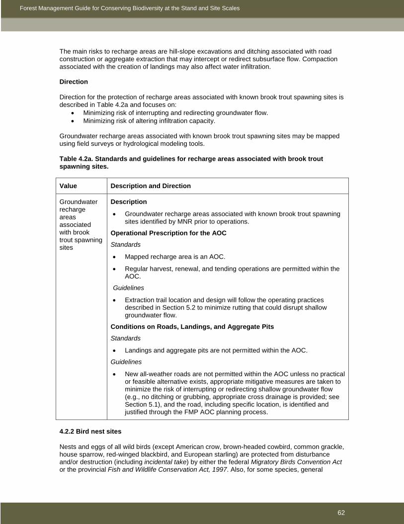
Forest Management Guide for Conserving Biodiversity at the Stand and Site Scales
62
The main risks to recharge areas are hill-slope excavations and ditching associated with road construction or aggregate extraction that may intercept or redirect subsurface flow. Compaction associated with the creation of landings may also affect water infiltration. Direction
Direction for the protection of recharge areas associated with known brook trout spawning sites is described in Table 4.2a and focuses on:
• Minimizing risk of interrupting and redirecting groundwater flow. • Minimizing risk of altering infiltration capacity.
Groundwater recharge areas associated with known brook trout spawning sites may be mapped using field surveys or hydrological modeling tools. Table 4.2a. Standards and guidelines for recharge areas associated with brook trout spawning sites.
Value Description and Direction
Groundwater recharge areas associated with brook trout spawning sites
Description
• Groundwater recharge areas associated with known brook trout spawning sites identified by MNR prior to operations.
Operational Prescription for the AOC
Standards
• Mapped recharge area is an AOC.
• Regular harvest, renewal, and tending operations are permitted within the AOC.
Guidelines
• Extraction trail location and design will follow the operating practices described in Section 5.2 to minimize rutting that could disrupt shallow groundwater flow.
Conditions on Roads, Landings, and Aggregate Pits
Standards
• Landings and aggregate pits are not permitted within the AOC.
Guidelines
• New all-weather roads are not permitted within the AOC unless no practical or feasible alternative exists, appropriate mitigative measures are taken to minimize the risk of interrupting or redirecting shallow groundwater flow (e.g., no ditching or grubbing, appropriate cross drainage is provided; see Section 5.1), and the road, including specific location, is identified and justified through the FMP AOC planning process.
4.2.2 Bird nest sites Nests and eggs of all wild birds (except American crow, brown-headed cowbird, common grackle, house sparrow, red-winged blackbird, and European starling) are protected from disturbance and/or destruction (including incidental take) by either the federal Migratory Birds Convention Act or the provincial Fish and Wildlife Conservation Act, 1997. Also, for some species, general

Forest Management Guide for Conserving Biodiversity at the Stand and Site Scales
63
direction in the Landscape Guide, and direction contained in Section 3 of this guide may not meet all habitat needs and additional species-specific direction may be required. This includes species that show strong fidelity to specific nesting structures or nesting areas, species at risk, or species that are otherwise especially sensitive to habitat alteration because of their life history requirements. Direction Specific direction is provided for a range of forest-dependent birds in Sections 4.2.2.1 to 4.2.2.8 and focuses on:
• Minimizing disturbance of occupied nests. • Maintaining suitability of habitat for selected species.
The direction in Sections 4.2.2.1 to 4.2.2.8 is intended for application at nest sites located in relatively undeveloped situations where birds are likely to be intolerant of forest management operations. Birds that build nests in highly developed or disturbed situations (e.g., adjacent to a well-traveled road or human habitation) may be unusually tolerant of human activities. For these habituated birds, the direction in Sections 4.2.2.1 to 4.2.2.8 may be overly conservative and a planning team may choose to develop a unique, nest-specific, AOC prescription that better reflects the tolerance of the birds. Since the direction in Sections 4.2.2.1 to 4.2.2.8 is not specifically intended for habituated birds, the new AOC prescription developed will not be considered an exception to the direction in this guide. Refer to the glossary for the definition of terms used in Sections 4.2.2.1 to 4.2.2.8. 4.2.2.1 Peregrine falcons Under the ESA, a species-specific habitat regulation will come into force for the peregrine falcon on February 18, 2010, after which time damage or destruction of this species’ habitat will be prohibited without authorization under the ESA. The following areas are prescribed as the habitat of the peregrine falcon that are relevant to forest management:
1. A natural cliff face on which a peregrine falcon is nesting or has nested at any time during the previous 15 years, excluding any part of the cliff face where the top of the cliff face is less than 15 metres above the base of the cliff face.
2. The area within one kilometre of an area described in paragraph 1. For additional information on defining and protecting habitat and activities that will not harm or harass the species that is compliant with the Endangered Species Act, 2007, please consult with the local MNR species at risk biologist. The habitat regulation may be accessed in its entirety through the Ontario e-laws website at http://www.e-laws.gov.on.ca/index.html. 4.2.2.2 Bald eagles and ospreys Bald eagles are listed as special concern in Ontario (ospreys are not listed as species at risk). Direction is provided for primary nests, alternate nests, and inactive nests that are known or suspected (with a high degree of certainty) to be/have been occupied or built by the bald eagle or osprey (Table 4.2b). All nests within a 400 m (eagles) or 300 m (ospreys) radius circle are considered part of the same nesting area unless other information suggests they have been used by >1 pair of eagles or ospreys. If at the time of operations, the status of a nest has changed (e.g., a formerly alternate nest is now the primary nest) or a new nest is located, the prescription (and values map) will be revised appropriately. If a nest is no longer usable because it has fallen out of the tree, the tree has fallen down, or the tree or habitat has become otherwise unsuitable for nesting,
• treat as a value that no longer exists if,

Forest Management Guide for Conserving Biodiversity at the Stand and Site Scales
64
o the nest was inactive o the nest occurred within a nesting area (i.e., within a 400 m (eagle) or 300 m
(osprey) radius circle) that contains other alternate or primary nests, or o the nest tree and/or surrounding habitat has been altered so it is no longer
suitable for nesting. • if the nest was a primary nest, it was the only active nest within a nesting area, and the
nest tree and surrounding habitat are still suitable for nesting, treat as a value that still exists for,
o 3 years from the date the nest was known to have fallen out of the nest tree (if the date the nest fell out of the nest tree is unknown, the date is be estimated as the mean between the date the nest was last known to be present and the date it was reported to be absent), or
o until a new nest is built in the nesting area. Table 4.2b. Standards and guidelines for bald eagle and osprey nest sites (see Figure 4.2a).
Value Description and Direction
Bald eagle primary nests
Description
• Nests known or suspected to have been occupied (see glossary for definitions) at least once within the past 5 years (i.e., active nests), unless the nest and all associated nests within the nesting area have been documented as unoccupied for ≥3 consecutive years, in which case the nest is considered inactive. When ≥2 active nests occur in sufficiently close proximity to be considered part of the nesting area of an individual pair, the nest with the most recent known or suspected history of occupancy within this nesting area is the primary nest; the other active nest(s) is (are) considered alternate nests.
• When inventory data are insufficient to determine which nest in a nesting area has been most recently occupied, the nest in the best condition is considered the primary nest.
• Direction applies to nests known before, or found during, operations.
Operational Prescription for the AOC
Standards
• 400 m radius AOC centred on primary nests.
• Harvest, renewal, and tending operations are permitted within the AOC subject to timing restrictions (see below) and the following conditions:
o Harvest is not permitted within 100 m of primary nests.
o Harvest that retains mature forest with ≥60% relatively uniform canopy closure (canopy openings not to exceed individual tree crowns) is permitted within 101-200 m of primary nests. Harvest that retains relatively uniform canopy closure ≥60% is generally restricted to commercial thinning, preparatory shelterwood harvest, or single tree selection harvest; no harvest is permitted if initial canopy closure <60%.
o Regular harvest is permitted within 201-400 m of primary nests subject to residual pattern requirements as per Section 3.2.2.
o Renewal and tending operations that will leave a residual stand structure below the minimum described above are not permitted; all

Forest Management Guide for Conserving Biodiversity at the Stand and Site Scales
65
other renewal and tending operations are permitted.
Guidelines
• If harvest that retains <60% relatively uniform canopy closure occurs within 200 m of a primary nest prior to its discovery, an additional patch of unharvested forest equivalent to the area harvested will be retained, preferably attached to the remaining unharvested forest surrounding the nest (to provide a supply of potential nest and roost trees).
• Wildlife trees and downed woody material will be retained within harvested portions of the AOC as per general direction in Section 3.2.3. Wildlife trees that may function as potential nest, perch, and roost sites will be preferentially retained, based on the following order of priority: 1) supercanopy trees, 2) veteran trees, 3) cavity trees, and 4) other live dominant or codominant trees that are windfirm. White pines, red pines, and poplars will be favored when available.
• Harvest, renewal, and tending operations are not permitted within 100-400 m of occupied primary nests during the critical breeding period based on potential impact of the operation (see below), except in extraordinary circumstances as specifically identified and justified through the FMP AOC planning process.
Potential impact1 No operations within
High 400 m
Moderate 200 m
Low 100 m 1 See Appendix 4.2 for definitions. Nest monitoring activities are excluded.
• The critical breeding period is defined as March 1 to August 31 for Northwest and Northeast Regions, and February 15 to August 15 for that portion of Southern Region within the AOU. Local knowledge of breeding chronology may be used to adjust these dates.
Conditions on Roads, Landings, and Aggregate Pits
Standards
New roads, landings, and aggregate pits are not permitted within 200 m of primary nests.
Guidelines
• Reasonable efforts will be made to avoid constructing new roads, landings, and aggregate pits within 201-400 m of primary nests.
• When roads are constructed within the AOC, temporary roads and/or water crossings will be used whenever practical and feasible to limit future access and disturbance.
• Operations associated with roads, landings, and aggregate pits are not permitted within 100-400 m of occupied nests during the critical breeding period based on potential impact (see table in Operational Prescription for the AOC), unless required for safety reasons or environmental protection,

Forest Management Guide for Conserving Biodiversity at the Stand and Site Scales
66
or except in extraordinary circumstances as specifically identified and justified through the FMP AOC planning process. However, there is no timing restriction on hauling or low potential impact road maintenance operations (e.g., grading) if the road predates the nest.
Bald eagle alternate nests
Description
• Nests known or suspected to have been occupied (see glossary for definitions) at least once within the past 5 years that are not primary nests (see Primary Nests), unless the nest and all associated nests within the nesting area have been documented as unoccupied for ≥3 consecutive years, in which case the nest is considered inactive.
• Direction applies to nests known before, or found during, operations.
Operational Prescription for the AOC
Standards
• 200 m radius AOC centred on alternate nests.
• Harvest is not permitted within 100 m of alternate nests; harvest that retains mature forest with ≥60% relatively uniform canopy closure (canopy openings not to exceed individual tree crowns) is permitted within the remainder of the AOC. Harvest that retains relatively uniform canopy closure ≥60% is generally restricted to commercial thinning, preparatory shelterwood harvest, or single tree selection harvest; no harvest is permitted if initial canopy closure <60%.
• Within the entire AOC, renewal and tending operations that will leave a residual stand structure below the minimum described above are not permitted; all other renewal and tending operations are permitted.
Guidelines
• If harvest that retains <60% relatively uniform canopy closure occurs within 200 m of an alternate nest prior to its discovery, an additional patch of unharvested forest equivalent to the area harvested will be retained, preferably attached to the remaining unharvested forest surrounding the nest (to provide a supply of potential nest and roost trees).
• Wildlife trees and downed woody material will be retained within harvested portions of the AOC as per general direction in Section 3.2.3. Wildlife trees that may function as potential nest, perch, and roost sites will be preferentially retained based on the following order of priority: 1) supercanopy trees, 2) veteran trees, 3) cavity trees and 4) other live dominant or codominant trees that are windfirm. White pines, red pines, and poplars will be favored when available.
• No timing restrictions on harvest, renewal, or tending operations within the AOC.
Conditions on Roads, Landings, and Aggregate Pits
Standards
New roads, landings, and aggregate pits are not permitted within 200 m of alternate nests.
Guidelines
• No timing restriction on operations associated with roads, landings, and aggregate pits within the AOC.

Forest Management Guide for Conserving Biodiversity at the Stand and Site Scales
67
Bald eagle inactive nests
Description
• Nests not known or suspected to have been occupied (see glossary for definitions) at least once within the past 5 years.
• Primary and alternate nests within nesting areas where all nests within the nesting area have been documented as unoccupied for ≥3 consecutive years.
• Direction applies to nests known before, or found during, operations.
Operational Prescription for the AOC
Standards
• 100 m radius AOC centred on inactive nests.
• Harvest is not permitted within 20 m of inactive nests; harvest that retains mature forest with ≥60% relatively uniform canopy closure (canopy openings not to exceed individual tree crowns) is permitted within the remainder of the AOC. Harvest that retains relatively uniform canopy closure ≥60% is generally restricted to commercial thinning, preparatory shelterwood harvest, or single tree selection harvest; no harvest is permitted if initial canopy closure <60%.
• Within the AOC, renewal and tending operations that will leave a residual stand structure below the minimum described above are not permitted; all other renewal and tending operations are permitted.
Guidelines
• Wildlife trees and downed woody material will be retained within harvested portions of the AOC as per general direction in Section 3.2.3. Wildlife trees that may function as potential nest, perch, and roost sites will be preferentially retained based on the following order of priority: 1) supercanopy trees, 2) veteran trees, 3) cavity trees and 4) other live dominant or codominant trees that are windfirm. White pines, red pines, and poplars will be favored when available.
• No timing restrictions on harvest, renewal, or tending operations within the AOC.
Conditions on Roads, Landings, and Aggregate Pits
Standards
New roads, landings, and aggregate pits are not permitted within 100 m of inactive nests.
Guidelines
• No timing restriction on operations associated with roads, landings, and aggregate pits within the AOC.

Forest Management Guide for Conserving Biodiversity at the Stand and Site Scales
68
Osprey primary nests
Description
• Nests known or suspected to have been occupied (see glossary for definitions) at least once within the past 5 years (i.e., active nests), unless the nest and all associated nests within the nesting area have been documented as unoccupied for ≥3 consecutive years, in which case the nest is considered inactive. When ≥2 active nests occur in sufficiently close proximity to be considered part of the nesting area of an individual pair, the nest with the most recent known or suspected history of occupancy within this nesting area is the primary nest; the other active nest(s) is(are) considered alternate nests.
• When inventory data are insufficient to determine which nest in a nesting area has been most recently occupied, the nest in the best condition is considered the primary nest.
• Direction applies to nests known before, or found during, operations.
Operational Prescription for the AOC
Standards
• 300 m radius AOC centred on primary nests.
• Harvest, renewal, and tending operations are permitted within the AOC subject to timing restrictions (see below) and the following conditions:
o Harvest is not permitted within 75 m of primary nests.
o Harvest that retains mature forest with ≥60% relatively uniform canopy closure (canopy openings not to exceed individual tree crowns) is permitted within 76-150 m of primary nests. Harvest that retains relatively uniform canopy closure ≥60% is generally restricted to commercial thinning, preparatory shelterwood harvest, or single tree selection harvest; no harvest is permitted if initial canopy closure <60%.
o Regular harvest is permitted within 151-300 m of primary nests subject to residual pattern requirements as per Section 3.2.2.
o Renewal and tending operations that will leave a residual stand structure below the minimum described above are not permitted; all other renewal and tending operations are permitted.
Guidelines
• If harvest that retains <60% relatively uniform canopy closure occurs within 150 m of a primary nest prior to its discovery, an additional patch of unharvested forest equivalent to the area harvested will be retained, preferably attached to the remaining unharvested forest surrounding the nest (to provide a supply of potential nest and roost trees).
• Wildlife trees and downed woody material will be retained within harvested portions of the AOC as per general direction in Section 3.2.3. Wildlife trees that may function as potential nest, perch, and roost sites will be preferentially retained based on the following order of priority: 1) supercanopy trees, 2) veteran trees, 3) cavity trees and 4) other live dominant or codominant trees that are windfirm. White pines, red pines, and poplars will be favored when available.
• Harvest, renewal, and tending operations are not permitted within 75 to 300 m of occupied primary nests during the critical breeding period based on
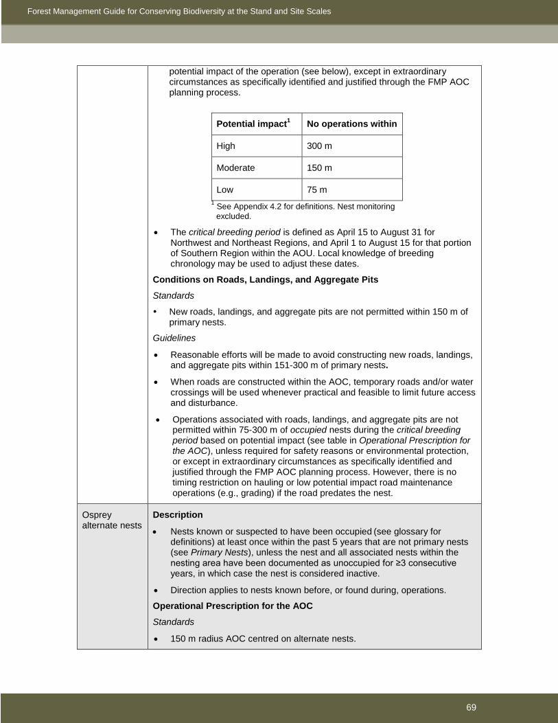
Forest Management Guide for Conserving Biodiversity at the Stand and Site Scales
69
potential impact of the operation (see below), except in extraordinary circumstances as specifically identified and justified through the FMP AOC planning process.
Potential impact1 No operations within
High 300 m
Moderate 150 m
Low 75 m
1 See Appendix 4.2 for definitions. Nest monitoring excluded.
• The critical breeding period is defined as April 15 to August 31 for Northwest and Northeast Regions, and April 1 to August 15 for that portion of Southern Region within the AOU. Local knowledge of breeding chronology may be used to adjust these dates.
Conditions on Roads, Landings, and Aggregate Pits
Standards
New roads, landings, and aggregate pits are not permitted within 150 m of primary nests.
Guidelines
• Reasonable efforts will be made to avoid constructing new roads, landings, and aggregate pits within 151-300 m of primary nests.
• When roads are constructed within the AOC, temporary roads and/or water crossings will be used whenever practical and feasible to limit future access and disturbance.
• Operations associated with roads, landings, and aggregate pits are not permitted within 75-300 m of occupied nests during the critical breeding period based on potential impact (see table in Operational Prescription for the AOC), unless required for safety reasons or environmental protection, or except in extraordinary circumstances as specifically identified and justified through the FMP AOC planning process. However, there is no timing restriction on hauling or low potential impact road maintenance operations (e.g., grading) if the road predates the nest.
Osprey alternate nests
Description
• Nests known or suspected to have been occupied (see glossary for definitions) at least once within the past 5 years that are not primary nests (see Primary Nests), unless the nest and all associated nests within the nesting area have been documented as unoccupied for ≥3 consecutive years, in which case the nest is considered inactive.
• Direction applies to nests known before, or found during, operations.
Operational Prescription for the AOC
Standards
• 150 m radius AOC centred on alternate nests.

Forest Management Guide for Conserving Biodiversity at the Stand and Site Scales
70
• Harvest is not permitted within 75 m of alternate nests; harvest that retains mature forest with ≥60% relatively uniform canopy closure (canopy openings not to exceed individual tree crowns) is permitted within the remainder of the AOC. Harvest that retains relatively uniform canopy closure ≥60% is generally restricted to commercial thinning, preparatory shelterwood harvest, or single tree selection harvest; no harvest is permitted if initial canopy closure <60%.
• Within the entire AOC, renewal and tending operations that will leave a residual stand structure below the minimum described above are not permitted; all other renewal and tending operations are permitted.
Guidelines
• If harvest that retains <60% relatively uniform canopy closure occurs within 150 m of an alternate nest prior to its discovery, an additional patch of unharvested forest equivalent to the area harvested will be retained, preferably attached to the remaining unharvested forest surrounding the nest (to provide a supply of potential nest and roost trees).
• Wildlife trees and downed woody material will be retained within harvested portions of the AOC as per general direction in Section 3.2.3. Wildlife trees that may function as potential nest, perch, and roost sites will be preferentially retained based on the following order of priority: 1) supercanopy trees, 2) veteran trees, 3) cavity trees and 4) other live dominant or codominant trees that are windfirm. White pines, red pines, and poplars will be favored when available.
• No timing restrictions on harvest, renewal, or tending operations within the AOC.
Conditions on Roads, Landings, and Aggregate Pits
Standards
New roads, landings, and aggregate pits are not permitted within 150 m of alternate nests.
Guidelines
• No timing restriction on operations associated with roads, landings, and aggregate pits within the AOC.
Osprey inactive nests
Description
• Nests not known or suspected to have been occupied (see glossary for definitions) at least once within the past 5 years.
• Primary and alternate nests within nesting areas where all nests within the nesting area have been documented as unoccupied for ≥3 consecutive years.
• Direction applies to nests known before, or found during, operations.
Operational Prescription for the AOC
Standards
• 75 m radius AOC centred on inactive nests.
• Harvest is not permitted within 20 m of inactive nests; harvest that retains mature forest with ≥60% relatively uniform canopy closure (canopy openings not to exceed individual tree crowns) is permitted within the

Forest Management Guide for Conserving Biodiversity at the Stand and Site Scales
71
remainder of the AOC. Harvest that retains relatively uniform canopy closure ≥60% is generally restricted to commercial thinning, preparatory shelterwood harvest, or single tree selection harvest; no harvest is permitted if initial canopy closure <60%.
• Within the AOC, renewal and tending operations that will leave a residual stand structure below the minimum described above are not permitted; all other renewal and tending operations are permitted.
Guidelines
• Wildlife trees and downed woody material will be retained within harvested portions of the AOC as per general direction in Section 3.2.3. Wildlife trees that may function as potential nest, perch, and roost sites will be preferentially retained based on the following order of priority: 1) supercanopy trees, 2) veteran trees, 3) cavity trees and 4) other live dominant or codominant trees that are windfirm. White pines, red pines, and poplars will be favored when available.
• No timing restrictions on harvest, renewal, or tending operations within the AOC.
Conditions on Roads, Landings, and Aggregate Pits
Standards
New roads, landings, and aggregate pits are not permitted within 75 m of inactive nests.
Guidelines
• No timing restriction on operations associated with roads, landings, and aggregate pits within the AOC.

Forest Management Guide for Conserving Biodiversity at the Stand and Site Scales
72
Figure 4.2a. Typical layout of the AOC around primary (1), alternate (2), and inactive (3) bald eagle nests in a boreal forest management unit (assuming all harvest is clearcuting). No High Impact Operations are permitted within 400 m of the primary nest (if occupied) during the critical breeding period (circle A). No clearcut harvest is permitted within 200 m of the primary and alternate nests (circles B and C) and 100 m of the inactive nest (circle D) at any time. Note: some types of partial harvest, such as single tree selection, are permitted within circles B, C, and D but have not been included in this example – see text. (Illustration by Mandy Saille). 4.2.2.3 Colonial-nesting birds (great blue heron, Bonaparte’s gull, bank swallow) Direction is provided for colonies that are known or suspected (with a high degree of certainty) to have been used by two species of water birds that nest in living or dead trees in wetlands or forested riparian habitats (great blue heron, Bonaparte’s gull) and one species that nests in sandy/gravelly banks or aggregate pits that is a conservation priority (bank swallow) (Table 4.2c). If at the time of operations, the status of a colony has changed (e.g., a formerly inactive colony is now active) or a new colony is located, the prescription (and values map) will be revised appropriately. If a colony is no longer usable because all nests have fallen out of trees or all nest trees have fallen down (herons and Bonaparte’s gulls), or the habitat has become otherwise unsuitable for nesting,

Forest Management Guide for Conserving Biodiversity at the Stand and Site Scales
73
• treat as a value that no longer exists if, o the colony was inactive, o the colony appears to have moved to a new location, or o the nest trees (herons and Bonaparte’s gulls) and/or surrounding habitat has
been altered so they/it are/is no longer suitable for nesting. • otherwise, treat the colony as a value that still exists
o for 5 (large heron colonies) or 3 (other colonies) years from the date the colony was known to have become unusable (if the actual date the colony became unusable is unknown, the date is be estimated as the mean between the date the colony was last known to be usable and the date it was reported to be unusable), or
o until a new colony is established nearby. Table 4.2c. Standards and guidelines for nest sites of colonial birds.
Value Description and Direction
Active great blue heron colonies
Description
• Large heron colonies (≥4 occupied nests) known or suspected to have been occupied (see glossary for definitions) at least once within the past 10 years (unless documented as unoccupied for ≥5 years).
• Small heron colonies (<4 occupied nests) known or suspected to have been occupied (see glossary for definitions) at least once within the past 5 years (unless documented as unoccupied for ≥3 years).
• Direction applies to colonies known before, or found during, operations.
Operational Prescription for the AOC
Standards
• 300 m radius AOC measured from peripheral nests.
• Harvest, renewal, and tending operations are permitted within the AOC subject to timing restrictions (see below) and the following conditions:
o Harvest is not permitted within 75 m of colonies.
o Harvest that retains mature forest with ≥60% relatively uniform canopy closure (canopy openings not to exceed individual tree crowns) is permitted within 76-150 m of colonies. Harvest that retains relatively uniform canopy closure ≥60% is generally restricted to commercial thinning, preparatory shelterwood harvest, or single tree selection harvest; no harvest is permitted if initial canopy closure <60%.
o Harvest that retains residual forest (see Section 3.2.2) is permitted within 151-300 m of large colonies; regular operations that retain residual pattern as per Section 3.2.2 are permitted within 151-300 m of small colonies.
o Renewal and tending operations that will leave a residual stand structure below the minimum described above are not permitted; all other renewal and tending operations are permitted.
o Wildlife trees and downed woody material will be retained within harvested portions of the AOC as per general direction in Section 3.2.3.
Guidelines

Forest Management Guide for Conserving Biodiversity at the Stand and Site Scales
74
• Harvest, renewal, and tending operations are not permitted within 75-300 m of occupied nests within colonies during the critical breeding period based on potential impact of the operation (see below), except in extraordinary circumstances as specifically identified and justified through the FMP AOC planning process.
Potential impact1 No operations within
High 300 m
Moderate 150 m
Low 75 m
1 See Appendix 4.2 for definitions. Nest monitoring excluded.
• The critical breeding period is defined as April 1 to August 15 for Northwest and Northeast Regions, and March 15 to July 31 for that portion of Southern Region within the AOU. Local knowledge of breeding chronology may be used to adjust these dates.
Conditions on Roads, Landings, and Aggregate Pits
Standards
New roads, landings, and aggregate pits are not permitted within 150 m of colonies.
Guidelines
• Reasonable efforts will be made to avoid constructing new roads, landings, and aggregate pits within 151-300 m of colonies (especially large colonies).
• When roads are constructed within the AOC, temporary roads and/or water crossings will be used whenever practical and feasible to limit future access and disturbance. Within residual forest, the width of the cleared corridor will be as narrow as practical and feasible, and will not exceed 20 m.
• Operations associated with roads, landings, and aggregate pits are not permitted within 75-300 m of occupied nests within colonies during the critical breeding period based on potential impact (see table in Operational Prescription for the AOC), unless required for safety reasons or environmental protection, or except in extraordinary circumstances as specifically identified and justified through the FMP AOC planning process. However, there is no timing restriction on hauling or low potential impact road maintenance operations (e.g., grading) if the road predates the colony.
Inactive great blue heron colonies
Description
• Large colonies in suitable habitat not known or suspected to have been occupied at least once within the past 10 years or documented as unoccupied for 5 or more consecutive years.
• Small colonies in suitable habitat not known or suspected to have been occupied at least once within the past 5 years or documented as unoccupied for 3 or more consecutive years.
• Direction applies to colonies known before, or found during, operations.
Forest Management Guide for Conserving Biodiversity at the Stand and Site Scales
75
Operational Prescription for the AOC
Standards
• 30 m radius AOC measured from peripheral nests.
• Harvest is not permitted within the AOC.
• Renewal and tending operations that will knock down desired residual trees are not permitted within the AOC.
Guidelines
• No timing restrictions on renewal or tending.
Conditions on Roads, Landings, and Aggregate Pits
Standards
New landings and aggregate pits are not permitted within the AOC.
Guidelines
• Reasonable efforts will be made to avoid constructing new roads within the AOC.
• No timing restriction on operations associated with roads, landings, and aggregate pits within the AOC.
Active colonies of Bonaparte’s gull
Description
• Colonies known or suspected to have been occupied at least once within the past 5 years (unless documented as unoccupied for ≥3 consecutive years).
• Direction applies to colonies known before, or found during, operations.
Operational Prescription for the AOC
Standards
• 150 m radius AOC measured from peripheral nests.
• Harvest, renewal, and tending operations are permitted within the AOC subject to timing restrictions (see below) and the following conditions:
o Harvest is not permitted within 75 m of colonies.
o Harvest that retains mature forest with ≥60% relatively uniform canopy closure (canopy openings not to exceed individual tree crowns) is permitted within 76-150 m of colonies. Harvest that retains relatively uniform canopy closure ≥60% is generally restricted to commercial thinning, preparatory shelterwood harvest, or single tree selection harvest; no harvest is permitted if initial canopy closure <60%.
o Renewal and tending operations that will leave a residual stand structure below the minimum described above are not permitted; all other renewal and tending operations are permitted.
o Wildlife trees and downed woody material will be retained within harvested portions of the AOC as per general direction in Section 3.2.3.
Guidelines
• Harvest, renewal, and tending operations are not permitted within 40-150 m of occupied nests within colonies during the critical breeding period based on potential impact of the operation (see below), except in extraordinary circumstances as specifically identified and justified through the FMP AOC

Forest Management Guide for Conserving Biodiversity at the Stand and Site Scales
76
planning process.
Potential impact1 No operations within
High 150 m
Moderate 75 m
Low 40 m
1 See Appendix 4.2 for definitions. Nest monitoring excluded.
• The critical breeding period is May 1 to August 31 for Bonaparte’s gull. Local knowledge of breeding chronology may be used to adjust these dates.
Conditions on Roads, Landings, and Aggregate Pits
Standards
New roads, landings, and aggregate pits are not permitted within 150 m of active colonies.
Guidelines
• Operations associated with roads, landings, and aggregate pits are not permitted within 40-150 m of occupied nests within colonies during the critical breeding period based on potential impact (see table in Operational Prescription for the AOC), unless required for safety reasons or environmental protection, or except in extraordinary circumstances as specifically identified and justified through the FMP AOC planning process. However, there is no timing restriction on hauling or low potential impact road maintenance operations (e.g., grading) if the road predates the colony.
Active large colonies of bank swallow
Description
• Colonies known or suspected to have been occupied by ≥100 pairs at least once within the past 5 years (unless documented as unoccupied for ≥3 consecutive years).
• Direction applies to colonies known before, or found during, operations.
Operational Prescription for the AOC
Standards
• 50 m radius AOC measured from peripheral nests.
• Regular harvest, renewal, and tending operations are permitted within the AOC subject to timing restrictions (see below).
Guidelines
• Harvest, renewal, and tending operations are not permitted within 10-50 m of occupied nests within colonies during the critical breeding period based on potential impact of the operation (see below), except in extraordinary circumstances as specifically identified and justified through the FMP AOC planning process.

Forest Management Guide for Conserving Biodiversity at the Stand and Site Scales
77
Potential impact1 No operations within
High 50 m
Moderate 25 m
Low 10 m
1 See Appendix 4.2 for definitions. Nest monitoring excluded.
• The critical breeding period is May 1 to July 31. Local knowledge of breeding chronology may be used to adjust these dates.
Conditions on Roads, Landings, and Aggregate Pits
Standards
New roads and landings are not permitted within 50 m of active colonies.
Aggregate extraction is permitted within the AOC subject to timing restrictions (see below).
Guidelines
• Operations associated with roads, landings, and aggregate pits are not permitted within 10-50 m of occupied nests within colonies during the critical breeding period based on potential impact (see table in Operational Prescription for the AOC), unless required for safety reasons or environmental protection, or except in extraordinary circumstances as specifically identified and justified through the FMP AOC planning process. However, there is no timing restriction on hauling or low potential impact road maintenance operations (e.g., grading) if the road predates the colony.
4.2.2.4 Uncommon stick-nesting raptors Direction for uncommon stick-nesting raptors is provided for primary nests, alternate nests, and inactive nests that are known or suspected (with a high degree of certainty) to be/have been occupied or built by the great gray owl, northern goshawk, or red-shouldered hawk (Table 4.2d). All nests within a 400 m radius circle are considered part of the same nesting area unless other information suggests they have been used by more than one pair of birds. If at the time of operations, the status of a nest has changed (e.g., a formerly alternate nest is now the primary nest) or a new nest is located, the prescription (and values map) will be revised appropriately. If a nest is no longer usable because it has fallen out of the tree, the tree has fallen down, or the tree or habitat has become otherwise unsuitable for nesting, treat as a value that no longer exists. Table 4.2d. Standards and guidelines for uncommon stick-nesting bird nest sites.
Value Description and Direction
Primary nests of great gray owl, northern
Description
• Nests known or suspected to have been occupied (see glossary for

Forest Management Guide for Conserving Biodiversity at the Stand and Site Scales
78
goshawk, or red-shouldered hawk
definitions) at least once within the past 5 years (i.e., active nests) unless the nest and all associated nests within the nesting area have been documented as unoccupied for ≥3 consecutive years, in which case the nest is considered inactive. When ≥2 active nests occur in sufficiently close proximity to be considered part of the nesting area of an individual pair, the nest with the most recent known or suspected history of occupancy within this nesting area is the primary nest; the other active nest(s) is(are) considered alternate nests.
• When inventory data are insufficient to determine which nest in a nesting area has been most recently occupied, the nest in the best condition is considered the primary nest.
• Direction applies to nests known before, or found during, operations.
Operational Prescription for the AOC
Standards
• 400 m radius AOC centred on primary nests.
• Harvest is permitted within the AOC subject to timing restrictions (see below) and the following species-specific conditions:
Species Conditions on harvest within the 400 m radius AOC
Red-shouldered hawk
o Harvest is not permitted within 50 m of a primary nest. If some harvest occurs within 50 m of a primary nest prior to its discovery, the primary nest will be retained in a 0.8 ha unharvested patch that is as nearly circular as possible (to minimize edge).
o A total of 28 ha of suitable nesting habitat will be retained within the AOC1. Suitable nesting habitat is mature forest with a relatively uniform canopy closure ≥70%2, average size of canopy openings not to exceed individual tree crowns, and maximum size of canopy gaps ≤0.1 ha.
o 7 ha of the 28 ha of suitable nesting habitat will be retained within 200 m of the primary nest; any harvest will follow the residual stand structure targets for creation of old growth forest conditions (5-5-5-5 m2/ha of poles, small logs, medium logs, and large logs, respectively; see the Ontario Tree Marking Guide, page 100); the remaining 21 ha of suitable nesting habitat may be located anywhere within the AOC.
o Harvest that changes development stage, reduces canopy closure below 60%2, or creates canopy openings that exceed individual tree crowns is not permitted within 200 m of the primary nest.
Great gray owl, northern goshawk
o Harvest is not permitted within 50 m of a primary nest. If some harvest occurs within 50 m of a primary nest prior to its discovery, the primary nest will be retained in a 0.8 ha unharvested patch that is as nearly circular

Forest Management Guide for Conserving Biodiversity at the Stand and Site Scales
79
as possible (to minimize edge).
o A total of 28 ha of suitable nesting habitat will be retained within the AOC1.
o 7 ha of the 28 ha of suitable nesting habitat will be retained within 200 m of the primary nest and will be mature forest with a relatively uniform canopy closure ≥70%2 and canopy openings not to exceed individual tree crowns.
o The remaining 21 ha of suitable nesting habitat may be located anywhere within the AOC and will be mature forest with a relatively uniform canopy closure ≥50%2 and a maximum size of canopy gaps ≤0.1 ha.
o Harvest that changes development stage, reduces canopy closure below 50%2, or creates canopy gaps >0.1 ha is not permitted within 200 m of the primary nest (northern goshawk only).
1The 50 m radius (0.8 ha) patch(es) of unharvested forest surrounding the primary nest (and any alternate nests) contribute(s) to the 28 ha patch of suitable nesting habitat. 2Based on dominant and codominant trees. No harvest is permitted if initial canopy closure is less than this minimum.
• Wildlife trees and downed woody material will be retained within harvested portions of the AOC as per general direction in Section 3.2.3.
• Within the entire AOC, renewal and tending operations that will leave a residual stand structure below the minimum described above are not permitted; all other renewal and tending operations are permitted subject to timing restrictions (see below).
Guidelines
• When mature forest is retained as suitable nesting habitat within the AOC, to the extent practical and feasible,
o Suitable nesting habitat will be retained as a contiguous patch that encompasses the primary nest and any alternate nests.
o Suitable nesting habitat will be retained that is classified as preferred based on the regional habitat matrices.
o Suitable nesting habitat will be retained as a circular patch centred on the primary nest (300 m radius circle) if the primary nest occurs in a large uniform block of habitat. Suitable nesting habitat will be retained as an irregularly-shaped patch (contained within the 400 m AOC) if this configuration better encompasses primary and alternate nests as well as preferred habitat.
o Retention of 70% canopy closure in dominant/codominant trees can generally be obtained in tolerant hardwood forest units through single tree selection harvests with a residual basal area of 20 m2/ha and a residual stand structure following the ideal for central Ontario (6-6-5-3 m2/ha of poles, small logs, medium logs, and large logs, respectively; see the Ontario Tree Marking Guide). Targets for residual basal area and stand structure for other forest units and silvicultural systems should be developed using canopy closure – BA – tree size relationships such

Forest Management Guide for Conserving Biodiversity at the Stand and Site Scales
80
as presented in the Ontario Tree Marking Guide (page 84).
• Harvest, renewal, and tending operations are not permitted within 50-200 m of occupied primary nests during the critical breeding period based on potential impact of the operation (see below), except in extraordinary circumstances as specifically identified and justified through the FMP AOC planning process.
Potential impact1 No operations within
High 200 m
Moderate 100 m
Low 50 m
1 See Appendix 4.2 for definitions. Nest monitoring excluded.
• The critical breeding period is defined as March 15 to July 15 for great gray owl, northern goshawk, and red-shouldered hawk for all of Ontario. Local knowledge of breeding chronology may be used to adjust these dates.
Conditions on Roads, Landings, and Aggregate Pits
Standards
New roads, landings, and aggregate pits are not permitted within 50 m of primary nests or within the 7 ha patch of suitable habitat retained within 200 m of primary nests.
Guidelines
• Reasonable efforts will be made to avoid constructing new roads, landings, and aggregate pits within 51-200 m of primary nests or within forest retained as suitable nesting habitat. If roads are constructed, temporary roads and/or water crossings will be used whenever practical and feasible to limit future access and disturbance and the width of the cleared corridor will be as narrow as practical and feasible, and will not exceed 20 m.
• Operations associated with roads, landings, and aggregate pits are not permitted within 50-200 m of occupied nests during the critical breeding period based on potential impact (see table in Operational Prescription for the AOC), unless required for safety reasons or environmental protection, or except in extraordinary circumstances as specifically identified and justified through the FMP AOC planning process. However, there is no timing restriction on hauling or low potential impact road maintenance operations (e.g., grading) if the road predates the nest.
Alternate nests of great gray owl, northern goshawk, or red-shouldered hawk
Description
• Nests known or suspected to have been occupied (see glossary for definitions) at least once within the past 5 years that are not primary nests (see Primary Nests), unless the nest and all associated nests within the nesting area have been documented as unoccupied for ≥3 consecutive years, in which case the nest is considered inactive.
• Any nest in good repair within 400 m of primary nests.

Forest Management Guide for Conserving Biodiversity at the Stand and Site Scales
81
• Direction applies to nests known before, or found during, operations.
Operational Prescription for the AOC
Standards
• 50 m radius AOC centred on alternate nests.
• Harvest is not permitted within the AOC. If some harvest occurs within 50 m of an alternate nest prior to its discovery, the alternate nest will be retained in a 0.8 ha unharvested patch that is as nearly circular as possible (to minimize edge).
• Renewal and tending operations that kill or knock down any trees are not permitted; all other renewal and tending operations are permitted.
Guidelines
• No timing restrictions on renewal or tending operations around alternate nests.
Conditions on Roads, Landings, and Aggregate Pits
Standards
New roads, landings, and aggregate pits are not permitted within the AOC.
Guidelines
• No timing restriction on operations associated with roads, landings, and aggregate pits within the AOC.
Inactive nests of great gray owl, northern goshawk, or red-shouldered hawk
Description
• Nests not known or suspected to have been occupied (see glossary for definitions) at least once within the past 5 years that are
o >400 m from a primary nest or
o ≤400 m from a primary nest but in poor repair.
• Primary and alternate nests within nesting areas where all nests within the nesting area have been documented as unoccupied for ≥3 consecutive years.
• Direction applies to nests known before, or found during, operations.
Conditions on Regular Operations, Roads, Landings, and Aggregate Pits
Standards
• If the nest is in good repair, harvest is not permitted within 20 m; the patch may be counted as residual forest (see Section 3.2.2). Otherwise, the nest tree only will be retained as a wildlife tree.
Guidelines
• No timing restrictions on harvest, renewal, or tending operations around inactive nests.
• Reasonable efforts will be made to avoid constructing new roads, landings, and aggregate pits within 20 m of inactive nests.
• No timing restriction on operations associated with roads, landings, and aggregate pits around inactive nests.

Forest Management Guide for Conserving Biodiversity at the Stand and Site Scales
82
4.2.2.5 Common stick-nesting raptors, tree-nesting common ravens, and unknown stick nests Direction for common stick-nesting birds is provided for nests that are known or suspected (with a high degree of certainty) to be occupied or built by the barred owl, broad-winged hawk, common raven, Cooper’s hawk, great horned owl, long-eared owl, merlin, red-tailed hawk, or sharp-shinned hawk (Table 4.2e). Direction is also provided for unoccupied stick nests for which the builder has not been identified but is unlikely to be the northern goshawk or red-shouldered hawk. If a nest is no longer usable because it has fallen out of the tree, the tree has fallen down, or the tree has become otherwise unsuitable for nesting, treat as a value that no longer exists. Table 4.2e. Standards and guidelines for common stick-nesting bird nest sites and unknown stick nests.
Item Description and Direction
Stick nests occupied by barred owl, broad-winged hawk, common raven, Cooper’s hawk, great horned owl, long-eared owl, merlin, red-tailed hawk, or sharp-shinned hawk
Description
• Nests known or suspected to be occupied by the barred owl, broad-winged hawk, common raven, Cooper’s hawk, great horned owl, long-eared owl, merlin, red-tailed hawk, or sharp-shinned hawk.
• Direction applies to nests known before, or found during, operations.
Operational Prescription for the AOC
Standards
• 50-200 m radius AOC centred on the occupied nest based on species as follows:
Species Radius of AOC
Barred owl 200 m
Broad-winged hawk, Cooper’s hawk, great horned owl, long-eared owl, red-tailed hawk
100 m
Common raven, merlin, sharp-shinned hawk 50 m
• Regular harvest, renewal, and tending operations are permitted around nests subject to timing restrictions (see below) and:
Species Retain
Broad-winged hawk, merlin, sharp-shinned hawk
The nest tree will be retained as a wildlife tree if the nest is in good repair or the nest tree contains a good fork1.
Barred owl, Cooper’s hawk, common raven, great horned owl, long-eared owl, red-tailed hawk
The nest tree will be retained in an unharvested residual patch (≥20 m radius) if the nest is in good repair (may be counted as residual forest). Otherwise, the nest tree will be retained as a wildlife tree.

Forest Management Guide for Conserving Biodiversity at the Stand and Site Scales
83
1 See glossary.
Guidelines
• Harvest, renewal, and tending operations are not permitted within 10-200 m of occupied nests during the critical breeding period based on species and potential impact of the operation (see table below), except in extraordinary circumstances as specifically identified and justified through the FMP AOC planning process.
Species
Timing restriction (m)
High Impact Operations1
Moderate Impact Operations
Low Impact Operations
Barred owl 200 m 100 m 50 m
Broad-winged hawk, Cooper’s hawk, great horned owl, long-eared owl red-tailed hawk
100 m
50 m
25 m
Common raven, merlin, sharp-shinned hawk
50 m
25 m
10 m
1 See Appendix 4.2 for definitions. Nest monitoring excluded.
• The critical breeding period for all of Ontario is defined as February 1 to May 31 for great horned owl; February 15 to June 15 for common raven; March 15 to July 15 for barred owl, long-eared owl, and red-tailed hawk; and April 1 to July 31 for broad-winged hawk, Cooper’s hawk, merlin, and sharp-shinned hawk. Local knowledge of breeding chronology may be used to adjust these dates.
Conditions on Roads, Landings, and Aggregate Pits
Standards
• New roads, landings, and aggregate pits will not be constructed within 20 m of nests of the barred owl, Cooper’s hawk, common raven, great horned owl, long-eared owl, and red-tailed hawk.
Guidelines
• Reasonable efforts will be made to avoid constructing new roads, landings, and aggregate pits within 20 m of nests of the broad-winged hawk, merlin, and sharp-shinned hawk.
• Operations associated with roads, landings, and aggregate pits are not permitted within 10-200 m of occupied nests during the critical breeding period based on potential impact and species (see table in Operational Prescription for the AOC), unless required for safety reasons or environmental protection, or except in extraordinary circumstances as specifically identified and justified through the FMP AOC planning process. However, there is no timing restriction on hauling or low potential impact road maintenance operations (e.g., grading) if the road predates the nest.

Forest Management Guide for Conserving Biodiversity at the Stand and Site Scales
84
Un-occupied stick nests built or used by barred owl, broad-winged hawk, common raven, Cooper’s hawk, great horned owl, long-eared owl, merlin, red-tailed hawk, or sharp-shinned hawk or by an unknown species
Description
• Unoccupied nests known or suspected to have been built or used by the barred owl, broad-winged hawk, common raven, Cooper’s hawk, great horned owl, long-eared owl, merlin, red-tailed hawk, or sharp-shinned hawk.
• Unoccupied nests built by an unknown species but unlikely to have been built by the northern goshawk or red-shouldered hawk.
• Direction applies to nests known before, or found during, operations.
Conditions on Regular Operations, Roads, Landings, and Aggregate Pits
Standards
• Harvest, renewal, and tending options:
Species Retain
Broad-winged hawk, merlin, sharp-shinned hawk, or unknown small stick nest (<75 cm diameter)
The nest tree will be retained as a wildlife tree if the nest is in good repair or the nest tree contains a good fork1.
Barred owl, Cooper’s hawk, common raven, great horned owl, long-eared owl, red-tailed hawk or unknown large stick nest (≥75 cm diameter)
The nest tree will be retained in an unharvested residual patch (≥20 m radius) if the nest is in good repair (may be counted as residual forest). Otherwise, the nest tree will be retained as a wildlife tree.
1 See glossary.
• New roads, landings, and aggregate pits will not be constructed within 20 m of nests of the barred owl, Cooper’s hawk, common raven, great horned owl, long-eared owl, red-tailed hawk, or unknown large stick nests.
Guidelines
• No timing restrictions on harvest, renewal, or tending operations around nests.
• Reasonable efforts will be made to avoid constructing new roads, landings, and aggregate pits within 20 m of nests of the broad-winged hawk, merlin, sharp-shinned hawk, or unknown small stick nests.
• No timing restriction on operations associated with roads, landings, and aggregate pits around unoccupied nests.
4.2.2.6 Cavities used by nesting raptors or nesting/communally-roosting chimney swifts Direction for cavity-nesting raptors and cavity-nesting/communally-roosting chimney swifts is provided for nests/communal roosts that are known or suspected (with a high degree of certainty) to be/have been occupied by the American kestrel, barred owl, boreal owl, eastern screech-owl, great horned owl, northern hawk owl, northern saw-whet owl, or chimney swift (Table 4.2f). If a nest/communal roost is no longer usable because the tree has fallen down or has become otherwise unsuitable for nesting, treat as a value that no longer exists.

Forest Management Guide for Conserving Biodiversity at the Stand and Site Scales
85
Table 4.2f. Standards, guidelines, and best management practices for cavities used by nesting raptors or nesting/ communally-roosting chimney swifts.
Item Description and Direction
Nests/ communal roosts in cavities occupied by American kestrel, barred owl, boreal owl, eastern screech-owl, great horned owl, northern hawk owl, northern saw-whet owl, or chimney swift
Description
• Nests/communal roosts in cavities known or suspected to be occupied by the American kestrel, barred owl, boreal owl, eastern screech-owl, great horned owl, northern hawk owl, northern saw-whet owl, or chimney swift.
• Direction applies to nests known before, or found during, operations.
Operational Prescription for the AOC
Standards
• 25-100 m radius AOC based on species as follows:
Species Radius of AOC
Barred owl 100 m
Great horned owl, northern hawk owl, chimney swift
50 m
American kestrel, boreal owl, eastern screech- owl, northern saw-whet owl
25 m
• Regular harvest, renewal, and tending operations are permitted around nests/communal roosts subject to timing restrictions (see below) and:
Species Retain
Trees used by American kestrel, boreal owl, eastern screech-owl, northern hawk owl, northern saw-whet owl
The nest tree will be retained as a wildlife tree if not a safety concern.
Trees used by barred owl, great horned owl, chimney swift
The nest/communal roost tree will be retained in an unharvested residual patch (≥20 m radius) (may be counted as residual forest).
Guidelines
• Harvest, renewal, and tending operations are not permitted within 0-100 m of occupied nests/communal roosts during the critical breeding/roosting period based on species and potential impact of the operation (see table below), except in extraordinary circumstances as specifically identified and justified through the FMP AOC planning process.
Species
Timing restriction (m)
High Impact Operations1
Moderate Impact Operations
Low Impact Operations

Forest Management Guide for Conserving Biodiversity at the Stand and Site Scales
86
Barred owl 100 m 50 m 25 m
Great horned owl, northern hawk owl, chimney swift
50 m
25 m
10 m
American kestrel, boreal owl, eastern screech- owl, northern saw-whet owl
25 m
10 m
0 m
1 See Appendix 4.2 for definitions. Nest monitoring excluded.
• The critical breeding period for all of Ontario is defined as February 1 to May 31 for great horned owl; March 15 to July 15 for barred owl, eastern screech-owl, northern hawk-owl, and northern saw-whet owl; and April 1 to July 31 for American kestrel and boreal owl. The critical breeding/roosting period is defined as May 1 to September 30 for the chimney swift. Local knowledge of breeding chronology may be used to adjust these dates.
Best management practices
• Nest trees used by the American kestrel, boreal owl, eastern screech-owl, northern hawk owl, or northern saw-whet owl that are a potential safety risk should be retained in an unharvested residual patch (≥20 m radius).
Conditions on Roads, Landings, and Aggregate Pits
Standards
• New roads, landings, and aggregate pits will not be constructed within 20 m of nests/communal roosts of the barred owl, great horned owl, or chimney swift.
Guidelines
• Reasonable efforts will be made to avoid constructing new roads, landings, and aggregate pits within 20 m of nests of the American kestrel, boreal owl, eastern screech-owl, northern hawk owl, or northern saw-whet owl.
• Operations associated with roads, landings, and aggregate pits are not permitted within 0-100 m of occupied nests during the critical breeding/roosting period based on potential impact and species (see table in Operational Prescription for the AOC), unless required for safety reasons or environmental protection, or except in extraordinary circumstances as specifically identified and justified through the FMP AOC planning process. However, there is no timing restriction on hauling or low potential impact road maintenance operations (e.g., grading) if the road predates the nest/communal roost.
Unoccupied nests/ communal roosts in cavities previously used by American kestrel, barred owl,
Description
• Unoccupied nests/communal roosts in cavities known or suspected to have been used by the American kestrel, barred owl, boreal owl, eastern screech-owl, great horned owl, northern hawk owl, northern saw-whet owl, or chimney swift.
• Direction applies to nests known before, or found during, operations.
Conditions on Regular Operations, Roads, Landings, and Aggregate Pits
Standards

Forest Management Guide for Conserving Biodiversity at the Stand and Site Scales
87
boreal owl, eastern screech-owl, great horned owl, northern hawk owl, northern saw-whet owl, or chimney swift
• Harvest, renewal, and tending options:
Species Retain
Trees used by American kestrel, boreal owl, eastern screech-owl, northern hawk owl, northern saw-whet owl
The nest tree will be retained as a wildlife tree if not a safety concern.
Trees used by barred owl, great horned owl, chimney swift
The nest/communal roost tree will be retained in an unharvested residual patch (≥20 m radius) (may be counted as residual forest).
• New roads, landings, and aggregate pits will not be constructed within 20 m of nests/communal roosts of the barred owl, great horned owl, or chimney swift.
Guidelines
• No timing restrictions on harvest, renewal, or tending operations around nests/roosts.
• Reasonable efforts will be made to avoid constructing new roads, landings, and aggregate pits within 20 m of nests of the American kestrel, boreal owl, eastern screech-owl, northern hawk owl, or northern saw-whet owl.
• No timing restriction on operations associated with roads, landings, and aggregate pits around unoccupied nests/communal roosts.
Best management practices
• Nest trees used by the American kestrel, boreal owl, eastern screech-owl, northern hawk owl, or northern saw-whet owl that are a potential safety risk should be retained in an unharvested residual patch (≥20 m radius).
4.2.2.7 Ground-nesting raptors Direction for ground-nesting raptors is provided for nests that are known or suspected (with a high degree of certainty) to be occupied by the northern harrier, short-eared owl, or turkey vulture (Table 4.2g). Table 4.2g. Standards and guidelines for ground-nesting raptor nest sites.
Item Description and Direction
Ground nests occupied by northern harrier, short-eared owl, or turkey vulture
Description
• Ground nests known or suspected to be occupied by the northern harrier, short-eared owl, or turkey vulture.
• Direction applies to nests known before, or found during, operations.
Operational Prescription for the AOC
Standards
• 50-150 m AOC based on species as follows:

Forest Management Guide for Conserving Biodiversity at the Stand and Site Scales
88
Species Radius of AOC
Turkey vulture 150 m
Short-eared owl 100 m
Northern harrier 50 m
• Regular harvest, renewal, and tending operations are permitted with timing restrictions (see below).
Guidelines
• Harvest, renewal, and tending operations are not permitted within 10-150 m of occupied nests during the critical breeding period based on species and potential impact of the operation (see table below), except in extraordinary circumstances as specifically identified and justified through the FMP AOC planning process.
Species
Timing restriction (m)
High Impact Operations1
Moderate Impact Operations
Low Impact Operations
Turkey vulture 150 m 75 m 40 m
Short-eared owl 100 m 50 m 25 m
Northern harrier 50 m 25 m 10 m
1 See Appendix 4.2 for definitions. Nest monitoring excluded.
• The critical breeding period for all of Ontario is defined as March 15 to July 15 for short-eared owl, April 1 to July 31 for northern harrier, and May 1 to August 31 for turkey vulture. Local knowledge of breeding chronology may be used to adjust these dates.
Conditions on Roads, Landings, and Aggregate Pits
Guidelines
• Operations associated with roads, landings, and aggregate pits are not permitted within 10-150 m of occupied nests during the critical breeding period based on potential impact and species (see table in Operational Prescription for the AOC), unless required for safety reasons or environmental protection, or except in extraordinary circumstances as specifically identified and justified through the FMP AOC planning process. However, there is no timing restriction on hauling or low potential impact road maintenance operations (e.g., grading) if the road predates the nest.
4.2.2.8 Forest-nesting birds not covered by direction in previous sections All forest workers will be vigilant for bird nests containing eggs or young during spring and summer. Known nests containing eggs or young encountered during operations will not be destroyed. Reasonable efforts will be made to minimize disturbance of known nests containing

Forest Management Guide for Conserving Biodiversity at the Stand and Site Scales
89
eggs or young encountered during operations. Direction for birds not covered in Sections 4.2.2.1 to 4.2.2.7 is provided for occupied nests (Table 4.2h). Table 4.2h. Standards, guidelines, and best management practices for known bird nests containing eggs or young encountered during forest management operations that are not covered by direction in Sections 4.2.2.1 to 4.2.2.7.
Item Description and Direction
Nests of waterfowl, grouse, or wild turkeys containing eggs encountered during forest management operations
Description
• Known nests of waterfowl, grouse, or wild turkeys containing eggs encountered during operations.
Conditions on Regular Operations, Roads, Landings, and Aggregate Pits
Standards
• Known nests of waterfowl, grouse, or wild turkeys containing eggs encountered during operations will not be destroyed1.
Guidelines
• Reasonable efforts will be made to minimize disturbance2 of known nests of waterfowl, grouse, or wild turkeys containing eggs encountered during operations.
Best management practices
• Harvest, renewal, and tending operations should be avoided within 10 m of known nests containing eggs. Specifically,
o Trees should be retained within 10 m of known nests containing eggs (patch may be counted as a clump of wildlife trees).
o Trees should not be felled into the area within 10 m of known nests containing eggs.
o Heavy equipment should not travel within 10 m of known nests containing eggs.
• New roads, landings, and aggregate pits should not be constructed within 10 m of known nests containing eggs.
Nests of songbirds or other small birds containing eggs or young encountered during forest management operations
Description
• Known nests of songbirds or other small birds containing eggs or young encountered during operations.
Conditions on Regular Operations, Roads, Landings, and Aggregate Pits
Standards
• Known nests of songbirds or other small birds containing eggs or young encountered during operations will not be destroyed1.
Guidelines
• Reasonable efforts will be made to minimize disturbance2 of known nests of songbirds or other small birds containing eggs or young encountered during operations.
Best management practices

Forest Management Guide for Conserving Biodiversity at the Stand and Site Scales
90
• Harvest, renewal, and tending operations should be avoided within 3 m of known nests containing eggs or young. Specifically,
o Trees should be retained within 3 m of known nests containing eggs or young (patch may be counted as a clump of wildlife trees).
o Trees should not be felled into the area within 3 m of known nests containing eggs or young.
o Heavy equipment should not travel within 3 m of known nests containing eggs or young.
• New roads, landings, and aggregate pits should not be constructed within 3 m of known nests containing eggs or young.
1 In this context, destruction means the complete or partial damage of the nest structure or its contents (i.e., attendant birds, eggs, or young). 2 In this context, disturbance means the incidental interference with breeding activities such as egg laying, incubation, brooding, or feeding of young. 4.2.3 Beaver habitat The Beaver is widely considered to be a keystone species; the mosaic of habitat conditions (newly flooded ponds, stagnant ponds, de-watered ponds, and beaver meadows) it creates across watersheds leads to increased species richness of both plants and animals. Beaver ponds are especially important habitat for a variety of dabbling ducks of conservation concern, such as american black ducks. While beaver activity is often viewed as detrimental to cold water game fish, beaver ponds may actually provide important fish habitat; research suggests that the productivity and diversity of fish communities in headwater streams is associated with the mosaic of beaver ponds found in various stages of succession. Beavers feed on a wide range of herbaceous and woody vegetation, but the supply of preferred woody vegetation that can be cached for winter feeding may be limiting. As beavers feed selectively on woody vegetation in the riparian zone, they remove preferred forage species such as trembling aspen, gradually causing an increase in the amount of less palatable and more shade tolerant woody plants such as balsam fir. As food supply is exhausted, beavers may abandon a pond, beginning the phase of pond de-watering and beaver meadow creation. Abandoned ponds may eventually be reoccupied but since preferred forage species are shade intolerant, some significant disturbance such as fire or timber harvest may be required to rejuvenate food supply. However, fire suppression activities and past practices that routinely retained ‘donuts’ of unharvested forest around beaver ponds have led to a growing concern that beavers and beaver pond habitats may be declining, at least in some parts of the province. Direction Direction in Section 4.1.1 promotes some management of shoreline forest adjacent to all lakes and ponds and is thus generally beneficial for beavers. Additional direction for beaver ponds or beaver meadows requiring special management (as identified by MNR or local trappers) is contained in Table 4.2i and focuses on:
• Managing shoreline forest to maximize regeneration of beaver food supply (primarily aspen)

Forest Management Guide for Conserving Biodiversity at the Stand and Site Scales
91
Table 4.2i. Guidelines and best management practices for beaver ponds and beaver meadows requiring special management to regenerate food supply.
Value Description and Direction
Beaver ponds and beaver meadows requiring special management to regenerate food supply
Description
• Beaver ponds and beaver meadows identified by MNR or local trappers that require special management to regenerate food supply.
Operational prescription for the AOC
Standards and Guidelines for the aquatic features associated with these values apply (see Section 4.1) with the following additions.
Guidelines
• Harvest, renewal, and tending operations within the AOC should promote establishment or perpetuation of intolerant hardwood or mixedwood FUs, to the extent practical and feasible, unless inconsistent with other ecological objectives.
Best management practices
• For clearcut FUs
o In the AOC, as much of the shoreline forest should be clearcut to the edge of water as is practical and feasible, considering residual forest requirements in Section 4.1. Clearcut portions of the AOC should ideally be ≥200 m long and within 50 m of water.
o When clearcutting, shoreline forest with >10% aspen (or other intolerant hardwoods) in the overstory, limited conifer advanced regeneration in the understory, and on low slopes should be targeted.
o Conifer advanced regeneration (especially balsam fir) should be removed to the extent practical and feasible. Use of prescribed fire should be considered.
o Aerial or machine-based ground application of herbicides should not be conducted within 50 m of the beaver pond or beaver meadow (applies to shorelines where regenerating hardwoods will be accessible to beavers).
• For selection and shelterwood FUs
o In the AOC, small clearcuts or large group openings in patches of intolerant hardwood, mixedwood, other conifer, or poor quality pine or hardwood shoreline forest should be created whenever practical and feasible, considering residual forest requirements in Section 4.1. Openings should be >0.1 ha in size (ideally >0.2 ha) and within 50 m of the pond.
Conditions on Roads, Landings, and Aggregate Pits
Standards and Guidelines for the aquatic features associated with these values apply (see Section 4.1).
4.2.4 Moose aquatic feeding areas and mineral licks In early summer, moose frequent aquatic habitats where they forage on submerged and floating aquatic plants that are rich in sodium. These moose aquatic feeding areas (MAFAs) are typically

Forest Management Guide for Conserving Biodiversity at the Stand and Site Scales
92
associated with shallow lakes, slow-moving rivers, shallow bays of deep lakes, and beaver ponds. Moose may also meet some of their annual sodium requirements by consuming muddy water found in mineral-rich springs, called mineral licks. Mineral licks and MAFAs are important components of habitat for moose. Forest management practices have the potential to alter shoreline forest that provides access routes, thermal cover, and visual screening. Direction MAFAs are typically associated with lakes, ponds, rivers, or streams; protection of water quality is addressed by AOC direction in Sections 4.1.1 and 4.1.2. There is no additional AOC associated with MAFAs. However, direction in Sections 4.1.1 and 4.1.2 specifies that residual shoreline forest will be retained preferentially adjacent to MAFAs, especially in specific areas (e.g., LLPs) identified for enhanced moose management (see Section 3.3.4) (preferential retention of residual shoreline forest adjacent to MAFAs is not required in areas managed for woodland caribou; see the Boreal Landscape Guide or other approved direction related to woodland caribou). Direction for selecting residual forest with the greatest effect on the suitability of MAFAs is provided in Table 4.2j and focuses on:
• Maintaining residual shoreline forest adjacent to MAFAs to provide access routes and visual screening.
Mineral licks are addressed through prescriptions for AOCs. Direction to maintain suitability of mineral licks is described in Table 4.2j and focuses on:
• Restricting operations around mineral licks to protect the hydrological integrity of the lick, provide thermal cover, and screen moose from disturbance.
MAFAs are also discussed in Section 3.3.4; their presence may be used to select for retention, habitat providing summer thermal cover within areas of enhanced management for moose.
Table 4.2j. Standards, guidelines, and best management practices for moose aquatic feeding areas and mineral licks.
Value Description and Direction
Moose aquatic feeding areas
Description
• Known class 2,3, and 4 MAFAs identified prior to operations.
Operational prescription for the AOC
There is no specific AOC associated with MAFAs. Standards and Guidelines for the aquatic feature associated with the MAFA apply (Section 4.1.1 or 4.1.2). If retaining residual shoreline forest adjacent to MAFAs, the following best management practices should be considered.
Best management practices
• Residual shoreline forest should be retained preferentially when it
o is adjacent to higher quality MAFAs (i.e., class 4 MAFAs are better than class 3 MAFAs which are better than class 2 MAFAs),
o is adjacent to larger MAFAs (i.e., MAFAs > 8 ha are better than MAFAs 4-8 ha which are better than MAFAs < 4 ha),
o is adjacent to MAFAs without features that restrict access such as steep

Forest Management Guide for Conserving Biodiversity at the Stand and Site Scales
93
terrain,
o will provide screening from roads,
o connects MAFAs to other residual forest (especially identified patches of summer thermal shelter; see Section 3.3.4) and/or travel corridors, or
o minimizes the distance between the aquatic vegetation and cover.
Mineral licks Description
• Natural mineral licks known or encountered during operations. Excludes mineral licks created by salt accumulation along roadways.
Operational prescription for the AOC
Standards
• 120 m radius AOC measured from the edge of woody vegetation averaging at least 2 m tall and with ≥25% canopy cover.
• No harvest, renewal, or tending operations are permitted within the AOC.
Conditions on Roads, Landings, and Aggregate Pits
Standards
• Operations associated with existing roads and aggregate pits are permitted within the AOC.
Guidelines
• New roads, landings, and aggregate pits are not permitted within the AOC except in extraordinary circumstances, as specifically identified and justified through the FMP AOC planning process.
4.2.5 Dens Within the AOU, a variety of species utilize dens as sites for reproduction and/or hibernation. For example, black bears use dens as hibernation sites. Cubs are also born within dens during the hibernation period. Black bears may use a wide variety of structures as dens, from hollow trees and logs to caves. However, throughout most of the AOU, dens are excavated into a mound or brush pile or under the root-mass of a fallen tree. Dens are rarely reused. Grey foxes use dens as refuge sites throughout the year but make greatest use of dens during whelping and pup rearing. Natal and maternal dens may be associated with hollow logs or trees, rocks and rock outcrops, burrows, abandoned buildings, or brush/debris piles. Den site fidelity is unknown. Cougars use dens during birthing and rearing of kittens. A wide range of transient and enduring features may be used including caves, shallow nooks in rock cliffs, boulder piles, uprooted trees, dense thickets, and fallen logs. Den site fidelity is unknown. Wolves use dens as sites for whelping and rearing pups. Wolves may use natural structures such as caves or hollow logs and stumps as dens, or may excavate their own dens or take over and enlarge dens constructed by other mammals. One pack may use several dens during a year. Dens may receive perennial use. Wolverines also use dens as sites for reproduction. Dens are typically situated in boulder piles or tangles of fallen trees beneath the snow. Dens may receive repeated use.

Forest Management Guide for Conserving Biodiversity at the Stand and Site Scales
94
Other furbearing mammals that use dens for reproduction include the American badger, Beaver, American marten, bobcat, coyote, fisher, least weasel, long-tailed weasel, lynx, mink, muskrat, raccoon, red fox, red squirrel, river otter, short-tailed weasel, and striped skunk. There is very little information on the effects of forest management operations on dens or their use. However, human activities within the vicinity of dens have been shown to affect use by some species. Moreover, the Fish and Wildlife Conservation Act, 1997 prohibits intentional damage or destruction of dens of black bears and other furbearing mammals, other than foxes (habitat of the threatened grey fox is protected under the Endangered Species Act, 2007 and skunks. Direction Dens known or suspected (with a high degree of certainty) to be or have been occupied by black bears, grey foxes, cougars, and wolves are addressed through prescriptions for AOCs because either the species shows high fidelity to dens (wolves), the species is considered to be at risk (grey fox, cougar, eastern wolf), or dens belonging to the species are explicitly protected by the Fish and Wildlife Conservation Act, 1997 (black bear). Dens of wolverines are addressed through meso-landscape scale direction in Section 4.3.7. Dens of other furbearing mammals (excluding red foxes and skunks) are addressed by conditions on regular operations. Direction for dens is described in Table 4.2k and focuses on:
• Minimizing disturbance of animals using dens. • Maintaining den structures. • Maintaining suitability of habitat immediately surrounding dens for those sites likely to be
traditionally used. Table 4.2k. Standards, guidelines, and best management practices for den sites of black bears, grey foxes, cougars, wolves, and other furbearing mammals.
Value Description and Direction
Occupied black bear dens
Description
• Dens known or suspected to contain one or more hibernating black bears.
• Direction applies to occupied dens known before, or found during, operations.
Operational prescription for the AOC
Standards
• 100 m radius AOC centred on the den entrance.
• Regular harvest, renewal, and tending operations are permitted within the AOC subject to timing restrictions (see below).
Guidelines
• Harvest, renewal, and tending operations involving heavy equipment are not permitted within the AOC during the denning period (see below), except in extraordinary circumstances as specifically identified and justified through the FMP AOC planning process.
• Other harvest, renewal, and tending operations that might potentially disturb denning bears are not permitted within the AOC during the first 4 weeks of the denning period (see below), except in extraordinary circumstances as specifically identified and justified through the FMP AOC

Forest Management Guide for Conserving Biodiversity at the Stand and Site Scales
95
planning process.
• The denning period generally lasts from October 15 to April 30, but exact dates vary depending on a variety of factors including latitude and weather. Local knowledge of denning chronology may be used to adjust these dates.
Conditions on Roads, Landings, and Aggregate Pits
Guidelines
• Road construction and aggregate extraction are not permitted within the AOC during the denning period (see above), except in extraordinary circumstances as specifically identified and justified through the FMP AOC planning process.
• Hauling and road maintenance operations are not permitted within the AOC during the denning period (see above), unless the road predates the den, is required for safety reasons or environmental protection, or except in extraordinary circumstances as specifically identified and justified through the FMP AOC planning process.
Occupied grey fox dens
Description
• Dens known or suspected to be occupied by grey foxes.
• Direction applies to dens known before, or found during, operations.
Operational prescription for the AOC
Standards
• 100 m radius AOC centred on the den entrance.
• Regular harvest, renewal, and tending operations are permitted within the AOC subject to timing restrictions (see below) and the general direction for the protection of dens of furbearing mammals (see below).
Guidelines
• Harvest, renewal, and tending operations are not permitted within the AOC during the denning period, except in extraordinary circumstances as specifically identified and justified through the FMP AOC planning process.
• The denning period is April 15 to September 15 in the AOU. Local knowledge of denning chronology may be used to adjust these dates.
Conditions on Roads, Landings, and Aggregate Pits
Guidelines
• Road construction and aggregate extraction are not permitted within the AOC during the denning period, except in extraordinary circumstances as specifically identified and justified through the FMP AOC planning process.
• Hauling and road maintenance operations are not permitted within 50 m of the den during the denning period unless the road predates the den, is required for safety reasons or environmental protection, or except in extraordinary circumstances as specifically identified and justified through the FMP AOC planning process.
Occupied cougar dens
Description

Forest Management Guide for Conserving Biodiversity at the Stand and Site Scales
96
• Dens known or suspected to be occupied by cougars.
• Direction applies to dens known before, or found during, operations.
Operational prescription for the AOC
Standards
• 200 m radius AOC centred on the den entrance.
• Regular harvest, renewal, and tending operations are permitted within the AOC subject to timing restrictions (see below) and the general direction for the protection of dens of furbearing mammals (see below).
Guidelines
• Harvest, renewal, and tending operations are not permitted within the AOC during the denning period, except in extraordinary circumstances as specifically identified and justified through the FMP AOC planning process.
• Kittens are typically born between April and September, but occupied dens may be located at any time of year. Thus, the denning period is potentially different for each occupied den encountered and is considered to extend for 8 weeks from the date an occupied den is located, or until a den is known to be no longer occupied.
Conditions on Roads, Landings, and Aggregate Pits
Guidelines
• Road construction and aggregate extraction are not permitted within the AOC during the denning period, except in extraordinary circumstances as specifically identified and justified through the FMP AOC planning process.
• Hauling and road maintenance operations are not permitted within 100 m of the den during the denning period unless the road predates the den, is required for safety reasons or environmental protection, or except in extraordinary circumstances as specifically identified and justified through the FMP AOC planning process.
Wolf dens Description
• Suitable dens known or suspected to have been occupied by wolves at least once within the past 5 (northern grey wolf) or 10 years (eastern wolf).
• Direction applies to dens known before, or found during, operations.
Operational prescription for the AOC
Standards
• 200 m radius AOC centred on the den entrance.
• Harvest, renewal, and tending operations are permitted within the AOC subject to timing restrictions (see below) and the following conditions:
o Harvest is not permitted within 50 m of dens.
o Harvest that retains mature forest with ≥60% relatively uniform canopy closure (canopy openings not to exceed individual tree crowns) is permitted within 51-100 m of dens. Harvest that retains relatively uniform canopy closure ≥60% is generally restricted to commercial thinning, preparatory shelterwood harvest, or single tree, selection harvest; no harvest is permitted if initial canopy closure <60%.

Forest Management Guide for Conserving Biodiversity at the Stand and Site Scales
97
o Regular harvest is permitted within 101-200 m of dens subject to residual pattern, wildlife tree, and downed woody material requirements as per Section 3.2.
o Renewal and tending operations that will leave a residual stand structure below the minimum described above are not permitted; all other renewal and tending operations are permitted.
Guidelines
• Harvest, renewal, and tending operations are not permitted within the AOC during the denning period, except in extraordinary circumstances as specifically identified and justified through the FMP AOC planning process.
• The denning period for wolves is April 15 to July 15 in the boreal forest and April 1 to June 30 in the Great Lakes–St. Lawrence forest. Local knowledge of denning chronology may be used to adjust these dates.
Conditions on Roads, Landings, and Aggregate Pits
Standards
• New roads, landings, and aggregate pits are not permitted within the inner 100 m of the AOC.
Guidelines
• Reasonable efforts will be made to avoid constructing new roads, landings, and aggregate pits within the outer 100 m of the AOC.
• When roads are constructed within the AOC, temporary roads and/or water crossings will be used whenever practical and feasible to limit future access and disturbance.
• Road construction and aggregate extraction are not permitted within 200 m of an occupied den during the denning period, except in extraordinary circumstances as specifically identified and justified through the FMP AOC planning process.
• Hauling and road maintenance operations are not permitted within 100 m of an occupied den during the denning period unless the road predates the den, is required for safety reasons or environmental protection, or except in extraordinary circumstances as specifically identified and justified through the FMP AOC planning process.
Dens of furbearing mammals (other than red foxes, skunks, wolves, and wolverines) in caves, excavated burrows, under large piles of coarse woody material, or other enduring
Description
• Dens in caves, excavated burrows, under large piles of coarse woody material, or other enduring features that are known to have been occupied by furbearing mammals (other than red foxes, skunks, wolves, and wolverines) at least once within the past 5 years.
• Direction applies to dens known before, or found during, operations.
Conditions on Regular Operations, Roads, Landings, and Aggregate Pits
Standards
• Harvest, renewal, and tending operations are not permitted within 20 m of the den entrance.
• New roads, landings, and aggregate pits are not permitted within 20 m of the den entrance.

Forest Management Guide for Conserving Biodiversity at the Stand and Site Scales
98
features
Guidelines
• Road construction and aggregate extraction are not permitted within 20 m of occupied dens, except in extraordinary circumstances as specifically identified and justified through the FMP AOC planning process.
• Hauling and road maintenance operations are not permitted within 20 m of occupied dens unless the road predates the den, is required for safety reasons or environmental protection, or except in extraordinary circumstances as specifically identified and justified through the FMP AOC planning process.
Dens of furbearing mammals (other than red foxes, skunks, wolves, and wolverines) in tree cavities, hollow logs, brush piles, or other transitory features
Description
• Dens in tree cavities, hollow logs, brush piles, or other transitory features that are known to be occupied by furbearing mammals (other than red foxes, skunks, wolves, and wolverines) and that are encountered during operations.
Conditions on Regular Operations, Roads, Landings, and Aggregate Pits
Standards
• Known occupied dens encountered during operations will not be destroyed1.
Guidelines
• Reasonable efforts will be made to minimize disturbance2 of furbearers occupying known dens encountered during operations.
Best management practices
• Harvest, renewal, and tending operations should be avoided within 3 m of dens known to be occupied. Specifically,
o Trees should be retained within 3 m of dens known to be occupied (patch may be counted as a clump of wildlife trees).
o Trees should not be felled into the area within 3 m of dens known to be occupied.
o Heavy equipment should not travel within 3 m of dens known to be occupied.
• New roads, landings, and aggregate pits should not be constructed within 3 m of dens known to be occupied.
1 In this context, destruction means the complete or partial damage of the den structure or its contents (i.e., adults or young). 2 In this context, disturbance means the incidental interference with significant life history activities associated with the den (e.g., whelping or raising of young). 4.2.6 Bat hibernacula Eight species of bats occur within the AOU: big brown bat, eastern pipistrelle, hoary bat, little brown bat, northern long-eared bat, red bat, silver-haired bat, and small-footed bat. None is a species at risk, although three species are considered rare or uncommon and all are listed as specially protected mammals in the Fish and Wildlife Conservation Act, 1997. All of Ontario’s bats are insectivores. Most foraging occurs over lakes, ponds, streams, wetlands, associated riparian habitats, other open habitats, or along roads, trails, and other forest edges; some foraging also occurs below, within, or above forest canopies, especially in older forest with
Forest Management Guide for Conserving Biodiversity at the Stand and Site Scales
99
irregular canopy structure. All species use forested habitats for roosting and/or reproduction. Some species simply roost in tree foliage but most species roost under the loose bark of dead or declining trees or in tree hollows or cavities. Most nursery colonies are reported from human dwellings, but trees with large hollows or cavities are likely used in natural situations. Five species hibernate in Ontario, typically using caves or abandoned mines that provide above-freezing air temperature and high relative humidity. Suitable hibernacula may be a limited resource; individual sites may be used by large numbers of bats drawn from an area of several thousand km2 around the hibernaculum. Disturbance of hibernating bats is a major mortality factor. Direction General direction that maintains a diversity of forest types and ages (including old growth), a range of potential roost and nursery sites within stands (cavity trees), and the integrity of aquatic and shoreline habitats largely addresses the basic habitat requirements of bats. Direction for hibernacula is summarized in Table 4.2l and focuses on:
• Minimizing alteration of habitat in the immediate vicinity of the hibernaculum opening. • Minimizing access to hibernacula. • Minimizing potential sources of disturbance around hibernacula during hibernation and
during periods of entry and emergence. Table 4.2l. Standards and guidelines for known bat hibernacula.
Value Description and Direction
Bat hibernacula
Description
• Hibernacula known to be suitable and to have been used at least once within the past 20 years by
o ≥50 little brown bats, ≥30 big brown bats, ≥20 eastern pipistrelles, ≥20 northern long-eared bats, or ≥1 small-footed bat(s), or
o as otherwise identified as significant by MNR.
• Direction applies to hibernacula known before, or found during, operations.
Operational Prescription for the AOC
Standards
• 200 m radius AOC centred on the entrance to the hibernaculum.
• Harvest, renewal, and tending operations are not permitted within the inner 100 m.
• Harvest, renewal, and tending operations that retain residual forest are permitted in the outer 100 m subject to timing restrictions (see below).
Guidelines
• Harvest, renewal, and tending operations involving heavy equipment are not permitted within the outer 100 m of the AOC during the hibernation and associated entrance and emergence periods, except in extraordinary circumstances as specifically identified and justified through the FMP AOC planning process.

Forest Management Guide for Conserving Biodiversity at the Stand and Site Scales
100
• The hibernation and associated entrance and emergence periods run from September 1 to May 30. Local knowledge about species using the hibernaculum and hibernation chronology may be used to adjust these dates.
Conditions on Roads, Landings, and Aggregate Pits
Standards
• New roads, landings, and aggregate pits are not permitted within the inner 100 m of the AOC.
Guidelines
• Reasonable efforts will be made to avoid constructing new roads, landings, and aggregate pits within the outer 100 m of the AOC.
• When roads are constructed within the AOC, temporary roads and/or water crossings will be used whenever practical and feasible to limit future access and disturbance.
• Road construction and aggregate extraction are not permitted within the AOC during the hibernation and associated entrance and emergence periods, except in extraordinary circumstances as specifically identified and justified through the FMP AOC planning process.
• Hauling and road maintenance operations are not permitted within the inner 100 m of the AOC during the hibernation and associated entrance and emergence periods unless the road predates the hibernaculum, is required for safety reasons or environmental protection, or except in extraordinary circumstances as specifically identified and justified through the FMP AOC planning process.
4.3 Protection of Species at Risk Sixty species (or species’ populations) inhabiting the AOU are currently listed as species at risk in Ontario Regulation 230/08 (the Species at Risk in Ontario (SARO) list). In Ontario, species at risk are protected under the provisions of several pieces of legislation and policies. The Endangered Species Act, 2007 (ESA), which came into effect on June 30 2008, includes prohibitions against killing, harming, harassing, capturing, taking, possessing, or transporting a species at any life stage that is listed as endangered, threatened, or extirpated on the SARO list. This Act further prohibits the damage or destruction of habitat of an endangered or threatened species (subject to the transition provisions of the Act). Under the ESA, the area that constitutes the habitat of a species at risk is the area prescribed by a species-specific habitat regulation or, where no such regulation exists, the area prescribed by clause (b) of the definition of “habitat” in the ESA. All species listed as endangered or threatened are also recognized as provincially featured species in Ontario's forest management planning process and are addressed by the Provincial Policy Statement under the Planning Act. The ESA does not explicitly protect species of special concern or their habitat. However, the Act does require development of management plans for these species. As well, many species of special concern are either listed as Specially Protected Wildlife in schedules under the Fish and Wildlife Conservation Act, 1997, or are directly or indirectly addressed by the federal Species at Risk Act, 2002, Fisheries Act, 1985, or Migratory Birds Convention Act, 1994. Moreover, the area of habitat for forest-dependent species at risk is one indicator of the ability of planned forest management operations to meet the criterion of conserving biological diversity in Ontario’s forests (see the Forest Management Planning Manual).

Forest Management Guide for Conserving Biodiversity at the Stand and Site Scales
101
In the following sections, direction is provided for species at risk that occur within the AOU, that may be negatively affected by forest management operations, and may not be fully addressed by direction within the Landscape Guide, or other sections of this guide. The direction generally applies to Element Occurrences (or other reliable observations) with a last observation date that is ≤20 years old, Quality Ranks of A to E, and an Accuracy Code of 0 to 2, unless otherwise noted (e.g., a 10-year rule has been adopted for species of special concern), prescribed in a species-specific habitat regulation, or described in a habitat description. Historical sightings and those with low positional accuracy should be a high priority for resurvey. Moreover, when sightings are >10 years old (>5 years for species of special concern), MNR will work with its partners to determine if the habitat is protected under the ESA (e.g., verify that the habitat is still potentially suitable for occupancy). The ESA includes provisions for the development of recovery strategies and the Ontario government’s response to those strategies. It also includes provisions for the use of flexibility tools, such as agreements, permits, and instruments. MNR is developing regulations, including ones prescribing the habitat of certain species, and policies to assist with interpreting and implementing the requirements of the ESA, and this effort will be ongoing for several years. With respect to forest management operations, this guide provides science-based information and direction for species within the AOU that have been designated as endangered, threatened, or special concern. The direction in this guide represents science-based guidance intended to minimize the risk that forest management operations might incidentally kill, harm, or harass species that are currently on the SARO list or damage or destroy their habitat. Direction in this guide should be considered as preliminary and will be superseded by any future direction provided by the MNR with respect to measures or actions that may be required in order to comply with the ESA. Planning teams may also need to refine or enhance prescriptions and protection measures to address specific local situations. Planning teams should consult MNR species at risk biologists for advice and direction on the implementation of ESA requirements. Future habitat descriptions, habitat regulations, or associated policy documents (e.g., statements of intended actions identified in the government’s response to recovery strategies) developed under the ESA may contain additional species-specific direction that supersedes direction in this guide and that must be followed to ensure compliance with the ESA. When completed, these documents will be available through MNR’s species at risk website (www.mnr.gov.on.ca/en/Business/ Species/index.html) and should be consulted for the most recent direction. Any regulations made to prescribe areas as habitat in a species-specific habitat regulation will also be available on e-laws (http://www.e-laws.gov.on.ca/index.html). The Committee on the Status of Species at Risk in Ontario (COSSARO) assesses and classifies species based on the best available scientific information (including community knowledge and Aboriginal Traditional Knowledge). The priority list of species to be assessed and classified by COSSARO is available through MNR’s species at risk website. The SARO list is amended 3 months after the Minister receives COSSARO’s report to reflect new classifications. Species newly listed as threatened or endangered, and their habitat, immediately receive protection under the ESA. It is MNR’s intention to post habitat descriptions on MNR’s species at risk website as soon as possible following listing to help provide technical information on the habitat requirements of a species and guidance on identifying its habitat on the ground. Proposals for species-specific habitat regulations will then be developed within 2 years of listing for endangered species (within 3 years for threatened species). For newly listed species of special concern, relevant statements of intended actions identified in the government’s response to provincial management plans (which will be prepared within 5 years of listing, unless there is a requirement to develop a recovery strategy or a management plan under the federal Species at Risk Act) may provide information for habitat identification and protection.

Forest Management Guide for Conserving Biodiversity at the Stand and Site Scales
102
Planning teams may choose to identify some rare species (e.g., those classified as S1 to S3 by the Natural Heritage Information Centre) that are not listed as species at risk, or otherwise addressed in this guide, as locally featured if forest management operations have the potential to adversely affect population viability. Direction for these species should be developed in consultation with regional or provincial species at risk staff. 4.3.1 Non-woody plants Twelve species of non-woody plants at risk occur within the AOU. Pitcher’s thistle inhabits sandy beaches and dunes along the Great Lakes coast and is only found in Pukaskwa Park within the AOU so no species-specific direction is provided. Direction is provided below for three forest-dwelling species (flooded jellyskin, American ginseng, broad beech fern) potentially encountered during operations within the Great Lakes–St. Lawrence forest. Flooded jellyskin is a threatened lichen that grows on the seasonally flooded bases of hardwood trees in woodland pools and rich hardwood swamps. Extant known locations all occur within the extreme southeastern portion of the Great Lakes–St. Lawrence forest but it could potentially occur across the entire Great Lakes–St. Lawrence forest and some southern portions of the boreal forest. Forest management operations that remove trees within or along the edge of pools, or alter hydrological processes within pools, could potentially affect habitat. American ginseng is an endangered plant that inhabits rich, moist areas in relatively undisturbed mature tolerant hardwood forest in the southern portions of the Great Lakes–St. Lawrence forest. Harvesting of the plants themselves is the principle threat. New roads may increase access and thus vulnerability to plant harvest. Tree harvest operations that change canopy cover or disturb the forest floor may negatively alter habitat. Broad beech fern is a plant of special concern that inhabits rich, moist areas in relatively undisturbed mature tolerant hardwood forest in the southern portions of the Great Lakes–St. Lawrence forest. Broad beech fern appears to be very sensitive to canopy opening and disturbance of the forest floor. The remaining eight species are generally not found in forested habitats, but could be affected by some forest management operations (primarily road construction). Direction below focuses on minimizing disturbance to the ecosystems containing these species. Ogden’s pondweed potentially occurs in slow-moving streams, beaver ponds, and alkaline lakes along the southern edge of the AOU. Primary threats are habitat destruction (especially loss of beaver ponds) and competition from invasive plants. Forest management activities are unlikely to affect this species, except possibly where construction of roads or water crossings might alter the hydrological regime of occupied habitat. Three species occur in natural grassland habitats (i.e., prairies, savannahs, or woodlands) (eastern prairie fringed-orchid, small white lady's-slipper orchid, western silvery aster). Natural grasslands may also be inhabited by a diversity of other provincially rare plant species. The supply of natural grassland habitats is much reduced from the period prior to European settlement, and accounts for a very small percentage of the AOU. Small remnant patches remain scattered across the southern portion of northwestern Ontario and in a few isolated locations along the edge of the AOU in southern Ontario. Four species occur along lake shorelines (branched bartonia, Engelmann’s quillwort, small-flowered lipocarpha, toothcup). The first two species are members of the Atlantic coastal plain plant community. In addition to these two species at risk, this plant community includes an

Forest Management Guide for Conserving Biodiversity at the Stand and Site Scales
103
additional six provincially rare species. This plant community is found primarily along the eastern seaboard, from Nova Scotia to Florida. Occurrences are known from about 50 lakes in the Bancroft-Minden, French-Severn, and Nipissing forest management units. Principle threats to the Atlantic coastal plain plant community (and small-flowered lipocarpha and toothcup) include shoreline development and alteration and recreational use of shorelines. Forest management practices likely have few negative effects on habitat suitability, except where road construction or movement of heavy equipment in shoreline areas might alter habitat (e.g., roads crossing beaver ponds). Forest management practices that encourage a natural cycle of beaver pond establishment, abandonment, and renewal are likely beneficial to Atlantic coastal plain flora. Three of the species noted above can also be found in wetland habitats such as fens and bogs (branched bartonia, eastern prairie fringed-orchid) or marshes (small white lady’s-slipper). Direction Direction for woodland pools and rich hardwood swamps (Section 4.1.3) provides general protection for habitats potentially occupied by flooded jellyskin across the AOU. This direction is modified slightly in Table 4.3a to provide additional protection for woodland pools known or likely to support flooded jellyskin (i.e., woodland pools associated with known locations of the species). General direction for aquatic habitats (Section 4.1) protects habitat occupied by Ogden’s pondweed. Direction for beaver ponds (Section 4.2.3) encourages the creation of new potential habitat. Direction in Table 4.3a focuses on further minimizing potential for changes to the hydrological regime of occupied habitats. Direction for American ginseng and broad beech fern focuses on identifying and protecting patches known before, or encountered during, operations in tolerant hardwood forest in the southern portion of the AOU. Plants separated by no more than 40 m constitute a ‘patch’. Patches are addressed through prescriptions for AOCs. Direction is described in Table 4.3a and focuses on:
• Minimizing access for collectors (for American ginseng). • Maintaining high canopy cover. • Minimizing disturbance of the forest floor.
Direction for species at risk that depend on natural grassland habitats, shoreline areas, or wetlands is also described in Table 4.3a and focuses on minimizing operations that might have an adverse effect on the plant community. Since harvest of plants is the principle threat to American ginseng populations, information on the location and population status will remain confidential. See the Forest Information Manual and the associated technical specifications for a discussion of the treatment of classified values information. Table 4.3a. Standards and guidelines for the flooded jellyskin, Ogden’s pondweed, American ginseng, broad beech fern, natural grassland plant communities, Atlantic coastal plain plant communities, and shorelines or wetlands supporting plants that are species at risk.
Value Description and Direction
Flooded jellyskin habitat
Description
• Suitable aquatic and terrestrial habitats associated with occurrences of the flooded jellyskin within the past 20 years as defined by either,
o a polygon encompassing 1 or more woodland pools known to contain

Forest Management Guide for Conserving Biodiversity at the Stand and Site Scales
104
the flooded jellyskin, other woodland pools that may provide future suitable habitat, and associated terrestrial habitat that influences the suitability of occupied woodland pools, as delineated by MNR through field survey, or
o as otherwise defined by an ESA habitat description or habitat regulation.
• Direction applies to habitat identified by MNR prior to, or during, operations.
Operational prescription for the AOC
Standards
• Delineated habitat comprises the AOC.
• Regular harvest, renewal, and tending operations are permitted within the AOC with the following conditions:
o Harvest, renewal, and tending operations are not permitted within 30 m of the high-water mark of woodland pools known to support the flooded jellyskin. Trees will not be felled into this area. Trees accidentally felled into this area will be left where they fall.
o Direction for woodland pools (Section 4.1.3) will be applied to all other woodland pools with a surface area ≥200 m2 (about a 15 m diameter if circular). In all forest units, all trees will be retained in and within 3 m of pools and residual forest will be retained within 15 m of pools.
Conditions on Roads, Landings, and Aggregate Pits
Standards
• New roads, landings, and aggregate pits are not permitted within 30 m of the high-water mark of woodland pools known to support the flooded jellyskin.
• Direction for woodland pools (Section 4.1.3) will be applied to all other woodland pools with a surface area ≥200 m2.
• New all-weather roads and aggregate pits are not permitted within the AOC unless there is no practical or feasible alternative and the road or aggregate pit, including specific location, is identified and justified through the FMP AOC planning process.
Ogden’s pondweed habitat
Description
• Suitable aquatic habitats associated with occurrences of Ogden’s pondweed within the past 20 years as defined by either,
o a polygon or portion of a polygon known to contain Ogden’s pondweed as delineated by MNR through field survey, or
o as otherwise defined by an ESA habitat description or habitat regulation.
• Direction applies to habitat identified by MNR prior to, or during, operations.
Operational Prescription for the AOC
Standards and Guidelines for the aquatic features associated with this value apply (see Section 4.1).

Forest Management Guide for Conserving Biodiversity at the Stand and Site Scales
105
Conditions on Roads, Landings, and Aggregate Pits
Standards and Guidelines for the aquatic features associated with this value apply (see Section 4.1) with the following addition.
Standards
• Activities with the potential to alter hydrological regime in occupied habitats are not permitted. Examples of activities specifically prohibited include,
o Water drawdown in occupied beaver ponds.
o Construction of new roads across occupied beaver ponds.
o Water crossings that potentially alter water level or flow rate in occupied segments of streams.
Large patches of American ginseng
Description
• Patch of ≥20 American ginseng plants and habitat within a 120 m radius of the periphery of the patch or as otherwise defined by an ESA habitat description or habitat regulation.
• Direction applies to patches known before, or found during, operations.
Operational Prescription for the AOC
Standards
• Delineated habitat comprises the AOC.
• Harvest, renewal, and tending operations are not permitted within 20 m of the ginseng patch. Trees will not be felled into this area. Trees accidentally felled into this area will be left where they fall.
• Within 21-120 m of the ginseng patch:
o Harvest that retains a minimum relatively uniform canopy closure of 70% (dominant and codominant trees) is permitted. Harvest will normally be restricted to single tree selection.
o Harvest, renewal, and tending operations that leave ruts or a significant area of exposed mineral soil are not permitted (see Section 5.2).
o Application of herbicides is not permitted.
• Following harvest, renewal, and tending operations, any markings that might attract collectors to the ginseng patch will be removed or hidden.
Guidelines
• Disturbance of the forest floor will be minimized within 21-120 m of the ginseng patch; extraction trail coverage will not exceed 10%.
• Harvest, renewal, and tending operations will be conducted during winter, except in extraordinary circumstances as specifically identified and justified through the FMP AOC planning process.
Conditions on Roads, Landings, and Aggregate Pits
Standards
• New roads are not permitted within 20 m of the ginseng patch.
• Landings and aggregate pits are not permitted within the AOC.
Forest Management Guide for Conserving Biodiversity at the Stand and Site Scales
106
Guidelines
• New roads are not permitted within 21-120 m of the ginseng patch unless there is no practical or feasible alternative, the potential impact on ginseng habitat and the potential for illegal collection can be mitigated (e.g., corridor width <10 m, no grubbing, no disruption of hydrological flow, locate road as far from ginseng patch as possible and where patch is not visible from road), and the road, including specific location, is identified and justified through the FMP AOC planning process (subject to restrictions on the mapping of classified values). Winter roads will be used unless there is no practical or feasible alternative.
• All roads within the AOC will be decommissioned or otherwise subject to access control measures following operations to minimize access by collectors except in extraordinary circumstances, as specifically identified and justified through the FMP AOC planning process.
Small patches of American ginseng
Patches of broad beech fern
Description
• Patch of <20 American ginseng plants and habitat within a 30 m radius of the periphery of the patch or as otherwise defined by an ESA habitat description or habitat regulation.
• Patch of any number of broad beech fern plants and habitat within a 30 m radius of the periphery of the patch or as otherwise defined by an ESA habitat description or habitat regulation.
• Direction applies to patches known before, or found during, operations.
Operational prescription for the AOC
Standards
• Delineated habitat comprises the AOC.
• Harvest, renewal, and tending operations are not permitted within the AOC. Trees will not be felled into the AOC. Trees accidentally felled into the AOC will be left where they fall.
• Following harvest, renewal, and tending operations, any markings that might attract collectors to a ginseng patch will be removed or hidden.
Conditions on Roads, Landings, and Aggregate Pits
Standards
• New roads, landings, and aggregate pits are not permitted within the AOC.
Remnant patches of natural grassland habitats
Description
• Patches of dry tall grass prairie, dry fescue mixedgrass prairie, bur oak–Saskatoon berry dry deciduous woodland, or other natural grassland habitats containing species at risk identified within the past 20 years or as otherwise defined by an ESA habitat description or habitat regulation.
• Direction applies to patches of natural grassland habitat identified by MNR prior to, or during, operations.
Operational prescription for the AOC
Standards
• The remnant patch of habitat as delineated by field survey comprises the

Forest Management Guide for Conserving Biodiversity at the Stand and Site Scales
107
AOC.
Guidelines
• Harvest, renewal, and tending operations are not permitted within the AOC unless required to maintain or enhance habitat suitability for grassland-dependent plant species as specifically identified in the FMP through the FMP AOC planning process (e.g., a prescribed fire might be planned to remove competing woody vegetation and release prairie plants or create a seedbed for regeneration of bur oak).
• Harvest, renewal, and tending operations permitted within the AOC will be conducted in a manner that minimizes disturbance of the grassland plant community; winter operations will be used to the extent practical and feasible.
Conditions on Roads, Landings, and Aggregate Pits
Standards
• New landings and aggregate pits are not permitted within the AOC.
Guidelines
• New roads are not permitted within the AOC unless there is no practical or feasible alternative, the potential impact on grassland plant communities can be mitigated (e.g., corridor width <10 m, no grubbing, no disruption of hydrological flow) and the road, including specific location, is identified and justified through the FMP AOC planning process. Winter roads will be used unless there is no practical or feasible alternative.
Lakes and ponds supporting Atlantic coastal plain plant communities or other shoreline plant communities containing species at risk (e.g., small-flowered lipocarpha or toothcup)
Description
• Shorelines of lakes and ponds known to support Atlantic coastal plain plant communities or other shoreline plant communities containing species at risk within the past 20 years or as otherwise defined by an ESA habitat description or habitat regulation.
• Direction applies to the entire shoreline of lakes and ponds identified by MNR prior to, or during, operations.
Operational prescription for the AOC
Standards and Guidelines for lakes and ponds apply as per Section 4.1.1 with the following additional direction.
Guidelines
• Residual forest will be retained in the AOC adjacent to portions of shorelines known to support Atlantic coastal plain plant communities or other shoreline plant communities containing species at risk.
• For lakes and ponds supporting Atlantic coastal plain plant communities, reasonable efforts (considering direction in Section 4.1.1) will be made to harvest forest not adjacent to portions of shorelines supporting Atlantic coastal plain plant communities to renew supplies of food for beavers to encourage the natural cycle of dam establishment, abandonment, and renewal (see Section 4.2.3).
Conditions on Roads, Landings, and Aggregate Pits
Standards and Guidelines for lakes and ponds apply as per Section 4.1.1 with the following additional direction.

Forest Management Guide for Conserving Biodiversity at the Stand and Site Scales
108
Guidelines
• Road construction is not permitted within the AOC except where no practical or feasible alternatives exist, the road is >20 m from any known patch of Atlantic coastal plain plant community or other shoreline plant communities containing species at risk, appropriate mitigative measures are taken to minimize the risk of sediment entering the aquatic feature and the disruption of hydrological flow (see Section 5.1), and the road, including specific location, is identified and justified through the FMP AOC planning process.
Non-forested wetlands supporting plants that are species at risk (e.g., branched bartonia, eastern prairie fringed-orchid, or small white lady’s-slipper)
Description
• Mapped non-forested wetlands (or portions of wetlands) (includes open wetlands (code OMS), treed wetlands (code TMS), and brush and alder (code BSH)) known to be occupied by species at risk within the past 20 years (10 years for species of special concern) or as otherwise defined by an ESA habitat description or habitat regulation.
• Direction applies to wetlands identified by MNR prior to, or during, operations.
Operational Prescription for the AOC1
Standards
• The AOC is defined as the wetland (or portion of the wetland) delineated as containing the species at risk based on field survey.
Conditions on Roads, Landings, and Aggregate Pits1
Standards
• New all weather roads, landings, and aggregate pits are not permitted within the AOC.
Guidelines
• New winter roads are not permitted within the AOC unless there is no practical or feasible alternative, the potential impact on the SAR species present can be mitigated, and the road, including specific location, is identified and justified through the FMP AOC planning process.
1 See also Conditions on Regular Operations, Roads, Landings, and Aggregate Pits for mapped permanent non-forested wetlands in Section 4.1.3.
4.3.2 Woody plants Only one woody plant currently listed as a species at risk (butternut) occurs within the AOU. Butternut is an endangered tree that typically inhabits rich, moist sites in tolerant hardwood forest in the southern portions of the Great Lakes–St. Lawrence forest. It is threatened by an introduced pathogen, the butternut canker. Because butternut is intolerant of shade, forest harvesting can be used to regenerate the species, but indiscriminate harvesting may remove potentially resistant genetic material. Direction Direction is provided in Table 4.3b and focuses on:
• Maintaining and reporting healthy individual trees. • Removing unhealthy trees.

Forest Management Guide for Conserving Biodiversity at the Stand and Site Scales
109
• Developing stand conditions suitable for butternut regeneration. Pockets of healthy trees, and even individual healthy trees, should be reported to the Forest Gene Conservation Association (www.fgca.net). Direction in Table 4.3b discusses removal of unhealthy butternut trees (i.e., those infected by the canker that are unlikely to survive and thus do not represent a potential source of resistant genetic material) to meet silvicultural objectives. The Endangered Species Act, 2007 prohibits the destruction of any life stage of an endangered species. However, exemption regulations have been developed to accommodate the removal of unhealthy trees. Trees to be removed must be identified by designated Butternut Health Assessors (BHAs), as per current guidelines for BHAs, and will be accompanied by appropriate Butternut Health Assessment documentation that is required under the current Butternut Guidelines ESA 2007. While not listed as species at risk, some tree species may be locally rare or uncommon in specific portions of the AOU (e.g., red spruce in the Great Lakes–St. Lawrence forest, white pine in the boreal forest). Direction for maintaining populations of these species may be found in other MNR guides such as A Silvicultural Guide for the Great Lakes – St. Lawrence Conifer Forest in Ontario (1998). Table 4.3b. Standards, guidelines, and best management practices for the butternut.
Butternut Silvicultural ground rules
Standards • SGRs will specify that
o no healthy butternut trees will be marked for removal or harvested unless authorized by a permit issued under the Endangered Species Act, 2007.
o careful logging practices will ensure that the crown, stem, and roots of healthy butternut trees will not be damaged.
• Healthy trees1 include those with
o more than 70% live crown and less than 20% of the combined circumference (measured at dbh) of the bole (main stem) and root flare affected by cankers, or
o at least 50% live crown and no cankers (visible) on the bole (main stem) or root flares.
Guidelines • SGRs may specify that unhealthy2 butternut trees may be marked for removal to meet silvicultural objectives. However, marking will be conducted by designated Butternut Health Assessors (BHAs), as per current guidelines for BHAs, and will be accompanied by appropriate Butternut Health Assessment documentation that is required under the current Butternut Guidelines ESA 2007.
• When consistent with other silvicultural and ecological objectives, forest management plans will identify opportunities for regeneration of butternut.
Best management practices
When appropriate (see above), Forest Operations Prescriptions will identify how silvicultural practices are to be modified to encourage regeneration of butternut based on the following direction.
• Selection forest units
Forest Management Guide for Conserving Biodiversity at the Stand and Site Scales
110
o Pockets (≥0.5 ha) within stands with 5-15 healthy butternut trees/ha
Group selection openings (30-70 m diameter circular opening) should be created to encourage regeneration.
Healthy butternut seed trees should be retained along the edge of openings.
Within openings, all stems should be felled, except healthy butternut trees.
Competition should be controlled within openings as necessary.
o Pockets (≥0.5 ha) within stands with >15 healthy butternut trees/ha
Follow direction for uniform shelterwood harvest (below).
• Shelterwood forest units
o Pockets (≥0.5 ha) within stands with ≥5 healthy butternut trees/ha
The uniform shelterwood system with full crown spacing should be applied.
Depending on crown size, a total (including species other than butternut) of 30-60 crop trees/ha should be retained, with bole spacing ranging from 12-20 m.
All non-crop tree stems should be felled.
Competition should be controlled within the pocket as necessary. 1 The term healthy is considered to be synonymous with the term retainable used in Endangered Species Act, 2007 regulations. 2 The term unhealthy is considered to be synonymous with the term non-retainable used in Endangered Species Act, 2007 regulations. 4.3.3 Invertebrates One species of mollusc found within the AOU is designated as a species at risk. The rainbow mussel (threatened) is found in the Moira and Salmon Rivers along the southern edge of the AOU. Main threats are competition from zebra mussels and inputs of sediment, nutrients, and toxic substances from urban and agricultural sources. General habitat suitability is maintained by direction in Section 4.1.2 so no species-specific direction is prescribed. Two species of insects found within the AOU are designated as species at risk. The monarch (special concern) is a butterfly of non-forested, riparian, and forest-edge habitats and is not likely negatively affected by forest management operations so no species-specific direction is prescribed. The West Virginia white (special concern) is a butterfly of mature, moist, rich hardwood forest with broad-leaved toothwort in the understory (critical for larval development). Primary threats appear to be loss or fragmentation of suitable habitat and loss of toothwort to competition from invasive garlic mustard. Selection harvesting may be acceptable as long as toothwort is not negatively affected by soil disturbance and roads do not create movement barriers. Species-specific direction is prescribed below. Direction Suitable habitat delineated as occupied is addressed through prescriptions for AOCs. Direction is provided in Table 4.3c and focuses on:
• Maintaining suitable stand structure in occupied habitat.

Forest Management Guide for Conserving Biodiversity at the Stand and Site Scales
111
• Minimizing soil disturbance by operating outside the frost-free period. • Minimizing creation of barriers to movement.
Table 4.3c. Standards and guidelines for the West Virginia white.
Value Description and Direction
Habitat occupied by West Virginia white
Description
• Suitable habitat occupied by the West Virginia white at least once within the past 10 years as delineated through field survey or as otherwise defined by an ESA habitat description or habitat regulation.
• Direction applies to occupied habitat identified by MNR prior to, or during, operations.
Operational Prescription for the AOC
Standards
• Delineated habitat comprises the AOC.
• Selection harvest is permitted within the AOC subject to timing restrictions (see below); other types of harvest are not permitted within the AOC.
• Renewal and tending operations are permitted within the AOC subject to timing restrictions (see below).
Guidelines
• All equipment will be thoroughly washed before use in the AOC when there is a risk of introducing garlic mustard.
• Harvest, renewal, and tending operations are not permitted within the AOC during the frost-free period except in extraordinary circumstances, as specifically identified and justified through the FMP AOC planning process.
• The frost-free period is defined as April 1 to December 31. Local knowledge may be used to adjust these dates to ensure operations will not be conducted when there is a significant risk of soil disturbance.
Conditions on Roads, Landings, and Aggregate Pits
Standards
• Landings and aggregate pits are not permitted within the AOC.
Guidelines
• New roads are not permitted within the AOC unless there is no practical or feasible alternative, the potential impact on West Virginia white habitat can be mitigated (e.g., the cleared right-of-way will not exceed 10 m for operational roads and 20 m for primary and branch roads), and the road, including specific location, is identified and justified through the FMP AOC planning process.
4.3.4 Fish Eleven species or subspecies of fish designated as species at risk inhabit standing or flowing waters within the AOU. Some of the main threats to these species are, or have been:
• Lake acidification (aurora trout)
Forest Management Guide for Conserving Biodiversity at the Stand and Site Scales
112
• Changes in water quality associated with agriculture and urban development (channel darter, redside dace, river redhorse)
• Commercial over-fishing (American eel, kiyi, lake sturgeon, shortjaw cisco, shortnose cisco)
• Movement barriers created by dams (American eel, lake sturgeon) • Loss of spawning habitat (bigmouth buffalo) • Sea lamprey control (northern brook lamprey) • Competition from introduced species (lake sturgeon, redside dace, shortjaw cisco,
shortnose cisco) Forest management operations are generally not viewed as contributing to the decline of these species or as a principle threat to their persistence. Thus, general direction for maintaining suitability of aquatic and wetland habitats (Section 4.1) is considered sufficient and no species-specific direction is prescribed. However, in Section 4.1, aquatic features containing fish that are species at risk are considered to have high potential sensitivity to forest management operations and receive the highest level of protection. In addition to the direction in Section 4.1, all operations around water are guided by the MNR/DFO Fish Habitat Compliance Protocol (2007) and must adhere to the Fisheries Act. Moreover, the Protocol for the Review of Water Crossings Proposed Through the Forest Management Planning Process (2005) requires review by DFO for all water crossings associated with habitat occupied by species at risk. Forest access roads may potentially increase the risk of introducing fish species that may prey upon or compete with fish that are species at risk. Thus, planning teams may choose to place additional restrictions on the construction, use, or decommissioning of roads around aquatic features that support fish that are species at risk, such as the redside dace, that may be adversely affected by introduced species (see discussion on strategic road planning in Section 5.1.1). 4.3.5 Amphibians and reptiles No amphibians that occur within the AOU are listed as species at risk. Amphibians generally benefit from the direction for the protection of aquatic and wetland habitats, especially woodland pools (Section 4.1), and the retention of downed woody material (Section 3.2.3). Twelve species of reptiles known to inhabit the AOU are listed as species at risk. Many of these species benefit from or are protected by general direction for aquatic and wetland habitats (Section 4.1). 4.3.5.1 Lizards Ontario’s only lizard, the five-lined skink, is listed as a species at risk (special concern) and is found along the southern edge of the AOU. However, it typically inhabits non-forested habitats; main threats are thought to be cottage and shoreline development. No species-specific direction is prescribed. 4.3.5.2 Snakes Six species of snakes listed as species at risk occur within the Great Lakes–St. Lawrence forest portion of the AOU: eastern foxsnake (threatened), eastern hog-nosed snake (threatened), eastern ratsnake (threatened), eastern ribbonsnake (special concern), massasauga (threatened), and milksnake (special concern). All species may be found in the forest but generally prefer non-forested habitats (e.g., wetlands), forest openings, or forest edges.

Forest Management Guide for Conserving Biodiversity at the Stand and Site Scales
113
Main threats to these species are habitat loss resulting from human development, persecution, and traffic-related mortality. However, forest management operations have the potential to affect two significant components of habitat for these species: hibernacula and gestation/oviposition sites. These snakes overwinter singly or communally in traditionally-used sites known as hibernacula. Hibernacula are typically animal burrows, rock crevices, caverns, fissures, or subterranean spaces in wetlands. Hibernacula permit snakes to move below the frost line to avoid freezing and have sufficient moisture to prevent desiccation. The eastern foxsnake, eastern ratsnake, and massasauga show the greatest fidelity to communal hibernacula and may also be found concentrated (staging) in the vicinity of hibernacula for several days to weeks when snakes are entering or emerging from hibernacula. The other three species are typically less likely to use communal hibernacula, show less fidelity, or exhibit less staging behavior. The massasauga and eastern ribbonsnake give birth to live young. Gravid massasaugas restrict their activities to specific locations, known as gestation sites, during summer. Gestation sites are small (<1 ha), are generally found in forest openings (often rock outcrops), and are typically associated with enduring features such as large flat rocks (‘table rocks’) that provide basking sites and cover. Individual gestation sites may be used over many years, frequently by multiple females. Gravid ribbonsnakes do not appear to have special habitat requirements. The other four species lay eggs at locations termed oviposition sites. Oviposition sites include large logs and stumps, decaying leaf piles, sandy areas, rocks, and rock crevices. Because warm temperatures are critical for successful incubation of eggs, oviposition sites almost always occur in areas with open canopies. Sites may be used by more than one female in multiple years. Direction Known hibernacula and gestation/oviposition sites are addressed by prescriptions for AOCs. Direction is described in Table 4.3d and focuses on:
• Prohibiting physical disturbance of known hibernacula and gestation/oviposition sites. • Minimizing operations involving heavy equipment around known hibernacula during the
fall entrance and spring emergence periods for species that show fidelity to communal hibernacula and/or exhibit staging behavior.
Table 4.3d. Standards and guidelines for hibernacula and gestation/oviposition sites of the eastern foxsnake, eastern hog-nosed snake, eastern ratsnake, eastern ribbonsnake, massasauga, and milksnake.
Value Description and Direction
Hibernacula used by eastern foxsnake, eastern ratsnake, or massasauga
Description
• Suitable known hibernacula used by the eastern foxsnake, eastern ratsnake, or massasauga at least once within the past 20 years and habitat within a 100 m radius or as otherwise defined by an ESA habitat description or habitat regulation.
• Direction applies to hibernacula identified by MNR prior to, or during, operations.
Operational prescription for the AOC
Standards
• Delineated habitat comprises the AOC.
• Harvest, renewal, and tending operations are permitted within the AOC

Forest Management Guide for Conserving Biodiversity at the Stand and Site Scales
114
subject to timing restrictions (see below) and the following conditions:
o Harvest, renewal, and tending operations are not permitted within 50 m of the area delineated as the hibernaculum.
o Harvest that retains forest that meets the definition of residual and retains wildlife trees and downed woody material, as per Section 3.2, is permitted within 51-100 m of the area delineated as the hibernaculum; no harvest is permitted if initial canopy closure <50%.
o Renewal and tending operations that will leave a residual stand structure below the minimum described above are not permitted; all other renewal and tending operations are permitted within 51-100 m of the area delineated as the hibernaculum.
Guidelines
• Harvest, renewal, and tending operations involving heavy equipment (e.g., skidders, mechanical harvesters) are not permitted within 51-100 m of the area delineated as the hibernaculum during the period when snakes are entering or emerging from hibernacula (and potentially staging), except in extraordinary circumstances as specifically identified and justified through the FMP AOC planning process.
• The entrance and emergence periods are defined as September 1 to October 15 and April 15 to June 1. Local knowledge may be used to adjust these dates.
Conditions on Roads, Landings, and Aggregate Pits
Standards
• New roads, landings, and aggregate pits are not permitted within 50 m of the area delineated as the hibernaculum.
Guidelines
• Reasonable efforts will be made to avoid constructing new roads, landings, and aggregate pits within 51-100 m of the area delineated as the hibernaculum.
• When operational roads are constructed within the AOC, winter roads and/or temporary water crossings will be used whenever practical and feasible to limit future access and disturbance.
• Road construction and aggregate extraction are not permitted within the AOC during the entrance/emergence periods (see above), except in extraordinary circumstances as specifically identified and justified through the FMP AOC planning process.
• Hauling and road maintenance operations (except when required for safety reasons or environmental protection) are not permitted on existing roads within 50 m of the area delineated as the hibernaculum during the entrance/emergence periods (see above), except in extraordinary circumstances as specifically identified and justified through the FMP AOC planning process.
• Hauling and road maintenance operations (except when required for safety reasons or environmental protection) are not permitted within 51-100 m of the area delineated as the hibernaculum during the entrance/emergence periods (see above) unless accompanied by mitigative measures (e.g., operator awareness training).

Forest Management Guide for Conserving Biodiversity at the Stand and Site Scales
115
Hibernacula used by eastern hog-nosed snake, eastern ribbonsnake, or milksnake
Description
• Suitable known hibernacula used by the eastern hog-nosed snake, eastern ribbonsnake, or milksnake at least once within the past 5 years and habitat within a 30 m radius or as otherwise defined by an ESA habitat description or habitat regulation.
• Direction applies to hibernacula identified by MNR prior to, or during, operations.
Operational prescription for the AOC
Standards
• Delineated habitat comprises the AOC.
• Harvest, renewal, and tending operations are not permitted within the AOC.
Conditions on Roads, Landings, and Aggregate Pits
Standards
• New roads, landings, and aggregate pits are not permitted within the AOC.
Guidelines
• Hauling and road maintenance operations (except when required for safety reasons or environmental protection) on existing roads and aggregate extraction from existing pits are not permitted within the AOC from September 1 to October 15 and April 15 to June 1, except in extraordinary circumstances as specifically identified and justified through the FMP AOC planning process. Local knowledge may be used to adjust these dates.
Gestation/ oviposition sites used by eastern foxsnake, eastern ratsnake, eastern hog-nosed snake, massasauga, or milksnake
Description
• Suitable known oviposition sites used by the eastern foxsnake, eastern hog-nosed snake, eastern ratsnake, or milksnake at least once within the past 5 years and habitat within a 30 m radius or as otherwise defined by an ESA habitat description or habitat regulation.
• Suitable known gestation sites used by the massasauga at least once within the past 20 years and habitat within a 30 m radius or as otherwise defined by an ESA habitat description or habitat regulation.
• Direction applies to sites identified by MNR prior to, or during, operations.
Operational prescription for the AOC
Standards
• Delineated habitat comprises the AOC.
• Harvest, renewal, and tending operations are not permitted within the AOC.
Conditions on Roads, Landings, and Aggregate Pits
Standards
• New roads, landings, and aggregate pits are not permitted within the AOC.
Guidelines
• Hauling and road maintenance operations (except when required for safety

Forest Management Guide for Conserving Biodiversity at the Stand and Site Scales
116
reasons or environmental protection) on existing roads and aggregate extraction from existing pits are not permitted within the AOC from June 1 to October 15, except in extraordinary circumstances as specifically identified and justified through the FMP AOC planning process. Local knowledge may be used to adjust these dates.
4.3.5.3 Turtles Six species of turtles found in the AOU are designated as species at risk: Blanding’s turtle (threatened), eastern musk turtle, formerly known as stinkpot (threatened), northern map turtle (special concern), spiny softshell (threatened), spotted turtle (endangered), and wood turtle (endangered). All six species are found primarily within the Great Lakes–St. Lawrence forest region. All species are aquatic during some portion of the year, inhabiting lakes, ponds, rivers, streams, and permanent or seasonal wetlands. Main threats are shoreline development, recreational use of shorelines, wetland drainage, water level control, environmental contaminants, traffic-related mortality, or illegal collection. Forest management operations rarely affect the habitat of most species, except potentially at nest sites or hibernacula. Nests are typically excavated in coarse soils, but eggs may also be laid in moss, decaying vegetation, or rotting wood, depending on the species. Nest sites are generally located in open habitats typically close to water, such as beaches and sand bars. However, some nest sites may be up to a few hundred meters from water. Nest sites may be used by several females; fidelity to nest sites is not well studied and appears to vary among species. Turtles typically hibernate in wetlands, ponds, or deep pools in rivers or streams. Hibernacula are usually occupied by numerous individuals. Fidelity to individual hibernacula is commonly reported. The wood turtle is the most terrestrial of the six species. During spring and fall, it is largely aquatic and is primarily associated with rivers and large streams. During summer, it becomes increasingly terrestrial, wandering hundreds of meters from watercourses used in spring and fall. Thus, it is the species most likely to be directly affected by forest management operations. The Blanding’s turtle and spotted turtle are semi-terrestrial. They may be found in upland habitats when nesting, basking, aestivating, moving between wetlands, or moving to or from hibernacula, and thus may also be directly affected by forest management operations. The main effect of forest management operations on these species is likely increased potential for traffic-related mortality and illegal collection associated with increased access. Direction The Blanding’s turtle, spotted turtle, and wood turtle are threatened or endangered, terrestrial, or semi-terrestrial (and thus most likely to be directly affected by road traffic and forest management operations), or potentially threatened by illegal collection. Species-specific direction is provided in Table 4.3e for the Blanding’s turtle and spotted turtle and focuses on:
• Reducing access to populations by collectors. • Minimizing risk of direct mortality from forestry-related traffic and forest management
operations. • Mitigating potential effects of forest management operations on special habitat features,
especially known or suspected nesting sites and hibernacula. Under the ESA, a species-specific habitat regulation will come into force for the wood turtle on February 18, 2010, after which time damage or destruction of this species’ habitat will be
Forest Management Guide for Conserving Biodiversity at the Stand and Site Scales
117
prohibited without authorization under the ESA. The following areas are prescribed as the habitat of the wood turtle that are relevant to forest management in the area of the undertaking:
In the territorial districts of Algoma, Nipissing and Parry Sound, the City of Greater Sudbury, and the County of Renfrew,
i. any part of a river, stream or other body of water, up to the high water mark, that is being used by a wood turtle or on which a wood turtle directly depends in order to carry on its life processes,
ii. any part of a river, stream or other body of water up to the high water mark that is within 6000 metres of the area described in subparagraph i and that provides suitable conditions for a wood turtle to carry out its life processes,
iii. the area above the high water mark that is within 500 metres of an area described in subparagraph i or ii, and
iv. an area above the high water mark that is not described in subparagraph iii and that is being used by a wood turtle as a nesting site or that is within 300 metres of that area.
For additional information on defining and protecting habitat and activities that will not harm or harass the wood turtle that is compliant with the Endangered Species Act, 2007, please consult with the local MNR species at risk biologist. The habitat regulation may be accessed in its entirety through the Ontario e-laws website at http://www.e-laws.gov.on.ca/index.html. The other three species are addressed by generic direction in Table 4.3e that focuses on:
• Protecting known or suspected nesting sites and hibernacula from unacceptable habitat alteration.
Buffers described for nesting sites and hibernacula apply to either point or polygonal features. Suspected sites are identified based on occupancy of suitable habitat at the appropriate time of year. Since illegal collection is the principal threat to wood turtle populations, information on the location and population status will remain confidential. See the Forest Information Manual and the associated technical specifications for a discussion of the treatment of classified values information. Table 4.3e. Standards, guidelines, and best management practices for the Blanding’s turtle, northern map turtle, spiny softshell, spotted turtle, and eastern musk turtle turtle.
Value Description and Direction
Blanding’s turtle habitat, spotted turtle habitat
Description
• Suitable aquatic and associated habitats occupied by the Blanding’s turtle or spotted turtle within the past 20 years defined by either
o suitable aquatic habitats known to be occupied by a local population of turtles, as delineated through field survey, and terrestrial habitats within 300 m these aquatic habitats,
o suitable aquatic habitats with a high likelihood of being occupied by a local population of turtles based on proximity (≤1000 m for Blanding’s turtle, ≤500 m for spotted turtle) to individual Element of Occurrence observation points or other reliable sightings, and terrestrial habitats within 300 m these aquatic habitats, or
o as otherwise defined by an ESA habitat description or habitat regulation.

Forest Management Guide for Conserving Biodiversity at the Stand and Site Scales
118
• Suitable aquatic habitat is defined as aquatic features that have a high potential to be used either during the active season (summer habitat) or during hibernation (winter habitat), as identified by MNR based on field surveys or other reliable methods.
• Direction applies to habitat identified by MNR prior to, or during, operations.
Operational Prescription for the AOC
Standards
• Delineated habitat comprises the AOC.
• Regular harvest, renewal, and tending operations are permitted within the AOC subject to the following restrictions:
o Harvest, renewal, and tending operations are not permitted within 30 m of known or suspected nesting sites (both species), within 30 m of suitable summer habitat (both species), or within 30 m of known or suspected aestivation sites (spotted turtle).
o Operations involving heavy equipment (e.g., mechanical harvesters, skidders, bulldozers) or otherwise representing a potential injury risk to turtles are not permitted within suitable winter habitat (any season), within 150 m of suitable summer habitat during the active season (see below), or within 151-300 m of suitable summer habitat during the nesting period (see below).
Guidelines
• A local strategy will be developed to address how turtles will be protected if encountered during operations.
• The active season is defined as May 1 to September 30 for the Blanding’s turtle and April 1 to October 31 for the spotted turtle. The nesting period is defined as June 1 to 30 for both species. Local knowledge may be used to adjust these dates.
Best management practices
• Minimize operations involving heavy equipment (e.g., mechanical harvesters, skidders, bulldozers) or otherwise representing a potential injury risk to turtles within 151-300 m of suitable summer habitat during the entire active season (see above).
Conditions on Roads, Landings, and Aggregate Pits
Standards
• Landings and aggregate pits are not permitted within 150 m of suitable summer habitat.
• New roads (including winter roads) are not permitted within suitable winter habitat (both species), within 30 m of known or suspected nesting sites (both species), or within 30 m of known or suspected aestivation sites (spotted turtle).
• Road construction and aggregate extraction are not permitted within 150 m of suitable summer habitat during the active season or within 151-300 m of suitable summer habitat during the nesting period (see above).
• Water drawdowns are not permitted in suitable aquatic habitat.

Forest Management Guide for Conserving Biodiversity at the Stand and Site Scales
119
• During the active season, use of roads within the AOC will be accompanied by driver awareness training.
• Within 150 m of suitable summer habitat, dust control may be accomplished with the use of water only.
Guidelines
• New all weather roads are not permitted within 150 m of suitable summer habitat unless there is no practical or feasible alternative, and the road, including specific location, is identified and justified through the FMP AOC planning process.
• Reasonable efforts will be made to avoid constructing new all weather roads, landings, and aggregate pits within 151-300 m of suitable summer habitat.
• Reasonable efforts will be made to ensure roads constructed within the AOC will be located to avoid key habitat features (e.g., nesting sites, hibernacula) and concentrations of turtle sightings and to minimize access within the AOC. Roads will be located in consultation with MNR.
• Reasonable efforts will be made to promptly decommission new roads or implement access control measures within the AOC.
• When roads are constructed within the AOC, reasonable efforts will be made to use winter roads and temporary water crossings.
• Hauling is not permitted within 150 m of suitable summer habitat during the active season or within 151-300 m of suitable summer habitat during the nesting period, except in extraordinary circumstances as specifically identified and justified through the FMP AOC planning process.
• Use of roads within the AOC will be accompanied by a strategy to mitigate potential for traffic-related mortality of turtles if the road is used during the active season. Tactics may include:
o modifying driver behavior through use of warning signs,
o reducing volume of traffic through use of access control measures such as gates,
o restricting speed through training, signage, or speed control devices, or
o other methods developed in consultation with MNR.
• During the nesting and incubation periods (June 1 to September 30 for Blanding’s turtle; June 1 to October 31 for spotted turtle) road maintenance operations that disturb the roadbed (except that required for safety reasons or environmental protection) are not permitted within 150 m of suitable summer habitat or along other road segments known or suspected to be used for nesting, except in extraordinary circumstances, as specifically identified and justified through the FMP AOC planning process. The timing of this restriction may be adjusted to reflect annual variation in weather or other local factors.
Best management practices
• Minimize operations associated with roads, landings, and aggregate pits within 151-300 m of suitable summer habitat during the entire active season (see above).

Forest Management Guide for Conserving Biodiversity at the Stand and Site Scales
120
Nesting sites of northern map turtle, spiny softshell, or eastern musk turtle
Description
• Suitable sites known or suspected to have been used by nesting northern map turtles, spiny softshells, or eastern musk turtles at least once within the past 10 years and habitat within a 30 m radius or as otherwise defined by an ESA habitat description or habitat regulation .
• Direction applies to nesting sites identified by MNR prior to, or during, operations.
Operational Prescription for the AOC
Standards
• Delineated habitat comprises the AOC.
• Harvest, renewal, and tending operations are not permitted within the AOC.
Conditions on Roads, Landings, and Aggregate Pits
Standards
• New roads, landings, and aggregate pits are not permitted within the AOC.
Guidelines
• Road maintenance operations on existing roads that disturb the roadbed (except when required for safety reasons or environmental protection) and aggregate extraction from existing pits are not permitted within the AOC from June 1 to September 30, except in extraordinary circumstances as specifically identified and justified through the FMP AOC planning process.
Hibernacula of northern map turtle, spiny softshell, or eastern musk turtle
Description
• Suitable hibernacula and associated aquatic features known or suspected to have been used by the northern map turtle, spiny softshell, or eastern musk turtle at least once within the past 10 years.
• The associated aquatic features are defined as either,
o the river or stream segment 200 m above and below a hibernaculum,
o the wetland polygon containing a hibernaculum, or
o as otherwise defined by an ESA habitat description or habitat regulation.
• Direction applies to suitable hibernacula and associated aquatic features identified by MNR prior to, or during, operations.
Operational Prescription for the AOC
Standards
• Delineated habitat comprises the AOC.
• Harvest, renewal, and tending operations are not permitted within the AOC.
Conditions on Roads, Landings, and Aggregate Pits
Standards
• New all-weather roads, seasonal roads, or water crossings are not permitted within the AOC unless there is no practical or feasible alternative, and the road or water crossing, including specific location, is identified and

Forest Management Guide for Conserving Biodiversity at the Stand and Site Scales
121
justified through the FMP AOC planning process.
• No operations permitted that would significantly alter hydrological flow (e.g., water drawdown).
Guidelines
• Reconstruction of water crossings within the AOC will be considered by MNR on a case-by-case basis.
4.3.6 Birds Fourteen species of birds designated as species at risk breed within the AOU. No species-specific direction is provided for three species that do not occupy forested habitats and that are not likely to be affected by forest management operations (loggerhead shrike, piping plover, American white pelican). Section 4.2.2 discusses direction for three species (bald eagle, peregrine falcon, short-eared owl) that may be affected by forest management operations and have identifiable nest sites. In the following section, direction is provided for eight additional species that could be affected by forest management operations for which individual nest sites are unlikely to be known, but for which occupied breeding habitat can be delineated. The cerulean warbler is a songbird of special concern that inhabits mature tolerant hardwood forest in the southern portions of the Great Lakes–St. Lawrence forest. Principle threats are considered to be the loss and fragmentation of large patches of mature tolerant hardwood forest. The Kirtland’s warbler is an endangered songbird that inhabits dry, young jack pine forest. It has recently been confirmed as breeding at one location in central Ontario, the first record since the 1940s. It is anticipated that additional sightings will be discovered within the Great Lakes–St. Lawrence forest as individuals disperse from the recovering population in Michigan. Principle threats are considered to be the supply of young, dense jack pine forest (in the Great Lakes–St. Lawrence forest) and nest-parasitism by brown-headed cowbirds. The Louisiana waterthrush is a songbird of special concern that occurs sporadically within mature hardwood or mixedwood forest adjacent to permanent headwater streams with well developed riffle and pool sections in the southern portion of the Great Lakes–St. Lawrence forest. Forest harvesting and forest fragmentation are considered primary threats, although there is little quantitative information on the effects of harvesting. The red-headed woodpecker is a cavity-using bird of special concern that inhabits open forest and forest edges and is found along the southern edge of the AOU and around Fort Frances in northwestern Ontario. Habitat suitability may be negatively affected by some types of forest management operations (e.g., clearcutting), but positively affected by others (e.g., group selection harvest). The black tern is a waterbird of special concern found scattered across the AOU in marshes dominated by cattails and bulrushes. The golden-winged warbler is a songbird of special concern that inhabits old fields, rights-of-way, young regenerating forest, and shrubby wetlands within the southern two-thirds of the Great Lakes–St. Lawrence forest. The least bittern is a threatened waterbird that inhabits cattail marshes along the southern edge of the AOU. The yellow rail is a waterbird of special concern that inhabits shallow, sedge-dominated marshes across the AOU. For these four species, forest management operations likely either have little impact or even a positive effect (e.g., creation of early successional forest), unless there is road construction within occupied wetlands. Direction

Forest Management Guide for Conserving Biodiversity at the Stand and Site Scales
122
Suitable habitat occupied by breeding birds is addressed by prescriptions for AOCs. Direction provided in Table 4.3f focuses on:
• Maintaining suitability of occupied habitat. • Avoiding disturbance of nesting birds during the critical breeding period.
Table 4.3f. Standards and guidelines for the cerulean warbler, Kirtland’s warbler, Louisiana waterthrush, red-headed woodpecker, black tern, golden-winged warbler, least bittern, and yellow rail.
Value Description and Direction
Breeding habitat of cerulean warbler
Description
• Suitable habitat occupied by breeding cerulean warblers within the past 10 years defined by either
o suitable habitat occupied by breeding birds as delineated through field survey,
o a 10 ha patch of suitable habitat associated with individual Element of Occurrence observation points or other reliable sightings associated with breeding activity, or
o as otherwise defined by an ESA habitat description or habitat regulation.
• Direction applies to suitable breeding habitat delineated by MNR prior to, or during, operations.
Operational Prescription for the AOC
Standards
• Delineated habitat comprises the AOC.
• Selection harvest is permitted within the AOC following residual stand structure targets for old growth hardwood forest (see the Ontario Tree Marking Guide, page 100) and subject to timing restrictions (see below); other types of harvest are not permitted.
• Renewal and tending operations are permitted within the AOC subject to timing restrictions (see below).
• Wildlife trees and downed woody material will be retained within harvested portions of the AOC as per general direction in Section 3.2.3.
Guidelines
• Harvest, renewal, and tending operations are not permitted within the AOC during the critical breeding period, except in extraordinary circumstances as specifically identified and justified through the FMP AOC planning process.
• The critical breeding period is defined as May 1 to July 31 for all areas within the AOU. Local knowledge of breeding chronology may be used to adjust these dates.
Conditions on Roads, Landings, and Aggregate Pits
Standards
• New aggregate pits are not permitted within the AOC.
Guidelines

Forest Management Guide for Conserving Biodiversity at the Stand and Site Scales
123
Reasonable efforts will be made to avoid constructing new roads and landings within the AOC, especially if the AOC is small (<10 ha).
• Road construction and aggregate extraction are not permitted within the AOC during the critical breeding period, (see above) except in extraordinary circumstances as specifically identified and justified through the FMP AOC planning process.
Breeding habitat of Kirtland’s warbler
Description
• Suitable habitat occupied by breeding Kirtland’s warblers within the past 20 years defined by either
o suitable habitat occupied by breeding birds as delineated through field survey,
o a 30 ha patch of suitable habitat associated with individual Element of Occurrence observation points or other reliable sightings associated with breeding activity, or
o as otherwise defined by an ESA habitat description or habitat regulation.
• Direction applies to suitable breeding habitat delineated by MNR prior to, or during, operations.
Operational Prescription for the AOC
Standards
• Delineated habitat comprises the AOC.
Guidelines
• Harvest, renewal, and tending operations are not permitted within the AOC unless compatible with enhancing or maintaining habitat (e.g., prescribed burning) as specifically identified and justified through the FMP AOC planning process and conducted outside the critical breeding period.
• The critical breeding period is defined as May 1 to July 31 for all areas within the AOU. Local knowledge of breeding chronology may be used to adjust these dates.
Conditions on Roads, Landings, and Aggregate Pits
Standards
• New landings and aggregate pits are not permitted within the AOC.
Guidelines
New roads are not permitted within the AOC unless there is no practical or feasible alternative, the patch of occupied habitat is large (>80 ha), reasonable efforts will be made to mitigate potential impact on occupied habitat, and the road, including specific location, is identified and justified in the FMP through the FMP AOC planning process.
• Road construction and aggregate extraction are not permitted within the AOC during the critical breeding period, (see above) except in extraordinary circumstances as specifically identified and justified through the FMP AOC planning process.

Forest Management Guide for Conserving Biodiversity at the Stand and Site Scales
124
Breeding habitat of Louisiana waterthrush
Description
• Suitable habitat occupied by breeding Louisiana waterthrushes within the past 10 years defined by either
o suitable habitat occupied by breeding birds as delineated through field survey,
o suitable habitat within 50 m on both sides of a stream for a distance of 400 m above and below individual Element of Occurrence observation points or other reliable sightings associated with breeding activity, or
o as otherwise defined by an ESA habitat description or habitat regulation.
• Direction applies to suitable breeding habitat delineated by MNR prior to, or during, operations.
Operational Prescription for the AOC
Standards
• Delineated habitat comprises the AOC.
• Selection harvest is permitted within the AOC subject to timing restrictions (see below); no other types of harvest are permitted within the AOC.
• Renewal and tending operations are permitted within the AOC subject to timing restrictions (see below).
• Wildlife trees and downed woody material will be retained within harvested portions of the AOC as per general direction in Section 3.2.3.
Guidelines
• Harvest, renewal, and tending operations are not permitted within the AOC during the critical breeding period, except in extraordinary circumstances as specifically identified and justified through the FMP AOC planning process.
• The critical breeding period is defined as May 1 to July 31 for all areas within the AOU. Local knowledge of breeding chronology may be used to adjust these dates.
Conditions on Roads, Landings, and Aggregate Pits
Standards
• New landings and aggregate pits are not permitted within the AOC.
Guidelines
• Reasonable efforts will be made to avoid constructing new roads within the AOC.
• Road construction and aggregate extraction are not permitted within the AOC during the critical breeding period, (see above) except in extraordinary circumstances as specifically identified and justified through the FMP AOC planning process.
Breeding habitat of red-headed woodpecker
Description
• Suitable habitat occupied by breeding red-headed woodpeckers within the past 10 years defined by either

Forest Management Guide for Conserving Biodiversity at the Stand and Site Scales
125
o suitable habitat occupied by breeding birds as delineated through field survey,
o a 3 ha patch of suitable habitat associated with individual Element of Occurrence observation points or other reliable sightings associated with breeding activity, or
o as otherwise defined by an ESA habitat description or habitat regulation.
• Direction applies to suitable breeding habitat delineated by MNR prior to, or during, operations.
Operational Prescription for the AOC
Standards
• Delineated habitat comprises the AOC.
• Harvest is permitted within the AOC that retains ≥70 dominant or codominant trees/ha subject to timing restrictions (see below); known nest trees will be retained in uncut patches ≥20 m in radius.
• Renewal and tending operations are permitted within the AOC subject to timing restrictions (see below).
Guidelines
• Wildlife trees and downed woody material will be retained within harvested portions of the AOC as per general direction in Section 3.2.3; living wildlife trees with cavities or the potential to develop cavities will be emphasized.
• Creation of group openings will be encouraged in single tree selection cuts.
• Harvest, renewal, and tending operations are not permitted within the AOC during the critical breeding period, except in extraordinary circumstances as specifically identified and justified through the FMP AOC planning process.
• The critical breeding period is defined as May 1 to July 31 for all areas within the AOU. Local knowledge of breeding chronology may be used to adjust these dates.
Conditions on Roads, Landings, and Aggregate Pits
Standards
• New aggregate pits are not permitted within the AOC.
Guidelines
• Road construction and aggregate extraction are not permitted within the AOC during the critical breeding period, except in extraordinary circumstances as specifically identified and justified through the FMP AOC planning process.
Wetlands occupied by breeding black terns, golden-winged warblers, least bitterns, or
Description
• Suitable habitat occupied by breeding black terns, golden-winged warblers, least bitterns, or yellow rails within the past 20 years (least bittern) or 10 years (black tern, golden-winged warbler, yellow rail) defined by either
o suitable habitat occupied by breeding birds as delineated through field survey,

Forest Management Guide for Conserving Biodiversity at the Stand and Site Scales
126
yellow rails o a 5 ha (least bittern), 10 ha (golden-winged warbler), 15 ha (yellow rail) or 20 ha (black tern) patch of suitable non-forested wetland habitat (or the entire wetland polygon if <5/10/15/20 ha) associated with individual Element of Occurrence observation points or other reliable sightings associated with breeding activity, or
o as otherwise defined by an ESA habitat description or habitat regulation.
• Direction applies to suitable breeding habitat delineated by MNR prior to, or during, operations.
Operational Prescription for the AOC1
Standards
• Delineated habitat comprises the AOC.
Conditions on Roads, Landings, and Aggregate Pits1
Standards
• New all weather roads, landings, and aggregate pits are not permitted within the AOC.
• Water drawdowns or other activities that significantly alter hydrological regime are not permitted.
Guidelines
• New winter roads are not permitted within the AOC unless there is no practical or feasible alternative, reasonable efforts will be made to mitigate potential impact on occupied habitat, and the road, including specific location, is identified and justified through the FMP AOC planning process.
1 See also Conditions on Regular Operations, Roads, Landings, and Aggregate Pits for mapped permanent non-forested wetlands in Section 4.1.3.
4.3.7 Mammals Six species or ecotypes of mammals listed as at risk occur (or potentially occur) within the AOU. The woodland caribou (threatened) responds to habitat composition and structure at large scales. Thus, direction is anticipated to be included in the Boreal Landscape Guide. No species-specific direction is provided for the American badger (endangered) since it is a species of prairies and farmland and unlikely to be negatively affected by forest management operations. The grey fox (threatened) and cougar (endangered) are both habitat generalists that likely benefit from the diversity of conditions created by general direction in the Landscape Guide, and Section 3 of the Stand and Site Guide. Site-specific direction is provided to minimize disturbance around den sites (Section 4.2.5). The wolverine (threatened) requires large areas (100s km2) with little human infrastructure. The landscape-scale approach to the management of woodland caribou habitat is expected to maintain large blocks of unharvested and roadless habitat suitable for wolverines (see the Boreal Landscape Guide or other approved direction related to woodland caribou). Direction is provided below to create small landscapes with minimal human disturbance associated with known den sites (Section 4.3.7.1). The eastern wolf (special concern) is a habitat generalist and benefits from the diversity of conditions created by general direction in the Landscape Guide and Section 3 of the Stand and

Forest Management Guide for Conserving Biodiversity at the Stand and Site Scales
127
Site Guide. Site-specific direction is provided to minimize disturbance around den sites (Section 4.2.5) and traditional rendezvous sites (Section 4.3.7.2). 4.3.7.1 Wolverine den sites Within their large home ranges, the supply of suitable denning sites may be limiting and may influence kit survival. Dens are comprised of snow tunnels up to 60 m long and are typically associated with large boulders, large woody material, or fallen trees. Dens are frequently located in ravines where deep snow accumulates or along rocky talus slopes. Human contact may cause females to abandon den sites; dens are typically located a considerable distance from roads and human infrastructure. Direction for den sites of wolverines is described in Table 4.3g and focuses on:
• Minimizing disturbance of wolverines using dens sites. • Maintaining suitability of habitat surrounding den sites.
Table 4.3g. Standards and guidelines for den sites of the wolverine.
Value Description and Direction
Wolverine dens Description
• Natal or maternal dens known to have been occupied by wolverines within the past 10 years (unless documented as unoccupied for ≥3 consecutive years) and habitat within a 4 km radius or as otherwise defined by an ESA habitat description or habitat regulation.
• Direction applies to dens known before, or found during, operations.
Operational Prescription for the AOC and Conditions on Roads, Landings, and Aggregate Pits
Standards
• Delineated habitat comprises the AOC.
• In consultation with MNR’s Species at Risk staff, a den site management plan will be developed that outlines the extent and timing of harvest, renewal, and tending operations acceptable within the AOC, as well as conditions on roads, landings, and aggregate pits.
Guidelines
• Reasonable efforts will be made to incorporate the AOC into a large block of unharvested and unroaded forest (e.g., a leave block in the caribou mosaic).
• The den site management plan will,
o Normally prohibit harvest, renewal, and tending operations, road construction, and aggregate extraction within the AOC. However, some operations may be permitted to meet ecological, social, or economic objectives.
o Include a Use Management Strategy for existing roads that will provide locally-appropriate measures to minimize road-associated impacts on wolverines. This may include access controls while roads are in use and a decommissioning plan for roads following use.

Forest Management Guide for Conserving Biodiversity at the Stand and Site Scales
128
4.3.7.2 Eastern wolf traditional rendezvous sites When wolf pups are about two months of age, they are moved from maternal dens to a series of rendezvous sites where they remain while the pack hunts. Individual sites may be occupied for a period of days to weeks. By early fall, pups begin to hunt with the pack and use of rendezvous sites decreases. Rendezvous sites may be found in a variety of habitats such as open bogs, burns, clearcuts, beaver meadows, and open forest. Rendezvous sites are often used by wolf packs during multiple years. Areas used as rendezvous sites one year may be used as den sites in a subsequent year. Wolves in remote areas, or where prone to harvest by humans, appear to have a low tolerance for human activity near rendezvous sites. Direction for traditional rendezvous sites of eastern wolves is described in Table 4.3h and focuses on:
• Minimizing disturbance of wolves using traditional rendezvous sites. • Maintaining suitability of habitat immediately surrounding traditional rendezvous sites.
Planning teams will use the most recent information available to determine whether wolves in their forest management unit are likely the eastern or northern grey subspecies (e.g., see the Backgrounder on Wolf Conservation in Ontario, 2005). Traditional rendezvous sites are those that have been used ≥2 weeks/year for ≥2 years within the past 10 years. When detailed information on the periodicity of use is lacking, presence of matted vegetation, well-worn trails, and abundant wolf scat can be used as evidence of traditional use. Table 4.3h. Standards and guidelines for traditional rendezvous sites of the eastern wolf.
Value Description and Direction
Eastern wolf traditional rendezvous sites
Description
• Rendezvous sites known to have received traditional use by the eastern wolf and habitat within a 200 m radius or as otherwise defined by an ESA habitat description or habitat regulation.
• Direction applies to sites identified by MNR prior to, or during, operations.
Operational Prescription for the AOC
Standards
• Delineated habitat comprises the AOC.
• Harvest, renewal, and tending operations are permitted within the AOC subject to timing restrictions (see below) and the following conditions:
o Harvest is not permitted within 50 m of rendezvous sites.
o Harvest that retains residual forest is permitted within 51-100 m of rendezvous sites; no harvest is permitted if initial canopy closure <50%.
o Regular harvest is permitted within 101-200 m of rendezvous sites subject to residual pattern, wildlife tree, and downed woody material requirements as per Section 3.2.3.
o Renewal and tending operations that will leave a residual stand structure below the minimum described above are not permitted; all
Forest Management Guide for Conserving Biodiversity at the Stand and Site Scales
129
other renewal and tending operations are permitted.
Guidelines
• Harvest, renewal, and tending operations are not permitted within the AOC during the normal period of use, except in extraordinary circumstances as specifically identified and justified through the FMP AOC planning process.
• The normal period of use by wolves is May 15 to September 15 in the Great Lakes–St. Lawrence forest and June 1 to October 1 in the boreal forest. Local knowledge of the chronology of use may be used to adjust these dates.
Conditions on Roads, Landings, and Aggregate Pits
Standards
• New roads, landings, and aggregate pits are not permitted within100 m of rendezvous sites.
Guidelines
• Reasonable efforts will be made to avoid constructing new roads, landings, and aggregate pits within 101-200 m of rendezvous sites.
• When roads are constructed within the AOC, temporary roads and/or water crossings will be used whenever practical and feasible to limit future access and disturbance.
• Road construction and aggregate extraction are not permitted within 200 m of a rendezvous site during the normal period of use, except in extraordinary circumstances as specifically identified and justified through the FMP AOC planning process.
• Hauling and road maintenance operations (except when required for safety reasons or environmental protection) are not permitted within 100 m of a rendezvous site during the normal period of use unless the road predates the rendezvous site or except in extraordinary circumstances, as specifically identified and justified through the FMP AOC planning process.

Forest Management Guide for Conserving Biodiversity at the Stand and Site Scales
130
5.0 OPERATIONAL CONSIDERATIONS The majority of the direction in the Stand and Site Guide can be directly related to at least one aspect (e.g., emulating natural disturbances) of the CFSA principle to conserve large, healthy, diverse and productive Crown forests and their associated ecological processes and biological diversity. This section aims to prevent, minimize, or mitigate any potential negative impacts on wildlife and the physical environment that could result from forest operations and that are not addressed in Sections 3 or 4. The potential impacts of operations need to be considered during both the planning and implementation phases. Well-informed, advanced planning will help to prevent the selection of inappropriate operations and identify methods to prevent, minimize, and mitigate potential negative impacts that may occur during implementation. A variety of strategies and techniques can be used during the implementation of forest operations to prevent, minimize, and mitigate negative impacts. However, the direction in this section of the guide is generally limited to what is required during planning or preparing for operations. In many cases, the direction in the guide will provide only the goal (e.g., minimize mineral soil exposure) or the conceptual approach (e.g., use erosion-resistant materials below the high water mark). There is a large amount of technical information available that can be used to implement the direction in this guide. Some commonly used technical documents that are particularly relevant to Ontario are cited, but in recognition of the fast pace of improvements in methods and materials (e.g., techniques and materials to mitigate concerns regarding erosion) direction on technical implementation of operations is generally not provided. Further, there are many technical details that cannot be well articulated in any document and only exist in the experience and ingenuity of the operators. Section 5.1 provides direction for the planning, construction, maintenance and decommissioning of roads and water crossings. Section 5.2 provides direction for the conservation of soil and water resources. Section 5.3 provides a short discussion on the spread of invasive species. The majority of the direction in Sections 5.1 will be implemented as conditions on roads, landings, and pits, and the majority of the direction in section 5.2 will be implemented as conditions on regular operations. 5.1 Roads and Water Crossings These standards, guidelines, and best management practices provide planning teams with direction required to address environmental, social, and safety concerns associated with the planning, construction, maintenance, and decommissioning of roads and water crossings. Many of the standards, guidelines, and best management practices in this section have been used in Ontario for a number of years. The direction in this section replaces the direction in the Environmental Guidelines for Access Roads and Water Crossings (MNR 1990), which remains available as a resource document. The direction in this section will be implemented using regular FMP products (e.g., road corridor planning) and conditions on regular operations. 5.1.1 Roads 5.1.1.1 Roads outside areas of concern3 3 The direction for roads outside areas of concern include all roads that are planned, constructed, maintained and then decommissioned under the auspices of the FMPM on Crown land in the AOU, excluding roads within AOCs.

Forest Management Guide for Conserving Biodiversity at the Stand and Site Scales
131
Table 5.1a. Standards, guidelines, and best management practices for the planning, construction, and maintenance of roads outside areas of concern.
Standards • Materials moved during construction, such as grubbed or earth fill material, will not be piled where they block drainage courses.
• Fill material for roads built below the high water level, within the floodplain of a water feature, will be erosion resistant and/or protected from erosion.
• Any exposed mineral soil between the height of land and a water crossing, or within 100 m of a water crossing, whichever is less, will be trimmed to a stable angle and be protected from erosion so sediment will not enter the water after construction (Figure 5.1a).
Figure 5.1a. Typical slope grades used to prevent erosion (Illustration by Kestevan Design).
• MNR will ensure that the signs used to identify the use management strategies for roads (e.g., travel restrictions) are maintained.
Guidelines
• The planning, construction, and maintenance of primary and branch road corridors and road network locations, and their applicable use management strategies, will consider:
i) the strategic direction associated with other resource plans, policies and directives (e.g., Crown Land Use Policy Atlas);
ii) the strategic direction being addressed through the use of LLPs resulting from the application of the Landscape Guide;
iii) the management objectives, and emphasis for specific areas (e.g., direction provided by the Crown Land Use Policy Atlas; LLPs as described in Section 3.3 of this guide); and
iv) the potential impact (including benefits) to other natural resource features, land uses, and values (e.g. lakes and streams, cottage sites, boat caches.
Cleared buffer
Rounded edge
Cut slope 1:5 to 2:0 Road slope 2:1

Forest Management Guide for Conserving Biodiversity at the Stand and Site Scales
132
• Ensure engineering safety considerations are incorporated into road planning.
• Have a monitoring program for roads or road networks and use appropriate mitigation to prevent or stop erosion in ditches, on steep slopes, etc.
• When all-weather roads must cross wetlands, provide frequent cross drainage culverts to ensure that surface water is equalized on both sides of the road and impacts to hydrologic flow and wetland function are minimized (see also Sections 4.1.3, 4.3.1, 4.3.5.3 and 4.3.6).
• When the road location and landings within the approved corridor are being finalized, avoid recognizable ephemeral streams, springs, seeps, and other areas of groundwater discharge that are connected to lakes, ponds, rivers, or streams and small unmapped wetlands (e.g., woodland pools) (see also Sections 4.1.3, 4.3.1, 4.3.5.3 and 4.3.6).
• If recognizable ephemeral streams, springs, seeps, and other areas of groundwater discharge that are connected to lakes, ponds, rivers, or streams, or small unmapped wetlands must be crossed, use construction and maintenance techniques and practices to minimize impacts to hydrologic flow and wetland function. Natural water movements will not be impeded, accelerated, or diverted (see also Sections 4.1.3, 4.3.1, 4.3.5.3 and 4.3.6).
• Identify areas of concentrated surface water flow and prevent blockage through appropriate use of cross drainage culverts. Some of these locations may best be determined the following spring when ponding is evident at unpredicted locations along a new road.
• Where ditches leading downhill from rock cuts pass over earth material, use techniques to protect the earth/rock interface from erosion.
• Grubbing of low vegetative cover between the height of land (e.g., the high point on a ditch line) and a water crossing, or within 100 m of a water crossing, whichever is less, will be limited to that required to address engineering issues and safety concerns, such as the removal of hazards.
• Have a plan to ensure rock or earth remains within the right-of-way when explosives and blasting are required.
• When constructing roads during the bird nesting season, and occupied nests are encountered, follow direction in Section 4.2.2.
• When planning primary and branch road corridors, avoid high value wildlife habitats such as ungulate wintering areas (see Sections 3.3.3 and 3.3.4 and the Landscape Guide for further information).
• Do not place windrows or grubbing materials across known migration paths of wildlife in a manner that could impede their travel.
• Reasonable efforts (e.g., clearing of logging debris, avoid steep ditching) will be made to ensure that recreational portage routes and trails used for accessing and working traplines are passable following forest management operations.
Best Management Practices
• Log landings, loading areas, and turn-around areas should be located on high ground to avoid rutting and blocking of drainage paths.
• Grubbed material should be piled and stored so that it can be used to

Forest Management Guide for Conserving Biodiversity at the Stand and Site Scales
133
assist in road decommissioning.
• In erodable soils on steep slopes, or near water features, long ditches without off-takes should be stabilized.
• Any wetland or peatland (e.g., bogs, fens) with organic layers over 2 m deep, without a good root mat, should be avoided because they are less likely to support the road weight, resulting in excessive settlement or displacement and impacts to hydrologic flow and wetland function.
• If wetlands (e.g., bogs) must be crossed to conduct forest operations, consider using temporary, winter crossings when the soil is frozen.
• If long windrows (e.g., of slash or rock) are created, breaks should be provided to allow animals, other forest users and operations unobstructed access routes across the right-of-way. A 10 m break every 100 m of windrow is a good target.
• If areas where animal migrations occur (e.g., deer, woodland caribou) are known, wing back snow banks following heavy snowfalls and maintain low snow banks over the course of the winter.
• Construction of loop roads in high value wildlife habitats should be avoided.
5.1.1.2 Roads within areas of concern Despite careful planning, some roads will traverse AOCs. Table 5.1b provides direction intended to mitigate potential adverse effects that applies generically to all AOCs. See Section 4 for additional restrictions on roads based on the specific values associated with individual AOCs and Section 5.1.2 for direction that addresses the potential effects of road crossings on water features. Table 5.1b. Standards, guidelines, and best management practices for the planning, construction, and maintenance of roads within areas of concern.
Standards • Before construction of any road in an AOC, ensure all considerations with respect to road planning, location, use management strategy and other mitigation techniques are consistent with the specific direction for the associated value as described in Section 4.0.
• Unless approved by MNR, construction and maintenance operations that may enter a water feature (i.e., in-water work) or that may potentially cause sediment to enter a water feature, are not to occur in shoreline AOCs during periods of fish spawning, incubation, and fry emergence. These periods are outlined in generic timing restrictions for each region, by species or fish group, in Table 5.1f in Section 5.1.2.
• Fill material placed to build the road below high water level within the floodplain of a water feature will be erosion resistant and/or protected from erosion.
Guidelines • Narrow the clearing width of the road right-of-way to the minimum required for construction and safety purposes. Some AOC prescriptions specify maximum right-of-way widths (see Section 4 for details).
• To maintain drainage patterns and minimize the potential for sediment-laden roadbed or ditch run-off to reach a water feature, use cross drainage culverts whenever a road crosses a gully or other natural

Forest Management Guide for Conserving Biodiversity at the Stand and Site Scales
134
drainage feature.
• To minimize the potential impacts on fish habitat and water quality in shoreline AOCs:
i) fill in or around a water feature will be erosion resistant;
ii) in erodable soils, it will be necessary to use erosion control techniques;
iii) trees will be felled so they do not fall into water;
iv) design ditches so they do not discharge directly into a water feature; ditches will divert flow into the bush so the water filters through natural vegetation before entering a water feature unless impractical to do so, and
v) where it is not practical to disperse ditch water before the ditch reaches a water feature, mitigative measures will be required.
• Roads built within 15 m of a water feature and not associated with a water crossing will: use techniques and practices to reduce the possibility of roadbed erosion; avoid grubbing; and, design ditches to minimize the possibility of sediment entering the water feature.
• Reasonable efforts (e.g., clearing of logging debris, avoid steep ditching) will be made to ensure that recreational portage routes, and trails used for accessing and working traplines, are passable following forest management operations.
Best Management Practices
• Clearing of trees and brush should be done in daylight.
• Establish a minimum size for cross drainage culverts based on local conditions.
• Place culverts in approaches of a causeway to reduce the velocity of the spring freshet through the main culvert in the channel.
• Have a maintenance schedule to keep culverts clear of obstructions to help avoid potential problems, particularly washouts and problems related to fish passage.
• Nuisance beaver activity should be managed to keep culverts clear. Suggested methods are provided in The Beaver Handbook (MNR 1995), or in Operational Statements from DFO.
5.1.1.3 Decommissioning of roads Roads and road networks are often decommissioned at the same time as their associated water crossings. See Section 5.1.2.3 for further information on the decommissioning and rehabilitation of water crossings. Table 5.1c. Standards, guidelines, and best management practices for decommissioning of roads.
Standards
• Where decommissioning is planned, it will be incorporated into the approved use management strategy for roads and road networks as per FMPM requirements.
Guidelines • For each road or road network scheduled to be decommissioned, ensure

Forest Management Guide for Conserving Biodiversity at the Stand and Site Scales
135
decommissioning is consistent with the approved use management strategy and techniques are carried out in accordance with the requirements in the annual work schedule.
• For each road or road network scheduled to be decommissioned, stabilize slopes and areas of the road with known or identifiable hazards (e.g., slopes susceptible to washouts) to prevent erosion and protect public safety.
• Specific road and road network decommissioning direction is provided in Section 3.3, as well as in the Landscape Guide. Where applicable, this direction will contribute to the use management strategy for the road or road network.
• Decommissioning of roads is usually related to decommissioning of water crossings. Ensure the schedules for road or road network and water crossing decommissioning (Section 5.1.2.3) are coordinated. When decommissioning a road or road system, assess all water crossings on that road or road system (Section 5.1.2.3).
• For decommissioned roads or road networks, MNR will have an appropriate monitoring program to address environmental and/or safety concerns.
Best Management Practices
• Materials which had been moved and piled during construction, such as grubbed or other earth fill materials should be re-distributed so they contribute to the productive land base; e.g., use the material to cover areas of roadbed to aid in the establishment of vegetative cover.
• Where the use management strategy suggests the road will not be used in the long-term (e.g., direction in Section 3.3), consider returning the road bed to the productive forest landbase. Roadbeds, log landings, loading areas, and turn-around areas can be treated and planted with trees or other plants appropriate for the site and consistent with other management objectives of the area.
• Plan and construct roads to minimize costs associated with decommissioning (e.g., use temporary re-useable bridges).
• If the use management strategy is to provide for access controls, consider options such as:
- signage;
- placement of a physical barrier such as large rock or earth berms;
- a gate, or
- any other option the planning team believes is appropriate for the site.
• Remove cross drainage culverts and modify the road bed to prevent erosion, while allowing water to flow freely across it.
• Use winter crossings (Figure 5.1.4) if the intent of decommissioning is to limit all-weather access.
• As a safety precaution, ensure the roadbed where any cross drainage culverts were removed has a gentle slope (i.e., no sudden drops) and is erosion resistant.
Forest Management Guide for Conserving Biodiversity at the Stand and Site Scales
136
5.1.2 Water crossings The direction in this section is applicable to all water crossings (i.e., temporary and permanent) and all road categories (i.e., primary, branch, operational) unless more specific information is provided (e.g., direction is for a temporary, winter-only crossing). See Sections 5.1.1.2 and 5.1.1.3 for further information on roads associated with water crossings. 5.1.2.1 Design and location Table 5.1d. Standards, guidelines, and best management practices for the design and location of water crossings.
Standards
• The submission, review and approval of water crossings built under authority of the CFSA will comply with the requirements of the FMPM and all other applicable legislation. Further information about the approval process for water crossings (e.g., MNR engineering approvals) can be obtained from the local MNR and/or Conservation Authority.
• The culvert or bridge opening size shall be determined by hydrologic and hydraulic analyses, in accordance with design procedures developed for Ontario use. A water crossing structure with a single span greater than 3 m is considered to be a bridge; design of all bridges will comply with the requirements in the Crown Land Bridge Management Guidelines.
• Selection of the type of water crossing structure, its location and its capacity to pass water and allow for the movement of fish, will consider:
i) possible negative effects on the form and function of the undisturbed natural channel and its floodplain;
ii) the fish species present and the impact of the crossing structure on them, as required by the Fisheries Act; and
iii) whether the water crossing is over navigable waters.
Guidelines • Avoid crossing in areas which affect known critical fish habitat, such as fish spawning, feeding, over-wintering, or nursery areas.
• Avoid steep high banks or sites where actively slumping banks are evident.
Best Management Practices
• Choose a site where the road approaches are favorable and earth cuts are not required within 100 m of the water’s edge.
• If past or present beaver activity is identified at a crossing location, change the crossing location (preferably upstream of the area with beaver activity), or include mitigative techniques to address the probability beavers will return to the site.
5.1.2.2 Installation and maintenance Table 5.1e. Standards, guidelines, and best management practices for the installation and maintenance of water crossings.
Standards • Those responsible for installation and maintenance will monitor operations and select operating practices, materials, and mitigation techniques at each water crossing to prevent the harmful alteration, disruption or destruction of

Forest Management Guide for Conserving Biodiversity at the Stand and Site Scales
137
fish habitat or the impairment of water quality. Harmful alteration, disruption, or destruction of fish habitat is not permitted without DFO approval.
• The installation of a water crossing will not result in the impediment of fish passage; mitigative techniques will be applied if the structure has the potential to impede or block fish migration or passage.
• At any time of year, the free movement of water and fish will not be blocked or otherwise impeded, except for brief periods during construction and as approved by MNR.
• The removal of stream boulders is generally not acceptable, except where necessary for installation of a crossing structure which retains a natural streambed (e.g., a bridge).
• Construction operations that may enter a water feature (i.e., in-water work) or that may potentially cause sediment to enter a water feature, are not to occur during periods of fish spawning, incubation, or fry emergence, unless approved by MNR. Timing restrictions vary across the province; generic timing restrictions, by species for each MNR region, are provided in Table 5.1f. If warranted, local MNR offices can vary timing dates and mitigative measures based on local knowledge.
• Fill material required to build the road at the site of the crossing, below the high water level and within the floodplain of the water feature, will be erosion resistant and/or protected from erosion.
• Any exposed mineral soil between the height of land and the water crossing, or within 100 m of the water crossing, whichever is less, will be trimmed to a stable angle and be protected from erosion so sediment will not enter water.
• During construction and maintenance of a water crossing, contamination of a water feature by foreign materials such as lumber, nails, fuel, oil, or herbicides is not permitted (the crossing structure itself, including temporary crossings, can be in the water, if the approved design allows for this).
• Prevent sediment from entering the water features by using erosion and sediment control techniques.
• Blasting in or near water produces shock waves that can kill fish and will normally be avoided. Blasting with a potential impact on fish or fish habitat will only be done following approval from DFO.
• Upon completion of a water crossing, any temporary fill, culverts, refuse, etc. will be removed from the construction area and properly disposed of in a satisfactory manner.
• After construction, on-site inspections will be made by the proponent to confirm these standards are being met.
• If using temporary winter-only crossings, materials other than ice and snow will be removed from the stream prior to spring break-up.
• Upon installation, each new water crossing will be incorporated into the approved program for monitoring roads and water crossings.
• These standards are applicable to previously installed water crossings when they are replaced or upgraded due to sub-standard safety, environmental, or operational reasons.
Guidelines • Use techniques and materials appropriate for the conditions encountered at each water crossing, to minimize disturbance of a water feature and

Forest Management Guide for Conserving Biodiversity at the Stand and Site Scales
138
significantly reduce the potential for erosion and sedimentation.
• Ensure logs and brush which may need to be removed or trimmed at the crossing site do not enter the water feature.
• Grubbing of low vegetative cover between the height of land and a water crossing, or within 100 m of a water crossing, whichever is less, will be limited to that required to address engineering issues and safety concerns, such as the removal of hazards.
• When diverting and/or removing water for dry installations, chase away or trap and relocate live fish before completely dewatering the area (note: permits may be required; consult the local MNR district office for further information).
• Apply mitigative techniques to provide for fish passage if there is potential to impede or block fish migration during installation of the crossing.
• Begin site stabilization and clean-up as soon as possible after the water crossing has been installed, including the removal of all diversions.
• Trim fill slopes to a stable angle, or use other mitigative stabilization techniques. A person should be able to walk up the slope without causing slumping and sliding of soil particles. When a temporary channel is no longer required, it should be stabilized to avoid long-term erosion.
• Construct and use fords during the driest time of the year but not during the restricted time of high risk to fish; ensure the ford does not restrict fish passage.
• Material used within the stream and on the banks to improve the crossing will be clean, non-erodable, and non-toxic to aquatic life.
• Install culverts on a straight section of stream. When installation of a culvert on a straight section of stream is not possible, minimize the change in stream morphology and impacts on fish habitat (Figure 5.1b).

Forest Management Guide for Conserving Biodiversity at the Stand and Site Scales
139
Figure 5.1b. Fitting a culvert to the creek alignment to minimize change in stream morphology. Examples A, B, and E are preferred. Examples C and D change stream morphology and will likely require DFO approval (Illustration by Kestevan Design).
• Replace or correct existing water crossings that pose a risk to public safety or fish passage or fish migration (e.g., Figure 5.1c) using the guidance and advice provided in MNR and forest industry’s Forest Roads and Water Crossing Initiative Task Team Report. Specifically:
i. Through the existing approved program for monitoring roads and water crossings (Standard), significant changes and problems with water crossings will be identified and inventory data bases will be updated.
ii. Identified problem water crossings will be corrected to current prescribed standards as soon as practical on a priority basis.
iii. Problems that pose the greatest risk to public safety, fish passage, or fish migration will be given a higher priority for remedial action, while lesser priority problems will be attended to as time and resources permit.

Forest Management Guide for Conserving Biodiversity at the Stand and Site Scales
140
Figure 5.1c. An example of how a perched culvert can be corrected to allow fish passage (adapted from Newbury and Gaboury 1993 - Illustration by Kestevan Design).

Forest Management Guide for Conserving Biodiversity at the Stand and Site Scales
141
Best Management Practices
• Use instream sediment control techniques to isolate working equipment from shallow open water. A good reference source is MNR’s Instream Sediment Control Techniques - Field Implementation Manual (1996).
• Establish a maintenance schedule to keep culverts clear of obstructions to help avoid potential problems, particularly washouts and obstruction of fish passage.
• Nuisance beaver activity should be managed to keep culverts clear and provide for the passage of water and fish. Suggested methods are provided in MNR’s The Beaver Handbook (1995) or in Operational Statements from DFO.
• On large streams (i.e., streams >2 m wide), consider crossing with a bridge or arch (open-bottom) culvert. Bridges and arches have a higher initial cost, but are less prone to washouts and beaver problems than complete (e.g., round) culverts.
• To facilitate fish passage, install culverts with at least 10% of the diameter of the culvert below the natural stream bed.
• Maintain vegetation on the approaches and fill slopes by re-seeding of gaps or by placing sediment and erosion controls on road cuts and fills where problems occur.
• Normally, culverts are not recommended for use as temporary, winter-only, water crossings. Structures and techniques such as temporary bridges, ice bridges, and snowfills are normally more appropriate (Figure 5.1d).
Figure 5.1d. An example of a temporary winter snowfill crossing.
Preserving existing ice and snowpack
Winter road surface
Snowfill pushed in to make crossing
Original streambed and banks

Forest Management Guide for Conserving Biodiversity at the Stand and Site Scales
142
Table 5.1f Timing restrictions for in-water work to protect fish and fish habitat1 Fish Species Region Spring Spawners Northwest Northeast Southern2 Walleye Apr 1 – Jun 15
Apr 1 – Jun 203 Apr 1 – Jun 20 Warmwater Fisheries
No in-water construction from Apr 1 – Jun 30, unless risk to the fish population(s) can be prevented or mitigated as approved by MNR.
Northern Pike Apr 1 – Jun 15 Apr 1 – Jun 15 Lake Sturgeon May 1 – Jun 15 May 1 – Jun 30
May 1 – Jul 153
Muskellunge May 1 – Jun 30 May 15 – Jul 154
May 15 – Jul 15 Coldwater/Mixed Fisheries No in-water construction from Oct 1 – Jun 30, unless risk to the fish population(s) can be prevented or mitigated as approved by MNR.
Largemouth Bass May 15 – Jul 15 May 15 – Jul 15 Smallmouth Bass May 15 – Jul 15 May 15 – Jul 15 Rainbow Trout Apr 1 – Jun 15 Apr 1 – Jun 15
Unknown Species Apr 1 – Jun 15 Apr 1 – Jun 15 Coldwater Fisheries No in-water construction from Oct 1 – May 31, unless risk to the fish population(s) can be prevented or mitigated as approved by MNR.
Fall Spawners Lake Trout Sept 15 – May 15
Sept 1 – May 304 Sept 15 – May 30 Sept 1 – May 304
Brook Trout Sept 1 – Jun 15 Sept 1 – Jun 15
Pacific Salmon Sept 1 – Jun 15 Sept 1 – Jun 15 Unknown Fisheries No in-water construction from Oct 1 – Jun 30, unless risk to the fish population(s) can be prevented or mitigated as approved by MNR.
Lake Whitefish Oct 1 – May 15 Sept 15 – May 304
Oct 1 – May 15 Sept 15 – May 304
Lake Herring Oct 15 – May 15 Oct 1 – May 304
Oct 15 – May 15 Oct 1 – May 304
Unknown Species Sept 1 – Jun 15 Sept 1 – Jun 15 Critical Fisheries Habitat No in-water construction allowed.
1 All dates inclusive. Dates listed for all regions are to be used in the absence of better (i.e., local) information. In-water work can proceed with appropriate mitigation as approved by MNR or the appropriate authority. 2 Dates are for areas of Southern Region within the AOU. Timing restrictions in this region are not based on fish species, but on fish community types, or critical fish habitat, as shown in the column. 3 If there is a late spring. 4 In northern areas. Northern areas are not precisely defined; consult with MNR district office for applicability. 5.1.2.3 Decommissioning and rehabilitation Table 5.1g. Standards, guidelines, and best management practices for the decommissioning and rehabilitation of water crossings
Standards • If decommissioning of a road or road system is being considered (Section 5.1.1.3), all water crossings on that road or road system will be assessed. Water crossings that will no longer be maintained will be formally de-commissioned in an environmentally sound manner and approved by MNR. Decommissioning may or may not require removal of a water crossing.
• During decommissioning, workers will prevent contamination of a water feature by foreign materials such as lumber, nails, logs, brush, fuel and oil.

Forest Management Guide for Conserving Biodiversity at the Stand and Site Scales
143
• Decommissioning and rehabilitation operations that may enter a water feature (i.e., in-water work) or that may potentially cause sediment to enter a water feature, are not to occur during periods of fish spawning, incubation, or fry emergence, unless approved by MNR. Timing restrictions vary across the province; generic timing restrictions, by species for each MNR region, are provided in Table 5.1e. If warranted, local MNR offices can vary timing dates and mitigative measures based on local knowledge.
• The proponent for decommissioning of water crossings will monitor operations and mitigation techniques to prevent the harmful alteration, disruption, or destruction of fish habitat, the impairment of water quality, and, problems related to fish passage.
• Fill material placed below the high water level within the floodplain of a water feature will be erosion resistant and/or protected from erosion.
• Any exposed mineral soil between the height of land and the water crossing, or within 100 m of the water crossing, whichever is less, will be trimmed to a stable angle and be protected from erosion so sediment will not enter the water.
• Upon completion of decommissioning, any temporary fill, culverts, refuse, etc. will be removed from the construction area and disposed of in a satisfactory manner.
• Following decommissioning, on-site inspections will be made by the proponent to confirm the standards are being met. Problems are to be reported to MNR immediately.
• For decommissioned water crossings that have not been removed, have a monitoring program to identify and mitigate safety and environmental issues.
Guidelines • Whether and how a water crossing structure is to be removed will be based on an analysis of biological, water quality, engineering, and safety criteria, which considers, at a minimum, the following items:
Biological
i) history of beaver activity;
ii) sensitivity of fish species;
iii) whether the structure is currently an impediment to fish migration or may be an impediment to fish migration in the future;
iv) the presence of critical fish habitat and the likelihood of the habitat being impacted should a washout occur; and
v) whether removal activities would cause damage to fish or fish habitat.
Water Quality
i) in the event of a washout or erosion problems, will additions to natural background levels of suspended sediments affect downstream fish habitat or other values.
Engineering
i) the type of the water crossing structure (e.g., culvert);
ii) the length of time the structure was designed to be functional (e.g., whether the crossing has been designed for a 10-year or 100-year storm event);

Forest Management Guide for Conserving Biodiversity at the Stand and Site Scales
144
iii) the expected life of the materials used in the construction of the crossing structure;
iv) whether the fill material is similar to the streambed/streambank material;
v) whether the road will allow for floodwaters to pass without washing out;
vi) the amount and type of fill used in construction of the water crossing;
vii) impact of removal of the crossing on the use management strategy of the associated road or road network; and
viii) costs of removal.
Safety
i) if the water crossing structure failed or if a washout occurred, would a hazardous situation result.
• Use techniques appropriate for the conditions encountered at each crossing to minimize disturbance of the water feature and the potential for erosion and sedimentation during and after decommissioning.
• Decommissioning of water crossings is related to decommissioning of roads. Ensure the schedules for water crossing and road or road network decommissioning (Section 5.1.1.3) are coordinated.
• Decommissioning of the water crossing will be consistent with the vehicular traffic expected by the use management strategy for the road or road network.
• If continued vehicle passage can be considered after removal of the crossing structure, ensure the crossing site is safe and erosion resistant (e.g., a ford Figure 5.1e).
Figure 5.1e. Typical features of a ford (Illustration by Kestevan Design).
Best Management Practices
• For water crossings for which decommissioning results in removal of the crossing and conditions unsuitable for vehicular passage, consider rendering the road impassable on each approach with physical barriers (e.g., a large rock berm).
flat approaches sloped to shed water
ford with “v” shape cross-section for
fish passage
hardened channel bottom
water bar or dip to divert runoff from road

Forest Management Guide for Conserving Biodiversity at the Stand and Site Scales
145
• Where culverts have not been removed, excavate a depression in the approach where floodwater can spill over the road in the event of a culvert blockage (Figure 5.1f). This may require placing erosion-resistant materials on the downstream side of the road fill.
Figure 5.1f. A depression beside the culvert allows water to spill over the road in the event of a flood or culvert blockage (Illustration by Kestevan Design).
5.2 Soil and Water Conservation Maintaining healthy forest soils and natural water movement across, through, and within forest soils is critical to maintaining healthy forest ecosystems. The combination of all the direction (standards, guidelines, and best management practices) in the Stand and Site Guide (e.g., aquatic values in Section 4), and other forest management guides (e.g., Landscape Guide) constitutes a comprehensive approach to soil and water conservation. If any single piece of direction in this section is applied in isolation it will not be adequate to conserve soil and water resources. However, if applied in an integrated fashion the probability of adverse impacts will be minimized. Section 5.2 addresses the conservation of soil and shallow ground water resources during forest management activities, with a focus on site disturbance resulting from forest management operations. Site disturbance does not necessarily imply site damage. The effects of site disturbance can be long-lasting or short-lived. Site disturbance can occur through both natural and human-caused forces, which may be important to long-term ecosystem function. The direction in this section is intended to lower the probability of site damage occurring but does not necessarily represent the threshold where site disturbance would begin to be considered site damage. There are many ways to categorize the types of site disturbance that may be associated with forest management activities. The following sections present site disturbance direction under the categories of rutting, compaction, erosion, nutrient loss, loss of productive land, and hydrological disruption (see Figure 5.2a). All of the above categories are linked and it is difficult to discuss one without thinking about the other. When considering direction for one type of site disturbance, managers are encouraged to consider opportunities for synergy with the direction in other

Forest Management Guide for Conserving Biodiversity at the Stand and Site Scales
146
disturbance categories and other sections of this guide. For example, soil rutting often results in compaction and both rutting and compaction can influence water infiltration and movement which can lead to erosion.
Figure 5.2a. Stylized overview depicting hypothetical areas susceptible to various forms of site disturbance resulting from forest management operations (Illustration by Mandy Saille). Well-informed advanced planning is a critical step in conserving soil and water resources. This includes all aspects of planning such as; block design, road location, landing location, skid trail layout, machinery selection, timing of entry, duration of entry, operator training, contingency planning, and renewal and tending planning. Sections 5.2.1-5.2.5 detail a number of standards, guidelines, and best management practices that are designed to prevent, minimize, or mitigate negative site disturbance or site damage occurrences. The importance of prevention, through advanced planning and good information, cannot be overstated. Table 5.2a. Standards and guidelines identifying when direction in Section 5.2 applies.
Standards • The standards and guidelines in Sections 5.2.1-5 apply equally to operations within the regular harvest area and areas of concern.
• The standards and guidelines in Sections 5.2.1-5 apply equally to all harvest, renewal, and tending operations.
Guidelines • Unless specifically referenced in the individual piece of direction, the direction in Section 5.2.1-5 does not apply to roads, aggregate pits, landings, or roadside work areas.
• When assessing site disturbance of a current operation, any site disturbance associated with previous entries will be taken into consideration.
shallow soil susceptible to nutrient removals
steep terrain susceptible to erosion
organic soil susceptible to rutting in the frost free period
landing where compaction and debris can lead to loss of productive land
concentrated drainage susceptible to hydrological disruptions
Forest Management Guide for Conserving Biodiversity at the Stand and Site Scales
147
Throughout this guide (e.g., Section 4.1) terms such as rut, significant mineral soil exposure, and hydrological disruption are used. To understand the various pieces of direction that refer to these terms, it is important to first understand the definition. Table 5.2b defines terms associated with site disturbance as used in this guide. These definitions by themselves are not to be construed as a standard or guideline. Refer to the individual section where a definition is used to understand the application. Table 5.2b. Definition of terms associated with site disturbance.
Rut Continuous trench or furrow created by machine traffic that is ≥4 m long and ≥30 cm deep (Figure 5.2b). When operating on shallow soils the lesser of depth to bedrock/large boulders or 30 cm will be used.
Ruts may be empty, filled with water, or filled with varying amounts of intermixed organic and mineral soil/debris. In cases of concentrated heavy rutting it may be difficult to distinguish individual ruts. Furrows, scalps, trenches, etc., created specifically for site preparation purposes are not considered ruts. This definition alone does not imply that ruts in excess of these dimensions are not allowed or that damage has occurred when these dimensions are exceeded.
Extraction trails Anywhere a machine being used for extraction (skidder, forwarder, etc) has traveled within the block (excluding travel on roads, landings, and roadside work areas).
Significant mineral soil exposure
Patches of mineral soil exposed by machine traffic that are individually larger than 4m2 in size or have an aggregate area that exceeds 5% coverage.
The percent coverage of exposed mineral soil will be measured over a 15 m by 15 m area when operating adjacent to water, and the harvested area of the AOC for all other values (e.g., American ginseng).
Disruption of hydrologic function
Alteration of the physical characteristics of a site such that the natural flow of water, on or below the surface, is significantly impeded (e.g., by damming), accelerated (e.g., by channelization), or diverted (e.g., by ditching).
The natural “watering up” process associated with the removal of forest cover is not considered a hydrological disruption.

Forest Management Guide for Conserving Biodiversity at the Stand and Site Scales
148
Figure 5.2b. Graphical representation of a rut (Illustration by Mandy Saille). The direction in section 5.2.1-5 will be implemented using conditions on regular operations. 5.2.1 Rutting and compaction The objective of this section is to provide direction that prevents, mitigates, and/or rehabilitates rutting and compaction associated with forest management operations. In general terms, a rut is a trench or furrow created by machine wheels or tracks caused by soil displacement and/or compaction. Compaction is the compression of soil caused by a machine load that exceeds the strength of the soil to resist it. Compaction can occur independent of rutting through machine vibration and slipping of tires. Rutting may occur independent of compaction (e.g., on saturated soil), but in general a rut can be thought of as a visual proxy for compaction.
Table 5.2c. Standards, guidelines, and best management practices - rutting and compaction.
Standards
All silviculture systems
• No more than 50% of any 0.1 ha circle is permitted in ruts.
• No ruts permitted that channel water into, or within 15 m of lakes, ponds, rivers, streams, woodland pools, or those portions of mapped non-forested wetlands dominated by open water or non-woody vegetation (see Section 4.1).
Refer to the relevant silviculture guide for any conditions on timing of operations and machinery selection.
Selection, shelterwood, and commercial thinning:
• No more than 2% of any 20 ha area (or the operating block if less than 20 ha) is permitted in ruts.
Clearcut silviculture system (excluding commercial thinning):
• Shallow soils (<30cm): No more than 5% of any 20 ha area (or the

Forest Management Guide for Conserving Biodiversity at the Stand and Site Scales
149
operating block if less than 20 ha) is permitted in ruts.
• All other soils: No more than 10% of any 20 ha area (or the operating block if less than 20 ha) is permitted in ruts.
Guidelines All silviculture systems:
• The area of rutting and compaction will be minimized.
• In advance of any operations, MNR and industry compliance staff will agree to an approach to measuring the percent coverage, depth, and length of a rut, definition of roadside work area, and percent coverage of extraction trails. Appendix 5.2a is provided as a suggested starting point.
Selection, shelterwood, and commercial thinning:
• Area in extraction trails will be minimized and will not exceed the following values unless a higher value is required to meet objectives and specified in the FMP (silviculture ground rule, conditions on regular operations, etc).
o 20% for selection
o 30% for shelterwood and thinning
• Ruts on long slopes, or on short steep sections, can cause significant erosion that can degrade sites and prevent future use of extraction trails. Local criteria will be developed to identify when stabilization, repair, and/or work stoppage must occur to mitigate effects.
Clearcut silviculture system:
• In clearcut operations, where advanced regeneration is a significant contributor to future forest development (e.g., CLAAG, HARP, white pine advanced regeneration, tolerant hardwood understory, etc.), the area in extraction trails will be minimized. On sites susceptible to rutting, achievement of this guideline will have to be balanced against the increased rutting that may occur when extraction is concentrated on fewer trails.
Best Management Practices
• Refer to Appendix 5.2c for a number of suggested strategies and techniques to minimize rutting and compaction during field implementation.
• Field staff, particularly equipment operators, should be trained in the identification of susceptible sites (e.g., Figure 5.2c), rutting, and compaction.
• When applying the second guideline in this section (develop an approach to measuring ruts), foster a common understanding at a level broader than the management unit (e.g., regional) to gain efficiencies and maximize consistency.
• Identify susceptible sites in advance of operations (e.g., via ground reconnaissance, air photos, remote sensing). An approach to dealing with these areas should be developed and communicated to operators and supervisors.
o The site disturbance susceptibility table in Appendix 5.2b can be used as a starting point.

Forest Management Guide for Conserving Biodiversity at the Stand and Site Scales
150
o Where available, predictive modeling tools (e.g., flow accumulation models, topographic index (Figure 5.2d), etc.) can be used as an additional source of information for the possible location of susceptible sites. The outputs of these tools are not to be thought of as values requiring verification, but equally they should not replace normal field reconnaissance.
• Develop a local list of standard operating procedures to prevent or minimize disturbance for various site type and machine combinations that may potentially result in compaction and rutting.
• Selection of areas for harvest should be made in recognition of susceptible sites and a balance sought between stands in which operations can occur at any time of the year and those where operations are best carried out in the winter or the driest part of the summer.
• Where other factors allow, summer/winter balance should be maintained during implementation such that flexibility is maintained across multiple years.
• When selecting areas for harvest, the availability, flexibility, and limitations of equipment in relation to susceptible sites should be considered.
• When practical and feasible, access should be planned to prevent or minimize site damage (e.g., build roads well in advance of operations so lack of access is not a recurring reason for off-season operations on susceptible sites).
• Where practical and feasible, maintain a choice of operating blocks within an economical floating distance to be able to move from susceptible areas during periods of abnormal environmental conditions (e.g., high rainfall, early thaw, late freeze) with minimal interruption in production.
There are a variety of sources of additional strategies and techniques that will assist managers in meeting the standards and guidelines described above during operational implementation. A list of suggested background reading relevant to Ontario operations is included in the Background and Rationale for Direction. A summary of relevant strategies and techniques to minimize soil rutting and compaction during operational implementation is provided in Appendix 5.2c.

Forest Management Guide for Conserving Biodiversity at the Stand and Site Scales
151
Figure 5.2c. Susceptible sites like this wet organic soil are normally harvested while the ground is frozen or using high floatation equipment to avoid rutting (photo by Larry Watkins).
Figure 5.2d. Example of a topographic index map used to predict relative wetness. The red arrow indicates a predicted wet area that would not have been obvious from visual inspection of topographic maps. The black circle indicates the predicted location of a concentrated drainage path. Knowing these locations in advance allows for more robust operational planning (season of harvest, equipment selection, road and skid trail layout, etc.).

Forest Management Guide for Conserving Biodiversity at the Stand and Site Scales
152
5.2.2 Erosion The objective of this section is to provide direction that prevents, mitigates, and/or rehabilitates erosion associated with forest management operations. Erosion can be defined as the overland movement of soil particles by water, wind, or gravity. Erosion can be the result of either natural causes or human site alterations. Operations that are not implemented with erosion controls in mind can destabilize previously stable ground and result in localized erosion. Erosion can result in loss of productive land (e.g., blow sand – Figure 5.2e) and provide a source point for further erosion. The associated deposition of sediment can smother the roots of residual trees and may result in the harmful alteration, disruption, or destruction of fish habitat. Due to the relatively flat topography in most of Ontario, large-scale erosion is not normally a significant concern. Localized occurrences of erosion are most often visible following localized site disturbances. It is recognized that not all indicators of site instability are visible; however, if reasonable precautions are taken, the chance of localized occurrences of erosion can be minimized.
Figure 5.2e. Large areas of ’blow sand’ can be difficult to stabilize and regenerate once exposed. Where it is not possible to maintain ground cover, prompt regeneration with suitable species can reduce the likelihood of erosion (photo by Scott McPherson). Table 5.2d. Standards, guidelines, and best management practices – erosion.
Standards • No specific standard - refer to direction for roads and water crossings (Section 5.1), rutting and compaction (Section 5.2.1), and aquatic and wetland ecosystems (Section 4.1).
Guidelines • Decommission main skid trails constructed on steep slopes by installing water bars, diversion ditches, straw bales, etc. at appropriate intervals or critical landform junctures to filter runoff water through surrounding vegetation.
• Minimize mineral soil exposure to that required for efficient operations and effective silviculture (consistent with SGR for the site).
• Mitigate or rehabilitate areas of significant erosion that are

Forest Management Guide for Conserving Biodiversity at the Stand and Site Scales
153
transporting, or are likely to transport, sediment into a water feature.
Best Management Practice
• Refer to Appendix 5.2c for a partial list of strategies and techniques that may be used to minimize rutting and compaction during operations.
• Identify susceptible sites (see Appendix 5.2b for a starting point) and develop standard operating procedures to minimize the risk of erosion on those sites.
• Communicate the nature and, if possible, the location of susceptible sites to field supervisors and equipment operators, including silviculture operators.
• Train field staff, especially equipment operators, in the recognition and significance of soil exposure and erosion.
• Areas susceptible to mass wasting (river banks, soil over steep bedrock, etc.) should be treated carefully. Silviculture ground rules, or individual plans specific to the area, should be developed and include specific measures to minimize erosion potential.
• On broad sloping alluvial areas, care should be taken not to orient the cut blocks such that the entire width (with slope) of the area is cut in a single operation.
• Rehabilitate areas where soil has been deposited on the roots of residual trees and an impact on productivity is likely.

Forest Management Guide for Conserving Biodiversity at the Stand and Site Scales
154
Figure 5.2f. Rehabilitating main skid trails by stabilizing crossings [top], installing water bars on slopes [bottom], and other means can reduce the risk of future erosion (photos by Bancroft Minden Forest Company Inc.). 5.2.3 Nutrient loss The objective of this section is to provide direction that prevents and/or mitigates unintentional nutrient loss associated with forest management operations. Nutrient loss can be described as the release and off-site transport of nutrients following forest management operations. With

Forest Management Guide for Conserving Biodiversity at the Stand and Site Scales
155
present commercial rotations, on most sites, nutrient removals due to logging are not significant and total nutrient levels may actually increase over time. Natural nutrient cycling should replenish nutrient capital lost due to forest harvest with minimal impacts on ecosystem productivity if rotation lengths are sufficiently long. Sites where the trees hold a relatively high proportion of the nutrient capital are regarded as most susceptible (e.g., Fig 5.2g)
Figure 5.2g. Shallow soil site with potentially limited nutrient capital (photo by Dan Duckert). Post-harvest nutrient loss due to leaching is also a consideration in determining site sensitivity. Leaching is greatest when no plant material is available to absorb and store nutrients on the site. Therefore, site susceptibility is related to how fast the site can be occupied by vegetation after harvest. Relatively little additional direction to address nutrient loss has been included as the silviculture guides already provide detailed direction for specific site and treatment combinations that may be susceptible to nutrient loss. Table 5.2e. Standards, guidelines, and best management practices – nutrient loss.
Standards Refer to silvicultural guides
Guidelines Refer to silvicultural guides
Best Management Practices
• Refer to Appendix 5.2c for a partial list of strategies and techniques that may be used to minimize the risk of nutrient loss during operations on susceptible sites.
• Identify susceptible sites (see Appendix 5.2b for a starting point) and develop conditions on regular operations to minimize the risk of nutrient loss on those sites.

Forest Management Guide for Conserving Biodiversity at the Stand and Site Scales
156
Figure 5.2h. A cut-to-length harvester can be used to de-limb and slash trees at the stump to avoid moving nutrients associated with unutilized fibre to roadside (photo by Mike Curran). 5.2.4 Loss of productive land The objective of this section is to provide direction that minimizes, and accounts for, the loss of productive land associated with forest management operations. Loss of productive land can be described as the conversion of previously productive forest land to a long-term or permanently non-forested condition as a result of forest management operations. Some loss of productive land through the conversion to other land types (e.g., permanent roads) is inevitable in even the most efficient forest operations. During the forest management planning process the loss of productive land associated with forest management operations is forecast and any effect incorporated into the development of the long-term strategic direction. The actual area of non-forest or non-productive forest (roads, landings, slash/debris piles, grass, brush, etc.) created through forest management operations is either spatially incorporated into the inventory, or otherwise reflected in the inventory attributes. Larger and more permanent features (e.g., primary roads) are normally represented as polygons in the inventory while the effects (if any) of smaller and less permanent features (e.g., slash/debris piles) are reflected in the stand description (e.g., stocking). Table 5.2f. Standards, guidelines, and best management practices – loss of productive land.
Standards None
Guidelines • Minimize the amount of area being converted to non-forest (e.g., roads and landings) to that required for efficient operations.
• Unutilized woody material, which accumulates at roadside, is smothering productive land, and is expected to remain unutilized, will be piled, redistributed, or otherwise treated to increase the area available for regeneration (e.g., Fig 5.2i).

Forest Management Guide for Conserving Biodiversity at the Stand and Site Scales
157
Best Management Practices
• As a rule-of-thumb, strive to keep the area of roads and landings to less than 4% on a per block basis (it is recognized that operational constraints may require more road in some circumstances and that less road may be possible, and therefore desirable, in others)
• Refer to Appendix 5.2c for a partial list of strategies and techniques that may be used to minimize loss of productive land during operations.
• Avoid piling unutilized fiber on productive non-forest cover types (e.g., brush and alder).
• Area converted to non-forest or non-productive forest (slash/debris piles, operational roads, landings, flooding, etc.) should be quantified and monitored for recovery into productive land. Use existing process (e.g., free-to-grow survey) as much as possible to obtain this data. The results should be used to further refine forecasts of area converted to non-forest and non-productive forest.
Figure 5.2i. Unutilized woody material that accumulates at roadside can be piled (and burned) to maximize the area available for regeneration (photo by MNR). 5.2.5 Hydrological impacts The objective of this section is to provide direction that prevents and/or minimizes hydrological impacts associated with forest management operations. Hydrological impacts can be described as changes in the potential rates and/or patterns of surface and shallow groundwater flow through various parts of the forest ecosystem. Table 5.2g. Standards, guidelines, and best management practices – hydrological impacts.
Standards • None (refer to Section 5.1 for related direction)

Forest Management Guide for Conserving Biodiversity at the Stand and Site Scales
158
Guidelines • Based on local conditions, explore reasonable alternatives to crossing organic and saturated mineral soils during the frost-free period. Conditions on regular operations will be developed to minimize the potential for hydrological disruption when crossing during the frost-free period cannot be avoided.
• Based on local conditions, take reasonable precautions to ensure harvest, renewal, and tending operations will not result in disturbance of the forest floor that impedes, accelerates, or diverts water movement within recognizable ephemeral streams, springs, seeps, and other areas of groundwater discharge connect to lakes, ponds, rivers, or streams.
Best Management Practices
• Refer to Appendix 5.2c for a partial list of strategies and techniques that will minimize site disturbance (e.g., rutting) during operations and thereby minimize the risk of hydrological disruption.
• Train field staff, especially equipment operators, in the recognition and significance of disruption of hydrological function.
• Use hydrological modeling tools (e.g., flow accumulation, topographic index, etc.) to help identify possible unmapped drainage, localized wet areas, mapped drainage that is misplaced or may not exist, or hydrological linkages (i.e., ephemeral streams, springs, seeps, and other areas of groundwater discharge). The outputs of these tools are not to be thought of as values requiring verification, but equally they should not replace normal field reconnaissance.
o Communicate the location and importance of these features to supervisors and operators in advance of commencing operations in the local area.
o Avoid building roads or skidding through areas of accumulated flow, particularly when near a water feature.
• On very dry sites, careful logging practices that retain some trees, shrubs, advanced growth, and slash can reduce overall ground temperature and reduce excess drying. Refer to Section 3 for a more detailed discussion of retaining structure on site.
• Where possible, locate roads and landings so skidding and forwarding does not have to cross natural drainage patterns.
• Regenerate susceptible sites as quickly as possible to restore transpiration and moderate hydrological changes.

Forest Management Guide for Conserving Biodiversity at the Stand and Site Scales
159
Figure 5.2j. Using machinery with low ground pressure options, such as these high floatation tires, can help to minimize damage and may expand the range of sites on which operations can occur in unfrozen conditions (photo by Joe Maure).
5.3 Spread of Invasive Species The health and biological diversity of Ontario’s forests are increasingly threatened by the introduction and spread of a variety of invasive insects, plants, and diseases. When the spread of invasive species is known to threaten the viability of specific species, explicit direction has been provided in previous sections of this guide. For example, Section 4.3.2 encourages removal of trees that are infected with butternut canker to help reduce spread of the disease and Section 4.3.3 requires thorough washing of equipment before working in habitat occupied by the West Virginia white when there is a risk of introducing garlic mustard. Other MNR guides, such as the Ontario Tree Marking Guide, also provide direction related to the removal of trees infected by introduced diseases such as white pine blister rust and beech bark disease. In addition to the cases noted above where specific pests may threaten certain values, forest operations should strive to minimize the risk of spreading any invasive species. To achieve this, forest workers should be trained to identify invasive species in their local area and know what actions can be employed to minimize their spread (best management practice). Various sources may be consulted for the latest information on how to identify and control invasive species such as the Canadian Forest Service’s Forest Invasive Alien Species of Canada website (www.exoticpests.gc.ca), the Ontario Federation of Anglers and Hunters’ Invading Species Awareness Program website (www.invadingspecies.com), and the US Forest Service’s Non-native Invasive Species website (www.fs.fed.us/r9/wildlife/nnis).

Forest Management Guide for Conserving Biodiversity at the Stand and Site Scales
160
6.0 SALVAGE AND BIOFIBRE HARVEST 6.1 Salvage Harvest Historically, the practice in Ontario following fire or blowdown was to encourage the utilization of killed and damaged trees and associated green or undamaged trees, where economical. This practice changed somewhat following implementation of the Forest Management Guide for Natural Disturbance Pattern Emulation (NDPE guide). The NDPE guide encouraged forest managers to avoid salvage logging in a portion of an area that had burned, retain some fire-origin habitat, features and processes, retain some residual trees, and, wherever possible, minimize the amount of unburned area harvested in a salvage proposal. With respect to salvage harvest in areas of blowdown, or where forests had been subject to disease, insect infestation, or other natural disturbance factors (e.g., ice storms), biodiversity issues were not previously addressed. The direction in this section will apply to all salvage operations, regardless of the origin or type of natural disturbance that led to the decision to engage in salvage operations. The direction in this section will be implemented using FMP products (e.g., delineation of salvage boundary) and conditions on regular operations. Table 6.1a. Standards, guidelines, and best management practices for salvage operations in natural disturbances.
Standard • Consistent with direction in Section 3.2.3.1, salvage harvest will normally retain a minimum average of ≥25 stems/ha ≥3 m in height and ≥10 cm dbh. This is the minimum average for the harvest block (or minimum average per 20 ha if the harvest block ≥20 ha) contingent upon sufficient numbers and types of standing stems being available and in a condition suitable for retention.
Guidelines • Salvage operations will consider strategic landscape objectives.
• When finalizing boundaries of a salvage operation that results from wildfire, the area of undisturbed forest included in the salvage operation will be minimized.
• When finalizing boundaries of a salvage operation that results from blowdown, insect infestation, or other factors (e.g., ice storms), the area of the salvage operation can include undisturbed forest. When salvage operations include undisturbed area, Section 3.2.2 will apply.
• The trees retained following salvage operations will have a range of distribution patterns (relatively even-spaced to some clumping), recognizing operational limitations, and subject to the availability of standing trees.
• Adjust the timing of entry and/or other operational factors to minimize unnecessary site disturbance that could potentially result in ecological damage (e.g., avoid salvaging a swamp in the frost-free period).
• Reasonable efforts will be made to avoid windrowing or crushing of downed woody material.
Best Management Practices
• Whenever possible, the trees retained following harvest will be the same species and size classes as trees that would have been retained following normal harvest (as per direction in Section 3.2.3.1).
• When leaving unsalvaged patches of disturbed forest, give preference to

Forest Management Guide for Conserving Biodiversity at the Stand and Site Scales
161
areas adjacent to, or in close proximity to, the undisturbed forest.
• Consider limiting or concentrating skid trail coverage when salvage operations are extended for ≥3 years, particularly in fire salvage areas.
• In fire salvage areas, preferably retain conifers such as jack pine and black spruce as wildlife trees.
6.2 Biofibre Harvest Introduction Forest biofibre refers to forest resources from Crown lands that are not being utilized for other forest products (e.g., sawlog) and that are made available under an approved forest management plan (MNR Forest Directive 03 02 01). Forest biofibre is comprised of:
1. unmerchantable timber such as undersized wood, cull trees or portions of trees, 2. individual trees and stands of trees that are merchantable, and 3. trees that may be salvaged as a result of a natural disturbance.
Biofibre may be the primary (e.g., otherwise unmarketable stand of low-grade hardwoods) or secondary (e.g., undersized material after optimizing recovery of veener and sawlog) product of a planned harvest operation. By limiting the scope of biofibre to material made available under an approved forest management plan, biofibre can be thought of as simply an additional forest resource, similar to saw logs or pulpwood, which can be used to produce forest products (e.g., bioenergy, wood pellets, biochemicals). The objective of this section is to clearly specify how the direction in the Stand and Site Guide and other forest management guides applies to the harvest of biofibre, and to make explicit the existing restrictions on what can be removed through forest harvesting regardless of the product derived. The direction in this section will be implemented using conditions on regular operations. The guidelines in this section apply to all areas of operations. Table 6.2a. Standards and guidelines – biofibre harvest.
Standard • Unless otherwise specified, the direction in this and other forest management guides will apply equally to all planned harvest areas regardless of the product derived.
Guidelines • Stumps and all below ground portions of a tree are not available for utilization as a forest product. Movement or removal associated with normal operations (construction of roads, landings, and skid trails; renewal and tending; slash piling; etc.), including incidental movement or removal during harvest operations, is permitted but will be minimized to that required for efficient operations. Removal for forest health purposes is permitted.
• Organic matter that is not part of a harvested tree (including boles, branches, roots, bark, leaves, needles, debris, soil carbon, etc) will remain on site. Movement of such material for access or silvicultural purposes is permitted.

Forest Management Guide for Conserving Biodiversity at the Stand and Site Scales
162
7.0 EFFECTIVENESS MONITORING Direction in this guide is based on the best scientific information and expert advice available at the time of writing (see Background and Rationale for Direction). Direction for some species is based on a large body of scientific literature that thoroughly describes habitat requirements and effects of forest management operations, and in some cases, even evaluates the effectiveness of previous direction (e.g., red-shouldered hawk). However, direction for many species is based on a more limited body of scientific knowledge. For this direction, there is uncertainty associated with the outcome of its application. Uncertainty arises for numerous reasons. For example, there may have been few studies upon which to base direction, studies may have been conducted in a different ecological context (e.g., in western temperate forests), or results of studies may have been inconclusive or even contradictory. Direction that is uncertain can be viewed as a hypothesis that requires testing within the context of the suite of forest management operations practised across Ontario’s ecologically diverse landscape. The Declaration Order regarding MNR’s Class Environmental Assessment Approval for Forest Management on Crown Lands in Ontario (MNR-71 as amended by MNR-71/2) implicitly recognizes uncertainty and stipulates the following conditions associated with testing the effectiveness of forest management guides: 31. MNR shall maintain a program of scientific studies to assess the effectiveness of Guides.
Updates on the progress of these studies shall be provided to the Provincial Forest Technical Committee to assist in the review and revision of Guides.
and 38(f) Each revised, amalgamated or new Guide shall contain a description of an approach that
shall be undertaken to monitor the effectiveness of the Guide. Testing the effectiveness of direction forms one part of the guide development cycle (Figure 7.1a). Societal goals, experience-based advice from practitioners and scientists, reliable knowledge synthesized from the scientific literature, available technologies, and available inventories were all considered during the development of the direction that forms this guide. Development was also guided by overarching principles such as those contained within the CFSA (e.g., emulate natural disturbances). The development process ultimately led to the coarse and fine filter direction described in section 1.3 and contained in Sections 3 to 6. When implemented through the forest management planning process, this direction will influence the development of operations maps, silvicultural prescriptions, AOC prescriptions, and conditions on regular operations, roads, landings, and aggregate pits. Actual operations will be monitored to ensure compliance and the results of operations will be monitored to ensure that direction is effective in producing anticipated outcomes. Monitoring will then be used to evaluate (test) the effectiveness of direction in the guide and revise as appropriate. This “learning while doing” cycle exemplifies the principles of adaptive management. The following sections outline MNR’s approach to monitoring the effectiveness of direction in this guide. A brief conceptual framework for conducting effectiveness monitoring research is first presented. Ten pieces of direction for which there is a relatively high degree of uncertainty, and thus are high priorities for effectiveness monitoring, are then identified. Finally, MNR’s approach to delivery of an effectiveness monitoring program that will acquire new knowledge to facilitate the review and revision of direction in the guide is described. 7.1 Effectiveness Monitoring Principles Direction in this guide is intended to conserve biological diversity at site, stand, multi-stand, and meso-landscape scales, using a nested coarse and fine filter approach (see Section 1.3).

Forest Management Guide for Conserving Biodiversity at the Stand and Site Scales
163
Testing coarse filter direction Coarse filter direction is designed to create habitat at various scales that supports a community of plants and animals that has a complement of species, has an abundance of each species, and functions in a manner similar to that of communities in habitats derived from natural processes. Examples of coarse filter direction include guidance on pattern within harvest areas, wildlife tree retention, and downed woody material.
Figure 7.1a. Components of the guide development process (adapted from Stankey et al. (2005)). Testing the effectiveness of coarse filter direction requires a comparison of plant and animal communities in stands or small landscapes that have been created through forest management operations that followed direction in the guide (or created conditions similar to those prescribed by the guide) and those that have arisen from natural events. Studies may be mensurative or manipulative experiments. No study can hope to monitor all plants and animals so species or groups of species that serve as indicators of the composition, abundance, and functional integrity of the community need to be identified. There is a large body of literature describing how species can be selected as indicators. Species are typically selected to represent different taxonomic groups, functional groups, body sizes, habitat affinities, and special ecological roles (e.g., keystone species).
Comparing the list of species, or groups of species, and their abundance within habitats arising from forest management operations and natural disturbances will provide one assessment of the effectiveness of the direction in this guide. However, abundance by itself is not always a good indicator of habitat suitability. Some habitats may support a high density of a specific species, but certain characteristics of the habitat may predispose residents to high rates of mortality or low rates of fecundity. These habitats may be population sinks rather than sources. Consequently, testing the effectiveness of direction also requires some comparison of population demographics in addition to simple measures of species richness and abundance.
EVALUATE
Science & management Goals Experience Knowledge Technology Inventory
DEVELOP
MONITOR
IMPLEMENT
Science & management
Revised Goals New Experience New Knowledge New Technology
Updated Inventory
Management Operations map Silvicultural prescriptions AOC prescriptions Conditions on normal operations
Emulate Natural Disturbances & Landscape Pattern
Emulate Natural Disturbances & Landscape Pattern
Forest Practices (limits of silviculture)
Forest Practices (limits of silviculture)
Minimize Adverse Effects
Minimize Adverse Effects
Science Tools & Support
Management Compliance
Science Effectivenes
Management Coarse filter direction (e.g., 25 wildlife trees/ha) Fine filter direction (e.g., eagle AOC)
Science Testable hypotheses
Analysis Framework

Forest Management Guide for Conserving Biodiversity at the Stand and Site Scales
164
Testing fine filter direction Fine filter direction is intended to either provide habitat conditions required to maintain a specific species at a desired level or to mitigate the potentially disruptive effects of some forest management operations on specific life history events. Examples of the former include direction that specifies the amount of critical thermal cover to retain in deer yards, the amount of summer thermal shelter to retain for moose, and the amount of dense mature hardwood forest to retain in the vicinity of red-shouldered hawk nests. Examples of the latter include direction that restricts harvest, renewal, and tending operations near bald eagle nests during the breeding season, restricts hauling and maintenance on roads near wood turtle nesting habitat, or restricts the timing of water crossing construction. Testing the effectiveness of individual pieces of fine filter direction requires explicit identification of the objective of the direction. For example, restrictions on operations within 400 m of bald eagle nests during the breeding season are intended to ensure use and productivity patterns that are comparable between nests in harvest areas and those in remote undisturbed locations. Testing the effectiveness of fine filter direction lends itself to either manipulative or mensurative experimental approaches. In both cases it is essential to have a sample size that is large enough to have a reasonable expectation of being able to detect biologically meaningful differences if they exist. How close is close enough? Ideally, coarse filter direction in this guide would create habitat with exactly the same mix of species and with each species found in exactly the same abundance as in habitat arising from natural processes. In reality, outcomes from application of the guide will rarely be exactly the same as conditions observed in natural situations. Management activities guided by coarse filter direction cannot completely duplicate all aspects of natural processes (especially the tremendously wide range of natural variability). The CFSA recognizes this fact by explicitly requiring the emulation not duplication of natural disturbances within the limits of silvicultural requirements. Even when management activities and natural processes produce habitats with similar composition and structure, differences in the response of plants and animals may be observed simply due to sampling error. Thus, when evaluating the coarse filter direction in the guide it is imperative to define in advance ‘how close is close enough’, and which spatial and temporal scales are appropriate for assessment. In contrast to coarse filter direction, evaluating the effectiveness of fine filter direction is somewhat more straightforward because it is associated with simpler objectives. However, as a consequence of sampling error, observed outcomes may not exactly match expected outcomes, even when direction is effective. Thus, as part of the evaluation process, it is important to identify in advance what will be considered a biologically meaningful (rather than simply a statistically significant) deviation from expectation. The response of plants and animals to the habitat created by both the coarse and fine filter direction in this guide may be influenced by numerous factors unrelated to habitat, such as level of harvest by hunters, density of local predator populations, and severity of local winter weather conditions. Thus, when evaluating the effectiveness of direction in this guide, it is imperative that these non-habitat factors be considered and controlled, to the extent possible, during study design and data analysis. For a more detailed discussion of effectiveness monitoring principles, see MNR’s Effectiveness Monitoring of Forest Management Guidelines: Strategic Direction (In prep.).

Forest Management Guide for Conserving Biodiversity at the Stand and Site Scales
165
7.2 What to Evaluate – Identifying Key Uncertainties Many individual pieces of coarse and fine filter direction in this guide do not require rigorous testing because they are based on an extensive body of scientific evidence, or may already have been tested within the context of Ontario’s forest management practices (see Background and Rationale for Direction). Conversely, there are many pieces of direction in the guide for which there is uncertainty associated with the outcome of their application. Unfortunately, there are insufficient resources to address all of these uncertainties. Consequently, a list of ten key effectiveness monitoring questions was identified based on the degree of uncertainty, the potential impact of applying incorrect direction, and the interest expressed by stakeholders. Some of these questions are being addressed by ongoing research projects. Others are not and are high priorities for consideration within MNR’s effectiveness monitoring program. Direction contained within this guide for many species at risk is associated with a high degree of uncertainty. Direction with the highest degree of uncertainty tends to be associated with species with few known sites (e.g., flooded jellyskin habitat, wolverine dens). While further research on these species is desirable, specific questions have not been identified as a high priority for consideration within MNR’s effectiveness monitoring program because too few sites are typically known to permit a scientifically rigorous evaluation. Q1. Within the context provided by direction in the Landscape Guide, will the coarse filter direction in Section 3.2.2, in concert with the fine filter direction in Section 4, produce a pattern of harvested and residual forest at stand and multi-stand scales that supports wildlife communities similar to those found in habitats disturbed by natural events? Direction in the Stand and Site Guide is intended to provide levels of residual forest cover similar to those prescribed by the Forest Management Guide for Natural Disturbance Pattern Emulation (NDPEG). Direction in the NDPEG was based on the amount of residual forest observed in a sample of wildfires in Ontario. While additional study has been conducted by researchers at MNR’s Ontario Forest Research Institute (OFRI) to document the amount and pattern of residual forest in wildfires, the response of wildlife communities to this direction has not been rigorously tested. Thus, this question should be a high priority for consideration within MNR’s effectiveness monitoring program. Evaluating the effectiveness of the Landscape Guide will involve comparison of wildlife communities across small landscapes (10,000-20,000 ha) arising from forest management operations following the guide and from natural disturbance (see MNR’s Effectiveness Monitoring of Forest Management Guidelines: Strategic Direction (In prep.)). Analysis of these data at the stand and multi-stand scale will address this question. Q2. Within the context provided by direction in the Landscape Guide, will the coarse filter direction in Section 3.2.2, in concert with the fine filter direction in Section 4, retain sufficient residual forest within catchments to ensure that hydrological effects resulting from forest management operations: i) do not exceed those observed in naturally disturbed catchments and ii) do not exceed acceptable levels for specific parameters (e.g., methyl mercury)? A number of ongoing studies in Ontario are evaluating hydrological catchment-scale effects of forest management activities. For example,
o The Comparative Aquatic Effects Program at MNR’s Centre for Northern Forest Ecosystem Research (CNFER) is evaluating the catchment-scale effects of harvesting on water quality in small streams in northwestern Ontario.
o The Forest Watershed and Riparian Disturbance Project, conducted by researchers at Lakehead University, is evaluating how watershed disturbance influences the movement of water and nutrients into forest streams in northwestern Ontario.

Forest Management Guide for Conserving Biodiversity at the Stand and Site Scales
166
o The Scalable Indicators of Disturbance Project, conducted by researchers from the universities of Trent, Guelph, and Western Ontario, is attempting to predict the cumulative impacts of harvesting on streamflow across a range of spatial scales.
Models developed by these research projects may help define the appropriate scale to assess catchment-scale effects and the amount of residual forest required to maintain acceptable export levels of specific parameters such as methyl mercury. However, none of these studies includes naturally disturbed catchments as controls. Thus, their ability to assess effectiveness of direction relative to emulation of natural disturbances is limited and this question should be a high priority for consideration within MNR’s effectiveness monitoring program. Q3. Will the direction in Section 3.2.3 retain a sufficient number and variety of wildlife trees in harvested areas to support cavity-using wildlife communities similar to those found in habitats arising from natural events? The literature suggests that differences in cavity-using wildlife communities (especially bird communities) is one of the major differences between recently harvested and naturally disturbed habitats. Direction on wildlife trees has been designed to better address the needs of cavity-using wildlife species in harvested forest (e.g., more emphasis on stubbing to create habitat for species such as the black-backed woodpecker) to minimize these differences, but is still largely based on previous direction (e.g., 25 trees/ha prescribed by the NDPEG) which, in some cases, does not have a strong scientific basis and has not been rigorously tested. Ongoing research in the Great Lakes–St. Lawrence forest by MNR’s Southern Science and Information Section (SSIS) is evaluating the relationship between abundance of various cavity-using birds and the density and characteristics of live cavity trees and dead standing trees in partial harvests. However, this question, as it pertains to application of the Stand and Site Guide in the boreal forest, should be a high priority for consideration within MNR’s effectiveness monitoring program. Q4. Will the direction for AOCs (around water features and other site-specific values), small residual patches, wildlife trees, and downed woody material in Section 3.2.3 maintain or produce sufficient downed woody material through time in habitat arising from harvesting to support DWM-dependent wildlife communities and ecological processes (e.g., nutrient cycling) similar to those found in habitats arising from natural events? Direction in the guide is a working hypothesis due to the limited scientific information available to define thresholds. Thus, this question should be a high priority for consideration within MNR’s effectiveness monitoring program. However, analysis at the stand and multi-stand scales of data collected to evaluate the effectiveness of the Landscape Guide (see Q1 above) will address this question. Q5. Will the fine filter direction for moose in Section 3.3.4 create habitat that sustains a higher density of moose (or a higher harvest of moose) than that produced by general coarse filter direction in the Landscape and Stand and Site Guides? Direction is based largely on preliminary results from the Moose Guidelines Effectiveness Monitoring Project conducted by MNR’s CNFER. Habitat suitability and population dynamics models developed by this project will be valuable in predicting the effects of applying this direction. However, effectiveness can only be fully evaluated by comparing moose response (controlling for hunter harvest) inside and outside areas identified for application of this fine filter direction. Thus, this question should be a high priority for consideration within MNR’s effectiveness monitoring program. Q6. Will the forest management activities permitted within shoreline AOCs (Section 4.1.1 and 4.1.2) have undesirable effects (e.g., cause a HADD) on water quality or aquatic biota?

Forest Management Guide for Conserving Biodiversity at the Stand and Site Scales
167
The available evidence suggests that forest management operations permitted within shoreline AOCs will not have adverse effects on water quality and aquatic biota if thoughtfully planned and carefully implemented (see Background and Rationale for Direction). Much of this evidence comes from research that has been conducted in Ontario (e.g., MNR Coldwater Lakes Study, CNFER – Forest Ecosystem Science Co-op Shoreline Forestry Study, Canadian Forest Service (CFS) Turkey Lakes Watershed Study). However, some components of the shoreline AOC direction are based largely on expert advice or inductive inference. Moreover, given public perception about harvesting adjacent to aquatic systems, further research on the effectiveness of this direction is warranted. However, this question is a low priority for consideration within MNR’s effectiveness monitoring program because a variety of studies investigating the effects of forest management activities on aquatic systems is currently ongoing in Ontario, and will ultimately address many of the uncertainties associated with direction in the guide. For example,
o The Comparative Aquatic Effects Program at MNR’s CNFER is evaluating the effects of harvesting and the effectiveness of the Timber Management Guidelines for the Protection of Fish Habitat on water quality and aquatic biota in small streams in northwestern Ontario.
o The White River Riparian Harvesting Impacts Project conducted by the CFS is evaluating the effects of partial harvesting within AOCs adjacent to permanent streams on water quality and aquatic biota in northeastern Ontario.
o The Turkey Lakes Watershed Study led by the CFS is evaluating the effects of partial and clearcut harvesting on various aspects of water quality and aquatic biota in lakes and streams in the Great Lakes–St. Lawrence forest.
o The Esker Lakes Research Project conducted by researchers from the University of Guelph is evaluating the effectiveness of riparian buffers of various widths for the protection of water quality and aquatic biota in lakes in northeastern Ontario.
o A project conducted by MNR’s OFRI is modelling the supply and recruitment of large downed wood in the littoral zone of lakes in the Great Lakes–St. Lawrence forest.
Q7. Will the forest management operations permitted within shoreline AOCs result in undesirable effects on hydrological linkages between upland forest and aquatic habitats? Hydrological linkages between upland forest and aquatic habitats (e.g., springs, seeps, ephemeral streams) are considered to be important components of fish habitat. However, relatively little is known about the effects of forest management activities within shoreline areas on hydrological linkages and direction is precautionary. Thus, additional research is warranted. This question is a low priority for consideration within MNR’s effectiveness monitoring program because research is currently being conducted by the Comparative Aquatic Effects Program at MNR’s CNFER to develop methods to predict and map hydrological linkages and evaluate the effects of forest management operations on associated brook trout habitat. Q8. Will forest management operations permitted within shoreline AOCs (Sections 4.1.1 and 4.1.2) create a diversity of ages of shoreline forest that maintains a riparian wildlife community (including beavers) similar to that found in habitats arising from natural events? Direction involving retention of shoreline forest in Section 4.1 is predicated on the assumption that creating a mix of age classes of shoreline forest will maintain a diverse riparian wildlife community (including keystone species such as beavers) that is similar to that found in habitats arising from natural events. While there is some empirical support for this assumption and some evidence that past practices may have been too conservative, and may have had a negative effect on some species requiring early to mid-successional shoreline forest (see Background and Rationale for Direction), the evidence in the literature is not conclusive and requires further research.

Forest Management Guide for Conserving Biodiversity at the Stand and Site Scales
168
However, this question is a low priority for consideration within MNR’s effectiveness monitoring program, because relevant research has been conducted as part of the White River Riparian Harvesting Impacts Project conducted by the CFS. Moreover, researchers at the University of Guelph have (in collaboration with MNR, Canadian Wildlife Service, and others) initiated a study to compare waterbird communities (and the supply of beaver habitat) in managed and naturally disturbed landscapes. Q9. Will seasonal restrictions on forest management operations around occupied bird nests (Section 4.2.2) result in reproductive output comparable to nests in undisturbed situations? Seasonal buffers for most species in Section 4.2.2 are based on a model relating body size to flushing distance (see Background and Rationale for Direction). Empirical evidence from other jurisdictions for a few species suggests that direction should be effective. However, the direction needs to be tested in Ontario, especially for those species for which the direction has changed substantially from previous guides (i.e., bald eagles, ospreys, great blue herons). Thus, this question should be a high priority for consideration within MNR’s effectiveness monitoring program. Q10. Will restrictions on rutting and skid trail coverage in Section 5.2.1 result in acceptable growth of residual trees (partial harvests) and regeneration success (all harvests)? The Forest Engineering Research Institute of Canada, MNR’s SSIS, and MNR’s CNFER have conducted a number of studies in Ontario to document typical levels of site disturbance in the Great Lakes–St. Lawrence forest and boreal forest. Some of these studies have examined the link between site disturbance and silvicultural objectives on specific sites over relatively short time frames (site damage occurs when site disturbance affects silvicultural objectives).
Direction in Section 5.2 was based largely on expert opinion, as informed by results from these studies. There is an ongoing debate among stakeholders about the appropriateness of the thresholds identified in the guide. Thus, this question should be a high priority for consideration within MNR’s effectiveness monitoring program. 7.3 Delivering Effectiveness Monitoring: Acquiring New Knowledge Direction in the Stand and Site Guide falls into three broad groups:
• Some direction is a low priority for consideration within MNR’s effectiveness monitoring program because it has a low degree of uncertainty or the risk associated with applying incorrect direction is low.
• Some direction raises key questions for effectiveness monitoring research, but consideration within MNR’s effectiveness monitoring program is a low priority because there is considerable ongoing research that will address uncertainty in the direction (e.g., Q6 above).
• Some direction is a high priority for consideration within MNR’s effectiveness monitoring program because uncertainties will not be addressed by ongoing research (e.g., Q2 above).
The MNR will use a number of different approaches to facilitate the acquisition of new knowledge that will aid in the testing of direction for each of these three groups:
• The MNR will continue to monitor the broad scientific literature, attend scientific conferences, and maintain connections with federal and academic researchers to identify new research that may challenge assumptions about the effectiveness of direction or otherwise provide new knowledge to revise direction.
• The MNR will continue to monitor results of ongoing research studies, specifically relevant to the ten questions discussed above, and will attempt to provide support, advice, or otherwise collaborate to the extent feasible.

Forest Management Guide for Conserving Biodiversity at the Stand and Site Scales
169
• The MNR will initiate new effectiveness monitoring studies that will address key uncertainties (such as those described above) that are not likely to be adequately addressed by ongoing studies.
As part of the regular review and revision of guides to complete the adaptive guide development cycle illustrated in Figure 7.1a, new knowledge acquired through this combination of approaches will be used to revise direction as appropriate.

Forest Management Guide for Conserving Biodiversity at the Stand and Site Scales
170
LITERATURE CITED Anon. 2005. Protecting what sustains us: Ontario’s biodiversity strategy. Queen’s Printer for
Ontario, Toronto. 44 pp. Bellhouse, T.B. and B.J. Naylor. 1996. The ecological function of down woody material in the
forests of central Ontario. Ver. 2.0 OMNR, CRST Tech. Rpt. No. 43, revised. 29 pp. Buss, M., K. Morrison, and M. Wilton. 1998. Identification and delineation of white-tailed deer
winter habitat. Section 2.1c in W.B. Ranta 1998. Selected Wildlife and Habitat Features: Inventory Manual - for use in forest management planning. Queen’s Printer for Ontario, Toronto. 236 pp.
Holloway, G.L., B. J. Naylor, and W. R. Watt, Editors. 2004. Habitat relationships of wildlife in
Ontario. Revised habitat suitability models for the Great Lakes-St. Lawrence and boreal east forests. OMNR, Southern Science & Information and Northeast Science & Information Joint Tech. Rpt. No.1. 110p.
Hunter, M.L. 1990. Wildlife, Forests, and Forestry. Prentice Hall, Englewood Cliffs, NJ. 370 pp. James, R.D. 1991. Annotated checklist of the birds of Ontario. Royal Ont. Mus. Life Sc. Misc.
Pub., Toronto, ON. 128 pp. MNR. 1992. Direction ‘90s. Queen’s Printer for Ontario, Toronto. 14 pp. MNR. 2001. Forest management guide for natural disturbance pattern emulation. Version 3.1.
Queen’s Printer for Ontario, Toronto. 40 pp. MNR. 2004. Ontario tree marking guide. Queen’s Printer for Ontario, Toronto. 252 pp. MNR. 2005. Our sustainable future: Ministry of Natural Resources strategic directions. Queen’s
Printer for Ontario, Toronto. 23 pp. MNR. 2006. Forest management guides: An introduction. Queen’s Printer for Ontario, Toronto. 18
pp. Naylor, B.J. 1998. Integrating timber and wildlife habitat management. Section 8 in MNR. 1998. A
silviculture guide for the Great Lakes – St. Lawrence conifer forest in Ontario. Queen’s Printer for Ontario, Toronto. 424 pp.
Newbury, R.W. and M.N. Gaboury. 1993. Stream analysis and fish habitat design. A field manual.
Newbury Hydraulics, Gibsons, British Columbia. 256 pp. Peck, G.K. and R.D. James. 1983. Breeding birds of Ontario: nidiology and distribution, vol.1.
Non-passerines. Life Sci. Misc. Publ., Royal Ont. Mus., Toronto. 319 pp. Ranta, W.B. 1998. Selected wildlife and habitat features: Inventory manual - for use in forest
management planning. Queen’s Printer for Ontario, Toronto. 236 pp. Stankey, G.H., R.N. Clark, and B.T. Bormann. 2005. Adaptive management of natural resources:
theory, concepts, and management institutions. USDA For. Ser. Gen. Tech. Rpt. PNW-GTR-654.
IUCN, UNEP and WWF (1980): World conservation strategy: Living resource conservation for
sustainable development. International Union for Conservation of Nature and Natural Resources.

Forest Management Guide for Conserving Biodiversity at the Stand and Site Scales
171
APPENDICES Note: The numbering system used in these appendices (and the Background and Rationale for Direction document) does not follow a conventional numbering system. The number for each appendix corresponds to the section and subsection (e.g. 4.2) where it is first referred to in the guide. Where more than one appendix was referred to in the same section, an alphabetic suffix has been added (e.g. 5.2b).

Forest Management Guide for Conserving Biodiversity at the Stand and Site Scales
172
Appendix 1a – Contributors The foundation for the direction in Section 4.1 was provided by the trail breaking efforts of the individuals involved in the initial attempt to revise the 1988 Timber Management Guidelines for the Protection of Fish Habitat: Dave Barras, Algonquin Forest Authority Bob Bergmann, MNR, Parry Sound District Al Bisschop, MNR, FMPS Ala Boyd, MNR, FWB Joe Churcher, MNR, FPS Greg Deyne, MNR, NER Ken Durst, Tembec Inc. Gareth Goodchild, DFO Mark Gordon, Ministry of Environment Rob Mackereth, MNR, CNFER John McLaren, Mackenzie Forest Products Don Moschuk, Abitibi-Consolidated) Dan Puddister, MNR, Cochrane District Rob Steedman, MNR, CNFER Rob Swainson, MNR, Nipigon District Donna Wales, MNR, FWB Neville Ward, DFO, Ontario - Great Lakes Area Significant contributions to the writing of individual sections of the guide were made by the following individuals: Ted Armstrong, MNR, NWR Wasyl Bakowski, MNR, NHIC Heather Barns, MNR, FPS John Boos, MNR, SR Lisa Buse, MNR, OFRI Jim Broadfoot, Broadfoot Consulting Cathy Cavalier, MNR, NWR Alan Chow, MNR, NWR Bill Cole, MNR, OFRI Daryl Coulson, MNR, Pembroke Vince Crichton, Manitoba Conservation Mike Curran, British Columbia Ministry of Forests and Range Neil Dawson, MNR, TAU Dave Deugo, MNR, Bracebridge Dan Duckert, MNR, CNFER Shelagh Duckett, MNR, FHSS Glen Hooper, MNR, NWR Michael Irvine, MNR, FHS Dana Kinsman, MNR, FMB Dave Kreutzweiser, CFS, Great Lakes Forestry Centre Greg Lucking, MNR, NER Darren McCormick, MNR, CNFER Scott McPherson, MNR, SSI Dave Morris, MNR, CNFER Marty Obbard, MNR, WRDS Brent Patterson, MNR, WRDS Ajith Perera, MNR, OFRI Brian Polhill, MNR, FMB Gerry Racey, MNR, NWSI

Forest Management Guide for Conserving Biodiversity at the Stand and Site Scales
173
Scott Reid, MNR, SSI Rob Rempel, MNR, CNFER Chris Risley, MNR, BS Suzanne Robinson, MNR, Midhurst Art Rodgers, MNR, CNFER Jeremy Rouse, MNR, Parry Sound Mark Sobchuk, MNR, NWR Don Sutherland, MNR, NHIC Michael Ter-Mikaelian, MNR, OFRI Shaun Thompson, MNR, Kemptville Lauren Trute, MNR, Pembroke Neville Ward, DFO, Ontario - Great Lakes Area Rebecca Zeran, MNR, BS In addition, the following individuals provided valuable advice, information, data, or logistical support; Brad Allison, MNR, CNFER Harvey Anderson, MNR (retired) Dean Armstrong, Bowater Inc. Kimberly Babbitt, Department of Natural Resources, University of New Hampshire Neil Babik, USDA Forest Service, Region 9 Lesley Barnes, MNR, Red Lake Fred Beall, CFS, Great Lakes Forestry Centre Stephen Belfry, MNR, North Bay Wayne Bell, MNR, OFRI John Benson, Trent University Al Bisschop, MNR, FMP Kristine Bitterman, MNR, CMD Laura Bjorgan, MNR, BS Ron Black, MNR, Parry Sound Gabriel Blouin-Demers, University of Ottawa Jeff Bowman, MNR, WRDS Barb Boysen, Forest Gene Conservation Association Mark Brigham, University of Regina Robert Brooks, USDA Forest Service, University of Massachusetts Ron Brooks, University of Guelph (retired) Dawn Burke, MNR, SSI Matt Burne, Department of Natural Resource Conservation, University of Massachusetts Rebecca Burns, MNR, North Bay Peter Bush, Dalhousie University, School for Resource and Environmental Studies Faculty of Management Graham Cameron, MNR, Bancroft Brian Campbell, Buchanan Forest Products Jennifer Chikoskie, MNR, NWR Al Corlett, Consultant, Toronto Brad Crane, MNR, NE Geomatics Bill Crins, MNR, Ontario Parks Planning & Research Scott Crocoll, New York Department of Environmental Conservation Gord Cumming, Algonquin Forestry Authority Glenn Cunnington, Trent University Allen Curry, NB Cooperative Fish and Wildlife Research Unit, University of New Brunswick Mike Daley, Henry Fiset and Sons Ltd. Bill Dalton, MNR, FES Yvon Deschamps, Domtar, Inc. Al Dextrase, MNR, BS

Forest Management Guide for Conserving Biodiversity at the Stand and Site Scales
174
Greg Deyne, MNR, NER James Duncan, Manitoba Conservation, Wildlife and Ecosystem Protection Branch Warren Dunlop, MNR, FS Andre Dupont, MNR, Sault Ste. Marie Chris Edge, Laurentian University Brad Ekstrom, Hearst Forest Management Inc. Ken Elliott, MNR, SSI Phil Elkie, MNR, FPS Jean Enneson, Laurentian University Dave Euler, Birch Point Enterprises Jean Favreau, FPInnovations, FERIC Brock Fenton, University of Western Ontario Larry Ferguson, MNR, Kirkland Lake Ed Fiander, Lindsay, Ontario Bruce Fleck, Bancroft District, MNR Pat Furlong, MNR, CNFER Hilary Gignac, MNR, NWR Doug Gilmore, MNR, Woodland Caribou Provincial Park Michael Gluck, MNR, FPS Celia Graham, MNR, FPS William Greaves, Laurentian University James Grier, North Dakota State University Teryl Grubb, USDA Forest Service, Rocky Mountain Research Station Elizabeth Gustafsson, MNR Library Mike Hall, MNR, Sudbury Peter Hamilton, FPInnovations, FERIC Mark Hanson, Minnesota DNR, Wetland Wildlife Pops & Research Group Karen Hartley, MNR, BS Keith Hautala, KBM Forestry Consultants Inc. Tim Haxton, MNR, SSI Chris Henschel, CPAWS, Wildlands League Colin Hewitt, Abitibi Bowater Chris Heydon, MNR, WS Michael Hoepting, MNR, CNFER Steve Holmes, CFS, Great Lakes Forestry Centre Jack Hughes, CWS, Ontario Region Anita Imrie, MNR, BS Kathy Irwin, MNR, Bancroft Janet Jackson, MNR, CNFER Deb Jacobs, MNR, Sudbury Andrew Jobes, MNR, BS Bill Johnson, MNR, Kirkland Lake Bruce King, MNR, LUEP Bohdan Kowalyk, MNR, Aurora Jason Koivisto, MNR, IRB Dennis Krusac, USDA Forest Service, Southern Region Rob Kushneriuk, MNR, CNFER Lynn Landriault, MNR, SSI Blake Laporte, MNR, OFRI Anna Lawson, MNR, SR Chris Leale, MNR, Nipigon Paul Leale, MNR, Sudbury District Jeff Leavey, Ottawa Valley Forest Inc. Robert Lee, Macoun Field Club , Ottawa Jacqueline Litzgus, Laurentian University Scott Lockhart, MNR, Kenora

Forest Management Guide for Conserving Biodiversity at the Stand and Site Scales
175
Mike Malek, Tembec Elaine Mallory, MNR, OFRI Gary Martin, MNR, Provincial legislation specialist Roel May, Norwegian University of Science and Technology Jan McDonnell, MNR, Parry Sound Ken McIlwrick, CFS, Great Lakes Forestry Centre Jim McLaughlin, MNR, OFRI John McLaughlin, MNR, OFRI Darryl McLeod, MNR, Fort Frances John McNicol, Consultant, Sault Ste. Marie Stephen Mills, MNR, NESI Andree Morneault, MNR, SSI James Munn, Bancroft Minden Forest Company Inc. Steve Munro, Westwind Forest Stewardship Inc. Benoit Nadeau, Domtar Inc. Dave Nesbitt, MNR, SSI Glen Niznowski, Buchanon Forest Products Tom Nudds, University of Guelph Mike Oldham, MNR, NHIC Marc Ouellette, MNR, OFRI Brian Palik, USDA Forest Service, Northern Research Station Paul Poschman, Abitibi Consolidated Mark Partington, FP Innovations, FERIC Dave Pearce, Wildlands League Margaret Penner, Consultant, Huntsville Mike Phillips, Minnesota Department of Natural Resources Robert Pineo, Ontario Federation of Anglers and Hunters Curtis Pinkerton, Henry Fiset and Sons Ltd. Fred Pinto, MNR, SSI Sergej Postupalsky, Prairie du Sac, WI Brian Potter, MNR, BS Mark Ridgway, MNR, ARDS Tim Reece, Clergue Forest Management Inc. Doug Reid, MNR, CNFER Rick Rosatte, MNR, WRDS Ken Ross, CWS, Ontario Region Dan Rouillard, MNR, FMB Rob Routledge, MNR, OFRI Scott Sampson, Ontario Vernal Pools Association Chris Schaefer, MNR, NWR Wayne Selinger, MNR, Sudbury Julie Simard, MNR, BS Dennis Skidds, URI Environmental Data Center Darren Sleep, National Council for Air and Stream Improvement Inc. Roxanne St.Martin, MNR, SR Jim Steele, MNR, FES Owen Steele, Ducks Unlimited Canada Brad Steinberg, MNR, Algonquin Park Martin Streit, Leeds County Stewardship Council Chloe Stuart, MNR, BS Kandyd Szuba, Domtar Inc. Andrew Taylor, CWS, Ontario Region Kim Taylor, MNR, NER Claude Thibeault, Timiskaming Forest Alliance Inc. Dean Thompson, CFS, Great Lakes Forestry Centre Ian Thompson, CFS, Great Lakes Forestry Centre

Forest Management Guide for Conserving Biodiversity at the Stand and Site Scales
176
Lyn Thompson, MNR, SSI Linda Touzin, MNR, Kemptville Paul Tremblay, Domtar Inc. Jim Trottier, MNR, Blind River John Vandenbroeck, MNR, Fort Frances Maria VandenHeuvel, MNR, APRS Ross Vennesland, BC Ministry of Enivronment Yves Vivier, Timiskaming Forest Alliance Inc. Larry, Watkins, MNR, FESS Pam Wesley, MNR, Sault Ste. Marie Murray Woods, MNR, SSI Barry White, Alberta Sustainable Resource Development Mike Williams, Ducks Unlimited Canada Robert Willson, Consultant, Guelph Joe Yaraskavitch, MNR, Algonquin Park To all the individuals who have contributed to the development of this guide, the writing team expresses its sincere thanks. And finally, thank you to the numerous workshop participants, pilot testing teams, informal reviewers, and the individuals and organizations who took the time to submit comments through the environmental registry. Your comments, criticisms, questions, suggestions and advice on previous drafts all helped create this final document.

Forest Management Guide for Conserving Biodiversity at the Stand and Site Scales
177
Appendix 1b – Scientific names of species mentioned in the Stand & Site Guide (based primarily on the Natural Heritage Information Centre website – www. nhic.mnr.gov.on.ca). Common name Scientific name Woody Plants Alder Alnus incana & Alnus viridis Balsam fir Abies balsamea Black ash Fraxinus nigra Black spruce Picea mariana Bur oak Quercus macrocarpa Butternut Juglans cinerea Cedar Thuja occidentalis Dogwood Cornus spp. Green ash Fraxinus pennsylvanica var. subintegerrima Hemlock Tsuga canadensis Jack pine Pinus banksiana Labrador tea Rhododendron groenlandicum Leatherleaf Chamaedaphne calyculata Mountain ash Sorbus spp. Oak Quercus spp. Poplar Populus spp. Red ash Fraxinus pennsylvanica Red pine Pinus resinosa Red spruce Picea rubens Silver maple Acer saccharinum Trembling aspen Populus tremuloides White birch Betula papyrifera White elm Ulmus americana White pine Pinus strobus White spruce Picea glauca Willow Salix spp. Non-woody plants American ginseng Panax quinquefolius Branched bartonia Bartonia paniculata Broad beech fern Phegopteris hexagonoptera Eastern prairie fringed-orchid Platanthera leucophaea Engelmann’s quillwort Isoetes engelmannii Flooded jellyskin Leptogium rivulare Garlic mustard Alliaria petiolata Ogden’s pondweed Potamogeton ogdenii Pitcher’s thistle Cirsium pitcheri Small-flowered lipocarpha Lipocarpha micrantha Small white lady's-slipper orchid Cypripedium candidum Toothcup Rotala ramosior Western silvery aster Symphyotrichum sericeum Invertebrates Monarch Danaus plexippus Rainbow mussel Villosa iris West Virginia white Pieris virginiensis

Forest Management Guide for Conserving Biodiversity at the Stand and Site Scales
178
Fish American eel Anguilla rostrata Aurora trout Salvelinus fontinalis timagamiensis Bigmouth buffalo Ictiobus cyprinellus Brook trout Salvelinus fontinalis Channel darter Percina copelandi Kiyi Coregonus kiyi Lake herring Coregonus artedi Lake trout Salvelinus namaycush Lake sturgeon Acipenser fulvescens Lake whitefish Coregonus clupeaformis Largemouth bass Micropterus salmoides Muskellunge Esox masquinongy Northern brook lamprey Ichthyomyzon fossor Northern pike Esox lucius Pacific salmon Oncorhynchus gorbuscha, O. kisutch, & O.tshawytscha Rainbow trout Oncorhynchus mykiss Redside dace Clinostomus elongatus River redhorse Moxostoma carinatum Shortjaw cisco Coregonus zenithicus Shortnose cisco Coregonus reighardi Smallmouth bass Micropterus dolomieu Walleye Sander vitreus Reptiles Blanding’s turtle Emydoidea blandingii Eastern foxsnake Elaphe gloydi Eastern hog-nosed snake Heterodon platirhinos Eastern ratsnake Elaphe obsoleta Eastern ribbonsnake Thamnophis sauritus Five-lined skink Eumeces fasciatus Massasauga Sistrurus catenatus Milksnake Lampropeltis triangulum Northern map turtle Graptemys geographica Spiny softshell Apalone spinifera Spotted turtle Clemmys guttata Eastern musk turtle Sternotherus odoratus Wood turtle Glyptemys insculpta Birds American black duck Anas rubripes American crow Corvus brachyrhynchos American kestrel Falco sparverius American white pelican Pelecanus erythrorhynchos Bald eagle Haliaeetus leucocephalus Bank swallow Riparia riparia Barred owl Strix varia Black tern Chlidonias niger Bonaparte’s gull Larus philadelphia Boreal owl Aegolius funereus Broad-winged hawk Buteo platypterus

Forest Management Guide for Conserving Biodiversity at the Stand and Site Scales
179
Brown-headed cowbird Molothrus ater Cerulean warbler Dendroica cerulea Chimney swift Chaetura pelagica Common grackle Quiscalus quiscula Common raven Corvus corax Common yellowthroat Geothlypis trichas Cooper’s hawk Accipiter cooperii Eastern kingbird Tyrannus tyrannus Eastern screech-owl Megascops asio European starling Sturnus vulgaris Golden eagle Aquila chrysaetos Golden-winged warbler Vermivora chrysoptera Great blue heron Ardea herodias Great gray owl Strix nebulosa Great horned owl Bubo virginianus House sparrow Passer domesticus Kirtland’s warbler Dendroica kirtlandii Least bittern Ixobrychus exilis Loggerhead shrike Lanius ludovicianus Long-eared owl Asio otus Louisiana waterthrush Seiurus motacilla Merlin Falco columbarius Northern goshawk Accipiter gentilis Northern harrier Circus cyaneus Northern hawk owl Surnia ulula Northern saw-whet owl Aegolius acadicus Osprey Pandion haliaetus Peregrine falcon Falco peregrinus Pileated woodpecker Dryocopus pileatus Piping plover Charadrius melodus Red-headed woodpecker Melanerpes erythrocephalus Red-shouldered hawk Buteo lineatus Red-tailed hawk Buteo jamaicensis Red-winged blackbird Agelaius phoeniceus Sharp-shinned hawk Accipiter striatus Short-eared owl Asio flammeus Turkey vulture Cathartes aura Wild turkey Meleagris gallopavo Wood duck Aix sponsa Yellow rail Coturnicops noveboracensis Mammals American badger Taxidea taxus Beaver Castor canadensis Big brown bat Eptesicus fuscus Black bear Ursus americanus Bobcat Lynx rufus Cougar Puma concolor Coyote Canis latrans Eastern pipistrelle Pipistrellus subflavus Eastern wolf Canis lupus lycaon Elk Cervus canadensis Fisher Martes pennanti Grey fox Urocyon cinereoargenteus Hoary bat Lasiurus cinereus

Forest Management Guide for Conserving Biodiversity at the Stand and Site Scales
180
Least weasel Mustela nivalis Little brown bat Myotis lucifugus Long-tailed weasel Mustela frenata Lynx Lynx canadensis Marten Martes americana Mink Mustela vison Moose Alces americanus Muskrat Ondatra zibethicus Northern grey wolf Canis lupus occidentalis Northern long-eared bat Myotis septentrionalis Raccoon Procyon lotor Red bat Lasiurus borealis Red fox Vulpes vulpes Red squirrel Tamiasciurus hudsonicus River otter Lontra canadensis Short-tailed weasel Mustela erminea Silver-haired bat Lasionycteris noctivagans Small-footed bat Myotis leibii Southern flying squirrel Glaucomys volans Striped skunk Mephitis mephitis White-tailed deer Odocoileus virginianus Wolf Canis lupus Wolverine Gulo gulo Woodland caribou Rangifer tarandus caribou Diseases Beech bark disease Nectria coccinea var. faginata Butternut canker Sirococcus clavigignenti-juglandacearum White pine blister rust Cronartium ribicola

Forest Management Guide for Conserving Biodiversity at the Stand and Site Scales
181
Appendix 3.2a – Example of the implementation of the 5 ha patch size requirement in Section 3.2.2.2. The 5 ha requirement can be satisfied by a single 5+ ha patch completely contained within the 500 ha assessment area (A), a single 5+ ha patch partially within the circle with at least 5 ha within the assessment area (C), or several 5+ ha patches partially within the 500 ha assessment area whose combined area within the assessment area is at least 5 ha (D). A single 5 ha patch that is not entirely within the assessment area (B) or several 5+ ha patches partially within the 500 ha assessment area with a combined area less than 5 ha (not shown) would not be acceptable.
A B
C D

Forest Management Guide for Conserving Biodiversity at the Stand and Site Scales
182
Appendix 3.2b – Graphical examples of post-harvest stand structure created by application of the wildlife tree direction in Section 3.2.3.1. (Tables 3.2d, 3.2e, 3.2f) Example A: Clearcut harvest The following figure depicts a hypothetical 1 ha block of forest that meets the minimum wildlife tree Standards for clearcut harvests (i.e., ≥5 large living trees on each hectare). In this case, the operator has left 1 large living poplar (oval crown) and 4 large living conifers (pyramidal crowns) with existing cavities or the potential to develop cavities. While this condition is acceptable on individual hectares within a cutblock, wildlife tree retention within any 20 ha portion of a cutblock must meet the following additional Standards –
• an average of ≥25 wildlife trees/ha, and • an average of ≥10 large stems or large stubs/ha.

Forest Management Guide for Conserving Biodiversity at the Stand and Site Scales
183
Example B: Clearcut harvest The following figure depicts a hypothetical 1 ha block of forest that meets all wildlife tree Standards and Guidelines for clearcut harvests. The operator has left:
• 25 wildlife trees/ha (Standard is an average of ≥25/ha), comprised of – o 10 large living trees – mix of poplars (large oval crowns) and conifers (green
pyramidal crowns) with existing cavities or the potential to develop cavities (Standard is an average of ≥10 large stems/ha with a minimum of 5 large living trees on each hectare), and
o 15 other stems – mix of small poplars (small oval crowns), small safe dead conifers (brown pyramidal crowns), and small stubs (black sticks) (Guideline is additional wildlife trees may be safe standing dead trees, small stubs, or any other living trees; stubbing is encouraged as a Best Management Practice).
• Wildlife trees are well-dispersed; at least 15 individual stems/ha (Guideline).

Forest Management Guide for Conserving Biodiversity at the Stand and Site Scales
184
Example C: Clearcut harvest The following figure depicts a hypothetical 1 ha block of forest that meets all wildlife tree Standards and Guidelines for clearcut harvests. The operator has left:
• 25 wildlife trees/ha (Standard is an average of ≥25/ha), comprised of – o 5 large living trees – 1 poplar (oval crown) and 4 conifers (pyramidal crowns) with
existing cavities or the potential to develop cavities – and 5 large stubs (orange sticks) (Standard is an average of ≥10 large stems/ha with a minimum of 5 large living trees on each hectare), and
o 15 small stubs (black sticks) (Guideline is additional wildlife trees may be safe standing dead trees, small stubs, or any other living trees; stubbing is encouraged as a Best Management Practice).
• Wildlife trees are well-dispersed; at least 15 individual stems/ha (Guideline).

Forest Management Guide for Conserving Biodiversity at the Stand and Site Scales
185
Example D: Selection harvest The following figure depicts a hypothetical 1 ha block of forest that meets all wildlife tree Standards and Guidelines for tolerant hardwood selection harvests. Tree markers retained:
• 10 living cavity trees – tolerant hardwoods (dark green oval crowns) with existing cavities or the potential to develop cavities (Standard is an average of ≥10 living cavity trees or large stubs/ha with a minimum of 5 living cavity trees on each hectare),
• 10 scattered conifers (pyramidal crowns) (Guideline is an average of ≥10/ha), including 1 pine supercanopy tree (tallest of the conifers shown) (Guideline is an average of ≥1 per 4 ha), and
• 10 mast trees – healthy dominant and co-dominant beech trees (orange oval crowns) (Guideline is an average of ≥10/ha).
• Wildlife trees are well-dispersed; at least half as individual stems (Guideline). The other pale green trees were left for silvicultural purposes.

Forest Management Guide for Conserving Biodiversity at the Stand and Site Scales
186
Example E: White pine shelterwood regeneration harvest The following figure depicts a hypothetical 1 ha block of forest that meets all wildlife tree Standards and Guidelines for white pine shelterwood regeneration harvests. Tree markers retained:
• 10 living cavity trees – mix of poplars (dark green oval crowns) and pines (pyramidal crowns) with existing cavities or the potential to develop cavities (Standard is an average of ≥10 living cavity trees or large stubs/ha with a minimum of 5 living cavity trees on each hectare),
• 5 mast trees – healthy dominant and co-dominant oaks (orange oval crowns) (Guideline is an average of ≥10/ha when available - in this case all oaks present were retained).
• 1 pine supercanopy tree (tallest of the conifers shown) (Guideline is an average of ≥1 per 4 ha), and
• 84 pine crop trees - crop trees address Guideline of ≥10 scattered conifers/ha. • Wildlife trees are well-dispersed; at least half as individual stems (Guideline).
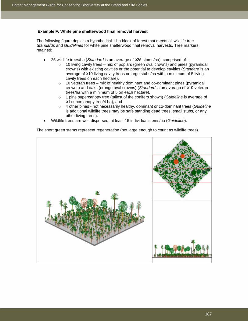
Forest Management Guide for Conserving Biodiversity at the Stand and Site Scales
187
Example F: White pine shelterwood final removal harvest The following figure depicts a hypothetical 1 ha block of forest that meets all wildlife tree Standards and Guidelines for white pine shelterwood final removal harvests. Tree markers retained:
• 25 wildlife trees/ha (Standard is an average of ≥25 stems/ha), comprised of - o 10 living cavity trees – mix of poplars (green oval crowns) and pines (pyramidal
crowns) with existing cavities or the potential to develop cavities (Standard is an average of ≥10 living cavity trees or large stubs/ha with a minimum of 5 living cavity trees on each hectare),
o 10 veteran trees – mix of healthy dominant and co-dominant pines (pyramidal crowns) and oaks (orange oval crowns) (Standard is an average of ≥10 veteran trees/ha with a minimum of 5 on each hectare),
o 1 pine supercanopy tree (tallest of the conifers shown) (Guideline is average of ≥1 supercanopy tree/4 ha), and
o 4 other pines - not necessarily healthy, dominant or co-dominant trees (Guideline is additional wildlife trees may be safe standing dead trees, small stubs, or any other living trees).
• Wildlife trees are well-dispersed; at least 15 individual stems/ha (Guideline). The short green stems represent regeneration (not large enough to count as wildlife trees).

Forest Management Guide for Conserving Biodiversity at the Stand and Site Scales
188
Example G: White and red pine seed tree harvest The following figure depicts a hypothetical 1 ha block of forest that meets all wildlife tree Standards and Guidelines for white and red pine seed tree harvests. Tree markers retained:
• 25 wildlife trees (Standard is an average of ≥ 25/ha), comprised of - o 10 living cavity trees – mix of poplars (oval crowns) and pines (pyramidal crowns)
with existing cavities or the potential to develop cavities (Standard is an average of ≥10 living cavity trees or large stubs/ha with a minimum of 5 living cavity trees on each hectare),
o 15 healthy dominant and co-dominant pine seed trees – seed trees count as veteran trees (Standard is an average of ≥10 veteran trees/ha with a minimum of 5 on each hectare), and
o 2 of the pine cavity trees are also supercanopy trees (tallest of the conifers shown) (Guideline is average of ≥1 supercanopy tree/4 ha).
• Wildlife trees are well-dispersed; at least 15 individual stems/ha (Guideline).

Forest Management Guide for Conserving Biodiversity at the Stand and Site Scales
189
Appendix 3.3 – Stand level direction for maintaining or enhancing cover and food supply in deer winter concentration areas.
In Stratum I, maintenance of critical thermal and access cover while enhancing or maintaining food (browse) supply within a deer concentration area is crucial. Table 1 provides stand level direction for areas within Stratum I where forest operations are proposed and maintenance or enhancement of the concentration area is an objective. This direction will be followed unless better (local) direction, approved by MNR, is available.
Table 1. Stand level considerations for maintaining or enhancing cover and food supply in deer winter concentration areas
Major Forest Type Stands Identified as Critical Thermal Cover
Stands Required for Access Cover and/or Food (browse) Production
Hemlock and Cedar These tree species are preferred for both thermal and access cover. The accompanying direction applies to any stand with 40% or greater hemlock or cedar composition.
• Group selection or shelterwood harvesting is preferred in hemlock. Maintain at least 60% conifer canopy closure in trees at least 10 m tall.
• For cedar; use group selection, shelterwood, or narrow strip cuts (20 m wide cut strips, 40 m wide leave strips) that retain 60% conifer canopy closure in trees at least 10 m tall.
• Focus on removal of hardwoods.
• Final removal cuts with shelterwood harvesting not to occur until regeneration has 60% canopy closure and is at least 5 m tall.
• Regeneration of cedar and hemlock in the presence of high deer numbers may not be possible. Therefore, defer management of hemlock and cedar stands until deer numbers are low, or until deer distribution changes, or plant with an alternate species such as red spruce.
Maintain access cover: • Shelterwood preparatory and regeneration cuts
will maintain adequate access cover: in first and final removal cuts retain clumps of 3-5 conifers (at least 10 m tall) with interlocking crowns spaced 10-30 m and no further than 60 m apart, unless regeneration is at least 5 m in height.
• For clearcuts use either: 1) patch (<1ha) or strips, (ideally 20-40 m wide) with return cuts not to occur until regeneration is at least 5 m in height ; or 2) retain clumps of 3-5 conifers (at least 10 m in height) with interlocking crowns spaced 10-30 m and no more than 60 m apart
• There may be situations where access cover is not maintained to discourage browsing by deer and thus increase the probability of regenerating cover. In these situations, large clearcut blocks in cedar should be planned to discourage deer from browsing cedar regeneration; first cuts should be strip-cuts and return cuts should occur soon after cedar has regenerated within the original cut strips to minimize loss of regeneration because of browsing by deer.
• Follow acceptable harvest, renewal, and tending treatments as per silvicultural ground rules in all other hemlock and cedar stands (i.e., stands not identified as critical thermal or access cover).
Pine, Spruce and Fir (Great Lakes – St. Lawrence forest) These forest types will often provide both thermal and access cover, especially as mixed conifer stands and in association with hemlock and cedar. The value of red pine and jack pine as cover is most beneficial when in mixed conifer stands. White pine, spruce, and balsam fir may represent the dominant thermal cover within some deer yards and will provide the majority of the critical thermal cover component.
• Defer from harvest
Maintain Access Cover: • Shelterwood preparatory and regeneration cuts
will maintain adequate access cover: in first and final removal cuts retain clumps of 3-5 conifers (at least 10 m tall) with interlocking crowns spaced 10-30 m and no further than 60 m apart, unless regeneration is at least 10 m in height.
• For clearcuts use either: 1) patch (<1ha) or strip clearcut (ideally 20-40 m wide) with return cuts not to occur until regeneration is at least 10 m in height; or 2) retain clumps of 3-5 conifer trees (at least 10 m in height) with interlocking crowns and spaced 10-30 m and no more than 60 m apart.
• Follow acceptable harvest, renewal, and tending treatments as per silvicultural ground rules in all other pine, spruce, and fir stands (i.e., pine, spruce, and fir stands not identified as critical thermal or access cover)
Pine, spruce and fir • Defer from harvest • For clearcuts use either: 1) patch (<10 ha) or

Forest Management Guide for Conserving Biodiversity at the Stand and Site Scales
190
Major Forest Type Stands Identified as Critical Thermal Cover
Stands Required for Access Cover and/or Food (browse) Production
(Boreal) Black and white spruce, white, red, and jack pine, and balsam fir will often be the primary tree species providing thermal and access cover. Mixed conifer will often provide the best cover, but in some areas the only cover available may be pure stands of a poor canopy closure species (e.g., jack pine). Balsam fir, even when dead and dying (following outbreaks of spruce budworm), still provides cover, as well as food (i.e., arboreal lichens).
strip clearcut (ideally 20-40 m wide) with return cuts not to occur until regeneration is at least 10 m in height; or 2) when choosing residual trees, retain clumps of 3-5 conifers at least 10 m in height) with interlocking crowns and spaced 10-30 m and no more than 60 m apart.
• For large winter concentration areas in northwestern Ontario (e.g., >5,000 ha) that are comprised primarily of this forest type, harvest in cutblock sizes of 30-60 ha, or in configurations where conifer stand cover-to-cover distances do not exceed 200 m.
Tolerant Hardwoods- Tolerant hardwood forests managed under selection or shelterwood silvicultural systems typically do not normally provide thermal cover. This forest type does provide a source of browse after harvesting occurs. Access cover is important to allow deer to move freely through the stand to get to the food sources provided through harvest.
This forest type does not normally provide critical thermal cover. Follow direction for access cover and food production.
• Focus on removal of hardwoods and maintain conifer component to the extent possible
• Aggregations of conifers when encountered of at least 0.04 ha (20 m x 20 m) in size, at least 10 m tall and with at least 60% conifer canopy closure are to be managed for critical thermal cover on landscapes where the supply or distribution of conifer is limited.
• Where critical thermal cover is limited, manage aggregations of conifers less than 0.04 ha to maintain shelter patches of at least 3-5 conifers, at least 10 m tall, with interlocking crowns. Ideally, these shelter patches should be 10-30 m apart and no more than 60 m apart. In order of priority, retain hemlock, red spruce, cedar, white spruce, white pine, and balsam fir.
• Retain solitary conifers at least 10 m tall that link aggregations and shelter patches of conifer.
• Small, well-dispersed patch cuts (group selection openings) within selection or shelterwood stands can increase the deer carrying capacity. The size of the openings should be about 1-2 times the height of the stand, located close to access or thermal cover, and integrated with other silvicultural objectives.
Intolerant Hardwoods and Mixedwoods- Intolerant hardwood and mixedwood forest types typically are harvested using clearcut methods. If these forest types have proposed harvests using selection or shelterwood methods refer to the Tolerant Hardwood forest type for harvest prescriptions. These forest types can provide the greatest increases to browse supply and well planned harvesting can provide a shifting mosaic of young forest through time. The maintenance of access cover is important so that deer can access the abundant browse
This forest type does not normally provide critical thermal cover. Follow direction for access cover and food production.
• Small cuts are preferred (1-10 ha) to produce pockets of browse accessible to deer. Maintain access cover as described below:
• For larger (>10 ha) conventional clearcuts maintain access cover as follows: Maintain shelter patches of at least 3-5
conifers, at least 10 m tall, with interlocking crowns. Ideally, these shelter patches should be 10-30 m apart and no more than 60 m apart. In order of priority, retain hemlock, red spruce, cedar, white spruce, white pine, and balsam fir.
Solitary conifers at least 10 m tall that link aggregations and shelter patches of conifer are to be retained.
• Alternatively, clearcutting could be done in narrow strips (20-40 m wide) or patches (<1ha); return cuts could occur within 5-7 years or when regeneration has outgrown the height for browsing deer (> 2 m). Maintain access cover as described above for strip/patch and return cuts.

Forest Management Guide for Conserving Biodiversity at the Stand and Site Scales
191
Major Forest Type Stands Identified as Critical Thermal Cover
Stands Required for Access Cover and/or Food (browse) Production
produced. Boreal Mixedwoods (as defined in the Boreal Mixedwood Guide) A boreal mixedwood stand occurs on a rich, boreal mixedwood site that favours the production of closed canopies of trembling aspen or white birch in early successional stages, black spruce or white spruce in mid-successional stages, and balsam fir in late successional stages. No single species exceeds 80% of the basal area. Boreal mixedwood stands are a common feature of deer winter concentration areas in northwestern Ontario. They provide food and/or cover in all successional stages. In mid to late successional stages, an abundance of arboreal lichens can enhance deer Kw
• Defer from harvest • Manage stands using small patch cuts or narrow strips to favour softwood-leading or softwood-dominated stand conditions (at canopy transition). Overstory cover will be maintained. As a minimum, retain clumps spaced 10-30 m apart, comprised of 3-5 conifers with interlocking crowns that are at least 10 m in height.

Forest Management Guide for Conserving Biodiversity at the Stand and Site Scales
192
Appendix 4.2 – Assessing the potential impact of forest management operations on nesting birds. Forest management operations that may potentially disturb nesting birds are classified as High, Moderate, or Low Impact Operations in Section 4.2.2 based on the following six criteria: Criterion Description and score A Duration of individual events (e.g., a truck driving past a nest is a discrete
event): 0. Seconds 1. Minutes 2. Hours
B Number of individual events per day: 0. Few (<5) discrete events 1. Many (≥5) discrete events 2. Events are continuous (e.g., harvest operation)
C Time period over which events occur during the breeding season: 0. Minutes 1. Hours 2. Days
D Detectability of events at nest: 0. Low likelihood of being heard or seen 1. Likely to be heard 2. Likely to be seen
E Number of pedestrians involved in activity: 0. None 1. Few (<5) 2. Many (≥5)
F Number of small (e.g., chainsaws) or large (e.g., skidders) pieces of equipment involved that produce noise:
0. None 1. One large or a few (<5) small pieces of equipment 2. More than one large or many (≥5) small pieces of equipment
The overall score = [(A+B+C)*(D+E+F)]/36 A score ≥0.67 suggests a HIGH potential impact A score ≥0.33 suggests a MODERATE potential impact A score <0.33 suggests a LOW potential impact For example, a mechanical harvesting operation involving 1 or more feller bunchers, 1 or more grapple skidders, and many people that could be heard for numerous weeks from an osprey nest would score a 2 for criterion A, a 2 for criterion B, a 2 for criterion C, a 1 for criterion D, a 2 for criterion E, and a 2 for criterion F for a total score of 0.83 (High Potential Impact). A small crew of tree planters working around an osprey nest in a cutover for 1 day would score a 2 for criterion A, a 2 for criterion B, a 1 for criterion C, a 2 for criterion D, a 1 for criterion E, and a 1 for criterion F for a total score of 0.56 (Moderate Potential Impact). One truck hauling within sight of an osprey nest (>5 loads per day) for a week would score a 0 for criterion A, a 1 for criterion B, a 2 for criterion C, a 2 for criterion D, a 0 for criterion E, and a 1 for criterion F for a total score of 0.25 (Low Potential Impact).

Forest Management Guide for Conserving Biodiversity at the Stand and Site Scales
193
The above approach can be used to rate the potential impact of any proposed activity. The following table provides some examples of how common activities typically rank using the above approach. Potential impact Examples High Harvest operation
Large tree plant (≥5 people) if visible Mechanical site preparation Road construction
Moderate Ground (airblast) herbicide application Large tree plant if not visible Small tree plant if visible Small crew using brushsaws
Low Aerial application of herbicides Boundary/tree marking Hauling Routine road maintenance (e.g., grading)
Note: for complex operations, the cumulative potential impact of all concurrent activities should be assessed. For example, when a harvest operation involves concurrent felling, skidding/forwarding, roadside delimbing, slashing, and loading, all activities should be included in the evaluation of potential impact.

Forest Management Guide for Conserving Biodiversity at the Stand and Site Scales
194
Appendix 5.2a – Measuring ruts The following are some initial suggestions to be adjusted, or expanded upon, locally. • In general, roadside work areas include areas at the edge of the road where concentrated
activity other than skidding (piling, delimbing, slashing, chipping, slash piling, etc.) is necessary to receive and process wood from the rest of the harvest area. The roadside work area normally extends 1-1.5 tree-lengths from the edge of the road and may only occur along the length of some portions of the road, depending on the pattern of operations. Operations that process in the block and deliver shortwood to roadside may have a narrower roadside work area than full tree and tree length operations. When defining the roadside work area, consider the opportunity to be consistent with the area where wildlife trees are measured (see introductory text in Section 3.2.3.1).
• The block should be stratified to delineate areas where the direction applies; o exclude roads, landings, and roadside work areas o define the area of clearcut, shelterwood, and selection harvest o in clearcut areas, define the area of shallow soils
• Percent coverage is to be determined based on a line transect method. The total distance of the line that intersects ruts as a percentage of the total line length should determine the areal coverage over the sampled area.
o A suggested approach to layout of transects: Pick the center of the most disturbed area on the block, establish 3 random 100 m transects, offset by 120o, within a 250m radius circle around that point. The percent cover would be the total length of the line that intersects a rut or trail divided by 3.
• Depth is to be measured from the surface of the soil, including organic layers (LFH) if present. Figure 5.2a.1 provides some examples from which local determinations can be expanded.
• When the depth varies across the width of the rut (i.e., perpendicular to the direction of travel), the deepest point is to be measured as the depth.
• When a rut has been filled, or partially filled with soil, litter, water, or debris, the depth should be measured as if the rut had not been filled. This includes areas in organic soil where churning and mixing of surface and sub-surface organic layers has occurred. In some circumstances it will be difficult to determine the unfilled depth.
250m

Forest Management Guide for Conserving Biodiversity at the Stand and Site Scales
195
• When determining if a potential rut is at least 4 m long, the length is measured as the contiguous portion that is deeper than 30 cm (or depth to bedrock / large boulders), and is not to be an average depth measurement where some of the length is less than 30 cm deep.
Figure 5.2a.1. Suggested approach to measuring depth.
displaced
raised
depth

Forest Management Guide for Conserving Biodiversity at the Stand and Site Scales
196
Appendix 5.2b – Site disturbance susceptibility tables The following color codes apply to the site disturbance susceptibility charts. The soil descriptions generally follow the Ontario Institute of Pedology descriptions. The core information for these charts was translated from the Forest Management Guides for the Protection of the Physical Environment. low low-mod mod mod-higher higher
NA Rutting Susceptibility Mineral Organic Texture All Sand Other Fibric Mesic Humic Depth <30cm 31+ 31+ all all all
Soil Moisture C
ondition
wet
moist
dry
frozen
Erosion Susceptibility texture All Shallow
Mineral Mineral Other
than Silty Silty Organic - fibric
Organic - mesic/humic
depth 0-5 6-30 31-60 61+ 31-60 61+ 21-40 41+ 21-40 41+
Slope
31+
11 - 30
0 - 10

Forest Management Guide for Conserving Biodiversity at the Stand and Site Scales
197
Nutrient Loss Susceptibility
Texture Other
All Shallow Mineral Sandy Mineral Organics Organic Depth 0-5 6-20 0-5 0-5 6-20 all all Mineral Depth 0-5 0-5 6-30 31-60 31-60 all all
Logging Method
Clearcut - full tree
Clearcut - tree length and cut
to length
Partial Harvest

Forest Management Guide for Conserving Biodiversity at the Stand and Site Scales
198
Appendix 5.2c – Suggested strategies and techniques to minimize site disturbance during harvest, renewal, and tending operations i) Rutting and compaction Encourage advanced planning of access within the block (i.e., skid trails and landings) by the
operator and/or supervisor. Identify and locate primary trails and convergence zones where the ground has the greatest
load-bearing capacity. Limit and flag the number of main skid trails and ensure all operators are aware of their
location. In fully mechanized operations, limit travel of forwarder and skidder to harvester trails On main trails or on convergence zones, consider strengthening with slash matting where
damage is likely to occur. In some cases gravelling of main skid trails should be considered. Keep skid trails as straight or as gently curving as possible. In clearcut systems, normally distribute skid trails widely, while avoiding wet pockets or other
susceptible areas. In partial cut systems, normally concentrate skid trails to minimize the extent of damage to residual stems.
Forwarding/skidding should not deviate from designated extraction trails. When only a few machine passes can create a significant risk of compaction or rutting,
concentrate machine traffic on main trails and mitigate any damage that occurs (i.e., do not disperse traffic).
Recognize some damage to main trail areas is expected as a cost of minimizing damage to residual trees and the rest of the site, and have a plan to mitigate damage on main trails;
In partial cut systems, winch as much wood as possible to the skidder to minimize the extent of skid trails.
Use high floatation equipment if summer logging chances include large areas of organic soil and monitor closely to ensure damage is minimal.
If it is not possible to completely avoid susceptible wet areas such as swales, seeps, and wetlands;
o reach into them with a felling head or winch wood out of them using conventional cut and skid systems;
o use feller-bunchers to cut and bring bunches back to solid ground; o use “hoe-chucking” (e.g., excavator) to move wood to solid ground; o use brush and tops to increase the load-bearing capacity of the soil, recognizing
some disturbance may occur; o if machine traffic must enter the swale area, avoid crossing the entire width, but
rather approach from both sides and reach into the middle; On sites susceptible to compaction and rutting, use slash matting on equipment traffic areas;
for example, place slash in front of machines when using cut-to-length systems that limb and top on site.
Recognize that the use of slash matting or other mitigative techniques may disguise some types of soil disturbance and consider moving blocks if excessive use of mitigation is required.
In general, during harvesting and site preparation operations, minimize the disturbance/removal of soil organic layers and topsoil.
Operations should be allowed or discontinued based on the actual compaction and rutting which is occurring. As examples:
o in the late winter/early spring, it may be possible to operate on night shift and until mid-morning, if frost conditions are satisfactory, and then stop operations when the ground warms up in the afternoon,
o a shut down for a few days may be required after a period of high precipitation. Whenever possible, non-productive areas (such as rock outcrops) or other relatively high
load-bearing soils should be selected for landing sites. Proper day to day on-site planning is important. Operators need to be competent, properly
trained, and aware of the objectives and plans for specific sites.

Forest Management Guide for Conserving Biodiversity at the Stand and Site Scales
199
Continually monitor during and after operations to mitigate any damage that may occur and better forecast where future problems may occur.
In winter conditions where the soil is not adequately frozen, compacting the snow with a feller-buncher prior to wood extraction, or blading off some snow from trails and landings before use, will allow the frost to penetrate deeper. Sufficient wait time at sub-zero temperatures (at least overnight) must be allowed for the soil to freeze properly before the benefit can be realized.
Skid or forward wood as soon as possible to avoid the “watering up” that can occur quickly (days) after felling.
Where possible locate roads and landings so that skidding can occur in a downhill direction. Adjust this strategy when working on erosion-prone soils.
Where possible, turn machinery on the road or other high strength soil rather than in the cutblock.
Where machine design allows (e.g., some forwarders) travel empty in reverse to avoid soil damage caused by turning in the block.
On high hazard sites (see Appendix 5.2b), or when conditions are such that rutting can occur, reduce loads on the skidders to distribute the weight evenly to all four wheels (rule of thumb – 2/3 of a full load).
ii) Erosion • Where safety permits, skid across slopes and avoid skidding with the slope. • Avoid road and landing layout that requires skidding or forwarding up or down steep slopes. • Where skidding or forwarding with the slope is necessary, consider dispersing traffic so
repeat traffic does not cause rutting and/or compaction. • Where skidding or forwarding with the slope is necessary, use chains or other implements to
increase traction to avoid tearing the root mat and organic layers. • Where skidding or forwarding with the slope is necessary, avoid turning on the slope to
minimize tearing of the root mat and organic layers. • Consider extremely steep slope areas as inoperable and avoid machine travel. The specific
steepness threshold should be determined locally, based on site conditions and available machinery.
• Consider the use of winter-only operations on very high-hazard sites (e.g., very fine sand with thin organic layers).
• Avoid harvesting areas that clearly will erode as a result of the removal of trees (e.g., discontinuous shallow organic layer over bedrock).
• Where possible, use low or no mineral soil exposure renewal options such as straight planting, hand scalping, seeding, and natural regeneration in steep and/or erosion-prone areas.
• Where safety permits, ensure site preparation runs across the slope and avoid aligning with the slope.
• Site prepare to provide the minimum amount of mineral soil exposure to achieve silvicultural objectives. On high-hazard sites, favour discontinuous scalp over continuous trench site preparation methods.
• Within the limits of operational efficiency, use the smallest prime-mover possible to achieve site preparation goals.
• On high-hazard sites, avoid broadcast site preparation (e.g., ploughing, summer blading) that exposes excessive amounts of mineral soil.
• Favour fast-growing species and immediate renewal in steep or erosion prone areas; • Identify ruts or furrows on slopes that are channeling runoff and causing erosion. Limit further
erosion by filling these ruts with slash, debris, or non-erodible soil. • Divert mid-slope ruts that are, or are likely to, channel water with cross drains, obstacles, or
berms (i.e., water bars). This is particularly applicable to extraction trails in partial harvest systems.

Forest Management Guide for Conserving Biodiversity at the Stand and Site Scales
200
• On high-hazard sites, monitor soil condition during and after operations to mitigate any damage that may occur and better forecast where future problems will occur.
• Where possible, disperse unutilized slash over areas that are prone to erosion (e.g., fine sands that are easily eroded by wind and on slopes).
iii) Nutrient Loss • Give preference to logging methods that leave debris and unutilized fibre in the cut area (e.g.,
cut-to-length, tree length, etc.) over logging methods that process and pile debris and unutilized fibre at roadside (e.g., full-tree).
• Use winter harvest operations to conserve nutrients on site (leaf fall and root stores). • Where possible, re-distribute unutilized slash and chipper waste back over the cut area in a
manner that will not interfere with silviculture or diversity objectives. • Maintain a diversity of tree and plant species on site, including hardwood and alders, to
improve the capture and cycling of nutrients. • Leave some trees (potentially non-crop trees) un-harvested to serve as nutrient sinks to
capture mobile ions made available immediately following harvest and site preparation. • Consider delaying the use of herbicide to release young conifer plantations (e.g., spruce) until
they are ready to capture the nutrients on the site. • On very shallow sites, or sites with undulating topography, use high flotation (low impact)
equipment to maintain the integrity of the surface organic layer, and prevent rutting or compaction in the deeper soil inclusions. This is especially important during wet weather conditions when the organic layer or soil is saturated.
• Post-harvest prescriptions and renewal efforts should be carried out as quickly as possible on shallow soil sites to encourage full site occupancy. This should also help to prevent problems with erosion and loss of nutrients.
• Lower nutrient demanding species, such as jack pine, should be matched to nutrient-poor sites. The use of fast-growing species is advisable to ensure rapid reforestation and reduce the erosion risk.
iv) Loss of productive land • All roads should be marked on the ground in advance of construction, preferably the corridor
as well as the center line. • Develop a block plan for operational roads and communicate the plan to the operators.
Alternatively, encourage operators to develop a block plan in advance of harvesting and construction.
• Locate branch and operational roads to ensure operators are skidding the maximum cost-effective distance.
• Avoid excessive use of turn-arounds and loop roads. • Use winter-only access options where delivery schedules and silviculture requirements
permit. • Pre-determine the number and location of landings and communicate with the operator.
Identify contingency landings to adapt to localized situations, such as encountering susceptible areas or unmapped streams that may change the skidding plan.
• Use shovel equipment (excavator, backhoe, etc.) rather than bladed equipment (dozers, etc.) to build roads to minimize width of disturbed areas.
• Whenever possible, non-productive areas (such as rock outcrops) should be selected for landing sites. When doing so, ensure they are far enough from natural drainages and other values to minimize the risk of introducing sediment.
• Where feasible, use equipment combinations that can maximize the distance between roads (e.g., forwarders).
• Where feasible, select machinery combinations that maximize within-block processing to minimize slash and debris piles.

Forest Management Guide for Conserving Biodiversity at the Stand and Site Scales
201
• Practice environmentally friendly, zero discharge maintenance and re-fueling to ensure no soil contamination occurs.
• Pile roadside wood as high as safety permits to minimize the area of landings. • Keep bush inventories low by using “hot logging” to minimize the number of landings. This
approach should be balanced with the potential for rutting and compaction as a greater area of the block converges on fewer landings.
• Within the bounds of road-use strategies, site prepare and otherwise regenerate operational roads, ditches, and landings that are no longer needed.
• Educate supervisors and operators on the short- and long-term effects of excessive conversion to non-forest to enable informed planning and decision-making.
• Where safety permits and other values will not be compromised, burn piles of slash, debris, and unutilized fibre.
• Where possible, re-distribute unutilized slash and chipper waste back over the cut area in a manner that will not interfere with silvicultural or diversity objectives.
• Do not use site preparation techniques which rely on piling slash in unproductive windrows or mounds unless these will be burned.
• Maximize the use of unutilized processing debris for road construction. (e.g., brush matting swamp crossings, fill wet holes, stabilize steep road banks, stabilize ditches).
• Encourage the use of unutilized processing debris to rehabilitate gravel pits, borrow pits, or other human-caused unproductive sites.

Forest Management Guide for Conserving Biodiversity at the Stand and Site Scales
202
Background and Rationale for Direction This document is only available in digital format. Once the final version of this guide is published, it will be available for download from the following location on the Ministry of Natural Resources website; http://www.mnr.gov.on.ca/en/Business/Forests/Publication/272847.html Paper and CD copies are available upon request from; Stand and Site Guide B&R c/o Forest Policy Section Forest Management Branch Ontario Ministry of Natural Resources Suite 400 – 70 Foster Drive Sault Ste. Marie, ON, Canada P6A 6M8

Forest Management Guide for Conserving Biodiversity at the Stand and Site Scales
203
GLOSSARY Active (forestry aggregate pit): A pit where excavation activities are occurring. After excavation has commenced, a pit will be considered active until it is rehabilitated, regardless of whether or not there is machinery working in the pit. Active (nests): see nests Angle of repose: The maximum slope or angle at which material such as soil or loose rock remains stable. AOC: Area of concern AOU: Area of the Undertaking Bedding areas: Generally in reference to specific areas where cervids lie down or sleep. Bedding areas often have a seasonal and/or temporal aspect to their location and pattern of use (e.g., day and night). Best management practice: A component of a guide that suggests a practice or strategy to help implement the overall purpose of the standards and guidelines. Biofibre: Forest resources from Crown forests that are not normally being utilized for conventional forest products and that are made available under an approved forest management plan. Browse: Twigs and foliage of tree and shrub stems that are consumed by one or more species of cervid. Species used and preferred as browse differ among cervid species. Usually, only the current annual growth is suitable and selected as browse, because it is more nutritious and palatable. However, older stems and twigs may be consumed, particularly when populations exceed carrying capacity. Cavity tree: A dead, dying, or live tree with a cavity or cavities, or with the potential to develop cavities, that is larger than 10 cm dbh and taller than 3 m. In the past, these trees were sometimes referred to as ‘snags’ or ‘snag trees’. The term snag is no longer applied to wildlife trees to avoid confusion or contradiction in terminology (e.g. Regulations for Industrial Establishments O. Reg. 851 (s.103), made under the Occupational Health and Safety Act, 1979). Cervid: Mammalian species that are a member of the deer family. There are four cervid species in Ontario (moose, white-tailed deer, elk, and woodland caribou). CFSA: Crown Forest Sustainability Act, 1994 CLAAG: Careful logging around advanced growth – An operational practice that can be applied with any harvest method under the clearcut silvicultural system where the objective is to remove the overstory, protect understory advance growth, and regenerate an even-aged stand. The resulting stand develops under full light conditions, generally with a reduced rotation length. Colonies - Occupied – Occupied colonies are those containing ≥ 1 occupied nest. Colonies - Active and Inactive: Active colonies are those with a high likelihood of reuse and include those known or suspected to contain ≥1 occupied nest at least once during the past 5 breeding periods (10 breeding periods for large heron colonies) unless all nests have been documented as unoccupied for ≥3 consecutive breeding periods (≥5 consecutive breeding periods for large heron colonies). All other colonies are classified as inactive. Colonies known to have been occupied are those at which breeding activity was confirmed. Colonies suspected to

Forest Management Guide for Conserving Biodiversity at the Stand and Site Scales
204
have been occupied are those at which breeding activity was not confirmed, but for which there is compelling evidence of recent use. For example, any great blue heron colonies in suitable habitat with nests in good repair or that contain new material may be suspected to have been recently occupied (as per Ranta 1998). Conditions on regular operations (CROs): Conditions applied in areas of harvest, renewal and tending operations, conducted in accordance with the SGRs, to maintain or protect features that are not addressed by operational prescriptions for areas of concern (e.g., grouse nests, wildlife trees) or to implement specific operational standards and guidelines (e.g., rutting). Critical breeding season: The critical breeding season includes courtship, nest building, egg laying, incubation, and rearing of young to fledging and is defined based on the best data available for Ontario (primarily the Ontario Nest Records Scheme; Peck and James 1983, James 1991). Critical thermal cover: Conifer cover required to meet the needs of deer in a winter concentration area, or ‘yard’. The amount of critical thermal cover depends on deer yard carrying capacity and associated objectives and targets. Generally, 10-30% of the forest in Ontario deer yards should be managed as critical thermal cover. Crown/canopy closure: The ground area covered by the crowns of trees or woody vegetation as delineated by the vertical projection of crown perimeters and commonly expressed as a percentage of total ground area. Culvert: Corrugated steel pipe is the common material used for small diameter (usually less than 1800 mm) culverts to convey water under an access road. The term refers to the factory-assembled round shapes connected together with couplers. Larger culverts (generally those >1800 mm diameter), are normally multi-plate or structural plate culverts and are assembled in the field. Deer yard (deer winter concentration area): A forested area deer traditionally migrate to and where they spend the winter months. The ‘core’ of a deer yard is that portion of the yard where use by deer is highest during winters that are severe, also referred to as Stratum I. Boundaries of a deer yard tend to change over time. DFO: Department of Fisheries and Oceans Disruption of hydrological function: Alteration of the physical characteristics of a site such that the natural flow of water, on or below the surface, is significantly impeded (e.g., by damming, accelerated (e.g., by channelization), or diverted (e.g., by ditching). The natural “watering up” process associated with the removal of forest cover is not included as a hydrological disruption. Diversity tree: Trees retained as wildlife trees that occur infrequently or are uncommon for the forest type. EA: Environmental Assessment – generally referring to the Declaration Order regarding MNR’s Class Environmental Assessment Approval for Forest Management on Crown Lands in Ontario (MNR-71 as amended by MNR-71/2) Ephemeral streams: Streams without well-defined channels that generally flow only during and after large precipitation events. ESA: Endangered Species Act, 2007
Forest Management Guide for Conserving Biodiversity at the Stand and Site Scales
205
Extraction trail: Anywhere a machine being used for extraction (skidder, forwarder, etc.) has traveled within the block (excluding travel on roads and landings). Extraordinary circumstances: In a small number of situations, deviation from direction in this guide may be permitted when strict application of the direction would result in unacceptable socio-economic or environmental consequences and the modified activities are unlikely to have an adverse effect on the objectives of the direction. For example, an occupied hawk nest might be located after some harvesting has been conducted within its AOC. Skidding wood already felled would normally not be permitted during the critical breeding period. However, if there is a high risk that the merchantability of the wood will be compromised by delaying skidding until after the critical breeding period (e.g., white pine logs will stain) and the risk of disrupting the breeding activity is considered to be low (e.g., skidding activity will not be visible from the nest, will be conducted when the chicks are no longer being brooded, will not be conducted on cold or wet days), the situation may be considered an extraordinary circumstance and the prescription for the specific nest may be amended to permit the skidding activity as subject to appropriate conditions. This amended prescription will not be considered an exception to this guide. Featured species: These are species that have been identified as species for which habitat will be managed. The habitats of provincially-featured species, which include moose, deer, marten, pileated woodpecker and species that are listed as threatened or endangered with extinction, must be managed; habitats of species identified as locally-featured are managed at the discretion of the District Manager in recognition of the value of that species locally. Locally-featured species may be individual species or combinations of species and can be animals or plants. Fish habitat: Resources and conditions essential for the production of fish, including water quality and quantity, spawning grounds, nursery, rearing, food supply and migration areas on which fish depend, directly or indirectly, for their life processes. FMP: Forest Management Plan FMPM: Forest Management Planning Manual Guideline: A component of a guide that provides mandatory direction, but requires professional judgment for it to be applied appropriately at the local level. Habitat carrying capacity: Carrying capacity (K) is a concept basic to wildlife management, generally defined as the maximum number of individuals (e.g., deer) an area can support on a sustained basis (i.e., without detrimental effects on the habitat). Habitat resiliency: (as used in Section 4.1) DFO (2007) defines this term as Habitat resiliency refers to the ability of an aquatic ecosystem to recover from changes in environment conditions. The flow and thermal regimes of the system as well as its physical characteristics are important considerations in describing freshwater ecosystems. See DFO (2007: Table 5) for further details. Habituated Birds: In the context of this guide, habituated birds are those that exhibit a high tolerance for human activity in the vicinity of their nest sites (e.g., they nest in close proximity to well-traveled roads or human habitation). Direction in Section 4.2.2 may be overly conservative for habituated birds. Thus, planning teams may choose to develop unique prescriptions for habituated birds that will not be considered exceptions to the direction in this guide. Habituated birds will be identified by MNR based on consideration of the history of occupancy and productivity of the nest site and the history of both forestry and non-forestry related human activities in the vicinity of the nest site. HARP: Harvest with advanced regeneration protection – The removal of the dominant canopy layer in uneven-aged lowland black spruce ecosystems. HARP protects and retains stems below

Forest Management Guide for Conserving Biodiversity at the Stand and Site Scales
206
a set diameter limit leaving a significant component of the overstory. The resulting stand is uneven-aged and uneven-sized. High potential impact operations: (as used in Section 4.2.2) Forest management operations that have a high potential to disturb nesting birds and adversely affect occupancy or productivity. Potential impact of operations is based on duration of individual events, number of individual events per day, time period over which events occur during the breeding season, detectability of events at the nest, number of pedestrians involved in activity, and number of small (e.g., chainsaw) or large (e.g., skidder) pieces of equipment involved that produce noise (see Appendix 4.2 for details). Harvest operations, large tree planting operations (≥5 people) if visible, and road construction are typically considered high potential impact operations. Intermittent streams: Streams with a well-defined channel that generally flow only during wet seasons (30-90% of the year). During the driest part of the summer, flow may be reduced to a trickle or may only occur within the streambed. Inactive (forestry aggregate pit): A period of time when no work is occurring in an active pit. Inactive (nests): see nests Lakes: Areas of open water at least 8 ha in size and, at some point, greater than 2 m deep. Small lakes are <100 ha in size. Medium lakes are 100-999 ha in size. Large lakes are ≥1000 ha in size. LLP: Large landscape patche LOS: Line-of-sight Low potential impact operations: (as used in Section 4.2.2) Forest management operations that have a low potential to disturb nesting birds and adversely affect occupancy or productivity. Potential impact of operations is based on duration of individual events, number of individual events per day, time period over which events occur during the breeding season, detectability of events at nest, number of pedestrians involved in activity, and number of small (e.g., chainsaw) or large (e.g., skidder) pieces of equipment involved that produce noise (see Appendix 4.2 for details). Tree marking, routine road maintenance such as grading, and hauling are typically considered low potential impact operations. MAFA: Moose aquatic feeding areas Mast tree: Mast trees are trees that produce edible fruits. Mast is usually described as hard mast (e.g., acorns) or soft mast (e.g., cherries). Mature development stage: Holloway et al. (2004) define the mature development stage as the period in which overstory trees attain full development and sexual maturity, mortality of overstory trees begins to create canopy gaps and encourages understory development, and height growth of overstory trees slows dramatically. The onset age of the mature development stage is typically 60-80 years. Mature forest: As used in this guide, forest that has reached the mature or old development stage (see Holloway et al. 2004). Merchantable timber: A descriptor for a tree or forest stand that has attained sufficient size, quality, and/or volume to be suitable for harvest. A conifer, poplar, or white birch log of which more than one-half of the total content is sound wood, when the content is measured in cubic metres; or

Forest Management Guide for Conserving Biodiversity at the Stand and Site Scales
207
A hardwood log other than poplar or white birch of which more than one-third of the total content is sound wood, when the content is measured in cubic metres. Moderate potential impact operations: (as used in Section 4.2.2) Forest management operations that have a moderate potential to disturb nesting birds and adversely affect occupancy or productivity. Potential impact of operations is based on duration of individual events, number of individual events per day, time period over which events occur during the breeding season, detectability of events at nest, number of pedestrians involved in activity, and number of small (e.g., chainsaw) or large (e.g., skidder) pieces of equipment involved that produce noise (see Appendix 4.2 for details). Large tree planting operations (≥5 people) if not visible, small tree planting operations if visible, and small crews using brushsaws are typically considered moderate potential impact operations. Moose aquatic feeding areas (MAFAs): Relatively small, shallow water areas with an abundance of aquatic vegetation comprised of mostly submergent species moose (and deer) favour as food. Nests – Active and Inactive: These terms apply to nests of the bald eagle, osprey, great gray owl, northern goshawk, and red-shouldered hawk. Active nests are those with a high likelihood of reuse and include those known or suspected to have been occupied at least once during the past 5 breeding periods unless the nest and all associated nests within the nesting area have been documented as unoccupied for ≥3 consecutive breeding periods. All other nests are classified as inactive. Nests known to have been occupied are those at which breeding activity was confirmed. Nests suspected to have been occupied are those at which breeding activity was not confirmed, but for which there is compelling evidence of recent use. For example, eagle and osprey nests in suitable habitat that are in good repair or contain new material may be suspected to have been recently occupied (as per Ranta 1998). For other species, nests showing evidence of use such as down feathers, decoration, or whitewash may be suspected to have been recently used (see criteria in Box 4.4 in MNR 2004). Nests – Good Repair: A nest is considered to be in good repair when there is sufficient nest material present to permit its use with minimal reconstruction. The nest on the left is in poor repair. The nest on the right is in good repair. (Photo by K. Szuba)
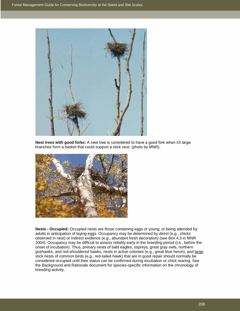
Forest Management Guide for Conserving Biodiversity at the Stand and Site Scales
208
Nest trees with good forks: A nest tree is considered to have a good fork when ≥3 large branches form a basket that could support a stick nest. (photo by MNR).
Nests - Occupied: Occupied nests are those containing eggs or young, or being attended by adults in anticipation of laying eggs. Occupancy may be determined by direct (e.g., chicks observed in nest) or indirect evidence (e.g., abundant fresh decoration) (see Box 4.3 in MNR 2004). Occupancy may be difficult to assess reliably early in the breeding period (i.e., before the onset of incubation). Thus, primary nests of bald eagles, ospreys, great gray owls, northern goshawks, and red-shouldered hawks, nests in active colonies (e.g., great blue heron), and large stick nests of common birds (e.g., red-tailed hawk) that are in good repair should normally be considered occupied until their status can be confirmed during incubation or chick rearing. See the Background and Rationale document for species-specific information on the chronology of breeding activity.

Forest Management Guide for Conserving Biodiversity at the Stand and Site Scales
209
Nests – Primary and Alternate: When a single active nest occurs within a nesting area (i.e., within a circle of a specified radius based on species), it is classified as the primary nest. When ≥2 active nests occur within a nesting area, the nest with the most recent known or suspected history of occupancy is the primary nest; the other active nest(s) is(are) considered alternate nests.
Old development stage: Holloway et al. (2004) define the old development stage as the period when frequent mortality of overstory trees results in a mosaic of canopy gaps and encourages development of a multi-layered canopy and an abundance of dead trees and downed woody material. The onset age of the old development stage is typically 90-130 years.
Operational Statements: Documents developed by DFO for proponents, that provide nationally consistent advice on standard measures to apply to selected activities that are low risk to fish habitat. Permanent stream: A stream with a well-defined channel that generally flows throughout the majority (≥90%) of the year. The streambed is typically located below the water table and groundwater (or a permanent water feature) is the primary source of flow. Ponds: Bodies of shallow (generally <2 m deep), open water (≤25% of surface area covered by emergent vegetation) between ≥0.5 ha and <8 ha in size. PSW: Provincially significant wetlands Rarity: (as used in Section 4.1) DFO (2007) defines this term as The relative strength of a fish population or prevalence of a particular type of habitat. See DFO (2007:Table 5) for further details. Reasonable efforts: Numerous guidelines stipulate that reasonable efforts will be made to conduct a specific course of action (e.g., avoid building roads within a certain distance of a specific value). The term reasonable efforts implies that a sincere attempt has been made to select the course of action described in the guideline and that any deviation from that course of action has been based on a thoughtful consideration of the consequences of practical and feasible alternatives. Specific examples of what constitutes reasonable efforts are provided in some sections. More generally, what is considered a reasonable effort should be based on what other reasonable people would have done in a similar situation. Residual forest: A forested patch that generally functions more as habitat for wildlife that inhabit older forest than as habitat for wildlife that inhabit younger forest. Quantitative criteria are provided in Section 3.2.2.1. Roadside work area: The area of land adjacent to a road and within the boundaries of the harvest area where concentrated activity other than skidding (piling, delimbing, slashing, chipping, slash piling, etc.) is necessary to receive and process wood from the rest of the harvest area. Rut: Continuous trench or furrow created by machine traffic that is ≥4 m long and ≥30 cm deep. When operating on shallow soils the lesser of depth to bedrock/large boulders or 30 cm will be used. Ruts may be empty, filled with water, or filled with varying amounts of intermixed organic and mineral soil/debris. In cases of concentrated heavy rutting it may be difficult to distinguish individual ruts. Furrows, scalps, trenches, etc., created specifically for site preparation purposes are not considered ruts. SFMM: Strategic Forest Management Model SGR: Silvicultural Ground Rule

Forest Management Guide for Conserving Biodiversity at the Stand and Site Scales
210
Significant mineral soil exposure: Patches of mineral soil exposed by machine traffic that are individually larger than 4m2 in size or have an aggregate area that exceeds 5% coverage. The percent coverage of exposed mineral soil will be measured over a 15 m by 15 m area when operating adjacent to water, or the harvested area of the AOC for all other values (e.g., ginseng). Silvicultural system: A process that applies silvicultural practices, including tending (thinning, pruning, etc.), harvesting, and renewal, to a stand in order to produce a crop of timber and other forest products. Systems are classified according to the method of harvesting of mature forest stands with a view to regeneration establishment (i.e., clearcut, shelterwood, selection). Species' dependence on habitat: (as used in Section 4.1) DFO (2007) defines this term as Use of habitat by fish species. Some species may be able to spawn in a wide range of habitats, while others may have very specific habitat requirements. See DFO (2007:Table 5) for further details. Species sensitivity: (as used in Section 4.1) DFO (2007) defines this term as Sensitivity of species to changes in environmental conditions, such as suspended sediments, water temperature or salinity. See DFO (2007:Table 5) for further details. Springs, seeps: Springs and seeps are areas of groundwater discharge, typically located near the base of slopes or hillsides. Flow may vary with seasonal precipitation. A seep is a spring with a very small flow of water. Soils around springs and seeps are generally saturated year-round. Water discharged by springs and seeps is usually, but not always, cool or cold. Stage of management: One of a series of cuts when using the shelterwood silvicultural system to aid in stand improvement and regeneration. Generally, these are referred to as preparatory, regeneration, and removal cuts, although the number of stages can vary dependent on stand characteristics and silvicultural objectives. Cutting may be distributed uniformly across a stand or concentrated in narrow strips or small patches. Standard: A component of a guide that provides mandatory direction. Stubs: A stub is a live tree that has been cut (and killed) well above the normal stump height (i.e., 3-5 m high). In managed forests, the ‘stubbing’ of live trees is increasingly being used when the objective is to emulate some of the physical properties of a tree that died quickly during a catastrophic natural event (e.g., wildfire). Succession: Changes in species composition in an ecosystem over time, often in a predictable order. Supercanopy trees: Large trees that emerge above the main canopy of a stand. Tending: Forest operations which are carried out to improve the growth or quality of a forest. Tending may involve cleaning (i.e., the removal of undesirable or competing vegetation through the use of herbicides or manual treatments), thinning, stand improvement, or pruning. Travel routes: Trails used by animals (e.g., cervids) to move among, or between, habitats. Travel routes are often traditional, may be used over long periods of time, and may have a seasonal aspect to use. Use management strategy: A statement outlining the purpose and description, and defining the roles and responsibilities related to use, maintenance, use control, abandonment, and monitoring of roads on Crown land. Veteran trees: Trees with characteristics (e.g., thick bark) that allow them to survive a stand-initiating disturbance, such as a fire, and eventually grow to become supercanopy trees in the future mature stand.

Forest Management Guide for Conserving Biodiversity at the Stand and Site Scales
211
Windrow: A longitudinal pile of material, usually difficult for humans, large mammals, and machinery to traverse. Road building may result in windrows comprised of rocks, boulders, and other aggregate that tend to run parallel to a section of road. Windrows are also commonly created by the piling of tops and branches of trees that have been brought to roadside and de-limbed or by the alignment of slash during site preparation operations. Woodland pools: Small isolated open water wetlands that have hydrologic regimes characterized by alternating periods of flooding and drying.

Forest Management Guide for Conserving Biodiversity at the Stand and Site Scales
212