forest gales - forest research
TRANSCRIPT

Version 2.5
Forest GALESA wind risk decision support tool for
forest management in Britain

Forestry Commission: EdinburghIn association with Forest Research
User manual
Forest GALESA wind risk decision support tool for
forest management in Britain

© Crown Copyright 2015
Version 1.0 published by the Forestry Commission in 2000. Version 2.0 published in 2006. This Version 2.5 published in 2015.
ISBN: 978-0-85538-932-1
Keywords: climate; forestry; forest management; gales; storm damage; wind; windthrow.
FCSW001/FC( JW)/WWW/OCT15
Enquiries relating to this publication should be addressed to:
Forest Research
Northern Research Station
Roslin
Midlothian EH25 9SY
0300 067 5900
Acknowledgements
The initial development of Forest GALES was part funded by the European Union as part of the STORMS (Silvicultural Techniques Offering Risk Minimising Strategies) project. Recent developments have been a partnership between Forest Research and INRA (French National Institute for Agricultural Research).
Forest GALES project team:Bruce Nicoll, Sophie Hale, Barry Gardiner, Andrew Peace and Bill Rayner of Forest Research.
Software development:Barry Gardiner, Sophie Hale, Juan Suárez, Stephen Bathgate and Mark Brady of Forest Research.
Forest Research is the Forestry Commission's Research Agency and is the UK's foremost body for forest and tree related research including tree health issues, surveying and monitoring, silviculture, ecology and social science. We also have expertise in hydrology, land stability and urban greening and we lead in forestry adaptation and the contribution of forestry to climate change mitigation. Forest Research's work informs the development and delivery of UK Government and devolved administration policies for sustainable management and protection of trees, woods and forests. www.forestry.gov.uk/forestresearch
The Forestry Commission will consider all requests to make the content of publications available in alternative formats. Please send any such requests to the Diversity Team at [email protected] or call 0300 067 5046.
ii Forest GALES 2.5

Introduction 1 The Forest GALES software 1 Background to the development of Forest GALES 2 DAMS (Detailed Aspect Method of Scoring) 2 What’s new in Forest GALES 2.5? 2
Installing Forest GALES 5 System requirements 5 How to install Forest GALES 5 Administration privileges in Windows 7 and 8 6 Help files 7 Uninstalling Forest GALES 7 Running the model for the first time 8
How the model works 9 What force would be needed to uproot or break the tree? 9 What wind speed would create the force required to damage the tree? 9 What is the probability of a damaging wind speed occurring? 9
Using Forest GALES 11 Operating modes 11 Selecting a mode and opening a query form 11 Forest GALES query forms 11 Navigating Forest GALES 13 Getting help 14
Predictions using field measurements 15 Stand characteristics box 15 Tree characteristics box 17 DAMS box 20 Upwind edge effect box 21 Controls box 21 Wind damage risk box 22
Predictions using yield models 23 Stand characteristics box 23 Tree characteristics box 24 Other boxes 24 User defined yield tables 25
Predictions through time 27 Stand characteristics box 27 Tree characteristics box 27 DAMS box 27 Controls box 27 User-defined yield tables 28 Viewing the results 28
Contents
Forest GALES 2.5 iii

Batch mode 30 Creating batch input files 31 Batch mode helper 31 Batch mode query form 31 Year of calculation 32
Examples 33 1. Single stand predictions using field measurements – getting started 33 2. Single stand predictions using field measurements – the effect of a new edge 34 3. Single stand predictions using yield models 35 4. DAMS 36 5. DAMS – rough guess 37 6. DAMS – grid reference 37 7. DAMS – calculate DAMS score 38
Research mode 39 Changing parameters 39 Constants and limits input file 40 Species parameter files 43 User-defined species 44 Weibull parameters 46 Batch-Weibull mode 47
Glossary 50
Further reading and useful sources of information 52
Technical appendix 53 Critical turning moments for overturning and breakage 53 Aerodynamic parameters 54 Critical wind speed 55 Return period 55 References 57
iv Forest GALES 2.5

Wind is the major disturbance factor in European forests and it is responsible for more than 50% of all damage by volume. The risk of wind damage is a significant constraint to forest management in Britain. The first major storm to affect British commercial forests, since major replanting started after World War I, was in 1953 in northeast Scotland. This has been followed by major storms in 1968 (central Scotland), 1976 (Wales and central England), 1987 (southeast England), 1990 (southwest England and south Wales), 2005 (northwest England and northwest Scotland), and 2012 (central Scotland). Damage levels ranged from 0.5 to almost 4 million cubic metres, representing up to five times the normal annual cut for the affected region.
Wind damage results in both direct costs (e.g. the additional cost of harvesting) and indirect costs (e.g. loss of amenity). It impacts on silvicultural practice by restricting thinning and shortening rotations, and it can lead to precautionary felling in forests at risk of windthrow in many parts of the country. Wind damage is of particular concern on exposed sites or sites with soils that restrict the rooting depth of trees. Windthrow is normally the main form of damage, but wind snap can be locally important when trees are particularly well anchored. Good forest management can significantly reduce the vulnerability of a forest to wind damage. However, in order to manage and minimise risk, forest managers need information on the likely timing and magnitude of damage so that they are able to predict the level of risk, and assess the implications of different management options.
The Forest GALES software
Forest GALES is a computer-based decision support system that assesses the risk of wind damage to conifer forests in Britain and compares the impacts of different silvicultural practices. Forest GALES is recommended for use at forest scales, rather than for individual stands, because of inherent variability in predictions. It is currently designed for use in stands of uniform age and species. It works by calculating the wind speed at which damage is expected to occur, based on stand and soil characteristics (the ‘critical wind speed’). It then uses this critical wind speed and the wind climate (predicted from the stand location) to calculate the probability of damage. The model calculates the risk for a representative ‘average’ tree within the stand and, by implication, the stand as a whole.
Forest GALES calculates both the risk of overturning (windthrow) and stem breakage, allowing managers to assess the likelihood of the different types of damage. For example, comparable values of critical wind speeds indicate that similar proportions of overturning and breakage are likely if damage occurs, whereas large differences (e.g. >5 m per second) would indicate much higher levels of the damage type with the lower critical wind speed. Forest GALES also allows the user to test the impact of standard thinnings or alternative thinnings defined by the user. Forest GALES is the recommended tool for testing the impact of thinning in operational guidance for Forestry Commission staff.
Updates and further informationFor latest updates and on-line version of this manual, go to: www.forestry.gov.uk/forestgales
Introduction
Forest GALES 2.5 1

Background to the development of Forest GALES
Forest GALES is based on research conducted by the Forestry Commission and Forest Research over the past 50 years. Version 2.5 represents over a decade of development since Version 1.0 was first published in 2000, and it contains significant improvements from Version 2.1 (published in 2006). For example, there have been improvements in the way the model simulates the gustiness of the wind, the description of tree crown characteristics, the classification of soil and rooting, and the representation of the wind climate. In particular there has now been validation of the model against wind damage in Cowal and Trossachs Forest District following a storm in January 2012. Work is currently underway on prototype models that calculate the risk to every individual tree within a stand, rather than an ‘average tree’, and work with mixed structure and species stands.
Prior to the availability of the Forest GALES software, strategies for minimising wind damage were guided by the windthrow hazard classification (WHC) system, described in Forestry Commission Leaflet 85 Windthrow hazard classification. This provided a method to zone forest areas of 500 ha or more by adding scores for windiness and soil together to estimate a hazard class. Although the WHC provided a successful basis for comparing sites and guiding decisions on thinning, it did not predict the timing or amount of damage with acceptable accuracy. Furthermore, it was not possible to test the influence of species choice or type of thinning. For these reasons, Forest GALES has now replaced the WHC as the recommended decision support tool for managing wind risk for forest management in Britain. However, it is possible to calculate WHC in Forest GALES so that users can make comparisons between the two methods.
DAMS (Detailed Aspect Method of Scoring)
The average windiness of a site is measured using the DAMS system*. DAMS is based on location, elevation and topographic exposure, and gives a good representation of both the average wind speed and the frequency of strong winds at a site. Values of DAMS in Britain typically range from 10 (sheltered) to 24 (exposed). Small differences in DAMS can result in large differences in predictions of wind damage.
What’s new in Forest GALES 2.5?
Improved predictions
A study of wind damage following a storm at a site in the west of Scotland in 2012 compared the damage predicted by Forest GALES and the actual damage that had occurred. This confirmed users’ observations that Forest GALES 2.1 was pessimistic in its predictions of damage, i.e. it was predicting more damage than actually occurred. This, coupled with new measurements of the ‘gustiness’ of wind in forests, has led to a reduction in the ‘gust factor’ used in the software. As a result, the estimated critical wind speeds in Forest GALES 2.5 are higher, and stands are now predicted to be more stable and at less at risk of damage. This is the most significant change to the model output and largely over-rides differences introduced by the other changes described below. For example, some thinnings that were restricted to sites with DAMS of 17 or below might now be possible on sites with DAMS up to 19. Note that this is only a general indication of the differences between ForestGALES 2.1 and Forest GALES 2.5; it is important that each site is assessed individually with the new version of Forest GALES.
* QUINE, C.P. and WHITE, I.M.S. (1994). Using the relationship between rate of tatter and topographic variables to predict site windiness in upland Britain. Forestry 67, 245–256.
2 Forest GALES 2.5

Change to inputs
The resistance to overturning (anchorage of a tree) in Forest GALES 2.1 was calculated using information on soil type, cultivation and drainage. In Forest GALES 2.5, the effects of cultivation and drainage have been combined and replaced by rooting depth. The grouping of soil types within Forest GALES 2.5 has also changed. A Soil and rooting helper is now available to help users choose the correct combination of soil and rooting for a given site. As a result of these developments, the inputs to Forest GALES 2.5 have changed. However, overall there is no substantial or systematic difference to the critical wind speed for overturning as a result of these changes, and there is also less of a difference between soil types than there was in Forest GALES 2.1. Sites previously classed as having ‘poor’ or ‘good’ drainage will become slightly more and less stable, respectively.
Crown size calculations
The calculations of crown size within Forest GALES 2.5 have been revised and are now based on a much larger dataset than was previously available. For most species this makes little difference. For Scots pine and Corsican pine, spuriously high values of critical wind speed no longer occur. The larger dataset has produced substantially more robust calculations of crown size for western hemlock, Douglas fir and lodgepole pine.
‘Normal’ and ‘Research’ mode
Forest GALES 2.5 runs in two modes. The default ‘Normal’ mode provides a standardised version that should give the majority of users all the facilities they require to make wind risk calculations and export results to Microsoft Word or Excel. The alternative ‘Research’ mode has added features that make the software more flexible for research users. Species-specific external parameter files make it easier to alter parameters such as crown relationships or anchorage coefficients. New species can also be added. Weibull parameters (describing the wind regime) can be entered directly rather than by being calculated from DAMS. A wide range of outputs can now be saved to a file.
Forest GALES 2.5 3

4 Forest GALES 2.5

Installing Forest GALESSystem requirements
•Windows® operating system (Windows® 3 to 8).
•30 MB of available hard-disk space (if DAMS scores not installed on hard-disk) or 535 MB for full installation.
The system requirements are minimal and Forest GALES makes no use of the Registry, in order to reduce issues with Windows® security. In Windows® 7 and 8 there may be some issues installing and running Forest GALES due to security settings (see box below). It is recommended to have Microsoft® Excel and Word installed to help produce reports. Results can be exported to Microsoft® Excel, Word or as ASCII text files.
A zipped directory containing DAMS values (approximately 240 MB) can be downloaded from the Forest GALES website (www.forestry.gov.uk/forestgales) and extracted to anywhere on your computer. DAMS values are unchanged from earlier versions of Forest GALES, so existing DAMS CDs can also be used.
How to install Forest GALESForest GALES can be installed in two ways, depending on your computer’s security settings.
Method 1 (this should work on most computers):
è Run the installation file called ForestGALES25_SetUp.exe.
By default the program will be installed into the directory C:\Program Files (x86)\Forest Research\ForestGALES_2.5. However, it can be placed elsewhere if required during the installation process. The installation program will automatically place all the files where they are needed and add an option to run Forest GALES2.5 from the programs list (Figure 1), or from the start screen in Windows® 8.
Figure 1 Programs list.
During installation you will be given information about copyright and the changes in Forest GALES2.5 in comparison with previous versions.
Method 2 (if Method 1 does not work).
è Unzip all the files required from the self-extracting file ForestGALES25_Extract.exe.
This file can be put anywhere on your hard disc. The only difference from Option 1 above is that there is no dialog during extraction. You must read Readme.pdf or Readme.txt for
Users must agree to the ForestGALES licence agreement during installation. The licence agreement should be printed and kept for future reference and may be viewed or printed at any time from www.forestry.gov.uk/forestgales.
INSTALLING Forest GALES 5

information on copyright, and the changes in Forest GALES2.5. This method does not make a link to the programs list but you can add a shortcut to the desktop. An example shortcut (ForestGALES25.lnk) is provided in the folder \ForestGALES_2.5\Templates, which links to ForestGALES.exe extracted to the desktop. The shortcut must be placed on the desktop and its target properties edited to match with the particular user and extraction location of Forest GALES2.5 (Figure 2).
Figure 2 Shortcut settings.
Administration privileges in Windows® 7 and 8 The level of security has increased in Windows® 7 and 8 compared with previous versions. This means that there can be problems in installing, running or saving files if Windows® requires administrator rights. The installation program described in Method 1 above has been set up to try to minimise these problems and give the user control over all the files in the installation file space. However, if you have any problems with lack of privileges you have three options:
1. Install the program to an area of the hard disc where you know you have read, write and execute privileges.
2. Install the self-extracting version (Method 2 above) to an area of the hard disc where you know there are no requirements for administrator privileges (the desktop is a good location). This should avoid most security issues.
3. Try running the installation file or Forest GALES2.5 as an administrator. Right mouse click on the executable file and choose Run as administrator from the menu (Figure 3).
Figure 3 Run as administrator.
6 Forest GALES 2.5

Help files
By default Forest GALES accesses all help information from the file forestgales25_help_manual.chm. This is a compiled html file and should work in all versions of Windows®.
If you are having problems with forestgales25_help_manual.chm an optional alternative version of the help information is provided as the file forestgales25_help_manual.hlp, which is the classic type of Windows® help file. This can be set as the default help file in Forest GALES under the Help drop-down menu in the Main form (Figure 4). This file should work:
1. For versions of Windows® earlier than Windows® 7. 2. For Windows® 7 (and Windows® 8 under most circumstances) after downloading and
installing the Windows® Help program (WinHlp32.exe) from http://www.microsoft.com/en-us/download/details.aspx?id=91.
Figure 4 Default file selection.
Uninstalling Forest GALES
To uninstall the program:
1. Press Start, or click the PC settings button in Windows® 8.2. Choose Control panel.3. Choose Programs: Uninstall a program (or put Control Panel\Programs\Programs and
Features into Windows® Explorer).4. Select ForestGALES2.5 from the list of programs (Figure 5).5. Left click on Uninstall in the banner above the list of programs.
Figure 5 Uninstall.
This will remove all the components and data files of Forest GALES2.5 with the exception of files created while using the program. Exceptions include saved/exported data files and new yield models. These may have to be manually deleted. The DAMS folder can be deleted manually.
INSTALLING Forest GALES 7

Running the model for the first time
Start the program from the Windows® Start button. After the initial welcome screen you will be presented with the main menu window as shown in Figure 6.
Choose Mode, Single stand, Prediction using field measurements and a new query form will appear as shown in Figure 7. The initial default values are as follows:
•Species to ‘Sitka spruce’
•Soil group to ‘Gleyed mineral soils - B’
•Rooting to ‘Shallow (<80 cm)’
•Current spacing to 2.8 m
•Top height to 20 m
•DBH to 20 cm
•DAMS score of 15
Press the Run button and the Return period, Wind damage risk status and Critical wind speeds for overturning and breakage will appear in the previously empty boxes at the bottom of the form. Return periods will be 200 years for both overturning and breakage. Change the top height to 22 m using the up arrow next to the top height edit box and press the Run button again. The return periods will change to 13 years for breakage and 133 years for overturning. You are running Forest GALES!
The various options available for the model are explained in later sections of this manual.
Figure 6 Forest GALES main menu.
Figure 7 Query form for Single stand predictions using field measurements.
8 Forest GALES 2.5

How the model worksThe model uses data relating to individual trees to estimate the risk of damage to stands of trees by answering three questions:
1. What force would be needed to uproot or break the tree?2. What wind speed would create the force required to damage the tree
(i.e. what is the threshold or critical wind speed)?3. What is the probability of the threshold wind speed being exceeded?
What force would be needed to uproot or break the tree?Trees fail in high winds either by stem breakage, or by overturning as tree are uprooted, depending largely on how well anchored they are. Forest GALES calculates both the resistance of the stem to breakage and the resistance of the tree to uprooting.
Resistance to breakage is calculated based on theoretical work on stem strength that regards tree stems as structures, combined with data on the wood strength and stiffness of different tree species.
Resistance to uprooting is calculated based on an extensive database of tree-pulling experiments that relate tree characteristics to the force required to pull a tree over. These experiments were conducted on a range of soil and cultivation types for many species. The influence of cultivation and drainage is represented within Forest GALES by rooting depth. However, for some combinations of species, soil type and rooting depth, data are not available, and in these cases assumptions are made to allow data to be extrapolated. When this happens, a warning message box will appear.
What wind speed would create the force required to damage the tree?In Forest GALES the wind loading on trees is calculated from the drag the forest exerts on the flow above the canopy. The drag is a function of the wind speed and the aerodynamic roughness of the canopy which is dependent on the crown size and the area of ground occupied by each tree.
Crown size is modelled using regressions based on the height and diameter of the tree.
From a knowledge of the average wind loading on each tree and the resistance to breakage and overturning, the wind speed that would just cause the tree to overturn or break is calculated. This includes calculating the extra force due to the overhanging weight of the crown and stem as the tree bends.
What is the probability of a damaging wind speed occurring?Having calculated the wind speed required to damage the tree, the probability of such a wind speed is estimated.
HOW THE MODEL WORKS 9

The average windiness of the site is measured using the DAMS system, which is based on location, elevation and exposure. However, average winds are unlikely to damage the tree, and the risk of extreme winds that are sufficiently strong to cause damage must be derived from DAMS using a Weibull distribution.
This distribution is extremely sensitive, and small changes in the wind speed required to cause damage can be associated with large changes in the probability of damage occurring.
Having calculated the probability of damage, this is converted to a return period for a damaging wind speed occurring. This is the average interval between storms that are associated with damaging winds.
Wind damage risk status provides a rough estimate of risk, ranging from Status 1 (return period for damaging winds more than 100 years) to Status 6 (return period less than 10 years).
10 Forest GALES 2.5

Using Forest GALESThere are several ways to start the program.
The easiest is to press Start, followed by Programs, ForestGALES 2.5, ForestGALES. When this is done, the program will start and the main menu (Figure 6) will load onto the screen.
Forest GALES has been designed as a complete Windows® application. Menus are easily accessible with the mouse in the top part of the main window, or they can be accessed using pop-up windows, shortcut keys or speed buttons.
Operating modes
Forest GALES can be used interactively in two operating modes:
•Single stand mode – calculates the risk for one particular stand.
•Batch mode – calculates the risk for a number of stands one after another.
There are three ways of making predictions within these modes:
•Predictions using field measurements – calculates the risk of damage at a single point in time from stand characteristics defined by the user.
•Predictions using yield models – calculates the risk of damage at a single point in time from stand characteristics contained in yield models.
•Predictions through time – calculates the risk of damage over a typical rotation from stand characteristics contained in yield models.
Selecting a mode and opening a query form
Having started the program, to select a particular mode, left click on Mode at the top of the main menu.
A menu will appear. Left click on the mode that you want, and the menu will disappear, and a form will appear automatically.
Alternatively, a new form can be created using the shortcut buttons at the top of the main window. The meaning of each shortcut button is indicated by a hint message that appears when the mouse is positioned over the button.
It is possible to have several copies of a query form open at the same time. This may be useful if you wish to compare alternative scenarios.
Forest GALES query forms
Forest GALES collects data from and writes results to query forms. The exact layout of the form depends on the mode (single stand or batch) in which the model is being used and the type of prediction being made (using field measurements, using yield models, through time). Figure 8 shows the layout of the form for Single stand predictions using field measurements.
USING Forest GALES 11

Stand characteristics box Describes the soil, rooting depth, spacing and (where appropriate) planting year.
Tree characteristics box Describes the size of the trees within the stand being modelled.
Upwind edge effect boxStates whether a new brown edge is present, and, if so, the size of the gap created.
DAMS boxDescribes how windy the site is. DAMS can be entered directly, calculated exactly, extracted from a pre-calculated data file for a particular location or estimated roughly. The layout of the box depends on which selection is chosen.
To locate the DAMS dataset (required for pre-calculated DAMS values) select DAMS (Alt + D) from the main menu and locate the directory ‘Windscores’. Make sure that the ‘Windscores’ directory is actually open, as shown in Figure 9, by double-clicking on it. Otherwise you will get the message ‘DAMS data not found in selected directory’.
Figure 9 ‘Windscores’ directory.
Controls boxAllows the user to run the model, save inputs, load a saved file, print results, close the form, save defaults and obtain help.
Wind damage risk boxIndicates the risk of uprooting or stem breakage occurring, and the estimated return period.
The query forms for other modes are described in later sections of this manual.
Figure 8 Query form for Single stand predictions using field measurements.
Stand characteristics boxTree characteristics boxControls box
DAMS boxEdge effect boxWind damage risk box
12 Forest GALES 2.5

Navigating Forest GALES
Using the mouse
As the mouse is moved over the query form, any of the components can be selected by clicking the left mouse button. If text boxes (such as Stand ID), up/down boxes (such as spacing) or menu boxes (such as species) are selected, then changes can be made to the box by either typing in text (for the text and up/down boxes) or by selecting the arrow buttons at the right edge of the box (for menus and up/down boxes).
When one of these boxes is selected then pressing F1 will result in Help being displayed to describe the use of the box.
If the mouse is moved over one of the buttons then the appearance of the button will change. Clicking the left hand mouse button will cause the button on the form to be pressed. This can be used to run the model, print the form, etc.
Using the Tab key
Pressing Tab causes the ‘focus’ to move through each of the controls in turn.
The appearance of focus depends on the type of control. For text boxes, up/down boxes and menus the focus is indicated by the background becoming blue. For the buttons, focus is indicated by a thin black border and a black dashed box around the caption (and picture, if present) on the button.
When a control has focus, pressing F1 will result in help being displayed that relates to the control.
A control which has focus can also be edited, changed or activated as follows: Text boxes Edit using the keyboard (e.g. Stand ID) Up/down boxes Edit using the keyboard (e.g. spacing) Menu boxes Edit using the up and down keys (e.g. species) Radio buttons Select using the up and down keys (e.g. windfirm/brown edge) Buttons Use the Enter key to press the button (e.g. Calculate DAMS or RUN)
Using shortcuts
Shortcuts allow a combination of the ALT key plus a letter to be used to select an option.
The Alt + key shortcuts in the main menu are: Alt + F Open File menu Alt + M Open Mode menu Alt + A Open DAMS menu Alt + I Open Options menu Alt + W Open Window menu Alt + H Open Help menu
Within Forest GALES, the shortcut for a particular button is indicated by an underlined letter in the button caption.
USING Forest GALES 13

Getting help
Help can be obtained either by clicking on a Help button, selecting Help from the main menu, or by pressing F1.
Pressing Help starts the help system – this allows the user to search for a particular topic or keyword.
Pressing F1 will display help relating to the component that has focus (usually the last item where you clicked the mouse). These help pages are therefore ‘context sensitive’.
14 Forest GALES 2.5

Predictions using field measurements
This is the standard type of prediction. It allows the user to calculate the risk of damage based on the stand’s mensurational characteristics at a single point in time. An example of this type of prediction is shown on page 33 (Example 1).
The user enters data that describe the site, the tree crop and whether or not a new edge is present.
In individual stand predictions, pressing Run will then calculate the probabilities of damage occurring based on the selected options. Making predictions for multiple stands is explained on page 30 in the Batch mode section.
Stand characteristics box
The Stand characteristics box (Figure 10) allows you to describe the stand for which you wish to calculate the risk of damage.
Figure 10 Stand characteristics box.
Stand ID
An identification for the stand. Note: names longer than 25 characters will not print correctly if a report is produced.
Soil group
The Soil group option allows you to select whether the main soil type in the stand is a freely-draining mineral soil, a gleyed mineral soil, a peaty mineral soil or a peat. These four soil groups appear in the Soil group drop-down menu.
Table 1 shows which individual soil types fall within each group. All soils within each group are treated as having the same characteristics. For example, if you are not sure whether your soil is ironpan (freely-draining) or brown earth (freely draining), it does not matter; both will give the same result.
PREDICTIONS USING FIELD MEASUREMENTS 15

Table 1 Soil groups available within Forest GALES, indicating the soil types within each group.
A Freely-draining mineral soils
B Gleyed mineral soils
C Peaty mineral soils D Deep peats
Brown earth (freely-draining)
Ironpan (freely-draining)
Podzol (freely-draining)
Calcareous soil
Rankers and skeletal soils
Littoral soils
Man-made soils
Ironpan (gleyed)
Podzol (gleyed)
Brown earth (gleyed)
Surface-water gley
Ground-water gley
Ironpan (peaty)
Podzol (peaty)
Peaty gley
Juncus (or basin) bogs
Molinia (or flushed blanket) bogs
Sphagnum (or flat or raised) bogs
Unflushed blanket bog
Eroded bog
Rooting
This describes the depth of rootable soil in the stand. The options are: 1 Shallow <80 cm and 2 Deep ≥80 cm.
Soil and rooting help
If you need help deciding which soil group or rooting depth to choose for your site click Soil and rooting help in the Stand characteristics box. This will give a default rooting depth for each site. Alternatively, use the Soil and rooting help (see Box 1 on page 18). Current spacing
The average spacing between trees at the time of risk assessment. It must be between 0.6 and 10 metres.
Current stocking
The number of trees per hectare at the time of risk assessment. The user has the choice between this option and the previous one.
16 Forest GALES 2.5

Tree characteristics box
The characteristics of the average tree of the stand are entered in the Tree characteristics box (Figure 12).
Figure 12 Tree characteristics box.
The options that can be selected from the Tree characteristics box are:
Species
The main species in the stand. Options are:
•Scots pine
•Douglas fir
•Corsican pine
•Noble fir
•Lodgepole pine
•Grand fir
•European larch
•Sitka spruce
•Japanese larch
•Norway spruce
•Hybrid larch
•Western hemlock
Top height
Top height (in metres) of the stand being assessed. This must be between 5 and 75 m.
Diameter at breast height (dbh)
Mean diameter (in cm) of the stand being assessed. This must be between 5 and 50 cm.
PREDICTIONS USING FIELD MEASUREMENTS 17

Soil and rooting depth help is available in Forest GALES either by clicking on Soil and rooting help in the Stand characteristics box, or by using the table shown opposite. These can be used to identify which soil group and rooting depth to allocate to your site.
The numbered soil types listed in the table correspond to the Forestry Commission soil type classification set out in the Forestry Commission Field Guide The identification of soils for forest management. Choose the numbered soil type in the table that best matches your site soil type. Referring to the soil characteristics at the top answer the questions (yes or no) that apply, to determine which soil group and default rooting depth to use in Forest GALES. Cells shaded grey can be ignored. Note that some of the numbered soil types match a soil group and default rooting depth with no questions.
The ‘Rooting depth’ that is indicated by the helper is a default rooting depth that you can use if you have no information about rooting in the stand. However, if the rootable depth is known to be limited to <80 cm on a site, a default deep rooting should be adjusted to shallow as appropriate. Similarly, if rooting depth is known to be >80 cm, a default shallow rooting should be adjusted to deep.
In Single stand mode, the Soil group and rooting depth are selected using the drop-down menus in the Stand characteristics box. If you are using Batch mode, enter the appropriate codes in your input file (see page 19).
Soil and rooting help box.
Box 1 Soil and rooting help
18 Forest GALES 2.5

PREDICTIONS USING FIELD MEASUREMENTS 19
Forestry Commission soil type
Soil characteristics Entry for Stand characteristics box Code for Batch mode
Indurated/ plough pan/ hard pan
Iron pan broken
Peaty Gleyed Brown Soil group Rooting depth
1. Brown earths
✓ Freely-draining mineral soils Shallow A 1
✗ ✗ Freely-draining mineral soils Deep A 2
✗ ✓ Gleyed mineral soils Shallow B 1
2. Man-made soils Freely-draining mineral soils Shallow A 1
3. Podzols
✓ Freely-draining mineral soils Shallow A 1
✗ ✓ ✓ Peaty mineral soils Shallow C 1
✗ ✓ ✗ Peaty mineral soils Deep C 2
✗ ✗ ✓ Gleyed mineral soils Shallow B 1
✗ ✗ ✗ Freely-draining mineral soils Deep A 2
4. Ironpan soils
✓ ✓ ✓ Peaty mineral soils Shallow C 1
✓ ✓ ✗ Peaty mineral soils Deep C 2
✓ ✗ ✓ Gleyed mineral soils Shallow B 1
✓ ✗ ✗ Freely-draining mineral soils Deep A 2
✗ ✓ Peaty mineral soils Shallow C 1
✗ ✗ ✓ Gleyed mineral soils Shallow B 1
✗ ✗ ✗ Freely-draining mineral soils Shallow A 1
5. Ground-water gley soils Gleyed mineral soils Shallow B 1
6. Peaty (surface-water) gley soils Peaty mineral soils Shallow C 1
7. Surface-water gley soils Gleyed mineral soils Shallow B 1
8. Juncus (or basin) soils Deep peats Shallow D 1
9. Molinia (or flushed blanket) bogs Deep peats Shallow D 1
10. Sphagnum (or flat or raised) bog Deep peats Shallow D 1
11. Calluna, Eriophorum, Trichophorum (or unflushed blanket) bogs Deep peats Shallow D 1
12. Calcareous soils
✓ Freely-draining mineral soils Shallow A 1
✗ Gleyed mineral soils Shallow B 1
13. Rankers and skeletal soils
✓ Peaty mineral soils Shallow C 1
✗ ✓ Gleyed mineral soils Shallow B 1
✗ ✗ Freely-draining mineral soils Shallow A 1
14. Eroded bogs Deep peats Shallow D 1
15. Littoral soils Freely-draining mineral soils Deep A 2

DAMS box
DAMS is a measure of site windiness. The greater the value, the windier the site. Only values between 5 and 32 (the range of values found in Britain) will be accepted by the model. If the DAMS score for the site is known then it can be entered directly. If it is not known then it can be estimated, looked up or calculated by the program. The DAMS box is displayed in Figure 13. The effect of changing the DAMS value is shown in Example 4 (page 36).
Figure 13 DAMS box.
Rough guess method
In the DAMS box, select Calculation then click the Apply... button. The calculation box will appear. Selecting the Rough guess box (Figure 14) will give the opportunity to estimate the DAMS score. Select the options that best describe the site based on region within GB, elevation, shelter and aspect. Press Apply to copy the resulting DAMS score to the query form, or Cancel to close the window without copying the value across. This method is particularly useful for making general comparisons between sites. An example of this method of obtaining DAMS is shown on page 37 (Example 5).
Figure 14 Rough guess box.
Grid reference method
In the DAMS box, the user can select Grid reference and then enter the grid reference of the site; the DAMS score, if available, will be displayed. Example 6 (page 37) shows the use of the grid reference method for obtaining DAMS.
Exact calculation method
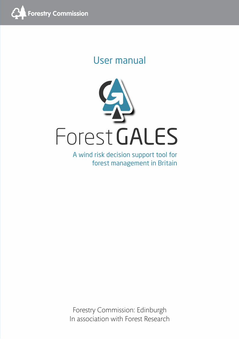
In the DAMS box, select Calculation then click the Apply... button. The calculation box will appear. Selecting the Exact calculation box (Figure 15) will give the opportunity to calculate the exact DAMS score. The Wind zone for the location can be found using the map that is displayed when View map is pressed. DAMS scores and wind zone boundaries are discussed in Forestry Commission Research Information Note 230 Revised windiness scores for the windthrow hazard classification. Elevation is entered together with the Topex values for each of eight compass directions (TOPEX is the angle to the horizon in whole degrees in the particular compass direction, with values less than zero being entered as zero). The resulting DAMS score can be copied to the main form by pressing Apply, or discarded by pressing Cancel. Example 7 (page 38) illustrates use of exact calculation for obtaining DAMS.
20 Forest GALES 2.5
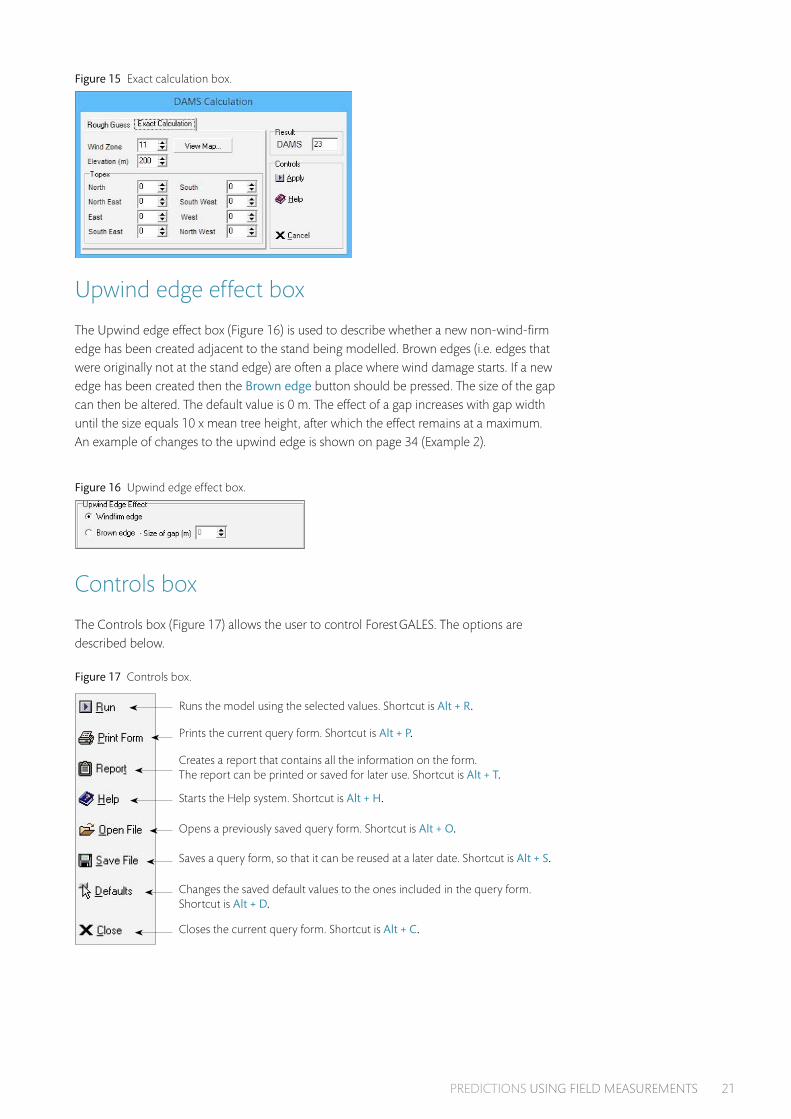
Figure 15 Exact calculation box.
Upwind edge effect box
The Upwind edge effect box (Figure 16) is used to describe whether a new non-wind-firm edge has been created adjacent to the stand being modelled. Brown edges (i.e. edges that were originally not at the stand edge) are often a place where wind damage starts. If a new edge has been created then the Brown edge button should be pressed. The size of the gap can then be altered. The default value is 0 m. The effect of a gap increases with gap width until the size equals 10 x mean tree height, after which the effect remains at a maximum. An example of changes to the upwind edge is shown on page 34 (Example 2).
Figure 16 Upwind edge effect box.
Controls box The Controls box (Figure 17) allows the user to control Forest GALES. The options are described below.
Figure 17 Controls box.
Runs the model using the selected values. Shortcut is Alt + R.
Prints the current query form. Shortcut is Alt + P.
Creates a report that contains all the information on the form. The report can be printed or saved for later use. Shortcut is Alt + T.
Starts the Help system. Shortcut is Alt + H.
Opens a previously saved query form. Shortcut is Alt + O.
Saves a query form, so that it can be reused at a later date. Shortcut is Alt + S.
Changes the saved default values to the ones included in the query form. Shortcut is Alt + D.
Closes the current query form. Shortcut is Alt + C.
PREDICTIONS USING FIELD MEASUREMENTS 21

Wind damage risk box
Model outputs are displayed in this box (Figure 18).
Figure 18 Wind damage risk box.
Critical wind speed
The critical wind speeds (i.e. the lowest wind speeds that will cause overturning or breakage) are presented. By default these are presented in m/s. Wind speed units can be changed in the Options menu.
Return period
The average length in years between wind speeds exceeding the critical wind speed occurring at the site. This is the average interval between gales that will damage the site. The statistical nature of the wind climate means that strong winds with long return periods (i.e. > 50 years) may occur within a few years of each other. The occurrence of a damaging storm does not alter the risk of further damage in subsequent years.
Wind damage risk status (WDRS)
Wind damage risk status is a measure of the risk of damage either by overturning or stem breakage. Six classes of WDRS exist. These are colour coded as a visual guide to the user: 1,2 – green; 3,4 – orange; 5,6 – red, as shown in Table 2.
Table 2 Wind damage risk status (WDRS) and associated return periods.
WDRS Return period
1 >100 years
2 100–50 years
3 50–33 years
4 33–20 years
5 20–10 years
6 <10 years
Unlike the Windthrow hazard class (WHC) classes, the risk status of a site will change over time. If the risk status for stem breakage is greater than for overturning, then stem breakage is likely to be the predominant form of damage, whereas if the risk status is greater for overturning than for breakage then uprooting is likely to be the predominant form of damage.
Windthrow hazard classification (WHC)
The WHC class for the site, based on the ‘traditional’ system described in Forestry Commission Leaflet 85 Windthrow hazard classification, using the DAMS score and soil type. This is provided to allow comparisons to be made between the old and new system.
22 Forest GALES 2.5

Predictions using yield models This type of prediction allows the user to calculate the risk of damage at a single point in time based on stand characteristics defined in yield models. It is particularly useful when the mensurational characteristics of a stand are not known or when wanting predictions made at a single point in the future. Figure 19 shows the predictions using yield models query form for single stands. Making predictions for multiple stands is explained in the Batch mode section. An example of this type of prediction is shown on page 35 (Example 3).
A selection of yield tables is distributed with Forest GALES, and is stored in the directory \yldmdls. To select a yield model, choose the species, then select the yield class, thinning regime and initial stocking that apply. Only the yield models which are available can be selected from the program. It is, however, possible to create new yield models which can be used as input for Forest GALES. This is described on pages 25 to 26.
Figure 19 Query form for Single stand predictions using yield models.
Stand characteristics box
As for Predictions using field measurements, the Stand characteristics box contains the Stand ID, Soil group and Rooting options (see page 15). The current stocking cannot be specified as this is taken from the yield tables.
Planting year
A planting year can be specified. This will automatically adjust the stand age to the present in the Tree characteristics box. If you want to make a prediction into the future adjust the age of the stand (see below) instead of specifying a planting year.
PREDICTIONS USING YIELD MODELS 23

Tree characteristics box
When predictions are made using yield models, the Tree characteristics box shows the same Species option as found in the predictions using field measurements (see page 17). However, the other options are different:
Yield class
The thinning model regimes displayed will depend on the yield models available, as described in the Forestry Commission software Forest Yield: a PC-based yield model for forest management in Britain.
Thinning regime
•Intermediate thinning with no delay
•Intermediate thinning with five year delay
•Intermediate thinning with ten year delay
•Line thinning with no delay
•Line thinning with five year delay
•Line thinning with ten year delay
•Crown thinning
•No thinning
Initial spacing
The initial spacing (in metres, based on square planting) should be selected. The range varies from 0.9–4.5 m depending on yield models available.
Age
The age of the crop to be modelled. The valid range varies between yield models. Ages between published values are calculated using linear interpolation between the nearest younger and nearest older published value. By default if the date of planting has been entered then the age of the stand will be calculated. This will give the risk now. It is possible however to change the date, allowing the risk to be calculated at some other time.
The ‘Tree details’ button
If this button is pressed then the height, diameter, current spacing and volume of the trees will be displayed. This is designed to provide information about the type of stand being modelled.
Other boxes
The DAMS box, the Controls box, the Upwind edge effect box and the Wind damage risk box are identical to those described on pages 20 to 22.
24 Forest GALES 2.5

User-defined yield models
New yield models can be constructed for use within Forest GALES using a word processor, or spreadsheet program.
Currently Forest GALES doesn’t contain a user-defined yield model helper. Yield models must therefore be created using a word processor or Windows® Excel. The general layout of the yield model file is described below. A Windows® Excel template is included with Forest GALES in directory yldmodls\userdefined and is called yieldmodel.xls.
The format of the model is illustrated in Table 3 and is:
Line one: a header to describe what is in each fieldLine two onwards: fields separated by a single space to define
•Age (years)
•Top height (m)
•Stocking density trees/ha
•DBH (cm)
•Basal area (m3/ha)
•Mean tree volume (m3/tree)
•Volume per hectare (m3/ha)
In each case data refer to the main crop after thinning. This is the format of the Forestry Commission yield models.
Table 3 Layout of a yield model for use in Forest GALES.
Age (years) Top height (m)
Trees/ha Mean DBH (cm)
Basal area (m2/ha)
Mean tree volume
(m3)
Volume (m3/ha)
20 7.4 2781 11 26 0.03 71
25 9.2 2300 13 32 0.06 90
30 10.9 1900 15 38 0.10 120
Naming user-defined yield models
The file should be saved as a text file with a file extension of .yld. If Forest GALES is to recognise the model then it must be named in a specific way. This consists of an 8 character name.
1. The first two characters indicate species; these are shown in Table 4.
2. The second two characters refer to the yield class (02–30).
3. The third two characters refer to thinning regime, and are shown in Table 4.
4. The final two characters refer to initial spacing in metres x 10. Therefore 0.9 m spacing becomes 09, and 2.1 m spacing becomes 21.
PREDICTIONS USING YIELD MODELS 25

Table 4 Species and thinning codes for naming user-defined yield models.
Species code Species Thinning code Thinning regime
SS Sitka spruce IZ Intermediate thinning no delay
NS Norway spruce IF Intermediate thinning five years delay
SP Scots pine IT Intermediate thinning ten years delay
LP Lodgepole pine LZ line thinning no delay
CP Corsican pine LF line thinning five years delay
EL European larch LT line thinning ten years delay
JL Japanese larch CZ crown thinning
HL Hybrid larch NO non-thinning
DF Douglas fir T1 user-defined thinning regime
GF Grand fir T2 user-defined thinning regime
NF Noble fir T3 user-defined thinning regime
WH Western hemlock
A user-defined model for yield class 18 Sitka spruce for a non-standard thinning regime planted initially at 2.0 m spacing would therefore be saved as SS18T120.yld.
The file should be saved in the directory yldmdls\XX\ where XX is the two letter species code indicated in Table 4.
If a new model is created with an identical name to a model that already exists, then the old model will be lost.
Using Windows® Excel to create user-defined yield models
1. Open the file yieldmodel.xls in Windows® Excel. It is in the directory \yldmdls\userdefined\ wherever you have installed Forest GALES.
2. Type data for the yield model into the template.
3. Extra lines can be added as necessary. If the template contains more lines than are needed, then remember to delete the extra lines.
4. Press File, Save As.
5. Choose the option Formatted Text(Space delimited)(*.prn).
6. The file must be saved in the directory XX, where XX is the two character species code indicated in Table 4.
7. Type the filename according to the format described on page 25 to 26.
Note: The filename must be enclosed in quotes (e.g. ‘SS20IZ20.yld’), otherwise the file extension .prn will be added resulting in a filename called something like SS20IZ20.yld.prn
8. Press Save.
The new model will be accessible within Forest GALES when a new Predictions using yield models query form is opened.
26 Forest GALES 2.5

Predictions through time Predictions through time allow the user to calculate the risk of damage to a stand over part or all of its rotation, rather than at just a single age.
Figure 20 shows the predictions through time query form for single stands. Making predictions for multiple stands is explained in the section on page 30 (Batch mode section). The main difference between predictions through time and predictions at a single point in time is that the results are displayed on a separate form when the model is run. Also, there is no option for modelling the effect of a new edge.
Figure 20 Query form for Single stand predictions through time.
Stand characteristics box
This is identical to the Stand characteristics box in predictions using yield models (see page 23) except that year of planting is not available, since predictions through time calculates risk over the whole rotation, not at just a single age.
Tree characteristics box
This is identical to the Tree characteristics box described on page 24 except that age is not available.
DAMS box
This is identical to the DAMS box described on page 20.
Controls box
This is identical to the Controls box described on page 21, except that a report cannot be created.
PREDICTIONS THROUGH TIME 27

User-defined yield tables
New yield tables can be constructed using the method described on pages 25 to 26.
Viewing the results
Figure 21 shows a typical results form. The form has four areas: a graphics window, two tabular windows and a Controls box. These are described below.
Figure 21 Results form for Single stand predictions through time.
The graphics window
The graphics window indicates the return period in years for damaging storms at intervals throughout the rotation. Typically as the trees grow older and taller the risk of wind damage increases and the return period therefore decreases.
The graph contains two lines. The red line indicates the risk of overturning, and the blue line indicates the risk of stem breakage. The data relate to average trees (i.e. with mean diameter and height) based on the yield tables.
Details of the graph can be investigated as follows:
Zooming into the graph:
•Place the mouse cursor at the top left hand corner of the area you wish to zoom in to.
•Hold down the left mouse button.
•With the mouse button held down, move the mouse to the lower right hand corner of the area you wish to zoom in to.
•Release the mouse button.
•The display will then change to the selected area.
Note: there is a minimum area which can be selected, and if a smaller area is selected then no zooming will occur.
28 Forest GALES 2.5

Scrolling around the graph:
•Place the mouse cursor somewhere on the graph.
•Hold down the right mouse button.
•With the right button held down, move the mouse.
•The graph will move as you do this.
Resetting the graph:
•Place the mouse cursor on the graph.
•Hold down the left hand mouse button.
•With the left button held down move the mouse to the left and upwards.
•The display will then revert to the original state.
Note: there is a minimum area which can be selected, and if a smaller area is selected, then the graph will not reset.
Displaying new results:The effect of changing the yield model used can be observed directly in the graphics window. Go to the query form, change any parameter, press the Run button and the graphics display will change. This allows the user to easily observe the effect of changing the thinning model or soil type or species, for example.
The tabular data windows
The table window on the left hand side indicates how return period changes with age, and provides details on height, diameter, spacing and volume of the crop with age. The date when the crop enters each Wind damage risk status (WDRS) is displayed in the table window on the right hand side. Data can be exported as described below.
The results form controls box
The controls that can be used on the results form are:
Print Form (Alt +P) Prints the current query form.Report (Alt + T) Creates a report that contains all the information on the form.
The report can be printed or saved for later use. Help (Alt + H) Starts the Help system.Excel® Export (Alt + X) Allows the user to export the tabular results to Windows® Excel.
PREDICTIONS THROUGH TIME 29

Batch modeForest GALES has been designed to allow batch files of data (i.e. multiple stands) to be processed, in addition to assessing the risk to stands one at a time. This allows data for a whole forest, property or coupe to be stored and calculated together.
In this mode, data are read in from one file, and output to a different file. This can be very helpful if a large number of stands need to be assessed at the same time. Those stands would not necessarily have to be linked to each other as the calculations are made independently. The Batch mode can be used with each type of prediction.
The interface of Forest GALES in Batch mode is different from that used for individual stands, and contains input and output areas as well as the control panel. Figures 22–24 show the interface for each type of prediction.
Figure 22 Query form for Batch mode predictions using field measurements.
Figure 23 Query form for Batch mode predictions using yield models.
Figure 24 Query form for Batch mode predictions through time.
30 Forest GALES 2.5

Creating batch input files
Input files can be created using the Batch mode helper window that appears in front of the query form when working in the Batch mode (see Figures 22–24). Special codes are needed for some parameters, so the use of the Batch mode helper application is recommended.
However, the input files can also be created from a spreadsheet. If doing so, it is recommended to add a line of input to the form using the Batch mode helper, then clicking Save inputs. Open the resulting file in Excel, and use it to ensure correct formatting. Note that DBH values can be entered in either cm (1–99 cm) or in metres (0.01–0.99 m). All outputs are written in cm.
When a batch file is opened using Open file on the query form, a progress box appears. When the file is loaded this is replaced with the message “File successfully opened”. For very large files (thousands of lines) on occasion this progress box may appear to freeze. Be patient, and the file will open.
Batch mode helper
The Batch mode helper allows the user to select inputs from menus, and these are then written to the input area of the query form. This is useful because Forest GALES uses coded values to describe the species and site rather than descriptions, and these values may be difficult to remember. For each prediction type, the options are identical* to those described for the corresponding query form in the Single stand prediction mode (See the sections starting on pages 15, 23 and 27).
Note: Clicking on Close causes both the helper and the Batch mode query form to be closed. Unless you want to discard the inputs, click on Calculate risk before closing the helper.
Controls box
The controls in the Batch mode helper are:
Add (Alt + A) Adds the selected values to the input area of the query form.Print Form (Alt + P) Prints the current query form.Help (Alt + H) Starts the Help system.Defaults (Alt + D) Changes the saved default values saved to the ones included
in the query form.Close (Alt + C) Closes both the helper and the query form.
Batch mode query form
The characteristics of the stand are entered in the input area. All data relating to a single stand are displayed on the same line. After running the program, the results of the model are displayed in the output area. If the data have been saved then the filename will be displayed at the top of the output area. The outputs vary slightly depending on the mode you are running in (see Table 5).
* There is a slight difference when making predictions for Batch mode using yield models. The year at which you wish to calculate the risk has to be specified on the query form rather than in the helper.
BATCH MODE 31

Table 5 Modes available for multiple stand predictions.
Mode Outputs
Predictions using field measurements
Return period for overturning, wind damage risk status for overturning, return period for breakage, wind damage risk status for breakage.
Predictions using yield models Model used, current top height (m), current DBH (m), current spacing (m), return period for overturning, wind damage risk status for overturning, return period for breakage, wind damage risk status for breakage.
Predictions through time* Model used, age to reach WDRS 1 to 6 for overturning, age to reach WDRS 1 to 6 for breakage.
* Double clicking on any of the input lines in this mode will open the graphics display window as for a single stand. In this way it is possible to observe differences between the risk for all the stands entered as inputs.
Controls box
The controls in the Batch mode query form are:
Calculate Risks (Alt + R) Runs the model using the selected values.Delete Row (Alt + E) Deletes a row of data from the input area.Open File (Alt + O) Opens a previously saved query form.Save Inputs (Alt + N) Saves the input file for later use.Save Outputs (Alt + U) Save the output file so that it can be exported to another application.Help (Alt + H) Starts the Help system.Excel® Export (Alt + X) Allows the user to export the tabular results to Excel®.
Year of calculation
When you are in the Predictions using yield models mode then the option is provided to modify the Year of calculation in the bottom right corner. The default is the current year but any year in the past or future (up to 2100) can be chosen. If the age is less than the minimum in the yield table the model defaults to the minimum age. If the age is beyond the maximum age in the yield tables the model defaults to the maximum age.
32 Forest GALES 2.5

Examples
1: Single stand predictions using field measurements – getting started
1. Start Forest GALES.
2. Left click on Mode è The Mode dialog box will open.
3. Choose Single stand, Predictions using field measurements è A new query form will open. This form has a range of pre-selected options. However, no value will be present in the Wind damage risk box.
For the purpose of this exercise, make sure the default options are set to the following values: Species Sitka spruce, Soil group Gleyed mineral soil – B, Rooting Shallow (<80 cm), Spacing 2.8 m, Top height of stand 20 m, Mean DBH 20 cm, DAMS Score 15, Windfirm edge.
4. Left click on Run è Values of 200 years will appear in the Wind damage risk box for the Return period for both overturning and breakage.
5. Left click on the up button to the right of the Mean DBH box è The DBH will increase by 0.1 cm per 'click'.
6. Keep changing the DBH in this way until a value of 22 cm appears in the box.
7. Change Top height until it reads 22 m.
8. Change Current spacing until it reads 3.5 m.
9. Left click on Run è The values in the Wind damage risk boxes will change to 30 years for Return period for overturning and 8 years for Return period for breakage.
This indicates that the risk of damage changes rapidly with changes in DBH, height and spacing. Other parameters can be changed in a similar way.
EXAMPLES 33

2: Single stand predictions using field measurements – the effect of a new edge
This example shows how creating new edges affects the risk of damage.
1. Start Forest GALES and open a query form for Single stands predictions using field measurements in the same way as the previous example. Set the options to: Species Sitka spruce, Soil group Gleyed mineral soil – B, Rooting Shallow (<80 cm), Spacing 2.8 m, Top height of stand 20 m, Mean DBH 20 cm, DAMS Score 15, Windfirm edge.
2. Left click on Run è This will give the return periods for damage for the default parameters, and no new edge.
3. Left click on the Brown edge button è A black dot will appear on the button, and the value for size of upwind gap will become black. Change the Size of gap to 400 m.
Using the pre-selected values left click on Run è The values in the Probabilities boxes will change and should become 8 years for Return period for overturning and 3 years for Return period for breakage. This indicates that the risk of damage is much greater if a new edge is present, than if no new edge is present. The Gap size box will also have changed to 188 m. This is 10 x the mean tree height. Gap widths greater than this have no additional effect on stability.
4. Now try changing the size of the gap to 20 m and left click on Run è The values in the Probabilities boxes will change and should become 16 years for Return period for overturning and 5 years for Return period for breakage.
Again, try changing other options to see what happens.
34 Forest GALES 2.5

3: Single stand predictions using yield models
This example shows how to use yield models to provide input data for the model.
1. Left click on Mode è The Mode dialog box will open
2. Choose Single stand, Predictions using yield models è A new query form will open. This form has a range of pre-selected options. However, no value will be present in the Wind damage risk box. For the purpose of this exercise, make sure the default options are set to the following values: Species Sitka spruce, Soil group Gleyed mineral soil - B, Rooting Shallow (< 80 cm), Yield class 14, Thinning regime Crown thinning, Initial spacing 1.7 m, Age 44 DAMS Score 15. Windfirm edge.
3. Left click on Run è This will give the probabilities of damage for a stand of YC 14 Sitka spruce, planted at 1.7 m spacing with a crown thinning regime at an age of 44. The values in the Probabilities boxes will change and should become 200 years for Return period for overturning and 200 years for Return period for breakage. The size and spacing of the modelled trees can be viewed using the Tree details button.
4. Now change the age to 50 and left click on Run è The values in the Probabilities boxes will change and should become 96 years for Return period for overturning and 83 years for Return period for breakage. This indicates that the risk is increasing with stand age.
5. Now left click on the down arrow to the right of Thinning regime è A menu of thinning options will appear as you move the mouse over the options, they are highlighted in turn.
6. Left click on Intermediate with no delay
7. Left click on Run è The values in the Probabilities boxes will change and should become 200 years for the Return period for overturning and 200 years for the Return period for breakage.
Again, try changing other options to see what happens.
EXAMPLES 35

4: DAMS
This example demonstrates the use of DAMS as an input for the model.
1. Start Forest GALES and open a query form for Single stand predictions using yield models in the same way as the previous example.
2. Set the options to: Species Sitka spruce, Soil group Gleyed mineral soil – B, Rooting Shallow (<80 cm), Yield classs 14, Thinning regime Crown thinning, Initial spacing 1.7 m Age 44, DAMS Score 15, Windfirm edge. Left click on Run è This will give the probabilities of damage for a typical tree in a stand of YC 14 Sitka spruce, planted at 1.7 m spacing with a crown thinning regime at an age of 44. The values in the Probabilities boxes will change and should become 200 years for Return period for overturning and 200 years for Return period for breakage.
3. Within the DAMS box, use the up and down arrows to select 17 as the value of DAMS score. The higher the DAMS score the windier the site.
4. Leave the options as they are and left click on Run è The return periods should change to 30 years for the Return period for overturning and 28 years for Return period for breakage.
It should be apparent that relatively small changes in DAMS result in large changes in calculated risk.
Again, try changing other options to see what happens.
36 Forest GALES 2.5

5: DAMS – rough guess
This example demonstrates using a rough estimate of DAMS as an input for the model.
1. Start Forest GALES and open a query form for Single stands predictions using yield models.
2. Within the DAMS box select the Calculation button then click Apply... è A new form will appear.
3. Left click on the Rough guess tab è New options will appear.
4. Select GB Region Scottish & English Borders, Elevation Mid-Slope, Shelter Exposed, Aspect West. è 18 will appear in the DAMS box. Pressing Apply would copy this value to the query form.
5. In the GB Region box, select central Wales è 17 will appear in the DAMS box.
Again, try changing other options to see what happens.
6: DAMS – grid reference
This example demonstrates how to obtain the DAMS score for a specific grid reference.
1. Start Forest GALES and open a query form for Single stands predictions using yield models.
2. Within the DAMS box click the Grid Reference button. Press Apply... è15 will appear in the DAMS box. This is the value of DAMS for NH180150. If Forest GALES cannot find the DAMS data it will ask you to locate it. The Find files option in the Windows start-up menu may be useful for this.
3. Type NY659932 in the Grid reference box
4. Left click Apply è17 will appear in the DAMS box.
Again, try changing other options to see what happens.
EXAMPLES 37

7: DAMS – calculate DAMS score
This example demonstrates how to obtain the DAMS score for a location based on ground measurements.
1. Start Forest GALES and open a query form for Single stands predictions using yield models
2. Within the DAMS box select the Calculation button then left click Apply... è A new form will appear.
3. Left click on the Exact calculation tab è New options will appear. By default, 23 will appear in the DAMS box. This would relate to a hill top site at 200 m elevation in the west of Scotland. Pressing Apply would copy this value to the query form.
4. To change the location left click on View map è This will cause a new window to appear.
5. Left click in the dark blue area in central Scotland (north west of the Tay estuary).
6. Press OK è The wind zone value 3 should be placed into the Wind zone box and 15 will appear in the DAMS box.
7. Select 100 in the Elevation box è 13 will appear in the DAMS box.
8. Enter Topex scores as shown in Table 6.
Table 6 Example Topex values.
North 0 South 5
North-east 3 South-west 2
East 5 West 0
South-east 10 North-west 0
è 10 will appear in the DAMS box.
Again, try changing other options to see what happens.
38 Forest GALES 2.5

Research modeTo access Research mode click Options and then click Research mode (or click Ctrl + R) (see Figure 25).
Figure 25 Research mode.
Research mode allows users greater flexibility in some aspects of using Forest GALES. Specifically:
•A wide range of parameters have been extracted into external parameter files, both general to the whole model and species-specific.
•There is a facility to add user-defined species, yield models and rooting depth/anchorage coefficient.
•There is a facility to set Weibull_A directly in the parameter file (rather than calculate it from DAMS). This can be used in the single stand modes, and in the standard batch modes if the same Weibull_A and Weibull_K are to be applied to all stands being analysed.
•An additional batch mode has been included, using field measurements, where Weibull_A and Weibull_K are entered on the input form instead of DAMS. This enables the Weibull parameters to be varied for each stand being analysed. This mode is shown using an additional icon to the right of the six standard modes at the top of the Forest GALES main window. This mode also allows very long files (longer than 32994 lines) to be processed.
•A detailed range of outputs are now optionally saved to file.
Click Help | Help to access help files for Research mode. There is also a Technical appendix detailing the equations used within Forest GALES.
Changing parameters
In earlier versions of Forest GALES, parameters were hard to change because they were embedded in the code. Forest GALES 2.5 has external parameter files, enabling users to easily alter parameters. One file contains universal constants, physical and aerodynamic parameters. A separate set of files, one for each species, contain parameters and variables that differ according to species.
These files can be edited using any text editor. However, it is easiest to use a text editor that enables Forest GALES to access the file while it is open within the editor, so the file need not be closed each time the program is run.
RESEARCH MODE 39

These files are read each time Forest GALES is run (i.e. 'Run' or 'Calculate risks' button pressed). This means that they can be altered, saved, and the model rerun without needing to close Forest GALES between runs.
The name, file location (with respect to the executable Forest GALES file) and file formatting are hardwired into Forest GALES 2.5. If a parameter file is not found, or is formatted incorrectly, an error message will appear and the program will do no calculations. In Batch mode, no calculations will be done for the affected input row and all subsequent rows. The program does not need to be closed while the problem is resolved. For example, if the message 'File FGParameters.txt not found' appears after clicking Run, click OK, then ensure that the file is in the correct location, and click Run again.
The format of the two types of parameter files are shown within this document. In addition, Read-only versions of example files are provided: ExampleFGParameters.txt and ExampleSpeciesParameters.txt.
A Restore defaults option is available, which will return all values in all external parameters files to the installation values.
Click Options | Restore defaults or Ctrl + shift + Z
Constants and limits input file
The file containing constants and model limits is called FGParameters.txt. It is held in the root directory of Forest GALES_2.5 (i.e. ForestGALES_2.5\FGParameters.txt) and must not be moved from here.
The parameters held in this parameter file are:
Physical 'constants'
•Snow density (kg/m3)
•Von Karman constant
•Air density (kg/m3)
•Acceleration due to gravity (m/s2)
Model limits
•Number of tree heights from edge assumed to be in forest
•Size of gap regarded as infinite (in tree heights)
•Limit defining resolution of Forest GALES model
•Multiplier defining number of sections in each metre length of trunk e.g. multiplier = 2 to have 0.5 m sections; multiplier = 0.5 to have 2 m sections (more sections means more accuracy but slower computation time)
40 Forest GALES 2.5

Aerodynamic parameters
•Element drag coefficient (CR): used to calculate zero plane displacement 1
•Surface drag coefficient (CS): used to calculate zero plane displacement 1
•Constant (CW): used to calculate Roughness 2
•Height above zero plane displacement at which we require wind speed (m)
•Roughness of land surrounding forest (m) [not used in this version of Forest GALES]
•Ua: used in calculation of annual exceedance probability 3
•Four parameters used in calculation of Uc: used in calculation of annual exceedance probability 4
•Weibull_K 4
•Code for Weibull_A calculation method [1: Entered directly; or 2: Calculated from DAMS]
•Weibull_A [used if code is 1] 5
•Two parameters for calculating Weibull_A from DAMS [used if code is 2] 6
Refer to the Technical appendix to see how these values are used:
1 See Equation 102 See Equation 113 See Equation 184 See Equation 195 See Equation 206 See Equation 17 [These Weibull parameters are not used in Batch-Weibull mode]
The structure of the FGParameters.txt file is shown below. Lines with comments and parameter names begin with #. Parameter values are on the line below the parameter name.
RESEARCH MODE 41

FGParameters.txt
1. # FG2.5Res2. # File containing constants, model limits and aerodynamic parameters3. #4. # Each comment describes the line below5. #6. # SNOWDENSITY: snow density kg/m3 7. 1508. # K: von Karman constant;9. 0.410. # RO: air density kg/m3
11. 1.222612. # G: acceleration due to gravity m/s2
13. 9.8114. # TREE_HEIGHTS_FROM_EDGE: number of tree heights from edge assumed to be in forest15. 916. # BIGGAP: size of gap regarded as infinite17. 1018. # LIMIT: defines resolution of Forest GALES model19. 0.0120. # CR: Element drag coefficient 21. 0.322. # CS: Surface drag coefficient 23. 0.00324. # CW: Constant25. 226. # CALC_HT: height above zpd at which we require wind speed27. 1028. # FIELD_ZO: Roughness of land surrounding forest29. 0.0630. # Ua: 31. 532. # U_C1: parameter for calculating U_C 33. -0.590334. # U_C 2: parameter for calculating U_C35. 4.434536. # U_C3: parameter for calculating U_C37. -11.863338. # U_C4: parameter for calculating U_C39. 13.56940. # Weibull_K41. 1.8542. # Weibull-A method: Entered directly [1]; Calc.from DAMS [2]43. 144. # Weibull_A_Entered45. 646. # Params for calc.Weibull-A: A_Weibull = DAMStoWeibullA1 + DAMStoWeibullA2 * DAMS47. # DAMStoWeibullA148. -0.962649. # DAMStoWeibullA250. 0.427951. # Number of sections in each metre length of trunk52. 1
42 Forest GALES 2.5
Species parameter files
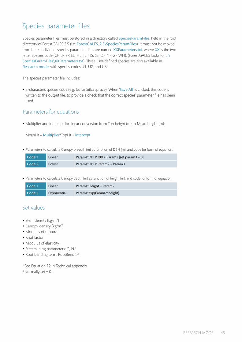
Species parameter files must be stored in a directory called SpeciesParamFiles, held in the root directory of Forest GALES 2.5 (i.e. ForestGALES_2.5\SpeciesParamFiles); it must not be moved from here. Individual species parameter files are named XXParameters.txt, where XX is the two letter species code (CP, LP, SP, EL, HL, JL, NS, SS, DF, NF, GF, WH). (Forest GALES looks for ...\SpeciesParamFiles\XXParameters.txt). Three user-defined species are also available in Research mode, with species codes U1, U2, and U3.
The species parameter file includes:
•2-characters species code (e.g. SS for Sitka spruce). When 'Save All' is clicked, this code is written to the output file, to provide a check that the correct species' parameter file has been used.
Parameters for equations
•Multiplier and intercept for linear conversion from Top height (m) to Mean height (m): MeanHt = Multiplier*TopHt + intercept
• Parameters to calculate Canopy breadth (m) as function of DBH (m), and code for form of equation.
Code:1 Linear Param1*DBH*100 + Param2 [set param3 = 0]
Code:2 Power Param1*DBH^Param2 + Param3
• Parameters to calculate Canopy depth (m) as function of height (m), and code for form of equation.
Code:1 Linear Param1*Height + Param2
Code:2 Exponential Param1*exp(Param2*height)
Set values
•Stem density (kg/m3)
•Canopy density (kg/m3)
•Modulus of rupture
•Knot factor
•Modulus of elasticity
•Streamlining parameters: C, N 1
•Root bending term: RootBendK 2
1 See Equation 12 in Technical appendix2 Normally set = 0.
RESEARCH MODE 43

Overturning moment calculation
Anchorage coefficients 1 For each of the four soil groups (A,B,C,D) there are three anchorage coefficients: one for each rooting depth (shallow, deep) and one user-defined.
1 See Equation 1 in Technical appendix
Maximum stem weight (kg)For each soil-rooting depth combination, the maximum stem weight is used to raise a warning to the user for extrapolated values, or where no data were available for the soil/rooting depth combination.
Refer to the section starting on page 15 of the User guide for information on soil groupings and rooting depth.
Scaling parameterA scaling parameter has been included (OTM scaling value) to enable percentage changes to the anchorage coefficient to be applied, without altering the actual values of the coefficients in the parameter file. If the OTM scaling value is set at 100, this is equivalent to using the actual anchorage coefficient.
The structure of the species paramater file is shown on page 45 to 46; this must be adhered to.
•Within the species parameter file, all comment lines begin with #.
•At intervals, after the #, a line number is given (e.g. L8). These have been included to help ensure that the file format is correct. They should correspond with the line numbers in the text editor.
User-defined species
Three user-defined species can be used when working in Research mode. The species parameter files for these are named U1Parameters.txt, U2Parameters.txt and U3Parameters.txt and are located in the directory SpeciesParamFiles. Simply edit these to contain values for your own species; the structure is identical to that described earlier.
In Research mode, the Species drop-down menu in the Tree characteristics box of all Forest GALES modes will show User-defined species 1, User-defined species 2 and User-defined species 3 at the bottom of the species list. This can be used to select your species.
If you make a batch input file for your user-defined species, the species codes should be entered as U1, U2, U3. If you are using these species for Predictions using yield models, or Predictions through time, ensure that you have made corresponding yield tables (see “User-defined yield models” on P27 of the User manual), stored in the folder yldmodls\XX\ where XX is U1, U2 or U3.
44 Forest GALES 2.5

1. # Forest GALES 2.5Res Sitka spruce parameter file2. SS3. # L3 Conversion Top height (m) to mean height (m): MeanHt = Multiplier*TopHt + intercept4. # Multiplier5. 1.04676. # Intercept7. -2.14528. # L8 CanopyBreadth (m) as function of DBH (cm).9. # Equation form: 1 linear: Param1*DBH*100 + param2; 2 Power: Param1*DBH^Param2 +
Param310. 111. # Param112. 0.134613. # Param214. 0.641815. # Param316. 017. # L17 CanopyDepth (m) as function of height (m)= Mulitplier*Height + intercept; (m).18. # Equation form: 1 linear: Param1*Height + param2; 2 Exp: Param1*exp(Param2*height)19. 120. # Param121. 0.366722. # Param223. 2.468224. # L24 Stem Density25. 850 26. # Canopy Density27. 2.528. # Modulus of rupture29. 3.4E730. # L30 Knot factor31. 1.032. # Modulus of elasticity33. 5.9E934. # L34 Streamlining parameters35. # C36. 2.3537. # N38. 0.5139. # Root bending term RootBendK40. 0.041. # L41 Overturning Moment Multipliers42. # Soil-A; Rooting depth 1,2,User43. 153.244. 178.145. 156.246. # Soil-B; Rooting depth 1,2,User47. 135.848. 157.949. 138.550. # Soil-C; Rooting depth 1,2,User51. 148.352. 172.5
RESEARCH MODE 45

53. 151.254. # Soil-D; Rooting depth 1,2,User55. 168.756. 196.257. 172.158. # L58 OTM Scaling value59. 10060. # Maximum stem weight in each category (kg)61. # Soil-A; Rooting depth 1,2,User62. 51963. 89364. 51965. # Soil-B; Rooting depth 1,2,User66. 206867. 104268. 206869. # L69 Soil-C; Rooting depth 1,2,User70. 120571. 23772. 120573. # L73 Soil-D; Rooting depth 1,2,User74. 107075. 101276. 1070
Weibull parameters
In previous versions of Forest GALES, Weibull_K was embedded as a constant within the code and Weibull_A was calculated from DAMS for each site. Using Research mode in Forest GALES 2.5, in the six standard (three single-stand and three batch) modes:
•Weibull_K is held within the external parameter file FGparameters.txt and can easily be altered.
•Weibull_A can be read directly from the external parameter file, or it can be calculated from DAMS if preferred. A code within the parameter file switches between these two options. If Weibull_A is calculated from DAMS, the variables relating Weibull_A to DAMS can be altered in the parameter file. See Equation 17 in the Technical appendix.
If you are working in a Batch mode, the same settings apply to all stands in the batch. When Forest GALES is run, a message appears in the bottom of the open window saying whether Weibull_A was entered directly or calculated using DAMS.
46 Forest GALES 2.5

Batch-Weibull mode
There is also a new mode: Batch-Weibull mode. When Research mode is selected, an icon for this mode appears at the top of the Forest GALES window (Figure 26). Click this to open the Batch-Weibull window. Figure 26 Batch-Weibull mode icon.
This mode uses field measurements (see the sections starting on page 15 and page 30 of User manual and Table 7), but Weibull_A and Weibull_K are entered individually for each stand in the Weibull Box (Figure 27).
Figure 27 Weibull box.
Table 7 Summary of derivation of Weibull parameters in each mode.
Mode Weibull_K Weibull_A
Single stand modes: field measurement; yield model; through time
Read from parameter file Either calculated from DAMS, or read from parameter file, depending on code in parameter file
Batch modes: field measurement; yield model; through time
Read from parameter file Either calculated from DAMS, or read from parameter file, depending on code in parameter file. Weibull_K and Weibull_A the same for all stands analysed in one batch
Batch mode: Weibull (field measurement)
Entered separately for each stand in the batch (irrespective of code in parameter file)
Long files
The standard batch modes in Forest GALES 2.5 have a limit of 32994 lines of data. While this is sufficient for most purposes, on occasion a longer file might be needed. The Batch-Weibull mode includes a feature allowing files of unlimited length to be read in. Files in Batch-Weibull mode are of the type *.bmw. For guidance of how to easily create a batch input file, refer to Creating batch input files on page 31.
Open Batch-Weibull mode
Select the Field measurements – Weibull: batch mode window
Click the Run long file button (or Alt + L)
Select the file and click Open
RESEARCH MODE 47

Forest GALES will then process the selected file. Outputs are automatically saved as a *.csv file with the same name and in the same directory as the input file.
Outputs
In addition to the basic outputs saved in Normal mode of Forest GALES 2.5 [Save Outputs button; See Table 5], in Research mode there is a Save All, which saves inputs, and basic and detailed outputs (Table 8).
In Batch mode using field measurements, Batch mode using yield models, and Batch mode using Weibull parameters, Save All saves information for all stands included in the batch.
For predictions through time, Save All is available in Single stand mode, and in Batch mode when you double-click a single row of data to view outputs for an individual stand. Clicking Save All at this point will save information for the selected stand. The outputs saved are shown in Table 6.
To use Save All, click on the button when calculations have completed. Specify a filename and path of your choice.
Note: If you wish to use Save All for a given run of Forest GALES, do so before running the model again, as the default output file is automatically overwritten each time the program is run.
Table 8 Outputs saved using Save all button in Research mode.
Field Yield Weibull Through time* Through time
StandID x x x x Age Overturn WDRS1 x
Species x x x x Age Overturn WDRS2 x
Yield class (m3/ha/yr) x x Age Overturn WDRS3 x
Thinning regime x x Age Overturn WDRS4 x
Initial spacing (m) x x Age Overturn WDRS5 x
Model used x x Age Overturn WDRS6 x
Species file used x x x x Age Break WDRS1 x
Soil group x x x x Age Break WDRS2 x
Rooting depth x x x x Age Break WDRS3 x
Spacing (m) x x x x Age Break WDRS4 x
P_Year x Age Break WDRS5 x
Year of calc x Age Break WDRS6 x
DAMS x x x
Age (yr) x x
Top height (m) x x x x
DBH (cm) x x x x
Mean vol (m3) x
Vol per ha (m3/ha) x
Gap size (m) x x x
CWS1 overturning (m/s) x x x x
Return period over (yr) x x x x
WDRS overturning x x x x
CWS1 breakage (m/s) x x x x
48 Forest GALES 2.5

Field Yield Weibull Through time* Through time
Return period breakage (yr) x x x x
WDRS breakage x x x x
CWS1 damage (m/s) x x x x
Return period damage (yr) x x x x
WDRS damage x x x x
Mode of damage x x x x
Mean height (m) x x x x
Canopy width (m) x x x x
Canopy depth (m) x x x x
Crown base (m) x x x x
Stem wt (kg) x x x x
Stem vol (kg/m3) x x x x
Branch wt (kg) x x x x
Branch vol (kg/m3) x x x x
Max. overturning moment (Nm) x x x x
Max. breakage moment (Nm) x x x x
CWS overturning at canopy top2 (m/s) x x x x
CWS breakage at canopy top2 (m/s) x x x x
Gustiness x x x x
Edge factor x x x x
Gust factor (Edge factor * Gustiness) x x x x
ZPD (m) x x x x
Z0 (m) x x x x
Drag coefficient x x x x
A-Weibull x x x x
K-Weibull x x x x
A-Weibull method x x x
Comments x x x x
* For Through time, outputs in the table listed from Age downwards are output for each age in the selected yield table. The values for ’Age to reach WDRS 1-6’ apply to the whole rotation.
1 CWS is critical wind speed at 10 m above zero-plane displacement.
2 Canopy top is mean tree height.
RESEARCH MODE 49

Glossary Anchorage The complex of mechanisms by which the root system and soil resist the wind
forces on the stem and crown.Brown edge An edge of a stand that was created by felling part or all of the adjacent crop,
rather than being a crop boundary since the time of planting.Centre of pressure The average position in the crown of the tree where the total force
of the wind can be said to act.Coherent gusts Organised rotational motions in the air (= Vortices).Critical wind speed Threshold hourly wind speed above which the average tree of a stand
is expected to be overturned or snapped.Critical height The top height of the stand at which damage was expected to start within
the WHC system.Cultivation The method of preparing the soil prior to tree establishment. This may have been
done by many means such as ploughing, mounding or producing turves.Damping The processes by which oscillations are reduced in size and tend to stop. Damping
includes canopy clashing, canopy drag through the air, and frictional movement of stem fibres.
DAMS score Detailed Aspect Method of Scoring – a system for scoring windiness derived from tatter flags and using representation of location and terrain to calculate a score.
DBH Diameter of a tree at 1.3 m above ground level.Dominance The ‘social’ status of a tree within a crop. Five categories are usually defined –
dominant (trees with a crown entirely within the canopy), codominant (trees with much of their crown in the canopy), subdominant (trees with their crowns generally below the canopy), suppressed (trees with small crowns entirely beneath the canopy, which are gradually dying from lack of light) and dead.
Drag area The surface area of the tree (canopy and stem) presented to the wind. Drag area is reduced as wind speed increases, due to streamlining of the tree.
Drag force The force on the tree caused by the pressure exerted by the wind on the crown (= wind loading).
Drainage A description of site wetness; poor refers to a wet site where rooting is severely restricted by a shallow watertable – due to local topography or failure of/lack of installed drainage system; good refers to better than average site – due to topography (e.g. shedding slope) or good quality intensive drainage network.
Frequency of oscillation The number of sway cycles of the tree per second.Fulcrum The position on the lee-side of the tree where the root system pivots when the tree
is bent by the wind (= hinge).General yield class An index used in Britain, expressing the potential stem volume productivity
of even-aged stands of trees (in units of cubic metres per hectare per year), based on an assessment of top height at a given stand age.
Gust A rapid increase in wind speed over a short period of time (seconds rather than minutes).Gust factor Ratio of the maximum turning moment to the mean turning moment on a tree
from wind over the period of an hour.Hinge See Fulcrum.Leeward The side of the tree facing away from the wind.Lever The distance between the point of action of a force and the fulcrum.Modulus of elasticity A measure of stiffness. Modulus of elasticity is the load that theoretically
would be required to make a material double (or halve) in length were it to behave perfectly elastically. In practice timber generally stops behaving elastically when its length changes by 1% and breaks when the change exceeds 2%.
50 Forest GALES 2.5

Modulus of rupture The force per unit area that is required to break a material when a bending load is applied.
Moment Force multiplied by distance (= torque).Overturning moment The force on the tree multiplied by the distance from where the force
acts (the centre of pressure) to the fulcrum, plus the additional moment due to the weight of the over-hanging crown.
Risk (for a tree) The probability in a particular year of the critical wind speed being exceeded (see Vulnerability).
Risk status A measurement of the probability of the critical wind speed being exceeded in a particular year, grouped into six categories. Status 1: return period >100 years; Status 2: return period 50–100 years; Status 3: return period 33–50 years; Status 4: return period 20–33 years; Status 5: return period 10–20 years; Status 6: return period <10 years.
Root architecture The appearance and structure of the root system, particularly the number and arrangement in three dimensions of the thickest roots.
Rooting depth The average maximum depth of tree roots below the soil surface. On many sites this is constrained by limiting soil conditions such as a water table, induration or the underlying bedrock. Rooting depth may be measured in a soil pit, or estimated based on soil type and conditions.
Spacing – Current The average spacing between trees at the time of risk assessment.Spacing – Initial The average spacing between trees at the time of planting.Stocking The number of trees per hectare at the time of risk assessment.Terminal height The top height of a stand at which wind damage was expected to reach a
level necessitating clearance.Thinning The removal of a proportion of the tree crop for silvicultural or economic reasons.
Forest GALES can extract data from yield models categorised according to thinning regime and initial spacing. The regimes used in the yield models are non-thinning (no trees actively removed, though some may die naturally), intermediate thinning (removal of trees from throughout the crop, with the smaller trees being preferentially removed), line thinning (removal of trees in straight lines) and crown thinning (removal of trees that are competing with the crowns of the highest quality trees). Models have also been produced for delayed thinnings.
Top height The average height of the 100 trees of largest diameter per hectare, usually measured as the average height of the largest diameter trees in a sample of 0.01 ha plots.
Topex A measure of exposure based on the sum of the angles to the horizon in eight compass directions.
Turbulence The random variations in wind speed and direction.Vortices See Coherent gusts.Vulnerability The threshold wind speed required to blow over a particular tree on a particular
site. WHC See Windthrow hazard classification.Wind loading See Drag force.Windthrow hazard classification A method to zone forest areas of 500 ha or more by adding
classification scores for windiness and soil together to estimate a hazard class. Each class was associated with a critical height and a terminal height.
Windward The side of the tree facing towards the wind.Wind zone A range of windiness categories for the whole of Britain. The higher the wind zone
the windier the climate on average.
GLOSSARY 51

Further reading and useful sources of information
Forestry Commission publications
www.forestry.gov.uk/publications
•Forest mensuration: a handbook for practitioners (FCBK039)
•Forests and wind: management to minimise damage (FCBU114)
•Rooting and stability in Sitka spruce (FCBU040)
•The identification of soils for forest management (FCFG001)
•Forest Yield: a PC-based yield model for forest management in Britain (FCSW002, in prep)
Other publications
•Wind and wind-related damage to trees (Cambridge University Press)
•Joint evaluation of storms, forests vulnerability and their restoration. Discussion Paper 9 (European Forest Institute)
•Living with storm damage to forests: what science can tell us 3 (European Forest Institute)
Websites
•Forest GALES - www.forestry.gov.uk/fr/forestgales
52 Forest GALES 2.5

Technical appendix
Critical turning moments for overturning and breakageThe critical turning moments for overturning and breaking of a tree can be derived using the formula in Gardiner et al. (2000):
1 Mcrit_over = Creg • SW
2 Mcrit_break = π • fknot • MOR • diam3
32
where M is the total overturning moment (in Nm, resulting from wind loading and from the weight of the overhanging crown) and diam is the diameter of the stem (m). M is calculated at the base of the tree (diam = d0) for overturning and either at the base of the tree or at breast height (diam = dbh) for stem breakage. SW is the weight of the bole of the tree (kg) multiplied by an average green density value (typically 850-1000 kg m-3). The remaining parameters are species-specific: Creg (Nm kg-1) is an anchorage coefficient obtained from tree pulling experiments, and is a function of species, soil type and rooting depth. The Creg values used in Forest GALES 2.5 were derived from reanalysis of data presented in Nicoll et al. (2006), and provide a more consistent change in value for different depths of rooting than the values presented in that paper. The parameter fknot is a factor to reduce wood strength due to the presence of knots (usually between 0.8 to 1; Ruel et al., 2010); and MOR is the green wood Modulus of Rupture (Pa) for the particular species, derived from bending tests (e.g. Lavers, 1969).
Gardiner et al. (2000) and Quine and Gardiner (2007) showed that the mean bending moment at any height (z, in m) on a tree can be derived from the aerodynamic stress on the forest canopy (τ = ρu*
2 ), the average spacing between trees (D, in m) and the assumption that the wind loading acts on average at the height of the zero-plane displacement (d, in m; Thom, 1971):
3 Mmean (z) = (d – z) ρu*2 D 2
where u* is the friction velocity (m2 s-2) and ρ is air density (kg m-3). This can be used to calculate the turning moment on a tree at height z above the ground in terms of the canopy top wind speed (u(h), m s-1) by assuming a logarithmic wind profile above the canopy (Gardiner et al., 2000; Quine and Gardiner, 2007):
4
where h is the average tree height (m), z0 is the aerodynamic roughness (m), and k = 0.4 (Von Karman’s constant). This is then converted into a calculation of the maximum turning moment by multiplying by a gust factor (G):
5
where fCW is a factor to account for the additional moment provided by the overhanging
Mmean (z) = (d – z) ρ Du(h)k 2
In h – d z0
Mmax (z) = fcw (d – z) ρ G Du(h)k 2
In h – d z0
TECHNICAL APPENDIX 53

displaced mass of the canopy. This can be calculated directly using the tree bending equations described by Neild and Wood (1999) (their Equation 7) if the force of the wind (ρu*
2 D2), the point of action of the wind (d) and the mass distribution with height in the tree are known.
A gust factor (G) is required because the maximum wind loading occurs during short-term gusts of a few seconds, but maximum wind loading is predicted from the mean hourly wind speed u(h) in order to match with standard climatological wind data. G is the ratio between maximum and mean turning moment and is calculated as a function of the spacing to tree height ratio, based on wind tunnel measurements (Gardiner et al., 1997). The original formula used by Gardiner et al. (2000) was found to be unstable at low values of D/h (close spacing) and was replaced by the following equation, which gave a more robust fit to the data:
6 G=[(–2.1•D/h +0.91)•x/h+(1.0611•In(D/h)+4.2)]•gfadj
where x is the distance from the forest edge (m). Note that it is necessary to ensure that –2.1•D/h + 0.91 ≥ 0. The factor gfadj = 1.0 replaces the value of 1.5 used in versions of Forest GALES, which was found during a comparison against observed damage to give critical wind speeds that were too low (Hale et al., 2015).
Aerodynamic parameters
The aerodynamic parameters in Equation 4, z0 and d, can be calculated using the method of Raupach (1994):
7
8 z0 = (h – d)•exp(–k•γ + ψh)
9 Λ = 2 canopybreadth•canopydepth • CD / D2
2
10 γ = 1 , max Λ = 0.6
11 ψh = In (Cw) –1 + 1 Cw
where cd1 = 7.5, CS = 0.003, CR = 0.3 and CW = 2, canopybreadth is the maximum width of the canopy (m), canopydepth is the length of the live crown (m), and CD (drag coefficient) is a measure of the streamlining of the crown in the wind, which can be calculated from the experimental data in Mayhead (1973), Rudnicki et al. (2004) or Vollsinger et al. (2005):
12 CD = C • u–n
where u is the wind speed of interest (m s-1). As examples, C = 2.35 and n = 0.51 for Sitka spruce and C = 3.07 and n = 0.75 for Scots pine with a maximum value of drag coefficient set at u = 10 m s–1 and a minimum value at u = 25 m s–1. Note that we divide the value of canopybreadth by 2 to get the average canopy width for the tree because we assume a rhomboid shape for the crown with the maximum width of the canopy defining the width of the rhomboidThe AEP for a particular critical wind speed (Windspeed) is given by:
d = h 1 – 1 – exp (– cd1•Λ) cd1• Λ
Cs + CR•Λ 1/2
2
54 Forest GALES 2.5

Critical wind speed
By equating Equations 1 and 2 with Equation 5 it is possible to calculate the critical wind speed at canopy top for overturning and stem breakage (u(h)crit_over and u(h)crit_break, respectively, in m s–1):
13
14
These equations have to be solved iteratively because porosity is a function of wind speed and, therefore, so are d and z0. These critical wind speeds need to be converted to the corresponding wind speeds at 10 m above the zero plane displacement (u(d+10)crit) in order to utilise meteorological data to calculate probabilities of occurrence and return periods:
15 u (d+10)crit = u(h)crit •
where ucrit is either u(d+10)crit_over or u(d+10)crit_break.
Return period
The return period for this critical wind speed (u(d+10)crit) can be calculated from the Weibull distribution, which describes well the wind speed distribution at individual locations in Britain (Cook, 1985); the Weibull shape parameter (Weibull_K) is relatively constant (~ 1.85), and the scale parameter (Weibull_A) is related to the mean wind speed (WSmean) through the expression:
16 WSmean = Weibull_A•Γ (1 + 1/1.85) = Weibull_A•0.888
where Γ is the gamma function (see Troen and Petersen, 1989).
The Weibull parameters are used to calculate the annual exceedance probability of the critical wind speed. In Forest GALES 2.5 Standard mode, Weibull_K is set at a constant value of 1.85, and Weibull_A is calculated from DAMS as follows (Quine, 2000):
17 Weibull_A = a • DAMS – b
For the forested areas where this relationship was parameterised, values are:
a = 0.4279
b = –0.9626
In h – d z0
In 10 z0
u(h)crit_break
= 1 π • MOR • dbh3 1/2 fknot 1/2 In h – d kD 32ρG (d – 1.3) f
CW z
0
u(h)crit_over
= 1 Creg• SW 1/2 1 1/2 In h – d kD ρGd f
CW z
0
TECHNICAL APPENDIX 55

In the Research mode of Forest GALES 2.5, Weibull_A and Weibull_K can be entered directly by the user.
To calculate the annual exceedance probabilbity (AEP) we use a method developed by ESDU that links the Weibull distribution to the Fisher-Tippet Type 1 extreme value distribution.
The AEP for a particular critical wind speed (Windspeed) is given by:
18 AEP = 1 – exp – exp –1 Windspeed 2 –U U/ Ua
where (from Quine, 2000):
19 U_C = U_C1 • Weibull_K3 + U_C 2 • Weibull_K2 + U_C3 • Weibull_K + U_C4
20 U = (Weibull_A * U_C)2
The return period (average number of years between damaging events) is given by 1 / AEP.
with:
U_C1 = -0.5903
U_C 2 = 4.4345
U_C3 = -11.8633
U_C 4 = 13.569
and Ua is taken as equal to 5 (Quine, 2000).
56 Forest GALES 2.5

References
COOK, N.J. (1985). The designer's guide to wind loading of building structures. Part 1: Background, damage survey, wind data and structural classification. Butterworths, London. pp 371.
GARDINER, B.A., STACEY, G.R., BELCHER, R.E. and WOOD, C.J. (1997). Field and wind-tunnel assessments of the implications of respacing and thinning on tree stability. Forestry 70, 233–252.
GARDINER, B., PELTOLA, H. and KELLOMÄKI, S. (2000). Comparison of two models for predicting the critical wind speeds required to damage coniferous trees. Ecological Modelling 129, 1–23.
HALE, S.E., GARDINER B., PEACE, A., NICOLL, B., TAYLOR, P. and PIZZIRANI, S., (2015). Comparison and validation of three versions of a forest wind risk model. Environmental Modelling and Software 68, 27-41
LAVERS, G.M. (1969). The strength properties of timbers. Forest Product Research Laboratory Bulletin 50 (2nd edition). HMSO, London.
MAYHEAD, G.J. (1973). Some drag coefficients for British forest trees derived from wind tunnel studies. Agricultural Meteorology 12, 123–130.
NEILD, S.A. and WOOD, C.J. (1999). Estimating stem and root-anchorage flexibility in trees. Tree Physiology 19, 141–151.
NICOLL, B.C., GARDINER, B.A., RAYNER, B. and PEACE, A.J. (2006). Anchorage of coniferous trees in relation to species, soil type and rooting depth. Canadian Journal of Forest Research 36, 1871–1883.
QUINE, C.P. (2000). Estimation of mean wind climate and probability of strong winds for wind risk assessment. Forestry 73, 247–258.
QUINE, C.P. and GARDINER, B.A. (2007). Understanding how the interaction of wind and trees results in windthrow, stem breakage and canopy gap formation. In: E. Johnson and K. Miyanishi (eds) Plant disturbance ecology: the process and the response. Academic Press, Burlington, MA, USA. 698p.
RAUPACH, M.R. (1994). Simplified expressions for vegetation roughness length and zero-plane displacement as functions of canopy height and area index. Boundary-Layer Meteorology 71, 211–216.
RUDNICKI, M., MITCHELL, S.J. and NOVAK, M.D. (2004). Wind tunnel measurements of crown streamlining and drag relationships for three conifer species. Canadian Journal of Forest Research 34, 666–676.
RUEL, J.-C., ACHIM, A., ESPINOZA, R.H., CLOUTIER, A. and BROSSIER, B. (2010). Wood degradation after windthrow in a northern environment. Forest Products Journal 60, 200–206.
THOM, A.S. (1971). Momentum absorption by vegetation. Quarterly Journal of the Royal Meteorological Society 97, 414–428.
TROEN, I. and PETERSEN, E.L. (1989). European wind atlas. Risø National Laboratory, Denmark.VOLLSINGER, S., MITCHELL, S.J., BYRNE, K.E., NOVAK, M.D. and RUDNICKI, M. (2005). Wind
tunnel measurements of crown streamlining and drag relationships for several hardwood species. Canadian Journal of Forest Research 35, 1238–1249.
REFERENCES 57

58 Forest GALES 2.5


Wind damage is a major challenge for the management of forests in Britain, and it has economic, environmental and social consequences. In some areas the threat of wind damage restricts silvicultural options and leads to the use of shortened rotations, giving lower income from timber sales. In order to minimise risk, forest managers need information on the likely timing and magnitude of damage so that they are able to predict the level of risk and assess the implications of different management options. Forest GALES draws together more than 30 years of knowledge and research into a user-friendly decision support tool that will enable forest managers to estimate the probability of wind damage to conifer stands in Britain. The software calculates the wind speed that would be expected to damage a stand of trees and it provides windiness scores (DAMS) for the whole of Britain. It assesses the current level of risk of overturning and stem breakage, and the change in risk over the lifetime of the crop, in addition to assessing the effect on risk of thinning and the creation of brown edges. Forest GALES is able to calculate the risk to any number of stands simultaneously.
Silvan House231 Corstorphine Road
EdinburghEH12 7AT
www.forestry.gov.uk