forest fire management - national disaster management
TRANSCRIPT
1
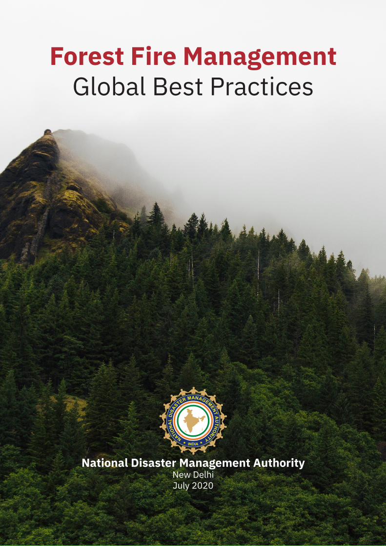
Forest Fire Management Global Best Practices
National Disaster Management AuthorityNew DelhiJuly 2020
2
1. Background 32. Drivers of Forest Fire 43. Forestfireacrosstheglobe 54. Forest Fire in India 75. GlobalBestPractices 95.1. Australia 95.1.1. Mitigation 95.1.2. Preparedness 105.1.3. Response 115.1.4. Recovery 115.2. UnitedStatesofAmerica 125.2.1. Mitigation 125.2.2. Preparedness 135.2.3. Response 145.2.4. Recovery 155.3. Brazil/Amazon 155.3.1. Mitigation 155.4. Canada 155.4.1. Mitigation 155.4.2. Preparedness 165.4.3. Response 165.4.4. Recovery 165.5. TheUnitedKingdom 175.5.1. Preparedness 175.5.2. Mitigation 175.5.3. Responseandrelief 175.5.4. Recovery 186. Communitybasedforestfireandtraditionalpractices 196.1. Brazil 196.2. Guatemala 206.3. UnitedKingdom 206.4. Australia 226.5. UnitedStatesAmerica 236.6. Indonesia 246.7. Vietnam 246.8. Philippines 246.9. Thailand 256.10. Guinea-Bissau 256.11. Canada 256.12. EuropeanUnion 267. LessonLearntandRecommendations 28 Reference 30
Table of Contents

3
1. BackgroundIn natural forest systems, fire plays a very important role. It is one of the methods for the natural recycling of nutrients often helping the tree species to regenerate. The fire ecology often removes invasive weeds and helps in maintaining habitat for wildlife. However, in modern-day society with human populations cohabiting and being heavily dependent on forest resources without any long-term planning, the forest fires are becoming more frequent and intense. As the demands for both timber and non-timber forest produce have grown over time, the traditional way of managing the cycle of fire is no longer practiced. Also, the over-extraction of resources has led to the degradation of large tracts of forest area. With climate change leading to drying of biomass and adding organic build-up over time the forest fires are enormous and are no longer beneficial to the forest health. According to the Fifth Assessment Report of the Intergovernmental Panel on Climate Change, annual carbon emissions from forest fires are in the range of 2.5 billion to 4.0 billion tons of CO2 (MoEFCC, 2018). Globally, the raging forest fires are affecting the wildlife habitats and biodiversity. These fires are also displacing millions of people and taking away livelihoods.
A forest fire can be divided into three phases- Grass, undergrowth and crown fires. Usually, grass and the dry undergrowth ignite first and are easy to control. If the fire reaches the treetops, especially in the case of conifers, leading to a crown or canopy fire it becomes considerably more difficult to control.
Globally, only around 4% of all forest fires have natural causes such as lightning. In all other cases, the anthropogenic origin of the fires is common. Often, the burned areas and with it the entire ecosystem with the plants and animals living within it, are irretrievably lost.

4
2. Drivers of Forest FireDuring the last decades, both distribution and frequency of wildfires have been changing in many areas across the world, due to changes in climate, landscapes, or socioeconomic drivers. These drivers often work hand in hand. This is particularly important in areas where humans are the major source of ignitions and landscape change.
Nonetheless, the effects of those driving factors on wildfires vary across temporal and spatial scales, requiring spatio-temporal models capable of simulating the spatial and temporal fire patterns. Several studies have attempted to assess the on-going evolution of the roles that biophysical conditions and human factors play in fire occurrence (presence/absence) and frequency (number of fires per unit area and time) from a stationary and temporal point of view. Besides, other studies have applied different models for various periods and later compared them over the longer term. At a landscape scale, fire behavior is determined by three principal environmental factors: fuel, weather, and topography (Pyne et al., 1996). At the regional or global scale, fire is influenced by climate, vegetation, and land-use (Bowman et al., 2009).
The burning for agricultural practices like shifting cultivation accounts for forest burned areas where it is practiced like in the Amazon forests. Fire regime transition can occur due to human landscape management, fire suppression, overgrazing, invasive plants, and climate change (Bowman et al., 2009). Historical fire suppression can accumulate more fuels and may result in more severe wildfire events (Gedalof et al., 2005). (Jin, 2010). The patterns of urbanization are sinking the boundaries between urban and are wildland areas and becoming increasingly blurred in many parts of the world. The Wildland-Urban Interface (WUI) has become the frontline of wildfire disasters.
5
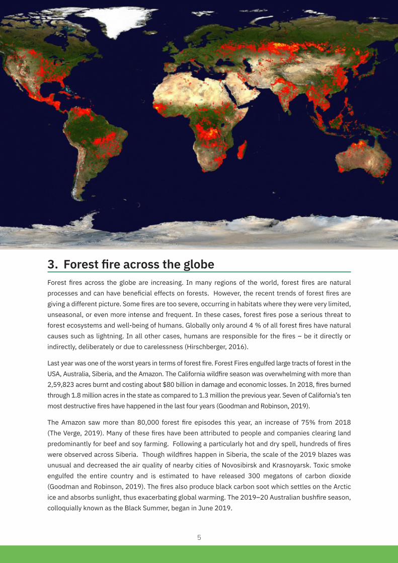
3. ForestfireacrosstheglobeForest fires across the globe are increasing. In many regions of the world, forest fires are natural processes and can have beneficial effects on forests. However, the recent trends of forest fires are giving a different picture. Some fires are too severe, occurring in habitats where they were very limited, unseasonal, or even more intense and frequent. In these cases, forest fires pose a serious threat to forest ecosystems and well-being of humans. Globally only around 4 % of all forest fires have natural causes such as lightning. In all other cases, humans are responsible for the fires – be it directly or indirectly, deliberately or due to carelessness (Hirschberger, 2016).
Last year was one of the worst years in terms of forest fire. Forest Fires engulfed large tracts of forest in the USA, Australia, Siberia, and the Amazon. The California wildfire season was overwhelming with more than 2,59,823 acres burnt and costing about $80 billion in damage and economic losses. In 2018, fires burned through 1.8 million acres in the state as compared to 1.3 million the previous year. Seven of California’s ten most destructive fires have happened in the last four years (Goodman and Robinson, 2019).
The Amazon saw more than 80,000 forest fire episodes this year, an increase of 75% from 2018 (The Verge, 2019). Many of these fires have been attributed to people and companies clearing land predominantly for beef and soy farming. Following a particularly hot and dry spell, hundreds of fires were observed across Siberia. Though wildfires happen in Siberia, the scale of the 2019 blazes was unusual and decreased the air quality of nearby cities of Novosibirsk and Krasnoyarsk. Toxic smoke engulfed the entire country and is estimated to have released 300 megatons of carbon dioxide (Goodman and Robinson, 2019). The fires also produce black carbon soot which settles on the Arctic ice and absorbs sunlight, thus exacerbating global warming. The 2019–20 Australian bushfire season, colloquially known as the Black Summer, began in June 2019.

6
The fires burnt an estimated 18.6 million hectares destroyed over 5,900 buildings (including 2,779 homes) and killed at least 34 people. An estimated one billion animals have been killed and some endangered species may be driven to extinction. At its peak, air quality dropped to hazardous levels.
Community-based forest fire and traditional practices:
Forest fire is a growing threat to communities around the world. Traditionally, reducing forest fire risk was co-managed by the administration and local communities. But over time the local communities have been sidelined to pave way for forest departments/ fire departments to manage the forest fire. However, community-driven forest fire management can reduce the deaths of residents. The loss of property and damages to infrastructure can be hugely reduced, thus saving millions of taxpayers’ money.
Over time, discontinuation of some traditional forest management systems has led to a knowledge gap, as elders are no longer passing down their experiences to the younger generation. The community cohesion and ‘attachment’ to local resources are also important for controlled fire use. A few communities have successfully taken over forest fire management from sponsored/ government projects. However, the allocation of resources for forest fire management needs careful planning to ensure that poor communities are not overburdened by such arrangements, support the community’s needs and in the future should provide benefits. Tenure security is another incentive for community fire prevention and control. The absence of tenure conflict also bolsters a community’s interest in fire management. The community’s control over its resources can ensure that its interests and concerns are addressed and protected too. This in turn provides an opportunity for the economic well-being of forest-dependent communities.
In recent decades, especially in developed countries, preferences for second homes, suburban lifestyles, and the desire to live closer to nature have pushed populations into the “Wildland-Urban Interface” (WUI) — areas with more vegetation, parks, and forests than their city center and older suburb counterparts. These establishments built on not-local material, with high energy requirements; consumer goods, and not fire resilient design often face severe consequences of the forest fire.
7
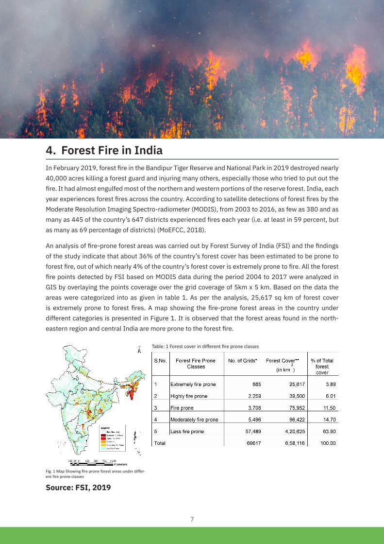
4. ForestFireinIndiaIn February 2019, forest fire in the Bandipur Tiger Reserve and National Park in 2019 destroyed nearly 40,000 acres killing a forest guard and injuring many others, especially those who tried to put out the fire. It had almost engulfed most of the northern and western portions of the reserve forest. India, each year experiences forest fires across the country. According to satellite detections of forest fires by the Moderate Resolution Imaging Spectro-radiometer (MODIS), from 2003 to 2016, as few as 380 and as many as 445 of the country’s 647 districts experienced fires each year (i.e. at least in 59 percent, but as many as 69 percentage of districts) (MoEFCC, 2018).
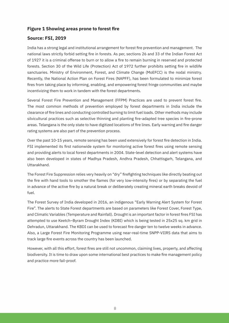
An analysis of fire-prone forest areas was carried out by Forest Survey of India (FSI) and the findings of the study indicate that about 36% of the country’s forest cover has been estimated to be prone to forest fire, out of which nearly 4% of the country’s forest cover is extremely prone to fire. All the forest fire points detected by FSI based on MODIS data during the period 2004 to 2017 were analyzed in GIS by overlaying the points coverage over the grid coverage of 5km x 5 km. Based on the data the areas were categorized into as given in table 1. As per the analysis, 25,617 sq km of forest cover is extremely prone to forest fires. A map showing the fire-prone forest areas in the country under different categories is presented in Figure 1. It is observed that the forest areas found in the north-eastern region and central India are more prone to the forest fire.
Fig. 1 Map Showing fire prone forest areas under differ-ent fire prone classes
Table: 1 Forest cover in different fire prone classes
Source: FSI, 2019
8
Figure 1 Showing areas prone to forest fire
Source: FSI, 2019
India has a strong legal and institutional arrangement for forest fire prevention and management. The national laws strictly forbid setting fire in forests. As per, sections 26 and 33 of the Indian Forest Act of 1927 it is a criminal offense to burn or to allow a fire to remain burning in reserved and protected forests. Section 30 of the Wild Life (Protection) Act of 1972 further prohibits setting fire in wildlife sanctuaries. Ministry of Environment, Forest, and Climate Change (MoEFCC) is the nodal ministry. Recently, the National Action Plan on Forest Fires (NAPFF), has been formulated to minimize forest fires from taking place by informing, enabling, and empowering forest fringe communities and maybe incentivizing them to work in tandem with the forest departments.
Several Forest Fire Prevention and Management (FFPM) Practices are used to prevent forest fire. The most common methods of prevention employed by forest departments in India include the clearance of fire lines and conducting controlled burning to limit fuel loads. Other methods may include silvicultural practices such as selective thinning and planting fire-adapted tree species in fire-prone areas. Telangana is the only state to have digitized locations of fire lines. Early warning and fire danger rating systems are also part of the prevention process.
Over the past 10-15 years, remote sensing has been used extensively for forest fire detection in India. FSI implemented its first nationwide system for monitoring active forest fires using remote sensing and providing alerts to local forest departments in 2004. State-level detection and alert systems have also been developed in states of Madhya Pradesh, Andhra Pradesh, Chhattisgarh, Telangana, and Uttarakhand.
The Forest Fire Suppression relies very heavily on “dry” firefighting techniques like directly beating out the fire with hand tools to smother the flames (for very low-intensity fires) or by separating the fuel in advance of the active fire by a natural break or deliberately creating mineral earth breaks devoid of fuel.
The Forest Survey of India developed in 2016, an indigenous “Early Warning Alert System for Forest Fire”. The alerts to State Forest departments are based on parameters like Forest Cover, Forest Type, and Climatic Variables (Temperature and Rainfall). Drought is an important factor in forest fires FSI has attempted to use Keetch–Byram Drought Index (KDBI) which is being tested in 25x25 sq. km grid in Dehradun, Uttarakhand. The KBDI can be used to forecast fire danger ten to twelve weeks in advance. Also, a Large Forest Fire Monitoring Programme using near-real-time SNPP-VIIRS data that aims to track large fire events across the country has been launched.
However, with all this effort, forest fires are still not uncommon, claiming lives, property, and affecting biodiversity. It is time to draw upon some international best practices to make fire management policy and practice more fail-proof.

9
5. Global Best Practices This report is a desktop review of best practices in forest fire management across the globe. This report identifies and documents various best forest fire management practices in the world along with traditional community-based practices wherever possible. The methodology involves the desktop review of research articles and grey material like government reports, news articles, etc. available in open source.
5.1. Australia
5.1.1. Mitigation
Management of electricity distribution: The Black Saturday fires in 2009 killed 173 people and caused an estimated AUD $4 billion (USD $2.75 billion) in damage. These fires were started by power lines. Victoria’s government set or strengthened several mandates for utilities, along with a deadline for meeting them.
The risk-reduction actions were a mix of the mundane and the high-tech actions. The mundane starts with stepped-up inspections of utility equipment and tree trimming. There has also been some ‘hardening’ of the system, including burying about three percent of Victoria’s 90,000-kilometers of rural power lines. Given that underground cabling is expensive reducing fire risk on most of Victoria’s circuits is about making overhead lines safer like bare conductors have been replaced with insulated wires.

10
Also, Victoria mandated the upgrading of automatic circuit reclosers. Reclosers are circuit breakers that can quickly stop power flows during a fault and then just as quickly restore it. They use repeated high-energy blasts to determine whether a fault is temporary or permanent. During hot and windy periods, that current can start a fire. Victoria utilities have replaced about 2,000 reclosers with ‘smart’ reclosers that can be remotely controlled. In high-risk periods, the reclosers are set to operate at higher sensitivity and will not attempt to restore power—increasing outages but eliminating hundreds of potential fire sources (Fairley, 2019).
Bushfire Safety System: The government adopted a systems approach to reducing bushfire risk. The program comprised 42 projects allocated across six emergency services agencies and government departments. They aligned to four themes: community education and engagement; warnings to the community; land and vegetation management and bushfire operations. The Victorian Fire Risk Register - Bushfire (VFRR-B) was developed under this program to assist stakeholders to view and assess the risk of bushfires to assets across Victoria. This app is being utilized in 66 of the 79 Victorian municipalities, 5 Alpine Resorts and French Island provide information for Municipal Fire Management Plans and decision making Bush Fire Household Assessment Tool has been developed to prepare your home and property withstand a fire.
5.1.2.Preparedness
A large number of Aircraft specialized/ dedicated for forest firefighting: During the fire of 2019-2020 specialized/ dedicated air carriers were deployed for firefighting. As per NSW Rural Fire Service, 100 aircraft were in the skies every day while Victoria Country Fire Authority says it has more than 60 to address raging wildfires. This air fleets include helicopters, fixed-wing aircraft and large air-tankers, most of which can be used to “firebomb” water onto fires or drop retardant from the sky. According to the National Aerial Firefighting Centre Overall, more than 500 aircraft are available for firefighting across Australia which has its fleet of about 130 aircraft ready to help boost a state’s response when required (BBC, 2020)
Volunteer-based firefighting: Australia is still retaining volunteer-based firefighting systems across Victoria, South Australia, and Western Australia which has traditionally had bushfires each summer. In NSW, most of the 2,000 or so brigades are found in country towns and rural centers dotted among eucalyptus bushland. Members are almost always locals, stepping in to save their communities. Also a central firefighting agency covering far away distance is not possible which requires immediate action.
Fires Near Me App: Official app presents information on bushfires from the fire agencies in the Australian states and territories and New Zealand. Provides information on current incidents and total fire bans. It is Developed by the NSW Rural Fire Service.
Awareness: A range of information brochures are made available to the general public which covers issues such as what measures people (particularly those living in bushfire prevalent areas) can take to minimize the spread of a bushfire and the protection of their property and lives before and during a bushfire. There are even information brochures available on how to select the least vulnerable home site (and suggested layout) for people who are intending to move into bushland areas. For example, the New South Wales Department of Bushfire Services brochure ‘Everyone’s Guide to Rural Homesite Selection and Layout’.

11
Awareness creation through games for children: Triple Zero Kids’ Challenge will teach kids about safety messages and hear what happens when you call Triple Zero. Along the way, they will meet the “Zeros” as they are guided step by step through the game.
Community-Based Management of fuel load on public and private lands: The Joint Fuel Management Program is the state-wide program of works to manage fuel on public and private land is worked out with community participation. It is a significant step in implementing the Safer Together program (community-based approach launched in 2015), working towards an integrated and risk-focused bushfire management. It demonstrates the Country Fire Authority (CFA) and Forest Fire Management Victoria’s (FFMVic) commitment to working as one sector, planning and delivering fuel management activities across public and private land. The same was renewed in October 2019. They include planned burning, slashing, mowing and clearing works, creating and maintaining fuel breaks and carrying out maintenance on fire infrastructure (like fire dams and lookout towers) by involving the local community.
5.1.3. Response
Early warning and risk communication: Australia’s early warning messages on bushfire indicate where a fire is moving and which communities are in its path, more similar to a cyclone path. The warnings also include detailed instructions for evacuation and survival. The country’s Fire Danger Rating, is based on how difficult fires will be to control, based on wind speed, humidity, temperature and vegetation dryness. The evacuation orders are issued by local law enforcement, such as a county sheriff’s office, and different counties use different platforms to disseminate wildfire information which includes social media, local sirens and wireless alerts.
Clear cut do’s and don’ts are issued by the Australian government on actions to be taken before a bushfire, during a bushfire and after a bushfire. The information on fire emergency services is also provided. There is a clear advisory on what to be done for pets.
Total Fire Ban: In Australia, the Fire Danger Ratings are forecast for four days and a Total Fire Ban is declared by CFA on days when fires are likely to spread rapidly and could be difficult to control. Fire Danger Ratings are updated twice daily at 5.30 am and 4 pm. Total Fire Bans are normally declared by 5 pm on the day before a ban.
5.1.4.Recovery
Remuneration for volunteer firefighters: A sum of AUD $6,000/ USD $4,200 USD to each volunteer firefighter who worked for a small or medium business, including small business owners to cover the economic loss during the bushfire season.
Private sector companies like Suncorp have announced a decision to pay unlimited emergency response leave for employees involved in the rescue efforts for their time.
Wildlife Recovery: The government has not only pledged AUD $50 million/ USD $33.5 million fund to help animal recovery but also have been air dropping carrots and sweet potatoes to help feed wildlife.
The National Bushfire Recovery Agency (NBRA) has included mental health support in its recovery program.

12
Drone seeding for the regeneration of native trees: In a collective effort to restore Australia from wildfire devastation, XAG has joined the first-ever post-fire drone seeding operation on Lake Cobrico, Victoria. This project was funded by the Department of Environment, Land, Water, and Planning (DELWP) and managed by Heytesbury District Landcare Network (HDLN). It is the first time that agricultural drones are used to re-establish native vegetation within a fire-ravaged peat swamp in Australia.
This April, XAG sent 3 sets of its P Series drones, equipped with JetSeed granule spreading system, to distribute native seeds directly on Lake Cobrico. Within only two days, approximately 40 hectares of burned land was replenished with new plants, using a blend of 12 different seeds. In the next six months, XAG and HDLN will closely monitor the result of drone seeding, which will be compared with that of the other area where plants are going to be naturally regrown. It is expected that the project would be replicated across the region and state, especially within the areas where traditional techniques are inapplicable.
5.2.UnitedStatesofAmerica
5.2.1.Mitigation
Program to improve adaptation to fire by the community: Firewise USA is a national recognition program that provides instructional resources to inform people how to adapt to living with wildfire and encourages neighbours to work together and take action to reduce their wildfire risk. The program provides technical assistance and education to interested landowners, homeowners, and communities to help them take action and ownership in preparing their homes against the threat of wildfire. The city’s outreach included a “Sharing the Responsibility” campaign to involve residents in mitigation activities. On Similar lines, the Austin-Travis County Community Wildfire Protection Plan is focused on collaboration and coordination among individuals to make communities wildfire ready.
Zoning, Building Codes, and Landscape Management: The number of houses in the Wildland-Urban Interface(WUI), or areas where structures or human development intermingle with undeveloped wildland is increasing each day. WUI Code and community wildfire protection plans encourage land conservation in the WUI and dense development in areas with less risk. Zoning and building code policies can also space homes to create barriers to stop a wildfire from spreading and encourage the use of fire-resistant building materials. Some of the examples include:
• The Flagstaff, Arizona, adopted a modification of the International Wildland-Urban Interface Code in 2008. The fire department began working with community development staff to require hazard mitigation for wildfires on all properties before development.
• A Caughlin Ranch, Nevada, Homeowners Association (HOA) enacted several changes including banning bark mulch, increasing the grounds crews’ activities to reduce hazardous fuel between parcels, and hosting community fire safety meetings in partnership with an agricultural extension. They also changed the HOA’s rules to make it easier to replace flammable vegetation with fire-resistant plants.
• Colorado Springs, Colorado, passed a roof ordinance that banned wood shake roofs and required roofing materials and assembly to keep the fire from penetrating the roof and igniting the structure below. From 2002 to 2016, more than 69,000 roofs were replaced or upgraded to fire-resistant roofing. The city also has a map of wildfire risk ratings, offers property owners free on-site consultations.

13
Vegetation Management and Forest Restoration: Managing the vegetation in the forest has been found effective in managing forest fire. A study in Washington state found that in areas treated with both thinning and prescribed burns, more than 57 percent of trees survived wildfires while only 19 percent of trees survived in areas treated with thinning alone. In the untreated areas, only 14 percent of trees survived the wildfire. One example is Los Alamos, New Mexico, worked with Los Alamos County and the U.S. Forest Service to thin forestland around the city. A 2011 fire though severe, due to fuel reduction efforts, no homes in Los Alamos were lost while 63 homes in other communities were destroyed (Kristiane et al. 2018).
Socio-Ecological Approach to Mitigating Wildfire: The Thomas Fire in December 2017 claimed two lives, burned 2,81,893 acres, and destroyed more than 1,000 structures before it was contained on Jan. 12, 2018. The Montecito Fire Protection District (MFPD), a small coastal community in California, saw the loss of only seven structures, a remarkably low number given the extreme fire behavior it experienced. The low fire loss was due to the successful mitigation strategies the Montecito community pursued for over two decades beginning in 1994. The effort was community-driven with a detailed Community Wildfire Protection Plan (CWPP) which determined what areas would be most prone to ember-cast and where additional fuel reduction efforts were needed. The firefighters were aided by defensive landscaping and code changes that made homes fire resistant. The CWPP and fire zone mapping gave firefighters a clearer picture of the critical areas (Kolden and Henson, 2019).
Prioritizing fire mitigation projects and making it inclusive: The CAL FIRE program in California has identified more than 30 strategically-defined local projects that can be addressed urgently in partnership with communities to make a difference in this wildfire season. Examples include removal of hazardous dead trees, vegetation clearing, creation of fuel breaks and community defensible spaces, and creation of ingress and egress corridors. Cal Fire also identified 200 communities that have a greater need for help because of a variety of socioeconomic factors, including having families in poverty, people with disabilities, people under age 5 and over age 65, people who have difficulty speaking English and households without a car.
Defensible Space: The concept of having “defensible space” against wildfires around homes in or near forests, scrubland, or open prairie can restrict the damage to houses and buildings. A densely- filled community in Silverthorne filled with condos and single-family homes had cut down trees and vegetation next to their houses creating defensible space. The fire reached 250 feet from homes but did not affect the structures.
5.2.2.Preparedness
Building awareness through community collaboration: The Firewise is a program that empowers communities to collaborate in reducing wildfire risks. At present, there are more than 1,500 recognized Firewise USA sites in 42 states actively engaging residents in preparing and protecting their homes against the threat of wildfire.
Community-level training on home ignition zone: Assessing Structure Ignition Potential from Wildfire – This is a two-day classroom training to effectively evaluate and communicate parcel level wildfire risks by using home ignition zone concepts to identify and address vulnerabilities that provide effective wildfire mitigation recommendations.

14
Professional certification: Certified Wildfire Mitigation Specialist program (CWMS) - The CWMS credential offers professionals whose work involves wildfire hazard mitigation, the ability to demonstrate that they understand hazard mitigation measures, planning and preparedness strategies, public education practices, and wildland fire science.
Wildfire Community Preparedness Day - Celebrated the first Saturday in May each year, is used to raise wildfire awareness, promote collaboration and bring neighbors together to work on projects that can help protect homes, neighbourhoods and entire communities from future wildfire risk or current post-fire impacts
Awareness program for teens: TakeAction - Teens for Wildfire Safe Communities – This program empowers youth living in communities with wildfire risks to take action through NFPA’s free tools and resources designed to get them involved in risk reduction projects and activities with their family and friends.
Mock exercise in medical emergency preparedness: The Public Health Emergency Preparedness and Hospital Preparedness Program (HPP) previous mock exercises helped in safely evacuating more than 1,160 patients from these hospitals and many other healthcare facilities, including more than 200 patients with developmental disabilities.
5.2.3. Response
Smokejumpers are specially trained wildland firefighters who provide an initial attack response on remote wildland fires. They are inserted at the site of the fire by parachute. In addition to performing the initial attack on wildfires, they may also provide leadership for extended attacks on wildland fires. The smokejumpers touch ground, they are supplied by parachute with food, water, and firefighting tools, making them self-sufficient for 48 hours.
Bi-Lingual Communications: The California Governor’s Office of Emergency Services (Cal OES) is committed to bi-lingual communications for many of its multimedia products and methods. This includes Spanish translations for videos produced about disaster assistance, resource website WildfireRecovery.org, social media posts, and video distribution assistance by the Sacramento Consulate to its constituency on Facebook and Twitter.
Addressing Pollution/ Smoke health issues: The California Department of Public Health (CDPH) provided over 10,00,000 N95 masks throughout the state for the wildfires. CDPH also had two teams from their immunizations branch to the shelters to help train and install protocol on limiting the spread of diseases to help provide flu shots for staff.
Air Quality Monitoring: The California Air Resources Board (CARB) deployed multiple portable air monitors and air quality sensors to the town of Palermo, the community of Chico-Tuscan Ridge, City of Santa Rosa, South Sacramento and Natomas.
Interagency coordination: To manage hazardous waste, FEMA partnered with EPA to support the California wildfire response. The EPA will help collect household hazardous waste in the impacted counties.
5.2.4.Recovery
Debris Management: CalRecycle is an agency involved in organizing, managing, implementing, and overseeing debris removal operations in support of local governments. CalRecycle oversees and manages contractors to conduct debris removal at no out-of-pocket cost to private property owners.
15
5.3.Brazil/Amazon
5.3.1.Mitigation
Integrated Fire Management (IFM): In 2014, the first Integrated Fire Management (IFM) program was launched in three Protected Areas (PAs). The IFM program considers local practices, ecological information, management options and aims to create landscape mosaics of different fire histories to conserve biodiversity, reduce the prevalence of Late-Dry Season (LDS) wildfires, protect fire-sensitive vegetation and reduce conflicts between PA managers and local communities. The first 3 years of imposed fire management regimes led to a 40–57% reduction in LDS fires, improved dialogue between researchers, managers, and local communities, generating fire management learning communities.
Addressing fire in Agriculture: Providing support to small-scale farmers’ communities (agrarian settlements, protected areas, indigenous communities, etc.) including instruction and training on fire control practices, fire-free farming, and fighting of accidental fires.
Licensing and Monitoring of Agricultural Fires: Currently, the responsibility is with state and municipal environmental authorities. It is only in federal lands (protected areas, INCRA settlements, and indigenous lands of Funai), that Ibama and ICMBio license and monitor.
Transboundary cooperation and disaster response network: Amazon forest is spread across several countries. Seven South American countries have agreed on measures to protect the Amazon river basin, amid global concern over massive fires in the world’s largest tropical forest. Bolivia, Brazil, Colombia, Ecuador, Guyana, Peru, and Suriname signed a pact, setting up a disaster response network and satellite monitoring. At a summit in Colombia, they also agreed to work on reforestation.
Voluntary Commitment Schemes and Conservation Units: Arresting deforestation has a positive impact on forest fires. The credit of Brazil’s success in controlling deforestation is its policy of creating conservation units and recognizing indigenous lands. The total deforested areas amount to 18% of Amazonia as a whole, but only 2% of the indigenous lands. The ‘soya moratorium’ is a voluntary initiative, a pact signed by the Brazilian vegetable oils industry association ABIOVE and the Brazilian grain exporters’ association ANEC in 2006. The ‘cattle agreement’ of 2009 is another moratorium that has had a significant impact on deforestation reduction.
5.4.Canada
5.4.1. Mitigation
An attitudinal shift - From fire suppression to fire management: Fire management not only emphasizes on fire suppression but also a range of activities, such as identification of high-priority areas. High-priority areas include residential areas, high-value commercial forests, and recreational sites. In these high-priority areas, fire mitigation is given priority like reducing fuel load, trimming of trees, maintaining fire-lines, etc.
Fire manager’s toolkits - The existing scientific information and knowledge about forest fire have been converted into a range of tools for assessing fire danger, predicting fires, and initiating

16
an optimum response. Some of these tools developed by Canada are Canadian Wildland Fire Information System (CWFIS), Canadian Forest Fire Danger Rating System (CFFDRS), Wildfire Threat Rating System (WTRS), Canadian Fire Effects Model (CanFIRE), etc. Using these tools, private individuals and research organizations are being encouraged to participate in various stages of fire management.
5.4.2.Preparedness
Use of building regulations - Fire Codes – Canada has introduced a fire code along with Building Code 2005. The Fire Code is designed to ensure that buildings are structurally sound, safe from fire, free of health hazards, and accessible. This fire code ensures an adequate level of fire safety for both occupants and emergency responders, inside and outside of buildings and facilities. The building permit system was strengthened and adherence to fire code was made mandatory.
Insurance premiums to cover forest fire – Canada has included forest fires as one of the perils to be insured. Private insurers developed premiums that reflect the true level of risk for the insured property. Because of the inclusion of forest fire, the premium rates were increased.
Resource sharing for reporting - Canada uses a lot of formal and informal networks to gather and share data on a forest fire. Formal channels like Fire weather forecasts have been issued by the Meteorological Service of Canada since the early 1900s. National Lightning Location System has been developed to monitor lightning strikes. Informal networks like members of the public, commercial air flights, forest industrial operators, lookouts, and directed air and surface patrol are involved to detect forest fires.
5.4.3. Response
International cooperation for fighting forest fire - Canada also made cooperative agreements with the USA for resource sharing, incident reporting, and mitigating fire risk.
Suppression zonation - Suppression zones are demarcated based on usage like recreation parks, animal sanctuaries, etc. Fires in the managed forest and other high-value areas are suppressed more vigorously than fires in other areas
Canadian Incident Command System – is used not only for fire events but for a wide range of emergencies. Among them are National Air Tanker Fleet - water bombers and land-based air tankers carrying fire retardant, Private Suppliers of Fire Suppression Equipment, and Services.
5.4.4.Recovery
The federal government assists provinces for expenditures incurred in responding to and recovering from large-scale natural disasters, including wildfires. Assistance is provided through Disaster Financial Assistance Arrangements (DFAAs) administered by Public Safety and Emergency Preparedness Canada. Fire recovery activities include Wildland Rehabilitation and Recovery, Disaster Financial Assistance, and feedback to the Private Insurance Industry.
The management of the fire to achieve ecological objectives is of increasing importance in protected areas. Earlier, national park policy recognized the natural role of fire in many ecosystems and allowed for limited suppression of wildfires (so-called “let burn” practices) and prescribed

17
fire where such approaches were compatible with resource management objectives. The Carbon Budget of Canada’s Forests is another practice to limit the fuel load in the forest areas.
Institutional practices to manage fire - Following types of federalism in Canadian fire management may be replicated for the Indian context. There are four types of federalism – where the federal government’s involvement is defined. Disentangled federalism, Federal and provincial governments work independently with little interaction. Interprovincial collaboration, Provinces work collaboratively, with limited federal involvement, to attain policy goals. Federal unilateralism, Federal government directs provincial policy, usually through conditional funding. Collaborative federalism, Federal and provincial governments work collaboratively to attain policy goals.
5.5.TheUnitedKingdom
5.5.1.Preparedness
Continuous Analytical Risk Assessment - Risk assessment is a dynamic process. With a changing situation, the exposure and vulnerability keep changing thereby resulting in a new risk. So the UK fire and rescue services keep developing new risk scenarios using state of the art technology. These risk scenarios provide understanding and awareness of wildfire behavior and development among Fire and Rescue Service and external agency personnel.
Benefits for fire fighters – Suitable, sufficient and safe system of work to protect firefighters, and external partner agency personnel, deployed to wildfire incidents is provided. Once the fire fighters are assured of their safety and well-being, they will be able to perform their duty better. Forest Resource and Services (FRS) personnel are provided with guidance on standardized safe systems of work.
Briefing and debriefing - Suitable and sufficient briefing and debriefing of wildfire teams for the safety of fire service operations. Suitable and resilient means of communications established and maintained at all times for the fire personnel. Wildfire suppression response teams are made competent to undertake their role.
5.5.2.Mitigation
Cooperation from various walks of life - LACES – Lookouts; Awareness; Communications; Escape Routes; Safety Zones is a protocol used to report the incident reporting. Good communications are maintained between the Incident/Sector Commander, wildfire team leader(s), the safety officer(s), Tactical Lookout, and Command Support.
Multi-scale Fire Plans – Fire plans are developed at Local, Regional, and National level to aid support arrangements and resilient safe systems of work. These plans enable in deploying indirect, as well as direct, wildfire suppression tactics.
5.5.3.Responseandrelief
Wildfire Prediction System (WPS) to ensure that the correct personnel and resources are deployed for the type and scale of the fire. During peace times, these FRS provide support for environmental protection awareness and enhance operational interoperability at local, regional, and national resilience.
18
Analytical Risk Assessment (ARA) - A robust and resilient decision-making log and analytical risk assessment (ARA) is maintained throughout the incident. All Fire and Rescue Services personnel adopt similar terminology which will improve communication and safety at a wildfire event, avoid confusion and ambiguity and enhance interoperability and resilience.
5.5.4.Recovery
Wildfire Command and Control supervision, Incident Command System (ICS) - principles and practices are applied in the context of a dynamic, geo-spatial incident. WCCS and ICS are enabled based on the type and size of the wildfire and the surroundings.

19
6.Community-basedforestfireandtraditionalpractices6.1.Brazil
Amazon forest lies majorly in Brazil and consists of multiple ecosystems like rainforest, savannahs, and wetlands. Brazil is home to numerous indigenous communities that ignite vegetation to promote resource availability, diversity, and resilience. Their burning traditions are important for sustenance, territorial management, and cultural expression.
Key to traditional fire management is the burning of small areas at different times over the whole dry season, thus producing a mosaic of burnt and unburnt patches across the landscape. This reduces fuel loads, introduces natural firebreaks, and limits the potential for catastrophic fires.
Integrated Fire Management (IFM) strategies: The Brazilian-German Cooperation Project “Prevention, Control and Monitoring of Bushfires in the Cerrado” have been developing Integrated Fire Management (IFM) strategies to achieve land use objectives, reduce greenhouse gas (GHG) emissions from burning, protect biodiversity and enhance community livelihoods in the Brazilian Cerrado. The model is based on Australian models for forest fire management. Its main goals include developing:

20
• ControlledFireManagement - the strategic implementation of controlled burning in the early dry season to reduce fire intensity, reduce the area burnt annually, and minimize uncontrolled large-scale fires.
• Community-BasedFireManagement (CBFiM) - a collaborative IFM approach to promote and develop fire management capacity and responsibility amongst communities to improve land use objectives and community livelihoods.
As a CBFiM initiative, the IFM Program increased the incorporation of residents and neighbouring community members into the fire brigades of the pilot areas in 2015. This facilitated integration of local knowledge including landscape and weather, as well as, resident community land use, traditional fire management, and livelihood challenges. Some of the Indigenous ethnic groups that have participated in Indigenous fire brigades with PrevFogo are the Gavião Parkatejê, Karajá, Krahô, Macuxi, Mebêngôkre (Kayapó), and Xerente.
PROARCO The Roraima fires in the Amazon are vulnerable to fires in drought years especially more acute in the “Arc of Deforestation” in the southern Amazon where timber harvest, agriculture, and other land management practices have greatly increased the flammability of vegetation. The government of Brazil took a loan from The World Bank in support of a project called PROARCO, a program for the prevention and control of burning and forest fires in the Deforestation Arc in 1998.
PROARCO also sponsored the creation, training, and equipping of some 45 municipal fire brigades. In nine municipalities in Mato Grosso, local fire brigades worked to prevent burning, put out small fires, and supervised controlled burning when permitted. The State of Tocantins spontaneously formed 27 fire brigades with its resources in addition to three brigades supported by PROARCO. The States of Rondonia and Acre also formed brigades. Fire brigades received training from the State Military Fire Companies in Amazonas, Rondonia, Acre, Mato Grosso, and the Tocantins. These local brigades helped suppress small fires that could have burned out of control into other properties or forested land.
The number of forest fires in privately owned lands of indigenous communities is relatively less.
6.2.Guatemala
Ancestral land Rights: In Guatemala, indigenous communities have been given forest concessions that give them the legal right to manage their ancestral forest lands. Analysis of satellite images of the Maya Biosphere Reserve reveals villagers with these rights to their territories to keep fires out of the areas where they are allowed to manage the forest. The national parks and other surrounding areas may get devastated by fire. A new study by the Prisma Foundation adds to growing evidence that proves that providing local communities and indigenous peoples with rights to their territories is the best way to protect tropical forests that are critical to combating climate change.
6.3.UnitedKingdom
Community-based solutions first appeared at local, regional, and then national levels during the 1990s, long before formal awareness and government policy began to deal with the issue.
21
These local wildfire groups and later regional and national forums evolved in response to crisis events. A patchwork of local solutions developed in Scotland, across England and in Wales from this bottom-up process. Knowledge of wildfire management has grown within these informal networks and diffused upwards from local and regional to national.
Local and regional fire groups: Local stakeholders have taken ownership of the wildfire problem, forming wildfire groups in collaboration with local FRS and working across conventional institutional boundaries. The Peak District Fire Operations Group was founded in 1997. It exemplifies innovation distributed across an informal network, with the Peak District National Park Authority acting as initiator and knowledge broker. Members include the six FRS within the Park, local water companies, amenity groups, and landowners. It became a model for other local wildfire groups, as has its Scottish equivalent, the South Grampians wildfire group.
Knowledge of the management of wildfires has been co-produced by these self-assembling local groups. Examples include local fire plans with inventories of fire fighting equipment, emergency contacts, vehicle rendezvous and access points, and sources of water for fire fighting. Neighbouring FRS collaborate, adopting the same size hoses and couplings to overcome problems of interoperability. This knowledge-making has been spontaneous and stakeholder-led.
These groups have developed new ways of working—a process of resourceful improvisation known as ‘bricolage,’ pulling in new stakeholders where appropriate. For example, the Peak District Fire Operations Group wildfire suppression training program included novel topics such as working with helicopters, thereby co-opting pilots as new stakeholders into the wildfire management process. The Peak District Fire Operations Group was copied elsewhere, for example, in South East England, Northumberland and Cumbria.
National Forums are cross-sector, multiagency groups of public, private, and third-sector stakeholders established to address wildfire issues but they are non-statutory. In part, they are a response to the spatially uneven coverage of local fire groups and national fragmentation of responsibility. Their roles include coordination, lobbying for change, serving as centers for knowledge exchange, and a point of consultation for government bodies.
University-based knowledge exchange projects have also helped build a cross-disciplinary and cross-sector national wildfire community. Initiatives have included: FireBeaters (2006–2008), the Fire Interdisciplinary Research on Ecosystem Services (FIRES) 2007–2009 seminars and resulting influential policy brief whose recommendations directly influenced the Chief Fire Officers Association Wildfire Group’s action plan; collaborative heather burns with Northumberland FRS and five universities, etc. In the process, wildfire was recognized as a semi-natural hazard (the vast majority are started by humans), with unique impacts facing civil society and one exacerbated by climate change
Local Resilience Forums and Community Risk Registers: The Civil Contingencies Act, in England also required Local Resilience Forums to undertake contingency planning. Local Resilience Forums are multi-agency, consisting of Category 1 responders in a Police Area (emergency services, including Fire Authorities), Category 2 responders including Local Authorities, the Health and Safety Executive, Environment Agency, as well as invited groups. Their duty is to ‘plan, assess and

22
advise’ on emergencies that threaten serious damage to human welfare (including property) and the environment (including plant life). The emphasis is on multi-agency collaboration.
Each Local Resilience Forum produces a public-facing Community Risk Register, which rates the relative likelihood, impact, and risk of locally relevant hazards and threats over the next five years, and makes contingency plans to control them. The five-year span is short relative to the recurrence interval of severe wildfire incidents.
6.4.Australia
Bushfire Safety System: The government adopted a systems approach to reducing bushfire risk. The program comprised 42 projects allocated across six emergency services agencies and government departments. They aligned to four themes: community education and engagement; warnings to the community; land and vegetation management and bushfire operations. The Victorian Fire Risk Register - Bushfire (VFRR-B) was developed under this program to assist stakeholders to view and assess the risk of bushfires to assets across Victoria. This app is being utilized in 66 of the 79 Victorian municipalities, 5 Alpine Resorts, and French Island provides information for Municipal Fire Management Plans and decision making.
Volunteer-based firefighting: Australia is still retaining volunteer-based firefighting systems across Victoria, South Australia, and Western Australia which has traditionally had bushfires each summer. In NSW, most of the 2,000 or so brigades are found in country towns and rural centers dotted among eucalyptus bushland. Members are almost always locals, stepping in to save their communities. Also, a central firefighting agency covering far away distance is not possible which requires immediate action.
FiresnearMeApp:Official app presents information on bushfires from the fire agencies in the Australian states and territories and New Zealand. Provides information on current incidents and total fire bans. It is Developed by the NSW Rural Fire Service.
AwarenessCreation:Awareness creation through games for children: Triple Zero Kids’ Challenge will teach kids about safety messages and hear what happens when you call Triple Zero. Along the way, they will meet the “Zeros” as they are guided step by step through the game.
Community-Based Management of fuel load on public and private lands: The Joint Fuel Management Program is the state-wide program of works to manage fuel on public and private land is worked out with community participation. It is a significant step in implementing the Safer Together program (community-based approach launched in 2015), working towards an integrated and risk-focused bushfire management. It demonstrates the Country Fire Authority (CFA) and Forest Fire Management Victoria’s (FFMVic) commitment to working as one sector, planning, and delivering fuel management activities across public and private land. The same was renewed in October 2019. They include planned burning, slashing, mowing and clearing works, creating and maintaining fuel breaks, and carrying out maintenance on fire infrastructure (like fire dams and lookout towers) by involving the local community.

23
TotalFireBan: In Australia, the Fire Danger Ratings are forecast for four days and a Total Fire Ban is declared by CFA on days when fires are likely to spread rapidly and could be difficult to control. Fire Danger Ratings are updated twice daily at 5.30 am and 4 pm. Total Fire Bans are normally declared by 5 pm on the day before a ban.
6.5.UnitedStatesAmerica
Programtoimproveadaptationtofirebythecommunity: Firewise USA is a national recognition program that provides instructional resources to inform people how to adapt to living with wildfire and encourages neighbours to work together and take action to reduce their wildfire risk. The program provides technical assistance and education to interested landowners, homeowners, and communities to help them take action and ownership in preparing their homes against the threat of wildfire. The city’s outreach included a “Sharing the Responsibility” campaign to involve residents in mitigation activities. On Similar lines, the Austin-Travis County Community Wildfire Protection Plan is focused collaboration and coordination among individuals to make communities wildfire ready.
Pre-fire risk reduction, on a variety of fronts, can help communities adapt to wildfire. Fire adaptation means communities take mitigation actions so they can live with wildfire without harm and extensive wildfire suppression efforts. The U.S. Forest Service develops, supports, and promotes community fire adaptation.
A key component of community fire adaptation is that there isn’t one silver bullet that reduces risk; there are many tools that, when used together and strategically, reduce risk. Some of the tools are Community Wildfire Protection Plan(CWPP) which identifies where wildfire risk exists, outlines ways to reduce or mitigate that risk, and helps do the risk reduction work on the ground. It’s not enough to have a CWPP, it must be regularly updated and implemented. Defensible space around structures means flammable fuels like leaf piles, unmown dry grass, lawnmowers and gas, lawn furniture, propane tanks, and wood piles, leaves and needles in the gutters and on the roof, and flammable trees too near the home are removed or stored in more appropriate places.
Zoning,BuildingCodes,andLandscapeManagement: The number of houses in the Wildland-Urban Interface(WUI), or areas where structures or human development intermingle with undeveloped wildland is increasing each day. WUI Code and CWPP encourages land conservation in the WUI and dense development in areas with less risk.
Socio-EcologicalApproachtoMitigatingWildfire:The Thomas Fire in December 2017 claimed two lives, burned 281,893 acres, and destroyed more than 1,000 structures before it was contained on Jan. 12, 2018. The Montecito Fire Protection District (MFPD), a small coastal community in California, saw the loss of only seven structures, a remarkably low number given the extreme fire behavior it experienced. The low fire loss was due to the successful mitigation strategies the Montecito community pursued for over two decades beginning in 1994. The effort was community-driven with a detailed CWPP which determined what areas would be most prone to ember-cast and where additional fuel reduction efforts were needed. The firefighters were aided by defensive landscaping and code changes that made homes fire resistant. The CWPP and fire zone mapping gave firefighters a clearer picture of the critical areas.

24
6.6.Indonesia
FireFreeVillageProgram: Established in July 2015, the Fire Free Village Program (FFVP) is a fire prevention project in Riau, Indonesia, founded in close collaboration with local communities and partnership with NGOs, the government, police, military and Riau’s Disaster Mitigation Agency, to address the underlying causes of fires through a process of socialisation, education and increased awareness of the negative impacts of burning.
No Burn Village Rewards: Incentivising villages to abandon traditional agricultural methods that employ fire as a land clearance and preparation tool, by awarding funding to community infrastructure projects for communities that do not burn on land areas within their control.
Community-basedhotspotmanagement: The number of hotspots that indicate forest and land fire in peatland in Indonesia, particularly in both Riau and West Kalimantan provinces. The Ministry of Forestry, Indonesia has run several programs to overcome this problem such as monitoring hotspots, campaigning for forest fire prevention, conducting coordination between government and local governments.
FireFreeAlliance: The Fire Free Alliance (FFA) is a voluntary multi-stakeholder group made up primarily of forestry and agriculture companies with NGOs and other concerned collaborators and partners. It comprises APRIL, Asian Agri, IOI, Musim Mas, Sime Darby, Wilmar, IDH, and PM Haze. FFA members commit to resolving Indonesia’s persistent fires and haze problems arising from the forest and land burning and actively collaborate to share information, knowledge, and resources as part of a collective effort to achieve lasting solutions.
Bali : The Villagers of Tenganan, Bali, Indonesia, follow customary law or ‘awig-awig desa’, which includes a provision for punishment for fire damages: “if one of the villagers burns bush or garbage that causes other trees to be burnt he will be fined as per the damage done and he should also perform a religious purification ceremony”
6.7.Vietnam
In Vietnam, the Payments for Forest Environmental Services (PFES) scheme was launched through two pilot projects, established in the Lam Dong and Son La provinces from 2008 to 2010. Building on lessons learned from these pilot projects, Decree No.99/2010/ND-CP was promulgated in 2010 (and amended in 2016) to institutionalize and expand the PFES program. In 2015, PFES covered 40 provinces, involving some 1,15,898 forest right holders and – because many large forest right holders lease forest out to households – more than 5,00,000 households and communities, with a total disbursement of some USD 263 million, raised largely by hydropower and drinking water companies as ecosystem service users. Though the program focuses on forest conservation, forest fire management is also embedded within the program.
6.8.Philippines
In the Dupinga watershed of Central Luzon, local communities have proactively established firebreaks, fire lines, and a systematic monitoring system to prevent fires escaping from grasslands. Here, swidden farmers burn Imperata grasslands to clear land for agriculture or to promote the sprouting of grass for roofing.

25
In Mount Kitanglad National Park in Mindanao, Philippines, Kitanglad, NGOs and Civil Society have come together with the Department of Environment and Natural Resources (DENR) to establish the Kitanglad Volunteer Guards, comprising volunteers from different ethnic communities in the area. Traditionally, these communities have special responsibilities for protecting their territories and resources. A council of tribe elders has to endorse their appointment. The DENR, which manages the national park, also organizes an oath-taking ceremony for the guards. The NGOs train the guards and also provides venues for meeting. The guards are mobilized to suppress forest fires and help the government in other conservation activities.
Another example in the Philippines for raising funds for forest fire management is the ‘No Fire Bonus’ scheme of the DENR and local or municipal authorities, which upland communities are entitled to if they maintain ‘no fire occurrence’ in their area.
Supporting alternative livelihood strategies of communities who live in or near the forest is a suitable incentive to suppress outbreaks of forest fires. For example, the introduction of agroforestry in Nueva Ecija, Philippines, encouraged the villagers to establish firebreaks.
Tenure security is another incentive for community fire prevention and control. Leasing forest land to the Compo Ikalahan villagers in Imuran, Nueva Vizcaya, Philippines, has reduced forest fire incidences. The leases are obliged to protect their forests against fires, and thus many have constructed fire lines.
6.9.Thailand
A community-based approach to forest fire management in Northern Thailand
The Royal Forest Department’s (RFD) Upper Nan Watershed Management Project in Northern Thailand is supported by the Danish Cooperation for Environment and Development (DANCED). The project covers 45 villages inhabited by 20,000 people from 5 ethnic groups within an area of 1,007 km2. The project aims to implement fire prevention and control systems on 160 km2 to reduce the incidence of forest fires by 50%.
Thailand has other examples of community forest fire management where external support, particularly from the government, has been important, such as in Dong Yai and Nam Sa where communities have been managing forest resources with the assistance of local forest officers and university staff. The villagers create firebreaks, remove leaf litter, and raise the alarm of fire outbreaks with loudspeakers. They douse fires with water from crude fire extinguishers, throw sand over the flames, as well as beat the fires with sticks and palm fronds. Similarly, in Nam Sa, with support from the RFD and the Chiang Mai University, local communities patrol the areas to prevent forest fires during the dry season
6.10.Guinea-Bissau
The rural inhabitants of Guinea-Bissau have been carrying out burning practices that are diversified according to cultural, socio-economic, demographic, and agro-ecological conditions. Many new bush-fire uses correspond to current best practices (e.g., use of firebreaks, backfiring, burning at cooler hours of the day), but under a scenario of changing climate and land uses there is room for

26
improving fire management to reduce negative environmental impacts while preserving cultural, economic and biodiversity benefits generated by some traditional burning practices.
All over the country, agricultural fire practices are mainly associated with shifting cultivation and mostly take place in May, just before the first rains (to avoid ash scattering by wind). The burning of shifting cultivation fields was traditionally carried out between 2 p.m. and 3 p.m. when winds tend to be strong and have a well-defined direction. No firebreaks were opened and the fire was set during the hottest time of the day and in the direction of the wind, to cover all areas of the field. This is important as incomplete combustion of the trunks will force farmers to leave part of a field uncultivated or to burn again. Additionally, in the freshwater swamp, the cultivation process begins with the burning of the grass (generally March–April), followed by the hoeing of the soil to pull up the deep roots, which are then dried, piled, and burned (April–May).
However, fire practices vary a great deal between different regions i.e. inhabited by the Fula and the Mandinga communities and the other communities in the country. In this region, the field is cleared of bushes and small trees in the first year of cultivation, leaving the large trees uncut. Then, this slashed biomass is piled around the trunks of the large trees, and bonfires are made in May, thereby killing the trees that will only be slashed and converted to ashes, together with the crop debris, in the following years. These agricultural fires were usually let to spread to the surrounding savannas and fallow fields to facilitate non-agricultural activities. The cropping cycle can reach ten years in this region — due to the production of cereals (sorghum, millet, fonio) tolerant to poor soils and the rotation with peanuts — and fallows could exceed twenty years. Freshwater swamp rice cultivation is mostly practiced by Fula and Mandinga women. After the rice harvest, they frequently grow vegetables and the burning of the cereal stubble occurs at the beginning of the dry season, rendering the late dry season burning unnecessary (which gets restricted to areas set aside for roof thatching material and pasture).
6.11.Canada
Canada uses a federal system for forest fire management. When a fire threatens a community or critical elements at risk, the local emergency management organization responds to manage the situation. If the incident cannot be managed by the local responders, the provincial emergency management organization is activated to help coordinate the forest fire emergency response and recovery. Public Safety Canada provides national coordination across federal agencies to implement the all-hazard approach for emergency management on federal lands and properties in Canada.
6.12.EuropeanUnion
EU acknowledged the urgency of combating the fires and providing help to local communities, but once the crisis is past, policymakers need to put forward science-informed policies to address the root causes of forest fires. The Mediterranean region shifted focus from reactive fire suppression to long-term proactive fire prevention and forest management at the landscape scale.
27
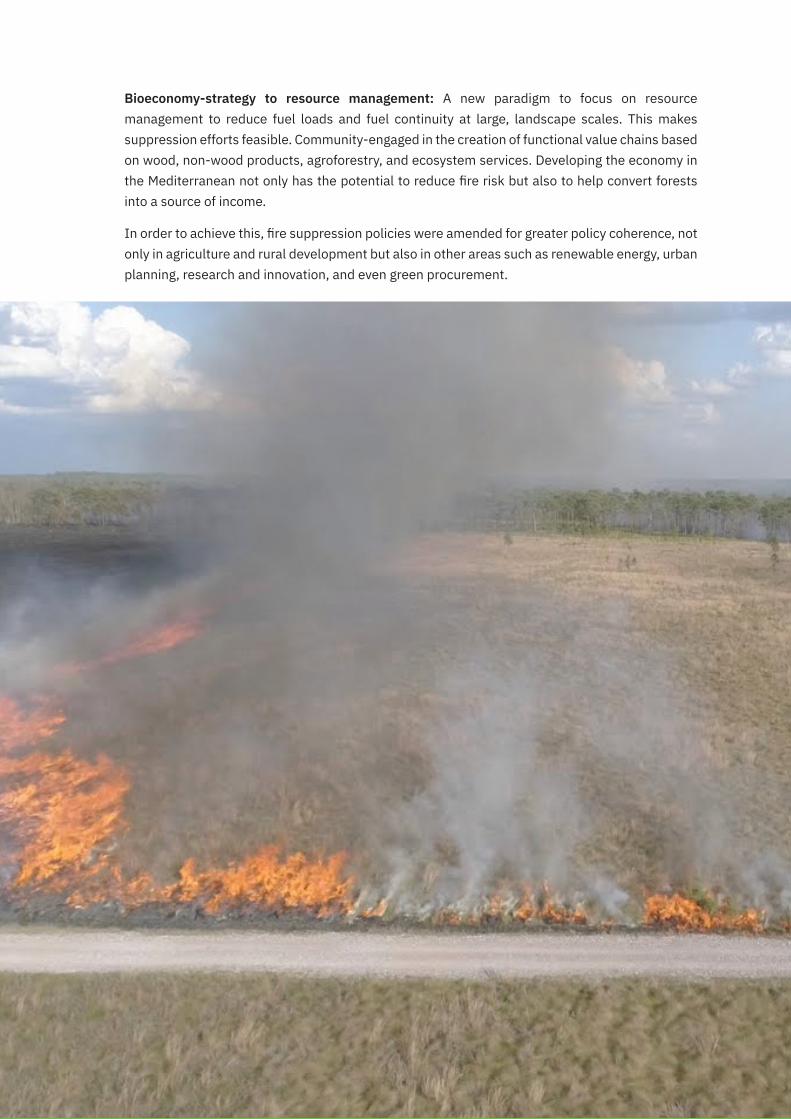
Bioeconomy-strategy to resource management: A new paradigm to focus on resource management to reduce fuel loads and fuel continuity at large, landscape scales. This makes suppression efforts feasible. Community-engaged in the creation of functional value chains based on wood, non-wood products, agroforestry, and ecosystem services. Developing the economy in the Mediterranean not only has the potential to reduce fire risk but also to help convert forests into a source of income.
In order to achieve this, fire suppression policies were amended for greater policy coherence, not only in agriculture and rural development but also in other areas such as renewable energy, urban planning, research and innovation, and even green procurement.

28
7.LessonsLearntandRecommendationsLooking at the forest fires worldwide, it may be relevant that mitigation of forest fire through fire suppression is only increasing the fuel load of the system, often resulting in out of control fires. Prescribed burning unless carried out in checks and balances has the risk of spreading across the forests. Rather steps may be taken to utilize organic load in the forest. Local communities may be engaged in the process to ensure livelihood and develop a sense of ownership towards the forest.
Forests or forest fires do not follow political boundaries. The approach to forest fire management must be trans-boundary and across political/ administrative borders.
Risk communication is of utmost importance in saving lives during a forest fire. Giving a clear and uniform message for each alert can help pass on the correct information. A set of standardized messages must be developed for each alert issued. The fire alert should also include smoke/ pollution concentration as a component.
Urban- Forest interface development is growing in India and across the globe. In general, the residents of such development are not aware of fire risk. Also, unlike their indigenous communities, they increase the hazard by introducing new materials for construction and interiors which are highly inflammable. Introduction of building codes, keeping a check on building material, trimming any grass/ trees, etc. can help in reducing forest fire damages.
Forest areas are increasingly becoming more commercial with hotels or small businesses and services like boarding schools, resorts, adventurous camps, etc. They must follow the necessary precautions

29
for managing the wildfire as well as limit any source of ignition/ starting of the fire. A simple activity like a campfire if unattended may result in a major forest fire.
Local/ indigenous communities may be trained as first responders to forest fires. The proximity to the forest fire may help the community reach the site fast and control the fire. In case of a large fire, there may be a provision to remunerate the volunteer firefighters from the local community. They may be provided with communication and firefighting gear.
Smokejumpers are specialized forces in the USA who are air-dropped into a remote forest to fight fires. They are equipped to be on their own and control the fires by maintaining fire lines till additional support is received. India may also train a specialized troop to fight the fire.
Across the globe, more effort and funds are channelized towards mitigation and response of forest fire. Little to no efforts are being made towards the recovery of communities and restoration of ecosystems. While planning for recovery it must be ensured the recovery does not resort to monoculture plantation and the diversity is maintained. To maintain diversity it is also important to maintain a seed bank/germplasm for native plant species.
The utility services such as electricity, natural gas, etc should be provided preferably underground, or at least maintained before the fire season for reducing the unwanted fire accidents.
Firefighting action plans must be prepared for each forest range considering the climate, terrain, type of vegetation, availability of water, etc. Drought remediation measures should also be taken into considerations while making these action plans.
Creating a bioeconomy through community-engaged creation of functional value chains based on wood, non-wood products, agroforestry, and ecosystem services can help ensure livelihood security as well as to control forest fire.

30
Reference• BBC(2020)Australiafires: What’s being done to fight the flames? https://www.bbc.com/news/
world-australia-51008051
• Bowman, DM.J.S., Balch, J.K., Artaxo, P., Bond, W.J., Carlson, J.M., Cochrane, M.A., D’Antonio, C.M., DeFries, R.S. et al. (2009), Fire in the earth system. Science, 324, 481–484
• Fire and Rescue Services – Wildfire Operational Guidance 2013
• Forest Fires – Sparking FireSmart policies in the EU
• Forest Survey of India (2019) “Identification of fire prone forest areas based on Gis analysis of archived forest fire points detected In the last thirteen years”, Technical Series- Volume 1 Ministry of Environment, Forest & Climate Change. Accessed at https://www.fsi.nic.in/technical-information-series Change
• Guha, Ramachandra. “Forestry in British and post-British India: A historical analysis.” Economic and Political Weekly (1983): 1882-1896.
• Hirschberger, Peter. “Forests ablaze: causes and effects of global forest fires.” Winter, S., von Laer, Y., Köberich, T., Eds (2016).
• Hongxiao Jin 2010 Master Thesis : https://lup.lub.lu.se/luur/download?func=downloadFile&recordOId=1857550&fileOId=1857574
• http://kids.triplezero.gov.au
• https://www.aerialfiremag.com/drone-seeding-assisting-bushfire-recovery-in-australia/
• https://www.cdc.gov/cpr/readiness/stories/ca.htm
• Huber, Kristiane, Ashley Lawson, and Janet Peace. “Maximizing Benefits: Strategies For Community Resilience.” Center for Climate and Energy Solutions (2018).
• INDC submitted by India to UNFCCC https://www4.unfccc.int/sites/ndcstaging/PublishedDocuments/India%20First/INDIA%20INDC%20TO%20UNFCCC.pdf
• Jack Goodman & Olga Robinson Forest fires: Are they worse than in previous years? https://www.bbc.com/news/world-49515462
• Kolden, C. and Henson, C. (2019). A socio-ecological approach to mitigating wildfire vulnerability in the Wildland Urban Interface: a case study from the 2017 Thomas Fire. Fire
• Ministry of Environment, Forest and Climate Change Government of India. Strengthening Forest Fire Management in India. World Bank, 2018.
• Mukerji, A. K. “Forest policy reforms in India–evolution of the joint forest management approach.” In World Forestry Congress, Québec City, Canada, pp. 0729-C1. 2003. http://www.fao.org/3/XII/0729-C1.htm
• Peter Fairley (2019) How an Australian State Fought Back Against Grid-Sparked Wildfires. https://spectrum.ieee.org/energywise/energy/the-smarter-grid/how-an-australian-state-faced-devastation-from-gridsparked-wildfires
• Pyne, S.J., Andrews, P.L., and Laven, R.D. (1996), Introduction to wildland fire, John Wileys & Sons Inc.
• S.W. Taylor, B. Stennes, S. Wang, and P. Taudin-Chabot, Integrating Canadian wildland fire management policy and institutions: sustaining natural resources, communities and ecosystems.
• Satendra, and Ashutosh Dev Kaushik. Forest fire disaster management. New Delhi: National Institute of Disaster Management, Ministry of Home Affairs, Government of India, 2014.
• Tiernan, Finbar; & O’Mallon, Eamonn. “Australia’s 2019–20 bushfire season”. The Canberra Times.
• Victorian Fire Risk Register – Bushfire: http://www.cerdi.edu.au/VictorianFireRiskRegister).
• Verge (2019) Everything you need to know about the fires in the Amazon. https://www.theverge.com/2019/8/28/20836891/amazon-fires-brazil-bolsonaro-rainforest-deforestation-analysis-effects Accessed on 12/8/2020

31

32