forest fire disaster management - nidm.gov.in fire.pdf · forest fire disaster management national...
TRANSCRIPT
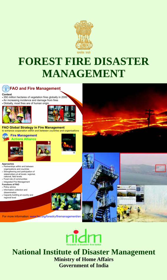
FOREST FIRE DISASTERMANAGEMENT
National Institute of Disaster ManagementMinistry of Home Affairs
Government of India
National Institute of Disaster ManagementMinistry of Home Affairs, Government of India5B, I.P. Estate, Ring Road, New Delhi-110 002
Website : www.nidm.gov.in

National Institute of Disaster ManagementMinistry of Home Affairs, Govt. of India
5B, I.P. Estate, Ring Road,New Delhi-110002Website: www.nidm.gov.in
FOREST FIRE DISASTER MANAGEMENT
Authors
Dr. SatendraDr. Ashutosh Dev Kaushik

FFDM Series – 1
FOREST FIRE DISASTER MANAGEMENT
Citation
Satendra and Kaushik, A.D. (2014): Forest Fire Diaster Management. National Institute of Disaster Management, Ministry of Home Affairs, New Delhi
Published byNIDM, New Delhi
Edition: First, 2014
ISBN-978-93-82571-09-4
© CopyrightNIDM, New Delhiwww.nidm.gov.in
This document may be freely reviewed, reproduced or translated, in part or whole, purely on non-profit basis. We welcome receiving information and suggestions on its adaptation or use in actual training and research.
Designing & PrintingIndia Offset PressA-1, Mayapuri Industrial Area,Phase-1, Mayapuri, New Delhi-110 064Ph.: 011 28116494


Preface
This book is the outcome of a team work and support from many persons and organizations. We owe a special debt of gratitude to various officials and experts from NDMA and Disaster Management Division of Ministry of Home Affairs, Govt. of India for the encouragement and support throughout the work. We would like to thank other experts, particularly faculties of FRI, Dehradun, Forest Survey of India, Dehradun and other forestry departments for their support and suggestions in the design of this book. We are grateful to Dr. V. K. Bahuguna, IFS, Ex-Director General, ICFRE, Dehradun and Prof. V.K. Sharma, Vice Chairman, SDMA of Sikkim State who had reviewed and discussed various issues related to forest fire risk mitigation, particularly preparedness aspects with us in detail and suggested some comments to improve the book content. We have had several rounds of discussions with many other experts engaged in forest fire for their comments before finalizing the book. However, we take the responsibility for any inadequacy in the book.
This book comprises seven chapters equipped with the latest information on forests, forest fire & its impacts, forest fire management strategies and related issues at national and international levels. An update and good annotated bibliography on forest fire has also been given in this book, which may be definitely useful for trainers, researchers and foresters.
At last but not the least, we are thankful to our colleagues of NIDM for their time to time discussions, valuable suggestions and support on different aspects of forest fire. We are also thankful to Dr. V.K. Naik, Consultant, NIDM for his valuable suggestions in the designing of the book.
A book of this nature, prepared for use anywhere in the country, is bound to have certain shortcomings; we trust that users will communicate their views to us so that we can strive to make this book more effective.
Authors
NIDM, SatendraNew Delhi Ashutosh D. Kaushik


i
CONTENTS
Message
Message
Preface
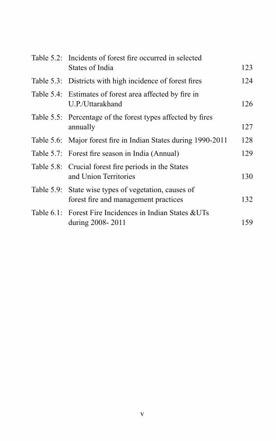
List of Table iv
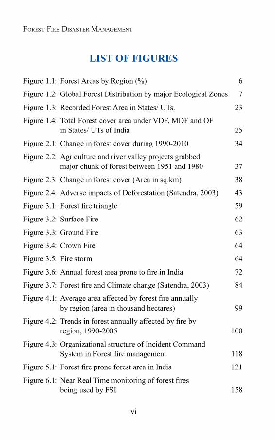
List of Figures vi
List of Boxes viii
List of Abbreviations ix
CHAPTER 1 FOREST : AN OVERVIEW
1.1 Introduction 1
1.2 Forests through Geological Ages 3
1.3 World forest scenario 5
1.4 Forests in India 10
1.5 Significanceofforests 26
CHAPTER 2 THE DIMINISHING FOREST COVER AND FOREST FIRE
2.1 Introduction 32
2.2 Global scenario 32
2.3 Growing pressure on forest in India 35
2.4 Forest degradation and its impact 39
2.5 Causes for deforestation, Forest degradation 41
2.6 Forestfire–themajorcauseofforestdegradation 50
CHAPTER 3 FOREST FIRE AND ITS IMPACTS
3.1 Introduction 52
ii
Forest Fire Disaster ManageMent
3.2 Forestfirethroughages 53
3.3 Forestfire–partofecosystem 54
3.4 Forestfire–asmanagementtool 56
3.5 Forestfire–abadmaster 58
3.6 Componentsofforestfire 59
3.7 Typesofforestfire 62
3.8 Whyforestfire? 65
3.9 Adverseimpactsofforestfire 71
3.10 ForestfireandClimatechange 83
CHAPTER 4 FOREST FIRE : THE GLOBAL SCENARIO
4.1 Introduction 86
4.2 Fire statistics and causes 97
4.3 Worldwidecausesofforestfire 102
4.4 International Cooperation in Forest Fire Management 103
4.5 Incident Command System & International cooperation 113
CHAPTER 5 FOREST FIRE : THE INDIAN SCENARIO
5.1 Introduction 120
5.2 Forestfirestatistics 122
5.3 VulnerabilityofIndianforeststowardsfire 125
5.4 Forestfireseason(Phenology)inIndia 128
5.5 Statewisetypesofvegetation,causesofforestfire 131 and management practices in India
CHAPTER 6 MANAGING FOREST FIRE
6.1 Introduction 143

iii
6.2 Amendment in National Forest Policy 144
6.3 Changingforestmanagementpracticesandforestfire 145
6.4 FAO Recommendations on Forest Fire Management 148
6.5 Forestfiremanagement-someinitiatives 151
6.6 Nationalplanforforestfiremanagement 153
6.7 Incident Command System / Incident 161 ResponseSystem(IRS)inIndia
CHAPTER 7 FOREST FIRE MANAGEMENT: ACTION PLAN
7.1 Introduction 163
7.2 Forestfiremanagement-thekeygaps 163
7.3 Actionplanforforestfiremanagement 166
GLOSSARY 181
FOREST FIRE SAFETY TIPS 199
ANNOTATED BIBLIOGRAPHY 209
BIBLIOGRAPHY 269
Contents

iv
Forest Fire Disaster ManageMent
LIST OF TABLES
Table 1.1: Geological Time Scale 4
Table 1.2: Forest Area by Region 2011 6
Table 1.3: Distribution of Forests by Ecological Zone 7
Table 1.4: Forest Types - Distribution & Extent 11
Table 1.5: State and UTs wise forest cover in India 22
Table 1.6: Forest cover in States and UTs in India 24
Table 1.7: Forest cover in tribal districts 29
Table 2.1: Net Change in Areas of Forest and Woodland 1975-85 33
Table 2.2: Annual change in forest area by region 34
Table 2.3: Diversion of forest land for non- farming purposes between 1951 and 1980 36
Table 2.4: Forest cover as estimated by the FSI from 1987 to 2009 37
Table 2.5: Diversion of forest land for non forest use (since the Enforcement of Forest Conservation Act, 1980) 48
Table 3.1: Number of incidents of forest fire reported in 15 States of India 73
Table 4.1: Susceptibility to fire, fire situation, fire season, fire incidences and management strategies at Global level 88
Table 4.2: Average area of forest annually affected by fire by region and sub-region, 2005 98
Table 4.3: Trends in forest annually affected by fire by region and sub-region, 1990-2005 99
Table 5.1: Data on Forest fire prone forest area in India 121
v
Table 5.2: Incidents of forest fire occurred in selected States of India 123
Table 5.3: Districts with high incidence of forest fires 124
Table 5.4: Estimates of forest area affected by fire in U.P./Uttarakhand 126
Table 5.5: Percentage of the forest types affected by fires annually 127
Table 5.6: Major forest fire in Indian States during 1990-2011 128
Table 5.7: Forest fire season in India (Annual) 129
Table 5.8: Crucial forest fire periods in the States and Union Territories 130
Table 5.9: State wise types of vegetation, causes of forest fire and management practices 132
Table 6.1: Forest Fire Incidences in Indian States &UTs during 2008- 2011 159
vi
Forest Fire Disaster ManageMent
LIST OF FIGURES
Figure 1.1: Forest Areas by Region (%) 6
Figure 1.2: Global Forest Distribution by major Ecological Zones 7
Figure 1.3: Recorded Forest Area in States/ UTs. 23
Figure 1.4: Total Forest cover area under VDF, MDF and OF in States/ UTs of India 25
Figure 2.1: Change in forest cover during 1990-2010 34
Figure 2.2: Agriculture and river valley projects grabbed major chunk of forest between 1951 and 1980 37
Figure 2.3: Change in forest cover (Area in sq.km) 38
Figure 2.4: Adverse impacts of Deforestation (Satendra, 2003) 43
Figure 3.1: Forest fire triangle 59
Figure 3.2: Surface Fire 62
Figure 3.3: Ground Fire 63
Figure 3.4: Crown Fire 64
Figure 3.5: Fire storm 64
Figure 3.6: Annual forest area prone to fire in India 72
Figure 3.7: Forest fire and Climate change (Satendra, 2003) 84
Figure 4.1: Average area affected by forest fire annually by region (area in thousand hectares) 99
Figure 4.2: Trends in forest annually affected by fire by region, 1990-2005 100
Figure 4.3: Organizational structure of Incident Command System in Forest fire management 118
Figure 5.1: Forest fire prone forest area in India 121
Figure 6.1: Near Real Time monitoring of forest fires being used by FSI 158
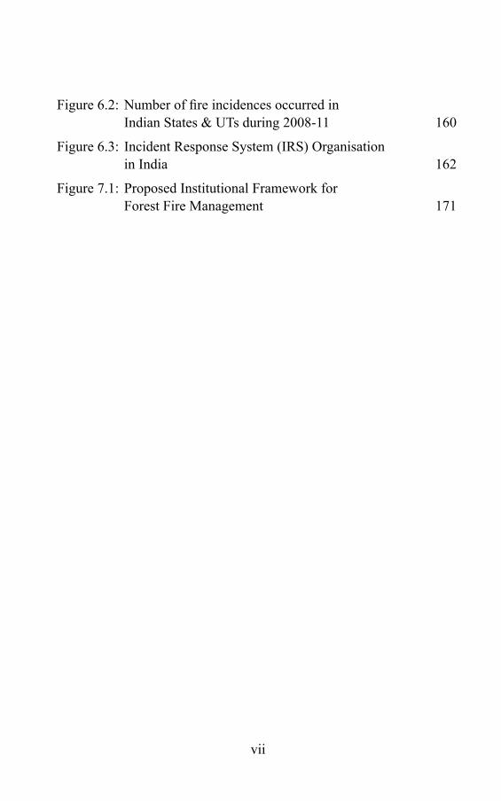
vii
Figure 6.2: Number of fire incidences occurred in Indian States & UTs during 2008-11 160
Figure 6.3: Incident Response System (IRS) Organisation in India 162
Figure 7.1: Proposed Institutional Framework for Forest Fire Management 171

viii
Forest Fire Disaster ManageMent
LIST OF BOxES
Box 1.1: Key Findings of the Global Forest Resource Assessment- 2010 8
Box 2.1: Demographic Status of the Country 44
Box 3.1: Forest Fire and Global Warming 78
Box 4.1: Wild Fire Disasters from 1980 - 2008 101
Box 7.1 Central Fire Management Research and Training Institute 177
ix
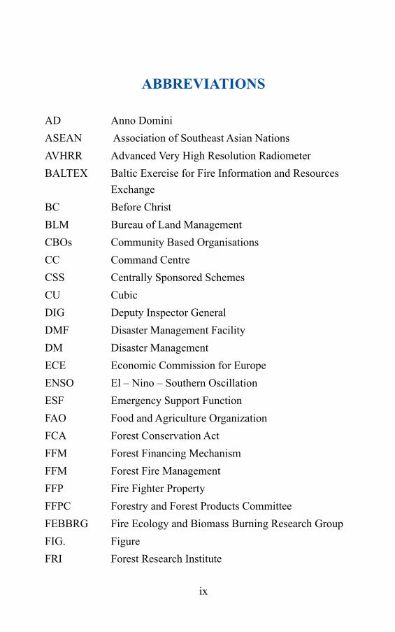
ABBREVIATIONS
AD Anno DominiASEAN Association of Southeast Asian NationsAVHRR Advanced Very High Resolution RadiometerBALTEX Baltic Exercise for Fire Information and Resources
Exchange BC Before ChristBLM Bureau of Land ManagementCBOs Community Based OrganisationsCC Command CentreCSS Centrally Sponsored SchemesCU CubicDIG Deputy Inspector GeneralDMF Disaster Management FacilityDM Disaster ManagementECE Economic Commission for EuropeENSO El – Nino – Southern OscillationESF Emergency Support FunctionFAO Food and Agriculture OrganizationFCA Forest Conservation ActFFM Forest Financing MechanismFFM Forest Fire ManagementFFP Fire Fighter PropertyFFPC Forestry and Forest Products CommitteeFEBBRG Fire Ecology and Biomass Burning Research GroupFIG. FigureFRI Forest Research Institute
x
Forest Fire Disaster ManageMent
FSI Forest Survey of IndiaGCMs General Circulation ModelsGDP Gross Domestic ProductGFRA/FRA Global Forest Resources AssessmentGFMC Global Fire Monitoring CentreGOI Government of IndiaGTZ Gesellschaft fur Technische ZusammenarbeitGWFN Global Wildland Fire NetworkHA HectareHP Himachal PradeshHPC High Powered CommitteeHRD Human Resource DevelopmentIC Incident CommanderICFRE Indian Council of Forest Research and EducationICIMOD International Centre for Integrated Mountain
DevelopmentICS Incident Command SystemIDNDR International Decade of Natural Disaster ReductionIEC Information, Education and CommunicationIG Inspector GeneralIMO Information & Media OfficerINSARAG International Search and Rescue Advisory GroupIRS Incident Response SystemIRTs Incident Response TeamsISDR International Strategy for Disaster ReductionISFR India State of Forest ReportITTO International Tropical Timber OrganizationIUCN International Union for Conservation of Nature
xi
JFM Joint Forest ManagementKm KilometerKML Keyhole Markup LanguageLO Liaison OfficerLS Logistics SectionMDF Moderately Dense ForestMODIS Management of Data Information Systems / Moderate
Resolution Imaging SpectrometerMoEF Ministry of Environment and ForestsMRA Main Results AreasNAFP Nepal-Australia Forestry ProjectNCMRWF National Centre for Medium Range Weather ForecastingNDMA National Disaster Management AuthorityNFAP National Forestry Action PlanNGOs Non Governmental OrganizationsNO Nodal OfficerNOAA National Oceanic and Atmospheric AdministrationNASA National Aeronautics and Space Administration NRSC National Remote Sensing CentreNTFP Non Timber Forest ProduceNWFP Non Wood Forest ProductsOF Open Forest OS Operations SectionPF Protected ForestPRIs Panchayati Raj InstitutionsPS Planning SectionRF Reserved ForestRO Responsible Officer
AbbreviAtions
xii
Forest Fire Disaster ManageMent
SFDs State Forest DepartmentsSMS Short Message ServiceSO Safety OfficerSq SquareSSR Seasonal Severity RatingTACIS Technical Assistance to the Commonwealth of
Independent StatesTCPs Technical Cooperation ProgrammesTOF Trees Outside ForestsUF Unclassified ForestU.K. United KingdomUN United NationUNESCO United Nations Educational and Scientific OrganizationUNU United Nations UniversityU.P. Uttar PradeshUS United StatesUSA United States of AmericaUSDA United States Department of AgricultureUTs Union TerritoriesVDF Very Dense ForestVFC Village Forest CommitteeWCN World Conservation NetworkWFAG Wildland Fire Advisory GroupWG Working GroupWHO World Health OrganizationWMO World Meteorological OrganizationWWF World Wide FundYR Year
Chapter 1
FOREST : AN OVERVIEW
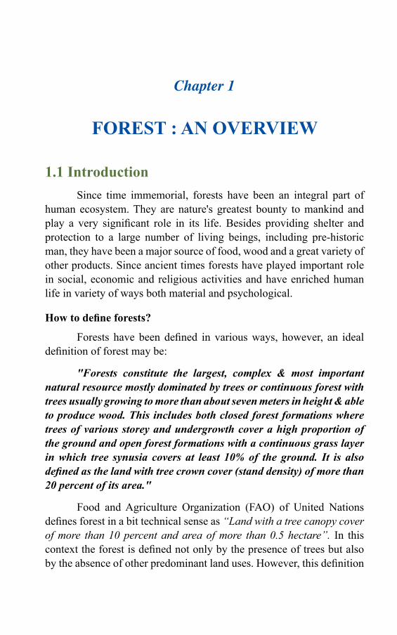
1.1 Introduction Since time immemorial, forests have been an integral part of
human ecosystem. They are nature's greatest bounty to mankind and play a very significant role in its life. Besides providing shelter and protection to a large number of living beings, including pre-historic man, they have been a major source of food, wood and a great variety of other products. Since ancient times forests have played important role in social, economic and religious activities and have enriched human life in variety of ways both material and psychological.
Howtodefineforests?
Forests have been defined in various ways, however, an ideal definition of forest may be:
"Forests constitute the largest, complex & most important natural resource mostly dominated by trees or continuous forest with trees usually growing to more than about seven meters in height & able to produce wood. This includes both closed forest formations where trees of various storey and undergrowth cover a high proportion of the ground and open forest formations with a continuous grass layer in which tree synusia covers at least 10% of the ground. It is also defined as the land with tree crown cover (stand density) of more than 20 percent of its area."
Food and Agriculture Organization (FAO) of United Nations defines forest in a bit technical sense as “Land with a tree canopy cover of more than 10 percent and area of more than 0.5 hectare”. In this context the forest is defined not only by the presence of trees but also by the absence of other predominant land uses. However, this definition

2
Forest Fire Disaster ManageMentForest Fire DisAster MAnAgeMent
of the forest does not cover its legal aspect. As far as the legal aspect is concerned, it has nothing to do with tree canopy or the tree cover and is simply defined as an area of land accorded as “Forest” in the revenue records or proclaimed to be forest under “Forest Law or Act”. In India, while describing forest area, only this legal status of the forest is taken into consideration and according to this “forest area” is an area recorded as forest in the government records and is commonly known as “the recoded forest area”. The recorded forest area can be classified as reserved, protected and unclassified as defined below-ReservedForest(RF): An area notified under the provisions of Indian Forest Acts or the State Forest Acts having full degree of protection. In Reserved Forests all activities are prohibited unless permitted.ProtectedForest(PF): An area notified under the provisions of Indian Forest Act or the State Forest Act.UnclassifiedForest(UF): An area recorded as forest but not included in reserved or protected forest category. Ownership status of such forests varies from state to state.
In whatever way it is defined; the forests are the major forms of natural landscape and are the most important natural resources of the world. Unlike other natural resources, such as minerals, mineral oils and natural gas, forests have the great advantage of being renewable and its productivity in use depends considerably upon the way its benefits are reaped by man.
For million of years most of the parts of the terrestrial habitats i.e. the natural vegetation were forests. For several thousands of years, primitive man lived in forests as hunter and food gatherer component of forest ecosystem. In the later stages, forests were invaded and cleared for suitable agricultural pursuits, this was at such an early stage that man yet did not develop the iron implements and he had to girdle the tree with stone implements. From that stage to the present time, forests are viewed from two angles:
I. Firstly they give valuable raw material and secondly, II. They are considered rivals for the space needed for crops and flocks.
3
1.2 Forests through Geological AgesA careful perusal or study of ecosystem is of paramount
importance to understand the scientific secrets of the life and its continuity on this living planet, the EARTH. Since origin of life in the geological past, diverse ecosystems have evolved on earth, the factors, which are governing climate and are the main geographical dimensions of our planet Earth. Earth is an unique and the only known planet with LIFE - the power that an organism possesses to maintain and reproduce itself.
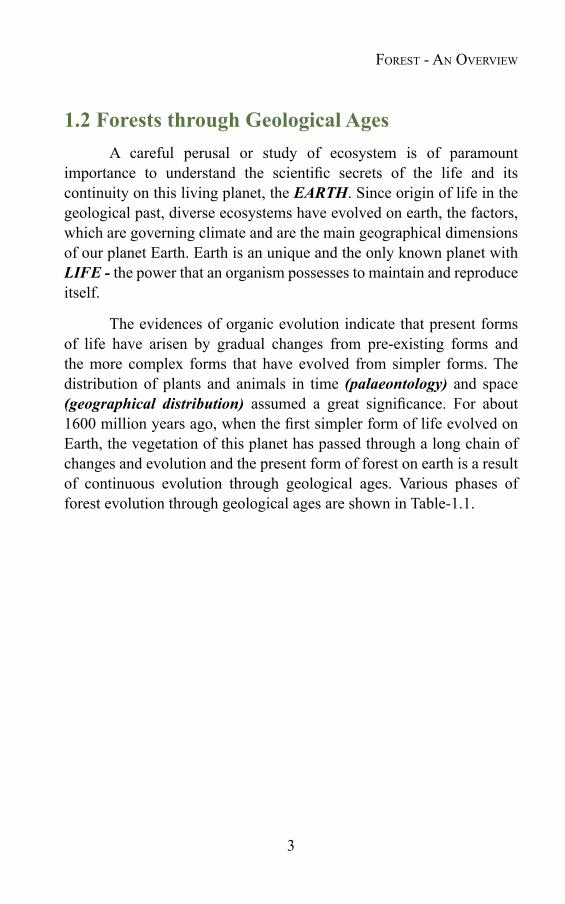
The evidences of organic evolution indicate that present forms of life have arisen by gradual changes from pre-existing forms and the more complex forms that have evolved from simpler forms. The distribution of plants and animals in time (palaeontology) and space (geographical distribution) assumed a great significance. For about 1600 million years ago, when the first simpler form of life evolved on Earth, the vegetation of this planet has passed through a long chain of changes and evolution and the present form of forest on earth is a result of continuous evolution through geological ages. Various phases of forest evolution through geological ages are shown in Table-1.1.
Forest - An overview

4
Forest Fire Disaster ManageMent
Table-1.1: Geological Time ScaleEra Period Epoch Approx.
Beginning(millionsyrs.B.P.)
Approx. Duration(millionsyrs.)
Plants Animals
Cen
ozoi
c
Quaternary Recent
Pleistocene
0.01
3
0.01
3
Decline of woody plants, rise of herbaceous plants Extinction of many Species
Modern Humans
Ice Ages; evolution of humans; giant mammals
Tertiary PlioceneMiocene
Oligocene
Eocene
Paleocene
1025
40
60
70
715
15
20
10
Forests decline;Grasslands spread
Monocotyledons become common
Rise of monocots;
Dicots common
Early hominidsSpread of anthropoid apesFirst anthropoids; some modern genera of mammalsMany modern mammalian families appearMost modern orders of mammals appear
Mes
ozoi
c
Cretaceous
Jurassic
Triassic
135
180
225
65
45
45
Flowering plants spread;gymnosperms decline
Cycads and conifers common; probable origin of angiospermsExtinction of seed ferns; gymnosperms dominant
First modern birds; some modern orders of mammals; dinosaurs become extinct at end of periodDinosaurs dominant; first birds and mammals
Labyrinthodont amphibians; mammal-like reptiles; first dinosaurs
Pa
leoz
oic
Permian
Carboni-ferous
Devonian
270
350
400
45
80
50
Decline of lycopods and horsetails; seed ferns and gymnosperms dominateTropical Coal Forests; lycopods and horsetails dominantFirst seed plants (gymnosperms); forests
Reptiles replace amphibians as dominant land animals
First reptiles; amphibians dominant; insects commonFish dominant; sharks abundant; first amphibians
5
Silurian
Ordovician
Cambrian
440
500
600
40
60
100
Evidence of primitive land plants
Probable origin of land plants
Marine algae diversify
Marine arachnids dominant; arthropods invade landFirst vertebrates (jawless fishes); invertebrates dominate the seasAll major invertebrate phyla appear suddenly; trilobites, branchiopods dominant
Pre-
Cam
bria
n From origin of Earth 4.5-5.0 billion years ago
Primitive aquatic plants—algae, fungi
Marine protozoa; few mollusks, some worms and other soft metazoans
Source: Life Science of Evolution by William D. Stansfield (2003), Macmillan Publishing Co., INC, New York
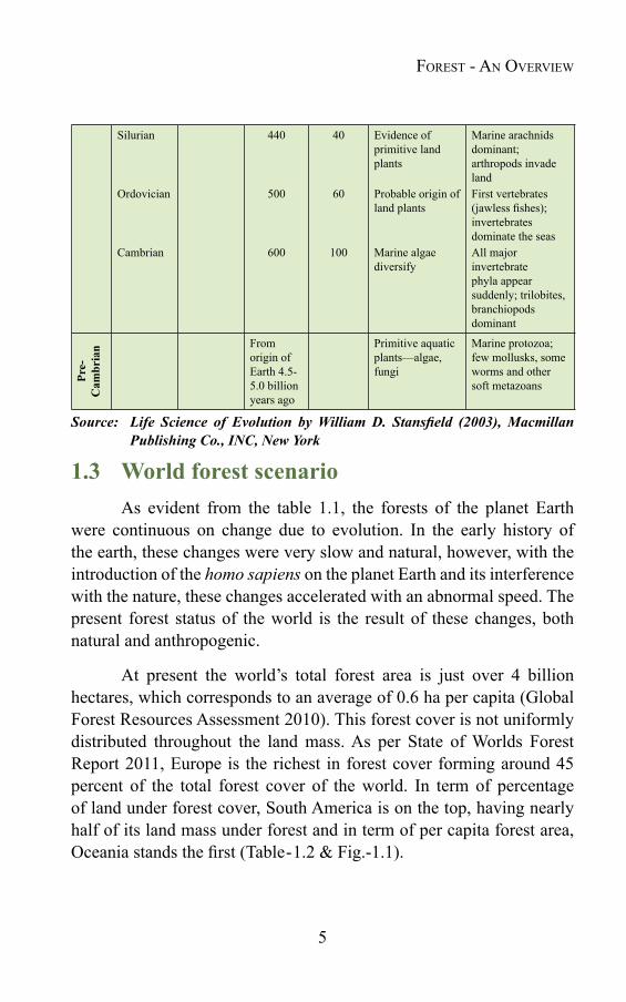
1.3 World forest scenarioAs evident from the table 1.1, the forests of the planet Earth
were continuous on change due to evolution. In the early history of the earth, these changes were very slow and natural, however, with the introduction of the homo sapiens on the planet Earth and its interference with the nature, these changes accelerated with an abnormal speed. The present forest status of the world is the result of these changes, both natural and anthropogenic.
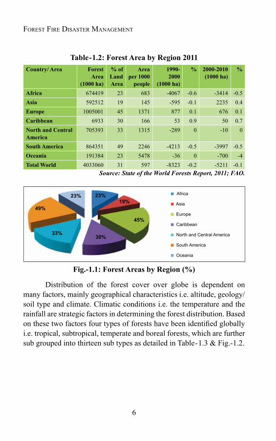
At present the world’s total forest area is just over 4 billion hectares, which corresponds to an average of 0.6 ha per capita (Global Forest Resources Assessment 2010). This forest cover is not uniformly distributed throughout the land mass. As per State of Worlds Forest Report 2011, Europe is the richest in forest cover forming around 45 percent of the total forest cover of the world. In term of percentage of land under forest cover, South America is on the top, having nearly half of its land mass under forest and in term of per capita forest area, Oceania stands the first (Table-1.2 & Fig.-1.1).
Forest - An overview
6
Forest Fire Disaster ManageMent
Table-1.2: Forest Area by Region 2011Country/ Area Forest
Area (1000ha)
% of Land Area
Area per 1000
people
1990-2000
(1000ha)
% 2000-2010 (1000ha)
%
Africa 674419 23 683 -4067 -0.6 -3414 -0.5Asia 592512 19 145 -595 -0.1 2235 0.4Europe 1005001 45 1371 877 0.1 676 0.1Caribbean 6933 30 166 53 0.9 50 0.7North and Central America
705393 33 1315 -289 0 -10 0
South America 864351 49 2246 -4213 -0.5 -3997 -0.5Oceania 191384 23 5478 -36 0 -700 -4Total World 4033060 31 597 -8323 -0.2 -5211 -0.1
Source: State of the World Forests Report, 2011; FAO.
Fig.-1.1:ForestAreasbyRegion(%)
Distribution of the forest cover over globe is dependent on many factors, mainly geographical characteristics i.e. altitude, geology/ soil type and climate. Climatic conditions i.e. the temperature and the rainfall are strategic factors in determining the forest distribution. Based on these two factors four types of forests have been identified globally i.e. tropical, subtropical, temperate and boreal forests, which are further sub grouped into thirteen sub types as detailed in Table-1.3 & Fig.-1.2.
Africa
Asia
Europe
Caribbean
North and Central America
South America
Oceania
30%
45%
19%23%23%
49%
33%
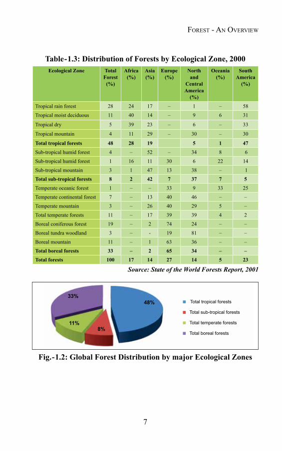
7
Table-1.3: Distribution of Forests by Ecological Zone, 2000Ecological Zone Total
Forest (%)
Africa (%)
Asia (%)
Europe (%)
North and
Central America (%)
Oceania (%)
South America (%)
Tropical rain forest 28 24 17 – 1 – 58
Tropical moist deciduous 11 40 14 – 9 6 31
Tropical dry 5 39 23 – 6 – 33
Tropical mountain 4 11 29 – 30 – 30
Total tropical forests 48 28 19 5 1 47
Sub-tropical humid forest 4 – 52 – 34 8 6
Sub-tropical humid forest 1 16 11 30 6 22 14
Sub-tropical mountain 3 1 47 13 38 – 1
Total sub-tropical forests 8 2 42 7 37 7 5
Temperate oceanic forest 1 – – 33 9 33 25
Temperate continental forest 7 – 13 40 46 – –
Temperate mountain 3 – 26 40 29 5 –
Total temperate forests 11 – 17 39 39 4 2
Boreal coniferous forest 19 – 2 74 24 – –
Boreal tundra woodland 3 – - 19 81 – –
Boreal mountain 11 – 1 63 36 – –
Total boreal forests 33 – 2 65 34 – –
Total forests 100 17 14 27 14 5 23
Source: State of the World Forests Report, 2001
Fig.-1.2:GlobalForestDistributionbymajorEcologicalZones
Total tropical forests
Total sub-tropical forests
Total temperate forests
Total boreal forests
48%33%
11%8%
Forest - An overview
8
Forest Fire Disaster ManageMent
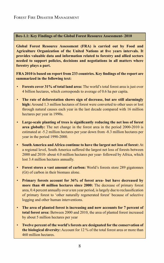
Box-1.1: Key Findings of the Global Forest Resource Assessment- 2010
Global Forest Resource Assessment (FRA) is carried out by Food andAgriculture Organization of the United Nations at five years intervals. Itprovides valuable data and information related to forestry and allied sectors needed to support policies, decisions and negotiations in all matters where forestry plays a part.
FRA2010isbasedonreportfrom233countries.Keyfindingsofthereportaresummarized in the following text:
• Forests cover 31% of total land area: The world’s total forest area is just over 4 billion hectares, which corresponds to average of 0.6 ha per capita.
• The rate of deforestation shows sign of decrease, but are still alarmingly high: Around 1.3 million hectares of forest were converted to other uses or lost through natural causes each year in the last decade compared with 16 million hectares per year in 1990s.
• Large-scaleplantingoftreesissignificantlyreducingthenetlossofforestarea globally: The net change in the forest area in the period 2000-2010 is estimated at -5.2 million hectares per year down from -8.3 million hectares per year in the period 1990-2000.
• South America and Africa continue to have the largest net loss of forest: At a regional level, South America suffered the largest net loss of forests between 2000 and 2010- about 4.0 million hectares per year- followed by Africa, which lost 3.4 million hectares annually.
• Forest stores a vast amount of carbon: World’s forests store 289 gigatonnes (Gt) of carbon in their biomass alone.
• Primary forests account for 36% of forest area- but have decreased by more than 40 million hectares since 2000: The decrease of primary forest area, 0.4 percent annually over a ten year period, is largely due to reclassification of primary forest to ‘other naturally regenerated forest’ because of selective logging and other human interventions.
• The area of planted forest is increasing and now accounts for 7 percent of total forest area: Between 2000 and 2010, the area of planted forest increased by about 5 million hectares per year
• Twelve percent of the world’s forests are designated for the conservation of the biological diversity: Account for 12 % of the total forest area or more than 460 million hectares.

9
• Legally established protected areas cover an estimate of 13 percent of the world’s forests: The area of forest within a protected area system has increased by 94 million hectares since 1990. Two thirds of this increase has been since 2000.
• Forest Fire is severely underreported at global level: Forest fires can be devastating and also frequently cause loss of property and human life. However, the area of forest affected by fires was severely underreported, with information missing from many countries, especially in Africa. Less than 10 percent of all forests are prescribed burning; the rest are classified as wildfires.
• Insect pests and diseases, natural disasters and invasive species are causing severe damage in some countries: Outbreaks of forest insect pests damage 35 million hectares of forest annually primarily in the temperate and boreal zone.
• Thirty percent of the world’s forests are primarily used for production of wood and non-wood forest products.
• Wood removals increased between 2000 and 2005 following a fall in the 1990s.
• Eight percent of the world’s forests have protection of soil and water resourcesastheirprimaryobjective: Around 330 million hectares of forest are designated for soil and water conservation avalanche control, sand dune stabilization, desertification control or costal protection.
• The management of forests for social and cultural functions is increasing, buttheareaisdifficulttoquantify.
• Thevalueofwoodremovalsishigh,butfluctuating: Wood removals valued just over US$100 billion annually in the period 2003-2007, mainly accounted for industrial round wood.
• The value of non-wood forest products remain underestimated: The reported value of non-wood forest product removals amounted to about US$18.5 billion in 2005.
• Around 10 million people are employed in forest management and conservation- but many more are directly dependent on forests for their livelihoods.
• Governments generally spend more on forestry than they collect in revenue: On average, total forest revenue collection was about US$ 4.5 per hectare, ranging from under US$1 per hectare in Africa to just over US$ 6 per hectare in Europe. Public expenditure on forestry was about US$ 7.5 per hectare on average.
Forest - An overview
10
Forest Fire Disaster ManageMent
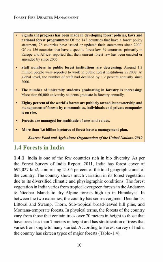
• Significantprogresshasbeenmadeindevelopingforestpolicies,lawsandnational forest programmes: Of the 143 countries that have a forest policy statement, 76 countries have issued or updated their statements since 2000. Of the 156 countries that have a specific forest law, 69 countries- primarily in Europe and Africa- reported that their current forest law has been enacted or amended by since 2005.
• Staff numbers in public forest institutions are decreasing: Around 1.3 million people were reported to work in public forest institutions in 2008. At global level, the number of staff had declined by 1.2 percent annually since 2000.
• The number of university students graduating in forestry is increasing: More than 60,000 university students graduate in forestry annually.
• Eighty percent of the world’s forests are publicly owned, but ownership and management of forests by communities, individuals and private companies is on rise.
• Forestsaremanagedformultitudeofusesandvalues.
• Morethan1.6billionhectaresofforesthaveamanagementplan.
Source: Food and Agriculture Organization of the United Nations, 2010
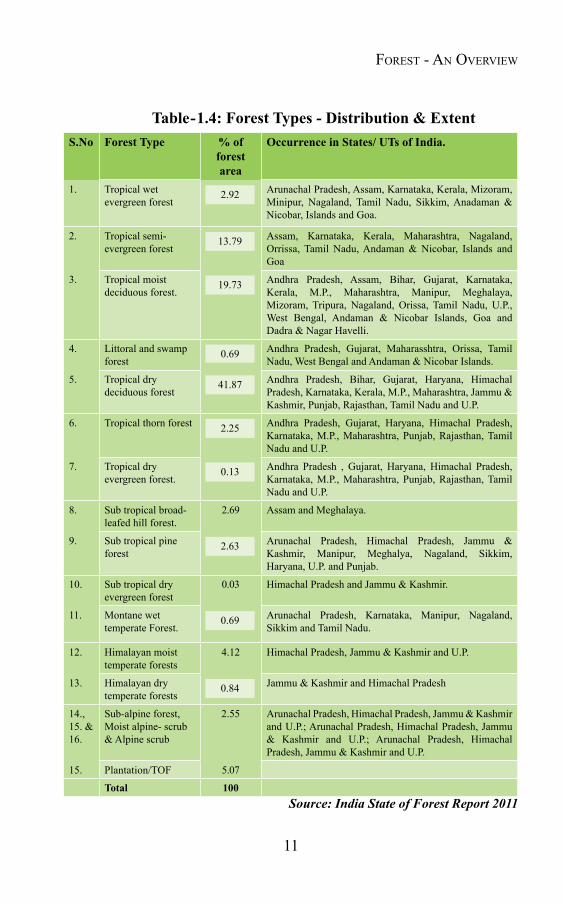
1.4 Forests in India1.4.1 India is one of the few countries rich in bio diversity. As per the Forest Survey of India Report, 2011, India has forest cover of 692,027 km2, comprising 21.05 percent of the total geographic area of the country. The country shows much variation in its forest vegetation due to its diversified climatic and physiographic conditions. The forest vegetation in India varies from tropical evergreen forests in the Andaman & Nicobar Islands to dry Alpine forests high up in Himalayas. In between the two extremes, the country has semi-evergreen, Deciduous, Littoral and Swamp, Thorn, Sub-tropical broad-leaved hill pine, and Montana-temperate forests. In physical terms, the forests of the country vary from those that contain trees over 70 meters in height to those that have trees less than 7 meters in height and has stratification of trees that varies from single to many storied. According to Forest survey of India, the country has sixteen types of major forests (Table-1.4).
11
Table-1.4: Forest Types - Distribution & ExtentS.No Forest Type % of
forest area
Occurrence in States/ UTs of India.
1. Tropical wet evergreen forest
2.92 Arunachal Pradesh, Assam, Karnataka, Kerala, Mizoram, Minipur, Nagaland, Tamil Nadu, Sikkim, Anadaman & Nicobar, Islands and Goa.
2. Tropical semi-evergreen forest
13.79 Assam, Karnataka, Kerala, Maharashtra, Nagaland, Orrissa, Tamil Nadu, Andaman & Nicobar, Islands and Goa
3. Tropical moist deciduous forest.
19.73 Andhra Pradesh, Assam, Bihar, Gujarat, Karnataka, Kerala, M.P., Maharashtra, Manipur, Meghalaya, Mizoram, Tripura, Nagaland, Orissa, Tamil Nadu, U.P., West Bengal, Andaman & Nicobar Islands, Goa and Dadra & Nagar Havelli.
4. Littoral and swamp forest
0.69 Andhra Pradesh, Gujarat, Maharasshtra, Orissa, Tamil Nadu, West Bengal and Andaman & Nicobar Islands.
5. Tropical dry deciduous forest
41.87 Andhra Pradesh, Bihar, Gujarat, Haryana, Himachal Pradesh, Karnataka, Kerala, M.P., Maharashtra, Jammu & Kashmir, Punjab, Rajasthan, Tamil Nadu and U.P.
6. Tropical thorn forest 2.25 Andhra Pradesh, Gujarat, Haryana, Himachal Pradesh, Karnataka, M.P., Maharashtra, Punjab, Rajasthan, Tamil Nadu and U.P.
7. Tropical dry evergreen forest.
0.13 Andhra Pradesh , Gujarat, Haryana, Himachal Pradesh, Karnataka, M.P., Maharashtra, Punjab, Rajasthan, Tamil Nadu and U.P.
8. Sub tropical broad-leafed hill forest.
2.69 Assam and Meghalaya.
9. Sub tropical pine forest
2.63 Arunachal Pradesh, Himachal Pradesh, Jammu & Kashmir, Manipur, Meghalya, Nagaland, Sikkim, Haryana, U.P. and Punjab.
10. Sub tropical dry evergreen forest
0.03 Himachal Pradesh and Jammu & Kashmir.
11. Montane wet temperate Forest.
0.69 Arunachal Pradesh, Karnataka, Manipur, Nagaland, Sikkim and Tamil Nadu.
12. Himalayan moist temperate forests
4.12 Himachal Pradesh, Jammu & Kashmir and U.P.
13. Himalayan dry temperate forests
0.84 Jammu & Kashmir and Himachal Pradesh
14., 15. & 16.
Sub-alpine forest, Moist alpine- scrub & Alpine scrub
2.55 Arunachal Pradesh, Himachal Pradesh, Jammu & Kashmir and U.P.; Arunachal Pradesh, Himachal Pradesh, Jammu & Kashmir and U.P.; Arunachal Pradesh, Himachal Pradesh, Jammu & Kashmir and U.P.
15. Plantation/TOF 5.07
Total 100Source: India State of Forest Report 2011
Forest - An overview
12
Forest Fire Disaster ManageMent
1.4.2 Rich in Bio-Diversity
Because of its diverse physiographic and climatic conditions, India’s forests are rich in biodiversity. India falls in the confluence of three major bio-geographic realms, the Indo-Malayan, Eurasian and Afro-tropical and is one of the 12-mega biodiversity countries of the world. The country is divided into ten bio-geographic zones:
I. Trans-Himalayan,
II. Himalayan,
III. Indian deserts,
IV. Semi-arid areas,
V. Western Ghats,
VI. Deccan peninsula,
VII. Gangetic plain,
VIII. North-East India,
IX. Islands, and
X. Coasts.
1.4.3 Flora and Fauna
Forest consists of two major components i.e. flora and fauna. As far as flora is concerned, a number of detailed ethno-botanical explorations have been conducted in different parts of the country and more than 800 plant species of ethno-botanical interest have been collected and identified. As per Botanical Survey of India, the country can be divided into eight distinct floristic regions namely: Western Himalayas, Eastern Himalayas, Assam and North-East, the Gangetic plain, Indus plain, Deccan, Malabar and Andaman.
(i) The Western Himalayan region extending from Kashmir to Kumaon and characterized by the temperate zone is rich in forests of spruce,
13
fir, cedrus, chir pine, other conifers and broad-leaved trees. The higher altitude area of this region named Alpine Zone extends from the upper limit of the temperate zone to about 4,750 meter elevation or even higher. The characteristic trees of the zone are the silver fir, birch, juniper and dwarf willows.
(ii) The Eastern Himalayan region extends from Sikkim eastwards and embraces Darjeeling, Kurseong and the adjacent tracts. The temperate zone of the region has forests of oak, laurel, maple, rhododendrons, alder and birch; different types of conifers, juniper and dwarf willows.
(iii) The Assam and northeastern region comprising of the valleys of Brahmaputra and Surma and the intervening hill regions is rich and luxurious with evergreen forests, occasional thick clumps of bamboo, and tall grasses.
(iv) The Gangetic plain region covers the area from the Aravalli ranges to Bengal and Orissa. A large part of the area is alluvial plain and is under cultivation for wheat, sugar cane and rice. Only small area of the region supports forests of different types.
(v) The Indus plain region comprises of the plains of Punjab, western Rajasthan and northern Gujarat. The region is dry and hot and supports scanty natural vegetation.
(vi) The Deccan region, characterized by the entire tableland of the Indian peninsula supports vegetation of various kinds from scrub areas to mixed deciduous forests.
(vii) The Malabar region covers the excessively humid belt of mountain running parallel to the southwest coast and contains evergreen and moist deciduous forests. This region, besides being rich in forest vegetation, produces important commercial crops like coconut, betel nut, pepper, coffee and tea. Rubber, cashew nut and eucalyptus trees have also been successfully introduced in some parts of this region.
(viii) The Andaman region comprises the Andaman and Nicobar Islands. It bounds in evergreen, semi-evergreen and mangrove forests.
Forest - An overview
14
Forest Fire Disaster ManageMent
As reported by the Zoological Survey of the country, India has about 90,000 known species of fauna of which 2546 are fishes, 210 amphibians, 425 reptiles, 2000 birds, 397 mammals and the remaining are invertebrates, including protozoa, worms, insects (arthropod), mollusks, crustaceans, etc.
1.4.4 Factorsinfluencingforests
Despite being rich in bio-diversity, the country presents a very poor picture, as far as its forest cover is concerned. With only 2.5 of the world’s geographic area and 1.8 % of the total forest cover, the country has to support more than 16% of the total human and about 18% of the cattle population. The forest cover of the country is closely associated with various factors, both natural and man-made. The geology, climate, socio-economic conditions etc. are various such factors which directly or indirectly influence the forest and its bio-diversity. Before going into details about the forest cover, it will be worth to have a glimpse of various facts and figures, influencing forest ecosystem in the country.
(a)PhysicalfeaturesCovering an area of 3,287,263 km2, India is the seventh
largest county of the world. India physically comprises of four broad geographical areas, namely the Great Himalayas (East and West), the vast Indo-Gangetic Plains, the Great Thar Desert, and the Southern peninsula bounded by Western and Eastern Ghats. India, which is bounded by the Himalayas in the North, stretches south flanked by the Bay of Bengal and Arabian Sea and tapers off into the Indian Ocean. The land mass of the country lies within latitudes 8.4 and 37.6 degrees North and longitudes 68.7 and 97.25 degrees East. Physiologically and biologically India is primarily tropical, however, due to altitude variations and other habitat factors, a range of climates can be observed influencing its ecology, flora and fauna. There are also considerable differences among the States, in their pattern of development and other socio-economic and demographic profiles influencing forest eco-system.
Geology and Soils- The geological regions of India broadly follows the
15
physical features and may be grouped into three regions: The Himalayas and their associated group of mountains, the Indo-Gangetic plain and the Peninsular shield. About 600 million years ago, most of the Himalayan region was under sea. About 70 million ago, in a series of mountain building movements through northward movement, the sediment and the basement rocks rose to great heights and the weathering and erosive agencies worked on these to produce all that we see today. The Indo-Gangetic plain as a great alluvial tract separates the Himalayas in north from the peninsula to the south.
The peninsular region has a relative stability. Highly metamorphosed rocks of the earliest periods, dating as far back as 4,000 million years are found here; the rest being covered by the coal-bearing Gondwana formations, lava flows belonging to the Deccan Trap formation and younger sediments.
Each type being particular to a specific locality, India has a wide range of soils. The two important soil types from point of view of agriculture production are Alluvial and Black Cotton Soils. The Alluvial soil composed of sediments of silt and sand deposited by rivers in the interior constitutes the great Indo-Gangetic plains. Alluvial soils, also occurring in the valleys of Narmada and Tapti in Madhya Pradesh and the Cauvery in Tamil Nadu, are considered good for the production of wheat, rice, other cereals, pulses, oil seeds, potato, and sugarcane etc.
Distributing through Maharashtra, Gujarat, Madhya Pradesh, Karnataka, and Andhra Pradesh, Tamil Nadu, Uttar Pradesh and Rajasthan, Black Cotton Soil cover about 51.8 million hectare land mass. These soils are considered good for cultivation of cotton, cereals, pulses, oil seeds, citrus fruits, and vegetables etc. Red soils are found primarily in Tamil Nadu, Karnataka, Kerala, Maharashtra, Andhra Pradesh, Madhya Pradesh, Bihar and West Bengal. Almost all types of crops are grown in these soils but these soils are most suited for rice, ragi, tobacco and vegetable cultivation. Laterite and lateritic soils, covering over 12.6 million hectare area are usually not fertile. The area of desert soils in the country is around 37 million hectares and is also
Forest - An overview

16
Forest Fire Disaster ManageMent
not good for agriculture because of climatic and physiographic factors.
The country is drained by 14 major river systems, broadly classified into four broad basins i.e. Himalayan, Peninsular, Coastal and Inland drainage basins. Himalayan rivers are generally snow fed and perennial. During the monsoon months, the Himalayas receive very high rainfall which leads to discharge of huge quantities of water causing frequent floods and landslides. The Ganga sub-basin, a part of the larger Ganga- Brahmaputra- Meghana basin is the largest in the country. About one-quarter of the India's total area comprises of its catchments area. The peninsular rivers of the country are generally rain fed and therefore, fluctuate in volume. The inland drainage basin streams of Western Rajasthan are few and most of them are of an ephemeral character by draining into either individual basins or into salt lakes, like the Sambhar, or are lost in the sands, having no outlet to the sea.
Climate- Despite being a tropical country, due to great altitudinal variations, almost all climatic conditions from hot desert to cold desert exists in the country. The climate of India may be broadly described as being mostly tropical, tropical-monsoon and montane- temperate in the Himalayas. The four main seasons prevalent in India are winter, summer, south-western monsoon and post-monsoon period. Among all these climatic seasons, post monsoon period commonly known as the winter monsoon begins over north India and passes over the Bay of Bengal before bringing monsoon to the Andaman and to India's southeast coast. The southwest or summer monsoon provides 80 % of the total precipitation in the country. One and a half times of the world's average rainfall per sq. km area is received by India i.e. a total of 400 million hectare meters of annual rainfall and 20 million hectare meters of snowfall in the Himalayas. However, rainfall is confined mostly to the monsoon months leading to 180 million hectare meters of runoff. Out of the balance of 240 million hectare meters, around 140 million hectare meter percolates in the soil, 70 million hectare meters evaporates, around 26 million hectare meters are stored in major and minor irrigation projects and around 4 million hectare meters remains in small tanks.
17
(b)Landusepattern
Out of the total 3,287,263 km2 (329 mha) geographical area in the country, the land use data available is only for about 305 million hectares. As per the latest information available, major portion of the land is used for agriculture purpose (around 142.2 million hectares). The agriculture constitutes about 30 % of the country’s GDP and makes major contribution in its economy. Of the total sown area in the country, 84.82 million hectares (i.e. 63%) is rain fed and completely depends on rain for its irrigation.
The forest cover of the country is about 692,027 km2, 22 million hectare is used for urban and non agriculture purposes, the barren land (without any vegetation due to natural reasons viz. snow bound or rocky in nature) is around 19 million hectare. A major portion of the land is degraded due to wind/ water erosion, water logging and shifting cultivation (approximately 107.4 million hectare). There is around 2.38 million hectare of land suffered due to shifting cultivation, mainly in the northeastern states.
(c)Socio-economiccondition
Agriculture is the mainstay of India's economy, contributing approximately 30% to GDP and 65% to the employment. There are 105.29 million operational land holdings in India. The net cropped area of the country is around 140 million-hectare, which comprises around 45.1 of the total land area. Estimates of land use suggest that in addition to denudation of non-agricultural land, 85 million hectare or 59% of agricultural land suffer from soil degradation.
India supports approximately 17.64 % of world's population with only 2.4% of the world's geographic area. India's estimated population has crossed one billion, resulting in an average density of around 382 persons per sq. km. Population density varies between States, e.g. there are about 17 people per sq. km. in Arunachal Pradesh, while 1102 people per sq.km in Bihar as per Census 2011. About 70% of the total population and 80% of the population below poverty line live in rural
Forest - An overview

18
Forest Fire Disaster ManageMent
villages. About half of the country's population and more than two thirds of all women over 15 years of age are illiterate.
The indices of low socio-economic development in India include heavy pressure of population; improper land use and inappropriate systems of farming; deforestation; unplanned development of industries; infrastructure and urban settlements; uncontrolled use of water resources; lack of adequate sanitation; unhealthy working conditions; improper planning of development activities; over-exploitation and non-replenishment of renewable resources; and poor level of education.
Irrational systems of resource have led to floods, droughts, erosion and impoverishment of soil, lowering of water level, water logging, sedimentation, lack of clean drinking water, fall in agricultural productivity, depletion of fishery and forestry resources, water pollution, health hazards, extinction and endangerment of plant and animal species, loss of bio-diversity and poverty.
In India, approximately 37% of the total population is below the poverty line (Tendulkar Committee, 2011). Despite the significant progress in areas such as nutrition and health over the last 65 years, much remains to be done for certain regions and population groups. The poverty and dearth of livelihood and other income generating resources have increased the dependency of the man on natural resources, among which forest is the most vulnerable and easily accessible resource. Along with supplying fuel wood, fodder and other minor forest produce, poor people of the country are forced to exploit forests to earn livelihood.
1.4.5 Indian forests through ages
The existing forest scenario of the country is consequence of natural evolution and changes (both natural and man made). Evidences reveal that the first plant in India appeared around 450 million years ago. Rich coal deposits in India confirm that 300 million years ago the country was very rich in forests. According to paleo-botanical evidences, the Bengal, eastern Bihar and Assam regions were covered by rich forests more than 135 million years ago.

19
a)Ancientperiod
In two great epics of India, the Ramayana and the Mahabharatha there are extensive references to forests and trees, which indicate that forests were generally worshiped and protected during that period. There is also an account of the destruction of the Khandawa forest by fire in the Mahabharatha. In the Vishnu Purana and other Puranas, there is reference to vanas (forests) existing across the length and breadth of the country, from Kashmir down to peninsular India.
The earliest historical evidence of forests and their use in human life in India relates to the Mohenjodaro- Harappa civilization (about 5000-4000 B.C.). The seals and painted pottery recovered from the Indus Valley shows the pipal and babul trees. From 2000-1500 B.C., the migration of Aryans to India carried forward the process of extensive clearing of forests, especially in areas like Punjab in northwestern India to meet the needs of their numerous settlements, including need for vehicles, housing and fuel. Their use of iron for agriculture implements was a contributory factor in the diffusion of agriculture.
Description about forests in the Mauryan period is also available in Kautilya's Arthasastra (321 B.C.), Indika of Megasthenes, Mudrarakshasas of Visakhadatta and inscriptions of Emperor Ashoka. The study of these books and inscriptions shows that the Mauryan kings were well aware about the significance of forests and wildlife and probably had an independent forest department to look after the conservation of this valuable natural resource. The forest and wildlife offences and corresponding penalties described in these books also confirm this.
Despite centuries separating the two periods, the Gupta period (A.D. 200-600) witnessed a distribution of forests similar to that of the Mauryan period. During the period, while the forests were dense in Himalayan foothills and Dandakaranya, the western region had a desert climate and sparse vegetation and the Indo-Gangetic plains had flourishing agriculture.
Forest - An overview
20
Forest Fire Disaster ManageMent
In the post Gupta period, characterized by fragmentation of the country into a large number of states ruled by fratricidal strife, large-scale felling and destruction of forests were caused by hunting, demand for timber and by forest fires. Continuous destruction of forests for timber and clearance for cultivation was the characteristic of the Moghual period (1526-1700). The northern and eastern provinces during this period had the best forests, in which wildlife flourished. Widespread deforestation to meet the demands of firewood, etc. was one of the major factors of reducing forest cover during this period. The other biotic factors, which led to the destruction of vegetation was clearing of land for cultivation and grazing by domestic animals.
b)Thecolonialperiod
During the colonial rule, the major task undertaken by Britishers was creation of forest department and classification of forests into reserved and protected forests and therein settlement of rights. In British India period, out of 788,156 square miles of total land area, 42.56 % was under cultivation, 44.38 % for common use of the community and only 13.06 % was notified as reserved and protected forest. Most of the exploitable areas and important tree species were brought under working plans. Selection and selection-cum-improvement felling, conversion to uniform system, standard/reserves as well as the taungya system (Agri-silviculture), involving clear felling and strip plantation with short duration of agriculture crops between the strips and finally the clear felling and plantation of economically viable species come under various silvicultural systems.
The Britishers also introduced an institutional framework for better management of forests in the country and established Imperial Forest Institute in 1906. Chief Conservators of forests began to be appointed for each province by 1907 and in 1910 a "Forestry Board" comprised of representative chief conservators under the presidentship of the Inspector General of Forests, was set up, which met once in three years to discuss the forestry programmes. In 1927, the new Indian Forest Act was passed. With the passing of the Government of India Act
21
of 1935, forests became entirely the concern of the provinces, though Inspector General of Forests of India continued to provide technical guidance and advice.
c)PostIndependence
After independence too, forests of the country remained under tremendous pressure due to various factors. Industrialization and green revolution to make the country self sufficient resulted into enormous loss of forest land. Lack of adequate financial inputs has also adversely affected sustainable development of forests and conservation of biodiversity in the country. Inspite of growing demands resulting into degradation of forests, in recent past number of initiatives by foresters and local people have created areas of new hope for regeneration and development of sustainable use of forest areas all over the country. During the last two – three decades, Social, Agro-forestry and Community Forestry Programmes in India gave emphasis to bring both forests and foresters closer to the community. The Government of India's new participatory forest management systems, being developed by forest departments and forest committees, hold a great promise of a new direction in forest management.
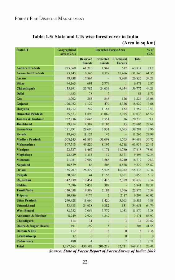
India has a total landmass of around 3.29 million sq. km, out of which the total forest area in the country is around 769,512. sq. km. i.e. 23.41 percentage of the total geographic area. According to State of Forest Report of FSI (2009), the recorded forest area comprises of three categories i.e. reserved (51.6%), protected (26.79%) and un-classed forest (17.24%). The State / UTs wise contribution of the recorded forest area is given in Table-1.5 and Fig.-1.3.
Forest - An overview
22
Forest Fire Disaster ManageMent
Table-1.5: State and UTs wise forest cover in India(Areainsq.km)
State/UT Geographical Area(G.A.)
Recorded Forest Area % of G.A.
Reserved Forests
Protected Forests
Unclassed Forests
Total
Andhra Pradesh 275,069 61,210 1,967 637 63,814 23.2Arunachal Pradesh 83,743 10,546 9,528 31,466 51,540 61.55Assam 78,438 17,864 – 8,968 26,832 34.21Bihar 94,163 693 5,779 1 6,473 6.87Chhattisgarh 135,191 25,782 24,036 9,954 59,772 44.21Delhi 1,483 78 7 – 85 5.73Goa 3,702 253 845 126 1,224 33.06Gujarat 196,022 14,122 479 4,326 18,927 9.66Haryana 44,212 249 1,158 152 1,559 3.53Himachal Pradesh 55,673 1,898 33,060 2,075 37,033 66.52Jammu & Kashmir 222,236 17,643 2,551 36 20,230 9.1Jharkhand 79,714 4,387 19,185 33 23,605 29.61Karnataka 191,791 28,690 3,931 5,663 38,284 19.96Kerala 38,863 11,123 142 – 11,265 28.99Madhya Pradesh 308,245 61,886 31,098 1,705 94,689 30.72Maharashtra 307,713 49,226 8,195 4,518 61,939 20.13Manipur 22,327 1,467 4,171 11,780 17,418 78.01Meghalaya 22,429 1,113 12 8,371 9,496 42.34Mizoram 21,081 7,909 3,568 5,240 16,717 79.3Nagaland 16,579 86 508 8,628 9,222 55.62Orissa 155,707 26,329 15,525 16,282 58,136 37.34Punjab 50,362 44 1,153 1,861 3,058 6.12Rajasthan 342,239 12,454 17,416 2,769 32,639 9.54Sikkim 7,096 5,452 389 - 5,841 82.31Tamil Nadu 130,058 19,388 2,183 1,306 22,877 17.59Tripura 10,486 4175 2 2117 6,294 60.02Uttar Pradesh 240,928 11,660 1,420 3,503 16,583 6.88Uttarakhand 53,483 24,638 9,882 131 34,651 64.79West Bengal 88,752 7,054 3,772 1,053 11,879 13.38Andaman & Nicobar 8,249 2,929 4,242 – 7,171 86.93Chandigarh 114 31 - 3 34 29.82Dadra & Nagar Haveli 491 199 5 – 204 41.55Daman & Diu 112 0 8 0 8 7.38Lakshadweep 32 0 0 0 0 0Puducherry 480 4 2 7 13 2.71Total 3,287,263 430,582 206,219 132,711 769,512 23.41
Source: State of Forest Report of Forest Survey of India: 2009

23
Fig. -1.3: Recorded Forest Area in States/ UTs.(Source: State Forest Report- 2009, FSI)
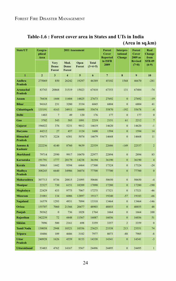
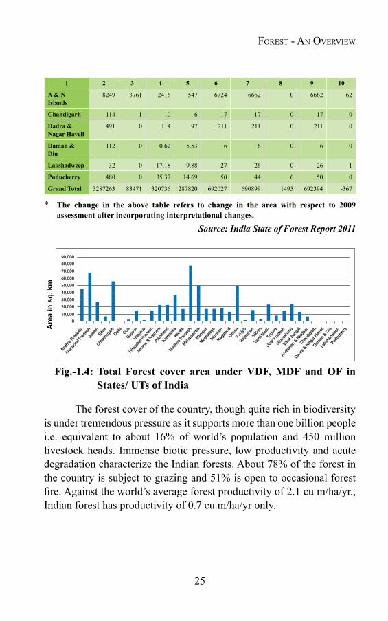
Though as per the India State Forest Report, 2009, the recorded forest area of the country was more than 23%, major chunk of this area is without any tree cover. Out of the total recorded forest area i.e. 769,512 sq. km, only 690,899 sq. km was under forest cover (the land mass having tree canopy of more than ten percent). Further, depending upon the crown density, the forest cover in the country has been classified into Very Dense Forest (VDF), Moderately Dense Forest (MDF) and Open Forest (OF). While the forest land with tree canopy of more than 70% has been classified as Very dense, between 40% to 70% and between 10% to 40% have been put in categories of Moderately dense and Open forest, respectively. The state wise details of the forest cover under these three categories i.e. VDF, MDF & OF are given in Table-1.6 & Fig.-1.4.
Laksha
dweep
100,000
Are
a in
sq.
km
90,000
80,000
70,000
60,000
50,000
40,000
30,000
20,000
10,000
0
Andhra
Pradesh
Arunach
al Prad
esh
Assam
Bihar
Chhatt
isgarh
Delhi
Goa
Gujarat
Haryan
a
Himachal P
radesh
Jammu &
Kashmir
Jharkh
and
Karnata
kaKera
la
Madhya
Pradesh
Mahara
shtra
Manipu
r
Megha
laya
Mizoram
Nagala
ndOdis
haPun
jab
Rajasth
anSikk
im
Tamil N
aduTri
pura
Uttar Prad
esh
Uttarakh
and
West Beng
al
Andham
an & Nico
bar
Chand
igarh
Dadra &
Nagar H
aveli
Daman
& Diu
Puduc
herry
Forest - An overview
24
Forest Fire Disaster ManageMent
Table-1.6 : Forest cover area in States and UTs in India(Areainsq.km)
State/UT Geogra- phical Area
2011 Assessment Forest Cover
Reported in ISFR
2009
Interpre-tational Change
Forest Cover
2009 as Revised (7+8)
Real Change
from SFR-09 (6-9)Very
Dense Forest
Mod. Dense Forest
Open Forest
Total (3+4+5)
1 2 3 4 5 6 7 8 9 10
Andhra Pradesh
275069 850 26242 19297 46389 45102 1568 46670 -281
Arunachal Pradesh
83743 20868 31519 15023 67410 67353 131 67484 -74
Assam 78438 1444 11404 14825 27673 27692 0 27692 -19
Bihar 94163 231 3280 3334 6845 6804 0 6804 41
Chhattisgarh 135191 4163 34911 16600 55674 55870 -192 55678 -4
Delhi 1483 7 49 120 176 177 0 177 0
Goa 3702 543 585 1091 2219 2151 61 2212 7
Gujarat 196022 376 5231 9012 14619 14620 0 14620 -1
Haryana 44212 27 457 1124 1608 1594 0 1594 14
Himachal Pradesh
55673 3224 6381 5074 14679 14668 0 14668 11
Jammu & Kashmir
222236 4140 8760 9639 22539 22686 -149 22537 2
Jharkhand 79714 2590 9917 10470 22977 22894 0 2894 83
Karnataka 191791 1777 20179 14238 36194 36190 0 36190 4
Kerala 38863 1442 9394 6464 17300 17324 0 17324 -24
Madhya Pradesh
308245 6640 34986 36074 77700 77700 0 77700 0
Maharashtra 307713 8736 20815 21095 50646 50650 0 50650 -4
Manipur 22327 730 6151 10209 17090 17280 0 17280 -190
Meghalaya 22429 433 9775 7067 17275 17321 0 17321 -46
Mizoram 21081 134 6086 12897 19117 19240 -57 19183 -66
Nagaland 16579 1293 4931 7094 13318 13464 0 13464 -146
Orissa 155707 7060 21366 20477 48903 48855 0 48855 48
Punjab 50362 0 736 1028 1764 1664 0 1664 100
Rajasthan 342239 72 4448 11567 16087 16036 0 16036 51
Sikkim 7096 500 2161 698 3359 3357 2 3359 0
Tamil Nadu 130058 2948 10321 10356 23625 23338 213 23551 74
Tripura 10486 109 4686 3182 7977 8073 -88 7985 -8
Uttar Pradesh
240928 1626 4559 8153 14338 14341 0 14341 -3
Uttarakhand 53483 4762 14167 5567 24496 24495 0 24495 1
25
1 2 3 4 5 6 7 8 9 10
A & N Islands
8249 3761 2416 547 6724 6662 0 6662 62
Chandigarh 114 1 10 6 17 17 0 17 0
Dadra & Nagar Haveli
491 0 114 97 211 211 0 211 0
Daman & Diu
112 0 0.62 5.53 6 6 0 6 0
Lakshadweep 32 0 17.18 9.88 27 26 0 26 1
Puducherry 480 0 35.37 14.69 50 44 6 50 0
Grand Total 3287263 83471 320736 287820 692027 690899 1495 692394 -367
* The change in the above table refers to change in the area with respect to 2009 assessment after incorporating interpretational changes.
Source: India State of Forest Report 2011
Fig.-1.4: Total Forest cover area under VDF, MDF and OF in States/ UTs of India
The forest cover of the country, though quite rich in biodiversity is under tremendous pressure as it supports more than one billion people i.e. equivalent to about 16% of world’s population and 450 million livestock heads. Immense biotic pressure, low productivity and acute degradation characterize the Indian forests. About 78% of the forest in the country is subject to grazing and 51% is open to occasional forest fire. Against the world’s average forest productivity of 2.1 cu m/ha/yr., Indian forest has productivity of 0.7 cu m/ha/yr only.
Forest - An overview
26
Forest Fire Disaster ManageMent
1.5 Significanceofforests1.5.1 Since ancient times forests have been integral parts of Indian society. Ancient literature of Hindu Mythology like Puranas, Vedas etc. have mentioned the significance of this natural resource for the community. Forests have not only proved significant for economic utility, but also influenced the social and economic life of the mankind, modified their views and provided new thoughts to poets and artists too. Number of different scriptures in the past have talked about these roles of forests. The Agni Purana (Hindu Scripture) while discussing the role of forests in human life goes so far as to say "That Man who plant trees for the welfare of the public obtains obsolete bliss." The Geeta (Another Hindu Scripture) mentions "Living beings survive on food. Food is produced by rain, rain depends on forests. Therefore, conservation of forests is necessary to keep it in a healthy state."
Our historical past is full of examples, which show that our ancestors recognizing forest’s significance tried their best to conserve and protect this valuable natural resource. Not only in the past, but in Modern Indian Society also forests are treated sacred and there are many evidences when different sects of Indian Society at times have raised voice against deforestation successfully. “Chipko Movement” of Uttarakhand is the recent example of such awareness in our society.
But unfortunately this awareness is restricted to very limited section of our society and a major population in the country is still unaware about significance of forests. As a result, the forests of the country are suffering at the hand of its own people. In such circumstances, it is very important that people are made aware of the significance of forests, so that they themselves take initiative to protect and conserve them successfully. Some of the significant features of forests are as follows:
1.5.2 Socio-economicsignificanceoftheforests
Forestry makes several contributions, which are supporting sustained human welfare. These include direct benefits (physical

27
products such as wood, food, medicines, fuel, fodder, fiber and organic fertilizer) as well as indirect and attributable benefits. As an inseparable component of the total land use systems, forestry has significant inter-relationship with agricultural, pastoral and food-producing systems also. Through soil and water conservation and maintenance of soil fertility, forestry provides critical support for agricultural development. In addition, forest-based enterprises help increase rural employment and raise income and living standards of rural people, including forest dwellers and indigenous groups. The quality of life in rural areas depends upon the management of adjacent forests. Some of the following figures, especially in Indian context clearly show importance of forests.
● Over two-thirds of rural and half of the urban population use fuel wood for cooking purposes.
● About a quarter of India’s livestock population, which is the largest in the world, is almost totally dependent on forestlands.
● About 70 per cent of India’s population uses traditional medicine (mainly forest-based), and many of the rural poor have no access to other systems of medicine.
● Forest-based activities are often an important source of cash income for the poor, especially during lean seasons.
● The wild relatives of avocado, banana, cashew, cacao, cinnamon, coconut, coffee, grapefruit, lemon, paprika, oil, palm, rubber etc. worth billion of rupees are found in tropical forests.
1.5.3 Livelihood Generation
Forestry is a comparatively labour-intensive activity. Forests and the diverse forest-based enterprises provide direct and indirect employment. As per Global Forest Resources Assessment (GFRA) 2010 about ten million people are employed in forest management and conservation globally, but many more are directly dependent on forest for their livelihood.. It is estimated that about 250 million person days are generated annually under various plan schemes taken up for forestry development in forest areas and other government lands. In
Forest - An overview
28
Forest Fire Disaster ManageMent
addition, about 75 million person days are generated annually under agro-forestry and farm-forestry programmes. Non-plan activities, which include protection, maintenance and harvesting of forests, are estimated to generate about 100 million person days. Forests provide considerable employment to rural poor and tribal people in and around forest areas, who make a living either by consumption or sale/barter of various produce collected from the forest. The employment generated in the processing of the forest produce, both in the organized and unorganized sector, is also considerable.
1.5.4 Forests and Tribal population
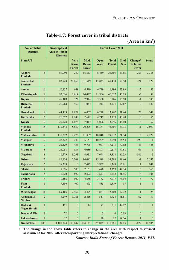
Tribal population has intimate relationship with forests. Socio-cultural and socio-economic pattern of the tribal population are inextricably linked with forests. Forests are source of subsistence and livelihood for the tribal communities. The tribal population is spread over in almost 188 districts of 26 states/ UTs in the country. This tribal land is very rich in forest, where almost 37.32% of the area is under forest (Table-1.7). The tribal population is very intimately related with the forest and depends on forest for its many needs viz.-
Food in the forms of yams and other tubers, mushroom, bamboo shoots, several kinds of fruit and nuts, honey, red ants, eggs and meat;
Fiber from the barks of trees and climbers, with which to fashion different kinds of rope and even clothes;
Herbal Medicine, for common ailments;
Oils, from seeds of different plant species for cooking, medicine and other purposes;
Wood for building, agricultural implements and fuels;
Bamboo- for fences and buildings, other daily use articles like baskets, bows, arrows and flutes;
Twigs, used as toothbrushes, etc.
29
Table-1.7: Forest cover in tribal districts(Areainkm2)
No. of Tribal Districts
Geographical Area in Tribal
Districts
Forest Cover 2011
State/UT Very Dense Forest
Mod. Dense Forest
Open Forest
Total Forest
% of G.A
Change* in forest
cover
Scrub
Andhra Pradesh
8 87,090 239 16,613 8,449 25,301 29.05 -266 2,368
Arunachal Pradesh
13 83,743 20,868 31,519 15,023 67,410 80.50 -74 122
Assam 16 50,137 648 4,599 6,749 11,996 23.93 -12 93
Chhattisgarh 9 92,656 3,614 24,477 11,966 40,057 43.23 -3 89
Gujarat 8 48,409 322 2,944 3,500 6,766 13.98 -1 393
Himachal Pradesh
3 26,764 950 1,067 1,214 3,231 12.07 0 139
Jharkhand 8 44,413 1,677 6,067 6,218 13,962 31.44 73 341
Karnataka 5 26,597 1,248 7,642 4,249 13,139 49.40 0 55
Kerala 9 27,228 1,073 7,017 5,006 13,096 48.10 -13 52
Madhya Pradesh
18 139,448 5,639 20,275 16,387 42,301 30.33 -11 2,097
Maharashtra 11 138,272 7,275 11,389 10,848 29,512 21.34 3 2,127
Manipur 9 22,327 730 6,151 10,209 17,090 76.54 -190 1
Meghalaya 7 22,429 433 9,775 7,067 17,275 77.02 -46 485
Mizoram 8 21,081 134 6,086 12,897 19,117 90.68 -66 1
Nagaland 8 16,579 1,293 4,931 7,094 13,318 80.33 -146 3
Orissa 12 86,124 5,268 14,442 13,588 33,298 38.66 -1 2,552
Rajasthan 5 38,218 0 2,442 3,907 6,349 16.61 1 941
Sikkim 4 7,096 500 2,161 698 3,359 47.34 0 363
Tamil Nadu 6 30,720 697 2,392 3,653 6,742 21.95 18 404
Tripura 4 10,486 109 4,686 3,182 7,977 76.04 -8 72
Uttar Pradesh
1 7,680 409 475 435 1,319 17 -1 1
West Bengal 11 69,403 2,962 4,475 4,863 12,300 17.72 1 28
Andaman & Nicobar
2 8,249 3,761 2,416 547 6,724 81.51 62 57
Dadra & Nagar Haveli
1 491 0 114 97 211 42.97 0 1
Daman & Diu 1 72 0 1 3 4 5.03 0 0
Lakshadweep 1 32 0 17 10 27 84.56 1 0
Grand Total 188 1,105,744 59,849 194,173 157,859 411,881 37.25 -679 12,785
• The change in the above table refers to change in the area with respect to revisedassessment for 2009 after incorporating interpretational changes.
Source: India State of Forest Report- 2011, FSI.
Forest - An overview
30
Forest Fire Disaster ManageMent
1.5.5 Forest as integral component of water cycle
Forest is the best water manager of the earth ecosystem. Forests absorb rainwater and release it gradually into streams, preventing flooding and extending water availability into dry months, when it is most needed. Some 40% of third world farmers depend on forested watersheds for water to irrigate crops or for livestock. As per GFRA report 2010 around 330 million hectares of forests are designated for soil and water conservation, avalanche control, sand dune stabilization, coastal protection etc. In India, forests provide water regulation and flood control valued at $72 billion per year. They also keep soil from eroding into rivers. Silting of reservoirs costs the world economy about $8 billion per year in lost hydroelectricity and irrigation water. Forest helps in reducing siltation in the rivers and reservoirs in an effective manner.
1.5.6 Forest as source of Gene pool
Forest vegetation provides the gene pool that can protect commercial plant strains against pests and changing conditions of climate and soil and also provide the raw material for breeding higher-yielding strains.
1.5.7 Forest as conservator of biological diversity
Biological diversity encompasses the variety of life forms, the ecological roles they perform and the genetic diversity they contain (FAO- 1989). In forests biological diversity allows species to evolve and adapt, to maintain the potential for tree breeding and movement and to support their ecosystem. As per GFRA- 2010 at present about 12 percent of the world's forests are designated for the conservation of the biological diversity.
1.5.8 Natural climate stabilizer
Forests stabilize climate and work as natural air conditioner. They work as store houses for Carbon and as per an estimate the world’s
31
forest at present stores around 289 gigatonnes of Carbon in their biomass (GFRA, 2010). Deforestation releases greenhouse gases, viz. carbon dioxide, methane and nitrous oxide, which accounts for 25 per cent of the warming effect of all greenhouse gas emissions. Replacing the carbon storage function of all tropical forests would cost an estimated $3.7 billion-equal to the gross national product of Japan. Forest, by working as natural air conditioner helps in climate stabilization.
1.5.9 Forests- source for recreation
Forests serve people directly for recreation. National Parks, wild life sanctuaries, bird sanctuaries and other forest associated recreation attract millions of tourists every year and earn good amount of revenue.
In addition to above mentioned benefits, forests contribute significantly in the following ways-
● Forests afford protection to wildlife against strong cold (or hot) & dry winds.
● It affords protection against adverse effects of solar radiation. ● They help in balancing carbon-di-oxide & oxygen of the atmosphere. ● Forests maintain fertility of the soil by returning nutrients to it
through litter. ● Forests regulate the earth’s temperature regime & water cycle. ● Forests check soil erosion, landslides, shifting of sands & silting. ● Forests reduce danger of floods. ● The forests help in biological rejuvenation of soils by opening soil
and improve it by adding organic litter or humus.
Forest - An overview

Chapter 2
THE DIMINISHING FOREST COVER AND FOREST FIRE
2.1 IntroductionForests have had historical similarities throughout the world.
When the population was small, forests were plentiful and provided most of the basic needs. With the shift from a nomadic existence to a settled livelihood by man, forests were cleared for agriculture and habitations. In due course of time, society recognized the need to manage forests as a resource for its benefit and earning revenue, ultimately resulting into forest depletion. When forests were plentiful, the impact of deforestation was not much and the eco-balance between human being and its environment was still maintained. However, with increasing need and demand for forest produce this impact became more visible and deteriorating.
Though deforestation / forest degradation has been a worldwide phenomenon, it has affected developing countries more adversely. The poor socio-economic condition of the people in these countries (increasing their dependency on natural forests) has been the major cause for deterioration.
2.2 Global ScenarioBefore pre-agriculture period, forests in the world were almost
intact. With the invasion of agriculture, the prehistoric man started clearing forest for farming land leading to non-ending process of deforestation, which persists till date. As per an estimate, since pre- agriculture period almost 900 million hectares of forestland has been deforested by man. The historical evidences suggest that situation was not much deteriorated till 1000 years ago, when the forests were almost

33
stable and covered around 34 per cent of the land. But with the onset of industrialization and demand for land and timber, forest cover began growing threadbare in scattered parts of Europe, Central America, China and India. Two centuries ago, the thinning spread, leaving parts of Europe and China bare, while only a century ago, and in the wake of the Industrial Revolution, eastern North America was deforested. Still little had changed and forests covered almost 32 per cent of the land during the period.
However, in the recent past i.e. 50 years ago this change has accelerated explosively. Vast tracts of forest have vanished from the Far East and the mainland of South-East Asia; Central America, western North America and eastern South America, the Indian subcontinent and sub-Saharan Africa, the Amazon Basin and Central Europe. As per the Food and Agriculture Organization-U.N. “Production Year Book”, 1987, during the period 1975 to 1985, the average loss of the forest has been about two percent. During these ten years, about eighty million hectares of the forest was lost (Table-2.1). According to the GFRA Report, the situation improved a bit after 1990. The global forest area was reduced by around 8.3 million hectares (0.2%) per year between 1990 and 2000 and by around 5.2 million hectares (0.1%) per year between 2000 and 2010. The forest area has reduced in most regions since 1990, except Europe (where the area increased in both the decades) and Asia (where the area reduced between 1990 and 2000 but has increased between 2000 and 2010) (GFRA, 2010) (Table-2.2 and Fig.-2.1).
Between 2000 and 2010, the largest decrease in forest area was in Brazil (2.6 million hectares per year on average) and the largest increase was in China (3.0 million hectares per year on average).
Table-2.1: Net Change in Areas of Forest and Woodland 1975-85Global Region Area in million hectares Change in per centWorld -82.9 -1.99Developed world -12.9 -0.70Developing world -70.0 -3.01
Source: FAO- U.N. “Production Year Book”, 1987
The Diminishing ForesT Cover AnD ForesT Fire
34
Forest Fire Disaster ManageMent
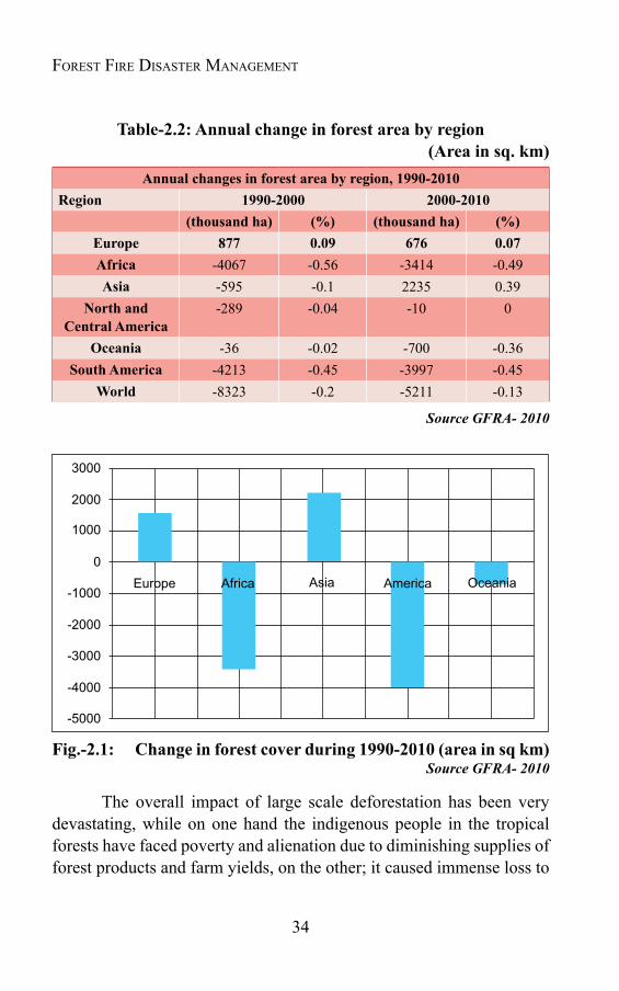
Table-2.2: Annual change in forest area by region(Areainsq.km)
Annual changes in forest area by region, 1990-2010Region 1990-2000 2000-2010
(thousandha) (%) (thousandha) (%)Europe 877 0.09 676 0.07Africa -4067 -0.56 -3414 -0.49Asia -595 -0.1 2235 0.39
North and Central America
-289 -0.04 -10 0
Oceania -36 -0.02 -700 -0.36South America -4213 -0.45 -3997 -0.45
World -8323 -0.2 -5211 -0.13
Source GFRA- 2010
Fig.-2.1: Changeinforestcoverduring1990-2010(areainsqkm)Source GFRA- 2010
The overall impact of large scale deforestation has been very devastating, while on one hand the indigenous people in the tropical forests have faced poverty and alienation due to diminishing supplies of forest products and farm yields, on the other; it caused immense loss to
3000
Europe Asia
2000
1000
0
-1000
-2000
-3000
-4000
-5000
America OceaniaAfrica
35
environment and ecology. There have been profound ecological effects of forest loss, as evident in the exacerbation of droughts and floods, release of heat trapping temperatures, advent of new pests into cropped lands, much sedimentation in river beds and hydroelectric reservoirs, and loss of productive fisheries.
The decline in forests along with other adverse effects also threatened the genetic diversity of the world’s plants and animals. The World Conservation Union calculated that about 12.5 per cent of the world’s 270,000 species of plants and about 75 per cent of the world’s mammals are threatened by forest decline (McNeely et al., 1990). The Commission concluded that “forests can no longer be used in the same way as they have been in the past. Forest products and services must be assured through new political choices and policy decisions that ensure the survival of forests.”
2.3 Growing pressure on forest in IndiaDue to various monogenetic reasons, the pressure on natural
forest is increasing throughout the world. The forests today have at least five times more pressure than what they can withstand. Like many other developing countries, forests in India are also under tremendous pressure mainly as a result of increased demand for forest produce viz. fuel, fodder, timber, non timber forest produce (NTFP) etc. by ever exploiting population of the country. Presently a major chunk of forest area in the country is under illegal encroachment. The collection of fuel wood is considerably higher than what can sustainably be removed from the forests. Forests also contribute major percentage of the fodder requirement for the cattle, including 178 million tons of green fodder and 145 million tons of dry fodder. It has been estimated that half of the livestock population i.e. 270 millions graze in forests. This demand gets accentuated due to the extraction of green fodder to the tune of 175-200 million ton annually.
Currently people occupy around 1.5 million hectares of forestland for agricultural purposes. The trend of diversion of forestlands for non-
The Diminishing ForesT Cover AnD ForesT Fire

36
Forest Fire Disaster ManageMent
forestry purposes though arrested after the Forest Conservation Act, 1980 came into force, still continues. These effects cumulatively cause loss of ecological stability and bio-diversity, reduction in carbon sink capability, climate change, floods, droughts, desertification, damages to watersheds, silting of reservoirs, estuarine & river beds, changes in hydrological regimes, etc. According to World Bank, approximately 10 million hectares of land mass is reported to be under shifting cultivation, involving several million people spread over 16 states in India. According to Forest Survey of India estimate 53-54% of the forest area is annually affected by forest fires incidence (mostly due to practices such as agriculture and shifting cultivation).
The maximum forest loss in India has been estimated between 1950 and 1980, just before the enactment of Forest Conservation Act. During this period, a huge forest area was allotted to various sectors in the name of development. The non-forestry uses, for which forest area was converted during the period included agriculture, river valley projects, industries/ townships, transmission, roads etc. (Table-2.3 & Fig.-2.2).
Table-2.3: Diversion of forest land for non-farming purposes between 1951 and 1980
Purpose Area covered in million hectaresAgriculture 2.623River valley projects 0.502Industries and Townships 0.134Transmission lines and roads 0.061Miscellaneous 1.008Total 4.328
Sources: The State of Forest Report 1987, FSI; Forestry Statistics India, 1995, ICFRE, Dehradun
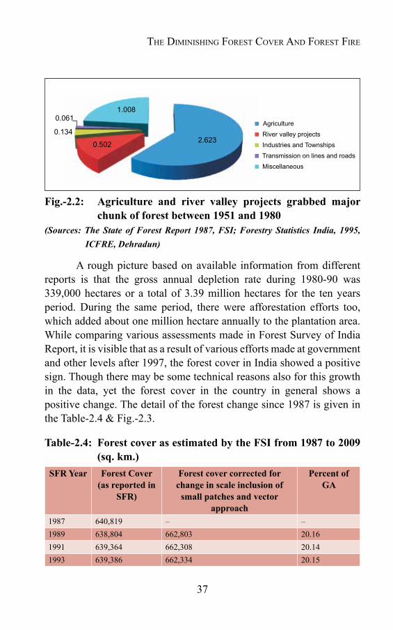
37
Fig.-2.2: Agriculture and river valley projects grabbed majorchunk of forest between 1951 and 1980
(Sources: The State of Forest Report 1987, FSI; Forestry Statistics India, 1995, ICFRE, Dehradun)
A rough picture based on available information from different reports is that the gross annual depletion rate during 1980-90 was 339,000 hectares or a total of 3.39 million hectares for the ten years period. During the same period, there were afforestation efforts too, which added about one million hectare annually to the plantation area. While comparing various assessments made in Forest Survey of India Report, it is visible that as a result of various efforts made at government and other levels after 1997, the forest cover in India showed a positive sign. Though there may be some technical reasons also for this growth in the data, yet the forest cover in the country in general shows a positive change. The detail of the forest change since 1987 is given in the Table-2.4 & Fig.-2.3.
Table-2.4: Forest cover as estimated by the FSI from 1987 to 2009 (sq.km.)
SFR Year Forest Cover (asreportedin
SFR)
Forest cover corrected for change in scale inclusion of
small patches and vector approach
Percent of GA
1987 640,819 – –1989 638,804 662,803 20.161991 639,364 662,308 20.141993 639,386 662,334 20.15
Agriculture River valley projects Industries and Townships Transmission on lines and roads Miscellaneous
0.061
0.134
1.008
0.502 2.623
The Diminishing ForesT Cover AnD ForesT Fire
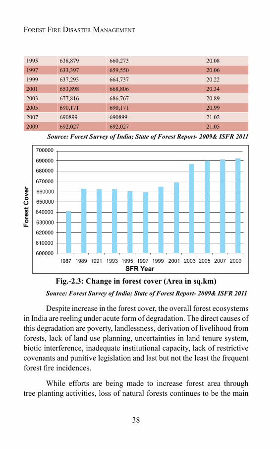
38
Forest Fire Disaster ManageMent
1995 638,879 660,273 20.081997 633,397 659,550 20.061999 637,293 664,737 20.222001 653,898 668,806 20.342003 677,816 686,767 20.892005 690,171 690,171 20.992007 690899 690899 21.022009 692,027 692,027 21.05
Source: Forest Survey of India; State of Forest Report- 2009& ISFR 2011
Fig.-2.3:Changeinforestcover(Areainsq.km)Source: Forest Survey of India; State of Forest Report- 2009& ISFR 2011
Despite increase in the forest cover, the overall forest ecosystems in India are reeling under acute form of degradation. The direct causes of this degradation are poverty, landlessness, derivation of livelihood from forests, lack of land use planning, uncertainties in land tenure system, biotic interference, inadequate institutional capacity, lack of restrictive covenants and punitive legislation and last but not the least the frequent forest fire incidences.
While efforts are being made to increase forest area through tree planting activities, loss of natural forests continues to be the main
SFR Year1989
700000
690000
680000
670000
660000
650000
640000
630000
620000
610000
6000001987
Fore
st C
over
1991 1993 1995 1997 1999 2001 2003 2005 2007 2009
39
concern for the country. Tree planting and social forestry activities cannot fully compensate for the loss of natural forests, since they have very different attributes. The remaining natural forests, and as well as the forest plantations) are becoming progressively degraded due to overuse and lack of protection. The deterioration of the quality, stocking condition and productivity of forests is a matter of serious concern, as is deforestation.
2.4 Forest degradation and its impactDespite that the overall forest cover in the country is on increase,
most of the forest areas in the country are ecologically in various stages of retrogression. The forest ecosystems are reeling under acute form of degradation, which has adversely affected the Indian society, both socially and economically. Owing to various other factors, the deterioration of the forest is the major cause for increase in both physical as well as socio-economic vulnerability of country to disasters. It has been widely accepted that deforestation increases the intensity of natural disasters and is often the factor that transforms a natural hazard or climatic extreme into a disaster
In ecologically more sensitive and destabilized areas like Himalayas and Western Ghats, the impact of deforestation/ degradation has been more severe. In the recent past, as a result of so called developmental activities, particularly in sensitive regions, the environment has been very adversely affected, resulting into exponential increase in fragility of land mass.
Deforestation and other allied land degradation activities such as water logging, flooding, ravines, shifting cultivation, mining, salinisation, soil erosion, landslides / rock falls and desertification have affected more than half of the total geographical area of the country. The deforestation in the form of mangrove removal has made coastal regions of the country susceptible to erosion and damage to human settlements.
The deforestation and destruction of other natural resources have compelled people from rural areas to migrate in search of new
The Diminishing ForesT Cover AnD ForesT Fire
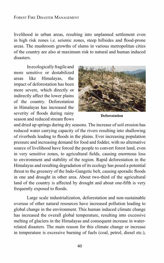
40
Forest Fire Disaster ManageMent
livelihood in urban areas, resulting into unplanned settlement even in high risk zones i.e. seismic zones, steep hillsides and flood-prone areas. The mushroom growths of slums in various metropolitan cities of the country are also at maximum risk to natural and human induced disasters.
In ecologically fragile and more sensitive or destabilized areas like Himalayas, the impact of deforestation has been more severe, which directly or indirectly affect the lower plains of the country. Deforestation in Himalayas has increased the severity of floods during rainy season and reduced stream flows and dried up springs during dry seasons. The increase of soil erosion has reduced water carrying capacity of the rivers resulting into shallowing of riverbeds leading to floods in the plains. Ever increasing population pressure and increasing demand for food and fodder, with no alternative source of livelihood have forced the people to convert forest land, even in very sensitive zones, to agricultural fields, causing enormous loss to environment and stability of the region. Rapid deforestation in the Himalayas and resulting degradation of its ecology has posed a potential threat to the greenery of the Indo-Gangetic belt, causing sporadic floods in one and drought in other area. About two-third of the agricultural land of the country is affected by drought and about one-fifth is very frequently exposed to floods.
Large scale industrialization, deforestation and non-sustainable overuse of other natural resources have increased pollution leading to global change in the environment. This human induced climate change has increased the overall global temperature, resulting into excessive melting of glaciers in the Himalayas and consequent increase in water-related disasters. The main reason for this climate change or increase in temperature is excessive burning of fuels (coal, petrol, diesel etc.),
Deforestation
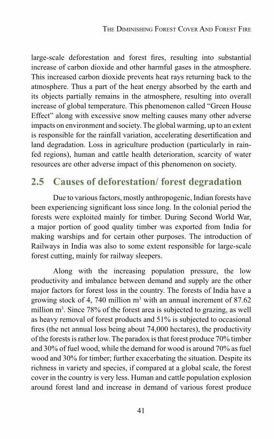
41
large-scale deforestation and forest fires, resulting into substantial increase of carbon dioxide and other harmful gases in the atmosphere. This increased carbon dioxide prevents heat rays returning back to the atmosphere. Thus a part of the heat energy absorbed by the earth and its objects partially remains in the atmosphere, resulting into overall increase of global temperature. This phenomenon called “Green House Effect” along with excessive snow melting causes many other adverse impacts on environment and society. The global warming, up to an extent is responsible for the rainfall variation, accelerating desertification and land degradation. Loss in agriculture production (particularly in rain-fed regions), human and cattle health deterioration, scarcity of water resources are other adverse impact of this phenomenon on society.
2.5 Causes of deforestation/ forest degradationDue to various factors, mostly anthropogenic, Indian forests have
been experiencing significant loss since long. In the colonial period the forests were exploited mainly for timber. During Second World War, a major portion of good quality timber was exported from India for making warships and for certain other purposes. The introduction of Railways in India was also to some extent responsible for large-scale forest cutting, mainly for railway sleepers.
Along with the increasing population pressure, the low productivity and imbalance between demand and supply are the other major factors for forest loss in the country. The forests of India have a growing stock of 4, 740 million m3 with an annual increment of 87.62 million m3. Since 78% of the forest area is subjected to grazing, as well as heavy removal of forest products and 51% is subjected to occasional fires (the net annual loss being about 74,000 hectares), the productivity of the forests is rather low. The paradox is that forest produce 70% timber and 30% of fuel wood, while the demand for wood is around 70% as fuel wood and 30% for timber; further exacerbating the situation. Despite its richness in variety and species, if compared at a global scale, the forest cover in the country is very less. Human and cattle population explosion around forest land and increase in demand of various forest produce
The Diminishing ForesT Cover AnD ForesT Fire

42
Forest Fire Disaster ManageMent
have adversely affected the Indian forests. Agriculture (including shifting cultivation), multipurpose projects, irrigation structures, industries, mining, quarrying for minerals, road construction, erection of transmission lines, and clearing for encroachments (industrialization, urbanization and human settlements) etc. have been some of the major factors responsible for the present poor situation of forests in the country.
In addition to these direct and visible reasons, many other socio-political and socio- economic factors responsible for poor state of the forests of the country are- poverty and unemployment, poor legislative provisions, impractical management tactics, gender inequality etc. Unlike the developed countries, the forest in the country is inextricably linked with socio-economic status of the society. The people living within or near the forests are directly or indirectly dependent on forests for their daily needs. Till recent past, due to low population pressure, this relationship had been very harmonious, however, with increasing demand, the situation deteriorated and as a result forests suffered adversely.
2.5.1 Demographic pressure and poor socio- economic condition
As mentioned earlier too, the increasing demographic pressure has been the major factor for deforestation. The growth in population has increased the demand for livelihood. Scarcity of other livelihood resources, especially in rural areas has forced people to exploit natural resources, particularly the forests. Along with demographic pressure, poverty has been another important factor, responsible for forest degradation. As per the Planning Commission of India about 37% of the country population is forced to survive below poverty line. Poor in the country are compelled to exploit natural resources for their survival. Dependency on forests for fuel, wood, grazing, encroachment etc. is the issues that is directly linked with the poverty (Fig.-2.4).
43
Fig.-2.4:AdverseimpactsofDeforestation(Satendra,2003)
2.5.2 Increasing demand for fuel wood and timberFuel wood burning is the major source of energy for cooking
and other small scale industries in India .The consumption of fuel wood in our country is about five times higher than what can sustainably be removed from forests. Fuel wood meets about 40% energy needs of the country. The estimated fuel wood consumption in the country is about 320 million tones. About 70% of the fuel wood is accounted for by households and the rest by commercial and industrial units. Around 80% of the rural people and some 48% of urban people use fuel wood for cooking.
The Diminishing ForesT Cover AnD ForesT Fire
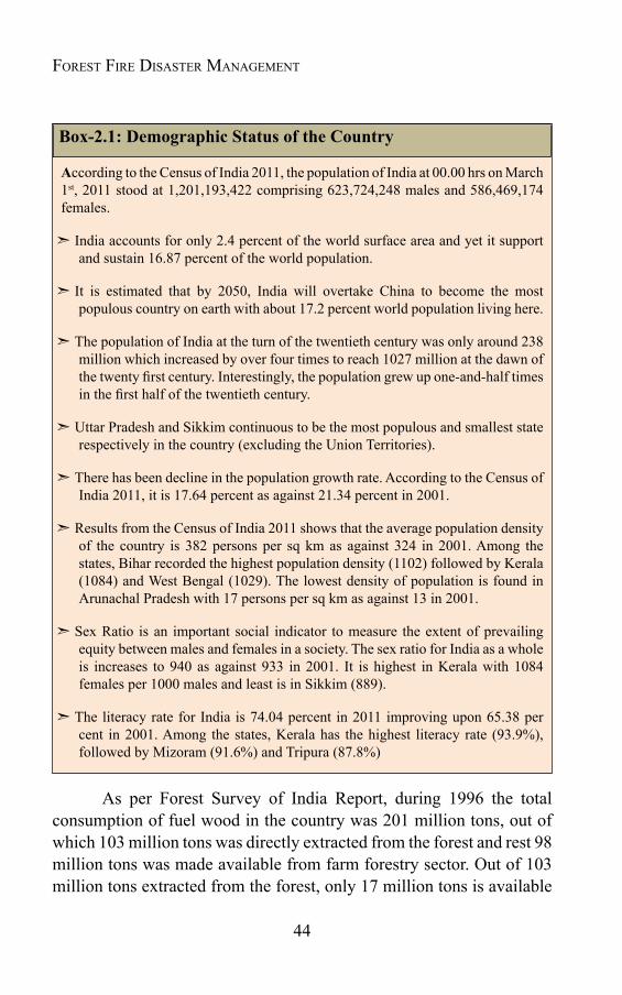
44
Forest Fire Disaster ManageMent
Box-2.1: Demographic Status of the Country
According to the Census of India 2011, the population of India at 00.00 hrs on March 1st, 2011 stood at 1,201,193,422 comprising 623,724,248 males and 586,469,174 females.
India accounts for only 2.4 percent of the world surface area and yet it support and sustain 16.87 percent of the world population.
It is estimated that by 2050, India will overtake China to become the most populous country on earth with about 17.2 percent world population living here.
The population of India at the turn of the twentieth century was only around 238 million which increased by over four times to reach 1027 million at the dawn of the twenty first century. Interestingly, the population grew up one-and-half times in the first half of the twentieth century.
Uttar Pradesh and Sikkim continuous to be the most populous and smallest state respectively in the country (excluding the Union Territories).
There has been decline in the population growth rate. According to the Census of India 2011, it is 17.64 percent as against 21.34 percent in 2001.
Results from the Census of India 2011 shows that the average population density of the country is 382 persons per sq km as against 324 in 2001. Among the states, Bihar recorded the highest population density (1102) followed by Kerala (1084) and West Bengal (1029). The lowest density of population is found in Arunachal Pradesh with 17 persons per sq km as against 13 in 2001.
Sex Ratio is an important social indicator to measure the extent of prevailing equity between males and females in a society. The sex ratio for India as a whole is increases to 940 as against 933 in 2001. It is highest in Kerala with 1084 females per 1000 males and least is in Sikkim (889).
The literacy rate for India is 74.04 percent in 2011 improving upon 65.38 per cent in 2001. Among the states, Kerala has the highest literacy rate (93.9%), followed by Mizoram (91.6%) and Tripura (87.8%)
As per Forest Survey of India Report, during 1996 the total consumption of fuel wood in the country was 201 million tons, out of which 103 million tons was directly extracted from the forest and rest 98 million tons was made available from farm forestry sector. Out of 103 million tons extracted from the forest, only 17 million tons is available
45
on sustainable basis and the rest 86 million tons is removed in excess, causing enormous damage to forest and its eco system.
The demand and supply data for fuel wood indicates an increasing gap. As major portion for this gap is filled from over exploitation of forest, beyond its carrying capacity, it gives an alarming signal for forest health. Not only fuel wood, the timber extraction is other major problem associated with forest degradation in the country. According to estimates made, about 64 million cubic meters timber was consumed in the country during 1996. Out of this, around fifty percent was directly extracted from the forests and rest was from the farm forestry.
2.5.3 Cattle grazing and fodder supply
India has the largest cattle population in the world. In the absence of adequate productive pasturelands and appropriate grazing policy, forests have become the major source of grazing and fodder. Grazing not only directly harm the forest, it also increase soil erosion and deteriorate soil quality, thus having adverse impact on forest regeneration and growth.
As per an estimate, around 60% of the livestock (about 300 million) graze in forests. These include traditional sedentary village livestock and migratory animals herded by ethnic grazers. Additionally, grazers collect about 175 million tones of green fodder annually, by lopping and harvesting grasses, which adversely affect regeneration of forests. A sample survey by Forest Survey of India estimates that the grazing affects approximately 78 per cent of country’s forests. Grazing occurs even in protected areas (67 percent of national parks and 83% of wildlife sanctuaries surveyed reported grazing incidences).
2.5.4 Illicit felling & encroachments
As a result of increased demand of wood, the pressure on forest has gone up, encouraging illicit felling. Illicit felling by timber mafia, fuel wood gatherers, land encroachers etc. is very common in India. The increasing demand of wood products and its increasing value has made
The Diminishing ForesT Cover AnD ForesT Fire
46
Forest Fire Disaster ManageMent
illicit felling a profitable business for timber mafia. The sandalwood, teak, rosewood, sals etc. are the major species, which are smuggled from forest by organised gangs. Due to increasing profit involved, these gangs are usually armed with sophisticated arms and ammunitions, which make the work of forest protection very difficult and risky. In some states, these gangs have become so powerful and daring that they do not hesitate in attacking senior forest and police officials also.
In addition to illicit felling, forest land encroachment for agriculture and other purposes has geared up in the recent past. The escalating land price has further accelerated this practice in rural and urban areas both. The most evident impact of weak forest protection practices is encroachment by violating forest boundaries through organized massive efforts. Boundaries also recede through illegal peripheral occupation by communities living around the forests. Though exact figures are not available for the cumulative deforested area resulting from forest encroachments, it is estimated that people illegally occupy about 1.5 million hectares of forest area for agriculture and other uses.
2.5.5 Development vs. Deforestation
With increasing population and subsequent development/industrialization, the demand of land has increased substantially. The major impact of this has been on forestland. One of the major factors leading to deforestation and / or forest degradation is transfer of forest land for various non-forestry uses. This forest land diversion, particularly for developmental projects has been very harmful for forest ecosystem. A development project starts destroying the forest even before it goes into production. The process begins with building of infrastructure in the form of roads, railway lines, offices, township, electricity etc.
Construction of roads in fragile belt of hilly areas affects the stability of hill slopes; damage the vegetation cover and the environment. The construction of roads has adversely affected the eco-balance in all the hill states of Himalayas and also in some southern States of
47
Nilgiri hills. After China War in 1962, the main emphasis of the Central Government was to increase connectivity in Himalayan region through roads. During this period even the interior villages were connected by roads. But the most unfortunate part of this development had been that these roads were constructed without giving much consideration to environmental issues. This activity has generated huge amount of debris and other waste, which ultimately became major factor for forest degradation and other environment related problems.
Industrialization and urbanization are two other major causes for forest degradation. After independence, availability of natural resource (forest, minerals, raw material etc.), electricity, communication and cheap labor have encouraged prospective industrialists to establish industries in various towns and cities of the country, resulting into environmental problems like pollution, deforestation etc.
Dam construction, obstructing the natural water flow, not only affects the ecological balance in an area but also causes environmental loss to natural resources and wildlife. Adversely attacking the forest regeneration and growth, construction of dams causes massive damage to forest and wildlife. A large part of the forest gets drowned under the reservoir. The labour force also causes destruction to forest for its fuel need. There is change in water table in the rocks/soil along the reservoir leading to increased soil erosion. The other reason for increased rate of erosion is clearance of vegetation in the upstream side.
Thus all unscientific development practices result into enormous loss to vegetation and environment. Keeping in view the severity of the problem the Government of India in 1980 enacted the Forest Conservation Act (FCA) with an objective to check diversion of forestland for non-forestry purposes. Forest Conservation Act stipulates that State governments or any other authority is prevented from diverting forest lands for non-forestry purposes and that prior approval of the central government is required for any such diversion. Wherever, diversion of forest land is unavoidable for developmental purposes, approvals granted to concern State governments are subject
The Diminishing ForesT Cover AnD ForesT Fire

48
Forest Fire Disaster ManageMent
to safeguards, which include compensatory afforestation on non-forest land with equivalent characteristics or double the area of forest land cleared. As result of enactment of Forest Conservation Act the rate of land diversion, approximately 1, 50,000 hectares per year between 1950 and 1980, fell to 25,000 hectares per year between 1980 and 1995. There has been a further decrease in the area of forest land diverted for non-forestry uses in the last few years to around 15,500 hectares per year (Table-2.5).
Table-2.5: DiversionofForest landfornonforestuse (SincetheEnforcementofForestConservationAct,1980)
Year ForestLandDiverted(areainsq.km)1980 Nil1981 2672.041982 3246.541983 5702.011984 7837.591985 10608.071986 11963.111987 72780.051988 18765.351989 20365.051990 138551.381991 625.211992 5686.941993 11785.641994 13527.691995 46158.521996 8764.791997 16313.201998 12630.00
Source: Ministry of Environment & Forests, DIG (FCA)
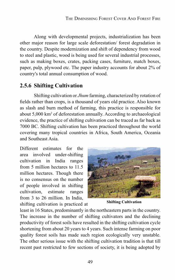
49
Along with developmental projects, industrialization has been other major reason for large scale deforestation/ forest degradation in the country. Despite modernization and shift of dependency from wood to steel and plastic, wood is being used for several industrial processes, such as making boxes, crates, packing cases, furniture, match boxes, paper, pulp, plywood etc. The paper industry accounts for about 2% of country's total annual consumption of wood.
2.5.6 Shifting Cultivation
Shifting cultivation or Jhum farming, characterized by rotation of fields rather than crops, is a thousand of years old practice. Also known as slash and burn method of farming, this practice is responsible for about 5,000 km2 of deforestation annually. According to archaeological evidence, the practice of shifting cultivation can be traced as far back as 7000 BC. Shifting cultivation has been practiced throughout the world covering many tropical countries in Africa, South America, Oceania and Southeast Asia.
Different estimates for the area involved under-shifting cultivation in India ranges from 5 million hectares to 11.5 million hectares. Though there is no consensus on the number of people involved in shifting cultivation, estimate ranges from 3 to 26 million. In India, shifting cultivation is practiced at least in 16 States, predominantly in the northeastern parts in the country. The increase in the number of shifting cultivators and the declining productivity of forest soils have resulted in the shifting cultivation cycle shortening from about 20 years to 4 years. Such intense farming on poor quality forest soils has made such region ecologically very unstable. The other serious issue with the shifting cultivation tradition is that till recent past restricted to few sections of society, it is being adopted by
Shifting Cultivation
The Diminishing ForesT Cover AnD ForesT Fire

50
Forest Fire Disaster ManageMent
more and more people. Many rural people, without secure access to land are also becoming shifting cultivators. Shifting cultivation is the major cause of forest fire. According to Forest Survey of India estimate (1995), 53 to 54 per cent of the forest area in India is annually affected by the incidence of forest fires (mostly from agricultural practices such as shifting cultivation).
2.6 Forestfire-themajorcauseofforestdegradationAlongwith other factors discussed, forest fire is a major cause of
injury and loss to forests. With the population increase, the frequency and subsequent damage due to forest fire is increasing day by day. The impact of the fire is diverse on the forest ecosystem. Besides directly damaging the forest trees, the fire also adversely affects forest regeneration, microclimate, soil erosion, and wild life etc. In most of the cases, the forest fire causes retrogression of forest vegetation. Forest fire is one of the major degenerating factors, which extensively damages the growing stock and its generations and making area vulnerable to erosion. It has wide-ranging adverse ecological, economic and social implications. Globally speaking, forest fires all over the world are under reported due to various factors. As per the information compiled in GFRA- 2010, on an average one percent of all forests were reported to be significantly affected by forest fire each year. However, the areas affected by fires are severely underreported, with information missing from many countries.
Forest fires in India are generally ground fires. About 35 million hectares of forest area is affected by fires annually. About 95 per cent of the forest fires are caused by human beings, especially to promote new flush of grasses, collection of minor forest produce or to prepare land for shifting cultivation. While statistical data on fire loss in India are very weak, it is estimated that the proportion of the forest areas prone to forest fire annually ranges from 33% to over 90% in different states. As per an estimate of the United Nations Development Programme and Food and Agriculture Organisation project in Maharashtra State, the economic loss due to forest fire is around Rs. 9000/- per hectare
51
per annum. If multiplied to the total forest cover of the country, this comes to a very substantial amount. The severity of the problem may be judged from the forest fire data of the year 1995 and 1999 in the two States- Uttar Pradesh and Himachal Pradesh where forest worth crores of rupees was turned to ashes during the period.
The Diminishing ForesT Cover AnD ForesT Fire

Chapter 3
FOREST FIRE AND ITS IMPACTS
3.1 IntroductionThe word “fire” evolved from the Greek word “pyra” meaning
growing embers. Fire is actually the heat and the light that results when three elements i.e. fuel, oxygen and the source are combined. The other elements, which determine the behavior of the fire, are weather, the landscape and the presence of the fuel. As far as the birth of fire is concerned, fire emerged on the earth with its origin only. From the time our planet came into existence, lightening has sparked landscape. Artificial or the human induced fire began when the earlier human being first rubbed two stones. Discovery of fire has been a revolutionary invention of human civilization. The nomadic life saw a sudden change in its life style after this invention. It is interesting to know that the first experience of fire, which ancient human being felt was of forest fire. Thus forest fire has been an integral part of human civilization. The discovery of fire has perhaps been one of the greatest innovations of all time. It had so much significance in the earlier history of mankind that they started worshipping it as God. In Indian mythology there are many evidences, where fire or Agni was worshiped and respected as Agni Devta. In Hindu mythology a full volume on Agni Purana already exists, which is solely about the praise of this mighty source of energy. Not only in Hindu Mythology, other ancient mythologies also have more or less description of fire in its religious books. In Greek mythology, fire has been considered one of the four essential elements, along with water, earth and air.
Forest fire may be defined as an unclosed and freely spreading combustion that consumes the natural fuels. Combustion is another word for fire. When a fire burns out of control it is known as Wild Fire.

53
Almost everyone basically knows what a fire looks and feels like, but in reality fire consists of four parts i.e. gas, flame, heat and smoke.
Fire Gas: These are the gases created by the combustion process. They are invisible to the naked eye, but they exist and include such poisonous substances as Carbon monoxide.
Flame: This is the light given off by the burning gas. As long as the three essential ingredients, fuel, oxygen, and heat are there, it can be seen.
Heat: This is the part of the fire that one feels as warmth. A normal fire usually burns at around 1,100º C.
Smoke: Smoke is a harmful vapor cloud mixed with a fine powder of solid particles and some gases. The solid particles in smoke create breathing and viewing problem during fire.
3.2 ForestfirethroughagesFire has been a major influencing factor on the development and
management of many of the world's forests. Some forest ecosystems have evolved in response to frequent fires from natural causes, but most others are susceptible to the effects of wildfire. Each year millions of hectares of the world's forests are consumed by fire, which results in enormous economic losses because of burnt timber; degraded real estate; high costs of suppression; damage to environmental, recreational and amnesty values; and loss of life.
Forest fires are not new to the world; they have burned across the earth for millions of years. Evidence of fires that burned in the past exists today in petrified trees that lived long ago and have over many years turned into hard rock. Some petrified trees have fossilized charcoal called “Fusain” in their trunks. The charcoal marks, which indicate that the tree was once in the path of a fire, are called fire scars on a living tree. All these evidences support that our temperate world’s forest ecosystem has developed with fire.
Forest Fire And its impActs
54
Forest Fire Disaster ManageMent
During prehistoric period, mankind used fire as a cultural tool. Of the many ways in which pre-historic man modified the forest, fire was effective enough to significantly influence the forest types. Fire, today is the single most important tool in converting tropical forests to agricultural land. Man in prehistoric time used fire to clear fields for cultivation, to drive game, and as a means of communication.
Thus forest fire since prehistoric time has been a part of man's cultural traditions and was not of much damage to forest ecosystem. Actually small and limited forest fires are integral part of the forest ecosystem and are very essential for healthy and proper growth and development of forests. However, the large uncontrolled fire badly damages the forest in many ways because of its increased intensity and frequency and also its uncontrollable nature. Forest fire has really become a matter of much concern for society.
3.3 Forestfire–partofecosystemFires in forests are not unnatural. It has been a natural part of
the ecosystem since origin of forest on this planet. Most of the fires are very useful and essential for good natural forest development and regeneration. Throughout historic time forest fires have been ignited and burned naturally through the forest. These low intensity fires in past kept the forest floor free from the natural annual build up of the litter i.e. tree needles, dead grass, senescent leaves & twigs, thick brush, and dead trees. As a result, fire has shaped vegetation patterns and wildlife distributions in the forests.
Fire effects on all forests are not equal. While same fire, beneficial for one ecosystem, may be dreadful for the other, depending upon the climatic conditions and type of vegetation. Tropical rain forests choked in fog and continuously drenched by mists and down pours are least affected by fires. In deciduous forests of temperate region, as a result of heavy rainfall and dampness and relatively high humidity, fire is very occasional and less damaging. Evergreen forests with broad leaves of dry areas and conifer forest are more susceptible to fire in general.

55
Fire severity affects the survival and establishment of many shrub species, organic matter consumption, soil heating and the biological response of soil, flora and fauna. The extent of soil heating depends on the physical characteristics of the fire, in particular to the quantity of fuel consumed. In some ecosystems, fire may be considered as a component of great importance, particularly in promoting primary productivity. Fire may also stimulate flowering, increase the branching behavior, seed production and seedling establishment.
Soil heating due to fire changes its chemical, physical and microbial properties. The direct chemical changes during soil heating and combustion of soil organic matter lead to a massive volatilization of simple nitrogenous compounds, mainly nitrate and ammonium and to some extent sulphur, phosphorus, and other ions depending on the fire intensity and temperature. But at the same time, fire transforms soil nitrogen bound in organic substances into ammonium, a form readily available to either plants or subsequent microbial nitrification. The increase in ammonium and nitrate concentrations in many ecosystems has also been reported as a result of fire incidences. This increase in the availability of nutrients (nitrogen, phosphorous and other mineral nutrients) is certainly beneficial for the vegetation and enhances its growth.
Prescribed burning is used as a way to put the fire back into a specific unit of land i.e. ecosystem. Fallen trees and limbs left to rot on the forest floor decay at a very slow rate. In fact, large logs can take more than hundred years to decompose. This process is aided by the numerous species of bacteria, insects, and wildlife that live in the decomposing materials. All this rotting is one way through which nature recycles nutrients back into the soil. Pine needles decompose very slowly. It takes more than a year for ten percent of the pine needles to decay. As a result, year after year, pine needles continue to build up until they are eliminated by fire. In brief, natural recycling is a very lengthy and time-consuming phenomenon in forest. Fire is the best process to intensify this natural process. Faster recycling occurs during a fire and gases are released into the atmosphere in the form of smoke.
Forest Fire And its impActs
56
Forest Fire Disaster ManageMent
In the burned area, nitrogen and other nutrient remains are leached back into the soil as rain soaks the ground. This is nature's way of rapidly feeding nutrients to the soil. Unfortunately, when there is too much fuel on the ground and it is burned, an intense severe fire occurs, where these benefits are often missing. Intense fire tends to scorch the ground and kill the trees. In brief, the forest needs both slow recycling from decomposition and fast recycling from fires.
Thus forest fires are not always harmful. Small and controlled fires in the form of prescribed burning are very essential and useful. In the absence of fire, vegetative changes may result in fuel loads far exceeding safety levels, which would pose a serious threat to forest if ignited. The small scale controlled fires provide social and ecological benefits too, like reducing risk of catastrophic forest fire, improving silvicultural opportunities, increasing forage and habitat opportunities for wildlife, enhancing biodiversity and so on.
3.4 Forestfire–asmanagementtoolAlthough fire has been the primary agent of deforestation, yet as a
natural process it serves an important function in maintaining the health of certain ecosystems. The traditional view of fire as a destructive agent requiring immediate suppression has given way to the view that fire can and should be used to meet land management goals under specific ecological conditions. For decades, controlled burning has been used as a genuine forest management measure in the developed countries. In western countries, especially Britain, U.S.A., Canada etc. controlled fires are burnt at intervals of 10-12 years to maintain uniform growth. In South and Southeast Asia, including India, “Slash and Burn” method of farming is used by the tribals of hilly areas, in which they cut down and burn small areas of the forest and use the cleared land for cultivation. This method of burning offers them not only the cheapest means to clear the forest, but also supplies free fertilizers in the form of ash from the burnt vegetation on limited scales.
Most of the limited fires are very useful and essential for good

57
natural forest development and regeneration. Many cultures have stories about great fire creatures and recognize fire as a part of nature. The Egyptians believed story of a brightly colored bird named the Phoenix, which lived for as long as 600 years! At the end of its life the Phoenix would burn itself in a fire. The new Phoenix would then live for another 600 years. Fire was a way for the Phoenix to renew itself.
Natural resource managers use fires as a means to renew the natural environment. To protect natural resources and keep the environment healthy, managers study an area and write a fire prescription for that area. A prescription indicates when trained professionals ignite fire or how long a fire ignited by lightening will be allowed to burn. A prescription may include the information that how wet fuels must be, the maximum speed wind may be blowing or the highest outside temperature. Fire managers
suggest exact fire prescriptions before burning is allowed. These fire prescriptions are based on weather, moisture content of the fuels, and how the fire can be lighted (ignition patterns).
This prescribed fire called "management-ignited prescribed fires" allows natural processes to occur. Such fires are permitted usually in large parks or forests that have a prescribed fire plan (a prescription) and where humans and their property are not in danger. When a management-ignited fire occurs or when a fire is started by a lightning strike (also called a prescribed natural fire), the blaze is monitored daily by fire experts. Laws and regulations also determine when a prescribed fire may be ignited. Air quality regulations play an important role during such process. Prescribed burning takes place when laws, regulations, and forest needs are all in balance. Prescribed burnings don't take place when there are safety, health, and aesthetic concerns.
Phoenix
Forest Fire And its impActs
58
Forest Fire Disaster ManageMent
3.5 Forestfire-abadmaster“Fire is a good servant but a bad master” the saying is true
for forest fire too. Limited and controlled forest fires have been very useful and essential for healthy forest growth. But uncontrolled forest fire may engulf and destroy healthy thick forest cover within no time. Besides direct loss to forest cover, forest fire also kills wildlife, damages environment, degrade soil quality and retrogrades forest regeneration. Since historical times, forest throughout the world has been adversely affected by fire. Fire always causes many direct or indirect effects on the forest ecosystem. They may merely be beneficial but at most of the times these effects are deteriorating. The damage to a forest by fire depends mainly on size of the fire.
The main adverse impact of the uncontrollable forest fire includes damage to growing stock of forests, loss of biodiversity, increase in soil erosion, scorching of soil and reduction in its permeability and water retaining capacity and volatization of the nutrients like Nitrogen. Not only for forest vegetation and environment, the forest fire causes direct loss to human being also in the form of damage to life and property. Extreme forest fire burns thousand of houses and kills many human beings and cattle throughout the world. As reported in the Global Forest Resources Assessment (GFRA), 2010 the recent examples of human lives loss due to forest fire include- Victoria in Australia in 2003 causing 73 fatalities and Greece fires in 2007 resulting into 70 deaths. Large uncontrolled forest fires result into health problems due to fire generated smoke. Breathing problems, skin irritation, loss of visibility and other related problems are very common during forest fires. Researchers have revealed that extreme forest fires may create conditions, which ultimately result into floods and landslides, causing enormous loss to life and property. The loss to timber increment, loss of soil fertility, soil erosion, loss of employment, drying up of water sources and loss to bio-diversity are immeasurable losses by forest fire.
Forest fires during the summer of 1995 and 1999 in the Himalayan hills give an idea about the damage forest fires may result into. These

59
fires were very severe and attracted the attention of whole nation. Fires that affected an area of 6, 77,700 hectares resulted into quantifiable timber loss worth around crores of rupees. The fires also created heavy smoke in the region, which covered the surrounding area for quite a few days. These fires caused changes in the microclimate of the area in the form of soil- moisture balance and increased evaporation.
Not only the large fires, but in certain cases the small fires may also cause immense loss. In the month of February, 2001, one small fire in the Gwar Forest area of Rudraprayag district, Uttarakhand claimed four lives and injured many more. The fire broke out in a grass field, when some women were busy in harvesting the fodder grass.
3.6 Componentsofforestfire3.6.1 Fire is the naturally occurring companion of energy released in the form of heat and light, when oxygen combines with a combustible or burnable material at a suitable high temperature (about 617 degrees F, temperature or 325 degrees C for wood to burn). There are basically three components i.e. fuel, heat and oxygen that are needed in right combination to produce fire. Combination of these components, produces the “fire triangle”. By nature, triangle needs three sides, missing of any of the one side will collapse the triangle. The same is true for fire. Take away any of the three components of fire - fuel, heat or oxygen, the fire collapses. Firefighters to suppress the fire, try to do just that and remove one of the three essential components of fire.
Fig.-3.1:ForestfiretriangleSource: Forest Encyclopedia Network & Ward, 2001
Forest Fire And its impActs
60
Forest Fire Disaster ManageMent
With a steady supply of oxygen (a fire needs air that contains at least 16 percent oxygen; the earth’s atmosphere contains 21 percent oxygen), fuel and temperature become critical for sustaining a fire once it is ignited. The general relationship between fuel and temperature is simple: the more fuel, higher the heat; the more heat, the faster the fire spreads. When there is plenty of heat and fuel, fires start at its own. In the words of one fire behavior expert, “Large fires live to feed themselves.” Large fires can create their own winds and weather, increasing flow of oxygen. A large fire can generate hurricane – force winds with a speed of up to 120 miles an hour. The key to fire management is understanding its nature- how it is created, what it takes to create fire, and more important during difficult fire seasons- what is to be done to control it?
3.6.2 Fuels for forest Fire
Among the three components required for fire, the basic necessity to initiate and continue a forest fire is the presence of suitable fuel. Forest fire has different kind of fuels. The important among them are as follows:
a) Groundfuels
Ground fuel involves all the combustible material below the loose litter of the surface. The materials which constitutes the ground fuels can be summarized as follows-
various decayed stages of the humus, trees, shrubs and roots, muck and peat.
Ground fuel always supports the glowing combustion and not the flame. They don't ignite till the moisture content drops very low (less than 20 percent). The combustion becomes very persistent once the ground fuels ignite.
b) Surfacefuels
All the combustible material on the forest floor is included in

61
surface fuels. This type of fuel is the most common type of fire fuels. This may include-
tree leaves and the fine litter, grasses, weeds, ferns and the other herbaceous plants, ow brush, seedlings and saplings of trees, fine deadwood on the forest floor, large logs and stumps, and roots of trees.
These fuels ignite very readily and provide the basic combustible material for the forest fires.
c) Aerialfuels
All the combustible dead or live material located in the under storey and above the forest canopy is included in this type of fuels. These fuels are separated from the ground by more than a meter. The main aerial fuels include:
branches and foliage of trees, trees and shrubs of the under storey, standing dead trees, and mosses, lichens and epiphytic plants on trees.
The aerial fuels provide much needed combustible material for the spread of forest fire. The inferno in case of crown fires spreads by consuming aerial fuels.
The primary factor that helps in the spread of forest fire is the continuity of fuels. Fuel continuity is also one of the most important factors in controlling forest fire. This is due to the fact that they transfer heat by radiation, conduction and convection. Continuity, a relative term denotes both the forms of continuity i.e. vertical and horizontal. These are very essential for the fire spread and are taken into account while planning forest fire control.
Forest Fire And its impActs
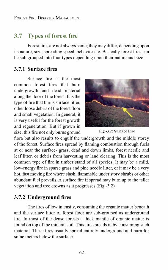
62
Forest Fire Disaster ManageMent
3.7 TypesofforestfireForest fires are not always same; they may differ, depending upon
its nature, size, spreading speed, behavior etc. Basically forest fires can be sub grouped into four types depending upon their nature and size –
3.7.1 Surfacefires
Surface fire is the most common forest fires that burn undergrowth and dead material along the floor of the forest. It is the type of fire that burns surface litter, other loose debris of the forest floor and small vegetation. In general, it is very useful for the forest growth and regeneration. But if grown in size, this fire not only burns ground flora but also results to engulf the undergrowth and the middle storey of the forest. Surface fires spread by flaming combustion through fuels at or near the surface- grass, dead and down limbs, forest needle and leaf litter, or debris from harvesting or land clearing. This is the most common type of fire in timber stand of all species. It may be a mild, low-energy fire in sparse grass and pine needle litter, or it may be a very hot, fast moving fire where slash, flammable under story shrubs or other abundant fuel prevails. A surface fire if spread may burn up to the taller vegetation and tree crowns as it progresses (Fig.-3.2).
3.7.2 Undergroundfires
The fires of low intensity, consuming the organic matter beneath and the surface litter of forest floor are sub-grouped as underground fire. In most of the dense forests a thick mantle of organic matter is found on top of the mineral soil. This fire spreads in by consuming such material. These fires usually spread entirely underground and burn for some meters below the surface.
Fig.-3.2: Surface Fire
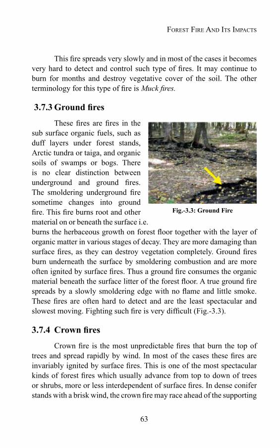
63
This fire spreads very slowly and in most of the cases it becomes very hard to detect and control such type of fires. It may continue to burn for months and destroy vegetative cover of the soil. The other terminology for this type of fire is Muck fires.
3.7.3Groundfires
These fires are fires in the sub surface organic fuels, such as duff layers under forest stands, Arctic tundra or taiga, and organic soils of swamps or bogs. There is no clear distinction between underground and ground fires. The smoldering underground fire sometime changes into ground fire. This fire burns root and other material on or beneath the surface i.e. burns the herbaceous growth on forest floor together with the layer of organic matter in various stages of decay. They are more damaging than surface fires, as they can destroy vegetation completely. Ground fires burn underneath the surface by smoldering combustion and are more often ignited by surface fires. Thus a ground fire consumes the organic material beneath the surface litter of the forest floor. A true ground fire spreads by a slowly smoldering edge with no flame and little smoke. These fires are often hard to detect and are the least spectacular and slowest moving. Fighting such fire is very difficult (Fig.-3.3).
3.7.4 Crownfires
Crown fire is the most unpredictable fires that burn the top of trees and spread rapidly by wind. In most of the cases these fires are invariably ignited by surface fires. This is one of the most spectacular kinds of forest fires which usually advance from top to down of trees or shrubs, more or less interdependent of surface fires. In dense conifer stands with a brisk wind, the crown fire may race ahead of the supporting
Fig.-3.3: Ground Fire
Forest Fire And its impActs
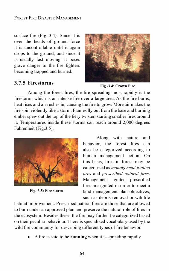
64
Forest Fire Disaster ManageMent
surface fire (Fig.-3.4). Since it is over the heads of ground force it is uncontrollable until it again drops to the ground, and since it is usually fast moving, it poses grave danger to the fire fighters becoming trapped and burned.
3.7.5 Firestorms
Among the forest fires, the fire spreading most rapidly is the firestorm, which is an intense fire over a large area. As the fire burns, heat rises and air rushes in, causing the fire to grow. More air makes the fire spin violently like a storm. Flames fly out from the base and burning ember spew out the top of the fiery twister, starting smaller fires around it. Temperatures inside these storms can reach around 2,000 degrees Fahrenheit (Fig.3.5).
Along with nature and behavior, the forest fires can also be categorized according to human management action. On this basis, fires in forest may be categorized as management ignited fires and prescribed natural fires. Management ignited prescribed fires are ignited in order to meet a land management plan objectives, such as debris removal or wildlife
habitat improvement. Prescribed natural fires are those that are allowed to burn under an approved plan and preserve the natural role of fires in the ecosystem. Besides these, the fire may further be categorized based on their peculiar behaviour. There is specialized vocabulary used by the wild fire community for describing different types of fire behavior.
A fire is said to be running when it is spreading rapidly
Fig.-3.5: Fire storm
Fig.-3.4: Crown Fire
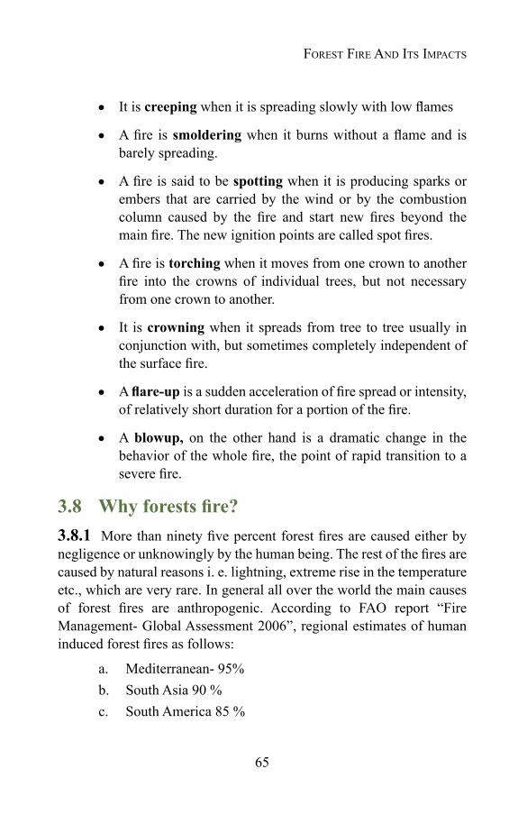
65
It is creeping when it is spreading slowly with low flames
A fire is smoldering when it burns without a flame and is barely spreading.
A fire is said to be spotting when it is producing sparks or embers that are carried by the wind or by the combustion column caused by the fire and start new fires beyond the main fire. The new ignition points are called spot fires.
A fire is torching when it moves from one crown to another fire into the crowns of individual trees, but not necessary from one crown to another.
It is crowning when it spreads from tree to tree usually in conjunction with, but sometimes completely independent of the surface fire.
A flare-up is a sudden acceleration of fire spread or intensity, of relatively short duration for a portion of the fire.
A blowup, on the other hand is a dramatic change in the behavior of the whole fire, the point of rapid transition to a severe fire.
3.8 Whyforestsfire?3.8.1 More than ninety five percent forest fires are caused either by negligence or unknowingly by the human being. The rest of the fires are caused by natural reasons i. e. lightning, extreme rise in the temperature etc., which are very rare. In general all over the world the main causes of forest fires are anthropogenic. According to FAO report “Fire Management- Global Assessment 2006”, regional estimates of human induced forest fires as follows:
a. Mediterranean- 95%b. South Asia 90 %c. South America 85 %
Forest Fire And its impActs

66
Forest Fire Disaster ManageMent
d. North America 80 %e. Balkan countries 59 %
The natural causes of forest fires are common in remote areas only.
Out of three essential components of fire triangle, two components i.e. fuel and oxygen are naturally available in forest. It is the third component i.e. heat that really initiates fire in the forest. Heat may be supplied by either natural or artificial reasons. Depending upon the source of the heat, the causes for forest fire may be classified as natural or artificial. While lightening, volcanic explosion, friction of rolling stone etc. are the natural causes for forest fire; the anthropogenic causes may be subdivided into two categories i.e. deliberate causes and unintentional or accidental causes.
Natural AnthropogenicDeliberate causes Accidental causes
1. Lightning 1 Shifting Cultivation 1 Collection of Non Timber Forest Produce
2. Friction of rolling stone
2 To flush growth of tendu leaves
2 Burning farm residues
3. Rubbing of dry bamboo clumps
3 To have good growth of grass and fodder
3 Driving away wild animals
4. Volcanic explosion
4 To settle score with forest department or personal rivalry
4 Throwing burning bidi/ cigarettes
. 5 To clear path by villagers 5. Camp fires by picnickers
. 6 To encroach upon the forest land
6. Sparks from vehicle –exhaust
. 7. For concealing illicit felling
7. Sparks from transformers
. 8. Tribal traditions/ customs
8. Uncontrolled prescribed burning
. 9. Resin tapping
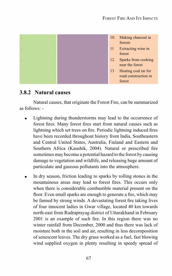
67
. 10. Making charcoal in forests
. 11 Extracting wine in forest
. 12. Sparks from cooking near the forest
13 Heating coal tar for road construction in forest
3.8.2 Natural causes
Natural causes, that originate the Forest Fire, can be summarized as follows: -
Lightning during thunderstorms may lead to the occurrence of forest fires. Many forest fires start from natural causes such as lightning which set trees on fire. Periodic lightning induced fires have been recorded throughout history from India, Southeastern and Central United States, Australia, Finland and Eastern and Southern Africa (Kaushik, 2004). Natural or prescribed fire sometimes may become a potential hazard to the forest by causing damage to vegetation and wildlife, and releasing huge amount of particulate and gaseous pollutants into the atmosphere.
In dry season, friction leading to sparks by rolling stones in the mountainous areas may lead to forest fires. This occurs only when there is considerable combustible material present on the floor. Even small sparks are enough to generate a fire, which may be fanned by strong winds. A devastating forest fire taking lives of four innocent ladies in Gwar village, located 40 km towards north-east from Rudraprayag district of Uttarakhand in February 2001 is an example of such fire. In this region there was no winter rainfall from December, 2000 and thus there was lack of moisture both in the soil and air, resulting in less decomposition of senescent leaves. The dry grass worked as a fuel, fast blowing wind supplied oxygen in plenty resulting in speedy spread of
Forest Fire And its impActs
68
Forest Fire Disaster ManageMent
fire and according to the villagers falling of hard quartzite stones produced sparks which ignited the fuel.
In bamboo areas, forest fires may occur by the rubbing together of clumps of dry bamboos.
Volcanic eruptions also lead to forest fires naturally.
3.8.3 Anthropogenic causes
More than 90% forest fires are caused by human beings, deliberately (for personal gains or rivalry) or merely due to negligence or just by accident. Forest fires sometimes originate due to accidental or unintentional reasons. Some of the instances are as follows-
a)Deliberateor intentionalcauses- Intentional forest fire is caused by people for some personal gain or rivalry with forest department. Examples are:
i)Shiftingcultivation- Most of the forest fires in India are deliberately set by small-scale farmers or landless rural people. In the northeastern parts of India, the practice of slash-and-burn shifting cultivation is the leading cause of forest destruction. The most heavily affected areas by slash and burning methods are Arunachal Pradesh, Assam, Manipur, Meghalaya, Mizoram, Nagaland and Tripura. Nationally, estimated 4.35 million hectare areas are affected by fire as part of shifting cultivation. This is especially significant in that with the growth of population and consequent decrease in the land/person ratio, not only more areas are subjected to shifting cultivation, but also the fallow period for regeneration has been reduced from the initial thirty years to two years.
ii) To get good grass / fodder crop- Forest fires are also caused intentionally to meet the need of fodder for grazing cattle. In the country although some 12.5 million hectares of land is officially classified as permanent pasture or grazing land, most of this area is virtually devoid of grass. Thus a major portion of the grazing requirement is met from forest area by setting fires to produce new flushes of grass in the dry season.
69
iii) To get better flush for tendu leaves- In central India, fires are ignited in forest to increase the production of tendu leaves. Tendu leaves collectors set fires in the summer months to promote a better flush of leaves. The problem is compounded by the fact that tendu areas are leased for the collection of leaves on an annual basis; the purchasers are therefore reluctant to make long-term investments in crop improvement. The most economical and quick alternative for this is to set tendu areas on fire; which often extends to other forest areas owing to negligence and carelessness.
iv)Forconcealingtheillicitfelling- Smugglers and poachers many times start forest fires to hide the stumps of illicit felling. The poachers use forest fires for terrorizing wild animals and hunting too.
v)Forcleaningforestpathsbythevillagers- Many times villagers set small fires to clear off path from dry litter i.e. tree twigs, branches, leaves etc. This fire, when becomes uncontrollable, turns disastrous.
vi)Tosettlescores- In some cases forests may also be set on fire by some miscreants in order to settle scores with the forest department or its staff.
b)AccidentalorUnintentionalcauses
Many times due to negligence, even small fires may result into devastating fires. Some of the main unintentional reasons for such fires are-
i)Collection ofNonTimberForest Produce (NTFP) – Collection of NTFP by tribal or other local habitants residing near the forest has been one of the major causes of forest fire. To facilitate collection of NTFP the collectors ignite fire, which accidentally may spread in the forest, resulting into major fire. The main non-wood forest product that contributes to forest fire in India is the mahua flower (Madhuca indica) collection by local people in north-central India to produce a popular beverage, or boiled with sal seeds (Shorea robusta) as a seasonal grain substitute. Mahua pickers burn the dry leaves under the trees to get a clean patch of floor to facilitate flower collection. While the intention is
Forest Fire And its impActs

70
Forest Fire Disaster ManageMent
only to clear a small patch beneath a single tree, these fires often spread out of control. Since the collection of mahua flowers is done during the summer months, the hot dry weather aggravates the situation.
ii) Burning farm residue- After a harvest, farmers set fire to their agricultural fields. Many times, when these fires are not put out completely, may spread to the adjoining forest areas.
iii)Protectingcropsfromthewildanimals- Villagers residing in or near the forest many times light up fire in the forest to keep the wild animals away from their crop and cattle. Sometimes when this fire is not put out completely, it may result in a disastrous forest fire.
iv) Careless throwing of cigarettes, bidi stubs, match sticks bygrazers/ travelers- Travelers, picnickers, nomadic grazers, villagers or even forest labourers some time throw un-extinguished cigarettes, bidis, and match sticks in the forest areas. When accompanied by little/ strong winds, this may result in fires capable of destroying valuable timber worth millions of rupees.
v)Negligenceincampfiresandworkingoperationsnearcampingground and fairs - Un-extinguished camp fires of trekkers, labour camps, nomads moving through the forest with their animals or the fires of road side charcoal panniers, when not put out properly lead to devastating forest fires.
vi) Sparks from transformers or vehicles passing through theforest- The sparks from transformers installed in the forest or near it may sometimes results into fires in forest. Similarly the sparkles from the vehicles passing through the area may also ignite fires in the forest areas.
vii)Uncontrolledprescribedburning- Just before the onset of the fire prone season, forest department do controlled burning in forest areas. Controlled burning is done to burn all the combustible material in the forest before the dry season to prevent major forest fires. Sometimes due to carelessness this fire may spread and result into large inferno.

71
viii) Resin tapping- Negligence in extracting resin from Chir Pine cones and careless burning of torchwood of Chir by pedestrian during night also result into forest fires. Careless handling of resin during resin tapping in the summer season may also start a fire, if the wind begins to blow at high speeds.
xi)Charcoalmakingandwineextracting in the forest- Small and medium scale charcoal making industries (both legal and illegal) and illegal wine extracting are common in Indian forests. Sparks from these activities may lead to fires in the forest.
x)Sparksfromthehousekitchensneartheforest- Habitations are common within or near the forests in India. The households residing here use fire wood as fuel for cooking and other purposes. Sparks from such burning may sometime result in fire in the nearby forest.
xi)Heatingcoaltarforroadconstruction–During road construction in forest areas, the charcoal heat to smelt coal tar may light up the dry litter resulting in huge forest fire.
xii)Huntingbytribals- Forest tribal for searching wild animals and their nests/ homes often set wild grass on fire. For preventing growth of leeches also, fires are ignited by local inhabitants.
3.9 AdverseimpactsofforestfireForest fires are a major cause of degradation of forests/
environment. Despite lack of reliable information about forest fire, it is clear that the acreage of forest area burnt today is much more than ever before, all over the world. The area burnt due to forest fires in the United States of America (USA), which was of the order of 1.62 million ha in 2002, has gone up to 4.05 million ha in 2006. It is estimated that in India the proportion of forest areas prone to forest fires annually ranges from 33 percent in some States to over 90 percent in others. Forest fires in about 95 percent cases are anthropogenic and result into wide ranging adverse ecological, economical and social impacts.
The Forest Survey of India data on forest fire attribute around 50
Forest Fire And its impActs
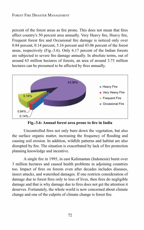
72
Forest Fire Disaster ManageMent
percent of the forest areas as fire prone. This does not mean that fires affect country's 50 percent area annually. Very Heavy fire, Heavy fire, Frequent forest fire and Occasional fire damage is noticed only over 0.84 percent, 0.14 percent, 5.16 percent and 43.06 percent of the forest areas, respectively (Fig.-3.6). Only 6.17 percent of the Indian forests are subjected to severe fire damage annually. In absolute terms, out of around 63 million hectares of forests, an area of around 3.73 million hectares can be presumed to be affected by fires annually.
Fig.-3.6:AnnualforestareapronetofireinIndia
Uncontrolled fires not only burn down the vegetation, but also the surface organic matter, increasing the frequency of flooding and causing soil erosion. In addition, wildlife patterns and habitat are also disrupted by fire. The situation is exacerbated by lack of fire protection planning knowledge and incentive.
A single fire in 1995, in east Kalimantan (Indonesia) burnt over 3 million hectares and caused health problems in adjoining countries too. Impact of fires on forests even after decades includes diseases, insect attacks, and watershed damages. If one restricts consideration of damage due to forest fires only to loss of lives, then fires do negligible damage and that is why damage due to fires does not get the attention it deserves. Fortunately, the whole world is now concerned about climate change and one of the culprits of climate change is forest fire.
Heavy Fire
Very Heavy Fire
Frequent Fire
Occasional Fire
43.06%
5.16%
0.84%0.14%
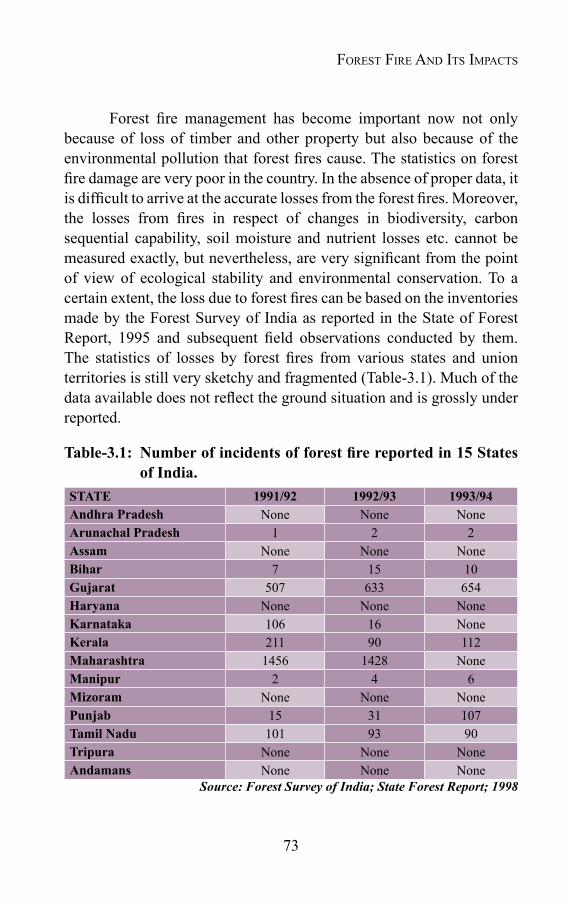
73
Forest fire management has become important now not only because of loss of timber and other property but also because of the environmental pollution that forest fires cause. The statistics on forest fire damage are very poor in the country. In the absence of proper data, it is difficult to arrive at the accurate losses from the forest fires. Moreover, the losses from fires in respect of changes in biodiversity, carbon sequential capability, soil moisture and nutrient losses etc. cannot be measured exactly, but nevertheless, are very significant from the point of view of ecological stability and environmental conservation. To a certain extent, the loss due to forest fires can be based on the inventories made by the Forest Survey of India as reported in the State of Forest Report, 1995 and subsequent field observations conducted by them. The statistics of losses by forest fires from various states and union territories is still very sketchy and fragmented (Table-3.1). Much of the data available does not reflect the ground situation and is grossly under reported.
Table-3.1: Numberofincidentsofforestfirereportedin15Statesof India.
STATE 1991/92 1992/93 1993/94Andhra Pradesh None None NoneArunachal Pradesh 1 2 2Assam None None NoneBihar 7 15 10Gujarat 507 633 654Haryana None None NoneKarnataka 106 16 NoneKerala 211 90 112Maharashtra 1456 1428 NoneManipur 2 4 6Mizoram None None NonePunjab 15 31 107Tamil Nadu 101 93 90Tripura None None NoneAndamans None None None
Source: Forest Survey of India; State Forest Report; 1998
Forest Fire And its impActs

74
Forest Fire Disaster ManageMent
Uncontrolled fires affect forest resources in a variety of ways. Regeneration is killed or dies back, thereby delaying the establishment of a new crop and extending the rotation. When newly planted teak plantations are bumt, it is standard practice to cut the young trees down to ground level; this stimulates a new vigorous shoot from the base, but at least one year's growth is lost. Fires are reported to damage seriously the regeneration of important tree species in Sal forest. Chir pine regeneration is similarly killed or set back by fire. Young eucalyptus plantations frequently require replanting as coppice regeneration dies back (or must be cut back) after fire.
Although in older crops the trees develop thick bark, which protect them from small fires; intense fires may destroy them too. During fire incidences, Eucalyptus appears to suffer more than the indigenous species and the effects of fires are apparent in reduced stocking per hectare and lower yields at maturity.
Repeated burnings result into destruction of the ground flora, ultimately leading to site deterioration and thus changes in soil nutrient status and accelerated erosion. This also reduces the vegetative growth rate. No research appears to have been done in India on the growth losses attributable to wildfires. Australian studies indicate that the volume increment of various species of eucalyptus is reduced after fires and the effect persists for several years. The cumulative loss of annual increment depends on the severity of the fire, but generally lies in the range of one to three years' growth.
Timber quality is affected by scorching from the base of the tree, which damages the cambium, leading to defective butt logs. Fungal infection may occur through the damaged tissues and cause rot. In chir pine forests, resin tapping affects the yield of merchantable timber by damaging the lower part of the tree; the scars enable fires to bum into the heartwood and, in some cases, kill the tree.
Main losses from extensive forest fires are discussed in the succeeding text:

75
i) Lossofvaluabletimberresources
Forest fires cause indispensable loss to timber and deteriorate its quality. Valuable timber species like teak, sal, chir, deodar, sheesam, rosewood etc. are adversely affected by fire. However, the adhesive impact of forest fire varies from species to species, depending upon its susceptibility.
Pine Forest: In Himalayas the periodicity of the fire in pine forest is 2 to 5 years. Eleven percent of the pine forest experiences fire every year. Most of the pine forests experience the surface fire, while some other may experience more damaging crown fire also. The total area affected by a single fire normally limits within a range of 5 sq. km. The fire in pine forest in hilly terrain, moving downward from the hill top is normally slow and less damaging. The fire moving upward from the bottom of the hills is more damaging and usually turns into crown fire and is very difficult to control.
Teak Plantations: Teak is vulnerable to damage from low intensity fires only for its first five years, thereafter low intensity fire has no effect on the tree or on wood quality. From about five years onward, the dense canopy of teak during the growing season suppresses most under storey weeds.
Eucalyptus Plantations: The eucalyptus, although a smooth barked variety, once they are older than about 5 years, are quite tolerant of low intensity ground fires. They can be control burnt from age five onwards safely. Fires after that age do not cause any noticeable loss of timber quality for pulpwood. Therefore, it is only during the period 2-5 years that they are vulnerable to fire and need protection measures.
Mahua: It is likely that forest fires have very little impact on mahua trees. This species occurs as scattered single trees in mixed species stands. It is understood that virtually every tree is visited each year for the mahua harvest. The practice of burning under the trees to clear the undergrowth in preparation for harvest means that each tree has its own fire trace created for it. Even if subsequent leaf fall occurs, the litter is very light and does not carry a damaging fire.
Forest Fire And its impActs
76
Forest Fire Disaster ManageMent
ii)Impactofforestfireoneco-system- The most damaging impact of forest fire on ecosystem is very evident in the Himalayas, where hills existing between the heights of 1000 to 1800 meters are dominated by pine forests and seem to be more fire prone. Most of these forests have preceding fire history; repeated fires have converted mixed forests of oak and chir to pure chir forest. Of course, chir pine was also planted in these areas but one of the principal reasons for the conversion of mixed forests of oak and chir is the occurrence of repeated and uncontrolled fires. Uncontrolled fires have made the situation less favourable for oaks to grow and more favourable for chir to grow. The uncontrolled fires in such areas help in spreading pine forest at the cost of indigenous oak forest, which is very serious threat to the ecological balance in the Himalayan region.
iii)Degradationofwatercatchmentsareasresultingintolossofwater-After forest fire, soil moisture is decreased and litter decomposition becomes almost negligible, which creates a possibility of forest fire in future. Just after fire, the chemical and physical changes in upper layer of soil make it impervious and thus reduce water infiltration. The removal of litter also decreases water holding capacity of soil and most of the rainwater is washed away removing top fertile soil of the forest resulting into loss of soil fertility.
iv)Lossofwildlifehabitatanddepletionofwildlife- Forests are the habitat of many wild animals. Sometimes the local people put the fire and drum beats to keep the wild animals away, but when fire becomes uncontrolled, the problem of survival of animals and their habitat arises. Wildfire along with killing wild animals also destroys their habitat and thus makes their survival at stake. The forest fires in Sankhuwasabha and Ilam in Nepal claimed red pandas, leopards as well as monkeys, deer, bear and other species.
Forest fire dramatically impacts the animal life. Animals are first to lose their lives due to heat generated. Eggs of birds and insects are destroyed due to fire impact. Some animals have a natural threat warning system and usually migrate from the danger areas. The birds also save themselves by migration, but their eggs are usually destroyed. Such

77
migration of birds and the animals in normal condition is not permanent and they return back when the conditions are normalized.
v)Loss ofnatural vegetationand reductionof forest cover- As a result of fires, millions of hectares of the forest area turn to ashes and remains of no use. Among various degradation factors, forest fire is also one of the major factors for overall loss in forest cover. The wild fires have adverse impact on forest tree growth. Researches in United States have shown that today many low elevations forest in the west are thick with small trees, while historic photographs and personal accounts tell of these forests characterized by large trees spaced far enough.
vi)Globalwarming- One of the major culprits of climate change is forest fire. The immediate effect of vegetation burning is the production and release of gases including carbon dioxide, carbon monoxide, methane, non-methane hydrocarbons, nitric oxide, methyl chloride and various other gases, which are released and returned to the atmosphere in a matter of hours. The burning of forest also destroys an important sink for atmospheric carbon dioxide. Hence, burning has a significant role in the world’s carbon dioxide budget. If the burned ecosystem regrows, the carbon dioxide is eventually removed from the atmosphere via photosynthesis and is incorporated into the new vegetative growth. Other gaseous emission, however, remain in the atmosphere. The depletion of ozone layer gets started as a result of these noxious gases. This ozone layer depletion not only results in various adverse impacts but also further increases the chances of forest fire in future. International Centre for Integrated Mountain Development (ICIMOD) working in Hindukush Mountains pins the blame on global warming for creating the conditions that led to fires. Some foresters blame record high temperatures and the failure of winter rains for destruction through fire of hundreds of hectares of natural forest in the Garhwal Himalayas in India and in eastern and central regions of Nepal in 2006.
Green house gases released during the combustion of vegetations lead to an increased warming of the earth or human induced global climate change. Studies suggest that biomass burning has increased on a
Forest Fire And its impActs
78
Forest Fire Disaster ManageMent
global scale over the last 100 years and calculations indicate that hotter earth resulted from global warming will lead to more frequent water related calamities and larger fires.
As per FAO report “Fire Management- Global Assessment 2006”, the quantity of biomass burned each year from all resources is about 9200 million tones. Overall global fires in vegetation consume 5130 million tones, 42 percent of which is in Africa. This burning releases about 3431 million tones of CO2 and other emissions. However due to cyclic nature of disturbances in fire dependant and fire dependant eco systems involves sequestration of atmospheric carbon for regrowth of the plant biomass and thus fire generated CO2 is not contributing to a net release of carbon in atmosphere.
Box-3.1: Forest Fire and Global Warming
Climate plays a vital role in determining fire patterns and intensity and, in turn, fire influences the climate system via the release of carbon. Forest fires and global warming have created dangerous relationship. The close linkage between high fire activity and inter annual and decadal-scale climate oscillations indicates that fire occurrence increases during the La Nina phase of the ENSO southern United States and Patagonia, Argentina. Whereas a marked increase in fire activity occurs in tropical rainforests during EI Nino phases. Sedimentary charcoal records also show a strong link between climate and fire activity, with reduced fire in cold intervals and increased fire in warm intervals, regardless of whether humans were present. The changing weather pattern in one of the major factor is contributing to current increase in instances of forest fires. The main reason for this is change in overall increase in the temperature; change in precipitation pattern and moisture content in the atmosphere. Drier soil leads less evaporation and so the heat goes into higher temperatures, less recycled moisture in the atmosphere, and hence less rain during summer. This results into increased heat waves and thus increased risk of wildfires.
The Climate change is affecting various climate related variables like – soil moisture content, vegetation density, affecting the fire season severity. Extended periods of above normal temperatures and below – normal rainfall are key factors that contribute to an active wildfire season. It is not only the global warming that is affecting the forest fire, but is true in the reverse way also i.e. the forest fires are also contributing to global warming. As per an assessment based on scientific research, the combination of intentional and unintentional fires – by burning carbon-storing vegetation has contributing a whopping 20% of all human caused green house gas emission since the Industrial Revolution.
79
vii) Microclimate change: The changed microclimate caused by removal of litter and duff, opening of the canopy by killing over storey shrubs and trees and darkening of the soil surface by residual soot and charcoal can increase insulation causing temperature increase. As a result the changed area becomes unhealthy for living of both wild habitats and local people.
viii) Soilerosion: The scientific studies indicate that erosion of the soil from the forest land depends on many factors i.e. the soil porosity, its mineral composition, the texture, the gradient of the land and length etc. All these factors decide the ease with which the individual soil particles are detached. Though the erosion of soil during low scale forest fire is a natural phenomenon, yet during severe fire conditions, this process turns into more serious problems, both for environment and habitat. Anthropogenic activities such as fire suppression, logging and road construction in forest areas have adversely affected the soil stability. The fire impact on forest floor may vary from just removing the litter to the total consumption of the forest fuel and alteration of the soil mineral structure.
The most intense forest fire always has a direct heating effect on the soil at the depth below 7 to 10 cm. As a result, the soil of the fire affected area loses its water holding capacity and becomes vulnerable for erosion. Due to consumption of the forest organic residue by fires, the mineral soil is exposed and consequently its infiltration and water holding capacity are automatically reduced. Burning of vegetation also reduces the amount of rain fall infiltration by the forest canopy and reduces evaporation by the forest vegetation.
The soil and water response to wild fire is often a function of fire severity and occurrence of hydrologic events. For a wide range of severities, the impact of hydrology and sediment loss can be minimized if the precipitation is less. However, when the precipitation follows a severe fire, the impact of the water is very high and substantial. This increase in soil erosion, especially in the hilly terrain has very long lasting impact on the ecosystem of the region. The duration of the increased vulnerability also depends upon the severity of the forest fire.
Forest Fire And its impActs
80
Forest Fire Disaster ManageMent
In moderate fire conditions, the normalcy in soil erosion may return back within a year or two. However, in the case of very severe fire conditions, the return period to normalcy may vary from 5-7 and even ten years.
In hilly terrains, the rate of the soil erosion shows spatial variability, which is an important characteristic of hill slopes. Field experiments show that when two third of the upper portion of the hill slopes is in high severity burn conditions, it produces twice as much sediment as compared to when the upper two- third lies in low severity burn conditions. The earlier conditions are very common in field and thus lead to severe soil erosion.
ix) Soil erosion and impact on ecosystems- The fire initiated soil erosion has very adverse impact on various eco- systems near the burned area. Loss of soil from hill slopes produces several significant ecosystem impacts. Soil movement in the streams, lakes etc. may degrade water quality and change the geomorphic and hydrologic characteristics of these systems. The soil loss from hill slopes may also alter future soil productivity. As a result of the increased soil erosion, the delivery of the sediment in large quantities to water bodies may also affect aquatic animals and their habitat.
x)Forestfireandfloods- The water yield of a water body depends on the quantity of the rain, evapotranspiration, type of the soil and vegetation etc. During the first year after a fire, the magnitude of the total water yield suddenly increases. The magnitude may vary greatly within a location or between locations, depending upon the fire intensity, rainfall, geomorphology, the type of soil & vegetation and the proportion of the vegetation burned. In some exceptional conditions this may lead to flood also. Water repellent soils and cover loss cause flood peaks to arrive faster, rise to higher levels and entrain significant amount of bed load and suspended sediments. These floods may have devastating impacts on soil and water quality and also affect the ecosystem prevailing in the region.
xi) Deteriorating Biological Environment- Forest fires also pose
81
serious health hazard by creating polluting smoke and noxious gases. The burning of vegetation gives off not only carbon dioxide but also many other noxious gases (Green House gases) such as carbon monoxide, methane hydrocarbons, nitric oxide and nitrous oxide that lead to global warming and ozone layer depletion. Thousands of people suffer from serious respiratory problems due to these toxic gases.
Burning forests and grasslands also add to already serious threat of global warming. Forests play a vital role in keeping the level of carbon di oxide in the atmosphere in check. Forests, grasslands and agricultural lands make up bulk of the global biomass burning in a global phenomenon. Recent research suggests that biomass burning may be a significant global source of methyl bromide, which is an active ozone depleting substance.
Researchers have also come out with very significant information about the impact of forest fire on environment as a result of green house gas- nitrous oxide through bacteria. Nitrification is a biological process where bacteria convert ammonia (found naturally in soil and fire ash) to nitric oxide and nitrous oxides. The increased concentration of ammonia in the ash leads to more nitrification after a fire, thereby releasing additional nitric and nitrous oxide.
xii)Adverse impact on Health system- The fires in the forest are source of smoke that cause air pollution and rise in the temperature. The forest fires in 1995 and 1999 in Himalayan states gutted the mountains with the smoke, resulting into loss of visibility to about 200 meters. The temperature in the region also rose by 2 to 3 degree Celsius. This resulted into uneasiness among the local population of the region. Scientific studies of major forest fire of South East Asia of 1997 came out with many new findings. These fires were unique, since they involved both the burning of above ground vegetation, as well as the below ground i.e. peat (a form of coal). Smoldering peat vegetation produces much more smoke than the burning of normal vegetation. This fire generated smoke covered almost all of South East Asia resulting into more than 20 million cases of smoke related health problems.
Forest Fire And its impActs
82
Forest Fire Disaster ManageMent
xiii)Socio-economicimpact- Fire is a major factor of destruction of human settlelement and often causes deterioration of site by subsequent increased erosion. Thus fire is threatening human life and property both. If the weather conditions are very dry or windy, fire burns much faster. A fire near settlements may also damage the houses. Damage also can be caused by smoke. Smoke in building smells unpleasant, leaves ashes and impacts human health. Forest fire also adversely affect livelihood resources, especially for tribals, who habitat within or near the forest. In India, where approximately 65 million people are classified as tribal and directly depend upon collection of non-timber forest products from the forest areas for their livelihood are directly affected by forest fire.
xiv)Carbonsequestrationpotential- Trees act as carbon sinks when they absorb carbon dioxide from atmosphere and build up the same in the form of wood. Hardwood contains 48 percent of carbon in the form of cellulose and wood and it is estimated that 2.2 tones of wood are required to sequester one ton of carbon. On the other hand, while the wood is burnt the reverse process takes place in which the atmospheric oxygen is used and carbon- di-oxide is released into the atmosphere. Hence, forests act both as source as well as sink of carbon, depending upon the manner and purpose for which they are raised and managed. Burning of the vegetation release hundreds of years of stored carbon- di- oxide (CO2) into the atmosphere, and thus results into permanent destruction of important sink of carbon dioxide.
xv)Threat toLifeandProperty- Forest fires affect human life and property in different ways. Human life is at risk when fire crews fight fires either at the fire front or from conflict with animals, especially elephants. A forest fire that spreads outside the forest can consume buildings or infrastructure. There are also indirect dangers to life and property due to forest fire. If too much forage is lost within the reserve, elephants move out of the forest searching for food and in doing so destroy crops and property. In certain cases forest fire directly cause loss of life as observed in Gwar village of Rudraprayag district in the year 2001, when four ladies were killed while harvesting grass near forest area. In hills, the management practices of forest fire are interrupted by

83
various types of constraints such as poor knowledge & data base, lack of cooperation among sectors, resources, training of staff and paucity of funds etc.
In the western countries, especially in the United States, forest fires cause enormous loss to house buildings. As per an estimate, forest fires burned around 10,000 houses in the United States between 1985 and 2000. In 2000 alone, at least 800 family houses were destroyed by wild fires in that country.
xvi) ReducingTourismValues- Smoke and haze generated by fires are inimical to a good tourist experience, especially when a significant part of the tourist experience depends on views of the mountains. Fire in forest gives a negative impression to the tourists. Smoke due to fires affects the visibility and air quality which adversely affect tourism industry. From the overall tourism industry perspective, the generation of smoke needs to be minimized, especially during the peak tourist season of April-June.
3.10ForestfireandClimatechange"Fires are obviously one of the major responses to climate
change, but fires are not only a response -- they feed back to warming, which feeds more fires.” When vegetation burns, the resulting release of stored carbon increases global warming. The more fires, the more carbon dioxide released the more warming -- and the more warming, the more fires. The very fine soot, known as black carbon, that is released into the atmosphere by fires also contributes to warming (Fig.3.7).
Forest fires affect the global carbon cycle, and thus the climate, in three main ways (Kasischke and Stocks, 2000). First, fire releases large quantities of carbon into the atmosphere through the combustion of plant material and surface soil organic matter. Second, fire-killed vegetation decomposes over time emitting carbon. Third, the vegetation on newly burned sites may not absorb as much carbon from the atmosphere as the decaying vegetation emits, or as much as the pre-fire vegetation absorbed, for several years or decades after a fire. Fires are thus an
Forest Fire And its impActs
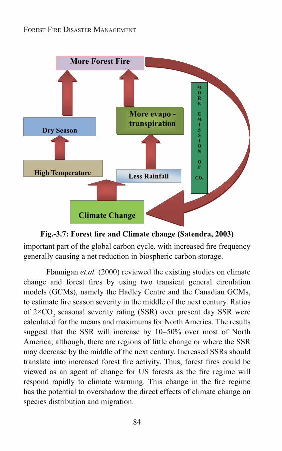
84
Forest Fire Disaster ManageMent
important part of the global carbon cycle, with increased fire frequency generally causing a net reduction in biospheric carbon storage.
Flannigan et.al. (2000) reviewed the existing studies on climate change and forest fires by using two transient general circulation models (GCMs), namely the Hadley Centre and the Canadian GCMs, to estimate fire season severity in the middle of the next century. Ratios of 2×CO2 seasonal severity rating (SSR) over present day SSR were calculated for the means and maximums for North America. The results suggest that the SSR will increase by 10–50% over most of North America; although, there are regions of little change or where the SSR may decrease by the middle of the next century. Increased SSRs should translate into increased forest fire activity. Thus, forest fires could be viewed as an agent of change for US forests as the fire regime will respond rapidly to climate warming. This change in the fire regime has the potential to overshadow the direct effects of climate change on species distribution and migration.
Fig.-3.7:ForestfireandClimatechange(Satendra,2003)
85
Bowman et.al. (2009), said, "We're most concerned that fire has not been rigorously and adequately incorporated in the climate models. It's remarkable that such an integral part of the landscape has been so sidelined." Because fire on Earth predates humans, its ubiquitous activity is simultaneously accepted and overlooked. "Fire is extraordinarily obvious, but deeply subtle." A more complete understanding of how the Earth works requires recognizing how fire is interwined with and also a driver of human history and the Earth's history, the authors write. Balch (2009) observed that "The synthesis is a prerequisite for adaptation to the apparent recent intensification of fire feedbacks, which have been exacerbated by climate change, rapid land-cover transformation, and exotic species introductions" and further commented about "fires where we don't normally see fires," and pointed to the occurrence of bigger and more frequent fires from the western U.S. to the tropics. Swetnam (2009) said that, in addition to the burning in the tropics, huge tracts of the boreal forests of Siberia, Canada and northern Europe burn each year. "The role of fire in forests in the boreal zone is unappreciated," he said. "Russian forests alone contain more than 50 percent of the carbon stored on land in the Northern Hemisphere," and warming is happening fastest at high latitudes. In some recent years, the acreage burned in the forests of Siberia exceeded the size of the U.S. state of Virginia, he said. As the world warms, more of those regions are likely to burn, accelerating the warming.
Forest Fire And its impActs
Chapter 4
FOREST FIRE: THE GLOBAL SCENARIO
4.1 IntroductionThe problem of wild fire is a universal phenomenon which is
a dominant disturbing factor in all types of vegetation throughout the world. Though in world-ecosystem fire is a natural phenomenon and helps the vegetation by organizing physical and biological attributes, influencing energy flows and biological cycles, yet its adverse impact in ecosystem is quite well known. Due to various natural and mostly the human induced factors, the severity of forest fires in general is increasing day by day. The adverse impacts of this increased forest fire and its severity have brought this menace in the category of other natural disasters like floods, droughts, earthquakes etc.
Forest fires are common in almost all types of vegetation. In the temperate and northern boreal forests, it occurs regularly during the dry summers. On an average 5 to 20 million hectares of forest are burned annually in North America and Eurasia due to fire hazard. In the Mediterranean forests also the situation is similar and around 0.6 million hectare forest is burned here annually. Though equatorial rain forests are bit moist, however extreme droughts associated with other human induced activities make it too vulnerable to fire. In South Africa, cyclic climate variability caused by El-Nino-Southern Oscillation (ENSO) phenomenon is responsible for extreme fire events in the forests.
In tropical forests, fire is a regular phenomenon at the short interval of one to five years. The Tropical Sub-montane Conifers Forests due its specific vegetation (pine), rich in resin and susceptible to fire, are subjected to forest fire regularly. In addition to standing forest
87
crop, fire is very common in tropical grass- land and Savannas. Tropical Savannas spread over an area of about 2.6 billion hectare (consisting of more or less continuous spread of grass with interrupted trees and shrubs) are prone to fire and are burnt regularly. On an average hundred millions hectares land in these grasslands are burnt annually, mostly in dry season. As per an estimate about 3 million tones of vegetation are burned here every year, resulting into three times more gas and particles emission than that by other burning. The intensity of fire in Savannas has increased in the recent past due to population pressure also. Though all forests bearing countries are hit by fire menace, one or other time, some are more prone.
A brief about the susceptibility of ten countries to fire, their fire situation, fire season (phenology), major fire incidences, fire management strategies/ plans etc. are briefed in Table-4.1.
Forest Fire: the Global scenario
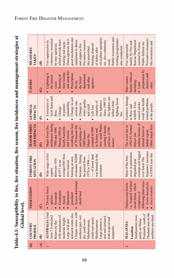
88
Forest Fire Disaster ManageMentTable-4.1:Susceptibilitytofire,firesituation,fireseason,fireincidencesandmanagem
entstrategiesat
Glo
bal l
evel
.SN
CO
UN
TR
Y
PRO
FIL
EV
EG
ETA
TIO
NFO
RE
ST F
IRE
SI
TU
ATIO
NM
AJO
R F
IRE
S A
ND
IMPA
CT
SG
EN
RE
AL
IMPA
CT
SC
AU
SES
ME
ASU
RE
S TA
KE
N
(A)
(B)
(C)
(D)
(E)
(F)
(G)
(H)
1A
UST
RA
LIA
-Tot
al
Are
a-7.
9 m
ln.k
m2
Rel
ativ
ely
flat
with
mou
ntai
ns o
f m
oder
ate
heig
ht.
Larg
e Arid
and
se
mia
rid z
ones
als
o.C
limat
e va
ries-
with
no
rther
n pa
rt- w
et
dry,
sout
h w
est-
Med
iterr
anea
n,
sout
h-ea
st-q
uasi
-M
edite
rran
ean.
La
rge
porti
on is
ar
id a
nd se
mia
rid,
both
trop
ical
and
te
mpe
rate
.
Div
erse
fore
st
spec
ies-
-
Sava
nnah
Euca
lypt
us
Aca
cia
Hum
moc
k gr
assl
and
Aca
cia
dom
inat
ed
shru
b la
nd
Wid
e ra
nge
of fi
re
regi
me.
Bet
wee
n 19
56
&19
71 o
n an
av
erag
e194
5 fir
es
wer
e no
ticed
bu
rnin
g an
are
a of
aro
und
3620
00
hect
ares
.. D
urin
g th
e pe
riod
from
19
78 to
199
6 --
----
-- o
f for
est l
and
was
bur
ned
in th
e co
ntin
ent.
Maj
or fo
rest
fire
in
cide
nces
dur
ing
1980
and
199
0.D
urin
g 19
80 in
So
uth
Aus
tralia
an
d V
icto
ria-
resu
lting
into
loss
of
70
hum
an li
fe
and
burn
ing
of >
20
00 h
ouse
s.M
ajor
fire
er
upte
d in
1990
in
Syd
ney
and
New
sout
h W
ales
ca
usin
g 4
deat
hs
and
loss
of 2
06
hous
es.
Extin
ctio
n of
lo
cal f
auna
and
flo
ra.
Cha
nge
in p
astu
re
pala
tabi
lity.
Cha
nge
in so
il er
osio
n ra
te.
Cha
nge
in
wat
er q
ualit
y an
d yi
eld.
Life
loss
(m
ajor
ity o
f fir
e fig
hter
s).
Sinc
e 19
80 5
2 fir
e fig
hter
s are
ki
lled
whi
le
fight
ing
fore
st
fire.
Ligh
tnin
g is
th
e na
tura
l ca
use.
Bur
ning
of
farm
resi
due
and
cam
p fir
e.
Pres
crip
tion
fire
by
the
fore
st
depa
rtmen
t an
d ot
her
agen
cies
Fire
supp
ress
ion
by
volu
ntee
rs, r
ecru
ited
by m
ay a
genc
ies,
whi
ch p
rovi
de th
em
train
ing
and
equi
p.
Thes
e ag
enci
es h
ave
good
mec
hani
sm a
nd
equi
pmen
t to
dete
ct
and
supp
ress
fire
.Pr
even
tive
mea
sure
lik
e pr
escr
ibed
bu
rnin
g, d
ispo
sal
of d
ebris
afte
r si
lvic
ultu
re o
pera
tion
etc.
als
o co
mm
only
us
ed.
Publ
ic a
war
enes
s and
tra
inin
g pr
ogra
mm
es
also
con
duct
ed.
2M
AL
AYSI
A-
Loc
atio
n:
Sout
heas
tern
Asi
a,
partl
y on
Mal
ay
Peni
nsul
a, so
uth
of
Thai
land
and
on
the
north
ern
one-
third
Dip
itero
carp
fore
sts
i.e. T
ropi
cal l
owla
nd
moi
st fo
rest
, whi
ch
com
pris
es o
f fo
llow
ing
plan
t tre
es-
A
ralia
das
yphy
lla A
reca
tria
ndra
Mos
t of t
he fi
res
occu
r in
plan
tatio
n,
degr
aded
pea
t sw
amps
and
logg
ed
over
fore
st T
he
freq
uenc
y in
crea
ses
in E
NSO
yea
r due
The
wor
st fi
re in
19
82-8
3, b
urne
d al
mos
t one
m
illio
n he
ctar
e of
na
tura
l for
est i
n Sa
bah
regi
on.
Oth
er m
ajor
fire
s
Exte
nsiv
e da
mag
e to
flor
a, a
nd
wild
life.
Fire
s ca
used
smok
e re
sult
into
hea
lth
rela
ted
prob
lem
s in
the
peop
le.
Mai
n ca
uses
hu
man
indu
ced
incl
udin
g-
Land
pr
epar
atio
n by
fa
rmer
s and
ot
her
Fire
supp
ress
ion
mai
nly
by F
ire a
nd
Res
cue
Dep
artm
ent
assi
sted
by
Fore
st,
Publ
ic d
efen
se e
tc.
Prev
entiv
e m
easu
res
like
awar
enes
s and
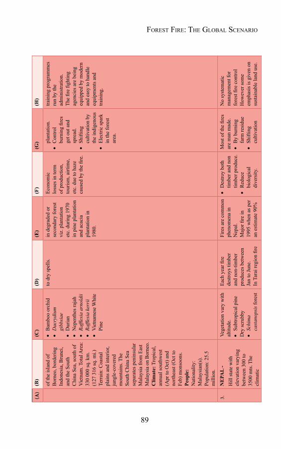
89
(A)
(B)
(C)
(D)
(E)
(F)
(G)
(H)
of th
e is
land
of
Bor
neo,
bor
derin
g In
done
sia,
Bru
nei,
and
the
Sout
h C
hina
Sea
, sou
th o
f V
ietn
am. T
otal
Are
a:
330
000
sq. k
m.
(127
316
sq. m
i.)
Terr
ain:
Coa
stal
pl
ains
and
inte
rior,
jung
le-c
over
ed
mou
ntai
ns. T
he
Sout
h C
hina
Sea
se
para
tes p
enin
sula
r M
alay
sia
from
Eas
t M
alay
sia
on B
orne
o.
Clim
ate:
Tro
pica
l, an
nual
sout
hwes
t (A
pr to
Oct
) and
no
rthea
st (O
ct to
Fe
b) m
onso
ons.
Peop
le:
Nat
iona
lity:
M
alay
sian
(s).
Popu
latio
n: 2
5.5
mill
ion.
Bam
boo
orch
id
Dac
rydi
um
gibb
siae
Dur
ian
Nep
enth
es ra
jah
Raffl
esia
arn
oldi
i
Raffl
esia
ker
rii
Viet
nam
ese W
hite
Pi
ne
to d
ry sp
ells
.in
deg
rade
d or
se
cond
ary
fore
st
viz.
pla
ntat
ion
etc.
dur
ing
1970
in
pin
e pl
anta
tion
and
acac
ia
plan
tatio
n in
19
80.
Econ
omic
lo
sses
in te
rm
of p
rodu
ctio
n,
tour
ism
, airt
ime,
et
c. d
ue to
haz
e ca
used
by
the
fire.
pl
anta
tion.
Con
trol
burn
ing
fires
ge
t out
and
sp
read
.
Shift
ing
culti
vatio
n by
th
e in
dige
nous
Elec
tric
spar
k in
the
fore
st
area
.
train
ing
prog
ram
mes
ru
n by
the
adm
inis
tratio
n.Th
e fir
e fig
htin
g ag
enci
es a
re b
eing
eq
uipp
ed b
y m
oder
n an
d ea
sy to
han
dle
equi
pmen
ts a
nd
train
ing.
3.N
EPA
L -
Hill
stat
e w
ith
elev
atio
n va
ryin
g be
twee
n 30
0 to
35
00 m
ts. T
he
clim
atic
Vege
tatio
n va
ry w
ith
altit
ude.
Subt
ropi
cal p
ine
Dry
scru
bby
Schi
ma
cast
anop
sis f
ores
t
Each
yea
r fire
de
stro
ys ti
mbe
r an
d no
n-tim
ber
prod
uces
bet
wee
n Ja
n to
June
.In
Tar
ai re
gion
fire
Fire
s are
com
mon
ph
enom
ena
in
Nep
al.
Maj
or fi
re in
19
95 w
hen
as p
er
an e
stim
ate
90%
Des
troy
both
tim
ber a
nd n
on
timbe
r pro
duce
.
Red
uce
biol
ogic
al
dive
rsity
.
Mos
t of t
he fi
res
are
man
mad
e.
By
burn
ing
farm
resi
due
Shift
ing
culti
vatio
n
No
syst
emat
ic
man
agem
ent f
or
fore
st fi
re c
ontro
l H
owev
er so
me
emph
asis
is g
iven
on
sust
aina
ble
land
use
.
Forest Fire: the Global scenario
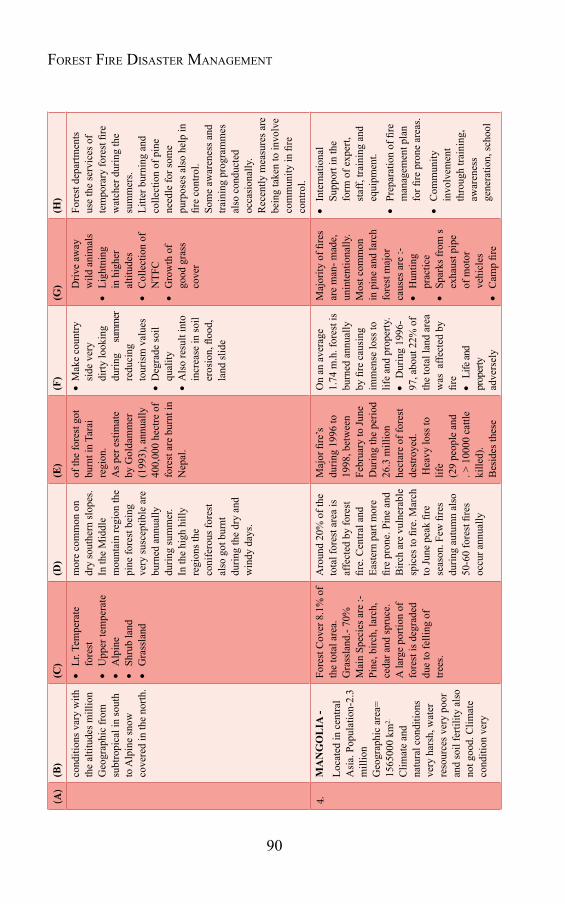
90
Forest Fire Disaster ManageMent(A
)(B)
(C)
(D)
(E)
(F)
(G)
(H)
cond
ition
s var
y w
ith
the
altit
udes
mill
ion
Geo
grap
hic
from
su
btro
pica
l in
sout
h to
Alp
ine
snow
co
vere
d in
the
north
.
Lr. T
empe
rate
fo
rest
Upp
er te
mpe
rate
Alp
ine
Shru
b la
nd
Gra
ssla
nd
mor
e co
mm
on o
n dr
y so
uthe
rn sl
opes
. In
the
Mid
dle
mou
ntai
n re
gion
the
pine
fore
st b
eing
ve
ry su
scep
tible
are
bu
rned
ann
ually
du
ring
sum
mer
. In
the
high
hill
y re
gion
s the
co
nife
rous
fore
st
also
got
bur
nt
durin
g th
e dr
y an
d w
indy
day
s.
of th
e fo
rest
got
bu
rnt i
n Ta
rai
regi
on.
As p
er e
stim
ate
by G
olda
mm
er
(199
3), a
nnua
lly
400,
000
hect
re o
f fo
rest
are
bur
nt in
N
epal
.
M
ake
coun
try
side
ver
y di
rty lo
okin
g du
ring
su
mm
er
redu
cing
to
uris
m v
alue
s D
egra
de so
il qu
ality
A
lso
resu
lt in
to
incr
ease
in so
il er
osio
n, fl
ood,
la
nd sl
ide
D
rive
away
w
ild a
nim
als
Ligh
tnin
g in
hig
her
altit
udes
Col
lect
ion
of
NTF
C
Gro
wth
of
good
gra
ss
cove
r
Fore
st d
epar
tmen
ts
use
the
serv
ices
of
tem
pora
ry fo
rest
fire
w
atch
er d
urin
g th
e su
mm
ers.
Litte
r bur
ning
and
co
llect
ion
of p
ine
need
le fo
r som
e pu
rpos
es a
lso
help
in
fire
cont
rol.
Som
e aw
aren
ess a
nd
train
ing
prog
ram
mes
al
so c
ondu
cted
oc
casi
onal
ly.
Rec
ently
mea
sure
s are
be
ing
take
n to
invo
lve
com
mun
ity in
fire
co
ntro
l.
4.M
AN
GO
LIA
-Lo
cate
d in
cen
tral
Asi
a. P
opul
atio
n-2.
3 m
illio
nG
eogr
aphi
c ar
ea=
1565
000
km2.
Clim
ate
and
natu
ral c
ondi
tions
ve
ry h
arsh
, wat
er
reso
urce
s ver
y po
oran
d so
il fe
rtilit
y al
so
not g
ood.
Clim
ate
cond
ition
ver
y
Fore
st C
over
8.1
% o
f th
e to
tal a
rea.
Gra
ssla
nd.-
70%
M
ain
Spec
ies a
re :-
Pine
, birc
h, la
rch,
ce
dar a
nd sp
ruce
.A
larg
e po
rtion
of
fore
st is
deg
rade
d du
e to
felli
ng o
f tre
es.
Aro
und
20%
of t
he
tota
l for
est a
rea
is
affe
cted
by
fore
st
fire.
Cen
tral a
nd
East
ern
part
mor
e fir
e pr
one.
Pin
e an
d B
irch
are
vuln
erab
le
spic
es to
fire
. Mar
ch
to Ju
ne p
eak
fire
seas
on. F
ew fi
res
durin
g au
tum
n al
so
50-6
0 fo
rest
fire
s oc
cur a
nnua
lly
Maj
or fi
re’s
du
ring
1996
to
1998
, bet
wee
n Fe
brua
ry to
June
D
urin
g th
e pe
riod
26.3
mill
ion
hect
are
of fo
rest
de
stro
yed.
Hea
vy lo
ss to
lif
e (2
9 pe
ople
and
. >
100
00 c
attle
ki
lled)
.B
esid
es th
ese
On
an a
vera
ge
1.74
m.h
. for
est i
s bu
rned
ann
ually
by
fire
cau
sing
im
men
se lo
ss to
lif
e an
d pr
oper
ty.
Dur
ing
1996
-97
, abo
ut 2
2% o
f th
e to
tal l
and
area
w
as a
ffect
ed b
y fir
e
Life
and
prop
erty
ad
vers
ely
Maj
ority
of fi
res
are
man
- mad
e,
unin
tent
iona
lly.
Mos
t com
mon
in
pin
e an
d la
rch
fore
st m
ajor
ca
uses
are
:-
Hun
ting
pr
actic
e
Spar
ks fr
om s
ex
haus
t pip
e of
mot
or
vehi
cles
Cam
p fir
e
Inte
rnat
iona
l Su
ppor
t in
the
form
of e
xper
t, st
aff,
train
ing
and
equi
pmen
t.
Prep
arat
ion
of fi
re
man
agem
ent p
lan
for fi
re p
rone
are
as.
Com
mun
ity
invo
lvem
ent
thro
ugh
train
ing,
aw
aren
ess
gene
ratio
n, sc
hool
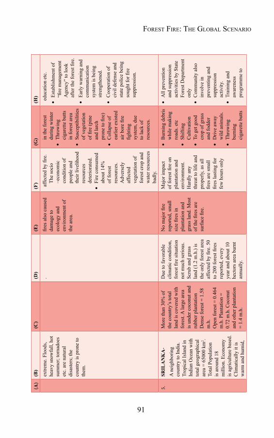
91
(A)
(B)
(C)
(D)
(E)
(F)
(G)
(H)
extre
me.
Flo
ods,
he
avy
snow
fall,
hot
su
mm
er; t
orna
does
et
c. a
re n
atur
al
disa
ster
s; th
e co
untry
is p
rone
to
them
.
. fir
es a
lso
caus
ed
dam
age
to
ecol
ogy
and
envi
ronm
ent o
f th
e ar
ea.
affe
cted
by
fire.
Th
e so
cio
–eco
nom
ic
cond
ition
of
peop
le a
nd
thei
r liv
elih
ood
reso
urce
s de
terio
rate
d.
Fire
con
sum
ed
abou
t 14%
of
fore
st
reso
urce
s. A
dver
sely
af
fect
ed
vege
tatio
n of
fo
rest
cro
p an
d w
ater
reso
urce
s ba
dly.
in
the
fore
st
durin
g w
inte
r
Thro
win
g ci
gare
tte b
utts
in
fore
st a
rea
Susc
eptib
ilitie
s of
veg
etat
ion
of fi
re (p
ine
and
larc
h pr
one
to fi
re)
Col
laps
e of
ea
rlier
exi
sted
ai
r bor
e fir
e fig
htin
g sy
stem
, due
to
lack
of
reso
urce
s.
edu
catio
n et
c.
Esta
blis
hmen
t of
“fire
man
agem
ent
Age
ncy”
to lo
ok
afte
r the
fore
st fi
re.
Early
war
ning
and
co
mm
unic
atio
n sy
stem
is b
eing
st
reng
then
ed.
Coo
pera
tion
of
civi
l def
ense
and
st
ate
polic
e be
ing
soug
ht fo
r fire
su
ppre
ssio
n.
5.SR
ILA
NK
A-
A n
eigh
borin
g co
untry
to In
dia.
Tr
opic
al Is
land
in
Indi
an O
cean
with
to
tal g
eogr
aphi
cal
area
= 6
5000
km
2 . To
tal P
opul
atio
n is
aro
und
18
mill
ion.
Eco
nom
y is
agr
icul
ture
bas
ed.
Clim
atic
ally
it is
w
arm
and
hum
id,
Mor
e th
an 3
0% o
f th
e co
untry
’s to
tal
land
is c
over
ed w
ith
fore
st. A
larg
e ar
ea
is u
nder
coc
onut
and
ru
bber
pla
ntat
ion
Den
se fo
rest
= 1
.58
m.h
.O
pen
fore
st =
0.4
64
m.h
. Pla
ntat
ion
= 0.
72 m
.h. C
ocon
ut
and
othe
r pla
ntat
ion
= 1.
4 m
.h.
Due
to fa
vora
ble
clim
atic
con
ditio
n,
fore
st fi
re si
tuat
ion
not m
uch
serio
us.
Scru
b an
d gr
ass
land
(1.2
m.h
.) is
th
e on
ly fo
rest
are
a af
fect
ed b
y fir
e. 5
0 to
200
fore
st fi
res
repo
rted,
eve
ry
year
and
abo
ut 1
0 he
ctor
s are
a bu
rnt
annu
ally
.
No
maj
or fi
re
repo
rted,
smal
l si
ze fi
res i
n pl
anta
tion
and
gras
s lan
d. M
ost
of th
e fir
es a
re
surf
ace
fire.
Maj
or im
pact
of
fore
st fi
re o
n pl
anta
tion
and
envi
ronm
ent.
Har
dly
any
thre
at to
life
and
pr
oper
ly, a
s all
fires
are
smal
l fir
es la
stin
g fo
r fe
w h
ours
onl
y
Bur
ning
deb
ris
whi
le m
akin
g ro
ads.
etc
Shift
ing
Cul
tivat
ion
To g
et g
ood
crop
of g
rass
an
d fo
dder
Driv
e aw
ay
wild
ani
mal
s.
Thro
win
g bu
rnin
g ci
gare
tte b
utts
All
prev
entio
n an
d su
ppre
ssio
n ac
tiviti
es b
y St
ate
Fore
st D
epar
tmen
t on
ly
Com
mun
ity a
lso
invo
lve
in
prev
entin
g an
d su
ppre
ssio
n ac
tivity
.
Trai
ning
and
aw
aren
ess
prog
ram
me
to
Forest Fire: the Global scenario
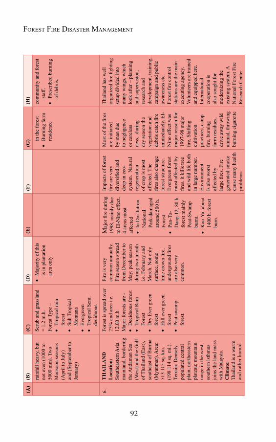
92
Forest Fire Disaster ManageMent(A
)(B)
(C)
(D)
(E)
(F)
(G)
(H)
rain
fall
heav
y, b
ut
not e
ven
(100
0 to
50
00 m
m).
Two
Mon
soon
seas
ons
(Apr
il to
July
) an
d (S
epte
mbe
r to
Janu
ary)
Scru
b an
d gr
assl
and
= 1.
2 m
.h.
Fore
st T
ype
–
Trop
ical
rain
fo
rest
Sub
Trop
ical
M
onta
na
Ever
gree
n
Trop
ical
Sem
i de
cidu
ous
Maj
ority
of t
his
is in
pla
ntat
ion
area
onl
y
in
the
fore
st
Bur
ning
farm
re
side
nce
com
mun
ity a
nd fo
rest
st
aff.
Pres
crib
ed b
urni
ng
of d
ebris
.
6.T
HA
ILA
ND
L
ocat
ion:
So
uthe
aste
rn A
sia
mai
nlan
d, b
orde
ring
the A
ndam
an S
ea
(Wes
t) an
d th
e G
ulf
of T
haila
nd (E
ast),
so
uthe
ast o
f Bur
ma
(Mya
nmar
). A
rea:
51
3 11
5 sq
. km
. (1
98 1
14 sq
. mi.)
. Te
rrai
n: D
ense
ly
popu
late
d ce
ntra
l pl
ain;
nor
thea
ster
n pl
atea
u; m
ount
ain
rang
e in
the
wes
t; so
uthe
rn is
thm
us
join
s the
land
mas
s w
ith M
alay
sia.
Clim
ate:
Th
aila
nd is
a w
arm
an
d ra
ther
hum
id
Fore
st is
spre
ad o
ver
25%
and
are
a i.e
. 12
.00
m.h
M
ajor
fore
sts a
re -
Dec
iduo
us fo
rest
Trop
ical
Rai
n Fo
rest
Dry
Eve
r gre
en
fore
st
Hill
eve
r gre
en
fore
st
Peat
swam
p fo
rest
.
Fire
is v
ery
com
mon
ann
ually
. Fi
re se
ason
spre
ad
from
Dec
embe
r to
May
; pea
k se
ason
du
ring
two
mon
th
i.e. F
ebru
ary
and
Mar
ch. N
ot o
nly
surf
ace,
som
e tim
e cr
own
fire,
un
derg
roun
d fir
es
are
also
ver
y co
mm
on.
Maj
or fi
re d
urin
g 19
98, m
ainl
y du
e to
El-N
ino
effe
ct.
4 ar
eas m
ost
affe
cted
In D
oi-I
ntro
n N
atio
nal
Park
-dam
aged
ar
ound
500
h.
Fore
st
Pan-
To-
Dan
g-12
, 80
h.
fore
st m
ainl
y Pe
at-S
wam
p bu
rnt.
Kao
-Yai
abo
ut
1400
h. f
ores
t bu
rn.
Impa
cts o
f for
est
fire
are
very
di
vers
ified
and
de
ep in
eco
-sy
stem
. N
atur
al
rege
nera
tion
of c
rop
is m
ost
affe
cted
. The
fir
es a
lso
chan
ge
fore
st st
ruct
ure.
Ev
ergr
een
fore
st
mos
t affe
cted
by
fires
. it k
ills t
ree
and
wild
life
bot
h in
larg
e nu
mbe
r. En
viro
nmen
t is
als
o w
orst
af
fect
ed b
y la
rge
fires
. Fire
ge
nera
ted
smok
e ca
use
man
y he
alth
pr
oble
ms.
Mos
t of t
he fi
res
are
initi
ated
by
man
due
to
neg
ligen
ce
or c
arel
ess
ness
, du
ring
dry
seas
on th
e ve
geta
tion
and
debr
is c
atch
fire
im
med
iate
ly. E
I-N
ino
effe
ct w
as
maj
or re
ason
for
1997
-98
maj
or
fire,
Shi
fting
cu
ltiva
tion
prac
tices
, cam
p fir
e, b
urni
ng
farm
resi
dues
, dr
ive
away
wild
an
imal
, thr
owin
g bu
rnin
g ci
gare
tte
Thai
land
has
wel
l or
gani
zed
fire
fight
ing
setu
p di
vide
d in
to
man
y w
ings
, whi
ch
look
afte
r – p
lann
ing
and
supe
rvis
ion,
re
sear
ch a
nd
deve
lopm
ent,
train
ing,
ca
mpa
ign
and
publ
ic
awar
enes
s etc
. Fo
rest
fire
con
trol
stat
ions
are
the
mai
n ex
ecut
ing
agen
cy.
Volu
ntee
rs a
re tr
aine
d an
d eq
uipp
ed h
ere.
In
tern
atio
nal
coop
erat
ion
is
also
soug
ht fo
r m
oder
nizi
ng th
e ex
istin
g sy
stem
. A
Nat
iona
l For
est F
ire
Res
earc
h C
ente
r

93
(A)
(B)
(C)
(D)
(E)
(F)
(G)
(H)
trop
ical
coun
try
with
mon
soon
al
clim
ate.
Seas
ons-
-Dry
: Mar
ch
to M
ay, R
ainy
: Ju
ne to
Oct
ober
, C
ool:
Nov
embe
r to
Feb
ruar
y. Po
pula
tion
(199
9):
62 m
illio
n
Soil
eros
ion
and
land
cut
ting
also
in
crea
se d
ue to
fir
e. T
ouris
t spo
ts
also
dam
aged
.
butts
are
maj
or
sour
ces o
f hea
t fo
r fire
initi
atio
n.
open
ed d
urin
g 19
99.
Atte
mpt
bei
ng m
ade
to a
war
e an
d tra
in
loca
l pop
ulat
ion
also
.
7.K
OR
EA
-A
pen
insu
lar
coun
try o
n th
e w
este
rn c
oast
of
Paci
fic o
cean
, w
ith 3
3o 06
to 4
3
o01 N
latit
ude
and
124 o
11 to
131
o
53 E
long
itude
. C
ontin
enta
l clim
ate
with
sum
mer
m
onso
ons.
Hot
an
d hu
mid
dur
ing
sum
mer
. The
rain
s ar
e ve
ry fr
eque
nt.
Aut
umn
and
sprin
g se
ason
are
ver
y sh
ort.
The
terr
ain
is v
ery
irreg
ular
with
sc
atte
red
hills
.
Fore
st v
eget
atio
n is
qu
ite v
aria
ble
with
16
eco
– re
gion
ba
sed
on c
limat
ic
cond
ition
s -
War
m-T
empe
rate
Ve
geta
tion
Tem
pera
te
Ve
geta
tion
Col
d-Te
mpe
rate
Ve
geta
tion
Flow
erin
g Pe
riods
Fore
st fi
res c
omm
on
betw
een
Febr
uary
to
May
and
Nov
embe
r to
Dec
embe
r. Le
ss
fire
durin
g su
mm
er
due
to su
ffici
ent
rain
fall.
Out
of 1
6 Ec
o-re
gion
s, fir
e fr
eque
nt in
thre
e re
gion
s due
to
scar
city
of r
ain
and
com
para
tivel
y dr
y w
eath
er fi
re u
sual
ly
star
ts fr
om th
e bo
ttom
of m
ount
ain
and
spre
ad u
pwar
d.
Dur
ing
1990
-99
arou
nd 3
60 fi
res
occu
rred
, dam
agin
g ab
out 1
400
hect
ares
of
fore
st p
er y
ear.
Dur
ing
1996
la
rge
fire
brok
e in
K
osun
g K
angw
on
regi
on w
hich
bu
rned
370
0 he
ctar
e of
fore
st
appr
oxim
atel
y.
Fire
Impa
cts
on v
eget
atio
n ar
e de
vast
atin
g,
espe
cial
ly in
pi
ne fo
rest
, oc
casi
onal
ly
burn
ing
com
plet
e ve
geta
tion
and
som
e tim
e af
fect
hum
an
settl
emen
ts a
lso
and
crop
s. In
199
6 fo
rest
fire
cau
sed
maj
or lo
ss to
pi
ne m
ushr
oom
, re
side
ntia
l hou
ses
and
othe
r pro
perty
am
ount
ing
to 6
6 m
illio
n.
Maj
ority
of t
he
fires
are
man
ca
used
, due
to
bur
ning
of
farm
s- re
sidu
e,
driv
e aw
ay w
ild
anim
als,
killi
ng
harm
ful i
nsec
ts
and
up to
som
e ex
tent
agr
icul
ture
pr
actic
es.
Thro
win
g bu
rnin
g ci
gare
ttes
also
cau
se fi
re.
Kor
ean
fore
st
serv
ice
is th
e so
cial
ag
ency
for f
ores
t fire
m
anag
emen
t. Se
para
te
depa
rtmen
t i.e
. fo
rest
fire
pre
vent
ion
Dep
artm
ent a
nd
Arr
ival
fore
st
Cou
nter
offi
cer t
o lo
ok a
fter t
he is
sue.
M
ain
emp
hasi
s is
on fi
re su
ppre
ssio
n.
Educ
atio
n an
d tra
inin
g al
so p
rovi
ded
thro
ugh
thes
e de
partm
ents
. Cou
ntry
ha
s a p
lann
ing
to
draw
effe
ctiv
e an
d re
gula
tion
to ta
ckle
pr
oble
m e
ffect
ivel
y.
Forest Fire: the Global scenario
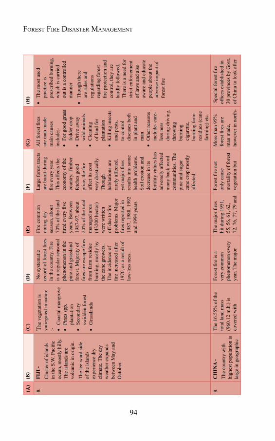
94
Forest Fire Disaster ManageMent(A
)(B)
(C)
(D)
(E)
(F)
(G)
(H)
8.FI
JI -
Clu
ster
of i
slan
ds
in th
e S.
W. P
acifi
c oc
ean,
mos
tly h
illy.
Th
e is
land
s are
vo
lcan
ic in
orig
in.
The
lee-
war
d si
de
of th
e is
land
s ex
perie
nce
dry
clim
ate.
The
dry
w
eath
er e
xpan
ds
betw
een
May
and
O
ctob
er.
The
vege
tatio
n is
va
riega
ted
in n
atur
e :-
Coa
stal
man
grov
e
Pine
s spp
. pl
anta
tion
Seco
ndar
y sw
idde
n fo
rest
Gra
ssla
nds
No
syst
emat
ic
reco
rd o
f for
est fi
res
in th
e co
untry
. Fire
is
a re
gula
r sea
sona
l ph
enom
enon
in th
e pi
ne a
nd g
rass
land
fo
rest
. Maj
ority
of
fires
are
esc
ape
fires
fr
om fa
rm re
sidu
e bu
rnin
g, m
ostly
by
the
cane
gro
wer
s. Th
e in
cide
nce
of
fire
incr
ease
d af
ter
1970
, as a
resu
lt of
la
w-le
ss n
ess.
Fire
com
mon
du
ring
dry
seas
on, a
bout
70
% o
f the
land
fir
ed e
very
five
ye
ars.
Bet
wee
n 19
87-9
7, a
bout
20
% o
f the
tota
l m
anag
ed a
rea
(432
00 h
ecto
r)
wer
e w
ritte
n of
f due
to fi
re
prob
lem
s. M
ajor
fir
es re
porte
d in
19
87, 1
988,
199
2 an
d 19
94 y
ears
Larg
e fo
rest
trac
ts
are
burn
t dur
ing
fire
ever
y ye
ar.
This
affe
cts t
he
econ
omy
of th
e co
untry
. Tim
ber
fetc
hes g
ood
pric
e, th
e fir
e af
fect
its c
ost
very
dra
stic
ally
. Th
ough
ha
bita
tions
are
ra
rely
affe
cted
, ye
t maj
or fi
res
resu
lts in
to so
me
heal
th p
robl
ems.
So
il er
osio
n an
d de
crea
se in
its
ferti
lity
valu
es h
as
adve
rsel
y af
fect
ed
man
y ba
ck w
ord
com
mun
ities
. The
pi
ne a
nd su
gar
cane
cro
p m
ostly
af
fect
ed.
All
fore
st fi
res
are
man
mad
e m
ain
caus
es
incl
ude:
-
For g
ood
gras
s fo
dder
cro
p
Driv
e aw
ay
wild
ani
mal
s.
Cle
anin
g of
land
for
plan
tatio
n
Kill
ing
inse
cts
and
pest
s, to
con
trol
dise
ases
bot
h in
pla
nt a
nd
man
Oth
er re
ason
s in
clud
e- c
are-
less
nes
s du
ring
driv
ing,
th
row
ing
burn
ing
ciga
rette
, bu
rnin
g fa
rm
resi
dues
(can
e fa
rmin
g) e
tc.
The
mos
t use
d pr
actic
e is
pr
escr
ibed
bur
ning
, w
hich
is c
arrie
d ou
t is a
con
trolle
d m
anne
r
Thou
gh th
ere
are
rule
s and
re
gula
tions
re
gard
ing
fore
st
fire
prot
ectio
n an
d co
ntro
l, th
ey a
re
hard
ly fo
llow
ed.
Ther
e is
a n
eed
for
stric
t enf
orce
men
t of
law
s and
als
o
awar
e an
d ed
ucat
e pe
ople
abo
ut th
e ad
vers
e im
pact
of
fore
st fi
re
9.C
HIN
A -
The
coun
try w
ith
high
est p
opul
atio
n is
la
rge
in g
eogr
aphi
c
The
16.5
5% o
f the
to
tal l
and
mas
s (9
60.1
2 m
.h.)
is
cove
red
with
Fore
st fi
re is
a
very
com
mon
ph
enom
enon
eve
ry
year
. The
maj
or
The
maj
or fi
res
hit d
urin
g 19
51,
55, 5
6, 6
1, 6
2,
72, 7
6, 7
7, 7
9 an
d
Fore
st fi
re n
ot
only
cau
se
mor
talit
y of
fore
st
vege
tatio
n bu
t
Mor
e th
an 9
5%
fore
st fi
res a
re
man
mad
e,
how
ever
in n
orth
-
Spe
cial
fore
st fi
re
offic
es e
stab
lishe
d in
30
pro
vinc
es b
y G
ovt.
of C
hina
to lo
ok a
fter
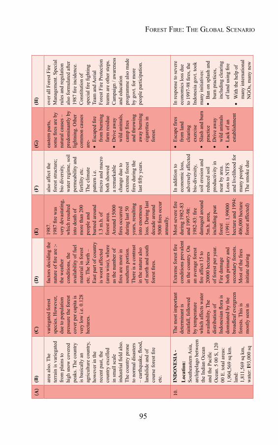
95
(A)
(B)
(C)
(D)
(E)
(F)
(G)
(H)
area
als
o. T
he
terr
ain
is v
arie
gate
d fr
om p
lain
s to
high
snow
cov
ered
pe
aks.
The
coun
try
is b
asic
ally
an
agric
ultu
re c
ount
ry,
how
ever
in th
e re
cent
pas
t, th
e co
untry
exc
elle
d in
smal
l sca
le
indu
stria
l fiel
d al
so.
The
coun
try p
rone
to
nor
mal
dis
aste
rs
– ea
rthqu
ake,
floo
d,
land
slid
e an
d of
co
urse
fore
st fi
re
etc.
varie
gate
d fo
rest
sp
ecie
s. H
owev
er,
due
to p
opul
atio
n pr
essu
re th
e fo
rest
co
ver p
er c
apita
is
very
low
i.e.
0.1
28
hect
ares
.
fact
ors d
ecid
ing
the
natu
re o
f fire
are
:-th
e w
eath
er
cond
ition
s, th
e av
aila
bilit
y of
fuel
m
ater
ial i
n fo
rest
et
c. T
he N
orth
–
East
par
t of c
ount
ry
is w
orst
affe
cted
(a
rea
wis
e), w
here
as
the
num
ber o
f fir
es a
re m
ore
in
sout
hern
por
tion.
Th
ere
is a
con
trast
in
the
natu
re a
lso
of n
orth
and
sout
h fo
rest
fire
s.
1987
.19
87 fi
re w
as
very
dev
asta
ting,
w
hich
resu
lted
into
dea
th o
f m
ore
than
200
pe
ople
and
bu
rned
aro
und
1.3
m.h
. of
fore
st a
rea.
A
roun
d 15
000
fires
occ
urre
d du
ring
last
50
year
s, re
sulti
ng
into
eno
rmou
s lo
ss. D
urin
g la
st
deca
de a
roun
d 50
00 fi
res o
ccur
an
nual
ly.
also
affe
ct th
e fo
rest
stru
ctur
e;
bio
dive
rsity
, w
ater
regi
me,
soil
perm
eabi
lity
and
ferti
lity
etc.
Th
e cl
imat
e pa
ttern
i.e.
m
icro
and
mac
ro
both
show
ed
a re
mar
kabl
e ch
ange
due
to
extre
me
fore
st
fires
dur
ing
the
last
fifty
yea
rs.
east
ern
parts
, so
me
fires
are
by
natu
ral c
ause
s –
pred
omin
antly
by
light
ning
. Oth
er
com
mon
cau
ses
are-
Esca
ped
fire
from
bur
ning
fa
rm re
sidu
e
Driv
e aw
ay
wild
ani
mal
s, ca
mp
fires
an
d th
row
ing
away
bur
ning
ci
gare
ttes i
n fo
rest
.
over
all
Fore
st F
ire
Man
agem
ent.
Spec
ial
rule
s and
regu
latio
n al
so fo
rmul
ated
afte
r 19
87 fi
re in
cide
nce.
Con
stitu
tion
of
spec
ial fi
re fi
ghtin
g Te
am a
nd A
eria
l Fo
rest
Fire
Pro
tect
ion
team
s are
oth
er st
eps.
Cam
paig
n / a
war
enes
s an
d ed
ucat
ion
prog
ram
me
also
mad
e by
gov
t. fo
r mor
e pe
ople
par
ticip
atio
n.
10.
IND
ON
ESI
A -
Loc
atio
n:
Sout
heas
tern
Asi
a,
arch
ipel
ago
betw
een
the
Indi
an O
cean
an
d th
e Pa
cific
O
cean
. 5 0
0 S,
120
00
E. t
otal
are
as:
1,90
4,56
9 sq
km
. la
nd:
1,81
1,56
9 sq
km
, w
ater
: I93
,000
sq
The
mos
t im
porta
nt
dete
rmin
ant i
s ra
infa
ll, fo
llow
ed
by te
mpe
ratu
re
whi
ch a
ffect
s wat
er
avai
labi
lity.
The
di
strib
utio
n of
In
done
sian
flor
a is
do
min
ated
by
the
broa
dlea
f eve
rgre
en
fore
sts.
This
is
mos
tly se
en in
Extre
me
fore
st fi
re
cond
ition
s pre
vale
nt
in th
e co
untry
. On
an a
vera
ge fo
rest
fir
e af
fect
15
to
2000
0 he
ctar
es
of fo
rest
per
yea
r. Fi
re d
amag
e bo
th p
rimar
y an
d se
cond
ary
fore
sts.
Mos
t of t
he fi
res
initi
ate
durin
g
Mos
t sev
ere
fire
durin
g 19
82-8
3 an
d 19
97-9
8:19
82-8
3: fi
re
dam
aged
aro
und
5m.h
. are
a,
incl
udin
g pe
at
fore
st(1
991:
1,9
9000
he
ctar
e an
d 19
94:
406,
000
hect
are
fore
st a
ffect
ed)
In a
dditi
on to
ec
onom
ic lo
ss,
adve
rsel
y af
fect
ed
bio-
dive
rsity
, so
il er
osio
n an
d re
duce
d so
il pr
oduc
tivity
in
near
by
area
. Lo
ss to
NTF
S an
d liv
elih
ood
for
man
y pe
ople
. Th
e sm
oke
due
Esca
pe fi
res
from
land
cl
earin
g ex
erci
se
Slas
h an
d bu
rn
prac
tice
Driv
e aw
ay
wild
ani
mal
s
Lack
of a
n es
tabl
ishm
ent
In re
spon
se to
seve
re
econ
omic
s los
s due
to
199
7-98
fire
s, th
e In
done
sia
govt
. too
k m
any
initi
ativ
es:
Ban
on
spla
sh a
nd
burn
pra
ctic
es,
incl
udin
g cl
earin
g of
land
usi
ng fi
re
With
the
help
of
man
y in
tern
atio
nal
NG
Os,
man
y ne
w
Forest Fire: the Global scenario

96
Forest Fire Disaster ManageMent(A
)(B)
(C)
(D)
(E)
(F)
(G)
(H)
km. T
erra
in- m
ostly
co
asta
l low
land
s;
larg
er is
land
s hav
e in
terio
r mou
ntai
ns.
Clim
ate-
trop
ical
; ho
t, hu
mid
; m
ore
mod
erat
e in
hig
hlan
ds.
Popu
latio
n-
appr
oxim
atel
y 23
7 m
illio
n.
the
regi
ons w
here
po
pula
tion
dens
ity is
st
ill re
lativ
ely
low,
su
ch a
s Sum
atra
, B
orne
o, S
ulaw
esi
and
Wes
t Pap
ua.
On
Java
and
Bal
i th
e ve
geta
tion
is d
omin
ated
by
culti
vate
d pl
ants
. Sw
amp
fore
sts,
man
grov
e, a
nd
Nyp
a fr
utic
ans
fore
sts a
re fo
und
alon
g th
e co
ast.
On
the
mou
ntai
nous
re
gion
s sub
alpi
ne
and
alpi
ne v
eget
atio
n is
dom
inan
t. In
the
less
er S
unda
isla
nds,
whe
re ra
infa
ll is
no
t as p
lent
iful a
s in
oth
er p
arts
of
Indo
nesi
a, g
rass
land
s ar
e re
gula
rly se
en.
roug
ht se
ason
, tri
gged
by
EI-
Nin
o –
Sout
hern
O
scill
atio
n (E
NSO
). Pe
at fi
re is
als
o ve
ry fr
eque
nt a
nd
cont
inue
s for
long
pe
riod.
1997
-98:
The
m
ost d
isas
trous
fir
e in
the
hist
ory
caus
ed b
urni
ng o
f ar
ound
5.2
m.h
. of
fore
st. L
oss
appr
oxim
atel
y 2
billi
on d
olla
r tim
ber.
Maj
or fi
re d
urin
g 19
99 a
lso,
but
not
so
seve
re.
to fi
re c
ause
d se
rious
pro
blem
, es
peci
ally
dur
ing
(199
7-98
), w
hich
rem
aine
d fo
r man
y da
ys.
Num
ber o
f peo
ple
suffe
red
from
va
rious
dis
ease
s an
d tre
ated
for.
fu
nctio
ning
sy
stem
is a
lso
maj
or c
ause
.
Bur
ning
ci
gare
ttes
thro
wn
by
care
less
tre
espa
sser
s
pr
ojec
ts st
arte
d in
fir
e pr
one
area
.
Sepa
rate
D
irect
orat
e to
look
af
ter t
he p
robl
em a
t na
tiona
l lev
el.
Sour
ce: G
loba
l For
est R
esou
rces
Ass
essm
ent,
2010
97
4.2 Fire statistics and causesThe basic problem with fire research and development is lack of reliable statistics about the number of incidence, damage, area burnt, etc. This type of information is rarely available and if available, its reliability is question marked. The reliable data on occurrence of fires, area burned and damage are available only for limited countries. Economic Commission for Europe (ECE) publishes such data for Northern Hemisphere countries, including Eastern and Western European countries, U.S.A., Canada and Russia. For other countries data are collected from various sources and published regularly in different reports and journals. “International Forest Fire News” published from Germany, is a popular Journal publishing such reports regularly. “Global Fire Monitoring Centre” is another organisation, which is bringing out such reports on updated forest fire data worldwide.
Recently Global Forest Resources Assessment -2010 (a report prepared by FAO- UN) compiled information about forest fires from different countries all over the world. The main findings of the report about forest fire situation are as follows-
In 118 countries (having 65 percent of world forest cover) 19.8 million hectare of forest is affected by fire annually. This area represents less than one percent of the forest in these countries. (Table-4.2 & Fig.-4.1)
The largest areas of forest affected by fire were reported by Chad, Australia, United States of America, India and Canada, which all reported an average of more than 1 million hectares of forest burnt annually
Regarding the number of fires; as per the data compiled from 64 countries (representing 60 percent of the global forest area) an average of 487000 vegetation fires occurred per year during the period 2003-2007 in forests.
In terms of the number of forest fires, 81 countries, representing 50
Forest Fire: the Global scenario
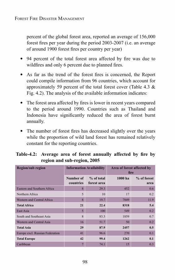
98
Forest Fire Disaster ManageMent
percent of the global forest area, reported an average of 156,000 forest fires per year during the period 2003-2007 (i.e. an average of around 1900 forest fires per country per year)
94 percent of the total forest area affected by fire was due to wildfires and only 6 percent due to planned fires.
As far as the trend of the forest fires is concerned, the Report could compile information from 96 countries, which account for approximately 59 percent of the total forest cover (Table 4.3 & Fig. 4.2). The analysis of the available information indicates:
The forest area affected by fires is lower in recent years compared to the period around 1990. Countries such as Thailand and Indonesia have significantly reduced the area of forest burnt annually.
The number of forest fires has decreased slightly over the years while the proportion of wild land forest has remained relatively constant for the reporting countries.
Table-4.2: Average area of forest annually affected by fire byregion and sub-region, 2005
Region/sub region Information Availability Area of forest affected by fire
Number of countries
% of total forest area
1000 ha % of forest area
Eastern and Southern Africa 8 29.3 452 0.6
Northern Africa 5 10 17 0.2
Western and Central Africa 8 19.7 7849 11.9
Total Africa 21 22.4 8318 5.4
East Asia 5 100 549 0.2
South and Southeast Asia 8 83.3 1859 0.7
Western and Central Asia 16 51.7 50 0.2
Total Asia 29 87.9 2457 0.5
Europe excl. Russian Federation 41 96.6 270 0.1
Total Europe 42 99.4 1262 0.1
Caribbean 7 74.1 15 0.3
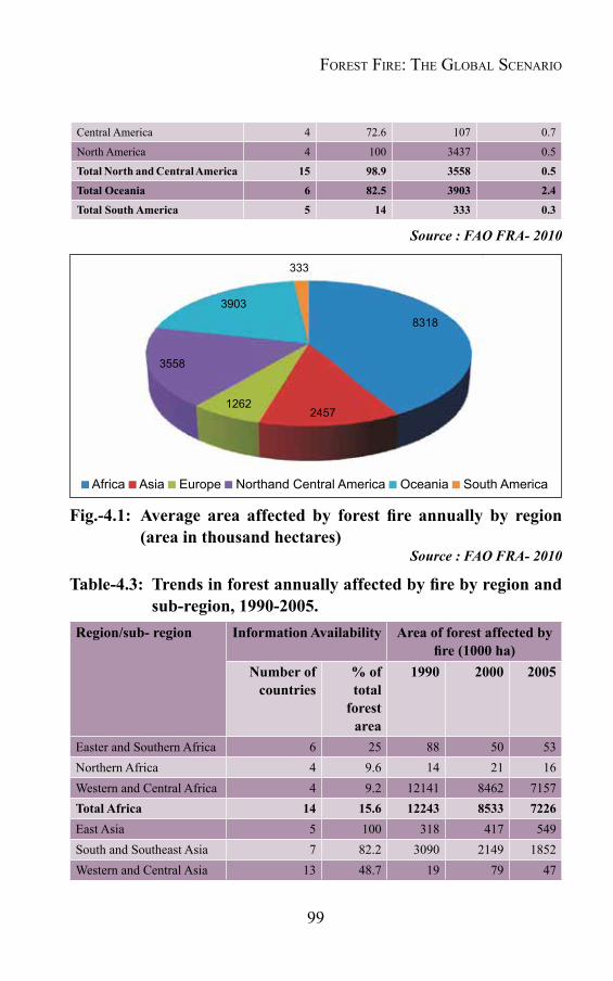
99
333
3903
3558
1262
8318
2457
Africa Asia Europe Northand Central America Oceania South America
Central America 4 72.6 107 0.7
North America 4 100 3437 0.5
Total North and Central America 15 98.9 3558 0.5
Total Oceania 6 82.5 3903 2.4
Total South America 5 14 333 0.3
Source : FAO FRA- 2010
Fig.-4.1: Average area affected by forest fire annually by region(areainthousandhectares)
Source : FAO FRA- 2010
Table-4.3: Trendsinforestannuallyaffectedbyfirebyregionandsub-region, 1990-2005.
Region/sub- region Information Availability Area of forest affected by fire(1000ha)
Number of countries
% of total
forest area
1990 2000 2005
Easter and Southern Africa 6 25 88 50 53Northern Africa 4 9.6 14 21 16Western and Central Africa 4 9.2 12141 8462 7157Total Africa 14 15.6 12243 8533 7226East Asia 5 100 318 417 549South and Southeast Asia 7 82.2 3090 2149 1852Western and Central Asia 13 48.7 19 79 47
Forest Fire: the Global scenario
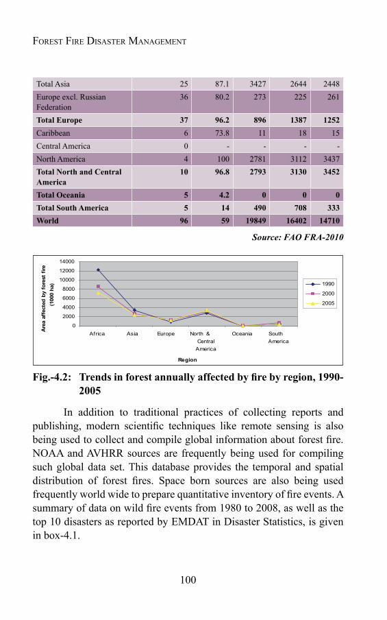
100
Forest Fire Disaster ManageMent
Total Asia 25 87.1 3427 2644 2448Europe excl. Russian Federation
36 80.2 273 225 261
Total Europe 37 96.2 896 1387 1252Caribbean 6 73.8 11 18 15Central America 0 - - - -North America 4 100 2781 3112 3437Total North and Central America
10 96.8 2793 3130 3452
Total Oceania 5 4.2 0 0 0Total South America 5 14 490 708 333World 96 59 19849 16402 14710
Source: FAO FRA-2010
Fig.-4.2: Trendsinforestannuallyaffectedbyfirebyregion,1990-2005
In addition to traditional practices of collecting reports and publishing, modern scientific techniques like remote sensing is also being used to collect and compile global information about forest fire. NOAA and AVHRR sources are frequently being used for compiling such global data set. This database provides the temporal and spatial distribution of forest fires. Space born sources are also being used frequently world wide to prepare quantitative inventory of fire events. A summary of data on wild fire events from 1980 to 2008, as well as the top 10 disasters as reported by EMDAT in Disaster Statistics, is given in box-4.1.

101
Box-4.1: Wild Fire Disasters from 1980 - 2008Overview Number of eventsNo of events: 294
No of people killed: 1,666
Average people killed per year: 57
No of people affected: 5,766,092
Average people affected per year: 198,831
EconomicDamage(US$X1,000): 42,806,705
EconomicDamageperyear(US$X1,000): 1,476,093
Top 10 Disasters ReportedAffected people Number of people affectedDisaster Date Affected (no. of people)Indonesia 1994 3,000,000 Macedonia FRY 2007 1,000,000 United States 2007 640,064 Argentina 1987 152,752 Portugal 2003 150,000 Paraguay 2007 125,000 Russia 1998 100,683 China P Rep 1987 56,313 Nepal 1992 50,000 Myanmar 1981 48,588
Killed people Number of people killed
Disaster Date Killed(no.ofpeople)Indonesia 1997 240 China P Rep 1987 191 Australia 1983 75 Greece 2007 67 Indonesia 1991 57 Nepal 1992 56 Mexico 1998 50 Mozambique 2008 49 Sudan 1998 47 Poland 1992 35
Economicdamages Reportedeconomicdamages(US$inbillion
Disaster Date Cost(US$X1,000)Indonesia 1997 8,000,000 Canada 1989 4,200,000 United States 2003 3,500,000 United States 2007 2,500,000 United States 1991 2,500,000 Spain 2005 2,050,000 Greece 2007 1,750,000 Portugal 2003 1,730,000 Mongolia 1996 1,712,800 Portugal 2005 1,650,000
Source: “EM-DAT: The OFDA/CRED International Disaster Database, University catholique de Louvain, Brussels, Bel.” Data version: v11.08
84
Box 4.1: Wild Fire Disasters from 1980 - 2008 Overview No of events: 294 No of people killed: 1,666 Average people killed per year: 57No of people affected: 5,766,092Average people affected per year: 198,831 Economic Damage (US$ X 1,000): 42,806,705 Economic Damage per year (US$ X 1,000): 1,476,093
Top 10 Disasters Reported Affected people Disaster Date Affected (no. of people)Indonesia 1994 3,000,000 Macedonia FRY 2007 1,000,000 United States 2007 640,064 Argentina 1987 152,752 Portugal 2003 150,000 Paraguay 2007 125,000 Russia 1998 100,683 China P Rep 1987 56,313 Nepal 1992 50,000 Myanmar 1981 48,588
Killed people
Disaster Date Killed (no. of people)Indonesia 1997 240 China P Rep 1987 191 Australia 1983 75 Greece 2007 67 Indonesia 1991 57 Nepal 1992 56 Mexico 1998 50 Mozambique 2008 49 Sudan 1998 47 Poland 1992 35
Economic damages
Disaster Date Cost (US$ X 1,000)Indonesia 1997 8,000,000 Canada 1989 4,200,000 United States 2003 3,500,000 United States 2007 2,500,000 United States 1991 2,500,000 Spain 2005 2,050,000 Greece 2007 1,750,000 Portugal 2003 1,730,000 Mongolia 1996 1,712,800 Portugal 2005 1,650,000
Source of data: "EM-DAT: The OFDA/CRED International Disaster Database, University catholique de Louvain, Brussels, Bel." Data version: v11.08
Reported economic damages (US$ in billion)
Number of people killed
Number of people affected
Number of events
Forest Fire: the Global scenario
102
Forest Fire Disaster ManageMent
4.3 WorldwidecausesofforestfireMore than 90 percent forest fires all over the world are initiated due to anthropogenic activities, in which majority is related to land use pattern. Conversion of forestland to agriculture, pastureland and plantation are the main eminent factors for such incidences. In tropics, two types of practices for conversion of forest land are common i.e. shifting cultivation and permanent conversion.
a) Shifting Cultivation: The shifting cultivation is the farming practice where forest land is allowed to return to forest crop after a shorter period of use. In such practices, the forest vegetation are cut at the end of rainy season and allowed over to dry for some period and then burnt. The vegetation ash is left in the area, which provides sufficient nutrient for the agriculture crop. This cleared area is used for agriculture for few years until the crop production decline. After this the land is left for natural forest regeneration and new forest area is searched for agriculture purpose. The practice is commonly used by millions of people throughout the world causing immense loss to forest. In the recent past, due to increasing population pressure and lack of other alternative livelihood resources, this traditional land use techniques has not only increased but also lead to shortening of shifting cultivation cycle.
b) Permanent Conversion: With the increasing population pressure, the forest areas in many countries are permanently converted to non forestry purposes, such as pastures, agriculture land, resettlement and orchards. Such conversion of forest also follows after clear felling and setting the permanent forest vegetation on fire. The resettlement in Tarai belt of U.P. and other states in India are the recent example of such conversion, where thousand of hectares of forest area are cut and burnt to resettle the migrant population and do agriculture practice.
These two practices discussed above are the major causes of forest fire and degradation of forest cover dominant in tropical countries. Though reliable data is not available, yet as per an estimate, almost one to two billion metric tons of forest vegetation is destroyed by these

103
practices, resulting into enormous social, economical, ecological and environmental damage.
c) Other causes: In addition to agricultural use, the forest fire issues are linked with other economical and social factors also. Collection of non timber forest produce (NTFP) like mahua, Sal-seeds, kendu leaves etc. are other major causes for initiating forest fire in many developing countries. Besides economical issues, in some tribal clans forest is ignited to celebrate some ritual customs. This ignited fire usually spreads in the adjoining forest and results into catastrophe.
The aggressive fire suppression has also been up to an extent responsible for extreme fire events by altering the composition of the tree species, which are more fire prone. As a result the forests, specially the dry forests are dominated by heavy ground fuels and high tree densities, which are much more likely to have severe fires. Conversion of fire resistant old forests to plantation is also up to an extent responsible for increased fire risk in the forests.
Among the developmental activities, road construction has been the most devastating factor for increase in forest-fire incidences. Roads are turned as ignition source that contribute to fire risk by providing access to forests, where people can ignite it. Increase in grazing by livestock is another common cause of forest fire throughout the world. Grazing removes the grassy fuels that carry frequent surface fires and often ushers in fire prone exotic plants and shrubs. Fires are initiated by picnickers, grazers, tourists etc. due to negligence. Throwing burning cigarette butts, camp fires, cooking food within or near the forest areas are examples when fire is caused merely by negligence.
4.4 International Cooperation in Forest Fire Management
4.4.1 Global initiatives are essential to deal with regional issues, like global climate change, rise of sea levels, melting of glaciers and of course forest fire. During the recent past forest fire has emerged as a severe problem adversely affecting the health and sustainability of the global
Forest Fire: the Global scenario
104
Forest Fire Disaster ManageMent
vegetation. Keeping in view the severity of the problem, a need has been felt worldwide to evolve an effective strategy for fire management planning and practices by seeking international cooperation. It has been felt that communities, being the first responder, be engaged in its management vigorously and experience and expertise of countries be shared for capacity building of individual countries to effectively tackle the problem. Joint research and development network, especially in advancing knowledge about forest fire and in learning from one another's experience carry a lot of advantage and strengthen the prevailing system. Early warning techniques, use of satellite data, suppression techniques, sending experts at the time of fire breakout etc. are the field activities, where such cooperation may be of immense use and significance. In the case of severe fire, it is natural for friendly countries to share expertise and rush helpful agencies that carry rich experiences and could be of great service in the hours of need.
The Global Fire Monitoring Centre (GFMC) is the foremost pioneer organization providing individual support and relevant information useful in strengthening an international cooperation. The Centre is hosted by the Fire Ecology and Biomass Burning Research Group (FEBBRG) of the Max Planck Institute of Chemistry, Bio geochemistry Department, Germany. The Centre was established initially by Government of Germany as a German contribution to the UN sponsored International Decade of Natural Disaster Reduction (IDNDR) 1990-2000 programme. The GFMC, carrying out extensive research and demonstration in the subject of forest fire is providing consultancy services to many countries. Cooperation with Deutsche Gesellschaft fur Technische Zusammenarbeit (GTZ) projects was implemented in Brazil 1980-82, Indonesia-1987, Algeria-1992, Argentina-1991-97, Srilanka-1991 etc. The Centre has close partnership and association with several international agencies and institutions i.e.
The UN International Decade of Natural Disaster Reduction (IDNDR) and its successor arrangement, the International Strategy for Disaster Reduction (ISDR).
105
The World Conservation Network (WCN).
The Deutsche Gesellschaft fur Technische Zusammenarbeit mbH (GTZ).
The United Nations Economic Commission for Europe (ECE).
UN International Search and Rescue Advisory Group (INSARAG), Fire Group.
The International Tropical Timber Organization (ITTO).
The World Health Organization (WHO).
The United Nations Educational and Scientific Organization (UNESCO).
The World Bank, Disaster Management Facility (DMF) and its associated pro- Vention Consortium on Natural and Technological Catastrophes and the World Institute for Disaster Risk Management.
The Technical Assistance to the Commonwealth of Independent States (TACIS) programme in Russia.
The U.S. Bureau of Land Management (BLM).
In the recent past an increasing collaboration among countries and among regions in the field of forest fire management is observed and many more agencies are getting involved in it. The regional analysis by FAO- UN in its report “Fire management: global assessment 2006” mentions -
22 international emergency response agreements, 16 international agreements on other matters and 6 national inland agreements dealing with forest fires globally.
Bilateral and other agreements for joint fire suppression or the exchange of fire crews are in force in several places, especially in border areas, for example Canada with the United States, China
Forest Fire: the Global scenario
106
Forest Fire Disaster ManageMent
with Russia, among some countries of Meso-America, Mexico with the United States; Mongolia with China and Russia, Russia with Finland; and Russia with the Islamic Republic of Iran.
Adhoc agreements have been formulated to respond to emergency situations such as between Brazil and Colombia in 1998.
The three North American countries have jointly adopted the Incident Command System, enabling them to work together using a unified command structure and terminology.
Bilateral and multilateral emergency assistance are also in place, for example the assistance offered by Australia and Singapore to Indonesia in 2005, or by the United States to Mexico.
International fire response exercises have been conducted with multilateral cooperation in the Baltic region (BALTEX Fire 2000), the European Union (France 2004) and Balkans (“Taming the Dragon” 2002, organized by North Atlantic Treaty Organization)
In 2000, the World conservation Union and Global Fire Monitoring Centre (GFMC) suggested the creation of an interagency working group (WG) on wild land fire as a contribution to and in accordance with- the framework for implementation of the United Nations International Strategy for Disaster Reduction (UN-ISDR). The working group formally came into existence in 2000 with the name of WG-4. It ultimately provided an international, interagency and intersectoral forum in which United Nations agencies and civil society worked together to formulate a vision and common goals to enhance interagency and international cooperation towards “reducing the negative impacts of fire on the environment and humanity”.
WG-4 emphasized the establishment of a “global network of regional-to national- level focal point for early warning of wild land fire, fire monitoring and impact assessment”.
107
The 3rd International Wild Land Fire Conference and the International Wild Land First Summit were held in Sydney, Australia, in October 2003. This helped in formulating a development strategy i.e. “Strategy for Future Development of International cooperation in Wild Land Fire Management”, aiming to develop and strengthen regional Wildland Fire Networks through networking in information sharing, capacity building, preparation of bilateral and multilateral agreements.
At the end of 2003, WG-4 became the Wildland Fire Advisory Group (WFAG) under the auspices of UN-ISDR. It represents an advisory body to the United Nations system, providing technical, scientific and policy- supporting advice through UN-ISDR and IATF and acting as a liaison between the United Nations system and GWFN and its supporting partners.
Regional Wild land Fire Networks with the support of GWFN are involved in following important activities:
Regional agreements such as the ASEAN Agreement on Transboundary Haze Pollution in 2001, which entered into force in 2003, and the Congo Basin Conservation Treaty, signed at the Congo Basin Forest Summit in 2005;
Regional plans for cooperation in fire management
Establishment of training centres
Regional meetings and declarations
In addition to above, various UN agencies are also involved in strengthening international cooperation in the field of forest fire management. The significant contributions of such agencies may be enlisted as-
FAO- promotion of international cooperation in vegetation fire management; technical cooperation programmes (TCPs) in the field and information dissemination through seven regional forest commissions;
Forest Fire: the Global scenario
108
Forest Fire Disaster ManageMent
World Health Organization (WHO)- development of Health guidelines for vegetation fire events;
World Meteorological Organization (WMO)- forecasting/ early warning of EL Nino, fire weather and smoke transport phenomena involving the global network of hydrometerological stations;
International Tropical Timber Organization (ITTO)- support to national fire management and participation of producer countries in the International Wild land Fire Conference;
United Nations University- vegetation fire research and training focus through establishment of University of Freiburg as an associate institute of UNU;
UN conventions- agreement by the secretariats of the three Rio Conventions.
4.4.2 Guiding Principles for International Cooperation: While seeking or providing help at international level, urgent need of a well-drawn strategy is very much felt, which can guide and help the countries and even the communities facing the menace of forest fire? The International Wild Land Fire Summit, held at Sydney in October, 2003 came out with some significant guiding principles in this regard, which may be effective while formulating international cooperation projects for forest fire management. While carrying out international cooperation some issues which need due consideration are-
a)Generalissues Developing countries are especially challenged by fires because
of their important links with land use practices, socio-economic and other social issues and food production; management practices here must take all these aspects into consideration.
The result and outcome of forest fire management projects in different countries must be published and made available for experience sharing and lesson learning.

109
Community-based fire management forms the basis of effective fire management programs at the community level, in both developed and developing countries.
The contributions, commitments and responsibilities of all those involved must clearly be stated, especially in relation to accountability, command and control, and financial, human resource and other non-financial inputs of the project.
Must try to achieve sustainable institutional strengthening and capacity building within government agencies and in appropriate circumstances include Non-Government Organizations (NGOs) etc. for effective forest fire management.
Should have as one objective the delivery of sustainable outcomes for end users at the local community level.
Should be undertaken using agreed international procedures and protocols.
Systematic monitoring, accurate reporting and accessible information archiving.
Appropriate initiatives suited to the culture, technology, environmental conditions, educational and economic circumstances of the recipient country.
Holistic approach for forest fire management, including fire protection, planning, prevention, suppression and rehabilitation.
All fire management activities should be safe, cost- effective and support sound natural resources management.
Consistent with a more inclusive style of fire management that incorporates the needs and expectations of people.
Fire management and suppression plans must incorporate and understand the need and expectations of communities and local stakeholders.
Forest Fire: the Global scenario

110
Forest Fire Disaster ManageMent
Fire suppression operations must be in accordance with a previously agreed command and control structure.
b)FireProtectionPlans- A Fire Protection Plan is must to carry out preparedness and response activities. A well developed Plan must include:
An assessment of the threat to human life, property, forest, other wooded land and other land assets and values, in conjunction with the management objectives for the area.
Preparedness for the fire suppression must reflect the variable nature of fire dangers.
Developing appropriate modern early warning capability of wild-land fire danger.
Initiate prevention activities to reduce the hazards and potential losses.
Must ensure a measured fire suppression response that reflects the threat, the safety of fire fighting personnel and the public, and the impact on the environment.
Must formalize a single management structure for all personnel.
Trained, well equipped, assessed and accredited personnel must be appointed.
Striving for consistent funding that enables fire managers to adequately meet the goals of the guiding principles safely and efficiently.
c) FuelManagement- Out of three integral components of fire i.e. heat, oxygen and fuel; better fuel management practices may reduce the vulnerability of an area to fire. In conducting fuels management operations, the following should be considered:
Fuels management programs need to be planned to provide protection to human life and property, by reducing the potential
111
hazards associated with wild-land fires and at the same time maintaining the environmental integrity of the landscape and preserving cultural resources.
Reducing fuels through mechanical or physical means or through the use of prescribed burning to management objectives must satisfy legal requirements and be thoroughly planned.
Using or excluding prescribed fire, based on scientific knowledge.
Basing prescribed burning operations on clearly defined objectives and prescriptions, providing a safe working environment, and minimizing the risk of fire escape.
Incorporating during the fuels management planning process, the principles of environmental care, in accordance with approved standards, prescriptions and guidelines.
d) Environmental Protection- Forest fire cause immense loss to environment, to minimize it the following principles need to be observed:
Fire management activities should be based upon good scientific studies and follow sound management principles.
These activities should be planned and conducted in an environmentally sensitive manner taking into account fire regimes and fire management activities appropriate to maintain the vigor and diversity in populations of species and communities of the area's indigenous flora and fauna.
Appropriate measure to be taken to safeguard water quality and quantity. Also ensure to minimize the impact of fire management activities on streams, springs, soaks, swampy ground and bodies of standing water, and their physical and biological quality.
Landscape values, geomorphologic features, cultural and historical sites being considered when planning operations.
Soil being protected by measures which prevent inappropriate
Forest Fire: the Global scenario

112
Forest Fire Disaster ManageMent
destruction of its physical and chemical properties or which promote stabilization of bare or disturbed earth following disturbance.
Indigenous flora and fauna being protected following wildfire suppression by measures which promote the re-establishment of the ecological processes existing prior to the wildfire.
e) Capacity-buildinginfiremanagement
Another area of importance in international collaboration is capacity building in fire management. There is quite good scope to enhance the capacity of individual country through training of its officials and other staff (mainly forest department personnel) and exposure visits in countries having good infrastructures and experience in handling forest fires.
Need based research and dissemination of outcomes is of utmost significance in enhancing capacity of individual country in managing forest fire. There is need for regional research in the field of forest fire management, including fire impact on ecosystem, development of fire danger ratings, fire behavior prediction, socio- economic aspect of forest fire etc. Use of modern techniques including remote sensing in fire detection, use of prescribed fires, fire suppression techniques and innovative equipments, impact assessment etc. are some of the other burning research topics, which need immediate attention and further research at regional levels. The outcomes of the research need to be shared for its optimum utilization.
f) Strengtheningearlywarning
The UN Secretary General had requested development of a global vegetation fire information system, as laid out in the Hyogo Framework for Action 2005-2015: building the resilience of nations and communities to disasters (GFMC, 2006b). In 2005 an international consortium of institutions endorsed such an information system as a thematic component of the global multi hazard early warning system.
113
The objectives of the global fire early warning systems are to:
develop a global early warning system for vegetation fire.
develop an information network to quickly disseminate early warning of fire danger globally to local communities;
develop a historical record of global fire danger information for early warning product enhancement, validation and strategic planning purposes;
design and implement a technology transfer programme to provide the following training for global, regional, national and local community applications;
– Early warning system operation,
– Methods for local to global calibration of the system,
– Use of the system for prevention, preparedness, detection and where appropriate, fire response decision- making.
4.5 Incident Command System (ICS) &International cooperation
4.5.1 Experiences in the past have shown that at the time of emergency situations, as in the case of forest fire suppression, parochial attitudes, internal politics and the lack of communication result into poorly managed operations. Lack of coordination among various agencies and unclear accountability often result in safety issues being neglected. Therefore, there is a professional, social, economic and political demand for a well coordinated and timely effective system to tackle any emergency situation in an efficient manner. Incident Command System (ICS) is a model tool for command, coordination and use of resources at the site of the incident. The system was evolved after a major forest fire in Southern California during 1970. The system is based on the management and direction tools, experts and Disaster Managers are already aware of.
Forest Fire: the Global scenario
114
Forest Fire Disaster ManageMent
Incident Command System has proved to be very effective in managing not only forest fires but also other common disasters, such as floods, earthquakes, volcanic explosions etc. In the recent past, many countries have adopted the ICS or similar systems for addressing emergencies. In addition, a number of them have adopted fire-fighting agreements based on a common system enabling interoperability when lending support to other countries. Australia and New Zealand faced with emergency response issues, evaluated incident management systems around the world, elected to adopt the ICS and modify it to their specific requirements. The system has proved very effective, not only in these countries but has also proved useful in rendering help to others at the time of need. They even helped USA by sending critically needed incident managers to tackle the emergency situation in the past. ICS was also used during forest fire in Ethiopia during 2000.
Thus ICS has been very popular and effective, while incorporating International Cooperation at the time of emergency, including forest fire. ICS has considerable flexibility and can grow/shrink or adopt to meet different area specific needs. The system may need to be adopted to suit a particular country's existing political, cultural, social and administrative systems. Such adaptations are beneficial in making system more useful during international cooperation in managing emergency situations. It is in real sense very essential that the helping country and the receiving country both use the same emergency management systems, which facilitates the management operation in all aspects.
Why ICS is required? While managing a disastrous emergency situation, many management problems emerge. The ICS system has been specially designed to adhere to the majority of such problems viz.:
(1) Inefficient supervision.
(2) Incomplete communication.
(3) Lack of proper coordination among stake holders.
(4) In-efficient organizational structure.
115
(5) In-consistent terminology.
(6) Poor information flow network.
(7) Unclear line of authority.
ICS is a system evolved after considerable effort and investment of time to address all these issues and effectively tackle them simultaneously. The basic characteristics of an efficient ICS system are that it must-
– be cost effective,
– be flexible to suit the local needs and condition,
– facilitate common management structures that integrate with officials from different agencies, and
– be able to be used on a daily basis for routine situations and major emergencies.
4.5.2 Essential components of ICS- In addition to the basic characteristics discussed above, the ICS system must be equipped with following components to make it more suitable and useful:
(i) Common Technology: - Essential in any emergency management, especially when diverse groups or agencies are involved as responders.
(ii) Integrated Communication: - Requires a common communication plan, standard operating procedures, common frequency and common terminology.
(iii) Identified functionaries: - There must be well designated and identified functionaries, working as primary and secondary support systems with clearly defined functions to assist in the effective management of an incidence.
(iv) Appropriate and comprehensive resource management:- Organizing resources across all agencies involved in incident management including-
Forest Fire: the Global scenario
116
Forest Fire Disaster ManageMent
– Optimizing resources use.
– Providing accountability.
– Maintaining resources during long duration incidents.
– Managing day and night shift resources.
– Reducing communication load.
– Maximum personnel safety.
(v) Appropriate Action Plan: - Incident action must cover all objectives and support activities during the operation. It should preferably be a written document clearly describing, the responsibility and accountability of every individual.
(vi) Manageable Span of Control: - It describes the number of individuals or functions to be effectively managed by one single person. Depending upon the situation and availability of the resource person, the span of control may be ticked.
4.5.3 Frameworkandorganizationalstructuresrequired
ICS framework provides a well coordinated inter-agency management plan to tackle an emergency situation more effectively and efficiently. This framework provides opportunity to establish a united command of the respective agencies together at a single location, so that a single incident action is developed to achieve the following objectives:-
1. Duplication of effort is reduced or eliminated reducing the chance of confusion.
2. The combined effects of all agencies are optimized as they perform their respective assignments under single Incident Action Plan.
117
3. One set of objectives for the incident.
4. A collective approach to develop strategies to achieve set objectives.
5. Coordination and information flow between agencies involved.
6. No agency's authority or legal requirement will be compromised or neglected.
7. Each agency is fully aware of the plan, action, and constraints of other agencies.
The organizational structure of ICS is based around the following five major management authorities:-
Command - Sets objectives and priorities
- Has overall responsibility of the incident or event
Operations - Conducts tactical operations to carry out the plan
- Develops tactical objectives
- Organisation
- Directs all resources
Planning - Develops the action plan to accomplish the objectives
- Collects and evaluates information
- Maintains resource status
Logistics - Provides support to meet incident needs
- Provides resources and all other services needed to support the incident
Finance/ - Monitors costs related to incidentAdministration - Provides accounting
Forest Fire: the Global scenario
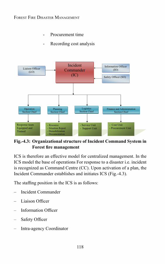
118
Forest Fire Disaster ManageMent
- Procurement time
- Recording cost analysis
Fig.-4.3: Organizational structure of Incident Command System in Forestfiremanagement
ICS is therefore an effective model for centralized management. In the ICS model the base of operations For response to a disaster i.e. incident is recognized as Command Centre (CC). Upon activation of a plan, the Incident Commander establishes and initiates ICS (Fig.-4.3).
The staffing position in the ICS is as follows:
– Incident Commander
– Liaison Officer
– Information Officer
– Safety Officer
– Intra-agency Coordinator
119
– Operations Section Chief
– Planning Section Chief
– Logistics Section Chief
– Finance & Administration Section Chief
– Operation Teams
– Damage Assessment
– Search and Rescue
– Medical Assistance
– Donation Management
– Restoration of each ESF (Emergency Support Functions)
– Relief Camps Team
Forest Fire: the Global scenario
Chapter 5
FOREST FIRE: THE INDIAN SCENARIO
5.1 IntroductionIndia constitutes one of the mega bio-diversity zones of the
world, abundant with unique and diversified floral and faunal wealth. With 6, 92,027 square kilometers of forest cover, India is one of the richest areas of bio-diversity in the world. Including environmental benefits, the forests of the country are economically also very rich. If we take the example of conifers only, India has about 1.7 mh of productive conifer forest, with various valuable timber species i.e. fir, spruce, deodar, kail, teak, sal and chir pine. Estimated growing stock of these forests is over 200 million cubic meters, the monitory value of which comes to be more than Rs. 40,000 to 60,000 millions (Bahuguna, 1999). In the country, with about 17 percent of the world human and 18 percent of cattle population, forests meet nearly 40 percent of the energy and 30 percent of the fodder needs. It is estimated that about 270 million tons of fuel wood, 280 million tons of fodder, over 12 million cubic meters of timber and a large quantity of Non-Timber Forest Produces (NTFPs) are removed from the forests annually. Due to increasing population pressure need, this exemplary land ecosystem of the world is struggling for its survival. Increasing human interference in the natural forest ecosystem has also tremendously increased the forest fire incidences. Forest fire is one of the causative factors, which periodically covers large forest areas destroying timber, other properties and wild life etc. The ecosystems are under severe threat due to recurrent fires, which is attributed to the forest degradation, soil erosion, reduced productivity etc. Every year one or other part of the forests in India is facing the agony in the cruel hands of mankind by putting fire intentionally or
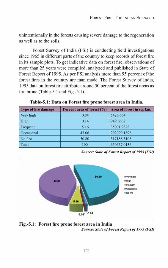
121
unintentionally in the forests causing severe damage to the regeneration as well as to the soils.
Forest Survey of India (FSI) is conducting field investigations since 1965 in different parts of the country to keep records of forest fire in its sample plots. To get indicative data on forest fire, observations of more than 25 years were compiled, analyzed and published in State of Forest Report of 1995. As per FSI analysis more than 95 percent of the forest fires in the country are man made. The Forest Survey of India, 1995 data on forest fire attribute around 50 percent of the forest areas as fire prone (Table-5.1 and Fig.-5.1).
Table-5.1:DataonForestfireproneforestareainIndia.Typeoffiredamage Percentareaofforest(%) Areaofforestinsq.km.Very high 0.84 5426.664High 0.14 949.6662Frequent 5.16 35001.9828Occasional 43.06 292090.1898No fire 50.80 317188.5108Total 100 650657.0136
Source: State of Forest Report of 1995 (FSI)
Fig.-5.1: ForestfireproneforestareainIndiaSource: State of Forest Report of 1995 (FSI)
0.14
5.16
43.0650.80
0.84
Forest Fire: the indian scenario

122
Forest Fire Disaster ManageMent
Out of total forest area, very high, high and frequent forest fires damage are noticed over 0.84 percent, 0.14 percent and 5.16 percent of the forest areas respectively. Thus, about 6.14 percent of the forests are prone to severe fire damage.
This forest fires spread over large forest area in the country cause immense loss to the environment and the property. As far as the annual loss in economic term is concerned, it is estimated that loss from the forest fire comes to be Rs. 4,400 million approximately. However, this estimate only counts the replacement cost of the seedlings and does not include the losses to bio- diversity, timber, increment, carbon sequestration capacity, soil moisture and nutrient loss etc. (Bahuguna, 1999). Ecological, economic and social impacts of the forest fire in India in brief may be enlisted as: loss of timber, loss of bio-diversity, loss of the wild life habitat, global warming, soil erosion and depletion of soil quality, loss of fuel wood and fodder, damage to water and the other natural resources, loss of natural regeneration, loss of NTFPs, Ozone layer depletion, change in micro-climate leading to health problems, other health problems due to smoke, soil erosion and floods, loss of livelihood for the people living in or near the forest etc.
5.2 Forest Fire Statistics In India there is no compressive study data made to indicate the
loss of forests in terms of area burnt and value, volume, regeneration etc. The available forest fire statistics are not reliable, as in most of the cases it is under estimated. The reason behind this is probably the fear of accountability. Despite all this, some scanty data is available about forest fire in various forms. Forest Survey of India in a countrywide study in 1995 estimated that about 1.45 million hectares of forest area is affected by fire annually in the country. According to assessment of the Forest Protection Division of the Ministry of Environment and Forest, Government of India, fires in India annually affect 3.73 million hectares of forests (Table-5.2).

123
Table-5.2: Incidents of forest fire occurred in selected States ofIndia
FireIncidentsinForestAreasofIndia (areainkm2)
State/District
Forest Area
Sample Plots
ExtentofFireIncidence(areainkm2)
Very Heavy
Heavy Frequent Occa-sional
No Fire Un- recorded
Total
Andhra Pradesh
14,826.71 2,037 60.58 5.75 521.99 3,335.27 10,016.34 886.78 14,826.71
Assam 15,427.88 2,482 70.91 0.00 590.25 4,551.13 10,176.68 38.91 15,826.88
Bihar 5,347.01 296 57.72 0.00 452.62 3,330.74 1,505.93 0.00 5,347.01
Himachal Pradesh
10,269.40 4,878 163.70 0.00 671.45 3,811.38 5,054.92 567.98 10,269.43
Jammu and Kashmir
3,331.75 428 7.50 0.00 60.98 1,089.58 2,088.05 85.64 3,331.75
Haryana and Punjab
1,180.72 145 0.00 0.00 41.54 332.48 806.70 0.00 1,180.72
Karnataka 13,223.30 1,780 59.71 30.33 470.64 3,342.94 9,309.79 9.89 13,223.30
Manipur 15,154 1,880 0.00 151.54 454.62 5,758.52 8,789.32 0.00 15,154.00
Madhya Pradesh
19,625.91 1,947 136.53 23.07 1838.83 10,644.29 6,983.19 0.00 19,625.91
Maharashtra 8,165.54 1,355 0.00 0,00 186.83 4,222.57 3,756.94 0.00 8,166.34
Meghalaya 9,905.66 1,659 26.75 0.00 269.12 3,347.25 5,230.91 1,031.60 9,905.63
Nagaland 14,954.91 1,128 0.00 0.00 1084.23 12,038.70 1,831.98 0.00 14,954.91
Orissa 20,143.38 2,972 204.42 78.50 923.19 11,345.34 7,258.18 333.52 20,143.16
Rajasthan 20,178.79 2,446 71.39 0.00 99.03 4,348.12 14,763.26 896.99 20,178.79
Sikkim 1,707.77 401 47.12 0.00 18.14 544.84 1,097.67 0.00 1,707.77
Tripura 6,445.36 555 34.59 0.00 361.75 5,293.65 755.37 0.00 6,445.36
Uttar Pradesh
23,164.09 2,825 871.43 0.00 2092.51 11,124.10 9,076.05 0.00 23,164.09
West Bengal 5,764.81 1,471 4,77397 0.00 656.43 1,356.52 3,444.32 302.76 5,764.81
Dadra and Nagar Haveli
186.49 62 0.00 0.00 0.00 180.89 5.5947 0.00 186.49
Total 209,003.48 30,747 1,817.13 289.19 10,794.16 89,998.33 101,951.19 4,154.07 209,004.10
Percentage 0.87 0.14 5.16 43.06 48.78 1.99 100.00
Source: India Disaster Report, Lok Sabha, Un-starred Question No. 1314, 7 December 1998.
Though Forest Survey of India started monitoring forest fire since 2004, yet the uninterrupted forest fire records are available only after November, 2005. Table-5.3 shows number of forest fire incidences in different states for two seasons. From the table it is clear that more than 50 percent of the forest fires in the country took place in north
Forest Fire: the indian scenario
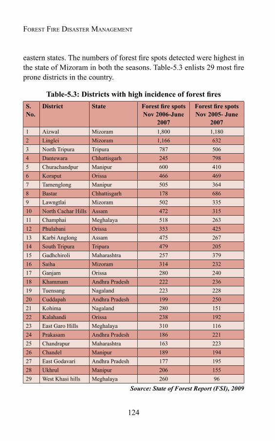
124
Forest Fire Disaster ManageMent
eastern states. The numbers of forest fire spots detected were highest in the state of Mizoram in both the seasons. Table-5.3 enlists 29 most fire prone districts in the country.
Table-5.3:DistrictswithhighincidenceofforestfiresS. No.
District State ForestfirespotsNov 2006-June
2007
ForestfirespotsNov 2005- June
20071 Aizwal Mizoram 1,800 1,1802 Linglei Mizoram 1,166 6323 North Tripura Tripura 787 5064 Dantewara Chhattisgarh 245 7985 Churachandpur Manipur 600 4106 Koraput Orissa 466 4697 Tamenglong Manipur 505 3648 Bastar Chhattisgarh 178 6869 Lawngtlai Mizoram 502 33510 North Cachar Hills Assam 472 31511 Champhai Meghalaya 518 26312 Phulabani Orissa 353 42513 Karbi Anglong Assam 475 26714 South Tripura Tripura 479 20515 Gadhchiroli Maharashtra 257 37916 Saiha Mizoram 314 23217 Ganjam Orissa 280 24018 Khammam Andhra Pradesh 222 23619 Tuensang Nagaland 223 22820 Cuddapah Andhra Pradesh 199 25021 Kohima Nagaland 280 15122 Kalahandi Orissa 238 19223 East Garo Hills Meghalaya 310 11624 Prakasam Andhra Pradesh 186 22125 Chandrapur Maharashtra 163 22326 Chandel Manipur 189 19427 East Godavari Andhra Pradesh 177 19528 Ukhrul Manipur 206 15529 West Khasi hills Meghalaya 260 96
Source: State of Forest Report (FSI), 2009
125
Along with Forest Survey of India and state forest departments, some NGOs (national and international) are engaged in gathering information about forest fires. WWF- India has carried out number of case studies in different parts of the country about the forest fire incidences and compiled it in the form of a booklet (Forest Fires in India: Lessons from Case Studies by Rajeev L. Semwal, WWF for Nature-India, 2003).
Despite all these attempts, still the data bank about the forest fire in the country is very weak and needs more serious attempts. To overcome this problem, new innovative methods need to be used. Satellite data may be of quite significance to evolve new innovative techniques in the field of Forest Fire Management. Along with the satellite data many field-based attempts should also be made at various levels to collect forest fire statistics in the country. The information and the data feed by the researchers present a very grim situation about the calamity in the country and need a serious thought to overcome the problem and tackle the situation in more effective manner.
5.3 VulnerabilityofIndianforeststowardsfireThe forest fire is dependent on three essential components i.e.
fuel, oxygen and heat. Availability of these three components is not uniform throughout the country's forest and thus the forest fire situation in the country is not uniform. Depending upon the susceptibility of the tree species and climatic conditions, the fire situation is very diverse in different forest areas. The vulnerability of the Indian forests towards fire varies from place to place depending upon the type of vegetation, the climate and various other factors- both natural as well as man made. The coniferous forest in the Himalayan region comprising of fir (Albies spp), spruce (Picea smithiana), Cedrus deodra, Pinus roxburgii and P. Wallichiana etc. is very prone to fire. The most vulnerable stretches of the world to forest fire are the youngest mountain ranges of Himalayas. Because of the more rain density, the forests of Eastern Himalayas are less vulnerable to forest fires as compared to those in Western Himalayas. With large scale expansion of chir forests in Himalayan mountains,
Forest Fire: the indian scenario
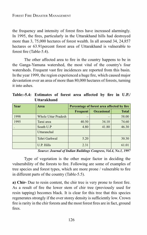
126
Forest Fire Disaster ManageMent
the frequency and intensity of forest fires have increased alarmingly. In 1995, the fires, particularly in the Uttarakhand hills had destroyed more than 3, 75,000 hectares of forest wealth. In all around 34, 24,857 hectares or 63.91percent forest area of Uttarakhand is vulnerable to forest fire (Table-5.4).
The other affected area to fire in the country happens to be in the Ganga-Yamuna watershed, the most vital of the country's four watersheds. Frequent vast fire incidences are reported from this basin. In the year 1999, the region experienced a huge fire, which caused major devastation over an area of more than 80,000 hectares of forests, turning it into ashes.
Table:-5.4: Estimates of forest area affected by fire in U.P./Uttarakhand
Year Area PercentageofforestareaaffectedbyfireFrequent Occasional Total
1998 Whole Uttar Pradesh – – 58.001995 Tarai area 40.50 34.10 74.60. South U.P 4.80 41.80 46.30
Uttaranchal
Tehri Garhwal 5.20 30.30
U.P. Hills 2.31 61.01
Source: Journal of Indian Buildings Congress, Vol.4, No.1, 1997
Type of vegetation is the other major factor in deciding the vulnerability of the forests to fire. Following are some of examples of tree species and forest types, which are more prone / vulnerable to fire in different parts of the country (Table-5.5).
a)Chir-Due to resin content, the chir tree is very prone to forest fire. As a result of fire the lower stem of chir tree (previously used for resin tapping) becomes black. It is clear for this tree that this species regenerates strongly if the over storey density is sufficiently low. Crown fire is rarity in the chir forests and the most forest fires are in fact, ground fires.

127
b)Other coniferous species- Like chir, other conifers including, fir (Abies sp.), Spruce (Picea smithiana), Cedrus deodara are also very susceptible to forest fire.
c)Sal-The butt damage of this species occurs, even if the fire intensity is not much.
d)OtherPlantations-The plantations like Eucalyptus, Teak, Poplar, Sisham and several other species are also vulnerable to fire. Among these species, Eucalyptus is grown on 8 years rotation for pulpwood, while other species are grown on longer rotations for larger and higher value timber products. From the age of about 5 years, both Teak and Eucalyptus are quite resistant to ground fire. There is only three-year period i.e. between the ages of 2 and 5, when Eucalyptus and Teak are at maximum risk from forest fire.
e)MixedDryForest- Fire is commonly used by tribal people in such forests to prepare the ground for harvesting mahua flowers and fruit, and it is apparent that they use fire skill for this purpose. But when these practices are used indiscriminately, it causes much damage to the surrounding species and soil.
In addition to the susceptibility of particular species, other factors viz. the age of the trees, climate, the terrain etc. also decide the incidence of forest fire in a particular forest. The socio- economic and sociocultural pattern of the society also decides the vulnerability of forest to fire.
Table-5.5:PercentageoftheforesttypesaffectedbyfiresannuallyTypes of the forest Percentage of forest
area affected by frequentfires
Percentage of forest area affectedbyoccasionalfires
Coniferous 8 40Moist deciduous 15 60Dry deciduous 5 35Wet semi- ever green 9 40North Eastern region 50 45
Source: http://www.fire.uni-freiburg.de/iffn/country/in/in_5.htm
Forest Fire: the indian scenario
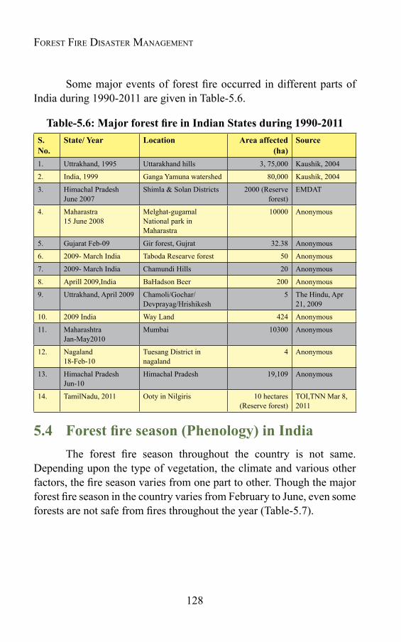
128
Forest Fire Disaster ManageMent
Some major events of forest fire occurred in different parts of India during 1990-2011 are given in Table-5.6.
Table-5.6:MajorforestfireinIndianStatesduring1990-2011S.No.
State/ Year Location Area affected (ha)
Source
1. Uttrakhand, 1995 Uttarakhand hills 3, 75,000 Kaushik, 2004
2. India, 1999 Ganga Yamuna watershed 80,000 Kaushik, 2004
3. Himachal Pradesh June 2007
Shimla & Solan Districts 2000 (Reserve forest)
EMDAT
4. Maharastra15 June 2008
Melghat-gugamal National park in Maharastra
10000 Anonymous
5. Gujarat Feb-09 Gir forest, Gujrat 32.38 Anonymous
6. 2009- March India Taboda Researve forest 50 Anonymous
7. 2009- March India Chamundi Hills 20 Anonymous
8. Aprill 2009,India BaHadson Beer 200 Anonymous
9. Uttrakhand, April 2009 Chamoli/Gochar/ Devprayag/Hrishikesh
5 The Hindu, Apr 21, 2009
10. 2009 India Way Land 424 Anonymous
11. Maharashtra Jan-May2010
Mumbai 10300 Anonymous
12. Nagaland 18-Feb-10
Tuesang District in nagaland
4 Anonymous
13. Himachal Pradesh Jun-10
Himachal Pradesh 19,109 Anonymous
14. TamilNadu, 2011 Ooty in Nilgiris 10 hectares (Reserve forest)
TOI,TNN Mar 8, 2011
5.4 Forestfireseason(Phenology)inIndiaThe forest fire season throughout the country is not same.
Depending upon the type of vegetation, the climate and various other factors, the fire season varies from one part to other. Though the major forest fire season in the country varies from February to June, even some forests are not safe from fires throughout the year (Table-5.7).
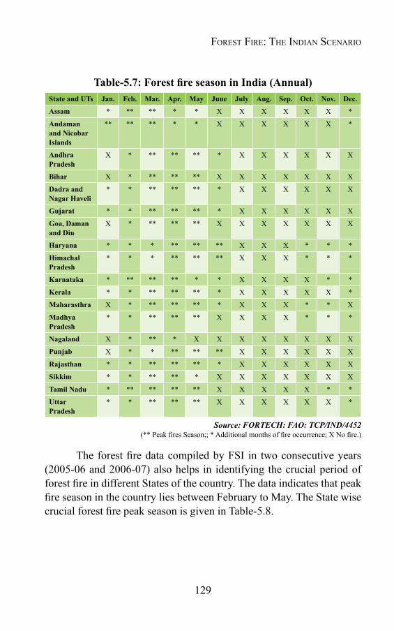
129
Table-5.7:ForestfireseasoninIndia(Annual)State and UTs Jan. Feb. Mar. Apr. May June July Aug. Sep. Oct. Nov. Dec.
Assam * ** ** * * X X X X X X *
Andaman and Nicobar Islands
** ** ** * * X X X X X X *
Andhra Pradesh
X * ** ** ** * X X X X X X
Bihar X * ** ** ** X X X X X X X
Dadra and Nagar Haveli
* * ** ** ** * X X X X X X
Gujarat * * ** ** ** * X X X X X X
Goa, Daman and Diu
X * ** ** ** X X X X X X X
Haryana * * * ** ** ** X X X * * *
Himachal Pradesh
* * * ** ** ** X X X * * *
Karnataka * ** ** ** * * X X X X * *
Kerala * * ** ** ** * X X X X X *
Maharasthra X * ** ** ** * X X X * * X
Madhya Pradesh
* * ** ** ** X X X X * * *
Nagaland X * ** * X X X X X X X X
Punjab X * * ** ** ** X X X X X X
Rajasthan * * ** ** ** * X X X X X X
Sikkim * * ** ** * X X X X X X X
Tamil Nadu * ** ** ** ** X X X X X * *
Uttar Pradesh
* * ** ** ** X X X X X X *
Source: FORTECH: FAO: TCP/IND/4452(** Peak fires Season;; * Additional months of fire occurrence; X No fire.)
The forest fire data compiled by FSI in two consecutive years (2005-06 and 2006-07) also helps in identifying the crucial period of forest fire in different States of the country. The data indicates that peak fire season in the country lies between February to May. The State wise crucial forest fire peak season is given in Table-5.8.
Forest Fire: the indian scenario
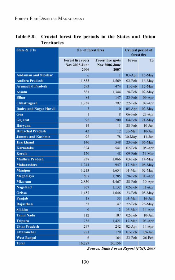
130
Forest Fire Disaster ManageMent
Table-5.8: Crucial forest fire periods in the States and UnionTerritories
State & UTs No.offorestfires Crucial period of forestfire
ForestfirespotsNov 2005-June
2006
ForestfirespotsNov 2006-June
2007
From To
Andaman and Nicobar 6 1 03-Apr 15-MayAndhra Pradesh 1,855 1,569 02-Feb 16-MayArunachal Pradesh 593 474 11-Feb 17-MayAssam 881 1,344 28-Feb 02-MayBihar 84 147 23-Feb 09-AprChhattisgarh 1,738 792 22-Feb 02-AprDadra and Nagar Haveli 3 0 05-Apr 02-MayGoa 1 8 06-Feb 23-AprGujarat 92 200 04-Feb 21-MayHaryana 14 11 28-Feb 10-JunHimachal Pradesh 43 12 05-Mar 10-JunJammu and Kashmir 92 78 30-May 11-JunJharkhand 140 548 23-Feb 06-MayKarnataka 324 541 02-Feb 05-AprKerala 120 48 09-Feb 21-MarMadhya Pradesh 838 1,066 03-Feb 14-MayMaharashtra 1,244 947 17-Mar 08-MayManipur 1,213 1,654 01-Mar 02-MayMeghalaya 507 1,285 28-Feb 03-AprMizoram 2,830 4,467 28-Feb 30-AprNagaland 767 1,132 02-Feb 11-AprOrissa 1,457 1,646 23-Feb 08-MayPunjab 18 33 03-Mar 16-JunRajasthan 53 47 22-Feb 26-MaySikkim 0 2 06-Mar 14-AprTamil Nadu 112 107 02-Feb 10-JunTripura 738 1,421 17-Mar 03-AprUttar Pradesh 297 242 02-Apr 14-AprUttaranchal 221 170 01-Feb 09-JunWest Bengal 6 164 23-Feb 26-FebTotal 16,287 20,156
Source: State Forest Report (FSI), 2009
131
5.5 State wise types of vegetation, causes of forest fireandmanagementpracticesinIndiaBased on local socio-economic and climatic conditions, types of
vegetation / forest type, the fire situations, causes of forest fire and fire management system of different States of India is briefed in Table-5.9.
Forest Fire: the indian scenario
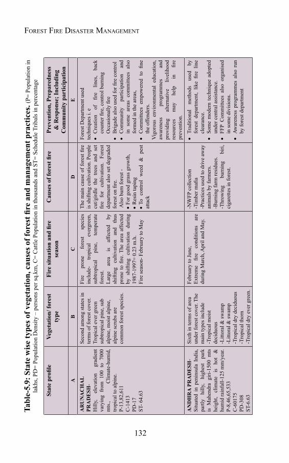
132
Forest Fire Disaster ManageMentTable-5.9:Statewisetypesofvegetation,causesofforestfireandmanagem
entpractices.(
P= P
opul
atio
n in
la
khs,
PD=
Popu
latio
n D
ensi
ty –
per
sons
per
sq.k
m, C
= C
attle
Pop
ulat
ion
in th
ousa
nds a
nd S
T= S
ched
ule
Trib
als i
n pe
rcen
tage
Stateprofile
Vege
tatio
n/ fo
rest
ty
peFiresituationandfire
seas
onCausesofforestfire
Prev
entio
n, P
repa
redn
ess
& R
espo
nse;
Incl
udin
g C
omm
unity
par
ticip
atio
nA
BC
DE
AR
UN
AC
HA
L PR
AD
ESH
- H
illy,
el
evat
ion
grad
ient
va
ryin
g fr
om 1
00 t
o 70
00
mts
., C
limat
e-hu
mid
, tro
pica
l to
alpi
ne.
P-13
,82,
611
C-1
413
PD-1
7ST
- 64.
63
Seco
nd a
mon
g st
ates
in
term
s of f
ores
t cov
er.
Trop
ical
eve
r gre
en
subt
ropi
cal p
ine,
sub
alpi
ne, m
oist
alp
ine,
al
pine
scru
bs a
re
com
mon
fore
st sp
ecie
s.
Fire
pr
one
fore
st
spec
ies
incl
ude-
tro
pica
l ev
ergr
een,
su
btro
pica
l pi
ne,
tem
pera
te
fore
st.
Larg
e ar
ea
is
affe
cted
by
sh
iftin
g cu
ltiva
tion
and
thus
pr
one
to fi
re. T
he a
rea
affe
cted
by
shi
fting
cul
tivat
ion
durin
g 19
87-1
997=
0.2
3 m
.h.
Fire
seas
on- F
ebru
ary
to M
ay
The
mai
n ca
use
of fo
rest
fire
is
shift
ing
culti
vatio
n. P
eopl
e cu
t/gird
le t
he t
rees
and
set
fir
e fo
r cu
ltiva
tion.
Fo
rest
de
partm
ent a
lso
set d
egra
ded
fore
st o
n fir
e. A
lso
burn
fore
st -
•Fo
r goo
d gr
ass g
row
th,
•R
esin
tapi
ng•
To c
ontro
l w
eed
& p
est
atta
ck
Fore
st D
epar
tmen
t use
d te
chni
ques
i. e
•C
reat
ion
of
fire
lines
, ba
ck
coun
ter fi
re, c
ontro
l bur
ning
O
ccas
iona
lly fi
re
•B
rigad
e al
so u
sed
for fi
re c
ontro
l•
Com
mun
ity
parti
cipa
tion
and
in s
ome
area
s co
mm
ittee
s al
so
form
ed in
the
area
s,•
Com
mitt
ees
empo
wer
ed t
o fin
e th
e of
fend
ers.
Vig
orou
s en
viro
nmen
tal
educ
atio
n,
awar
enes
s pr
ogra
mm
es
and
prov
idin
g al
tern
ativ
e liv
elih
ood
reso
urce
s m
ay
help
in
fir
e pr
even
tion.
AN
DH
RA
PR
AD
ESH
- Si
tuat
ed i
n pe
nins
ula
Indi
a,
partl
y hi
lly,
high
est
park
is
Mah
endr
a gi
ri-15
00 m
ts
heig
ht,
clim
ate
is
hot
&
hum
id ra
infa
ll-12
5 m
m/y
ear.
P-8,
46,6
5,53
3C
-601
75PD
-308
ST-6
.63
Sixt
h in
term
s of a
rea
unde
r for
est c
over
. The
m
ain
type
s inc
lude
-Tro
pica
l moi
st
deci
duou
s-L
ittor
al &
swam
p-L
ittor
al &
swam
p-T
ropi
cal d
ry d
ecid
uous
-Tro
pica
l tho
rn-T
ropi
cal d
ry e
ver g
reen
.
Febr
uary
to Ju
ne,
Extre
me
fire
cond
ition
s ar
e du
ring
Mar
ch, A
pril
and
May
.
-NW
FP c
olle
ctio
n-T
imbe
r mafi
a-P
ract
ices
use
d to
driv
e aw
ay
anim
als b
y fa
rmer
s.-B
urni
ng fa
rm re
sidu
es.
-Thr
owin
g bu
rnin
g bi
ri,
ciga
rette
s in
fore
st.
•Tr
aditi
onal
m
etho
ds
used
by
fo
rest
dep
artm
ent,
like
fire
line
clea
ranc
e.•
Som
e m
oder
n te
chni
que
adop
ted
unde
r cen
tral a
ssis
tanc
e.•
FFP
Com
mitt
ees
also
org
anis
ed
in so
me
divi
sion
s.•
Awar
enes
s pr
ogra
mm
es a
lso
run
by fo
rest
dep
artm
ent
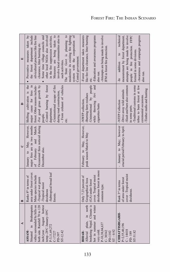
133
AB
CD
E
ASS
AM
- Si
tuat
ed
in
Bra
hmap
utra
va
lley
surr
ound
ed b
y hi
lls o
n bo
th s
ide.
Rai
nfal
l 70
to 1
20
inch
/yea
r. A
ugus
t ho
ttest
te
mp.
-28o C
Janu
ary-
10o C
P-3,
11,6
9,27
2C
-172
27PD
-397
ST-1
2.42
Ran
ks 8
th in
term
s of
area
und
er fo
rest
cov
er.
Mai
n sp
ecie
s inc
lude
-Tro
pica
l wet
gre
en-T
ropi
cal m
oist
de
cidu
ous
-Sub
tropi
cal b
road
leaf
fo
rest
s.
Janu
ary
to
May
. H
owev
er,
maj
or fi
res
are
in t
wo
mon
ths
of
Febr
uary
an
d M
arch
. O
ccas
iona
l fir
es n
otic
ed d
urin
g D
ecem
ber a
lso.
Shift
ing
culti
vatio
n is
th
e m
ajor
ca
use
for
fires
in
fo
rest
. Oth
er re
ason
s inc
lude
--F
or g
ood
gras
s gr
owth
by
peop
le.
-Con
trol
burn
ing
by f
ores
t de
partm
ent.
-Uni
nten
tiona
l esc
ape
of fi
re
durin
g ro
ad c
onst
ruct
ion,
-
From
exh
aust
of
vehi
cles
et
c.
•Pr
even
tive
mea
sure
s ta
ken
by
the
fore
st
depa
rtmen
t in
clud
e si
lvic
ultu
ral p
ract
ices
like
fire
line
cl
eara
nce,
litte
r bur
ning
etc
. •
Som
e tim
e vi
llage
cou
ncils
and
ot
her
loca
l N
GO
s al
so i
nvol
ved
in t
he fi
re s
uppr
essi
on a
ctiv
ities
. M
easu
res
are
bein
g ta
ken
to
invo
lve
loca
l com
mun
ities
als
o in
su
ch a
ctiv
ities
.Th
e St
ate
Gov
t is
pl
anni
ng
to
mod
erni
ze i
ts e
xist
ing
fire
fight
ing
syst
em
with
th
e co
oper
atio
n of
C
entra
l gov
ernm
ent.
BIH
AR
- A
lluvi
al
plai
n,
in
north
bo
rder
ing
Nep
al. C
limat
e is
ho
t in
sum
mer
and
win
ter
very
col
d.
P-10
,38,
04,6
37C
- 303
42PD
-110
2ST
– 0
.92
Onl
y 7.
23 p
erce
nt o
f G
eogr
aphi
cal A
rea
(GA
) und
er fo
rest
co
ver.
Trop
ical
moi
st
deci
duou
s for
est i
n m
ore
com
mon
type
.
Febr
uary
to
M
ay,
How
ever
, pe
ak se
ason
Mar
ch to
May
-NW
FP c
olle
ctio
n,-B
urni
ng fa
rm re
sidu
es-U
nint
entio
nal
by
peop
le
whi
le
thro
win
g bi
ri
and
ciga
rette
s but
ts
-For
est
depa
rtmen
t ta
kes
mea
sure
s lik
e fir
e lin
e cl
eara
nce,
litte
r bur
ning
et
c.-E
duca
tion
and
awar
enes
s pr
ogra
ms
also
run.
-Atte
mpt
s are
bei
ng m
ade
to in
volv
e JF
M in
fore
st fi
re p
rote
ctio
n.
CH
HAT
TIS
HG
AR
H-
P=2,
55,4
0,19
6C
- 14
418
PD- 1
89ST
-31.
82
Ran
k 3rd
in te
rms
of a
rea
unde
r for
est
cove
r –Tr
opic
al m
oist
de
cidu
ous.
- Ja
nuar
y to
M
ay;
how
ever
cr
ucia
l per
iod
Febr
uary
to A
pril.
-NTF
P C
olle
ctio
n-D
rive
away
wild
ani
mal
s-S
lash
and
burn
also
com
mon
in
som
e pa
rts.
-Tra
ditio
nal c
usto
ms i
n so
me
tribe
s to
bur
n fo
rest
at
few
ce
rem
onia
l occ
asio
ns.
-Tim
ber m
afia
and
hunt
ing
-In
addi
tion
to
tech
nica
l m
easu
rem
ent
by f
ores
t de
partm
ent,
atte
mpt
s ar
e be
ing
mad
e to
invo
lve
peop
le
in
fire
prot
ectio
n.
FFPC
fo
rmed
in so
me
divi
sion
s.-A
war
enes
s an
d ca
mpa
ign
prog
ress
al
so ru
n.
Forest Fire: the indian scenario
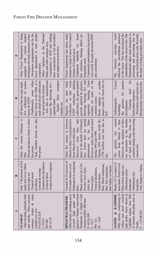
134
Forest Fire Disaster ManageMentA
BC
DE
GU
JAR
AT-
Allu
vial
pla
in, p
artia
lly h
illy
and
mar
shy.
Thr
ee s
easo
ns-
sum
mer
, w
inte
r &
ra
iny,
ra
infa
ll ve
ry lo
w.
P-6,
03,8
3,62
8C
-235
15PD
-308
ST-1
4.79
Onl
y 7.
46 p
erce
nt o
f GA
un
der t
ree
cove
r. M
ain
fore
st ty
pes a
re-T
ropi
cal m
oist
de
cidu
ous.
-Litt
oral
& sw
amp
-Tro
pica
l dry
dec
iduo
us.
-Tro
pica
l tho
rn-T
ropi
cal d
ry e
verg
reen
Mai
n fir
e se
ason
Feb
ruar
y to
M
ayM
ixed
dec
iduo
us fo
rest
is m
ore
fire
pron
e.Te
ak,
bam
boo
fore
sts
are
also
fir
e pr
one
All
fore
st fi
re a
re m
an m
ade
-For
co
llect
ion
of
mah
ua,
hone
y &
NTF
P-T
radi
tiona
lly
som
e tri
bes
burn
for
est
at t
he b
irth
of a
m
ale
child
(Raa
b cu
ltiva
tion)
-for
goo
d gr
owth
of g
rass
- A
lso
due
to u
nint
entio
nal
caus
es l
ike
thro
win
g bi
ri –
ci
gare
tte b
utts
- Sp
arks
fr
om
trans
port
exha
ust e
tc.
-Sta
te F
ores
t D
epar
tmen
t is
bei
ng
equi
pped
w
ith
vario
us
mod
ern
tech
niqu
es fo
r ear
ly d
etec
tion
of fi
re.
-Aw
aren
ess
prog
ram
mes
run
by
the
fore
st d
epar
tmen
t to
see
k pe
ople
co
oper
atio
n.-S
trict
vi
gila
nce
in
the
Nat
iona
l Pa
rks a
nd o
ther
stra
tegi
c ar
ea.
-Con
stitu
tion
of J
FM a
nd s
eeki
ng
thei
r co
oper
atio
n in
fire
pre
vent
ion
and
supp
ress
ion
activ
ities
.
HIM
AC
HA
L PR
AD
ESH
- H
illy
terr
ain,
incl
udin
g sn
ow
cove
red
high
pe
aks
and
glac
iers
. Clim
ate v
arie
s fro
m
Tem
pera
te t
o A
lpin
e C
old.
A
nnua
l rai
nfal
l- 90
0 m
mP-
68,
56,5
09C
- 521
7PD
- 123
ST
– 4
.02
Aro
und
26.3
5 pe
rcen
t of
GA
und
er fo
rest
cov
er.
Subt
ropi
cal t
o te
mpe
rate
flo
ra.
Maj
or sp
ecie
s are
Chi
r, D
eoda
r, K
ail,
Oak
s, Al
der,
etc.
Fore
st ty
pes-
Trop
ical
dec
iduo
us,
Trop
ical
thor
n,H
im. M
oist
tem
pera
te,
Him
. Dry
tem
pera
te,
Sub
Alp
ine
to A
lpin
e.
Mai
n fir
e se
ason
is
be
twee
n M
arch
to Ju
ne. C
ruci
al p
erio
d is
fr
om M
arch
to M
id Ju
ne.
How
ever
, so
me
fires
ta
ke
plac
e in
the
mon
th o
f Fe
brua
ry
also
. Fo
rest
fir
es
are
annu
al
phen
omen
a in
th
e St
ate;
ho
wev
er, m
ajor
fire
s to
ok p
lace
du
ring
1995
and
199
9.D
urin
g 19
95 f
ores
t w
orth
Rs.
1750
mill
ion
was
los
t du
e to
fir
e.
Maj
ority
ar
e m
an
mad
e.
Col
lect
ion
of
fuel
w
ood,
N
TFP
colle
ctio
n,
shift
ing
culti
vatio
n, f
or g
ood
past
ure
grow
th, i
gniti
on b
y gr
azie
rs,
thro
win
g bu
rnin
g bi
ri
and
ciga
rette
s, bu
rnin
g Fa
rm
resi
dues
ar
e so
me
of
the
com
mon
cau
ses.
Res
in
tapp
ing
is
anot
her
maj
or c
ause
for f
ores
t fire
in
H.P
.
Fore
st d
epar
tmen
t ha
s ta
ken
man
y in
itiat
ives
und
er F
ores
t Fire
Con
trol
Sche
me
of C
entra
l gov
t. Tr
aditi
onal
M
etho
ds
viz.
fo
rest
lin
e cl
eara
nce,
bur
ning
deb
ris e
tc.
freq
uent
ly u
sed.
Com
mun
ity p
artic
ipat
ion
has p
rove
d ve
ry u
sefu
l. In
man
y di
visi
ons F
FPC
al
so c
onst
itute
d.
JAM
MU
&
K
ASH
MIR
- H
illy
terr
ain,
com
pris
ing
of
valle
ys a
nd s
now
cov
ered
hi
gh p
eaks
. Sn
ow d
eser
t in
La
ddak
h re
gion
, fo
ot h
ills
of J
amm
u an
d pl
ain
area
in
Sout
hP
- 1,2
5,48
,926
Ran
ks 1
2th in
resp
ect o
f ar
ea u
nder
fore
st c
over
. M
ain
fore
st ty
pes a
re-
-Him
alay
an m
oist
te
mpe
rate
-Him
alay
an d
ry
tem
pera
te-S
ub A
lpin
e to
Alp
ine.
The
gene
ral
fire
seas
on
varie
s fr
om
Mar
ch
to
June
. H
owev
er,
the
num
bers
of
fires
ar
e m
axim
um
in
the
mon
ths
of A
pril
and
May
. Fi
res
are
com
mon
dur
ing
crop
har
vest
ing
seas
on a
lso.
Ant
hrop
ogen
ic
Cau
ses
incl
udin
g--B
y gr
azie
rs
for
past
ure
deve
lopm
ent
- C
lear
ing
land
fo
r ho
rticu
lture
pur
pose
s.- P
icni
cker
s and
tour
ists
etc
.- B
eing
bor
der a
rea
fore
st fi
re
The
Terr
oris
t ac
tiviti
es
wor
st
affe
cted
the
silv
icul
tura
l pr
actic
es
in th
e fo
rest
. Thi
s ha
s in
crea
sed
the
vuln
erab
ility
of t
he fo
rest
to fi
re. T
he
Dep
artm
ent t
akes
som
e m
easu
res
in
prot
ectin
g an
d pr
even
ting
fire
in
som
e re
stric
ted
area
s on
ly. R
ecen
tly
the
Stat
e is
bei
ng p
rovi
ded
som
e

135
AB
CD
E
C -
1098
7 PD
- 124
ST –
10.
98
occa
sion
ally
cau
sed
by t
he
bom
bing
and
exp
losi
ons t
oo.
assi
stan
ce
unde
r th
e ce
ntra
lly
spon
sore
d sc
hem
e to
take
pre
vent
ive
step
s. So
me
train
ing
and
awar
enes
s pr
ogra
mm
es a
lso
initi
ated
by
the
Stat
e Fo
rest
Dep
artm
ent.
JHA
RK
HA
ND
- Pl
atea
us
and
plai
n la
nd,
rich
in
min
eral
reso
urce
s an
d fo
rest
bo
th
P - 3
,29,
66,2
38C
- 18
100
PD -
414
ST -
26.3
4
Ran
ks-1
1th in
term
s of
the
fore
st c
over
are
a.Fe
brua
ry to
May
, how
ever
mai
n se
ason
in th
ree
mon
ths
betw
een
Mar
ch to
May
-Shi
fting
cu
ltiva
tion
and
burn
an
d sl
ash
agric
ultu
re
prac
tices
use
d by
trib
als.
-NTF
P co
llect
ion
- R
ival
ry
with
fo
rest
de
partm
ent.
- Hun
ting
and
poac
hing
- T
imbe
r mafi
a-
Thro
win
g bu
rnin
g bi
ri-
ciga
rette
but
ts a
nd b
urni
ng
cam
p fir
e.-
Trad
ition
al
cust
oms
in
som
e tri
bes
to b
urn
fore
st
to
cele
brat
e so
me
good
oc
casi
ons.
- Tre
spas
sers
and
pic
nick
ers.
-For
est
divi
sion
s ar
e be
ing
equi
pped
with
mob
ile v
ans,
mod
ern
equi
pmen
ts e
tc.
-Tra
ditio
nal
met
hods
lik
e bu
rnin
g de
bris
, cle
arin
g fo
rest
fire
line
s et
c.
also
use
d- F
ire w
atch
ers a
lso
appo
inte
d.- J
FM h
elp
is a
lso
bein
g so
ught
.
KA
RN
ATA
KA
- Si
tuat
ed
on w
este
rn e
dge
of D
ecca
n Pl
atea
u.
P - 6
,11,
30,7
04C
- 30
859
PD -
319
ST –
6.5
5
Ran
ks se
vent
h in
term
s of
are
a un
der f
ores
t co
ver
Mai
n sp
ecie
s are
--T
ropi
cal w
et e
verg
reen
-Tro
pica
l sem
i ev
ergr
een
-Tro
pica
l moi
st
deci
duou
s-T
ropi
cal d
ry d
ecid
uous
-Tro
pica
l tho
rn
-Tro
pica
l dry
eve
r gr
een
Janu
ary
to J
une
and
Nov
embe
r to
Dec
embe
r.Pe
ak
fire
seas
on
in
betw
een
Febr
uary
to A
pril.
NTF
P co
llect
ion
- R
ival
ry
with
fo
rest
de
partm
ent.
- H
untin
g an
d po
achi
ng
- tim
ber m
afia
- Th
row
ing
burn
ing
biri
- ci
gare
tte b
utts
and
bur
ning
ca
mp
fire.
- Tr
aditi
onal
cu
stom
s in
so
me
tribe
s -
Driv
ing
away
w
ild
anim
als v
iz. e
leph
ants
- K
arna
taka
For
est d
epar
tmen
t has
sl
ight
ly b
ette
r fa
cilit
ies
to t
ackl
e fo
rest
fire
.-
Mod
ern
met
hods
and
equ
ipm
ent
used
und
er C
entra
l Gov
t. Sc
hem
e.-
Com
mun
ity
is
also
be
ing
invo
lved
in
fore
st fi
re p
rote
ctio
n th
roug
h th
e FF
PC.
Forest Fire: the indian scenario
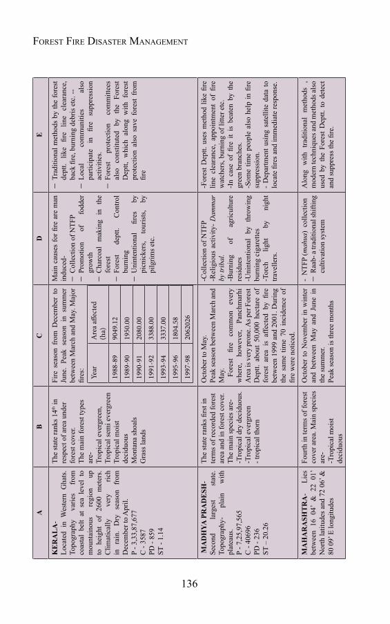
136
Forest Fire Disaster ManageMentA
BC
DE
KE
RA
LA
- Lo
cate
d in
Wes
tern
Gha
ts.
Topo
grap
hy
varie
s fr
om
coas
tal
belt
at s
ea l
evel
to
mou
ntai
nous
re
gion
up
to
hei
ght
of 2
600
met
ers.
Clim
atic
ally
ve
ry
rich
in
rain
. D
ry
seas
on
from
D
ecem
ber t
o A
pril.
P - 3
,33,
87,6
77C
- 35
87PD
- 85
9ST
- 1.
14
The
stat
e ra
nks 1
4th in
re
spec
t of a
rea
unde
r fo
rest
cov
er.
The
mai
n fo
rest
type
s ar
e-Tr
opic
al e
verg
reen
,Tr
opic
al se
mi e
verg
reen
Trop
ical
moi
st
deci
duou
sM
onta
na sh
oals
Gra
ss la
nds
Fire
sea
son
from
Dec
embe
r to
Ju
ne.
Peak
sea
son
in s
umm
er
betw
een
Mar
ch a
nd M
ay. M
ajor
fir
es:
Year
Are
a aff
ecte
d (h
a)
1988
-89
9049
.12
1989
-90
1950
.00
1990
-91
2080
.00
1991
-92
3388
.00
1993
-94
3337
.00
1995
-96
1804
.58
1997
-98
2062
026
Mai
n ca
uses
for fi
re a
re m
an
indu
ced-
-C
olle
ctio
n of
NTF
P-
Prom
otio
n of
fo
dder
gr
owth
-C
harc
oal
mak
ing
in
the
fore
st-
Fore
st
dept
t. C
ontro
l bu
rnin
g-
Uni
nten
tiona
l fir
es
by
picn
icke
rs,
tour
ists
, by
pi
lgrim
s etc
.
-Tr
aditi
onal
met
hods
by
the
fore
st
dept
t. lik
e fir
e lin
e cl
eara
nce,
ba
ck fi
re, b
urni
ng d
ebris
etc
. --
-
Loca
l co
mm
uniti
es
also
pa
rtici
pate
in
fir
e su
ppre
ssio
n ac
tiviti
es.
-Fo
rest
pr
otec
tion
com
mitt
ees
also
co
nstit
uted
by
th
e Fo
rest
D
eptt,
whi
ch a
long
with
for
est
prot
ectio
n al
so s
ave
fore
st f
rom
fir
e
MA
DH
YA P
RA
DE
SH-
Seco
nd
larg
est
stat
e.
Topo
grap
hy-
plai
n w
ith
plat
eaus
.P
- 7,2
5,97
,565
C -
4069
6PD
- 23
6ST
– 2
0.26
The
stat
e ra
nks fi
rst i
n te
rms o
f rec
orde
d fo
rest
ar
ea a
nd in
fore
st c
over
. Th
e m
ain
spec
ies a
re-
-Tro
pica
l dry
dec
iduo
us.
-Tro
pica
l eve
rgre
en- t
ropi
cal t
horn
Oct
ober
to M
ay.
Peak
seas
on b
etw
een
Mar
ch a
nd
May
.
Fore
st
fire
com
mon
ev
ery
whe
re,
how
ever
, Pa
nchm
arhi
A
rea i
s ver
y pr
one.
As p
er F
ores
t D
eptt.
abo
ut 5
0,00
0 he
ctar
e of
fo
rest
are
a is
affe
cted
by
fire
betw
een
1999
and
200
1. D
urin
g th
e sa
me
time
70 i
ncid
ence
of
fire
wer
e no
ticed
.
-Col
lect
ion
of N
TFP
-Rel
igio
us a
ctiv
ity-
Dam
mar
by
trib
al.
-Bur
ning
of
ag
ricul
ture
re
sidu
es-U
nint
entio
nal
by t
hrow
ing
burn
ing
ciga
rette
s-T
orch
lig
ht
by
nigh
t tra
velle
rs.
-For
est D
eptt.
use
s m
etho
d lik
e fir
e lin
e cl
eara
nce,
app
oint
men
t of
fire
w
atch
ers,
burn
ing
of li
tter e
tc.
-In
case
of
fire
it is
bea
ten
by t
he
gree
n br
anch
es.
-Som
e tim
e pe
ople
als
o he
lp in
fire
su
ppre
ssio
n.-
Dep
artm
ent u
sing
sat
ellit
e da
ta to
lo
cate
fire
s and
imm
edia
te re
spon
se.
MA
HA
RA
SHT
RA
- Li
es
betw
een
16 0
4’ &
22
01’
Nor
th la
titud
es a
nd 7
2 06
’ &
80 0
9’ E
long
itude
s
Four
th in
term
s of f
ores
t co
ver a
rea.
Mai
n sp
ecie
s ar
e-
-Tro
pica
l moi
st
deci
duou
s
Oct
ober
to N
ovem
ber
in w
inte
r an
d be
twee
n M
ay a
nd J
une
in
the
sum
mer
.Pe
ak se
ason
is th
ree
mon
ths
- N
TFP
(mah
ua)
colle
ctio
n-
Raa
b- a
tradi
tiona
l shi
fting
cu
ltiva
tion
syst
em
Alo
ng w
ith t
radi
tiona
l m
etho
ds ,
m
oder
n te
chni
ques
and
met
hods
also
us
ed b
y th
e Fo
rest
Dep
tt. t
o de
tect
an
d su
ppre
ss th
e fir
e.
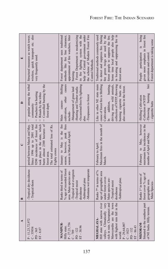
137
AB
CD
E
P - 1
1,23
,72,
972
C -
3595
4PD
- 36
5ST
- 8.
87
-Tro
pica
l dry
dec
iduo
us- T
ropi
cal t
horn
perio
d be
twee
n M
arch
and
May
.Si
nce
1996
up
to 2
001
tota
l 92
90 i
ncid
ence
s of
for
est
fire
took
pla
ce i
n th
e st
ate,
whi
ch
burn
t al
mos
t 23
00 h
ecta
res
of
fore
st a
rea.
The
tota
l es
timat
ed l
oss
of R
s. Ei
ghty
cro
res
- p
opul
ar a
mon
g th
e tri
bal
com
mun
ity
-Po
ache
rs fo
r hun
ting
-R
itual
s by
the
tribe
s-
Con
trolle
d bu
rnin
g by
the
fore
st d
eptt.
Stru
ctur
al m
easu
res
as w
atch
tow
er,
wire
less
, qu
ick
trans
port
etc.
als
o ve
ry fr
eque
ntly
use
d.
MA
NIP
UR
- H
illy
stat
e.P
- 27,
21,7
56C
- 78
9PD
- 12
2ST
– 3
8.96
Ran
ks th
ird in
term
s of
% a
ge o
f rec
orde
d fo
rest
ar
ea. M
ain
spec
ies a
re-
-Tro
pica
l wet
eve
rgre
en-T
ropi
cal m
oist
de
cidu
ous
-Sub
tropi
cal p
ine
-Mon
tana
wet
tem
pera
te
Janu
ary
to
May
is
th
e fir
e se
ason
, ho
wev
er,
peak
fir
es
seas
on in
Mar
ch a
nd A
pril.
Mai
n ca
uses
- Sh
iftin
g cu
ltiva
tion,
ot
her
caus
es
incl
ude-
-Man
agem
ent o
f gra
ss la
nd-H
untin
g an
d Ti
mbe
r mafi
a-O
ccas
iona
l fire
s by
light
ning
al
so.
-Tre
spas
sers
to fo
rest
Fore
st d
epar
tmen
t us
es t
radi
tiona
l m
etho
ds
like
fire
line
clea
ranc
e,
appo
intm
ent
of fi
re w
atch
ers,
litte
r bu
rnin
g. F
ores
t D
epar
tmen
t is
mod
erni
zing
its
fir
e fig
htin
g sy
stem
w
ith
the
help
of
Cen
tral
gove
rnm
ent
unde
r th
e sc
hem
e of
Mod
ern
Fore
st F
ire
Con
trol M
etho
ds.
ME
GH
AL
AYA
- H
ill s
tate
with
nar
row
riv
er
valle
ys.
Clim
atic
ally
ve
ry
rich
in r
ain.
Che
rapu
nzi a
nd
Maw
synr
din
are
the
tow
n w
ith h
ighe
st r
ain
fall
in t
he
wor
ld.
P - 2
9,64
,007
C -
1823
PD -
132
ST –
86.
43
Ran
ks 7
th in
term
s of %
ag
e of
geo
grap
hic
area
un
der f
ores
t cov
er.
Mai
n sp
ecie
s are
--T
ropi
cal m
oist
de
cidu
ous
-Sub
tropi
cal p
ine.
Febr
uary
to A
pril.
M
axim
um fi
res
in th
e m
onth
of
Mar
ch.
Like
in o
ther
NE
stat
e m
ain
caus
e of
fore
st fi
re is
Shi
fting
C
ultiv
atio
n.In
ad
ditio
n,
hunt
ing,
dr
ivin
g aw
ay w
ild a
nim
als,
colle
ctio
n of
NTF
P, th
row
ing
burn
ing
ciga
rette
but
ts e
tc.
also
cau
ses fi
re in
the
fore
st.
Trad
ition
al m
etho
ds c
omm
only
use
d to
det
ect
and
supp
ress
fire
. D
urin
g fir
e gr
een
twig
s ar
e us
ed b
y th
e fo
rest
peo
ple
to s
uppr
ess
the
fire.
So
me
time
loca
l pe
ople
als
o he
lp
in l
ocat
ing
and
supp
ress
ing
fire
in
fore
st a
rea.
MIZ
OR
AM
- Si
tuat
ed in
the
sout
hern
par
t of
NE
Indi
a. H
illy
terr
ain.
Ran
ks 1
st in
term
s of
fore
st c
over
% a
ge o
f ge
ogra
phic
are
a. M
ain
Spec
ies-
Febr
uary
to
M
ay,
how
ever
m
axim
um fi
re in
cide
nces
in th
e m
onth
s of A
pril
and
May
.
-Shi
fting
Cul
tivat
ion
-Col
lect
ion
of N
TFP
-Thr
owin
g bu
rnin
g bi
ri –
ciga
rette
but
ts
Peop
le
parti
cipa
tion
is
bein
g gi
ven
mor
e em
phas
is i
n fo
rest
fire
pr
even
tion
and
cont
rol.
Fore
st d
epar
tmen
t is t
akin
g so
me
Forest Fire: the indian scenario

138
Forest Fire Disaster ManageMentA
BC
DE
P - 1
0,91
,014
C -
328
PD -
52ST
- 94
.19
- Tr
opic
al w
et
ever
gree
n-
Trop
ical
moi
st
deci
duou
s
-Bur
ning
farm
resi
dues
-For
goo
d gr
ass g
row
th.
-Cle
aran
ce
of
land
fo
r va
rious
pur
pose
s.
initi
ativ
es
and
getti
ng
fund
fr
om
the
MO
EF f
or m
akin
g ap
prop
riate
ar
rang
emen
ts.
Publ
ic
awar
enes
s an
d tra
inin
g pr
ogra
mm
es a
lso
cond
ucte
d by
the
Fo
rest
Dep
artm
ent.
NA
GA
LA
ND
- H
illy
stat
e in
the
NE
Indi
a.P
- 19,
80,6
02C
- 14
19PD
- 11
9ST
- 88
.98
Ran
ks 3
rd in
term
s of %
ag
e of
geo
grap
hic
area
un
der f
ores
t cov
er.
Mai
n sp
ecie
s--
Trop
ical
wet
ev
ergr
een
- Tr
opic
al S
emi
ever
gree
n-
Sub
Trop
ical
Pin
e-
Mon
tana
Wet
te
mpe
rate
.
Fire
sea
son
from
Feb
ruar
y to
M
ay. H
owev
er, t
he p
eak
seas
on
in th
e m
onth
of M
arch
.
Jhoo
m o
r shi
fting
cul
tivat
ion
is t
he m
ost
com
mon
cau
se
for
fore
st
fire.
Th
e ot
her
min
or c
ause
s are
--
NTF
P C
olle
ctio
n-
Driv
e aw
ay w
ild a
nim
als
to sa
ve c
rops
.-
Thro
win
g sm
ould
erin
g bi
ri –
ciga
rette
s bu
tts b
y th
e ca
rele
ss tr
espa
sser
s.-
Esca
pe
fires
fr
om
the
burn
ing
of f
arm
res
idue
s or
coo
king
nea
r th
e fo
rest
ar
ea.
Fore
st d
epar
tmen
t see
ks p
eopl
e he
lp
in s
uppr
essi
ng a
nd d
etec
ting
fore
st
fire.
Vill
age
Cou
ncils
- th
e lo
cal
self
gove
rnm
ent
bodi
es a
lso
coop
erat
e w
ith th
e fo
rest
dep
artm
ent.
OR
ISSA
- Si
tuat
ed o
n th
e Ea
st c
oast
of
Bay
of B
enga
l.P
- 4,1
9,47
,358
C -
2305
7PD
- 26
9 ST
– 2
2.19
Ran
ks 5
th in
term
s of
area
und
er fo
rest
cov
er.
Mai
n sp
ecie
s--T
ropi
cal m
oist
de
cidu
ous
-Tro
pica
l sem
i ev
ergr
een.
Fire
sea
son
Febr
uary
to
June
; C
ruci
al p
erio
d in
Mar
ch a
nd
Apr
il
- Sh
iftin
g C
ultiv
atio
n.-
Col
lect
ion
of N
TFP,
- B
urni
ng o
f fa
rm r
esid
ues
to c
lear
the
land
.-
Esca
pe
fires
fr
om
the
cook
ing
fires
- Th
row
ing
burn
ing
biri
and
ciga
rette
s.
Fore
st d
epar
tmen
t ta
kes
prev
entiv
e st
eps
by a
ppoi
ntin
g fir
e w
atch
ers,
clea
ring
fire
lines
, bur
ning
litte
r etc
. In
so
me
fore
st
divi
sion
s m
oder
n eq
uipm
ent
also
acq
uire
d w
ith t
he
assi
stan
ce o
f MO
EF, G
OI.
FFPC
and
JFM
als
o be
ing
enga
ged
in c
heck
ing
fire
inci
denc
es i
n th
e fo
rest
.
RA
JAST
HA
N-
Larg
est
stat
e ch
arac
teriz
ed b
y sc
anty
ra
in. P
artly
hill
y- A
rava
lli
Onl
y 4.
69 p
erce
nt o
f GA
un
der f
ores
t cov
er.
Mai
n sp
ecie
s-
Fire
sea
son
is f
rom
Jan
uary
to
June
. Pe
ak fi
re s
easo
n in
the
m
onth
of M
ay.
Bei
ng h
ot a
nd d
ry c
limat
e th
e ve
geta
tion
catc
hes
fire
imm
edia
tely
. The
sour
ce o
f
Fore
st
depa
rtmen
t ap
poin
ts
fire
wat
cher
s dur
ing
the
sum
mer
.In
Nat
iona
l Par
ks a
nd W
ild L
ife

139
AB
CD
E
rang
e. S
ome
part
is d
eser
t. C
limat
e dr
y ho
tP
- 6,8
6,21
,012
C -
5666
3PD
– 2
01ST
– 1
2.57
-Tro
pica
l dry
dec
iduo
us-T
ropi
cal t
horn
-Tro
pica
l dry
eve
r gre
en
igni
tion
are-
- Es
cape
fir
e fr
om
the
burn
ing
of f
arm
res
idue
s to
cle
ar th
e la
nd.
- Tr
ibal
fire
for
est f
or g
ood
gras
s gro
wth
- G
razi
ers
and
cook
ing
food
in th
e fo
rest
are
a al
so
igni
te fi
res
- To
scar
e w
ild a
nim
als
Sanc
tuar
ies
vario
us
silv
icul
tura
l pr
actic
es
i.e.
clea
ranc
e of
fir
e lin
e, b
urni
ng o
f lit
ter,
back
fire
are
ad
opte
d to
pre
vent
fire
.
SIK
KIM
- M
ount
aino
us
stat
e ha
ving
som
e hi
ghes
t pe
aks o
f the
wor
ld. E
leva
tion
varie
s fro
m 2
50 to
859
5 m
ts.
Clim
ate
sub
tropi
cal t
o co
ld
tem
pera
te a
nd A
lpin
e.P
- 6,0
7,68
8C
- 27
0PD
- 86
ST –
20.
61
Ran
ks se
cond
in te
rms o
f %
age
of g
eogr
aphi
c ar
ea
unde
r re
cord
ed
fore
st
area
.M
ain
Spec
ies
-Tro
pica
l eve
rgre
en-S
ub tr
opic
al p
ine
-Mon
tana
wet
tem
pera
te
Janu
ary
to M
ay is
the
mai
n fir
e se
ason
, how
ever
max
imum
fire
in
cide
nce
take
pla
ce d
urin
g tw
o m
onth
s i.e
. Mar
ch a
nd A
pril.
Occ
asio
nal
fires
in
the
mon
ths
of
Nov
embe
r an
d D
ecem
ber
also
.Lo
wer
ele
vatio
n fa
ce fi
re e
very
ye
ar,
whi
ch
in
mos
t of
th
e ca
ses
is
surf
ace
fire.
D
urin
g 19
99 fi
erce
fire
hit
the
fore
st o
f C
hing
rhon
g ar
ea w
orst
.
Mos
t of
th
e fir
es
are
inte
ntio
nal/
unin
tent
iona
l by
pe
ople
--
To g
row
goo
d gr
ass c
rop.
- B
onfir
e du
ring
win
ter
- H
untin
g an
d ill
egal
felli
ng.
- To
kee
p aw
ay w
ild l
ife
away
fro
m th
e ag
ricul
ture
fa
rms.
- U
sing
torc
h by
tres
pass
ers
durin
g ni
ght.
- B
y na
tura
l lig
hten
ing
on
high
hill
s.
Fore
st
depa
rtmen
t us
es
som
e tra
ditio
nal
met
hods
to
cont
rol
and
prev
ent fi
re. H
owev
er, t
here
is la
ck
of in
stitu
tiona
l mec
hani
sm.
Una
war
enes
s am
ong
com
mun
ity i
s th
e m
ain
caus
e of
for
est
fire.
Sta
te
fore
st
Dep
artm
ent
is
plan
ning
to
in
volv
e co
mm
unity
in
fo
rest
fir
e m
anag
emen
t.C
onst
itutio
n of F
ores
t Fire
Pro
tect
ion
Com
mitt
ees i
s und
er c
onsi
dera
tion.
TAM
ILN
AD
U-
80
05’
&
13
35’
Nor
th
latit
ude
and
76o
15’
& 8
0 20
’ Ea
st l
ongi
tude
. Fa
cing
In
dian
Oce
an w
ith c
oast
line
of
100
0 km
s.P
- 7,2
1,38
,958
C -
3075
9PD
- 55
5ST
– 1
.05
Ran
ks t
enth
in
term
s of
ar
ea u
nder
fore
st c
over
.Th
e m
ain
spec
ies a
re-
-Dry
dec
iduo
us-S
avan
nahs
-Sem
i eve
r gre
en-S
outh
ern
thor
n
Fire
sea
son
betw
een
Mar
ch a
nd
May
, how
ever
the
pea
k se
ason
in
the
mon
th o
f Mar
ch a
nd A
pril
only
.D
urin
g 19
96-9
7 a
maj
or fi
re
took
pla
ce i
n th
e Sa
ndal
woo
d fo
rest
of t
he S
tate
resu
lting
into
- C
olle
ctio
n of
N
TFP
(tam
arin
d,
Mah
ua,
wild
ja
cks e
tc.).
- Fa
rm re
sidu
e bu
rnin
g-
Driv
e aw
ay w
ild a
nim
als
( esp
ecia
lly w
ild a
nim
als)
- Ti
mbe
r mafi
a
- Tr
aditi
onal
met
hods
not
wor
king
w
ell d
ue to
pop
ulat
ion
pres
sure
.-
Fore
st
Fire
Pr
otec
tion
Com
mitt
ees
cons
titut
ed i
n m
any
divi
sion
s by
Fore
st -D
epar
tmen
t.-
Awar
enes
s an
d ca
mpa
ign
prog
ram
mes
als
o co
nduc
ted.
- FF
P C
omm
ittee
s m
embe
rs g
iven
pr
oper
trai
ning
.
Forest Fire: the indian scenario
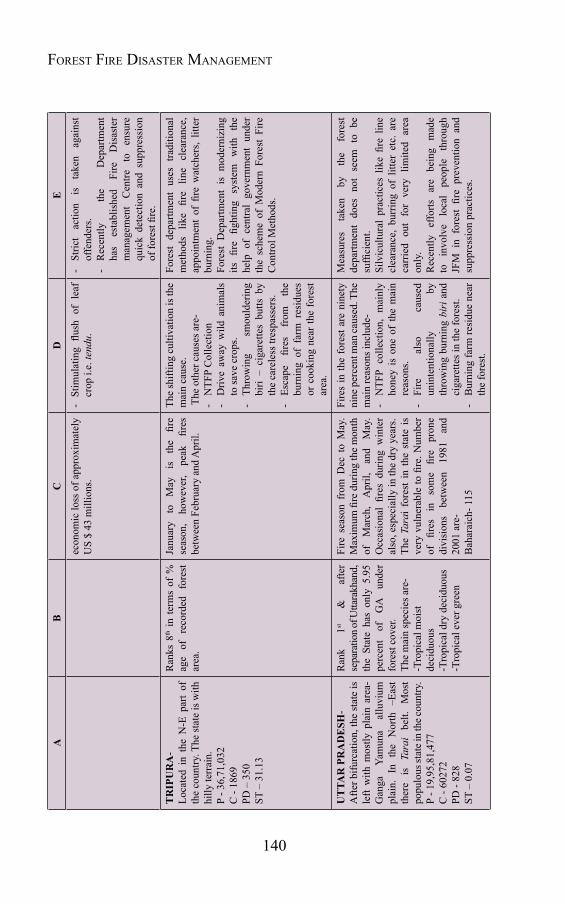
140
Forest Fire Disaster ManageMentA
BC
DE
econ
omic
loss
of a
ppro
xim
atel
y U
S $
43 m
illio
ns.
- St
imul
atin
g flu
sh o
f le
af
crop
i.e.
tend
u.-
Stric
t ac
tion
is
take
n ag
ains
t of
fend
ers.
- R
ecen
tly
the
Dep
artm
ent
has
esta
blis
hed
Fire
D
isas
ter
man
agem
ent
Cen
tre
to
ensu
re
quic
k de
tect
ion
and
supp
ress
ion
of fo
rest
fire
.
TR
IPU
RA
- Lo
cate
d in
the
N-E
par
t of
th
e co
untry
. The
stat
e is
with
hi
lly te
rrai
n.P
- 36,
71,0
32C
- 18
69PD
– 3
50ST
– 3
1.13
Ran
ks 8
th i
n te
rms
of %
ag
e of
re
cord
ed
fore
st
area
.
Janu
ary
to
May
is
th
e fir
e se
ason
, ho
wev
er,
peak
fir
es
betw
een
Febr
uary
and
Apr
il.
The
shift
ing
culti
vatio
n is
the
mai
n ca
use.
The
oth
er c
ause
s are
--
NTF
P C
olle
ctio
n-
Driv
e aw
ay w
ild a
nim
als
to sa
ve c
rops
.-
Thro
win
g sm
ould
erin
g bi
ri –
ciga
rette
s bu
tts b
y th
e ca
rele
ss tr
espa
sser
s.-
Esca
pe
fires
fr
om
the
burn
ing
of f
arm
res
idue
s or
coo
king
nea
r th
e fo
rest
ar
ea.
Fore
st d
epar
tmen
t us
es t
radi
tiona
l m
etho
ds
like
fire
line
clea
ranc
e,
appo
intm
ent
of fi
re w
atch
ers,
litte
r bu
rnin
g.
Fore
st D
epar
tmen
t is
mod
erni
zing
its
fir
e fig
htin
g sy
stem
w
ith
the
help
of
cent
ral
gove
rnm
ent
unde
r th
e sc
hem
e of
Mod
ern
Fore
st F
ire
Con
trol M
etho
ds.
UT
TAR
PR
AD
ESH
- A
fter b
ifurc
atio
n, th
e st
ate
is
left
with
mos
tly p
lain
are
a-
Gan
ga
Yam
una
allu
vium
pl
ain.
In
th
e N
orth
–E
ast
ther
e is
Ta
rai
belt.
M
ost
popu
lous
stat
e in
the c
ount
ry.
P - 1
9,95
,81,
477
C -
6027
2PD
- 82
8ST
– 0
.07
Ran
k 1st
&
af
ter
sepa
ratio
n of U
ttara
khan
d,
the
Stat
e ha
s on
ly 5
.95
perc
ent
of
GA
un
der
fore
st c
over
. Th
e m
ain
spec
ies a
re-
-Tro
pica
l moi
st
deci
duou
s-T
ropi
cal d
ry d
ecid
uous
-Tro
pica
l eve
r gre
en
Fire
sea
son
from
Dec
to
May
. M
axim
um fi
re d
urin
g th
e m
onth
of
M
arch
, A
pril,
an
d M
ay.
Occ
asio
nal
fires
dur
ing
win
ter
also
, esp
ecia
lly in
the
dry
year
s.Th
e Ta
rai
fore
st i
n th
e st
ate
is
very
vul
nera
ble
to fi
re. N
umbe
r of
fir
es
in
som
e fir
e pr
one
divi
sion
s be
twee
n 19
81
and
2001
are
-B
ahar
aich
- 115
Fire
s in
the
fore
st a
re n
inet
y ni
ne p
erce
nt m
an ca
used
. The
m
ain
reas
ons i
nclu
de-
- N
TFP
colle
ctio
n, m
ainl
y ho
ney
is o
ne o
f th
e m
ain
reas
ons.
- Fi
re
also
ca
used
un
inte
ntio
nally
by
th
row
ing
burn
ing
biri
and
ci
gare
ttes i
n th
e fo
rest
.-
Bur
ning
farm
resi
due
near
th
e fo
rest
.
Mea
sure
s ta
ken
by
the
fore
st
depa
rtmen
t do
es n
ot s
eem
to
be
suffi
cien
t.Si
lvic
ultu
ral
prac
tices
lik
e fir
e lin
e cl
eara
nce,
bur
ring
of l
itter
etc
. ar
e ca
rrie
d ou
t fo
r ve
ry l
imite
d ar
ea
only
.R
ecen
tly
effo
rts
are
bein
g m
ade
to
invo
lve
loca
l pe
ople
th
roug
h JF
M i
n fo
rest
fire
pre
vent
ion
and
supp
ress
ion
prac
tices
.
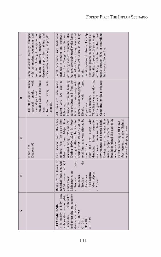
141
AB
CD
E
Khe
ri- 4
68D
udhw
a- 9
5-
The
othe
r ca
uses
inc
lude
pe
rson
al
enm
ity
with
fo
rest
dep
artm
ent,
- M
akin
g w
ine
in th
e fo
rest
ar
ea.
- To
sc
are
away
w
ild
anim
als.
Som
e di
visi
ons
rece
ntly
equ
ippe
d w
ith t
he m
oder
n eq
uipm
ents
and
fir
e pr
oof
clot
hing
to
supp
ress
fire
in
m
ore
effe
ctiv
e m
anne
r. St
ate
depa
rtmen
t pr
ovid
es
train
ing
and
crea
te a
war
enes
s am
ong
the
peop
le.
UT
TAR
AK
HA
ND
- It
is
mos
tly
a hi
lly
stat
e w
ith s
outh
ern
porti
on p
lain
. La
ndsl
ides
, ea
rthqu
akes
an
d fo
rest
fire
are
com
mon
di
sast
ers i
n th
e st
ate.
P - 1
,01,
16,7
52C
- 51
41PD
- 18
9ST
– 3
.02
Ran
ks
6th
in
term
s of
re
cord
ed fo
rest
are
a w
ith
45.6
0 pe
rcen
t of
G
A
unde
r for
est.
Mai
n sp
ecie
s are
--
Trop
ical
m
oist
de
cidu
ous.
- Tr
opic
al
dry
deci
duou
s-
Sub
alp
ine
M
oist
Alp
ine
- A
lpin
e
Fire
se
ason
fr
om
Dec
embe
r to
Jun
e. P
eak
fire
seas
on f
rom
M
arch
to
Ju
ne.
Maj
or
fires
oc
curr
ed d
urin
g 19
95 a
nd 1
999.
D
urin
g 19
99,
22.6
4 %
for
est
area
got
affe
cted
by
the
fire.
D
urin
g 19
95,
19.3
2 %
of
the
tota
l for
est a
rea
was
affe
cted
by
seve
re fi
res.
Bot
h th
e fir
es
alon
g w
ith
dam
agin
g fo
rest
ve
geta
tion
also
cau
sed
imm
ense
los
s to
en
viro
nmen
t and
peo
ple
heal
th.
Dur
ing
thes
e tw
o m
ajor
fire
s m
any
peop
le
suffe
red
from
br
eath
ing
rela
ted
dise
ases
in th
e ne
ar b
y ar
eas.
Fore
st fi
res d
urin
g 20
01 k
illed
four
pe
rson
s in
th
e G
arhw
al
regi
on- R
udra
pray
g di
stric
t.
All
fires
ar
e m
an
mad
e,
exce
pt
very
fe
w
due
to
light
enin
g.Es
cape
fire
from
the
burn
ing
farm
res
idue
s an
d fr
om t
he
fires
lit
to d
rive
away
wild
an
imal
s cau
se d
amag
ing
fire.
Riv
alry
w
ith
fore
st
depa
rtmen
t.N
TFP
colle
ctio
n.Th
row
ing
away
sm
ould
erin
g bi
ri- c
igar
ette
s etc
.C
amp
fires
by
the
picn
icke
rs
etc.
Fore
st d
epar
tmen
t us
es t
radi
tiona
l m
etho
ds t
o pr
even
t an
d su
ppre
ss
fore
st fi
re.
Thou
gh s
ome
divi
sion
s ar
e ha
ving
mod
ern
equi
pmen
t al
so
but t
hey
are
rare
ly u
sed
by th
e fo
rest
of
ficia
l as
the
y ar
e ve
ry h
eavy
and
no
t co
nven
ient
to
use
in t
he h
illy
terr
ain.
Fore
st d
epar
tmen
t al
so s
eeks
hel
p fr
om lo
cal p
eopl
e in
sup
pres
sion
of
fore
st fi
re. I
n so
me
villa
ges a
ttem
pts
are
bein
g m
ade
to i
nvol
ve l
ocal
pe
ople
thr
ough
JFM
in
cont
rolli
ng
the
men
ace
of fo
rest
fire
.
Forest Fire: the indian scenario
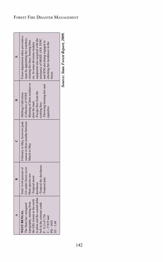
142
Forest Fire Disaster ManageMentA
BC
DE
WE
ST B
EN
GA
L-
The
Stat
e ha
s var
iega
ted
topo
grap
hy, s
tarti
ng fr
om
the
hilly
terr
ain
in th
e no
rth
to p
lain
and
the
coas
tal d
elta
be
lt in
the
extre
me
sout
h.
P - 9
,13,
47,7
36
C
- 37
419
and
PD -
1029
ST –
5.4
9
Tota
l 14.
64 p
erce
nt o
f G
A u
nder
fore
st c
over
.M
ain
spec
ies a
re-
-Tro
pica
l moi
st
deci
duou
s-T
ropi
cal d
ry d
ecid
uous
-Tro
pica
l pin
e
Febr
uary
to M
ay, h
owev
er p
eak
seas
on in
thre
e m
onth
s bet
wee
n M
arch
to M
ay
-Shi
fting
Cul
tivat
ion.
-Col
lect
ion
of N
TFP,
-Bur
ning
of f
arm
resi
dues
to
clea
r the
land
.-E
scap
e fir
es fr
om th
e co
okin
g fir
es-T
hrow
ing
burn
ing
biri
and
ciga
rette
s
Fore
st d
epar
tmen
t tak
es p
reve
ntiv
e st
eps b
y ap
poin
ting
fire
wat
cher
s, cl
earin
g fir
e lin
es, b
urni
ng li
tter
etc.
In so
me
divi
sion
s mod
ern
equi
pmen
t als
o ac
quire
d w
ith th
e as
sist
ance
of M
OEF
, GO
I. FF
PC
and
JFM
als
o be
ing
enga
ged
in
chec
king
fire
inci
denc
es in
the
fore
st.
Sour
ce: S
tate
For
est R
epor
t, 20
09.

Chapter 6
MANAGING FOREST FIRE
6.1 IntroductionExact information about deforestation and forest degradation in
the country, though very limited, yet whatever data available, predicts a very sad situation about forest health. Taking into consideration the seriousness of the problem, just after independence the Government of India started giving the issue of forest conservation and protection (including protection against forest fire) a serious thought. The first progressive step taken in this regard was the formulation of National Forest Policy in 1952, when the erstwhile Ministry of Food and Agriculture, Government of India enunciated a Forest Policy for the management of State Forests in the country. Indian Constitution provided guidelines under the Forest Policy for protection of forests and wildlife. According to this policy the State shall endeavoring to protect and to improve the environment and to safeguard the forests and wildlife of the country and the citizens are to protect and improve the natural environment including forests, lakes, rivers and wildlife and to have compassion for living creatures. The first main issue laid down in the Indian Forest Policy, 1952 is that one-third of the land area of the country should be under forest cover for ensuring a balanced and complementary land use system. It provided scope for the management and control of private forests, containment of shifting cultivation, creation of village forests etc. In addition to formulation of the Forest Policy, the Government of India took numbers of the progressive steps for protection, preservation and management of forests, including:
I. The Indian Forest Service was revived in 1966 to ensure co-ordinated professional management of Forests. The purpose of establishing this cadre of officers has been safety and protection of environment and taking care of national interest.

144
Forest Fire Disaster ManageMent
II. The subject 'Forest' was transferred from the State List to the Concurrent List of the Constitution of India in 1976 to ensure uniform policy and management throughout the nation.
III. The Forest Conservation Act, 1980 was enacted which was later amended in 1988. It provides that areas recorded as Forests in Government records cannot be transferred for non-forestry use without the prior approval of the Government of India.
IV. A separate Ministry i.e. “Ministry of Environment and Forest” was created in the Union Government in 1985 and the Forest wing from the Ministry of Agriculture was transferred to the new ministry.
6.2 Amendment in National Forest PolicyDespite these steps taken from time to time, forests in the country
continued to suffer serious depletion. This is attributable to relentless pressures arising from ever-increasing demand for fuelwood, fodder and timber; inadequacy of protection measures; diversion of forest lands to non-forest uses without ensuring compensatory aforestation and essential environmental safeguards; and above all the tendency to look upon forests as revenue earning resource. A need was felt to review the situation and evolve for future a new strategy of forest conservation. Keeping this in view, the India’s National Forest Policy was amended in 1988. This amended policy presents a visionary strategy for future forest conservation and management, laying emphasis on protection of forest against encroachment, fire and grazing. The main objectives set out by new National Forest Policy (1988) include:
1) Maintaining environmental stability.
2) Conserving the natural heritage of the country.
3) Checking soil erosion and denudation.
4) Checking the extension of sand dunes.
5) Increasing forests and tree cover.
145
6) Meeting the requirements for fuel wood, fodder, minor forest produce, and small timber.
7) Increasing productivity of the forests.
8) Encouraging efficient utilization of the forest produce.
9) Creating a massive people's movement, including involvement of women, for achieving these objectives.
The principle aim of the New National Forest Policy is to ensure environmental stability and maintenance of ecological balance. The policy discusses the steps to be taken for forest conservation, including forest fire management in more effective manner. The policy addresses the problem of forest fires in the following specific terms:
“The incidence of the forest fires in the country is high. Standing trees and fodder are destroyed on a large scale and natural regeneration annihilated by such fires. Special precautions should be taken during the fire season. Improved and modern management practices should be adopted to deal with forest fires."
The text clearly indicates that the legal and policy framework already exists in favour of forest fire management; however, there is need for proper action plan and its implementation to generate public opinion against negligence, ignorance, and indifference towards fire.
6.3 Changing forest management practices and forestfireHistorically, the management of forest in India started with
the objective of sustained yields of outputs through scientifically based knowledge application in project form for a division, named “Working Plan”. It continued as such up to 1960, however, the pressure of growing population put these plans out of gear. In 1976 Social Forestry programme was launched followed by “Participatory Forest Management Programme” in 1990. Under this programme seedling distribution and tree planting activities were undertaken through a
Managing Forest Fire

146
Forest Fire Disaster ManageMent
large number of projects and programmes. Many State Governments have already passed resolutions favoring participatory management of forests. The system provides the scope, nature and intensity of the participation as well as the purpose, methods, rights, responsibilities and incentives to the stakeholders. The transition from production forestry to participatory forest management also changed forest management scenario and has posed various challenges before the foresters, as well as the researchers.
In the recent past, a holistic approach has been adopted in managing the forest in more effective manner by giving more emphasis to other related issues too. The forests management is currently relying upon massive afforestation, efficient use of wastelands, reclamation of waste lands, management of natural forests, increasing productivity of existing ecosystems, efficient utilization of wood and non timber forest produce (NTFP), management, protection of fragile ecosystems and conservation of existing bio-diversity, germplasm collection and biotechnological research, participatory forest management and various sustainability issues.
The latest forestry management practices are ushering a new culture amongst the rural masses i.e. the culture of community/ community based organisations involvement. The Panchayats, local bodies, Mahila Mandals, NGOs etc. are influencing the behaviour of rural masses towards forests. They have achieved it through training, creating awareness, mobilization of the people, building confidence, multi-disciplinary applied research and providing analytical studies. At present the rural masses are no longer ignorant about their rights, benefits and concessions. Right to Information has transformed the society’s knowledge levels. Today’s rural women, though still in shackles of old culture, are tending to be more progressive in public life as well as developmental processes. Knowledge is being given due importance in conservation and protection of forests. Village people now have a culture, which is well integrated with forest cycle from collection of seeds to harvesting of crops. Forestry operation and societal rituals are also well connected. This changing scenario is the strength of the
147
Modern Forest Management in the county.
This paradigm shift in the forest management has brought a revolutionary change in the forest fire management system too. The National Forest policy states that at least one third of the county’s geographic area (around 110 million ha) should be under adequately stocked forest cover as compared to the present 69.09 million hectares. One of the ways to increase forest cover is to protect existing forests from the damaging effects of forest fire, especially in the areas of natural regeneration.
The issue of effective forest fire management in the countries like India, where so many issues are clubbed with forest management is not so simple. Due to population explosion and its ever-increasing pressure on forest, the problem of managing forest fire has become more complicated in comparison to the past, when the fire situation in the country was totally different. In earlier days, as there was not much population pressure, the traditional methods were quite satisfactory and sufficient for forest fire management. The most successful method during that time was an elaborate network of fire lines, block lines and their early clearing and burning. These traditional methods became insufficient and ineffective with changing scenario. The dependency of the people on forest residing near the forest area for fuel wood, timber, grazing of cattle and over exploitation of non timber forest produce has turned the traditional fire protection methods almost outdated. The situation has further deteriorated due to inefficient forest fire management measures in the past.
To achieve the target set by new National Forest Policy of 110 million hectares under forest cover, it becomes imperative to evolve and implement intensive result oriented forest fire management programme in the country. For this Indian forests deserve a full-fledged fire management system institutionalized at the State level with strategic inputs of training, research, and awareness building. In this regard, Government of India has recently started taking initiatives and various attempts have been made to come out with a comprehensive plan for
Managing Forest Fire
148
Forest Fire Disaster ManageMent
tackling the issue more effectively and efficiently. To overcome the issue successfully, the Government has taken cooperation and technical assistance from international organizations too. In this context, the FAO–UN cooperation and support in the form of implementation of Technical Cooperation Programme (TCP) project on Training in Forest Fire Management Planning is worth mentioning, where a number of recommendations have been made for effective forest fire management in the country.
6.4 FAO Recommendations on Forest Fire ManagementThe FAO has run a special TCP project program in the country
under which main emphasis was given to human resource development in forest fire management. The FAO aided TCP project on training in Forest Fire Management Planning was started during May, 1995 and concluded in December, 1995. The main objective of this project was to review India’s current forest fire problem, provide training in strategic fire planning to key forestry personnel at the State and National levels to enable them to develop fire plans based on ecological, economical and social conditions for their respective States and to develop at least one model State Forest Fire Management Plan.
To achieve the set objectives of the project, the work plan was divided into following four phases:
(I) To conduct comprehensive analysis of the forest fire situation in India, including the study of number of fires and area burnt; the effects of ecological, economical and social impacts, current capacity for forest fire management at the National and States levels, including review of existing laws, regulations and policies covering forest fire management.
(II) To design a training package on strategic forest fire management planning which would enable Indian foresters to prepare site specific fire plans for all the forest types in the country.

149
(III) To conduct training courses for the foresters and planners, who would then be capable of preparing strategic Forest Fire Management Plans and providing identical training to large number of field foresters throughout the country.
(IV) To develop minimum one model State Forest Fire Management Plan to serve as an example for subsequent State plans and National plan. Plans are to be organized into a series of program components, which can be considered for development assistance by international donors and financiers.
The international consultant team in their Technical Report made many recommendations for an effective forest fire management. The main among them are-
As prevention is better than cure, a preventive program of zoning, danger rating, early warning and real time monitoring has to be designed and installed.
At the strategy level, coordination with Government agencies like the National Remote Sensing Agency, Forest Survey of India, the Meteorological Department, the All India Radio and the State-owned television should be promoted by the forest departments of the States to plan their actions in the fire season.
A national awareness compaign on fire damage, prevention, detection and communication and suppression should be launched involving schools, Joint Forest Management (JFM) committees, non-Government and other voluntary organizations during the onset of fire season every year.
A central fire management research and training institute for foresters and public agencies should be set up for providing knowledge and skills for fire managers, including trainers at JFM unit levels.
Fire experiment stations should be set up in representative regions to study various effects of fires in different ecosystems
Managing Forest Fire
150
Forest Fire Disaster ManageMent
and provide extension services to the concerned States.
Prevention and Management programmes should be integrated in the Joint Forest Management framework by State Governments.
Fire management should be named specifically as element of “Protection” in the list of priority strategies of National Forestry Action Plan.
The committee in its report suggested following measures for prevention and control of forest fires:
i. Increased vigilance by appointment of adequate number of firewatchers during the month of April, May and June, which used to be the practice earlier.
ii. Clearing and maintenance practice of fire lines, which have been virtually abandoned due to shortage of funds, must be carried out regularly.
iii. The practice of controlled burning to deal with accumulation of combustible pine needles on the forest floor, which has been abandoned as a result of shortage of funds, has to be reintroduced.
iv. Proper forest management and silvicultural practices, particularly in pine forests, which have been abandoned as a result of imposition of the ban on green felling, must be reintroduced to ensure proper health and protection of the forest. For this purpose, ban on felling of pine should immediately be revoked and the forestry activities must be carried out as per working plans.
v. Efforts for finding alternative uses for pine needles should be supported by the Government so as to demonstrate their economic viability. This will help to reduce the accumulation of combustible material on the forest floor.
vi. The forest department staff should be provided with complete communication network through wireless to enable quick
151
response in dealing with forest fires and also with the problems of illicit felling.
vii. The communication network has to be supported with improved mobility to enable quick transport of human and materials from one area to another. For this at least one additional jeep may be provided at divisional level, especially in the hill areas.
viii. Where villagers do not come to assist the forest department in extinguishing forest fires, their timber rights should be curtailed if not forfeited.
In its report, the committee emphasized that the State Governments must ensure that adequate funds are provided to the forest department for proper care, maintenance and protection of the forests. The steady reduction in such funds has seriously affected the activities of the forest department. These funds should be provided through a centrally sponsored scheme for this purpose.
6.5 Forestfiremanagement-someinitiativesAs per Indian constitution the Central and State Governments are
enabled to legislate on forestry issues; however, the implementation part of the programme / policy lies exclusively with the later. Fire prevention, detection and suppression activities are the responsibilities of the State government, where it lies exclusively with the State Forest Department, which unfortunately has no separate wing or unit for carrying out this strategic activity. The regular staff of the forest department has to carry out this task without any extra support or assistance. In most of the cases there is no exclusive fund to look after fire management related activities and in such circumstances it becomes very difficult for the department to carry out its duties honestly. Taking into consideration this pitiable situation, the Union Ministry of Environment and Forests initiated a project “Modern Forest Fire Control Project" in 1984 –1990 assisted by United Nations Development Program in two States of U.P. and Maharashtra. The purpose of this project was to introduce and evaluate integrated forest fire management systems in both the States
Managing Forest Fire
152
Forest Fire Disaster ManageMent
and come out with an appropriate plan of action. The project was highly successful from the standpoints of technical soundness and economic efficiencies. Motivated by the success of this project the Ministry of Environment and Forests has introduced a centrally sponsored scheme namely “Modern Forest Fire Control Methods” since 1992-93 in the eleven selected States of Andhra Pradesh, Bihar , Gujarat, Himachal Pradesh, Kerala, Karnataka, Madhya Pradesh, Maharashtra , Orissa, Tamil Nadu and Uttar Pradesh. The project continued during the first three years of the Ninth Plan period i.e. from 1997 to 2000. In 2000 the scheme was extended to all the States and Union Territories of the country.
The objectives of this scheme are:
(i) To control forest fires with a view to protect and conserve forests.
(ii) To devise, test and demonstrate the principles and techniques of forest fire management.
(iii) To improve the productivity of forests by reducing incidence and extent of fire.
(iv) To create awareness among the masses about the effects of forest fires on the forests and environment.
(v) To conduct training programmes for the forest officials and local people to prevent, detect and control forest fires.
To meet the aforementioned objectives financial support is provided under following subheads:
Prevention: Creation of fire lines, training and demonstration publicity.
Detection: Construction of watch towers, network of wireless sets, fire finders.
Suppression: Hand tools, fire resistant clothing and fire tenders.
During the Tenth Plan period, the States and UTs were financially supported for forest fire management under the new Scheme “Integrated Forest Protection Scheme”.
153
The Government of India also developed various guidelines and advisories to help State governments in managing forest fires in more effective and efficient manners. In addition to guidelines, the Government of India also issued Protocol on Forest Fire Proforma for Forest Fire Reporting at different levels. The main issues have been raised in the “Guidelines on Fire Management and Preparedness”.
In addition to the ongoing schemes for forest fire management, the Government is also considering the setting up of a National Institute of Forest Fire Management with satellite centres in different parts of India with an objective to bring the latest forest fire fighting technologies to India through proper research, training of personnel and technology transfer on a long-term basis. Notwithstanding the existing efforts, it is still felt that there is an acute shortage of resources for forest fire prevention, detection, and control and also for research, training and equipment.
6.6 Nationalplanforforestfiremanagement6.6.1 In continuation of its efforts to effectively deal the forest fire issues, Ministry of Environment and Forest, Government of India has made essential provisions in National Forest Policy. The modified National Forest Policy has addressed a systematic plan for Forest Fire Management, according to which special precautions need to be taken during the fire season in addition to improved and modern management practices to deal with forest fires. In general this plan aims to prepare a strong data base / network on forest fires and evolve an appropriate strategy to deal the forest fire situation in more effective manner. The capacity building, community involvement, awareness generation etc. are integral components of this plan.
The main objectives of the National Plan for Forest Fire Management are:
To strengthen the Organizations responsible for forest fire management including–n Communication network of wireless system/ satellite
Managing Forest Fire
154
Forest Fire Disaster ManageMent
network.n Effective transportationn Improved fire resistant clothingn Fire fighting equipmentn Fire findern Fire tendersn Watch towers and other fire detecting systems etc.
To coordinate the States/UT's plans for systematic forest fire management.
To provide input regarding training, research, extension, and publicity.
To coordinate international transfer of technology and training in the field of forest fire management.
Creation of a strong database for:n Numbers of fires.n Area burnt.n Damage caused to flora and fauna.n Effect of fire on land and soil.n Causes of Forest fire.n Measures taken.n Extent and effect of prescribed fires.
Assessment of ecological, social, and economic impact of fires. Strong national extension strategy for people's awareness and
their participation in forest fire management through JFM, VFC, and NGOs.
Develop necessary human resources by imparting training and encouraging research in forest fire management.
Develop organisational structures at National and State levels. To assess technical and financial assistance required by various
States/UTs for forest fire management.

155
To develop necessary mechanism for monitoring and evaluating management practices.
To provide strong legal base by amending Indian Forest Act, National Code for writing Working Plans and giving due importance to forest fire management in the National Forestry Action Programme.
Number of initiatives have been taken under the plan to strengthen the forest fire management system in the country. A strong central component for the development of an Early Warning Fire Forecasting System using satellite data and Fire Danger Rating System for early detection of forest fire has been introduced. Forest Survey of India (FSI) is working in collaboration with the National Centre for Medium Range Weather Forecasting (NCMRWF) for this project. The Forest Research Institute (FRI), based at Dehradun is also being involved in the plan to assess the impact of forest fire on vegetation and micro-climate.
6.6.2 Strategies- To make the plan successful and meet the objectives, there is need to have a systematic strategic planning including following components-
Publicity and extension- Covering preparation of publication/extension material e.g. pamphlets, handouts, circulars, posters and media programs through TV, radio, video tapes, etc.
Training and education- Designing syllabus for planning, management and ground level firefighting courses in Forestry Institutions.
Strengthening of organizational framework- Though appropriate modification and alteration in State Forest Departments’ structural framework and providing sufficient human power.
Research and development, by strengthening the existing and introducing new R&D institutions dealing with forest fire management.
National Forest Fire Danger Rating System- Designing uniform
Managing Forest Fire

156
Forest Fire Disaster ManageMent
system of Forest Fire Danger Rating and reporting for all States/UT's. Also designing and installing a network of fire forecasting at National and State levels in collaboration with the Meteorological Department.
Monitoring, evaluation and updating prescription- Designing uniform formats for reporting, monitoring and evaluation.
International coordination and transfer of technology- Organising seminars, training programs, conferences, and study tours in different countries leading in Forest Fire Management, e.g., U.S.A., Australia, U.K., Spain, France, etc.
Institution of National Awards- Institution of Gallantry Awards for exemplary works in forest fire prevention, protection, and suppression.
Revision of guidelines for working plan- Introduction of a chapter on Forest Fire Working Circle.
Effective fire fighting tools and machinery- Provisions of modern and effective tools and machinery e.g. Fire Beaters, Forest Fire Showel, Pulaskis Tools, Fire Rakes, McLeod Tools, Brush Tools, Power Blowers, Back-Pack Pump Sets, Fire Tenders etc.
Financial support to States- Provision of Aids/Loans from GOI to States/UT's according to their action plan for Systematic Forest Fire Management.
Promotion of people’s participation-Through involvement of NGOs, Voluntary Organisations, Village Forest Committees (VFCs) etc.
Inclusion of Forest fire management in National Forestry Action Plan (NFAP) - Sufficient mention of strategic Forest Fire Management in the document of NFAP.
Revision of Indian Forest Act- The relevant section of the Indian Forest Act needs to be revised to give due importance to legal protection against man-made forest fire.
157
Creation of a national forest fire control board- With the task of supervising the control of devastating forest fire in exigencies in fragile areas like Himalayan zone, Western Ghats etc.
6.6.3 Forest Fire Monitoring
Since the year 2005, FSI has been monitoring forest fires across the country using inputs received from MODIS satellite system, a joint collaboration of NASA and Geography Department of University of Maryland. In March 2010, FSI started a system of sending SMS/email alerts through its website www.fsi.nic.in. Any user can register for the alert system by providing his/her mobile phone number and email address and the names of district/state/UT for which the information is sought. Every day, between 1100 -1200 hrs email and SMS alerts reach the registered users giving a summary of total number of forest fires detected in their chosen areas.
FSI is monitoring (Near Real Time Monitoring of Forest Fires) forest fires of the country since 2004 using remote sensing based system developed by the University of Maryland (USA) and NASA viz MODIS Rapid Response System. The detection of forest fires is made on the daily basis through the website http://maps.geog.umd.edu. After collecting the coordinates of the fire spots, FSI maps the forest fires through GIS analysis. The coordinates of all the forest fire spots are then sent to the respective State Forest Departments through fax and email for control during fire season (Fig.-6.1). From the feedback received from SFDs, it has been observed that the detected forest fires are correct on more than 95% points.
6.6.4 Methodology
The near real time monitoring of forest fires involves dissemination of forest fire alerts through mobile SMS system. FSI has initiated Real time monitoring of forest fires in collaboration with National Remote Sensing Centre (NRSC) wherein the forest fire alerts for the active fire locations would be generated as KML (Keyhole Markup Language) file
Managing Forest Fire
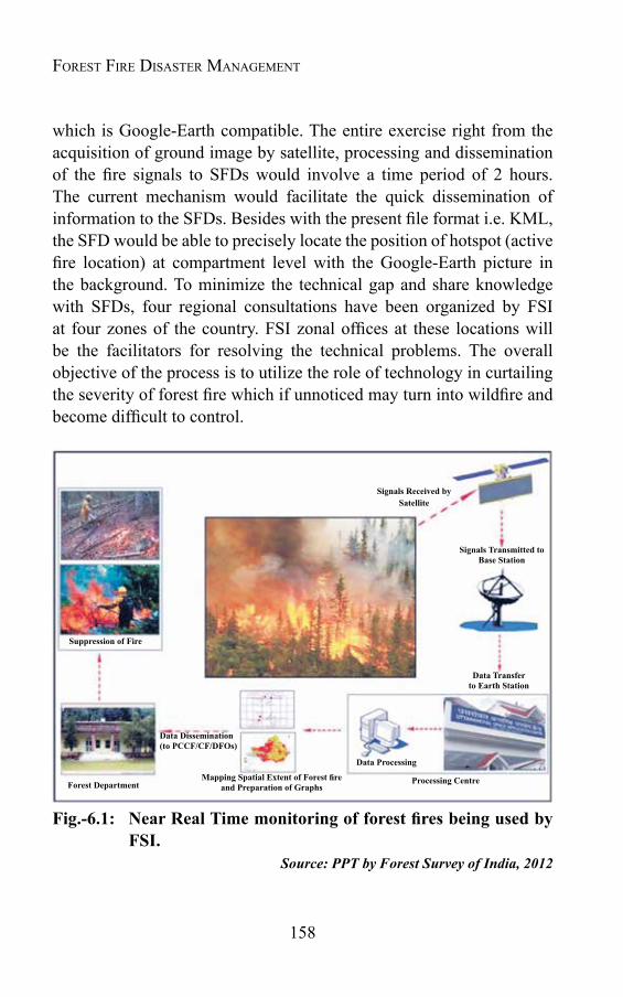
158
Forest Fire Disaster ManageMent
which is Google-Earth compatible. The entire exercise right from the acquisition of ground image by satellite, processing and dissemination of the fire signals to SFDs would involve a time period of 2 hours. The current mechanism would facilitate the quick dissemination of information to the SFDs. Besides with the present file format i.e. KML, the SFD would be able to precisely locate the position of hotspot (active fire location) at compartment level with the Google-Earth picture in the background. To minimize the technical gap and share knowledge with SFDs, four regional consultations have been organized by FSI at four zones of the country. FSI zonal offices at these locations will be the facilitators for resolving the technical problems. The overall objective of the process is to utilize the role of technology in curtailing the severity of forest fire which if unnoticed may turn into wildfire and become difficult to control.
Fig.-6.1: NearRealTimemonitoringofforestfiresbeingusedbyFSI.
Source: PPT by Forest Survey of India, 2012
Signals Received by Satellite
Signals Transmitted toBase Station
Data Transferto Earth Station
MappingSpatialExtentofForestfireand Preparation of Graphs
Data Dissemination(toPCCF/CF/DFOs)
Forest Department
Suppression of Fire
Processing Centre
Data Processing

159
The detailed geo-coordinates of the forest fire point locations are also made available on the FSI website. All the archival forest fire data is also available on the website and is being used by a sizeable number of users. The service was widely publicised amongst the SFDs and the feedback received from them indicates that the forest fire detection has an accuracy of over 95%. The on-going exercise has helped in identifying the forest fire prone areas in the country and also the critical time period of fire occurrence for each State and UT. The identification of fire sensitive zones as well as the fire seasons is likely to help in formulation of effective forest fire control strategy in terms of prevention, alertness, mitigation, fund allocation and deployment of personnel and equipment. The work has generated basic data on the pattern of forest fire in the country which can be used for preparing national level strategy for early warning and burnt area assessment. A total of 13,898 fire incidences were reported by FSI to the States in the year 2010-11 (Table-6.1 & Fig.-6.2).
Table-6.1: Forest Fire Incidences in Indian States & UTs during 2008- 2011
S.No. STATE/UTs 2010-2011 2009-10 2008-091 Andaman & Nicobar 0 7 12 Andhra Pradesh 1119 1837 24423 Arunachal Pradesh 485 576 7864 Assam 1322 2511 19015 Bihar 81 397 1436 Chandigarh 0 0 07 Chhattisgarh 1074 2835 28498 Dadra & Nagar Haveli 0 0 09 Daman & Diu 0 0 010 Delhi 1 0 011 Goa 3 0 212 Gujarat 101 179 18213 Haryana 5 29 2114 Himachal Pradesh 6 125 16815 Jammu & Kashmir 7 30 11716 Jharkhand 192 1314 43017 Karnataka 370 428 604
Managing Forest Fire
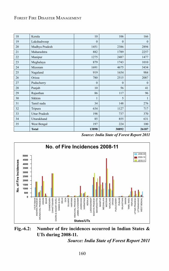
160
Forest Fire Disaster ManageMent
18 Kerala 10 106 16619 Lakshadweep 0 0 020 Madhya Pradesh 1451 2386 289421 Maharashtra 882 1789 225722 Manipur 1275 2487 147723 Meghalaya 879 1743 101024 Mizoram 1691 4675 343425 Nagaland 919 1654 98426 Orissa 780 2515 208727 Puducherry 0 0 028 Punjab 10 56 4129 Rajasthan 86 117 9630 Sikkim 1 5 131 Tamil nadu 34 148 27632 Tripura 634 1127 71733 Uttar Pradesh 198 737 37034 Uttarakhand 85 855 63135 West Bengal 197 224 100
Total 13898 30892 26187
Source: India State of Forest Report 2011
A &
N Is
land
sA
ND
HR
A P
RA
DE
SH
AR
UN
AC
HA
L P
RA
DE
SH
AS
SA
MB
IHA
R
CH
AN
DIG
AR
HC
HH
ATTI
SH
AR
H
DA
DR
A &
NA
GA
R H
AVE
LID
AM
AN
& D
IUD
ELH
I
GO
AG
UJA
RAT
HIM
AC
HA
L P
RA
DE
SH
JAM
MU
& K
AS
HM
IRJH
AR
KH
AN
DK
AR
NAT
AK
A
KE
RA
LA
LAK
SH
AD
WE
EP
MA
DH
YA P
RA
DE
SH
MA
HA
RA
SH
TRA
MA
NIP
UR
ME
GH
ALA
YAM
IZO
RA
M
NA
GA
LAN
DO
RIS
SA
PU
DU
CH
ER
RY
PU
NJA
BR
AJA
STH
AN
SIK
KIM
TAM
IL N
AD
UTR
IPU
RA
UTT
AR
PR
AD
ES
HU
TTA
RA
KH
AN
DW
ES
T B
EN
GA
L
HA
RYA
NA
States/UTs
No.
of F
ire In
cide
nces
No. of Fire Incidences 2008-1150004500
40003500
300025002000
15001000
5000
2008-092009-10
2010-11
Fig.-6.2: NumberoffireincidencesoccurredinIndianStates&UTs during 2008-11.
Source: India State of Forest Report 2011
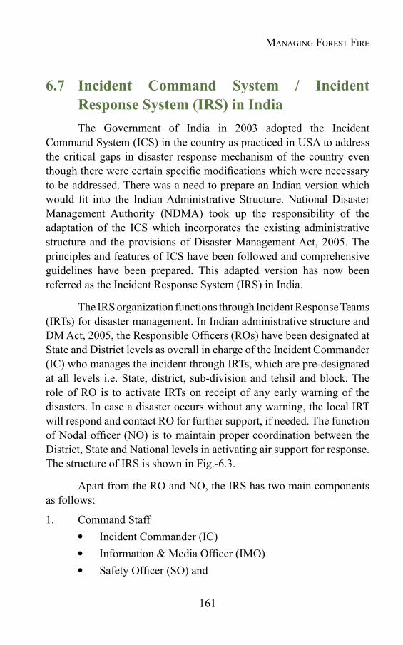
161
6.7 Incident Command System / Incident ResponseSystem(IRS)inIndiaThe Government of India in 2003 adopted the Incident
Command System (ICS) in the country as practiced in USA to address the critical gaps in disaster response mechanism of the country even though there were certain specific modifications which were necessary to be addressed. There was a need to prepare an Indian version which would fit into the Indian Administrative Structure. National Disaster Management Authority (NDMA) took up the responsibility of the adaptation of the ICS which incorporates the existing administrative structure and the provisions of Disaster Management Act, 2005. The principles and features of ICS have been followed and comprehensive guidelines have been prepared. This adapted version has now been referred as the Incident Response System (IRS) in India.
The IRS organization functions through Incident Response Teams (IRTs) for disaster management. In Indian administrative structure and DM Act, 2005, the Responsible Officers (ROs) have been designated at State and District levels as overall in charge of the Incident Commander (IC) who manages the incident through IRTs, which are pre-designated at all levels i.e. State, district, sub-division and tehsil and block. The role of RO is to activate IRTs on receipt of any early warning of the disasters. In case a disaster occurs without any warning, the local IRT will respond and contact RO for further support, if needed. The function of Nodal officer (NO) is to maintain proper coordination between the District, State and National levels in activating air support for response. The structure of IRS is shown in Fig.-6.3.
Apart from the RO and NO, the IRS has two main components as follows:
1. Command Staff Incident Commander (IC) Information & Media Officer (IMO) Safety Officer (SO) and
Managing Forest Fire

162
Forest Fire Disaster ManageMent
Liaison Officer (LO)2. General Staff
Operations Section (OS) Planning Section (PS) Logistics Section (LS)
The features and significance of various forms of IRS in detail with reference to the Indian context have been discussed in National Disaster Management Guidelines- IRS, NDMA (2010), GOI publication.
Fig.-6.3:IncidentResponseSystem(IRS)OrganisationinIndia.Source: National Disaster Management Guidelines- IRS, NDMA (2010), GOI
The IRS provides a participatory, well structured, fail safe, multi disciplinary, multi departmental and systematic approach to guide administrative mechanisms at all levels of the Government. It also provides scope for private sector, NGOs, CBOs, PRIs and communities to work seamlessly in the response activities. It has been implemented irrespective of size, location, type and complexity of the disaster in India like the ICS in USA.
COMMANDSTAFF
GENERALSTAFF
Liaison Officer
Logistics SectionOperations Section
Information & Media Officer
RESPONSIBLE OFFICER
INCIDENT COMMANDER
Safety Officer
Planning Section
Nodal Officer(Air Operation)
Deputy
Chapter 7
FOREST FIRE MANAGEMENT: ACTION PLAN
7.1 IntroductionThe “disaster” brought by fire is though usually very small in
geographical scales, yet its effects can spell devastation. The High Powered Committee (HPC) on Disaster Management, constituted on behalf of Prime minister in 1999, in its report submitted in October' 2002 identified forest fire as one of the 33 major types of disasters prevalent in the country enlisted under the category of "Accident Related Disasters".
In general there is a lack of concern about the detrimental impact of forest fire on society, mainly because the direct loss in terms of human lives and property damage (houses buildings, infrastructure etc.) is not much in comparison to other natural disasters like flood, cyclones, tsunami etc. However, if viewed in terms of intangible impact of forest fire, it is much more than that of other common disasters. The intangible loss due to forest fire includes impact on biodiversity, damage to watershed services, loss of soil fertility, increase in soil erosion and landslides etc. In the present day context forest fire is said to have developed a dangerous relationship with the global warming by adding Green House Gases. Albeit, the direct loss due to forest fire may not be much evident in economic terms, its long term impacts mainly on environment are more devastating and need serious efforts to manage forest fires in more effective manner.
7.2 Forestfiremanagement-thekeygapsThe analysis of secondary as well as primary information
collected from various stakeholders i.e. forest officials, policy makers and

164
Forest Fire Disaster ManageMent
implementers, district and local level administrative officials and staff, NGOs and CBOs representatives, and community through interaction, meetings, workshops etc. reveals that the forest fire management in India still lacks a systematic and scientific approach. The key gaps in the system are enlisted as –
a)Lack of appropriate policy and planning to tackle forest fire: Existing forest policy and other documents, including plans etc. lack clear guidelines for forest fire management.
b) Lack of proper institutional mechanism: In general forest fire management in the country is looked after by the forest department. There is no institutional mechanism available within the forest department, with sole responsibility of fire management. There is no separate establishment, even in higher fire prone regions to look after the forest fire.
c) Emphasis on response only:Though the forest departments are taking care of forest fire, but in general in present scenario, response is their main concern. Very less or negligible importance is given to other issues i.e. mitigation, preparedness, human resource development, providing scientific input, awareness creation, etc.
d)Lackofscientificapproachtocollectfiredataanddocumentitforforestfiremanagement: The Forest Survey of India has recently started compiling forest fire data, however, at State level still there is not much sincere effort to collect and document these data and use it in research and planning. There is a need to collect and compile fire information related to area burnt, damage to forest crop, environment and wild life along with indirect loss to soil and water resources. This information is possible only thorough research and investigation. The forest department is also required to develop forest fire vulnerability map at beat level based on forest vegetation and past history.
e) Lack of funding: There is no provision for separate budget for forest fire management at State level in general. Forest fire management activities are usually carried out using forest protection fund. The State

165
Forest Departments are being financially supported under CSS Schemes; however this allocation is not sufficient to meet the challenges.
f) Not many initiatives to involve local community: The local community may play significant role in forest fire management, however, except few states; there is not much sincere efforts done in this regard. There is a need to involve community by providing them some initiatives to protect forest from fires.
g)Poorresponse toHRDandother capacitybuilding initiatives: The forest fire in general is looked after by forest department; however, the officials and other staff of the forest departments in most of the cases are not trained and lack complete knowledge about forest fire and its behavior. The forest department training institutes are also not well equipped to provide training in the field of forest fire management. Though forest fire has been included in the list of disasters, but it is not being given due consideration in the training programmes being conducted at national and regional levels by disaster management training institutes.
h)Lackofpropercontingencyplansandrehearsals/drillsforfiresuppression: There is need to develop proper contingency plans at beat level and update them every year before the fire season. The forest officials are also required to rehearse and practice the fire suppression exercise, involving community. However, these important components of forest fire management area not given much significance by the forest departments at state levels.
i) Poor early warning system: In the recent past there are many new developments in the field of detection of forest fire using various indicators and disseminating the information received to the field staff to take quick possible action. However, the techniques and methodology used by most of the forest departments are not showing changes. They still use the traditional methods to detect fires and disseminate information at field levels. There is an urgent need to revitalize the system using modern techniques and train the field staff to use them more effectively.
Forest Fire ManageMent: action Plan
166
Forest Fire Disaster ManageMent
j)Lackofpreventiveandpreparednessmeasurestoensurebetterresponse: Preparedness activities like clearing fire lines, removing the fuel (dead wood, leaves etc.), recruiting forest fire watchers, making the equipment ready to use, rehearsal and drill practices, reuniting fire protection committees etc. are very essential to prevent and prepare for any forest fire incident.
k) Lack of coordination: Coordination of forest departments with other agencies, whose support may be very important in forest fire management, is very poor. The sharing of information is very minimal, causing extreme gaps in knowledge sharing and using knowledge available for better forest fire management planning. There is lack of proper coordination among research institutes in forestry sector and the service provider. Similar situation exists for the data generating institutes and the user groups. The meteorological, fire, disaster management departments etc. may play significant role in forest fire management; however, the forest department coordination with these departments and their regional and local level offices is very poor; which prevents their valuable support in detecting/ identifying forest fire and its suppression.
7.3 Actionplanforforestfiremanagement7.3.1 Forest FireManagement (FFM) in India is the mandate of the forest department, therefore it is imperative that forest department be capacitated at national, regional and local levels for making forest fire management system more effective and reduce the vulnerability of the Indian forest to fires. This needs a comprehensive action plan, incorporating various issues mentioned in the preceding text. With this background an Action Plan for Forest Departments is being suggested. The plan briefed in the succeeding text discusses various strategic areas, which need to be strengthened to make the department at different levels more capable in dealing the menace of forest fire in the country.
The plan has been developed through an interactive consultation process with a variety of key stakeholders on forest fire management within and outside the forest department.
167
7.3.2 Objectiveandpurpose: The objective of the plan is to strengthen forest fire prevention, preparedness and response mechanism within the forest departments at various levels to deal with forest fire more effectively.
The plan of action will be used to:
provide Forest Department with a framework to strengthen skills and increase capacities for FFM, enabling it to play effectively the role of a service provider in times of need;
upgrade forest personnel’s services to manage forest fire and reduce the risks
contribute towards better coordination between key stakeholders at different levels, and in particular at local levels; and
provide a framework within which to report performance and success.
7.3.3 Principles and philosophy: The plan is building on the vision of the Government of India policy statement on Forest Fire “Resolution No.13/52-F, dated the 12th May 1952”, as well as New Forest policy, 1988. Within this context the Plan of Action includes:
considers Forest Fire Management as an integral component of forest management planning,
proposes management to upgrade the existing capacity of forest department in context of forest fire management.
counts on partnerships with other stakeholders, including GOs, NGOs and CBOs, based on complementarities and mutual comparative advantages
promotes the development of high professionalism in forest department on forest fire management.
defines forest dwellers and community as the ultimate beneficiaries
Forest Fire ManageMent: action Plan
168
Forest Fire Disaster ManageMent
7.3.4 Main result areas and entry points proposed for forest department interventions
Following entry points & main result areas (MRA) have been identified to strengthen Forest Department in respect of Forest Fire Management:
A. Institutional Setup for Forest Fire Management and stakeholders coordination
B. Policy framework
C. Assess and monitor forest fire risks and enhance sustainable application of warning systems
D. Knowledge management, capacity building and awareness generation
E. Technical options for forest fire management
A. Institutional Setup for Forest Fire Management (FFM)andStakeholderscoordination
At present there is no specific entity mandated within Forest Department to be responsible for fire risk reduction. The new role of Forest Department in FFM requires a well defined institutional set up, partnerships and networks.
Goal: The goal of this exercise is to ensure efficient institutional mechanism within Forest Department at various levels covering all aspects of FFM and coordinating with other stakeholders and role players.
Proposed strategies: What needs to be done?
Institutionalize capacities for FFM in forest department.
Develop a well defined institutional framework within forest department at national and state levels.
169
Identify duties and responsibilities of various role players in the newly developed framework.
Keeping in view the severity of forest fire, the existing organizational structure, both at central and state level seems to be unsatisfactory. At present, the Forest Protection Division, headed by Inspector General (IG) level officer looks after the forest fire management work at National level with the cooperation of National Disaster Management Authority (NDMA), Disaster Management (NDM) Division of Government of India, National Institute of Disaster Management (NIDM), International organizations, Forest Survey of India (FSI), Forest Research Institute (FRI) and other regional offices of MoEF in the country. It is required that for effective dealing, a separate division be established for forest fire management, which could exclusively deal with the issue. Air Operation Wing, which has been wrapped up long back, may again be operated to tackle any unforeseen severe forest fire as that of 1995 in U.P. & H.P. Establishing such wing, though a costly affair, may also be useful for regular forest surveys and other associated activities. The wing is to be established at par with international standard to face any type of mis-happening. The air-craft or helicopters of the wing may also be utilized during other types of disasters like flood, earthquake etc. and may be very useful in supplying relief and rescue work without wasting time.
The Ministry of Environment & Forests (MoEF) has six regional offices in the country acting as coordinating offices with the state forest departments. These offices may be used to regulate forest fire management activities and for this separate wing may be established, exclusively to look after forest fire.
At state level, the forest fire management operations are looked after by regular forest staff, which is already over burdened. It will be appropriate, if a separate wing is established at state forest headquaters, headed by Chief Conservator of Forest level officer. This wing may work in collaboration with central level unit and provide all types of guidance, supervision etc. to all forest divisions of the state regarding
Forest Fire ManageMent: action Plan

170
Forest Fire Disaster ManageMent
forest fire management. In the lean period, the wing may work on data compilation, preparedness and mitigation measures. Training programmes for forest officials in fire fighting may also be organized at forest training schools. Sufficient fund provision is to be made for research and development and suitable projects may be sanctioned to state level research institutions to establish a strong data- base. The wing in collaboration with publicity division of the forest department may carry out effective awareness generation programmes among community through various IEC materials. In sensitive areas, Forest Fire Protection Committees may be established ensuring community participation.
During forest fire situation, this wing may work as Emergency Operation Centre (EOC) equipped with all communication and other facilities and may supervise and guide suppression work. In case of severe fire conditions, necessary assistance may be sought from State Disaster Management Authority (SDMA), Disaster Management Department at State level and at central level too, if required.
Depending upon the severity of the situation, similar arrangements may be made at Divisional level too. In fire prone divisions, a range office or Assistant Conservator of Forest (ACF) level officer may be deputed to look after all forest fire related activities of the division under the overall supervision of Divisional Forest Officer who can be assisted by District Disaster Management Authority (DDMA) and Range Officer (Fig.-7.1).

171
FRI = Forest Research Institute, Dehradum, IG = Inspector General, FF. = Forest Fire, DIG = Deputy Inspector General, CF = Conservator of Forest AIG = Asstt. Inspector General CCF = Chief Conservator of Forest, CCFF = Chief Conservator of Forest Fire, MoEF = Ministry of Environment & Forest, MoHA = Ministry of Home Affairs, DM = Disaster Management, GOI = Government of India, FSI = Forest Survey of India, SDMA = State Disaster Management Authority, DDMA = District Disaster Management Authority. NIDM=National Institute of Disaster Management.
Fig.-7.1: Proposed Institutional Framework for Forest Fire Management
Forest Fire ManageMent: action Plan
172
Forest Fire Disaster ManageMent
B. Policy frameworkGaps to be addressed: The present policy/ planning documents do not give due consideration to Forest Fire Management. Revised key policy documents need to incorporate clear guidance about Forest Department and other stakeholders’ role and contributions to FFM.
Goal: Revised policy and planning framework which includes FFM in more comprehensive and systematic manner
Proposed strategies Incorporate FFM issues in existing policy and planning
documents in more systematic way: There is a need to incorporate clear cut guidelines and responsibilities of different role players to capacitate forest department and other stakeholders to manage forest fire in more systematic manner.
Develop/ update forest fire manuals for field staff guiding them in simple way to detect/ report about and suppress forest fire.
Incorporate FFM issues into other national / regional/ local level Disaster Risk Management programmes.
Though legal and policy framework exists in favour of fire protection, there is a need to strengthen and make it more practical and implementable. Existing acts though quite effective in forest and wild life conservation, do not give specific attention to forest fire management. As in more than 90 % cases forest fire is a human induced phenomenon, there is urgent need that some special Act be enacted to provide appropriate legal frame-work at national and state level both. Such Forest Fire Prevention Act will also strengthen the forest department in controlling and checking the illegal activities within or near the forest, leading to severe forest fires.
Subject to the enactment of suitable legislation, it is also necessary to evolve detail regulations to help in enforcement of the law. The existing codes/regulations/laws related to forest / wildlife protection
173
and preservation are to be reviewed and suitable mechanism be evolved for their effective enforcement.
C. Assess and monitor forest fire risks and enhancesustainable application of warning systems
Gaps to be addressed: For an efficient and timely generation and transfer of information related to fire warning, it is necessary to enhance the capacity of forest management functionaries at various levels to generate timely warning and translate it into useful information for field staff and others. In addition there is need to prepare forest fire vulnerability maps based on past history and other variables like forest vegetation, weather conditions etc.
Goal: Increased capacity in generating relevant warning, increased understanding of warning systems by forest management functionaries and sustained support and coordination between the partner organizations
Proposed strategies Capacity building for the better use of early warning (technical
efficiency & HRD): The forest officials need to be trained in using various indicators to get prior information about forest fire at the earliest time possible to take timely action. The forest department may be provided with necessary equipment in detecting forest fire at the earliest possible. Forest officials are to be trained in using various valuable information, available at national and international levels and translate it for local use.
Strengthen collaboration with partner organizations involved in generating warning: Necessary collaboration is required with organisations involved in generating early warning about forest fire. Meteorological Departments and other national and international sources providing weather related information may be collaborated to get prior information about the temperature and rainfall situation- two main deciding factors for forest fires.
Forest Fire ManageMent: action Plan
174
Forest Fire Disaster ManageMent
Disseminate refined early warning product outputs at field levels in user- friendly way: The information available from different sources need to be dovetailed for making use at local level and necessary arrangement be made to disseminate this information at field level to make use in taking appropriate preventive, preparedness and response actions in time.
Assess risks and prepare vulnerability and risk maps: To get prepared and take necessary preventive measures in time, it is necessary that the vulnerability/ risk maps be prepared of forest area, depending mainly on past history, climatic conditions and other human induced factors like population density, socio-economic conditions etc.
D. Knowledge management, capacity building and awareness generation
Gaps to be addressed: The knowledge of forest staff about FFM and the operational skills needed to implement fire prevention, preparedness and suppression activities need to be updated and upgraded. Therefore, awareness creation and capacity building on FFM are important keys. There is also a lack of knowledge and awareness about FFM at the community level. Forest department can play a crucial role in creating awareness and translating FFM policies into concrete field action.
Goal: Use knowledge and training to build a culture of innovation, safety and resilience, and institutionalize training on FFM for Forest Department, other role players and also at community levels.
Proposed strategies Enhance and maintain forest fire specific data base and enlist
good practices: Forest fire specific data is very limited and if available is not very reliable. For most of the States, forest fire database is either not available and if available is very sketchy. This prevents in developing appropriate forest fire management planning and avails necessary resources to deal with the problem
175
effectively. There is need to use modern scientific technique to collect, compile and document forest fire related data. To prepare effective strategy for forest fire management, it will be of significance that a robust and sound information data-base is prepared. The Forest Survey of India may be strengthened to collect and compile strategic information regarding forest fire at national level. Efforts be made at state level also to verify and enrich data network.
The data network may consist of:
Information about climate, weather, etc.
Historical documentation of forest fires, including location, type of vegetation, history, causes and other details.
Number of forest fires, the area burnt and other adverse impact,
Type of vegetation burnt, the flora and fauna of the area.
Resources, including human resource available with the state govt. to detect and combat forest fire,
Other area specific relevant information.
Various modern techniques including remote sensing may be used to collect and compile information related to forest fire. Remote sensing, GIS etc. can provide data base which can be used in forecasting and locating forest fire, its extent and appropriate technique to suppress the same.
Documentation of good practices: At national and international levels there are number of good practices in forest fire management. There is need to document such practices in proper way so that good lessons be learnt from them and utilize them in making forest fire management system more effective and practical.
Systematically utilize outputs and knowledge created by
Forest Fire ManageMent: action Plan

176
Forest Fire Disaster ManageMent
otherprojectsforFFM: Many forest fire management related projects have been implemented in different States in the past with national and international support. The learning and outputs of these projects will be of immense utility in making forest fire machinery at national and state level more effective.
Develop/up-dateoperationalfieldmanualsandguidelinesfor field staff with sufficient inputs on FFM: Several state forest departments have developed field manuals for forest staff; however, such manuals in general lack proper guidelines to detect, communicate and techniques to suppress forest fires. There is need to upgrade such manuals and develop new ones in the states where such manuals are not available.
Enhance capacities of Forest Department training institutes & trainers: Almost all the State Governments have their State Forest Training Institutes and Colleges. Forest Fire Management (FFM) needs to be an integral part of course curricula of these institutes. The course being taught in such institutes about the forest fire management should be updated and enriched with latest information about forest fire detection, suppression and rehabilitation.
Disaster Management Institutes: For wider dissemination of forest fire management knowledge and capacitating more resources and skilled force, it is required that FFM may be included in the course curricula of the Disaster Management Institutes at national and regional levels. It will also help in better coordination among forest department and disaster management functionaries.
Increase community awareness: Community participation has proved very useful in forest fire management. More people participation may only be ensured by making community aware about the significance of FFM and its benefit to community. Different methodology and IEC means may be used for it. As in more than ninety percent cases of forest fires are ignited
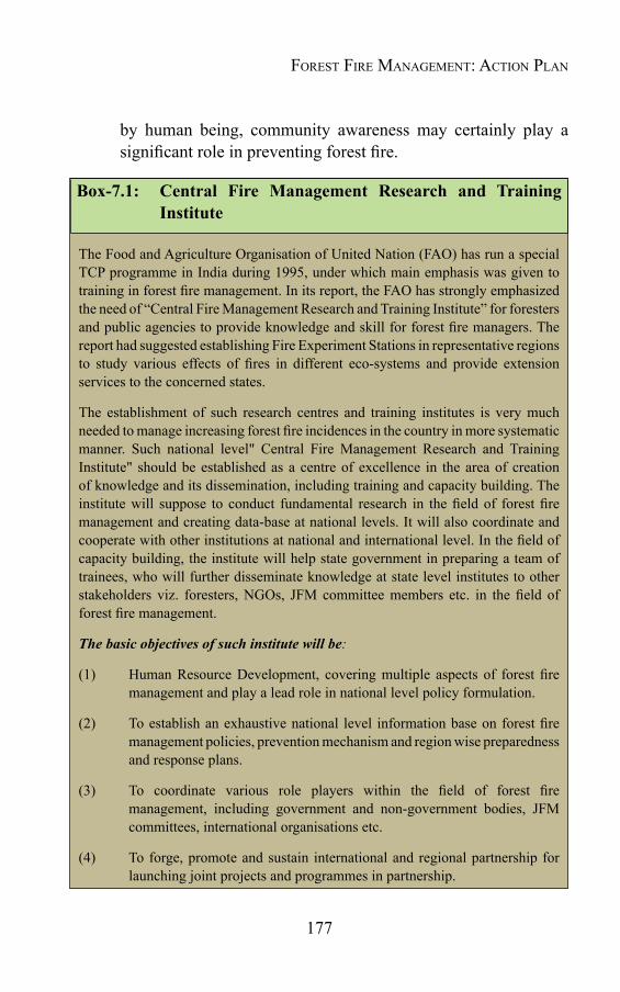
177
by human being, community awareness may certainly play a significant role in preventing forest fire.
Box-7.1: Central Fire Management Research and Training Institute
The Food and Agriculture Organisation of United Nation (FAO) has run a special TCP programme in India during 1995, under which main emphasis was given to training in forest fire management. In its report, the FAO has strongly emphasized the need of “Central Fire Management Research and Training Institute” for foresters and public agencies to provide knowledge and skill for forest fire managers. The report had suggested establishing Fire Experiment Stations in representative regions to study various effects of fires in different eco-systems and provide extension services to the concerned states.
The establishment of such research centres and training institutes is very much needed to manage increasing forest fire incidences in the country in more systematic manner. Such national level" Central Fire Management Research and Training Institute" should be established as a centre of excellence in the area of creation of knowledge and its dissemination, including training and capacity building. The institute will suppose to conduct fundamental research in the field of forest fire management and creating data-base at national levels. It will also coordinate and cooperate with other institutions at national and international level. In the field of capacity building, the institute will help state government in preparing a team of trainees, who will further disseminate knowledge at state level institutes to other stakeholders viz. foresters, NGOs, JFM committee members etc. in the field of forest fire management.
The basic objectives of such institute will be:
(1) Human Resource Development, covering multiple aspects of forest fire management and play a lead role in national level policy formulation.
(2) To establish an exhaustive national level information base on forest fire management policies, prevention mechanism and region wise preparedness and response plans.
(3) To coordinate various role players within the field of forest fire management, including government and non-government bodies, JFM committees, international organisations etc.
(4) To forge, promote and sustain international and regional partnership for launching joint projects and programmes in partnership.
Forest Fire ManageMent: action Plan

178
Forest Fire Disaster ManageMent
(5) To help state forest departments in strengthening their forest fire management systems and capacity building of various stake holders and role-players.
(6) To help state forest department in preparing forest fire management plan and formulate policy in this regard.
(7) Cooperation and experience sharing with various international organizations working in the field of forest fire management.
National forest fire knowledge network
A national forest fire knowledge network must be established to cover all dimensions of forest fire in the country. Such network must be tuned to the felt need of all stakeholders, including forest fire managers, policy makers and planners, decision makers, community etc. Central Level Forest Fire Management Institute may be handed over this responsibility. The network should exhibit a deep concern for its uses and knowledge packed should be available easily in time.
Necessary steps to be taken in this regard must include -
– All knowledge scattered in research institutions, universities etc. related to fire management must be compiled and form part of the network.
– Relevant projects related to forest fire research development may be sanctioned to universities/research institution to enrich the forest fire knowledge. The outcome of such research may be published and publicized for the benefit of all stake-holders.
– Traditional knowledge about forest fire management available with villagers and forest dwellers may be of significant use in forest fire management planning. Such knowledge may be collected and compiled in the form of compendium for further use.
– Necessary steps must be taken for national and international
179
networking of knowledge on all spheres of forest fire management.
– The experts, researchers, the administration people and institutes having knowledge and experience in the field of forest fire management must be enlisted in the form of a directory, which must be updated from time to time.
E. Technical options to reduce underlying risks
Gaps to be addressed: A significant amount of technical options to assist Forest Department in increasing their resilience, preparedness and response capacities against forest fire are known and available at regional, national and international levels. However, the spectrum of available options is often not known or easily accessible. To make FFM more effective, it is of utmost significance that available options are systematically assessed, documented, shared and adapted to location specific needs in a participatory way.
Goal: Increased capacity to manage forest fire, involving community and using a variety of tested technical interventions.
Proposed strategies:
Stock taking: Assess indigenous knowledge and techniques to detect and suppress forest fire, and upgrade it with scientific inputs and research: At local and regional levels there are many indigenous techniques and knowledge available, there is a need to compile and collect such information and upgrade it with scientific inputs and field tests to find its suitability in making forest fire system more effective, useful and less expensive.
Promote FFM related research and technology innovations: The research institutes, involved in forestry and related research, may be pursued to do research in developing appropriate techniques in getting prior information about forest fire, detecting it, and suitable mechanism to suppress it.
Forest Fire ManageMent: action Plan

180
Forest Fire Disaster ManageMent
Technology transfers at various levels and use it with location specific required modification, involving scientificinputs: Already tested and found technologies useful in forest fire management may be shared at regional, national and international levels. The technologies so borrowed need to be further modified as per the location specific requirement.
GLOSSARY
aerial fuel
The standing and supported live and dead fuels not in direct contact with the ground and consisting mainly of foliage, twigs, branches, stems, bark, lianas and other vines, moss and high brush. In general they easily dry out and may carry surface fires into the canopy.
agrosilvopastoral system
Land-use system in which woody perennials are used on the same land as agricultural crops and animals, in some form of spatial arrangement or temporal sequence. In fire management agrosilvopastoral systems are planned as fuelbreaks (particularly shaded fuelbreaks) to reduce fire risk by modifying understory vegetation and soil cover (cf. fuelbreak).
backfire
A fire spreading, or set to spread, into or against the wind: (1) As used in firesuppression: A fire set along the inner edge of a control line to consume the fuel in the path of a forest fire and/or change the direction of force of the fire's convection column (Note: doing this on a small scale and with closer control, in order to consume patches of unburned fuel and aid control-line construction (as in mopping-up) is distinguished as "burning out, firing out, clean burning"); (2) As used in prescribed burning: designation of fire movement in relation to wind.
backfiring
A form of indirect attack where extensive fire is set along the inner edge of a control line or natural barrier, usually some distance from the wildfire and taking advantage of indrafts, to consume fuels in the path of the fire, and thereby halt or retard the progress of the fire front.

182
Forest Fire Disaster ManageMent
biomass
(1) The amount of living matter in a given habitat, expressed either as the weight of organisms per unit area or as the volume of organisms per unit volume of habitat. (2) Organic matter that can be converted to fuel and is therefore regarded as a potential energy source. Note: Organisms include plant biomass (phytomass) and animal biomass (zoomass). (3) In fire science the term biomass is often used synonymously with the term "fuel" and includes both living and dead phytomass (necromass); the zoomass is usually excluded.
buffer strip / buffer zone
A fuel break on the form of a strip of land along or adjacent to roads, trails, watercourses and recreation sites, or between (separating) fuel complexes (cf. fuelbreak).
candle bark
Long streamers of bark decorticated from some gum-barked Eucalyptus species forming a firebrand responsible for long-distance spotting.
combustion
Consumption of fuels by oxidation, evolving heat and generally flame (neither necessarily sensible) and/or incandescence. Combustion can be divided into four phases: pre-ignition (or preheating), flaming, smouldering, and glowing.
control line
Comprehensive term for all constructed or natural barriers and treated fire edges used to control a fire.
dead fuel
Fuels with no living tissue in which moisture content is governed almost entirely by atmospheric moisture (relative humidity and precipitation), dry-bulb temperature, and solar radiation (cf. Live Fuel).

183
dispatcher
A person employed to receive reports of discovery and status of fires, confirm their locations, take action promptly to provide the firefighters and equipment likely to be needed for control in first attack, send them to the proper place and provide support as needed.
draped fuels
Needles, leaves, and twigs that have fallen from tree branches and have lodged on lower branches or brush. Comprises a part of aerial fuels.
drip torch
A hand-held apparatus for igniting prescribed fires and backfires by dripping flaming fuel on the materials to be burned. The device consists of a fuel fount, burner arm, and ignition source. Fuel used is generally a mixture of 65-80% diesel and 20-35% gasoline.
early burning
Prescribed burning early in the dry season, before the leaves and undergrowth are completely dry or before the leaves are shed; carried out as a precaution against more severe fire damage later in the fire season.
escapedfire
Fire which has exceeded or is expected to exceed initial attack capabilities or planned prescription.
finefuel
Fast-drying dead fuels, generally characterized by a comparatively high surface area-to-volume ratio, which are less than 0.5 cm in diameter and have a timelag of one hour or less. These fuels (grass, leaves, needles, etc.) ignite readily and are consumed rapidly by fire when dry. (cf. flash fuel, medium fuel, heavy fuel).
Glossary
184
Forest Fire Disaster ManageMent
firebehaviour
The manner in which fuel ignites, flame develops, and fire spreads and exhibits other related phenomena as determined by the interaction of fuels, weather, and topography. Some common terms used to describe fire behaviour include the following:
smouldering - A fire burning without flame and barely spreading.
creeping - A fire spreading slowly over the ground, generally with a low flame.
running - A fire rapidly spreading and with a well-defined head.
torching - Ignition and flare up of foliage of a single tree or a small clump of trees, usually from bottom to top (syn. candling).
spotting - A fire producing firebrands carried by the surface wind, a fire whirl, and/or convection column that fall beyond the main fire perimeter and result in spot fires. Note: Solid Mass or Ember Transport under Heat Transfer.
crowning - A fire ascending into the crowns of trees and spreading from crown to crown.
Note: Three classes of Crown Fire under Forest Fire (I).
firebelt
A strip, cleared or planted with trees, maintained as a firebreak or fuelbreak.
firebreak
Any natural or constructed discontinuity in a fuelbed utilized to segregate, stop, and control the spread of fire or to provide a control line from which to suppress a fire; characterized by complete lack of combustibles down to mineral soil (as distinguished from fuelbreak).
fireclimax
A plant community at a stage of succession maintained by periodic fires.
185
firecontrol
All activities concerned with protection of vegetation from fire.
firecycle
The number of years required to burn over an area equal to the entire area of interest.
firedanger
A general term used to express an assessment of both fixed and variable factors of the fire environment that determine the ease of ignition, rate of spread, difficulty of control, and fire impact; often expressed as an index.
firedangerrating
A component of a fire management system that integrates the effects of selected fire danger factors into one or more qualitative or numerical indices of current protection needs.
fire-dependentspecies
Plant and animal species which require regular fire influence which triggers or facilitates regeneration mechanisms, or regulates competition. Without the influence of fire these species would become extinct.
fireecology
The study of the relationships and interactions between fire, living organisms, and the environment.
fireexclusion
Planned (systematic) protection of an ecosystem from any wildfire, including any prescribed fire, by all means of fire prevention and suppression in order to obtain management objectives (cf. fire control).
Glossary
186
Forest Fire Disaster ManageMent
firefrequency
The average number of fires or regularly occurring fire events per unit time in a designated area.
firehazard
(1) A fuel complex, defined by volume, type, condition, arrangement, and location, that determines the degree both of ease of ignition and of fire suppression difficulty; (2) a measure of that part of the fire danger contributed by the fuels available for burning. Note: Is worked out from their relative amount, type, and condition, particularly their moisture contents.
firehistory
The reconstruction and interpretation of the chronological record, causes and impacts of fire occurrence in an ecosystem in relation to changes of past environmental, cultural and socio-economic conditions. Fire history evidence is based on analysis of charcoal deposits in soils, sediments, and ice, dendrochronology (fire scar analysis), historical documents, and fire reports.
fireinformationsystem
An information system designed to support fire management decisions. Advanced fire information systems integrate different sources of information required (e.g., vegetation conditions including fire history, topography, fire weather, fire behaviour models, real-or near-real time fire detection and monitoring data, fire management resources, infrastructures and pre-suppression information) on the base of a Geographic Information System (GIS) and allows real-time distribution or access via telecommunication.
fireintervalorfire-returninterval
The number of years between two successive fires documented in a designated area (i.e., the interval between two successive fire occurrences); the size of the area must be clearly specified.
187
firemanagement
All activities required for the protection of burnable forest and other vegetation values from fire and the use of fire to meet land management goals and objectives. It involves the strategic integration of such factors as a knowledge of fire regimes, probable fire effects, values-at-risk, level of forest protection required, cost of fire-related activities, and prescribed fire technology into multiple-use planning, decision making, and day-to-day activities to accomplish stated resource management objectives. Successful fire management depends on effective fire prevention, detection, and pre-suppression, having an adequate fire suppression capability, and consideration of fire ecology relationships.
firemanagementplan
(1) A statement, for a specific area, of fire policy and prescribed action; (2) The systematic, technological, and administrative management process of determining the organization, facilities, resources, and procedures required to protect people, property, and forest areas from fire and to use fire to accomplish forest management and other land use objectives (cf. fire prevention plan or fire Campaign, pre-suppression planning, pre-attack plan, fire suppression plan, end-of-season appraisal).
firepre-suppression
Activities undertaken in advance of fire occurrence to help ensure more effective fire suppression; includes overall planning, recruitment and training of fire personnel, procurement and maintenance of firefighting equipment and supplies, fuel treatment, and creating, maintaining, and improving a system of fuel breaks, roads, water sources, and control lines.
fireprevention
All measures in fire management, fuel management, forest management, forest utilization and concerning the land users and the general public, including law enforcement, that may result in the
Glossary
188
Forest Fire Disaster ManageMent
prevention of outbreak of fires or the reduction of fire severity and spread.
fireprotection
All actions taken to limit the adverse environmental, social, political, cultural and economical effects of wild land fire.
fireregime
The patterns of fire occurrence, size, and severity - and sometimes, vegetation and fire effects as well - in a given area or ecosystem. It integrates various fire characteristics. A natural fire regime is the total pattern of fires over time that is characteristic of a natural region or ecosystem. The classification of fire regimes includes variations in ignition, fire intensity and behaviour, typical fire size, fire return intervals, and ecological effects.
fireseason
(1) Period(s) of the year during which wildland fires are likely to occur and affect resources sufficiently to warrant organized fire management activities; (2) a legally enacted time during which burning activities are regulated by State or local authority.
firesuppression
All activities concerned with controlling and extinguishing a fire following its detection. (Syn. Fire Control, Fire Fighting). Methods of suppression are:
direct attack - A method whereby the fire is attacked immediately adjacent to the burning fuel.
parallel attack - A method whereby a fireguard is constructed as close to the fire as heat and flame permit, and burning out the fuel between the fire and the fireguard.
indirect attack - A method whereby the control line is strategically located to take advantage of favourable terrain and natural breaks in advance of the fire perimeter and the intervening strip is usually burned out or backfired.

189
hot spotting - A method to check the spread and intensity of a fire at those points that exhibit the most rapid spread or that otherwise pose some special threat to control of the situation. This is incontrast to systematically working all parts of the fire at the same time, or progressively, in a step-by-step manner.
cold trailing - A method of determining whether or not a fire is still burning, involving careful inspection and feeling with the hand, or by use of a hand-held infrared scanner, to detect any heat source.
mop-up - The act of extinguishing a fire after it has been brought under control.
fireweather
Weather conditions which influence fire ignition, behaviour, and suppression. Weather parameters are dry-bulb temperature, relative humidity, wind speed and direction, precipitation, atmospheric stability, winds aloft.
flammability
Relative ease of igniting and burning of a given fuel under controlled conditions, with or without a pilot flame. Flammability of a fuel is characterised quantitatively by the ignition delay of a sample of fuel exposed to a normalised radiation source.
flashfuel
Fuels, e.g. grass, ferns, leaves, draped (i.e., intercepted when falling) needles, tree moss, and light slash, that ignite readily and are consumed rapidly by fire when dry; generally characterized by a comparatively high surface-to-volume ratio.
forestfire
I.Definitionofforestfire
Any wildfire or prescribed fire that is burning in a forest, variously defined for legal purposes. The FAO Forest Resource Assessment 2000 aims towards global standardization of the terminology:
Glossary

190
Forest Fire Disaster ManageMent
forest: Land with tree crown cover of more than 10 percent and area of more than 0.5 hectares. The trees should be able to reach a minimum height of 5 meters at maturity.
other wooded land: Land either with a crown cover of 5-10 percent of trees able to reach a height of 5 meters at maturity; or a crown cover of more than 10 percent of trees not able to reach a height of 5 meters at maturity; or with shrub or bush cover of more than 10 percent.
other land: Land with less crown cover, tree height, or shrub cover as defined under "Other wooded land". Indication is desired if recurring wildfires affect "Other land" by inhibiting regeneration to the "Forest" and "Other wooded land" categories.
I. Typology
ground fire: A fire that burns in the ground fuel layer (syn. Subsurface fire, below surface fire).
surface fire: A fire that burns in the surface fuel layer, excluding the crowns of the trees, as either a head fire, flank fire, or backfire.
crown fire: A fire that advances through the crown fuel layer, usually in conjunction with the surface fire. Crown fires can be classified according to the degree of dependence on the surface fire phase:
intermittent crown fire: A fire in which trees discontinuously torch, but rate of spread is controlled by the surface fire phase (syn. Passive Crown Fire).
active crown fire: A fire that advances with a well-defined wall of flame extending from the ground surface to above the crown fuel layer. Probably most crown fires are of this class. Development of an active crown fire requires a substantial surface fire, and thereafter the surface and crown phases spread as a linked unit (syn. Dependent Crown Fire).
independent crown fire: A fire that advances in the crown fuel layer only (syn. Running Crown Fire).
forest protection
That section of forestry concerned with the management of biotic

191
and non-biotic damage to forests, arising from the action of humans (particularly unauthorized use of fire, human-caused wildfires, grazing and browsing, felling), natural wildfires, pests, pathogens, and extreme climatic events (wind, frost, precipitation).
fragmentation
The process of transforming large continuous vegetation or landscape patterns into smaller patches by disturbance. Natural agents of fragmentation are fire, landslides, windthrow, insects, erosion. Human-induced fragmentations include land use (e.g., agriculture, grazing, forestry), construction of residential areas, roads and other infrastructures. Fragmentation involves change of fire regimes due to alteration and discontinuity of fuels.
fuel
All combustible organic material in forests and other vegetation types, including agricultural bio-mass such as grass, branches and wood, infrastructure in urban interface areas; which create heat during the combustion process.
fuel accumulation
Process or result of build-up of those elements of a vegetation complex which are not subject to biological decay, reduction by fire, animal grazing and browsing, or harvest by humans; used in characterizing fuel dynamics between two fires and implications on fire behaviour.
fuel arrangement
The horizontal and vertical distribution of all combustible materials within a particular fuel type.
fuelbreak
Generally wide (20 - 300 meters) strips of land on which either less flammable native vegetation is maintained and integrated into fire management planning, or vegetation has been permanently modified so that fires burning into them can be more readily controlled (as distinguished
Glossary
192
Forest Fire Disaster ManageMent
from firebreak). In some countries fuelbreaks are integrated elements of agro-silvopastoral systems in which the vegetative cover is intensively treated by crop cultivation or grazing. Some fuelbreaks contain narrow firebreaks which may be roads or narrower hand-constructed lines. During fires, these firebreaks can quickly be widened either with hand tools or by firing out. Fuelbreaks have the advantages of preventing erosion, offering a safe place for firefighters to work, low maintenance, and a pleasing appearance (cf. control line, agrosilvopastoral system, buffer strip/zone).
fuel consumption
The amount of a specified fuel type or strata that is removed through the fire process, often expressed as a percentage of the pre-burn fuel weight (or fuel load). It includes available fuel plus fuel consumed after the fire front passes.
fuel loading
The amount of fuel present expressed quantitatively in terms of weight of fuel per unit area. This may be available fuel (consumable fuel) or total fuel, usually expressed as ovendry weight.
fuel management
Act or practice of controlling flammability and reducing resistance to control of wildland fuels through mechanical, chemical, biological, or manual means, or by fire, in support of land management objectives.
fuel reduction
Manipulation, including combustion, or removal of fuels to reduce the likelihood of ignition, the potential fire intensity, and/or to lessen potential damage and resistance to control.
greenbelt
(1) A fuelbreak maintained by the cultivation of strips of less flammable plants within a zone of high fire hazard, e.g., an irrigated,
193
landscaped, and regularly maintained fuelbreak put to some additional use (e.g., golf course, park, playground).
hazard reduction
Treatment of living and dead forest fuels to reduce the likelihood of a fire starting, and to lessen its damage potential and resistance to control (cf. Fuel Treatment). Activity gaining special importance in residential/wildland interface areas.
Incident Command System
A standardized on-scene emergency management concept specifically designed to allow its user(s) to adopt an integrated organizational structure equal to the complexity and demands of single or multiple incidents, without being hindered by jurisdictional boundaries. (element of the Incident Command System [ICS]).
IntegratedForestFireManagement(IFFM)
Designation of fire management systems which include one or both of the following concepts of integration: (1) Integration of prescribed natural or human-caused wildfires and/or planned application of fire in forestry and other land-use systems in accordance with the objectives of prescribed burning; (2) Integration of the activities and the use of the capabilities of the rural populations (communities, individual land users), government agencies, NGOs, POs to meet the overall objectives of land management, vegetation (forest) protection, and smoke management including "community-based fire management" or CBFiM. The term IFFM is common for fire management approaches in less developed regions including forest and non-forest ecosystems. Note: In case of absence of forests in the area concerned the term Integrated Fire Management (IFM) is used instead (cf. prescribed burning).
ladder fuel
Fuels which provide vertical continuity between strata and allow fire to carry from surface fuels into the crowns of trees or shrubs (torching, crowning) and support continuation of crown fires (cf. crown fuel, ground fuel, and surface fuel).
Glossary

194
Forest Fire Disaster ManageMent
late burning
Prescribed burning activities towards the end of the dry season.
lowintensityfire
Fire which burns with a relatively low intensity, e.g. a prescribed surface fire as opposed to a high-intensity crown fire.
pre-attack plan
A plan detailing predetermined fire suppression strategy and tactics to be deployed following fire occurrence in a given land management unit. A pre-attack plan contains data on fuel types and topographic conditions including fuelbreaks, access routes and travel times, water supply sources, lakes suitable for skimmer aircraft, and existing heliports. It also includes information on existing and/or proposed locations for control lines (including the types and number of fire suppression resources that may be required and probable rates of fireguard construction, and possible constraints), base and line camps, helispots, and the priorities for construction and/or improvement of pre-suppression facilities (syn. pre-attack planning, pre-attack, cf. fire management plan, fire suppression plan, pre-suppression planning).
prescribed burning
Controlled application of fire to vegetation in either their natural or modified state, under specified environmental conditions which allow the fire to be confined to a predetermined area and at the same time to produce the intensity of heat and rate of spread required to attain planned resource management objectives (cf. Prescribed Fire). Note: This term has replaced the earlier term "Controlled Burning".
prescribedfire
A management-ignited wildland fire or a wildfire that burns within prescription, i.e. the fire is confined to a predetermined area and produces the fire behavior and fire characteristics required to attain planned fire treatment and/or resource management objectives. The act or procedure of setting a prescribed fire is called prescribed burning (cf.
195
Prescribed Burning). A wildfire burning within prescription may result from a human-caused fire or a natural fire (cf. prescribed natural fire, integrated forest fire management, wildfire).
prescribednaturalfire
Naturally ignited fires , such as those started by lightning, which are further used to burn under specific management prescriptions without initial fire suppression and which are managed to achieve resource benefits under close supervision (cf. prescribed fire, wildfire).
prescription
Written statement defining the objectives to be attained as well as the conditions of temperature, humidity, wind direction and speed, fuel moisture, and soil moisture, under which a fire will be allowed to burn. A prescription is generally expressed as acceptable ranges of the prescription elements, and the limit of the geographic area to be covered.
rate of spread
The speed at which a fire extends its horizontal dimensions, expressed in terms of distance per unit of time (m/min or km/h) (syn. fire spread, cf. rate of area growth, rate of perimeter growth).
reclamation burning
Prescribed burning for restoration of ecosystem characteristics and functioning (cf. restoration).
rehabilitation
The activities necessary to repair damage or disturbance caused by wildfire or the wildfire suppression activity (cf. restoration).
residence time
(1) The time required for the flaming zone of a fire to pass a stationary point. (2) The time an emission component is in the air between emission and removal from the air or change into another
Glossary
196
Forest Fire Disaster ManageMent
chemical configuration.
residential / wildland interface
The transition zone between residential areas and wildlands or vegetated fuels (cf. Urban, Urban/Wildland Interface, Wildland, Wildland Fire, Rural Urban Interface).
restoration
Restoration of biophysical capacity of ecosystems to previous (desired) conditions. Restoration includes rehabilitation measures after fire, or prescribed burning where certain fire effects are desired (cf. rehabilitation, reclamation burning).
ringfire
A fire started by igniting the full perimeter of the intended burn area so that the ensuing fire fronts converge toward the centre of the burn.
risk
(1) The probability of fire initiation due to the presence and activity of a causative agent. (2) A causative agent.
ruralfireprotection
Fire protection and firefighting problems that are outside of areas covered by municipal Fire & Rescue Services and its Fire Ordinance; these areas are usually remote from public water supplies and require all terrain vehicles to reach.
serotiny
Storage of seeds in closed seed containers in the canopy of shrubs and trees. For instance, serotinous cones of Lodgepole Pine do not open until subjected to temperatures of 45 to 50°C, causing the melting of the resin bond that seals the cone scales.
slash
Debris (fuels) resulting from natural events (wind/ fire) or human
197
activities like forest harvesting.
slash disposal
Treatment of slash to reduce fire hazard or for other purposes (cf. Fuel Management).
smoke haze
An aggregation (suspension) in the atmosphere of very fine, widely dispersed, solid or liquid particles generated by vegetation fires giving the air an opalescent appearance.
smoke management
The application of knowledge of fire behaviour and meteorological processes to minimize air quality degradation during prescribed fires.
spotfire
(1) Fire ignited outside the perimeter of the main fire by a firebrand (by flying sparks or embers transported by air currents, gravity, or fire whirls). (2) A very small fire which jumped over the fireline, that requires little time and resources to extinguish by air currents, gravity, and/or fire whirls (cf. Long-Range Spotting).
standreplacementfire
Fire which kills all or most living overstory trees in a forest and initiates secondary succession or regrowth.
underburning
Prescribed burning with a low intensity fire in activity-created or natural fuels under a timber canopy.
urban / wildland interface
The transition zone (1) between cities and wildland (cf. urban, wildland, wildland fire), (2) where structures and other human development meets undeveloped wildland or vegetative fuels (syn. residential/wildland interface, wildland/urban interface, rural urban interface).
Glossary

198
Forest Fire Disaster ManageMent
values-at-risk
Natural resources, developments, or other values that may be jeopardized if a fire occurs.
wilderness
(1) A wild, uncultivated, uninhabited region, vegetated and non-vegetated. (2) Area of remarkable natural beauty and ecological diversity. (3) Area established to conserve its primeval character and influence for public enjoyment, under uncultivated conditions, in perpetuity.
wildfire
(1) Any unplanned and uncontrolled wildland fire which regardless of ignition source may require suppression response, or other action according to agency policy. (2) Any free burning wildland fire unaffected by fire suppression measures which meets management objectives (cf. wildland, wildland fire, prescribed natural fire, prescribed fire).
wildland
Vegetated and non-vegetated land in which development is essentially non-existent, except for roads, railroads, powerlines, and similar transportation facilities; structures, if any, are widely scattered. In fire management terminology this general term includes all burnable vegetation resources including managed forests and forest plantations (cf. residential/wildland interface, wildfire).
wildlandfire
Any fire occurring on wildland regardless of ignition sources, damages or benefits (cf. wildland, wildfire, residential/wildland interface).
Source: FAO terminology (FAO 2003).
ForadditionalfiretermspleaserefertotherevisedFAOWildlandFireManagement Terminology. FAO Forestry Paper 70. FAO, Rome 2003.
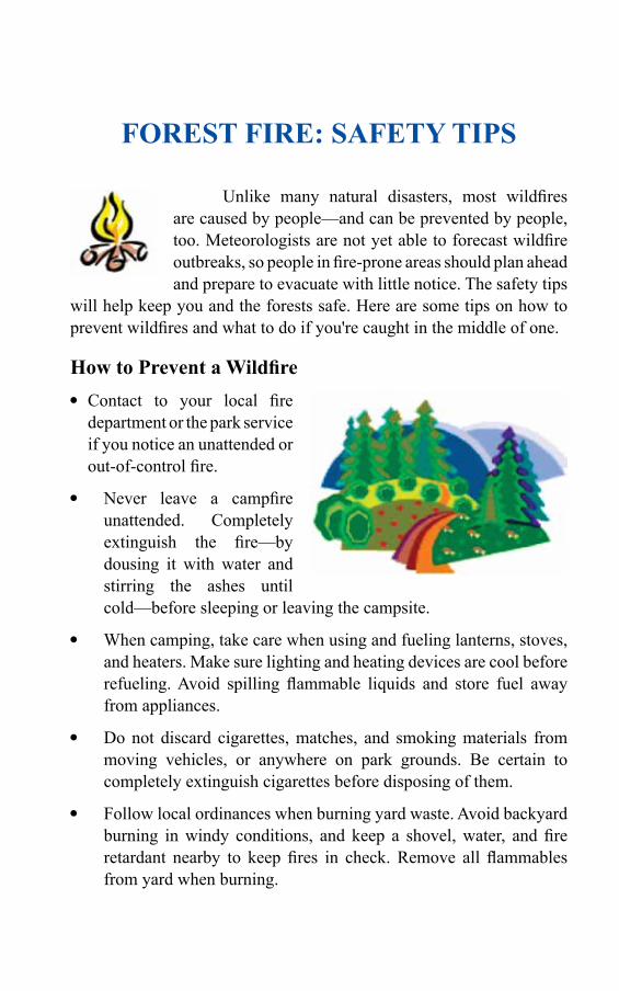
FOREST FIRE: SAFETY TIPS
Unlike many natural disasters, most wildfires are caused by people—and can be prevented by people, too. Meteorologists are not yet able to forecast wildfire outbreaks, so people in fire-prone areas should plan ahead and prepare to evacuate with little notice. The safety tips
will help keep you and the forests safe. Here are some tips on how to prevent wildfires and what to do if you're caught in the middle of one.
HowtoPreventaWildfire Contact to your local fire
department or the park service if you notice an unattended or out-of-control fire.
Never leave a campfire unattended. Completely extinguish the fire—by dousing it with water and stirring the ashes until cold—before sleeping or leaving the campsite.
When camping, take care when using and fueling lanterns, stoves, and heaters. Make sure lighting and heating devices are cool before refueling. Avoid spilling flammable liquids and store fuel away from appliances.
Do not discard cigarettes, matches, and smoking materials from moving vehicles, or anywhere on park grounds. Be certain to completely extinguish cigarettes before disposing of them.
Follow local ordinances when burning yard waste. Avoid backyard burning in windy conditions, and keep a shovel, water, and fire retardant nearby to keep fires in check. Remove all flammables from yard when burning.

200
Forest Fire Disaster ManageMent
Evacuation Tips If advised to evacuate, do so immediately.
Know your evacuation route ahead of time and prepare an evacuation checklist and emergency supplies.
Wear protective clothing and footwear to protect yourself from flying sparks and ashes.
Before You Leave, Prepare Your House Remove combustibles, including firewood, yard waste, barbecue
grills, and fuel cans, from your yard.
Close all windows, vents, and doors to prevent a draft.
Shut off natural gas, propane, or fuel oil supplies.
Fill any large vessels—pools, hot tubs, garbage cans, or tubs—with water to slow or discourage fire.
IfCaughtinaWildfire Don't try to outrun the blaze. Instead, look for a body of water such
as a pond or river to crouch in.
If there is no water nearby, find a depressed, cleared area with little vegetation, lie low to the ground, and cover your body with wet clothing, a blanket, or soil. Stay low and covered until the fire passes.
Protect your lungs by breathing air closest to the ground, through a moist cloth, if possible, to avoid inhaling smoke.
Fire Safety Tips for Kids
Waysyoucanpreventwildfires
There are many ways that you can help to prevent wildfires.
201
NEVERleaveacampfireunattended. Don’t start a fire outdoors unless conditions will allow the fire to
burn safely from when it is started until it is put out.
Always have adult supervision when you are around a fire.
Build a campfire on rocks or sand.
Don’t put rocks around a campfire. When you go to put it out, the rocks can hide small pieces of wood that are still burning.
Keep your campfire small and under control.
Don’t build campfires underneath trees.
Always leave a bucket of water and a shovel near a campfire.
Make sure your fire is out before you leave it.
Have an adult put out the campfire completely.
Hereisthecorrectwaytoputoutacampfire(haveanadultdothis)
1. Pour lots of water on the campfire
2. Stir the ashes with a stick
3. Pour more water over top of it
Repeat these three steps until…
1. The ashes don’t hiss anymore
2. Everything looks wet
3. No more smoke comes from the ashes
Have an adult hold their hand over the ashes to see if they are still warm. If they are, stir and pour more water on them until they are cold.
NEVER play with matches or fireworks. Put out smoking materials thoroughly.
Forest Fire: saFety tips
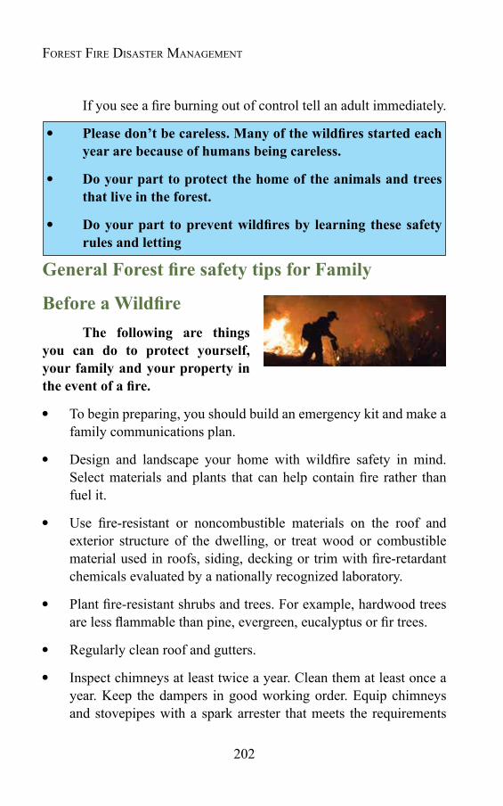
202
Forest Fire Disaster ManageMent
If you see a fire burning out of control tell an adult immediately.
Pleasedon’tbecareless.Manyofthewildfiresstartedeachyear are because of humans being careless.
Do your part to protect the home of the animals and trees that live in the forest.
Doyourpart topreventwildfiresby learning these safetyrules and letting
GeneralForestfiresafetytipsforFamily
BeforeaWildfireThe following are things
you can do to protect yourself, your family and your property in theeventofafire.
To begin preparing, you should build an emergency kit and make a family communications plan.
Design and landscape your home with wildfire safety in mind. Select materials and plants that can help contain fire rather than fuel it.
Use fire-resistant or noncombustible materials on the roof and exterior structure of the dwelling, or treat wood or combustible material used in roofs, siding, decking or trim with fire-retardant chemicals evaluated by a nationally recognized laboratory.
Plant fire-resistant shrubs and trees. For example, hardwood trees are less flammable than pine, evergreen, eucalyptus or fir trees.
Regularly clean roof and gutters.
Inspect chimneys at least twice a year. Clean them at least once a year. Keep the dampers in good working order. Equip chimneys and stovepipes with a spark arrester that meets the requirements
203
of National Fire Protection Standard. (Contact your local fire department for exact specifications.)
Use 1/8-inch mesh screen beneath porches, decks, floor areas, and the home itself. Also, screen openings to floors, roof and attic.
Install a dual-sensor smoke alarm on each level of your home, especially near bedrooms; test monthly and change the batteries at least once each year.
Teach each family member how to use a fire extinguisher (ABC type) and show them where it's kept.
Keep handy household items that can be used as fire tools: a rake, axe, handsaw or chain saw, bucket and shovel.
Keep a ladder that will reach the roof.
Consider installing protective shutters or heavy fire-resistant drapes.
Clear items that will burn from around the house, including wood piles, lawn furniture, barbecue grills, tarp coverings, etc. Move them outside of your defensible space.
Plan Your Water Needs Identify and maintain an adequate
outside water source such as a small pond, cistern, well, swimming pool, or hydrant.
Have a garden hose that is long enough to reach any area of the home and other structures on the property.
Install freeze-proof exterior water outlets on at least two sides of the home and near other structures on the property. Install additional outlets at least 50 feet from the home.
Forest Fire: saFety tips
204
Forest Fire Disaster ManageMent
Consider obtaining a portable gasoline powered pump in case electrical power is cut off.
AfteraWildfireThe following are guidelines for different circumstances in the
period following a fire:
Go to a designated public shelter if you have been told to evacuate or you feel it is unsafe to remain in your home.
If you are with burn victims, or are a burn victim yourself, seek help immediately; cool and cover burns to reduce chance of further injury or infection.
If you remained at home, check the roof immediately after the fire danger has passed. Put out any roof fires, sparks or embers. Check the attic for hidden burning sparks.
For several hours after the fire, maintain a "fire watch." Re-check for smoke and sparks throughout the house.
If you have evacuated, do not enter your home until fire officials say it is safe.
If a building inspector has placed a color-coded sign on the home, do not enter it until you get more information, advice and instructions about what the sign means and whether it is safe to enter your home.
If you must leave your home because a building inspector says the building is unsafe, ask someone you trust to watch the property during your absence.
Use caution when entering burned areas as hazards may still exist, including hot spots, which can flare up without warning.
If you detect heat or smoke when entering a damaged building, evacuate immediately.
205
If you have a safe or strong box, do not try to open it. It can hold intense heat for several hours. If the door is opened before the box has cooled, the contents could burst into flames.
Avoid damaged or fallen power lines, poles and downed wires.
Watch for ash pits and mark them for safety and warn family and neighbors to keep clear of the pits also.
Watch animals closely and keep them under your direct control. Hidden embers and hot spots could burn your pets’ paws or hooves.
Follow public health guidance on safe cleanup of fire ash and safe use of masks.
Wet debris down to minimize breathing dust particles.
Wear leather gloves and heavy soled shoes to protect hands and feet.
Cleaning products, paint, batteries and damaged fuel containers need to be disposed of properly to avoid risk.
Discard any food that has been exposed to heat, smoke or soot.
Do NOT use water that you think may be contaminated to wash dishes, brush teeth, prepare food, wash hands, make ice or make baby formula.
Remain calm. Pace yourself. You may find yourself in the position of taking charge of other people. Listen carefully to what people are telling you, and deal patiently with urgent situations first.
DuringaWildfireIf advised to evacuate, do so immediately. Take your disaster
supply kit, lock your home and choose a route away from the fire hazard. Watch for changes in the speed and direction of the fire and smoke. Tell someone when you left and where you are going.
If you see a wildfire and haven't received evacuation orders yet,
Forest Fire: saFety tips
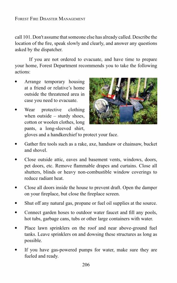
206
Forest Fire Disaster ManageMent
call 101. Don't assume that someone else has already called. Describe the location of the fire, speak slowly and clearly, and answer any questions asked by the dispatcher.
If you are not ordered to evacuate, and have time to prepare your home, Forest Department recommends you to take the following actions:
Arrange temporary housing at a friend or relative’s home outside the threatened area in case you need to evacuate.
Wear protective clothing when outside – sturdy shoes, cotton or woolen clothes, long pants, a long-sleeved shirt, gloves and a handkerchief to protect your face.
Gather fire tools such as a rake, axe, handsaw or chainsaw, bucket and shovel.
Close outside attic, eaves and basement vents, windows, doors, pet doors, etc. Remove flammable drapes and curtains. Close all shutters, blinds or heavy non-combustible window coverings to reduce radiant heat.
Close all doors inside the house to prevent draft. Open the damper on your fireplace, but close the fireplace screen.
Shut off any natural gas, propane or fuel oil supplies at the source.
Connect garden hoses to outdoor water faucet and fill any pools, hot tubs, garbage cans, tubs or other large containers with water.
Place lawn sprinklers on the roof and near above-ground fuel tanks. Leave sprinklers on and dowsing these structures as long as possible.
If you have gas-powered pumps for water, make sure they are fueled and ready.
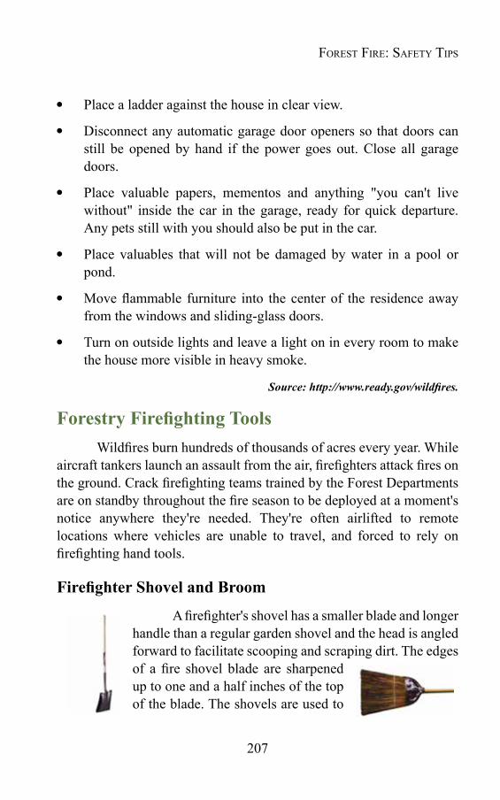
207
Place a ladder against the house in clear view.
Disconnect any automatic garage door openers so that doors can still be opened by hand if the power goes out. Close all garage doors.
Place valuable papers, mementos and anything "you can't live without" inside the car in the garage, ready for quick departure. Any pets still with you should also be put in the car.
Place valuables that will not be damaged by water in a pool or pond.
Move flammable furniture into the center of the residence away from the windows and sliding-glass doors.
Turn on outside lights and leave a light on in every room to make the house more visible in heavy smoke.
Source: http://www.ready.gov/wildfires.
ForestryFirefightingToolsWildfires burn hundreds of thousands of acres every year. While
aircraft tankers launch an assault from the air, firefighters attack fires on the ground. Crack firefighting teams trained by the Forest Departments are on standby throughout the fire season to be deployed at a moment's notice anywhere they're needed. They're often airlifted to remote locations where vehicles are unable to travel, and forced to rely on firefighting hand tools.
FirefighterShovelandBroom
A firefighter's shovel has a smaller blade and longer handle than a regular garden shovel and the head is angled forward to facilitate scooping and scraping dirt. The edges of a fire shovel blade are sharpened up to one and a half inches of the top of the blade. The shovels are used to
Forest Fire: saFety tips
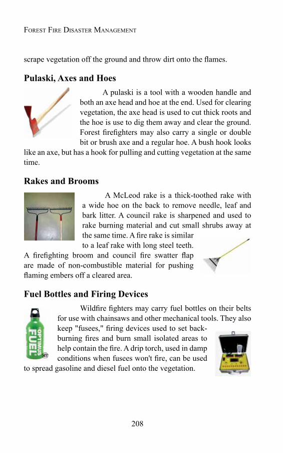
208
Forest Fire Disaster ManageMent
scrape vegetation off the ground and throw dirt onto the flames.
Pulaski, Axes and HoesA pulaski is a tool with a wooden handle and
both an axe head and hoe at the end. Used for clearing vegetation, the axe head is used to cut thick roots and the hoe is use to dig them away and clear the ground. Forest firefighters may also carry a single or double bit or brush axe and a regular hoe. A bush hook looks
like an axe, but has a hook for pulling and cutting vegetation at the same time.
Rakes and BroomsA McLeod rake is a thick-toothed rake with
a wide hoe on the back to remove needle, leaf and bark litter. A council rake is sharpened and used to rake burning material and cut small shrubs away at the same time. A fire rake is similar to a leaf rake with long steel teeth.
A firefighting broom and council fire swatter flap are made of non-combustible material for pushing flaming embers off a cleared area.
Fuel Bottles and Firing DevicesWildfire fighters may carry fuel bottles on their belts
for use with chainsaws and other mechanical tools. They also keep "fusees," firing devices used to set back-burning fires and burn small isolated areas to help contain the fire. A drip torch, used in damp conditions when fusees won't fire, can be used
to spread gasoline and diesel fuel onto the vegetation.
ANNOTATED BIBLIOGRAPHY
Articles, Papers & Reports Wink, R.L., and H.A.Wright. 1973. Effects of fire on an
Ashe juniper community. Journal of RangeManagement.26(5):326-329.
In an Ashe juniper community, a minimum of 1000 kg/ha of fine fuel was needed to carry a fire to kill juniper seedlings and burn piles of dozed juniper. Grasses recovered quickly and soil erosion was minimal when burned during a wet winter and spring. During a dry winter and spring, however, burning increased drought stress on plants, reduced herbaceous yields, and exposed soil to wind and water erosion for a long period of time when soil moisture was low.
Mutch, R.W., 1976. Fire management and land use planning today: tradition and change in the Forest Service. Western Wildlands3(1):13-19.
The author discusses the necessity of changing from fire control to fire management, in which fire management is integrated with fire ecology principles and land-use planning requirements. The author presents traditional approaches and current trends by using a survey of fire management personnel, which shows that managers are interested in natural fire management, while also aiming to improve suppression ability. The author points out that wildland fire should be regarded as an ecological process as well as a management tool. The author also argues that successful fire management may be achieved by informing the public, applying research results, and increasing understanding of the role of both fire prevention and prescribed burning in total fire management.
Stankey, G.H. 1976. Wilderness Fire Policy: An Investigation of Visitor Knowledge and Beliefs, Research Paper INT-180, USDA Forest Service, Intermountain Forest and Range

210
Forest Fire Disaster ManageMent
Experiment Station, Ogden, UT.
The author conducted a research survey of visitors to the Selway-Bitterroot Wilderness in Idaho and Montana to investigate knowledge and beliefs about wilderness fire policies. The survey indicates that while the majority favored fire suppression, a substantial minority (34%) supported the more natural role of fire. The results also demonstrate that most respondents had a fairly low degree of understanding regarding the role of fire in forests, but as their level of knowledge increased, so did the likelihood that they would support the more natural role of fire. Several management actions are recommended that would enhance public support for a modification of wilderness fire suppression policies.
Lee,R.G.1977. Institutionalchangeandfiremanagement,in Proceedings of the Symposium on the Environmental Consequences of Fire and Fuel Management in Mediterranean Ecosystems, Palo Alto, CA, August 1-5, 1977, HA Mooney and CE Conrad, ed. General Technical Services Report, WO; 3, USDA Forest Service, Washington, DC.
The author examines the development of wildfire control by social organization. The author describes three types of institutions: local volunteers, fire control bureaucracies, and possible new organizations that integrate fire, fuel, and land management.
Lee, RG, and TM Bonnicksen. 1978. Brushland Watershed Fire Management Policy in Southern California: Biosocial Consideration. Water Resources Center, University of California, Davis.
The authors present a biosocial system model that can be useful for analysis on brush-land fire management policy. The author addresses two advantages of this model. First, the biosocial system model enhances examination of fire management policy from various disciplines. The authors argue that environmental policy should be tested within different perspectives. The biosocial system model provides systematic models for understanding various environmental issues. Second, the
211
model permits managers and researchers to anticipate how a fire control agency will adjust to possible changes in its social environment. This model also makes it possible to anticipate organizational responses to major changes in the biophysical environment. The author describes the actual application of this model to San Diego County's brushland fire management.
Lee, R.G. 1979. Organizational Adaptation and Wildfire Control, Association Paper 027 Rural Sociological Society (RSS),
The author examines organized efforts to control wildfire in the United States by using methods for studying social history. Records and documents reveal that fire-control practices developed and changed in response to institutionalized actions in the larger society. The author points out that informal community organization had institutionalized control over fire by using it as a tool for clearing land and protecting valued resources and improvements before government assumed jurisdiction over wildfires. The nationalization of forest-management policy that accompanied the Progressive Era led to the formation of formal social organizations that institutionalized the exclusion of fire from the forest environment. This commitment to fire exclusion persisted de-spite scientific evidence and experience showing that fire was beneficial as well as destructive to valued resources. Organizations periodically re-legitimized their commitment to fire exclusion by reenacting traditional heroic myths of control over fire, which was symbolized as a demonic power. Rationalization of the institutional environment associated with the emergence of an advanced-industrial society caused fire control organizations to reconstitute legitimacy through adopting new practices and enacting myths of rationality that empower professional agents to pursue multipurpose fire management. Results from this analysis support the theory that organizations adapt to changing environmental conditions by ceremonially enacting practices institutionalized in their social environment.
Wright, H.A., and A.W. Bailey. 1982. Fire Ecology: United
AnnotAted BiBliogrAphys
212
Forest Fire Disaster ManageMent
States and Southern Canada. John Wiley and Sons, New York. 501p.
Wright and Bailey present a historical perspective on the role of fire in the major ecosystems of the United States and southern Canada. They describe the impact of fire on plant species, particularly native plant communities, with detailed discussion from an ecological perspective. The book highlights the potential role that fire can play in managing ecosystems for both plants and animals.
Donoghue, L.R. 1983. The American Legal System and its Relations to the USDA Forest Service and Human-Caused Wildfires. MS thesis, Michigan State University, East Lan-sing.
The author points out that information and education programs have helped reduce the occurrence of human-caused wildfires, but that agencies should also offer law enforcement education programs, which could significantly reduce fire ignitions. The author argues that whether law enforcement is beneficial depends in part on what managers know about the legal system and how they use it to prevent human-caused wildfires. The author examines the American legal system, defining and describing its major components and interactions. The study results illustrate several findings: (1) increasing a state's legal efforts against wildfire violations decreases that state's wildfires; (2) law enforcement efforts differ significantly in the North and South; (3) legal efforts have a greater impact on incendiary and debris-burning fires than on other fire causes; (4) compared to the South, legal efforts in the North have a greater impact on combined incendiary and debris-burning fires; and (5) law enforcement in both regions affects the occurrence of incendiary fires more than it affects debris-burning fires.
Cortner, H.J., M.J. Zwolinski, E.H. Carpenter, and J.G. Taylor. 1984. Public support for firemanagement policies.Journal of Forestry82(6):359—361.
The authors conducted a telephone survey to investigate the
213
public's perception and acceptance of prescribed fire policy in the Tucson, AZ, metropolitan area. The survey showed that the public recognized that forest fires could be beneficial as well as harmful. Public acceptance and understanding of the purposes and benefits of fire management were high. The authors suggest that the public was generally well-informed, and that entirely new approaches to fire education were not necessary, although modifications (pertaining to local knowledge and conditions) are recommended. Finally, the authors recommend that public education focus on local forest conditions as well as on local knowledge and acceptance of fire management.
Taylor,J.G.,andT.C.Daniel.1984.Prescribedfire:publiceducation and perception. Journal of Forestry 82(6): 361-365.
The authors conducted a survey to investigate the public's acceptability of prescribed burning. The survey respondents were residents in Tucson, Arizona, who rated slides of forest scenes. The respondents also read brochures about fire effects and took a post test that measured both knowledge and attitudes about fire. The survey results showed that ratings of scenic quality were improved by light fires, but were diminished by severe burns. Acceptability ratings for recreation depended on what type of activity people engaged in. For instance, campers expressed the greatest sensitivity to fire effects. The survey also showed that reading the brochures increased respondents' knowledge and tolerance of fire, but did not affect their ratings of scenic or recreational quality. Overall, the results indicated that the respondents support prescribed burning.
McCool, S.F., and G.H. Stankey, 1985. Visitor Attitudes Toward Wilderness Fire Management Policy: 1971-84. Research Report INT-357, USDA Forest Service, Intermountain Forest and Range Experiment Station, Ogden, UT.
The authors conducted a survey of visitors to the Selway-Bitterroot Wilderness, Montana, to investigate knowledge of fire effects and attitudes toward fire management in a wilderness setting. Visitors
AnnotAted BiBliogrAphys
214
Forest Fire Disaster ManageMent
were more knowledgeable about fire effects and were more supportive of fire management, rather than fire suppression, than were respondents to a similar study in 1971. The results also demonstrate that about 50% of the visitors felt that manager-ignited fires would be beneficial to wilderness, about 16% felt these fires would be detrimental, and about 33% were unsure.
McDowell, H. 1985. Fire management policies and programs: an industry view, pp. 53— 54 in Proceedings, Symposium and Workshop on Wilderness Fire, Missoula, MT, November 15-18, 1983, JM Lotam, BM Kilgore, WC Fischer, and RW Mutch, ed. General Technical Report INT-182, USDA Forest Service, Intermountain Forest and Range Experi-ment Station, Ogden, UT.
The author points out that the recreation industry may be most influenced by wilderness fire activities. This industry includes guides, packers, and outfitters. Current wilderness fire management programs and policies do not seriously affect forest industries, miners, and grazers. However, according to the author, many of these industries are also involved as wilderness users and will maintain their interest in their management on a personal basis.
Gardner,P.D.,H.J.Cortner,andJ.A.Bridges.1985.Wildfire:managing the hazard in urbanizing areas. Journal of Soil and Water Conservation40(4):318—321.
The authors argue that although a number of policy responses have been suggested to reduce the impacts of wild land fires on the physical environment and human activities, how acceptable they are to the general public is another question. This is because the wild land fire hazard depends not only on the physical environment, but on human interactions with the physical environment as well. The authors present five classes of mitigation: (1) reducing the intensity, frequency, or magnitude of the hazardous event by physically changing the environment; (2) limiting exposure to the hazard through local and state land-use regulations; (3) reducing the vulnerability of structures

215
and people; (4) increasing homeowners' awareness of the wild land fire through education; and (5) taking care of individuals who are negatively impacted by wild land fire. The authors suggest that the implementation of any policy option depends not only on the expertise of the natural resource manager or local planner, but also on the public's receptivity.
Gardner, P.D., HJ Cortner, K.F. Widaman, and K.J. Stenberg, 1985. Forest-user attitudes toward alternative firemanagementpolicies.Environmental Management 9(4):303—311.
The authors point out that the formulation and implementation of new fire policies in the national forests depend upon public acceptance. A national survey of organized groups of forest users indicates that, contrary to the concern of many forest managers, considerable support exists for flexible fire suppression policies. Forest users are also willing to accept the risk associated with the manager's use of prescribed fire. However, survey results demonstrate intergroup differences on the acceptability of prescribed fire management. The authors discuss this variation in relation to a number of socioeconomic variables, general fire knowledge, specific knowledge about the effects of low-intensity fires, and risk preference levels.
Saveland,J.M.1985.Risk infiremanagement,pp.85—97in Fire Management: The Challenge of Protection and Use, Proceedings of a Symposium, Logan, UT, April 17-19, 1985, JN Long, ed. Department of Forest Resources, Utah State University, Logan.
The author points out that the amount of wildfire protection and prescribed fire use is determined by an individual decision maker's propensity for accepting risk. Risk assessment consists of risk identification, risk estimation, and risk evaluation. The major risk that concerns fire management is identified as the threat of catastrophic fire. The author indicates that estimation of risk consists of determining the probability of occurrence and the magnitude of various events. According to the author, decision theory and utility theory are useful
AnnotAted BiBliogrAphys
216
Forest Fire Disaster ManageMent
tools for risk estimation. Risk averse, risk neutral, and risk taker profiles are shown by using a utility function. Cost effectiveness and cost-benefit models are presented as means to evaluate how much risk reduction, if any, is necessary. The author presents the cost effectiveness model to show the tradeoff between the costs of risk reduction and the amount of risk reduced. A decrease in funding implies an increase in risk. The author concludes that a combination of prescribed fire use and wildfire protection will achieve a cost-effective level of risk and associated benefits that are optimum.
Taylor, J.G., and T.C. Daniel. 1985. Perceived scenic and recreational quality of forest burn areas, pp. 398^06 inProceedings, Symposium and Workshop on Wilderness Fire, Missoula, M..T, November 15-18, 1883, J.M. Lotan, B.M. Kilgore, W.C. Fischer, and R.W. Mutch, ed. Research Paper INT-182, US DA Forest Service, Intermountain Forest and Range Experiment Station, Ogden, UT.
The authors conducted a study to compare (1) public perception of scenic quality after both severe and light fires and (2) effects of both types of fires on perceptions of recreational acceptability. The study also aimed to construct and test documents for educating and informing the public about effects of fire, and to test the effects of fire information levels on attitudes toward fire. The results showed that the public's perception of recreational acceptability was more adversely affected by severe fire than by light fire. However, the study also demonstrates that perceptions of the effect of fire vary, depending upon types of recreation activities. Overall, the public supports prescribed burning. The authors point out that prescribed fires (light) should enhance perceived scenic quality for three or more years, but they may have some adverse effects on camping. Severe forest fires should be expected to cause significant deterioration in scenic quality and recreational acceptability for a prolonged time; camping and picnicking are essentially precluded in burned areas.
Carpenter, E.H., J.G. Taylor, H.J. Cortner, P.D. Gardner,
217
M.J. Zwolinski, andT.C. Daniel., 1986. Target audiences andcontentforforestfireinformationprograms.Journal of Environmental Education17(3):33-42.
The authors present data from three independent surveys on the public attitude toward prescribed burning policy. The survey results indicate a high level of support for fire management practices initiated and controlled by the manager. The results also show that the public can differentiate between situations that result in beneficial effects and those that have harmful effects, suggesting a sophisticated understanding of fire management. Additional analysis reveals the extent to which socio-demographic characteristics and beliefs about the effects of fire in forest environments can predict public approval. The authors suggest that the content of fire information programs should be directed toward a broad, cross-section of adults, and should directly address factors such as fire size, intensity, and impact upon animals, which can cause emotional concern. The authors also recommend that fire information programs clearly describe situations where fire should be suppressed, as well as where fire can be used to achieve beneficial management objectives; public acceptance of fires increases as more information is given and as control is specified. Finally, the authors suggest that fire information programs include discussions on the beneficial effects that can be realized from wildfires and from prescribed burning, and on the responsibilities, as well as risks, of prescribed fire.
Chambers, J.W. 1987. The evolution of wild land firemanagement and policy. Fire Management Notes48(2):5-8.
The author describes the evolution of wild land fire management and its policy in the United States. The first fire policy was generated because of the "cut and run" timber harvest practices on private lands in the Lake States during the late 1800s and early 1900s. The policy was control oriented and was carried out by the U.S. Army. The "10 a.m. policy" was dominant from the 1930s to the early 1970s. World War II led to the age of mechanization in fire control, as the development and surplus of war equipment provided suitable equipment. The age
AnnotAted BiBliogrAphys
218
Forest Fire Disaster ManageMent
of specialization began in the 1970s. The FIRESCOPE program was initiated in 1970 as a result of wild land-urban interface fire suppression. Expenditures for fire suppression skyrocketed in the mid 1970s. The passage of the Forest and Rangeland Renewable Resource Planning Act of 1974 changed fire policy in the U.S. The Act demands that both the use of prescribed fire and the control of wildfire be integral parts of the Forest Service land management planning process. The National Wildfire Coordination group was established in 1976.
Gardner, P.D., H.J. Cortner, and K. Widaman. 1987. The riskperceptionsandpolicyresponse towardwild landfirehazards by urban home-owners. Landscape and Urban Planning 14: 163-172.
The authors point out that expanding urban areas have brought an increasing number of people into the wild land-urban interface, creating a fire hazard. Public officials in southern California, for example, have suggested programs for protecting urban residents. However, the programs have not gained attention from residents in the wild land-urban interface. The authors investigate why the urban public has not been receptive to adopting these programs. Their results indicate that urban residents have a low initial awareness of fire severity, assign low probabilities to occurrences, and prefer policy strategies that shift the hazard management responsibility to public resource managers.
Lee, R.G., 1987. Community fragmentation: implications for futurewildfiremanagement, inProceedings of Symposium on Wild land Fire 2000, South Lake Tahoe, CA, April 27-30, 1987, JB Davis and RE Martin, ed. General Technical Report PSW-101, USDA Forest Service, Pacific Southwest Forestand Range Experiment Station, Berkeley, CA.
The author points out that modern fire management is an alternative to conventional fire management, which assumes that all fires must be put out. The author argues that modern fire management conflicts with conventional fire control because the two are based upon different assumptions: "all fire is bad" versus "fire is an integral

219
component of natural ecosystems."
Stine, S.E. 1987. User attitudes toward fire policy inwilderness areas. Fire Management Notes(2):16-17.
The author conducted a survey to investigate wilderness visitors' perception about prescribed fire. The results demonstrate that wilderness users support prescribed fire if fires are ignited by natural causes rather than through an agency's intervention. The results also show that wilderness users support putting out fires that were caused by humans. The wilderness users also support prescribed burning in seldom-used areas. Based upon the survey, it appears that user perceptions may conflict with current fire management policies and purposes. The author suggests that further educational programs about prescribed burning are needed.
Apsey, M.T. 1988. Fire management in the media age, in Fire Management in a Climate of Change: Proceedings from 1988 Northwest Fire Council Annual Meeting, Dunsmuir Lodge, Victoria, BC, November 14-15, 1988, BD Lawson, BC Hawkes, and GN Dalrymple, ed. Northwest Fire Council, Victoria, BC.
The author points out that fire management today not only requires technological improvement, but also entails communication with the media. That is because wildfire is often televised as a dramatic event, attracting the public's criticism. The public's perception of the way firefighters deal with wildfire may be modified by the way in which the media televise it. Therefore, establishing regular contact with the media may help to eliminate unnecessary misconceptions and misunderstandings of fire management. The author insists that it is no longer enough to simply do the job well. In many cases, public confidence in the fire management profession depends on public understanding of what the job is all about.
Mills, T.J., and F.W. Bratten, 1988. Economic Efficiency and Risk Character of Fire management Programs, Northern
AnnotAted BiBliogrAphys

220
Forest Fire Disaster ManageMent
Rocky Mountains, Research Paper PSW-192, USDA Forest Service, Pacific Southwest Forest and Range ExperimentStation, Berkeley, CA.
The authors used the Fire Economics Evaluation System (FEES) to test three hypotheses about fire system performance on selected public lands in the northern Rocky Mountains. The hypotheses were as follows: (1) Economic efficiency is affected by the size of the fire management budget and the mix or emphasis of the fire management inputs purchased with the budget; (2) risk in the fire management system decreases with increasing fire management funding; and (3) the most efficient funding for a risk-averse manager is higher than for a risk-neutral manager. The study results indicate that efficiency is strongly affected by the program level, but the effect of the fire management mix or emphasis on efficiency was relatively minor. The most economically efficient initial attack program level was the lowest of those tested, 75% below the base level funding for the study period. The decrease in risk with increase in funding was relatively minor. Furthermore, the conclusions of the study were not affected by realistic changes in two major model inputs: fire prevention and large-fire suppression effectiveness, and resource management objectives.
Sommers, W.T. 1988. Fire management in the wildland/urbaninterface—achallengeforresearchandmanagement,in Protecting People and Homes from Wildfire in the Interior West: Proceedings of the Symposium and Workshop, Missoula, MT, October 6—8, 1987. General Technical Report INT-251, USDA Forest Service, Intermountain Research Station, Ogden, UT.
The author points out that although fire management issues in the wildland-urban interface have received increased attention, there is little information on the magnitude or significance of the problem. The author stresses that managers and researchers should define, describe, and quantify the wildland-urban interface from a fire management perspective. The behavioral sciences represent the area most critically
221
deficient in knowledge about wildland-urban interface fire problems. Fire managers need to know how to work effectively with local governing bodies in implementing fire safety and risk-reduction programs. Finally, incentives that influence the residents' behavior must be understood.
Turpin, J.C. 1988. Changes in public attitudes to prescribed fire,pp.49-52inFire Management in a Climate of Change: Proceedings from 1988 Northwest Fire Council AnnualMeeting, Dunamuir Lodge, Victoria, BC, November 14—15, 1988, BD Lawson, BC Hawkes, and GN Dalrymple, ed. Northwest Fire Council, Victoria, BC.
The author (a representative of the Washington Environmental Council) presents several concerns about prescribed burning. The author points out that agencies should not ignore or dismiss concerns expressed by environmental organizations and citizens, otherwise suspicions and negative perceptions about prescribed burning may be amplified. The author recommends that agencies keep communication lines open and provide credible information from independent sources. According to the author, these efforts can influence opinion leaders, both from the general public and within environmental organizations.
Wittaker,D.,1988.Publicperceptionoffiremanagement,pp30-31 in Fire Management in a Climate of Change: Proceedings from 1988 Northwest Fire Council Annual Meeting, Dunsmuir Lodge, Victoria BC, November 14—15, 1988,7BD Lawson, BC Hawkes, and GN Dalrymple, ed. Northwest Fire Council, Victoria, BC.
The author (who is the mayor of Penticion, BC) argues that a law allowing municipal government to regulate zoning is imperative for fire prevention. The author also points out that the development of forest lands must be carefully considered by the Ministry of Forests, municipal government, and the public.
Agee,J.K.1989.WildfireinthePacificWest:Abriefhistoryand implications for the future, in Proceedings of the
AnnotAted BiBliogrAphys
222
Forest Fire Disaster ManageMent
Symposium on Fire andWatershed Management, Sacramento, CA, October 26-28, 1988, NH Berg, ed. General Technical Report PSW-109, USDAForest Service, Pacific SouthwestForest and Range Experiment Station, Berkeley, CA.
The author points out that wildfire is a natural component of forested land. Its frequency, severity, and effects vary depending on the specific environment, type of fire, and adaptation of the forest biota to fire. The author argues that the socio-political environment in which these forests exist has had a much more significant impact on public and private policy towards fire than has the physical-biological environment. Although ecological criteria are important in technical planning, they will be overshadowed by socio-political criteria in problem definition and solutions for the future.
Wakimoto,R.H.,1989.Nationalfiremanagementpolicy:Alook at the need for change. Western Wildlands15(2):35-39.
The fire management policy review team was established in order to review the fire policy for the Yellowstone fire in 1988. The review team conducted several hearings to get input from the public in the vicinity of Yellowstone National Park. Seven issues were raised through the sessions: (1) The objectives of prescribed natural fire programs in national parks and wilderness are sound, but the policies need to be refined, strengthened, and reaffirmed. These policies permit fires to burn under predetermined conditions. (2) Many current fire management plans do not meet current policies; the prescriptions in them are inadequate, and decision making needs to be tightened. (3) There are risks inherent in trying to manage fire, but they can be reduced by careful planning and preparation. Planned burning and other efforts to reduce fuel hazards near high-value structures, along with the creation of fuel breaks along boundaries, can help reduce risks from both prescribed natural fires and wildfire. (4) The ecological effects of prescribed natural fire support resource objectives, but the social and economic effects may be unacceptable in some cases. Prescribed natural fires may affect uses of parks and wilderness, and may impact outside
223
areas through smoke and stream sedimentation. (5) Dissemination of information before and during prescribed natural fires must be improved. There should be more public participation in the development of fire management plans. (6) Internal management processes, such as training more personnel, developing uniform terminology, and utilizing similar budget structures, would significantly improve fire management. (7) Claims were heard that some managers support naturalness above all else, allowing fires to burn outside of prescription requirements without taking appropriate action to suppress them.
Cortner, H.J., P.D. Gardner, and J.G. Taylor. 1990. Fire hazards at the urban-wildland interface: what the public expects. Environmental Management.14(1):57-62.
The authors point out that wildland-urban interface issues have become problematic for forest managers. The authors conducted surveys on how public knowledge and perceptions of fire policies and fire hazards change over time, what kind of policy responses homeowners prefer as a way of preventing fire hazards at the urban-wildland interface, and how citizens view their own obligations as participants in interface issues. The authors present data from the surveys and discuss some findings and implications of their results. The data show that public attitudes toward fire have changed significantly over the past two decades, and that educating the public about fire and managers' use of fire can have positive effects on behavior. Yet, when attempting to modify individuals' be¬havior concerning interface fire risks, managers must also consider important issues of incentives, distribution of costs, and unanticipated policy impacts.
Daniel, T.C. 1990. Social/political obstacles and opportunities inprescribedfiremanage-ment,inProceedings: Effects of Fire Management of Southwestern Natural Resources, Tucson, AZ, November 15-17, 1988, JS Krammes, ed. General Technical Report RM-191, USDA Forest Service, Rocky Mountain Forest and Range Experiment Station, Fort Collins, CO.
The author describes several obstacles to implementing
AnnotAted BiBliogrAphys

224
Forest Fire Disaster ManageMent
prescribed fire management. The obstacles include misunderstanding of fire in forest ecosystems; concern about risks to life and property; and overestimation of adverse effects on scenic impact and recreational safety. The author points out that the above concerns might stem from several factors: (1) some resource management policies and practices are not sufficiently sensitive to the value that the public places on nature; (2) the public is not always well informed about the natural processes that they want protected; (3) management of the forest tends to be viewed as in direct conflict with the desire to be near nature and to live in a pristine environment; and (4) earlier fire prevention campaigns were very successful, in part because they were very simple—forest fires are bad and should be prevented. The author suggests that environmental education would be helpful if public accep-tance of prescribed burning stems from the lack of adequate understanding of the role of fire in forest ecosystems.
Manfredo, M.J., M. Fishbein, G.E. Haas, and A.E. Watson. 1990.Attitudes toward prescribed fire policies. Journal of Forestry88(7):19—23.
The authors argue that although biological information may provide support for prescribed fire policy that alone is not sufficient justification for its implementation. Fire policy has societal and political components, and the fact that people appear poorly informed about the consequences of fire policy and the effects of fire adds controversy to the issue. Two telephone surveys were conducted to investigate attitudes towards the "let-burn" prescribed fire policy used during the Yellowstone fires of 1988. The results indicate slightly positive overall support for the prescribed burn policy, whereas the national sample was evenly divided. The authors discuss beliefs about outcomes of the prescribed fire policy and knowledge about wildfire in relation to attitudes (positive or negative) about the policy in the two survey groups. The results suggested no clear direction for managers and policy makers for meeting public preferences, but highlighted the difficulty of making decisions about prescribed fire policies that would be approved by a large majority of citizens.
225
Shelby, B, and R.W. Speaker. 1990. Public attitudes and perceptions about prescribed burning, pp. 253-260 in Natural and Prescribed Fire in Pacific Northwest Forests, JD Walstad, SR Radosevich, and DV Sandberg, ed. Oregon State University Press, Corvallis.
The authors point out that public perceptions of fire management mainly depend on public knowledge and understanding about fire. The authors argue that despite increasing support for fire management from the public, there are also often concerns about air quality and water pollution induced by fire management. The authors suggest that further implementation of prescribed burning will necessitate a consensus about the use and effects of fire, as well as a long-term effort to provide information to the public about fire management, and a willingness to adequately and scientifically address specific concerns.
Taylor, J.G. 1990. Playing with fire: effects of fire inmanagement of southwestern recreation resources, in Effects of Fire Management of Southwestern Natural Resources: Proceedings of the Symposium, Tucson, AZ, November 15-17, 1988, JS Krammes, ed. General Technical Report RM-191, US DA Forest Service, Rocky Mountain Forest and Range Experiment Station, Fort Collins, CO.
The author summarizes previous studies about fire management and public attitudes toward it. Growing acceptance and sophistication characterize the public's attitude toward current fire management. Prescribed burning is generally well accepted, but fires started by human carelessness or by lightning are not. As the nature and degree of control of fire are better understood, people tend to be more accepting of prescribed burning. It is important to note, however, that the public is not likely to accept lightning-caused fire. Understanding the beneficial effects of fire on forest ecosystems is important in accepting various types of fire. Knowing that lightning is the usual cause of forest fires in many western forest types also is significant in peoples' acceptance of a variety of fires, but this knowledge is not widespread. Knowing that
AnnotAted BiBliogrAphys

226
Forest Fire Disaster ManageMent
most fires in forest ecosystems are small and that most animals are able to escape from wildfires is important to the public's acceptance of fires that are not specifically designated, set, and controlled by managers. The author points out that four factors are essential for successful information and education programs about fire management for the public: (1) a long-term effort to inform the public about the natural role of fire in undisturbed ecosystems; (2) a strong consensus among managers and concerned people about the correct use and beneficial effects of prescribed fire; (3) public perception that the information is scientifically sound and does not stem from an interest group with a biased position; and (4) adequate treatment of specific public concerns related to the use of fire, including the risks of prescribed burning getting out of control, smoke, intrusion into populated areas and related effects on public health, potential health hazards of burning chemically treated sites, and aesthetic impacts.
McConnell, DWII, and S.B. Baldwin. 1991. Private, non-industrial forest owner's perceptions of controlled burning influencingforestmanagement,inFire and the Environment, Ecological and Cultural Perspectives: Proceedings of an International Symposium, Knoxville, TN, March 20-24, 1990, SC Nodvin, and TA Waldrop, ed. General Technical Report SE-69, USDA Forest Service, Southeastern Forest Experiment Station, Ashville, NC.
The authors point out that perceptions of controlled burning by private and non-industrial forest (PNIF) owners provide insight into forest management behavior of these owners. The authors conducted personal interview of randomly selected forest owners in the Wiregrass Region of Alabama in order to determine relationships between their perceptions, ownership objectives, and forest management activities. The interviews reveal that more than 66% of owners felt that controlled burning was a useful forest management practice on their land, although only 25% were currently using controlled burning. Both positive and negative perceptions of controlled burning are presented. The authors emphasize the relationship of these perceptions to owners' forest
227
management behavior and the subsequent importance of this information to professional foresters who work with owners.
Phillips,C.B.,andC.W.George.1991.Wildlandfireinthe1990s: problems, solutions, and priorities as seen by firemanagers. Fire Management Notes52(1):3—10.
The authors discuss problems associated with fire suppression. These problems are (1) inefficient communication among firefighters and agencies, (2) lack of standardization in training and equipping firefighters, (3) inefficient incident command systems, (4) lack of alternatives in tactics and strategies for fire suppression, (5) inadequate management for information and data flow, (6) barrier of laws and policies for cooperation among different agencies, (7) lack of new tools, techniques, and staffing standards, and (8) growing fire suppression in the wildland-urban interface. The authors suggest recommendations for solving each problem.
Rice, C.L., and J.B. Davis. 1991. Land-use planning may reducefiredamageintheurban-wildlandintermix.GeneralTechnicalReport PSW-127,USDAForest Service, PacificSouthwest Research Station, Berkeley, CA.
The authors conducted a study of fire damage after a wildfire, along with general plans, local planning regulations, and the real estate development process in three counties in California. Their studies support the idea that good fire-safe planning protects homes threatened by fire, and that loss occurs in the absence of good planning.
• Chambers,V.1992.Publicinvolvementinfiremanagement.Fire Management Notes53—54(2):8-9.
The author points out that fire management is now scrutinized by a well-educated and sophisticated public. The public often expresses concerns about the economic efficiency of fire suppression, air quality, and other environmental issues resulting from fire management; therefore, fire managers must shift from the public information end of the spectrum to true public involvement, where the public is engaged
AnnotAted BiBliogrAphys
228
Forest Fire Disaster ManageMent
in open dialogue on various issues. According to the author, trust may be established between managers and the public through public involvement, which will enhance public support for fire management policies.
Magill,Arthur.W. 1992-1993. People, firemanagersmusttalk with them. Fire Manage-ment Notes53-54(2):3-7.
The author points out those fire managers know that wildland-urban interface fire problems are "people problems" and they recognize that such problems are not all the same. Managers have repeatedly warned about the risk of building structures with flammable materials in landscapes with fire-prone vegetation. Yet, they are continually frustrated because residents do not heed these warnings. The author describes several factors that may prevent managers from achieving their fire management goals. First, people not only respond poorly to warnings, but tend to be oblivious to events that can disastrously influence their property and lives. Second, the building trade builds to satisfy people's desire to live in the wildland-urban interface. Third, community plans frequently do not address the wildland-urban interface fire issue. Finally, local govern-ments have been unwilling to enact ordinances that control construction. The author argues that these situations may be changed if fire managers overcome their reluctance to public involvement and become leaders in two-way communication with the people they wish to influence. These goals may be achieved if fire managers will seek training in social sciences that emphasizes interpersonal relations, multicultural relations, and com¬munication strategies.
Beebe, G.S., and P.N. Omi. 1993. Wildland burning: The perception of risk. Journal of Forestry 91(9):19-24.
The authors discuss the risks of natural and technological hazards, and how public perception of risk is shaped, in relation to the implications of wildfire in public lands and at the urban/wildland interface. The authors point out that fire managers have to simultaneously protect public safety and use fire as a tool of management. The authors indicate that the media plays a critical role in forming public perceptions of fire risks;
229
media reports are often distorted, resulting in public misconceptions about forest fire. The authors insist that public participation is a key to implementing the current fire management policy.
Hough, J.L. 1993.Whyburn thebush?Social approachesto bush-fire management inWestAfrican national parks.Biological Conservation65(1):23—28.
The author presents social research into local residents' perceptions of the effects of fire in northern Benin. The results indicate that local residents' perceptions correspond to scientific understanding. The author predicts that the establishment and protection of national parks will increase the incidence of human-caused bush-fires.
Bradley, J. 1995. Political considerations of park and wilderness management, in Proceedings, Symposium on Fire in Wilderness and Park Management, Missoula, Montana, March 30-April 1, 1993, JK Brown, RW Mutch, CW Spoon, and RH Wakimoto, ed. General Technical Report INT-320, USDA Forest Service, Intermountain Research Station, Ogden, UT.
The authors discuss the basis for subcommittee and congressional support of a natural fire policy and its implementation. The authors argue that the natural fire program is critical for quality land management. Natural fire is important because it is based on correct science, which must underlie land management policy, and because we cannot have true wilderness without natural fire.
Cook, S. 1995. Wildfire at the Wildland/Urban Interface: A Survey of Meso-Level Decision-makers and Their Support of Wildfire Hazard Mitigation Measures. MS thesis, Geography Department, University of Florida, Gainesville.
The natural hazard of wildfire at the wildland/urban interface is investigated. The author points out that lack of action on this hazard are derived from poor coordination and understanding among government officials at three levels—federal, state and county— who administer
AnnotAted BiBliogrAphys

230
Forest Fire Disaster ManageMent
the areas involved. Federal and state officials tend to be similar in background, hold similar beliefs, and exhibit similar behavior. County officials are more uniform than either of their peer groups in the same categories; however, the individuals working at the county level are very different from individuals at the other two levels of government. To investigate why counties with similar wildfire histories differ in their responses to the problem, the Kingdon "Garbage Can" model of decision making was applied to responses from individuals lin the involved counties. The author found that officials in counties that have not developed wildfire hazard mitigation plans are less likely to recognize a problem, less likely to recognize solutions, and less likely to have people available to work on the issue than are officials from counties that have developed wildfire hazard mitigation plans.
Murphy, E.M. 1995. Public involvement inwilderness fireplanning and decision making, in Proceedings, Symposium on Fire in Wilderness and Park Management, Missoula, Montana, March 30-April 1, 1993. JK Brown, RW Mutch, CW Spoon, and RH Wakimoto, ed. General Technical Report INT-320, USDA Forest Service, Intermountain Research Station, Ogden, UT.
The author points out that public involvement is crucial to the success of any prescribed natural fire program; however, according to the author, it is a job that few fire managers are comfortable doing. The author describes some of the attitudes that keep agencies from public involvement, such as the "it's not my job syndrome", "we know best belief", and "doing things right versus doing the right things". The author demonstrates some key approaches for developing a public involvement plan: (1) deciding the goals of public involvement, (2) identifying potentially affected interests, (3) considering available tools, and (4) implementing.
Pyne, S.J. 1995. World Fire: The Culture of Fire on Earth. Holt, New York.
The author illustrates how fire and humans have coevolved
231
throughout history. The author points out that the prevalence of humans is largely attributable to their control over fire, and that the distribution and characteristics of fire have become deeply dependent on humans. The author argues that humans and fire are inseparable, and that they have repeatedly played a critical role in shaping the landscape. The author also contends that there is less fire on earth today than in the time of Columbus, contrary to popular belief. The author argues that eliminating fire will not save the planet from destruction, but will only eradicate the regenerative powers it once implemented.
Schmoyer-Weber, J. 1995. Public information on actively burningprescribednaturalfires,inProceedings, Symposium on Fire in Wilderness and Park Management, Missoula, Mon¬tana, March 30-April 1, 1993, JK Brown, RW Mutch, CW Spoon, and RH Wakimoto, ed. General Technical Report INT-320, USDA Forest Service, Intermountain Research Station, Ogden, UT.
The author presents three phases of public information on prescribed burning. Conflicting emotions are stirred in wilderness users and neighbors when an agency monitors fire rather than suppressing it. The author emphasizes that members of the public who will be affected by a fire should be informed so they will know what is going on and what action they should take.
Smith, C. 1995. Fire issues and communication by the media, in Proceedings, Symposium on Fire in Wilderness and Park Management, Missoula, Montana, March 30—April 1, 1993, JK Brown, RW Mutch, CW Spoon, and RH Wakimoto, ed. General Technical Report INT-320, USDA Forest Service, Intermountain Research Station, Ogden, UT.
The author examines 320 stories about wildfire published since 1988. The author points out that journalists did not learn from the mistakes they made in reporting the Yellowstone fires. The conventions of journalism, which value drama over explanation, suggest that wildfire and other natural catastrophes will often be reported in apocalyptic
AnnotAted BiBliogrAphys

232
Forest Fire Disaster ManageMent
terms, rather than as the predictable outcomes of natural forces. Studies of how journalists reported five major stories suggest five factors that determine how wildfires are reported: (1) source enterprise, (2) cultural resonance, (3) issue salience, (4) newness, and (5) the degree to which the setting is rural or urban. Because of these criteria, news organizations sometimes do a poor job of providing the kinds of information needed by news consumers to reach intelligent conclusions about how public lands should be managed.
Stankey, G.H., and S.F. McCool. 1995. Evolving conceptions of wilderness: implications for management of fire, inProceedings, Symposium on Fire in Wilderness and Park Management, Missoula, Montana, March 30-April 1, 1993, JK Brown, RW Mutch, CW Spoon, and RH Wakimoto, ed. General Technical Report INT-320. USDA Forest Service, Intermountain Research Station, Ogden, UT.
The authors point out that we view wilderness as a sometimes ugly and dangerous place where natural processes dominate the landscape. Such an attitude toward wilderness influences methods of fire management because the appropriateness of fire management is determined by social definitions of the resource and how to protect it. The authors suggest that an interactive approach to decision making should be used, wherein fire managers work with the public to determine appropriate and effective management programs.
VetoJ.L.,1995.Avisionforthefutureoffireinwilderness,in Proceedings, Symposium on Fire in Wilderness and Park Management, Missoula, Montana, March 30-April 1, 1993, JK Brown, RW Mutch, CW Spoon, and RH Wakimoto, ed. General Technical Report INT-320, USDA Forest Service, Intermountain Research Station, Ogden, UT.
The author argues that suppression of fire in wilderness areas is expensive. Therefore, prescribed burning is a good tool for forest management. However, prescribed burning policy often confronts criticisms expressed by elected officials, who must be expected to
233
reflect their constituents' views. Public education is key to implementing prescribed burning. An effective educational program for the public may necessitate different types of expertise. If three agencies (USFS, BLM, and NPS) cooperate, such a program can be generated.
Williams, J.T., 1995. Managing risk in wilderness firemanagement,pp.22—23inProceedings, Symposium on Fire in Wilderness and Park Management, Missoula, Montana, March30-April 1, 1993, JK Brown, RW Mutch, CW Spoon, and RH Wakimoto, ed. General Technical Report INT-320, USDA Forest Service, Intermountain Research Station, Ogden, UT.
The author presents four criteria by which prescribed natural burning may be implemented in wilderness settings: (1) fuel treatment measures taken outside of wilderness are not sufficient to mitigate the risks within wilderness; (2) the potential for lightning-caused fires represents too great a risk; (3) the public is involved in discussions leading to the decision; and (4) an interdisciplinary team has reached consensus on the manage¬ment ignition option. The author also raises the question, "How do we sustain the fire-adapted ecosystem within acceptable limits of risks?" The author points out that we need creative new techniques that will enable us to implement fire policies.
Apicella, M. 1996. Federal Wildland Fire Management Policy and Program Review Implementation Action Plan Report. Federal Wildland Fire Policy, USDA Forest Service, Washington, DC.
The report describes the background of current fire management policies of various federal agencies. The report presents several issues of fire management with which federal agencies currently are confronted. The report concludes that interagency cooperation is necessary in order to deal with various issues in fire management.
Shindler, B, and M. Reed. 1996. Forest Management in the Blue Mountains: Public Perspectives on Prescribed Fire and
AnnotAted BiBliogrAphys
234
Forest Fire Disaster ManageMent
Mechanical Thinning. Department of Forest Resources, Oregon State University Press, Corvallis.
The authors conducted research on residents' perceptions of prescribed fire and mechanical thinning. Samples were drawn from the residents of the Blue Mountains in Oregon. This study demonstrates that most respondents are receptive, and that many strongly support the use of both prescribed fire and mechanical thinning. The authors point out that although very vocal interest groups often attract agencies' attention, they do not necessarily represent the general public's view of prescribed fire and mechanical thinning. The authors also present several factors that contribute to public acceptance of prescribed fire and mechanical thinning: (1) how a decision influences the local economy, (2) how a practice detracts or contributes to people's understanding of sustainable forestry, (3) the visual quality aspects of management, and (4) how the final management decisions are made. The authors present five factors that are key to understanding the public's acceptance of these practices: (1) people need to see things with their own eyes; (2) people want both natural conditions and forest products; (3) credible information is essential; (4) paying attention to agency/public barriers is important; and (5) people will only support what they understand.
Suckling, K. 1996. Fire and forest ecosystem health in the American Southwest: A brief primer. Southwest Forest Alliance. Southwest Center for Biological Diversity. http://www.sw-center.org/swcbd/papers/fire-prm.html
A brief introduction to the issues, arguments, and concepts behind policy debates surrounding logging and wildfire.
Swetnam,T.W.,andC.H.Baisan.1996.Historicalfireregimepatterns in the southwestern United States since AD 1700, pp. 11-32. In:C.D.Allen(teched.),Fireeffectsinsouthwesternforests, proceedings of the second La Mesa Fire symposium. Gen. Tech. Rep. RM-GTR-286. Los Alamos, NM: U.S. Dept. of Agriculture, Forest Service.
235
This article argues that fuel and climate have historically been the primary driving and regulating forces in fire regimes. While Native Americans may have set some fires now documented in fire-scar records, the fires would not have burned over large areas had not the requisite fuels been present along with necessary climatological conditions. The authors argue that ignition sources were usually not limiting, but that, rather, it was the fuels and related climatic conditions that were. Thus, it is usually unnecessary to invoke human-set fires as an explanation of the cause of fire regime patterns in the Southwest. Even if humans had never crossed from Asia to North America, historical fire regimes in most southwestern forests would nonetheless have been similar in most respects to the fire regimes that have been documented.
Cook, S. 1997. Wildfire adapted ecosystems meet man'sdevelopment. Australian Journal of Emergency Management 12(2):24-31.
The author points out that population pressure of the twentieth century have pushed humans into fire-prone areas. This trend necessitates the identification of potential wildfire hazards by trained observers, followed by communication to homeowners in the affected areas. Although efforts to reduce the wildfire hazard have increased, threats to wildland/urban communities have not been addressed because of the inability of agencies to cooperate, poor decision-making processes, low priority accorded to such threats, and the unavailability of sufficient funds to deal with these threats.
Daniel, T.C., M. Meitner, and E. Weidemann. 1997. Human desires and fears in ecologically rational wildland fire management, in Fire effects in Southwestern Forests: Proceedings of the Second LaMesa Fire Symposium, Los Alamos, N.M., March 29-31, 1994, C.D. Allen, ed. General Technical Report RM-286, USDA Forest Service, Rocky Mountain Forest and Range Experiment Station, Fort Collins, CO.
The authors point out that while natural areas are generally
AnnotAted BiBliogrAphys

236
Forest Fire Disaster ManageMent
perceived as safe places by city dwellers, the potential danger of fire is not always fully recognized. City dwellers may correctly perceive the risks, but may be unwilling to compromise their perceptions of natural beauty, because environmental fears and desires are based largely on emotions rather than logic. That is, human desires and fears may have relatively little to do with "understanding", as environmental perception research has shown. It may be too ambitious for manicagers to assume that people understand the risks associated with a technical dimension. In fact, past studies show that people's risk perceptions are often not consistent with such technical assessments. The authors argue that words do not elicit realistic emotional responses, such as fears and desires. To understand people's actions (and inaction) regarding fire hazards, the processes by which those actions are determined must be taken into account. The authors suggest that computer visualization technology may be more effective than words in motivating a realistic response to fire danger in the wildland-urban interface.
Daniels,S.E.1997.Humanreactionstolarge-scalewildfires:contrasting the response of U.S. Forest Service personnel and the general public to the 1994 Wenatchee fires. Un-published paper, Steven E. Daniels, Director, Western Rural Development Center, Utah State University, Logan.
The author conducted qualitative research on human reactions to Wenatchee fires in 1994. The primary focus of the research was to investigate the response of Forest Service personnel and the general public to the fire. The study found that Forest Service personnel's reactions to the fire were cognitive and intellectual, whereas the general public's reaction to the fire was affective. The author points out that this difference may interfere with smooth communication between the Forest Service and the general public. The author's recommendations to Forest Service personnel are as follows: (1) they should not belittle the public's affective response to fire or be dismissive toward them, (2) they should recognize the legitimacy of the public's grief and assist with the process, (3) they should shift out of the crisis-team mind-set after the fire is controlled and allow people more opportunities for reflection and
237
discussion, and (4) they should acknowledge that the agency may have lost trustworthiness in the eyes of the public.
Martin, R.E. 1997. Prescribed fire as social issue, inConference Proceedings: Environmental Regulation and Prescribed Fire: Legal and Social Challenges, Tampa Airport Hilton, Tampa, FL, March 14-17, 1995, DC Bryan, ed. Center for Professional Development, Florida State University, Tallahassee.
The author points out that prescribed fire is a social issue, and it automatically becomes an ecological, political, and economic issue. The author argues that a century-long fire exclusion program has worsened the health of wild lands. Therefore fire must be used as the most economically and ecologically sound tool to improve natural ecosystems. However, the public views prescribed fire suspiciously because the public often pays attention to problematic fires. Thus, although prescribed fire in wild lands faces strong opposition, it must be used in conjunction with other tools to properly manage those lands. The author stresses that the issues of prescribed fire must be addressed through education and public involvement, and studied in context with the total "ecologic-socio-politico-economic" picture.
Lavin,M.J.1997.Managingfirerisktopeople,structures,and the environment. Fire Management Notes57(4):4—6.
The author points out that the wildland-urban interface fire problem has recently received increased national attention. The author insists that the risk of fire can be managed. However, it can be reduced only when landowners and residents cooperate with state and/or local agencies. The author suggests that managing fire risk in the wildland-urban interface is a shared responsibility. Federal, state, and local fire agencies are realizing that without homeowners' involvement little can be done to reverse the trend of fire losses from the wildland-urban interface. Thus, the wildland-urban interface is a political minefield.
Pyne, S.J. 1997. Fire in America: A Cultural History of
AnnotAted BiBliogrAphys
238
Forest Fire Disaster ManageMent
Wildland and Rural Fire. University of Washington Press, Seattle, WA. 654p.
Pyne explores the efforts of American cultures to control fire and use it to manage the landscape from prehistory to the present day. The book also examines the historical role of fire in cultures around the world and discusses how these different cultures have influenced Americans' views and uses of fire.
Pyne, S.J., 1997. America's Fires: Management on Wildlands and Forests. Issues Series, Forest History Society, Durham, NC.
The author describes the history of fire management in the United States. The author also illustrates how fire agencies transform their fire policies from control to management.
Pyne, S.J. 1997. Vestal Fire: An Environmental History, Told Through Fire, of Europe and Europe's Encounter with the World. Weyerhaeuser Cycle of Fire Series, University of Wash¬ington Press, Seattle.
The author examines how humans struggle to control the natural force of fire. The author also describes a history of fire usage and its various roles on the European continent.
Reeves, S, F.T. Cole, and J. Savery, 1997. Fire management challenges and opportunities for land managers: using Okefenokee and Pocosin Lakes National Wildlife Refuge as examples, in Conference Proceedings, Environmental Regulation and Prescribed Fire: Legal and Social Challenges, Tampa Airport Hilton, Tampa, FL, March 14-17,1995, DC Bryan, ed. Center for Professional Development, Florida State University, Tallahassee.
The authors point out that managers of wilderness or conservation areas often face dilemmas concerning fire. Fire performs a natural role in rejuvenating ecosystems; however, implementing a professionally
239
developed prescribed fire program often means confronting various regulations, stewardship responsibilities, and social liabilities. The authors contend that the above barriers all become more complex as the wildland-urban interface increases and as the number of habitat classifications increases. The authors emphasize that fire management policy must be developed according to both the above regulations and conservation of fire-dependent habitats.
Schuster, E.G., D.A. Cleaves, and E.F. Bell, 1997. Analysis of USDA Forest Service Fire-Related Expenditures 1970-1995. Research Paper PSW-230, USDA Forest Service, PacificSouthwest Research Station, Berkeley, CA.
The authors analyze the expenditures for fire pre-suppression and suppression activities of the Forest Service. The analysis shows that expenditures increased from $61 million in fiscal year (FY) 1970 to $951 million in FY1994. Yet, real (net after inflation) expenditures have not increased significantly since FY 1970, if FY 1994 expenditures are excluded. The analysis also demonstrates that during any given year, 56% of suppression expenditures are spent on supplies and services, including aircraft and food, and 32% on salaries and wages. Weather, access, and firefighter availability and skills were key contributors to suppression costs. Real expenditures for fuel treatments have declined over the past 25 years, but are currently rising because of renewed interest in prescribed burning. The future challenge for fire managers is reducing fire-related ex-penditures in light of how fire is dealt with in ecosystem management.
Lichtman, P. 1998. The politics of wildfire: lessons fromYellowstone. Journal of Forestry96(5):4-9.
The author points out that land managers and ecologists generally agree that the 1988 fires in the Greater Yellowstone Ecosystem were an ecologically important part of a natural disturbance pattern, and that little could have been done to stop them. For policymakers, however, the fires were a major public relations failure. The author argues that forest managers and decision makers must understand how the public and
AnnotAted BiBliogrAphys
240
Forest Fire Disaster ManageMent
politicians perceive fire. The author suggests that it is not sufficient for managers to just consider the technological and ecological dimensions of fire in natural resource management. The author emphasizes that interaction between the public and elected officials is indispensable for gaining support for natural fire.
PoliciesAffecting Forest Fires (FAO 1999) and the FAO/ITTO International Expert Meeting on Forest Fire Management(FAO2001a)andLegalFrameworksforForestFire Management:International Agreements and National Legislation(FAO2002a).
The guidelines also address the objectives of the United Nations International Strategy for Disaster Reduction (ISDR) that has been established by the UN Economic and Social Council (ECOSOC) and the General Assembly of the United Nations (UN 1999), particularly the ISDR Interagency Task Force on Natural Disaster Reduction, Working Group on Wildland Fire. The Working Group on Wildland Fire supports the UN and other international stakeholders by providing an inter-sectoral and interdisciplinary global platform for policy support. The guidelines recognize that many forest fires originate in agricultural and pastoral systems; and in degraded vegetation, outside of forest areas. Therefore, fire management on former and degraded forest lands may help to re-establish productive forests and to safeguard the success of reforestation programs.
Carroll, M.S., A.J. Findley, K.A. Blatner, S.R. Mendez, S.E. Daniels, and G.B. Walker. 2000. Social Assesment for the Wenatchee National Forest Wildfires of 1994: Targeted Analysis for the Leavenworth, Entiat, and Chelan Ranger District. USDA Forest Service, General Technical Report, PNW-479.
The authors conducted a social assessment to explore local residents' reaction to the Wenatchee Complex Fires in 1994. A primary purpose of the study was to identify local residents' various beliefs and values about wildfire and forest management. The study results were
241
presented based on five social entities: political coalition, stakeholder groups, residency tenure distinctions, geographical divisions, or ethnic communities. The authors concluded that improving public involvement processes was crucial in the wake of natural disaster.
FederalEmergencyManagementAgency.(2000).Survivingthestorm:Aguidetowildfirepreparedness.Retrieved from https://www.fema.gov/pdf/library/98surst_wf.pdf [PDF 237 Kb]
This guide explains how to keep safe before, during, and after a wildfire.
M.D. Flannigan, B.J. Stocks & B.M. Wotton, 2000. Climate changeandforestfires:ScienceofTheTotalEnvironment,Volume 262, Issue 3, 15 November 2000, Pages 221–229, www.elsevier.com/locate/scitotenv
This paper addresses the impacts of climate change on forest fires and describes how this, in turn, will impact on the forests of the United States. In addition to reviewing existing studies on climate change and forest fires we have used two transient general circulation models (GCMs), namely the Hadley Centre and the Canadian GCMs, to estimate fire season severity in the middle of the next century. Ratios of 2×CO2 seasonal severity rating (SSR) over present day SSR were calculated for the means and maximums for North America. The results suggest that the SSR will increase by 10–50% over most of North America; although, there are regions of little change or where the SSR may decrease by the middle of the next century. Increased SSRs should translate into increased forest fire activity. Thus, forest fires could be viewed as an agent of change for US forests as the fire regime will respond rapidly to climate warming. This change in the fire regime has the potential to overshadow the direct effects of climate change on species distribution and migration. http://www.sciencedirect.com/science/article/pii/S0048969700005246 - AFF2#AFF2
Winter, Greg, and Fried, Jeremy. 2000. Homeowner Perspectives on Fire Hazard, Responsibility, and
AnnotAted BiBliogrAphys
242
Forest Fire Disaster ManageMent
Management Strategies at the Wildland Urban Interface. Society and Natural Resources 13: 33-49.
The authors conducted focus group discussions with subset of survey participants to investigate how forest homeowners, who lived in wildland-urban interface in Michigan, perceived wildfire hazard, allocation of fire protection responsibility, and their preferred fire management strategies. Study results show that participants tended to regard forest fire as an uncontrollable natural event, and forest fire damage as random. Due to these attributes the participants were lees likely to support investing firefighting infra- structure, take all possible fire preventive actions for their home, and resolute in their emphasis on solutions that reduce the number of fire ignitions. The authors argue that participants' negative perception of prescribed burning may be a barrier to using it as fuel treatment in wildland-urban interface in Michigan.
Yoshitaka Kumagai. 2001. "Causal Reasoning ofWildfireDamage." Oregon State University. Ph.D. dissertation.
The author conducted research to investigate how people in wildfire hazard zones who had experiencied wildfire perceived the cause of wildfire damage. A pre-fire mail survey, realtime filed interviews, and a follow-up mail survey were conducted on the western slope of the Sierra Nevada in 1999. Survey results revealed that people who had experienced wildfire attributed the cause of damage to other people's actions more than did those who had not experienced wildfire. Field interview data suggest that whether residents incurred damage, maintained a sense of control in their situation, or had personal relationships with firefighters influenced the way in which they attributed the cause of damage. Results also indicated that people without past wildfire experience tended to attribute the cause of wildfire to a simplistic schema such as cigarette, while people with past wildfire experience tended to attribute the cause of wildfire to more specific notions and factors associated with firefighters, such as out-of-control prescribed burning or inadequate past fuel treatment.
Forestprotectionworkingpapers(2002):guidelinesonfire
243
management in temperate and boral forests
Source(s): Food and Agricultural Organization of the United Nations (FAO) . Reference code: DRR7940, Publication date: 2002 , Number of pages: 78 p.
These fire management guidelines are designed to provide a base for policy makers and managers at various levels to develop programs and projects in which the specific national, socio-economic, and natural problems related to fire in temperate and boreal natural and planted forests will be addressed. The scope of the guidelines is to assist countries in developing programs for reducing damage caused by fire; and to help forest managers and rural residents to safely use and take advantage of the beneficial effects of fire in land-use systems. The guidelines are in accordance with the FAO policy and take into account the recommendations of the FAO Meeting on Public
Morehouse, B.J. 2002. Climate, Forest Fires, and Recreation: Insights from the U.S. Southwest. University of Arizona, Institute for the Study of Planet Earth, pp. 195-226. In: A. Matzarakis andC.R. de Freitas (eds.), Proceedings of theFirst International Workshop on Climate, Tourism, and Recreation. International Society of Biometeorology. Report of a Workshop Held at Porto Carras, Neos Marmaras, Halkidiki, Greece, 5-10 Oct.
This report investigates the dangers of juxtaposing recreational density and high wildfire risk, specifically in the U.S. Southwest. In this region, the hazards of wildfire are elevated because of high fuel load buildups resulting from long-term policies of fire suppression and climatic influences. Knowledge of climate history and processes might improve the planning process although such information is not yet well integrated into such processes, nor do managers deal with the possible implications of relation of such climate information to the public, information that could influence tourism marketing and recreational activity patterns.
AnnotAted BiBliogrAphys
244
Forest Fire Disaster ManageMent
Omi, P.N., and E.J. Martinson. 2002. Effect of fuels treatment onwildfire severity. Final report to the Joint Fire ScienceProgram Governing Board. Fort Collins, CO: Western Forest Fire Research Center.
The authors evaluate fire severity in treated and untreated stands of eight recent wildfires and conclude that some fuel treatments, especially those that remove large trees, tend to make forests more fire prone, cause fires of higher intensity, and exacerbate the ecological impacts of a given fire.
Carter, R. 2003. Climate, forest management stoke Western wildfires.EndinSight.ClimateAssessmentfortheSouthwest.4p. http://www.ispe.arizona.edu/climas/forecasts/articles/wildfire_April2003.pdf-
A short but well researched essay addressing the extent of wildfire activity during FY2002. Addresses the various possible causes of what was an especially busy fire year, including drought, fire suppression policy, grazing, logging, bark beetles, and the controversy surrounding logging versus thinning.
CoronadoNationalForest(CNF).2003b.CoronadoNationalForest Fire Management Plan. U.S. Dept. of Agriculture, Forest Service. 164p.
http://www.fs.fed.us/r3/coronado/forest/projects/fire_mgt/wfa/documents/fmp/fmp.pdf -
Following the fire program based in the Coronado National Forest Land and Resource Management Plan (LRMP), this document sets the parameters for fulfilling the objectives of fire prevention on the Coronado NF.
NationalAssociationofSchoolPsychologists.(2003).Helpingchildren after a wildfire: Tips for parents and teachers.Retrieved from http://www.nasponline.org/resources/crisis_safety/ wildfire_teachers.pdf [PDF 31.4 Kb]
245
This tip sheet discusses what parents and teachers can do to help children cope after a wildfire.
National Association of School Psychologists. (2003).Responding to wildfires: Helping children and families;Information for school crisis teams. Retrieved from http://www.caspsurveys.org/NEW/pdfs/fires.pdf [PDF 167 Kb]
This article provides possible stress reactions experienced by children after a wildfire and how crisis response teams can help them and their families.
P.S. Roy, 2003. Forest Fire and Degradation Assessment Using Satellite Remote Sensing and Geographic Information System-IndianInstituteofRemoteSensing(NRSA)DehraDun, Satellite Remote Sensing and GIS Applications in Agricultural Meteorology pp. 361-400
The paper focused that according to a Forest Survey of India report, about 50 per cent of forest areas in the country are prone to fire. It is estimated that the proportion of forest areas prone to forest fires annually ranges from 33% in some states to over 90% in others. While statistical data and geospatial information on forest fire are very weak or even not available. About 90% of the forest fires in India are started by humans. The degree of forest fire risk analysis and frequency of fire incidents are very important factors for taking preventive measures and post fire degradation assessment. Geospatial techniques are proving to be powerful tools to assess the forest fire risk and degradation assessment. The present paper also describes the present state of forests, methodology, models and case studies of forest fire risk and degradation assessment in context to Indian forests.
Woolf, N.B. 2003. Raging fires devastate forests, destroyhomes, and wipe out wildlife. National Animal Interest Alliance. http://www.naiaonline.org/body/articles/archives/fires.htm.
AnnotAted BiBliogrAphys

246
Forest Fire Disaster ManageMent
A brief article noted the recent prevalence of fires and its connection to logging activity or lack thereof.
ArizonaStateCartographer'sOffice(ASCO).2004.SouthwestCommunityWildfireProtectionPlan(SCWPP)forAt-RiskCommunities of the Sitgreaves National Forest in Apache, Coconino, and Navajo Counties. Logan Simpson Design,Tempe AZ. 67p. http://sco.az.gov/fire/SitgreavesCWPP.pdf
The Sitgreaves Communities' Wildfire Protection Plan for the "at-risk" communities located in the Sitgreaves National Forest (SNF) was developed in response to the Healthy Forests Restoration Act of 2003 (HFRA). This legislation established incentives for communities to develop comprehensive wildfire protection plans. The legislation also directs the Departments of Interior and Agriculture to address local community priorities in fuel reduction treatments on federal and non-federal lands.
General Accounting Office (GAO). 2004b. Wildfiresuppression:Funding transfers causeproject cancellationsand delays, strained relationships, and management disruptions. GAO 04-612. Report to Congressional Requesters.63p.http://www.gao.gov/new.items/d04612.pdf -
This report assesses Forest Service and BLM response to the 2003 fire season, noting the tactics used to reduce wildfire, the costs incurred to the agencies and other federal programs, and suggestions for prioritizing controlled-burn and fuel-reduction activities.
Graham,R.T.,S.McCaffrey,andT.B.Jain(tech.eds.).2004.Sciencebasisforchangingforeststructuretomodifywildfirebehavior and severity. Gen. Tech. Rep. RMRS-GTR-120. Fort Collins, CO: U.S. Dept. of Agriculture, Forest Service, Rocky Mountain Research Station. 43p. http://www.fs.fed.us/rm/pubs/rmrs gtr120.html
A discussion on the causes behind severe wildfires, this article

247
identifies various methods of fuel treatment to prevent the types of recent fires that put local communities into jeopardy.
Laughlin D.C., J.D. Baker, M.T. Stoddard, M.L. Daniels, J.D. Springer, C.N. Gildar, A.M. Green, and W.W. Covington. 2004.Towardreferenceconditions:Wildfireeffectsonflorain an old-growth ponderosa pine forest. Forest Ecology and Management. 199:137-152.
The paper examines the impacts of wildfire on a relatively undisturbed ponderosa pine forest on the north rim of the Grand Canyon National Park. This site had not burned in seventy-six years. After the fire, understory vegetation in the forest shifted, and there was an increase in annual and biennial forbs. Fire at this site did not increase species richness, plant cover, or plant diversity after two years. This paper supports the use of wildfire to maintain and improve forest health in old-growth forests, by altering understory species composition and reducing fuel loads.
Richard T. Brown,* James K. Agee, F and Jerry F. Franklin.2004. Forest Restoration and Fire: Principles in the ContextofPlaceby♦DefendersofWildlife,1880WillametteFalls Drive, Suite 200, West linn, OR 97068, U.S.A., Division of Ecosystem Sciences, College of Forest Resources, Box 352100, University of Washington, Seattle, WA 98915, U.S.A. Conservation Biology, Pages 903-912 Volume 18, No. 4, August 2004
There is broad consensus that active management through thinning and fire is urgently needed in many forests of the western United States. This consensus stems from physically based models of fire behavior and substantial empirical evidence. But the types of thinning and fire and where they are applied are the subjects of much debate. We propose that low thinning is the most appropriate type of thinning practice. Treating surface fuels, reducing ladder fuels, and opening overstory canopies generally produce fire-safe forest conditions, but large, fire-resistant trees are also important components of fire-safe forests. The
AnnotAted BiBliogrAphys
248
Forest Fire Disaster ManageMent
context of place is critical in assigning priority for the limited resources that will be available for restoration treatments. Historical low-severity fire regimes, because of their current high hazards and dominance by fire-resistant species, are the highest priority for treatment. Mixed-severity fire regimes are of intermediate priority, and high-severity fire regimes are of lowest priority. Classification systems based on potential vegetation will help identify these fire regimes at a local scale.
Rinne, J.N. 2004. Forests, fish and fire:Relationships andmanagement implications for fishes in the SouthwesternU.S.A., pp. 151-156. In: G.J. Scrimgeour, G. Eisler, B. McCulloch, U. Silins, andM.Monita (eds.), Forest Land-Fish Conference II-Ecosystem Stewardship through Collaboration. Proc. Forest-Land-Fish Conf. II, 26-28 Apr., Edmonton, Alberta.
http://www.tucanada.org/forestlandfish2/pdfs/abstracts/pages%20151-156.pdf
This report addresses the impact of wildfire on fish populations and their related aquatic ecosystems. It notes that all native species offish in the southwestern stream ecosystems could be affected by post-wildfire impacts.
Southwest Area Interagency Wildland Fire Operation. 2004. Monsoonarrivalhelpsreducefirerestrictionsandclosures.Southwest Area News Release. 1p.
http://kp12m.as.arizona.edu/new articles/nuttall fire 2004/docs/news release 072204.pdf
A brief news update reporting the beneficial effects of monsoons around 22 July, 2004, but noting the continued dangers of wildfire despite wetter weather.
Teelman, T.A. and D. Bell. 2004. Community response to wildlife fire threats:Heber-OvergaardArizona case study.North Carolina State University Department of Forestry,

249
7-11 Jun. 10p. http: //www .ncsu. edu/proj ect/wildfire/Arizona/H-OCase Study .pdf
This case study traces wildfire risk in the communities surrounding the Apache-Sitgreaves National Forests in the Heber-Overgaard district.
Healthy Forest Initiative. 2005. Fact sheet: Making a difference, community wildfire protection plan, Arizona.U.S. Dept. of Agriculture/U.S. Dept. of the Interior. 1p. http://www.healthyforests.gov/projects/state_projects/arizona-cwpp.pdf
A brief fact sheet addressing the progress made by local community action groups regarding the prevention of wildfires in Arizona.
Meck, Stuart, and James C. Schwab. 2005. Planning for Wildfires. APA Planning Advisory Service Report no. 529/530.Chicago: American Planning Association.
A report written in collaboration with the National Wildland/Urban Interface Fire Program, this is a great work to begin a discussion of wildfire prevention. The authors' research was split into two main areas: best practice examples and plan considerations for communities with wildfire hazards.
M. D. Flannigan, B. D. Amiro, K. A. Logan, B. J. Stocks and B. M. Wotton. 2005. Forest Fires and Climate Change in the 21ST Century : Mitigation and Adaptation Strategies for Global Change, Volume 11, Number 4, 847-859, DOI: 10.1007/s11027-005-9020-7, ISSN: 13812386, ISBN: 1102700590207
Fire is the major stand-renewing disturbance in the circumboreal forest. Weather and climate are the most important factors influencing fire activity and these factors are changing due to human-caused climate change. This paper discusses and synthesises the current state of fire and climate change research and the potential direction for future studies on fire and climate change. In the future, under a warmer climate, we
AnnotAted BiBliogrAphys

250
Forest Fire Disaster ManageMent
expect more severe fire weather, more area burned, more ignitions and a longer fire season. Although there will be large spatial and temporal variation in the fire activity response to climate change. This field of research allows us to better understand the interactions and feedbacks between fire, climate, vegetation and humans and to identify vulnerable regions. Lastly, projections of fire activity for this century can be used to explore options for mitigation and adaptation.
Meahl,J.2005.Morewildfireslikelyasrestrictionsineffect.Eloy News. 19 May.
http://www.zwire.com/site/news.cfm?newsid=14555409&BRD=1817&PAG=461&deptid=222071&rfi=8
Identifies bans on open fires enacted by the BLM and other land trust agencies to prevent the occurrence of large wildfires this year (2005). The bans include such activities as campfires and smoking outdoors.
National Interagency Fire Center (NIFC). 2005.WildlandFire Statistics. Boise, ID: U.S. Dept. of Agriculture, U.S. Dept. of the Interior. National Fire and Aviation Executive Board. Federal Fire Policy Directives Task Group. http://www.nifc.gov/stats/wildlandfirestats.html
Provides data for the years 1960-2004 identifying number of fires, acres affected, and the cost of suppression.
FAO Forestry Paper 151: Fire management global assessment 2006
Fire management is an essential part of sustainable forest management. This publication complements the Global Forest Resources Assessment 2005 (FRA 2005) as an in-depth thematic study on the incidence, impact and management of forest fires in different regions of the world.
Reinhardt,B.(2007).ForanyoneaffectedbytheCalifornia
251
wildfires. Retrieved from http://www20.csueastbay.edu/news/category-pages/archive-pre-2009/the-view/top-stories/article-465.html
This tip sheet explains the stress reactions that someone affected by a wildfire may experience.
AmericanRedCross.(2009).BeRedCrossready:Wildfiresafety checklist. Retrieved from http://www.redcross.org/www-files/Documents/pdf/Preparedness/checklists/Wildfire.pdf [PDF 256 Kb]
This fact sheet provides information on how to prepare for a wildfire. (Also available in Spanish at http://www.redcross.org/www-files/Documents/pdf/ foreignmat/Spanish/WildFire_SP_9_09.pdf [PDF 186 Kb])
• FAO. 2009. FIRE-Fire disturbance. T13 Assessment of the status of the development of the standards for the Terrestrial Essential Climate Variables. FOOD AND AGRICULTURE ORGANIZATION OF THE UNITED NATIONS (FAO) Rome, 2009. Electronic Publishing Policy and Support Branch Communication Division - FAO Viale delle Terme di Caracalla, 00153 Rome, Italy or by e-mail to: [email protected]
Fire is an important ecosystem disturbance with varying return frequencies, resulting in land cover alteration and change, and atmospheric emissions on multiple time scales. Fire is also an important land management practice and is an important natural abiotic agent in fire dependent ecosystems. It is also used for fire and ecosystem management planning and operational purposes (fire use, preparedness and wildfire suppression) and development of informed policies. The Fire Disturbance Essential Climate Variable includes Burned Area as the primary variable and two supplementary variables: Active Fire and Fire Radiated Power (or Fire Radiative Power - FRP). Active Fire is the location of burning at the time of the observation and is expressed in spatial coordinates or by an indicator of presence of absence of
AnnotAted BiBliogrAphys
252
Forest Fire Disaster ManageMent
fire in a spatially explicit digital raster map, such as a satellite image. FRP is the rate of emitted radiative energy by the fire at the time of the observation and is expressed in units of power, such as Watts (W). Fire activity is a global phenomenon characterized by strong spatial and temporal variability. Documentation of fire activity by aerial means (including manned or unmanned aircraft), such as GPS plotting, post-fire photography or high resolution radiometers, is done traditionally in some countries, notably in Russia and other countries of the former Soviet Union. Data from satellite remote sensing are the most suitable and useful means for large and global scale monitoring. Observing systems have been developed using sensors on board both polar orbiting and geostationary satellites.
Alexander,M.E.andM.G.Cruz(2011)."Interdependencesbetween flame length and fireline intensity in predictingcrownfireinitiationandcrownscorchheight."InternationalJournal of Wildland Fire. http://dx.doi.org/10.1071/WF11001
This state-of-knowledge review examines some of the underlying assumptions and limitations associated with the inter-relationships among four widely used descriptors of surface fire behaviour and post-fire impacts in wildland fire science and management, namely Byram's fireline intensity, flame length, stem-bark char height and crown scorch height. More specifically, the following topical areas are critically examined based on a comprehensive review of the pertinent literature: (i) estimating fireline intensity from flame length; (ii) substituting flame length for fireline intensity in Van Wagner's crown fire initiation model; (iii) the validity of linkages between the Rothermel surface fire behaviour and Van Wagner's crown scorch height models; (iv) estimating flame height from post-fire observations of stem-bark char height; and (v) estimating fireline intensity from post-fire observations of crown scorch height. There has been an overwhelming tendency within the wildland fire community to regard Byram's flame length-fireline intensity and Van Wagner's crown scorch height-fireline intensity models as universal in nature. However, research has subsequently shown that such linkages among fire behaviour and post-fire impact characteristics are

253
in fact strongly influenced by fuelbed structure, thereby necessitating consideration of fuel complex specific-type models of such relationships.
B. Mike Wotton, James S. Gould, W. Lachlan McCaw, N. Phillip Cheney and Stephen Taylor. 2011. Flame temperature andresidencetimeoffiresindryeucalyptforest.International Journal of Wildland Fire - http://dx.doi.org/10.1071/WF10127, Submitted: 12 November 2010 Accepted: 26 May 2011 Published online: 15 December 2011
Temperature profiles of flames were measured using arrays of thermocouples on towers located in experimental bushfires of varying intensity, carried out in dry eucalypt forest of different fuel age and structure. In-fire video of flame-front passage and time series data from very fine exposed thermocouples were used to estimate the duration of passage of the main flaming front in these experimental fires. Flame temperature measured at points within the flame was found to vary with height; maximum flame temperature was greater in the tall shrub fuel than in the low shrub fuel sites. A model to estimate flame temperature at any height within a flame of a specific height was developed. The maximum flame temperature observed was ~1100°C near the flame base and, when observation height was normalised by flame height, flame temperature exponentially decreased to the visible flame tip where temperatures were ~300°C. Maximum flame temperature was significantly correlated with rate of spread, fire intensity, flame height and surface fuel bulk density. Average flame-front residence time for eucalypt forest fuels was 37s and did not vary significantly with fine fuel moisture, fuel quantity or bulk density.
Beck,P.S.A.andS.J.Goetz(2011)."Satelliteobservationsof high northern latitude vegetation productivity changes between 1982 and 2008: ecological variability and regional differences."EnvironmentalResearchLetters6(4):045501.http://stacks.iop.org/1748-9326/6/i=4/a=045501
To assess ongoing changes in high latitude vegetation productivity, authors compared spatiotemporal patterns in remotely
AnnotAted BiBliogrAphys
254
Forest Fire Disaster ManageMent
sensed vegetation productivity in the tundra and boreal zones of North America and Eurasia. Authors compared the long-term GIMMS (Global Inventory Modeling and Mapping Studies) NDVI (Normalized Difference Vegetation Index) to the more recent and advanced MODIS (Moderate Resolution Imaging Spectroradiometer) NDVI data set, and mapped circumpolar trends in a gross productivity metric derived from the former. Authors then analyzed how temporal changes in productivity differed along an evergreen-deciduous gradient in boreal Alaska, along a shrub cover gradient in Arctic Alaska, and during succession after fire in boreal North America and northern Eurasia. Authors find that the earlier reported contrast between trends of increasing tundra and decreasing boreal forest productivity has amplified in recent years, particularly in North America. Decreases in boreal forest productivity are most prominent in areas of denser tree cover and, particularly in Alaska, evergreen forest stands. On the North Slope of Alaska, however, increases in tundra productivity do not appear restricted to areas of higher shrub cover, which suggests enhanced productivity across functional vegetation types. Differences in the recovery of post-disturbance vegetation productivity between North America and Eurasia are described using burn chronosequences, and the potential factors driving regional differences are discussed.
Iwata, H., M. Ueyama, et al. (2011). "Quick Recovery ofCarbon Exchanges in a Burned Black Spruce Forest in Interior Alaska." Sola 7: 105-108. http://www.istage.ist.go.Jp/article/sola/7/0/7 105/ article
Observations of carbon dioxide (CO2) flux with the eddy covariance technique were conducted at a burned boreal forest site five years after a wildfire and at a mature forest site in Interior Alaska to investigate the effects of wildfire on CO2 exchange in a boreal forest. Both gross primary productivity and ecosystem respiration were lower at the burned site. The lower amount of vegetation explains the lower gross primary productivity and ecosystem respiration at the burned site. The reduced soil organic layer at the burned site further explains the lower respiration. On an annual basis, the five-year-old burned site was

255
a CO2 sink, which indicated earlier recovery of CO2 exchange compared to other burned boreal forests in North America
• Kasischke,E.S.andE.E.Hoy(2011)."Controlsoncarbonconsumption during Alaskan wildland fires." GlobalChange Biology: n/a-n/a. http://dx.doi.Org/10.llll/i.1365-2486.2011.02573.x
A method was developed to estimate carbon consumed during wildland fires in interior Alaska based on medium-spatial scale data (60 m cell size) generated on a daily basis. Carbon consumption estimates were developed for 41 fire events in the large fire year of 2004 and 34 fire events from the small fire years of 2006 to 2008. Total carbon consumed during the large fire year (2.72 x 10⁶ ha burned) was 64.7 Tg C, and the average carbon consumption during the small fire years (0.09 x 10⁶ ha burned) was 1.3 Tg C. Uncertainties for the annual carbon emissions ranged from 13 to 21%. Carbon consumed from burning of black spruce forests represented 76% of the total during large fire years and 57% during small fire years. This was the result of the widespread distribution of black spruce forests across the landscape and the deep burning of the surface organic layers common to these ecosystems. Average carbon consumed was 3.01 kg m-2 during the large fire year and 1.69 kg m-2 during the small fire years. Most of the carbon consumption was from burning of ground layer fuels (85% in the large fire year and 78% in small fire years). Most of the difference in average carbon consumption between large and small fire years was in the consumption of ground layer fuels (2.60 vs. 1.31 kg m-2 during large and small fire years, respectively). There was great variation in average fuel consumption between individual fire events (0.56 to 5.06 kg m-2) controlled by variations in fuel types and topography, timing of the fires during the fire season, and variations in fuel moisture at the time of burning.
Makoto,K.,N.Kamata,etal.(2011)."Bark-beetle-attackedtrees produced more charcoal than unattacked trees during a forest fire on the Kenai Peninsula, Southern Alaska."
AnnotAted BiBliogrAphys

256
Forest Fire Disaster ManageMent
Scandinavian Journal of Forest Research: 1-6. http://dx.doi.org/10.1080/02827581.2011.619566
Alaskan boreal forests frequently suffer from outbreaks of bark beetles and fires, factors that appear to combine to alter charcoal production. Charcoal (black carbon) production in forest ecosystems is an important pathway to clarify for a more complete understanding of the effects of fire on carbon cycling in boreal forests. In this study, we aimed to clarify the effects of prevalent outbreaks of the spruce beetle, Dendroctonus rufipennis (Kirby), on charcoal production during forest fires in boreal forests. Snags with prefire damage by the spruce beetle (infested snags) have significantly more charcoal than those undamaged before fire (noninfested snags). This increased amount of charcoal in spruce beetle-damaged trees was probably the result of dried biomass in the canopies of these trees. The results of this study suggest that with changing environmental conditions, the proliferation of insect damage in the boreal forest can modify the effects of fire on carbon sink via a change in the amount of charcoal production.
• Nicholas J. Gralewicz, TrisalynA. Nelson andMichaelA.Wulder. 2011. Spatial and temporal patterns of wildfireignitions in Canada from 1980 to 2006. International Journal of Wildland Fire - http://dx.doi.org/10.1071/WF10095 Submitted: 14 August 2010 Accepted: 7 June 2011 Published online: 20 December 2011
A spatially explicit baseline measure of historic, current and future wildfire ignition expectations is required to monitor and understand changes in fire occurrence, the distribution of which climate change is anticipated to modify. Using spatial–temporal patterns of fire in Canada, we present a method to identify baseline expectations and ignition trends between 1980 and 2006 across 1-km spatial units. Kernel density estimates of wildfire ignitions and temporal trajectory metrics were calculated to describe expected ignition density, variability from expected density, and increasing or decreasing density trends. Baseline ignition expectations and trends were used to create unique fire ignition

257
regimes and assess anthropogenic influence on ignitions. Fire ignition densities decreased exponentially as distance to road or populated place increased, and largest ignition trends occurred closest to both variables. Fire ignition regime delineation was more dependent on human transportation networks than human settlement. These findings provide a unique approach to quantifying ignition expectations. This research highlights the potential of this baseline approach for monitoring efforts and fire–environment interaction research and offers a preliminary spatially explicit model of wildfire occurrence expectations in Canada.
• Rykhus,R.andZ.Lu(2011)."Monitoringaborealwildfireusing multi-temporal Radarsat-1 intensity and coherence images."Geomatics,NaturalHazardsandRisk2(1):15-32.http://www.informaworld.com/10.1080/19475705.2010.532971
Twenty-five C-band Radarsat-1 synthetic aperture radar (SAR) images acquired from the summer of 2002 to the summer of 2005 are used to map a 2003 boreal wildfire (B346) in the Yukon Flats National Wildlife Refuge, Alaska under conditions of near-persistent cloud cover. Our analysis is primarily based on the 15 SAR scenes acquired during arctic growing seasons. The Radarsat-1 intensity data are used to map the onset and progression of the fire, and interferometric coherence images are used to qualify burn severity and monitor post-fire recovery. We base our analysis of the fire on three test sites, two from within the fire and one unburned site. The B346 fire increased backscattered intensity values for the two burn study sites by approximately 5-6 dB and substantially reduced coherence from background levels of approximately 0.8 in unburned background forested areas to approximately 0.2 in the burned area. Using ancillary vegetation information from the National Land Cover Database (NLCD) and information on burn severity from Normalized Burn Ratio (NBR) data, we conclude that burn site 2 was more severely burned than burn site 1 and that C-band interferometric coherence data are useful for mapping landscape changes due to fire. Differences in burn severity and topography are determined to be the likely reasons for the observed differences in post-fire intensity and
AnnotAted BiBliogrAphys
258
Forest Fire Disaster ManageMent
coherence trends between burn sites.
• Turetsky,M.R.,W.F.Donahue,etal.(2011)."Experimentaldrying intensifiesburningandcarbon losses inanorthernpeatland." Nat Commun 2: 514. http://dx.doi.org/10.1038/ncommsl523
For millennia, peatlands have served as an important sink for atmospheric CO2 and today represent a large soil carbon reservoir. While recent land use and wildfires have reduced carbon sequestration in tropical peatlands, the influence of disturbance on boreal peatlands is uncertain, yet it is important for predicting the fate of northern high-latitude carbon reserves. Here we quantify rates of organic matter storage and combustion losses in a boreal peatland subjected to long-term experimental drainage, a portion of which subsequently burned during a wildfire. We show that drainage doubled rates of organic matter accumulation in the soils of unburned plots. However, drainage also increased carbon losses during wildfire nine fold to 16.8±0.2 kg C m-2, equivalent to a loss of more than 450 years of peat accumulation. Interactions between peatland drainage and fire are likely to cause long-term carbon emissions to far exceed rates of carbon uptake, diminishing the northern peatland carbon sink.
Waddington,J.M.,D.K.Thompson,etal.(2011)."Examiningthe utility of the Canadian Forest Fire Weather Index System in boreal peatlands." Canadian Journal of Forest Research: 47-58. http://www.nrcresearchpress.com/doi/abs/10.1139/xll-162
The Duff Moisture Code (DMC) and Drought Code (DC) components of the Canadian Forest Fire Weather Index (FWI) System are used by fire managers to assess the vulnerability of organic soils to ignition and depth of burn despite being developed for upland soils. Given the need to assess wildfire risk in peatlands, we compared the DMC and DC in eight peatlands located in five regions in boreal Canada with water table position (WT) and surface volumetric moisture content (VMC). The slope of the change in WT and DC relationship
259
ranged greatly (-0.01 to -0.11 cm) between sites and years likely due to differences in site-specific peat properties, catchment water supply, and presence of seasonal ice. A DC of 400, which has been associated with wildfire vulnerability in uplands, corresponded to a seasonal drop in WT in the range of 4-36 cm. The slopes of the relationships between DMC and DC with 5 and 15 cm VMC also varied greatly between sites. Our findings suggest that these FWI components are suitable for predicting the general moisture status and fire danger in boreal peatlands. However, there is a need for a modified DC for specific peat types to indicate when the WT has reached a critical depth upon which fire danger increases. We also present a suggested framework for the development of a new peat moisture code within the FWI.
Werth,P.A.,B.E.Potter,etal.(2011).Synthesisofknowledgeofextremefirebehavior:volumeIforfiremanagers.Portland,OR: 144. http://www.nwccweb.us/content/products/fwx/pnw gtr854.pdf
The National Wildfire Coordinating Group definition of extreme fire behavior (EFB) indicates a level of fire behavior characteristics that ordinarily precludes methods of direct control action. One or more of the following is usually involved: high rate of spread, prolific crowning/spotting, presence of fire whirls, and strong convection column. Predictability is difficult because such fires often exercise some degree of influence on their environment and behave erratically, sometimes dangerously. Alternate terms include "blow up" and "fire storm."
Fire managers examining fires over the last 100 years have come to understand many of the factors necessary for EFB development. This work produced guidelines included in current firefighter training, which presents the current methods of predicting EFB by using the crown fire model, which is based on the environmental influences of weather, fuels, and topography.
Current training does not include the full extent of scientific understanding. Material in current training programs is also not the most recent scientific knowledge. National Fire Plan funds have sponsored
AnnotAted BiBliogrAphys
260
Forest Fire Disaster ManageMent
newer research related to wind profiles' influence on fire behavior, plume growth, crown fires, fire dynamics in live fuels, and conditions associated with vortex development. Of significant concern is that characteristic features of EFB depend on conditions undetectable on the ground, relying fundamentally on invisible properties such as wind shear or atmospheric stability.
Obviously no one completely understands all the factors contributing to EFB because of gaps in our knowledge. These gaps, as well as the limitations as to when various models or indices apply should be noted to avoid application where they are not appropriate or warranted. This synthesis will serve as a summary of existing extreme fire behavior knowledge for use by fire managers, firefighters, and fire researchers. This synthesis will focus on the state of the science, but will also consider how that science is currently presented to the fire management community, including incident commanders, fire behavior analysts, incident meteorologists, National Weather Service office forecasters, and firefighters. It will seek to clearly delineate the known, the unknown, and areas of research with the greatest potential impact on firefighter protection.
Wolken,J.M.,T.N.Hollingsworth,etal.(2011)."EvidenceandimplicationsofrecentandprojectedclimatechangeinAlaska'sforestecosystems."Ecosphere2(11):artl24.http://dx.doi.Org/10.1890/ESll-00288.l
The structure and function of Alaska's forests have changed significantly in response to a changing climate, including alterations in species composition and climate feedbacks (e.g., carbon, radiation budgets) that have important regional societal consequences and human feedbacks to forest ecosystems. In this paper we present the first comprehensive synthesis of climate-change impacts on all forested ecosystems of Alaska, highlighting changes in the most critical biophysical factors of each region. We developed a conceptual framework describing climate drivers, biophysical factors and types of change to illustrate how the biophysical and social subsystems of
261
Alaskan forests interact and respond directly and indirectly to a changing climate. We then identify the regional and global implications to the climate system and associated socio-economic impacts, as presented in the current literature. Projections of temperature and precipitation suggest wildfire will continue to be the dominant biophysical factor in the Interior-boreal forest, leading to shifts from conifer-to deciduous-dominated forests. Based on existing research, projected increases in temperature in the Southcentral-and Kenai-boreal forests will likely increase the frequency and severity of insect outbreaks and associated wildfires, and increase the probability of establishment by invasive plant species. In the Coastal-temperate forest region snow and ice is regarded as the dominant biophysical factor. With continued warming, hydrologic changes related to more rapidly melting glaciers and rising elevation of the winter snowline will alter discharge in many rivers, which will have important consequences for terrestrial and marine ecosystem productivity. These climate-related changes will affect plant species distribution and wildlife habitat, which have regional societal consequences, and trace-gas emissions and radiation budgets, which are globally important. Our conceptual framework facilitates assessment of current and future consequences of a changing climate, emphasizes regional differences in biophysical factors, and points to linkages that may exist but that currently lack supporting research. The framework also serves as a visual tool for resource managers and policy makers to develop regional and global management strategies and to inform policies related to climate mitigation and adaptation.
Gralewicz, N. J., T. A. Nelson, et al. (2012). "FactorsinfluencingnationalscalewildfiresusceptibilityinCanada."ForestEcologyandManagement265(0):20-29.http://www.sciencedirect.com/science/article/pii/S0378112711006542
Wildfires are expected to increase as a result of climate change. In order to effectively manage and monitor climate-induced changes in Canadian forests, a national-scale understanding of factors influencing wildfire susceptibility is necessary. The goal of this study is to better understand factors influencing large area wildfire susceptibility in
AnnotAted BiBliogrAphys
262
Forest Fire Disaster ManageMent
Canada. Using year 2000 Canadian land cover data, we identify locations that burned before and after 2000. Pre- and post-fire landscape patterns were assessed and regression tree analyses were used to identify factors influencing national-scale fire susceptibility. Land cover composition, forest pattern, elevation, and anthropogenic influences were quantified for both pre- and post-fire environments. We examined recovery of forest pattern following wildfire events and derived a large-area fire susceptibility model using decision tree classification. Our results indicate that 11.88% of forested ecozones were impacted by large fires. The majority of large wildfires occur in coniferous forests characterized by high forest cover (greater than 45%), few forest patches, large mean forest patch area, and fragmentation-limited forest. Forests occurring at low to intermediate distances from populated places (50-150 km) and roads (12-72 km) experienced unexpectedly high amounts of fire, as did lower elevation forests. After fire, percentage forest cover, number of forest patches, forest patch size, and proportion forest patches regenerated to pre-fire forest pattern conditions within approximately 20 years. Anthropogenic influences on wildfire susceptibility indicate that human activity still dictates national fire regimes. Additionally, knowledge of space-time patterns of fire-landscape interaction and landscape pattern regeneration provides useful baselines for future comparisons with responses to climate change.
Kalamees,R.,K.Pussa,etal.(2012)."Adaptationtoborealforestwildfireinherbs:Responsestopost-fireenvironmentalcues in two Pulsatilla species." Acta Oecologica 38(0):1-7. http://www.sciencedirect.com/science/article/pii/S1146609x11001147
Although boreal forests are biomes which are characterized by periodical forest wildfires, very little is known about adaptations to fire in forest herbs. We investigated whether a putatively fire-dependent herbaceous species - Pulsatilla patens - demonstrated adaptive responses to environmental cues that reflect differences in pre-fire and post-fire environments (the presence of ericoid litter and charcoal, and light levels). For comparison, we included in the experiment a close
263
congeneric species that is less bound to forest ecosystems (Pulsatilla pratensis) and a morphologically similar mesic grassland species from the same family (Ranunculus polyanthemos), as examples of species for which adaptations to fire should be of lower value, or of no value at all, respectively. The addition of ericoid litter to the soil generally enhanced plant growth, suggesting that its negative effect on plant germination and growth is not as widespread as previously thought. In both Pulsatilla species charcoal without forest litter retarded plant growth, but in combination with ericoid litter the negative effect disappeared or was even replaced by a slightly positive effect. Such an interactive effect was absent in the grassland species R. polyanthemos. The response of Pulsatilla species to different post-fire signals may be explained by adaptive down-regulation of growth after high-intensity fire - small plant size can be advantageous in sparse and well illuminated field-layer vegetation - and intense growth in the more competitive situation following weak fire. An additional experiment demonstrated that the effects of fire-related treatments were not mediated by differential AM infection.
Ordonez, C, A. Saavedra, et al. (2012). "Using model-based geostatistics to predict lightning-caused wildfires."Environmental Modelling & Software 29(1): 44-50. http://www.sciencedirect.com/science/article/pii/S1364815211002155
The probability of fire in a particular area depends on a range of environmental and geographic variables. Fire prevention planning can be assisted by the construction of models to identify the variables that have a significant influence on the occurrence of fires and by building maps showing the spatial probability distribution for fires occurring in specific geographic areas. We used generalized spatial linear models to predict spatially distributed probabilities for fire occurrence in locations where storms featuring lightning occurred, on the basis of a set of variables related to climatology, orography, vegetation and lightning characteristics, and to assess the relative importance of these variables. A comparison of this model with simple logistic regression models
AnnotAted BiBliogrAphys
264
Forest Fire Disaster ManageMent
used by other researchers to resolve similar problems demonstrates the importance of bearing in mind spatial correlation between variables.
Quentin Renard , Raphaël Pélissier , B. R. Ramesh andNarendran Kodandapani. 2012. Environmental susceptibility model for predicting forest fire occurrence in theWesternGhats of India.
Forest fires are a recurrent management problem in the Western Ghats of India. Although most fires occur during the dry season, information on the spatial distribution of fires is needed to improve fire prevention. We used the MODIS Hotspots database and Maxent algorithm to provide a quantitative understanding of the environmental controls regulating the spatial distribution of forest fires over the period 2003–07 in the entire Western Ghats and in two nested subregions with contrasting characteristics. We used hierarchical partitioning to assess the independent contributions of climate, topography and vegetation to the goodness-of-fit of models and to build the most parsimonious fire susceptibility model in each study area. Results show that although areas predicted as highly prone to forest fires were mainly localised on the eastern slopes of the Ghats, spatial predictions and model accuracies differed significantly between study areas. We suggest accordingly a two-step approach to identify: first, large fire-prone areas by paying special attention to the climatic conditions of the monsoon season before the fire season, which determine the fuels moisture content during the fire season; second, the most vulnerable sites within the fire-prone areas using local models mainly based on the type of vegetation.
Books S B Shows, B Clarke. 1994. Forest Fire Control. International
BookDistributors.BookCondition:New.pp.vi+109,Illus.Bookseller Inventory # 7457217. ISBN 10: 8170891906 / ISBN 13: 9788170891901.
This book discussed about the policy at national level, effect of fire on forest values, planning of protection, prevention strategies
265
and forest management along with various steps of Presuspression and suspression in controlling of forest fire.
• Five Fires: Race, Catastrophe, and the Shaping of California
Book by David Wyatt; Addison-Wesley, 1997. Persus publicizing,Reading, MA. Publication.
Earthquake and forest fire and drought and "the Santa Ana is to accept," Joan Didion argues...James and the Californians he wrote about survived the earthquake and fire by subsuming the experiencing into the spectatorial self.
Opportunities, Fire Protection Services Careers
Book by Ronny J. Coleman; VGM Career Books, 2003. Chicago. Publication Year: 2003. Page Number: ii.
The U.S. Forest Service protects the areas of the country that are called national forests. These are primarily areas...watershed. There are national forests in almost all of the fifty...nations natural resources from fire. During any given year, the U.S. Forest Service may fight hundreds of thousands of fires that are caused by either.
Indonesia's Fires and Haze: The Cost of Catastrophe
Book by David Glover, Timothy Jessup; International Development Research Centre, 2006. Publisher: International Development Research Centre. Ottawa. Publication Year: 2006. Page Number: iii.
The need to improve forest management is at the heart...issues in Indonesia, including forest fires. The Indonesian government...industry have treated Indonesias forests as though they were of low...invest- ments in improved forest management despite the value...causes of the 1997/98 forestfires as well as other social and...that is largely destroyed by fire. Despite warnings from environmental.
• R.K. Luna. 2007. Principles and Practices of Forest Fire
AnnotAted BiBliogrAphys
266
Forest Fire Disaster ManageMent
Control. International Book Distributors, 9/3, Rajpur Road, (Ist Floor), DehraDun – 248001 (India). ISBN: 9788170893429. E-mail: [email protected], [email protected] & [email protected]. Website: www.ibdbooks.com.
Through recurrent fires cause a great harm to the structure and the functions of the forest ecosystems, wildlife and biodiversity and economic wealth, they had not been given an appropriate place in the forest management schemes of India. Fires still annihilate millions of hectares of forest area annually causing irreparable damage to the plantations raises of a considerable cost and effort. Forest fires in India are still fought with age-old methods, when systematic modern fire management techniques and methods are followed in rest of the world. This book after presenting a comprehensive overview of the fire history in India, enlists the faces and dimensions of the fire problem and explores the causes and effects of fires on the forest watersheds productivity and national economy. The unpredictable fire behavior due to variable weather and fuel elements has been discussed with respects to fire size, fire shape, fire growth, fire frequency, and fire intensity. Various principles and practices of fire control measures have been dealt under fire prevention fire presuppression activities and fire suppression along with tools and mechanized equipment strategy.
• Jha,M.K.(Ed.).2010.NaturalandAnthropogenicDisasters-Vulnerability, Preparedness and Mitigation. Springer jointly published with Capital Publishing Company, ISBN 978-90-481-2497-8
The major challenges of the 21st century faced by human beings are how to achieve water security, food security, energy security and environmental security. Owing to enhanced natural/anthropogenic disasters worldwide, these challenges become much more complicated and daunting especially for developing countries. Therefore, it is important to highlight the risk of different disasters as well as the modern tools and techniques for minimizing disaster incidence and losses.
Disaster management being highly multidisciplinary in
267
nature, a comprehensive book dealing with different aspects of disaster management, and encompassing important disasters faced by humankind is presently not available. This book is an attempt to fulfill this gap. It provides clear, comprehensive, and up-to-date information about different facets of disaster management along with salient case studies including management of forest fire disaster: Perspectives from Swaziland. The book highlights the current status of disaster management focusing on developing nations, discusses vital issues such as climate change and sustainable development, modern approaches and tools/techniques, and the challenges of and future R&D needs for sustainable disaster management.
Source: http://akfireconsortium.uaf.edu (Alaska Fire Science, November 2011 - Fire Publications)
http:// www.questia.com
http://www.fao.org/forestry/firemanagement/en/
http://www.fao.org/docrep/012/i1239e/i1239e00.htm
http://www.samhsa.gov/dtac/dbhis/dbhis_specific_bib.asp
http://www.planning.org/research/postdisaster/bibliography.htm
http://www.mendeley.com/research/forest-fires-climate-change-21st-century/
http://www.sciencedirect.com/science/article/pii/S0048969700005246
AnnotAted BiBliogrAphys
268
Forest Fire Disaster ManageMent
http://books.google.co.in/books/about/Principles_Practices_Of_Forest_Fire_Cont.html?id=mhBbPgAACAAJ&redir_esc=y
http://www.amazon.com/Natural-Anthropogenic-Disasters-Vulnerability-Preparedness/dp/9048124972
BIBLIOGRAPHY
Anon, 1995. Report of the Committee of Enquiry into Forest Fires in Himachal Pradesh and Uttar Pradesh in 1995, Government of India.
Anon, 1999. State of Forest Report, 1999; Forest Survey of India, Dehradun.
Ariyadasa, K.P. 2002. The Fire Situation in Sri Lanka; International Forest Fire News, 26 January, 2002, p. 96-100, Germany.
Bahuguna, V. K., 1999. Forest fire prevention and control strategies in India; International Forest Fire News, IFFN No. 20- March, 1999, p. 5-9.
Bahuguna, V.K. and Upadhyay, A., 2002. Forest fires in India: Policy initiatives for community participation; International Forestry Review, 4(2).
Bahuguna, V.K. and Satendra, 2002. Fire Situation in India, International Forest Fire News, No-26, Jan. 2002, pp 23-27.
Bahuguna V. K., Mitra, K., Capistrano, C. and Saigal, S. (eds), 2004. ‘Root to Canopy: Regenerating forests through community-State Partnerships’. (Commonwealth Forestry Association: Winrock International India: Delhi).
Bajracharya, K. M., 2002. Fire situation in Nepal; International Forest Fire News, 26 January, 2002, p. 84-86.
Balch, Jennifer K., 2009 with Bowman et al. Fire in the Earth System. Science, 2009; 324 (5926): 481-484 DOI: 10.1126/science.1163886.
Bebarta, K.C., 2004. Forest Resources and Sustainable Development- Principles, Perspectives and Practices, Concept
270
Forest Fire Disaster ManageMent
Publishing Co., N. Delhi.
Bowman, D.M., J.K. Balch, P. Artaxo, W.J. Bond, J.M. Carlson, M.A. Cochrane, C.M. D'Antonio, R.S. DeFries, J.C. Doyle, S.P. Harrison, F.H. Johnston, J.E. Keeley, M.A. Krawchuk, C.A. Kull, J. B. Marston, M.A. Moritz, I.C. Prentice, C.I. Roos, A.C. Scott, T.W. Swetnam, G.R. van der Werf, S.J. Pyne, 2009, 'Fire in the Earth system' , Science, vol. 324, pp. 481- 484.
Byron, N. & Arnold JEM, 1999. What features for the people of the tropical forests? World Development 27 (5) 789-805.
Climate Change: Global Risks, Challenges and Decisions. IOP Publishing, IOP Conf. Series: Earth and Environmental Science 6 (2009) 382027 doi:10.1088/1755-1307/6/8/382027
Dwivedi, A.P., 1980. Forestry in India, Jugal Kishore and Company, Dehradun, 634.9095400000000.
F.A.O., 1963. World Forest Inventory. FAO Rome.
F.A.O.-U.N., 1987. Production Year Book, FAO statistics series,Vol. 41 (1987), ISSN No. 1014-7640 1014-7640.
F.A.O., 1994. Readings in Sustainable Forest Management; FAO Forestry Paper 122 (EFS).
F.A.O., 1995. Forest Resources, Assessment 1990: Global Synthesis. (EFS) FAO Forestry Paper 124. FAO-UN: Rome.
F.A.O., 1996. Forestry Resources, Assessment 1990, FAO Forestry Paper 130, Rome.
F.A.O., 2000. FAO Strategic plans for Forestry Resources. FAO Forestry Paper 140, Rome.
F.A.O. 2001b. State of World’s Forests (2001), Rome, FAO.
FAO terminology (FAO 2003).
271
FAO, 2003.Wildland Fire Management Terminology. FAO Forestry Paper 70. FAO, Rome.
Fire Ecology, 2002, Vol. 12, No.1. Eco-link, quarterly publication of the Temperate Forest Foundation © 2002 Temperate Forest Foundation.
Fire Influences Global Warming More Than Previously Thought, Science Daily (Apr. 29, 2009,) University of Arizona.
Gill, A.M. and P.H.R. Moore, 2002. Fire Situation in Australia; International Forest Fire news no.26- January, 2002, p. 2-8, Germany.
Global Forest Resources Assessment, 2010. Main Report, FAO Forestry Paper 163.
Goldammer, J.G., 2002. Fire Situation in Indonesia; International Forest Fire News, 26 January, 2002, p. 37-45, Germany.
Goldammer, J.G. 2002. Fire situation in Mongolia; International Forest Fire News, 26 January, 2002, p. 75-83, Germany.
Government of India, 1984. Conservation of Biological Diversity in India. An Appraisal, Ministry of Environment and Forests. P. 13
Government of India, 1992. National Conservation Strategy and Policy Statement on Environment and Development, Ministry of Environment and Forest (MOEF), (NCSPED), New Delhi.
Government of India, 1994. Conservation of Biological Diversity in India. An Approach. Ministry of Environment and Forest (MOEF), Government of India New Delhi.
Government of India, 1998. National Forest Policy – 1988, Ministry of Environment and Forests. Government of India.
Government of India, 1999. Forest Fire Situation in India- FAO-TCP Project on Training in Forest Fire Management
BiBliography
272
Forest Fire Disaster ManageMent
Planning. Ministry of Environment and Forest, Government of India.
Government of India, 1999. IDNDR: India Experience and Initiatives, Report by Department of Agriculture and Cooperation, Government of India, New Delhi.
Government of India, 1999. National Forestry Action Programme – India, Ministry of Environment and Forests, GOI, New Delhi.
Government of India, 2000. National Forestry Research Plan; ICFRE, Ministry of Environment and Forest, GOI, N. Delhi.
Government of India, 2000. State of Forest report-1999, Forest Survey of India, Ministry of Environment and forest, GOI, Dehradun.
Government of India, 2002. High Powered Committee Report on Disaster Management, Department of Agriculture and Cooperation, GOI, New Delhi.
Government of India, 2002. National Human Resource Development Report-2001, Planning commission, Government of India.
Government of India, 2002. State of Forest Report-2001. Forest Survey of India, Ministry of Environment and Forest, GOI, N. Delhi.
Government of Uttar Pradesh, 1996-97. Forest Fire Prevention and Control in U.P., State Forest Department, U.P.
Gupta, H.K. and Rastogi, B.K., 1975. Dams and Earthquakes, Elsevier, Amsterdam.
“Hindu”-2003. India: Half of Forest Area fire prone: Report, July 15, 2003.
India Disaster Report,1998. Lok Sabha, Un-starred Question

273
No. 1314, 7 December 1998.
India State of Forest Report, 2011. Published by Forest Survey of India (MInistry of Environment & Forests) Kaulagarh Road , P.O –IPE, Dehradun -248195, India, www.fsi.nic.in
International Tropical Timber Organization (ITTO), 1998. Criteria and Indicators for Sustainable Forest Management of Natural Tropical forests. Yokahama. Japan.
J.C. and Barnes, D.F., 1985, The Causes of Deforestation in Developing Countries; Annals. Association of American Geographers, 75:163-84.
Journal of Indian Buildings Congress, Vol.4, No.1, 1997
Kasischke, E.S.; Stocks, B.J., 2000. Introduction. Fire, climate change, and carbon cycling in the North American boreal forest. Kasischke and B.J. Stocks, editors. Ecological Studies 138. Springer-Verlag, New York, N.Y 2000.
Kaushik, A.D., 2004. Forest Fire as a natural disaster in India. Indian Journal of Public Administration. Vol.L.No.2, April-June, p. 475-482.
King, T., 2002. Report on the Fire Situation in Fiji; International Forest Fire News, 26 January, 2002, p. 15-19, Germany.
Lal, J.B., 1989. India’s forests: Myth and Reality, Natraj Publication; Dehradun.
Lim, J.H., 2002. Fire Situation in Republic of Korea; International Forest Fire News, 26- January, 2002, p. 61-65, Germany.
Mathews, E., 1983. Global Vegetation and Land Use: New High Resolution Database for Climate Studies Journal of Climatic and Applied Metrology, 22:474-87.
Mathews, J.D., 1989. Silvicultural Systems, Clarendon Press, Oxford.
BiBliography
274
Forest Fire Disaster ManageMent
Mathews, A.S., 1990. Global Forests Resources, Belhaven Press London.
Mathur, V.P., 1981. Forest Management, Jugal Kishore and Company, Dehradun.
McNeely, Jeffrey A., Kenton R. Miller, Walter V. Reid, Russell A. Mittermeier and Timothy B. Werner, 1990. Conserving the world’s Biodiversity. IUCN/WRI/CI WWF-US/World Bank, Washington, D.C.
Mohd. Shahwalid, H.O. and Jamal, 1999. Indonesia’s fires and Haze: the Cost of Catastrophe (D. Glover and T. Jessup, eds). Institute of South East Asian Studies, Singapore.
Mukerjee Amitava & Agnihotri, V.K., 1993. Environment and Development; View from the East and West, Concept Publishing Company, New Delhi.
Mukherjee, Neela, 1997. Participatory Appraisal of Natural Resources. Concept Publishing Company, New Delhi.
Mukerjee, A. K., 2004. Training Policy and Legislative Changes towards JFM, in Roots to Canopy: Regenerating forests Through Community – State Partnership (V.K.)
Munchener Ruk, 2000. Topics 2000, Natural Catastrophe- the Current Position, Munich Re Group, Germany.
M.D. Flannigan, B.J Stocks & B.M Wotton, 2000. Climate change and forest fires:, Science of The Total Environment, Volume 262, Issue 3, 15 November 2000, Pages 221–229, www.elsevier.com/locate/scitotenv
National Disaster Management Guidelines, 2010: Incident Response System, National Disaster Management Authority July 2010), GOI Publication (ISBN: 978-93-80440-03-3).
Oxford/New York; Oxford University Press.
275
Pachauri, R. K. and P. V. Sridharan, Eds., 1998. Looking back to think ahead, GREEN India 2047: growth with resources enhancement of environment and nature. New Delhi, Tata Energy Research Institute, (1998), p 350.
Paterson, S.S., 1956. The Forest Area of the world and its potential productivity, Regal University of Gothenburg.
Pogeyed, M.L., 2002. Fire Situation in Philippines, International Forest Fire News, No. 26- January, 2002. p. 92-95, Germany.
Rajeev L. Semwal, 2003. Forest Fires in India: Lessons from Case Studies, Published by World Wildlife Fund for Nature-India, (www.ibgn.org/newsletter1_2_19.htm).
Ramsay, G. C., McArhtur, N.A. and Dowling, V.P. , 1996. Building in a fire prone environment: research on building survival in two major bushfires; Proc. Linn. Soc. N.116, 133-140.
Satendra, 1999. Forest Fire: Problem and Solution, Kurukshetra Vol. 47 No.-7, Government of India Publication, N. Delhi.
Satendara, 2000. Forest Fire, Employment News, vol. xxvvii. No. 3, Publication Division Ministry of Information and Broadcasting, GOI, N. Delhi.
Satendra , 2002. Forest Fire Prevention and Control in Himalaya, In Nainwal, H.C. and Prasad, C. (Eds.), Proc. National Seminar on Geodynamics and Environment Management in Himalaya, H.N.B. Garhwal University, Uttarakhand
Satendra, 2003. Disaster Management in The Hills. Concept Publishing Company, A/15-16, Commercial Block, Mohan Garden, New Delhi-110059. ISBN-81-8069-014-8.
Shageriya, K.P., 1967. Forest and Forestry, National Book Trust, New Delhi.
BiBliography

276
Forest Fire Disaster ManageMent
Sharma, S. P., 1996. Forest Fire in Nepal; International Forest Fire News, 15, p. 36-39, Germany.
Shu, L. and Xiaorni, T., 2002. Fire Situation in China; International Forest Fire News, 26- January, 2002, p. 9-12, Germany.
Shulaman, D. 1997. Wild fire in Mongolia, 1996; International Forest Fire News, No.15, p. 30-35.
Srivastava, R.K., 1999. Controlling Forest Fire Incidences by Generating Awareness A Case Study from Nilgiri Biosphere Reserves, Coimbtore, India; IFFN, No 20 March, p. 10-15, Germany.
Srivastava, R.K., 2000. Forest fire causing poor stocking of Santalum album and Terminalia chebula in Southern India, IFFN, No 22- April, 2000, p. 36-47.
Swetnam, Thomas, W. 2009 with Bowman et al. Fire in the Earth System. Science, 2009; 324 (5926): 481-484 DOI: 10.1126/science.1163886.
Valdiya, K.S., 1987. Environmental Geology- Indian Context; Tata- Mc Graw Hill Publishing Co. Ltd. New Delhi.
Ward, D. 2001. Combustion Chemistry and Smoke. In: A. Johnson and K. Miyanishi, eds. Forest rfies: Behavior and Ecological Effects. San Diego, CA: Academic Press: 55-78.
William, R.H., 1989. American forestry and historical geography. Cambridge University Press Cambridge and New York.
William D. Stansfield, 2003. Life Science of Evolution, Macmillan Publishing Co., INC, New York
Willing, M., 1989. Deforestation; past and present paragon in Human Geography, 13:176-208.
Wingard, J. and W. Moody, 2000. Integrated fire Management:

277
The Mongolia Experience; International Forest Fire News, No. 23, 16-21.
World Bank, 1992. Development and the Environment: World Development Report 1992.
World Commissions on Environment and Development (WCED), 1987. (http://www.un-documents.net/wced-ocf.htm).
World Commission on Forests and Sustainable Development (WCFSD), 1999. Our Forests Our Future: Cambridge University Press.
World Watch Institute, 1997. Alens Realeas, 23rd April 1997, Washington DC, World, Watch Institute.
World Watch Institute, 1999. New Releases: April – 1999, Washington DC Woodwel (1970).
World Watch Institute, 2001. State of the World – 2001, USA.
Web links http://www.fao.org/forestry/firemanagement/en/
http://www.fao.org/docrep/012/i1239e/i1239e00.htm
http://www.fao.org/forestry/fra/fra2010/en/ (GFRA 2010)
http://akfireconsortium.uaf.edu (Alaska Fire Science, November 2011 - Fire Publications)
http://www.fireplan.gov/overview.cfm
http://www.fire.uni-freiburg.de/iffn/country/in/in_5.htm
http://www.sciencedaily.com/releases/2009/04/090423142332.htm
http://www.sciencedaily.com
http://www.samhsa.gov/dtac/dbhis/dbhis_specific_bib.asp
BiBliography
278
Forest Fire Disaster ManageMent
• http://www.planning.org/research/postdisaster/bibliography.htm
http://www.mendeley.com/research/forest-fires-climate-change-21st-century/
h t t p : / / w w w. s c i e n c e d i r e c t . c o m / s c i e n c e / a r t i c l e / p i i /S0048969700005246
http://ibnlive.in.com/news/its-official-37-live-below-poverty-line/113522-3.html
http://www.ready.gov/wildfires.
http://www.ehow.com/info_8056212_forestry-firefighting-tools.html
h t t p : / / w w w . m n r . g o v . o n . c a / e n / B u s i n e s s /AFFM/2ColumnSubPage/STEL02_16567html
279
Dr. Satendra, IFSExecutive DirectorNational Institute of Disaster Management, New [email protected]
Dr. Satendra, an Indian Forest Service officer of 1986 batch took charge of NIDM on 16th August 2011. He obtained his Ph. D. from Delhi University and M.B.A. with specialization in Disaster Management from University of Hull, United Kingdom. He carries with him 30 years of experience including that of with the Department of Disaster Management, Government of Bihar, Ministry of Rural Development and Forest Fire Division of Ministry of Environment and Forest, Government of India. He also worked as International Expert on Disaster Management and Climate Change with Food and Agriculture Organization, UN in several countries. Dr. Satendra has authored several books, research articles and has publications on Disaster Management, Forestry and other related issues.
A Ph.D. in environmental ecology, he carries with him 25 years of experience in the field of Environment, Ecology and Disaster Management. He has been working in National Institute of Disaster Management, Ministry of Home Affairs since 1999. His key areas of interest are in Flood Disaster Management, Forest fire management and Climate Change. He has authored more than 30 research papers, articles, reports and books to his credit. He had earlier worked as a Lecturer in C.C.S. University campus, Meerut.
Dr. Ashutosh Dev Kaushik,Sr. Faculty, Hydro-Meteorological Disaster Division, NIDM [email protected]
About the Authors

FOREST FIRE DISASTERMANAGEMENT
National Institute of Disaster ManagementMinistry of Home Affairs
Government of India
National Institute of Disaster ManagementMinistry of Home Affairs, Government of India5B, I.P. Estate, Ring Road, New Delhi-110 002
Website : www.nidm.gov.in