fish stream crossing structures recently installed in the
TRANSCRIPT

February 9, 2001 1
Fish Stream Crossing Structures recently installed
in the Quesnel Forest District
Cris Guppy Forest Ecosystem Specialist
Quesnel Forest District Habitat Protection Branch
Ministry of Environment, Lands and Parks
Final Report - February 9, 2001
February 9, 2001
2
2
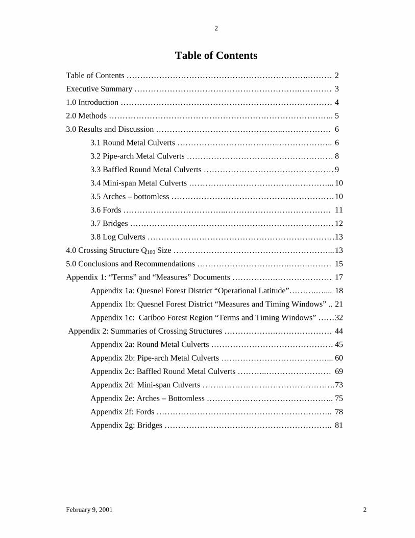
Table of Contents Table of Contents ………………………………………………………….……… 2
Executive Summary …………………………………………………….………… 3
1.0 Introduction …………………………………………………………………… 4
2.0 Methods ……………………………………………………………………….. 5
3.0 Results and Discussion ………………………………………..……………… 6
3.1 Round Metal Culverts ………………………………..……………….. 6
3.2 Pipe-arch Metal Culverts ……………………………………………… 8
3.3 Baffled Round Metal Culverts ………………………………………… 9
3.4 Mini-span Metal Culverts ……………………………………………... 10
3.5 Arches – bottomless …………………………………………………… 10
3.6 Fords ………………………………..………………………………… 11
3.7 Bridges ………………………………………………………………… 12
3.8 Log Culverts ……………………………………………………………13
4.0 Crossing Structure Q100 Size …………………………………………………... 13
5.0 Conclusions and Recommendations …………………………….…….……… 15
Appendix 1: “Terms” and “Measures” Documents …………….………………… 17
Appendix 1a: Quesnel Forest District “Operational Latitude”……….….... 18
Appendix 1b: Quesnel Forest District “Measures and Timing Windows” .. 21
Appendix 1c: Cariboo Forest Region “Terms and Timing Windows” …… 32
Appendix 2: Summaries of Crossing Structures ……………….………………… 44
Appendix 2a: Round Metal Culverts ……………………………………… 45
Appendix 2b: Pipe-arch Metal Culverts …………………………………... 60
Appendix 2c: Baffled Round Metal Culverts ………..…………………… 69
Appendix 2d: Mini-span Culverts …………………………………………. 73
Appendix 2e: Arches – Bottomless ……………………………………….. 75
Appendix 2f: Fords ……………………………………………………….. 78
Appendix 2g: Bridges …………………………………………………….. 81

February 9, 2001
3
3
Executive Summary A field review was conducted in the Quesnel Forest District of crossing structures installed on fish streams under the Forest Practices Code of BC Act (FPC). A total of 72 FPC crossing structures were examined, consisting of 26 round culverts, 15 pipe-arch (“D-pipe”) metal culverts, 3 baffled round metal culverts, 1 “mini-span”, 4 bottomless arches, 2 fords, and 21 bridges. No log culverts were examined. This sample is a significant proportion of the post-FPC permanent fish stream crossing structures in the Quesnel Forest District, and occurred from September to November, 2000. I estimate the total number of such structures at about 120, a poll of licensees by the MoF arrived at an estimate of 300 such structures. Culverts showed frequent indications of high current speeds. The gravel and rock substrate placed in many embedded round and pipe-arch metal culverts was partially or entirely washed out. Current speeds sufficient to flush out the substrate would have been in excess of the maximum passable by fish. Substrate consisting of large angular rocks was generally stable, but sometimes blocked fish passage at low water. The high current speeds result from a significant proportion of the stream water flowing in the floodplain of many streams during high run-off periods, rather than primarily in the channel. Since culvert size has been determined from channel width, the floodwaters result in culverts being undersize with respect to the objective of maintaining fish-passable current speeds. Bridges, with one exception, generally appeared to be without serious problems. The general conclusion is that most fish stream crossing structures should be bridges, with the abutments and riprap well back from the stream bank. Round metal culverts, pipe arch metal culverts or bottomless arches may be suitable for very small streams where the structure can span the floodplain, or at locations where stream water is ponded. When these structures are used they must have large rip rap placed inside as substrate, with sufficient finer gravel to fill the gaps between the large rocks. Culvert height must be at least 1800 mm to allow effective installation of heavy substrate without risk of injury to worker’s backs. Bridge abutments and rip rap should be placed well back from the stream banks to maintain channel integrity and streamside vegetation.
February 9, 2001
4
4
1.0 Introduction Stream crossing structures installed during road construction, modification or deactivation can have significant impacts on fish populations through damage to fish habitat, including changes to upstream fish movement. The most significant impacts on fish habitat generally result from culvert installation, but bridges and other crossing structures can also have adverse impacts.
Culvert impacts on fish populations include impeding or preventing upstream migration, sedimentation, and replacement of a complex aquatic habitat with a simplified environment. Culverts can determine the extent of fish use of habitats in a stream and, if fish passage is completely blocked, can exclude all fish from a watershed.
A natural stream channel provides a wide variety of widths, depths and water velocities throughout its length and width, thus offering fish a wide choice of routes suited to a wide range of swimming abilities. In contrast, a culvert is a streamlined, hydraulically efficient channel which has comparatively high water velocities that are relatively constant throughout the culvert length. The water velocities adjacent to the culvert bottom and sides are lower than the velocities in the middle of the culvert. Placement of rock and gravel in a culvert can provide some roughness to the culvert bottom, resulting in slower overall current speed and a greater range of current speeds near the bottom of the culvert.
The most common problems with culverts are excessive water velocities and perched outlets (outlets above streambed level, resulting in a vertical waterfall), both of which result in barriers to fish passage. Juvenile fish are especially sensitive to current speeds, and will not travel upstream if high water velocities are present. Water velocities in culverts must not exceed fish swimming abilities, at the season in which upstream movement is occurring. The optimal design of culverts for fish passage for each stream crossing requires knowledge of both the fish species and the size of the fish involved, as well as the magnitude, duration, frequency and seasonal changes in water flow in relation to the timing of fish movement.
The Forest Practices Code of British Columbia Act (FPC) authorises the Designated Environmental Official (DEO) to provide timing windows and measures for construction and modification activity on fish stream crossings. The FPC also authorises the DEO to provide timing windows and measures for deactivation activity on all streams, whether or not fish bearing. The Ministry of Environment, Lands and Parks (MELP) has established Forest Ecosystem Specialists, Habitat Protection Officers, and Water Resource Specialists as Designated Environment Officials for the purposes of:
1. FPC Act 60.2 [November 24, 2000] 2. Timber Harvesting Practices Regulation 21(3) [June 15, 1998]. 3. Forest Road Regulation: Part 2 Section 2.4; Part 3 Section 13(1)(h); Part 5 Sections 19,
20(1)(h), and 20(2)(a) [March 1, 2000]. 4. Woodlot License Forest Management Regulation: Part 4 Sections 50 and 56; Part 5
Section 68 [March 1, 1999]. 5. Community Forest Agreement Regulation, through application of the Woodlot License
Forest Management Regulation. [December 4, 2000].
February 9, 2001
5
5
The Ministry of Environment, Lands and Parks has supplied several iterations of timing windows and terms/measures since 1996 for the Quesnel Forest District of the Cariboo Forest Region (Appendix 1). The intent of the terms/measures was to provide forest and range licensees with guidance on how to install, modify or remove stream-crossing structures without damaging fish habitat and without blocking fish passage. This report assesses whether the terms/measures component of the documents achieves the objectives.
2.0 Methods Locations for field reviews were chosen from my memory of road systems that have had at least one crossing of a fish stream installed since June 15, 1995 when the Forest Practices Code of British Columbia Act (FPC) came into force. In addition to reviewing the targeted crossing structures, the remainder of each road system was driven to locate crossing structures that I had forgotten or had not been aware of.
There is no consolidated record of fish stream crossing structures, hence all structures were located from memory or by chance encounters. The dates of installation were determined from memory and through assessment of indicators of age of site disturbance such as road fill condition and vegetation growth. As a result a few of the crossing structures in this report may actually have been installed prior to June 15, 1995. This is not important within the context of this report, because the objective is not to review “compliance”, but instead is to assess the effectiveness of the terms/measures in ensuring fish passage and preventing damage to fish habitat. Compliance and enforcement issues are addressed outside this report.
Fish stream status was determined through available inventory, when available. When inventory was not available, fish stream status was determined by FPC definition. As a result some sites default to fish streams due to stream gradients less than 20% and lack of evidence that no fish occur in the stream, but further inventory may result in non-fish bearing status. Only crossing structures in fish streams are included in this report.
Field review of each crossing structure was deliberately kept as abbreviated as possible, due to the limited time available. The location of each site was recorded, photographs of the structure taken, the stream channel width and gradient recorded, and the type of structure noted. For culverts, the diameter, gradient, depth of embedding, and amount of substrate placed inside was noted. For bridges the distance between the toes of the riprap (= channel width under the bridge) was recorded. Current speed was not recorded because all streams were at annual low water. The review was conducted in September, October and November, 2000.
February 9, 2001
6
6
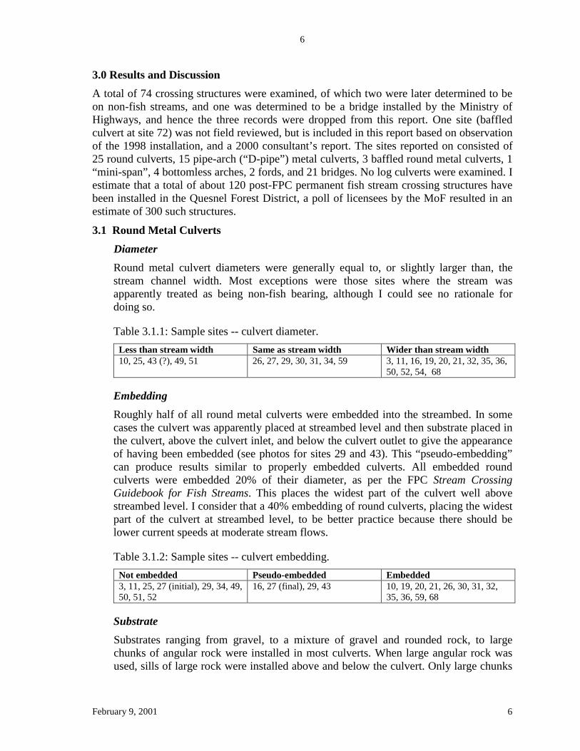
3.0 Results and Discussion A total of 74 crossing structures were examined, of which two were later determined to be on non-fish streams, and one was determined to be a bridge installed by the Ministry of Highways, and hence the three records were dropped from this report. One site (baffled culvert at site 72) was not field reviewed, but is included in this report based on observation of the 1998 installation, and a 2000 consultant’s report. The sites reported on consisted of 25 round culverts, 15 pipe-arch (“D-pipe”) metal culverts, 3 baffled round metal culverts, 1 “mini-span”, 4 bottomless arches, 2 fords, and 21 bridges. No log culverts were examined. I estimate that a total of about 120 post-FPC permanent fish stream crossing structures have been installed in the Quesnel Forest District, a poll of licensees by the MoF resulted in an estimate of 300 such structures.
3.1 Round Metal Culverts Diameter Round metal culvert diameters were generally equal to, or slightly larger than, the stream channel width. Most exceptions were those sites where the stream was apparently treated as being non-fish bearing, although I could see no rationale for doing so.
Table 3.1.1: Sample sites -- culvert diameter. Less than stream width Same as stream width Wider than stream width 10, 25, 43 (?), 49, 51 26, 27, 29, 30, 31, 34, 59 3, 11, 16, 19, 20, 21, 32, 35, 36,
50, 52, 54, 68
Embedding Roughly half of all round metal culverts were embedded into the streambed. In some cases the culvert was apparently placed at streambed level and then substrate placed in the culvert, above the culvert inlet, and below the culvert outlet to give the appearance of having been embedded (see photos for sites 29 and 43). This “pseudo-embedding” can produce results similar to properly embedded culverts. All embedded round culverts were embedded 20% of their diameter, as per the FPC Stream Crossing Guidebook for Fish Streams. This places the widest part of the culvert well above streambed level. I consider that a 40% embedding of round culverts, placing the widest part of the culvert at streambed level, to be better practice because there should be lower current speeds at moderate stream flows.
Table 3.1.2: Sample sites -- culvert embedding. Not embedded Pseudo-embedded Embedded 3, 11, 25, 27 (initial), 29, 34, 49, 50, 51, 52
16, 27 (final), 29, 43 10, 19, 20, 21, 26, 30, 31, 32, 35, 36, 59, 68
Substrate Substrates ranging from gravel, to a mixture of gravel and rounded rock, to large chunks of angular rock were installed in most culverts. When large angular rock was used, sills of large rock were installed above and below the culvert. Only large chunks

February 9, 2001
7
7
of angular rock were reliably retained within culverts, anything smaller was prone to flushing out.
A few culverts apparently were losing substrate through flushing, but, due to high natural bed-load movement, the substrate apparently was replaced as current speeds dropped (sites 29, 32).
When the only substrate was large angular rock, there were several instances of fish passage being blocked at low water. All the water flowed below the surface of the rock, although in the stream channel outside the culvert there was sufficient water for movement by small fish.
Table 3.1.3: Sample sites -- substrate placement. Inadequate Substrate
Gravel Gravel and Rock Rock with good fish passage
Rock with fish passage impeded at low water
3, 10, 11, 25, 29 (initial), 34, 49, 50, 51, 52, 59
26, 68 16, 32, 35, 36, 54 20, 21, 29 (final), 43
19, 27, 30, 31
Table 3.1.4: Sample sites -- substrate retention.
Inadequate Substrate Flushing Out Natural Replacement Stable 3, 10, 11, 25, 29 (initial), 34, 49, 50, 51, 52, 59
16, 54, 68, 26 None 19, 20, 21, 27, 29, 30, 31, 32, 35, 36, 43
Current Speed Current speeds were not measured, and hence this section is more prediction than conclusion. It also provides a prioritisation of sites for measurement of current speeds. However, when the substrate was flushed out of the culverts, current speeds must have been greatly in excess of those that permit fish passage. A subjective assessment of likely moderate to peak flow current speeds, based on high water marks inside and below the culverts and the existing low flow current, also suggests that current speeds are likely to be too high for fish passage.
If the round metal culverts had been embedded 40% of their diameter (rather than 20%), to place the widest part of the culvert at streambed level, current speeds at low to moderate water flows would have been somewhat reduced. There would have been minimal effect on current speed at moderate to high water flows.
Table 3.1.5: Sample sites -- estimated current speed (during spring for adult RB, during summer for juvenile RB) [RB = Rainbow Trout].
Too high for both adult and juvenile RB
Too high for adult RB only (> 1.9 m/sec)
Too high for juvenile RB only (>0.5 m/sec)
Adequate for both adult and juvenile RB (<0.5 m/sec)
3, 16, 25, 29 (initial), 39, 51, 52, 68
10, 11, 29 (final), 30, 31, 34, 38, 54
None 19, 20, 21, 26, 27, 32, 35, 36, 37, 59

February 9, 2001
8
8
3.2 Pipe-arch Metal Culverts Width Pipe-arch metal culverts (“D-pipes”) are round metal culverts that have been mechanically deformed to produce a nearly flat bottom. Their diameter was always equal to, or slightly larger than, the stream channel width, with the exception of three old culverts that were retrofitted to reduce the impediments to fish passage.
Table 3.2.1: Sample sites -- culvert width. Less than stream width Same as stream width Wider than stream width 38, 39, 40 [all retrofitted] 14, 41 (?), 60 7, 9, 18, 28, 61, 62, 63, 65, 66
Embedding All pipe-arch metal culverts were embedded. At four sites the culvert was originally placed at streambed level, and then, as part of retrofitting the culvert, substrate placed in the culvert, above the culvert inlet, and below the culvert outlet to give the effect of having been embedded. This “pseudo-embedding” can produce results similar to properly embedded culverts, although the associated downstream weirs required as part of the retrofitting produced significant high-current speed cascades. All pipe-arch culverts were embedded 20% of their diameter, as per the FPC Stream Crossing Guidebook for Fish Streams. This places the widest part of the culvert at streambed level.
Table 3.2.2: Sample sites -- culvert embedding. Not embedded Pseudo-embedded Embedded None 38, 39, 40, 41 7, 9, 14, 18, 28, 60, 61, 62, 63,
65, 66
Substrate Substrate ranging from gravel, to a mixture of gravel and rounded rock, to large chunks of angular rock was installed in most culverts. When large angular rock was used, sills of large rock were installed above and below the culvert. Only large chunks of angular rock were reliably retained within culverts, anything smaller was prone to flushing out.
A few culverts apparently were losing substrate through flushing, but, due to high natural bed-load movement, the substrate apparently was replaced as current speeds dropped (sites 9, 28). Fish passage appears to be impeded at the four retrofitted sites, as a result of high current speed cascades below the downstream weir and likely high current speeds within the culverts near high water.
Table 3.2.3: Sample sites -- substrate placement. Inadequate Substrate
Gravel Gravel and Rock Rock with good fish passage
Rock with fish passage impeded
14, 66 61, 65 7, 9, 18, 28, 60, 62, 63
None 38, 39, 40, 41 (retrofitted)

February 9, 2001
9
9
Table 3.2.4: Sample sites -- substrate retention.
Inadequate Substrate Flushing Out Natural Replacement Stable 14, 66 7, 18, 28, 60, 61?, 65 9 38, 39, 40, 41, 62?, 63?
Current Speed Current speeds were not measured, and hence this section is more prediction than conclusion. It also provides a priorization of sites for measurement of current speeds. However, when the substrate was flushed out of the culverts, current speeds must have been greatly in excess of those that permit fish passage. A subjective assessment of likely moderate to peak flow current speeds, based on high water marks inside and below the culverts and the existing low flow current, also suggests that current speeds are likely to be too high for fish passage.
Table 3.2.5: Sample sites -- estimated current speed (during spring for adult RB, during summer for juvenile RB) [RB = Rainbow Trout].
Too high for both adult and juvenile RB
Too high for adult RB only (> 1.9 m/sec)
Too high for juvenile RB only (>0.5 m/sec)
Adequate for both adult and juvenile RB (<0.5 m/sec)
7, 38?, 39?, 40?, 41?, 65, 66
9, 18, 28, 60, 61, 62, 63
None 14
3.3 Baffled Round Metal Culverts
Diameter Baffled round metal culvert diameter ranged from less than to greater than the stream channel width.
Table 3.3.1: Sample sites – culvert diameter. Less than stream width Same as stream width Wider than stream width 5 72 (?) 67
Embedding Two of the baffled round metal culverts were placed flush with the streambed. One was embedded.
Table 3.3.2: Sample sites – culvert embedding. Not embedded Pseudo-embedded Embedded 67, 72 None 5
Substrate The one embedded baffled culvert (site 5) initially had no substrate placed in it. This resulted in large numbers of fish being trapped behind the baffles in late fall, where winter freezing would have killed them. The area behind the baffles was then filled

February 9, 2001
10
10
with gravel, which washed out the following spring. A mixture of large rock and gravel was then used to fill behind the baffles. Some of the gravel has since washed out.
Current Speed Current speeds were not measured, and hence this section is more prediction than conclusion. It also provides a prioritisation of sites for measurement of current speeds. However, when the substrate was flushed out of the culverts, current speeds must have been greatly in excess of those that permit fish passage. I have watched the current flow in the embedded culvert during spring run-off, when Rainbow Trout would be moving upstream, and it is unlikely that fish could have passed up the culvert.
Table 3.3.3: Sample sites -- estimated current speed (during spring for adult RB, during summer for juvenile RB) [RB = Rainbow Trout].
Too high for both adult and juvenile RB
Too high for adult RB only (> 1.9 m/sec)
Too high for juvenile RB only (>0.5 m/sec)
Adequate for both adult and juvenile RB (<0.5 m/sec)
67, 72 5 None None
3.4 Mini-span Metal Culverts
Width The one mini-span metal culvert is greatly in excess of channel width.
Embedding The mini-span was embedded.
Substrate A mixture of angular gravel and rock was placed in the mini-span, completely burying the cross-struts. Much of the substrate was flushed out in 2000. It is important to note that this occurred despite the 3.0 m width of the culvert being greatly in excess of the 0.5 m channel width. This may, in part, have been due to excessive water entering the stream from the ditchline.
Current Speed Current speeds were not measured. However, when the substrate was flushed out of the culverts, current speeds must have been greatly in excess of those that permit fish passage.
3.5 Arches – bottomless Width The four bottomless arches were all 3 to 4 times channel width.

February 9, 2001
11
11
Table 3.5.1: Sample sites – culvert width. Less than stream width Same as stream width Wider than stream width None None 45, 46, 47, 48
Embedding The footings of the arches were embedded to below streambed level.
Table 3.5.2: Sample sites – culvert embedding. Not embedded Pseudo-embedded Embedded None None 45, 46, 47, 48
Substrate One arch was armoured inside, the others were left as raw dirt. Some erosion of the dirt has occurred by floodwater, but most of it has not yet been affected by water. Floodwater will inevitably erode much of the dirt, and cause downstream sedimentation.
Table 3.5.3: Sample sites -- substrate placement adjacent to channel. Inadequate Substrate
Gravel Gravel and Rock Rock
46, 47, 48 None None 45
Current Speed Current speeds were not measured. Current speeds are likely to remain near natural levels at all water flows for all four streams because the arches span most of the flood plains.
Table 3.5.4: Sample sites -- estimated current speed (during spring for adult RB, during summer for juvenile RB) [RB = Rainbow Trout].
Too high for both adult and juvenile RB
Too high for adult RB only (> 1.9 m/sec)
Too high for juvenile RB only (>0.5 m/sec)
Adequate for both adult and juvenile RB (<0.5 m/sec)
None None None 45, 46, 47, 48
3.6 Fords
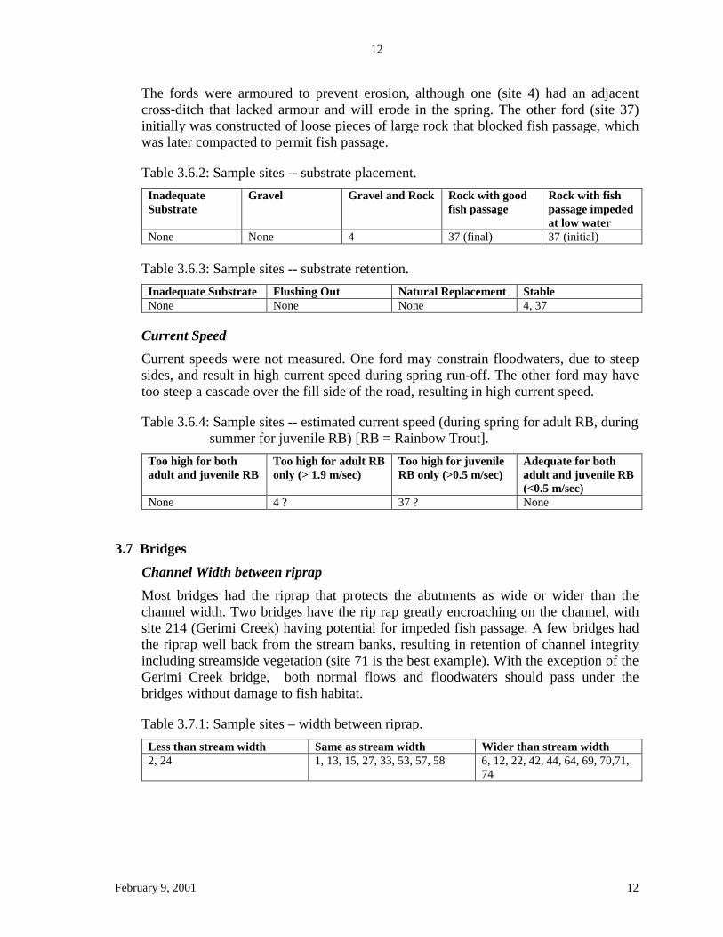
Ford channel width The wetted parts of the two fords were near stream channel width at time of inspection.
Table 3.6.1: Sample sites – ford channel width. Less than stream width Same as stream width Wider than stream width 4, 37 (?) None
Substrate
February 9, 2001
12
12
The fords were armoured to prevent erosion, although one (site 4) had an adjacent cross-ditch that lacked armour and will erode in the spring. The other ford (site 37) initially was constructed of loose pieces of large rock that blocked fish passage, which was later compacted to permit fish passage.
Table 3.6.2: Sample sites -- substrate placement. Inadequate Substrate
Gravel Gravel and Rock Rock with good fish passage
Rock with fish passage impeded at low water
None None 4 37 (final) 37 (initial) Table 3.6.3: Sample sites -- substrate retention.
Inadequate Substrate Flushing Out Natural Replacement Stable None None None 4, 37
Current Speed Current speeds were not measured. One ford may constrain floodwaters, due to steep sides, and result in high current speed during spring run-off. The other ford may have too steep a cascade over the fill side of the road, resulting in high current speed.
Table 3.6.4: Sample sites -- estimated current speed (during spring for adult RB, during summer for juvenile RB) [RB = Rainbow Trout].
Too high for both adult and juvenile RB
Too high for adult RB only (> 1.9 m/sec)
Too high for juvenile RB only (>0.5 m/sec)
Adequate for both adult and juvenile RB (<0.5 m/sec)
None 4 ? 37 ? None
3.7 Bridges
Channel Width between riprap Most bridges had the riprap that protects the abutments as wide or wider than the channel width. Two bridges have the rip rap greatly encroaching on the channel, with site 214 (Gerimi Creek) having potential for impeded fish passage. A few bridges had the riprap well back from the stream banks, resulting in retention of channel integrity including streamside vegetation (site 71 is the best example). With the exception of the Gerimi Creek bridge, both normal flows and floodwaters should pass under the bridges without damage to fish habitat.
Table 3.7.1: Sample sites – width between riprap. Less than stream width Same as stream width Wider than stream width 2, 24 1, 13, 15, 27, 33, 53, 57, 58 6, 12, 22, 42, 44, 64, 69, 70,71,
74

February 9, 2001
13
13
Current Speed The current speed is likely to be acceptable for all bridges except the one at Gerimi Creek. Current speed during spring run-off, when Quesnel River Rainbow Trout are likely to be moving up Gerimi Creek to spawn, may be too high for fish passage. In addition, there is a risk that the channel may down-cut and destabilise the riprap.
3.8 Log Culverts No log culverts were examined during this project, although at least three have been built across fish streams in the last two years in the Quesnel Forest District.
4.0 Crossing Structure Q100 Size The Forest Practices Code requires that bridges, their approaches, and stream culvert structures be designed to meet the Q100 peak flow (Forest Road Regulation 9(1)(h)). This requirement was also included in the DEO stream crossing “Measures” for the Quesnel Forest District. The Q100 requirement was not checked as part of the review of the stream crossing structures in this report, due to lack of time, but it is an important consideration because an undersize structure unable to pass high flows may fail and result in significant downstream damage to fish habitat. The Forest Practices Code does not specify how the Q100 peak flow is to be determined. There are several methods commonly used in the Quesnel Forest District, each based on different assumptions. I discuss the basic principles below, without including all the operational details. Method 1. Stream Channel Cross-sectional Area Method This is the method recommended in the Forest Road Engineering Guidebook and the Stream Crossing Guidebook for Fish Streams. The cross-sectional area of flow required to pass through a culvert is calculated by:
Area (A) = [(Wbf + W2) x Dbf]/2, where
Wbf = bankfull width W2 = bottom width Dbf = bankfull depth
The cross-sectional area of the culvert required to pass the Q100 peak flow is A x 3.0.
“This procedure assumes that: the bank-full scenario of any stream represents the mean annual flood for the stream (Q2); that the ratio applied to obtain Q100 is 3.0; and that the discharge is not sensitive to influences from pipe slope and roughness or other factors” (Forest Road Engineering Guidebook, p. 45). The first of these three assumptions is definitely incorrect for the majority of small, low gradient fish streams in the Quesnel Forest District, rendering the method of little value. Small low gradient streams, which are the only fish streams potentially suitable for culverts, have a highly variable proportion of their annual peak flows contained within the stream banks. Some streams have most of the annual peak flow contained within the stream banks, but most streams have a large portion

February 9, 2001
14
14
of their annual peak flow running outside the stream channel in the floodplain. Therefore I consider this method unusable for most small, low gradient fish streams in the Quesnel Forest District, because it will result in frequent significant under estimates of the Q100 peak flows.
Method 2. Burkli-Ziegler Formula – Watershed Area, Slope and Forest Cover The cross-sectional area of flow required to pass through a culvert is calculated by a number of variations on the basic formula (using different units of measure), which is based on watershed area, watershed slope and forest cover. One version of the formula (modified by MoF from the version in the Forestry Handbook for British Columbia, 4th edition) is:
Q = 230 RC(S/A) 0.25
Q = peak run-off, ft3/mile2 A = watershed area, mile2 R = average rate of rainfall, in/hr C = runoff coefficient for slope and forest cover (tabulated values from 0.05 to
0.90) S = average watershed slope, ft/100 ft (%)
The above formula results in a Q10 value (peak flow for 10-year flood). The cross-sectional area of the culvert required to pass the Q100 peak flow is Q10 x 1.8 (MoF Regional Engineer).
This method is based on the assumption that the peak flow in a stream is a function of watershed area, watershed slope, the amount of forest cover, and the rainfall intensity characteristic of the watershed. These assumptions seem reasonable, and most of the values are easily obtained from a map. The most uncertainty is associated with the value “R”, because lack of data for most specific sites requires extrapolation from the few weather stations where the value is known. I consider this to be a usable method of calculating Q100.
Method 3. Talbot Formula – Watershed Area, Slope, Forest Cover and Soils The cross-sectional area of flow required to pass through a culvert is calculated by a number of variations on the basic formula (using different units of measure), which is based on watershed area, watershed slope, forest cover and soil type. One version of the formula (Forestry Handbook for British Columbia, 4th edition) is:
W = (A0.75)*C*R
W = cross-sectional area of culvert, ft2 A = watershed area, acres R = reduction factor for rainfall intensity less than 4 in/hr = (lesser rainfall)/4, which for Quesnel ranges from 2/4 to 4/4 = 0.5 to 1.0. C = runoff coefficient for slope, forest cover & soil type (tabulated values from
0.2 to 1.0)
The Talbot Formula results in a W value for the Q10 (10-year flood). The cross-sectional area of the culvert required to pass the Q100 peak flow is W x 3.0. I consider this to be a usable method of calculating Q100.

February 9, 2001
15
15
5.0 Conclusions and Recommendations Culverts There is little difference in the effectiveness of round metal culverts, pipe-arch culverts, baffled culverts, mini-span culverts and bottomless arches installed in fish streams. All these types of structures are prone to high current speeds that result in small to moderate substrate being flushed out. Substrate composed of large angular chunks of rock is retained in culverts, but the high current speeds will still be present. Rock substrate that lacks fine material is prone to blocking fish passage at low water. The four bottomless arches were free of problems, other than lack of armouring, only because they were (by chance) sized to span the floodplain rather than just spanning the channel. Providing time permits, I will document current speeds in the spring and early summer of 2001.
The majority of the streams in the Quesnel Forest District have a significant proportion of the water flowing in the floodplain, outside the channel, during annual high flows. The size standard for culverts in fish streams, as stipulated by the FPC Stream Crossing Guidebook for Fish Streams, is for the culvert to be at least as wide as the stream channel. The floodwater is compressed to flow through the culvert, resulting in excessive current speeds. The compression of flood water is the key problem associated with culverts installed to FPC standards in fish streams in the Quesnel Forest Distirct. These conditions occur during summer rainstorms, as well as during spring run-off. Flood conditions generally last 4-6 weeks during the spring for each stream, although the time span is highly variable both between streams and between years. This spring run-off period is when Rainbow Trout are moving upstream to spawn, and hence excessive current speeds in culverts will adversely affect their reproductive success. This will not occur for culverts in all streams, but I see no method of accurately predicting “problem” streams.
The presence of excessive current speeds has been deduced from indicators such as high water marks and substrate scouring inside and below culverts. I am convinced that excessive current speeds are present in many “FPC” culverts during spring run-off, and can no longer support their installation except for a few specific sites. However, the actual current speeds of at least a subsample of the culverts should be measured in the spring to confirm the presence of excessive current speeds.
Circumstances under which round metal culverts, pipe arch metal culverts or bottomless arches may have acceptable current speeds at all times are:
1. Streams with zero gradient, with ponded water above, below and through the culvert site, with the culvert is sized for meeting the Q100 requirements for outlet controlled flow; and
2. Very small headwaters streams with shallow channels where the culvert can be sized to span the floodplain.
When these structures are used they should have large rip rap placed inside as substrate, with sufficient finer mineral material to fill the gaps between the large rocks. The minimum height of any embedded culvert or bottomless arch should be 1800 mm, to permit effective installation of large rock material without unreasonable risk of back injury to workers.

February 9, 2001
16
16
Bridges Bridges generally adequately pass water, but the integrity of the banks and riparian vegetation is only maintained when the abutments and rip rap are well back from the banks. The rip rap and abutments should start at least 2-3 meters back from each bank, and the excavation between the toe of the rip rap and the soils behind the banks should be filled with soil so that it can be anchored by vegetation roots. This will adequately protect the fish habitat associated with stream banks, including low riparian vegetation, at the crossing site as well as upstream and downstream of the bridge. Compression of floodwaters under bridges is of concern. Placement of the rip rap and abutments well back from the stream banks will provide some floodplain to accommodate peak flows. Large culverts should be placed under the approaches, to accommodate floodwater wherever they encroach on the floodplain. Fish passage and habitat will tend to be much less adversely affect by increased current speeds under bridges than by culverts, because there will tend to be a low current area along the edge of the rip rap (much less so if floodwater is constrained by smooth abutments). When a bridge is installed to replace a previously existing crossing structure, a new stream channel should be reconstructed under the bridge. The new stream channel should be wider than the natural stream channel upstream and downstream, and should incorporate structural complexity of both the bed and the banks of the stream.

February 9, 2001
17
17
Appendix 1
“Terms” and “Measures” Documents

February 9, 2001
18
18
Appendix 1a Quesnel Forest District “Operational Latitude”
Document February 23, 1999
Guppy, Crispin and Charlotte Kurta. 1999. Operational latitude in conservation measures and timing windows for fish stream crossings in the Quesnel Forest District (February 23, 1999). Environment and Lands, Habitat Protection, Quesnel Forest District.

February 9, 2001
19
19
File: 39645-01 February 23, 1999 To: District Manager, Quesnel Forest District Small Business Forest Enterprise Program Woods Managers, Quesnel Forest District Licensees
Dear Sir/Madame:
Re: Operational latitude in conservation measures and timing windows for fish stream crossings in the Quesnel Forest District
This letter is to emphasise the operational latitude provided within our ‘Measures and Timing Windows’ document for stream crossings, dated September 10, 1998. The ‘Measures and Timing Windows’ document is an efficiency measure intended to be used as a set of ‘best practices’. When these measures and timing windows are adhered to for stream crossing proposals, no referral to the DEO (district Habitat Protection staff) is required. We continue to be available for consultation, at your discretion.
You may propose alternative measures and timing windows for specific projects where you feel that the legal obligations for Section 21(3) of the Timber Harvesting Practices Regulation (temporary stream crossings and other operations in a fish stream) and Sections 9, 13 and 19 of the Forest Road Regulation (crossings in fish streams, road deactivation) have been met. However, prior to application of alternative measures and timing windows, these proposals must be submitted to the DEO for review and endorsement. For example, the requirement for a 1.5 m clearance for bridges may be varied if based on the opinion of a qualified professional. It is expected that when alternate measures and timing windows are proposed, the referral will include a description of how the legal requirements have been met.
Please note that proper classification (as per the FPC Fish Stream Identification Guidebook) of the stream reach at the crossing site may simplify the measures and lower the costs required for crossing, particularly if classification determines that the stream is not a fish stream. The lowest cost structures which meet the legal requirements of ensuring fish passage and protecting fish habitat should be used.
MINISTRY OF ENVIRONMENT, LANDS AND PARKS
Habitat Protection Branch 322 Johnston Ave., Quesnel, British Columbia V2J 3M5 Telephone: (250) 992-4400 Facsimile: (250) 992-4403

February 9, 2001 20
Referral Requirements
The referral requirements for fish streams listed below replace the previous requirements outlined in the September 10, 1998 document.
• A Notice of Commencement is required for all bridges, arches, log culverts or other bottomless stream crossing structures. No other referrals are required to the DEO. Field inspections and assessments of these bottomless crossing structures will be conducted after the Notice of Commencement has been received. To avoid additional paperwork, the Notice of Commencement to MELP may be a copy of the form normally sent to Ministry of Forests at the start of road construction or harvesting, with reference made to the open-bottom bridge or culvert to be installed.
• No referral is required for any culverts installed as per the ‘Measures and Timing Windows’ document. Stream crossing data sheets are expected to be completed and on file for all crossings, to document your decision-making process for selection of the culvert size and type. Field inspections and assessments will be conducted after installation.
• All sites where crossing measures other than those outlined in the ‘Measures and Timing Windows’ document are proposed, require referral to the DEO and possible field inspection. The ‘Stream Crossing Data Sheet’ is required as part of all referral packages.
Department of Fisheries and Oceans must still be notified, as they may require additional information. Consultation with the undersigned is recommended if there are any questions or concerns with the measures or timing windows.
Yours truly, Cris Guppy Forest Ecosystem Specialist Environment and Lands, Cariboo Region
Charlotte Kurta, RPBio. Habitat Protection Officer Environment and Lands, Cariboo Region
cc: Rodger Stewart, A/Regional Manager, Fish, Wildlife and Habitat , Cariboo Region

February 9, 2001
21
21
Appendix 1b Quesnel Forest District
“Measures and Timing Windows” Document
September 10, 1998
Guppy, Crispin and Charlotte Kurta. 1998. Measures and timing windows, Quesnel Forest District, for conservation of aquatic resources in fish streams (September 10, 1998). Environment and Lands, Habitat Protection, Quesnel Forest District.

February 9, 2001
22
22
File: 39645-01 September 10, 1998 To: District Manager, Quesnel Forest District Small Business Forest Enterprise Program Quesnel Forest District Licensees Woodlot Licensees
Dear Sir/Madame:
Re: Conservation Measures and Timing Windows for Instream Works affecting Fish Streams in the Quesnel Forest District
We submit the attached “Measures and Timing Windows” document to meet our legal obligations under the Forest Practices Code, as Designated Environment Officials for Section 21(3) of the Timber Harvesting Practices Regulation (temporary stream crossings and other operations in a fish stream) and Sections 13(h) and 19 of the Forest Road Regulation (crossings in fish streams, road deactivation). This document replaces the Interim Terms and Timing Windows that were established September 5, 1996. These measures and timing windows must be used by operational planners and forest industry operators in the application of practices for all stream crossings.
District Management Teams and Industry staff are encouraged to review these measures and timing windows with us to ensure appropriate interpretation and to expedite implementation. We expect immediate implementation of these measures, because the legal requirement to apply such measures and timing windows was effective June 15, 1998. Yours truly, Cris Guppy Forest Ecosystem Specialist Environment and Lands, Cariboo Region
Charlotte Kurta, RPBio. Habitat Protection Officer Environment and Lands, Cariboo Region
cc: Rodger Stewart, A/Regional Manager, Fish, Wildlife and Habitat , Cariboo Region Dirk Trigg, Ministry of Forests, Cariboo Region Barry Trenholm, Ministry of Forests, Cariboo Region Cariboo Lumber Manufactures Association
MINISTRY OF ENVIRONMENT, LANDS AND PARKS
Habitat Protection Branch 322 Johnston Ave., Quesnel, British Columbia V2J 3M5 Telephone: (604) 992-4400 Facsimile: (604) 992-4403
23February 9, 2001
MEASURES AND TIMING WINDOWS QUESNEL FOREST DISTRICT
For Conservation of Aquatic Resources in Fish Streams
1.0 SCOPE AND AUTHORITY
This document applies to all stream crossings and instream operations which fall under the Forest Act, Range Act and Forest Practices Code of BC Act, and which may affect a fish stream. It includes all works in or about a stream for forestry operations or projects performed under the auspices of Forest Renewal BC. Works conducted in accordance with the Forest Practices Code of BC Act do not require Water Act referrals to Water Management Branch, but the Canada Fisheries Act remains fully effective for the protection of fish habitat.
The Minister of Environment, Lands and Parks has established Forest Ecosystem Specialists, Habitat Protection Officers and Water Resource Specialists as Designated Environment Officials for the purposes of THPR 21(3), FRR 13(h) and FRR 19. In consideration of the Canada Fisheries Act, these staff also identify proposals to the Department of Fisheries and Oceans where there are concerns regarding protection of fish and fish habitat.
This document has been prepared by the Designated Environment Officials for the Quesnel Forest District, using the best information currently available, and in consultation with the MELP Fisheries Branch and the Department of Fisheries and Oceans. These measures and timing windows will be revised from time to time as new information is available.
The measures and timing windows established by the DEO are for the protection of aquatic resources under the legal authority of the Province of British Columbia. By way of these measures and timing windows, the DEO provides advice to proponents of forest operations on appropriate practices to protect fish and fish habitat. They are not approvals for activities that will impact fish or fish habitat, including the introduction of deleterious substances. Such concerns fall within the statutory authority of the Department of Fisheries and Oceans.
These measures and timing windows do not authorize anyone to conduct or participate in activities that are contrary to any statute (e.g. Land, Waste, Water, Wildlife, Forest Practices Code, Industrial Health and Safety or Canada Fisheries Acts). Any contract between a forest licensee or tenure holder and the Ministry of Forests does not affect MELP's mandate to monitor, investigate and when necessary, investigate apparent violations involving land, fish, wildlife or their habitats.

24February 9, 2001
2.0 RESPONSIBILITY It is the responsibility of the proponent to ensure compliance with these measures and
timing windows, which are legally required to be applied in all forestry and FRBC operations. Where there are problems that may require site-specific variance, alternative measures and timing windows must be obtained from the DEO before commencing operations.
Proponents are reminded that it is your responsibility to correctly classify each stream being crossed, and to determine the fish species present. Classification must be conducted as per the Fish Stream Identification Guidebook. This information is critical in selection of practices for stream crossing construction, maintenance and deactivation. For the purpose of determining site-specific timing windows, stream sampling should be designed to confirm presence/absence of key fish species. All streams with less than 20% gradient must be considered to be fish streams unless Code definitions allow otherwise or standard sampling techniques prove fish absence. Planning and construction costs may be reduced by strategic and timely stream assessment and riparian classification.
3.0 MEASURES FOR CONSERVATION OF AQUATIC RESOURCES IN FISH
STREAMS The (Draft) Stream Crossing Guidebook for Fish Streams and the Land Development
Guidelines for the Protection of Aquatic Habitats (BC Environment, September 1993) should be consulted for potential culvert and bridge installation options that ensure fish passage and protect fish habitat. The additional direction in this document takes precedence over such guidelines, where there is a difference.
Sections 9 and 13 of the Forest Road Regulation are the legal principles for the design and construction of stream crossings.
3.1 Large Streams - S1, S2 and large S3 (3m channel width or greater) All S1, S2, and large S3 streams must be crossed with a bridge or other open-bottom
structure to maintain the integrity of channel processes, avoid damage to downstream fish habitat, protect stream banks and to safely maintain fish passage. “Mini-span” bridges are not acceptable where channel width is 3 meters or greater.
Bridges and other open-bottom structures must be installed as per the Stream Crossing Guidebook for Fish Streams recommendations and the FPC. In addition to these requirements, the following measures apply to all bridges and other open-bottom structures to ensure safe fish passage and to protect fish habitat:
• The proponent is responsible for the engineering details, including correct log culvert and bridge sizes and meeting the FPC Q50 or Q100.
• Clearance must be at least 1.5 m above high water line to pass debris, for all S1, S2 and large S3 streams.
• Span of bridge or other open-bottom structure must be sufficient to ensure that abutments and rip-rap do not encroach on the natural stream channel.
• Prompt re-vegetation of stream banks and ditch lines is essential.

25February 9, 2001
3.2 Small streams - small S3 (less than 3m channel width) and S4 Most small S3 and S4 streams should be crossed using a bridge, log culvert, arch, or
other bottomless structure. S4 streams and small S3 streams with 0.5% or less gradient may be crossed using an over-size round culvert. S4 and small S3 streams with less than 5% gradient may be crossed using embedded pipe arch or elliptical culverts. Culverts that are properly sized, embedded to the appropriate depth and gradient, and properly maintained, as outlined in the Stream Crossing Guidebook for Fish Streams, may meet fish passage requirements. Non-embedded culverts are not acceptable in any fish streams, round culverts are never acceptable in fish streams over 0.5% gradient, and only open-bottom structures are acceptable at 5% greater or gradient.
Bridges, arches, log culverts and embedded culverts must be installed as per the Stream Crossing Guidebook for Fish Streams recommendations and the FPC. In addition to these requirements, the following measures apply to all crossing structures:
• The proponent is responsible for the engineering details, including correct culvert and bridge sizes and meeting the FPC Q50 or Q100 peak flow requirements. Ensure that peak flow requirements account for the loss of culvert area when culverts are embedded, including the height of rip-rap placed in the pipe.
• Bridge clearance must be at least 1.5 m above high water line to pass debris, unless a qualified professional has certified the required debris clearance height to be otherwise.
• Length of bridge or other open-bottom structure must ensure that abutments and rip-rap do not encroach on the natural stream channel.
• Culverts must not be used for streams (fish bearing or not) that exhibit evidence of channel instability, debris torrenting or have terrain or soil hazards within the inner gorge. Such channels must be crossed using open bottom structures that do not constrain natural processes and permit passage of bedload and debris.
• Culverts used in fish streams must not reduce natural channel width or flow capacity, and must not damage spawning habitat.
Baffled culverts are not recommended for any streams. The Stream Crossing Guidebook for Fish Streams describes the disadvantages of baffled culverts.
Proponents are reminded that correct installation of crossing structures for fish streams is required to ensure fish passage and to avoid damage to fish habitat. The embedding of culverts and the placement of D90 rip-rap within the culvert, as detailed in the Stream Crossing Guidebook for Fish Streams, are technically very challenging. Incorrectly installed crossing structures are likely to require costly replacement, and damage to fish habitat may have occurred or fish passage may have been impeded.

26February 9, 2001
3.3 Other Considerations
Location of Stream Crossings Stream crossings should be selected at a section of the stream which is as straight and
narrow as possible, to ensure no net fish habitat loss. The riparian area should also be as narrow as possible to minimize riparian habitat loss.
Crossings of alluvial fans should be at or near the apex of the fan to reduce the chance for significant changes in channel location. Protect the integrity of the road bed by placing additional drainage structures across the fan (particularly at the margins) and by using rip-rap along the road bed and about the main stream crossing.
Crossings of floodplains should be where the floodplain width is narrowest. Place additional drainage structures across the floodplain, especially at each auxiliary channel (even if dry), to ensure water flow during high water. If culverts are used for this, they must be spaced (and embedded) to ensure water movement on and below the surface to maintain the hydrology of the riparian habitats below the crossing. All crossing structures must be capable of fish passage during high water if the main channel is a fish bearing stream. Protect fill from erosion across the extent of the active floodplain.
Sediment
Ditches near a stream crossing must be designed to minimise the introduction of sediment to streams (whether or not fish bearing). Surface water flow during construction must be controlled so that siltation into streams will not occur. All exposed soils must be promptly re-vegetated to prevent erosion and stream sedimentation. Hydroseeding with an ecologically suitable seed mix concurrent with the work, so as to maximize the speed and density of re-vegetation, is a requirement for most stream crossings to ensure prompt re-vegetation.
Deactivation of Stream Crossings
Deactivation operations must be conducted in a manner that minimizes sediment introduction into streams, both during stream crossing removal and after operations are complete. The original stream channel width must be re-established in a manner that minimizes erosion potential and maintains channel and stream bed integrity above and below the site. Road approaches must be graded back to a slope that minimizes erosion potential. Exposed material must be promptly re-vegetated, normally using hydroseeding. The toes of fill slopes must be armored to control slumping, raveling, or erosion during high water.
A well designed armored ford must be established when crossing structures are removed, if there is a reasonable expectation of non-industrial vehicle traffic continuing to use the crossing site.
For some deactivation operations carried out under the Watershed Restoration envelope of FRBC, fisheries experts may establish site-specific operating standards. Such standards will need DEO approval.

27February 9, 2001
Silviculture Work
If an armored ford was established during removal of a stream crossing, the ford may be used by pickups and ATVs, as long as excessive sedimentation does not occur. An armored ford may also be used for a maximum of two crossings by clean site preparation equipment. The crossings must be made during the appropriate timing window for the stream, since some sediment will be produced.
The MOF “Robertson Crossing” modified cattle guard or similar structure may be used in an armored ford to raise the wheels of vehicles and equipment above the water to prevent sedimentation, and therefore eliminate the need for timing windows. Such crossing structures must not be used outside the timing windows if the crossing site has gravels suitable for fish spawning, because eggs in the gravels may be destroyed. The structure must be placed in, or removed from, the channel only during the appropriate timing window if sediment will be produced by the activity. Wheels and tracks of vehicles and equipment must be clean to prevent sediment dropping into the stream during crossing (a solid deck may be advisable).
We suggest the following temporary crossing structure for streams with less than 1.5 m channel width, if an armored ford is not available. Timing Windows do not apply if no sediment will enter the stream. The proponent must ensure worker safety.
• Place rubber mats on both sides of the stream, and over the channel itself. • Place a log or other support on each side of the stream on the rubber mats,
parallel to the channel and as far back as possible. • For a wheeled vehicle, lay planks across the stream supported by the logs (may
not be necessary for tracked machines). The machine may be walked across, supported by the logs to avoid damage to channel banks.
• Remove the logs and mats when complete. • Consult with Habitat Protection for streams larger than 1.5 m channel width, or
where this method will not work for streams less than 1.5 m width.
Water Licenses and Other Use
Water licensees or domestic users downstream from a proposed crossing, who may be affected by the proposal (especially by sedimentation or disruption of water flow), must be notified and protected from the potential effects of the development.
Community Watersheds
All stream crossings in the Troll Mountain Community Watershed, regardless of stream class, must be referred to the DEO for assessment by the Habitat Protection and Water Management Branches.

28February 9, 2001
Preservatives and Concrete
Wood treated with preservatives must be aged at least 6 months prior to being used in any stream crossing structure. Proponents must ensure that their supplier has done this. During the aging process, the wood must be stored at least 100 m from a stream. Use of creosote is discouraged, and must not be used below the high water mark. All cast-in-place concrete and grouting must be completely separated from fish bearing waters for a minimum of 48 hours.
Beavers
In locations where beaver activity occurs, bridges or over-size culverts should be considered for all streams to reduce maintenance requirements and to reduce downstream habitat damage resulting from dam removal. Where signs of recent beaver activity are present at time of crossing installation, “beaver stops” should be placed on the upstream end of all culverts, or other measures taken to reduce the chance of beavers damming the culvert.
The removal or modification of beaver dams must be authorized by a permit issued under the Wildlife Act. These can be obtained by applying to the Regional MELP office.
Emergency Measures and Stream Habitat Damage
In some circumstances emergency action will be required to protect roads, stream environments and crossing structures from catastrophic damage. Should consultation on conservation measures prove impossible due to an emergency need to prevent damage, the extent of emergency activity must be reported (in writing and with a map) to MELP and the Department of Fisheries and Oceans within 72 hours.
Damage to stream channels or fish habitat, or introduction of deleterious substances to a stream, must be reported to MELP and the Department of Fisheries and Oceans immediately. This includes activities that have occurred, for any reason, outside of the prescribed measures and timing windows.
4.0 REFERRALS Sites where bridges, arches, log culverts or other bottomless structures are proposed
do not require referral to the DEO, providing these measures and timing windows are followed. A Notice of Commencement is required for all bridges, arches, log culverts or other bottomless structures. All sites where round, elliptical, or pipearch culverts are proposed for fish streams require referral to the DEO and possible field inspection. This referral requirement replaces all previous referral requests made in our FDP comments.
Referrals must be submitted at least 30 days in advance of project commencement, with the understanding that MELP may require a site inspection during a snow free period. The attached “Stream Crossing Data Sheet” is required as part of all referral packages. The proponent must send a referral to DFO, where required by them.

29February 9, 2001
5.0 TIMING WINDOWS
Stream crossings that require instream works that may result in introduction of sediment to fish habitat must be conducted within the specified timing window for the stream or watershed. These timing windows must be applied to all fish-bearing streams, as well as non-fish bearing waters that are direct tributaries to downstream fish habitat and can reasonably be expected to result in sedimentation of the fish habitat. Timing windows ensure that in-stream works occur at the correct time of year to avoid damage to spawning habitat and destruction of fish eggs and juveniles.
Where water quality objectives must be maintained (i.e. community watersheds or downstream domestic use), there may be other timing considerations depending on site specific circumstances.
Watershed Timing Window
Baker Creek - downstream of Puntataenkut (Tibbles) Lake, and for Merston subbasin downstream of DL 2454
July 15 to July 31
Baker Creek - upstream of Puntataenkut (Tibbles) Lake, and for Merston subbasin upstream of DL 2454
July 15 to April 15
Blackwater River (including tributary rivers) July 15 to July 31 Bowron River July 15 to July 25 Cariboo River July 15 to August 7 Cottonwood/Swift River - downstream of
confluence with Bendixon Creek, and entire Swift River mainstem
July 15 to July 31
Cottonwood/Swift River - tributaries upstream of confluence with Bendixon Creek and including Bendixon Creek
July 15 to August 15
Narcosli Creek July 15 to July 31 Quesnel River July 15 to July 31 Willow River July 15 to July 25 Other Fraser River tributaries July 15 to July 31
The above Timing Windows apply to all streams within the specified watersheds. In-stream works that cannot be completed within the timing windows require DEO referral. The DEOs may vary the timing windows on a site specific basis, and proponents are reminded that adequate stream inventory data is critical to establishing the widest possible timing windows.
Notification to Bruce Hillaby, Department of Fisheries and Oceans, Williams Lake, is required for all in-stream works.

BC ENVIRONMENT / DFO STREAM CROSSING DATA SHEET Quesnel Forest District
February 9, 2001 30
STREAM CLASS:
CONTACT PERSON / LICENSEE:
Administrative Information: Stream Name: General
Location:
Tributary to: Watershed: Fish species present in system and what information was used to determine this (anecdotal, F.I.S.S. maps, sampling): Road Permit No.: CP/Block No.: Date Surveyed: Field Crew: BCGS Mapsheet : Air Photo No.:
Crossing Structure Information: Type and Dimensions of Crossing Structure (bridge/culvert/arch):
Culvert Gradient: Permanent or Temporary Installation: Proposed Dates of Work (start / finish): In-stream Work Window:
Stream Channel Information: Average channel width (m): Average wetted width (m): Average water depth (m): High water mark (m): Left bank height (m): Left bank sideslope (%): Right bank height (m): Right bank sideslope (%): Stream gradient (%): Flow estimate: (Low / Moderate / High) Permanent / ephemeral: Length surveyed:
Note that left and right banks are designated when facing downstream.
Stream Bed Material: Percent (%)
Fines/Organics (clay, silt, sand (<2 mm)) Small Gravels (.2-1.0 cm) Large Gravels(1-6 cm) Small Cobbles (6-12 cm) Large Cobbles (13-25 cm) Boulders (>25 cm) Bedrock

February 9, 2001 31
Habitat Unit Type * Above Crossing At Crossing Below Crossing
Pool Riffle Glide Other
Side channels
Definitions (as per DFO Stream Survey Field Guide): • Pool: portions of the stream with reduced current velocity at low flow and with deeper water than the
surrounding areas • Riffle: shallow rapids where the water flows swiftly over completely or partially submerged materials to
produce surface agitation • Glide: areas of swiftly flowing water, without surface waves, which approximate uniform flow • Other: rapids, chutes, marsh, slough • Side channels: lateral channels which flow roughly parallel to mainstem and are fed by water from the
mainstem.
General Comments:
Comments (channel debris; management concerns; obstructions; riparian zone); stream bank material composition, stream bank vegetation, habitat components present (cutbanks, boulders, deep pools, instream vegetation, overhanging vegetation, etc.) and a sketch of stream/valley cross-section: Attach a 1:50,000 location map and a 1:20,000 or better topographical map. Attach a ground-based photo series (upstream, downstream, right bank left bank) to assist in visualizing the site.

February 9, 2001 32
Appendix 1c Cariboo Forest Region
“Terms and Timing Windows” Document
September 5, 1996
Stewart, Rodger. 1996. Interim terms and timing windows for stream crossings in the Cariboo Forest Region (September 6, 1996). BC Environment, Cariboo Region.

February 9, 2001 33

February 9, 2001 34
February 9, 2001 35

February 9, 2001 36

February 9, 2001 37

February 9, 2001 38
February 9, 2001 39

February 9, 2001 40

February 9, 2001 41

February 9, 2001 42

February 9, 2001 43

February 9, 2001 44
Appendix 2
Summaries of Crossing Structures

February 9, 2001 45
Appendix 2a
Round Metal Culverts

February 9, 2001 46
Site 3: Round Metal Culvert Crossing of Mount Creek tributary. Location: 3700 Road (signed as 1700 Road), km 9.1, tributary of Mount Creek.
Map: 93B.086; UTM N: 5858990 E: 506200.
Fish Stream: The stream is assumed to support Rainbow Trout, based on gradient.
Comments: This culvert may have replaced a pre-FPC culvert passing a tributary of Merston Creek. The culvert will block fish passage (10% gradient), if fish are present.
Photograph 12.09: Site 3, stream channel below outlet.
Photograph 12.07: Site 3, inlet of culvert.
Stream width = 0.5 m Culvert width = 0.8 m Culvert slope = 10%
Site 10: Round Metal Culvert Crossing of Merston Creek tributary. Location: 3400 S Road, end of road.
Map: 93B.076; UTM N: 5849500 E: 504450. Fish Stream: The stream is assumed to support Rainbow Trout. Comments: Round culvert in a very “flashy” stream, embedded 20%, substrate of large rock placed in the upstream half of the culvert. The culvert will block fish passage at low water flows, due to the large rock.
Photograph 2.08: Site 10, culvert outlet. Note the ponding at the outlet that has resulted from scouring. Stream width = 1.2 m Culvert width = 1.1 m; Culvert slope = 1%
Photograph 2.09: Site 10, culvert interior (from outlet).

February 9, 2001 47
Site 11: Round Metal Culvert Crossing of Ramsey Creek tributary. Location: Lavington Road, 29.5 km, in-block culvert.
Map: 93B.065; UTM N: 5830000 E: 497150. Fish Stream: The stream is assumed to support Rainbow Trout. Comments: This culvert was installed at a new in-block crossing, and passes a small, low gradient tributary of Ramsey Creek. The culvert has now been removed.
Photograph 2.10: Site 11, culvert inlet. Note the erosion of the road surface and roadbed. Stream width = 0.5 m Culvert width = 0.8 m Culvert slope = 2% Photograph 2.12: Site 11, culvert interior from outlet.
Site 16: Round Metal Culvert Crossing of Trapline (Bradie ?) Creek tributary. Location: 2100 Road, branch at 2 km.
Map: 93B.085; UTM N: 5857800 E: 488050. Fish Stream: The stream is assumed to support Rainbow Trout. Comments: The gravel and rock substrate has flushed out. Maps are contradictory regarding stream name. Stream width = 0.8 m; Culvert width = 1.2 m; Culvert slope = 4%.
Photograph 3.07: Site 16, outlet. Photograph 3.08: Site 16, interior from outlet.

February 9, 2001 48
Site 19: Round Metal Culvert #1Crossing of Frye Creek. Location: 500 Road, at 0.5 km, Frye Creek at outlet of Fifteen Mile Lake.
Map: 93G.009; UTM N: 5876000 E: 559550. Fish Stream: The stream is known to support Rainbow Trout, by inventory. Comments: This round metal pipe was installed in 2000 to replace an undersize culvert. It was embedded 20% and rock substrate placed in it. The rock substrate blocks fish passage at low water, but the beaver dam immediately upstream also prevents fish passage at low water.
Photograph 4.06: Site 19, inlet. Note that the beaver dam is blocking fish passage upstream during low stream flow. Fifteen Mile Lake is behind the beaver dam. Stream width = 1.6 m (?) Culvert width = 2.2 m Culvert slope = 2%
Photograph 4.07: Site 19, interior from outlet. Note the rock near the inlet is blocking fish passage.
Site 20: Round Metal Culvert #2 Crossing of Frye Creek.
Location: 500 Road, at 2.0 km, Frye Creek. Map: 93G.009; UTM N: 5875000 E: 55650.
Fish Stream: The stream is assumed to support Rainbow Trout.
Comments: This round metal pipe was installed in 2000 to replace an undersize culvert. It was embedded 20% and rock substrate placed in it. A downstream beaver dam results in ponded water through the culvert. Stream width = 1.4 m (?); Culvert width = 2.0 m; Culvert slope = 0%.
Photograph 4.09: Site 20, inlet. Photograph 4.08: Site 20, outlet.
February 9, 2001 49
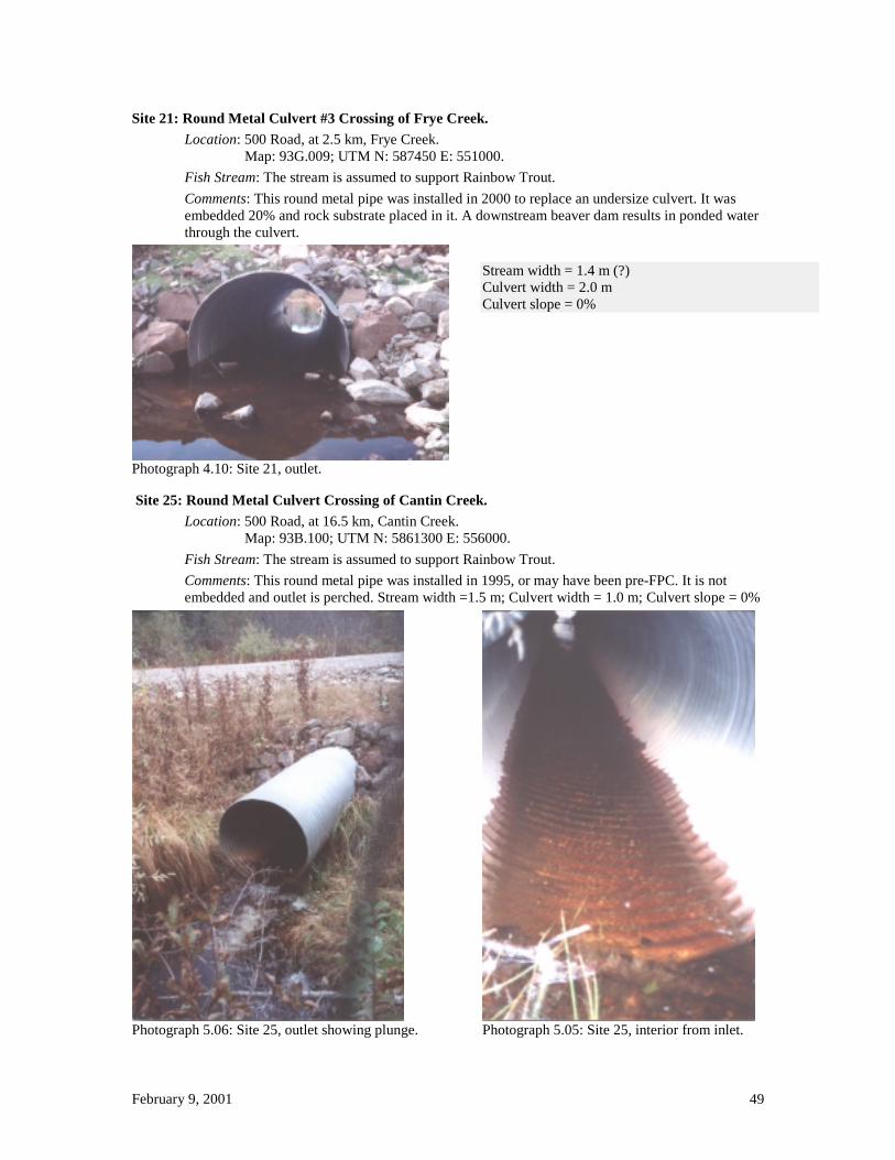
Site 21: Round Metal Culvert #3 Crossing of Frye Creek. Location: 500 Road, at 2.5 km, Frye Creek.
Map: 93G.009; UTM N: 587450 E: 551000. Fish Stream: The stream is assumed to support Rainbow Trout. Comments: This round metal pipe was installed in 2000 to replace an undersize culvert. It was embedded 20% and rock substrate placed in it. A downstream beaver dam results in ponded water through the culvert.
Photograph 4.10: Site 21, outlet.
Stream width = 1.4 m (?) Culvert width = 2.0 m Culvert slope = 0%
Site 25: Round Metal Culvert Crossing of Cantin Creek. Location: 500 Road, at 16.5 km, Cantin Creek.
Map: 93B.100; UTM N: 5861300 E: 556000. Fish Stream: The stream is assumed to support Rainbow Trout. Comments: This round metal pipe was installed in 1995, or may have been pre-FPC. It is not embedded and outlet is perched. Stream width =1.5 m; Culvert width = 1.0 m; Culvert slope = 0%
Photograph 5.06: Site 25, outlet showing plunge.
Photograph 5.05: Site 25, interior from inlet.

February 9, 2001 50
Site 26: Round Metal Culvert Crossing of Benson Creek.
Location: 300 Road, at 22 km, Benson Creek. [93B.100] Map: 93B.100; UTM N: 5864700 E: 561750.
Fish Stream: The stream is known to support Rainbow Trout (observed earlier in the year).
Comments: This round metal pipe was installed in 2000 after a burst beaver dam washed out the road. It was embedded 20% and rock substrate placed in it, and then pool created above and below the culvert (negating the embedding). A downstream beaver dam results in ponded water through the culvert.
Stream width = 1.8 m (?); Culvert width = 1.8 m; Culvert slope = 0%.
Photograph 5.11: Site 26, outlet. Photograph 0.01: Site 26, inlet with “beaver stop”.
Site 27: Round Metal Culvert Crossing of Benson Creek.
Location: 3600 Road, at 21 km, Benson Creek. Map: 93B.100; UTM N: 5866250 E: 562300.
Fish Stream: The stream is known to support Rainbow Trout (observed earlier in the year).
Comments: This embedded round culvert was installed in 1999 and had excessively high current speeds and the substrate in the culvert blocked fish passage at low water (5% culvert gradient, large diameter rip rap, culvert diameter probably too small). A bridge replaced it in 2000.
Stream width = 1.8 m (?); Culvert width = 1.8 m; Culvert slope = 5%.
Photograph 5.11: Site 27, inlet of culvert, fish passage blocked at low water by rock substrate.

February 9, 2001 51
Site 29: Round Metal Culvert Crossing of Alice Creek tributary. Location: 3500 A Road, at 8.2 km, tributary of Alice Creek.
Map: 93G.020; UTM N: 5885250 E: 562800. Fish Stream: The stream is assumed to support Rainbow Trout. Comments: This round metal culvert was installed in 1998, and was then upgraded to eliminate the perched outlet and provide rock substrate within the culvert. Natural bed-load is augmenting the rock the culvert. Stream width = 1.8 m; Culvert width = 1.8 m; Culvert slope = 3%.
Photograph 0.05: Site 29, original 1998 installation showing perched outlet and lack of substrate in the pipe.
Photograph 6.04: Site 29, the culvert outlet in 2000, two years after remedial substrate placement.
Site 30: Round Metal Culvert Crossing of Swift River tributary #1.
Location: 1300 A Road, Branch 10 at 13.2 km, tributary of Swift River. Map: 93B.100; UTM N: 5867350 E: 564450.
Fish Stream: The stream is assumed to support Rainbow Trout.
Comments: This round metal culvert was installed in 1999. Rock substrate was placed in the culvert. Fish passage is impeded at low water. Current speed at high flows may be too high.
Photograph 6.09: Site 30, inlet. Note that large rocks used as substrate impede fish passage. Stream width = 1.4 m Culvert width = 1.4 m; Culvert slope = 2%. Photograph 6.10: Site 30, outlet.
February 9, 2001 52
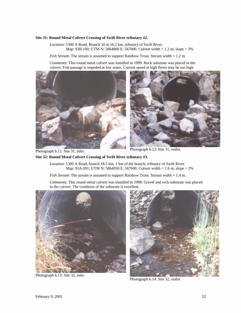
Site 31: Round Metal Culvert Crossing of Swift River tributary #2.
Location: 1300 A Road, Branch 10 at 16.2 km, tributary of Swift River. Map: 93B.100; UTM N: 5864800 E: 567000. Culvert width = 1.2 m; slope = 3%.
Fish Stream: The stream is assumed to support Rainbow Trout. Stream width = 1.2 m
Comments: This round metal culvert was installed in 1999. Rock substrate was placed in the culvert. Fish passage is impeded at low water. Current speed at high flows may be too high.
Photograph 6.11: Site 31, inlet. Photograph 6.12: Site 31, outlet.
Site 32: Round Metal Culvert Crossing of Swift River tributary #3.
Location: 1300 A Road, branch 18.5 km, 1 km of the branch, tributary of Swift River. Map: 93A.091; UTM N: 5864950 E: 567600. Culvert width = 1.6 m; slope = 2%
Fish Stream: The stream is assumed to support Rainbow Trout. Stream width = 1.4 m.
Comments: This round metal culvert was installed in 1998. Gravel and rock substrate was placed in the culvert. The condition of the substrate is excellent.
Photograph 6.13: Site 32, inlet. Photograph 6.14: Site 32, outlet.

February 9, 2001 53
Site 34: Round Metal Culvert Crossing of Bendixon Creek tributary.
Location: 1300 A Road, 30.5 km, tributary of Bendixon Creek. Map: 93A.082; UTM N: 5857200 E: 576700.
Fish Stream: The stream is assumed to support Rainbow Trout.
Comments: This round metal culvert was installed in 1995 or 1996 (possibly pre-FPC). The water is ponded through the pipe.
Photograph 7.02: Site 34, outlet.
Stream width = 1.4 m (?) Culvert width = 1.4 m Culvert slope = 0.5%
Site 35: Round Metal Culvert Crossing of “Gunnysack Creek”.
Location: 1300 A Road, 37 km, “Gunnysack Creek”, tributary of Swift River. Map: 93A.082; UTM N: 5856050 E: 5817600.
Fish Stream: The stream is known to support Rainbow Trout, lake upstream is fished.
Comments: This round metal culvert was installed in 1997. Stream width = 1.2 m; Culvert width = 1.8 m; Culvert slope = 2%.
Photograph 7.03: Site 35, upstream from inlet. Photograph 7.05: Site 35, inlet.

February 9, 2001 54
Site 36: Round Metal Culvert Crossing of Moustique Creek tributary.
Location: 1300 C Road, branch at 10 km, 0.2 km of branch, tributary of Moustique Creek. Map: 93H.001; UTM N: 5874850 E: 569450.
Fish Stream: The stream is known to support Rainbow Trout, by inventory.
Comments: This round metal culvert was installed in 2000. A freshly built beaver dam immediately upstream has contributed to sedimentation.
Photograph 7.07: Site 36, inlet.
Photograph 7.06: Site 36, outlet.
Photograph 7.08: Site 36, inlet.
Stream width = 1.2 m Culvert width = 1.8 m Culvert slope = 0%

February 9, 2001 55
Site 43: Round Metal Culvert Crossing of Australian Creek tributary. Location: 2800 (James Mountain) B Road, Branch 5, 6 km, tributary of Australian Creek.
Map: 93B.069; UTM N: 5836000 E: 542650. Fish Stream: The stream is known to support Rainbow Trout (observed in 1999). Comments: One culvert already existed and had a perched outlet. In 1999 the second culvert (on left) was installed and a weir built at the outlet to the plunge pool, to permit fish passage.
Photograph 8.07: Site 43, retrofitted culvert crossing. Culvert width = 1.6 m ; 1.8 m; Culvert slope = 1%.
Photograph 8.08: Site 43, retrofitted culvert crossing. Stream width = 3.0 m;
Site 49: Round Metal Culvert Crossing of Nyland Lake tributary. Location: 500 D Road, 1 km, tributary of Nyland Lake.
Map: 93B.080; UTM N: 5847800 E: 565700. Culvert slope = 1% Fish Stream: The stream is assumed to support Rainbow Trout. Stream width = 1.2 m Comments: This round metal culvert may have been installed in 1998. Culvert width = 1.0 m
Photograph 9.01: Site 49, inlet.
Photograph 8.25: Site 49, outlet. Note sedimentation.
February 9, 2001 56
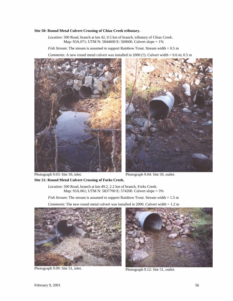
Site 50: Round Metal Culvert Crossing of Chiaz Creek tributary.
Location: 500 Road, branch at km 42, 0.5 km of branch, tributary of Chiaz Creek. Map: 93A.071; UTM N: 5844600 E: 569600. Culvert slope = 1%
Fish Stream: The stream is assumed to support Rainbow Trout. Stream width = 0.5 m
Comments: A new round metal culvert was installed in 2000 (?). Culvert width = 0.6 m; 0.5 m
Photograph 9.03: Site 50, inlet. Photograph 9.04: Site 50, outlet. Site 51: Round Metal Culvert Crossing of Forks Creek.
Location: 500 Road, branch at km 49.2, 2.2 km of branch, Forks Creek. Map: 93A.061; UTM N: 5837700 E: 574200. Culvert slope = 3%
Fish Stream: The stream is assumed to support Rainbow Trout. Stream width = 1.5 m
Comments: The new round metal culvert was installed in 2000. Culvert width = 1.2 m
Photograph 9.09: Site 51, inlet. Photograph 9.12: Site 51, outlet.

February 9, 2001 57
Site 52: Round Metal Culvert Crossing of Birrell Creek.
Location: 500 D Road, branch at km 43.5, 2.4 km of branch, Birrell Creek. Map: 93A.071; UTM N: 5840950 E: 569700.
Fish Stream: The stream is assumed to support Rainbow Trout.
Comments: The new round metal culvert was installed in 2000.
Photograph 10.02: Site 52, inlet. All the water is flowing through a crushed pipe to the right of the new culvert.
Stream width = 0.5 m Culvert width = 0.6 m; 0.4 m Culvert slope = 2%
Site 54: Round Metal Culvert Crossing of Maude Creek tributary. Location: 4900 M Road, branch at km 34, 2.2 km of branch, tributary of Maude Creek.
Map: 93A.061; UTM N: 5839250 E: 580650. Culvert slope = 4% Fish Stream: The stream is assumed to support Rainbow Trout. Stream width = 1.0 m Comments: The round metal culvert was installed in 1999. Culvert width = 4%
Photograph 10.04: Site 54, interior from outlet. Note that much of the substrate has flushed from the outlet end.
Photograph 10.05: Site 54, interior from inlet. Note the substrate has flushed out of the top end of the pipe.

February 9, 2001 58
Site 56: Round Metal Culvert Crossing of Le Bourdais Lake tributary.
SITE DELETED FROM FINAL DRAFT.
The licensee has provided a copy of an assessment (completed prior to structure modification and maintained on licensee files) demonstrating non-fish bearing status.
Site 59: Round Metal Culvert Crossing of Edward Creek tributary. Location: 4900 E Road, branch at 1.9 km, 0.7 km of branch, tributary of Edward Creek.
Map: 93A.081; UTM N: 5851000 E: 577000. Culvert slope = 0% Fish Stream: The stream is assumed to support Rainbow Trout. Stream width = 2.0 m Comments: The culvert was installed in 1998. Culvert width = 2.0 m
Photograph 11.03: Site 59, inlet.
Photograph 11.05: Site 59, sediment from road surface is entering stream (the culvert in right background).

February 9, 2001 59
Site 68: Round Metal Culvert Crossing of Blackwater (= West Road) River tributary.
Location: 8500 Road, Branch 14 (at 14 km), km 0.1 of Branch 14, tributary of Blackwater River. Map: 93G.014; UTM N: 5892150 E: 476200.
Fish Stream: The stream is assumed to support Rainbow Trout.
Comments: This round culvert was installed in 1998.
Photograph 14.05: Site 68, outlet.
Stream width = 0.8 m Culvert width = 1.4 m Culvert slope = 4%
Photograph 14.06: Site 68, interior from inlet.

February 9, 2001 60
Appendix 2b
Pipe-arch Metal Culverts

February 9, 2001 61
Site 7: Pipe-arch Culvert Crossing of Merston Creek tributary. Location: 3400 S Road, 3 km, tributary of Merston Creek.
Map: 93B.066; UTM N: 5837700 E: 506100.
Fish Stream: The stream is assumed to support Rainbow Trout.
Comments: The culvert was embedded 20%, and substrate comprised of gravel and large rock was placed over the entire bottom of the culvert.
Stream width = 1.0 m; Culvert width = 2.0 m; Culvert slope = 2%.
Photograph 15.07: Site 7, outlet. Note that little substrate remains within the culvert.
Photograph 15.06: Site 7, inlet.
Site 9: Pipe-arch Culvert Crossing of Merston Creek tributary.
Location: 3400 S Road, branch at 4 km, 1.0 km of the branch. [93B.076] Map: 93B.076; UTM N: 5837900 E: 506000.
Fish Stream: The stream is known to support Rainbow Trout (observed during review).
Comments: The pipe-arch culvert was embedded 20%, and substrate comprised of gravel and large rock was placed over the bottom of the culvert only at the inlet and outlet (with DEO approval). The culvert bottom is now completely covered with gravel, to about 20% of culvert height, from natural bed-load.
Stream width = 1.0 m; Culvert width = 2.0 m; Culvert slope = 3%.
Photograph 2.07: Site 9, culvert outlet. Note ponding at the outlet resulting from high outlet water velocity.
Photograph 2.06: Site 9, culvert interior (from outlet). Note scouring of substrate at the outlet.

February 9, 2001 62
Site 14: Pipe-arch Culvert Crossing of Trapline (Bradie ?) Creek tributary. Location: 2000 Road, branch at 10 km, 0.2 km of branch, tributary of Trapline (Bradie ?) Creek.
Map: 93B.085; UTM N: 5858350 E: 489000. Fish Stream: The stream is assumed to support Rainbow Trout. Comments: The pipe-arch culvert was installed in 2000, to replace old culverts. The pipe was placed at 0% gradient, and embedded 20%, without substrate being placed in the culvert. The stream is ponded above the culvert. Maps are contradictory regarding stream name.
Photograph 3.: Site 14, outlet. Stream width = 2.0 m Culvert width = 2.0 m Culvert slope = 0%
Photograph 3.: Site 14, interior from outlet. Site 18: Pipe-arch Crossing of Michelle Creek tributary.
Location: 3900 Road, at 8 km, tributary of Michelle Creek. Map: 93B.092; UTM N: 586380 E: 456050.
Fish Stream: The stream is assumed to support Rainbow Trout. Comments: This D-pipe was installed in 1999 to replace an old culvert.
Photograph 4.01: Site 18, outlet (new culvert on right).
Photograph 4.03: Site 18, interior from outlet. Note that the substrate has flushed out of part of the lower end of the culvert; some scouring has occurred below the pipe. Stream width = 1.2 m Culvert width = 1.5 m Culvert slope = 5%

February 9, 2001 63
Site 28: Pipe-arch Culvert Crossing of Stacey Creek tributary.
Location: 3500 A Road, at 6.5 km, tributary of Stacey Creek. Map: 93G.010; UTM N: 591000 E: 562650.
Fish Stream: The stream is assumed to support Rainbow Trout.
Comments: This D-pipe culvert was installed in 2000 to replace an old round culvert. Gravel and rock substrate was placed in the culvert. The substrate is flushing out.
Photograph 5.13: Site 28, outlet. Note that some of the substrate has flushed out despite large rock size. Stream width = 0.5 m Culvert width = 1.5 m Culvert slope = 3% Photograph 6.02: Site 28, inlet. Site 38: Multiplate Pipe-arch Culvert Crossing of Eskridge Creek.
Location: 1300 Road, 14.5 km, Eskridge Creek. Map: 93A.091; UTM N: 5871800 E: 562800.
Fish Stream: The stream is known to support Rainbow Trout, by inventory.
Comments: This pipe-arch culvert had a perched outlet, and a downstream weir was installed in 1998 to permit fish passage. The culvert is probably too small for a 100-year flood.
Photograph 7.13: Site 38, outlet.
Stream width = 5 m Culvert width = 3 m Culvert slope = 5%

February 9, 2001 64
Site 39: Multiplate Pipe-arch Culvert Crossing of Sovereign Creek tributary.
Location: 1300 Road, 16 km, Sovereign Creek tributary. [93A.091] Map: 93A.091; UTM N: 5871600 E: 574250.
Fish Stream: The stream is known to support Rainbow Trout, by inventory.
Comments: This pipe-arch culvert had a perched outlet, and a weir was installed in 1998 to permit fish passage. The culvert is probably too small for a 100-year flood.
Photograph 8.02: Site 39, outlet.
Stream width = 2.7 m Culvert width = 2.3 m Culvert slope = 2%
Site 40: Multiplate Pipe-arch Culvert Crossing of Sovereign Creek.
Location: 1300 Road, 19.5 km, Sovereign Creek. Map: 93A.091; UTM N: 5870200 E: 577050.
Fish Stream: The stream is known to support Rainbow Trout, by inventory.
Comments: This pipe-arch culvert had a perched outlet, and a weir was installed in 1998 to permit fish passage. The culvert is probably too small for a 100-year flood.
Photograph 8.03: Site 40,
Stream width = 4 m Culvert width = 3.5 m Culvert slope = 2%
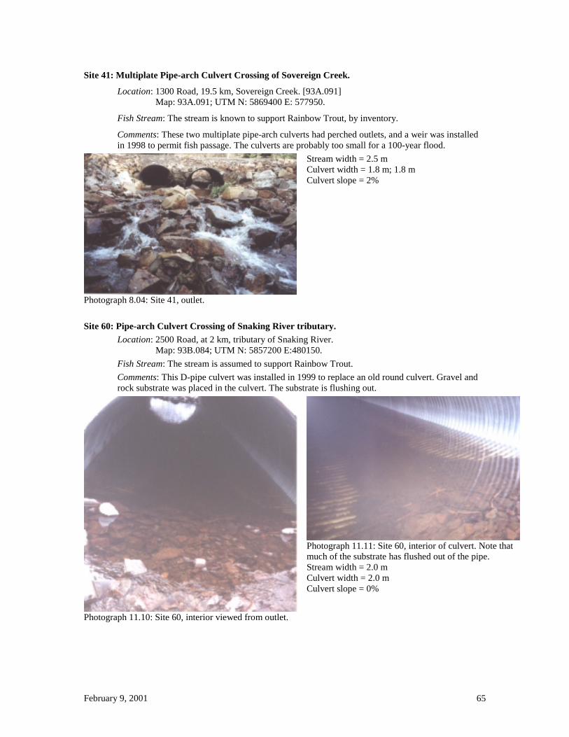
February 9, 2001 65
Site 41: Multiplate Pipe-arch Culvert Crossing of Sovereign Creek.
Location: 1300 Road, 19.5 km, Sovereign Creek. [93A.091] Map: 93A.091; UTM N: 5869400 E: 577950.
Fish Stream: The stream is known to support Rainbow Trout, by inventory.
Comments: These two multiplate pipe-arch culverts had perched outlets, and a weir was installed in 1998 to permit fish passage. The culverts are probably too small for a 100-year flood.
Photograph 8.04: Site 41, outlet.
Stream width = 2.5 m Culvert width = 1.8 m; 1.8 m Culvert slope = 2%
Site 60: Pipe-arch Culvert Crossing of Snaking River tributary.
Location: 2500 Road, at 2 km, tributary of Snaking River. Map: 93B.084; UTM N: 5857200 E:480150.
Fish Stream: The stream is assumed to support Rainbow Trout. Comments: This D-pipe culvert was installed in 1999 to replace an old round culvert. Gravel and rock substrate was placed in the culvert. The substrate is flushing out.
Photograph 11.10: Site 60, interior viewed from outlet.
Photograph 11.11: Site 60, interior of culvert. Note that much of the substrate has flushed out of the pipe. Stream width = 2.0 m Culvert width = 2.0 m Culvert slope = 0%

February 9, 2001 66
Site 61: Pipe-arch Culvert Crossing of Snaking River tributary.
Location: 2500 Road, at 4.3 km, tributary of Snaking River. Map: 93B.084; UTM N: 5856600 E:477800.
Fish Stream: The stream is assumed to support Rainbow Trout.
Comments: This D-pipe culvert was installed in 1999 to replace an old round culvert. Gravel and rock substrate was placed in the culvert. The roadbed failed and slid into the outlet.
Photograph 11.13 (above): Site 61, culvert outlet with roadbed failure. Photograph 11.12 (to right): Site 61, culvert outlet partly filled with roadbed material. Stream width = 0.9 m Culvert width = 2.0 m; Culvert slope = 2%
Site 62: Pipe-arch Culvert Crossing of Fraser River tributary.
Location: Marshall Road, at 1.7 km, tributary of Fraser River. Map: 93G.017; UTM N: 5887300 E:516200.
Fish Stream: The stream is assumed to support Rainbow Trout.
Comments: This D-pipe culvert was installed in 2000. Gravel and rock substrate was placed in the culvert. Stream width = 1.0 m; Culvert with = 1.6 m; Culvert slope = 4%
Photograph 15.10: Site 62, culvert inlet. Photograph 15.12: Site 62, culvert interior, from inlet.

February 9, 2001 67
Site 63: Pipe-arch Culvert Crossing of Fraser River tributary. Location: Marshall Road, at 3.2 km, tributary of Fraser River.
Map: 93G.017; UTM N: 5888300 E:515100.
Fish Stream: The stream is assumed to support Rainbow Trout.
Comments: This D-pipe culvert was installed in 2000. Gravel and rock substrate was placed in the culvert.
Photograph 13.01: Site 63, inlet. Stream width = 1.0 m Culvert width = 1.6 m Culvert slope = 1%
Photograph 13.03: Site 63, interior from inlet.
Site 65: Pipe-arch Culvert Crossing of Fraser River tributary. Location: 11 L Road, at 2.8 km, tributary of Fraser River.
Map: 93G.026; UTM N: 5901350 E:508350. Culvert slope = 3%. Fish Stream: The stream is assumed to support Rainbow Trout. Stream width = 1.2 m Comments: This D-pipe culvert was installed in 1999. Culvert width = 1.4 m
Photograph 13.08: Site 65, inlet. Photograph 13.09: Site 65, interior from inlet.

February 9, 2001 68
Site 66: Pipe-arch Culvert Crossing of Fraser River tributary.
Location: 11 L Road, branch at 2.9 km, 3.1 km on the branch, tributary of Fraser River. Map: 93G.026; UTM N: 5901700 E:507900. Culvert slope = 3%.
Fish Stream: The stream is assumed to support Rainbow Trout.
Comments: This D-pipe culvert was installed in 1999.
Photograph 13.12: Site 66, inlet. Photograph 13.11: Site 66, interior from outlet. Stream width = 0.8 m; Culvert width = 1.2 m; Culvert slope = 0%

February 9, 2001 69
Appendix 2c
Baffled Round Metal Culverts

February 9, 2001 70
Site 5: Baffled Culvert Crossing of Merston Creek tributary.
Location: 3400 Road, 61 km, tributary to Merston Creek. Map: 93B.066; UTM N: 5835150 E: 504000.
Fish Stream: This site has an observed high density of young Rainbow Trout.
Comments: A baffled culvert was installed because the site is on a corner, and hence a costly double-wide bridge would have been required. In addition, the pond (rearing habitat) above the site is actually formed by the roadbed, and the “streambed” at the site had been formed through erosion of the roadbed when the original culvert washed out. The baffles form barriers across the bottom of the culvert, and stabilise the gravel/round rock substrate within the culvert. High spring current velocities probably impede adult Rainbow Trout upstream movement during spawning season, and also result in the finer substrate washing out. The baffles may form an impediment to upstream movement of small fish during low water, once the spring flows have washed out some of the substrate.
Stream width = 2.0 m; Culvert width = 2.4 m; Culvert slope = 8%.
Photograph 0.09: Site 5, interior from outlet, Sept. 1998. Photograph 15.03: Site 5, interior from outlet, Oct. 2000.
Photograph 15.02: Site 5, outlet, Oct. 2000.
Photograph 12.13: Site 5, inlet, Oct. 2000.
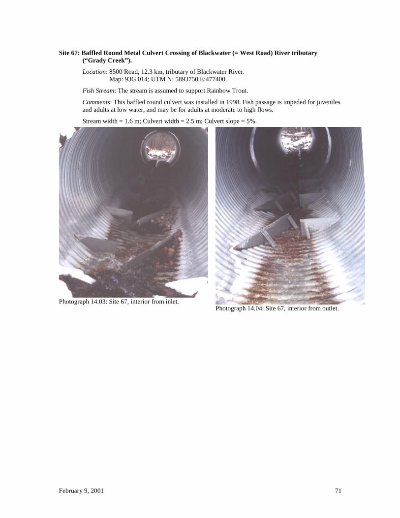
February 9, 2001 71
Site 67: Baffled Round Metal Culvert Crossing of Blackwater (= West Road) River tributary (“Grady Creek”).
Location: 8500 Road, 12.3 km, tributary of Blackwater River. Map: 93G.014; UTM N: 5893750 E:477400.
Fish Stream: The stream is assumed to support Rainbow Trout.
Comments: This baffled round culvert was installed in 1998. Fish passage is impeded for juveniles and adults at low water, and may be for adults at moderate to high flows.
Stream width = 1.6 m; Culvert width = 2.5 m; Culvert slope = 5%.
Photograph 14.03: Site 67, interior from inlet. Photograph 14.04: Site 67, interior from outlet.

February 9, 2001 72
Site 72: Baffled Round Metal Culvert Crossing of “Axel Creek”, tributary of Narcosli Creek.
Location: 10A Road, Branch at 4 km, km 1 of Branch, “Axel” Creek (tributary of Narcosli Creek). Map: 93B.077; UTM N: 5842200 E:521600.
Fish Stream: The stream is known to support Rainbow Trout, by inventory.
Comments: This baffled culvert was installed in 1998. It was not examined for this report, however current speeds have been found to be too high and a prescription is in place to backwater the culvert with a downstream weir.
Photograph 0.16: Site 72, inlet during installation. Photograph 0.17: Site 72, outlet at end of installation.
Photograph 0.18: Site 72, inlet during installation.
Stream width = 3.0 m (?) Culvert width = 3.0 m (?) Culvert slope = 3% (?)

February 9, 2001 73
Appendix 2d
Mini-span Culverts

February 9, 2001 74
Site 8: Mini-span Crossing of Merston Creek tributary. Location: 3400 S Road, branch at 3.1 km, 0.5 km of the branch.
Map: 93B.066; UTM N: 5837800 E: 506800.
Fish Stream: The stream is assumed to support Rainbow Trout.
Comments: This mini-span (open-bottom metal culvert with struts across the bottom) had substrate comprised of angular gravel and angular large rock placed over the entire bottom to cover the cross-struts. Poor ditch maintenance and lack of a ditch cross-drain resulted in substantial additional water volume passing through the structure, as well as sedimentation [problem now corrected]. About half of the substrate, both gravel and large rocks, has washed out of the culvert.
Stream width = 0.5 m; Culvert width = 3.0 m; Culvert slope = 2%.
Photograph 0.14: Site 8, mini-span installation in 1998.
Photograph 2.02: Site 8, interior from inlet, showing eroded substrate. P
hotograph 2.04: Site 8, ditchline leading to the inlet.

February 9, 2001 75
Appendix 2e
Arches - Bottomless

February 9, 2001 76
Site 45: Open-bottom Arch Crossing of Quesnel River tributary. Location: 500 J Road, 10.2 km, tributary of Quesnel River.
Map: 93B.080; UTM N: 5843000 E: 562400. Fish Stream: The stream is assumed to support Rainbow Trout. Comments: This arch was installed in 1998. Stream width = 1.5 m; Culvert width = 3.5 m; Culvert slope = 4%
Photograph 8.11: Site 45, inlet. Photograph 8.12: Site 45, interior from inlet.
Site 46: Open-bottom Arch Crossing of Chiaz Creek tributary. Location: 500 D Road, 3.1 km, tributary of Chiaz Creek.
Map: 93B.080; UTM N: 5846000 E: 566500. Fish Stream: The stream is assumed to support Rainbow Trout. Stream width = 1.0 m Comments: This arch was installed in 1998.Culvert width = 3.5 m; Culvert slope = 5%
Photograph 8.14: Site 46, inlet.
Photograph 8.16: Site 46, inlet.

February 9, 2001 77
Site 47: Open-bottom Arch Crossing of Chiaz Creek tributary.
Location: 500 D Road, 4.5 km, tributary of Chiaz Creek. Map: 93B.080; UTM N: 5844900 E: 566700.
Fish Stream: The stream is assumed to support Rainbow Trout. Stream width = 1.3 m
Comments: This arch was installed in 1998. Culvert width = 3.5 m; Culvert slope = 5%
Photograph 8.18: Site 47, inlet. Photograph 8.19: Site 47, interior from inlet. The full width of the arch near the outlet is floodplain.
Site 48: Open-bottom Arch Crossing of Chiaz Creek tributary.
Location: 500 D Road, branch at km 2, km 4.5 of branch, tributary of Chiaz Creek. Map: 93B.080; UTM N: 5845200 E: 565700.
Fish Stream: The stream is assumed to support Rainbow Trout. Stream width = 1.3 m.
Comments: This arch was installed in 1998. Culvert width = 3.5 m; Culvert slope = 5%
Photograph 0.01: Site 48, inlet. Photograph 0.01: Site 48, interior from inlet.

February 9, 2001 78
Appendix 2f
Fords

February 9, 2001 79
Site 4: ATV Ford Crossing of Merston Creek tributary. Location: 3400 T Road, 3 km, unnamed tributary of Merston Creek.
Map: 93B.066; UTM N: 5837990 E: 500300. Fish Stream: The stream was observed to support Rainbow Trout during the site visit. Comments: Ford armoured after my first visit, and the unarmoured cross-ditch installed. The cross-ditch is likely to deliver sediment into the stream during spring run-off. Stream width = 2.0 m; Ford width = 2.0 m
Photograph 12.10: Site 4, armoured ford for ATVs. Photograph 12.12: Site 4, cross-ditch above the stream. Sediment will be delivered directly into the stream.

February 9, 2001 80
Site 37: Ford Crossing of tributary of Moustique Creek.
Location: 1300 C Road, 11.5 km, tributary of Moustique Creek. Map: 93H.001; UTM N: 5874800 E: 569900.
Fish Stream: Rainbow Trout known at this site through inventory.
Comments: Pond and potential spawning habitat above the crossing site. The old culvert was plugged by beaver, resulting in the road washing out. The road is not presently used by the forest industry. As a result the washed out culvert was initially replaced by an unsuitable ford, which was then modified to permit fish passage and the road blocked to all except ATV traffic to minimise sedimentation.
Stream width = 1.2 m; Ford width = 1.0 m.
Photograph 0.01: Site 37, washed out culvert (beaver plugged).
Photograph 7.12: Site 37, ford blocking fish passage from use of uncompacted rock.
Photograph 7.10: Site 37, upstream view of ford showing rocks blocking fish passage.
Photograph 0.02: Site 37, ford modified to permit fish passage (current speed at peak flows may be an issue). Pickup access to the ford has been blocked to prevent sedimentation..

February 9, 2001 81
Appendix 2g
Bridges

February 9, 2001 82
Site 1: Bridge Crossing of Merston Creek. Location: 3700 Road (signed as 1700 Road), km 0.7, Merston Creek.
Map: 93B.086; UTM N: 5859450 E: 501200.
Fish Stream: Merston Creek is known to support Rainbow Trout and Chinook Salmon.
Comments: This bridge replaced a pre-FPC bridge across Merston Creek.
Photograph 12.03: Site 1, bridge across Merston Creek.
Site 2: Bridge Crossing of Mount Creek.
Location: 3700 Road (signed as 1700 Road), 7.8 km, Mount Creek. Map: 93B.086; UTM N: 5855790 E: 505200.
Fish Stream: Mount Creek is known to support Rainbow Trout.
Comments: This bridge replaced a pre-FPC bridge across Mount Creek. There is excessive riprap in the channel.
Photograph 12.06: Site 2, bridge across Mount Creek. The shadow of the bridge obscures the rip rap scattered across the entire width of the channel under the bridge.
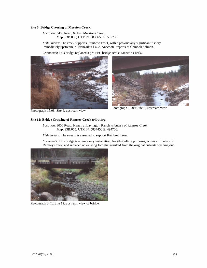
February 9, 2001 83
Site 6: Bridge Crossing of Merston Creek.
Location: 3400 Road, 60 km, Merston Creek. Map: 93B.066; UTM N: 5835650 E: 505750.
Fish Stream: The creek supports Rainbow Trout, with a provincially significant fishery immediately upstream in Tzenzaikut Lake. Anecdotal reports of Chinook Salmon.
Comments: This bridge replaced a pre-FPC bridge across Merston Creek.
Photograph 15.08: Site 6, upstream view. Photograph 15.09: Site 6, upstream view.
Site 12: Bridge Crossing of Ramsey Creek tributary.
Location: 9000 Road, branch at Lavington Ranch, tributary of Ramsey Creek. Map: 93B.065; UTM N: 5834450 E: 494700.
Fish Stream: The stream is assumed to support Rainbow Trout.
Comments: This bridge is a temporary installation, for silviculture purposes, across a tributary of Ramsey Creek, and replaced an existing ford that resulted from the original culverts washing out.
Photograph 3.01: Site 12, upstream view of bridge.

February 9, 2001 84
Site 13: Bridge Crossing #1 of Trapline (Bradie ?) Creek.
Location: 2000 Road, branch at 9 km, 0.2 km of branch, Trapline (Bradie ?)Creek. Map: 93B.085; UTM N: 5858600 E: 490500.
Fish Stream: The stream is assumed to support Rainbow Trout.
Comments: This bridge is a temporary installation. Maps are contradictory regarding stream name.
Photograph 3.03: Site 13, upstream view of bridge.
.
Site 15: Bridge Crossing #2 of Trapline (Bradie ?) Creek.
Location: 2100 Road, at 1.8 km, Trapline (Bradie ?) Creek. Map: 93B.085; UTM N: 5853800 E: 488030.
Fish Stream: The stream is assumed to support Rainbow Trout.
Comments: This bridge is a permanent installation. Maps are contradictory regarding stream name.
Photograph 3.06: Site 15, upstream view of bridge.

February 9, 2001 85
Site 22: Bridge Crossing of Frye Creek.
Location: 500 Road, at 4.6 km (0.2 km past 300 Road), Frye Creek. [93G.009] Map: 93G.009; UTM N: 5873200 E: 552500.
Fish Stream: The stream is assumed to support Rainbow Trout.
Comments: This bridge is for ATV and snowmobile use. It is made from an old semi-trailer deck, and spans most of the floodplain with a braided channel.
Photograph 4.11: Site 22, upstream side.

February 9, 2001 86
Site 24: Bridge Crossing of Gerimi Creek.
Location: 500 Road, at 20.5 km, Gerimi Creek. Map: 93B.090; UTM N: 5859650 E: 557850.
Fish Stream: The stream is known to support Rainbow Trout.
Comments: This bridge was installed in 1999 to replace an undersize baffled culvert. Channel width between rip rap is 1.7 meters, channel width of stream is 2.5 meters.
Photograph 5.04: Site 24, bridge from upstream side. Note the unusual height and length of the bridge.
Photograph 5.01: Site 24, stream channel under the bridge, viewed from above the bridge. Note the highly constrained channel and steep rip rap armouring.
Photograph 5.02, Site 24, rip rap slipped into channel. Note white clipboard for scale.

February 9, 2001 87
Site 27: Bridge Crossing of Benson Creek.
Location: 3600 Road, at 21 km, Benson Creek. Map: 93B.100; UTM N: 5866250 E: 562300.
Fish Stream: The stream is known to support Rainbow Trout (observed earlier in the year).
Comments: This bridge was installed in 2000 to replace an embedded round culvert (installed 1999) that had excessively high current speeds and in which the substrate blocked fish passage at low water (5% culvert gradient, large diameter rip rap, culvert diameter probably too small).
Photograph 5.11: Site 27, view from upstream.
Site 33: Bridge Crossing of Bendixon Creek.
Location: 1300 A Road, 29.5 km, Bendixon Creek. Map: 93A.081; UTM N: 5857800 E: 576200.
Fish Stream: The stream is known to support Rainbow Trout.
Comments: This bridge was installed in 1997.
Photograph 7.01: Site 33, bridge from downstream.

February 9, 2001 88
Site 42: Bridge Crossing of Alix Creek.
Location: 2800 (James Mountain) A Road, branch at 6 km, 0.2 km of the branch, Alix Creek. Map: 93B.069; UTM N: 5831950 E: 540000.
Fish Stream: The stream is assumed to support Rainbow Trout.
Comments: This bridge was installed in 1999. The stream is beaver ponded.
Photograph 8.05: Site 42, upstream view.
Site 44: Bridge Crossing of stream north of Circle Creek, Quesnel River tributary.
Location: 1800 (French) Road, Branch 10, 0.8 km, “Circle” Creek. Map: 93B.079; UTM N: 5849200 E: 553550.
Fish Stream: The stream is assumed to support Rainbow Trout.
Comments: This bridge was installed in 1998.
Photograph 8.09: Site 44, upstream view.
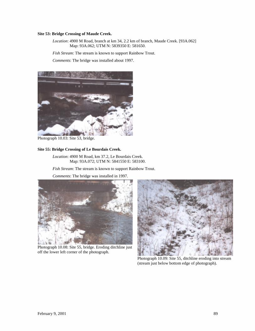
February 9, 2001 89
Site 53: Bridge Crossing of Maude Creek.
Location: 4900 M Road, branch at km 34, 2.2 km of branch, Maude Creek. [93A.062] Map: 93A.062; UTM N: 5839350 E: 581650.
Fish Stream: The stream is known to support Rainbow Trout.
Comments: The bridge was installed about 1997.
Photograph 10.03: Site 53, bridge.
Site 55: Bridge Crossing of Le Bourdais Creek.
Location: 4900 M Road, km 37.2, Le Bourdais Creek. Map: 93A.072; UTM N: 5841550 E: 583100.
Fish Stream: The stream is known to support Rainbow Trout.
Comments: The bridge was installed in 1997.
Photograph 10.08: Site 55, bridge. Eroding ditchline just off the lower left corner of the photograph.
Photograph 10.09: Site 55, ditchline eroding into stream (stream just below bottom edge of photograph).

February 9, 2001 90
Site 57: Bridge Crossing of Victoria Creek.
Location: 4900 E Road, 0.5 km, Victoria Creek. Map: 93A.071; UTM N: 5849000 E: 577300.
Fish Stream: The stream is known to support Rainbow Trout and Chinook Salmon.
Comments: The bridge was installed in 1998.
Photograph 10.12: Site 57, bridge. The logjam is downstream of the bridge, and hence is not of concern.
Site 58: Bridge Crossing of Edward Creek.
Location: 4900 E Road, branch at 1.9 km, 0.5 km of branch, Edward Creek. Map: 93A.081; UTM N: 5851000 E: 576800.
Fish Stream: The stream is known to support Rainbow Trout and Chinook Salmon.
Comments: The bridge was installed in 1998.
Photograph 10.13: Site 58,

February 9, 2001 91
Site 64: Bridge Crossing of Fraser River tributary.
Location: Marshall Road, at 5 km, tributary of Fraser River. Map: 93G.017; UTM N: 5891000 E: 514550.
Fish Stream: The stream is assumed to support Rainbow Trout.
Comments: This bridge was installed in 2000.
Photograph 13.05: Site 64, view from upstream.
Site 69: Bridge Crossing of Blackwater (= West Road) River tributary.
Location: 8500 Road, km 17.3, tributary of Blackwater River. Map: 93G.014; UTM N: 5892800 E: 473950.
Fish Stream: The stream is known to support Rainbow Trout, by inventory.
Comments: This bridge was installed in 1998.
Photograph 14.08: Site 69, view from upstream.

February 9, 2001 92
Site 70: Bridge Crossing of Blackwater (= West Road) River tributary. Location: 8500 Road, km 24, tributary of Blackwater River.
Map: 93G.013; UTM N: 5892000 E: 469500. Fish Stream: The stream is known to support Rainbow Trout, by inventory. Comments: This bridge was installed in 2000.
Photograph 14.09: Site 70,
Site 71: Bridge Crossing of Trapline (Bradie?) Creek. Location: 1700 Road, km 14, Trapline (Bradie?) Creek.
Map: 93B.085; UTM N: 5852700 E: 496400. Fish Stream: The stream is known to support Rainbow Trout, by inventory. Comments: This bridge was installed in 2000. Maps are contradictory regarding stream name.
Photograph 16.02+03: Site 71, view from upstream.
Photograph 16.04: Site 71, base of abutment armouring.

February 9, 2001 93
Site 74: Bridge Crossing of Porter Creek tributary.
Location: 4900 X Road, km 3.8 of X Road, tributary of Porter Creek. Map: 93A.072; UTM N: 5849900 E: 591400.
Fish Stream: The stream is assumed to support Rainbow Trout and Bull Trout.
Comments: This temporary bridge was installed in 2000.
Photograph 16.05: Site 74, view from downstream.