final soil contamination report soil contamination report building m232-236, mcb camp lejeune, north...
TRANSCRIPT

ne
FINAL SOIL CONTAMINATION REPORT
BUILDINGS M232-236
NCDENR Incident Number: 9593 Marine Corps Base
Camp Lejeune, North Carolina
August 29, 2008
Prepared for:
Ms. Lori Reuther Marine Corps North Carolina IPT Naval Facilities Engineering Command Mid-Atlantic 6506 Hampton Blvd Norfolk, VA 23508-1278
Ms. Johanna Arnold I&E/EMD/EQB Building 12, Post Lane MCB Camp Lejeune, NC 28542
Prepared by:
Sovereign Consulting Inc. 405 Oakmears Crescent, Suite 1 Virginia Beach, VA 23462
Contract Number: N62470-04-D-0205
Task Order: 0019
FINAL Soil Contamination Report Building M232-236, MCB Camp Lejeune, North Carolina
August 2008
TABLE OF CONTENTS
EXECUTIVE SUMMARY ______________________________________________ 1
1.0 TITLE PAGE ________________________________________________________2
2.0 INTRODUCTION ____________________________________________________3
3.0 SITE HISTORY______________________________________________________3
4.0 SOIL INVESTIGATION ______________________________________________4
5.0 CONCLUSIONS AND RECOMMENDATIONS __________________________5
6.0 REFERENCES ______________________________________________________6
TABLES TABLE 1 SUMMARY OF SOIL SAMPLING RESULTS – TPH DRO/GRO TABLE 2 SUMMARY OF GROUNDWATER SAMPLING RESULTS – EPA
METHOD 602 TABLE 3 SUMMARY OF GROUNDWATER SAMPLING RESULTS – EPA
METHOD 625 TABLE 4 SUMMARY OF GROUNDWATER SAMPLING RESULTS –
METHOD VPH/EPH TABLE 5 SUMMARY OF GROUNDWATER SAMPLING RESULTS –
METHOD VPH/EPH AS COMPARED TO NCGWQSs
FIGURES
FIGURE 1 GENERAL VICINITY TOPOGRAPHIC SITE MAP FIGURE 2 SITE MAP WITH SOIL SAMPLE RESULTS – TPH-DRO/GRO FIGURE 3 SITE MAP WITH GROUNDWATER RESULTS – EPA METHOD 602 FIGURE 4 SITE MAP WITH GROUNDWATER RESULTS – EPA METHOD 625 FIGURE 5 SITE MAP WITH GROUNDWATER RESULTS – METHOD VPH/EPH

FINAL Soil Contamination Report Building M232-236, MCB Camp Lejeune, North Carolina
August 2008
APPENDICES
APPENDIX A BORING LOGS APPENDIX B LABORATORY REPORTS AND CHAIN OF CUSTODY
DOCUMENTATION

FINAL Soil Contamination Report Building M232-236, MCB Camp Lejeune, North Carolina
August 2008
LIST OF ACRONYMS 2000 Guidelines Groundwater Section Guidelines for Investigation and Remediation of Soil
and Groundwater 2001 Guidelines Guidelines for Assessment and Corrective Action, North Carolina
Underground Storage Tank Section (Effective July 1, 2001) 2L GWQS NCAC T15A:02L Groundwater Quality Standards
AS Air Sparge AST Aboveground Storage Tank BDL Below Detection Limit BN Base/Neutral (extractables) BNA Base/Neutral/Acid (extractables) BQL Below Quantitation Limit BLS Below Land Surface BTEX Benzene, Toluene, Ethylbenzene, Xylenes CAP Corrective Action Plan CFR Code of Federal Regulations Cr Chromium CSA Comprehensive Site Assessment DIPE Di-isopropyl Ether DO Dissolved Oxygen DOD Department of Defense DPT Direct Push Technology DWQ Division of Water Quality DWM Division of Waste Management DTW Depth to Water EDB Ethylene di-bromide EMD Environmental Management Division EPA Environmental Protection Agency EPH Extractable Petroleum Hydrocarbons EQB Environmental Quality Branch Fe Iron FID Flame Ionization Detector FT Feet GCL Gross Contaminant Level GIS Geographic Information System GPS Global Positioning System Guidelines Vol. II Groundwater Section Guidelines for Investigation and Remediation of Soil
and Groundwater, Volume II, Petroleum Underground Storage Tanks (January 2, 1998)
HDPE High Density Polyethylene I/C Industrial/Commercial ID Identification I&E Installations and Environment Department IGWQS Interim Groundwater Quality Standards IPE Isopropyl Ether LSA Limited Site Assessment LUST Leaking Underground Storage Tank m Meter MADEP Massachusetts Department of Environmental Protection MCAS Marine Corps Air Station MCB Marine Corps Base
FINAL Soil Contamination Report Building M232-236, MCB Camp Lejeune, North Carolina
August 2008
MDL Method Detection Limit mg/Kg Milligrams per Kilogram mg/L Milligrams per Liter MSCC Maximum Soil Contaminant Concentration MSL Mean Sea Level MTBE Methyl tertiary butyl ether µg/Kg Micrograms per Kilogram µg/L Micrograms per Liter NA Not Analyzed N/A Not Applicable NAVFAC Naval Facilities Engineering Command Atlantic NC North Carolina NCAC North Carolina Administrative Code NCDENR North Carolina Department of Environment and Natural Resources ND Not Detected NE None Established NM Not Measured NMT No Measurable Thickness NS Not Sampled OVA Organic Vapor Analyzer PAH Polynuclear Aromatic Hydrocarbons Pb Lead PPB Parts Per Billion PPM Parts Per Million PID Photo Ionization Detector PQL Practical Quantitation Limit PVC Polyvinyl chloride RBCA Risk-Based Corrective Action RCRA Resource Conservation and Recovery Act Res Residential SOW Scope of Work STGW Soil-to-Groundwater SVE Soil Vapor Extraction SVOC Semi Volatile Organic Compound TCLP Toxicity Characteristic Leaching Procedure TIC Tentatively Identified Compound TOC Top of Casing TPH Total Petroleum Hydrocarbons US United States USCS Unified Soil Classification System USEPA United States Environmental Protection Agency USGS United States Geological Survey UST Underground Storage Tank VOC Volatile Organic Compounds VPH Volatile Petroleum Hydrocarbons WiRO NCDENR Wilmington Regional Office
FINAL Soil Contamination Report Building M232-236, MCB Camp Lejeune, North Carolina
August 2008
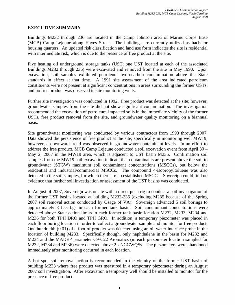
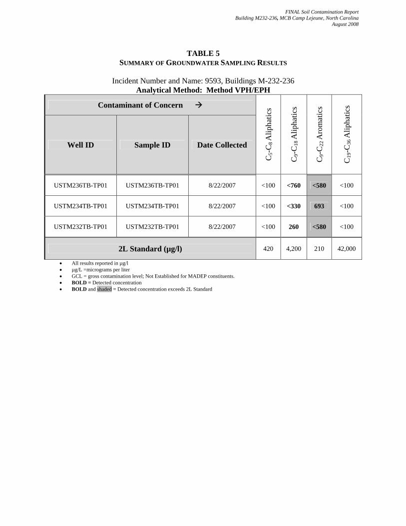
EXECUTIVE SUMMARY Buildings M232 through 236 are located in the Camp Johnson area of Marine Corps Base (MCB) Camp Lejeune along Hayes Street. The buildings are currently utilized as bachelor housing quarters. An updated risk classification and land use form indicates the site is residential with intermediate risk, which is due to the presence of free product at the site. Five heating oil underground storage tanks (UST; one UST located at each of the associated Buildings M232 through 236) were excavated and removed from the site in May 1990. Upon excavation, soil samples exhibited petroleum hydrocarbon contamination above the State standards in effect at that time. A 1991 site assessment of the area indicated petroleum constituents were not present at significant concentrations in areas surrounding the former USTs, and no free product was observed in site monitoring wells. Further site investigation was conducted in 1992. Free product was detected at the site; however, groundwater samples from the site did not show significant contamination. The investigation recommended the excavation of petroleum-impacted soils in the immediate vicinity of the former USTs, free product removal from the site, and groundwater quality monitoring on a biannual basis. Site groundwater monitoring was conducted by various contractors from 1993 through 2007. Data showed the persistence of free product at the site, specifically in monitoring well MW19; however, a downward trend was observed in groundwater contaminant levels. In an effort to address the free product, MCB Camp Lejeune conducted a soil excavation event from April 30 – May 2, 2007 in the MW19 area, which is adjacent to UST basin M235. Confirmation soil samples from the MW19 soil excavation indicate that contaminants are present above the soil to groundwater (STGW) maximum soil contaminant concentrations (MSCCs), but below the residential and industrial/commercial MSCCs. The compound 4-isopropyltoluene was also detected in the soil samples, for which there are no established MSCCs. Sovereign could find no evidence that further soil investigation or assessment of the UST basins was conducted. In August of 2007, Sovereign was onsite with a direct push rig to conduct a soil investigation of the former UST basins located at building M232-236 (excluding M235 because of the Spring 2007 soil removal action conducted by Osage of VA). Sovereign advanced 5 soil borings to approximately 8 feet bgs in each former tank basin. Soil contaminant concentrations were detected above State action limits in each former tank basin location M232, M233, M234 and M236 for both TPH DRO and TPH GRO. In addition, a temporary piezometer was placed in each floor boring location in order to collect a groundwater sample and monitor for free product. One hundredth (0.01) of a foot of product was detected using an oil water interface probe in the location of building M233. Specifically though, only naphthalene in the basin for M232 and M234 and the MADEP parameter C9-C22 Aromatics (in each piezometer location sampled for M232, M234 and M236) were detected above 2L NCGWQSs. The piezometers were abandoned immediately after monitoring occurred in each location. A hot spot soil removal action is recommended in the vicinity of the former UST basin of building M233 where free product was measured in a temporary piezometer during an August 2007 soil investigation. After excavation a temporary well should be installed to monitor for the presence of free product.
1
FINAL Soil Contamination Report Building M232-236, MCB Camp Lejeune, North Carolina
August 2008
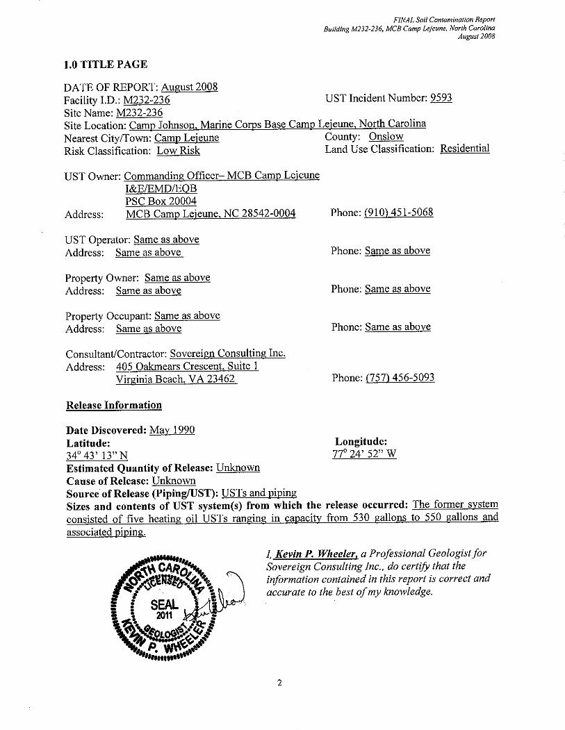
2.0 INTRODUCTION The purpose of this report is to summarize data from a soil sampling investigation conducted in the fall of 2007 in order to investigate the basins of the former underground storage tanks associated with Buildings M232 through M236. Data for Sovereign’s August 2007 soil investigation are presented in this report.
3.0 SITE HISTORY Buildings M232 through M236 are located along Hayes Street within Camp Johnson, which is aboard MCB Camp Lejeune in Onslow County, North Carolina. The buildings are currently used as bachelors’ quarters for military personnel. A shallow drainage ditch is present between the eastern wall of Buildings M232 through M236 and Hayes Street. The nearest mapped surface water bodies are the New River, located approximately 650 feet west of the site, and Northeast Creek, located approximately 850 feet southeast of the site. There are no potable water supply wells located within 1,500 feet of the site. Five heating oil USTs (one UST located at each of the associated Buildings M232 through 236) were excavated and removed from the site in May 1990. The USTs ranged in capacity from 530-gallons to 550-gallons and were in service from 1942 to the late 1980s. Upon UST removal, petroleum hydrocarbons were detected in the site soils. To define the extent of soil and groundwater contamination, site assessments were performed in 1991 and 1992. The 1991 site assessment included soil borings and the installation of 7 shallow aquifer monitoring wells with total depths of approximately 15 feet below ground surface [bgs], and seven intermediate wells with total depths of approximately 30 feet bgs. The wells were installed in pairs. Analysis of soil and groundwater indicated petroleum constituents were not present at significant concentrations in areas surrounding the former USTs, and no free product was observed in site monitoring wells. The report recommended, however, that the UST excavations be remediated to eliminate the potential for future risk. This recommendation was made since previous sampling data indicated the presence of petroleum hydrocarbons in the tank basins. As a result, additional investigation activities were conducted in 1992. The investigation included the installation of three surficial aquifer monitoring wells, each to total depths of approximately 15 feet bgs. No constituents were detected in groundwater samples collected from the three newly installed wells. Free product, however, was observed in monitoring well MW03 at a thickness of 0.12 foot. No measurable free product was identified in any other site well. It was recommended to excavate petroleum-impacted soils in the immediate vicinity of the former USTs, conduct free product removal from well MW03 using manual bailing, and monitor groundwater quality on a biannual basis. Upon review of the available reports, five monitoring wells were reportedly installed at locations adjacent to the former UST locations sometime between April 1998 and August 1999. In
3
FINAL Soil Contamination Report Building M232-236, MCB Camp Lejeune, North Carolina
August 2008
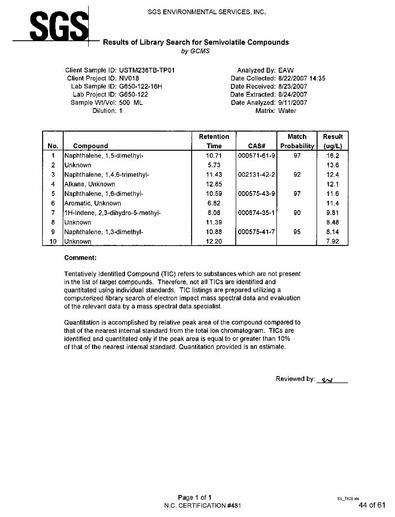
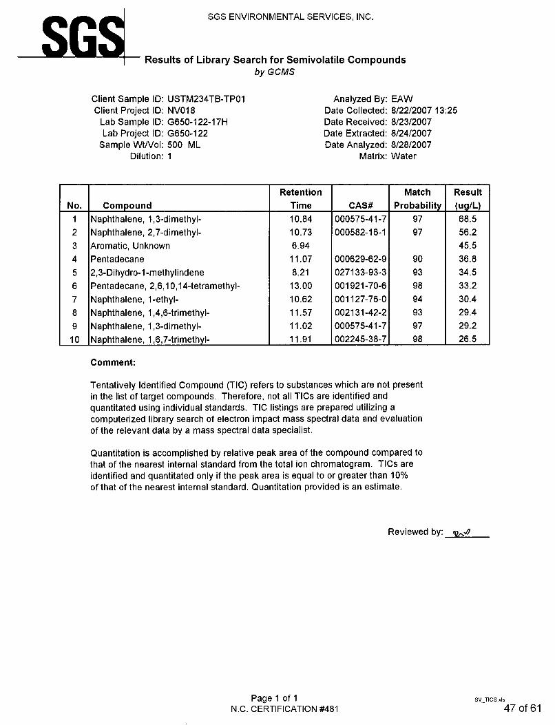
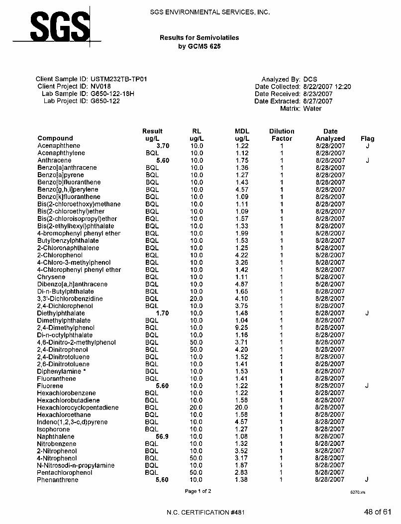
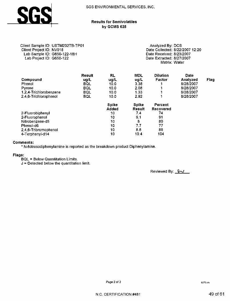
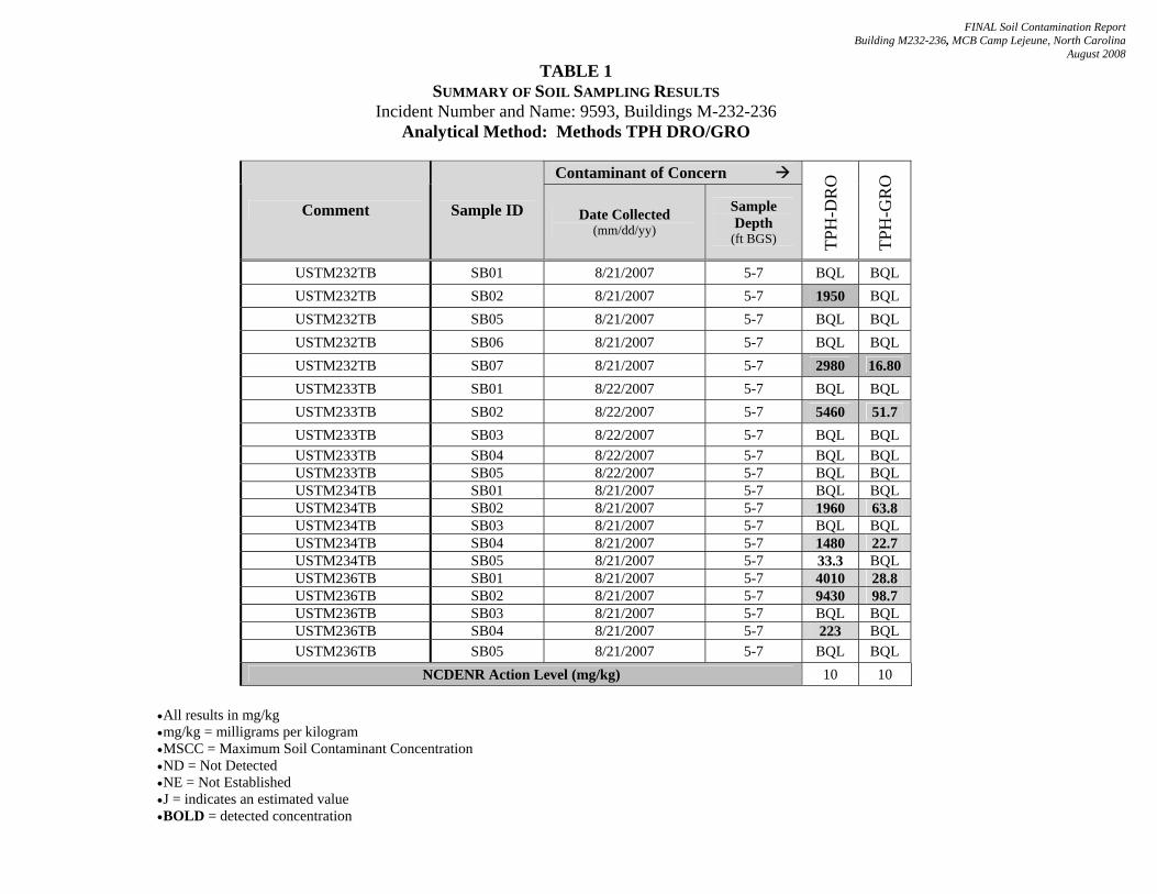
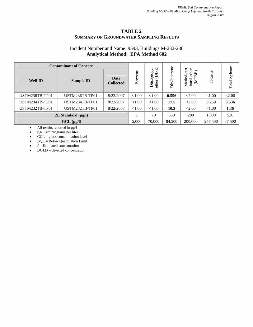
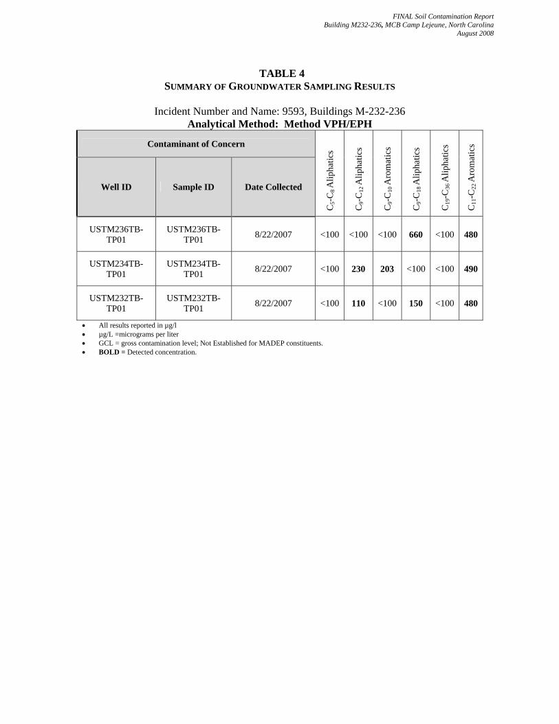
addition, Law Engineering and Environmental Services, Inc. (Law) conducted a risk characterization of the site in November 1999. It appears from data review that the wells were most likely installed as part of the risk characterization effort (this report, however, is unavailable for review). A 2000 Law report states that the risk characterization assessment indicated the site warranted classification as an Intermediate Risk based on the presence of measurable free product in monitoring well MW19. Law continued conducting groundwater monitoring activities in 2000 and 2001. Engineering and Environment, Inc. (EEI) assumed the responsibility of monitoring the site beginning in October 2002. Sovereign Consulting assumed monitoring activities for the site beginning with the 2006-2007 monitoring period. Measurable free product has only been detected in monitoring well MW19, and dissolved phase VOC and SVOC concentrations have been decreasing at the site. In an effort to address the free product, MCB Camp Lejeune conducted a soil excavation event from April 30 – May 2, 2007 in the MW19 area. Confirmation soil samples from the MW19 soil excavation indicate that contaminants are present above the soil to groundwater (STGW) maximum soil contaminant concentrations (MSCCs), but below the residential and industrial/commercial MSCCs. The compound 4-isopropyltoluene was also detected in the soil samples, for which there are no established MSCCs. 4.0 SOIL INVESTIGATION In August of 2007, Sovereign was onsite with a direct push rig to conduct a soil investigation of the former UST basins located at buildings M232-236 (excluding M235 because of the Spring 2007 soil removal action conducted by Osage of VA). Sovereign advanced 5 soil borings to approximately 8 feet bgs in each former tank basin. One boring was advanced in each former basin sidewall as well as the floor of the former basin in order to investigate soil contaminant concentrations. Soil samples were collected from each boring location and sent under chain of custody to SGS Paradigm of Wilmington, North Carolina and tested for TPH DRO and TPH GRO. These results are summarized in Table 1 of this report. Soil contaminant concentrations were detected above State action limits in each former tank basin location M232, M233, M234 and M236 for both TPH DRO and TPH GRO. In addition, a temporary piezometer was placed in each floor boring location in order to collect a groundwater sample and monitor for free product. One hundredth (0.01) of a foot of product was detected using an oil water interface probe in the location of building M233. The groundwater sample results for M232, M234, and M236 are summarized in Tables 2-5. VOCs, SVOCs, and MADEP Parameters were detected in each former tank basin location. Specifically though, only naphthalene in the basin for M232 and M234 and the MADEP parameter C9-C22 Aromatics (in each piezometer location sampled for M232, M234 and M236) were detected above 2L NCGWQSs. The piezometers were abandoned immediately after monitoring occurred in each location.
4
FINAL Soil Contamination Report Building M232-236, MCB Camp Lejeune, North Carolina
August 2008
5.0 CONCLUSIONS AND RECOMMENDATIONS Based on fieldwork and laboratory analytical data gathered during the August 2007 soil investigation activities, the following conclusions are presented.
1. Previous investigations indicate petroleum constituent concentrations in vadose zone soils are present at the site in the former tank basins above the STGW MSCCs and State Action Limits for TPH. 2. Well MW19, associated with the former UST located at M-235, was abandoned and the area was excavated from April 30 to May 2, 2007. No free product has been detected in the replacement monitoring well, MW23, since the removal action was completed. 3. Soil samples from the April-May 2007 soil excavation around MW19 indicate that contaminants are present above the STGW MSCCs, but below the residential and industrial/commercial MSCCs. The confirmation soil samples also exhibited 4-isopropyltoluene, which does not have established MSCCs. 4. Soil sample results from the August 2007 investigation indicate contaminant concentrations were detected above State action limits in each former tank basin location M232, M233, M234 and M236 for both TPH DRO and TPH GRO. 5. Piezometer monitoring results indicate one hundredth (0.01) of a foot of product was detected using an oil water interface probe in the location of building M233s. Further, naphthalene in the basin for M232 and M234 and the MADEP parameter C9-C22 Aromatics (in each piezometer location sampled for M232, M234 and M236) were detected above 2L NCGWQSs.
In order to move toward the eventual goal of No Further Action status at the site, MCB Camp Lejeune will have to demonstrate that soils in the former UST basins do not contain contamination above applicable state action limits for TPH DRO and TPH GRO or STGW MSCCs. Since the site is currently ranked as an intermediate site, all former tank basin soils must meet the lower of the residential or STGW MSCCs. A hot spot soil removal action is recommended in the vicinity of the former UST basin of building M233, where free product was observed in the temporary piezometers during the August 2007 soil investigation. After excavation a temporary well should be installed to monitor for the presence of free product. To monitor free product and groundwater conditions, Sovereign also recommends continuing gauging and sampling of existing monitoring program wells on a semi-annual basis. Recurrence of free product should be monitored in MW23 (replacement for monitoring well MW19), and product recovery should be conducted as indicated by the gauging data.
5

FINAL Soil Contamination Report Building M232-236, MCB Camp Lejeune, North Carolina
August 2008
6.0 REFERENCES AH Environmental Consultants, Final Report, Wellhead Protection Plan – 2002 Update, Marine Corps Base, Camp Lejeune, August 2002. Engineering and Environment, Inc., Quarterly Groundwater Monitoring Report, Site M-232-236, Marine Corps Base Camp Lejeune, North Carolina, Revision 1, September 22, 2004. Engineering and Environment, Inc., Quarterly Groundwater Monitoring Report, Site M-232-236, Marine Corps Base, Camp Lejeune, North Carolina, Revision 0, November 14, 2004. Engineering and Environment, Inc., Quarterly Groundwater Monitoring Report, Site M-232-236, Marine Corps Base, Camp Lejeune, North Carolina, Revision 0, February 4, 2005. Engineering and Environment, Inc., Annual Groundwater Monitoring Report, Site M232-236 Marine Corps Base Camp Lejeune, North Carolina, Revision 0, May 6, 2005. Engineering and Environment, Inc., Annual Groundwater Monitoring Report, Site M232-236 Marine Corps Base Camp Lejeune, North Carolina, Revision 0, January 6, 2006. Law Engineering and Environmental Services, Inc., Leaking Underground Storage Tank Natural Attenuation Sites, “No Further Action” Data Evaluation, MCB Camp Lejeune, North Carolina, MCAS New River, North Carolina. April 13, 1999. Law Engineering and Environmental Services, Inc., First Semi-annual Groundwater Monitoring Report, Buildings M-232-1 to M-236-1, Marine Corps Base Camp Lejeune, North Carolina. December 13, 2000. Law Engineering and Environmental Services, Inc., Second Semiannual Groundwater Monitoring Report, Buildings M-232-1 to M-236-1, Marine Corps Base Camp Lejeune, North Carolina. June 7, 2001. North Carolina Department of Environment and Natural Resources, Division of Waste Management, Underground Storage Tank Section, Guidelines for Assessment and Corrective Action, April 2001. O’Brien and Gere Engineers, Inc., Site Assessment, Tanks M-232-M-236, Camp Johnson, Marine Corps Base Camp Lejeune, North Carolina. January 1992. O’Brien and Gere Engineers, Inc., Addendum Site Assessment, Tanks M-232-M-236, Camp Johnson, Marine Corps Base Camp Lejeune, North Carolina, July 1993. Shaw Environmental and Infrastructure, Inc., Free Product Recovery Field Data Sheets, 2006-2007.
6

FINAL Soil Contamination Report Building M232-236, MCB Camp Lejeune, North Carolina
August 2008
TABLES
FINAL Soil Contamination Report Building M232-236, MCB Camp Lejeune, North Carolina
August 2008
TABLE 1 SUMMARY OF SOIL SAMPLING RESULTS
Incident Number and Name: 9593, Buildings M-232-236 Analytical Method: Methods TPH DRO/GRO
•All results in mg/kg •mg/kg = milligrams per kilogram •MSCC = Maximum Soil Contaminant Concentration •ND = Not Detected •NE = Not Established •J = indicates an estimated value •BOLD = detected concentration
Contaminant of Concern
Comment Sample ID Date Collected (mm/dd/yy)
Sample Depth
(ft BGS) TPH
-DR
O
TPH
-GR
O
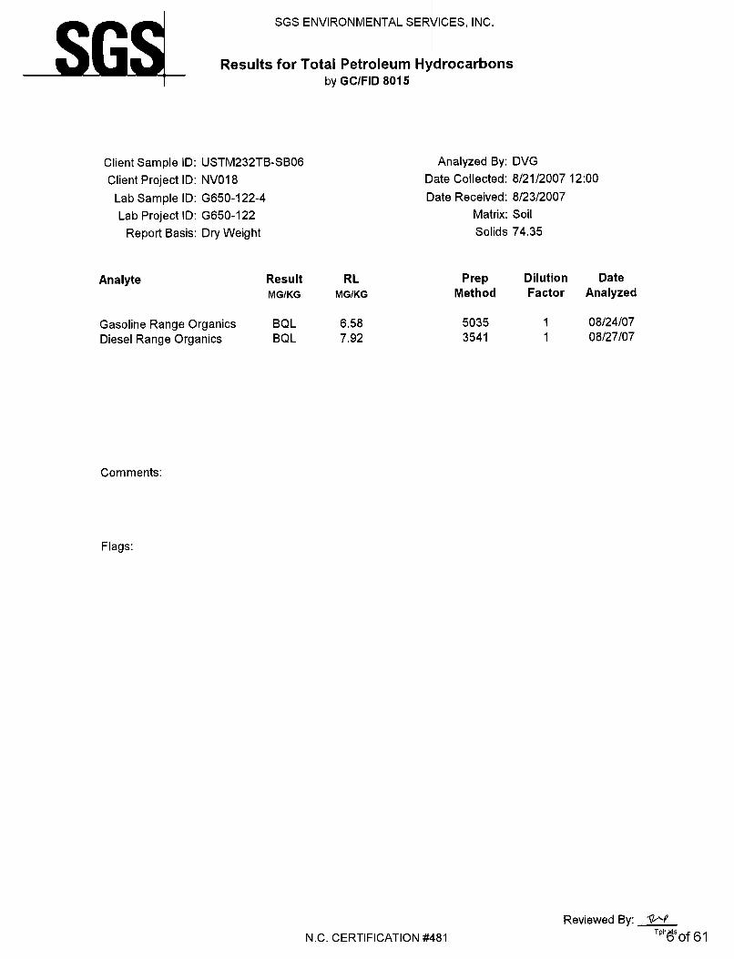
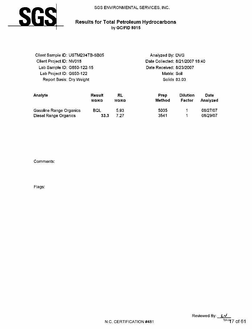
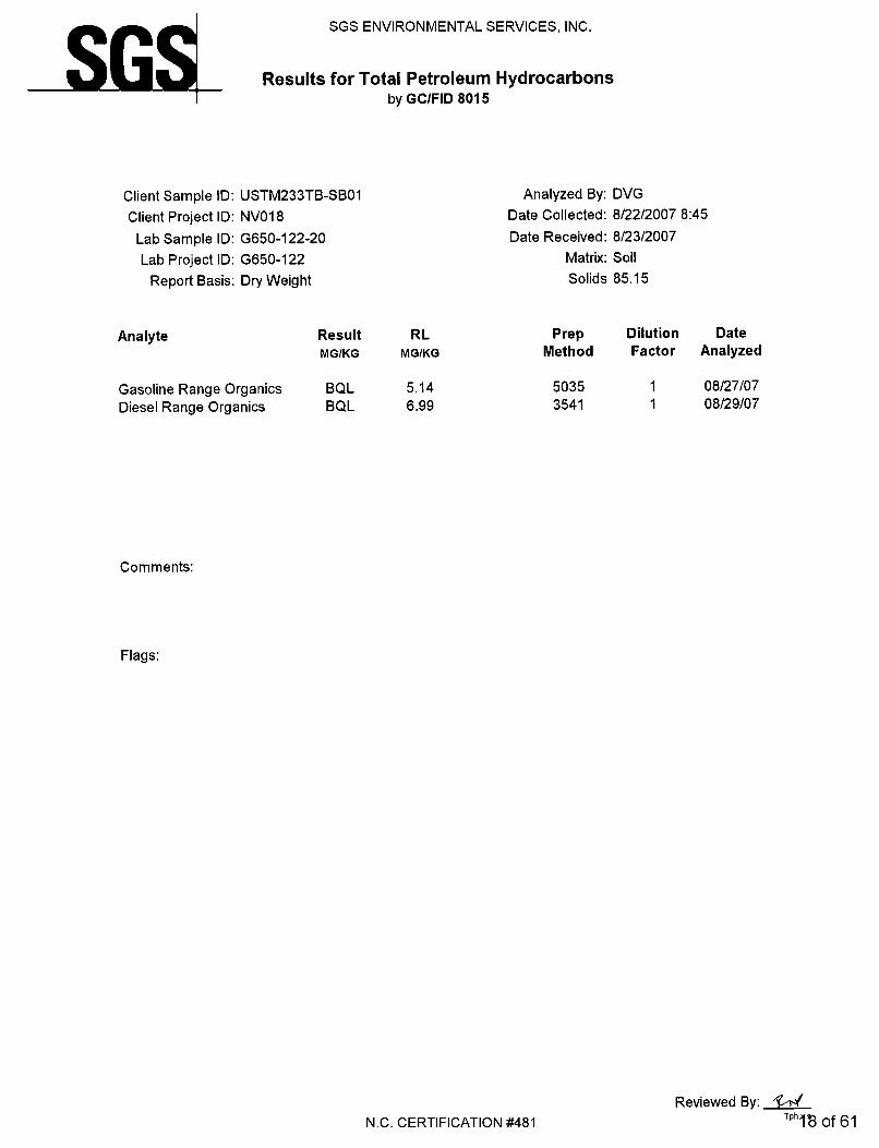
USTM232TB SB01 8/21/2007 5-7 BQL BQL USTM232TB SB02 8/21/2007 5-7 1950 BQL USTM232TB SB05 8/21/2007 5-7 BQL BQL USTM232TB SB06 8/21/2007 5-7 BQL BQL USTM232TB SB07 8/21/2007 5-7 2980 16.80 USTM233TB SB01 8/22/2007 5-7 BQL BQL USTM233TB SB02 8/22/2007 5-7 5460 51.7 USTM233TB SB03 8/22/2007 5-7 BQL BQL USTM233TB SB04 8/22/2007 5-7 BQL BQL USTM233TB SB05 8/22/2007 5-7 BQL BQL USTM234TB SB01 8/21/2007 5-7 BQL BQL USTM234TB SB02 8/21/2007 5-7 1960 63.8 USTM234TB SB03 8/21/2007 5-7 BQL BQL USTM234TB SB04 8/21/2007 5-7 1480 22.7 USTM234TB SB05 8/21/2007 5-7 33.3 BQL USTM236TB SB01 8/21/2007 5-7 4010 28.8 USTM236TB SB02 8/21/2007 5-7 9430 98.7 USTM236TB SB03 8/21/2007 5-7 BQL BQL USTM236TB SB04 8/21/2007 5-7 223 BQL USTM236TB SB05 8/21/2007 5-7 BQL BQL
NCDENR Action Level (mg/kg) 10 10
FINAL Soil Contamination Report Building M232-236, MCB Camp Lejeune, North Carolina
August 2008
TABLE 2
SUMMARY OF GROUNDWATER SAMPLING RESULTS
Incident Number and Name: 9593, Buildings M-232-236 Analytical Method: EPA Method 602
Contaminant of Concern
Well ID Sample ID Date Collected B
enze
ne
Diis
opro
pyl
ethe
r (D
IPE)
Ethy
lben
zene
Met
hyl-t
ert
buty
l eth
er
(MTB
E)
Tolu
ene
Tota
l Xyl
enes
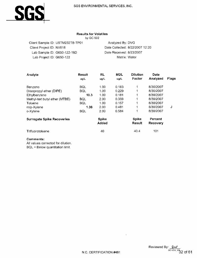
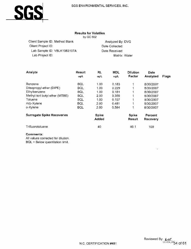
USTM236TB-TP01 USTM236TB-TP01 8/22/2007 <1.00 <1.00 0.556 <2.00 <1.00 <2.00 USTM234TB-TP01 USTM234TB-TP01 8/22/2007 <1.00 <1.00 17.5 <2.00 0.259 0.536 USTM232TB-TP01 USTM232TB-TP01 8/22/2007 <1.00 <1.00 10.3 <2.00 <1.00 1.36
2L Standard (µg/l) 1 70 550 200 1,000 530 GCL (µg/l) 5,000 70,000 84,500 200,000 257,500 87,500
• All results reported in µg/l • µg/L =micrograms per liter • GCL = gross contamination level • BQL = Below Quantitation Limit • J = Estimated concentration. • BOLD = detected concentration.

FINAL Soil Contamination Report Building M232-236, MCB Camp Lejeune, North Carolina
August 2008
TABLE 3 SUMMARY OF GROUNDWATER SAMPLING RESULTS
Incident Number and Name: 9593, Buildings M-232-236 Analytical Method: EPA Method 625 Plus 10 TICs
Contaminant of Concern
Well ID Sample ID Date Collected
Ace
naph
then
e
Dip
heny
lam
ine
Ant
hrac
ene
Fluo
rene
Nap
htha
lene
Phen
anth
rene
Tent
ativ
ely
Iden
tifie
d C
ompo
unds
(T
ICs)
USTM236TB-TP01
USTM236TB-TP01 8/22/2007 <10.0 <10.0 <10.0 <10.0 <10.0 <10.0 BQL
USTM234TB-TP01
USTM234TB-TP01 8/22/2007 6.60 <10.0 <10.0 11.3 31.6 13.7 BQL
USTM232TB-TP01
USTM232TB-TP01 8/22/2007 3.70J <10.0 5.60J 5.60J 56.9 5.60J BQL
2L Standard (µg/l) 80 NE 2100 280 21 210 NA GCL (µg/l) 2,120 NE 2100 950 15,500 410 NA
• All results reported in µg/L. • µg/L = microgram per liter • GCL = Gross contaminant level • BQL = Below quantitation limit • J = Estimated concentration • NA = Not Applicable • BOLD = Detected concentration. • BOLD and shaded = Detected concentration exceeds 2L standard.
FINAL Soil Contamination Report Building M232-236, MCB Camp Lejeune, North Carolina
August 2008
TABLE 4 SUMMARY OF GROUNDWATER SAMPLING RESULTS
Incident Number and Name: 9593, Buildings M-232-236
Analytical Method: Method VPH/EPH
Contaminant of Concern
Well ID Sample ID Date Collected
C5-
C8 A
lipha
tics
C9-
C12
Alip
hatic
s
C9-
C10
Aro
mat
ics
C9-
C18
Alip
hatic
s
C19
-C36
Alip
hatic
s
C11
-C22
Aro
mat
ics
USTM236TB-TP01
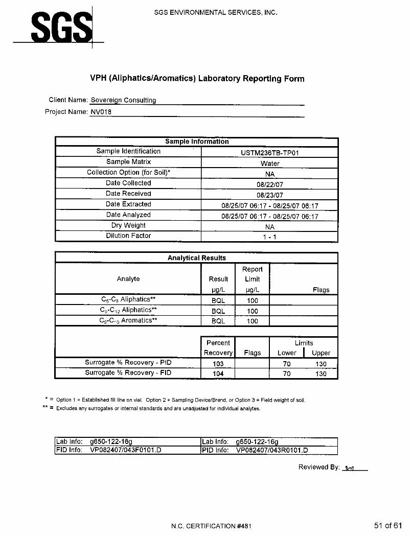
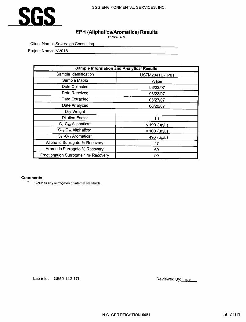
USTM236TB-TP01 8/22/2007 <100 <100 <100 660 <100 480
USTM234TB-TP01
USTM234TB-TP01 8/22/2007 <100 230 203 <100 <100 490
USTM232TB-TP01
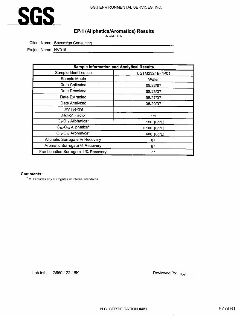
USTM232TB-TP01 8/22/2007 <100 110 <100 150 <100 480
• All results reported in µg/l • µg/L =micrograms per liter • GCL = gross contamination level; Not Established for MADEP constituents. • BOLD = Detected concentration.
FINAL Soil Contamination Report Building M232-236, MCB Camp Lejeune, North Carolina
August 2008
TABLE 5 SUMMARY OF GROUNDWATER SAMPLING RESULTS
Incident Number and Name: 9593, Buildings M-232-236
Analytical Method: Method VPH/EPH
Contaminant of Concern
Well ID Sample ID Date Collected
C5-
C8 A
lipha
tics
C9-
C18
Alip
hatic
s
C9-
C22
Aro
mat
ics
C19
-C36
Alip
hatic
s
USTM236TB-TP01 USTM236TB-TP01 8/22/2007 <100 <760 <580 <100
USTM234TB-TP01 USTM234TB-TP01 8/22/2007 <100 <330 693 <100
USTM232TB-TP01 USTM232TB-TP01 8/22/2007 <100 260 <580 <100
2L Standard (µg/l) 420 4,200 210 42,000
• All results reported in µg/l • µg/L =micrograms per liter • GCL = gross contamination level; Not Established for MADEP constituents. • BOLD = Detected concentration • BOLD and shaded = Detected concentration exceeds 2L Standard

FINAL Soil Contamination Report Building M232-236, MCB Camp Lejeune, North Carolina
August 2008
FIGURES

FIGUREPROJECT TITLE
JOB NO. DATE SCALE DRAWN BY CHECKED BY1
BUILDINGS M232-236MARINE CORPS BASECAMP LEJEUNE, NC
GENERAL VICINITYTOPOGRAPHIC SITE MAP
206-063 MAY 2007 AS SHOWN KAWS JAC
SCALEData Sources: Data Layers provided by MCB Camp Lejeune GIS Office.
SOVEREIGN CONSULTING INC.VIRGINIA BEACH, VIRGINIA
206-063-CAD-DWG-M232-236-FIGURE-1
500 0 500250 Feet
LegendWater Supply Wells
RoadsRailroads
Playgrounds
Athletic Fields and Courts
Parking Lots and Driveways
Buildings and Structures
Surface Water
1,500 ft. Radius
M232M233M234
M235M236
SB01
SB02SB05
SB06SB07
SB01
SB02 SB03
SB04SB05
SB01
SB02SB03
SB04
SB05
SB01
SB02
SB03
SB04
SB05
Soil Boring
ÙÙÙÙÙÙÙÙÙÙ
ÙÙÙÙÙÙÙÙÙÙÙÙÙÙÙ
ÙÙÙÙÙÙÙÙÙÙÙÙÙÙÙÙÙÙ
ÙÙÙÙÙÙ
ÙÙÙÙÙÙÙÙÙÙÙÙÙÙÙÙÙÙÙÙ
ÙÙÙÙ
ÙÙ
ÙÙ
ÙÙÙÙÙÙ
ÙÙ
ÙÙÙÙÙÙÙÙÙÙÙÙÙ
ÙÙÙÙÙÙÙÙÙÙÙÙÙÙÙÙÙÙÙÙÙÙ
ÙÙÙ
ÙÙÙÙ
ÙÙÙÙÙÙÙÙ
ÙÙ
ÙÙÙÙ
ÙÙ
ÙÙÙ
ÙÙÙÙÙÙÙÙÙÙÙ
ÙÙÙÙÙÙÙÙÙÙÙÙ
ÙÙÙÙÙÙÙÙÙÙÙÙÙÙÙÙÙÙ
ÙÙÙÙ
ÙÙÙÙÙÙ
ÙÙÙÙÙÙÙÙÙÙÙÙÙÙÙÙÙÙÙÙÙÙÙÙÙÙÙÙÙÙÙÙÙÙÙÙÙÙÙÙÙÙÙÙÙÙÙÙÙÙ
ÙÙ
ÙÙÙÙÙ
//
//
/// / / / / / / / / / / / / / / / / / / / // /
//
///////////////////////
//
//
/// / / / / / / / / / / / / / / / / / / / // /
//
///////////////////////
//
//
//
//
/// / / / / / / //
//
//
//
// ////////
//
//
/// / / / / / / / / / / / / / / / / / / / //
//
// /////////////////////
//
//
//
//
// / / / / / / ///
//
//
//
////////
//
//
/// / / / / / // /
//
/ ////////
//
//
/// / / / / / / / / / / / / / / / / / / / /
//
//
///////////////////////
//
//
//
//
/// / / / / / /
//
//
//
//
/////
//
//
//
// / / / /
//
//
//
//
//////// /
//
//
//
/ / // //
//
//
// ///
//
//
//
//
/ // //
//
// ///////////
//
/ /////
//
//
/// / / / / / / / / / / / / / / / / / / / /
//
//
///////////////////////
)
/ / / / / // / / / / / / / / / / / / / / ////////
/ / / // / / / / / / / / / / / / / / /
////// ////
////
////
////
///
/
/ /
/
/ / /// ////
// /
////
/
/ / /
////
////
////
////
//// / / / / / // / / / / / / / / / / / / / / / / / / / / /
////
/////
!=
!=
!=
!=
!=
!=
!>
!>
!>
!>
!>
!>
!>!>
!>
!>
!>
!>
!>
!>
!>
!>
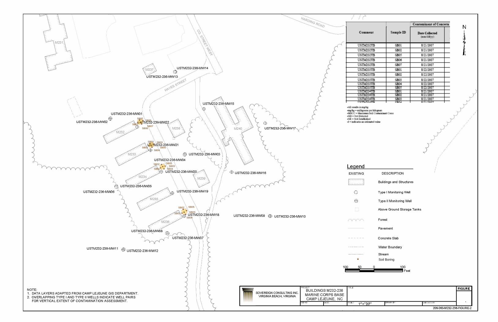
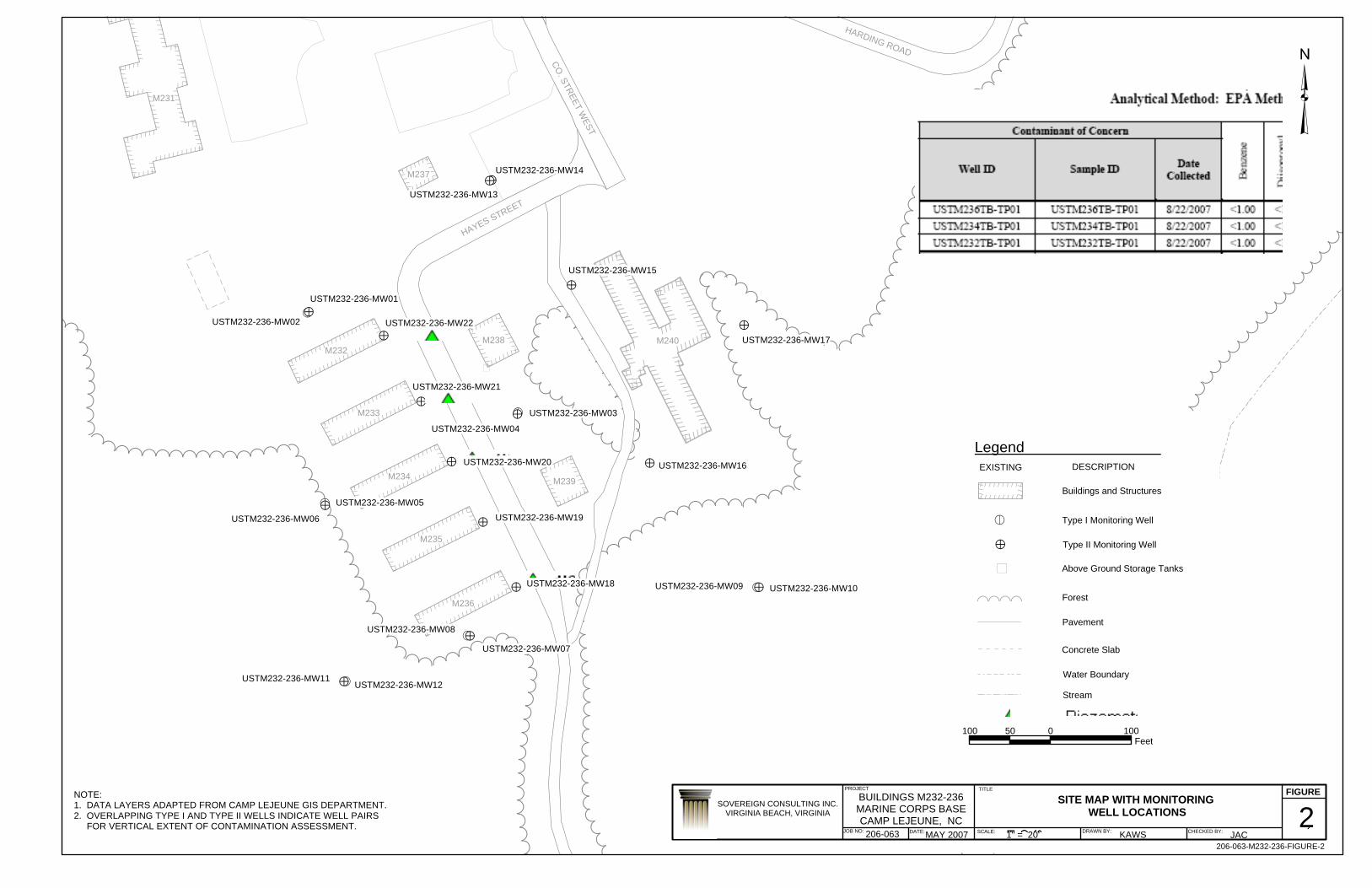
USTM232-236-MW14
USTM232-236-MW02
USTM232-236-MW04
USTM232-236-MW10
USTM232-236-MW08
USTM232-236-MW12
USTM232-236-MW06
USTM232-236-MW13
USTM232-236-MW15
USTM232-236-MW17
USTM232-236-MW22
USTM232-236-MW16
USTM232-236-MW01
USTM232-236-MW21
USTM232-236-MW20
USTM232-236-MW19
USTM232-236-MW18
USTM232-236-MW05
USTM232-236-MW03
USTM232-236-MW07
USTM232-236-MW09
USTM232-236-MW11
HAYES STREET
HARDING ROAD
CO. STREET W
EST
M231
M235
M233
M234
M232
M236
M238
M239
M237
M240
PROJECT TITLE FIGURE
JOB NO: DATE: SCALE: DRAWN BY: CHECKED BY:
³
SOVEREIGN CONSULTING INC.VIRGINIA BEACH, VIRGINIA
BUILDINGS M232-236MARINE CORPS BASECAMP LEJEUNE, NC
206-063
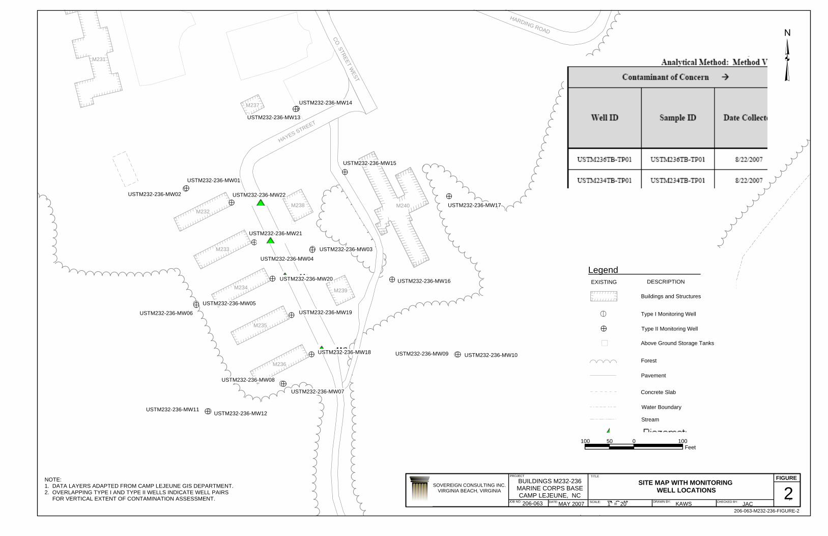
SITE MAP WITH MONITORING WELL LOCATIONS 2
MAY 2007 1" = 20' KAWS JAC206-063-M232-236-FIGURE-2
NOTE:1. DATA LAYERS ADAPTED FROM CAMP LEJEUNE GIS DEPARTMENT.2. OVERLAPPING TYPE I AND TYPE II WELLS INDICATE WELL PAIRS FOR VERTICAL EXTENT OF CONTAMINATION ASSESSMENT.
100 0 10050Feet
Legend
//
/// / / / / / / / / //
// ////////// Buildings and Structures
EXISTING DESCRIPTION
Type I Monitoring Well
> Type II Monitoring Well
!=
Above Ground Storage Tanks)
Concrete Slab
Water Boundary
Forest
Pavement
ÙÙÙÙ
Stream

ÙÙÙÙÙÙÙÙÙÙ
ÙÙÙÙÙÙÙÙÙÙÙÙÙÙÙ
ÙÙÙÙÙÙÙÙÙÙÙÙÙÙÙÙÙÙ
ÙÙÙÙÙÙ
ÙÙÙÙÙÙÙÙÙÙÙÙÙÙÙÙÙÙÙÙ
ÙÙÙÙ
ÙÙ
ÙÙ
ÙÙÙÙÙÙ
ÙÙ
ÙÙÙÙÙÙÙÙÙÙÙÙÙ
ÙÙÙÙÙÙÙÙÙÙÙÙÙÙÙÙÙÙÙÙÙÙ
ÙÙÙ
ÙÙÙÙ
ÙÙÙÙÙÙÙÙ
ÙÙ
ÙÙÙÙ
ÙÙ
ÙÙÙ
ÙÙÙÙÙÙÙÙÙÙÙ
ÙÙÙÙÙÙÙÙÙÙÙÙ
ÙÙÙÙÙÙÙÙÙÙÙÙÙÙÙÙÙÙ
ÙÙÙÙ
ÙÙÙÙÙÙ
ÙÙÙÙÙÙÙÙÙÙÙÙÙÙÙÙÙÙÙÙÙÙÙÙÙÙÙÙÙÙÙÙÙÙÙÙÙÙÙÙÙÙÙÙÙÙÙÙÙÙ
ÙÙ
ÙÙÙÙÙ
//
//
/// / / / / / / / / / / / / / / / / / / / // /
//
///////////////////////
//
//
/// / / / / / / / / / / / / / / / / / / / // /
//
///////////////////////
//
//
//
//
/// / / / / / / //
//
//
//
// ////////
//
//
/// / / / / / / / / / / / / / / / / / / / //
//
// /////////////////////
//
//
//
//
// / / / / / / ///
//
//
//
////////
//
//
/// / / / / / // /
//
/ ////////
//
//
/// / / / / / / / / / / / / / / / / / / / /
//
//
///////////////////////
//
//
//
//
/// / / / / / /
//
//
//
//
/////
//
//
//
// / / / /
//
//
//
//
//////// /
//
//
//
/ / // //
//
//
// ///
//
//
//
//
/ // //
//
// ///////////
//
/ /////
//
//
/// / / / / / / / / / / / / / / / / / / / /
//
//
///////////////////////
)
/ / / / / // / / / / / / / / / / / / / / ////////
/ / / // / / / / / / / / / / / / / / /
////// ////
////
////
////
///
/
/ /
/
/ / /// ////
// /
////
/
/ / /
////
////
////
////
//// / / / / / // / / / / / / / / / / / / / / / / / / / / /
////
/////
!=
!=
!=
!=
!=
!=
!>
!>
!>
!>
!>
!>
!>!>
!>
!>
!>
!>
!>
!>
!>
!>
USTM232-236-MW14
USTM232-236-MW02
USTM232-236-MW04
USTM232-236-MW10
USTM232-236-MW08
USTM232-236-MW12
USTM232-236-MW06
USTM232-236-MW13
USTM232-236-MW15
USTM232-236-MW17
USTM232-236-MW22
USTM232-236-MW16
USTM232-236-MW01
USTM232-236-MW21
USTM232-236-MW20
USTM232-236-MW19
USTM232-236-MW18
USTM232-236-MW05
USTM232-236-MW03
USTM232-236-MW07
USTM232-236-MW09
USTM232-236-MW11
HAYES STREET
HARDING ROAD
CO. STREET W
EST
M231
M235
M233
M234
M232
M236
M238
M239
M237
M240
PROJECT TITLE FIGURE
JOB NO: DATE: SCALE: DRAWN BY: CHECKED BY:
³
SOVEREIGN CONSULTING INC.VIRGINIA BEACH, VIRGINIA
BUILDINGS M232-236MARINE CORPS BASECAMP LEJEUNE, NC
206-063
SITE MAP WITH MONITORING WELL LOCATIONS 2
MAY 2007 1" = 20' KAWS JAC206-063-M232-236-FIGURE-2
NOTE:1. DATA LAYERS ADAPTED FROM CAMP LEJEUNE GIS DEPARTMENT.2. OVERLAPPING TYPE I AND TYPE II WELLS INDICATE WELL PAIRS FOR VERTICAL EXTENT OF CONTAMINATION ASSESSMENT.
100 0 10050Feet
Legend
//
/// / / / / / / / / //
// ////////// Buildings and Structures
EXISTING DESCRIPTION
Type I Monitoring Well
> Type II Monitoring Well
!=
Above Ground Storage Tanks)
Concrete Slab
Water Boundary
Forest
Pavement
ÙÙÙÙ
Stream
FINAL Soil Contamination Report Building M232-236, MCB Camp Lejeune, North Carolina
August 2008
APPENDIX A
BORING LOGS

SOVEREIGN CONSULTING INC.405 Oakmears Crescent, Suite 1 Client: NAVFAC Mid-Atlantic Date Drilled: 22 August 2007Virginia Beach, Virginia 23462 Project: Bldg M232-236 Total Depth: 8 feet
Location: MCB Camp LeJeune Logged By: Kurt Merkle
Drilling Co.: IMS Environmental Sample Method: DRO,GRODriller: Keith Borehole Diameter: 2"Drill Rig: Truck Mounted Geo-Probe Weather: 95 F Sunny, HumidDrill Method: Direct Push
USCS DEPTH Recovery PID Lithologic RemarksCODE/ (FT) (Feet) (ppm) Description
0
1
SM 2
3
4
5
6ML
7
8End of Soil Boring
Notes:
SOIL BORING LOG: USTM232TB-SB01
3.5
3.5
Gray, Medium to Fine Sandy Soil, Dry
Brown, Sandy Silt Soil, some Clay, Moist

SOVEREIGN CONSULTING INC.405 Oakmears Crescent, Suite 1 Client: NAVFAC Mid-Atlantic Date Drilled: 22 August 2007Virginia Beach, Virginia 23462 Project: Bldg M232-236 Total Depth: 8 feet
Location: MCB Camp LeJeune Logged By: Kurt Merkle
Drilling Co.: IMS Environmental Sample Method: DRO,GRODriller: Keith Borehole Diameter: 2"Drill Rig: Truck Mounted Geo-Probe Weather: 95 F Sunny, HumidDrill Method: Direct Push
USCS DEPTH Recovery PID Lithologic RemarksCODE/ (FT) (Feet) (ppm) Description
0
1
SM 2
3
4
5
6ML
7
8End of Soil Boring
Notes:
SOIL BORING LOG: USTM232TB-SB02
3.5
3.5
Gray, Medium to Fine Sandy Soil, Dry
Brown, Sandy Silt Soil, some Clay, Moist

SOVEREIGN CONSULTING INC.405 Oakmears Crescent, Suite 1 Client: NAVFAC Mid-Atlantic Date Drilled: 22 August 2007Virginia Beach, Virginia 23462 Project: Bldg M232-236 Total Depth: 8 feet
Location: MCB Camp LeJeune Logged By: Kurt Merkle
Drilling Co.: IMS Environmental Sample Method: DRO,GRODriller: Keith Borehole Diameter: 2"Drill Rig: Truck Mounted Geo-Probe Weather: 95 F Sunny, HumidDrill Method: Direct Push
USCS DEPTH Recovery PID Lithologic RemarksCODE/ (FT) (Feet) (ppm) Description
0
1
SM 2
3
4
5
6ML
7
8End of Soil Boring
Notes:
SOIL BORING LOG: USTM232TB-SB05
3.5
3.5
Gray, Medium to Fine Sandy Soil, Dry
Brown, Sandy Silt Soil, some Clay, Moist
SOVEREIGN CONSULTING INC.405 Oakmears Crescent, Suite 1 Client: NAVFAC Mid-Atlantic Date Drilled: 22 August 2007Virginia Beach, Virginia 23462 Project: Bldg M232-236 Total Depth: 8 feet
Location: MCB Camp LeJeune Logged By: Kurt Merkle
Drilling Co.: IMS Environmental Sample Method: DRO,GRODriller: Keith Borehole Diameter: 2"Drill Rig: Truck Mounted Geo-Probe Weather: 95 F Sunny, HumidDrill Method: Direct Push
USCS DEPTH Recovery PID Lithologic RemarksCODE/ (FT) (Feet) (ppm) Description
0
1
SM 2
3
4
5
6ML
7
8End of Soil Boring
Notes:
SOIL BORING LOG: USTM232TB-SB06
3.5
3.5
Gray, Medium to Fine Sandy Soil, Dry
Brown, Sandy Silt Soil, some Clay, Moist
SOVEREIGN CONSULTING INC.405 Oakmears Crescent, Suite 1 Client: NAVFAC Mid-Atlantic Date Drilled: 22 August 2007Virginia Beach, Virginia 23462 Project: Bldg M232-236 Total Depth: 8 feet
Location: MCB Camp LeJeune Logged By: Kurt Merkle
Drilling Co.: IMS Environmental Sample Method: DRO,GRODriller: Keith Borehole Diameter: 2"Drill Rig: Truck Mounted Geo-Probe Weather: 95 F Sunny, HumidDrill Method: Direct Push
USCS DEPTH Recovery PID Lithologic RemarksCODE/ (FT) (Feet) (ppm) Description
0
1
2
3
SP 4
5
6
7
8End of Soil Boring
Notes:
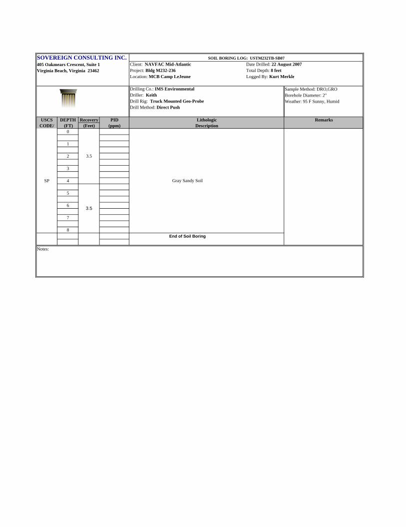
SOIL BORING LOG: USTM232TB-SB07
3.5
3.5
Gray Sandy Soil

SOVEREIGN CONSULTING INC.405 Oakmears Crescent, Suite 1 Client: NAVFAC Mid-Atlantic Date Drilled: 22 August 2007Virginia Beach, Virginia 23462 Project: Bldg M232-236 Total Depth: 8 feet
Location: MCB Camp LeJeune Logged By: Kurt Merkle
Drilling Co.: IMS Environmental Sample Method: DRO,GRODriller: Keith Borehole Diameter: 2"Drill Rig: Truck Mounted Geo-Probe Weather: 95 F Sunny, HumidDrill Method: Direct Push
USCS DEPTH Recovery PID Lithologic RemarksCODE/ (FT) (Feet) (ppm) Description
0
1
SM 2
3
4
5
6ML
7
8End of Soil Boring
Notes:
SOIL BORING LOG: USTM236TB-SB01
3.5
3.5
Gray, Medium to Fine Sandy Soil, Dry
Brown, Sandy Silt Soil, some Clay, Moist

SOVEREIGN CONSULTING INC.405 Oakmears Crescent, Suite 1 Client: NAVFAC Mid-Atlantic Date Drilled: 22 August 2007Virginia Beach, Virginia 23462 Project: Bldg M232-236 Total Depth: 8 feet
Location: MCB Camp LeJeune Logged By: Kurt Merkle
Drilling Co.: IMS Environmental Sample Method: DRO,GRODriller: Keith Borehole Diameter: 2"Drill Rig: Truck Mounted Geo-Probe Weather: 95 F Sunny, HumidDrill Method: Direct Push
USCS DEPTH Recovery PID Lithologic RemarksCODE/ (FT) (Feet) (ppm) Description
0
1
SM 2
3
4
5
6ML
7
8End of Soil Boring
Notes:
SOIL BORING LOG: USTM236TB-SB02
3.5
3.5
Gray, Medium to Fine Sandy Soil, Dry
Brown, Sandy Silt Soil, some Clay, Moist

SOVEREIGN CONSULTING INC.405 Oakmears Crescent, Suite 1 Client: NAVFAC Mid-Atlantic Date Drilled: 22 August 2007Virginia Beach, Virginia 23462 Project: Bldg M232-236 Total Depth: 8 feet
Location: MCB Camp LeJeune Logged By: Kurt Merkle
Drilling Co.: IMS Environmental Sample Method: DRO,GRODriller: Keith Borehole Diameter: 2"Drill Rig: Truck Mounted Geo-Probe Weather: 95 F Sunny, HumidDrill Method: Direct Push
USCS DEPTH Recovery PID Lithologic RemarksCODE/ (FT) (Feet) (ppm) Description
0
1
SM 2
3
4
5
6ML
7
8End of Soil Boring
Notes:
SOIL BORING LOG: USTM236TB-SB03
3.5
3.5
Gray, Medium to Fine Sandy Soil, Dry
Brown, Sandy Silt Soil, some Clay, Moist

SOVEREIGN CONSULTING INC.405 Oakmears Crescent, Suite 1 Client: NAVFAC Mid-Atlantic Date Drilled: 22 August 2007Virginia Beach, Virginia 23462 Project: Bldg M232-236 Total Depth: 8 feet
Location: MCB Camp LeJeune Logged By: Kurt Merkle
Drilling Co.: IMS Environmental Sample Method: DRO,GRODriller: Keith Borehole Diameter: 2"Drill Rig: Truck Mounted Geo-Probe Weather: 95 F Sunny, HumidDrill Method: Direct Push
USCS DEPTH Recovery PID Lithologic RemarksCODE/ (FT) (Feet) (ppm) Description
0
1
SM 2
3
4
5
6ML
7
8End of Soil Boring
Notes:
SOIL BORING LOG: USTM236TB-SB04
3.5
3.5
Gray, Medium to Fine Sandy Soil, Dry
Brown, Sandy Silt Soil, some Clay, Moist

SOVEREIGN CONSULTING INC.405 Oakmears Crescent, Suite 1 Client: NAVFAC Mid-Atlantic Date Drilled: 22 August 2007Virginia Beach, Virginia 23462 Project: Bldg M232-236 Total Depth: 8 feet
Location: MCB Camp LeJeune Logged By: Kurt Merkle
Drilling Co.: IMS Environmental Sample Method: DRO,GRODriller: Keith Borehole Diameter: 2"Drill Rig: Truck Mounted Geo-Probe Weather: 95 F Sunny, HumidDrill Method: Direct Push
USCS DEPTH Recovery PID Lithologic RemarksCODE/ (FT) (Feet) (ppm) Description
0
1
2
3
SP 4
5
6
7
8End of Soil Boring
Notes:
SOIL BORING LOG: USTM236TB-SB05
3.5
3.5
Gray Sandy Soil

SOVEREIGN CONSULTING INC.405 Oakmears Crescent, Suite 1 Client: NAVFAC Mid-Atlantic Date Drilled: 22 August 2007Virginia Beach, Virginia 23462 Project: Bldg M232-236 Total Depth: 8 feet
Location: MCB Camp LeJeune Logged By: Kurt Merkle
Drilling Co.: IMS Environmental Sample Method: DRO,GRODriller: Keith Borehole Diameter: 2"Drill Rig: Truck Mounted Geo-Probe Weather: 95 F Sunny, HumidDrill Method: Direct Push
USCS DEPTH Recovery PID Lithologic RemarksCODE/ (FT) (Feet) (ppm) Description
0
1
SM 2
3
4
5
6ML
7
8End of Soil Boring
Notes:
SOIL BORING LOG: USTM234TB-SB01
3.5
3.5
Gray, Medium to Fine Sandy Soil, Dry
Brown, Sandy Silt Soil, some Clay, Moist

SOVEREIGN CONSULTING INC.405 Oakmears Crescent, Suite 1 Client: NAVFAC Mid-Atlantic Date Drilled: 22 August 2007Virginia Beach, Virginia 23462 Project: Bldg M232-236 Total Depth: 8 feet
Location: MCB Camp LeJeune Logged By: Kurt Merkle
Drilling Co.: IMS Environmental Sample Method: DRO,GRODriller: Keith Borehole Diameter: 2"Drill Rig: Truck Mounted Geo-Probe Weather: 95 F Sunny, HumidDrill Method: Direct Push
USCS DEPTH Recovery PID Lithologic RemarksCODE/ (FT) (Feet) (ppm) Description
0
1
SM 2
3
4
5
6ML
7
8End of Soil Boring
Notes:
SOIL BORING LOG: USTM234TB-SB02
3.5
3.5
Gray, Medium to Fine Sandy Soil, Dry
Brown, Sandy Silt Soil, some Clay, Moist

SOVEREIGN CONSULTING INC.405 Oakmears Crescent, Suite 1 Client: NAVFAC Mid-Atlantic Date Drilled: 22 August 2007Virginia Beach, Virginia 23462 Project: Bldg M232-236 Total Depth: 8 feet
Location: MCB Camp LeJeune Logged By: Kurt Merkle
Drilling Co.: IMS Environmental Sample Method: DRO,GRODriller: Keith Borehole Diameter: 2"Drill Rig: Truck Mounted Geo-Probe Weather: 95 F Sunny, HumidDrill Method: Direct Push
USCS DEPTH Recovery PID Lithologic RemarksCODE/ (FT) (Feet) (ppm) Description
0
1
SM 2
3
4
5
6ML
7
8End of Soil Boring
Notes:
SOIL BORING LOG: USTM234TB-SB03
3.5
3.5
Gray, Medium to Fine Sandy Soil, Dry
Brown, Sandy Silt Soil, some Clay, Moist

SOVEREIGN CONSULTING INC.405 Oakmears Crescent, Suite 1 Client: NAVFAC Mid-Atlantic Date Drilled: 22 August 2007Virginia Beach, Virginia 23462 Project: Bldg M232-236 Total Depth: 8 feet
Location: MCB Camp LeJeune Logged By: Kurt Merkle
Drilling Co.: IMS Environmental Sample Method: DRO,GRODriller: Keith Borehole Diameter: 2"Drill Rig: Truck Mounted Geo-Probe Weather: 95 F Sunny, HumidDrill Method: Direct Push
USCS DEPTH Recovery PID Lithologic RemarksCODE/ (FT) (Feet) (ppm) Description
0
1
SM 2
3
4
5
6ML
7
8End of Soil Boring
Notes:
SOIL BORING LOG: USTM234TB-SB04
3.5
3.5
Gray, Medium to Fine Sandy Soil, Dry
Brown, Sandy Silt Soil, some Clay, Moist

SOVEREIGN CONSULTING INC.405 Oakmears Crescent, Suite 1 Client: NAVFAC Mid-Atlantic Date Drilled: 22 August 2007Virginia Beach, Virginia 23462 Project: Bldg M232-236 Total Depth: 8 feet
Location: MCB Camp LeJeune Logged By: Kurt Merkle
Drilling Co.: IMS Environmental Sample Method: DRO,GRODriller: Keith Borehole Diameter: 2"Drill Rig: Truck Mounted Geo-Probe Weather: 95 F Sunny, HumidDrill Method: Direct Push
USCS DEPTH Recovery PID Lithologic RemarksCODE/ (FT) (Feet) (ppm) Description
0
1
2
3
SP 4
5
6
7
8End of Soil Boring
Notes:
SOIL BORING LOG: USTM234TB-SB05
3.5
3.5
Gray Sandy Soil

SOVEREIGN CONSULTING INC.405 Oakmears Crescent, Suite 1 Client: NAVFAC Mid-Atlantic Date Drilled: 23 August 2007Virginia Beach, Virginia 23462 Project: Bldg M232-236 Total Depth: 8 feet
Location: MCB Camp LeJeune Logged By: Kurt Merkle
Drilling Co.: IMS Environmental Sample Method: DRO,GRODriller: Keith Borehole Diameter: 2"Drill Rig: Truck Mounted Geo-Probe Weather: 95 F Sunny, HumidDrill Method: Direct Push
USCS DEPTH Recovery PID Lithologic RemarksCODE/ (FT) (Feet) (ppm) Description
0
1
SM 2
3
4
5
6ML
7
8End of Soil Boring
Notes:
SOIL BORING LOG: USTM233TB-SB01
3.5
3.5
Gray, Medium to Fine Sandy Soil, Dry
Brown, Sandy Silt Soil, some Clay, Moist

SOVEREIGN CONSULTING INC.405 Oakmears Crescent, Suite 1 Client: NAVFAC Mid-Atlantic Date Drilled: 23 August 2007Virginia Beach, Virginia 23462 Project: Bldg M232-236 Total Depth: 8 feet
Location: MCB Camp LeJeune Logged By: Kurt Merkle
Drilling Co.: IMS Environmental Sample Method: DRO,GRODriller: Keith Borehole Diameter: 2"Drill Rig: Truck Mounted Geo-Probe Weather: 95 F Sunny, HumidDrill Method: Direct Push
USCS DEPTH Recovery PID Lithologic RemarksCODE/ (FT) (Feet) (ppm) Description
0
1
SM 2
3
4
5
6ML
7
8End of Soil Boring
Notes:
SOIL BORING LOG: USTM233TB-SB02
3.5
3.5
Gray, Medium to Fine Sandy Soil, Dry
Brown, Sandy Silt Soil, some Clay, Moist

SOVEREIGN CONSULTING INC.405 Oakmears Crescent, Suite 1 Client: NAVFAC Mid-Atlantic Date Drilled: 23 August 2007Virginia Beach, Virginia 23462 Project: Bldg M232-236 Total Depth: 8 feet
Location: MCB Camp LeJeune Logged By: Kurt Merkle
Drilling Co.: IMS Environmental Sample Method: DRO,GRODriller: Keith Borehole Diameter: 2"Drill Rig: Truck Mounted Geo-Probe Weather: 95 F Sunny, HumidDrill Method: Direct Push
USCS DEPTH Recovery PID Lithologic RemarksCODE/ (FT) (Feet) (ppm) Description
0
1
SM 2
3
4
5
6ML
7
8End of Soil Boring
Notes:
SOIL BORING LOG: USTM233TB-SB03
3.5
3.5
Gray, Medium to Fine Sandy Soil, Dry
Brown, Sandy Silt Soil, some Clay, Moist

SOVEREIGN CONSULTING INC.405 Oakmears Crescent, Suite 1 Client: NAVFAC Mid-Atlantic Date Drilled: 23 August 2007Virginia Beach, Virginia 23462 Project: Bldg M232-236 Total Depth: 8 feet
Location: MCB Camp LeJeune Logged By: Kurt Merkle
Drilling Co.: IMS Environmental Sample Method: DRO,GRODriller: Keith Borehole Diameter: 2"Drill Rig: Truck Mounted Geo-Probe Weather: 95 F Sunny, HumidDrill Method: Direct Push
USCS DEPTH Recovery PID Lithologic RemarksCODE/ (FT) (Feet) (ppm) Description
0
1
SM 2
3
4
5
6ML
7
8End of Soil Boring
Notes:
SOIL BORING LOG: USTM233TB-SB04
3.5
3.5
Gray, Medium to Fine Sandy Soil, Dry
Brown, Sandy Silt Soil, some Clay, Moist

SOVEREIGN CONSULTING INC.405 Oakmears Crescent, Suite 1 Client: NAVFAC Mid-Atlantic Date Drilled: 23 August 2007Virginia Beach, Virginia 23462 Project: Bldg M232-236 Total Depth: 8 feet
Location: MCB Camp LeJeune Logged By: Kurt Merkle
Drilling Co.: IMS Environmental Sample Method: DRO,GRODriller: Keith Borehole Diameter: 2"Drill Rig: Truck Mounted Geo-Probe Weather: 95 F Sunny, HumidDrill Method: Direct Push
USCS DEPTH Recovery PID Lithologic RemarksCODE/ (FT) (Feet) (ppm) Description
0
1
2
3
SP 4
5
6
7
8End of Soil Boring
Notes:
SOIL BORING LOG: USTM233TB-SB05
3.5
3.5
Gray Sandy Soil
FINAL Soil Contamination Report Building M232-236, MCB Camp Lejeune, North Carolina
August 2008
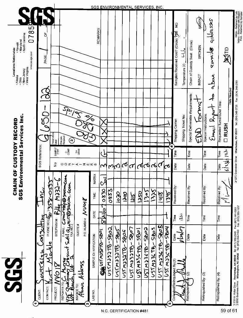
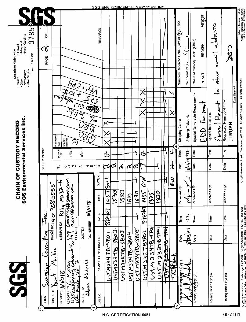
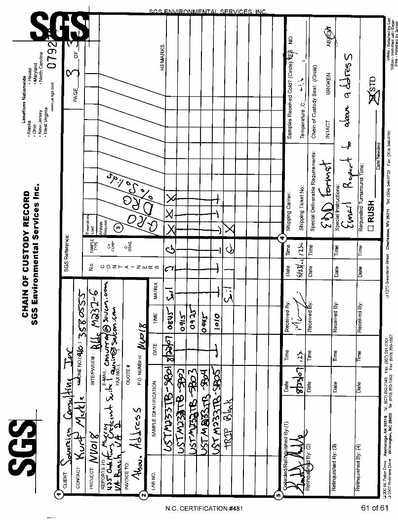
APPENDIX B
LABORATORY REPORTS AND CHAIN OF CUSTODY DOCUMENTATION