figure 1. the location of the sunrise city historic ... · may be root cellar depressions. ... root...
TRANSCRIPT

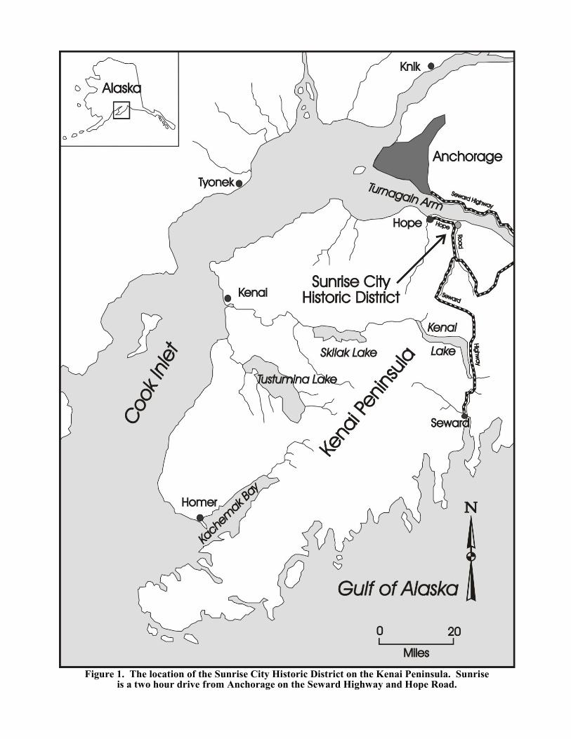
Figure 1. The location of the Sunrise City Historic District on the Kenai Peninsula. Sunriseis a two hour drive from Anchorage on the Seward Highway and Hope Road.

Figure 2. The Wheeler & Company Store (right) and the Alaska Commercial CompanyStore (left), at the corner of Main and Block streets, Sunrise. Photo courtesy of
U.S. Department of Agriculture, Chugach National Forest, Anchorage.
SUNRISE CITY HISTORIC DISTRICT
Prior to the well-known gold rushes tothe Klondike and Nome, there was a rush toTurnagain Arm. In 1893, prospectors filed thefirst mining claims on Resurrection Creek(near the present day town of Hope). Twoyears later, Sam Mills and J.T. Ballam stakedthe first mining claims on the Sixmiledrainage at the mouth of Canyon Creek. Asother prospectors staked claims in the drain-age, A.J. Mills and George Donaldson builtcabins on a flat, well drained site one-third ofa mile up from the mouth of Sixmile Creek.This small camp was accessible by shallow
draft boats from Tyonek, the closest deepwater port in Cook Inlet. The camp becamethe supply base for miners in the Sixmiledrainage. In July 1895, prospectors on thatdrainage formed the Sunrise Mining District. A handful of miners wintered over at the smallcamp, which they named Sunrise.
News of the discovery of gold on theSixmile drainage set off the Turnagain ArmGold Rush. In 1896, several thousand goldseekers overran the small camp at the mouthof Sixmile Creek. Most of these newcomerslived in tents, prompting one visitor to de-
1

Figure 3. Boundaries of the Sunrise City Historic District.
2

Figure 4. Jack and Nellie Frost’s Cabin at Sunrise, February 18, 1900. Left to right:Ferdinand and Mrs. Martin, G.W. Jack and W.L. “Jack” Frost, Mrs. G.W. Jack, and
Nellie Frost.
scribe the town as looking "like an army en-campment." On May 5, 1896, the miners helda meeting and organized a town called"Sunrise City." Sunrise was laid out in a grid,complete with blocks and lots. A procedurewas established so miners could buy lots tobuild residences and businesses.
In the following year, several thousandmore stampeders arrived in the SunriseMining District. As the townsite filled up,newcomers built cabins and tents on thehillside west of town, on the east bank ofSixmile Creek, and on a small islanddownstream from the town. In March 1898, the residents of Sunrise re-platted the town
and banned the possession of more than 25pounds of explosives within the city. By thistime, the town included three general stores,three saloons, a billiard hall, a restaurant, ahotel, a community hall, and a cemetery. Atramway road accessed the wharfs at themouth of Sixmile Creek.
Between 1896 and 1900, Sunrise wasthe largest town in the Cook Inlet area. Thepopulation fluctuated with the seasons. In1898, for example, only 100 miners livedthere in the winter, but during the summer thepopulation rose to 800. Marginal golddeposits in the district and the lure of morepromising strikes elsewhere prompted many
3

Figure 5. The southern end of the Sunrise tramway, leading to the docks near themouth of Sixmile Creek. The view is looking north. John Brooks Collection,UA 68-32-560N, Elmer E. Rasmuson Library, University of Alaska Fairbanks.
of the gold seekers to return to the lower 48. Others joined gold rushes to the Klondike andNome. After 1900, the population of Sunrisedwindled rapidly and the town of Hope,located ten miles to the west, became thelargest community in the area. During thedecade following the gold rush, firesdestroyed some of the buildings in Sunrise.The last store closed in 1910. The fewremaining miners used some of the abandonedbuildings for firewood. In 1939, the lastresident of Sunrise, Mike Connolly, died in aboating accident.
In the early 1950s, Donald Rucker andhis family homesteaded the abandonedSunrise townsite, salvaging lumber from theold buildings to construct a new house. Vern
and Barbara Stall purchased the property in1958. After the 1964 earthquake rendered thehouse uninhabitable, the Stalls built a newcabin above the highway. Evelyn Preblichacquired the property in 1971 and constructeda commercial campground up-stream from theold townsite. Dennis Sammut acquiredSunrise in the early 1990s and built a newhouse and guest cottage on the site where theRucker House once stood.
Today, Sunrise is an historic archae-ological district spanning both sides of Six-mile Creek. In 1997, the Historic Districtincluded the ruins of five partially standingbuildings, 38 building foundations, eight rootcellars, 18 artifact concentrations, 11 isolated artifacts, nine features of hand stacked rocks,
4

Figure 6. Volunteer Doug Gibson writing notes on archaeological testing that uncoveredthe cross ties at the south end of the Allensworth and Company Tramway Road at
Sunrise, August 30, 1998. The foundation of the Alaska Commercial Companystore is behind Gibson. Photo by Rolfe G. Buzzell.
three sections of a tramway road, 175depressions, and a cemetery.
Sunrise is significant for its associationwith the Turnagain Arm Gold Rush of 1896-1898 and early settlement in the Cook Inletarea. Sunrise was also an important stopoveron the Iditarod Trail between Seward andKnik before the Alaska Railroad wascompleted to Anchorage in 1916. In the earlyyears, gold seekers en route to the Innoko,Iditarod, and Seward Peninsula gold fieldswalked or rode on pack trains during thesummers from Seward over the Johnson PassTrail to Sunrise, then crossed Turnagain Armby boat. The Sunrise City Historic Districtwas listed on the National Register of HistoricPlaces on August 19, 1997. Most of the Sunrise City Historic
District is located on private property. Thesite is a fragile historic archaeological site. Many of the historic features are subtle andmay not be recognizable at first glance. Untilrecently, much of the site was overgrown withvegetation in the summer. The best time toview the site is in the spring after the snow hasmelted or in the fall after the first hard frost.Owners of the property since the 1950s,including the present owner, have madeimprovements over the years, destroying orcovering over some of the historic features.
Please do not disturb the ruins and donot pick up or disturb any historic artifacts. Special thanks to property owner DennisSammut for granting permission to the Hopeand Sunrise Historical Society to allow thistour of the Sunrise City Historic District.
5

6
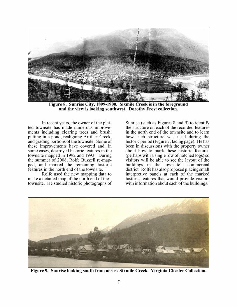
Figure 8. Sunrise City, 1899-1900. Sixmile Creek is in the foregroundand the view is looking southwest. Dorothy Frost collection.
Figure 9. Sunrise looking south from across Sixmile Creek. Virginia Chester Collection.
In recent years, the owner of the plat-ted townsite has made numerous improve-ments including clearing trees and brush,putting in a pond, realigning Artifact Creek,and grading portions of the townsite. Some ofthese improvements have covered and, insome cases, destroyed historic features in thetownsite mapped in 1992 and 1993. Duringthe summer of 2008, Rolfe Buzzell re-map-ped, and marked the remaining historicfeatures in the north end of the townsite.
Rolfe used the new mapping data tomake a detailed map of the north end of the townsite. He studied historic photographs of
Sunrise (such as Figures 8 and 9) to identifythe structure on each of the recorded featuresin the north end of the townsite and to learnhow each structure was used during thehistoric period (Figure 7, facing page). He hasbeen in discussions with the property ownerabout how to mark these historic features(perhaps with a single row of notched logs) sovisitors will be able to see the layout of thebuildings in the townsite’s commercialdistrict. Rolfe has also proposed placing smallinterpretive panels at each of the markedhistoric features that would provide visitorswith information about each of the buildings.
7

WALKING TOUR
The Sunrise City Historic District walking tour starts at the former KOACampground south of the old townsite. Dennis Sammut remodeled the 1970s campground lodge building and built severalnew structures nearby as guest quarters. Proceed on foot using the map on the facingpage. The trail leading into the townsite is theold Military Road, built by miners and laterimproved by the Alaska Road Commission.
Stop 1 (see Map 3 on page 7) is thebridge over Campground Creek. From thebridge, observe the rows of moss covered,hand-stacked tailings along the banks of thisdry creek. These features are evidence ofearly hand mining activity on the "Contention"mining claim dating from the early days of thetown. The miners picked up and stacked therocks along the banks of the creek so theycould shovel the gold bearing gravel intosluice boxes. Proceed north along the road tothe next stop.
Stop 2 is at two depressions on theright side of the trail. The original purpose ofthese features is unknown at this time. Theymay be root cellar depressions. Thesedepressions are the most common type ofarchaeological features in the Historic District. Proceed north along the trail.
Stop 3 is the ruins of a log cabin. Inthe 1990s, this was the best preserved historicstructure in the platted townsite. It may be theruins of one of Mike Connolly's cabins. Connolly lived in Sunrise from 1898-1939. Note the cabin foundation directly to the southand another foundation to the southwest onthe opposite side of the trail. Continue northalong the trail. At the gravel access road, turnright and walk toward the creek.
Stop 4 was the foundation of a cabinor workshop. This site illustrates thevulnerability of archaeological features todevelopment. There are more cabin ruins tothe south. Proceed north along the drivewaynext to the creek.
Stop 5 is the guest house and rec-reational home of Dennis Sammut. Home-steader Donald Rucker built a house at thissite in the 1950s from materials salvaged from
abandoned buildings in the townsite. Sammutbuilt his house and the nearby guest house inthe early 1990s. He stabilized the river bankin the late 1990s and added the boat launch. Continue north on the west side of Sammut’shouse along the foot path that winds south.
Stop 6 is what remains of SunriseCity's commercial district at the intersection ofBlock and Main streets. The foundations androot cellars of the Wheeler Brothers, AlaskaCommercial Company and U.S. MercantileCompany general stores are visible. Thefoundation cut for the south end of thetramway road is visible to the north. Proceedsouth to the ruins of a cabin.
Stop 7 is the ruins of a combinationlog and frame building. Note the presence ofother building foundations and root cellars inthe area, and particularly the number of smalldepressions created since the 1970s by artifactcollectors. Continue walking south, beingcareful to avoid stepping on artifacts.
Stop 8 used to consist of a series ofsmall depressions and a large surface scatterof broken bottles and ceramics. This was atrash dump from one of Sunrise's saloons. The depressions were from people digging forartifacts. Dennis Sammut covered thesefeatures in 2010 because they posed a hazardto his children. Continue walking south, thenproceed west.
Stop 9 is an old safe andmiscellaneous artifacts. Continue walkingwest to a small stream.
Stop 10 is at Sunrise Creek, whichSammut moved. In the 1990s, domesticartifacts were visible in the stream bed. There were no building foundations in thisarea, so the artifacts may have been associatedwith less permanent structures such as tentframes. Turn and walk east.
Stop 11: Sammut created a man-madelake in this area in 2007. The projectdestroyed cabin foundations and associated artifact scatters. The Rucker family had agarden in this area in the 1950s. This is theend of the tour. Return to the Campgroundparking lot by way of the trail that took us intothe townsite at the beginning of the tour.
8

Figure 10. Historic archaeological features mapped in 1992-1993 in the Sunrise Townsite. The street layout is based on the notes of the March 3, 1898 Sunrise City plat.
9

Figure 12. The grave markers at Point Comfort for the five victims of a 1901 snow slideon Lynx Creek. Photo by W.K. Case taken in 1909. PCA 01-1714, Alaska State Library.
POINT COMFORT CEMETERY
The cemetery at Sunrise City, knownas Point Comfort, is on state land one-third ofa mile northwest of the old townsite. On May5, 1897, a group of Sunrise residents filed alocation notice to establish a cemetery on thewest bank of Sixmile Creek. The death oftheir friend, Angus McDonald, prompted theminers to establish this cemetery, originallycalled Point McDonald. Later the name waschanged to Point Comfort Cemetery.
The number of people buried at PointComfort is unknown. Based on records andnewspaper articles, 15 people, including threeinfants, are known to be buried in thecemetery. There may be more. There are nowomen known to be buried there. The age of the men buried at Point Comfort ranges from24 to 76. The last resident of Sunrise City, Mike Connolly, was buried in the cemetery in1939. One person who was not associated with old Sunrise was buried at Point Comfort
in 1963. The U.S. Forest Service removedthe original wooden headboards in 1970 whena forest fire threatened the area. The originalheadboards were stored for three decades atthe Anchorage Museum of History and Art,but were turned over to the Hope Museum in2010.
A group of volunteers sponsored bythe Hope and Sunrise Historical Societyrestored the cemetery in 1994-1995. Res-toration work involved researching the namesof people buried in the cemetery, makingreplica headboards and installing them, andrestoring the fence around Baby Smith's grave. Plans included installing a split rail fencearound the cemetery to replace an earlier fencethat has all but disappeared. The materials forthe restoration project were donated by DennisSammut. A few years ago, Sammut installedthe picket fence, which diagonally crosses oneof the graves, without State permission.
10

Figure 12. Point Comfort Cemetery after the 1994-1995 restoration.
11
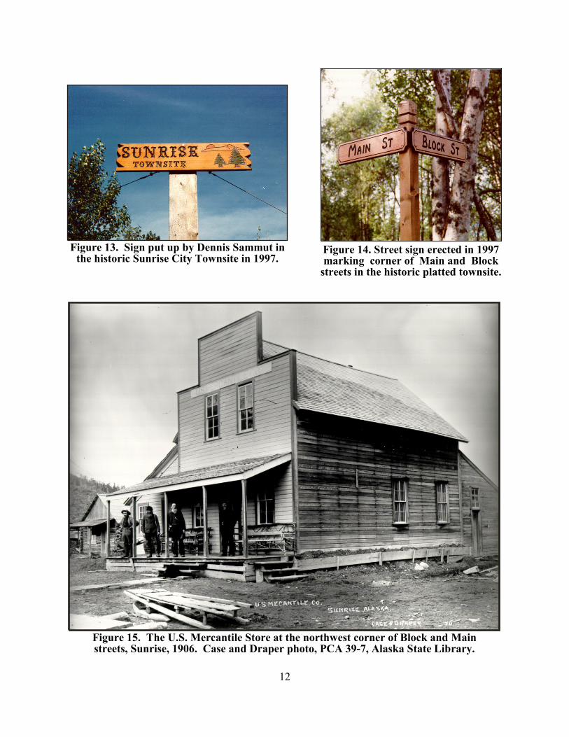
Figure 14. Street sign erected in 1997marking corner of Main and Block
streets in the historic platted townsite.
Figure 13. Sign put up by Dennis Sammut inthe historic Sunrise City Townsite in 1997.
Figure 15. The U.S. Mercantile Store at the northwest corner of Block and Mainstreets, Sunrise, 1906. Case and Draper photo, PCA 39-7, Alaska State Library.
12