fenton creek property - british columbia
TRANSCRIPT

E
1994 Exploration Progr on the
Fenton Creek Property
a
Claims:
Mining Division:
NTS Map Sheet:
Latitude:
Longitude: '
Owner of Claims:
Project Operator:
Consultant:
Report by:
Date of Report:
Fen 1, Fen 2, Fen 4, Tsalit 4, Tsalit 5, Tsalit 6, Tsalit 7, Tsalit 8, Fen 1 Fr., Fen 2 Fr.
Omineca Mining Division
9 3 L 2 W
54' 1O'N
126' 55' W
Baril Developments Ltd.
Electrum Resource Corporation
New Caledonian Geological Consulting
Peter A. Ronning, P.Eng.
January 1995 G E O L O G I C A L B R A N C H
E N T R E P O R T
t
I report 141 NCG
Table of Contents ... I .............................................................................................................................. lu
I . Summary and Conclusions ..................................................................................... 1
I1 . Introduction ......................................................................................................... 2
A . Location and Access ................................................................................. 2
B . Physiography ............................................................................................ 2 C . Property Definition ................................................................................... 2
2 . History .......................................................................................... 2
III . Work Program .................................................................................................... 4
1 . Claims ........................................................................................... 2
3 . Economic Potential ........................................................................ 4
IV . Geology ............................................................................................................. 5
A . Regional Geological Setting ..................................................................... 5 B . Mineral Deposits in the District ................................................................. 6
C . Local and Property Geology ..................................................................... 6
1 . Lithologic Units ............................................................................. 6
2 . Structural Geology ......................................................................... 7
3 . Alteration ...................................................................................... 7 V . Mineralization and Rock Geochemistry ................................................................ 8
VI . Soil Geochemistry .............................................................................................. 8 VII . Geophysics ........................................................................................................ 9 VIII . Discussion ....................................................................................................... 9
IX . Recommendations .............................................................................................. 9 X . Bibliography ........................................................................................................ 11
XI . Statement of Qualifications ................................................................................. 12
file: RPT-141.DOC 01/02/95 15:45 page ii

report 1 4 1 NCG
a
I
I I
l
a
List of Tables
Table 1 - List of Claims Table 2 - Regional Lithologic Units Table 3 - Correlation of Local and Regional Lithologic Units Table 4 - Descriptions of Rock Chip Samples Collected in 1994 Table 5 - Descriptions of Soil Samples Collected in 1994
1 2 3 4 5 6 7 8 9 10 11 12 13 14 15
List of Fipures
4 5 7
m vm
Location Map ...................................................................................... follows page 2 Claims ............................. . . . .. .. .. . .. ................................. ....................... follows page 4 Generalized Compilation ...................................................................... follows page 5 Geology and Rock Sample Locations ................................................... follows page 6 Copper in Rocks .................................................................................. follows page 8 Lead in Rocks .................... ..... .. . . . .. . . .................................................... follows page 8 Zinc in Rocks ....................................................................................... follows page 8 Silver in Rocks.. .. .......... ....................... ....... . .. .... .................................. follows page 8 Gold in Rocks ..... . ......... .............................. .. . .... .................................. follows page 8 Soil Sample Locations ......................................................................... follows page 9 Copper in Soils .................................................................................... f o ~ o w s page 9 Lead in Soils ........................................................................................ follows page 9 Zinc in Soils. .... ... . .......................................................... ...................... follows page 9 Silver in Soils. ............ . ............................................... ...... .................... follows page 9 Gold in Soils .. . . . . . .. ..... . . ........................................................................ follows page 9
List of ADDendiCeS
Appendix 1 - Geouhvsical Remrt Appendix 2 - Statement of Costs ADDendix 3 - Descriptions of Rock Samples Appendix 4 - Descriptions of Soil Samples Appendix 5 - Rock Chip Sample Analvses Appendix 6 - Soil Sample Analvses Appendix 7 - Analvtical Procedures
1 II
m vm M X XI
file: RPT-19-1.DOC 01/02/95 15:45 page iii

report 141 Appendix 1 NCG
I. Summarv and Conclusions
33 kilometers southwest of Houston, B.C., on NTS map sheet 93 L 2W. The modern history of exploration on the property dates from 1965, when a silver-lead-zinc anomaly was located in stream sediments from Code Creek. In the period 1972 through 1981 various exploration programs included in excess of 5,000 meters of drilling. The most obvious target for exploration in this district would be a deposit similar to EQuity Silver, which contained copper-silver-antimony sulphides and sulphosalts with associated gold in upper Jurassic to lower Cretaceous sediments and volcanics.
During 1994, exploration concentrated in a recent clear-cut where logging activities had created new rock exposures in an area determined by earlier work to be prospective. Thirty-eight rock ship samples and 22 soil samples were collected. 12.75 kilometers of VLF survey were done.
The project area is underlain largely by rocks correlated with the lower to middle mesozoic Hazelton Group. Most of the Hazelton rocks present are tuffs and lapilli tuffs.
Within the Hazelton Group there is a clear distinction between relatively unaltered tuffs and those which have been subjected to variably intense argillic and siliceous alteration. Visible sulphides are rare on the surface, but any found lie within the most intensely altered rocks.
The Fenton, or Fen property is located about 2 km south of the Morice River and about
Altered rocks lie north of a poorly constrained "alteration front" with a roughly arcuate shape. Within the alteration zone, outcrops are found only within 150 meters of the front. Beyond that, to the north, bedrock disappears beneath overburden and swampy ground. Relatively little exploration has been done north of the alteration front, due to the paucity of outcrop. Potential exists to find more alteration, and possibly mineralization, north of the altered outcrops.
Further work on this property should start with compilation and merging of the various available data sets. In particular, attention should be paid to any existing geophysical data that would shed light on the possible existence of overburden-covered mineralization north of the altered outcrops. If the existing geophysical information for that area is inadequate, further geophysical surveys may be warranted. The nature of such surveys can be determined only after the existing information is fully compiled.
altered zone. Relatively little drilling has been done in that area.
a
Ultimately, if geophysical indications warrant it, drilling may be undertaken within the
file: RPT-141 .DOC 01/02/95 15:45 Page 1

' 0
report 141
II. Introduction
NCG
A. Location and Access (see Figures 1 and 2)
The Fenton, or "Fen" property is located about 2 km south of the Morice River, straddling Fenton Creek, on NTS map sheet 93 L 2W. It is about 33 kilometers in a straight line southwest of Houston. Directions to the site by road are as follow:
from the center of Houston, drive about 5 km east along Highway 16 to the Morice River Forest Service Road (FSR)
follow the Morice River FSR about 25 kilometers south to the Morice West FSR
follow the Morice West FSR about 3% kilometers west to the Fenton Creek road
follow the Fenton Creek road about 5 kilometers southeast to the property
e
e
e
e
B. Physiography
Fenton Creek are deeply incised into mainly glacial cover. In places, resistant bedrock forms steep-sided hills with 100 meters to 150 meters of relief. Parts of the property have been clear cut.
The area comprises sloping terrain of modest relief (Church, 1972). Creeks such as
C. Property Definition
1. Claims (see Figure 2)
The claims that comprise the property are listed in Table 1 on page 4. All are owned by Baril Developments Ltd..
2. History
a) History of the District
Church and Barakso (1990) discuss the mining history of the Buck Creek map area, which is adjacent to the Fenton Creek area on the east:
prior to 1905
1915 to 1929
1912 to 1923
natives were reported to have recovered a small amount of placer gold from Bob Creek, about 11 kilometers south of Houston.
lode sulphides were explored on Grouse Mountain, 19 kilometers north of Houston.
lode sulphides were explored at Owen Lake, 35 kilometers south of Houston.
1972 the Silver Queen mine in the Owen Lake area commenced production, which ultimately amounted to 190,676 tonnes of ore yielding gold, silver, copper, lead, zinc and cadmium.
file: RPT-141.DOC 01/02/95 15:45

bo'
IS'
6
5
5
e
4
93 n 3 n 4 n e n e I - 102 n a nn n o
G s e r e
4 3 a n
n 3 e - n a 4 - n 3 a - 3.2
Location Map Fen Property
Figure 1
(map adapted from a digital map included in BCGS Open File 1994-1 3)
0 100 200 300 400
3 3
3 8
311
3 0
o s
- #4

report 141 NCG
1967
1980
The Sam Goosely prospect, later to be called the Equity Mine, was discovered.
production of copper, silver and antimony began at the Equity Mine, with a plant capacity of 4,000 tonnes per day.
b) History of the Fen Property
This history of what is now the Fen property is gleaned partly from Church (1972) and partly from company reports referenced in the bibliography:
1965
1966 - 1971
1972
1977
1980 - 1981
Julian Mining Company located a block of 20 claims in response to the discovery of a silver-lead-zinc geochemical anomaly on Code Creek.
Anaconda American Brass limited explored the property using numerous geochemical, geophysical and geological techniques. Physical work included line cutting, bulldozer trenching and construction of access roads. The latter are now largely unusable.
Helicon Explorations Limited picked up where Anaconda left off with geophysical and geochemical surveys. Helicon concluded with a 25 hole drilling program that exceeded 3,350 meters.
Mattagami Lake Exploration Limited began exploration that was to last several years and included various geophysical techniques and a soil survey. A limited drill program was done in 1978.
Vital Mines Limited and Mattagami Lake Exploration did a 1,69 1 meter diamond drilling program.
1991 - present Various geophysical and geochemical surveys have been undertaken by the present owner, B a d Developments Ltd.
During the exploration history described above, the original property holding evolved through several generations of claims into the present Fen property.
file: RPT-141.DOC 01/02/95 1545 page 3

report 141 NCG
Claim Name
Fen 1 Record Number Size in Units *Expiry Date
242780 20 25-Sep-97
Fen 1 Fr
Fen 2
Fen 2 Fr
Tsalit 4
I Tsalit5 I 243217 I 16 I 21-Mar-96 I
3 1 8278 1 19-Jun-97
241036 20 25-Jun-97
31 8279 1 19-Jun-97
2432 1 6 14 2 1 -Mar-96
I Tsalit 6 I 243218 I 1 I 21-Mar-96 I Tsalit 7
Tsalit 8
Fen 4
2432 1 9 1 21 -Mar-96
243220 1 21 -Mar-96
242901 16 24-Oct-95
3. Economic Potential The various surveys done over the years have indicated the presence of anomalous
concentrations of base and precious metals on the Fen property. While metal values found to date have been sub-economic, potential to discover a significant deposit still exists. A possible analogy is the Equity Silver deposit, which contains copper-silver-antimony sulphides and sulphosalts with associated gold. Mineralization there is found in tabular zones roughly conformable to a host sequence of upper Jurassic to. lower Cretaceous sediments and volcanics. Theories put forward as to the genesis of the Equity Silver deposit include a volcanogenic origin related to the host rocks and variations on an epigenetic replacement deposit driven by Tertiary intrusions (Church and Barakso, 1990).
III. Workhogram
Fr. and Fen 2 Fr. claims. Much of it consisted of describing and sampling new rock exposures created by logging activities. Thirty-eight rock chip samples were collected, as were 22 soil samples, including 13 samples from 4 soil profile pits. Roughly 12.75 kilometers of VLF survey were done.
The 1994 exploration program was concentrated largely on parts of the Fen 1,2,4, Fen 1
file: RPT-19 1. DOC 07/02/95 09:20 Page 4

I
N
I scale inmeters
W o o
FEN Claims other claims watercourses
Electrum Resource Corp
Fen Property Claims

I report 141 NCG
Tip Top Hill Volcanic Rocks
Table 2 - Regional Lithologic Units
Supracrustal Rocks
Tertiary
dacitic pyroclastic rocks and lavas
Fenton Creek Volcanic Rocks I rhyolite and trachyte breccia and glassy lava
Hazelton Group
Buck Creek Volcanic Rocks I mainly fresh brown aphanitic andesite I
mainly maroon and brown andesitic and dacitic pyroclastic rocks and epidote-bearing mottled grey-greenish andesite and basalt and minor rhyolite
sedimentary rocks I mainly sandstone, locally rust-coloured I
Igneous Intrusions
Tertiary
Owen Hill Granite I medium grained leucocratic granite I Mesozoic I small gabbro stock I medium grained gabbro I n7. GeoloPv
A. Regional Geological Setting (See Figure 3)
The most comprehensive summary of the regional geology is given by Church (1972). The lithologic sequence described in Table 2 on page 5 is copied from Church's Figure 40.
According to Church (1972) "the area is characterized by a reticulate pattern of small valleys and draws which evidently mark a system of important fractures". One important one, Church's Poplar Mountain Lineament, originates near the Morice River and trends about 165 degrees for about 24 kilometers. Weaker sub-parallel lineaments exist about 5 kilometers and 8% kilometers east of the Poplar Mountain Lineament.
A second series of prominent lineaments, coinciding with faults, trends about 050 degrees. Movement on these has chopped the geology of the property area into a number of northeasterly elongated panels. One of these faults displaces the Poplar Mountain Lineament in a right handed sense by about a kilometer.
file: RPT-19-1.DOC 07/02/95 09:OO Page 5

A
D h : Wednesday 1IpuSJ R e m : 1Sl
scale inrne - Revldon: 2
1
!
@ NCG
hoe :: !
Figure 19-1-3 adwed hm Church. 1992. and c o w ~ r v l B p o ~
Property Boundary
other claims “-L--- watercourses
topogrophic lineaments
airborne EM anorno I ies Zn i n s o i l >300pprn
Pb i n so i I > 40 pprn & Ag > 1.5 ppm
----------
0 0 DDH; least ,moderately,rnostrnineral ized
percuss ion d r i I I ho I e
Fenton Creek Volcanic Rocks
Buck Creek Volcanic Rocks?
Tip Top Hill Volcanic Rocks
Owen Hill Granite
U Mesozoic ~-, [ 1 sedimentary rocks, mainly sandstone
or m Mesozoic Hazelton Group
Electrum Resource Corp I Fen Property
Generalized Compilation
1

report 19-1 NCG
B. Mineral Deposits in the District A variety of mineral deposit types is found in the district, including copper and
molybdenum porphyry deposits, epithermal and mesothermal veins and replacement deposits (Church and Barakso, 1990). The most important deposit is Equity Silver. As previously noted, there has been some controversy as to the genesis of this deposit. In purely descriptive terms, it is a sulphide-rich orebody hosted by a Middle Jurassic to Upper Cretaceous volcano-sedimentary sequence. The sequence is intruded by a Tertiary quartz monzonite and a slightly younger Tertiary gabbro-monzonite. Many sulphide and metallic minerals are present, the most abundant including pyrite, chalcopyrite, tetrahedrite and arsenopyrite. An open pit on one orebody, the Southern Tail, yielded 6.8 million tonnes of ore grading 1.3 grams per tonne gold, 121 grams per tonne silver, 0.48 percent copper and 0.085 percent antimony (Church and Barakso, 1990). Open pit reserves on the main orebody were reported in 1984 to be 21.6 million tonnes grading 1.04 grams per tonne gold, 109 grams per tonne silver, 0.35 percent copper and 0.07 percent antimony (Cyr et. al., 1984, cited in Church and Barakso, 1990).
C. Local and Property Geology
1. Lithologic Units The lithologic units encountered in the course of the present geological investigation are
described on Figure 4. Table 3, which follows, correlates the mapped units on Figure 4, insofar as possible, with the regionally mapped units on Figure 3.
file: RPT-19- 1 .DOC 07/02/95 09:OO Page 6

Andesite or dacite porphyry; 10% biotite phenos 1 - 3 mm, 10% plag phenos 1 - 3 mm; medium greyish green, very finely crystalline groundmass; no sulphides, nonmagnetic. Probably dike. Intensely altered tuff; probably derived from unit A. Variably clay altered and silicified; highly variable sulphide content up to 5%. Pyrite is dominant sulphide; also present are grey metallics too fine to I.D. Rhyolite. Finely crystalline, variably sucrosic, local flow banding. Dominantly orthoclase feldspar, 5 - 10% millimetric quartz grains. No sulphides; locally speckled with Fe oxides. Characterized by brittle fracture cleavage at 1 mm spacing. May be an exfoliation.
Intermediate flow or sub-volcanic intrusive. Dense, hard, black, crypto- crystalline with a few plagioclase and quartz phenocrysts. Non magnetic.
Finely Crystalline Basalt
Carbonate. Iron-rich, grey, weathers orange. Primary carbonate or alteration product open to question.
Tuff? Completely altered to chalky white, soft, clay-rich rock. Protolith hard to determine but probably.felsic tuff. No indication of sulphides.
Altered Andesite Hornblende Porphyry.
Feldspar Crystal I Lithic Lapilli Tuff. Feldspars altered to opaque chalky masses of clays. 2% ovoid, sub-rounded black spots, soft and waxy with black streak. Traces of pvrite.
--9 FEN 1 FR Symbols and Notations
outcrop
brittle foliation
the following text styles are used to indicate different ws of information:
1
Si1
57. percent sulphides
H lithologic unit
sample number (refer to report for description)
alteration type; Si1 = silicification, Arg = Argillization - fracture
old exploration trench
-- inferred contact , - watercourse
Legal Corner Post; claim boundaries
scale in meters 0 1 0 0 2 0 0 3 0 0 4 0 0 5 0 0
Electrum Resource Corp.
Fen Property Geology and Rock Sample Locations
I


report 141 NCG
All of the altered outcrops are found within a couple of hundred meters of the alteration front. North of the outcrops, the ground slopes down towards a swamp (Figure 4). It is possible that the alteration zone continues underneath the swampy area.
The alteration consists of intense argillization, with variable amounts of silicification. The latter starts along hairline veinlets and locally becomes pervasive.
0
V. Mineralization and Rock Geochemistrv
sulphides locally in the altered rocks of Unit C. Furthermore, all of the higher metal values reported came from rocks either within or immediately adjacent to the altered zone.
Where sulphides are visible on the surface, pyrite is dominant. With the pyrite are fine grey disseminated sulphides that can't be identified with a hand lens. These are presumably the sources of the higher silver, zinc and lead values reported in some samples.
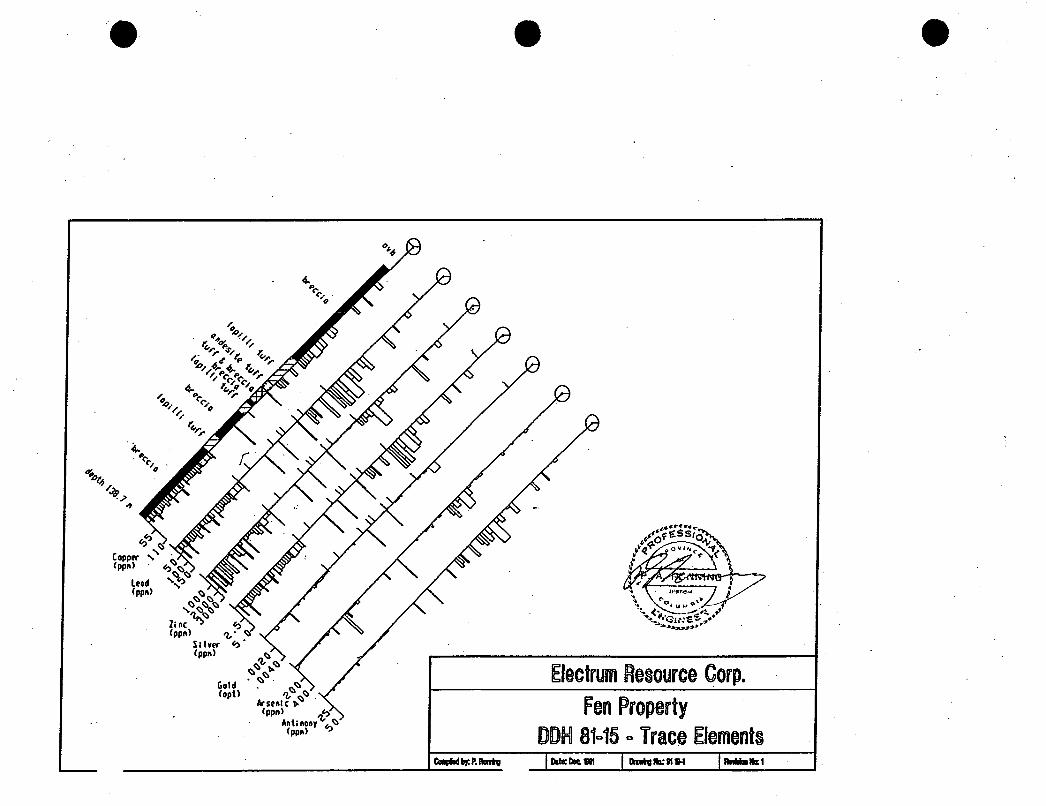
In drill holes, zinc values of up to 3.7% over 0.3 meters and silver values of up to 30.2 ppm over 0.6 meters have been reported (see sections for DDH's 81-10 and 81-15, included with this report).
The only mineralization seen during the course of the present work consisted of up to 5%
VI. Soil Geochemistrv Twenty-two soil samples were collected in 1994, and analyzed for 31 elements using the
ICP technique and for gold using a fire assay preparation and an AA finish. Fifteen of the samples were also analyzed for total barium and fluorine.
These plots serve only to document the samples collected in 1994. In order to properly interpret these results, they should be merged with those from prior years. This has not been done for this report.
At four sites, in a low-lying, swampy area, pits were hand dug and samples collected from two to four different soil horizons. This was done as a check on certain results obtained in earlier
0 The results for copper, lead, zinc, silver and gold are plotted on Figures 11 through 15.
soil sampling.
Soil samples 1550 A-D and 1600 A-C were collected at stations 1550 W and 1600 W on the base line. In a 1991 survey soil samples at these sites were found to contain 4.9 ppm and 18.0 ppm silver respectively (Zastavnikovich and Bzdel, 1991). Furthermore, between 1500 W and 1950 W, five of the 1991 samples contained zinc in excess of 1,000 ppm and only one contained less than 500 ppm zinc.
The 1994 check sampling at 1550 W and 1600 W indicates that silver is highly enriched in the organic debris that forms the upper 40 centimeters of the swamp accumulation. Black, purely organic material below the live roots but above any mineral soil contains 12.5 ppm silver at 1550 W and 17.3 ppm silver at 1600 W. Below the black organics, in a grey-brown, muddy mineral soil containing rock fragments, silver drops to 1.5 ppm and 1.9 ppm. Even deeper, in a mineral soil containing sub-rounded boulders up to 25 cm in diameter, silver drops to 0.1 ppm at 1550 W.
0
file: RPT-19-1 .DOC 07/02/95 09:OO Page 8

\ I
Feldspar Crystal I Lithic Lapilli Tuff. Feldspars altered to opaque chalky @ NCG masses of clays. 2% ovoid, sub-rounded black spots, soft and waxy with
I
I
H
G
F
E' D
C
B A Figure 5
.sspc.d~vraaroucn
Symbols and Notations Lithologic U
Andesite or dacite porphyry; 10% biotite phenos 1 - 3 mm, 10% plag phenos 1 - 3 mm; medium greyish green, very finely crystalline groundmass; no sulphides, nowmagnetic. Probably dike. Intensely altered tuff; probably derived from unit A. Variably clay altered and silicified; highly variable sulphide content up to 5%. Pyrite is dominant sulphide; also present are grey metallics too fine to I.D. Rhyolite. Finely crystalline, variably sucrosic, local flow banding. Dominantly orthoclase feldspar, 5 - 10% millimetric quark grains. No wlphides; locally speckled with Fe oddes. Characterized by brittle fracture cleavage at 1 mm spacing. May be an exfoliation.
Intermediate flow or sub-volcanic intrusive. Dense. hard, black, crypto- crystalline with a few plagioclase and quartz phenocrysts. Non magnetic.
Finely Crystalline Basalt
outcrop
+, brittle foliation
the following text styles are used to indicate different types of information:
2 Copper in Rocks, ppm
Si1
5~ percent sulphides
7 fracture alteration type; Si1 = silicification, Arg = Argillktion
old exploration trench
,-- inferred contact H liologicunit - watercourse m A ... j: ... i . . ::.::::.: ..:.:. .,.

I I
I
H
G
F
E D
C
B A
groundmass; no sulphides,non-ma&eti&. ProbabG dike. Intensely altered tuff; probably derived from unit A. Variably clay altered and silicified; highly variable sulphide content up to 5%. Pyrite is dominant sulphide; also present are grey metallics too fine to I.D. Rhyolite. Finely crystalline, variably sucrosic, local flow banding. Dominantly orthoclase feldspar, 5 - 10% millimetric quartz grains. No sulphides; locally speckled with Fe oxides. Characterized by brittle fracture cleavage at 1 mm spacing. May be an exfoliation.
Intermediate flow or sub-volcanic intrusive. Dense. hard, black, crypto- crystalline with a few plagioclase and quartz phenocrysts. Non magnetic.
Finely Crystalline Basalt
Carbonate. Iron-rich, grey, weathers orange. Primary carbonate or alteration product open to question.
Tuff? Completely altered to chalky white. soft, clay-rich rock. Protolith hard to determine but probably felsic tuff. No indication of sulphides.
Altered Andesite Hornblende Porphyry.
Feldspar Crystal I Lithic Lapilli Tuff. Feldspars altered to opaque chalky masses of clays. 2% ovoid, sub-rounded black spot$ soft and waxy with black streak. Traces of pyrite. ,
Outline of / Clearcut
13 1
outcrop
brittle foliation
the following text styles are used to indicate different types of information:
Lead in Rocks, ppm
Si1 alteration type; Si1 = silicification, Arg = Argil l i i ion
5% perknt sulphides
H lithologic unit
- fracture
old exploration trench
~ - - inferred contact - watercourse
A Legal Corner Post; claim boundaries
\ \ Tsalit 4
Tsalit 8 i
FEN 4
\
A Electrum Resource Corp.
/ Fen Property
I @ NCG . d l ( W h w b u a s c u c "
Figure 6

Symbols and Notations
Lithologic U Andesite or dacite porphyry; 10% biotite phenos 1 - 3 mm, 10% plag phenos 1 - 3 mm; medium greyish green, very finely crystalline groundmass; no sulphides, non-magnetic. Probably dike. Intensely altered tuff; probably derived from unit A. Variably clay altered and silicified; highly variable sulphide content up to 5%. Pyrite is dominant sulphide; also present are grey metallics too fine to I.D. Rhyolite. Finely crystalline, variably sucrosic, local flow banding. Dominantly orthoclase feldspar, 5 - 10% millirnetnc quartz grains. No sulphides; locally speckled with Fe oxides. Characterized by brittle fracture cleavage at 1 mm spacing. May be an exfoliation.
Intermediate flow or sub-volcanic intrusive. Dense, hard, black. crypt& crvstalline with a few plagioclase and quartz phenocyysts. Non magnetic.
outcrop
+ brittle foliation - fracture
the following text styles are used to indicate different types of information:
2 Zinc in Rocks, ppm
Si1
5% percent I sulphides
H lithologic unit
alterat'ion type; Si1 = silicification, Arg = Argilluation old exploration trench
,.- inferred contact - watercourse
Finely Crystalline Basalt
Carbonate. Iron-rich, grey, weathers orange. Primary carbonate or alteration product open to question.
Tuff? Completely altered to chalky white, soft, clay-rich rock. Protolith hard to determine but probably felsic tuff. No indication of sulphides.
Altered Andesite Hornblende Porphyry.
Feldspar Crystal / Lithic Lapilli Tuff. Feldspars altered to opaque chalky masses of clays. 2X ovoid, sub-rounded black spots, soft and waxy with black streak. Traces of pyrite.
Legal Corner Post; Electrum Resource Cow.
Fen Property Zinc in Rocks, ppm
claim boundaries
scale in meters DR*nWPAR Pm)od: 912- 19 DIuVm: w: 19.1-7 1
ii'- m: 191 Ddl: UmMY 7 f i W 0 Figure 7
@ NCG adapfd nom .WM SOYE..

I I FEN 1 FR
Svmbols and Notations Lithologic Units
Andesite or dacite porphyry; 10% biotite phenos 1 - 3 mm, 10% plag - a phenos 1 - 3 mm; medium greyish green, very finely crystalline
groundmass; no sulphides, non-magnetic. Probably dike. Intensely altered tuff; probably derived from unit A. Variably clay altered and silicified: hiahlv variable subhide content up to 5%. Pyrite is
@ outcrop the following text styles are used to indicate
4- brittle foliation different types of information:
domiant suiphGef also preseni are grey metallics too fine to 1.D Rhyolite. Finely crystalline, variably sucrosic, local flow banding. Dominantly orthoclase feldspar, 5 - 10% millimetric quartz grains. No sulphides; locally speckled with Fe oxides. Characterized by brittle fracture cleavage at 1 mm spacing. May be an exfoliation.
Intermediate flow or sub-volcanic intrusive. Dense, hard, black, crypto- crystalline with a few plagioclase and quart? phenocrysts. Non magnetic.
Finely Crystalline Basalt
.- - fracture
old exploration trench
--- - inferred contact / - watercourse
I m
2 . l Silverfin Rocks, ppm
Si1
5 x perter$ sulphides
H lithologic unit
I alteration type; Si1 = silicification, Arg = Argillization
I
Tsalit 8
I . ... . I Electrum Resource Cop.
Fen Property Silver in Rocks, ppm
Legal Comer Post; claim boundaries Carbonate. Iron-rich, grey, weathers orange. Primary carbonate or
alteration product open to question.
Tuff? Completely altered to chalky white, soft, clay-rich rock. Protolith hard to determine but probably felsic tuff. No indication of sulphides.
m m b r PAR w: 911.19 R.*hg: 1014
Dd.: Meday 7 N W a.pWl: 19.1 um4llal: 1
Altered Andesite Hornblende Porphyry. scale in meters loo 200 3M) 400 500
Figure 8 0
f& NCG adadap(.d hrm - s o a n
Feldspar Crystal I Lithic Lapilli Tuff. Feldspars altered to opaque chalky masses of clays. 2% ovoid, sub-rounded black spots, soft and waxy with black streak. Traces of pyrite.
I I
I " I

I + I _c_
Lithologic \> Units - - FEN 1 FR I
Symbols and Nbtations Andesite or dacite porphyry; 10% biotite phenos 1 - 3 mm, 10% plag ohenos 1 - 3 mm: medium greyish green, very finely Crystalline
the following text styles are used to indicate different types of information:
2 Gold in Rocks, ppb
groundmass; no sulphides, non-magnetic. Probably dike. Intensely altered tuff; probably derived from unit A. Variably clay altered and silicified; highly variable sulphide content up to 5%. Pyrite is dominant sulphide; also present are grey metallics too fine to I.D.
outcrop
+ brittle foliation - fracture Rhyolite. Finely crystalline, variably sucrosic, local flow banding. Dominantly orthoclase feldspar, 5 - 10% millimetric quartz grains. No sulphides; locally speckled with Fe oxides. Characterized by brittle fracture cleavage at 1 mm spacing. May be an exfoliation.
Intermediate flow or sub-volcanic intrusive. Dense, hard, black, crypto-
Si1
5x percent sulphides
alterition type; Si1 = silicification, Arg = Argiliiation old exploration trench
, .- inferred contact H lithologic unit
crystalline with a few plagioclase and quartz phenocrysts. Non magnetic.
Finely Crystalline Basalt
Carbonate. Iron-rich, grey, weathers orange. Primary carbonate or alteration product open to question.
Tuff? Completely altered to chalky white, soft, clay-rich rock. Protolith hard to determine but probably felsic tuff. No indication of sulphides.
- watercourse
Legal Comer Post; claim boundaries ?-- Electrum Resource C o p
Fen Property Gold in Rocks, ppb
m: 911- 19 Dnrkp: 13-14 scale in meters 0 tw) 200 JW 400 m
hmn w: PAR
Osl.:UmdsyllIw35
Altered Andesite Hornblende Porphyry.
Feldspar Crystal I Lahic Lapilli Tuff. Feldspars altered to opaque chalky masses of clays. 2% ovoid, sub-rounded black spots, soft and waxy with black streak. Traces of pyrite.
Rqml: 1 0 3 RlvllLa: 3
Figure 9 @ NCG horn nmn w c . *

I .

report 19-1 NCG
Zinc is also most concentrated in the organic layer, and there is a weak tendency for a
This indicates that the organic-rich material, which is typically 60 centimeters thick in the swamp, scavenges and concentrates hydromorphically transported metals. Furthermore, the mineral soil, found underneath 60 cm or so of organic 'material, appears to be transported. Thus any metal anomalies found in the low-lying swampy parts of the survey area are probably a result of complex mechanical and hydromorphic dispersion. Their ultimate source is almost impossible to deduce.
a similar concentration of copper.
VII. GeoDhvdcs A report by Todd A. Ballantyne, discussing the VLF survey done in 1994, is included with
this report as Appendix 1. In general it is difficult to correlate the VLF anomalies with any known geological features, a problem that is largely due to the paucity of outcrop. One tentative correlation can be suggested. Ballantyne points out that the most well defined VLF anomaly is located in the center of the grid, trending ESE as indicated on his Plate 1. A correlative anomaly is evident on Ballantyne's Plate 4.
"alteration front" as dra.wn in Figure 4. It is possible, though far from certain, that the alteration front is partly bounded on the southwest by some through-going structure to which the VLF responds.
The western part of this ESE feature is crudely correlative with the western part of the
VIII. Discussion
There is no doubt that hydrothermal alteration and mineralization have affected rocks assigned to the Hazelton Group in the survey area. Based solely on surface occurrences, without reference to drill hole data, the altered zone has dimensions of at least 750 meters east-west and 350 meters north-south. North of the exposures of altered tuff, the surface descends into a low- lying, swampy area with no rock exposures. Therefore the altered zone is open to the north for some unknown distance. One can speculate that the topographic low may be partly a reflection of the presence of rocks which are recessive due to a high degree of alteration.
Exploration north of altered outcrops will be difficult. Soil geochemistry is hard to interpret in that area due to the combined effects of hydromorphic and mechanical dispersion. Short of drilling, the only effective exploration techniques will be geophysical.
E. Recommendations
The following steps are necessary to further exploration of this area:
1.
2.
Merge the rock and soil geochemical information in this report with similar data from Zastavnikovich and Bzdel(l991) and Zastavnikovich and Visser (1993).
Compare the merged geochemical data with older data sets. This will require careful correlation of topographic references in order to compare data collected on different coordinate or grid systems.
file: RPT-141.DOC 01/02/95 15:45 Page 9

7 200N
claim boundaries I Legal Corner Post;
scale in meters 0 loo m 300 400 500
/
I Electrum Resource Corp.
Fen Property Soil Sample Locations
m by: PbR w: 912 - 19 Dm6q: 19.1-10
Dab: Monday 7lloR.i R.polt: 19.1 R.utdm:l
Figure 10 @ NCG .d.p(.d RMI VmicUl wwc.s
stacked markers in cate multiple Outline of \ Tsalit 4 \
samples from a profi t one site W \
FEN 2 /
r i

3 3 3 P - - N
3 0 0 00. r-
P 0 0 r--* r
0 0 co,
0 0 ** T-
28 + ++26+ q-+
23
42 25
45 28
54 23 17
+ V-p.26 $9.1- +
+
+
0 0 2
0 9
0 0 0.
7-
0 0
2 9 P + 2 9 . + + + + + + + +
+
+
7-
0 0 co
+ + +++ Outline of
+++
+++
Clearcut y Symbols and Notations
55 Copper in soils, pprn
old exploration trench - watercourse
scale in meters
0 1 0 0 200 300 400 500
Electrum Resource Corp. I Fen Property
Copper in Soils, ppm Drawing: 19-1-11 Drawn by: PAR
Date: Friday 7/07/95 Report: 19-1 Revision: I
Project: 912 - 19
i
Figure 11 I @ NCG adapted from various sources

N
3 0 0 a! r
3 0 0 r-* 7
+ + +++ + +++
/ O N /
302 7721 748
++ + + + + + ~ q W ' $ 1 0 9 4 + + + + + i 538 730 778
+
+ ++ + + + + + +
FEN 2 '
8 2 p y - 3q-+ + + + + + + + + + + + +
$++
Symbols and Notations 55 Zinc in soils, pprn
old exploration trench - watercourse
Electrum Resource Corp. I
Date: Friday 7/07/95 Report: 19-1 Revision: 1 scale in meters Figure 13
0 100 200 300 400 500 @ NCG adapted from various sources
Fen Property Zinc in Soils, ppm
Drawn by: PAR Project: 912 - 19 Drawing: 19-1-13 I I

+ + +++ + +++
u -
Symbols and Notations
55 Silver in soils, pprn old exploration trench - watercourse
scale in meters Y
0 100 200 300 400 500
Outline of Clearcut
Electrum Resource Corp.
Fen Property Silver in Soils, ppm
~~ ~~
Drawn by: PAR I project: 912 - 19 I Drawing: 19-1-14
Date: Friday 7/07/95 I Report: 19-1 I Revision: 1
Figure 14 @ NCG adapted from various sources

Symbols and Notations
55 Gold in Soils, ppb old exploration trench
watercourse
scale in meters
0 100 200 300 400 500
Electrum Resource Corp.
Fen Property Gold in Soils, ppb
Drawn by: PAR I project: 912 - 19 I Drawing: 19-1-15
Date: Friday 7/07/95 I Report: 19-1 I Revision: 1
Figure 15 @ NCG adapted from various sources

report 1 9 1 NCG
3. Re-examine existing drill hole data from the vicinity of the alteration zone. Determine whether there is any correlation between drill hole data and surface data.
Examine pre-1990s geophysical data for indications of alteration or sulphides in the swampy area north of altered rock exposures. Determine whether further geophysical surveys are warranted. Until the old data is reviewed in detail, it is not possible to determine what further types of surveys may be needed.
Based on geophysical information, determine whether drilling is warranted.
4.
5.
file: RPT-191.DOC 01/02/95 15:45 Page 10

report 19-1 NCG
Church, B.N. 1972: Code, Fen; in GEM, 1972, pp. 373 - 379
Church, B.N. and Barakso, J.J. 1990: Geology, Lithogeochemistry and Mineralization in the Buck Creek Area, British
Columbia; B.C. Geological Survey Branch, Paper 1990-2.
Helsen, J. 1982: Diamond Drilling Report; Red and Code Claims. Company report for Mattagami Lake
Exploration Ltd.
Mercer, W. 1981: Diamond Drill Report, Red, Code 6 , Code 7, Code 21FR. Claims. Company report for
Mattagami Lake Exploration Ltd. Tipper, H.W. and Richards, T.A. 1976: Geological Survey of Canada Open File 351, Smithers Map Sheet, Geological map at 1
inch to 4 miles.
Zastavnikovich, S and Bzdel, L.M. 1991: Geochemical and Geophysical Assessment Report on the Fen 1-4 and Tsalit 4-8 Mineral
Claims; company report for Baril Developments Ltd., filed for assessment credit.
Zastavnikovich, S and Visser, S.J. 1993: Geochemical and Geophysical Assessment Report on the Fen 1-4 & Tsalit 4-8 Mineral
Claims; company report for Baril Developments Ltd., filed for assessment credit.
0
file: RPT-141.DOC 01/02/95 15:45

report 1 9 1 NCG
1.
2.
3.
4.
5.
6.
7.
8.
9.
XI. Statement of Oualifications
I, Peter Arthur Ronning, of 1450 Davidson Road, Langdale, B.C., hereby certify that:
I am a consulting geological engineer, doing business under the registered name New Caledonian Geological Consulting. My business address is 912 - 510 West Hastings Street, Vancouver, B.C., V6B 1L8.
I am a member in good standing of the Association of Professional Engineers and Geoscientists of the Province of British Columbia.
I am a graduate of the University of British Columbia in geological engineering, with the degree of B.A.Sc. granted in 1973.
I hold the degree of M.Sc. (applied) in geology from Queen’s University in Kingston, Ontario, granted in 1983.
I have worked as a geologist and latterly as a geological engineer in the field of mineral exploration since 1973.
I am the author of the report entitled “1994 Exploration Program on the Fenton Creek Property”
I participated in the work described in this report.
I hold no beneficial interest in the mineral claims which are the subject of this report, nor in any corporation or other entity whose value could reasonably be expected to be affected by the conclusions expressed herein.
I authorize Electrum Resource Corp. and Baril Developments Limited to use this report, but only in its entire and unabridged form, for any lawful purpose.
Peter A. R o n n i n h g .
file: RPT-19-1.DOC 01/02/95 15:45 Page 12

report 1 4 1 Appendix 1
Amendix 1 - GeoDhvsical ReDort
\
NCG
file: RPT-141.DOC 01/02/95 15145

e
a
GEOPHYSICAL REPORT
VLF-EM SURVEYS
on the
FEN PROPERTY OMINECA, Mining Division N.T.S. 93 L/2W
prepared for:
E L E C T R U M R E S O U R C E C O R P . S u i t e 9 1 2 - 5 1 0 W e s t H a s t i n g s S t r e e t
V a n c o u v e r , B . C . V 6 C 1 V 5
Survey by:
S. Zastavnikovich
Report by:
Todd A. Ballantyne, P. Geo.
S . J . V . C o n s u l t a n t s L t d . 1 1 7 6 2 - 9 4 t h A v e n u e
D e l t a , B r i t i s h Co lumbia C a n a d a V 4 C 3R7
January 1995

Fen Propem . WF-EM Survey 1994
TABLE OF CONTENTS
~ R O D U C ~ O N ................................................................................................................. 1
FIELD WORK AND INSTRUMENTATION .............................................................................. 1
DATA PREsnvTAnON ....................................................................................................... 1
~[NTERPRETA~ON .............................................................................................................. 2
RECOMMENDATIONS & S ~ Y ................................................................................... 3
APPFNDIX I ...................................................................................................................... 4
Statement Of QualiJcications ............................................................................... 4
APPENDIX 11 ..................................................................................................................... 5
VLF-EM SURVEY DATA PREsnvTATION ..................................................................... 5

Fen Property - V U - E M Survey I994
INTRODUCTION
A VLF-EM survey was completed by S. Zastavnikovich on the Fen Property. The Property is located between Fenton and Code creeks four kilometres south of Morice River, 30 km southeast of Houston, B.C. in the Omineca mining division (N.T.S. 93W2W). The data was presented to S.J.V. Consultants Ltd. by Peter Ronning of New Caledonian Geological Consulting for plotting and interpretation.
The purpose of the survey was to search for concentrations of sulphides, to aid in the location of shear zones that may have associated mineralization and to aid in the mapping of local geology. This report is an addendum to the geological report written by New Caledonian Geological Consulting.
FIELD WORK AND INSTRUMENTATION The field work was performed by S. Zastavnikovich, a Geochemist during the
September 1994. A total of approximately 12.75 km, with stations every 25m along flagged lines, were surveyed by VLF-EM.
A Geonics EM-16 was used for the field instrument. The dip angle and quadrature measurements were recorded at each station. The east-west lines were surveyed with frequencies 24.8 kHz (NLK, Seattle) and 23.4 kHz (NPM, Hawaii). The north-south lines were surveyed with frequencies 24.0 kHz (NAA, Cutler) and 24.8 kHz (NLK). The azimuths to these transmitting stations from the property are Seattle - 160°, Hawaii - 220" and Cutler - 090". The survey direction in which the VLF data was collected is shown on the data presentation figures.
DATA PRESENTATION
The VLF-EM data, filtered VLF-EM data (using a standard four point Fraser filter) and compilation of the VLF-EM data are presented on the following plates:
Plate VLF-EM Survey Profiles G1
Plate VLF-EM Survey Profiles G2
Plate VLF-EM Survey Profiles G3
Dip Angle & Quadrature - Seattle ( N / S lines)
Dip Angle & Quadrature - Hawaii (N/S lines)
Dip Angle & Quadrature - Cutler (EN lines)
Appendix 11
Appendix 11
Appendix 11

Fen Property - VLF-EM Survey 1994
Plate VLF-EM Survey Profiles G4
Plate VLF-EM Survey Contours G5
Plate VLF-EM Survey Contours G6
Dip Angle & Quadrature - Seattle (Em lines)
Dip Angle & Quadrature - Seattle (N/S lines)
Dip Angle & Quadrature - Cutler (Em lines)
e Appendix 11
Appendix 11
Appendix 11
INTERPRETATION
The interpretation is presented on each of the VLF-EM plates G1 through G4. It is noted that there is a discrepancy between the results of the 1993 VLF survey and the expanded 1994 survey. While the data between these two surveys repeats very well, the 1993 interpretation of anomaly locations is not correct based upon the 1994 field notes. According to the 1993 data the survey direction was facing west and so the according cross-overs were identified The 1994 field notes state that the survey direction is in fact facing east (northeast). Therefore the location of the 1993 anomaly cross-overs are actually on the reverse cross-over in those data maps. The writer of this report was unable to talk with S. Zastavnjkovich to confirm the survey direction used in the interpretation of the 1994 data.
The Seattle (24.8 kHz) transmitter was the best suited for this grid. The Hawaii data provided little insight, but it may yield more information if the very subtle anomalies correlate with structures of interest. VLF results from the Cutler transmitter were similar to the Seattle data. The most well defined anomaly is located in the centre of the grid trending ESE on plate G1. This anomaly is confirmed on the north/south lines with the Seattle transmitter and partially confirmed with the Cutler data. The remainder of the anomalies are presented on the data profile maps on plates G1 through G4.
Contour maps of the Fraser filtered dip angle data are provided for Seattle and Cutler. Care should be taken when using the contoured presentation for interpretation. The gridding algorithm is not capable of comparing the line to line similarities in the signatures of data profiles for both the dip angle and quadrature and hence the anomalies plotted on the profile maps will not always reflect the contoured data.

Fen Property - V U - E M Survey I994
RECOMMENDATIONS & SUMMARY
The geophysical data should be compiled with geological mapping, geochemical sampling and overburden thickness to enhance the existing geophysical interpretation and to determine if idill or other geophysical techniques are required to increase the geological and geophysical information. Infill surveying of 100 metre spaced lines would greatly improve the ability to connect VLF anomalies from line to line. There are numerous very weak anomalies that cannot be confidently identified without geological information or more dense VLF data. More information is likely to be obtained from these data sets when compared with the geology and geochemical sampling. The field notes have not been correlated with the VLF survey. More time should be spent correlating the VLF results with the geology and field notes.
The VLF frequencies for Seattle and Cutler provided the best information. Data from the Hawaii transmitter was sketchy, but may prove of use if the weak anomalies show favourable correlation with the geology. At this point it is not clear to what degree mineralization is responsible for the anomalies delineated.
The VLF-EM survey has delineated numerous VLF anomalies.
17 January, 1995

I Fen Property - VLF-EM Survey 1994
17 January, 1995
APPENDIX I
Statement Of Qualifications
I, Todd A. Ballantyne, of 3538 West Sixteenth Avenue, Vancouver, in the Province of British Columbia, DO HEREBY CERTIFY:
1. THAT I am a graduate of the University of British Columbia with a Bachelor of Science degree in Geophysics.
2. THAT I have been engaged in mining and petroleum exploration since 1987.
3. THAT I am registered as a Professional Geoscientist with the Association of Professional Engineers and Geoscientists of the Province of British Columbia.
4. THAT this report is based on fieldwork carried out by S. Zastavnikovich in 1994.

Fen Property - VLF-EM Survey 1994
APPENDIX II
VLF-EM Survey Data Presentation

3 3 3 3 3 3 3 3 3 3 3 3 3 3 3 3 3 3 3 0 0 0 0 0 0 0 0 0 0 0 0 0 0 0 0 0 0 0 0 0 0 0 0 0 0 0 0 0 0 0 0 a r O o a 3 b o u 3 t ~ N r 0 0 0 0 0 0 0 c
LEGEND PROFILES ARE POSITWE LEFT AND UP
DIP ANGLE - QUADRATURE . . . . ~ . ,
VLF-EM PROFILE SCALE:
BASE VALUE f""' -10%
1991 M T A - \
U'. ... I .._. I...! I . I .-\ I . I . I . " . ' ' ' .
ANOMALY AXIS STRONG < WEAK MEDIUM 0 _ - f .
\ RESISTIVITY , - * - - . - \ CONTACT
EQUIPMENT GEONICS EM-16
TRANSMITIER STATION USED
SEAllLE. NLK, 24.8 kHz
DIRECTION OF SURVEY: EAST
1993 DATA ON THE ENDS OF THE BASE LINE ONLY
ELECTRUM RESOURCE CORP.
VLF-EM SURVEY PROFILES GRID-2
3 3 3 3 3 3 3 3 3 3 3 3 3 3 3 3 3 3 FEN PROPERTY 0 0 0 0 0 0 0 0 0 0 0 0 0 0 0 0 0 0 0 0 0 0 0 0 0 0 0 0 0 0 0 a - o o a 3 b o u 3 ~ o N ~ o o o o o o P J N N , r 7 r r r r 7 7 r o - ) c o b O l n OMINECA M.D., B.C. - N.T.S. 93L/2W
SCALE IN METRES
100 0 100 200 300
SEPTEMBER 1994 PLATE GI I . . ' '
S.J.V. CONSULTANTS LTD.

3 3 3 3 3 3 3 3 3 3 3 3 3 3 3 3 2 3 3 0 0 0 0 0 0 0 0 0 0 0 0 0 0 0 0 0 0 0 0 0 0 0 0 0 0 0 0 0 0 0 0 N r 0 0 - ) 0 3 b t f ) O $ ~ N ~ 0 0 0 0 0 0 0
LEGEND PROFILES ARE POSITWE LEFT AND UP
DIP ANGLE - QUADRATURE ;-._ . .
VLF-EM PROFILE SCALE:
BASEVALUE 0 €I:, ANOMALY AXIS
STRONG - - MEDIUM 0 WEAK RESISTIVITY , * - - . -
_ - . .
CONTACT
EQUIPMENT GEONICS EM-16
TRANSMITER STATION USED HAWAII, NPM, 23.4 kHz
DIRECTION OF SURVEY: EAST
3 3 3 0 0 0 0 0 0 N F O N N N
3 0 0 0
3 0 0 03 7
3 0 0 b 7
3
tf) r
3 0 0 In 7
3 3 3
7 7
3 0 0 r
7
3 3 3 3
cs, al I\
3 0 0 ro
ELECTRUM RESOURCE CORP. 3 FEN PROPERTY 0 VLF-EM SURVEY PROFILES 0 GRID-2 In OMINECA M.D.. E.C. - N.T.S. 93L/2W
SCALE IN METRES
100 0 100 Mo 500
S.J.V. CONSULTANTS LTD. SEPTEMBER 1994 PIATE G2

3
2 0 0 N
1 0 0 N
0
1 0 0 s
2 0 0 s
3 0 0 s
400 S
5 0 0 S
6 0 0 S
7 0 0 s
3 0 0 al r
3 0 0 ID r
\ .'T
3 0 0 * 7
3 3 0 0 0 r
3 0 0 03
3 0 0 ID r-
3 0 0 *
3 0 0 N ?-
3 0 0 0
3
ID
3 0 0 a3
3 0 0 ID
LEGEND PROFILES ARE POSITIVE LEFT AND UP DIP ANGLE - QUADRATURE , . . . . , .
VLF-EM PROFILE SCALE: +lox
BASE VALUE 0 f -10%
ANOMALY AXIS STRONG MEDIUM 0
WEAK RESlSnVlM
CONTACT
EQUIPMENT:
. - . . , . - - . . -
GEONICS EM-16
TRANSMITTER STATION USED:
CUTLER, NAA. 24.0 kHz
DIRECTION OF SURMY: NORTH
ELECTRUM RESOURCE CORP. FEN PROPERTY
VLF-EM SURVEY PROFILES GRID-2
OMINECA M.D., B.C. - N.T.S. 93L/2W
SCALE IN NElRES
I . . . ? - 1 0 100 zoo 330 100
SEPTEMBER 1994 PLATE G3 .J.V. CONSULTANTS LTD.

3 0 0 co r
2 00
1 0 0
0
1 0 0
2 0 0
3 00
400
5 00
6 00
7 0 0 s
3 0 0 0 0 0 0 0 * nl 0 0
3 3 3 3
0 0 0 0 0 0 0 * nl 0 0
3 3 3
r r r 03
3 3
3 3 3 3 0 0 0 0 0 0 0 0 0 0 0 co u) * (\I 0 0 r 7 r- r 7 03
S.J.V. CONSULTANTS LTO.
3 0 0 ID
LEGEND PROFILES ARE POSITIVE LEFT AND UP
DIP ANGLE - QUADRATURE . . . . . . . .
VLF-EM PROFILE SCALE: +lo%
BASE VALUE 0 f - 10%
ANOMALY AXIS STRONG - WEAK RESISTIVITY , - - - MEDIUM 0 . - . _
CONTACT
EQUIPMENT: GEONICS EM-16
TRANSMITIER STATION USED
SEATIE, NLK. 24.8 kHz
DIRECTION OF SURVEY: NORM
3 0 0 ID
f
ELECTRUM RESOURCE CORP. FEN PROPERTY
VLF-EM SURVEY PROFILES GRID-2
OMINECA M.D., B.C. - N.T.S. 93L/2W
SCME IN METRES
loo 0 i w 200 500 1 " ' : I
SEPTEMBER 1994 PLATE G4

3 3 3 3 3 3 3 3 3 3 3 3 3 3 3 3 3 3 3 0 0 0 0 0 0 0 0 0 0 0 0 0 0 0 0 0 0 0 0 0 0 0 0 0 0 0 0 0 0 0 0
FRASER FILTERED DIP ANGLE
NEGATIVE CONTOURS ARE SUPPRESSED
CONTOUR INTERVAL: 2%
POSTED INTERVAL 10% - ANOMALY AXIS
STRONG < MEDIUM 0 WEAK RESlSTNlM
CONTACT
EQUIPMENT:
. - . . - . - . . -
GEONICS EM-16
TRANSMITIER STATION USED
SEATTLE. NLK, 24.8 kHz
DIRECTION OF SURVEY: EAST
1993 DATA ON THE ENDS OF THE BASE LINE ONLY
ELECTRUM RESOURCE CORP.
VLF-EM SURVEY CONTOURS 3 3 3 3 3 3 3 3 3 3 3 3 3 3 3 3 3 3 FEN PROPERTY 0 0 0 0 0 0 0 0 0 0 0 0 0 0 0 0 0 0 0 0 0 0 0 0 0 0 0 0 0 0 0 N ~ O ~ a 3 b ~ u - ) * m N ~ 0 0 0 0 0 0 GRID-2 N N N , r- r r r r 7 r 7 , D C o r \ L o o OMINECA M.D.. B.C. - N.T.S. 93L/2W
SCALE IN METRES
1w 0 100 200 300
SEPTEMBER 1994 PLATE G 5 I I S.J.V. CONSULTANTS LTD.

0 e a
2 0 0 N
1 0 0 N
0
1 0 0 s
200 s
3 0 0 s
400 S
500 S
6 0 0 S
7 0 0 s
3 0 0 a3
3 3 3
0 0 0 0
3 3 0 0 0 0 * N
0
r r r a3
3 0 0 (D
T t T T T T LEGEND
FRASER FILTERED DIP ANGLE
NEGATIVE CONTOURS ARE SUPPRESSED
CONTOUR INTERVAL: 4%
POSTED INTERVAL: 20%
ANOMALY AXIS STRONG - MEDIUM 0
WEAK . . . . RESlSTlVllY
CONTACT - ~ - - - -
I- t
3 3 3 3 3 3 3 0 0 0 0 0 0 0 0 0 0 0 0 a3 (D d- N 0 0 0 r c 7 7 7 co (D
;.J.V. CONSULTANTS LTD.
F
EQUIPMENT GEONICS EM-16
TRANSMITTER STATION USED
CUTLER, NAA. 24.0 kHz
DIRECTION OF SURVEY: NORTH
ELECTRUM RESOURCE CORP. FEN PROPERlY
VLF-EM SURVEY CONTOURS GRID-2
OMINECA M.D.. B.C. - N.T.S. 93L/2W
SCALE IN METRES
100 0 100 200 3M)
SEPTEMBER 1994 PLATE G6 I . ' . : - I

report 1 4 1 Appendix 2
Amendix 2 - Statement of Costs
file: RPT-141.DOC 01/02/95 15:45
NCG

Statement of Expenditures As of: 05-Feb-95
Personnel Lastname Start Date End Date Fee GST Total Item
Barakso Edmunds Hammer Ronning Zastavnikovic
17/08/94 18/08/94 $600.00 $0.00 $600.00 26/09/94 30/09/94 $625.00 $0.00 $625.00 15/08/94 02/09/94 $1,480.00 $1 03.60 $1,583.60 02/08/94 02/02/95 $6,615.00 $463.05 $7,078.05 26/09/94 27/09/95 $3,150.00 $0.00 $3,150.00
$1 2,470.00 $566.65 $1 3,036.65
Vehicles Vehicle Description Start Date End Date cost GST Total Cost
Chev Blazer with Camper 17/08/94 08/09/94 $240.00 $16.80 $256.80
$240.00 $16.80 $256.80
Equipment Charges Equipment Description Start Date End Date cost GST Total Cost
0 Misc Camp & Field Eqpt 28/08/94 06/09/94 $1 00.00 $7.00 $1 07.00
$1 00.00 $7.00 $1 07.00 ~ ~~
Disbursements Type cost PST GST Item Total
Communications Equipment Rental Fares Field Supplies Geophysical Rpt Groceries Hotels Laboratory Costs Meals Office Supplies Shipping Vehicle Operation
0
$20.29 $1,383.57
$275.49 $1 81.44
$1 ,I 07.00 $184.81 $788.00
$1,322.50 $814.55 $44.50 $38.59
$585.96
$0.16 $47.15 $0.00
$9.55 $0.00
$2.23 $27.04 $0.00
$0.00
$3.12 $0.00 $0.00
$0.16 $47.1 5
$9.64 $9.55
$77.49 $3.99
$23.66 $92.58 $24.83 $3.12 $0.00
$16.24
$20.61 $1,477.87
$285.13 $200.54
$1 ,I 84.49 $1 91.02 $838.70
$1,415.08 $839.38 $50.73 $38.59
$602.20
$6,746.70 $89.24 $308.40 $7,144.34

Statement of Expenditures As of: 05-Feb-95
Grand Total Total Before Taxes - PST - GST Grand Total
$1 9,556.70 $89.24 $898.85 $20,544.79

report 141
Sample Number
PRF-01
PRF-02
PRF-03
PRF-04
PRF-05
PRF-06
PRF-07
file: RPT-19-1 .DOC
Appendix 3 NCG
Amendix 3 - Descrhtions of Rock Samdes
Table 4 - Descriptions of Rock Chip Samples Collected in 1994 Location
exposure in ditch beside logging road
in ditch beside logging road, +15m south of PRF-01
10 m west of roac in skid trail
exposure in old cat trail on south side of Mineral Hill
top of Mineral Hill
top of Mineral Hill, 10 m west of cliffs
Description
Highly altered, original lithology obscured but probably a tuff. Mafic destroyed. Feldspars altered to a soft white clay assemblage. Original millimetric quartz grains, although partly obscured by silicification, probably formed 15% of rock. Silicification in the form of partial flooding and a variably intense network of quartz veinlets now forms 15% of rock. &% sulphides or sulphosalts; mainly pyriie but also some dark grey minerals that tarnish to black. Thick coating of black oxides on outer exposed surfaces. Orange-brown Fe oxides line interior fractures.
Completely altered; grey, crypto-crystalline, moderately hard, 10% pore space as sub-millimetric, sharply angular vugs. Sulphides *5%, pyrite and unknown black sulphides. Also, 10% white specks of unknown alteration mineral.
Feldspar Crystal Lapilli Tuff. Mainly feldspar crystal tuff with 15% white, sub-millimetric feldspar crystals in grey, crypto- crystalline groundmass. 10% to 20% of rock is lithic lapilli, generally consisting of felsic volcanic material like the groundmass. Occasional relics of black minerals that may have been sulphides or sulpho-salts. Weathers to orange- brown. Sample is a grab from a 5m radius.
Feldspar crystal / lithic lapilli tuff. Texturally similar to PRF-03. Two % ovoid, sub-rounded black spots; soft, waxy black streak. Zeolite? Feldspars altered to opaque chalky masses. A few traces of pyrite and a few specks of Fe oxides. Sample is random grab of chips over length of outcrop.
Intermediate flow or sub-volcanic intrusive. Dense, hard, dark maroon with patches of green-grey. Generally crypto- crystalline, with a few identifiable phenocrysts of plagioclase and quartz. Non-magnetic. Fractures rusty; exposed surfaces buff grey.
Siliceous volcanic flow rock. Dense and hard, texturally similar to PRF-05. All of groundmass is very hard and has the sheen of finely crystalline quartz. A few irregular millimetric quartz stringers. Local dustings of fine black specks. Most of rock is rusty red. Sample is random selection of chips over about 20 meters of exposure.
Outcrop displays intense fracture cleavage. Cleavage is brittle, spaced at 0.5 cm to 1 .O cm. Orientation 250/45. Cleavage so prominent that OC has aspect of tilted pile of stacked plates. Rock is finely crystalline, pink. May be mainly orthoclase feldspar. 1% k1 mm specks of epidote. A few hairline veinlets of quartz, usually oblique to cleavage.
01102/95 15x45 page 111

report 141 Appendix 3 NCG
Sample Number
PRF-08
PRF-09
PRF-10
PRF-11
PRF-12
PRF-13
PRF-14
PRF-15
~ ~~
Location
Near central summit of Minera Hill.
old trench now forms ditch on south side of road.
north end of old bulldozer trench that forms ditch on east side of road
outcrop exposed by logging activit in clear cut on to1 of a knoll.
at edge of cut block, rubble in perimeter cat trai
bluff north of the road
last exposure on 308" trend at edge of clearcut.
Description
Possible traces of oxidized sulphides.
Rock rubble in roots of recently fallen tree. White, finely crystalline, porcellanous rhyolite. Mainly very finely crystalline feldspar. Quartz recognized in a few sub-millimetric grains and as a lacing of hairline veinlets. Rusty on fracture surfaces: traces of fine metallics. Sample is a grab from the rubble under the tree.
Lithologically as PRF-04. Sample is random grab.
Lithologically as PRF-04. Sample is random grab.
Andesite or dacite; probably sub-volcanic intrusion. 10% biotite phenocrysts, acicular, up to 3 mm long; may be pseudomorphs after hornblende, although they form good books. 10% plagioclase phenocrysts, idiomorphic to anhedral; typically 1 mm x 1-3 mm. Groundmass is medium greyish green, very finely crystalline mixture of felsic and mafic minerals. Feldspars are altered to soft, white powdery mass, probably clays. Exposed surface weathers to a pale greyish white. Fracture surfaces display hematitic oxidation. No sulphides. Non-magnetic. Exposed surface is pitted where the feldspar is weathered out. Outcrop exhibits fracture cleavage; 84/87 (lOO/m). Sample is a random chip from the few angular edges that permit specimens to be broken off.
Lithologically as PRF-11, with the exception that biotite phenocrysts are about '/2 the size. Outcrop pattern of rocks like PRF-11 and PRF-12 suggests a north trending dike. Sample is random grab of chips over the extent of the outcrop.
rubble in trail and debris pulled up in roots of fallen trees, indicate the presence of outcrop under a thin veneer of soil. The rock is a quartz-feldspar lithic lapilli tuff, texturally very similar to PRF-03 and PRF-04. Feldspars are altered to a white porcellanous clay mixture. 5% orange-red specks of oxides are present. No sulphides or silicification. The sample is a random grab of chips from tree roots and from the trail.
Rock type as PRF-11. Part of a group of exposures trending 308" that may be a deflected continuation of the dike south of the road where PRF-11 was collected.
Rock type as PRF-11 and PRF-14. Sample is a grab around a 5 meter radius.
file: RPT-191.DOC 01/02/95 15:45 page IV

report 141 Appendix 3 NCG
Sample Number
PRF-16
PRF-17
PRF-18
PRF-19
PRF-20
PRF-21
PRF-22
PRF-23
PRF-24
file: RPT-19-1 .DOC
Location
in skidder trail
in skidder trail
rocky knoll partly cut by perimeter skidder trail.
at lip of topographic bench
in perimeter cat trail
in cat trail, as itp- goes over the lip of an E-W trending bluff.
Description
an area 4 m by 6 m contains abundant rubble of highly altered feldspar porphyry. It may be a flow or a sub-volcanic intrusive, but it is different from PRF-11. Lacks any suggestion of biotite which is characteristic of PRF-11. Rock is entirely chalky white. 10% feldspar phenocrysts, now altered to clays. A few quartz crystals, sub-rounded, *l mm. Groundmass is greenish white, hard, slightly porous, porcellanous. Exposed surfaces weather orange-red. This rock not actually seen in situ but the ruble is presumed to be almost in place. The sample is a random grab of chips from the area.
Felsenmeer or possibly frost heaved rubble. Area 1 m x 1 m is covered with 1-5 cm fragments of tuff as at PRF-04. Mafics were destroyed, probably by leaching in the surficial environment. Sample collected by scooping up handsful out of a shallow pit. Not certain, but probable, that this represents bedrock.
Small area covered with fragments, as at PRF-17. Minor digging uncovers bedrock. Highly oxidized, orange Fe oxides and black Mn oxides. Probably a similar rock type to PRF-04.
True outcrop, lithologically as PRF-18.
Outcrop of rock as PRF-04.
sub-outcrop of rubble or felsenmeer. Lithologically as PRF- 04. Sample dug out of shallow pit with rock hammer at a randomly selected location.
Rubble, probably but not certainly outcrop. Altered version of unit described at PRF-04. Feldspars altered white clays. Groundmass also altered, to pale grey porcellanous very finely crystalline mass. 3% pore space; some is cavities where minerals were weathered out but some is due to volumetric changes with alteration. The soft black spots noted at PRF-04 are largely altered or removed. On newly broken surfaces, 5% orange-red specks of oxide are present, usually with a central cavity less than 1 mm. Older fracture surfaces, and exposed surfaces, are completely coated with Fe oxides. One grain of pyriie noted and deliberately includec in the sample.
A zone of gossanous rubble, *1 m x 1 Om, trending 1 70°, contains fragments up to 20 centimeters stained black (Mn), dark brown, dark red. Original minerals and textures lost. Could be an "iron cap" over oxidized sulphide mineralization. The sample is a random grab of loose pieces.
Highly altered volcanic; lithologic and textural details of protolith destroyed. Pale grey, very finely crystalline, flecked with 15% white sub-mm feldspars as clay pseudomorphs. 10% Fe oxides as speckles and fracture coatings. Speckles
01/02/95 15:45 page v

report 19-1 Appendix 3 , NCG
Sample Number
PRF-25
PRF-26
PRF-27
PRF-28
PRF-29
PRF-30
PRF-31
PRF-32
Location
skid trail exposure
skid trail
in skid trail
Ih bank of Fenton Creek, 3 meters above channel
Ih bank of Fenton Creek
Description
usually cored by a pit where something, possibly pyriie, has been weathered out.
Altered volcanic. Protolith masked. White, finely crystalline’ mixture of quartz and clays. Speckled with dark brown to black oxides, 10%. Trace of grey metallic specks, possibly hematite.
Moss-covered rubble on steep slope. Talus derived no more than 10 m above this point. Typical white altered volcanic as at PRF-25. At this point, however, more quartz, *15%, as interstitial patches and hairline veinlets. Sample is a grab from the rubble.
Altered hornblende porphyry. Finely sucrosic white groundmass consists of 25% quartz with clay altered feldspars. dense and hard. hornblende phenos mainly degraded to Fe oxide pseudomorphs, elongate, 1/2 to 4 mm. Surface pitted where hornblende pseudomorphs leached out. Originally, hornblende phenocrysts formed 10% of the rock, anhedral to idiomorphic, randomly oriented. The quartz-rich groundmass is probably an alteration. The original rock could have been andesite.
Intense quartz-clay alteration. Protolith obscured although probably tuff. 20% quartz as sub-millimetric grains and minor hairline stringers. The remainder is a soft white material probably consisting of clays. Speckled with 10% Fe oxides that may be pseudomorphous after hornblende. 2-3% pore space. Traces of fine grey minerals that may be sulphides. All fracture surfaces are coated with Fe oxides. Sample selected for hints of sulphides.
Rock as PRF-04 exhibiting degrees of alteration ranging from partial clay alteration of feldspar to almost complete quartz- clay as at PRF-28. Sample is grab of several chips representing a spectrum of alteration.
3m x 5 m of rubble as at PRF-29. Sample is grab selected for relatively high degree of alteration.
3m x 2m exposure of finely crystalline basalt. Weathers reddish, most fracture surfaces are dark brown. Rare unoxidized surfaces exhibit 25% euhedral 1 mm - 2 mm plagioclase phenocrysts in a very finely crystalline black groundmass. Non-magnetic.
4m x 4m exposure of carbonate rock. Unclear whether it is a primary carbonate or a product of alteration. Latter interp. favoured. Finely crystalline; reacts with 10% HCI only if powdered. Weathers orange-brown. On one fracture surface, orange-red Fe oxides plus soft black unknown metallic mineral with black streak. This mineral included in sample. In fresher pieces, rock is grey with irregular black hairline seams of an unknown mineral.
file: RPT-19-1 .DOC 01/02/95 15~45 Page VI

report 1 4 1
Sample Number
PRF-33
PRF-34
PRF-35
PRF-36
PRF-37
Appendix 3 NCG
Location
beside Fenton Creek
in old mining access road
site of old trench
cliff, Ih bankof Code Creek
on Mineral Hill.
Description
small moss-covered exposure of rock as PRF-32. Abundant manganese oxide staining. Some pyrite coating fractures.
Road cut outcrop of rock completely altered to a chalky white assemblage; soft, easily gouged with a steel point. Very slight reaction in 10% HCI. Probably mainly clay minerals. On some weathering surfaces, a relict porphyry texture is evident, consisting of 10% white, 2-4 mm sub-idiomorphic feldspar phenocrysts in a grey finely crystalline groundmass. Very locally within the outcrop is a stockwork. White rock is shattered to form fragments 2 mm to 2 cm, healed by dark grey hairline stringers of an unknown mineral.
Lithic lapilli feldspar crystal tuff and tuff breccia. 1-3 mm feldspar crystals, euhedral to subhedral, form 30% of the rock in a grey, finely crystalline felsic groundmass. A few breccia- sized fragments with a similar lithology are present. Feldspars are generally soft, at least partly altered to clay. No evidence of pervasive hydrothermal alteration. Fracture surfaces are rusty red-brown. Sample is a grab of several chips over 2 meters. A similar lithology is present over the entire 200 meters of the trench.
moss covered OC, 1 m x 1 m, created with pick. Feldspar crystal lithic lapilli tuff, similar to PRF-04. Feldspars altered to clays; otherwise little alteration.
White, finely crystalline, felsic rock. 5% - 10% k1 mm quartz grains. A few millimetric quartz stringers or stretched quartz grains exhibiting sub-parallel orientation. A few traces of epidote. Speckled with 10% Fe oxides after some unknown mineral. No sulphides. Probably the same rock as PRF-07 and PRF-08. Fracture cleavage 103/68, 100 per m., very rough, possibly an exfoliation. Other fracture sets at 270/60, 4 per m. and 350/87,1 per m.
file: RPT-19-1 .DOC 01/02/95 15:45

report 141 Appendix 4 NCG
Sample Number
1550A
15508
155oc
1 5500
1600A
1600B
1 60OC
Location Descriptions
BLOO, 15+50 W
BLOO, 15+50 W
BLOO, 15+50 W
0-1 5 cm. deep. Black organic layer containing live plant roots
15-40 cm deep. Black organic layer with trace mineral soil. Slight brownish tint.
40-45 cm deep. Grey-brown muddy mineral soil containing sub-centimetric rock fragments. Erratic patches of red-brown soil.
45 - >60 cm deep. Grey-brown muddy mineral soil with sub- centimetric rock fragments and boulders to at least 25 cm.
0-20 cm. deep. Black organic layer containing live plant roots.
20-40 cm deep. Dark grey to black organic layer with minor mineral soil component.
40-60 cm. deep. Grey-brown muddy mineral soil with sub- centimetric rock fragments. Lacks the patches of red-brown soil noted in 1550C
BLOO, 15+50 W
BLOO, 16+00 W
BLOO, 16+00 W
BLOO, 16+00 W
file: RPT-14l.DOC 01/02/95 1545 page Vlll

report 19-1 Appendix 5
Apuendik 5 - Rock Chir, Sample Analvses NCG
file: RPT-19-1.DOC 01/02/95 15:45

MlMPr BARAKSO PAOJ : ATRI: John Barakso
. . a - MIN-EX LABS - ICP REPORT 705 E S T 15 IH ST., MORTH VANCOWER, B.C. WM t12
TEL:<604)980-5814 FAK: (606)98D-%21
I

COMP: BARAKSO CONSULTANTS PROJ : ATTN: JOHN BARAKSO
MIN-EN LABS - ICP REPORT 705 UEST 15TH ST., NORTH VANCOUVER, B.C. VM I T 2
TEL: (604)980-5814 FAX: (604)980-9621
F I L E NO: 4V-0935-RJ1 DATE: 94/09/21
* rock * (ACT:F31)
SAMPLE NUMBER PRF-28 PRF-29 PRF-30 PRF-31 PRF-32 PRF-33 PRF-34 PRF-35 PRF-36 PRF-37

VANCOUVER OFFICE: 705 WEST 1sM STREET NORTH VANCOWEI?, RC. CANADA V I M 1T2 TELEPHONE (604) 880-5814 OR (604) 988-4524 FAX (604) Q80-@621
SMITHERS LAB.: 3 176 TATLOW ROAD SMITHERS, B.C. CANADA VOJ 2N0 TELEPHONE (604) 847-3004 FAX (604) 847-3005
AINERAL
Geochemical Analvsis Certificate 4V-1040-RG1
Company: JOHN BARAKSO Project: FEN Ann : John Barakso
Date: OCT-25-94 COPY 1. John Barakso, Vancouver, B.C.
We hereby certifr the following Geochemical Analysis of 1 rock samples submitted OCT-07-94 by J. Barakso.
l a
MIN-EN L A B ~ T O R I E S

report 19-1
file: RPT-19-1.DOC
Appendix 6
Appendix 6 - Soil SamDle Analyses
01 IOU95 15:45
NCG

COMP: BARAKSO CONSULTANTS PROJ : ATTN: JOHN BARAKSO
MIN-EN-LABS - ICP REPORT 705 UEST 15TH ST., NORTH VANCOUVER, B.C. V7M 1T2
TEL:(604)980-5814 FAX:(604)980-9621
F I L E NO: 4V-0935-SJI DATE: 94/09/21
* so i l * (ACT:F31)
AG AL AS B BA BE B I CA U) CO CU FE I: LI MG MN MO NA NI P PB SB SR TH T I V ZN GA SN U CR Au-Fire PPM % PPM PPI PPM PPM PPM % PPM PPH PPM % % PPH % PPM PPH % PPM PPM PPM PPM PPM PPH % PPH PPM PPM PPM PPM PPM PPB .1 .18 1 1 272 .5 3 1.93 7.3 3 28 1.56 .04 1 .20 2950 2 .02 23 1060 38 7 491 1 .01 8.5 748 1 1 1 3 8
12.5 .82 1 1 416 1.1 3 -99 26.4 4 69 1.72 .ll 11 .21 1019 4 .02 21 1390 141 20 362 1 .Ol 22.5 1084 1 1 2 11 18 1.5 .61 1 1 312 1.5 7 -43 7.4 8 23 4.68 -12 9 -28 1618 5 .01 24 1070 115 19 126 1 .04 49.0 730 1 1 2 12 8 .1 .71 1 1 314 .9 8 -44 7.1 8 17 3.11 .13 9 .39 2106 4 .02 23 800 60 18 118 1 .07 50.9 778 1 1 3 14 3 9.7 .68 1 1 278 1.0 3 1.81 6.5 2 45 1.27 .12 9 .30 632 4 -02 21 1160 77 23 474 1 .01 16.0 772 2 1 2 9 2 17.3 1.63 1 1 411 2.6 8 .91 14.1 6 126 3.72 -26 25 .46 2727 8 -02 51 1470 266 45 390 3 .01 40.9 1312 1 1 4 20 22 1.9 .62 1 1 163 1.3 4 .36 6.7 4 54 2.66 -17 9 -21 1739 4 .01 24 720 163 20 112 2 .01 29.7 538 1 1 2 9 8

COMP: JOHN BARAKSO PROJ: FEN ATTN: John Barakso
8 P
EIIN-EN LABS - I C P REPORT 705 UESl 15TK ST., UORTH UAUCUJUER, B.C. V M 112

. , .. . .I . '
MINERAL ENVIRONMENTS LABORATORIES (DNLsoNoFAssAyERs~..)
SPECIALISTS IN MINERAL ENVIRONMENTS CHEMISTS ASSAYEAS ANALYSTS QEOCHEMlSrS
'.. . . '
. , . ; .. , . ' . ,. . . . . _. .: . . . I .
. . . VA1JCOUV&? OFhCE: 765 WEST 16TH STREET NORTH VANCOWER, B.C. CANADA VIM 1T2 TELEPHONE (804) 980-5814 OR (604) 988-4524 FAX (604) 980-8621
3 176 TATLOW ROAD SMITHER$B.C. CANADA VOJ2NO ELEPHONE (804) 847-3004 FAX (604) 847-3005
SMITHERS LAB.:
I Geochemical Analvsis Certificate 4V-104O-SG1
Company: JOHN BARAKSO Date: OCT-25-94 Project: FEN COPY 1. John Barakso, Vancouver. B.C. Attn: John Barakso
We hereby certzjjJ the following Geochemical Analysis of 15 soil samples submitted OCT-07-94 by J. Barakso.
.

report 141 Appendix 7 NCG
ADpendix 7 - Analvtical Procedures The following descriptions of analytical procedures have been provided by Min-En
Laboratories Ltd.
file: RPT-141.DOC 01/02/95 1545

.. . - - . . . . .
a
I.

I . GeauhemicaZ samples for Au Pt Pd ara proceoeed by Min-En Laboratories, a t 705 West 15th St., North Vancouver, B. C., laboratory employing the following procedurest , - '
I . ng. the 8ampleS at 9 5 C, soil .and stream eadihent'
are screened. by. ..8Q anash .sieve. to obtain the mi f r ac t ion for analysie.; ' T ~ P rock samples are and pulverized ,n a ring m i l l pulverizer.
le s m p i e weig '1,. :IS, 00 o r 30~00 grama is .fi econcentrwted, .The precioue metal beads are taken utiori w i t h aguer.regia and rnade.to volume.
n l y , sample~ 'are. aspirated on an atomicr absorption' .
eter with 8 . auftable slat of 'standard solutions are f o r 'AU p h i s Pt o r ~ d , th8 sample siolution. i n an fnductively coupled plasma spectrometer
erence to a. su a b l e standard set,
_ -
. . , ,
. I . . . . . . .

. . , .
The:'sb,lutfons, are - analysed on atomic abaorption ' . . . apeetrometers using the appropriate standard sets.
. , ' . .: .A background correction car? be applied to Aq, Pb, and Cd . - . .:.'. ,
- . , .,. _.i . . ' - .
- _ ...L . equested, . . . i
." . : . .. .1 . . . , 1
, ,_., , , - ' ! , 3 . ' . . . , 3 1 ' ' ' .'
. .
I . .
. . . .
.. . . . . . . . . . . . . . .
I . . .
,.* .. . .
. ,-.- , . . _..;-
_._-A^.-.

. . . . . . -. , . . . . , ;_ I . . . .
t . , A f t e ~ ' drying the samples a t 9s c , r a i l and stream sediment -' ,sramples are scr&ened..by,80 mesh aieve to o b t a h t h a , m h U l p . 8O.,mesh'fraction~~or.analysis, . The rock samples are C r u B h e d by.a jaw crusher and pulverized on a ' r i n g mill pulverizer. , ..
s o f sample is weighed into porcelain c r u c i b l e s , . '
ndered Q 8 0 0 c f a r 3 hours, Samplefa are than 8d t o beaker8 and' digested using aqua regia,
". . : .
. . ' . . . . ' .
4 to volumi, and mixed, . .
, , Further oxidation a n a treaFrnent'of 75% of the above . . is tken extracted Yor gold by Methyl Iso-butyl
XBK solutions are.analyzed on an atomic . . ' 1 , . . . I . ' . . . . spectrometer using a sui table tatandard sat . d