famsi; tepango valley archaeological survey · tepango valley archaeological survey: tuxtla...
TRANSCRIPT
FAMSI © 2008: Wesley D. Stoner
Tepango Valley Archaeological Survey: Tuxtla Mountains, Southern Veracruz, México
Research Year: 2007
Culture: Veracruz Chronology: Classic Location: Tepango Valley, Tuxtla Mountains, Southern Veracruz, México Site: El Picayo Table of Contents Abstract Resumen Introduction Methods Preliminary Results
Middle Formative (900-400 BCE) Late Formative (400 BCE-100 CE) Terminal Formative (100-300 CE) Early Classic (300-450 CE) Middle Classic (450-650 CE) Late Classic (650-1000 CE) Postclassic (1000-1521 CE)
Discussion and Conclusions Acknowledgements List of Figures Sources Cited
2
Submitted 12/27/2007 by: Wesley D. Stoner Department of Anthropology University of Kentucky 211 Lafferty Hall Lexington, KY 40506-0024 [email protected] Abstract
The Tepango Valley Archaeological Survey (TVAS) was undertaken of 120 km2 within the Tepango River valley in the Tuxtla Mountains, southern Veracruz, México to gain an understanding of the occupational history of this important area. Data are used to retrodict the political organization of the Tepango Valley during every major epoch of pre-Columbian occupation. These data are then briefly compared to settlement in the neighboring Catemaco River valley. While materials and settlement analyses are still underway, this report comes to the conclusion that El Picayo (the primary center within the Tepango Valley), Matacapan (the primary center within the Catemaco Valley), and their corresponding hinterlands evolved simultaneously into relatively equal, but distinct, political entities. However, political authority within each valley appears to have been based on different themes. This has implications for the evolution of both valleys, particularly the role of Teotihuacán in the development of the Matacapan and the Catemaco Valley.
Resumen
El Recorrido Arqueológico del Valle Tepango (RAVT) fue hecho de 120 km2 dentro del valle del Río Tepango en la Sierra de los Tuxtlas, al sur de Veracruz, México a ganar una comprensión de la historia de asentamiento. Los datos son utilizados a deducir la organización política del Valle Tepango durante cada época de la ocupación pre-Colombina. Estos datos son comparados brevemente al asentamiento en el valle vecino del Río Catemaco. Los análisis de materiales y asentamientos son todavía en camino, pero este informe llega a la conclusión que El Picayo (el centro principal dentro el Valle Tepango), Matacapan (el centro principal dentro el Valle Catemaco), y sus interiores correspondientes evolucionados simultáneamente en entidades políticas relativamente iguales pero distintas. Sin embargo, la autoridad política dentro de cada valle aparece haber sido basada en temas diferentes. Esto tiene implicaciones para la evolución de ambos valles, especialmente el papel de Teotihuacan en el desarrollo del Matacapan y el Valle Catemaco.

3
Figure 1. Map showing the project area and neighboring projects within the central and western Tuxtlas Mountains, Veracruz, México.
Introduction
FAMSI funds (Grant #07049) were awarded to realize the Tepango Valley Archaeological Survey, an extensive regional survey focused on a segment of the Tepango River valley in the Tuxtla Mountains southern Veracruz, México (Figure 1). In addition to the exploration of an important area that has seen very few archaeological projects, the objective of the research is to provide a baseline to evaluate arguments made about the pre-Columbian Tuxtla Mountains from the perspective of the neighboring Catemaco Valley (Santley 1994, 2007, Santley and Arnold 1996, Arnold et al. 1993). Principal among the arguments to be tested is the impact that relationships between Matacapan (the largest site in the Catemaco Valley) and Teotihuacán had on the broader Tuxtlas region. Several researchers argue that a group from Teotihuacán founded Matacapan in the neighboring Catemaco Valley during the Early Classic (A.D. 300-450) (Arnold and Santley in press, Pool 1992, Santley et al. 1987), and reorganized

4
the Catemaco Valley political economy into a smaller-scale, structural duplicate of Teotihuacán by the Middle Classic (A.D. 450-650) (Santley 1994). The latter part of this argument grants Teotihuacán a powerful role in structuring the social and political economic development of the Tuxtlas. But, to recognize the impact of a distinctly foreign influence, a definition of local must first be known.
Based on limited research, no Teotihuacán materials were discovered at large site of El Picayo (Valenzuela 1945b, Ortiz 1975) within the Tepango Valley. Therefore, I conducted the first extensive settlement research at El Picayo and surrounding areas to produce an index of local cultural evolution that could be compared to the Catemaco Valley. Data collected included the size, number, and distribution of settlements throughout the study area, the size and style of monumental structures, ceramic compositional analyses to identify the presence or absence of exchange between Matacapan and sites in the Tepango Valley, and material culture style.
Prior to this research, Prehispanic occupation of the Tepango Valley was poorly understood. Communities within the large site El Picayo were briefly studied through a limited number of test excavations. Valenzuela (1945b) first excavated parts of this large site near the modern communities of Totocapan and Pollinapan (districts within El Picayo). He counted over 60 earthen mounds, some of which were constructed into formal architectural plans (Valenzuela 1945b:83). Ortiz later (1975) excavated a single test pit near the modern community of El Picayo, which revealed a continuous occupation from the Middle Formative (900-400 B.C.) through the Late Classic (A.D. 650-1000) periods. With regard to Teotihuacán style materials, Valenzuela (1945b), who also excavated at Matacapan (1945a), noted their absence at Totocapan and Pollinapan. Outside of El Picayo, the only archaeological work conducted within the survey area was a study of the primarily Postclassic site of Totógal (Venter 2005), located on the eastern flank of Cerro el Vigia. Also, Kruszczynski (2001) surveyed a 25-km2 area on the southern slopes of Cerro el Vigia.
This research reveals that El Picayo evolved as a patchwork conglomeration of settlement clusters. For the remainder of this paper, I refer to this site as El Picayo but use modern community names to refer to settlement groups within the whole (Figure 2).

5
Figure 2. Map of El Picayo showing the locations of districts discussed in the text as well as the distribution of mound groups.
Methods
During March through June 2007, a team of three archaeologists and four local workers traversed a total of 120 km2 in the Tepango Valley by walking 50m transects (Santley 1991:2). Fifty-meter spacing ensured a large coverage area, but small hamlets may be underrepresented. The project area is covered mostly by pasture (Figure 3), so sites were initially identified by mounded architecture and material concentrations in road cuts, footpaths, and fence lines. Surveyors additionally excavated shallow shovel probes on a 50m grid to identify and collect material and to delineate sites (Figure 4). Site locations were recorded on topographic maps, with UTM coordinates provided by a hand-held GPS. Site size reflects the area where material concentrations were observed on the surface or through shovel probes. Where surface visibility was good, two collections will be made: 1) a general collection of all obsidian and up to 100 rim sherds (following Stark 1991); and 2) all portable artifacts from a 3x3m control square for density comparisons (Santley 1991) (Figure 5). On sites within pasture, at least one

6
shovel probe was expanded into a 1x1m collection square to bolster the number of artifacts recovered at the site and to provide a standard unit of intersite comparison. All mounds were carefully measured using a Brunton compass and tape, and plotted using a hand held GPS.
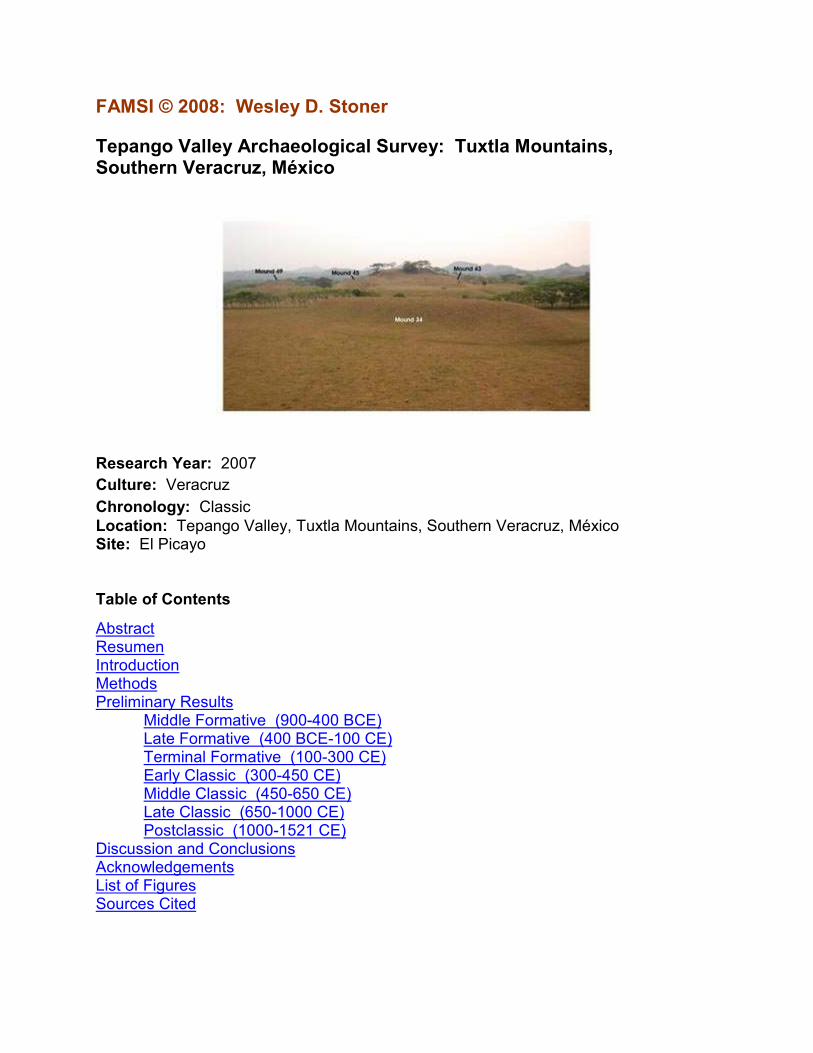
Figure 3. Photograph from the Acropolis at El Picayo, overlooking the Principal Mound Group (facing south).
Ceramic analysis follows the typology established for the area (Pool 1990, personal communication; Ortiz and Santley 1988; Ortiz 1975, personal communication; Venter 2005). The relative proportions of chronologically diagnostic ceramic types were utilized to place each collection within a phase of occupation. The dated collections were then plotted on a map of the survey area and site boundaries were drawn for each time period. Figurine style was assessed based on previous research (Follensbee 2000, Weiant 1943). Obsidian was characterized based on source, tool form, and debitage category (Barrett 2003, Knight 1999, Santley et al. 2001). All ground stone tools, sculptures, and petrogylphs were photographed and described in the field.

7
Figure 4. Photograph depicting the survey crew walking shovel-probed transects.
Figure 5. Photograph of workers collecting materials from a 3x3 m square associated with a mound (Site 24 facing west).

8
The distribution, size and monumentality of sites across the survey area allow the initial characterization of aspects of political organization. The relative size of regional centers to each other and to sites within their hinterland is considered as an index of the degree of political centralization, ranging from a high concentration of political power at a single site to power sharing or competition between several regional centers. To examine this trend over time, I employ a modified rank-size analysis. Smith and Schreiber 2006 argue that Santley’s use of rank-size analysis for the Tuxtlas Regional Survey (1994) was flawed because it was originally intended to be applied only to cities. Santley included rural settlements in his analysis, which could have skewed his results. I propose a simple solution to this problem by employing a cut-off point of the largest 15 sites in the region, which should include all of the large and small centers as well as some of the largest villages. It is wrong to assume that large villages do not play an important political economic role in the regional settlement hierarchy of pre-Columbian societies.
In short, rank-size analysis plots the population of each site within the project on a logarithmic scale on the y-axis versus site rank on the x-axis. The rank-size rule states that the “population of any community is equal to the population of the…first ranking community divided by the rank of the site in question (Santley 1994:250–see also Zipf 1949, Berry 1961)”. Plotting estimated site population versus site rank on a logarithmic scale should reveal a straight downward-trending line, or log-normal distribution (Figure 6). This translates into a well-integrated hierarchy of political centers. A concave plot indicates a more centralized settlement system headed by a primate center that is much larger than any other regional center. A convex plot indicates that several centers of roughly equal size occupied the uppermost tier of settlement, suggesting dispersed political authority. I substitute site size for site population because site population estimates are not available at this time. Estimated population is largely a function of site size, so this modified statistic should produce similar results.
Figure 6. Idealized rank-size plots.

9
To refine the rank-size results, I consider the number and type of monumental structures at each center. Monumental architecture (i.e., mounds) is a geographic representation of political authority. The total number and size of public and administrative buildings should be concentrated in relatively few centers if political authority is centralized, but more evenly distributed if political authority is dispersed. Architectural plans also serve as a qualitative comparison of political relationships between valleys, as centers within the same polity tend to employ similar architectural symbols.
I currently occupy the Archaeometry lab internship position at the Missouri University Research Reactor (MURR), to conduct instrumental neutron activation analysis (INAA) on a sample of Coarse Orange jars from the Tepango Valley. The National Science Foundation (NSF) funds this analysis. While the raw chemical results are available, statistical analysis and interpretation are ongoing. These results will not be featured in this report.
Preliminary Results
In this section, preliminary results of settlement analysis are presented according to phases of occupation. In total, 176 sites were documented, plus an additional 46 isolated collections1.
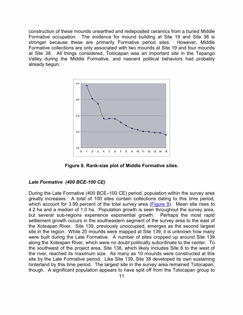
Middle Formative (900-400 BCE)
The first evidence of occupation within the survey area dates to the Middle Formative (900-400 BCE), as no Early Formative (1500-900 BCE) diagnostics were identified. A total of 25 sites were assigned to this time period, 0.56 percent of the total survey area (Figure 7). Mean site size is 2.7 ha, with a median size of 1.0 ha. Settlement during this period was rather dispersed, though three relatively large sites were established along the Tepango River. Sites located away from the Tepango River tended to be smaller–probably hamlets where a limited number of families lived. The Totocapan area within El Picayo was the largest site within the survey area at this time, about three times the size of either Site 19 or Site 38 (considering both 38N and 38S). Site 19, located near the modern community of Arroyo Salado, and Site 38, located less than a kilometer north of Cruz de Vidaña, were important loci within the region. Both of these sites yielded collections associated with mounds.
1 Isolated collections were loci of occupation, but the ‘site’ limits could not be confidently delineated based on surface remains.

10
Figure 7. Map of the project area showing the distribution of Middle Formative sites.
The rank-size plot depicts a concave line (Figure 8), but the fact that only three sites likely exercised regionally significant political power at this time must be considered. Considering only the three top ranks, El Picayo, Site 38 (both 38N and 38S), and Site 19 form a slightly concave pattern. While El Picayo likely exerted more influence within the Valley than the other two centers, given the generally dispersed settlement patterns it is likely that each loosely controlled a small number of closely situated sites. Near the modern community of Totocapan, Middle Formative ceramic diagnostics are associated with nine mounds in what will later become the civic-ceremonial core of El Picayo. While all of these collections were conducted off-mound, it remains possible that later
11
construction of these mounds unearthed and redeposited ceramics from a buried Middle Formative occupation. The evidence for mound building at Site 19 and Site 38 is stronger because these are primarily Formative period sites. However, Middle Formative collections are only associated with two mounds at Site 19 and four mounds at Site 38. All things considered, Totocapan was an important site in the Tepango Valley during the Middle Formative, and nascent political behaviors had probably already begun.
Figure 8. Rank-size plot of Middle Formative sites. Late Formative (400 BCE-100 CE)
During the Late Formative (400 BCE–100 CE) period, population within the survey area greatly increases. A total of 100 sites contain collections dating to this time period, which account for 3.99 percent of the total survey area (Figure 9). Mean site rises to 4.2 ha and a median of 1.0 ha. Population growth is seen throughout the survey area, but several sub-regions experience exponential growth. Perhaps the most rapid settlement growth occurs in the southeastern segment of the survey area to the east of the Xoteapan River. Site 139, previously unoccupied, emerges as the second largest site in the region. While 20 mounds were mapped at Site 139, it is unknown how many were built during the Late Formative. A number of sites cropped up around Site 139 along the Xoteapan River, which were no doubt politically subordinate to the center. To the southwest of the project area, Site 138, which likely includes Site 8 to the west of the river, reached its maximum size. As many as 10 mounds were constructed at this site by the Late Formative period. Like Site 139, Site 38 developed its own sustaining hinterland by this time period. The largest site in the survey area remained Totocapan, though. A significant population appears to have split off from the Totocapan group to
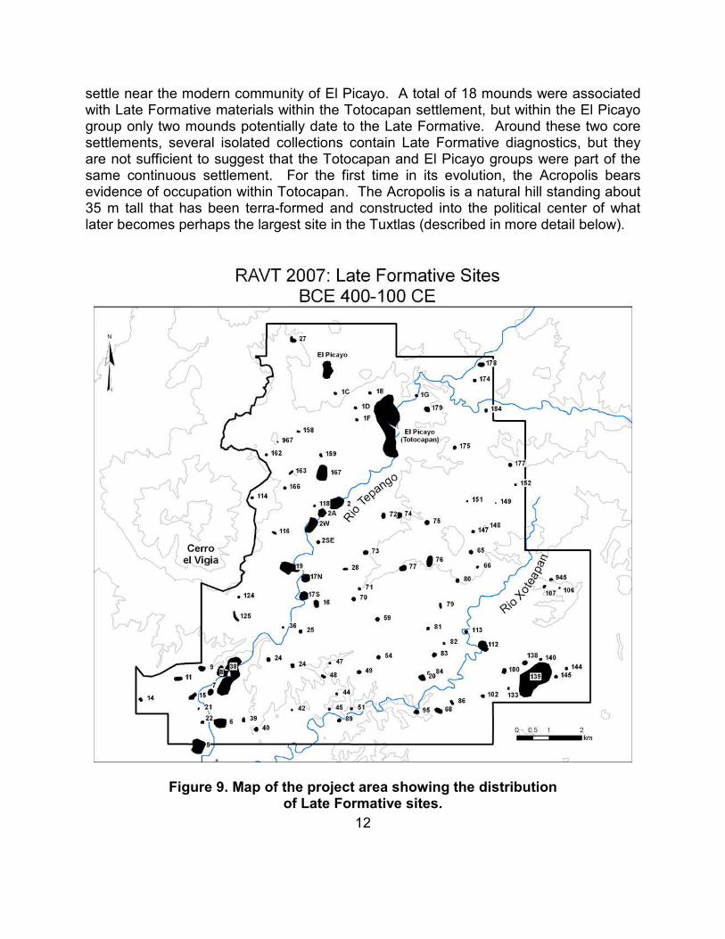
12
settle near the modern community of El Picayo. A total of 18 mounds were associated with Late Formative materials within the Totocapan settlement, but within the El Picayo group only two mounds potentially date to the Late Formative. Around these two core settlements, several isolated collections contain Late Formative diagnostics, but they are not sufficient to suggest that the Totocapan and El Picayo groups were part of the same continuous settlement. For the first time in its evolution, the Acropolis bears evidence of occupation within Totocapan. The Acropolis is a natural hill standing about 35 m tall that has been terra-formed and constructed into the political center of what later becomes perhaps the largest site in the Tuxtlas (described in more detail below).
Figure 9. Map of the project area showing the distribution of Late Formative sites.
13
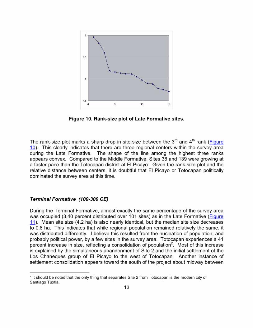
Figure 10. Rank-size plot of Late Formative sites.
The rank-size plot marks a sharp drop in site size between the 3rd and 4th rank (Figure 10). This clearly indicates that there are three regional centers within the survey area during the Late Formative. The shape of the line among the highest three ranks appears convex. Compared to the Middle Formative, Sites 38 and 139 were growing at a faster pace than the Totocapan district at El Picayo. Given the rank-size plot and the relative distance between centers, it is doubtful that El Picayo or Totocapan politically dominated the survey area at this time.
Terminal Formative (100-300 CE)
During the Terminal Formative, almost exactly the same percentage of the survey area was occupied (3.40 percent distributed over 101 sites) as in the Late Formative (Figure 11). Mean site size (4.2 ha) is also nearly identical, but the median site size decreases to 0.8 ha. This indicates that while regional population remained relatively the same, it was distributed differently. I believe this resulted from the nucleation of population, and probably political power, by a few sites in the survey area. Totocapan experiences a 41 percent increase in size, reflecting a consolidation of population2. Most of this increase is explained by the simultaneous abandonment of Site 2 and the initial settlement of the Los Chaneques group of El Picayo to the west of Totocapan. Another instance of settlement consolidation appears toward the south of the project about midway between
2 It should be noted that the only thing that separates Site 2 from Totocapan is the modern city of Santiago Tuxtla.

14
the Tepango and Xoteapan Rivers. Site 57, which eventually becomes part of a rather large cluster of sites, emerges as the seventh largest site in the region, while the area was unoccupied previously. Both Site 139 and Site 38/8 lose a minor percentage of their population, but they maintain their positions as the 2nd and 3rd largest sites in the region. One more notable change is that Site 19 reaches its maximum extent during the Terminal Formative period. At Totocapan, the number of mounds associated with Terminal Formative collections climbs to 24 or more. Included in this tally is a more extensive use of the Acropolis.
Figure 11. Map of the project area showing the distribution of Terminal Formative sites.

15
Figure 12. Rank-size plot of Terminal Formative sites.
The Terminal Formative rank-size plot demonstrates a somewhat different picture than the Late Formative plot (Figure 12). The overall shape of the plot appears only slightly concave because Totocapan and Site 139 are much larger than any other site, with the former more than double the size of the latter. However, “tiers” of settlement rank develop. Totocapan and Site 139 are the only sites in the uppermost tier. The regional influence of Site 38 begins to disappear, mainly due to the growth of a number of large villages. The development of settlement tiers may mark the emergence of a formal settlement hierarchy, perhaps spurred by increased interaction between centers and their hinterlands. Due to the distance and the dramatic dropoff in settlement density between Totocapan and Site 139, I suggest that they commanded different polities during the Terminal Formative. However, due to the benefits of river transportation and the relatively continuous distribution of sites along the Tepango River it is likely that Site 38/8 and Site 19 were politically subordinate to Totocapan during the Terminal Formative.
Early Classic (300-450 CE)
The Early Classic period is marked by the fewest number of, and some of the most rare, ceramic types. The drop in population seen during this period may therefore result partially from a bias in the chronological typology. The percent of the total survey area that displays Early Classic occupation declines from 3.40 percent in the Late Formative to 3.09 percent in the Early Classic (Figure 13). The number of sites occupied drops to 88. Interestingly, both the mean (4.3 ha) and median (1.2 ha) site size rise slightly, indicating that a larger portion of the regional settlement resides within the larger sites. Totocapan loses 35.5 percent of its total size while Site 2 grows by a factor of nine.

16
Their proximity suggests that these two sites are related, but the monumentality of Totocapan dwarfs the smaller site. Site 2 displaces Site 139 as the second largest site in the region, which is closely followed by the El Picayo group as the fourth largest. While Totocapan is still more than twice the size of El Picayo the size gap begins to close. Populations generally increased and shifted around in the northern half of the survey area, but the southern half experienced a relative depopulation. Site 139 remains important in the southeast, but Site 38 in the southwest was almost abandoned. Site 53, located just south of the project boundary, took the place of Site 138 as the most important in the area. If not for the occupation of Site 2, there would be two distinct settlement clusters in the northern and southern halves of the survey area at this time. This may indicate a political divide that forms between the major settlement clusters.
The Early Classic rank-size plot displays a mixed picture (Figure 14). Overall, the five largest sites in the region display a slightly convex plot, suggesting a high degree of political equality among centers. However, ranks 1, 2 and 4 are positioned closely together in the north of the survey with ranks 3 and 5 separated to the southeast and southwest corners. This distribution reflects a pattern of population nucleation in the north and dispersal in the south.
3 Inhabitants of the modern town of Xiguipilican refused our access to the site on our second day of work. The comesariado asked for money the first day, which we refused to pay. The second day the people refused us access to the site, citing rumors of gringos who robbed gold from the mounds two years back. The size of this site is therefore estimated based on the few collections we do have, visual inspection or surface, and relative proportions of ceramic diagnostics.

17
Figure 13. Map of the project area showing the distribution of Early Classic sites.

18
Figure 14. Rank-size plot of Early Classic sites.
Middle Classic (450-650 CE)
The Middle Classic is the time of maximum population in the Tepango Valley. Mean site size rises to 9.2 ha, with a median size of 1.6 ha. A total of 12.3 percent of the survey area displayed evidence of occupation during the Middle Classic, distributed among 165 sites (Figure 15). All of the individual districts within the now unified site of El Picayo are connected by a continuous distribution of material and mounds. The El Picayo conglomerate is almost seven times larger than Totocapan during the Early Classic. The principal civic-ceremonial center of the site remains at Totocapan, with a continuous distribution of mounds extending into Los Chaneques (separated only by Highway 180), the southern extreme of the site, and up to 300 m north from the Acropolis. Beyond that range, mounds are more sparsely distributed, with additional architectural concentrations within the El Picayo, Pollinapan, and Palo Blanco districts. Together, 127 mounds were constructed within this large center (see Figure 2). While the number of mounds is impressive by itself, the terra-forming activities within the Totocapan district are more so.

19
Figure 15. Map of the project area showing the distribution of Middle Classic sites.
In general, the entire Totocapan core has been sculpted to establish a vertically ranked series of terraces extending southward from the Acropolis (Figure 16). The Acropolis itself is the highest point in the immediate area. From the top of this natural hill, which is about 35 m above the main civic-ceremonial plaza, the whole site and much of the northern valley can be seen. About midway down the Acropolis, but still elevated above the Principal Terrace by about 10-12 m, the southern exposure of this hill has been leveled. Mounds constructed atop this platform enclose two distinct plaza groups.

20
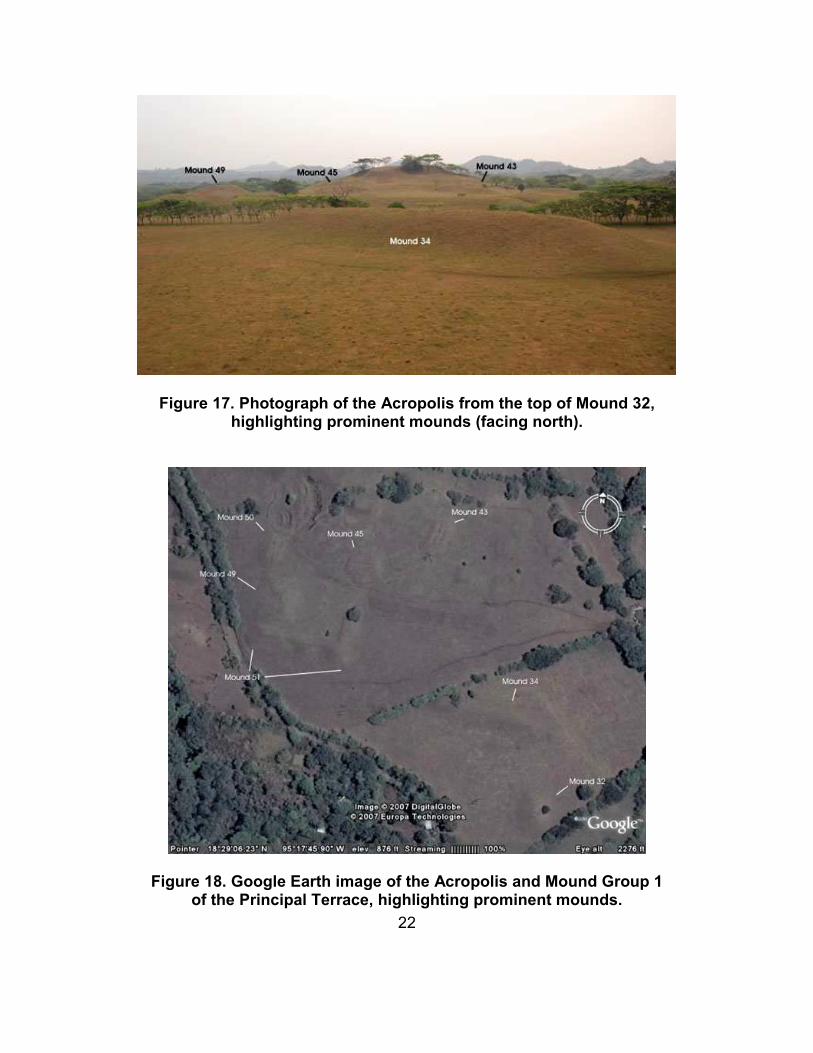
These plazas are bounded by the highest quality structures in the entire site. Mound 45 in the northeast corner of the Southwest Plaza, was constructed of both soil and basalt rock, the surface of which may also have been paved with basalt. This structure was rectangular with an access ramp extending to the south. Basalt wall foundations are visible on top of this mound. Mound 43 of the southeast plaza is the twin of Mound 45, constructed in the same manner with the same materials and an access ramp extending to the east. If one would draw a line from the conical mound of the Principal Mound Group, through the midpoint between the two plazas of the Acropolis, Mound 45 and Mound 43 appear as mirror images (Figure 17). The labor invested in building Mounds 45 and 43, and the relative quality of their construction, suggest that the site’s rulers lived there. Mounds 49 and 50 of the Southwest Acropolis are also made of both soil and basalt rock, with stone wall foundations visible on the surface. These two mounds along with Mound 51 almost serve as fortifications that restrict access to the Southwest Plaza. The organization of mounds around the Southeast Plaza acts in much the same way, though the scale is somewhat smaller. Considering that both plazas are elevated about 10-12 m above the surrounding ground surface, one arrives at the conclusion that the Acropolis was constructed to restrict public access. The single intended entrance to this veritable palace consists of a gradual earthen ramp that emerges onto a low flat mound located directly between the two plazas. The base of the Acropolis also was terra-formed into a shape that conforms to the organization of Mound Group 1 of the Principal Terrace. The space between the principal long mound (Mound 34) and the southern base of the Acropolis forms a broad corridor that has a most unnatural shape (Figure 18).

21
Figure 16. Map of the civic-ceremonial core of the Totocapan District within El Picayo.
22
Figure 17. Photograph of the Acropolis from the top of Mound 32, highlighting prominent mounds (facing north).
Figure 18. Google Earth image of the Acropolis and Mound Group 1 of the Principal Terrace, highlighting prominent mounds.

23
Compared to the probable social restrictions applied to the Acropolis, the mound groups situated on top of the Principal Terrace appeared much more accessible. Mound Group 1 of the Principal Terrace, which undoubtedly hosted the most important public activities conducted at the site, currently appears as a large open plaza. However, I fear that the modern habitation and the road may have destroyed or modified the southern end of this group. Mound 31, a rather small dome-shaped mound, currently ‘encloses’ the plaza to the south, but the scale of this mound does not match the monumentality of the large long mound to the north (Mound 34) or the principal conical mound to the east (Mound 32). This may indicate that later inhabitants of the area altered the original size and shape of Mound 31. Mound 32 (which can be seen in Figure 3) is the tallest mound (11 m) in the Totocapan district, though others come close to its stature. The western edge of this plaza is capped by what appears to be a ballcourt, a symbol of the Mesoamerican ballgame that is rare in the neighboring Catemaco Valley. The labor expended to construct Mound Group 2 of the Principal Terrace was considerably less than either the Acropolis or Mound Group 1. The arrangement of mounds is also less formal. To the south of the Principal Terrace, the Secondary Terrace is also an artificial platform that supports a number of mounds, but these mound groups continue the trend of decreasing size and formality seen from north to south within the Totocapan district. I believe based on the different levels of architectural investment seen in these three architectural complexes (the Acropolis, the Principal Terrace and the Secondary Terrace) represent the administrative hierarchy of the site and probably a large segment of the Valley. The symmetrical organization of the Acropolis as seen through the mirrored construction of Mounds 43 and 45, as well as the Southeast and Southwest plazas, suggest a duality of rule at the uppermost ranks within the site.
Figure 19. Rank-size plot of Middle Classic sites.

24
During the Middle Classic, the El Picayo conglomerate appears to have politically controlled most if not all of the survey area. Inspection of the rank-size plot places El Picayo as the sole center in the uppermost tier based on comparative settlement size (Figure 19). This measure does not even consider the fact that El Picayo possessed six times the number of mounds as Site 139, the second largest center. Site 82 covers a large amount of space, but only possesses one small mound group. Because the majority of sites tend to cluster along the two rivers in the survey area, with a dispersed scatter of small sites between Site 139 and El Picayo, it is possible that they were not part politically unified. However, I defer final judgement until a more rigorous statistical analysis can be conducted using settlement data from the current project along with data from the Tuxtlas Regional Survey (Santley and Arnold 1996) Kruszczynski’s (2001) survey of the southern flanks of Cerro el Vigia, and the Hueyapan survey (Killion and Urcid 2001) to the south. Issues of scale are very important to consider when establishing a regional settlement hierarchy and drawing polity boundaries. The size and position of Site 5 south of the project boundary, plus the relatively continuous occupation along the Tepango River between El Picayo and this site, suggests it was probably part of El Picayo’s political domain.
Late Classic (650-1000 CE)
During the Late Classic, settlement declines somewhat. A total of 8.0 percent of the total survey area, distributed over 164 sites, displays occupation at this time (Figure 20). The majority of this settlement decrease comes from large centers as El Picayo, Site 2, Site 139, and Site 82 begin to fragment. Mean site size for the Late Classic drops to 6.0 ha, while the median remains about the same (1.6 ha).
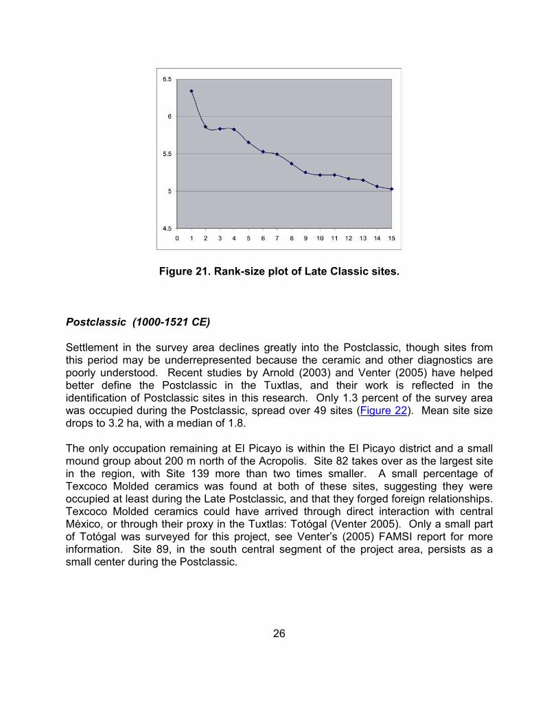
Despite the fragmentation seen at larger centers, the rank size plot remains similar to the previous time period, depicting a slightly concave line (Figure 21). The Totocapan District is almost three times the size of the El Picayo District. While these two districts of El Picayo were certainly related, they may have competed politically during the Late Classic. The region as a whole still displays a relatively strong degree of political centralization, with political centers retaining control over their hinterlands. However, deterioration of this condition is apparent through the fissioning of the large centers.

25
Figure 20. Map of the project area showing the distribution of Late Classic sites.
26
Figure 21. Rank-size plot of Late Classic sites.
Postclassic (1000-1521 CE)
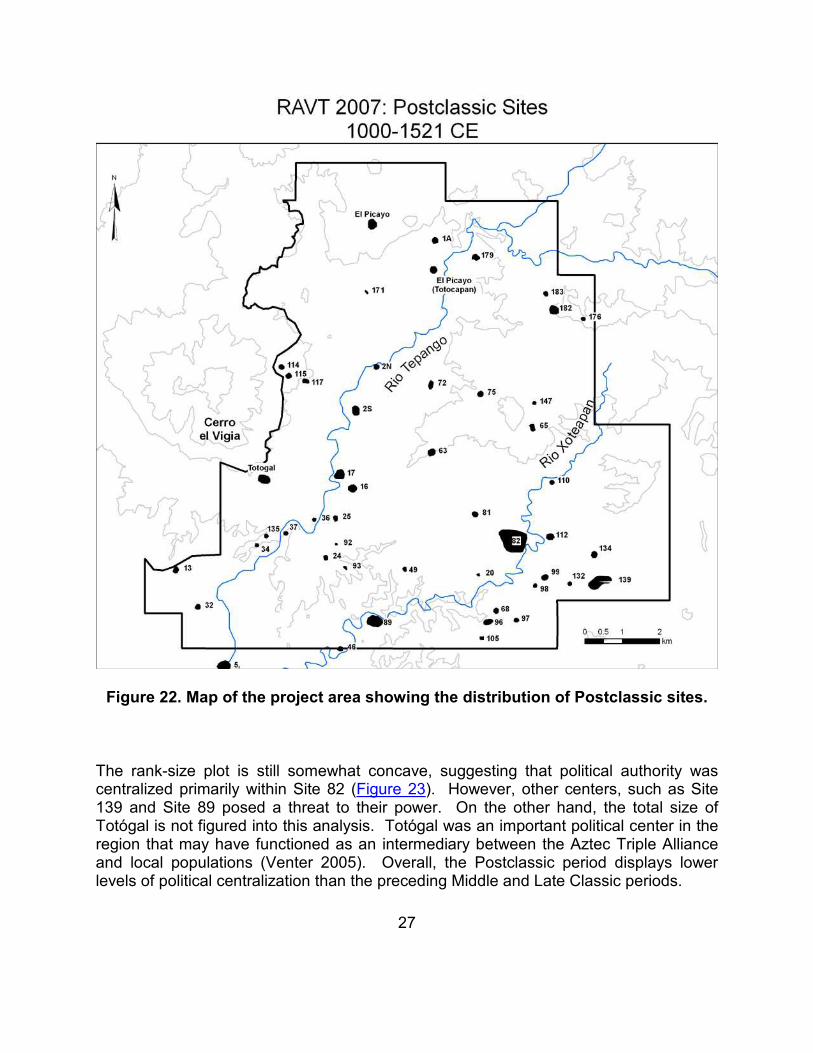
Settlement in the survey area declines greatly into the Postclassic, though sites from this period may be underrepresented because the ceramic and other diagnostics are poorly understood. Recent studies by Arnold (2003) and Venter (2005) have helped better define the Postclassic in the Tuxtlas, and their work is reflected in the identification of Postclassic sites in this research. Only 1.3 percent of the survey area was occupied during the Postclassic, spread over 49 sites (Figure 22). Mean site size drops to 3.2 ha, with a median of 1.8.
The only occupation remaining at El Picayo is within the El Picayo district and a small mound group about 200 m north of the Acropolis. Site 82 takes over as the largest site in the region, with Site 139 more than two times smaller. A small percentage of Texcoco Molded ceramics was found at both of these sites, suggesting they were occupied at least during the Late Postclassic, and that they forged foreign relationships. Texcoco Molded ceramics could have arrived through direct interaction with central México, or through their proxy in the Tuxtlas: Totógal (Venter 2005). Only a small part of Totógal was surveyed for this project, see Venter’s (2005) FAMSI report for more information. Site 89, in the south central segment of the project area, persists as a small center during the Postclassic.
27
Figure 22. Map of the project area showing the distribution of Postclassic sites.
The rank-size plot is still somewhat concave, suggesting that political authority was centralized primarily within Site 82 (Figure 23). However, other centers, such as Site 139 and Site 89 posed a threat to their power. On the other hand, the total size of Totógal is not figured into this analysis. Totógal was an important political center in the region that may have functioned as an intermediary between the Aztec Triple Alliance and local populations (Venter 2005). Overall, the Postclassic period displays lower levels of political centralization than the preceding Middle and Late Classic periods.

28
Figure 23. Rank-size plot of Postclassic sites.
Discussion and Conclusions
Survey within the Tepango River valley revealed a long and intensive history of settlement from the Middle Formative through the Postclassic. During the Formative and Classic periods, El Picayo, particularly the Totocapan area, dominated the political landscape. This initial look at settlement within this important river valley yields a fresh perspective to begin to evaluate arguments about the Tuxtlas that originated from work in Catemaco Valley (Santley 1991, 1994, 2007; Santley and Arnold 1996) and at Matacapan (Arnold and Santley in press; Arnold et al. 1993; Ortiz and Santley 1988; Pool 1990; Santley et al. 1985, 1987). The developmental trajectories of El Picayo and Matacapan are similar. El Picayo emerged as a regional center much earlier (Middle Formative) than Matacapan (Early Classic), but both reached their maximum size and power during the Middle Classic and began to decline during the Late Classic.
El Picayo achieved a maximum size of 585 ha while Matacapan reached 700 ha during the Middle Classic. While Matacapan is larger, El Picayo displays a higher level of mound building and landscape modification. These simple size comparisons suggest that El Picayo and Matacapan were equals within the Tuxtlas, rather than either being politically subordinate to the other. Because of this, it is probable that the two centers commanded distinct polities within each river valley. Several lines of evidence support this. First, the architectural themes presented at each center are quite different. At the center of Matacapan, the ruling elites lived in what was initially termed the Teotihuacán
29
Barrio, an architectural complex with at least two buildings constructed in the talud-tablero style made popular by Teotihuacán (Valenzuela 1945a). This complex opens into a very large civic-ceremonial plaza (the Great Plaza) that likely supported ritual performances and possibly a market (Santley et al. 1985). Compared to the very hierarchical and restricting use of space within the Totocapan District at El Picayo, the architectural layout of the Matacapan core appears more open to public access. Second, it seems that elites at both sites drew upon distinct sources of power. Matacapan emphasized its connections to Teotihuacán in the art and architecture found at the site (Arnold and Santley in press; Pool 1992; Santley et al. 1987). Additionally, control over economic production and exchange led to concentration of power at Matacapan (Arnold et al. 1993; Santley 1994, 2007; Santley et al. 1989; Stoner 2002, Stoner et al. in press). While little is currently known about the economic organization of El Picayo, a single fragment of a solid rectangular support was the only potential evidence of Teotihuacán style material. This solid support did not closely resemble the solid or hollow rectangular supports found at Matacapan or Teotihuacán (Ortiz and Santley 1988, Santley et al. 1987). Future research may reveal a Teotihuacán connection, but collections made extensively over all of El Picayo revealed nothing concrete. Rather than draw upon foreign symbols to legitimate power, the ruling elites at El Picayo may have employed the Mesoamerican ballgame as seen in other Gulf Coast regions (Daneels 2002; Stark 2003, in press; Urcid and Killion in press). Four ballcourts were mapped in different parts of the site. One of these was built into the Mound Group 1 on the Principal Terrace of El Picayo. The second is a small court located just east of the Acropolis, another is located in the Los Chaneques district and the last is found within the El Picayo District. Outside of El Picayo, ballcourts were also mapped at Site 38, and Site 139, also a project archaeologist noted the presence of a ballcourt at Site 5. A single small ballcourt was found at Matacapan, but it was positioned at a marginal location north of the Great Plaza.
Despite the similarity between the project area and the Gulf Lowlands in the use of ballcourt architecture to assert political authority, the architectural design referred to as the “standard plan” (Daneels 2002; Stark 1999, 2003, in press), “long plaza” (Dominguez Covarrubias 2001), or “plaza group” (Killion and Urcid 2001; Urcid and Killion in press) was scarce. This formal architectural complex was a redundant symbol of political authority employed throughout the Gulf Lowlands of central and southern Veracruz. With the possible exception of Teotepec, the Catemaco Valley settlements completely lacked this architectural symbol. Site 139 within the current project area does, however, possess a potential example of this architectural design. I would suggest that this indicates Site 139 and El Picayo belonged to different polities, but if a long mound closed the southern edge of Mound Group 1 of the Principal Terrace at El Picayo, it also would resemble the standard plan. The possibility of destruction of parts of Mound 31 (see above) creates enough speculation to conduct geophysical analysis in the future, which may shed light on this dilemma.
30
On a regional scale, El Picayo and Matacapan seemed to have ruled similarly composed hinterlands. Both sites were by far the largest and most monumentally invested centers within their respective river valleys. Santley (1991, 1994) describes the Catemaco Valley settlement system as size sequential, meaning the size of centers decreased with distance from Matacapan. This pattern was not clearly observed within the Tepango Valley. During the Middle Classic, Site 139, the second largest site in the survey area, was located about 8 km straight-line distance from El Picayo, while Site 2, smaller than Site 139, was 2 km south of El Picayo. Considering only centers along the Tepango River, Site 5 and Site 2 are about the same size, but Site 5, the more distant, appears to be more important in the settlement hierarchy.
Finally, initial results of a chemical analysis of Coarse Orange jars, currently being conducted by the author at the Missouri University Research Reactor, suggest that most of the Coarse Orange found at El Picayo is chemically similar to the paste recipe employed at the Comoapan production complex at Matacapan. These were made from Group C clays that are available around Matacapan and Ranchoapan in the Catemaco Valley. Clay outcrops located near El Picayo, however, are the chemically and mineralogically distinct Group S clays that dominate the Tepango Valley. This is strong evidence that El Picayo and Matacapan were engaged, at least to a minimal extent, in the exchange of goods.
While there are many gaps in this analysis that will be filled by further processing of the data produced by the Tepango Valley Archaeological Survey, it initially appears as though settlement in the Tepango Valley developed to a similar scale, complexity, and political organization as the Catemaco Valley without a strong presence of Teotihuacán symbols as seen at Matacapan. This suggests that while relationships between Matacapan and Teotihuacán were very important for the exchange of certain commodities and legitimation of political authority in the Catemaco valley, they were probably not directly responsible for the settlement organization that Santley (1991, 1994) describes. This tentative statement contradicts Santley’s assertion that the Teotihuacán connection was responsible for the dendritic settlement organization of the Catemaco Valley.
Acknowledgements
I would like to thank FAMSI for granting funds (#07049) that supported the TVAS. The National Science Foundation also provided funds to carryout the project and important materials analyses. The Instituto Nacional de Antropología e Historia (INAH) granted permits to conduct the fieldwork and to export a small sample of ceramics and obsidian for compositional analyses in the United States. My field and lab assistants were critical for the initiation and completion of this project: Sara Luz Rosiles Hernández, Hugo Alberto Huerta Vicente, and Blanca Rosa Moreno Diaz, all of the Universidad
31
Veracruzana. I would also like to thank the various local workers hired to conduct fieldwork and washing of artifacts in the lab: Aurelio Poxtan Tolem, Aurelio Poxtan Ixtepan, Jesús Poxtan Ixtepan, Martin Xolot Hernández, Juan José Ocampo, and Mario Lopez Palma. Dr. Chris Pool (University of Kentucky) provided essential guidance in planning this project, for recovering from snags once in the field, and for granting permission to store artifacts in the laboratory at Tres Zapotes. Finally, I would like to thank Maria del Carmen Rodriguez and Ponciano Ortiz Ceballos for helping me navigate the INAH bureaucracy at the beginning of the project, without them the project would have been delayed significantly.
List of Figures Figure 1. Map showing the project area and neighboring projects within the central and western Tuxtlas Mountains, Veracruz, México. Figure 2. Map of El Picayo showing the locations of districts discussed in the text as well as the distribution of mound groups. Figure 3. Photograph from the Acropolis at El Picayo, overlooking the Principal Mound Group (facing south). Figure 4. Photograph depicting the survey crew walking shovel-probed transects. Figure 5. Photograph of workers collecting materials from a 3x3 m square associated with a mound (Site 24 facing west). Figure 6. Idealized rank-size plots. Figure 7. Map of the project area showing the distribution of Middle Formative sites. Figure 8. Rank-size plot of Middle Formative sites. Figure 9. Map of the project area showing the distribution of Late Formative sites. Figure 10. Rank-size plot of Late Formative sites. Figure 11. Map of the project area showing the distribution of Terminal Formative sites. Figure 12. Rank-size plot of Terminal Formative sites.

32
Figure 13. Map of the project area showing the distribution of Early Classic sites. Figure 14. Rank-size plot of Early Classic sites. Figure 15. Map of the project area showing the distribution of Middle Classic sites. Figure 16. Map of the civic-ceremonial core of the Totocapan District within El Picayo. Figure 17. Photograph of the Acropolis from the top of Mound 32, highlighting prominent mounds (facing north). Figure 18. Google Earth image of the Acropolis and Mound Group 1 of the Principal Terrace, highlighting prominent mounds. Figure 19. Rank-size plot of Middle Classic sites. Figure 20. Map of the project area showing the distribution of Late Classic sites. Figure 21. Rank-size plot of Late Classic sites. Figure 22. Map of the project area showing the distribution of Postclassic sites. Figure 23. Rank-size plot of Postclassic sites.
Sources Cited Arnold, P.J. III 2003 Early Formative Pottery from the Tuxtla Mountains and Implications for Gulf
Olmec Origins. Latin American Antiquity 14(1): 29-46. Arnold, P.J., III, C.A. Pool, R.R. Kneebone and R.S. Santley 1993 Intensive Ceramic Production and Classic-Period Political Economy in the
Sierra de los Tuxtlas, Veracruz, México. Ancient Mesoamerica 4:175-191. Arnold, P.J. III and R.S. Santley In press Classic Period Cultural Currents in the Sierra de los Tuxtlas. Paper
presented at the Dumbarton Oaks conference: Classic Veracruz: Cultural Currents in the Ancient Gulf Lowlands.

33
Barrett, T.P. 2003 Tuxtlas Obsidian: Organization and Change in a Regional Craft Industry.
Doctoral Dissertation, University of New Mexico. Berry, B.J.L. 1961 City Size Distributions and Economic Development. Economic Development
and Culture Change 9:573-588. Daneels, A. 2002 El Patrón de Asentamiento del Periodo Clásico en la Cuenca Baja del Río
Cotaxtla, Centro de Veracruz. Unpublished doctoral dissertation, Universidad Nacional Autónoma de México.
Dominguez Covarrubias, E. 2001 La arquitectura monumental del periodo clásico en el sur de Veracruz: un
enfoque regional. Department of Anthropology. Puebla, México, Universidad de las Américas.
Follensbee, B. 2000 Sex and Gender in Olmec Art and Archaeology. Doctoral dissertation,
University of Maryland. Killion, T.W. and J. Urcíd 2001 The Olmec Legacy: Cultural Continuity in México's Southern Gulf Coast
Lowlands. Journal of Field Archaeology 28(1 and 2):3-25. Knight, C. 1999 The Late Formative to Classic Period Obsidian Economy at Palo Errado,
Veracruz, México. Ph.D. dissertation, University of Pittsburgh. Kruszczynski, M. 2001 Prehistoric Basalt Exploitation and Core-Periphery Relations Observed from
the Cerro el Vigia Hinterland of Tres Zapotes, Veracruz, México. Doctoral Dissertation, University of Pittsburgh.
Ortiz Ceballos, P. 1975 La Cerámica de los Tuxtlas, Universidad Veracruzana, Jalapa. Unpublished
tesis de licenciatura. Ortiz Ceballos, P, and R.S. Santley 1988 La Cerámica de Matacapan. Unpublished Manuscript.

34
Pool, C.A. 1990 Ceramic Production, Resource Procurement, and Exchange at Matacapan,
Veracruz, México. Ph.D. dissertation, Tulane University. 1992 Strangers in a Strange Land: Ethnicity and Ideology at an Enclave
Community in Middle Classic Mesoamerica. In Ancient Images, Ancient Thought: The Archaeology of Ideology, edited by S.A. Goldsmith. University of Calgary, Alberta.
Santley, R.S. 1991 Final Field Report: Tuxtlas Region Archaeological Survey, 1991 Field
Season. Report to the National Science Foundation. 1994 The Economy of Ancient Matacapan. Ancient Mesoamerica 5(2):243-266. 2007 The Prehistory of the Tuxtlas. University of New Mexico Press. Santley, R.S., P.J. Arnold III and C.A. Pool 1989 The Ceramics Production System at Matacapan, Veracruz, México. Journal of
Field Archaeology 16:107-132. Santley, R.S. and P.J. Arnold III 1996 Prehispanic settlement patterns in the Tuxtla Mountains, southern Veracruz,
México. Journal of Field Archaeology 23(2):225-249. Santley, R.S., T.P. Barrett, M.D. Glascock and H. Neff 2001 Pre-Hispanic Obsidian Procurement in the Tuxtla Mountains, Southern
Veracruz, México. Ancient Mesoamerica 12:49-63. Santley, R.S., B. Hall and C. Yarborough 1987 Enclaves, ethnicity, and the archaeological record at Matacapan. Ethnicity
and Culture:85-100. Santley, Robert S., Ponciano Ortiz Ceballos, Phillip J. Arnold III, Ronald R. Kneebone, Michael P. Smyth, Janet M. Kerley, Michael Berman, Barbara A. Hall, Verinoca Kann, Christopher A. Pool, Zenaido Salazar B., and Claire Yarborough 1985 Final Field Report, Matacapan Project: 1984 Season. A report to the Instituto
Nacional de Antropología e Historia. Smith, M.E. and K.J. Schreiber 2006 New World States and Empires: Politics, Religion, and Urbanism. In Journal
of Archaeological Research 14(1):1-52.

35
Stark, B.L. 1991 Survey Methods and Settlement Features in the Cerro de las Mesas Region.
In Settlement Archaeology of Cerro de las Mesas, Veracruz, México, edited by B.L. Stark, pp. 39-48. Institute of Archaeology Monograph 34. University of California, Los Angeles.
1999 Formal Architectural Complexes in South-Central Veracruz, México: A Capital
Zone? Journal of Field Archaeology, vol. 26. 2003 Cerro de las Mesas: Social and Economic Perspectives on a Gulf Center. In
Urbanism in Mesoamerica, vol. 1. The Pennsylvania State University Press. In press Polity and Economy in the Western Lower Papaloapan Basin. Classic-Period
Cultural Currents in Southern and Central Veracruz. Harvard University Press.
Stoner, W.D. 2002 Coarse Orange Pottery Exchange in Southern Veracruz: A Compositional
Perspective on Centralized Craft Production and Exchange in the Classic Period. Master of Arts thesis at the University of Kentucky, http://lib.uky.edu/ETD/ukyanth2002t00066/Stoner_thesis2002.pdf.
Stoner, W.D., C.A. Pool, H. Neff, and M.D. Glascock In press Exchange of Coarse Orange Pottery in Middle Classic Tuxtlas Mountains,
Southern Veracruz, México. Journal of Archaeological Science. Urcid, J and T. Killion In press Social Landscapes and Political Dynamics in the Southern Gulf Coast
Lowlands (500-1000 CE). Classic-Period Cultural Currents in Southern and Central Veracruz. Harvard University Press.
Valenzuela, J. 1945a Las exploraciones efectuadas en Los Tuxtlas, Veracruz. México. Museo
nacional de arqueología, historia y etnografía. Anales: 83-107. 1945b La segunda temporada de exploraciones en la región de Los Tuxtlas, estado
de Veracruz. México. Instituto nacional de antropología e historia. Anales:81-94.
Venter, M.L. 2005 Totógal: Investigations of Postclassic Occupation and the Aztec Frontier in
the Tuxtla Mountains, Veracruz, México. Report submitted to FAMSI.
36
Weiant, C.W. 1943 An Introduction to the Ceramics of Tres Zapotes, Veracruz, México. Bureau of
American Ethnology, Bulletin 139. Smithsonian Institution, Washington D.C. Zipf, G.K. 1949 Human Behavior and the Principle of Least Effort. Addison-Wesley,
Cambridge, MA.