f3 freeway to branxton link - roads and maritime services · f3 freeway to branxton link ... 2.4...
TRANSCRIPT

F3 Freeway to Branxton linkReview of Archaeological Constraints and Management Recommendations for the Proposed Branxton interchangeMARCH 2007

July 2005
Roads and Traffic Authority
Review of Archaeological Constraints and Management Recommendations for the Branxton Interchange - Proposed National Highway Link F3 to Branxton

Umwelt (Australia) Pty Limited 1862/R05/V3 July 2005 i
TABLE OF CONTENTS
1.0 INTRODUCTION ....................................................................... 1
1.1 PREDICTED IMPACTS OF BRANXTON INTERCHANGE ON ABORIGINAL CULTURAL HERITAGE.......................................................1
2.0 HISTORY OF ABORIGINAL CULTURAL HERITAGE SURVEY AND ASSESSMENT ................................................................. 2
2.1 BRAYSHAW 1994, 2001 .............................................................................2 2.2 CONDITIONS OF APPROVAL F3 TO BRANXTON PROJECT (2001) ......2 2.3 UMWELT 2003, 2004, 2005.........................................................................3 2.4 KNOWN SITES WITHIN THE BRANXTON INTERCHANGE AREA ..........4
3.0 METHODOLOGY AND RESULTS OF THE BRANXTON INTERCHANGE SURVEY......................................................... 6
3.1 ABORIGINAL CONSULTATION .................................................................6 3.2 METHODOLOGY FOR THE INSPECTION .................................................6 3.3 RESULTS OF THE INSPECTION................................................................6
3.3.1 Landform Units ..................................................................................7 3.3.2 Vegetation and Ground Surface Visibility ..........................................7 3.3.3 Geology and Soils .............................................................................7 3.3.4 Watercourses ....................................................................................7 3.3.5 Prior Disturbance...............................................................................8 3.3.6 Sites and PADs located.....................................................................8
3.4 INTERPRETATION OF THE RESULTS OF THE SURVEY ......................10
4.0 SIGNIFICANCE ASSESSMENT ............................................. 10
4.1 ABORIGINAL SIGNIFICANCE ..................................................................11 4.2 ARCHAEOLOGICAL/SCIENTIFIC SIGNIFICANCE ASSESSMENT........11 4.3 RANKING OF CRITERIA FOR EVALUATING ARCHAEOLOGICAL
SIGNIFICANCE..........................................................................................12 4.3.1 Rarity ...............................................................................................14 4.3.2 Representativeness.........................................................................15 4.3.3 Integrity............................................................................................15 4.3.4 Connectedness ...............................................................................16 4.3.5 Complexity.......................................................................................16 4.3.6 Potential for Archaeological Deposits..............................................16
4.4 SUMMARY OF ARCHAEOLOGICAL SITE SIGNIFICANCE....................17

Umwelt (Australia) Pty Limited 1862/R05/V3 July 2005 ii
4.5 ARCHAEOLOGICAL RESEARCH POTENTIAL.......................................17
5.0 MANAGEMENT OPTIONS...................................................... 18
5.1 OPTION 1 SITE CONSERVATION............................................................18 5.1.1 Discussion .......................................................................................18
5.2 OPTION 2 SITE DESTRUCTION WITHOUT SALVAGE...........................18 5.2.1 Discussion .......................................................................................18
5.3 OPTION 3 SITE DESTRUCTION WITH SALVAGE (SURFACE COLLECTION) ...........................................................................................18 5.3.1 Discussion .......................................................................................19
5.4 OPTION 4 SITE DESTRUCTION WITH SALVAGE (SUBSURFACE SALVAGE) .................................................................................................19 5.4.1 Discussion .......................................................................................19
5.5 OPTION 5 SUBSURFACE TESTING ........................................................19 5.5.1 Discussion .......................................................................................19
5.6 PREFERRED MANAGEMENT OPTIONS .................................................19 5.7 ABORIGINAL GROUP COMMENTS ON MANAGEMENT
RECOMMENDATIONS ..............................................................................20 5.8 ABORIGINAL HERITAGE MANAGEMENT PLAN ...................................20
6.0 MANAGEMENT RECOMMENDATIONS ................................ 21
7.0 SUGGESTED TIMETABLE FOR MANAGEMENT ACTIONS 22
8.0 REFERENCES ........................................................................ 22
FIGURES
1.1 Approved route of the F3 to Branxton Highway Link Seahampton to Branxton ...............................................................................................1 2.1 Management Recommendations for Sites/PADs Located in Association with the F3 to Branxton Route Alignment .........................4 2.2 Management Recommendations for Sites/PADs Located in Association with the F3 to Branxton Route Alignment .........................4 2.3 Previously Recorded Sites and PADs in the Branxton Interchange Area............................................................................................................5

Umwelt (Australia) Pty Limited 1862/R05/V3 July 2005 iii
3.1 Previously Recorded and New Sites and PADs in the Branxton Interchange Area ....................................................................................10
PLATES
1 Start of Survey Transect – Upper Slope .................................................7 2 First Creek Terrace on Northern Side of Anvil Creek ............................7 3 Waterhole and Pebbly Conglomerate Outcropping in Anvil Creek ......7 4 Low Spur Between Two Minor Tributaries of Anvil Creek ....................7 5 Isolated Find (Anvil Creek 27IF) ..............................................................8 6 Area at the Confluence of Redhouse Creek and Anvil Creek .............10 7 Aboriginal Community Participants Searching for Artefacts in the Redhouse Creek 1 Site ....................................................................10 8 Low Spur Crest at the Confluence of Redhouse Creek and Anvil Creek........................................................................................................10
APPENDICES
1 Correspondence from Aboriginal Groups 2 Site Cards

Umwelt (Australia) Pty Limited 1862/R05/V3 July 2005 1
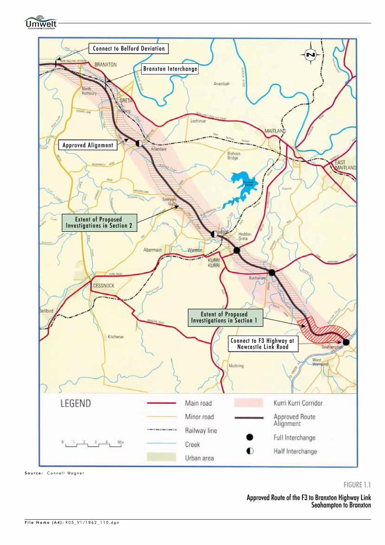
1.0 INTRODUCTION This report briefly outlines the relevant history of Aboriginal cultural heritage assessment undertaken for the F3 to Branxton Project before concentrating on issues relating specifically to the modified route for the Branxton Interchange, which is located between Greta and Branxton, in the Hunter Valley NSW (refer to Figure 1.1). The report provides details of the potential impact of the construction of the Branxton Interchange on Aboriginal sites and PADs in the area. Information is provided in relation to Aboriginal sites and potential archaeological deposits (PADs) known within the Branxton Interchange area prior to, and subsequent to the current survey. Some of these sites have been salvaged under Section 90 consent (#2102) and some of the PADs have been tested under a Section 87 Permit (#2096) (refer to Sections 2.3 and 2.4 for details). Documentation of the current survey is provided along with management recommendations for the sites and PAD still extant within the area to be impacted by the construction of the Branxton Interchange. The report concludes with a discussion of the Department of Environment and Conservation (DEC) consent/permit requirements for those sites and PADs where impact cannot be avoided. 1.1 PREDICTED IMPACTS OF BRANXTON INTERCHANGE ON
ABORIGINAL CULTURAL HERITAGE The construction of the Branxton Interchange has the potential to adversely impact upon Aboriginal sites and PADs within the construction impact area. These adverse effects may be as a direct or indirect consequence of the preconstruction, construction and post-construction phases. Table 1.1 indicates potential impacts and how these may affect sites and PADs. The site types discussed are those known in the immediate area from prior survey (Brayshaw 1994, 2001, Umwelt 2005) and those known in the broader area from the DEC/AHIMS site database.
Table 1.1 - Potential Impacts Sites/PADs/Areas of Aboriginal Cultural Heritage Sensitivity
Potential Impact Sites/PADs/Areas of Sensitivity Direct impact by geotechnical testing
� artefact scatters and isolated finds are the most likely site types to be affected by borehole drilling associated with geotechnical testing.
Highway link construction � bridge/culvert construction, vegetation clearance and ground disturbance has the potential to impact PADs, artefact scatters isolated finds and grinding grooves (grinding grooves could be located within Anvil Creek);
� grinding grooves located in close proximity to the route alignment; � increases of sediment in the bedload of streams brought about downstream of
the highway link construction area may cause increased erosion (by abrasion) of grinding groove sites.
Post construction phase � increases in sediment bedload of streams brought about downstream of drainage from the highway link may cause increased erosion (by abrasion) of grinding groove sites.

Umwelt (Australia) Pty Limited 1862/R05/V3 July 2005 2
2.0 HISTORY OF ABORIGINAL CULTURAL HERITAGE SURVEY AND ASSESSMENT
2.1 BRAYSHAW 1994, 2001 The initial assessment of the route alignment was undertaken in 1994 by Brayshaw MacDonald for Connell Wagner and the results of this survey are presented in Working Paper No. 6 of the 1995 Environmental Impact Statement. The 1994 survey was undertaken in consultation with Mindaribba Local Aboriginal Land Council (MLALC). The initial survey located 10 Aboriginal sites (including five artefact scatters and five isolated finds) and 10 PADs along the entire length of the route alignment surveyed at that time. A review by National Parks and Wildlife Service (NPWS) (now part of the Department of Environment and Conservation - DEC) of the 1994 survey and assessment produced for the EIS by Brayshaw, found that further work was required to meet the current reporting guidelines and the guidelines associated with the Integrated Development Assessment process. The NPWS review of the 1994 report resulted in a request for additional works to comply with new assessment requirements. Additional information required by the NPWS included: � documentation from appropriate Aboriginal groups and consideration of their views in the
development of the predictive landscape model and definition of sensitive cultural landscapes; � statement of methodology employed for surveys as well as relevant visibility data showing the
relationship between survey coverage and the topographic units to support the interpretation of the results;
� mapping of geology, land system and topographic units within the land system; � review of subsequent studies undertaken since 1994 to provide support for a predictive model
for the landscape along the approved route alignment and assessment of the survey results in view of the revised predictive model;
� development of a predictive model for site and sensitive landscape distribution and criteria for
the definition and identification of PADs; and � re-evaluation of the management options including conservation options as part of any
compensatory habitat outcomes, requirements for further investigation, etc. In 2001 Brayshaw provided the requisite report to NPWS. For this report Brayshaw included consultation with both MLALC and Awabakal Local Aboriginal Land Council (ALALC). Brayshaw indicated in her concluding remarks that her assessment related to the archaeological significance of the sites located and not to the Aboriginal cultural heritage value of the area to be crossed by the approved route alignment. According to Brayshaw this was still to be determined by ‘the Aboriginal people themselves’. 2.2 CONDITIONS OF APPROVAL F3 TO BRANXTON PROJECT (2001) In September 2001, the Chief Executive of the Roads and Traffic Authority (RTA) decided to proceed with the proposed highway link and subsequently sought the concurrence of the Director-General of NPWS and the approval of the NSW Minister for Planning. Conditional

Umwelt (Australia) Pty Limited 1862/R05/V3 July 2005 3
concurrence was granted by the Director-General of NPWS on 3 October 2001 and on 7 November 2001 the Minister for Planning granted conditional approval for the highway link. Conditions 100 to 112 (inclusive) of the Approval by the Minister for Planning relate to Heritage and Archaeology. Condition 100 of the Approval by the NSW Minister for Planning (Andrew Refshauge MP, also Minister for Aboriginal Affairs at this time) identified the appropriate Aboriginal community groups for involvement in the consultation process as: � Awabakal Local Aboriginal Land Council (ALALC); � Lower Wonnarua Tribal Council (LWTC - later to become Lower Wonnarua Tribal
Consultancy Pty Ltd); � Mindaribba Local Aboriginal Land Council (MLALC); and � Wonnarua Nation Aboriginal Corporation (WNAC). At the request of NPWS, RTA increased this list to include consultation with: � Barkuma Neighbourhood Centre (BNC); and � Black Creek Aboriginal Corporation (BCAC). In order to meet the conditions imposed by the Minister for Planning, RTA was required to complete six tasks. The tasks are broadly described as follows and collectively form Stage 2 of the Aboriginal Cultural Heritage Assessment: 1. coordinate and assist Aboriginal community groups with the preparation of Aboriginal Cultural
Heritage Assessments; 2. undertake a comprehensive Aboriginal Heritage Offset Study; 3. prepare a detailed research program and undertake a series of test excavations; 4. identify and document management zones for the ongoing management of sites along the route
corridor; 5. prepare a Cultural Heritage Plan of Management; and 6. undertake a salvage program as required by the NPWS and the local Aboriginal community
groups. 2.3 UMWELT 2003, 2004, 2005 In August 2002, Umwelt (Australia) Pty Limited was commissioned to undertake Task 1 of the Additional Aboriginal Heritage Assessment and over the following 12 months assisted ALALC, BCAC, BNC, LWTC and MLALC (WNAC chose not to participate) to prepare their cultural heritage assessments. The area assessed for Aboriginal cultural heritage values/sensitivity included the entire route alignment and a corridor five kilometres either side. Task 1 was completed and the report forwarded to DEC in September 2003. During the Aboriginal cultural heritage assessment process a constraint recognised by all the participating groups was the lack of broader consultation during the initial survey and assessment

Umwelt (Australia) Pty Limited 1862/R05/V3 July 2005 4
period (Brayshaw 1994, 2001). Another constraint was that the route alignment was not pegged during the initial survey period (Brayshaw 1994), suggesting the areas to be impacted may not have been adequately investigated. Therefore, all of the groups recommended that the entire route alignment, and any associated areas that may be impacted throughout the preconstruction and construction period, be inspected after the alignment was clearly pegged. Following further consultation with the groups it was agreed that ALALC should investigate and assess the impact of the project within their Land Council zone (the Section 1 area), whilst the rest of the groups investigated and assessed the remaining route alignment within MLALC’s zone (Section 2). In November 2003, Umwelt (in prep.) was commissioned to undertake the inspection of the route alignment and associated areas of impact as part of Task 3 of the Additional Aboriginal Heritage Assessment. At the request of DEC the inspection was to focus on obtaining information related to the distribution of Aboriginal resources (e.g. water, food and medicinal plants, stone for tool manufacture, shelter, areas with expansive outlooks, areas suitable for camping, etc) in the landscape and how this related to site distribution. The inspection was also to be used as an opportunity to collect data to formulate the detailed research design and methodology required for the salvage of sites and investigation of PADs to be impacted by the highway link project. The report relating to the investigation of the F3 route alignment has not been completed at the time of writing as some areas still remain that require inspection and assessment (areas where landholders have not given permission for entry, modifications to the route etc.). The inspection undertaken of the route alignment and access tracks required for geotechnical testing and road construction located in Sections 1 and 2, located 87 sites, 22 areas of potential archaeological deposit, two areas of cultural heritage significance and seven items of European heritage value. Table 2.1 provides a breakdown of the site types located.
Table 2.1 - Site Types/PADs Located in Section 1 and 2 of the F3 to Branxton Route Alignment
Site
Type Isolated
Find Artefact Scatter
Grinding Grooves
PAD Stone Arrangements
Area of Cultural Heritage
Value
Historic Total
Total 29 50 8 22 3 (recorded as one site)
2 7 121
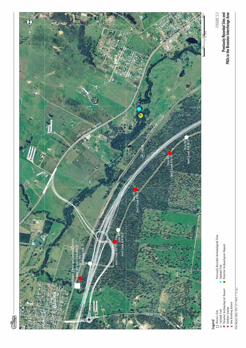
*Please note that this total includes some sites that were also recorded as incorporating a PAD. In order to allow for geotechnical testing and the timely commencement of highway link construction, Umwelt (2004, 2005) prepared a Section 87 Permit application and two Section 90 Consent applications (with the requisite Research Design and Methodologies) for sites, PADs and landforms along the route alignment. Section 90 consent was granted by DEC for sites within the Section 1 area on 7 June 2004 (NPWS #1940). The salvage of the sites and PADs in this area was undertaken in July 2004. Section 90 consent (# 2102) was granted for the collection of 66 sites on 14 February 2005. Section 87 permit (#2096) for the subsurface testing of 18 PADs, four sites and multiple landform units was granted on 16 February 2005. The surface collections were undertaken in April 2005 and the subsurface testing commenced in April 2005 and will continue until August 2005. Figures 2.1 and 2.2 indicate the location of the sites and PADs and the management recommendations currently approved by the DEC. 2.4 KNOWN SITES WITHIN THE BRANXTON INTERCHANGE AREA Prior to the inspection of the area proposed for impact by the Branxton Interchange there were several sites and PADs that had been recorded during the route alignment inspections carried out


Umwelt (Australia) Pty Limited 1862/R05/V3 July 2005 5
by Umwelt (2005) and Brayshaw (1994, 2001) in the area. Figure 2.3 indicates the sites and PADs located in proximity to the Branxton Interchange area known prior to the April 2005 survey. The southern on/off ramp for the Branxton Interchange (from the Main Northern Railway to Wine Country Drive) and the roundabout area were surveyed by Umwelt in January 2004 during the route alignment inspection. Inspection of the area to the north of the Main Northern Railway could not be undertaken at that time as landholder permission for access was not available. Of the sites/PADs located in January 2004, only Anvil Creek RTA 11 IF is within the area of direct impact by construction of the Branxton Interchange. The remaining sites on the southern side of the Main Northern Railway are on tracks required for access during geotechnical testing and during highway link construction for the route alignment of the main carriageway. The PAD (PAD18) extends into the area to be impacted by the main carriageway (but not the Branxton Interchange). The survey results, site significance assessment and site and PAD descriptions for the previously surveyed area are discussed in Umwelt (2005). Subsequent to the inspection of the southern section of the Branxton Interchange, DEC Section 90 consent and Section 87 permit applications were prepared in consultation with all five Aboriginal groups. The sites have subsequently been collected and the southern area of the Branxton Interchange, including the roundabout has been cleared of cultural heritage constraints. PAD 18 was subject to subsurface testing in May 2005 resulting in the retrieval of a very low number of artefacts. PAD 18 is outside the area of impact from the Branxton Interchange and thus not directly relevant to this report. Table 2.2 indicates the current status of the previously recorded sites (eg. salvaged under Section 90, subsurface tested under Section 87, no impact). The PAD (shown in yellow) and isolated find (shown in blue) on Figure 2.3 were located by Brayshaw in 1994 are in an area initially proposed for an off ramp for the highway link. The current Branxton Interchange is a modification to that original design.
Table 2.2 - Site/PAD Status
Site/PAD Site Type Status Further salvage required prior to impact
Anvil Creek RTA 10 Artefact scatter Salvaged under Section 90 Consent #2102
No further salvage required
Anvil Creek RTA 11 IF Isolated find Salvaged under Section 90 Consent #2102
No further salvage required
Anvil Creek RTA 18IF Isolated find Salvaged under Section 90 Consent #2102
No further salvage required.
Anvil Creek RTA 19 Artefact scatter Salvaged under Section 90 Consent #2102
No further salvage required
Anvil Creek RTA 20IF Isolated find Salvaged under Section 90 Consent #2102
No further salvage required
Anvil Creek RTA 21 Artefact scatter Salvaged under Section 90 Consent #2102
No further salvage required
Anvil Creek RTA 22 Artefact scatter Salvaged under Section 90 Consent #2102
No further salvage required
PAD 18 PAD Subsurface tested under Section 87 Permit #2096
If substantial numbers of artefacts are located during subsurface testing further salvage may be required.

Umwelt (Australia) Pty Limited 1862/R05/V3 July 2005 6
Table 2.2 - Site/PAD Status (Cont)
Site/PAD Site Type Status Further salvage required prior to impact
IF1 Isolated find Outside impact area-no impact
N/A
PAD (Blue) PAD Outside impact area -no impact
N/A
H3 Historic site Brick culvert under Main Northern Railway
Outside impact area -no impact
N/A
3.0 METHODOLOGY AND RESULTS OF THE BRANXTON
INTERCHANGE SURVEY 3.1 ABORIGINAL CONSULTATION Consultation with BCAC, BNC, LWTC, MLALC and WNAC has been ongoing in relation to the highway link project since August 2002 and inspection of the Branxton Interchange area was undertaken in two parts. The area to the south of the Main Northern Railway was surveyed in January 2004. The area to the north of the Main Northern Railway was surveyed in April 2005. Participants in the survey in January 2004 were: Ann Hickey (BNC), Hazel Bradford (BCAC) and Chris Turnbull and David Jackson (WNAC). Participants in the April 2005 survey were: Ann Hickey (BNC), Hazel Bradford (BCAC), Arthur Fletcher (MLALC) and Maree Waugh (LWTC). All five groups were afforded the opportunity to participate in the surveys, however, not all five groups could participate due to other commitments on the day. 3.2 METHODOLOGY FOR THE INSPECTION Inspection of the total area to be impacted by the Branxton Interchange was undertaken on foot. The centreline of the route alignment and the on/off access ramps were pegged to assist with the survey. Participants in the survey spread out in a line at 5 to 10 metre intervals. Ground surface visibility was generally poor due to pastoral grasses. Occasional patches of visibility were provided where rock outcropped at the surface (in the northern section) or where the survey transect crossed an existing power easement and access track (in the southern section). Where the route alignment crossed Anvil Creek it was inspected for at least 200 metres upstream and downstream of the edge of the route alignment to check for grinding grooves or sites along the banks of the creek. All sites/PADs identified were recorded in detail. The Aboriginal significance was discussed with the Aboriginal group representatives and archaeological significance of each of the sites/PADs was assessed according to DEC guidelines so that appropriate management recommendations could be formulated taking the significance assessment into account. 3.3 RESULTS OF THE INSPECTION As the sites in the southern section of the area to be impacted by the proposed Branxton Interchange have already been salvaged this section of the report will relate specifically to the northern section (north of the Main Northern Railway).

Umwelt (Australia) Pty Limited 1862/R05/V3 July 2005 7
3.3.1 Landform Units The survey followed the pegged route of the on/off ramp from the New England Highway to the Main Northern Railway (north to south). The survey team began on the upper slope (gradient two to three degrees) and moved downslope across the midslope (three degrees) and lower slope (one to two degrees) (Plate 1). The survey team then crossed a first creek terrace (40 metres wide - Plate 2) before dropping down to the current floodplain, that is only 5 to 10 metres wide in this area. The survey team crossed Anvil Creek in an area where the creekline contained large expanses of conglomerate outcrop, conglomerate benches and deep rock waterholes (Plate 3). The creek was flowing at the time of the survey. The creek is approximately 15 metres wide in this area. The survey transect then crossed the lower mid and upper slope and crest of a low spur that runs between two shallow grassy watercourses which are minor first order tributaries of Anvil Creek (Plate 4). The survey ended at the second watercourse which flowed under the Main Northern Railway at this point. There was no floodplain or terrace development within the area inspected on the southern side of Anvil Creek. 3.3.2 Vegetation and Ground Surface Visibility The entire area surveyed was covered with improved pastoral grassland with occasional patches of Hakea spp. and regrowth Casuarina spp. and Acacia spp. along the banks of Anvil Creek (Plate 1). Lomandra spp. (mat rush) was observed growing along the banks of Anvil Creek and Triglochin procera (water ribbons), Typha orientalis (bulrush) and Phragmites australis (common reed) were noted growing within areas of still water in the creek. All four of these plants were species used by Aboriginal hunter-gatherers for food and/or fibre. Ground surface visibility was zero in all landform units except the first creek terrace on the northern side of Anvil Creek (Plate 2). In this area visibility was 50%. 3.3.3 Geology and Soils Soils in the area are very sandy loams over a pebbly conglomerate. Pebbly conglomerate outcrops in several areas on the slopes indicating that the soil is very shallow. The soil appears to be substantially deeper on the first creek terrace and the modern floodplain. The pebbly conglomerate outcrops at intervals along the Anvil Creek and Redhouse Creek to the north (refer to Section 3.3.4). 3.3.4 Watercourses Anvil Creek was flowing at the time of the inspection. The size of the creek and the amount of water it carries, suggests that in pre-European times it would have supported fish, eels, freshwater crayfish and tortoises, making it a useful food resource for Aboriginal people. The base of Anvil Creek in the survey area is a coarse, poorly cemented pebbly conglomerate (Plate 3). The pebbly conglomerate outcrops as benches along the creek and deep pools form upstream of the benches. These pools hold freshwater for an extensive period after rain. The nature of the creekline indicates that it would have provided a valuable freshwater resource for Aboriginal people. It is probable that water would have been available in this area during extended dry periods when waterholes further upstream may have dried out. The pebbly conglomerate exposures within the creek were inspected, however, no axe grinding grooves were observed. It is unlikely that the course of Anvil Creek in this area has changed since European settlement as it cannot cut down any further into its bedrock base and is confined within its bedrock channel.


Umwelt (Australia) Pty Limited 1862/R05/V3 July 2005 8
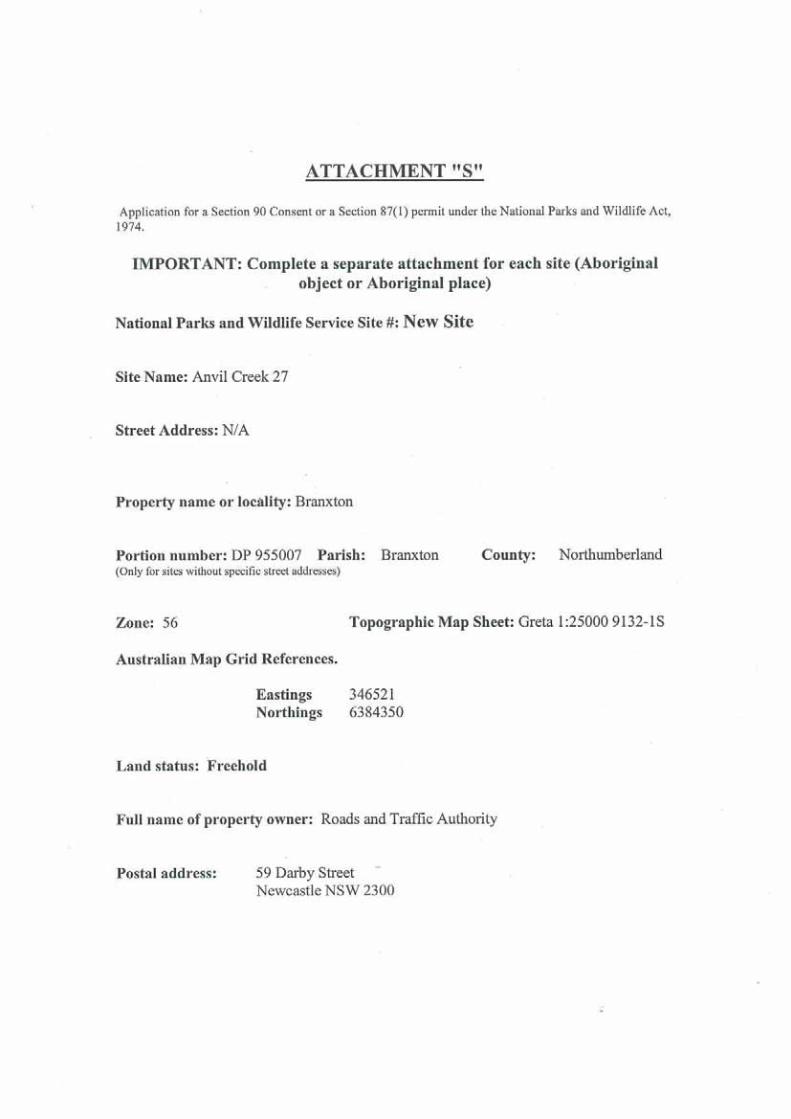
3.3.5 Prior Disturbance The whole of the area surveyed had been cleared and cultivated. According to a neighbouring farmer the land had been cultivated for at least 30 years before being used for grazing (mainly cattle and horses). On the southern side of the creek there has been a problem with woody weed regrowth (Hakea spp.) and the landholder has bulldozed sections of the area surveyed (on numerous occasions) to remove this pest. Prior disturbance was noted from the construction of the New England Highway at the start of the survey and the Main Northern Railway at the end of the survey. 3.3.6 Sites and PADs located One isolated find (Anvil Creek 27) and one area of PAD (PAD 21) were located during the survey of the area to be directly impacted by the construction of the Branxton Interchange (refer to Plates 2 and 5). Table 3.1 provides a description of the site and PAD located. The table also provides details of their location in relation to the proposed Branxton Interchange.


U
mw
elt (
Aus
tralia
) Pty
Lim
ited
1862
/R05
/V3
July
200
5 9
Tab
le 3
.1 -
Abo
rigi
nal s
ites a
nd P
AD
loca
ted
duri
ng th
e in
vest
igat
ion
of th
e no
rthe
rn se
ctio
n of
the
prop
osed
Bra
nxto
n In
terc
hang
e
Site
Nam
e/Ty
pe
Site
Typ
e N
o. o
f A
rtef
acts
A
MG
E
astin
g A
MG
N
orth
ing
MG
A
Eas
ting
MG
A
Nor
thin
g D
escr
iptio
n L
ocat
ion
in r
elat
ion
to
prop
osed
Bra
nxto
n In
terc
hang
e PA
D 2
1 PA
D
N/A
34
6711
63
8451
1 34
6816
63
8470
0 Th
e PA
D is
loca
ted
on a
firs
t cre
ek te
rrac
e on
the
north
ern
side
of A
nvil
Cre
ek. T
he te
rrac
e is
ap
prox
imat
ely
40 m
wid
e an
d ab
out 1
m h
ighe
r tha
n th
e cu
rren
t flo
odpl
ain.
The
cur
rent
floo
dpla
in is
onl
y 5
to 1
0 m
wid
e in
this
are
a. A
nvil
Cre
ek h
as
num
erou
s con
glom
erat
e be
nche
s tha
t for
m w
eirs
ac
ross
the
cree
k. L
arge
wat
erho
les e
xist
beh
ind
the
rock
ben
ches
. Th
ere
wer
e nu
mer
ous a
quat
ic p
lant
s and
ani
mal
s no
ted
in th
is a
rea
that
are
kno
wn
food
sour
ces f
or
Abo
rigin
al p
eopl
e.
The
PAD
is w
ithin
an
exis
ting
pow
er e
asem
ent.
Tops
oil d
epth
in th
is a
rea
is e
stim
ated
at
appr
oxim
atel
y 1
m. T
he e
asem
ent i
s bou
nded
by
regr
owth
Cas
uarin
a sp
p.
The
PAD
is w
ithin
the
area
to b
e im
pact
ed b
y an
on/
off r
amp
on th
e no
rther
n si
de o
f Anv
il C
reek
.
Anv
il C
reek
27
Isol
ated
Fi
nd
1 34
6521
63
8435
0 34
6626
63
8453
9 A
sing
le si
lcre
te fl
ake
was
loca
ted
on th
e m
idsl
ope
of a
spur
bet
wee
n tw
o m
inor
trib
utar
ies o
f Em
u C
reek
. The
arte
fact
was
sitti
ng o
n to
p of
out
crop
ping
co
nglo
mer
ate.
Thi
s are
a ha
s bee
n su
bjec
t to
culti
vatio
n an
d si
nce
culti
vatio
n ce
ased
, to
regu
lar
clea
ranc
e of
Hak
ea u
sing
a b
ulld
ozer
.
On
cent
relin
e of
on/
off
ram
p (n
ext t
o C
H30
0 pe
g) o
n so
uthe
rn si
de o
f A
nvil
Cre
ek.
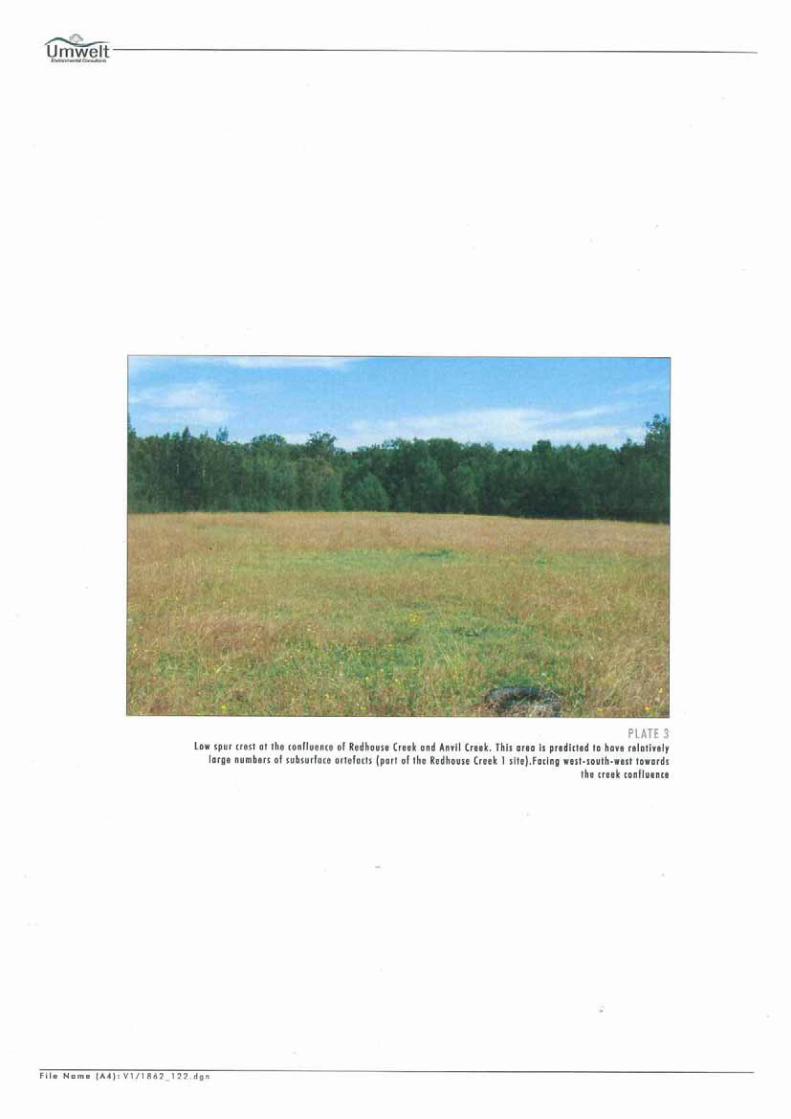
Red
hous
e C
reek
1
Arte
fact
Sc
atte
r an
d PA
D
34
3464
62
6384
549
3465
67
6384
738
A sc
atte
r of a
rtefa
cts w
as lo
cate
d in
are
as o
f ero
sion
as
soci
ated
with
the
bank
s of R
edho
use
Cre
ek a
nd
Anv
il C
reek
at t
he c
onflu
ence
of t
he tw
o cr
eeks
. A
sp
ur c
rest
div
ides
the
two
cree
ks a
nd p
rovi
des a
n el
evat
ed c
amp
site
in a
n ar
ea w
ith se
mi-p
erm
anen
t to
per
man
ent w
ater
. It i
s ass
esse
d th
at th
e sp
ur c
rest
ar
ea w
ithin
the
vici
nity
of t
he c
reek
con
fluen
ce w
ill
have
rela
tivel
y la
rge
num
bers
of a
rtefa
cts i
n a
subs
urfa
ce c
onte
xt.
The
site
and
ass
ocia
ted
PAD
are
app
roxi
mat
ely
100
m to
the
wes
t of t
he
area
to b
e im
pact
ed b
y th
e co
nstru
ctio
n of
the
Bra
nxto
n In
terc
hang
e

Umwelt (Australia) Pty Limited 1862/R05/V3 July 2005 10
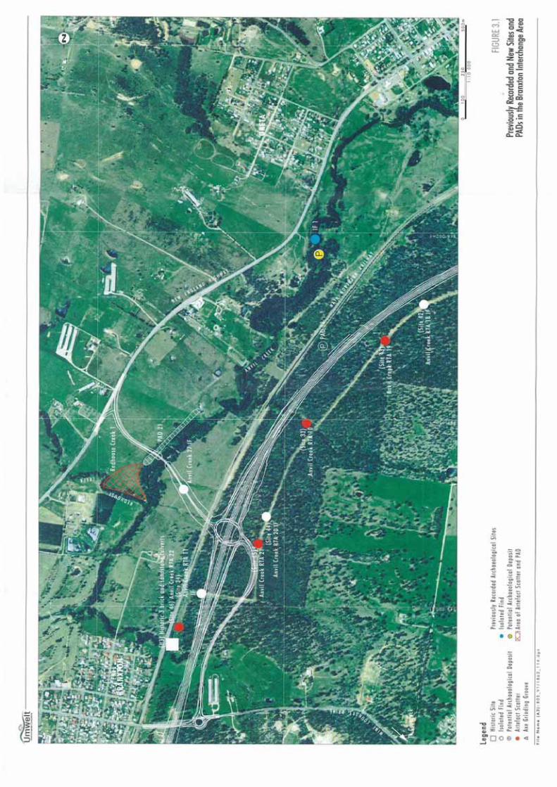
It was recognised during the survey that the area associated with Anvil Creek and especially the confluence of Anvil Creek and Redhouse Creek to the northwest, was sensitive from an Aboriginal and archaeological perspective. It was decided to enlarge the survey area to incorporate this creek confluence so that recommendations could be made for the protection of this area if thought warranted. The survey of this additional area resulted in the recording of an artefact scatter incorporating a large area of associated PAD (Redhouse Creek 1 - refer to Plates 6, 7 and 8). DEC site cards have been included in Appendix 2. 3.4 INTERPRETATION OF THE RESULTS OF THE SURVEY The results of the survey when seen in the light of the results of the broader inspection of the area undertaken as part of the route alignment inspection, suggest that a light background scatter of artefacts could be expected in a subsurface context across the whole of the survey area and its environs. Larger concentrations of artefacts could be expected in the vicinity of waterholes along Anvil Creek with the greatest concentration occurring on the northern (higher) side of Anvil Creek within the area at the confluence of Anvil Creek and Redhouse Creek (refer to Figure 3.1). The creek terrace located on the northern side of Anvil Creek is not confined to the area of impact and extends approximately 500 metres to the southeast and 100 metres to the northwest of the area proposed for the Branxton Interchange. The terrace may not be of great antiquity as the floodplain it adjoins appears very recent in nature. The depth of the terrace deposits, however, does provide the potential for the location of artefacts which may retain some degree of archaeological integrity below the plough zone. 4.0 SIGNIFICANCE ASSESSMENT Cultural heritage significance is a measure of the relative value or importance of Aboriginal sites. Significance is assessed according to principles outlined originally in Australia in the Burra Charter (1979), which was adapted from the UNESCO sponsored ICOMOS (International Council for Monuments and Sites) Venice Charter. The assessment of significance assists in the determination of appropriate cultural heritage management procedures for sites/artefacts that may be threatened by development activities. Assessing the significance of Aboriginal archaeological sites is an extremely complicated process that must take into account the interests of many parties. The Burra Charter defines cultural significance as the ‘aesthetic, historic, scientific or social value for past, present or future generations’ of a place. The DEC (NPWS Guidelines 1997) provides further discussion on the assessment of cultural significance for Aboriginal sites, and for artefact scatter sites in particular. Categories of significance relevant to Aboriginal archaeological sites include Aboriginal significance, archaeological/scientific significance, aesthetic significance, tourism potential and educational significance. The NSW NPWS Guidelines for Archaeological Report Writing (1997: 25) states:
While Aboriginal sites and places may have educational, tourism, and other values to groups in society their principle values are likely to be in terms of their cultural/social significance to Aboriginal people and their scientific significance to archaeologists. It is thus possible to identify two main streams in the overall significance assessment process: the assessment of cultural/social significance to Aboriginal people and the assessment of scientific significance to archaeologists.
Therefore, the significance of the sites and PAD within the proposed Branxton Interchange area will be assessed in relation to their Aboriginal significance and their scientific or archaeological significance. The criteria for assessing each type of archaeological ‘significance’ will be detailed in Section 4.2. The scientific significance assessment of the sites and the potential significance of


Umwelt (Australia) Pty Limited 1862/R05/V3 July 2005 11
the PAD recorded during the survey for this project will be discussed and justification for their significance ranking provided. 4.1 ABORIGINAL SIGNIFICANCE Aboriginal cultural significance can only be assessed by the relevant Aboriginal community groups and often varies from that of archaeological significance. Table 4.1 presents the assessment of Aboriginal significance provided by the representatives of the Aboriginal groups present during the survey. The Aboriginal significance of the sites and PAD is derived from their perceived cultural heritage sensitivity. From the table it can be seen that the Aboriginal representatives identified varying degrees of cultural heritage significance for the sites and PAD.
Table 4.1 - Aboriginal Significance
Site/PAD/Area Name Aboriginal Cultural Heritage SignificanceAnvil Creek 27 Isolated find Moderate PAD 21 High Redhouse Creek 1 and PAD High
The Aboriginal groups also highlighted the sensitivity of Anvil Creek itself. The creek was seen to be a valuable resource which would have provided a focus for Aboriginal occupation of the area. Thus, the groups would like to see the construction proposed in the area have limited impact on the actual creekline. In this instance they desired assurance that the on/off ramp would cross over Anvil Creek via a bridge rather than using culverts (in this regard the RTA design for the crossing does provide for a bridge to cross Anvil Creek). A copy of the draft report was forwarded to the groups on 25 May 2005 for their comment. The comments received from the groups are included in (Appendix 1) and summarised in Section 5.7. 4.2 ARCHAEOLOGICAL/SCIENTIFIC SIGNIFICANCE ASSESSMENT The archaeological or scientific significance of the sites and PAD and the potential archaeological deposits were assessed according to their value to contribute to furthering of the archaeological/scientific understanding of Aboriginal culture (their archaeological research potential) in the local and regional context. Six criteria were assessed to deduce archaeological research potential, these were: � rarity;
� representativeness; � integrity; � connectedness; � complexity; and
� potential for archaeological deposit.
Umwelt (Australia) Pty Limited 1862/R05/V3 July 2005 12
4.3 RANKING OF CRITERIA FOR EVALUATING ARCHAEOLOGICAL SIGNIFICANCE
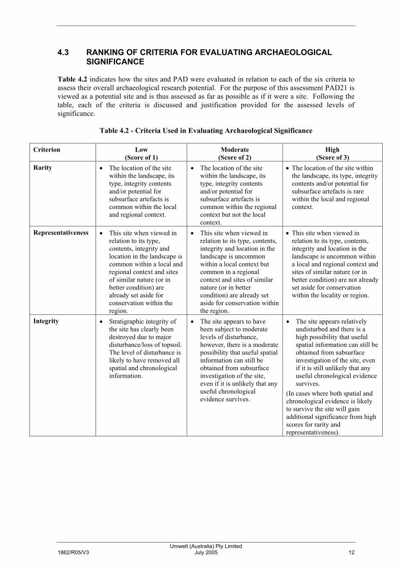
Table 4.2 indicates how the sites and PAD were evaluated in relation to each of the six criteria to assess their overall archaeological research potential. For the purpose of this assessment PAD21 is viewed as a potential site and is thus assessed as far as possible as if it were a site. Following the table, each of the criteria is discussed and justification provided for the assessed levels of significance.
Table 4.2 - Criteria Used in Evaluating Archaeological Significance
Criterion Low (Score of 1)
Moderate (Score of 2)
High (Score of 3)
Rarity � The location of the site within the landscape, its type, integrity contents and/or potential for subsurface artefacts is common within the local and regional context.
� The location of the site within the landscape, its type, integrity contents and/or potential for subsurface artefacts is common within the regional context but not the local context.
� The location of the site within the landscape, its type, integrity contents and/or potential for subsurface artefacts is rare within the local and regional context.
Representativeness � This site when viewed in relation to its type, contents, integrity and location in the landscape is common within a local and regional context and sites of similar nature (or in better condition) are already set aside for conservation within the region.
� This site when viewed in relation to its type, contents, integrity and location in the landscape is uncommon within a local context but common in a regional context and sites of similar nature (or in better condition) are already set aside for conservation within the region.
� This site when viewed in relation to its type, contents, integrity and location in the landscape is uncommon within a local and regional context and sites of similar nature (or in better condition) are not already set aside for conservation within the locality or region.
Integrity � Stratigraphic integrity of the site has clearly been destroyed due to major disturbance/loss of topsoil. The level of disturbance is likely to have removed all spatial and chronological information.
� The site appears to have been subject to moderate levels of disturbance, however, there is a moderate possibility that useful spatial information can still be obtained from subsurface investigation of the site, even if it is unlikely that any useful chronological evidence survives.
� The site appears relatively undisturbed and there is a high possibility that useful spatial information can still be obtained from subsurface investigation of the site, even if it is still unlikely that any useful chronological evidence survives.
(In cases where both spatial and chronological evidence is likely to survive the site will gain additional significance from high scores for rarity and representativeness).

Umwelt (Australia) Pty Limited 1862/R05/V3 July 2005 13
Table 4.2 - Criteria Used in Evaluating Archaeological Significance (cont)
Criterion Low (Score of 1)
Moderate (Score of 2)
High (Score of 3)
Connectedness � There is no evidence to suggest that the site is connected to other sites in the local area or the region through: - their chronology
(rarely known); - their site type (eg.
connectedness could be argued between an axe quarry, a nearby set of axe grinding grooves and an adjacent site exhibiting evidence of axe reduction);
- by the use of an unusual raw material, knapping technique/reduction strategy;
- similar designs/motifs in the case of art sites and engravings; and
- information provided by Aboriginal oral history.
� There is some evidence to suggest that the site is connected to other sites in the local area or the region through: - their chronology (rarely
known); - their site type (eg.
connectedness could be argued between an axe quarry, a nearby set of axe grinding grooves and an adjacent site exhibiting evidence of axe reduction);
- by the use of an unusual raw material, knapping technique/reduction strategy;
- similar designs/motifs in the case of art sites and engravings; and
- information provided by Aboriginal oral history.
� There is good evidence to support the theory that the site is connected to other sites in the local area or the region through: - their chronology (rarely
known); - their site type (eg.
connectedness could be argued between an axe quarry, a nearby set of axe grinding grooves and an adjacent site exhibiting evidence of axe reduction);
- by the use of an unusual raw material, knapping technique/reduction strategy;
- similar designs/motifs in the case of art sites and engravings; and
- information provided by Aboriginal oral history.
Complexity � The site does not exhibit and is not predicted to contain either of the following in a subsurface context: - a complex assemblage
of stone artefacts in terms of artefact types and/or raw materials (including use of local and imported raw materials) and/or knapping techniques/reduction strategies; and
- features such as hearths or heat treatment pits, activity areas.
� The site exhibits or can be predicted to contain one of the following in a subsurface context: - a complex assemblage
of stone artefacts in terms of artefact types and/or raw materials and/or knapping techniques/reduction strategies and/or use of local and imported raw materials; and
- features such as hearths or heat treatment pits, activity areas.
� The site exhibits or can be predicted to contain both of the following in a subsurface context: - a complex assemblage of
stone artefacts in terms of artefact types and/or raw materials and/or knapping techniques/reduction strategies and/or use of local and imported raw materials; and
- features such as hearths or heat treatment pits, activity areas.
Umwelt (Australia) Pty Limited 1862/R05/V3 July 2005 14
Table 4.2 - Criteria Used in Evaluating Archaeological Significance (cont)
Criterion Low (Score of 1)
Moderate (Score of 2)
High (Score of 3)
PAD � The site does not have or has only a low potential to contain subsurface archaeological material that has stratigraphic integrity or is of a nature that suggest its subsurface investigation would assist with answering questions of contemporary archaeological interest or that indicate it should be preserved for its future research potential.
� The site has a moderate potential to contain subsurface archaeological material that has stratigraphic integrity or is of a nature that its subsurface investigation would assist with answering questions of contemporary archaeological interest or that indicate it should be preserved for its future research potential.
� The site has a high potential to contain subsurface archaeological material that has stratigraphic integrity or is of a nature that its subsurface investigation would assist with answering questions of contemporary archaeological interest or that indicate it should be preserved for its future research potential.
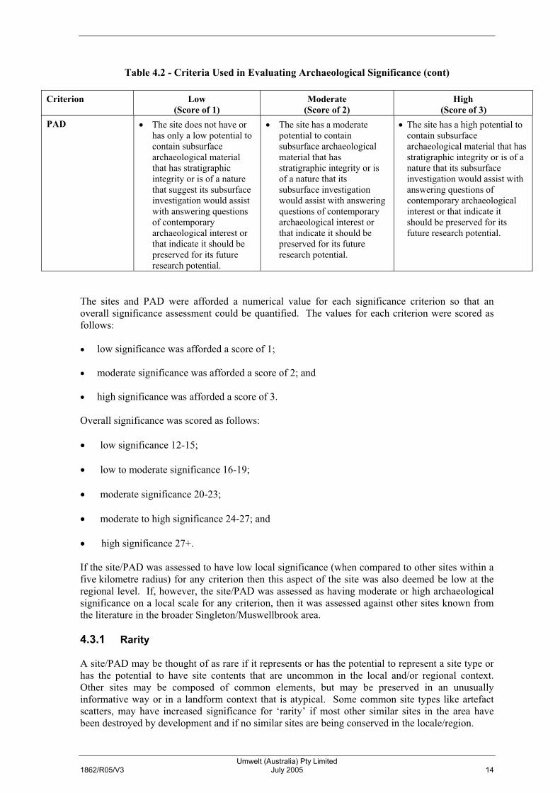
The sites and PAD were afforded a numerical value for each significance criterion so that an overall significance assessment could be quantified. The values for each criterion were scored as follows: � low significance was afforded a score of 1; � moderate significance was afforded a score of 2; and � high significance was afforded a score of 3. Overall significance was scored as follows: � low significance 12-15; � low to moderate significance 16-19; � moderate significance 20-23; � moderate to high significance 24-27; and � high significance 27+. If the site/PAD was assessed to have low local significance (when compared to other sites within a five kilometre radius) for any criterion then this aspect of the site was also deemed be low at the regional level. If, however, the site/PAD was assessed as having moderate or high archaeological significance on a local scale for any criterion, then it was assessed against other sites known from the literature in the broader Singleton/Muswellbrook area. 4.3.1 Rarity A site/PAD may be thought of as rare if it represents or has the potential to represent a site type or has the potential to have site contents that are uncommon in the local and/or regional context. Other sites may be composed of common elements, but may be preserved in an unusually informative way or in a landform context that is atypical. Some common site types like artefact scatters, may have increased significance for ‘rarity’ if most other similar sites in the area have been destroyed by development and if no similar sites are being conserved in the locale/region.

Umwelt (Australia) Pty Limited 1862/R05/V3 July 2005 15
Small artefact scatter sites and isolated finds near creeks and areas of PAD in alluvial deposits along creeks are common both locally and regionally and similar sites are known, and could be predicted, upstream and downstream along Anvil Creek, that are outside areas proposed for impact by the construction of the Branxton Interchange and the broader F3 highway link project. Thus the Anvil Creek 27 IF site and PAD21 are assessed as having low archaeological significance for rarity on a local and regional scale, however, there are few larger sites with PAD that are actually being conserved or have the potential to be conserved into the future. Thus, the Redhouse Creek 1 artefact scatter site and associated PAD is assessed as having high archaeological significance for rarity on a local scale and moderate archaeological significance for rarity on a regional scale. 4.3.2 Representativeness One of the objectives of cultural heritage management is to ensure that a representative sample of all site types is preserved in the variety of landscapes in which they occur. Like many other natural resources, archaeological sites are a non-renewable resource. Once they are destroyed they cannot be replaced or replicated. As a result, one of the aims of a scientific value assessment is to examine the potential of newly discovered sites to be conserved to act as ‘representative’ examples of a particular site type. Small artefact scatter sites, isolated finds and PADs are common both locally and regionally. Isolated finds on slopes are very common in the general Greta/Branxton area and have similar artefact types manufactured from similar raw materials to Anvil Creek 27IF. Many of these isolated find sites will be destroyed by highway link construction, but there are sufficient isolated finds that will not be impacted to lessen the representativeness value of the Anvil Creek 27 IF site to low on a local and regional scale. The area of PAD (PAD21) on the first creek terrace, is part of an extensive area of terrace along this section of Anvil Creek, the majority of which is not to be impacted by construction of the Branxton Interchange. Thus, PAD21 is also assessed as having low archaeological significance on a local and regional scale for representativeness. As there are few larger artefact scatter sites with PAD known, that are actually being conserved or have the potential to be conserved into the future, the Redhouse Creek 1 artefact scatter site and associated PAD is assessed as having high archaeological significance for representativeness on a local scale and moderate archaeological significance on a regional scale. 4.3.3 Integrity Each archaeological site/PAD represents/has the potential to represent, a number of pieces of evidence spatially organised both by human behaviour and by subsequent environmental and land-use effects. When a site/PAD has been subject to relatively few environmental or land-use (post-depositional) processes it will represent more directly the original human activities which created it. Such undisturbed sites/PADs are considered to have archaeological integrity and may have the potential to answer research questions of relevance to both the Aboriginal and archaeological community. Sites/PADs with archaeological integrity are necessary to answer questions related to the antiquity of Aboriginal occupation or related to change over time in ways people were behaving within the landscape. In sites which have been heavily disturbed by post-depositional processes such as tree clearance followed by erosion, agricultural activities and infrastructure development and/or bioturbation, aspects of the original activities which formed the sites will be disturbed and site integrity lost. This has a severe constraining effect on the utility of the site to inform about the Aboriginal past. The Anvil Creek 27IF site and the Redhouse Creek 1 site and PAD have only shallow soils which have been heavily disturbed by European land-use practices. Thus, they are assessed as having low archaeological significance for integrity on a local and regional scale. The soil deposits in the area of PAD21 are sufficiently deep that artefactual material may exist at a depth below the cultivation/disturbance zone which may retain a level of archaeological integrity, though
Umwelt (Australia) Pty Limited 1862/R05/V3 July 2005 16
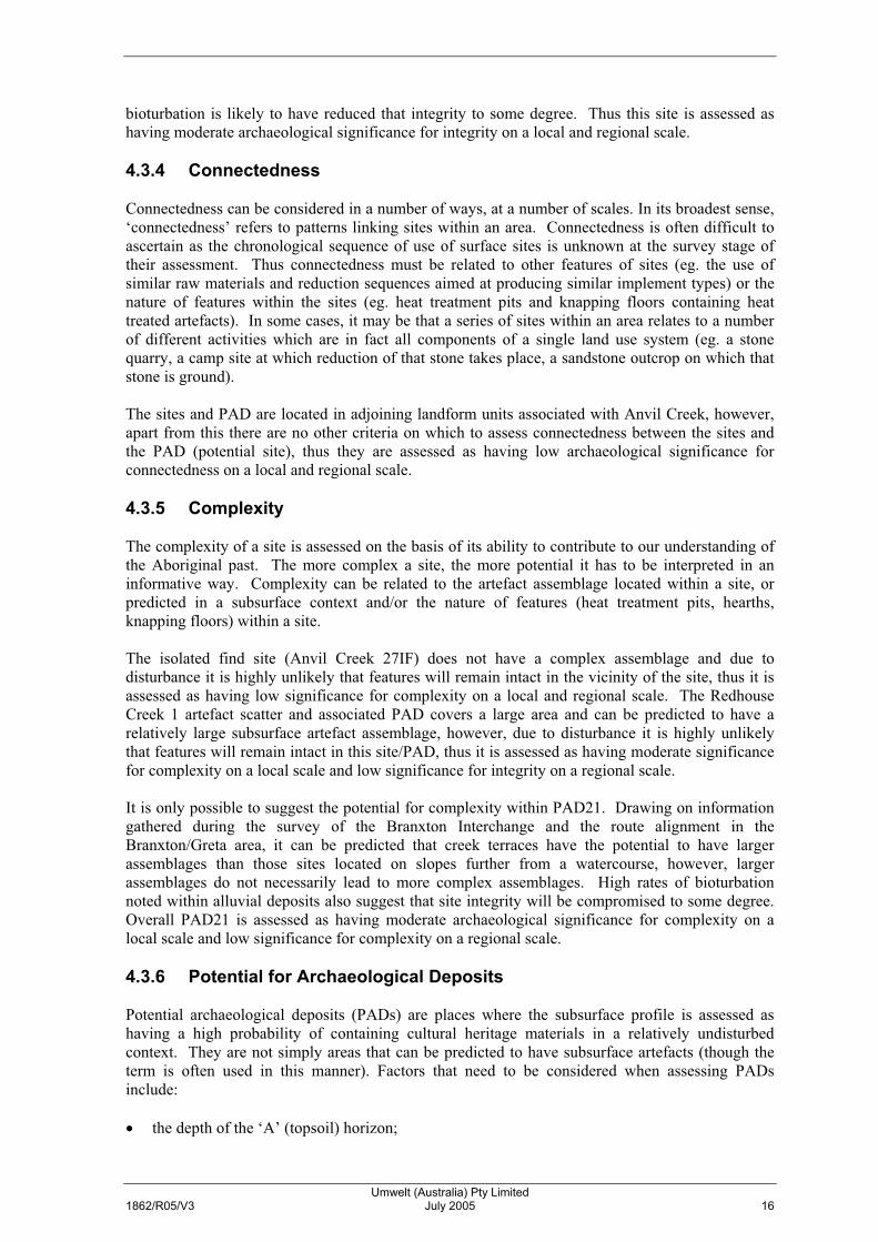
bioturbation is likely to have reduced that integrity to some degree. Thus this site is assessed as having moderate archaeological significance for integrity on a local and regional scale. 4.3.4 Connectedness Connectedness can be considered in a number of ways, at a number of scales. In its broadest sense, ‘connectedness’ refers to patterns linking sites within an area. Connectedness is often difficult to ascertain as the chronological sequence of use of surface sites is unknown at the survey stage of their assessment. Thus connectedness must be related to other features of sites (eg. the use of similar raw materials and reduction sequences aimed at producing similar implement types) or the nature of features within the sites (eg. heat treatment pits and knapping floors containing heat treated artefacts). In some cases, it may be that a series of sites within an area relates to a number of different activities which are in fact all components of a single land use system (eg. a stone quarry, a camp site at which reduction of that stone takes place, a sandstone outcrop on which that stone is ground). The sites and PAD are located in adjoining landform units associated with Anvil Creek, however, apart from this there are no other criteria on which to assess connectedness between the sites and the PAD (potential site), thus they are assessed as having low archaeological significance for connectedness on a local and regional scale. 4.3.5 Complexity The complexity of a site is assessed on the basis of its ability to contribute to our understanding of the Aboriginal past. The more complex a site, the more potential it has to be interpreted in an informative way. Complexity can be related to the artefact assemblage located within a site, or predicted in a subsurface context and/or the nature of features (heat treatment pits, hearths, knapping floors) within a site. The isolated find site (Anvil Creek 27IF) does not have a complex assemblage and due to disturbance it is highly unlikely that features will remain intact in the vicinity of the site, thus it is assessed as having low significance for complexity on a local and regional scale. The Redhouse Creek 1 artefact scatter and associated PAD covers a large area and can be predicted to have a relatively large subsurface artefact assemblage, however, due to disturbance it is highly unlikely that features will remain intact in this site/PAD, thus it is assessed as having moderate significance for complexity on a local scale and low significance for integrity on a regional scale. It is only possible to suggest the potential for complexity within PAD21. Drawing on information gathered during the survey of the Branxton Interchange and the route alignment in the Branxton/Greta area, it can be predicted that creek terraces have the potential to have larger assemblages than those sites located on slopes further from a watercourse, however, larger assemblages do not necessarily lead to more complex assemblages. High rates of bioturbation noted within alluvial deposits also suggest that site integrity will be compromised to some degree. Overall PAD21 is assessed as having moderate archaeological significance for complexity on a local scale and low significance for complexity on a regional scale. 4.3.6 Potential for Archaeological Deposits Potential archaeological deposits (PADs) are places where the subsurface profile is assessed as having a high probability of containing cultural heritage materials in a relatively undisturbed context. They are not simply areas that can be predicted to have subsurface artefacts (though the term is often used in this manner). Factors that need to be considered when assessing PADs include: � the depth of the ‘A’ (topsoil) horizon;
Umwelt (Australia) Pty Limited 1862/R05/V3 July 2005 17
� any potential disturbances to the subsurface environment (eg. bioturbation, stock trampling, power easement clearance, cultivation, dam construction etc);
� the probability of cultural materials being present as assessed through the environmental setting
and/or a surface artefact assemblage; and � any geomorphic agencies likely to have affected the area (eg. slopewash, colluvial erosion and
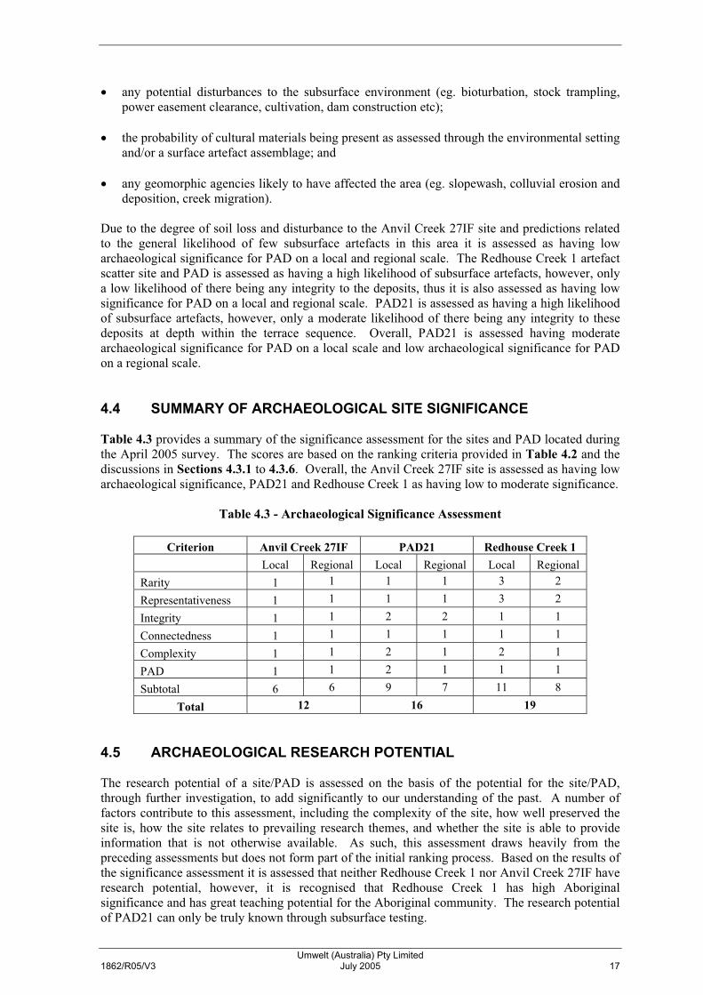
deposition, creek migration). Due to the degree of soil loss and disturbance to the Anvil Creek 27IF site and predictions related to the general likelihood of few subsurface artefacts in this area it is assessed as having low archaeological significance for PAD on a local and regional scale. The Redhouse Creek 1 artefact scatter site and PAD is assessed as having a high likelihood of subsurface artefacts, however, only a low likelihood of there being any integrity to the deposits, thus it is also assessed as having low significance for PAD on a local and regional scale. PAD21 is assessed as having a high likelihood of subsurface artefacts, however, only a moderate likelihood of there being any integrity to these deposits at depth within the terrace sequence. Overall, PAD21 is assessed having moderate archaeological significance for PAD on a local scale and low archaeological significance for PAD on a regional scale. 4.4 SUMMARY OF ARCHAEOLOGICAL SITE SIGNIFICANCE Table 4.3 provides a summary of the significance assessment for the sites and PAD located during the April 2005 survey. The scores are based on the ranking criteria provided in Table 4.2 and the discussions in Sections 4.3.1 to 4.3.6. Overall, the Anvil Creek 27IF site is assessed as having low archaeological significance, PAD21 and Redhouse Creek 1 as having low to moderate significance.
Table 4.3 - Archaeological Significance Assessment
Criterion Anvil Creek 27IF PAD21 Redhouse Creek 1 Local Regional Local Regional Local Regional Rarity 1 1 1 1 3 2
Representativeness 1 1 1 1 3 2
Integrity 1 1 2 2 1 1
Connectedness 1 1 1 1 1 1
Complexity 1 1 2 1 2 1
PAD 1 1 2 1 1 1
Subtotal 6 6 9 7 11 8
Total 12 16 19 4.5 ARCHAEOLOGICAL RESEARCH POTENTIAL The research potential of a site/PAD is assessed on the basis of the potential for the site/PAD, through further investigation, to add significantly to our understanding of the past. A number of factors contribute to this assessment, including the complexity of the site, how well preserved the site is, how the site relates to prevailing research themes, and whether the site is able to provide information that is not otherwise available. As such, this assessment draws heavily from the preceding assessments but does not form part of the initial ranking process. Based on the results of the significance assessment it is assessed that neither Redhouse Creek 1 nor Anvil Creek 27IF have research potential, however, it is recognised that Redhouse Creek 1 has high Aboriginal significance and has great teaching potential for the Aboriginal community. The research potential of PAD21 can only be truly known through subsurface testing.

Umwelt (Australia) Pty Limited 1862/R05/V3 July 2005 18
5.0 MANAGEMENT OPTIONS The following sections discuss the management options for the sites and PAD thought appropriate by the representatives of the Aboriginal groups present during the survey and from an archaeological perspective. Various management options are discussed and a preferred management option provided. The sites discussed are shown on Figure 3.1. 5.1 OPTION 1 SITE CONSERVATION Conserve the Anvil Creek 27IF, Redhouse Creek 1 and PAD21. 5.1.1 Discussion Redhouse Creek 1 is out side the area to be directly impacted by the construction of the Branxton Interchange. Due to the high Aboriginal significance of this site and its Aboriginal teaching potential conservation of this site is an appropriate option. Conservation would take the form of appropriate fencing and signage throughout the construction phase of the Branxton Interchange. The fenced area should be at least the area indicated on Figure 3.1. Conservation of Anvil Creek 27IF and PAD21 would mean the rerouting of the interchange on/off ramp. Rerouting the on/off ramp would only result in the impact of another area of PAD21 and it can be predicted that it would most likely impact other isolated finds. Under these circumstances rerouting is not beneficial. Therefore, conservation of Anvil Creek 27IF and PAD21 is not recommended. 5.2 OPTION 2 SITE DESTRUCTION WITHOUT SALVAGE Apply to the Director-General of the DEC for a Section 90 Consent for destruction of Anvil Creek 27IF, Redhouse Creek 1 and PAD21. 5.2.1 Discussion Site destruction is not warranted for Redhouse Creek 1 as it is outside the impact zone. Site destruction without some form of salvage was not acceptable to the Aboriginal community for Anvil Creek 27IF. The Aboriginal community requested that the artefact within the site be collected ahead of impact. From both an Aboriginal and archaeological perspective destruction of PAD21 without some form of subsurface testing to asses its research potential was not thought appropriate. 5.3 OPTION 3 SITE DESTRUCTION WITH SALVAGE (SURFACE
COLLECTION) Apply to the Director-General of the DEC for a Section 90 Consent with Salvage (surface collection only) for collection of the surface artefacts within the Anvil Creek 27IF and Redhouse Creek 1 sites (not applicable to PAD21) and allow development to proceed following the collection of all surface artefacts.

Umwelt (Australia) Pty Limited 1862/R05/V3 July 2005 19
5.3.1 Discussion This option is thought appropriate from both an Aboriginal and archaeological perspective for Anvil Creek 27IF. It is not appropriate for Redhouse Creek 1 which is outside the direct construction impact area and which can be conserved and is not applicable to PAD21 (as it does not have surface artefacts). 5.4 OPTION 4 SITE DESTRUCTION WITH SALVAGE (SUBSURFACE
SALVAGE) Apply to the Director-General of the DEC for a Section 90 Consent with subsurface salvage Anvil Creek 27IF, Redhouse Creek 1 and PAD21. 5.4.1 Discussion This option is not thought appropriate for Anvil Creek 27IF as the occurrence of sufficient subsurface artefacts to warrant subsurface salvage is highly unlikely. It is not appropriate for Redhouse Creek 1 which is outside the direct construction impact area and which can be conserved. As the subsurface potential for artefacts within PAD21 is not yet known, subsurface salvage is not thought warranted at present. Subsurface testing of this area should be undertaken first to establish the real research potential of the PAD. 5.5 OPTION 5 SUBSURFACE TESTING Apply to the Director-General of the DEC for a Section 87 Preliminary Research Permit for subsurface testing of PAD21. 5.5.1 Discussion From both an Aboriginal and archaeological perspective subsurface testing of PAD21 is thought warranted to assess its research potential. 5.6 PREFERRED MANAGEMENT OPTIONS Taking into account the concerns of the Aboriginal community and the archaeological significance and research potential of the sites and PAD, the following are seen as the preferred management recommendations: � apply to the Director-General of the DEC for a Section 90 Consent to collect the artefact in the
Anvil Creek 27IF site;
� apply to the Director-General of the DEC for a Section 87 Preliminary Research Permit for the subsurface testing of PAD21. If no artefactual material is located, then RTA will be free to commence works in this area. If artefacts are located during subsurface testing a Section 90 Consent for the site will be required. The requirement for further salvage in the area to be determined in consultation with the relevant Aboriginal community and the DEC based on the results of the Section 87 testing.; and
� RTA to provide temporary fencing to ensure the protection of the Redhouse Creek 1 site during
the proposed geotechnical investigations and the construction of the Branxton Interchange. The ongoing protection of the Redhouse Creek 1 site to be addressed in the Aboriginal heritage Management Plan for the broader F3 to Branxton project (refer to Section 5.7).

Umwelt (Australia) Pty Limited 1862/R05/V3 July 2005 20
The following conditions should be placed on the consent/permit: � if skeletal material thought to be human is encountered all works are to halt and the relevant
Aboriginal community groups, DEC and the NSW Police Department are to be called to the area; and
� all artefacts collected are to be appropriately recorded and catalogued for deposit with the
Australian Museum until such time as there is a Wonnarua Keeping Place for their deposition. As mentioned in Section 4.1, the Aboriginal community groups would like RTA to provide a bridge to cross Anvil Creek (as indicated on RTA plans and as shown on Figure 3.1), to protect this culturally sensitive area from extensive disturbance during construction works. 5.7 ABORIGINAL GROUP COMMENTS ON MANAGEMENT
RECOMMENDATIONS Three of the Aboriginal interest groups provided comment on the draft report. MLALC and WNAC did not provide comment despite being given two reminders and allowed an extra month to reply. Barkuma Neighbourhood Centre agreed with the management options and recommendations in this report (refer to Appendix 1). Black Creek Aboriginal Corporation also agreed to the management recommendations in the report and stated:
The members of Black Creek Aboriginal Corporation believe all Aboriginal sites have high significance, being that they allow us to learn more about our ancestors way of life and indicate the use of the landscape. We believe that as many sites as possible should be conserved, at least partially, therefore we support the full conservation of those sites that extend outside the route alignment. … we feel that the surface collection of the majority of the isolated finds and the badly disturbed artifact scatters is appropariate and support the subsurface investigation of those sites and PADs listed for subsurface investigation within the earlier report.
Lower Wonnarua Tribal Consultancy supported the management recommendations provided in this report and called for subsurface testing due to poor visibility. This recommendation is supported within the area of PAD 21 but is not warranted in other areas due to high levels of disturbance and low predicted numbers of artefacts. 5.8 ABORIGINAL HERITAGE MANAGEMENT PLAN Task 5 of Stage 2 of the Aboriginal Cultural Heritage Assessment for the F3 to Branxton project is the preparation of an Aboriginal Heritage Management Plan (AHMP). There are currently numerous sites/PADs/areas of cultural heritage significance in close proximity to the route alignment for which Section 90 consent is not required or which may not be impacted for a period of more than two years after operations commence. These sites should be subject to an AHMP to ensure their ongoing management/protection during highway link construction or until they are subject to salvage. An AHMP will also address the possibility of new sites that could be located during the road construction process or during salvage operations and address the detail of the salvage operations. The AHMP should be prepared in consultation with the relevant Aboriginal community groups and the DEC. The AHMP has two principal functions: � to provide an overview of which sites are subject to Section 87 and Section 90 Permits, and the
status and conditions associated with each of these Permits; and

Umwelt (Australia) Pty Limited 1862/R05/V3 July 2005 21
� to provide guidance to RTA and their contractors about the day to day management of cultural heritage values within proximity of the highway link construction area, both for known sites and sites that may be encountered during the course of construction.
As a minimum, the AHMP will address the following issues: � in-situ management of sites that will not be impacted by highway link construction (such as the
Redhouse Creek 1 site); � in-situ management of sites until they are subject to Section 87 and Section 90 Permits; � timing and compliance during the implementation of Section 87 and Section 90 Permit
conditions; � general land management issues to protect cultural heritage values; � protocol for establishment of minor infrastructure (parking bays, etc) in areas not covered by
permits; and � participation in decision making by the Aboriginal community. 6.0 MANAGEMENT RECOMMENDATIONS The following management recommendations have been formulated after consultation with the representatives of the Aboriginal community groups taking part in the field survey and in view of the overall Research Design and Methodology proposed for the investigative and salvage program for the overall F3 to Branxton project. It should be noted that this draft report and its recommendations will have to be subject to comment by the relevant Aboriginal groups prior to application for Section 90 consent for site salvage or for a Section 87 permit for subsurface testing. The recommendations take into account: � The legal requirement imposed by Section 90 of the National Parks and Wildlife Act 1974
which states that it is an offence to disturb, deface or cause or permit the destruction of objects or an Aboriginal place without the written consent of the Director-General of the DEC.
� The results of prior survey, assessment and salvage undertaken for the F3 to Branxton project
which has resulted in clearance of Aboriginal cultural heritage and archaeological constraints to the area of the roundabout and on/off ramp from Wine Country Drive to the south on the Main Northern Railway.
� The results of the surface survey in the area from the main Northern Railway, north to the New
England Highway. � An evaluation of the impacts of the construction of the Branxton Interchange on Aboriginal
cultural heritage and archaeological values. � The assessment of the Aboriginal and archaeological significance of the sites and PAD that
remain extant in the area (not previously salvaged). � Consultation with the relevant Aboriginal groups regarding management options and
recommendations during the assessment process. It is recommended that the construction of the Branxton Interchange be allowed to proceed under the following conditions:

Umwelt (Australia) Pty Limited 1862/R05/V3 July 2005 22
� application is made to the Director-General of the DEC for a Section 90 Consent to collect the
artefact in the Anvil Creek 27IF site;
� application is made to the Director-General of the DEC for a Section 87 Preliminary Research Permit for the subsurface testing of PAD21. If no artefactual material is located then RTA will be able to undertake works in this area. If artefacts are located during subsurface testing a Section 90 Consent for the site will be required prior to works commencing. The requirement for further salvage in the area to be determined in consultation with the relevant Aboriginal community and the DEC based on the results of the Section 87 testing;
� RTA to provide temporary fencing to ensure the protection of the Redhouse Creek 1 site during
construction of the Branxton Interchange; and � RTA to ensure that a bridge is provided to cross Anvil Creek to limit disturbance to this
culturally sensitive area. The following conditions should be placed on the consent/permit: � if skeletal material thought to be human is encountered all works are to halt and the relevant
Aboriginal community groups, DEC and the NSW Police Department are to be called to the area;
� all artefacts collected are to be appropriately recorded and catalogued for deposit with the
Australian Museum until such time as there is a Wonnarua Keeping Place for their deposition; and
� the protection of the Redhouse Creek 1 site be addressed in the Aboriginal Heritage
Management Plan to be prepared for the broader F3 to Branxton project. 7.0 SUGGESTED TIMETABLE FOR MANAGEMENT ACTIONS It is suggested that it should be possible to add the salvage of the Anvil Creek 27IF site and the subsurface testing of PAD21 to the existing consent and permit approved by the DEC. If this is possible the salvage and subsurface testing could be undertaken in August/September 2005. 8.0 REFERENCES Brayshaw McDonald Pty Ltd 1994. National Highway Extension F3 to New England Highway at
Branxton, Hunter Valley, NSW. Working Pare No. 6. Connell Wagner Pty Ltd. Proposed Highway Link F3 Freeway to Branxton. Environmental Impact Statement. September 1994.
Brayshaw, H C 2001. Proposed Highway Link F3 to Branxton Update of Archaeological
Assessment. Report to the NSW Roads and Traffic Authority through Connell Wagner Pty Ltd. October 2001.
Connell Wagner Pty Ltd 1995. Proposed Highway Link F3 Freeway to Branxton. Environmental
Impact Statement. Umwelt (Australia) Pty Limited 2003. Proposed National Highway Link F3 to Branxton. Project
No. 60052. Additional Aboriginal Heritage Assessment. September 2003. A report prepared for Roads and Traffic Authority.

Umwelt (Australia) Pty Limited 1862/R05/V3 July 2005 23
Umwelt (Australia) Pty Limited 2004. Research Design and Methodology to Accompany DEC
Section 90 Consent Application for Stage 1 Investigations and Site Conservation Works for the Route Alignment of the Proposed National Highway Link F3 to Branxton. April 2004.
Umwelt (Australia) Pty Limited 2005. Proposed National Highway Link F3 to Branxton: Stage 2
Research Design and Methodology to Accompany a DEC Section 87 Preliminary Research Permit and Section 90 Consent Application. January 2005.
Umwelt (Australia) Pty Limited (in prep.) Proposed National Highway Link F3 to Branxton
Aboriginal Heritage Route Alignment Inspection. A report prepared for Roads and Traffic Authority.

APPENDIX 1
Correspondence from Aboriginal Groups


APPENDIX 2
Site Cards


Umwelt (Australia) Pty Limited2/20 The Boulevarde
PO Box 838Toronto NSW 2283
Ph. 02 4950 5322Fax 02 4950 5737

For further information
Allan Bowditch, project manager Roads and Traffic Authority Locked Bag 30 Newcastle NSW 2300
131 RTA (131 782)
www.rta.nsw.gov.au
ISBN 9781877070396 RTA/Pub. 07.054