exploring cumulative effects of regional urban growth strategies
TRANSCRIPT
14 ISOCARP · REVIEW 11
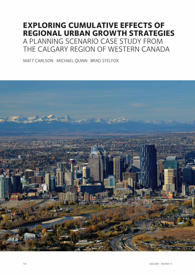
EXPLORING CUMULATIVE EFFECTS OF REGIONAL URBAN GROWTH STRATEGIES A PLANNING SCENARIO CASE STUDY FROM THE CALGARY REGION OF WESTERN CANADAMATT CARLSON · MICHAEL QUINN · BRAD STELFOX
Downtown Calgary. Source: authors

ISOCARP · REVIEW 11 15
EXPLORING CUMULATIVE EFFECTS OF REGIONAL URBAN GROWTH STRATEGIES
INTRODUCTION
Tyranny of Small Decisions and Cumulative EffectsFifty years ago, economist Alfred Kahn (1966)
introduced a concept that he called the ‘tyranny
of small decisions’. Kahn noted that significant
changes in the economy were the result of small
decisions - “small in their individual size, time
perspective, and in relation to their total, com-
bined, ultimate effect.” Ecologist William Odum
(1982) noted similar effects in the environment
and concluded “much of the current confusion
and distress surrounding environmental issues
can be traced to decisions that were never con-
sciously made, but simply resulted from a series of
small decisions.” The result of these observations
is that the physical form and socioeconomic con-
sequences of regional landscape patterns arise
more by default than intentional design.
Today we refer to these phenomena as ‘cumula-
tive effects’ (Weber et al. 2012). The results of
individual decisions accumulate across time and
space both additively (e.g., 1 ha subdivision + 1
ha subdivision = 2 ha subdivision) and synergistic-
ally (e.g., 1 ha subdivision + 1 ha subdivision =
2 ha subdivision & an increase of CO2 emissions
that interact with other emissions to exacerbate
climate change). Adding to the complexity of mu-
nicipal development is that it rarely occurs in isola-
tion, but rather in combination with other changes
such as natural resource development and natural
disturbances. The challenge here is that decision
making often occurs in isolated jurisdictional silos
with little communication between sectors. Chan-
ges in the physical landscape have significant
ripple effects on social, ecological and economic
conditions. Cumulative effects arise through the
complexity and ‘wickedness’ of these interacting
social-ecological systems (Game et al. 2014).
The form and function of any large city or re-
gion is a concrete expression of cumulative effects.
The urban and regional planning consequences of
multiple, autonomous decisions over space and
time can (and often do) lead to a degradation of
social, economic and environmental health. Faced
with immense complexity, urban and regional
planners require new approaches and tools to
understand and better address cumulative effects
of municipal development and other land use.
New and emerging technologies have a critical
role to play in assisting this broader dialogue to-
ward holistic and integrative planning.
Modelling and Scenario AnalysesPlanning in the face of cumulative effects is made
challenging by complexity as well as uncertainty
arising from knowledge gaps and contingency
on unpredictable drivers (Peterson et al. 2003).
These challenges make accurate prediction in-
feasible and related planning frameworks, such
as optimal decision making, ill-suited to land-use
planning. Instead, planning should assess the
consequences of multiple possible futures that
incorporate plausible but contrasting assump-
16 ISOCARP · REVIEW 11
MATT CARLSON · MICHAEL QUINN · BRAD STELFOX
tions for drivers such as land use. A promising
approach to address cumulative effects is the use
of robust spatial scenario analysis to explore the
potential interaction of decisions over time and
space (Mahmoud et al. 2009, Weber et al., 2012).
Benefits of scenario analysis include revealing im-
plications of existing policies, identifying drivers
that require attention, and illustrating the likely
consequences of alternative land-use strategies
(Shahumyan et al. 2014). Scenario approaches
also allow planners to test the assumptions made
in making development decisions through retro-
spective analysis.
By embracing the complexity of cumulative
effects, scenario analysis can inform land-use
decisions through understanding the trade-offs
among environmental and socioeconomic ob-
jectives. However, assessing the consequences of
overlapping human activities on diverse indicators
is itself a complicated undertaking. Doing so is fa-
cilitated by the use of computer simulation models
that apply mathematical relationships to dynam-
ically articulate the implications of multiple over-
lapping drivers on future conditions. Modelling
and scenario approaches can provide compelling
evidence to support policy, planning and manage-
ment decision making (Shahumyan et al. 2014).
In this paper we report on the results of a simu-
lation modeling exercise using ALCES (A Land-
scape Cumulative Effects Simulator; www.alces.
ca) to explore the cumulative effects of alternative
growth strategies in the Calgary region of western
Canada.
The Calgary RegionThe City of Calgary lies east of the Rocky Moun-
tains in western Canada. It is a relatively young
and rapidly growing city. The greater region is
currently home to approximately 1.2 million
people and it is projected that the population will
more than double in the next 60 years (Calgary
Regional Partnership 2015). Economically, the
region is a major driver of the national economy
and is the corporate headquarters to Canada’s
oil and gas sector. Ecologically, the area is char-
acterized by high amenity value in a semi-arid
transition zone between the Rocky Mountains
and the prairies. From the perspective of num-
erous societal indicators, the Calgary region is a
diverse, vibrant, and rapidly evolving matrix of
metropolitan centre (Calgary) and surrounding
communities.
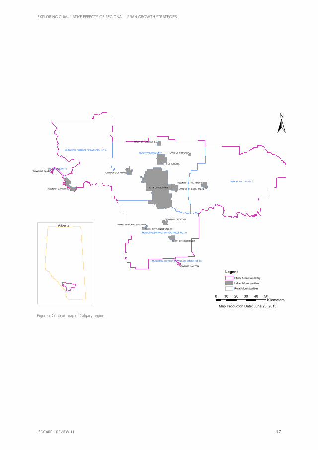
The Calgary Regional Partnership (CRP) is a
voluntary collaborative regional network (the only
one of its kind in Canada) of 13 municipalities
working together to ensure growth occurs in a sus-
tainable manner (Calgary Regional Partnership
2014a). The CRP takes a proactive approach to
planning and is committed to employing innova-
tive tools to assist in decision-making. The CRP
developed the Calgary Metropolitan Plan in 2009
(updated in 2012 & 2014) to serve as a roadmap
to determine how and where growth will occur in a
manner that protects the diverse values of the re-
gion (Calgary Regional Partnership 2014b). The
plan reflects the key principles of the CRP:
∙ Protecting the natural environment and
watershed;
∙ Fostering the region’s economic vitality;
∙ Accommodating growth in more compact
settlement patterns;
∙ Integrating efficient regional infrastructure
systems;
∙ Supported through a regional governance
approach.
The CRP also developed a set of indicators to
track progress on each of the key principles (Cal-
gary Regional Partnership 2015c). The scenarios
and modelling that we outline below are meant to
assist planners in assessing the implications of the
Calgary Metropolitan Plan on the distribution and
density of human activity and indicators related to
key CRP principles. The process of using the tool
and considering the outcomes also serves as way
to facilitate greater discussion between municipal
planning and other land users (e.g., agriculture, oil
& gas, energy transmission and forestry).
ISOCARP · REVIEW 11 17
EXPLORING CUMULATIVE EFFECTS OF REGIONAL URBAN GROWTH STRATEGIES
WHEATLAND COUNTY
ROCKY VIEW COUNTY
MUNICIPAL DISTRICT OF FOOTHILLS NO. 31
MUNICIPAL DISTRICT OF BIGHORN NO. 8
I.D. NO. 9 (BANFF)
MUNICIPAL DISTRICT OF WILLOW CREEK NO. 26
CITY OF CALGARY
CITY OF AIRDRIE
TOWN OF CANMORE TOWN OF CHESTERMERE
TOWN OF COCHRANE
TOWN OF STRATHMORE
TOWN OF HIGH RIVER
TOWN OF OKOTOKS
TOWN OF CROSSFIELD
TOWN OF NANTON
TOWN OF BANFF
TOWN OF TURNER VALLEY
TOWN OF IRRICANA
TOWN OF BLACK DIAMOND
±
0 10 20 30 40 50Kilometers
LegendStudy Area Boundary
Urban Municipalities
Rural Municipalities
Alberta
Map Production Date: June 23, 2015
Figure 1: Context map of Calgary region
18 ISOCARP · REVIEW 11
MATT CARLSON · MICHAEL QUINN · BRAD STELFOX
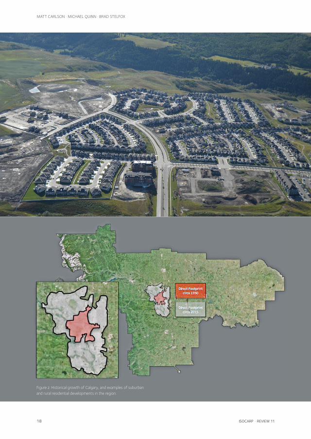
Figure 2: Historical growth of Calgary, and examples of suburban and rural residential developments in the region.

ISOCARP · REVIEW 11 19
EXPLORING CUMULATIVE EFFECTS OF REGIONAL URBAN GROWTH STRATEGIES
20 ISOCARP · REVIEW 11
MATT CARLSON · MICHAEL QUINN · BRAD STELFOX
APPROACH
ALCES Land-use Simulation ToolkitThe long-term (50 year) consequences of de-velopment in the Calgary region were simulat-ed using the ALCES land-use simulation toolkit. The toolkit has been used extensively to inform planning in Alberta (e.g., Carlson et al. 2010), as well as elsewhere in Canada, Australia, South America, and India. To achieve a holistic per-spective, ALCES incorporates a wide-range of land uses and ecological processes as drivers. Each driver is parameterized in the model by de-fining its growth rate and spatial distribution and the intensity of associated footprints (urban areas, rural residential, roads, industrial features, farmland, cutblocks, burns). Defining these as-sumptions requires integration of information from disparate sources including management plans, historical data, projections, current land-scape patterns, and resource inventories.
ALCES adopts a spatially explicit, cell-based simulation framework that allows individual cells to contain multiple natural and anthropo-genic cover types. ALCES is not a predictive model, but instead projects the future out-comes of user-defined scenarios. Although the precise future is unknowable and can not be computed by any modeling approach, ex-ploration of the logical consequences of plaus-ible but contrasting land-use scenarios allows for better identification of management strat-egies that are consistent with objectives.
Modelling Scenarios for the Calgary RegionComprehensive assessment of the Calgary region required simulation of rural and muni-cipal residential development as well as other influential land uses (agriculture, energy, for-estry, transportation) and natural disturb-ances such as wildfire. The current compos-ition of each cell was calculated from spatial land cover and development ‘footprint’ in-
ventories. Cell size was set at 0.25 km2 to balance spatial detail with strategic regional perspective. To simulate change in the com-position of cells through time, regional land-use and reclamation trajectories were spatial-ly allocated at an annual time step according to the expected spatial distribution of each activity. Although the scenario outcomes are calculated annually, due to space limitations, we only report the 50 year trajectory in the current paper.
Outcomes for two municipal development scenarios are presented in this report: busi-ness as usual (BAU) and Calgary Metropol-itan Plan (CMP). Both scenarios incorporate the same CRP-endorsed population trajec-tory, increasing from 1.5 million to 2.8 million over 50 years with most (93%) growth oc-curring in urban municipalities. The scenarios differed, however, with respect to how popu-lation growth was spatially accommodated.
The BAU scenario applied a municipal de-velopment model consistent with the spatial distribution of population growth that has oc-curred in recent decades. Population expan-sion in urban municipalities occurred in new suburbs that supported the current regional average urban population density (27 people/km2) and were located at the periphery of towns. Rural population growth occurred in new acreages whose location was based on key determinants of acreage development to date, including driving distance to Calgary and the accessibility of mountain views and rec-reational activities.
In the CMP scenario we implemented strat-egies set forth in the Calgary Metropolitan Plan and other municipal planning documents to shift to a more compact development form. Densification of existing residen-tial footprint accommodated 25% of popula-tion growth, except in Calgary where densifi-cation gradually increased to 50% as per the Calgary Municipal Development Plan. The

ISOCARP · REVIEW 11 21
EXPLORING CUMULATIVE EFFECTS OF REGIONAL URBAN GROWTH STRATEGIES
location of densification followed municipal plans and was also influenced by the availabil-ity of redevelopment opportunities. Popula-tion growth not accommodated through den-sification occurred in new developments that adopted proposed minimum density stan-dards (60 and 30 people/km2 in urban and rural areas, respectively) and were located in priority urban development areas and rural development nodes.
Reporting on IndicatorsIn consultation with the CRP, a variety of so-cial, environmental, and economic indicators were selected for the analysis to link with CMP principles. The full list of indicators includ-ed in the scenario analysis is provided in Table 1. In this paper we report on a subset of indi-cators to illustrate the utility of the approach: anthropogenic footprint, ecological connectiv-ity, nutrient runoff, infrastructure construction cost, and human health.
Ecological connectivity (Quinn et al. 2014) was derived from percolation theory and least-cost distance methods to assess how expand-ing anthropogenic footprint affected perme-ability among remnant natural areas. The ef-fect of land use to water quality was assessed
by calculating nutrient (phosphorous) runoff, using coefficients (kg/km2/year) derived for the region’s natural and anthropogenic cov-er types (Donahue 2013). Anthropogenic fea-tures such as municipal footprint tend to have higher rates of runoff, and elevated nutrient runoff can contribute to eutrophication, as well as water treatment cost (ALCES Group, 2014). The cost of elevated nutrient runoff was es-timated by applying cost coefficients for their removal at a water treatment facility ($25.45/kg phosphorous; ALCES Group 2014). To con-sider economic consequences of municipal development pattern, construction costs for road, water, and sewer were calculated using cost coefficients ($/km2/year) derived previ-ously for the region (IBI Group 2009). Reduced risk to individuals of being overweight or obese in response of densification was calculated using a relationship derived from health and population data from 33 cities across Canada. While approximate, the relationship is con-sistent with numerous studies (e.g., Booth et al. 2005) that have found a positive associa-tion between population density and human health due to elevated physical activity and walkability.
Simulation outcomes were disseminated to
Calgary Metropolitan Plan Principle Indicator
Phosphorous, nitrogen, and sediment runoff
Phosphorous, nitrogen, and sediment runoff
Water use relative to licensed diversions
Anthropogenic footprint area and edge
Ecological connectivity index
Biotic carbon storage
Wetland area
Population density
Population density
Settlement footprint
Human health
Farmland area
Infrastructure construction cost Infrastructure construction cost
Table 1: Indicators and Corresponding Calgary Metropolitan Plan Principles Selected for Scenario Modeling (Note – the current paper reports on a representative subset of this list)
22 ISOCARP · REVIEW 11
MATT CARLSON · MICHAEL QUINN · BRAD STELFOX
Basecase - 2014
Business-as-Usual - 2064
Calgary Metropolitan Plan - 2064
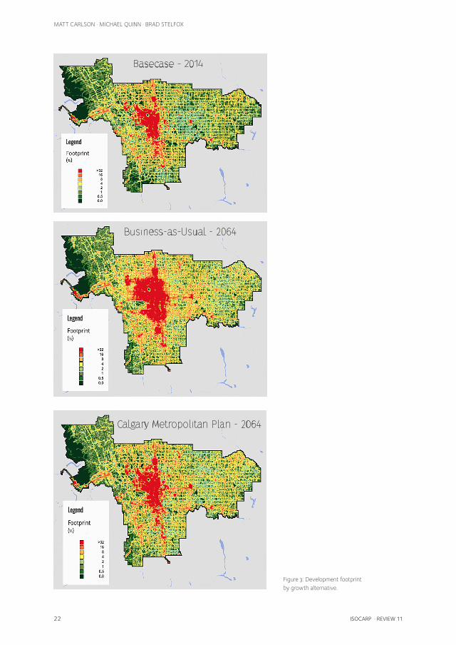
Figure 3: Development footprint by growth alternative.
ISOCARP · REVIEW 11 23
EXPLORING CUMULATIVE EFFECTS OF REGIONAL URBAN GROWTH STRATEGIES
the Calgary Regional Partnership using AL-CES Online, a user-friendly web application for visualization, customization, and comparison of land-use simulations. A common deficien-cy of previous land-use simulation models is that their complexity limits their use to a small group of experts. As a result, the full poten-tial of simulation modeling is often constrained where it matters the most: informing those re-sponsible for making land-use decisions. AL-CES Online addresses this limitation by enhan-cing the accessibility of scenario analysis to planners (Carlson et al. 2014). Maps of indi-cator outcomes that are included in this article were copied from the ALCES Online interface.
RESULTS
The Development FootprintTown and rural residential footprint currently cover 3.1% and 2.4% of the region, respectively, and town industrial areas account for another 0.3%. The combined 1,015 km2 covered by these features makes settlement footprint the second most abundant anthropogenic feature in the region behind farmland. Land currently occupied by urban and rural footprint reflects a historical landscape transformation from na-tive grasslands, forests and wetland commun-ities. In the BAU scenario, settlement footprint increased by 670 km2 to accommodate popu-lation growth (Figure 3). Settlement expan-sion was greatest at the periphery of Calgary and the surrounding rural area, and exceeded the more dispersed growth of footprints as-sociated with forestry and energy develop-ment. As a result, loss of farmland (527 km2), grassland (179 km2), and wetland (15 km2) was greatest in the central portion of the region. The CMP scenario required 53% less develop-ment of new town and rural residential foot-print, such that 298 km2 of farmland, 110 km2 of grassland, and 8 km2 of wetland were con-served relative to the BAU scenario.
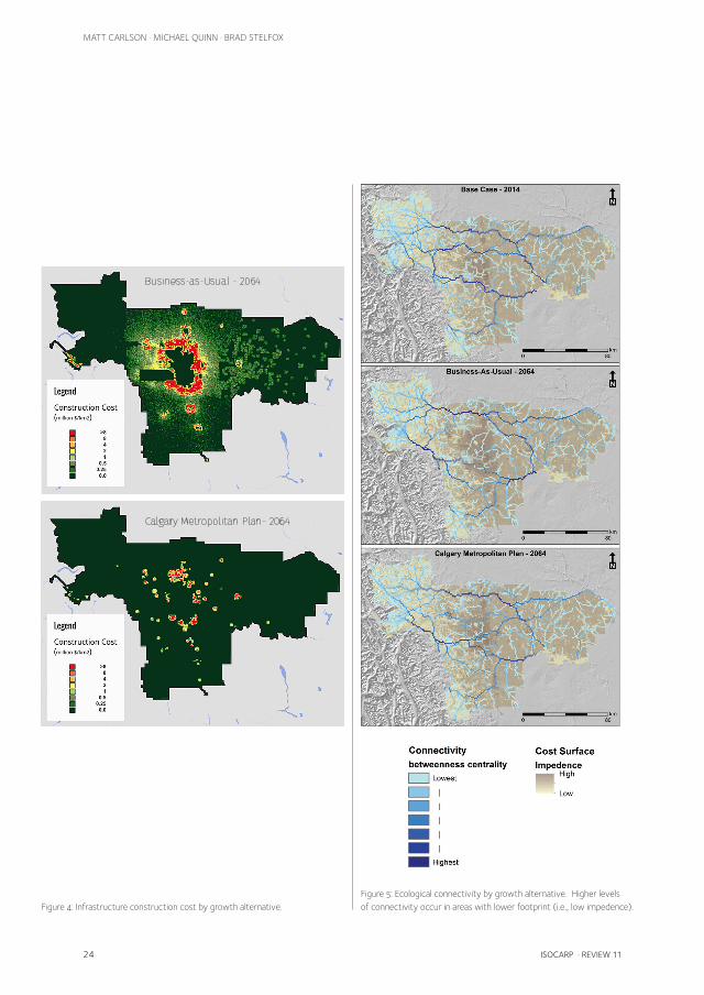
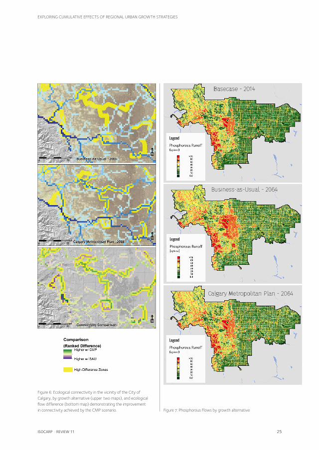
Economic, Social and Ecological ImplicationsTown and rural residential growth in the BAU scenario had negative long-term economic and environmental consequences. Construc-tion of new road, water, and sewer infrastruc-ture to service the new developments was estimated to cost $26.3 billion over 50 years (Figure 4). As well, connectivity between patches of relatively intact natural cover was reduced, indicating that ecological flows are likely to become increasingly inhibited, espe-cially in the central portion of the study area around Calgary (Figures 5 & 6). Although fur-ther research is required to determine specific impacts, implications of diminished ecologic-al connectivity could include reduced linkage of wildlife meta-populations and interrup-tion of ecological processes such as hydro-logical flow. Another environmental impact of the BAU scenario was degraded water quality due to elevated nutrient runoff. By the end of the simulation, annual phosphorous runoff increased by 87.7 tonnes compared to today with much of the elevated runoff occurring around Calgary (Figure 7).
By constraining new settlement footprint to priority growth areas and rural development nodes, the CRP scenario avoided much of the environmental and economic cost associated with the BAU scenario. Over the course of the simulation, the CMP scenario avoided 2,266 tonnes of phosphorous runoff relative to BAU (Figure 7), achieving an estimated $58 mil-lion in water treatment cost savings over 50 years. More impressive is the estimated $18.4 billion saved over the 50 year simulation due to reduced road, water, and sewer construc-tion needs (Figure 4). Another benefit of the CMP scenario is that ecological connectivity was better maintained in the central portion of the study area around Calgary (Figure 6). Connectivity cannot be expressed as a single metric, but the maps illustrate a critical loss
24 ISOCARP · REVIEW 11
MATT CARLSON · MICHAEL QUINN · BRAD STELFOX
Business-as-Usual - 2064
Calgary Metropolitan Plan- 2064
Business-as-Usual - 2064
Calgary Metropolitan Plan- 2064
Figure 4: Infrastructure construction cost by growth alternative.Figure 5: Ecological connectivity by growth alternative. Higher levels of connectivity occur in areas with lower footprint (i.e., low impedence).
ISOCARP · REVIEW 11 25
EXPLORING CUMULATIVE EFFECTS OF REGIONAL URBAN GROWTH STRATEGIES
Basecase - 2014
Business-as-Usual - 2064
Calgary Metropolitan Plan - 2064
Basecase - 2014
Business-as-Usual - 2064
Calgary Metropolitan Plan - 2064
Basecase - 2014
Business-as-Usual - 2064
Calgary Metropolitan Plan - 2064
Figure 6: Ecological connectivity in the vicinity of the City of Calgary, by growth alternative (upper two maps), and ecological flow difference (bottom map) demonstrating the improvement in connectivity achieved by the CMP scenario. Figure 7: Phosphorous Flows by growth alternative
26 ISOCARP · REVIEW 11
MATT CARLSON · MICHAEL QUINN · BRAD STELFOX
of potential ecological flows around the city. The effect is a long-term ecological isolation of the central urban area from the surrounding region. In effect, the BAU scenario shows that the city becomes a ‘plug’ in the regional flow of ecological goods and services.
It is important to note, however, that eco-logical connectivity still declined and nutrient runoff still increased in the CMP scenario rela-tive to today, in part due to the impacts of for-estry and energy development. The cumula-tive effects of multiple land uses underscores the importance of minimizing each sector’s im-pact (e.g., by constraining settlement expan-sion), by adopting best management practices, and coordinating planning across sectors to en-sure that conservation efforts from one sector are not negated by the impacts of others.
Hand in hand with the contrasting settle-ment expansion patterns are differences in
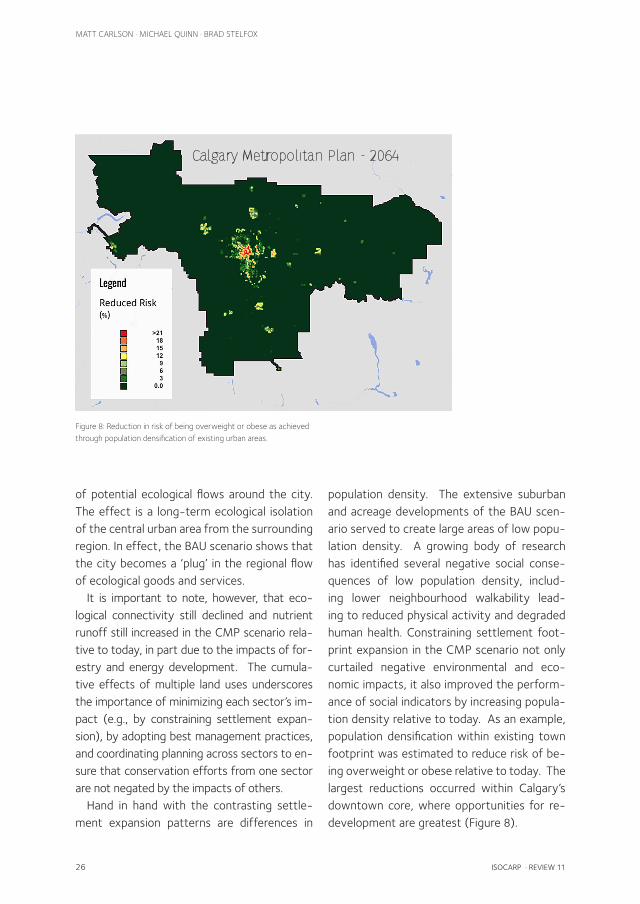
Figure 8: Reduction in risk of being overweight or obese as achieved through population densification of existing urban areas.
Calgary Metropolitan Plan - 2064
population density. The extensive suburban and acreage developments of the BAU scen-ario served to create large areas of low popu-lation density. A growing body of research has identified several negative social conse-quences of low population density, includ-ing lower neighbourhood walkability lead-ing to reduced physical activity and degraded human health. Constraining settlement foot-print expansion in the CMP scenario not only curtailed negative environmental and eco-nomic impacts, it also improved the perform-ance of social indicators by increasing popula-tion density relative to today. As an example, population densification within existing town footprint was estimated to reduce risk of be-ing overweight or obese relative to today. The largest reductions occurred within Calgary’s downtown core, where opportunities for re-development are greatest (Figure 8).

ISOCARP · REVIEW 11 27
EXPLORING CUMULATIVE EFFECTS OF REGIONAL URBAN GROWTH STRATEGIES
Figure 9: Calgary – city view.

28 ISOCARP · REVIEW 11
MATT CARLSON · MICHAEL QUINN · BRAD STELFOX
CONCLUSIONS
A key challenge facing planners in rapid-ly changing cities and regions is selection of development patterns that promote collect-ive benefits and reduce risks to a broad suite of social, economic, and environmental val-ues. The challenge is complex, but the imple-mentation of new and emerging information technology can help to reduce the complexity. Simulation tools, such as ALCES demonstrated here, provide planners with robust methods to test policy alternatives and communicate re-sults with stakeholders. ALCES also provides an opportunity for planners to work direct-ly with all regional interests in a participatory approach to scenario development. Engage-ment across all sectors of land use is essential in addressing cumulative effects.
Similar to many other areas, historical poli-cies in the Calgary region have largely promot-ed low-density expansive residential patterns (i.e., suburbia and low-density acreages). These historical decisions have engendered many undesirable consequences, including loss of wetlands and productive farmland, in-creased commute times, unaffordable costs of infrastructure maintenance, reduced walk-ability, increased water pollution, and elevat-ed landscape fragmentation causing reduced performance of social, economic and eco-logical processes. The BAU scenario developed for this paper clearly demonstrates the cumu-lative effects and economic costs associated with such growth.
There is, however, great opportunity for plan-ners to embrace new residential strategies that help mitigate historical issues, and showcase an urban and peri-urban template better suited for the needs of CRP residents during the next cen-tury. We demonstrate that the plans for more concentrated growth proffered in the Calgary Metropolitan Plan are a significant improvement over business as usual. Ultimately, the future
structure and function of CRP will be deter-mined by the combination of growth manage-ment policies and how the residential market-place responds to the different options made available by developers.
There is increasing evidence that society is changing in terms of its values related to resi-dential form (Tian et al. 2015). Home buyers are seeking communities that deliver higher levels of societal interaction, reduced dependency on cars, increased opportunity for walkability, re-duced carbon footprint, expanded opportun-ities for green space recreation within urban boundaries, and opportunities to secure local food that meets increasing standards of en-vironmental sustainability. Calgarians, and those who reside in surrounding communities, are be-coming increasingly aware of the importance of water (both quantity and quality) and are im-ploring politicians and planners to design urban strategies and residential policies that recog-nize the role and function of watersheds in de-fining the overall “livability” of cities that receive their water quality and quantity from the com-bined activities of all land uses that occur with-in their watersheds. Furthermore, as tax payers become more informed about the true costs of construction and maintenance of infrastructure, they are increasingly promoting urban growth strategies that can be sustained against current and future budgetary constraints. These val-ues are clearly entrenched in the planning docu-ments of the CRP.
This study illustrates that the CRP is at a cross-road, and is faced with important macro-architectural decisions that will define the ul-timate form and function (“where and how”) that guides how citizens will reside, move, and live in this region in the decades to come. The precise demands that future citizens place on the shoulders of planners and policy makers are both unknowable and evolving, and as such greater metropolitan planning has an inherent element of uncertainty. That said, it is clear that
ISOCARP · REVIEW 11 29
EXPLORING CUMULATIVE EFFECTS OF REGIONAL URBAN GROWTH STRATEGIES
Acknowledgements: The Calgary Regional
Partnership is thanked for its financial support
and for contributing data required for the
analysis. Land cover and footprint data were
provided by ABMI and Ducks Unlimited Canada.
The authors also thank the following members of
the ALCES Group for contributing to the analysis:
Tim Barker, Teresa Raabis, Nathan Stelfox, Inayat
Dhaliwal, Reg Prahalad, Noah Purves-Smith,
and Ben DeLong. Greg Chernoff of the Miistakis
Institute is thanked for calculating the ecological
connectivity index.
the historical urban and rural design strategies in cities and regions such as Calgary are unlikely to serve the future requirements of citizens whose knowledge of social and environmental sus-tainability is increasing, and who wish for these learnings to be embedded in sustainable urban and regional design. To this end, the results of this study provide empirical evidence of the social, economic, and environmental benefits of design strategies that reduce urban sprawl, promote walkability, and explicitly recognize the natural capital values of the CRP.
As with all modeling, the results of the scen-arios reported here are only as good as the input data. We searched a wide array of literature to develop metrics linking environmental to social and economic factors. There is clearly a need for further research to refine our understand-ing of these linkages. In particular, although it is generally accepted that relationships exist be-tween attributes of urban form (e.g., popula-tion density) and indicators related to quality of life (e.g., human health) and human behav-iour (e.g., energy use), these relationships need to be better quantified. The strength of AL-CES is that it is relatively simple to update the metrics as new and better information becomes available. Likewise, if a stakeholder objects to a certain assumption or value used in the mod-el it can be quickly changed to conduct a sensi-tivity analysis.
The scenario approach and results illustrated herein help to reduce the complexity of under-standing cumulative effects. The ALCES ap-proach is highly effective in explicit identifica-tion of the trade-offs associated with different policy and planning initiatives. Moreover, the approach provides an effective alternative to the incremental and siloed methods of planning that exacerbate negative cumulative effects. The next challenge is to use this information to facilitate the ongoing discussion of desired fu-ture conditions for the region. The CRP will con-tinue to explore the use of ALCES in the deliv-
ery of the CRP strategic plan and development of the next iteration of the Calgary Metropol-itan Plan. The scenarios that we outline in this paper provide a foundation from which the CRP can develop and test further planning and policy initiatives to meet the needs of the region while protecting the values desired by residents.
30 ISOCARP · REVIEW 11
MATT CARLSON · MICHAEL QUINN · BRAD STELFOX
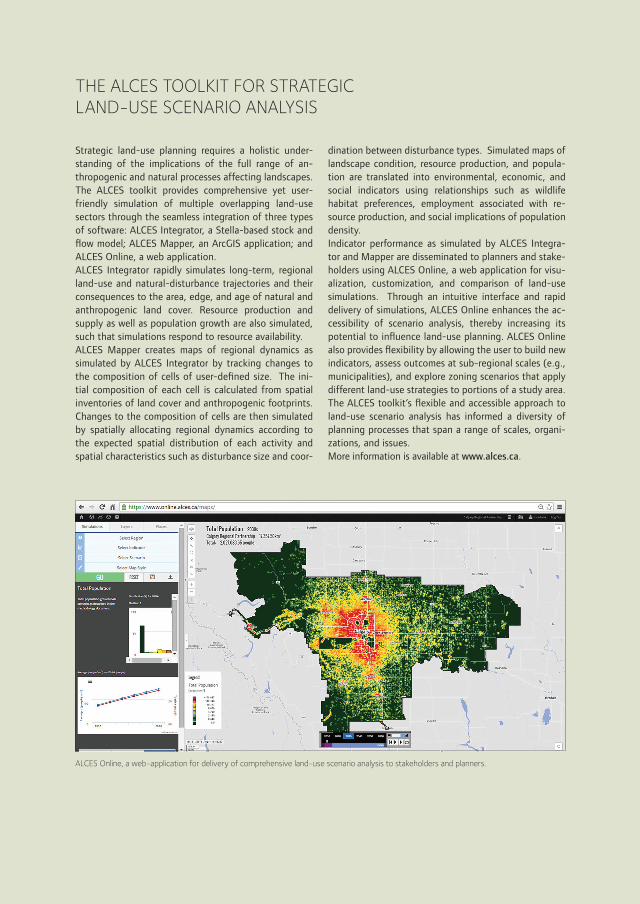
ALCES Online, a web-application for delivery of comprehensive land-use scenario analysis to stakeholders and planners.
Strategic land-use planning requires a holistic under-standing of the implications of the full range of an-thropogenic and natural processes affecting landscapes. The ALCES toolkit provides comprehensive yet user-friendly simulation of multiple overlapping land-use sectors through the seamless integration of three types of software: ALCES Integrator, a Stella-based stock and flow model; ALCES Mapper, an ArcGIS application; and ALCES Online, a web application. ALCES Integrator rapidly simulates long-term, regional land-use and natural-disturbance trajectories and their consequences to the area, edge, and age of natural and anthropogenic land cover. Resource production and supply as well as population growth are also simulated, such that simulations respond to resource availability. ALCES Mapper creates maps of regional dynamics as simulated by ALCES Integrator by tracking changes to the composition of cells of user-defined size. The ini-tial composition of each cell is calculated from spatial inventories of land cover and anthropogenic footprints. Changes to the composition of cells are then simulated by spatially allocating regional dynamics according to the expected spatial distribution of each activity and spatial characteristics such as disturbance size and coor-
dination between disturbance types. Simulated maps of landscape condition, resource production, and popula-tion are translated into environmental, economic, and social indicators using relationships such as wildlife habitat preferences, employment associated with re-source production, and social implications of population density. Indicator performance as simulated by ALCES Integra-tor and Mapper are disseminated to planners and stake-holders using ALCES Online, a web application for visu-alization, customization, and comparison of land-use simulations. Through an intuitive interface and rapid delivery of simulations, ALCES Online enhances the ac-cessibility of scenario analysis, thereby increasing its potential to influence land-use planning. ALCES Online also provides flexibility by allowing the user to build new indicators, assess outcomes at sub-regional scales (e.g., municipalities), and explore zoning scenarios that apply different land-use strategies to portions of a study area. The ALCES toolkit’s flexible and accessible approach to land-use scenario analysis has informed a diversity of planning processes that span a range of scales, organi-zations, and issues. More information is available at www.alces.ca.
THE ALCES TOOLKIT FOR STRATEGIC LAND-USE SCENARIO ANALYSIS

ISOCARP · REVIEW 11 31
EXPLORING CUMULATIVE EFFECTS OF REGIONAL URBAN GROWTH STRATEGIES
REFERENCES
ALCES Group. 2014. Temporal and Spatial Changes in the Natural Capital of the Upper Bow River Basin, Alberta, Canada. Bragg Creek: Action for Agriculture.
Booth, K.M., M.M. Pinkston, and W.S. Poston. 2005. Obesity and the built environment. Journal of American Dietetic Association 105(5s): 110-117.
Calgary Regional Partnership. 2015a. About the Calgary Regional Partnership. [Online] Available from: http://calgaryregion.ca/crp/calgary-regional-partnership/about/overview.html [Accessed: 29th June 2015]
Calgary Regional Partnership. Calgary Metropolitan Plan. 2014a. Cochrane: Calgary Regional Partnership.
Calgary Regional Partnership 2014b. Indicators for Measuring Progress. Cochrane: Calgary Regional Partnership.
Carlson, M., T. Antoniuk, D. Farr, S. Francis, K. Manuel, J. Nishi, B. Stelfox, M. Sutherland, C. Yarmoloy, C. Aumann, and D. Pan. 2010. Informing regional planning in Alberta’s Oilsands Region with a land-use simulation model. In: D.A. Swayne, W. Yang, A.A. Voinov, A. Rizzoli, and T. Filatova (Eds.). Proceedings of the 2010 International Congress on Environmental Modeling and Software, July 2010, Ottawa, Ontario.
Carlson, M., B. Stelfox, N. Purves-Smith, J. Straker, S. Berryman, T. Barker and B. Wilson. 2014. ALCES Online: Web-delivered scenario analysis to inform sustainable land-use decisions. In: D.P. Ames, N.W.T. Quinn, and A.E. Rizzoli (Eds.). Proceedings of the 2014 International Congress on Environmental Modeling and Software, June 2014, San Diego, California.
Donahue, W.F. 2013. Determining Appropriate Nutrient and Sediment Loading Coefficients for Modeling Effects of Changes in Landuse and Landcover in Alberta Watersheds. Canmore: Water Matters Society of Alberta.
Game, E.T. et al., 2014. Conservation in a wicked complex world; challenges and solutions. Conservation Letters, 7(3), pp.271–277. Available at: http://dx.doi.org/10.1111/conl.12050.
IBI Group. 2009. The Implications of Alternative Growth Patterns on Infrastructure Costs. Calgary: City of Calgary.
Kahn, A.E., 1966. The tyranny of small decisions: market failures, imperfections, and the limits of economics. Kyklos, 19(1), pp.23–47.
Mahmoud, M. et al., 2009. A formal framework for scenario development in support of environmental decision-making. Environmental Modelling & Software, 24(7), pp.798–808.
Odum, W.E., 1982. Environmental Degradation and the Tyranny of Small Decisions. BioScience, 32(9), pp.728–729.
Quinn, M.S. et al., 2014. Modeling a rapidly urbanizing regional landscape to assess connectivity of natural integrity for ecological flows. Spaces and Flows, 4(2), pp.71–83.
Peterson, G.D., G.S. Cumming, and S.R. Carpenter. 2003. Scenario planning: a tool for conservation in an uncertain world. Conservation Biology 17(2): 358-366.
Shahumyan, H. et al., 2014. Regional Development Scenario Evaluation through Land Use Modelling and Opportunity Mapping. Land, 3(3), pp.1180–1213.
Tian, G., Ewing, R. & Greene, W., 2014. Desire for Smart Growth: A Survey of Residential Preferences in the Salt Lake Region of Utah. Housing Policy Debate, 25(3), pp.446–462.
Weber, M., Krogman, N. & Antoniuk, T., 2012. Cumulative Effects Assessment: Linking Social, Ecological, and Governance Dimensions. Ecology and Society, 17(2). Available at: http://www.ecologyandsociety.org/vol17/iss2/art22/.