exploitation of radarsat-2 dual and quad- pol images and
TRANSCRIPT

Exploitation of Radarsat-2 dual and quad-pol images and modelled compact
polarimetry parameters for surface soil moisture estimation in mountainous areas.
F. Greifeneder1, C. Notarnicola1, J. Stamenkovic2, S. Paloscia3, M. Dabboor4, F. Charbonneau5
1Institute for Applied Remote Sensing, EURAC Research, Bolzano, Italy.2Signal Processing Laboratory, EPFL, Lausanne, Switzerland.
3Institute for Applied Physics, CNR, Florence, Italy.4Science and Technology Branch, Environment Canada, Torronto, Canada.
5Canadian Centre for Mapping and Earth Observation, Ottawa, Canada.

Institute for Applied Remote Sensing
Felix Greifeneder - [email protected]
Motivation
• 2018 the Radarsat-2 follow up mission will be launched
• Radarsat Constellation Mission (RCM)• 3 satellites• New mode: Compact Polarimetry (CP)• Main advantage: increased swath width –
shorter revisit times
• What are the capabilities for soil moisture estimation?
• Based on a support vector regression approach (Pasolli et al., 2010)
2

Institute for Applied Remote Sensing
Felix Greifeneder - [email protected]
Study Area
Mazia Valley, South Tyrol, Italy
Total area: ~100km²Altitude: 920 – 3738m a.s.l.Main land-cover types:
- Meadows- Pastures
Mean annual precipitation: 550mm
Area is constantly monitored by 16 fixed hydrological stations.
Further in-situ measurements are acquired during field campaigns
3


Institute for Applied Remote Sensing
Felix Greifeneder - [email protected]
Radarsat-2 FP
RADARSAT-2 Fine Quad-Pol mode
Polarization: HH, VV, VH, HV
Spatial Resolution: 11m x 9m
Acquisition Date: 15th of July, 2014
46 polarimetric decomposition parameters:
- Sinclair decomposition
- Pauli decomposition
- Freeman decomposition
- Yamaguchi decomposition
- H-Alpha decomposition
- Touzi decomposition
- Van Zyl decomposition
RADARSAT-2 Data and Products © MacDonald, Dettwiler and Associates Ltd. (2014) – All Rights Reserved. RADARSAT is an official trademark of the Canadian Space Agency.
6

Institute for Applied Remote Sensing
Felix Greifeneder - [email protected]
RCM CP Simulations
Simulated Radarsat Constellation Mission Acquisition in Strip-Map mode (Charbonneau et al., 2010)
Polarization: RR, RL, RV, RH
Spatial Resolution: 16m x 16m
Acquisition: Simulations, based on Radarsat-2 acquisition from 15th of July 2014
18 simulated polarimetric decomposition parameters:
- Circular cross polarization1
- Degree of polarization2
- Conformity coefficient3
- correlation coefficient RV – RH
- circular polarization ratio1
- m-chi decomposition4
- m-delta decomposition1
- Alpha-s parameteter5
- Shanon entropy
- Stokes vectos1
7
Institute for Applied Remote Sensing
Felix Greifeneder - [email protected]
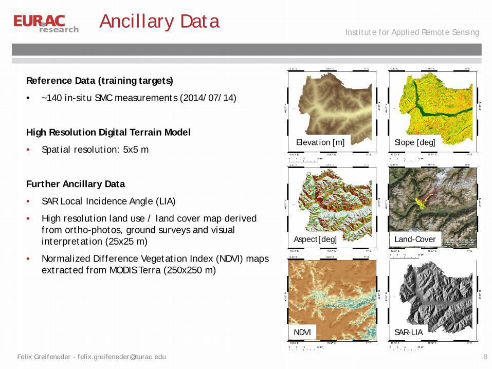
Reference Data (training targets)
• ~140 in-situ SMC measurements (2014/07/14)
High Resolution Digital Terrain Model
• Spatial resolution: 5x5 m
Further Ancillary Data
• SAR Local Incidence Angle (LIA)
• High resolution land use / land cover map derived from ortho-photos, ground surveys and visual interpretation (25x25 m)
• Normalized Difference Vegetation Index (NDVI) maps extracted from MODIS Terra (250x250 m)
Ancillary Data
Aspect[deg]
Elevation [m] Slope [deg]
Land-Cover
NDVI SAR-LIA
8

Institute for Applied Remote Sensing
Felix Greifeneder - [email protected]
• Model relationship between measures SMC and input features
• Linear case: 𝑓𝑓 𝑥𝑥 = 𝑤𝑤1𝑥𝑥 + 𝑏𝑏
• Minimize: 12𝑤𝑤2 + 𝐶𝐶 ∑𝑖𝑖(𝜉𝜉𝑖𝑖 + 𝜉𝜉𝑖𝑖∗)
• „Kernel-trick” is used to map non-linear input to a higher dimensional feature space
Machine Learning - Support Vector Regression (SVR)
Method - SVR

Institute for Applied Remote Sensing
Felix Greifeneder - [email protected]
SMC estimation
SAR data
SAR Processing Filtering
Rad/TerCorr.
Autom. Correg.
Feature Extraction
Automatic features ranking
SVR Learning
Ancillary Data
SMC Estimation
Filtering
SVR Estimation
K-Fo
ld C
ross
Val
idat
ion SVR – Model
Parameters
𝐼𝐼 𝑅𝑅: 𝑆𝑆 = �𝑟𝑟∈𝑅𝑅
�𝑠𝑠∈𝑆𝑆
𝑝𝑝 𝑟𝑟, 𝑠𝑠 log𝑝𝑝{𝑟𝑟, 𝑠𝑠}𝑝𝑝 𝑟𝑟 𝑝𝑝{𝑠𝑠}
Mutual Information Index (Peng et al., 2005)
10

Institute for Applied Remote Sensing
Felix Greifeneder - [email protected]
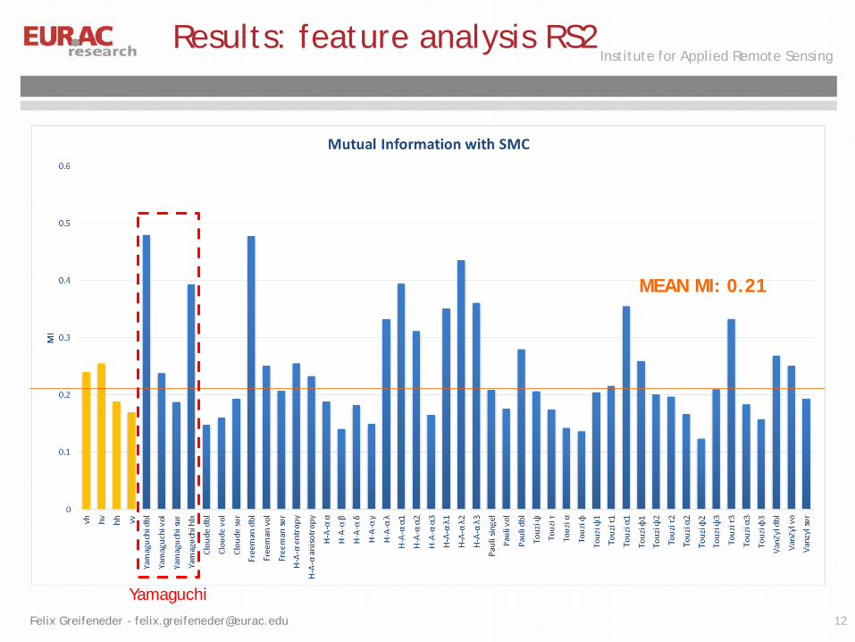
Results: feature analysis RS2
MEAN MI: 0.21
11
Institute for Applied Remote Sensing
Felix Greifeneder - [email protected]
Results: feature analysis RS2
MEAN MI: 0.21
Yamaguchi12

Institute for Applied Remote Sensing
Felix Greifeneder - [email protected]
Results: feature analysis RS2
MEAN MI: 0.21
Yamaguchi H-α13

Institute for Applied Remote Sensing
Felix Greifeneder - [email protected]
Results: feature analysis RCM CP
MEAN MI: 0.38
14

Institute for Applied Remote Sensing
Felix Greifeneder - [email protected]
Results: feature analysis RCM CP
MEAN MI: 0.38
m-X15

Institute for Applied Remote Sensing
Felix Greifeneder - [email protected]
Results
Input parameter configurations tested
Radarsat-2 Dual/Quad-Pol + ancillary data
Radarsat-2 Quad-Pol + ancillary data +
decomposition features
Radarsat-2 Quad-Pol, no ancillary data
Radarsat-2 Quad-Pol + decomposition featues, no
ancillary data
RCM CP + ancillary data
RCM CP + ancillary data + decomposition features
RCM CP, no ancillary data
RCM CP + decomposition featues, no ancillary data
16

Institute for Applied Remote Sensing
Felix Greifeneder - [email protected]
Results: SVR training
Quad-Pol
(HH, VV, VH, HV, ancillary data)
Quad-Pol + polarimetricdecomposition
(HH, VV, VH, HV,
ancillary data, 11 decomposition features)
Dual-Pol
(VV, VH, ancillary data)
17

Institute for Applied Remote Sensing
Felix Greifeneder - [email protected]
Results: SVR training
Circular-Pol
(RH, RV, RL, RR, ancillary data)
Circular-Pol + polarimetric decomposition
(RH, RV, RL, RR,
ancillary data, 3 decomposition features)
18

Institute for Applied Remote Sensing
Felix Greifeneder - [email protected]
Results: SVR training
Quad-Pol without ancillary data
(HH, VV, VH, HV)
Quad-Pol without ancillary data, polarimetric decomposition
(HH, VV, VH, HV, 11 decomposition features)
19

Institute for Applied Remote Sensing
Felix Greifeneder - [email protected]
Results: SVR training
Circular-Pol without ancillary data
(RH, RV, RR, RL)
Circular-Pol without ancillary data, polarimetric decomposition
(RH, RV, RR, RL, 3 decomposition features)
20

Institute for Applied Remote Sensing
Felix Greifeneder - [email protected]
Conclusion
• It was demonstrated that the estimation algorithm can work efficiently
• Best SMC accuracy based on Radarsat-2 quad-pol: RMSE = 0.05
• CP backscatter bands: RMSE = 0.14
• There is no improvement in case of Radarsat-2 quad-pol + decomposition parameters
• Significant improvement between simulated RCM backscatter without and with decomposition parameters: RMSE = 0.06
• Ancillary data is essential for accurate estimation of SMC
21

Institute for Applied Remote Sensing
Felix Greifeneder - [email protected]
Thank you for your attentionCorresponding author: [email protected]
This study was supported by the project “HiResAlp”, financed by Provincia Autonoma di Bolzano, Alto Adige, Ripartizione Diritto allo Studio, Università e ricerca scientifica.
The RADARSAT-2 images were acquired in the framework of the joint COSMO-SkyMed-Radarsat2 AO project ID 2880-5225 entitled “SARweCAN”.
22
Institute for Applied Remote Sensing
Felix Greifeneder - [email protected]
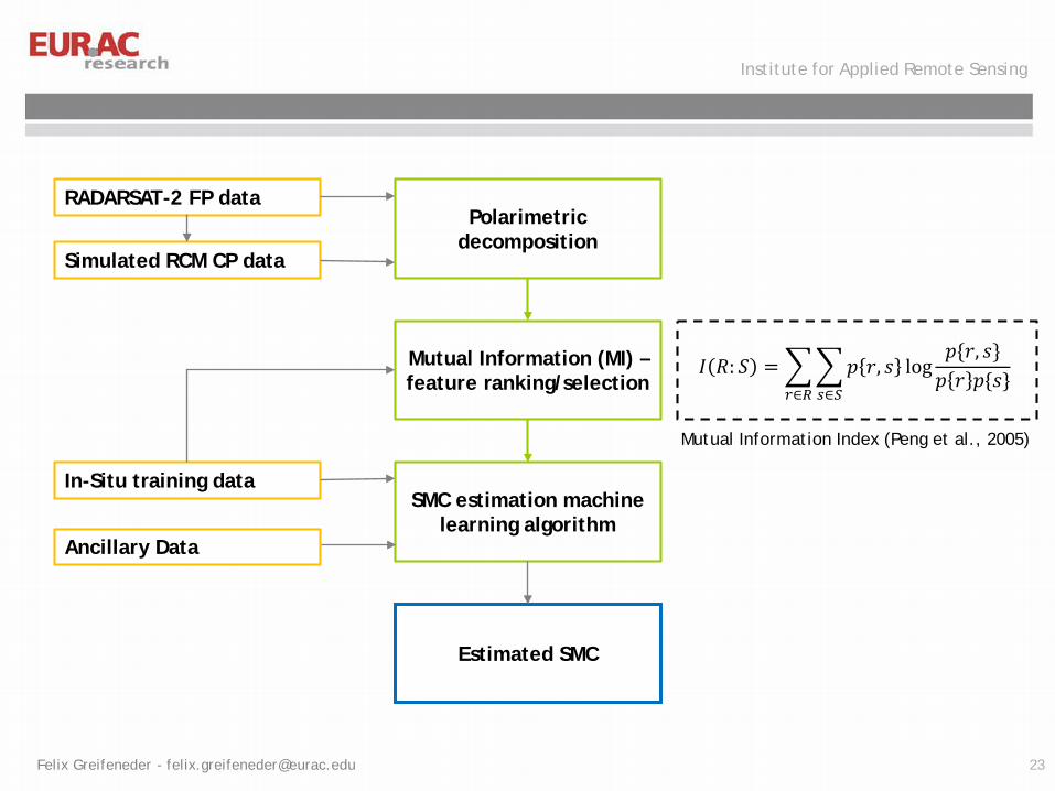
RADARSAT-2 FP data
Simulated RCM CP data
Ancillary Data
Polarimetricdecomposition
Mutual Information (MI) –feature ranking/selection
𝐼𝐼 𝑅𝑅: 𝑆𝑆 = �𝑟𝑟∈𝑅𝑅
�𝑠𝑠∈𝑆𝑆
𝑝𝑝 𝑟𝑟, 𝑠𝑠 log𝑝𝑝{𝑟𝑟, 𝑠𝑠}𝑝𝑝 𝑟𝑟 𝑝𝑝{𝑠𝑠}
SMC estimation machine learning algorithm
In-Situ training data
Estimated SMC
Mutual Information Index (Peng et al., 2005)
23