existing conditions – workbook no · dick jones citizen, ... library, oak grove ed gronke...
TRANSCRIPT
FINAL REPORT PREFACE I
Contract Information
Project Name: Clackamas County, McLoughlin Corridor Land Use and Transportation Plan
Intergovernmental Agreement No. 16023 Contract No. 16024 TGM File 1Z-97 Date: July 30, 1998 Amended May 21, 1999
This project is partially funded by a grant from the Transportation and Growth
Management (TGM) Program, a joint program of the Oregon Department of
Transportation and the Oregon Department of Land Conservation and Development.
This TGM grant is financed, in part, by federal Intermodal Surface Transportation
Efficiency Act, local government, and State of Oregon funds.
The contents of this document do not necessarily reflect views or policies of the State of
Oregon.
FINAL REPORT PREFACE II
Project Management Team Participants
ODOT
Lidwien Rahman Thomas Picco Clackamas County
Karen Buehrig Margaret Dickerson Lorraine Gonzales Cherie McGinnis Scott Pemble Dick Van Ingen, Project Manager
W & H Pacific, Inc.
Frank Angelo, Project Manager Catherine Corliss DKS Associates
Robert Schulte Hobson Johnson
Steve Ferrarini Pacific Rim Resources
Doug Zenn
FINAL REPORT PREFACE III
McLoughlin Corridor Work Group Participants
Al Sheakley Printer, Jennings Lodge Ben Baldwin Tri-Met Bob Bailey DLCD, commuter on McLoughlin Brenda Durbin Clack. Co. Social Service Agency Brian Runyan Clack. Co. Ped/Bike Committee Chuck Gode Citizen Dan Bartlet City of Milwaukie Darlene Maddux ODOT Bike/Ped Program Dave Church North Clackamas School District Dick Jones Citizen, Oak Lodge Comm. Council Doris Grolbert Clack. Co. Library, Oak Grove Ed Gronke Citizen, Jennings Lodge Edith Coulter Citizen, Oak Grove Edward Hacmac North Clack. Chamber of C. Frank Budwell Citizen, Jennings Lodge George Schneider Milwaukie Elks Lodge Jerry Foy Commercial Land Development Jim Justice Auto repair, Vinyard/McLoughlin John Heppler Citizen, Vineyard Place John Hudson Landowner, Courtney/McLoughlin John Kraxberger Real Estate Broker Leo Thornton West. Evangel. Campground Mike McManus Auto Sales Milo Haas Fire District #1 Neal Butler Clack. Co. Sheriff's Office Paul Koch Auto, Real Estate, M.H.Parks Paul Savas Auto tuning, Jennings Lodge Rob Wheeler North Clack, Chamber of Commerce Ted Leybold Metro Tom Picco ODOT Corridors Program Winston Kurth Citizen, Oak Grove
FINAL REPORT PREFACE IV
Table of Contents
A. Introduction ............................................................................................................. A-1
Organization......................................................................................................................A-1 The Planning Process to Date.......................................................................................A-2 Summary of Recommendations ...................................................................................A-4 B. Street Design Proposal and Circulation Plan......................................................... B-1
Transportation Policies ................................................................................................... B-1 Street Design ..................................................................................................................... B-2 On-Street Parking...........................................................................................................B-19 Street Lighting.................................................................................................................B-20 Access Management ......................................................................................................B-22 Pedestrian and Bicycle Facilities and Circulation.....................................................B-24 Transit Facilities and Circulation.................................................................................B-27 Street Classification........................................................................................................B-29 Transportation System Evaluation Criteria ..............................................................B-31
C. Zoning Proposal....................................................................................................... C-1 Current Land Use Policies..............................................................................................C-1 Parking Requirements .....................................................................................................C-4 Parking Lot Connectivity................................................................................................C-5 Sign Ordinance Implementation Issues ......................................................................C-6 Land Use Evaluation Criteria ........................................................................................C-8
D. Implementation Strategies ......................................................................................D-1
FINAL REPORT PREFACE V
List of Figures
Figure B-1 Recommended Cross-section Applications Figure B-2 Street Design Option - McLoughlin Blvd. at Oak Grove Blvd. Figure B-3 Street Design Option - McLoughlin Blvd. at Jennings Ave. Figure B-4 Street Design Option - McLoughlin Blvd. at Concord Rd. Figure B-5 Illustration of Redesigned Pedestrian Island Figure B-6 Recommended Pedestrian Island Design Figure D-1 Parking Bay
List of Tables
Table B-1 Recommended Clackamas County Street Functional Classification Table B-2 Transportation Design Alternatives Criteria Matrix, Year 2017 Table C-1 Land Use Criteria Matrix, Year 2017

FINAL REPORT INTRODUCTION A-1
Organization
This final report presents the Preferred Alternative as developed by the Project Management Team (PMT). The Preferred Alternative includes two main sections:
The Street Design and Circulation Plan - includes recommended cross-sections and other street design and transportation improvements to enhance all modes of travel in the McLoughlin Corridor.
The Zoning Proposal - includes the PMT’s recommendation and analysis of land use issues.
The Street Design and Circulation Plan begins with a summary of the PMT’s transportation recommendations. These recommendations are divided into seven elements: Transportation Planning Policies, Street Design, On-Street Parking, Street Lighting, Access Management, Pedestrian and Bicycle Facilities and Circulation, Transit Facilities and Circulation, and Street Classification. In the sections that follow, the specific recommendations associated with each element are then discussed and analyzed. The Street Design and Circulation Plan concludes with an assessment of the PMT’s recommendations in light of the Transportation System Evaluation Criteria, which were originally used in Workbook No. 2 to compare the alternatives. The Zoning Proposal begins with a summary of the PMT’s land use recommendations. These recommendations are divided into four elements: Land Use Policies, Parking Requirements, Parking Lot Connectivity, and Sign Ordinance Implementation Issues. In the sections that follow, the specific recommendations associated with each element are then discussed and analyzed. The Zoning Proposal concludes with an assessment of the PMT’s recommendations in light of the Land Use Evaluation Criteria, which were originally used in Workbook No. 2 to comparatively evaluate the alternatives.
FINAL REPORT INTRODUCTION A-2
The Planning Process to Date
Phase I – Existing Conditions
Phase I of the project evaluated the existing land use and transportation conditions and focused on identifying key issues and priorities. This was addressed in the first Workbook, Work Group meeting and Open House. Phase II – Alternatives Analysis
The next step (Phase II) was to develop and evaluate alternative solutions to the issues and problems identified in the first phase. The Alternatives Analysis (Workbook No. 2) included two general categories to be considered (land use and transportation) with choices to be made in each category. Instead of grouping the different land use and transportation approaches into stand-alone alternatives, they were presented as a menu from which discrete components could be evaluated and combined to form a recommendation for the preferred alternative. In the case of land use, the alternatives focused on meeting the requirements of Metro’s Title 1 and on improving the appearance and livability of the McLoughlin Corridor. The land use alternatives considered in the Alternatives Analysis included:
Land Use Alternative 1: Existing Land Use Regulations Land Use Alternative 2: Promote More Employment Intensive Uses Land Use Alternative 3: Create a More Pedestrian-Oriented Environment Land Use Alternative 4: Establish Higher Intensity Nodes
The Transportation Design Alternatives considered in the analysis included the following:
Transportation Design Alternative 1: Existing Street Design Transportation Design Alternative 2: Access Management (including a raised center
median, no on-street parking, and reducing the number of driveways) Transportation Design Alternative 3: Separating Through and Local Traffic Transportation Design Alternative 4: Automobile Connectivity Solutions Transportation Design Alternative 5: Bicycle/Pedestrian Enhancements
FINAL REPORT INTRODUCTION A-3
Phase III – Preferred Alternative
In this phase of the project the PMT considered all of the input received to date from the Work Group, interested citizens and affected agencies. In addition, the PMT conducted a technical assessment of many of the transportation design issues. Based on this information, the PMT prepared a series of recommendations regarding the street design, circulation and land use within the McLoughlin Corridor. These recommendations and accompanying analyses represented the PMT’s recommendation given available information and planning level of analysis. The recommendations were draft and were changed based on further comment from the Work Group, public and affected agencies and additional technical information. Phase IV – Final Recommendation and Implementation Strategy
In this phase of the project, based on comments received, the PMT revised the draft preferred alternative presented in Work Book 3 to prepare the final recommended preferred alternative. The final preferred alternative includes two main components:
• Street Design Proposal and Circulation Plan • Zoning Proposal
In addition, the PMT developed implementation strategies for each of the recommendations presented in the final preferred alternative. These were presented in Section D of Work Book 4, Implementation Strategies. Final Report
The final report incorporates many of the suggestions and comments received from the Work Group during their final meeting on June 19, 1999. It also includes the additions and corrections to the Work Book noted in the memorandum to the PMT and Work Group from W&H Pacific, Inc. dated July 14, 1999. The final report includes the final preferred alternative, which is comprised of two main components, and the Implementation Strategies:
• Street Design Proposal and Circulation Plan Section B of this report • Zoning Proposal Section C of this report • Implementation Strategies Section D of this report
FINAL REPORT INTRODUCTION A-4
Summary of Recommendations
Street Design and Circulation Plan
The Street Design and Circulation Plan is one of two main sections that form the final Preferred Alternative. The Street Design and Circulation Plan includes seven elements: Transportation Planning Policies; Street Design; On-Street Parking; Street Lighting; Access Management; Pedestrian and Bicycle Facilities and Circulation; Transit Facilities and Circulation; and Street Classification. The final recommendations for each element are summarized below. Transportation Planning Policies
The existing transportation policies have been retained.
Street Design
Designs (cross-sections) identifying recommended standard widths for utility easements, sidewalks, bike lanes, landscaping, travel lanes, and turn lanes are recommended for inclusion in the County's Urban Transportation System Plan (TSP).
Optional boulevard intersection designs have been developed and evaluated at the three
designated boulevard intersections: Oak Grove Blvd., Concord Rd. and Jennings Ave. These designs are recommended for further study in order to address side street and access issues.
Improvements to the pedestrian islands at Risley, Vineyard, Boardman and Hull.
Improved advance warning signage.
On-Street Parking
The elimination of on-street parking on McLoughlin Blvd.
Street Lighting
The addition of street lights along both sides of McLoughlin Blvd.
FINAL REPORT INTRODUCTION A-5
Access Management
Continued implementation of existing Access management policies, including: • Property access approval from ODOT, • Corner property access on secondary or subordinate road, • Limitations on new roadway accesses.
Work with ODOT to evaluate the suitability of the UBA (Urban Business Area Overlay) designation for McLoughlin. as a mechanism to address access management issues.
Pedestrian and Bicycle Facilities and Circulation
Complete and continuous sidewalks on both sides of the street. Landscape buffer between the sidewalk and the curb. Continuous bike lanes. Continued implementation of Clackamas County Bicycle and Clackamas County Pedestrian
Master Plans including sidewalks on selected side streets, new pedestrian pathways connecting Silversprings, Torbank and Westview roads, a new multi-use trail along the Portland Traction right-of-way.
Transit Facilities and Circulation
Improved pedestrian facilities to assist transit users in the pedestrian leg of their trip at and to bus stops.
Work with Tri-Met to improve bus service in SE Metro Area (Bus Rapid Transit). Recommend Tri-Met consider ways to improve east-west access within and to the
McLoughlin corridor and local shuttle service in the neighborhoods. Street Classification
Recommendations regarding street classifications for future inclusion in the urban Transportation System Plan (currently in progress).
• Change Oak Grove from a Collector to a Minor Arterial from River Rd. to Oatfield Rd.
• Change Concord from and Minor Arterial to a Collector from River Rd. to McLoughlin Blvd.
FINAL REPORT INTRODUCTION A-6
Summary of the Zoning Proposal
The Zoning Proposal is the second main sections of the final Preferred Alternative. The Zoning Proposal includes recommendations regarding the current land use policies, parking lot connectivity and sign ordinance implementation. The final recommendations for each element are summarized below.
Current Land Use Policies Retain existing zoning and continue implementation of Transit Oriented Development
Standards. Parking Requirements
Continued implementation of the existing loading and parking requirements of the Zoning and Development Ordinance.
Connections between Parking Lots
Encourage connections between parking lots. Sign Ordinance Enforcement
Explore opportunities to more effectively enforce the existing sign ordinance.
FINAL REPORT STREET DESIGN PROPOSAL AND CIRCULATION PLAN B-1
Transportation Planning Policies
Recommendation
The final recommendation is to retain the existing transportation planning policies in the Comprehensive Plan for McLoughlin Blvd. The rationale for this recommendation is discussed in detail in the “Discussion and Analysis” section. Discussion and Analysis
The Work Group generally supported retaining the existing transportation planning policies in the Comprehensive Plan. Based on this recommendation, McLoughlin would remain a designated “Boulevard” in the County’s Comprehensive Plan and Metro’s “Regional Street” designation would be implemented through these standards. Thus, the existing provisions for boulevards in the County’s Comprehensive Plan would continue to apply. These provisions are for environmentally-sensitive designs; people-oriented uses; and visual amenities such as street trees, landscaped medians, landscaped right-of-way edges, turn bays rather than continuous turn lanes, bus turn outs, pedestrian and transit-supportive features in the right-of-way; and aesthetically designed fixtures such as lights and road signs. The strict control of signs, and access for developments and subdivisions still would be policy. Enforcement efforts for all of the above policies would continue as at present. The County’s Comprehensive Plan would continue to identify the need to develop continuous sidewalks and bikeways along both sides of McLoughlin, improve pedestrian access and pedestrian crossings, and provide additional capacity throughout McLoughlin. McLoughlin would continue to be designated as a “transit trunk route” (“Major Transit Street” is the modern term used in the Zoning and Development Ordinance). The Comprehensive Plan also would continue to note the need to restrict curbside parking and visual obstructions. Street lights would continue to be required.
FINAL REPORT STREET DESIGN PROPOSAL AND CIRCULATION PLAN B-2
Street Design
Recommendations
Following are the final recommendations for the street design of McLoughlin Blvd. The rationale for these recommendations is discussed in detail in the “Discussion and Analysis” section.
Include the McLoughlin Blvd. Cross-sections and Corridor Design Plan as shown in Figure B-1 in the final street design recommendation for McLoughlin Blvd.
Recommend ODOT conduct further study of the design recommendations for the following
intersections as shown in Figures B-2 through B-4 in the final street design recommendation for McLoughlin Blvd. Further analysis of side street and access issues is recommended prior to making a final recommendation.
McLoughlin Blvd at Oak Grove Blvd. Figure B-2 McLoughlin Blvd at Jennings Ave. Figure B-3 McLoughlin Blvd at Concord Rd. Figure B-4
Incorporate the street design recommendation for McLoughlin Blvd. into the Urban
Transportation System Plan (TSP) currently under development with acknowledgement that the boulevard intersection design recommendation is pending further study.
Establish an understanding between ODOT and Clackamas County to assure that the
recommended street design is fully and consistently implemented.
Provide improved advanced warning signage (i.e., "Next Signal" signs).
FINAL REPORT STREET DESIGN PROPOSAL AND CIRCULATION PLAN B-3
Figure B-1, Cross-sections and Corridor Design Plan 11” x 17” – DKS With the following changes: Boulevard Intersection Cross-section shown as “optional” (W&H) Constrained Cross-section shown with full 120’ of rt-of-way (W&H – done) Correction of shy distance on ped island cross-section (W&H – done) Additional detail on location map (DKS)

FINAL REPORT STREET DESIGN PROPOSAL AND CIRCULATION PLAN B-4
Figure B-2, McLoughlin Blvd at Oak Grove Blvd. Design Recommendation DKS and Clackamas County (rename “Street Design Option)

FINAL REPORT STREET DESIGN PROPOSAL AND CIRCULATION PLAN B-5
Figure B-3, McLoughlin Blvd at Concord Rd. Design Recommendation DKS and Clackamas County (rename “Street Design Option)

FINAL REPORT STREET DESIGN PROPOSAL AND CIRCULATION PLAN B-6
Figure B-4, McLoughlin Blvd at Jennings Ave. Design DKS and Clackamas County (rename “Street Design Option)

FINAL REPORT STREET DESIGN PROPOSAL AND CIRCULATION PLAN B-7
Discussion and Analysis
Recommended Cross-Sections
As discussed in the follow-up to Workbook No. 1, the State owns a consistent 120 feet of right-of-way the length of the study area, with the exception of a wedge between Maple and Oak Grove Boulevard, on the west side near Taco Time, where the taper extends to a maximum of 220 feet. However, over the length of the Corridor the curbs are variable from property to property, with an assortment of street designs from no curb, curb but no sidewalk, sidewalk adjacent to the curb, sidewalk at the outside edge of the right-of-way, and everything in between. One of the primary objectives of this study was to establish a set of standards that could be implemented over time. A set of six cross-sections (illustrated in Figure B-1) for McLoughlin Blvd. are recommended: two which apply to those arterial segments of the highway that are outside of intersections and four which apply to the different types of intersections. These cross-sections, when implemented, will help improve safety and provide a consistent appearance within the Corridor:
Standard Arterial Segment Topographically Constrained Segment Standard Intersection without Right Turn Lane Standard Intersection with Right Turn Lane Boulevard Intersection (Optional) Pedestrian Island Intersection
These cross-sections would be applied to new development or redevelopment, as well as State or County improvement projects, with the goal that over the 20-year planning period the corridor would achieve a consistent appearance within the 120’ right-of-way.
FINAL REPORT STREET DESIGN PROPOSAL AND CIRCULATION PLAN B-8
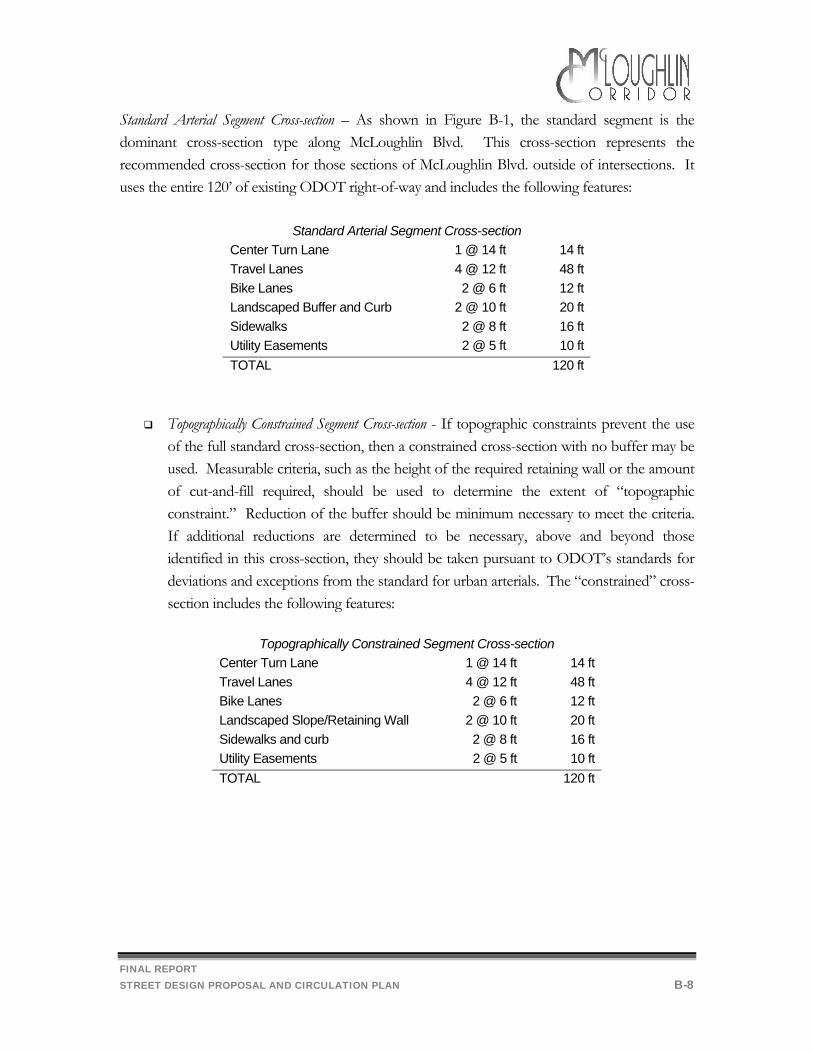
Standard Arterial Segment Cross-section – As shown in Figure B-1, the standard segment is the dominant cross-section type along McLoughlin Blvd. This cross-section represents the recommended cross-section for those sections of McLoughlin Blvd. outside of intersections. It uses the entire 120’ of existing ODOT right-of-way and includes the following features:
Standard Arterial Segment Cross-section
Center Turn Lane 1 @ 14 ft 14 ft Travel Lanes 4 @ 12 ft 48 ft Bike Lanes 2 @ 6 ft 12 ft Landscaped Buffer and Curb 2 @ 10 ft 20 ft Sidewalks 2 @ 8 ft 16 ft Utility Easements 2 @ 5 ft 10 ft TOTAL 120 ft
Topographically Constrained Segment Cross-section - If topographic constraints prevent the use of the full standard cross-section, then a constrained cross-section with no buffer may be used. Measurable criteria, such as the height of the required retaining wall or the amount of cut-and-fill required, should be used to determine the extent of “topographic constraint.” Reduction of the buffer should be minimum necessary to meet the criteria. If additional reductions are determined to be necessary, above and beyond those identified in this cross-section, they should be taken pursuant to ODOT’s standards for deviations and exceptions from the standard for urban arterials. The “constrained” cross-section includes the following features:
Topographically Constrained Segment Cross-section
Center Turn Lane 1 @ 14 ft 14 ft Travel Lanes 4 @ 12 ft 48 ft Bike Lanes 2 @ 6 ft 12 ft Landscaped Slope/Retaining Wall 2 @ 10 ft 20 ft Sidewalks and curb 2 @ 8 ft 16 ft Utility Easements 2 @ 5 ft 10 ft TOTAL 120 ft

FINAL REPORT STREET DESIGN PROPOSAL AND CIRCULATION PLAN B-9
Standard Intersection without Right-Turn Lane – This intersection cross-section is identical to the standard arterial segment cross-section except that the center turn lane would be striped and signed as a left turn lane. Similar to the topographically constrained cross-section described previously, the buffer could be reduced or deleted in a topographically constrained situation.
Standard Intersection without Right-Turn Lane
Left Turn Lane 1 @ 14 ft 14 ft Travel Lanes 4 @ 12 ft 48 ft Bike Lanes 2 @ 6 ft 12 ft Landscaped Buffer and curb 2 @ 10 ft 20 ft Sidewalks 2 @ 8ft 16 ft Utility Easements 2 @ 4 ft 10 ft TOTAL 120 ft
Standard Intersection with Right Turn Lane – This intersection cross-section provides a right turn lane for vehicles approaching the intersection. On the exiting legs of the intersection, the shoulder treatment would return to a standard 10 foot landscaped buffer. Alternatively, the utility easement could be narrowed to 3 feet and a 12 foot bus pull-out could be provided. Figure B-1 shows the intersection from the view of a driver approaching the intersection heading northbound.
Standard Intersection with Right Turn Lane
Left-Turn Lane 1 @ 14 ft 14 ft Right-Turn Lane 1 @ 15 ft 15 ft Travel Lanes 4 @ 12 ft 48 ft Bike Lanes 1 @ 6 ft
1 @ 5 ft 11 ft
Landscaped Buffer and Curb 1 @ 10 ft 10 ft Sidewalks and Curb (curb adjacent to sidewalk on one side only) 2 @ 8 ft 16 ft Utility Easements (5 ft. easement can be reduced to 3 ft. help accommodate a bus pull if needed)
1 @ 1 ft 1 @ 5 ft
6 ft
TOTAL 120 ft
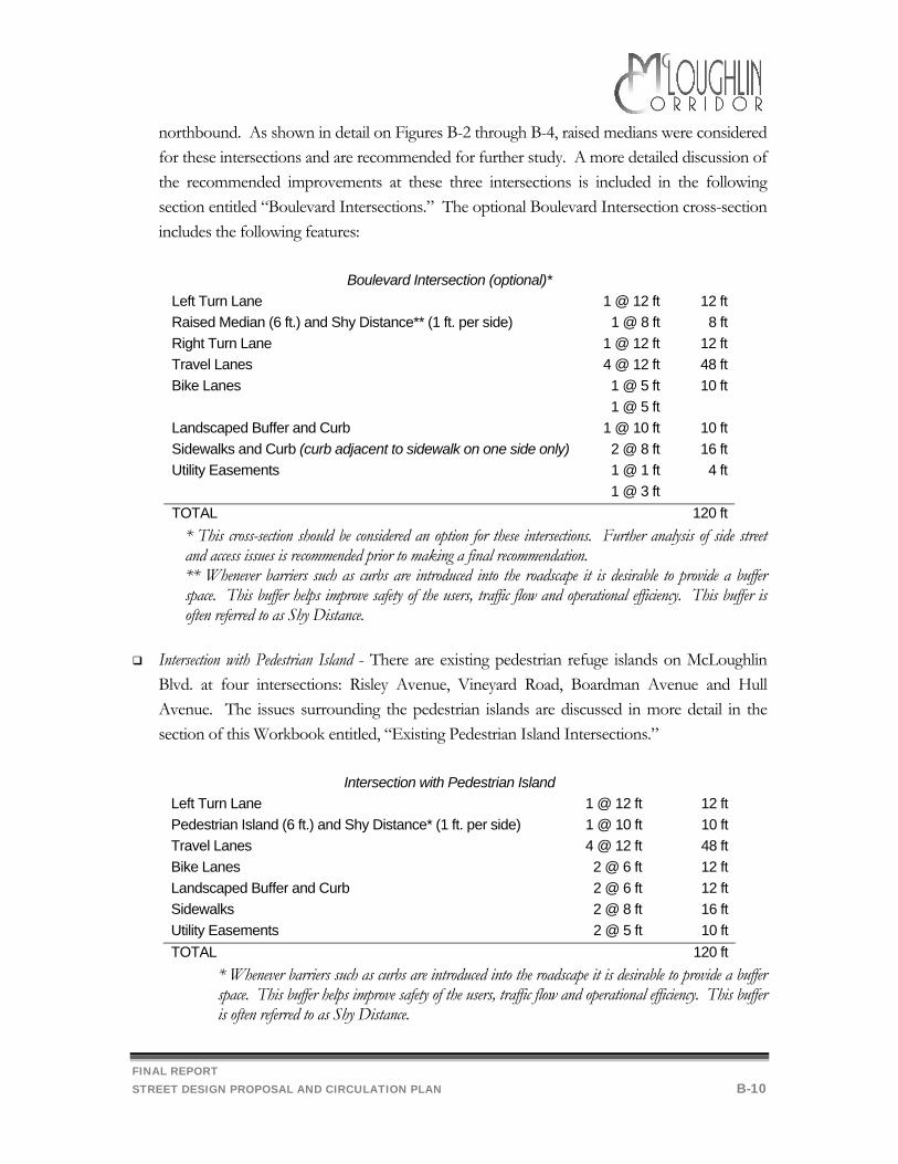
Boulevard Intersection -- Metro has designated three McLoughlin Blvd. intersections as “Boulevard” intersections: Oak Grove Blvd., Concord Road and Jennings Avenue. This optional intersection cross-section provides a right-turn lane and a left-turn pocket for vehicles approaching the intersection. On the exiting legs of the intersection, the shoulder treatment would return to a standard 10 foot landscaped buffer. Alternatively, the utility easement could be narrowed to 1 foot and a 12 foot bus pull-out could be provided. Figure B-1 shows the intersection from the view of a driver approaching the intersection heading
FINAL REPORT STREET DESIGN PROPOSAL AND CIRCULATION PLAN B-10
northbound. As shown in detail on Figures B-2 through B-4, raised medians were considered for these intersections and are recommended for further study. A more detailed discussion of the recommended improvements at these three intersections is included in the following section entitled “Boulevard Intersections.” The optional Boulevard Intersection cross-section includes the following features:
Boulevard Intersection (optional)*
Left Turn Lane 1 @ 12 ft 12 ft Raised Median (6 ft.) and Shy Distance** (1 ft. per side) 1 @ 8 ft 8 ft Right Turn Lane 1 @ 12 ft 12 ft Travel Lanes 4 @ 12 ft 48 ft Bike Lanes 1 @ 5 ft
1 @ 5 ft 10 ft
Landscaped Buffer and Curb 1 @ 10 ft 10 ft Sidewalks and Curb (curb adjacent to sidewalk on one side only) 2 @ 8 ft 16 ft Utility Easements 1 @ 1 ft
1 @ 3 ft 4 ft
TOTAL 120 ft * This cross-section should be considered an option for these intersections. Further analysis of side street and access issues is recommended prior to making a final recommendation. ** Whenever barriers such as curbs are introduced into the roadscape it is desirable to provide a buffer space. This buffer helps improve safety of the users, traffic flow and operational efficiency. This buffer is often referred to as Shy Distance.
Intersection with Pedestrian Island - There are existing pedestrian refuge islands on McLoughlin
Blvd. at four intersections: Risley Avenue, Vineyard Road, Boardman Avenue and Hull Avenue. The issues surrounding the pedestrian islands are discussed in more detail in the section of this Workbook entitled, “Existing Pedestrian Island Intersections.”
Intersection with Pedestrian Island
Left Turn Lane 1 @ 12 ft 12 ft Pedestrian Island (6 ft.) and Shy Distance* (1 ft. per side) 1 @ 10 ft 10 ft Travel Lanes 4 @ 12 ft 48 ft Bike Lanes 2 @ 6 ft 12 ft Landscaped Buffer and Curb 2 @ 6 ft 12 ft Sidewalks 2 @ 8 ft 16 ft Utility Easements 2 @ 5 ft 10 ft TOTAL 120 ft
* Whenever barriers such as curbs are introduced into the roadscape it is desirable to provide a buffer space. This buffer helps improve safety of the users, traffic flow and operational efficiency. This buffer is often referred to as Shy Distance.
FINAL REPORT STREET DESIGN PROPOSAL AND CIRCULATION PLAN B-11
Optional Boulevard Intersections
As shown in Figures B-2 through B-4, raised medians are recommended for further study on McLoughlin Blvd. at its intersection with Oak Grove Blvd., Jennings Avenue and Concord Road. Metro has designated these intersections as “Boulevard” intersections. Metro’s suggested design elements for “Boulevard” intersections are intended to improve mobility and safety for pedestrians and bicycles, and transit access. These design elements include the following:
Place crosswalks prior to curb returns to reduce crossing widths. (NOTE: We do not recommend that crosswalks should be placed this way because it increases the distance between vehicles turning right from the cross street onto McLoughlin and pedestrians using the crosswalk on McLoughlin. This reduces the visibility of the pedestrians to the driver and of the pedestrians to the right-turning vehicle, creating a potential safety hazard. Also, mitigation of this problem for intersections designed in this way has in some cases required a separate signal phase to be included for pedestrians, reducing the capacity and efficiency of the intersection).
Add raised median (preferred width of 6 feet, minimum width of 4 feet) for pedestrian refuge at crosswalks on regional streets. Plant trees on medians. Transition median to the predominant median treatment on regional streets, a painted two-way left-turn lane.
At intersections with exclusive right-turn lanes and far-side bus stops, avoid extending the right-turn lane through the intersection to create a bus pull-out. Instead, provide a normal curb return and create a bus turnout downstream from the intersection.
Provide pedestrian connections from the corner to adjacent land uses to minimize walking distances.
These three intersections also have been identified as high accident locations based on their Safety Priority Index System (SPIS) rating (see discussion in Workbook 1 Follow up, page 33). In order to determine whether a median could successfully address some of the vehicular traffic safety problems at these intersections, ODOT prepared a more detailed analysis of the accidents at each intersection. The results of this analysis are summarized in Workbook No. 3. The dimensions for the boulevard intersection cross-section described above were determined based upon ODOT’s draft design guidelines for urban highways and medians. Initial application of the guidelines resulted in a total cross-section width greater than the available 120 foot right-of-way. Therefore, ODOT staff recommended that the widths of specific cross-section elements should be reduced in accordance with the rationale contained in the draft urban highway design guidelines for constrained right-of-way sections. The rationale define the priority to be followed in reducing the cross-section elements and the minimum allowable width for each element.
FINAL REPORT STREET DESIGN PROPOSAL AND CIRCULATION PLAN B-12
Unless pedestrian circulation is an identified project goal, the first two elements to be reduced are sidewalks and the roadside buffer area between the curb line and sidewalk. However, since the concept of boulevard intersections emphasizes pedestrian circulation, these two elements could not be modified. Therefore, the following changes were identified: • Reduction in median shy distances from 2 feet to 1 feet • Reduction in bike lane widths from 6 feet to 5 feet • Reduction in the right-turn lane width from 15 feet to 12 feet In addition, the median width was reduced from eight feet to six feet. These changes brought the total right-of-way width to within the available 120 feet. Metro has stressed the importance of using landscaped buffers to create a good pedestrian environment at boulevard intersections. However, in order to accommodate a right-turn lane and travel lanes widths appropriate to a designated freight route, landscaped buffers are proposed to be tapered off on one side of the intersection. As shown in Figures B-2 through B-4, the major modifications that would occur at the boulevard intersections as a result of the recommended cross-section design are: • Installation of raised medians, extending from the cross-walks to 200 - 300 feet upstream of
the intersections • Limitation of allowable turning movements in and out of driveways adjacent to the
intersections • Installation of landscaped buffers • Construction of bus pullouts at the existing far-side bus stop locations The median lengths were determined based on the estimated future queue lengths for left-turning vehicles at the intersections. The medians will serve several functions as a pedestrian refuge within the intersection crosswalk, channelizing left-turning traffic on the intersection approaches, and improving traffic operations and safety related to driveways near the intersections. As mentioned above, the three boulevard intersections have been identified as high accident locations. An analysis of accidents occurring at driveways near the intersections by ODOT staff indicated that a high percentage of the accidents involved vehicles turning left into or left out of the driveways. Installation of the raised medians will prevent these maneuvers, limiting driveway access/egress to right-in, right-out turns only. This should not only improve safety conditions at these locations, but also increase the efficiency of traffic flow. These turning movement
FINAL REPORT STREET DESIGN PROPOSAL AND CIRCULATION PLAN B-13
restrictions already exist to a large extent, in fact, due to the difficulty of turning left through the long traffic queues on the intersection approaches. Landscaped buffers will be provided on the near sides of the intersections prior to the right-turn lanes and on the far sides of the intersections in areas not occupied by driveways or bus pullouts. The bus pullouts were designed in accordance with Tri-Met guidelines and will result in improved traffic operations in the intersection areas. Where possible, the pullouts were designed with normal curb returns in order to minimize pedestrian crossing distances. As noted, further study of the impacts on side street performance and function and on access for affected businesses should be conducted prior to making a final recommendation regarding these improvements. Additionally, because Tri-Met is considering the corridor for Bus Rapid Transit improvements (see Transit Facilities and Circulation section), further design changes to these intersections may be necessary to accommodate needed transit improvements. Existing Pedestrian Island Intersections
The function and value of the existing pedestrian refuge islands on McLoughlin Blvd. at its intersection with Risley Avenue, Vineyard Road, Boardman Avenue and Hull Avenue was a major issue raised during the planning process. Three options were assessed with regard to these intersections: removing the islands, installing new traffic signals, and redesigning the islands. There was considerable support from the Work Group and public in support of removing the islands entirely as opposed to redesigning them. However, as discussed in Workbook No. 3, given concerns about pedestrian safety and liability, and the fact that the intersections are not expected to meet signal warrants within the 20 year planning period, the final preferred alternative is to redesign the pedestrian islands. Redesigned Pedestrian Islands Given that the islands appear to be effective and new signals at these locations are not likely to be an option during the 20-year planning period, the opportunities to redesign the islands in order to make them more acceptable to the driving public were considered. Three important objectives in the design of pedestrian islands are:
To create an area that is perceived by pedestrians as a desirable location to cross Enhance the visibility of the island to motorists Minimize the obstructiveness of the island to traffic flow
FINAL REPORT STREET DESIGN PROPOSAL AND CIRCULATION PLAN B-14
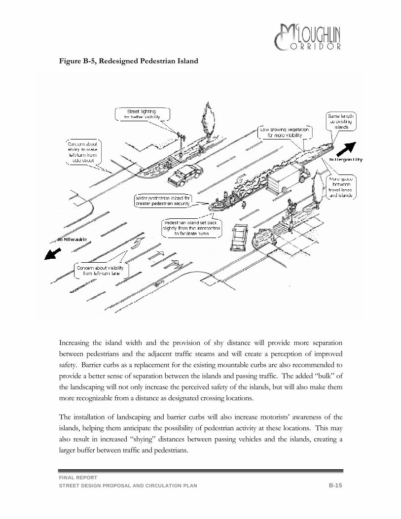
By improving the desirability of the islands as crossing locations, pedestrian flows can be channelized, thereby reducing the number of random crossing points along the boulevard. As shown in Figures B-5 and F-6, eight features have been included in the recommended redesign to increase the perceived safety (and desirability) of the existing islands:
Increasing the island width from six feet to eight feet Installation of barrier curbs Provision of one foot of “shy” distance between the travel lanes and both sides of the island
(striped) Installation of island landscaping Setting the islands back slightly (approximately 6 feet) from the intersection Realigning the islands so that the opposing left-turn bays on McLoughlin Blvd. to improve
sight distance Pedestrian-scale illumination and signage at the island to increase pedestrian and driver
visibility Advanced pedestrian crossing warning signs for vehicle traffic
FINAL REPORT STREET DESIGN PROPOSAL AND CIRCULATION PLAN B-15
Figure B-5, Redesigned Pedestrian Island
Increasing the island width and the provision of shy distance will provide more separation between pedestrians and the adjacent traffic steams and will create a perception of improved safety. Barrier curbs as a replacement for the existing mountable curbs are also recommended to provide a better sense of separation between the islands and passing traffic. The added “bulk” of the landscaping will not only increase the perceived safety of the islands, but will also make them more recognizable from a distance as designated crossing locations. The installation of landscaping and barrier curbs will also increase motorists’ awareness of the islands, helping them anticipate the possibility of pedestrian activity at these locations. This may also result in increased “shying” distances between passing vehicles and the islands, creating a larger buffer between traffic and pedestrians.

FINAL REPORT STREET DESIGN PROPOSAL AND CIRCULATION PLAN B-16
Figure 6 Pedestrian island schematic
FINAL REPORT STREET DESIGN PROPOSAL AND CIRCULATION PLAN B-17
The obstructiveness of the islands will be minimized through two design modifications. The first will be to change the existing rounded nose of the islands to the shape shown in Figure B-8. This will make it easier for vehicles turning left out of the side street to maneuver around the island and into the travel lanes on McLoughlin Boulevard and should reduce the likelihood of vehicles striking the curb. The second modification is the provision of one foot of shy distance between the islands and the inside travel lanes along the boulevard, providing motorists with a greater sense of maneuverability between the island and the adjacent travel lane. Additionally, shifting the pedestrian islands back from the intersections would address the problem of left-turning vehicles from the side streets having difficulty maneuvering around the islands, especially trucks. This improvement would provide a larger turning radius, making it easier for vehicles to merge into the southbound through lanes. ODOT Region 1 staff indicated that this proposal was not unreasonable, but that more detailed analyses would have to be performed prior to implementing this improvement to determine, for example, exactly how far back to shift the islands. One consideration would be to not shift the islands too far back, so that drivers turning right from the side street would not lose sight of crossing pedestrians. Two other recommended features for the intersection redesign address another current problem in which drivers turning left from both the northbound and southbound approaches on McLoughlin Boulevard have difficulty seeing on-coming through traffic through the opposing left-turn queues. This problem is caused in part by drivers lining up too far to the right of the left-turn lane, so that their line-of-sight is obstructed by vehicles waiting to turn left from the other direction. Although the pavement is currently striped to guide drivers to the left side of the left-turn lane, the painted striping frequently wears off so that drivers are unaware of where they should be. One possible solution suggested by ODOT staff would be to replace the painted striping with a thermoplastic material that would provide permanent channelization marking. Another possible cause of this problem may be that vehicles waiting to turn left from the opposite side of the intersection pull too far forward, thereby creating a sight obstruction for the other left-turning vehicles. This difficulty could be mitigated by the installation of stop bars for the left-turn lanes on both sides of the intersection. Installation of marked crosswalks at the pedestrian islands was considered as an improvement alternative. This proposal was not supported by ODOT Region 1 staff, however, who cited
FINAL REPORT STREET DESIGN PROPOSAL AND CIRCULATION PLAN B-18
previous research1 in the San Diego area which found that marked crosswalks were associated with an even higher pedestrian accident experience than similar unmarked crosswalks. As summarized in the Design and Safety of Pedestrian Facilities,2 the San Diego study found that pedestrians may “feel safer” within a marked crosswalk and expect motorists to act more cautiously. In reality, crosswalk markings are not as visible to motorists as they are to pedestrians, and the lines cannot stop an inattentive or impaired driver. While the study did not conclude that marked crosswalks were hazardous, it did indicate that inappropriate use and overuse of crosswalk markings was of little benefit. Two other studies were also identified in the Design and Safety of Pedestrian Facilities.3 A more recent study than the San Diego research had different results indicating that marked crosswalks were as safe or safer than unmarked crosswalks for all conditions studied. The case studies examined indicated that installation of crosswalk markings had little effect on driver speeds but were successful in attracting pedestrians to cross within the markings, minimizing their exposure times in the street.4 A current study for the Federal Highway Administration is re-examining the controversy of the safety of marked vs. unmarked crosswalks. This study is attempting to determine conditions where it is safer to provide marked crosswalks and conditions that justify no crosswalk markings. Due to the uncertainty regarding the appropriateness of marked crosswalks at unsignalized intersection locations, installation of marked crosswalks at the four pedestrian island intersections along McLoughlin Boulevard is not recommended at this time. This issue should be re-examined, however, when further information is available. Improved Advanced Warning Signage
Advanced warning signs give drivers time to prepare and make necessary lane changes in a safe and orderly fashion. Advanced warning is particularly important on fast moving, high volume roadways like McLoughlin Blvd. Signs such as "Roethe Road Next Signal" should be installed both north and southbound in advance of each of the eight signalized intersections within the study area.
1 Herms, B.F. “Pedestrian Crosswalk Study: Accidents in Painted and Unpainted Crosswalks” (HRR 406). Highway Research Board, Washington, D.C., 1972. 2 Institute of Transportation Engineers. “Design and Safety of Pedestrian Facilities, A Recommended Practice of the Institute of Transportation Engineers”. Institute of Transportation Engineers, Washington, D.C., 1998. 3 Institute of Transportation Engineers. 4 Knoblauch, R.L., Tustin, B.H., Smith, S.A., and Pietrucha, M.T. “Investigation of Exposure Based Pedestrian Areas: Crosswalks, Sidewalks, Local Streets and Major Arterials” (Report No. FHWA/RD-88/038). Federal Highway Administration, September 1988.
FINAL REPORT STREET DESIGN PROPOSAL AND CIRCULATION PLAN B-19
On-Street Parking
Recommendation
Following is the final recommendations for on-street parking on McLoughlin Blvd. The rationale for this recommendation is discussed in detail in the “Discussion and Analysis” section.
Prohibit on-street parking on McLoughlin Blvd. Discussion and Analysis
There was general support by the Work Group and attendees at the Open Houses to prohibit on-street parking along McLoughlin Blvd. Clackamas County requires that businesses provide sufficient off-street parking. On-street parking can decrease the capacity of adjacent travel lanes, block visibility, increase the potential for conflict by increasing the number of turning movements and create a hazard for bicyclists. For these reasons, on-street parking is typically prohibited on regional streets with speeds of 45 mph or greater. The draft ODOT Highway Design Manual states that “Most developed areas are inappropriate for on-street parking due to the higher traffic speeds and type of development. In most developed areas, buildings are set back from the highway and separated by parking lots. This type of developed area is not a situation which would benefit from on-street parking.” A discussion of how this recommendation might be implemented is provided in the Implementation Strategies, Section D.
FINAL REPORT STREET DESIGN PROPOSAL AND CIRCULATION PLAN B-20
Street Lighting
Recommendations:
Following are the final recommendations for street lighting on McLoughlin Blvd. The rationale for these recommendations is discussed in detail in the “Discussion and Analysis” section.
Provide continuous street lighting on both sides of McLoughlin Blvd.
A systematic plan to provide street lights should: Be designed to provide complete and continuous lighting (not piece-meal). Include an intergovernmental agreement between ODOT and Clackamas County, as well
as Gladstone, Milwaukie and Oregon City, if appropriate. Include, in the project area, approximately 175 new 400 watt flat lens cobra street lights
on 40 foot tall aluminum davit poles with a 6 or 8 foot arm placed two feet behind the curb at approximately 200 foot intervals on both sides of McLoughlin Blvd. Extended arms might be necessary at those locations where there is no landscaped buffer and the street lights must be placed on the far side of the sidewalk in the utility easement.
Locate street lights along McLoughlin Blvd. as shown in the cross-sections (see Figure B-1). As shown these would be installed so as not to block the sidewalk.
Include pedestrian-scale lighting at boulevard intersections and pedestrian island crossings.
Evaluate in the Implementation Report how best to fund the street lighting program on
Discussion and Analysis
McLoughlin Boulevard remains substantially without street lighting, from the Milwaukie City limits on the north to the Gladstone City limits on the south, for a number of reasons. McLoughlin is a State Highway but does not meet Oregon Department of Transportation (ODOT) guidelines for lineal illumination (street lighting between traffic signal poles), although ODOT does provide illumination on most traffic signals and at a few non-signalized intersections where there are frequent pedestrian crossings on McLoughlin. The County has waived installation of street lighting as a condition of approval for new development on McLoughlin because a discontinuous, piece-meal approach to lighting a major arterial road is not desirable from a safety or aesthetic standpoint, and there is currently not a means to generate adequate
FINAL REPORT STREET DESIGN PROPOSAL AND CIRCULATION PLAN B-21
revenue to pay for the operation and maintenance costs of this lighting if it were installed. In addition, the inconsistency of frontage improvements on McLoughlin would make a uniform installation of street lights difficult if they were to be installed as individual properties develop. A systematic plan to light McLoughlin will have to consider a number of factors.
Existing Conditions
• There are 26 street lights existing on McLoughlin (within the study area), primarily at signalized intersections with a few at other un-signalized intersections. Approximately 165 additional lights (for a total of 190 lights) will be required to fully light McLoughlin on both sides from the southern city limit of Milwaukie to the northern city limit of Gladstone.
• Frontage improvements along McLoughlin are not uniform, which presents an obstacle to placement of light poles.
• Existing wood power poles can be used in lieu of new street lighting poles in many situations. On McLoughlin, existing wood poles are neither uniformly spaced nor uniformly distributed on both sides of the street and are inadequate. Many of the existing wood poles have numerous utility connections to them, and there is physically not adequate room at the optimal height from the ground to mount street lights.
• Unless installation and operation and maintenance costs are absorbed entirely by ODOT, installation of street lighting on McLoughlin will require an Inter-Governmental Agreement between ODOT and the County to clarify jurisdictional responsibilities. Participation of adjoining municipalities, Milwaukie, Gladstone and Oregon City, needs to be considered for a complete design.
• Clackamas County Service District No. 5 is the agency responsible for street lighting in un-incorporated urban areas of the County. All lighting in neighborhoods and on collector and arterial streets in the District is provided by PGE. The District pays for this service with annual assessments it collects on the property tax statements of benefiting property owners. No County General Fund or Road Fund money is used for street lighting; the District is entirely self-supporting.
FINAL REPORT STREET DESIGN PROPOSAL AND CIRCULATION PLAN B-22
Access Management
Recommendation
Following is the final recommendation for the access management on McLoughlin Blvd. The rationale for this recommendation is discussed in detail in the “Discussion and Analysis” section.
Retain and continue to implement applicable access management policies and standards. Work with ODOT to evaluate the suitability of the UBA (Urban Business Area Overlay)
designation for McLoughlin. as a mechanism to address access management issues. Discussion and Analysis
As discussed in Workbook No. 2, large numbers of driveways create opportunities for confusion, conflict and congestion on roadways. ODOT's established access management policies for its facilities in order to prevent the proliferation of private access points. As noted in the Workbook 1 (Corrections, page 3), under ODOT's current access management program McLoughlin Blvd. has an Access Management Category of 4 –5. A Category 4-5 roadway has the following characteristics:
Spacing of at grade intersections with public roads no closer than one-quarter mile apart, Spacing of both left and right turns into private drives no closer than 300-500 feet apart, Signal spacing that is every one-quarter to one-half mile, and Either no median control or partial median control.
ODOT is currently revising its access management standards in conjunction with the adoption of the new 1999 Oregon Highway Plan (OHP). Under the new access management standards, McLoughlin Blvd., as an "Urban District Highway", would have an access spacing standard of 500 feet. Policies in the new OHP address concerns about existing driveways, infill and redevelopment and recognize that meeting the spacing standards may not always be possible. Additionally, the new OHP includes new designations and classifications which may be applicable to portions of McLoughlin Blvd. including "Urban Business Areas" (UBA). The primary objective of the state highway in an UBA "… is to maintain existing speeds while balancing the access needs of abutting properties with the need to move through traffic."5 The designation of a
5 ODOT, "Designations and Classifications in the 1999 Oregon Highway Plan, April 23, 1999.
FINAL REPORT STREET DESIGN PROPOSAL AND CIRCULATION PLAN B-23
UBA must be made through a corridor plan and/or local transportation system plan with agreement of both ODOT and the affected local government.6 UBAs are located as follows:
1. UBAs are located within urban growth boundaries. 2. UBAs may be located on District or Regional Highways where speeds are 35
miles per hour or less. (NOTE: At 40 mph, McLoughlin Blvd. within the study area does have a somewhat higher speed limit).
3. UBAs may be located on Statewide Highways where speeds are 35 miles per hour or less under specific circumstances.7
UBAs have the following design characteristics:
1. UBAs may vary in size. 2. Existing areas of commercial activity may constitute an UBA. 3. New buildings in an UBA should be clustered in centers or nodes so that the
facilities encourage people who arrive by car or transit to find it convenient to walk from place to place within the area.
4. UBAs should have: • Bicycle lanes and sidewalks and other pedestrian accommodations, especially
in commercial centers and community use areas. • Convenient and safe pedestrian crossings, especially at transit stops and other
high-use generators. • Intersections designed to address the needs of pedestrians and bicyclists. • Measures for addressing pedestrian crossing safety. These may include stop
signs, traffic signals and medians designed to serve as pedestrian refuges.8 Currently, the 1997 Clackamas County Roadway Standards includes the following standards for access, entries and driveways:
Access and driveway entrances to State highways shall require approval from ODOT and a roadway approach permit issued by ODOT. Access shall conform to the policies and procedures set forth in the 1991 Oregon Highway Plan and Access Management Manual or more recent updates.
On corner properties, access shall be taken on the secondary or subordinate classification roadway.
6 Ibid. 7 Ibid. 8 Ibid.
FINAL REPORT STREET DESIGN PROPOSAL AND CIRCULATION PLAN B-24
Arterials: Only collector roadways shall be permitted access onto arterial roadways at a separation distance of 600 feet from the nearest intersections when addressing minor arterials and 1,000 feet of separation on major arterials. Alternate access types and spacing intervals may be allowed if an access management plan which maintains the function and service of the arterial can be ensured.
Reducing the number of driveways also benefits pedestrian and bicyclist safety by reducing the potential opportunities for conflict as vehicles cross sidewalks and bike lanes to pull out into traffic. ODOT’s Bicycle and Pedestrian Plan notes that having many uncontrolled accesses to a busy road decreases pedestrian crossing opportunities. When a gap is created in the traffic stream, motorists entering the road fill the gap. Pedestrians seeking refuge in a center turn lane are unprotected. By implementing the existing access management policies and standards through the review of new development or redevelopment, the County and ODOT will continue to improve the overall operation and function of McLoughlin Blvd.
FINAL REPORT STREET DESIGN PROPOSAL AND CIRCULATION PLAN B-25
Pedestrian and Bicycle Facilities and Circulation
Recommendations
Following are the final recommendations for pedestrian facilities and circulation on McLoughlin Blvd. The rationale for these recommendations is discussed in detail in the “Discussion and Analysis” section.
Provide a complete and continuous sidewalk and bikeway system on both sides of McLoughlin Blvd.
Where possible provide a landscaped buffer between the sidewalk and the curb.
Bike lane widths should be as shown in Figure B-1.
Sidewalk widths and buffers should be as shown in Figure B-1.
Include in the Implementation Report amendments to the 1997 Clackamas County Roadway
Standards needed to implement the recommended cross-section, including requiring a landscaped buffer between the curb and the sidewalk.
Provide sidewalks and bike lanes on side streets and new pedestrian connections as described
in the adopted 1996 Clackamas County Pedestrian Master Plan and the adopted 1996 Clackamas County Bicycle Master Plan, respectively.
Discussion and Analysis
The Work Group and public generally supported providing a complete system of sidewalks and bike lanes on McLoughlin Blvd. Existing Comprehensive Plan policies also support street lighting, street trees, pedestrian amenities and complete sidewalks on designated boulevards (e.g., McLoughlin Blvd.). However, the location of the sidewalk relative to the street has not been treated consistently under current policy. The 1997 Clackamas County Roadway Standards require that all sidewalks be located adjacent to the curb unless otherwise approved by the County, and allows planting strips and street trees when required by Design Review. In order to improve the pedestrian environment, the recommendation would require a 10’ landscaped buffer between the 8 ft. sidewalk be developed consistently along McLoughlin, as shown in Figure B-1.
FINAL REPORT STREET DESIGN PROPOSAL AND CIRCULATION PLAN B-26
This 10’ landscaped buffer could be superseded by a right turn lane at congested intersections, or by parking bays or bus turn outs as needed. However, right turn lanes should be used only where warranted by a traffic study since they create additional problems for bicyclists and pedestrians. The Work Group generally supported a somewhat narrower sidewalk width (6 feet); however, given the speed and volume of traffic on McLoughlin Blvd., the recommendation is for the County to retain its existing standard of 8 foot sidewalks. The recommendation is also in compliance with ODOT’s Bicycle and Pedestrian Plan, adopted in 1995. This Plan states that sidewalks must be provided on both sides of all urban arterial and collector streets, unless physical limitations and land use characteristics render a sidewalk unsuitable on one side. In these situations, safe and convenient crossing opportunities must be provided to allow pedestrians to proceed on the side with sidewalks. Also, according to ODOT’s Bicycle and Pedestrian Plan, the standard sidewalk width is 6’ with greater sidewalk width needed in high pedestrian use areas. Well-designed streets include planting strips (landscaped buffers), which have several advantages:
Planting strips provide room for street trees, sign posts, utility and signal poles, mailboxes, parking meters, fire hydrants, etc.
When wide enough planting strips create a section of the driveway where a motor vehicle to wait out of the stream of traffic after crossing the sidewalk and provide additional room for turn movements.
Planting strips provide the opportunity to line up sidewalks, curb cuts and cross-walks at intersections.
Planting strips enhance the environment for wheelchair users, as sidewalks can be kept at a constant side slope, with the slope for driveways built into the planting strip section.
Planting strips provide an opportunity for aesthetic enhancements such as landscaping. Additionally, ODOT’s Bicycle and Pedestrian Plan states that on high speed corridors sidewalks must not be placed directly adjacent to a high-speed travel lane (design speed 45 mph and above). In terms of connectivity to McLoughlin Blvd., the County’s 1996 Pedestrian Master Plan Map (Figure B-4 of Workbook No. 2) establishes a system of essential pedestrian pathways, including new connections on Silversprings, Torbank, and Westview roads, and a new multi-use trail along the Portland Traction Right-of-Way. Also, currently, development often forms a barrier to pedestrian access by placing fences, hedges and other obstacles between residential and commercial uses (e.g., the Albertson’s shopping center). This forces nearby residents who might otherwise be within easy walking distance of the store to get in their automobiles to drive around
FINAL REPORT STREET DESIGN PROPOSAL AND CIRCULATION PLAN B-27
the block via the major arterial, further adding to the congestion. Alternately, developments such as the Fred Meyer Shopping Center provide rear-access for both pedestrians and vehicles. The County’s adopted Pedestrian Master Plan includes the following strategy: “Require that new development provide pedestrian connections within and between adjacent developments to increase the non-motorized mobility”. The County’s Comprehensive Plan includes the following policy: “Require, where appropriate, pedestrian/bicycle access out of cul-de-sacs or through long blocks.” These policies should continue to be used to encourage new development to connect to public rights-of-way to the rear of the development when available.
FINAL REPORT STREET DESIGN PROPOSAL AND CIRCULATION PLAN B-28
Transit Facilities and Circulation
Recommendations:
Following are the final recommendations for transit facilities and circulation on McLoughlin Blvd. The rationale for these recommendations is discussed in detail in the “Discussion and Analysis” section.
Improve pedestrian facilities and circulation in order to assist transit users in the pedestrian leg of their trip pursuant to the recommendations of the pedestrian and bicycle facilities and circulation recommendations.
Work with Tri-Met to adopt and implement a plan to improve bus service in the Southeast
Metro area, including the McLoughlin corridor.
Recommend Tri-Met consider ways to improve east-west access within and to the McLoughlin corridor and local shuttle service in the neighborhoods.
Discussion and Analysis
Tri-Met has developed a discussion draft for southeast bus improvements (dated 4/7/99) According to that draft the package of transit service and facilities improvements in the southeast would be developed around three Bus Rapid Transit routes. Bus Rapid Transit emulates light rail transit operating speeds, stations and park & ride lots. Faster operating speeds are achieved through a combination of exclusive lane and signal priority treatment and limited stops. Improvements in service and ridership would occur in the corridor as operating and capital investments are made over a multi-year period. Corresponding investments by others would be needed to improve pedestrian access and traffic circulation. Phase I: Service Quality Improvements (Fall 1999-2001)
Increase service on the corridor trunk routes – initially Line 33 – McLoughlin and then Line 31 – Estacada (via Clackamas Town Center).
Increase off-peak service on local southeast routes – midday, evenings and weekends. Improve bus stop amenities – pavement, shelters, lighting Create new shared use park & ride lots. Expand the Clackamas Town Center Transit Center.
FINAL REPORT STREET DESIGN PROPOSAL AND CIRCULATION PLAN B-29
Phase II: Bus Rapid Transit Development (Fall 1999-2001)
Upgrade Line 33 and 31 trunk routes to Bus Rapid Transit. Develop prominent bus stations, work with the cities, Clackamas County and ODOT to develop preferential treatments that speed up operations.
Develop an off street Milwaukie Transit Center. Construct three new park & ride lots (NOTE: none are proposed within the McLoughlin Study
Area) Add new east-west local service in Milwaukie and Gladstone.
Phase III: Upgraded Bus Rapid Transit with introduction of HOV Lanes (Fall 2004)
Construct HOV or exclusive bus lanes on McLoughlin Blvd. from eastside Portland to Tacoma St.
Construct an east Portland transit center. Adjust bus schedules to capture operating efficiencies.
Phase IV: Bus Rapid Transit development Oregon City to Gateway (Fall 2005)
Bus Rapid Transit development: Oregon City to Gateway (Fall 2005) Construct Bus Rapid Transit stations at Foster Rd., Division St., other locations to be
determined. Construct a new park & ride lot at Foster Rd./I-205 interchange. Operate Bus Rapid Transit on existing freeway lanes with stops at the Oregon City,
Clackamas Town Center and Gateway Transit Centers as well as the new freeway stops. A concern frequently raised by the both the Work Group and the public was a lack of sufficient east-west transit access through the McLoughlin Corridor. Additionally, a number of people supported the recommendations of the 1995 Oak Grove Community Plan (draft) which called for a shuttle bus that would zigzag through the Oak Grove area in various "figure 8" patterns to serve more than major streets. The area west of River Rd. and north of Oak Grove Blvd. was identified as having trouble accessing transit. A survey conducted in conjunction with the Oak Grove Community Plan found that residents in these areas had more difficulty accessing transit because of hills and distance.
FINAL REPORT STREET DESIGN PROPOSAL AND CIRCULATION PLAN B-30
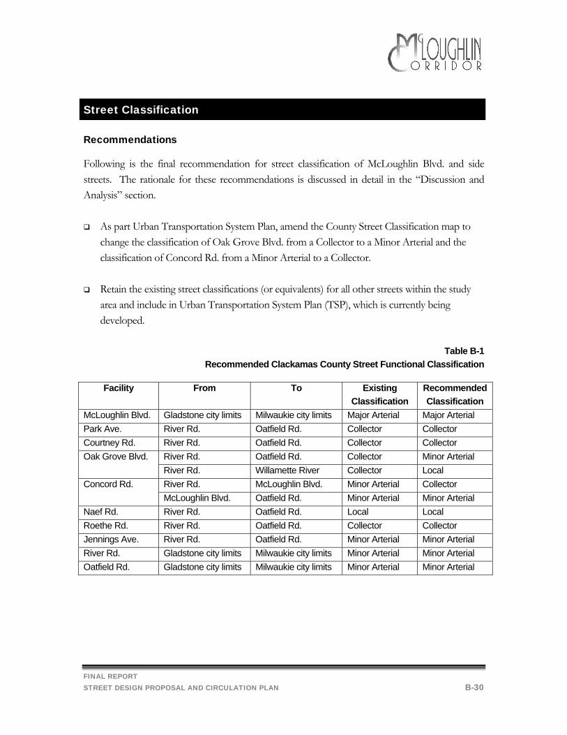
Street Classification
Recommendations
Following is the final recommendation for street classification of McLoughlin Blvd. and side streets. The rationale for these recommendations is discussed in detail in the “Discussion and Analysis” section.
As part Urban Transportation System Plan, amend the County Street Classification map to change the classification of Oak Grove Blvd. from a Collector to a Minor Arterial and the classification of Concord Rd. from a Minor Arterial to a Collector.
Retain the existing street classifications (or equivalents) for all other streets within the study
area and include in Urban Transportation System Plan (TSP), which is currently being developed.
Table B-1
Recommended Clackamas County Street Functional Classification
Facility From To Existing Classification
Recommended Classification
McLoughlin Blvd. Gladstone city limits Milwaukie city limits Major Arterial Major Arterial Park Ave. River Rd. Oatfield Rd. Collector Collector Courtney Rd. River Rd. Oatfield Rd. Collector Collector
River Rd. Oatfield Rd. Collector Minor Arterial Oak Grove Blvd. River Rd. Willamette River Collector Local River Rd. McLoughlin Blvd. Minor Arterial Collector Concord Rd. McLoughlin Blvd. Oatfield Rd. Minor Arterial Minor Arterial
Naef Rd. River Rd. Oatfield Rd. Local Local Roethe Rd. River Rd. Oatfield Rd. Collector Collector Jennings Ave. River Rd. Oatfield Rd. Minor Arterial Minor Arterial River Rd. Gladstone city limits Milwaukie city limits Minor Arterial Minor Arterial Oatfield Rd. Gladstone city limits Milwaukie city limits Minor Arterial Minor Arterial
FINAL REPORT STREET DESIGN PROPOSAL AND CIRCULATION PLAN B-31
Discussion and Analysis
Two changes to the existing Clackamas County street classifications within the McLoughlin Corridor study area appear to be appropriate.
• Oak Grove Blvd. – change from a Collector to a Minor Arterial • Concord Rd. – change from a Minor Arterial to a Collector
Concord is currently classified as a “minor arterial”. According to the Clackamas County Comprehensive Plan, Minor arterials are intended to connect collectors to the arterial system. They carry moderate volumes of traffic at moderate speeds. Oak Grove is currently classified as a “collector” street. According to the Comprehensive Plan, Collectors are the principle carrier within neighborhoods or single land use areas. They link neighborhoods with major activity centers or arterials and are generally not for through traffic. However, given that Oak Grove has higher traffic volumes and more commercial development than Concord, it is appropriate that the designations on these two streets be reversed, with Oak Grove Blvd. designated as a Minor Arterial and Concord designated as a Collector. This amendment to the County’s street classification map can be accomplished through the update of the County’s Urban Transportation System Plan, which is currently under development. The proposed amendment to the street classification system is in recognition of existing travel patterns in the area and is not expected to have an impact on traffic volumes. Additionally, it is not expected to significantly alter the design cross-section for either facility. Both will continue to include two travel lanes, sidewalks and bike lanes. Also, as development adjacent to both streets is generally complete, there would not likely be any change in access management. The amendment may, however, affect the prioritization of improvements, (e.g., Minor Arterials typically have a higher funding priority than Collectors). Additionally, the reclassification of Naef to “collector” was considered, but would not be appropriate because it is directly parallel to Roethe, which is already designated as a collector and should be serving this function within the neighborhood. According to the Clackamas County Comprehensive Plan, Roadway Classification and Guidelines (Table V-1), “collectors” are the principle carrier within neighborhoods or single land use areas.
FINAL REPORT STREET DESIGN PROPOSAL AND CIRCULATION PLAN B-32
Transportation System Evaluation Criteria
The evaluation criteria below were originally included in Workbook 2 to provide a consistent basis for the comparative analysis of the alternatives. In this section, they are provided to help evaluate the preferred alternative. The criteria are based on the following:
Project objectives (Workbook 2 Section B, page 1) Policy requirements of the project (Workbook 1, Section B-1) Previous workshop discussions (Workbook 1 Follow up, page 2) Open house comments (Workbook 2, Section A).
While including many of the main points from the workshop and open house, the project team attempted to avoid value judgements in the selection of the criteria. As such, some of the criteria may conflict with other criteria. The criteria for the transportation design alternatives are divided into nine general topic areas that cover the policy requirements of the project, previous workshop discussions and open house comments. Topic areas are:
Performance—The criteria under this area pertain to the design’s level of service, safety and connectivity effectiveness for areas and modes of transportation along McLoughlin Blvd.
Oregon Highway Plan—This includes criteria related to meeting applicable policies (level of importance and access management) of Oregon’s Highway Plan. This plan helps guide the operating and fiscal activities of the Oregon Highway Department. McLoughlin Boulevard, classified as a district highway, has a primary function of serving local traffic and land access. More detailed information about the Oregon Highway Plan is included in Workbook 1 Section B, page 6.
Title 1—This includes criteria related to meeting applicable requirements of Metro’s
Urban Growth Management Functional Plan Title 1, which is designed to minimize increases in the urban growth boundary by making more efficient use of land within it through zoning changes. Details about Title 1 are included in Workbook 1 Section B, page 9.

FINAL REPORT STREET DESIGN PROPOSAL AND CIRCULATION PLAN B-33
Title 6—This includes criteria related to meeting applicable requirements of Metro’s Urban Growth Management Functional Plan Title 6, which covers levels of service, connectivity and street design guidelines. Details about Title 6 are included in Workbook 1 Section B, page 13.
Comprehensive Plan—Clackamas County’s Comprehensive Plan cites transportation
goals applicable to this project in the areas of natural resource protection, residential development, commercial development, and energy efficiency. Details about the Comprehensive Plan are included in Workbook 1 Section B, beginning on page 17.
Economic Impacts—The criteria in this topic area address what will happen to various
types of jobs and employment. The criteria are based on the project’s economic analysis and public concerns raised at the workshop and open house.
Land Use Impacts—The criteria in this section generally address the transportation affects on potential land uses. In this topic area, it is particularly important to evaluate transportation options with consideration of how this option might affect the land use alternatives.
Additional Citizen Issues—Through the previous workshop and the open house, the
project team received numerous comments and concerns. Most of these are covered in other topic areas. The criteria in this topic area represent the most frequent comments not covered thus far in other topic areas.
Table B-2:
Transportation Design Alternatives Criteria Matrix, Year 2017
Criteria Street Design Proposal and Circulation Plan
Overall Performance Does the alternative improve the Arterial Level of Service compared to making no changes?
Under the Preferred Alternative, arterial LOS is expected to either remain the same or decrease slightly from the current LOS on the various segments of McLoughlin. The recommended changes may have a minor positive impact on operations; however, this is expected to be off-set by forecast traffic increases.
Does the alternative improve the Intersection Level of Service compared to making no changes?
The Preferred Alternative is not expected to have a significant impact on intersection LOS. Similar to taking no action, under the Preferred Alternative intersection LOS is expected to decrease from the current LOS B-C to C-F at the various signalized intersections on McLoughlin.
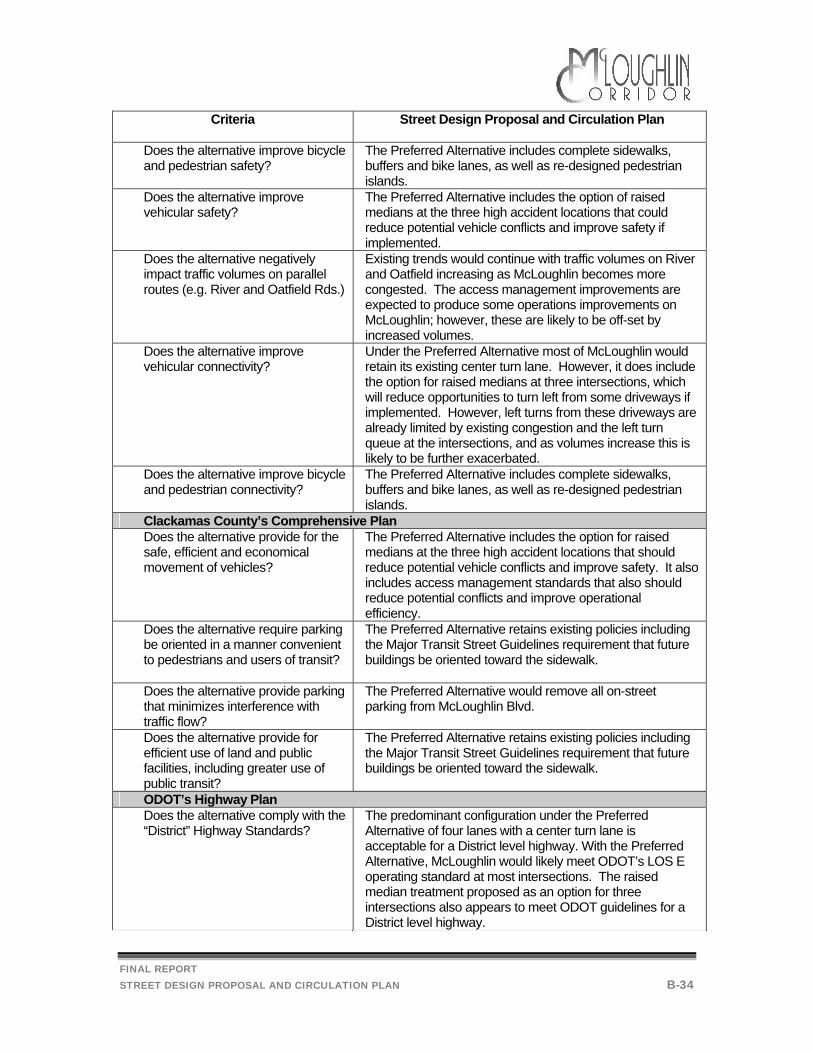
FINAL REPORT STREET DESIGN PROPOSAL AND CIRCULATION PLAN B-34
Criteria Street Design Proposal and Circulation Plan
Does the alternative improve bicycle and pedestrian safety?
The Preferred Alternative includes complete sidewalks, buffers and bike lanes, as well as re-designed pedestrian islands.
Does the alternative improve vehicular safety?
The Preferred Alternative includes the option of raised medians at the three high accident locations that could reduce potential vehicle conflicts and improve safety if implemented.
Does the alternative negatively impact traffic volumes on parallel routes (e.g. River and Oatfield Rds.)
Existing trends would continue with traffic volumes on River and Oatfield increasing as McLoughlin becomes more congested. The access management improvements are expected to produce some operations improvements on McLoughlin; however, these are likely to be off-set by increased volumes.
Does the alternative improve vehicular connectivity?
Under the Preferred Alternative most of McLoughlin would retain its existing center turn lane. However, it does include the option for raised medians at three intersections, which will reduce opportunities to turn left from some driveways if implemented. However, left turns from these driveways are already limited by existing congestion and the left turn queue at the intersections, and as volumes increase this is likely to be further exacerbated.
Does the alternative improve bicycle and pedestrian connectivity?
The Preferred Alternative includes complete sidewalks, buffers and bike lanes, as well as re-designed pedestrian islands.
Clackamas County’s Comprehensive Plan Does the alternative provide for the safe, efficient and economical movement of vehicles?
The Preferred Alternative includes the option for raised medians at the three high accident locations that should reduce potential vehicle conflicts and improve safety. It also includes access management standards that also should reduce potential conflicts and improve operational efficiency.
Does the alternative require parking be oriented in a manner convenient to pedestrians and users of transit?
The Preferred Alternative retains existing policies including the Major Transit Street Guidelines requirement that future buildings be oriented toward the sidewalk.
Does the alternative provide parking that minimizes interference with traffic flow?
The Preferred Alternative would remove all on-street parking from McLoughlin Blvd.
Does the alternative provide for efficient use of land and public facilities, including greater use of public transit?
The Preferred Alternative retains existing policies including the Major Transit Street Guidelines requirement that future buildings be oriented toward the sidewalk.
ODOT’s Highway Plan Does the alternative comply with the “District” Highway Standards?
The predominant configuration under the Preferred Alternative of four lanes with a center turn lane is acceptable for a District level highway. With the Preferred Alternative, McLoughlin would likely meet ODOT’s LOS E operating standard at most intersections. The raised median treatment proposed as an option for three intersections also appears to meet ODOT guidelines for a District level highway.
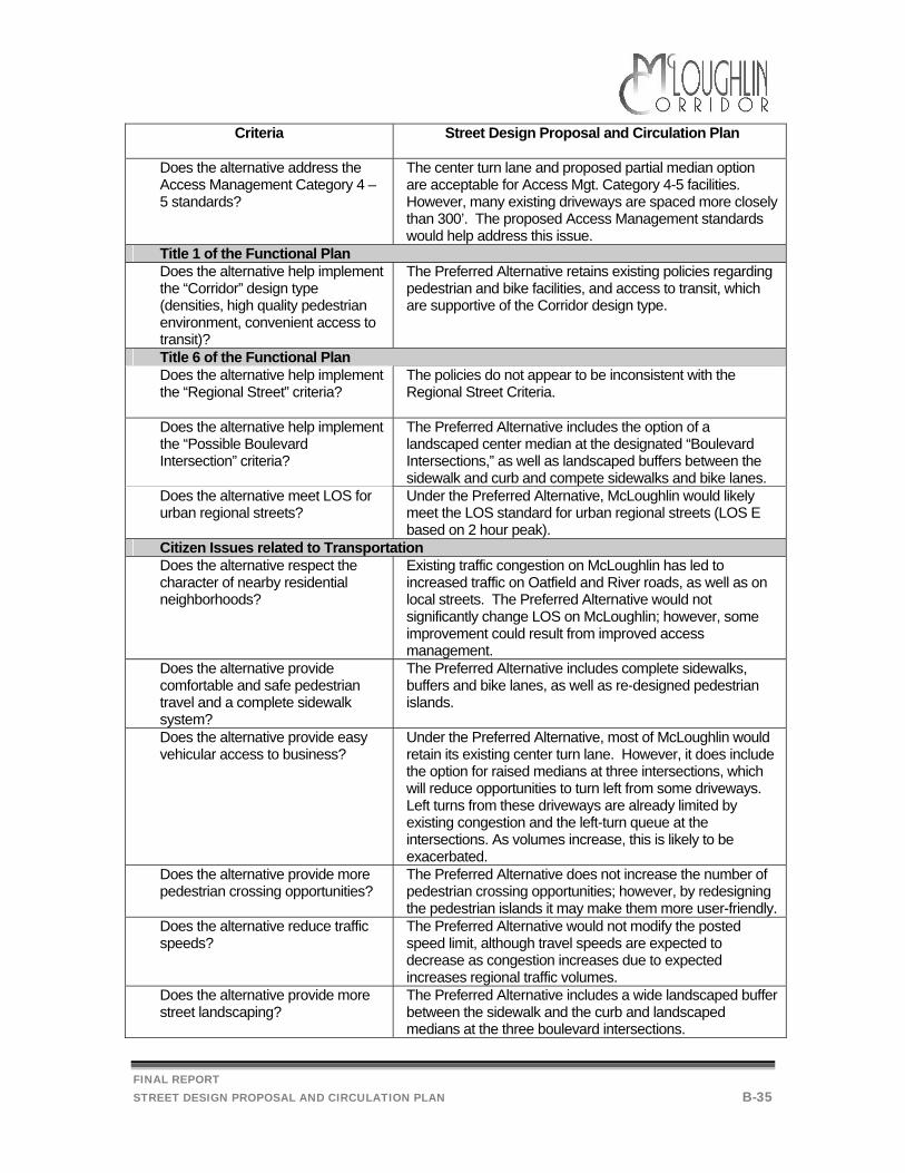
FINAL REPORT STREET DESIGN PROPOSAL AND CIRCULATION PLAN B-35
Criteria Street Design Proposal and Circulation Plan
Does the alternative address the Access Management Category 4 – 5 standards?
The center turn lane and proposed partial median option are acceptable for Access Mgt. Category 4-5 facilities. However, many existing driveways are spaced more closely than 300’. The proposed Access Management standards would help address this issue.
Title 1 of the Functional Plan Does the alternative help implement the “Corridor” design type (densities, high quality pedestrian environment, convenient access to transit)?
The Preferred Alternative retains existing policies regarding pedestrian and bike facilities, and access to transit, which are supportive of the Corridor design type.
Title 6 of the Functional Plan Does the alternative help implement the “Regional Street” criteria?
The policies do not appear to be inconsistent with the Regional Street Criteria.
Does the alternative help implement the “Possible Boulevard Intersection” criteria?
The Preferred Alternative includes the option of a landscaped center median at the designated “Boulevard Intersections,” as well as landscaped buffers between the sidewalk and curb and compete sidewalks and bike lanes.
Does the alternative meet LOS for urban regional streets?
Under the Preferred Alternative, McLoughlin would likely meet the LOS standard for urban regional streets (LOS E based on 2 hour peak).
Citizen Issues related to Transportation Does the alternative respect the character of nearby residential neighborhoods?
Existing traffic congestion on McLoughlin has led to increased traffic on Oatfield and River roads, as well as on local streets. The Preferred Alternative would not significantly change LOS on McLoughlin; however, some improvement could result from improved access management.
Does the alternative provide comfortable and safe pedestrian travel and a complete sidewalk system?
The Preferred Alternative includes complete sidewalks, buffers and bike lanes, as well as re-designed pedestrian islands.
Does the alternative provide easy vehicular access to business?
Under the Preferred Alternative, most of McLoughlin would retain its existing center turn lane. However, it does include the option for raised medians at three intersections, which will reduce opportunities to turn left from some driveways. Left turns from these driveways are already limited by existing congestion and the left-turn queue at the intersections. As volumes increase, this is likely to be exacerbated.
Does the alternative provide more pedestrian crossing opportunities?
The Preferred Alternative does not increase the number of pedestrian crossing opportunities; however, by redesigning the pedestrian islands it may make them more user-friendly.
Does the alternative reduce traffic speeds?
The Preferred Alternative would not modify the posted speed limit, although travel speeds are expected to decrease as congestion increases due to expected increases regional traffic volumes.
Does the alternative provide more street landscaping?
The Preferred Alternative includes a wide landscaped buffer between the sidewalk and the curb and landscaped medians at the three boulevard intersections.
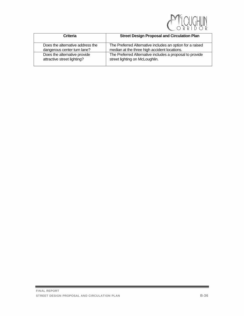
FINAL REPORT STREET DESIGN PROPOSAL AND CIRCULATION PLAN B-36
Criteria Street Design Proposal and Circulation Plan
Does the alternative address the dangerous center turn lane?
The Preferred Alternative includes an option for a raised median at the three high accident locations.
Does the alternative provide attractive street lighting?
The Preferred Alternative includes a proposal to provide street lighting on McLoughlin.

FINAL REPORT ZONING PROPOSAL C-1
Current Land Use Policies
Recommendations
Following are the final recommendations for land use policy within the McLoughlin corridor. The rationale for these recommendations is discussed in detail in the “Discussion and Analysis” section.
Retain existing zoning with no changes to current land use policies and regulations.
Continued implementation of transit-oriented development standards. Discussion and Analysis
The recommendation generally represents Land Use Alternative 1, the “Existing Land Use Regulations” Alternative (see Workbook No. 2). It assumes that there will be no changes to the current land use policies and regulations. Existing Comprehensive Plan and implementing ordinances will remain in effect. As shown in the Existing Zoning Map (Workbook 1, Figure B-2.1), zoning immediately along McLoughlin Blvd. would remain General Commercial, which would continue to allow a wide range of uses (see Workbook 1, Appendix A). Over the 20-year planning period it is assumed that property values would continue to increase at present trends; therefore, redevelopment and intensification of uses will continue to occur incrementally. As areas near bus stops redevelop, the regulations regarding transit-oriented development will be applied; thus, the pedestrian and transit environment along McLoughlin is expected to become somewhat improved. Metro Title 1 Compliance
Metro has established household and employment targets for all jurisdictions. The Metro targets for unincorporated Clackamas County are 19,530 new households and 42,685 new jobs. According to the requirements of Title 1, Clackamas County must amend it Comprehensive Plan and implementing ordinances to accommodate these targets. If proportionate shares9 of these targets are allocated to the Tier 1 Study Area, the approximate targeted increase of households between 1994 and 2017 will be approximately 277 dwelling units and approximately 1,583 new employees.
FINAL REPORT ZONING PROPOSAL C-2
Within the study area, the 2017 capacity analysis demonstrates that the area has the capacity to provide for sufficient dwelling units (within the 10% ‘substantial compliance’ margin)10. The potential for providing sufficient opportunity for employment in this area, however, is not as straight forward. The potential capacity was estimated using three different sets of assumptions: a market-based demand projection, a 2017 Capacity Estimate using conservative square foot per employee factors and a Maximum Capacity without Market Limitations estimate. Hobson Johnson prepared a demand analysis for Workbook No. 2 that estimates there will be a demand for 587 new retail jobs along the McLoughlin Corridor (see Economic Analysis, Workbook No. 2). This analysis does not account for the demand for industrial jobs or the potential for jobs in residential areas. The potential demand for jobs along the corridor is significantly less than amount employment targeted by Metro (by approximately 996 jobs). The initial estimate of the capacity of the existing zoning to allow for the creation of new jobs along the corridor, completed as a part of Workbook 2, indicated that the area would be short of Metro target by approximately 687 jobs. Revisions to the 2017 capacity methodology have refined that estimate to a shortfall of approximately 246 jobs. The 2017 Capacity Estimate reflects a development scenario that may be likely to occur considering the present market dynamics of the McLoughlin Corridor. This scenario assumes that current trends and types of development will continue given the corridor’s lack of access to a major freeway.
Base Assumptions for Employment 2017 Capacity Estimate:
• 2.5% of the new jobs in the corridor will be located in residential zones (e.g. jobs in apartment complexes, schools, churches, home occupations, etc.)
• Commercial development will occur at an average of 650 sq ft per employee • Industrial development will occur at an average of 1000 sq ft per employee • 20% of the jobs will be accommodated by infill on developed property • 7.5% of the new jobs will be accommodated within exist buildings.
Finally, a Potential Capacity estimate without Market Limitations was completed. This analysis estimated the number of new jobs that could be accommodated by the zoning, without regard for the market dynamics along the McLoughlin Corridor. Specifically, since the existing C3 zone does not restrict the height of a building, it could be stated that the McLoughlin Corridor has the ‘capacity’ for a total of 1,722 new jobs between 1994 and 2017, assuming that the vacant and redevelopable land is built with 2 story development, at 450 square feet per employee (e.g., office
9 Proportionate share based on the Transportation Analysis Zone and grid distributions provided by Metro. 10 See Work book 2 for detail analysis

FINAL REPORT ZONING PROPOSAL C-3
type development). This estimate also assumes that 20% of the new employees will be accommodated on properties currently considered built, for example, new restaurants in the parking lots of existing development. Under this scenario, McLoughlin Corridor would exceed the Metro target by 139 jobs. In summary, it does not appear that the existing zoning along the corridor is the limiting factor, but rather it is the availability of vacant land and market dynamics within the Corridor which hinder its potential for meeting the 2017 employment targets. At this time, rezoning of the portions of the McLoughlin Corridor to office or a strictly mixed use zone could possibly deter growth, which may lead to blight (see Workbook 2, Economic Analysis). Since office and mixed uses are permitted under the C3 zoning, the continued application of this zone will allow for uses envisioned by the Corridor designation, while also providing the opportunity for new jobs in the area. Transit-Oriented Development Standards
As stated in Workbook No. 3, McLoughlin Blvd. is designated a Major Transit Street. The State Transportation Planning Rule (TPR) requires that new retail, office or institutional buildings at or near existing or planned transit stops are to provide preferential access to transit by orienting building entrances to the transit stop or station and by locating buildings as close as possible to transit stops. In order to implement this TPR requirement, Clackamas County has defined the phrase “at or near” as areas or “boxes” which exist where a transit stop is within 250 feet of an intersection along a Major Transit Street. The shape of the “box” runs 250 feet along the Major Transit Street in both directions from the intersection, and along the intersecting street back to the depth of the commercial zoning. The “boxes” are mapped on Figure B-2 of Workbook No. 2. The standard of “as close as possible” is implemented by establishing a maximum front yard setback of 20 feet within a “box”. The Draft Design Guidelines Handbook, A Developer’s Guide to Implementing the Transportation Planning Rule in Clackamas County illustrates how these standards are to be implemented and is included in Appendix B of Workbook No. 2. Under the PMT’s recommendation, these guidelines and adopted provisions in the zoning ordinance would remain. Because they affect only new development, change on the ground would occur incrementally.
FINAL REPORT ZONING PROPOSAL C-4
Parking Requirements
Recommendation
Following is the final recommendation for on-street parking requirements within the McLoughlin corridor. The rationale for this recommendation is discussed in detail in the “Discussion and Analysis” section.
Continued implementation of the existing loading and parking requirements of the Zoning and Development Ordinance.
Discussion and Analysis
The existing Clackamas County Zoning and Development Ordinance (ZDO) requires that new development provide sufficient off-street parking and it sets standards for how much parking should be provided by each type of business. Concerns have been raised by the Work Group and by the general public that auto dealerships are not required to provide sufficient off-street parking, and are dependent upon on-street parking to meet their parking needs. Further research was conducted by Clackamas County to determine if the Zoning Development Ordinance should be amended to require more area for customer parking. Currently, the auto sales establishments are required to provide one space per 500 square feet of floor area. In some instances, auto sales establishments may have relatively small buildings in relationship to the number of employees and customers they attract. In these cases, a standard based on total site area may create more off street parking spaces. The City of Gresham, for instance, uses the following standard for truck, trailer, boat, auto rental or sales – minimum: 1.0 space per 1,000 square feet of site area – maximum: 1.3 spaces per 1,000 square feet of site area. What was found along McLoughlin Blvd, is that in most cases, sufficient off-street parking for employees and customers may have been provided, but is currently taken up with other uses. The property owners have chosen to use the space for inventory instead of for its required purpose. At this time, it is difficult to assess if requiring more on-site parking will be necessary to address the problem, since one of the recommendations is to prohibit on-street parking. When the option of customer parking on the street has been removed, the businesses could be encouraged to return the designated employee and customer off-street parking spaces to their originally intended purpose.
FINAL REPORT ZONING PROPOSAL C-5
Connections between Parking Lots
Recommendation
Following is the final recommendation for parking lot connectivity policy within the McLoughlin corridor. The rationale for this recommendation is discussed in detail in the “Discussion and Analysis” section.
Revise the Zoning Development Ordinance to better encourage connections between
parking lots. Discussion and Analysis:
Currently, shoppers wishing to make multiple stops along McLoughlin generally must exit each individual parking lot, travel down the arterial, and then turn into the next parking lot, even if the parking lots are immediately adjacent. This increase the number of vehicles on the arterial and the number of turning movements generated by that traffic. In order to improve parking lot connectivity, the County should include the following language in Section 1007 of the Zoning and Development Ordinance: “Parking lot connections to adjacent properties may be required to reduce traffic impacts on McLoughlin.”
FINAL REPORT ZONING PROPOSAL C-6
Sign Ordinance Issues
Recommendations:
Following is the final recommendation for sign ordinance implementation within the McLoughlin corridor. The rationale for these recommendations is discussed in detail in the “Discussion and Analysis” section.
More effectively enforce the existing sign ordinance.
Discussion and Analysis:
The existing sign regulations are included in their entirety in Appendix C of Workbook No. 2. Signs visible from State Highways would continue to be subject to approval by the Oregon State Highway Division pursuant to the Motorist Information Act. The County’s sign ordinance as it applies to multifamily, commercial or industrial development would continue to require the display of street number(s) for the development on the sign or building where it can be seen from adjacent roads and meet fire district standards. Unless otherwise specified, all signs would be subject to the yard setback requirements of the districts in which they are located (NOTE: in C-3 the minimum front yard setback is 15 feet. This is measured from the property line). Many temporary and portable signs would be prohibited. Unless otherwise provided for by design review, only one sign would be allowed for a development or complex, even when more than one tax lot or ownership is included in the development. Further, only three flags would continue to be allowed per site and these would be located on one pole. The sign ordinance is currently enforced by the Clackamas County Community Environment Department. Enforcement is complaint-driven (in other words, a citizen complaint initiates the process). Eight inspectors are currently working on approximately 2,400 violations. The violations range from solid waste to mechanical/electrical codes to junk vehicles to sign ordinance violations. Presently, the Department's priority is to address those violations that are health and safety-related first, with sign violations receiving a lower priority. Implementation of the sign ordinance will take continued dedication and perseverance. Previous sign enforcement experiences reveal that property owners are generally willing to comply with the regulations if they felt the rules were being applied consistently. Enforcement entails becoming familiar with each property and photographing the progress. After the property owners with violations are contacted, follow-up is essential. In addition, continued monitoring will be needed
FINAL REPORT ZONING PROPOSAL C-7
to keep the illegal signs off the street. Last year there where approximately 25-30 complaints regarding signs, which may have involved up to 500 property owners or signs. Often one complaint will target a whole road, such as someone complaining about all the signs on McLoughlin Blvd. In the past some complaints have been sent to mediation, which can be effective. Due to limited to financial and personnel resources, direction from the Board of Commissioners would be necessary to change the enforcement priorities of the Community Environment Department.
FINAL REPORT ZONING PROPOSAL C-8
Land Use Evaluation Criteria
The evaluation criteria below were originally included in Workbook 2 to provide a consistent basis for the comparative analysis of the alternatives. In this section, they are provided to help evaluate the final preferred alternative. The criteria are based on the following:
Project objectives (Workbook 2 Section B, page 1) Policy requirements of the project (Workbook 1, Section B-1) Previous workshop discussions (Workbook 1 Follow up, page 2) Open house comments (Workbook 2, Section A).
While including many of the main points from the workshop and open house, the project team attempted to avoid value judgements in the selection of the criteria. As such, some of the criteria may conflict with other criteria.
The land use criteria are divided into five general topic areas that cover the policy requirements of the project, previous workshop discussions and open house comments. Topic areas for the criteria are:
Title 1—This includes criteria related to applicable land use requirements of Metro’s Urban Growth Management Functional Plan Title 1, which is designed to minimize increases in the urban growth boundary by making more efficient use of land within it through zoning changes. Details about Title 1 are included in Workbook #1 section B, page 9.
Comprehensive Plan—Clackamas County’s Comprehensive Plan cites land use goals
applicable to this project in the areas of natural resource protection, residential development, commercial development, and energy efficiency. Details about the Comprehensive Plan are included in Workbook #1 section B, beginning on page 17.
Economic Impacts—The criteria in this topic area address what would happen to
various types of jobs and employment under each alternative. The criteria are based on the project’s economic analysis and public concerns raised at the workshop and open house. Additional economic analysis is included in Workbook 1, Section B-4 and Workbook 2, Appendix D.
FINAL REPORT ZONING PROPOSAL C-9
Transportation Impacts—The criteria in this section deal generally with the land use effects on the transportation system. In this topic area, it is particularly important to evaluate the land use alternative in combination with the transportation options.
Additional citizen issues—Through the previous workshop and the open house, the project team received numerous comments and concerns. Most of these are covered in other topic areas. The criteria in this topic area represent the most frequent comments not covered in other topic areas.
Table C-1
Land Use Criteria Matrix, Year 2017
Criteria
Zoning Proposal
Clackamas County’s Comprehensive Plan Goals Does the alternative protect the character of existing low density neighborhoods?
The Preferred Alternative would retain existing zoning. Existing residential zoning allows some home occupations and conditional uses.
Does the alternative provide a variety of living environments?
The existing zoning provides for a mix of residential development types – single family, multi-family, mixed-use, senior, etc.
Does the alternative provide for efficient use of land and public facilities, including greater use of public transit?
Existing zoning would allow for denser, transit-supportive development. Existing design guidelines would improve transit-orientation of new development.
Does the alternative provide opportunities for a wide range of commercial activities?
Existing General Commercial zoning allows for the widest range of commercial activities.
Does the alternative provide attractive areas for mixed uses, including clean, employment intensive industrial and office uses integrated with housing?
Existing General Commercial zoning allows for mixed-use development including multi-family housing and office. However, employment intensive uses are not required and the market has been for low employment density retail development.
Does the alternative encourage convenient, compact shopping areas offering a wide range of services and goods?
Existing General Commercial zoning would allow, but does not necessarily encourage the development of compact shopping areas.
Economic Impacts Does the alternative have a positive economic impact on existing uses in the corridor?
Current trends would continue or respond to changes in the market. (See Workbook 3, Appendix A)
Does the alternative have a positive economic impact on future retail development in the corridor?
Current trends would continue with retail uses likely to continue to dominate the corridor. (See Workbook 3, Appendix A)
FINAL REPORT ZONING PROPOSAL C-10
Criteria
Zoning Proposal
Does the alternative have a positive economic impact on future office development in the corridor?
Current trends would continue with some Class B office developing on sites generally less well-suited for retail. (See Workbook 3, Appendix A)
Does the alternative have a positive impact on when retail uses are likely to develop/redevelop?
Current trends would continue with retail development and re-development happening incrementally. (See Workbook 3, Appendix A)
Does the alternative have a positive impact on when office uses are likely to develop/redevelop?
Current trends would continue with office development and re-development happening incrementally. (See Workbook 3, Appendix A)
Does the alternative provide sufficient land for market choices?
The existing zoning provides for the widest range of uses with very few size restrictions. However, the corridor has very few large vacant parcels left that would well-suited to large-scale retail and similar uses. (See Workbook 3, Appendix A)
Transportation Impacts of the Land Use Proposal Does the alternative have a positive effect on PM Peak Hour Intersection Level of Service as measured against Alternative 1, Existing Land Use Regulations?
Under the Preferred Alternative, LOS is expected to decrease from the current LOS B-C to C-F at the various signalized intersections on McLoughlin.
Does the alternative support alternative modes of transportation (bike/ped/transit)?
Existing zoning would allow for denser, transit-supportive development; however, the existing development pattern is low density and auto-oriented. Existing design guidelines would improve transit-orientation of new development.
Title 1 of the Functional Plan Does the alternative implement the “Corridor” design type (densities, high quality pedestrian environment, convenient access to transit)?
The existing zoning does not preclude the 25 persons/ac. “corridor” density. However it does not require it. Existing policies, if implemented, could create a quality pedestrian environment with convenient access to transit.
Does the alternative help achieve the employment target (1,587 new jobs in Tier 1 by 2017)?
The existing zoning does not preclude the accomplishment of the employment targets but it does not require any minimum FAR or employment densities.
Does the alternative help achieve the housing target (264 new dwelling units in Tier 1 by 2017)?
The existing zoning does not preclude the accomplishment of the residential targets.
FINAL REPORT ZONING PROPOSAL C-11
Criteria
Zoning Proposal
Citizen Issues related to Land Use Does the alternative provide employment to support density increases?
The Preferred Alternative includes no residential density increases; the existing zoning does allow for a wide range of uses within the corridor including employment-intensive uses such as commercial and industrial.
Does the alternative retain the existing mix of uses and linear land use pattern?
The Preferred Alternative would retain the existing zoning. The specific uses and land use patterns may evolve over time as land re-develops, particularly as the Major Transit Street guidelines are implemented.
Does the alternative provide convenient vehicular access to destinations?
Existing development is auto-oriented and provides convenient parking in front of most buildings and under the Preferred Alternative most of McLoughlin would retain its existing center turn lane. However, it does include optional raised medians at three intersections, which will reduce opportunities to turn left from some driveways. Left turns from these driveways are already limited by existing congestion and the left turn queue at the intersections, and as volumes increase this is likely to be exacerbated. Increased parking lot connectivity will increase convenient vehicular access to adjoining destinations.
Does the alternative improve the overall appearance of McLoughlin?
The Preferred Alternative includes opportunities for increased landscaping, consistent sidewalks and bike lanes and improved implementation of the sign ordinance.
Does the alternative provide protection from business encroachment into adjacent neighborhoods?
Existing zoning, which allows some home occupations and conditional uses in residential zones, would be retained.
Does the alternative preserve/respect the overall character of adjacent neighborhoods?
Existing zoning map boundaries would be retained. No policy changes would be adopted as part of this project; however, the community would continue to evolve over time.
Does the alternative provide pedestrian amenities (lighting, benches, signs)?
The Preferred Alternative includes complete and consistent sidewalks, a landscaped buffer between the sidewalk and the curb, re-designed pedestrian islands, optional landscaped medians at the boulevard intersections, and street lighting.
FINAL REPORT IMPLEMENTATION STRATEGIES D-1
Introduction
The Implementation Strategies presented in the following section are intended to address the steps necessary to move forward with the policies and projects described in the final recommendation. The implementation strategies for the recommendations are organized into five categories: Implementing the Street Design Proposal This section addresses implementation strategies
for improving pedestrian facilities and bike lanes, redesigning the pedestrian islands, and further analyzing the boulevard intersections as recommended in the final preferred alternative.
Implementing On-Street Parking Restrictions This section addresses opportunities and issues associated with implementing the recommendation to eliminate on-street parking on McLoughlin Blvd.
Implementing Street Lighting This section includes costs and funding strategies to implement the recommendation to provide complete and consistent street lighting on McLoughlin Blvd.
Implementing Transit Improvements This section includes implementation strategies intended to take advantage of the opportunities presented by Tri-Met’s recent efforts to develop improved transit service in the McLoughlin corridor.
Transportation Funding Options This section summarizes the various funding programs available and addresses the suitability of those sources for funding the recommended improvements.
Implementing the Zoning Proposal This section addresses implementation strategies for improving parking lot connectivity and sign ordinance implementation.
FINAL REPORT IMPLEMENTATION STRATEGIES D-2
It should be noted that not all of the recommendations have resulted in implementation strategies. A number of issues were raised, evaluated and discussed as part of the alternatives analysis and draft preferred alternative analysis. In some cases it was found that it would be contrary to the public interest, ineffective or counter-productive to recommend a particular alternative. In these cases the final recommendation has been to retain and implement the existing policies and programs and no implementation strategy is necessary.
FINAL REPORT IMPLEMENTATION STRATEGIES D-3
Implementing the Street Design Proposal
There are five key components to implementing the street design proposal:
• Policy Changes • Pedestrian Facility Improvements (including sidewalks, landscaped
buffer and curb and gutter), • Bike Lane Improvements, • Redesigned Pedestrian Islands, • Advanced Warning Signage • Further Analysis of Boulevard Intersections.
In the following section each of these components is discussed in detail. Planning level cost estimates are provided where applicable. These cost estimates are very preliminary in nature and are provided only to establish an “order of magnitude” in terms of project cost. Potential funding sources and funding issues are also addressed as well as project timing. Policy Changes
In order to begin implementing the street design recommendations, the County should adopt the recommended cross-sections (Figure B-1) and supporting text into the Urban Transportation System Plan (TSP). The Urban TSP is proposed to be adopted by reference into the Clackamas County Comprehensive Plan. Including the McLoughlin cross-sections in the Urban TSP will provide a foundation for future improvements consistent with the recommendations of this study. The McLoughlin Blvd. TSP cross-sections would be utilized by the County in the same fashion as the standard cross-sections that are included in the TSP. For example, cross-sections in the TSP provide a guideline for project design and for development review. Policies and standards should also be adopted in the TSP which would allow an incremental decrease in the width of the cross-section based on topographic constraints to achieve the maximum reduction as shown in the Constrained Cross-section (see Figure B-1). Reductions in the width of the cross-section should be the minimum necessary and should be allowed only where topography or other physical constraints make use of the standard cross-section infeasible. Determination of topographic constraints should be based on measurable criteria such as the height of the required retaining wall or the amount of cut and fill.
FINAL REPORT IMPLEMENTATION STRATEGIES D-4
Establish an intergovernmental agreement between ODOT and Clackamas County regarding landscape maintenance.
Amend the Clackamas County Zoning and Development Ordinance as follows to require a
landscaped buffer between the curb and sidewalk on McLoughlin Blvd.:
[Add underlined section to Ordinance]
1009.03 General Provisions (E) Street-side landscaping within the right-of-way shall be required when there are no immediate plans to develop or otherwise disturb the portion of the right of way between the road and the property line, and one of the following applies:
1. Street trees are to be provided, under provisions of subsection 1009.09. 2. Landscaping is necessary to present an appearance consistent with the
proposed development as viewed from the road. (8-31-81) 3. Landscaping is necessary to reduce dust, noise, erosion, or fire hazard. 4. The road is designated as a scenic road in the Comprehensive Plan. 5. The street design standards for the road, as described in the Transportation
System Plan, include a landscaped buffer between the curb and the sidewalk.
Amend the Clackamas County Roadway Standards as follows: • Include the McLoughlin Corridor cross-sections, • Revise Section 240.1 (Curbs and Sidewalks) and 240.5 (Clear Zone Criteria) to clarify
that pursuant to the Transportation System Plan, a landscaped buffer is a standard feature on selected streets (e.g., McLoughlin Blvd.).
ODOT has an ongoing responsibility to maintain, preserve and improve McLoughlin Blvd. This responsibility is partially realized through participation with local jurisdictions, in which state facilities are located, in the preparation of Transportation System Plans, Corridor Plans, and Refinement Plans. In order to assure that the recommendations of this study are taken into consideration in future projects, ODOT should endorse the recommendations of this Study to the Board of County Commissioners. Additionally, ODOT should seek endorsement of the final recommendations of the McLoughlin Land Use and Transportation Study from the Oregon Transportation Commission through its process for the review and adoption of Corridor Plans.
FINAL REPORT IMPLEMENTATION STRATEGIES D-5
Pedestrian Facility Improvements (including sidewalks, landscaped buffer, curb and gutter)
The recommended street design includes the following pedestrian facility improvements:
Continuous eight-foot wide sidewalks on both sides of McLoughlin Blvd. the length of the study area.
A ten-foot wide landscaped buffer between the curb and the sidewalk on both sides of
McLoughlin Blvd., for most of the length of the study area. As shown in Figure B-1, the landscaped buffer would be narrower (six feet) at those intersections with pedestrian islands and would not be required in some locations to allow for right turn lanes.
Curbs and gutters on both sides of McLoughlin Blvd. the length of the study area, either
adjacent to the buffer or adjacent to the sidewalk.
Planning Level Cost Estimates
The following cost estimates are very preliminary in nature and provided only to establish an “order of magnitude” in terms of project cost. As with any project of this size and nature, there are many variables and unknowns. Detailed and accurate cost estimates should be prepared as part of the preliminary engineering process. The study area, from the south Milwaukie city limits (mile post 6.54) to the north Gladstone city limits (mile post 10.51) is 3.91 miles (20,645 feet). Within the study area, McLoughlin Blvd. currently has intermittent sidewalks of varying widths and locations within the right-of-way. It is estimated that less than ten percent of the existing sidewalk facilities would meet the proposed cross-section standards in terms of width and/or location. Additionally, sidewalks are not needed at side street crossings. Therefore, the planning level cost estimates are based on a ninety percent replacement of existing sidewalk facilities or approximately 37,000 feet. Similarly, buffers would be narrower (six feet) within approximately two hundred feet of the four intersections with pedestrian islands and would not be required within two hundred feet of the seven intersections with right-turn lanes (approach sides only). In those areas where topographic constraints prevent the installation of a landscaped buffer between the sidewalk and the curb, landscaping of the slope would be required; in order to account for the cost of this landscaping, these areas have not be removed from the estimate. Therefore, the planning level cost are based on landscaped buffers being installed along approximately eighty percent of the length of McLoughlin Blvd. within the study area or approximately 33,000 feet.
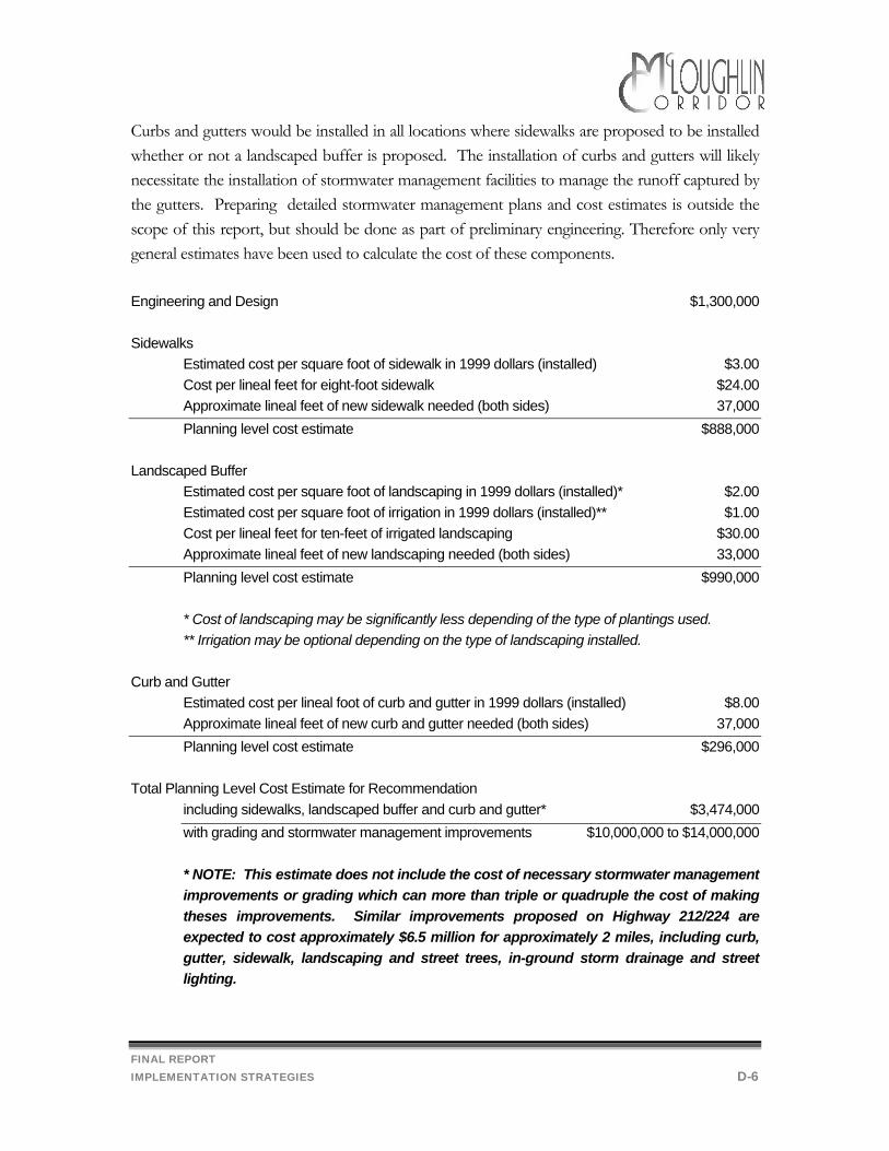
FINAL REPORT IMPLEMENTATION STRATEGIES D-6
Curbs and gutters would be installed in all locations where sidewalks are proposed to be installed whether or not a landscaped buffer is proposed. The installation of curbs and gutters will likely necessitate the installation of stormwater management facilities to manage the runoff captured by the gutters. Preparing detailed stormwater management plans and cost estimates is outside the scope of this report, but should be done as part of preliminary engineering. Therefore only very general estimates have been used to calculate the cost of these components. Engineering and Design $1,300,000 Sidewalks Estimated cost per square foot of sidewalk in 1999 dollars (installed) $3.00 Cost per lineal feet for eight-foot sidewalk $24.00 Approximate lineal feet of new sidewalk needed (both sides) 37,000 Planning level cost estimate $888,000 Landscaped Buffer Estimated cost per square foot of landscaping in 1999 dollars (installed)* $2.00 Estimated cost per square foot of irrigation in 1999 dollars (installed)** $1.00 Cost per lineal feet for ten-feet of irrigated landscaping $30.00 Approximate lineal feet of new landscaping needed (both sides) 33,000 Planning level cost estimate $990,000
* Cost of landscaping may be significantly less depending of the type of plantings used. ** Irrigation may be optional depending on the type of landscaping installed.
Curb and Gutter Estimated cost per lineal foot of curb and gutter in 1999 dollars (installed) $8.00 Approximate lineal feet of new curb and gutter needed (both sides) 37,000 Planning level cost estimate $296,000 Total Planning Level Cost Estimate for Recommendation
including sidewalks, landscaped buffer and curb and gutter* $3,474,000 with grading and stormwater management improvements $10,000,000 to $14,000,000 * NOTE: This estimate does not include the cost of necessary stormwater management improvements or grading which can more than triple or quadruple the cost of making theses improvements. Similar improvements proposed on Highway 212/224 are expected to cost approximately $6.5 million for approximately 2 miles, including curb, gutter, sidewalk, landscaping and street trees, in-ground storm drainage and street lighting.
FINAL REPORT IMPLEMENTATION STRATEGIES D-7
Funding
There are two general approaches to funding the proposed pedestrian facility improvements:
Incremental improvements where the cost to improve pedestrian facilities is proposed to be borne by the developer at the time of development or redevelopment. This is the approach that is currently being implemented. It would not require any additional investment by ODOT or the County; however, pedestrian facilities would continue to be installed incrementally and it may be many years before a complete, consistent and continuous pedestrian circulation system is in place.
Systematic improvements where the cost to improve all or part of the pedestrian facilities is
proposed to be borne by ODOT, the County and/or others as part of an overall improvement program. An overview of the programs available is provided in the section entitle Funding Options. Additionally, there may be funding opportunities for pedestrian improvements completed in conjunction with the transit improvements proposed by Tri-Met. All transit riders are pedestrians for a portion of their trip and improved and accessible sidewalks may be a necessary precursor to installing improved transit shelters.
Landscape Maintenance
A major implementation issue associated with the proposed street design is landscape maintenance. Most public agencies lack the funding and allocate labor with a low priority to maintain planter strips and planted medians with any regularity. A key issue in establishing an attractive landscape is that for the first year of establishment, regular, deep watering is essential for trees and shrubbery to grow. Volunteer tree planting organizations, such as Friends of Trees, ask adjacent property owners or tenants to sign a pledge to maintain the tree and to provide a minimum level of care for at least two years. Without this type of commitment, the growth of a healthy, attractive planting may be compromised. While state law precludes the state from requiring adjacent property owners to maintain landscaping within the right-of-way of facilities on the state system, the state can enter into an intergovernmental agreement (IGA) in which the state keeps ownership of the facility, but allows the jurisdiction to maintain the landscaping (an example of an IGA is provided in Appendix B). Alternatively, the state may cede ownership of the facility, with the local jurisdiction becoming the responsible party for maintaining the facility and the landscaping within the right-of-way. In either case, once the state agrees to let the local jurisdiction assume maintenance responsibility or ownership/maintenance responsibility, it's up to the jurisdiction how it accomplishes it. The local jurisdiction may take the responsibility upon itself, or it may require adjacent property owners to
FINAL REPORT IMPLEMENTATION STRATEGIES D-8
maintain the landscaping and sidewalks. In Clackamas County maintenance of the planting strip adjacent to a sidewalk has typically been the responsibility of the adjacent property owner. The Clackamas County Zoning and Development Ordinance, Section 1009 (Landscaping) requires that “appropriate methods of care and maintenance of landscaped plant materials shall be provided by the owner of the property”. In some locales, as a matter of community pride, neighborhood associations or business groups have organized volunteer committees to work on landscape maintenance projects to create a uniform landscape theme along a roadway. In some cases these groups have voted to charge themselves a fee that goes toward professional maintenance.
Bike Lane Improvements
The recommended street design includes continuous five to six foot wide bike lanes on both sides of McLoughlin Blvd., for most of the length of the study area. The recommended bike lane dimensions are as follows: Standard Arterial Cross-section 6 feet (both sides) Topographically Constrained Cross-section 6 feet (both sides) Standard Intersection without right turn lane 6 feet (both sides) Standard Intersection with right turn lane 6 feet (one side), 5 feet (one side) Optional Boulevard Intersection 5 feet (both sides) Pedestrian Island Intersection 6 feet (both sides) Planning Level Cost Estimates The study area, from the south Milwaukie city limits (mile post 6.54) to the north Gladstone city limits (mile post 10.51) is 3.91 miles (20,645 feet). Within the study area, McLoughlin Blvd. currently has intermittent bike lanes of varying widths and locations within the right-of-way. However if on-street parking were removed there would be paved right-of-way of sufficient width to allow for a bike lane as recommended along most of McLoughlin Blvd. If striping for bike lanes were done in conjunction with resurfacing, costs are expected to be relatively low, given that no additional right-of-way is required and existing pavement widths are sufficient along most of McLoughlin Blvd. However, implementation of this recommended improvement is dependent in some locations upon implementation of the recommendation to eliminate on-street parking.
FINAL REPORT IMPLEMENTATION STRATEGIES D-9
Funding
This project should be funded and implemented in conjunction with regularly scheduled resurfacing and maintenance by ODOT. Redesigned Pedestrian Islands
The recommended street design includes redesigning the four existing pedestrian islands to better accommodate pedestrian and vehicle circulation. As described in the final recommendations eight features have been included in the recommended redesign to increase the perceived safety (and desirability) of the existing islands (located at Risley, Vineyard, Boardman and Hull):
• Increasing the island width from six feet to eight feet • Installation of barrier curbs • Provision of one foot of “shy” distance between the travel lanes and both sides of the
island (striped) • Installation of island landscaping • Setting the islands back slightly from the intersection • Adjusting to alignment of the opposing left-turn bay to improve sight distance • Pedestrian-scale illumination and signage at the island to increase pedestrian and
driver visibility • Advanced pedestrian crossing warning signs for vehicle traffic
If an alternate intersection design would achieve similar or better safety characteristics for pedestrians and vehicles that design should be considered. Planning Level Cost Estimate
ODOT installed the original pedestrian islands in 1995 at an approximate cost of $3,000 per island. In addition to adjusting the cost for inflation the redesigned pedestrian islands would include additional features, as noted above. The redesigned islands at 8 feet wide and 100 feet long would be less than 800 square feet in area (with tapering) and would have a perimeter of approximately 200 feet. Preliminary cost estimates based on these rough estimates is provided below.
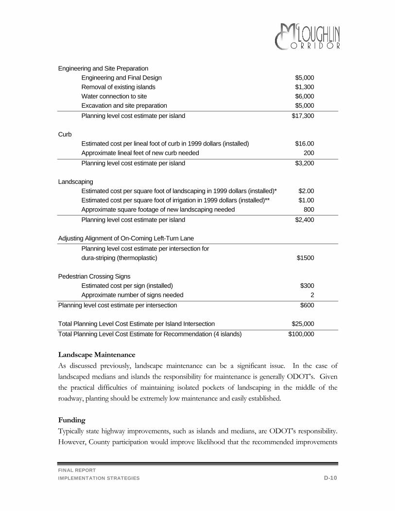
FINAL REPORT IMPLEMENTATION STRATEGIES D-10
Engineering and Site Preparation Engineering and Final Design $5,000 Removal of existing islands $1,300 Water connection to site $6,000 Excavation and site preparation $5,000 Planning level cost estimate per island $17,300 Curb Estimated cost per lineal foot of curb in 1999 dollars (installed) $16.00 Approximate lineal feet of new curb needed 200 Planning level cost estimate per island $3,200 Landscaping Estimated cost per square foot of landscaping in 1999 dollars (installed)* $2.00 Estimated cost per square foot of irrigation in 1999 dollars (installed)** $1.00 Approximate square footage of new landscaping needed 800 Planning level cost estimate per island $2,400 Adjusting Alignment of On-Coming Left-Turn Lane Planning level cost estimate per intersection for dura-striping (thermoplastic) $1500 Pedestrian Crossing Signs Estimated cost per sign (installed) $300 Approximate number of signs needed 2 Planning level cost estimate per intersection $600 Total Planning Level Cost Estimate per Island Intersection $25,000 Total Planning Level Cost Estimate for Recommendation (4 islands) $100,000
Landscape Maintenance
As discussed previously, landscape maintenance can be a significant issue. In the case of landscaped medians and islands the responsibility for maintenance is generally ODOT’s. Given the practical difficulties of maintaining isolated pockets of landscaping in the middle of the roadway, planting should be extremely low maintenance and easily established. Funding
Typically state highway improvements, such as islands and medians, are ODOT’s responsibility. However, County participation would improve likelihood that the recommended improvements
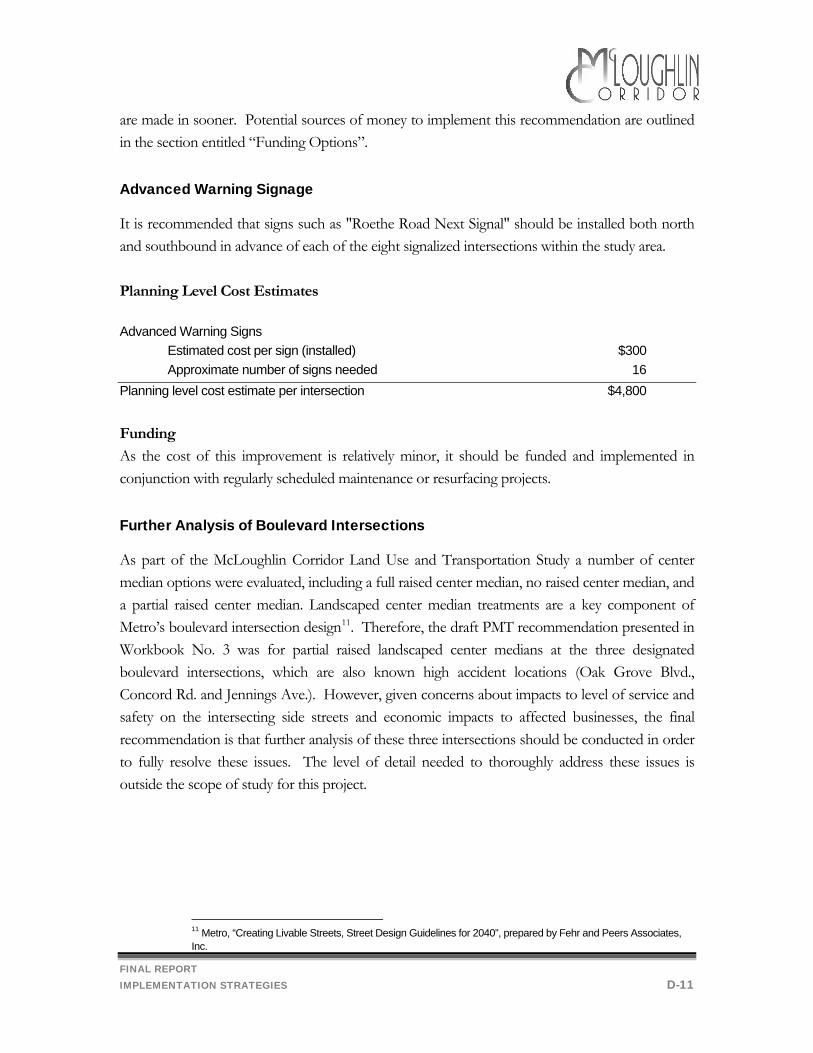
FINAL REPORT IMPLEMENTATION STRATEGIES D-11
are made in sooner. Potential sources of money to implement this recommendation are outlined in the section entitled “Funding Options”. Advanced Warning Signage
It is recommended that signs such as "Roethe Road Next Signal" should be installed both north and southbound in advance of each of the eight signalized intersections within the study area. Planning Level Cost Estimates Advanced Warning Signs Estimated cost per sign (installed) $300 Approximate number of signs needed 16 Planning level cost estimate per intersection $4,800 Funding
As the cost of this improvement is relatively minor, it should be funded and implemented in conjunction with regularly scheduled maintenance or resurfacing projects. Further Analysis of Boulevard Intersections
As part of the McLoughlin Corridor Land Use and Transportation Study a number of center median options were evaluated, including a full raised center median, no raised center median, and a partial raised center median. Landscaped center median treatments are a key component of Metro’s boulevard intersection design11. Therefore, the draft PMT recommendation presented in Workbook No. 3 was for partial raised landscaped center medians at the three designated boulevard intersections, which are also known high accident locations (Oak Grove Blvd., Concord Rd. and Jennings Ave.). However, given concerns about impacts to level of service and safety on the intersecting side streets and economic impacts to affected businesses, the final recommendation is that further analysis of these three intersections should be conducted in order to fully resolve these issues. The level of detail needed to thoroughly address these issues is outside the scope of study for this project.
11 Metro, “Creating Livable Streets, Street Design Guidelines for 2040”, prepared by Fehr and Peers Associates, Inc.
FINAL REPORT IMPLEMENTATION STRATEGIES D-12
A follow up analysis of these three intersections should include:
• Detailed review of existing accessways and easements, • Trip generation and travel patterns associated with individual businesses (driveway
traffic counts to determine trip generation and trip distribution patterns of existing businesses),
• Detailed review of accident history on McLoughlin within the influence of the intersections including time of day, weather, and other factors affecting travel to determine if other improvement (e.g., street lighting, no on-street parking, etc.) might improve intersection safety more effectively than medians,
• Detailed review of accident history on side streets to determine if there are any existing problems that would be exacerbated or, conversely, mitigated in conjunction with access improvements.
• Side street safety and level of service impacts resulting from redirected trips, including impacts on other nearby intersections (e.g., East Ave. at Oak Grove Blvd.),
• Develop alternative access plans, • Preliminary engineering to determine the appropriate length and width and design of
the median, including length of left-turn queue, U-turn potential and effect on intersection LOS, and
• Participation by affected property owners and interested McLoughlin Corridor Work Group members.
Completion of the detailed analysis described above is recommended before it is determined whether a landscaped center median is appropriate in these locations. It should be noted that proposed improvements to these designated “boulevard intersections” that are compliant with Metro’s street designs will receive additional consideration in the funding process. However, depending upon the results of the analysis, the County, together with ODOT, could request that Metro remove the “Possible Boulevard Intersection” designation from one or more of these intersections. Funding
A detailed analysis of these three intersections as described above should be conducted by ODOT. This may be done completed in conjunction with other proposed improvements or as a result of the Safety Priority Index System (SPIS) analysis. Other potential sources of funding for this analysis include ODOT's Corridor Planning Program and the State Transportation Improvement Program (STIP). In addition, as the Metropolitan Planning Organization for the

FINAL REPORT IMPLEMENTATION STRATEGIES D-13
Portland metropolitan area, Metro receives federal funds for planning which might be considered as a potential source of funding for a portion of such an analysis. Tri-Met might be another potential source of funding in conjunction with the proposed bus rapid transit project, and other efforts to improve the use of public transit along this key transportation corridor.
FINAL REPORT IMPLEMENTATION STRATEGIES D-14
Implementing On-Street Parking Restrictions
One of the most consistently supported recommendations of this study is the elimination of on-street parking on McLoughlin Blvd. The draft recommendation in Workbook 3 also included a related recommendation to allow an exception for businesses that were developed prior to the requirement that sufficient off-street parking be provided. This recommendation was received with mixed reviews. A number of people expressed concern that such an exception might be over-used. However, its utility is closely tied to how the on-street parking prohibition might be implemented on McLoughlin Blvd. In general there are four approaches to eliminating on-street parking on McLoughlin Blvd.
Option 1 ODOT to install and enforce “no parking” signs, Option 2 Eliminate on-street parking in conjunction with a systematic implementation
of the recommended street design by removing on-street parking spaces, or Option 3 Eliminate on-street parking in conjunction with the incremental
implementation of the recommended street design through development or redevelopment.
Option 4 A combination of Options 1, 2 and 3. Option 1
The first option, for ODOT to install “no parking signs”, could be implemented immediately and at relatively little cost. However, signs could only be installed where there are curbs and because the actual parking spaces would physically remain, the effectiveness of this option would rely heavily on police enforcement. Potentially this approach could create a hardship for some businesses and ODOT may wish to consider an exception for those businesses that predate the off-street parking requirements. Option 2
Under the second option, the existing on-street parking spaces would be superseded by wider sidewalks and a landscaped buffer. Thus, this option would not rely on police enforcement for its effectiveness. However, it is relatively expensive and would require more time to implement. This approach could also create a hardship for those businesses with insufficient off-street parking. Thus, the County and ODOT may wish to consider allowing property owners to request an exception to the on-street parking prohibition with the following limitations and restrictions:
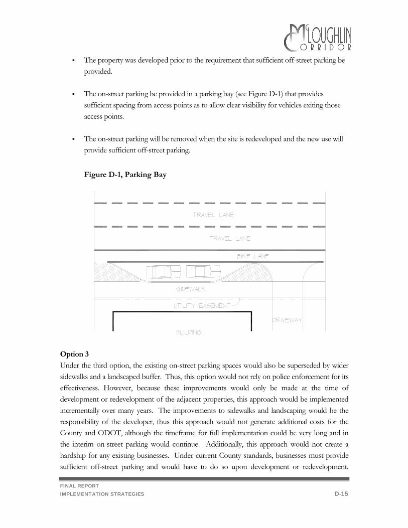
FINAL REPORT IMPLEMENTATION STRATEGIES D-15
The property was developed prior to the requirement that sufficient off-street parking be provided.
The on-street parking be provided in a parking bay (see Figure D-1) that provides
sufficient spacing from access points as to allow clear visibility for vehicles exiting those access points.
The on-street parking will be removed when the site is redeveloped and the new use will
provide sufficient off-street parking.
Figure D-1, Parking Bay
Option 3
Under the third option, the existing on-street parking spaces would also be superseded by wider sidewalks and a landscaped buffer. Thus, this option would not rely on police enforcement for its effectiveness. However, because these improvements would only be made at the time of development or redevelopment of the adjacent properties, this approach would be implemented incrementally over many years. The improvements to sidewalks and landscaping would be the responsibility of the developer, thus this approach would not generate additional costs for the County and ODOT, although the timeframe for full implementation could be very long and in the interim on-street parking would continue. Additionally, this approach would not create a hardship for any existing businesses. Under current County standards, businesses must provide sufficient off-street parking and would have to do so upon development or redevelopment.
FINAL REPORT IMPLEMENTATION STRATEGIES D-16
Thus, an exception to the on-street parking prohibition under this option would not be necessary or appropriate. Option 4
This option assumes that the ODOT and the County will implement a combination of Options 1, 2 and 3 as described above. Under this Option, McLoughlin Blvd. could be signed for “no parking”, and incrementally new development or redevelopment could begin to implement the recommended street design. Additionally, ODOT and the County could work together to seek funds to apply the new street design standards to selected sections of the highway in conjunction with other highway improvement projects. Similar to Option 1, this option could potentially create a hardship for businesses and an exception from the “no parking” signage may be appropriate in some locations. Additionally, ODOT and the County should work with affected property owners in determining the need for parking bays should funds be made available to apply the recommended street design to entire sections of the highway. Policy Changes
The recommended cross-sections for McLoughlin Blvd. do not include on-street parking on McLoughlin Blvd. By adopting these cross-sections into the Urban Transportation System Plan as recommended above, together with a policy recommending the elimination of on-street parking on McLoughlin Blvd., the County will establish a policy foundation for this recommendation, which would be appropriate under all of the implementation options described above.
The County and ODOT should coordinate with the cities of Milwaukie and Gladstone to
extend the no-parking restrictions further north and south along McLoughlin Blvd., as appropriate.
Planning Level Cost Estimate
Option 1 This option would require the installation of approximately 222 new “no parking” signs and 189 new posts at an approximate total cost of $18,000 to $20,000. The planning level cost estimates for Option 1 are based on the following assumptions:
150 foot sign spacing, 10% of signs already in place, 15% of the new signs could go on existing poles.
FINAL REPORT IMPLEMENTATION STRATEGIES D-17
Option 2 This option would be implemented at no additional cost as a result of the full implementation of the recommended street design.
Option 3 This option would be implemented at no additional cost as a result of the
incremental implementation of the recommended street design. Option 4 This option, similar to Option 1 would require the installation of “no parking” signs
at a total cost of $18,000 to $20,000. Additional implementation would occur at no additional cost as a result of a combination of both the full and incremental implementation of the recommended street design.
Funding
Typically state highway improvements, such as the purchase and installation of “no parking” signs, are ODOT’s responsibility. County encouragement would improve likelihood that the recommended improvements are made sooner. Potential sources of money to implement this recommendation are outlined in the section entitled “Funding Options”. Funding mechanisms for Options 2 and 3, which are based on implementation of the recommended street design, is addressed in the section entitled “Implementing the Street Design Proposal”.
FINAL REPORT IMPLEMENTATION STRATEGIES D-18
Implementing Street Lighting
The final preferred alternative includes a recommendation to provide continuous street lighting on both sides of McLoughlin Blvd. Planning Level Cost Estimate Two funding approaches were presented in the draft Preferred Alternative (see Workbook No. 3):
Option A: ODOT and Clackamas County fund only the estimated installation cost of approximately $600,000 and PGE provides and installs the lights. The $59,000 needed annually to pay for operations and maintenance and the amortized equipment costs is paid by property owners with frontage along McLoughlin Blvd. Annual cost to property owners is $1.75 per lineal foot of McLoughlin frontage.
Option B: ODOT and Clackamas County fund the estimated installation and equipment cost
of approximately $1.56 million as part of an overall streetscape improvement project. The $26,000 needed annually to pay for operations and maintenance is paid by property owners with frontage along McLoughlin Blvd. Annual cost to property owners is $0.77 per lineal foot of McLoughlin frontage.
In general there was support for Option A, which requires less money to up front and therefore might be more quickly initiated. Funding
Costs associated with street lighting break into three major areas. • Cost for installation of lights and poles. This is the cost of the pole and luminaire (lamp and
housing) and for its installation. Currently, most of the lighting that Service District No. 5 has is PGE Option A. Under this program, PGE owns and installs the pole and luminaire at no charge, and the District pays a higher operation and maintenance charge to offset these amortized installation costs but does not pay up-front installation charges. In the case of many of the Capital Improvement Projects for new or expanded roadways that the County builds with federal or urban renewal funds, the poles and luminaires and their installation is paid for by the project. In these instances (PGE Option B), the District is charged a significantly lower monthly operation and maintenance charge, since PGE does not have to recoup the pole and luminaire and installation costs. However, under Option B, at the end of the lifetime of the pole and luminaire, the District must have funds to replace them. Factoring in that some of the existing lights on McLoughlin would have to be replaced for a
FINAL REPORT IMPLEMENTATION STRATEGIES D-19
new uniform installation, a very rough estimate for installation of 175 lights and poles on McLoughlin would be $960,000 (roughly $5,500 per pole and luminaire).
• Cost for installation of circuitry. In addition to the cost of the poles and luminaires, there is a cost for installation of the circuitry to provide electricity to the lights; this includes trenching and conduit installation, splice box installation and may include a charge for installation of transformers. This cost is paid by the customer whether or not PGE owns and installs the poles. For 175 poles on McLoughlin, the rough estimate for this cost is $600,000.
• Cost for operation and maintenance of street lights. The annual charge for operation and maintenance of 175 lights under PGE Option A, in which PGE owns and installs the lights, currently would be $71,000. If the District purchased and installed the lights, the annual charge would be approximately $26,000.
• Total installation cost. For PGE owned and installed lights (PGE Option A), the rough estimate of the total installation charge would be $600,000 and the total installation charge would be $1.56 million if the County purchased and installed the lights. In addition, funds would be required to design the installation and co-ordinate with PGE's circuitry design if the County purchased and installed the lights.
• Revenue available for operation and maintenance. The current assessment mechanism that Service District No. 5 uses for street lighting could generate approximately $26,000 in revenue annually from properties with frontage on McLoughlin Boulevard for street light operation and maintenance. This would very closely match the PGE charges under PGE Option B but would generate a deficit under PGE Option A. Only properties with frontage on McLoughlin could be assessed, even though it can be argued that properties off of McLoughlin receive benefit from lighting on the major arterial serving their neighborhoods. Forming the assessment area to pay for this lighting will require a petition of the majority of property owners on McLoughlin Boulevard.
Design Options
• PGE has completed a sample preliminary design for installation of street lights on McLoughlin Boulevard from Oak Grove Boulevard to Concord Road. This design specifies 400 watt flat lens cobra street lights on 40 foot tall aluminum davit poles with a 6 or 8 foot arm placed two feet behind the curb at approximately 200 foot intervals on both sides of McLoughlin. This is a basic luminaire and pole and a standard design for lighting 4 to 6 travel lanes with sidewalk and bike lanes on a major arterial roadway. This design has been used to project the installation, operation and maintenance cost outlined above.
• Placing street light poles behind the sidewalk rather than between sidewalk and curb can, depending on other landscaping considerations, better illuminate the sidewalk. This design may sacrifice amount of light in the middle of the street at crossings and in the bicycle lane
FINAL REPORT IMPLEMENTATION STRATEGIES D-20
area, where the most immediate danger of lack of visibility of pedestrians stepping off the curb and into traffic occurs.
• Street plantings between curb and sidewalk or in a median strip can block pedestrian-side and street-side light depending on placement of light poles. Generally, poles placed in the planting strip, curb-side provide the best compromise illumination between sidewalk and travel lanes.
• Street lights are sometimes placed dually on standards in a center median strip. This can decrease installation cost due to fewer pole installations, but may reduce lighting on the sidewalk. Generally, street lights also have to be placed at curbside at intersections where curb lanes come into play and the median ends. Currently, Service District No. 5 does not use this type of installation.
• When considering boulevard treatments of arterial roadways, there is frequently a desire to use decorative luminaires and poles, or add extra illumination for pedestrians at the sidewalk. These considerations can be wide-ranging; there are many non-standard or custom lighting configurations available, at a price. Previous projects have produced estimates of 25%-50% higher costs for installation of custom lighting options and 25%-100% higher operating and maintenance costs for custom lighting options.
Although McLoughlin has many businesses with illuminated signs, security lighting or area lighting for parking lots that shed light to the street edge, these should not be considered street lighting. Good sign, security and area lighting should be positioned to illuminate property adequately but to not trespass a great degree onto the roadway, which can distract or temporarily blind passing motorists and pedestrians. Good street lighting should illuminate the zone with the most significant potential for interaction of pedestrians, bicycles and vehicles-curbs, crosswalks and bike lanes-and provide a zone of comfort for pedestrians on sidewalks and some back-lighting of property frontages.

FINAL REPORT IMPLEMENTATION STRATEGIES D-21
Implementing Transit Improvements
The final recommendations for transit improvements include improving pedestrian facilities and circulation in order to assist transit users in the pedestrian leg of their trip (to and from the bus stop), improving east-west access in the corridor, considering local shuttle service in the neighborhoods and work with Tri-Met to adopt and implement a plan to improve bus service in the corridor. Tri-Met's has proposed a four phased program of improvements
Phase I of Tri-Met’s Discussion Draft: Service Quality Improvements (Fall 1999-2001) Phase II of Tri-Met’s Discussion Draft: Bus Rapid Transit Development (Fall 1999-2001) Phase III of Tri-Met’s Discussion Draft: Upgraded Bus Rapid Transit with introduction of
HOV Lanes (Fall 2004) Phase IV of Tri-Met’s Discussion Draft: Bus Rapid Transit development Oregon City to
Gateway (Fall 2005)
Planning Level Cost Estimates
Approximately $1.5 million has tentatively been identified for the South Corridor Planning Project.
Tri-Met estimates that its Phase I expenditures in the McLoughlin corridor will be approximately
$300,000 to $350,000 for immediate improvements to bus shelters, bus stops, pads, trash cans and signage.
Funding
Tri-Met has secured funds available for Phase I implementation of the improvements and to begin the South Corridor Planning Project. Funding sources for the remaining phases have not been finalized. However, once priorities are set, capital projects will likely be funded through the Transportation Equity Act for the 21st Century (TEA-21) and other federal funding sources.
FINAL REPORT IMPLEMENTATION STRATEGIES D-22
Transportation Funding Options
The recommended improvements could be funded through an array of sources, depending on the solution negotiated between the County and ODOT on management of the facility. There are a variety of funding sources available, depending on how ODOT and the County choose to structure the improvement. State highway funds may be available from several sources, including state revenues and TEA-21 apportionments. Local sources may include local fuel taxes, property tax levies, local improvement district assessments, bonds, traffic impact fees and system development charges, road user taxes, general fund transfers, receipts from other local governments, and other miscellaneous sources. The following is a summary of possible sources to fund the recommended improvements. Federal Highway Funding
The Transportation Equity Act for the 21st Century (TEA-21) re-authorizes the federal transportation funding program begun in 1991. Approved in June 1998, TEA-21 authorizes highway, highway safety, transit and other transportation programs for the next six years. TEA-21 extends many of the original Federal funding programs, and combines a number of new initiatives to improve safety, and protect and enhance communities and the natural environment. Most of the funding in TEA-21 is tied to the Highway Trust Fund. Of the total Highway Trust Fund revenues over the next six years, estimated at about $218 billion, over $198 billion are guaranteed. TEA-21 also provides financial support to local communities to leverage Federal funding sources including direct Federal credit and matching programs. Within the Portland metropolitan area some TEA-21 money is distributed by Metro. Metro allocates funds to eligible projects every two years. The selected process for the next two years was completed in May/June 1999. Approximately 150 projects applied for funding, of which 71 projects were selected. From this process approximately $75.8 million will be distributed. The $75.8 million are in three funding categories: approximately $33 million are Surface Transportation Program (STP) funds; approximately $37 million are Congestion Mitigation and Air Quality (CMAQ) funds; and approximately $5 million are Transportation Enhancement funds. McLoughlin Boulevard improvements may be eligible for any of these programs, but most likely the STP and Enhancement programs.
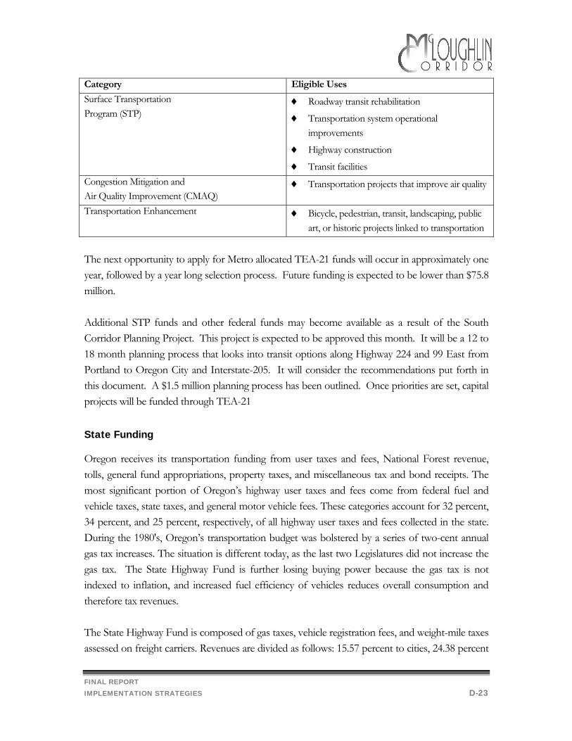
FINAL REPORT IMPLEMENTATION STRATEGIES D-23
Category Eligible Uses
Surface Transportation Program (STP)
♦ Roadway transit rehabilitation
♦ Transportation system operational improvements
♦ Highway construction
♦ Transit facilities Congestion Mitigation and Air Quality Improvement (CMAQ)
♦ Transportation projects that improve air quality
Transportation Enhancement ♦ Bicycle, pedestrian, transit, landscaping, public art, or historic projects linked to transportation
The next opportunity to apply for Metro allocated TEA-21 funds will occur in approximately one year, followed by a year long selection process. Future funding is expected to be lower than $75.8 million. Additional STP funds and other federal funds may become available as a result of the South Corridor Planning Project. This project is expected to be approved this month. It will be a 12 to 18 month planning process that looks into transit options along Highway 224 and 99 East from Portland to Oregon City and Interstate-205. It will consider the recommendations put forth in this document. A $1.5 million planning process has been outlined. Once priorities are set, capital projects will be funded through TEA-21 State Funding
Oregon receives its transportation funding from user taxes and fees, National Forest revenue, tolls, general fund appropriations, property taxes, and miscellaneous tax and bond receipts. The most significant portion of Oregon’s highway user taxes and fees come from federal fuel and vehicle taxes, state taxes, and general motor vehicle fees. These categories account for 32 percent, 34 percent, and 25 percent, respectively, of all highway user taxes and fees collected in the state. During the 1980's, Oregon’s transportation budget was bolstered by a series of two-cent annual gas tax increases. The situation is different today, as the last two Legislatures did not increase the gas tax. The State Highway Fund is further losing buying power because the gas tax is not indexed to inflation, and increased fuel efficiency of vehicles reduces overall consumption and therefore tax revenues. The State Highway Fund is composed of gas taxes, vehicle registration fees, and weight-mile taxes assessed on freight carriers. Revenues are divided as follows: 15.57 percent to cities, 24.38 percent
FINAL REPORT IMPLEMENTATION STRATEGIES D-24
to counties, and 60.05 percent to ODOT. The County share of the State Highway Fund is allocated based on population and vehicle registration ORS 366.514 requires at least one percent of the State Highway Fund received by ODOT, counties and cities be expended for the development of footpaths and bikeways. ODOT administers the bicycle funds, handles bikeway planning, design, engineering and construction, and provides technical assistance and advice to local governments concerning bikeways. This funding source may be appropriate for the McLoughlin Boulevard improvements. Oregon law allows local government, in addition to receiving state highway trust fund revenues, to levy local fuel taxes for roadway related improvements. Multnomah and Washington Counties, and some small cities have used this authorization. In Clackamas County this would require a vote of the citizen. Several attempts have been made by other jurisdictions but have not been supported by the electorate. As few local governments have implemented this option, non-user road revenues tend to be relied upon, to supplement the funds received from state and federal user revenues. Other local funding sources have included property tax levies, local improvement district assessments, bonds, traffic impact fees and system development charges, road user taxes, general fund transfers, receipts from other local governments, and other miscellaneous sources. Cities have relied more than counties on transfers from their general funds to support roadway improvements. Ballot Measure 5, however, approved by the voters in 1990, reduced the range of funding and financing options available to both cities and counties. Measure 5 limited the property tax rate for purposes other than for payment of certain general obligation indebtedness to $15 per $1000 of assessed value. The measure further divided the $15 per $1000 property tax authority into two components: $5 per thousand dedicated to the public schools; the remaining $10 dedicated to other local government units, including cities, counties, special service districts, and other non-school entities. The tax rate limitation for cities and counties went into effect in 1992. The school portion of the measure is being phased in over a five-year period beginning in FY 1992. In 1996, voters again approved a property tax limitation measure, Ballot Measure 47/50, which will further impact the ability of cities and counties to pay for needed infrastructure through historic or traditional means. The Oregon Special Public Works Fund (SPWF) Program was created by the 1985 Legislature as one of several programs for the distribution of funds from the Oregon Lottery to economic development projects in communities throughout the state. The program provides grant and loan assistance to eligible municipalities primarily for the construction of public infrastructure which supports private projects that result in permanent job creation or job retention. To be awarded
FINAL REPORT IMPLEMENTATION STRATEGIES D-25
funds, each infrastructure project must support businesses wishing to locate, expand, or remain in Oregon. While SPWF program assistance is provided in the form of both loans and grants, the program emphasizes loans in order to assure that funds will return to the state over time for reinvestment in local economic development infrastructure projects. The maximum loan amount per project is $11 million and the term of the loan cannot exceed the useful life of the project or 25 years, whichever is less. Interest rates for loans funded with State of Oregon Revenue Bonds are based on the rate that the state may borrow through the Oregon Economic Development Department Bond Bank. The Department may also make loans directly from the SPWF (not from revenue bond proceeds) and the term and rate on direct loans can be structured to meet project needs. The maximum grant per project is $500,000 but may not exceed 85% of the total project cost. The McLoughlin Boulevard project would not likely be eligible for this program, as it is oriented at retrofitting an existing facility in an existing business area and not at creation of new employment. System Development Charges
An increasingly common source of transportation funding, which is already being implemented by Clackamas County, is the collection of system development charges (SDCs) from new development. These charges are based on a measurement of the demand that a new development places on the street system and the capital cost of meeting that demand. These are one-time fees collected as the development comes on line. The need for projects funded by SDCs must be tied to growth and County SDC’s may not be used to fund improvements on state highways. Thus, the McLoughlin Boulevard improvement would not qualify, unless the County were to assume ownership of the portion of McLoughlin Blvd. Local Improvement Districts
Local improvement districts (LIDs) may be formed under Oregon Statutes to construct public improvements such as streets, sidewalks and other improvements. Formation of an LID can be initiated by property owners or by the County, subject to remonstrance. Local improvement districts are appropriate for those kinds of improvements that provide primarily local benefits. When improvements are made within the district, the cost of the improvement is generally distributed according to benefit among the properties within the district. The cost becomes an assessment against the property which is a lien equivalent to a tax lien. The property owner may
FINAL REPORT IMPLEMENTATION STRATEGIES D-26
pay the assessment in cash or apply for assessment financing according to terms offered by the County. ORS 370.610 prohibits local improvement districts from being applied to state highways. Thus, only if the County assumed ownership of McLoughlin Boulevard, could the recommended projects be funded through an LID. Additionally, a significant number of property owners would have to agree to participate in the LID. Should an LID be formed, once the benefit and cost have been set, an assessment is levied against the benefiting properties. They may pay in cash or apply for assessment financing. In Oregon this means the County will issue bonds and allow the property owners to pay their assessments over time. Oregon statutes allow the County to pledge its general obligation to the Bancroft bonds thus making the bonds general obligations of the City but paid by assessment payments. This lowers the borrowing cost of the benefited property owners. However, because general obligation improvement bonds are not specifically voter-approved, taxes levied to pay debt service on such bonds are subject to the limitations of Ballot Measure 5. As a result, local governments may not issue unlimited tax general obligation bonds without a vote of the electorate. Such limited tax improvement bonds are backed by available revenues of the City, including the ability to levy a tax, provided however, that such tax levy combined with all other general governmental tax levies do not exceed the $10.00 per $1,000 tax rate limitation. Conditions of Development
Projects are sometimes paid for by private development. Some private contributions are the result of a development right exchange of some sort. It is common practice to require a developer to build a road, to city standards, and then to deed the road to the County as a condition of development. This practice is used widely throughout the state and may have applicability to a variety of projects in Clackamas County. This would result in piecemeal development of the sidewalk project, as implementation would be tied to new development or redevelopment of existing parcels.
FINAL REPORT IMPLEMENTATION STRATEGIES D-27
Implementing the Zoning Proposal
There are two key components to implementing the zoning proposal:
• Zoning Development Ordinance changes • Better enforcement of the existing Sign Ordinance.
In the following section each of these components is discussed in detail.
Zoning Development Ordinance changes
To improve vehicular connectivity, the County should include the following language in Section 1007 of the Zoning and Development Ordinance: “Parking lot connections to adjacent properties may be required upon redevelopment to reduce traffic impacts onto McLoughlin.”
Planning Level Cost Estimates
Planning level costs associated with changing the ZDO are insignificant.
Funding
This change could be incorporated into the 2040 Compliance Package, presently budgeted for the 1999-2000 fiscal year.
Effective Enforcement of the Sign Ordinance
One issue identified by the general public was the need to improve the appearance of McLoughlin Blvd. The analysis has concluded that the existing sign ordinance addresses the concerns of the public and the Workgroup. Signs in violation of the ordinance need to be identified, removed or brought into compliance with the regulations. Effective implementation of the sign ordinance could include:
• Higher prioritization of the need to enforce sign regulations • Increased financial resources for code enforcement • Establishment of a ‘Corridor Committee’ to monitor sign violations
FINAL REPORT IMPLEMENTATION STRATEGIES D-28
Higher Prioritization of Sign Enforcement
The County must prioritize all of the activities of the Code Enforcement Section of the Department of Transportation and Development. It is the recommendation of this project that enforcement of the County’s sign regulations be place high enough on the list of priorities to receive attention. The benefits of a better appearance for McLoughlin Boulevard may include more incentive for locating businesses that hire larger numbers of workers, such as offices. Land values may increase, and McLoughlin may become seen as more of a community asset.
Increased financial resources for code enforcement
Code Enforcement comes from the County’s General Fund. Fines are returned to the General Fund but do not come close to paying the cost of enforcement. Therefore, code enforcement must compete with other programs that are paid for from the same funding source.
Estimated Person Hours It is estimated that it would take one person 6 to 8 weeks over three months to initiate an enforcement effort for McLoughlin. Then there would be lingering follow-up on cases of non-compliance that would be on-going.
Surely the issue of fairness will be raised because there are sign violations along many roads in Clackamas County. In order to enforce the ordinance equally throughout the County it would take a full time person dedicated to this work.
Estimated Cost
A full time person, including benefits, would cost about $52,000 per year.
Establishment of a ‘Corridor Committee’ to monitor sign violations
A committee of peers, volunteer property and business owners along McLoughlin, could be helpful in assisting the County with code violations, including sign violations. While these people would not be expected to enforce County ordinances, they may be able to achieve compliance through setting a good example, discussion, persuasion, and soliciting compliance in a friendly way.

FINAL REPORT APPENDIX A, COMMENTS APPENDIX A-1