evaluation of water scarcity in africa todd j. schram ce 394k.2 surface water hydrology term project...
TRANSCRIPT

Evaluation of Water Scarcity in Africa
Todd J. Schram
CE 394K.2Surface Water HydrologyTerm ProjectSpring 1999Dr. David Maidment Nile River, Cairo

Overview
Concepts of Water ScarcityData SourcesWater ResourcesPopulation ProjectionsEvaluation of ScarcityAssessment of Climate ChangeFuture Work

Water Scarcity Concepts
Water Stress Index ‘approximate min. level of water required per capita to
maintain adequate quality of life in a moderately developed country in an arid zone’
developed by Swedish hydrologist M. Falkenmark
Annual Renewable
Freshwater per
Capita (m3) Eff ects on Country
>1,700 Limited Stress/ Localized Problems
1,000 - 1,700 Water Stressed
<1,000 Water Scarce
<500 Absolute Scarcity
Benchmarks Used by UN and
World Bank as tool to evaluate water supply abundance of country

Consequences of Water Scarcity
Why should we be concerned? Deterioration of water quality Costs of producing/delivering water increases
rapidly Constrains economic development
Statistics for Developing Countries 80% of diseases caused by contaminated water 1/3 of all deaths attributed to water-related
diseases

Changes in Water Scarcity
Water Demand Population growth Industrialization Water conservation initiatives
Water Supply Climate variability Climate change

Sources of Data
UNEP-GRID Population Data
World Resource Institute Water Resources Data
ESRI Political Boundaries
ERBE Net Radiation
Geography Dept. (University of Delaware) Precipitation & Temperature

Data Characterization
Population Count Raster Dataset Resolution: 1o cells Tabular data converted to grid of 5,986 cells
Freshwater Resources 1) Spatially distributed value based on
country 2) Annual runoff from gridded precipitation
and evaporation data

Annual Renewable Freshwater Resources
Total Volume (cubic kilometers)
Note: Based on water resources of the country.
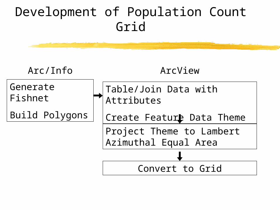
Development of Population Count Grid
Arc/Info
Generate Fishnet
Build Polygons
ArcView
Table/Join Data with Attributes
Create Feature Data Theme
Project Theme to Lambert Azimuthal Equal Area
Convert to Grid

Population Count Grids
Year 2000 Year 2025 Year 2050
Population Count per Cell
Note: Cell size is 1o x 1o.

Evaluations of Scarcity Conditions
Immediate Factor Effect of population growth on scarcity Analyzed using Water Stress Index
benchmarksLong Term Factor
Effect of climate change on scarcity Methodology presented

Extent of Water Scarcity
Year 2000 Year 2025 Year 2050
Water Scarcity Designations

Annual Hydrologic Data
Temperature (oC)Precipitation (mm) Net Radiation (W/m2)
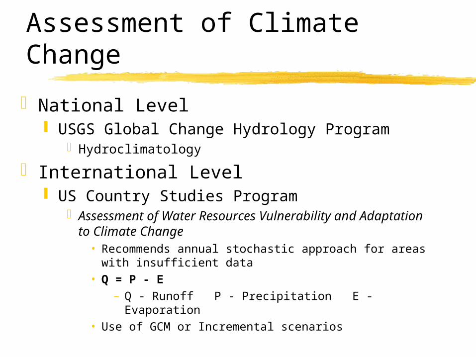
Assessment of Climate Change
National Level USGS Global Change Hydrology Program
Hydroclimatology
International Level US Country Studies Program
Assessment of Water Resources Vulnerability and Adaptation to Climate Change
• Recommends annual stochastic approach for areas with insufficient data
• Q = P - E– Q - Runoff P - Precipitation E - Evaporation
• Use of GCM or Incremental scenarios

Evaporation Calculation
Priestly-Taylor Evaporation Equation Applicable to continental
scale Parameters
Potential evaporationNet RadiationTemperatureSaturated vapor pressureLatent heat of vaporization
es = 611 * exp[17.27 * T/ (237.3+T)]
lv = 2.5E+06 - 2370 * T
E = 1.3 * D/ (D+g) * Er
Er = Rn/ (rw* lv)
D = 4098 * es/ (237.3+T)2
g = Cp * p/ (0.622 * lv) * (Kh/ Kw)

Conclusions
Water scarcity maps due to population growth Evaluate future water shortages of
countries within next 60 yearsEffects of future climate changes
Not easily determined Can determine temperature change
effects

Available Reports World Resource Institute (WRI)
World Resources 1998-1999
World Bank World Development 1999
World Water Organization The World’s Water: The Biennial Report on Freshwater Resources, 1998-1999
Population Action International Sustaining Water: Population and the Future of Renewable Water Supplies
UN - Commission on Sustainable Development Comprehensive Assessment of the Freshwater Resources of the World
U.S. Country Studies Program Assessment of Water Resources Vulnerability and Adaptation to Climate Change
UN Food and Agriculture Organization (FAO) Water and Social Resource Scarcity AQUASTAT

Future Work
Utilize annual hydrologic data to: conduct spatial evaluation to determine
local regions of water scarcity determine impact of climatic
temperature change on water scarcity

Questions?
Lake Victoria, Uganda