eurosion case study: slovenian coast (slovenia)
TRANSCRIPT
EUROSION Case Study
1
SLOVENIAN COAST (SLOVENIA)
Contact:
Marta VAHTAR
Institute for Integral
Development and Environment
Savska 5, 1230 Domzale (Slovenia)
Tel:+38 61 722 5210 Fax:+38 61 722 5215
e-mail: [email protected]
46
EUROSION Case Study
2
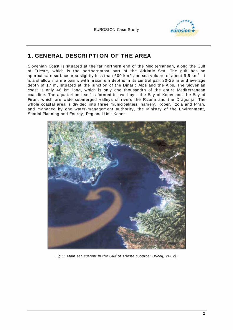
1. GENERAL DESCRIPTION OF THE AREA Slovenian Coast is situated at the far northern end of the Mediterranean, along the Gulf of Trieste, which is the northernmost part of the Adriatic Sea. The gulf has an approximate surface area slightly less than 600 km2 and sea volume of about 9.5 km3. It is a shallow marine basin, with maximum depths in its central part 20-25 m and average depth of 17 m, situated at the junction of the Dinaric Alps and the Alps. The Slovenian coast is only 46 km long, which is only one thousandth of the entire Mediterranean coastline. The aquatorium itself is formed in two bays, the Bay of Koper and the Bay of Piran, which are wide submerged valleys of rivers the Rizana and the Dragonja. The whole coastal area is divided into three municipalities, namely, Koper, Izola and Piran, and managed by one water-management authority, the Ministry of the Environment, Spatial Planning and Energy, Regional Unit Koper.
Fig.1: Main sea current in the Gulf of Trieste (Source: Bricelj, 2002).
EUROSION Case Study
3
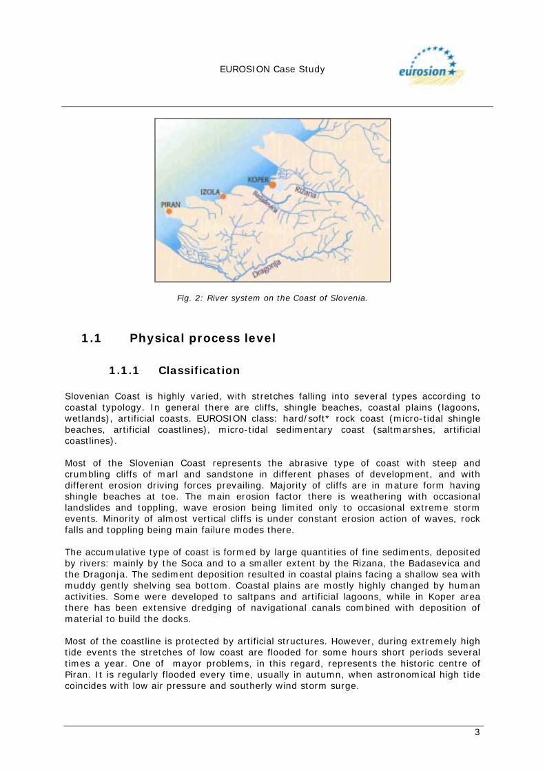
Fig. 2: River system on the Coast of Slovenia.
1.1 Physical process level
1.1.1 Classification Slovenian Coast is highly varied, with stretches falling into several types according to coastal typology. In general there are cliffs, shingle beaches, coastal plains (lagoons, wetlands), artificial coasts. EUROSION class: hard/soft* rock coast (micro-tidal shingle beaches, artificial coastlines), micro-tidal sedimentary coast (saltmarshes, artificial coastlines). Most of the Slovenian Coast represents the abrasive type of coast with steep and crumbling cliffs of marl and sandstone in different phases of development, and with different erosion driving forces prevailing. Majority of cliffs are in mature form having shingle beaches at toe. The main erosion factor there is weathering with occasional landslides and toppling, wave erosion being limited only to occasional extreme storm events. Minority of almost vertical cliffs is under constant erosion action of waves, rock falls and toppling being main failure modes there. The accumulative type of coast is formed by large quantities of fine sediments, deposited by rivers: mainly by the Soca and to a smaller extent by the Rizana, the Badasevica and the Dragonja. The sediment deposition resulted in coastal plains facing a shallow sea with muddy gently shelving sea bottom. Coastal plains are mostly highly changed by human activities. Some were developed to saltpans and artificial lagoons, while in Koper area there has been extensive dredging of navigational canals combined with deposition of material to build the docks. Most of the coastline is protected by artificial structures. However, during extremely high tide events the stretches of low coast are flooded for some hours short periods several times a year. One of mayor problems, in this regard, represents the historic centre of Piran. It is regularly flooded every time, usually in autumn, when astronomical high tide coincides with low air pressure and southerly wind storm surge.
EUROSION Case Study
4
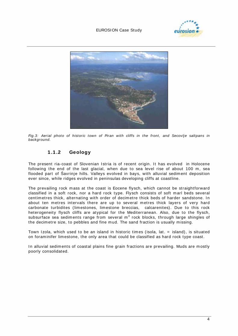
Fig.3: Aerial photo of historic town of Piran with cliffs in the front, and Secovlje saltpans in background.
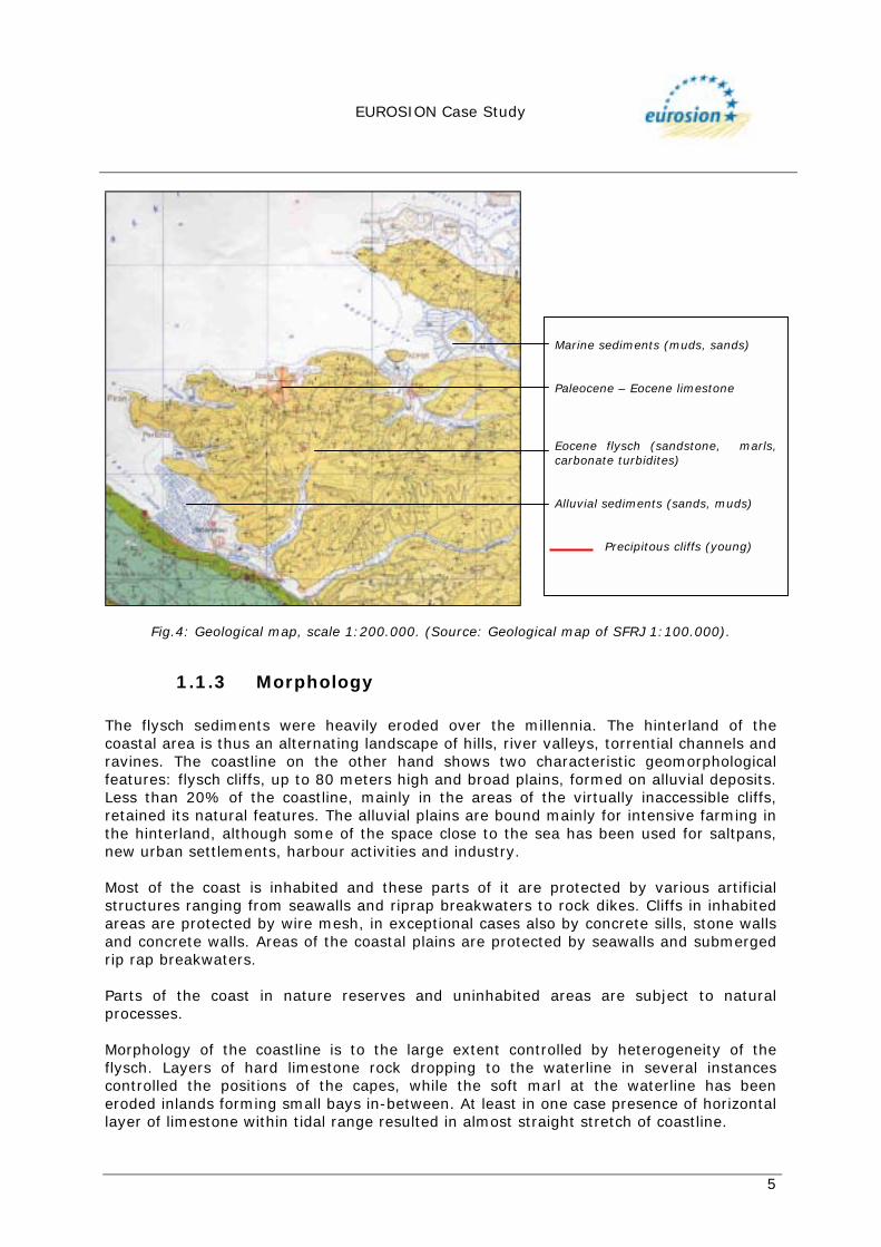
1.1.2 Geology The present ria-coast of Slovenian Istria is of recent origin. It has evolved in Holocene following the end of the last glacial, when due to sea level rise of about 100 m, sea flooded part of Šavrinje hills. Valleys evolved in bays, with alluvial sediment deposition ever since, while ridges evolved in peninsulas developing cliffs at coastline. The prevailing rock mass at the coast is Eocene flysch, which cannot be straightforward classified in a soft rock, nor a hard rock type. Flysch consists of soft marl beds several centimetres thick, alternating with order of decimetre thick beds of harder sandstone. In about ten metres intervals there are up to several metres thick layers of very hard carbonate turbidites (limestones, limestone breccias, calcarenites). Due to this rock heterogeneity flysch cliffs are atypical for the Mediterranean. Also, due to the flysch, subsurface sea sediments range from several m3 rock blocks, through large shingles of the decimetre size, to pebbles and fine mud. The sand fraction is usually missing. Town Izola, which used to be an island in historic times (isola, lat. = island), is situated on foraminifer limestone, the only area that could be classified as hard rock type coast. In alluvial sediments of coastal plains fine grain fractions are prevailing. Muds are mostly poorly consolidated.
EUROSION Case Study
5
Fig.4: Geological map, scale 1:200.000. (Source: Geological map of SFRJ 1:100.000).
1.1.3 Morphology The flysch sediments were heavily eroded over the millennia. The hinterland of the coastal area is thus an alternating landscape of hills, river valleys, torrential channels and ravines. The coastline on the other hand shows two characteristic geomorphological features: flysch cliffs, up to 80 meters high and broad plains, formed on alluvial deposits. Less than 20% of the coastline, mainly in the areas of the virtually inaccessible cliffs, retained its natural features. The alluvial plains are bound mainly for intensive farming in the hinterland, although some of the space close to the sea has been used for saltpans, new urban settlements, harbour activities and industry. Most of the coast is inhabited and these parts of it are protected by various artificial structures ranging from seawalls and riprap breakwaters to rock dikes. Cliffs in inhabited areas are protected by wire mesh, in exceptional cases also by concrete sills, stone walls and concrete walls. Areas of the coastal plains are protected by seawalls and submerged rip rap breakwaters. Parts of the coast in nature reserves and uninhabited areas are subject to natural processes. Morphology of the coastline is to the large extent controlled by heterogeneity of the flysch. Layers of hard limestone rock dropping to the waterline in several instances controlled the positions of the capes, while the soft marl at the waterline has been eroded inlands forming small bays in-between. At least in one case presence of horizontal layer of limestone within tidal range resulted in almost straight stretch of coastline.
Marine sediments (muds, sands) Paleocene – Eocene limestone Eocene flysch (sandstone, marls,carbonate turbidites) Alluvial sediments (sands, muds) Precipitous cliffs (young)
EUROSION Case Study
6
Morphology of cliffs is also controlled by position of marl, sandstone and limestone layers. More erodible marls expose layers of limestone to the point of rock falls into the sea. There, these blocks form natural breakwaters in front of the cliffs. Rock falls of sandstone result in shingle beaches. The cliffs having more sandstone and limestone layers in flysch are almost vertical. Other cliffs, where marl layers are predominant, have gentler slopes and are lower in height.
1.1.4 Physical processes The Gulf of Trieste is about 25 km across at its widest cross line. Fetch of north-easterly bora wind, the strongest in the area is 20 km at best, usually much less. Therefore, in this part of Mediterranean there are not extremely high waves. Southerly jugo wind produces highest waves in the Adriatic Sea, but due to prevailing northern aspect of the Slovenian Coast, this driving force is not as strong here as in other parts of the Adriatic. Wave height of most storms is as a rule less than 1m, the higher waves up to 4 m are exceptionally rare events. Daily tide range is usually less than 1 m, thus tidal erosion force is relatively small too. Erosion of rock coastline through the waves and tide, is of low intensity due to small driving forces. It is comparable to erosion due to weathering on slopes inland. Protection of loose sediments at coastal plains is critical, since the wave and tidal erosion of these materials is big enough to endanger the stability of the coastline. Sea currents along the coast are slow, thus the material transport by sea along the coastline is small. The most pronounced material transport is by waves during storms, when pebbles are shifted along the beaches. However shifting of larger sandstone shingles is negligible. Major sediment transport is by rivers and minor watercourses. The coastal plains are formed at the mouth of rivers discharging into sea.
1.1.5 Erosion Shifting of coastline inlands due to sea erosion is pronounced only in uninhabited areas and nature reserves, while the majority of inhabited coastline is erosion protected by artificial structures. The highest erosion progress is to be 6 cm per year, deduced from skeleton washing away from the grave cut in the cliff about 900 years ago (Zumer, 1990). All other available published sources are citing lower erosion rates. Historical data of cliff erosion next to protection wall of Piran Sv. Jurij church show erosion progress of 1 cm a year. Measurements at other sites gave values between 1 cm and 2 cm. In general, it could be taken that average speed of cliff shift at Slovenian Coast is in the range from several mm to several cm a year (Ogrin, 1992). There were not measurements of volumes eroded by sea. However, there are some measurements of flysch erosion at inland slopes several kilometres from the sea. By measurements of sediment transport by river, of the material eroded from cliffs, the volume eroded amounted to 400 m3/ha per year (Petkovsek, 2002). Erosion volumes
EUROSION Case Study
7
from inland flysch cliffs in neighbouring Croatia, range between 393 and 497 m3/ha per year. Since the cliffs shifting both inland and at the coast have been found to be of similar order of magnitude, these volumes are crude approximation for coastal erosion. Because the Gulf of Trieste is shallow, sedimentation of the eroded material to the bottom of the sea poses serious problem to navigation of transoceanic ships. Therefore, several technical solutions were introduced into the river systems to retain the eroded material inland. In the last decades, the process of natural reforestation of agricultural land is also taking place due to abandonment of agricultural production. This results in a trend that shows decline of sedimentation in the sea. Inland Landslides, torrential erosion and riverbank erosion are the most hazardous phenomena in Slovenia. Inland Erosion endangers about 44% of Slovenian territory and causes an annual loss of 2,5 million m3 of soils (CEP, 1996)
1.2 Socio-economic aspects
1.2.1 Population rate The Slovenian coast is heavily populated. The coastal region is an area of 344 km2 with a population of just under 80.000 people (232 inhabitants/km2), which means that the population density of the area is more than twice the national average. Most of the population (over 80%) lives within the 1,5 kilometre wide strip along the coast, which is 46 km long. This concentration of population and activities, which include: transport, industry, commerce, tourism and fishery, represents a mayor concern in the Coastal Area.
1.2.2 Major functions of the coastal zone
! Tourism and recreation: the area is visited by tourists primarily because of its natural beauties (coast, sea, bathing sites, characteristic landscape, the rich natural and cultural heritage) and, naturally, because of its attractive location relatively close to bigger cities of Northern Italy, Austria, Hungary, and mainland Slovenia. The Slovenian Coast has well developed tourist infrastructure. Tourism infrastructure includes several dozen hotels, sport facilities and public beaches, most of them artificial. The area has 21.000 tourist beds (that is 27% of all tourist capacities in the country), most of them in Piran receiving about 400,000 tourists a year. Tourism development in Piran, and other parts of the coast, sprawls outside the city creating needs for new infrastructure, is excessive beyond the carrying capacity of the coast and the road network. It is also located in sensitive coastal landscapes making additional pressure on natural coasts and reducing biodiversity potential of the area.
! Urbanisation: the urbanisation of the coastal strip together with the increasing
employment opportunities led to intensive migration of inhabitants from hinterland to the coast. Among the direct consequences of this exodus were deserted villages, the decay of urban buildings, poor maintenance of infrastructure, abandonment of farming, and the decay of the typical cultural landscape. In the eighties the migration process reversed, due mainly to the
EUROSION Case Study
8
greater private housing possibilities. The turnover had positive effects on the revitalisation of the hinterland. At the same time however, due to poor planning and insufficient control over building activities, the process led to a serious degradation of the cultural landscape. Today, the major problem of coastal cities and settlements lies in their extensive and dispersed expansion into the surrounding space in the last decades. The major changes in the narrow coastal strip in the last decades (abandoning of salt production in Luclja, the construction of tourist facilities including yacht marinas, the development of the port of Koper, infrastructure) resulted in a serious loss of natural coastline and degradation of the coastal ecosystems.
! Natural conservation: despite intensive human activities, there are extensive
protected areas of natural and historical sites. Nature reserves include cliffs, lagoons, underwater habitats, salt marshes and saltpans, reserves of Mediterranean terrestrial flora and fauna, as well as freshwater lakes. Protected nature heritage sites are: (1) Secovlje natural resort that includes saltpan and Soca peninsula (835 ha all together) – it is also Ramsar locality; (2) Strunjan natural resort that includes steep cliffs along the seashore (192 ha); and (3) Skocjanski Zatok. There are also other, presently unprotected natural heritage sites, such as Rtic Korbat, Stjuza lagoon, freshwater lake of Fiesa, Madona cape, Sv. Jernej channel, Sv. Nikolaj coastal wetland and Debeli Rtic. They should not only be managed for their intrinsic ecological value. They should be regarded as a part of a valuable network of attractive areas that can be used for diversifying the tourism product and diverting development centres away from the congested coastal strip.
! Fishing and mariculture: owing to the mixture of freshwater and seawater
various fish populate the Gulf of Trieste. The catch in the Slovenian part of the Gulf has been estimated to approximately 2000 tons of fish annually, while the mariculture activity corresponds to annual production levels of 100 tons of shellfish and 100 tons of fish. Mariculture is potentially an important activity in the area; the present levels of annual production may, under a management plan and with sufficient tourism demand, reach up to 450 - 1,000 tons a year of oyster and fish respectively.
! Agriculture: the traditional terrace culture on flysch slopes is very well adapted
to the environment as it reduces erosion, increases the cultivated surface and plays an exceptionally valuable role in water retention. Today, agriculture is largely neglected as an activity. Consequently, agricultural land became overgrown by forest. Besides, farms are small and have been fragmented down to 0.5 ha plots, with only about 10 % of the farms bigger than 5.0 ha. There are also vineyards, fruit plantations and olive tree groves, having potential for future development linked to tourism.
! Transportation: the Port of Koper, a major freight port of Slovenia, serves
several Central European countries. The port now handles 10 million tons of freight per year. This resulted in important economic development, enlargement of the docklands, with consequent substantial burdens on the environment due to coastal constructions, river training and dredging operations. In addition to the Port of Koper, located adjacent to the historic core of Koper, there are four marinas (Portoroz, Piran, Izola, and Koper) mooring about 2,000 yachts. There
EUROSION Case Study
9
are also other important transport facilities: airstrip servicing small sport and passenger planes, as well as important road and railway lines. Passenger ship lines serve along the coast, as well as ports in neighbouring Italy and Croatia. Apart from four major marinas, there are also small passenger and fishing harbours in major cities of Koper, Izola and Piran.
! Industry: industrial activities include petrol industry, shipbuilding, car
production, canning industry, fine mechanics, production of chemicals and food industry.
! Salt-extraction: salt extraction used to be one of the important economic
activities in the area for centuries. Almost all lowland parts of marshy valleys that were submerged by the sea, used to be cultivated as saltpans. Salt-extraction together with its interesting by-products (salt mud, heavy salt water) enabled the launching and development of spa tourism at Portoroz. Today, however, salt-extraction is in decline, which makes the area of saltpans sensitive to erosion.
1.2.3 Assessment of capital at risk Since the Gulf of Trieste is very shallow, the most important erosion related problem of the coast is filling up the bays with sediments that are brought to the sea from the hinterland by rivers. That problem is successfully dealt with the proper management of rivers in their upper sections, as well as with the proper land management, as well as with dredging of the sea bottom, especially in the area of mayor ship corridors. The other problem is related to holding the line of the coast. Almost 80% of all Slovenian coast is in some way protected from erosion with various constructions that need to be properly maintained. Because of relative stability of the land and because of relatively small impact of the waves, it is not expected that the erosion processes could cause major problems and property damages.
EUROSION Case Study
10
2. PROBLEM DESCRIPTION
2.1 Eroding sites To describe problems related to erosion, five locations were chosen:
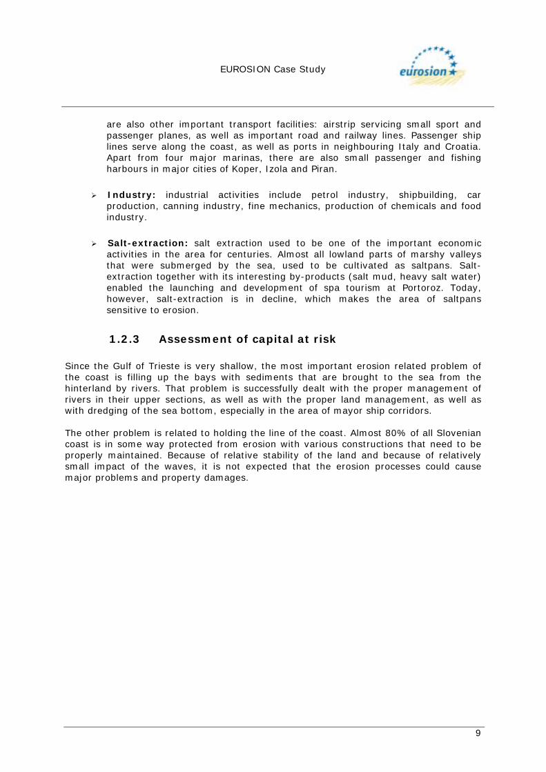
Piran Peninsula Historic town of Piran and the church of St. Jurij on the top of the cliff. Erosion there progressed through centuries to such a degree, that the foundations of the historic church, as well as nearby buildings are endangered.
Fig.5: Church of St. Jurij and town of Piran on the cliff. (Photo: Bricelj M.).
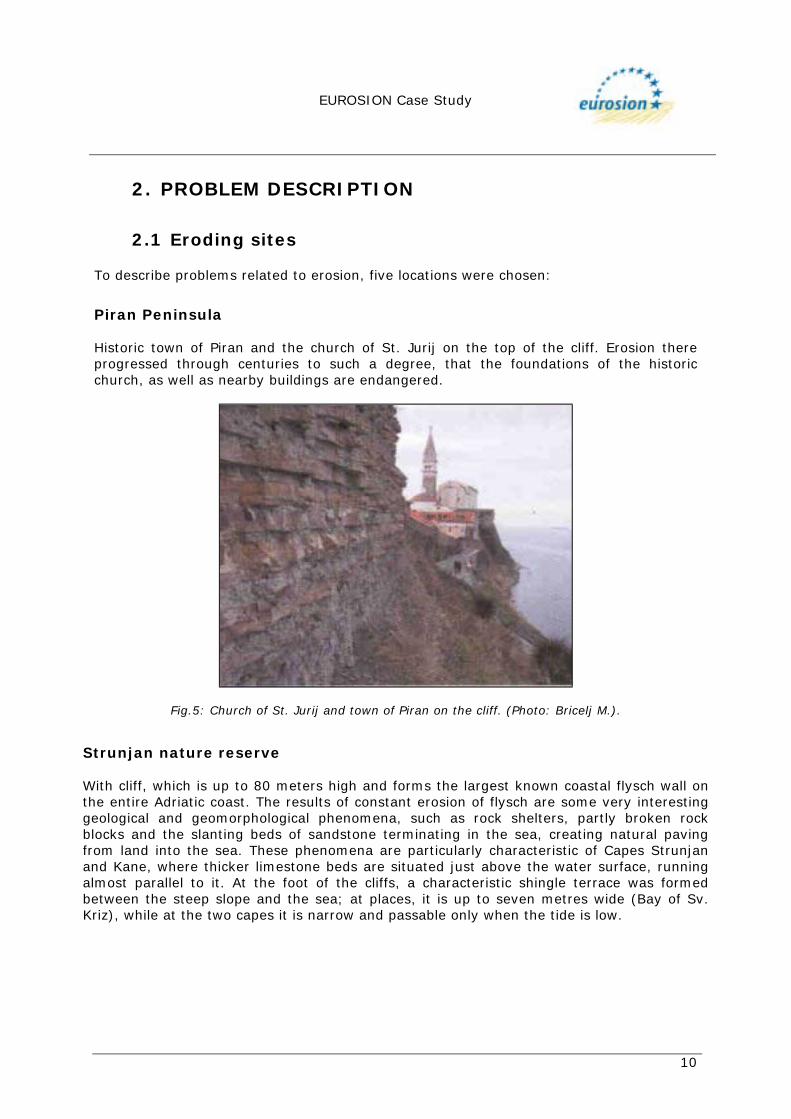
Strunjan nature reserve With cliff, which is up to 80 meters high and forms the largest known coastal flysch wall on the entire Adriatic coast. The results of constant erosion of flysch are some very interesting geological and geomorphological phenomena, such as rock shelters, partly broken rock blocks and the slanting beds of sandstone terminating in the sea, creating natural paving from land into the sea. These phenomena are particularly characteristic of Capes Strunjan and Kane, where thicker limestone beds are situated just above the water surface, running almost parallel to it. At the foot of the cliffs, a characteristic shingle terrace was formed between the steep slope and the sea; at places, it is up to seven metres wide (Bay of Sv. Kriz), while at the two capes it is narrow and passable only when the tide is low.
WP 4.1 D.3. Report of UAB Pilot Sites EUROSION – Draft v.3
(February/2003)
Slovenian coast
11
Figs. 6,7,8: The cliffs of Strunjan nature reserve. (Photo Hanc J. in Bricelj M.).
Fig.9: Cliffs, lagoon and saltpans of Strunjan nature reserve. (Source: Navigation Chart, Sheet Koperski zaliv, Scale 1:12.000, MPZ, 1999).
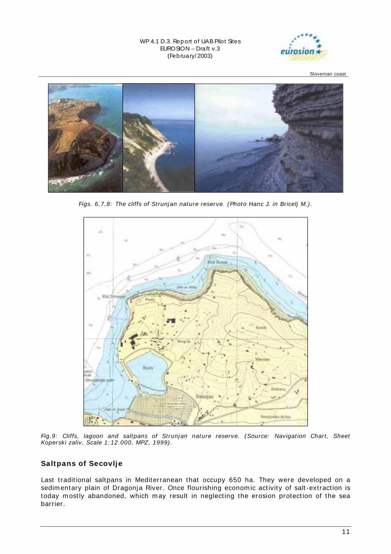
Saltpans of Secovlje Last traditional saltpans in Mediterranean that occupy 650 ha. They were developed on a sedimentary plain of Dragonja River. Once flourishing economic activity of salt-extraction is today mostly abandoned, which may result in neglecting the erosion protection of the sea barrier.
WP 4.1 D.3. Report of UAB Pilot Sites EUROSION – Draft v.3
(February/2003)
Slovenian coast
12
Figs. 10,11: Saltpans of Secovlje (Photo: Križan B. in Klemenc S.).
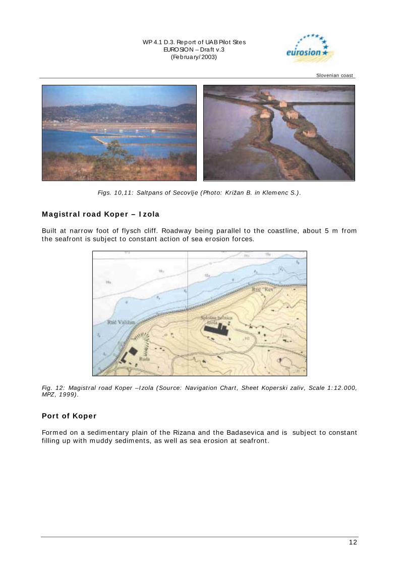
Magistral road Koper – Izola Built at narrow foot of flysch cliff. Roadway being parallel to the coastline, about 5 m from the seafront is subject to constant action of sea erosion forces.
Fig. 12: Magistral road Koper –Izola (Source: Navigation Chart, Sheet Koperski zaliv, Scale 1:12.000, MPZ, 1999).
Port of Koper Formed on a sedimentary plain of the Rizana and the Badasevica and is subject to constant filling up with muddy sediments, as well as sea erosion at seafront.
WP 4.1 D.3. Report of UAB Pilot Sites EUROSION – Draft v.3
(February/2003)
Slovenian coast
13
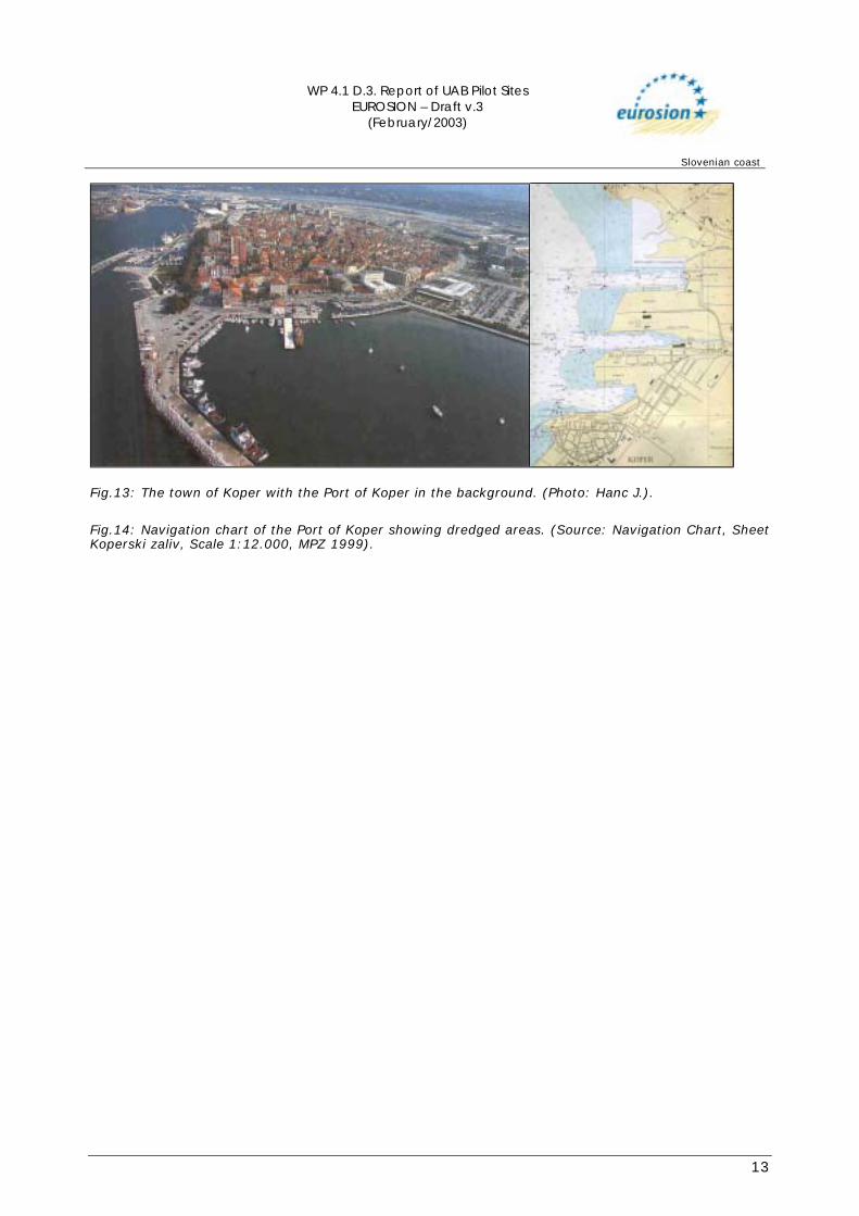
Fig.13: The town of Koper with the Port of Koper in the background. (Photo: Hanc J.). Fig.14: Navigation chart of the Port of Koper showing dredged areas. (Source: Navigation Chart, Sheet Koperski zaliv, Scale 1:12.000, MPZ 1999).
WP 4.1 D.3. Report of UAB Pilot Sites EUROSION – Draft v.3
(February/2003)
Slovenian coast
14
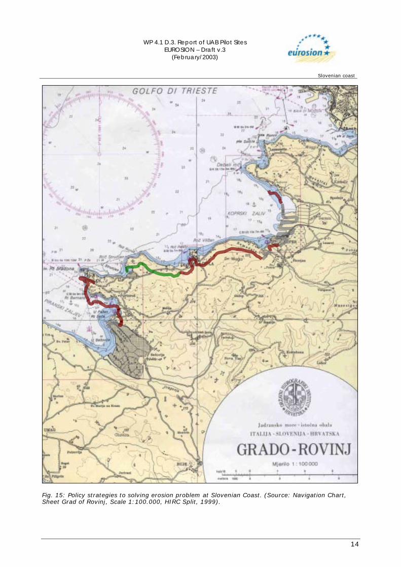
Fig. 15: Policy strategies to solving erosion problem at Slovenian Coast. (Source: Navigation Chart, Sheet Grad of Rovinj, Scale 1:100.000, HIRC Split, 1999).
WP 4.1 D.3. Report of UAB Pilot Sites EUROSION – Draft v.3
(February/2003)
Slovenian coast
15
2.2 Impacts
Piran Peninsula Location of the medieval town of Piran, which is one of the main tourist attractions of the Slovenian Coast. The rim of the town is the coastline with high cliff on the north side. Even though the erosion of the flysch cliff progresses relatively slow inlands, it started to threaten the foundations of some of the buildings on the top of it, among them Sv. Jurij church an exceptional monument of cultural heritage.
Strunjan nature reserve One of the important tourist seaside resorts, especially during the summer bathing season. The main erosion impact there, are falling stones life-threatening to visitors.
Saltpans of Secovlje Protected as cultural landscape of traditional saltpans, as well as only Ramsar locality of Slovenia giving shelter to 250 bird species, out of which 90 species nest in the area. The traditional saltpans are one of the most threatened wetlands in Mediterranean. Therefore, the interest to protect the area of saltpans from the sea erosion is definitely present. The consequences of possible destruction of the sea barrier could be catastrophic. Besides destruction of saltpans as national cultural monument, shifting of muddy sediments could cause serious problems in the nearby main tourist resort of Portoroz, where there are several kilometres of artificial sand beaches.
Magistral road Koper – Izola Along the seafront is constantly subject to sea erosion. The damage of roadway should result in major transport disruption of Slovenian Coast.
Port of Koper Authorities of the port are constantly dredging the sea bottom and removing muddy sediments to retain the proper depth of the port and main ship canals. The sediments are used to build new docklands and servicing areas. The problems are both siltation of the port basin and erosion at seafront. The disruption of port activity may result in serious loss of income important both to local community and nationwide, as well as affect clients throughout Central Europe.
WP 4.1 D.3. Report of UAB Pilot Sites EUROSION – Draft v.3
(February/2003)
Slovenian coast
16
3. SOLUTIONS/MEASURES
3.1 Policy options The most important policy option that was chosen and adopted is “hold the line”, which is implemented in most parts of the coastal zone, that are urbanised or subject to intensive use. Only the parts of the coast, that are either nature reserves or uninhabited areas are subject to natural processes, and are left to natural dynamics, with the soft policy option of “limited intervention”. In the area of the Port of Koper, the policy option is to “move seaward”.
3.2 Strategy
3.2.1 Approach related to the problem In general, the approach to solving erosion problems of the coastline is local, using proper technical solutions and appropriate land use. Only the problem of filling up the Gulf of Trieste with sediment transported by rivers, is dealt with regionally and internationally, trying to retain the sediments inland. Slovenia has long taken a keen interest in its environment. In the late seventies, when Slovenia was a republic within the former Yugoslavia, the first official administrative body was established to tackle environmental problems. The first environmental legal acts issued at that time were very sectororiented. Public participation in the environmental decision-making process was negligible. The gradual environmental deterioration in the eighties posed serious threats to human health and to development. As awareness among the public at large increased, stronger NGOs started to play a significant role in 1986-87. At that time the basic environmental national priorities were defined and the environment fund set up. Some major environmental decisions were taken, such as the switch to less polluting fuels to curb air pollution. (http://www.unece.org/)
3.2.2 Issues concerning threat to life and property The problems related to erosion in the case of Slovenian Coast do not represent widespread life danger to population. Therefore, no other than technical and land use measures adopted and used.
3.3 Technical measures
3.3.1 Historic measures Already in the past, the coast was highly urbanised and protected by various artificial structures ranging from seawalls and submerged breakwaters to rock dikes. Masonry stone walls protected Cliffs in inhabited areas. Areas of the coastal plains were protected by seawalls, rock dikes and submerged breakwaters. The hinterland was in a traditional agricultural use, where they used terraces to cultivate the land and to protect steep slopes from eroding fertile land.
WP 4.1 D.3. Report of UAB Pilot Sites EUROSION – Draft v.3
(February/2003)
Slovenian coast
17
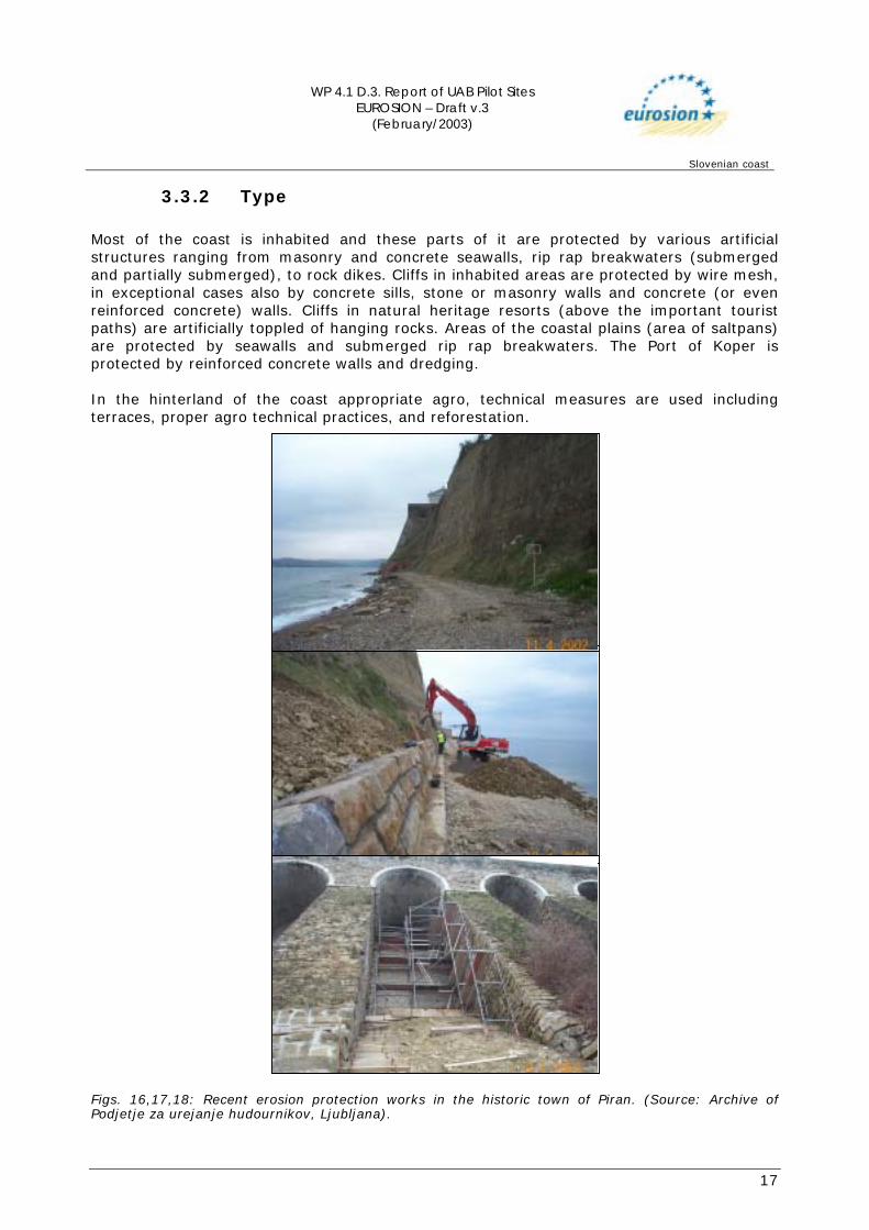
3.3.2 Type Most of the coast is inhabited and these parts of it are protected by various artificial structures ranging from masonry and concrete seawalls, rip rap breakwaters (submerged and partially submerged), to rock dikes. Cliffs in inhabited areas are protected by wire mesh, in exceptional cases also by concrete sills, stone or masonry walls and concrete (or even reinforced concrete) walls. Cliffs in natural heritage resorts (above the important tourist paths) are artificially toppled of hanging rocks. Areas of the coastal plains (area of saltpans) are protected by seawalls and submerged rip rap breakwaters. The Port of Koper is protected by reinforced concrete walls and dredging. In the hinterland of the coast appropriate agro, technical measures are used including terraces, proper agro technical practices, and reforestation.
Figs. 16,17,18: Recent erosion protection works in the historic town of Piran. (Source: Archive of Podjetje za urejanje hudournikov, Ljubljana).

WP 4.1 D.3. Report of UAB Pilot Sites EUROSION – Draft v.3
(February/2003)
Slovenian coast
18
3.3.3 Technical details There are no technical details available.
3.3.4 Costs Data about investment and maintenance costs per year are not available.
WP 4.1 D.3. Report of UAB Pilot Sites EUROSION – Draft v.3
(February/2003)
Slovenian coast
19
4. EFFECTS AND LESSONS LEARNT
4.1 Effects related to erosion All the introduced and practised measures led to total confinement of erosion, or at least to the good control of the natural processes.
4.2 Effects related to socio-economic aspects All the chosen strategies work well with user functions.
4.3 Effects in neighbouring regions All the effects of the introduced erosion measures are local in nature, and do not affect neighbouring regions.
4.4 Relation with ICZM ICZM is not yet practised in Slovenia. The first steps, however, are already taken with the preparation of the Integrated Regional Development Plan for Coastal Area (March 2002). Since the problem of erosion at Slovenian Coast seems to be well under control, the plan does not even mention it. The Ministry of the Environment and Spatial Planning is very supportive of integrated coastal zone management (ICZM). The prob lem of single-sector management of coastal resources was addressed by the National Environmental Program in 1999. This aimed at improving cooperation between ministries and regional and local authorities. In accordance with the 1999 act, The Promotion of Balanced Regional Development, a Regional Development Agency (RDA) was established. The RDA provides coastal municipalities with a regulatory and management structure in line with that proposed by the EU/Phare project on Coastal Area Management in Slovenia. A Coastal Area Management Program (CAMP) supported by the Mediterranean Action Plan (MAP) will be initiated in 2003 (Source: METAP / World Bank, 2002). The Background to ICZM in Slovenia are a completed MAP project, experience in international conventions (Barcelona and tri-lateral Italian, Croatian and Slovene convention) and a comprehensive stock-take of 2001. Priorities now are monitoring, establishment of contingency plans especially in relation to oil spills and implementation of the water framework directive. In 2003 a new MAP project will start that will take account of the ICZM Recommendation and the water framework directive. (Source: Minutes ICZM Expert Group 2002)
4.5 Conclusions
Effectiveness Erosion at Slovenian Coast is currently well controlled and contained by the chosen measures. Most of the measures to control erosion were introduced in the far past, and they are practised for centuries. Besides that, due to decline of farming and reforestation of the
WP 4.1 D.3. Report of UAB Pilot Sites EUROSION – Draft v.3
(February/2003)
Slovenian coast
20
hinterland, the erosion there is declining, which results in decreasing sedimentation of the eroded material into the sea.
Possible undesirable effects Since erosion of Slovenian Coast is well controlled and properly managed, it sometimes tends to be overlooked and consequently could be easily neglected. Consequently, this can result in poor maintenance.
Gaps in information There are scarce data on erosion available, and no systematic data collection on erosion at all. There is no central register of erosion control structures, and about yearly investment and maintenance costs.
WP 4.1 D.3. Report of UAB Pilot Sites EUROSION – Draft v.3
(February/2003)
Slovenian coast
21
5. REFERENCES Bricelj, M. (2002). Moje tvoje morje: Slovensko Sredozemlje in trajnostni razvoj, MOP RS, Ljubljana. CEP - The Council for Environmental protection of the republics of Slovenia (1996). The protection of roots of life, Ljubljana Federal Geologic Survey (1969). Geologic Map of Socialist Federative Republic of Yugoslavia, Sheet Trst, Scale 1:100 000, Beograd. Hydrographic Institute of the Republic of Croatia (1991). Navigation Chart, Sheet Grado Rovinj, Scale 1:100 000. Split. Ministrstvo za promet in zveze (1999). Navigation Chart, Sheet Koperski zaliv, Scale 1:12 000, Ljubljana. Ogrin, D. (1992). Dendrogomorphological Analysis of Erosion Processes – Two Case Studies from Koprsko Primorje (Slovenia), Proceedings of the International Symposium "Geomorphology and Sea", Mali Lošinj, University of Zagreb (pp 115-189). Petkovšek, G. (2002). Measurements of Soil Erosion and Material Transport in the Rokava Catchment (in Slovenian), Proceedings of 8th Meeting of Slovenian Association for Geodesy and Geophysics, Ljubljana (pp 27-37). Regionalni razvojni center Koper (2002). Regionalni razvojni program za juzno Primorsko, Gradivo za programski odbor, Marec. Slovenia Coastal Zone Management Programme PHARE ZZ 96 03, Final report, Volume 1, TRB, Vienna, July 1998. Sovinc, A. (2002). Ramsarska konvencija in slovenska mokrisca, MOP-URSVN, Ljubljana. Žumer, J. (1990). Recent Development of Cliffs on the Coast of Slovenian Istria, Proceedings of 5th Scientific Conferrence of Geomorphologists of Yugoslavia (in Slovenian), Krško, SAZU Ljubljana (pp 143-147). Internet: METAP/WORLD BANK (2002). Mediterranean Environmental Technical Assistance Program, Integrated Coastal Zone Management — ICZM / Slovenia: http://lnweb18.worldbank.org/mna/mena.nsf/Attachments/ICZM+Slovenia+Profile/$File/Coastal+Slovenia+A4.pdf http://www.unece.org/env/epr/studies/slovenia/features.pdf Minutes Expert group ICZM Recommendation 1st Meeting, 3 0ctober 2002, Brussels: http://europa.eu.int/comm/environment/iczm/exgrp_021003.pdf