european co2 geological storage atlas
TRANSCRIPT

The USA National Energy Technology Laboratory (NETL) proudly published the first Carbon Sequestration Atlas of the United States and Canada in 2007, and in 2012, the fourth version was published. The latest version (The North American Carbon Storage Atlas 2012) includes also Mexico and identifies the potential CO2 geological storage capacity in North America. The conservative estimates of the CO2 storage capacity is 136 Giga tons (Gt) for oil and gas fields; 65 Gt for coalfields; and 1,738 Gt for saline reservoirs, collectively representing over 500 years of storage.At current CO2 emission rates, calculations indicate that there is more than 500 years of storage potential in assessed formations.
The CO2 Storage Atlas of the Norwegian North Sea was published in 2011, describing possible subsurface storage locations for carbon dioxide in the Norwegian part of the North Sea. The atlas shows that this area has a total storage capacity of about 70 Gt of CO2. Also Australia is following now. Last year the Queensland Carbon Dioxide Geological Storage Atlas was published as the first storage atlas from Australia.
For Europe, the EU GeoCapacity project (involving 25 European partners) has provided GIS maps of the location of potential geological storage capacity in deep saline formations, hydrocarbon reservoirs and coalfields (Fig.1). The storage capacity estimates are in total 360 Gt with 326 Gt in deep saline aquifers, 32 Gt in depleted hydrocarbon fields and 2 Gt in unmineable coal beds. The onshore storage capacity is up to 116 Gt and the offshore storage capacity is up to 244 Gt.
The European Commission initiated the
project CO2StoP in 2011 to establish a database of publicly available data on CO2 storage potential in Europe (see this newsletter). The CO2StoP database may be the first step towards a European storage atlas.
The primary purpose of a European Atlas would be to give the CO2 storage potential for all
European states. Production of such an Atlas would entail the cooperation and coordination of CO2 geological storage experts from government agencies, geological surveys as well as academia
and industry. The objective of the atlas is to provide an overview of geological structures that are suitable for secure long-term storage of CO2. Knowledge regarding reservoir properties, sealing rocks, migration paths, storage capacity and monitoring methods is crucial in order to determine whether potential storage locations are suited to store CO2 over a long period of time. According to the EU Energy Roadmap 2050, Europe
needs to apply CO2 geological storage
from around 2030 in the power sector in order to attain emission-reduction targets. A European atlas will be vital for enabling progressive commercial deployment within the right time frame.
Published or interactive? A vital question for a European storage atlas is whether to publish the atlas in
traditional form and update it regularly, as for the Carbon Sequestration Atlas of the United States and Canada, or to create an interactive atlas that is accessible over the internet. The published version will, as in the case of the American atlas, need updates every few years as new data become available and methodologies for CO2 storage estimates are improved, whereas an interactive atlas would be updated directly and continuously. Published or interactive, ENeRG considers that time is now for a comprehensive European Atlas. Part of the work has already been done and, more important, there is in Europe a cohesive research community who can successfully realize that.
Niels Poulsenpresident of
ENeRG
The Newsletter of the ENeRG NetworkIssue N° 26 September 2012
European CO2 Geological Storage Atlas
Fig.1 EU GeoCapacity project (2009): Map of CO2 emission sources and storage sites
The 15-month project CO2StoP (Assessment of CO2 Storage Potential in Europe) started at the beginning of this year. The objective of CO2StoP is to build a CO2 storage potential database for the European Commission and the Joint Research Centre (JRC). The CO2Stop project includes 29 partners, which are organized in a small consortium with GEUS as coordinator and BGS and TNO as contractors. All other partners are subcontracted. The partners include national geological surveys and a range of other research organizations; most of them are also members of ENeRG.
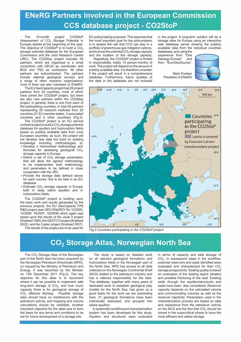
The EU GeoCapacity project had 26 project partners from 20 countries, most of which have joined the CO2StoP project, but there are also new partners within the CO2Stop project. In general, there is one from each of the participating countries, in total 29 partners representing 29 research institutes from 29 countries (21 EU member states, 3 associated countries and 5 other countries) (Fig.2).
The CO2StoP project is an EU service contract project to build a CO2 storage potential database for aquifers and hydrocarbon fields based on publicly available data from most European countries; as such, the project will not develop new data but build on existing knowledge including methodologies to:
The CO2StoP project is building upon the basic work and results generated by the previous projects, the EU GeoCapacity FP6 R&D project (see GEO ENeRGY No 12/2005, 14/2006, 16/2007, 18/2008) which again was based upon the results of the Joule II project (finalised 1995), the GESTCO project (finalised 2003), and the Castor project (finalised 2007).
The results of the project are to be used for
EU policymaking purposes. This assumes that the most important goal for the policymakers is to assess the role that CCS can play in a portfolio of greenhouse gas mitigation options, and to know the potential CO2 storage capacity and the location of this storage capacity.
Regretfully, the CO2StoP project is limited in responsibility, totally 13 person-months of work. The project will depend on the amount of publicly available data. It is therefore uncertain if the project will result in a comprehensive database. Furthermore, future updates of the data in the database are not included
in the project. A long-term solution will be a storage atlas for Europe using an interactive web database server drawing the publicly available data from the individual countries databases, and using the experience from “One Geology-Europe” and from “EuroGeoSource”.
Niels PoulsenPresident of ENeRG
ENeRG Partners Involved in the European Commission CCS database project - CO2StoP
The CO2 Storage Atlas of the Norwegian part of the North Sea has been prepared by the Norwegian Petroleum Directorate (NPD), on request by the Ministry of Petroleum and Energy. It was launched by the Minister on 13th December 2011 (Fig.3). The key objective for this atlas is to document where it can be possible to implement safe long-term storage of CO2, and how much capacity there is for geological storage of CO2 offshore Norway. Possible storage sites should have no interference with the petroleum activity, and mapping and volume calculations should be verifiable. Another important objective for the atlas was to form the basis for any terms and conditions to be set for future development of a storage site.
The study is based on detailed work on all relevant geological formations and hydrocarbon fields in the Norwegian part of the North Sea. NPD has access to all data collected on the Norwegian Continental Shelf (NCS) related to the petroleum industry and has a national responsibility for the data. This database, together with many years of dedicated work to establish geological play models for the North Sea, has given us a good basis for the work we are presenting here. 21 geological formations have been individually assessed, and grouped into saline aquifers.
A systematic workflow and characterization system has been developed for this study. Aquifers and structures were evaluated
in terms of capacity and safe storage of CO2. In subsequent steps in the workflow, potential reservoirs and seals identified were evaluated and characterized for their CO2 storage prospectivity. Sealing quality is based on evaluation of the sealing layers (shales) and possible fracturing of the seal. Existing wells through the aquifers/structures and seals have been also considered. Reservoir capacity depends on the calculated volume and communicating volumes as well as the reservoir injectivity. Parameters used in the characterization process are based on data and experience from the petroleum activity on the NCS and the fact that CO2 should be stored in the supercritical phase to have the most efficient and safest storage.
CO2 Storage Atlas, Norwegian North Sea
Fig.2 Countries participating in the CO2StoP project
Develop a harmonised methodology and formulae for assessing geological CO2 storage capacity in Europe. Define a set of CO2 storage parameters that will allow the agreed methodology to be implemented: both methodology and parameters to be defined in close cooperation with the JRC.Provide the storage data defined above for each country: this to be held in an EU database. Estimate CO2 storage capacity in Europe both in deep saline aquifers and in hydrocarbon fields.
•
•
•
•

ENeRG – European Network for Research in Geo-Energy is an informal contact network open to all European organisations with a primary mission and objective to conduct basic and applied research and technological activities related to the exploration and production of energy sources derived from the Earth’s crust.ENeRG president for 2012 is Niels E. Poulsen from Geological Survey of Denmark and Greenland, Copenhagen, Denmark. Contact: [email protected] secretariat is run by the Faculty of Mining, Geology and Petroleum Engineering, University of Zagreb, Croatia.Contact person: Zeljka Kurelec <[email protected]>
ENeRG website: <http://www.energnet.eu> is maintained by the Czech Geological Survey (CGS). Prague, Czech Republic. Contact person: Dr. Vít Hladík <[email protected]>ENeRG Newsletter – GEO ENeRGYThe Newsletter is published by the Institute of Geology at Tallinn University of Technology. Tallinn, Estonia.Editor: Dr. Alla Shogenova <[email protected]>Layout and computer typesetting: Kazbulat ShogenovLanguage review: Jon R. Ineson (GEUS) and Gillian E Pickup (Heriot-Watt University)
ENeRG – European Network for Research in Geo-Energy
The North American Carbon Storage Atlas 2012
The total potential storage capacity was calculated for the saline aquifers in the areas where there is considered to be no significant interference with the petroleum activity. In areas with extensive exploration and exploitation of petroleum, the potential storage capacity was based on abandoned fields. The atlas also provides a study of long distance migration of CO2 and volume calculations of some structural closures within regional aquifers. The storage efficiency factor has been assessed individually for each aquifer based on simplified reservoir simulation cases.
The estimated storage capacity is classified by the exploration maturity of the sites, with an estimated total potential of 48
Gigatonnes in aquifers and 24 Gigatonnes to be stored in hydrocarbon fields after abandonment.
Eva HallandProject Director
Norwegian Petroleum [email protected]
The USA National Energy Technology Laboratory (NETL) published the results of the first comprehensive mapping of the CO2 storage potential – The Carbon Sequestra-tion Atlas of the United States and Canada in 2007. It’s fourth version (this time including also the potential in Mexico) — The North American Carbon Storage Atlas was pre-sented at the 11th Annual Conference on Carbon Capture Utilization and Sequestra-tion in Pittsburgh on May 1, 2012 (Fig.4). This is the most current depiction of the potential CO2 geological storage capacity in North America. The conservative estimates of the CO2 storage capacity is 136 Giga tons (Gt) for oil and gas fields; 65 Gt for coalfields; and 1,738 Gt for saline reservoirs. Apply-ing the methodology of the static resource estimation, continuing with the current CO2 emission rates, calculations indicate that there is more than 500 years of storage potential in assessed formations. “High esti-mates” were also given which resulted in the potential even up to 5,000 years.
The development of the atlas involved the three countries identifying, gathering and sharing data on major carbon dioxide (CO2) sources and potential storage objects and, what is the most important, using compatible methodologies. It is frequently mentioned by officials that the atlas will be particularly useful for storing CO2 in cross-border res-ervoirs.
A novel approach in respect to the ear-lier versions means that it is now not only the “complete continental” atlas, it also has an online version (www.nacsap.org) and an online map viewer, which will provide inter-active display and analysis of both the emis-sion data and storage potential. The website contains information about CO2 stationary sources (2250 altogether) and storage re-sources in North America (oil and gas fields, coalfields and saline reservoirs), as well as methodologies for estimating storage resources and links to additional informa-tion. The online viewer houses data from all three countries, along with analytical tools to address CCS deployment. Intended for a broad range of users, the online viewer
gives users interactive access to the map layers and data used in the atlas.
There is another important difference in comparison to earlier versions. It shows an increase in potential storage capacity, at-tributed mainly to better geologic resolution and the identification of additional locations that could be used for EOR. By matching up EOR storage locations with specific sources of CO2, the atlas provides a more compre-hensive view of the outlook and potential for carbon storage through EOR as an early mover for construction of a large CCS sys-tem.
The atlas was developed at national level by the U.S. Department of Energy, Natural Resources Canada and the Mexican Minis-try of Energy. Particularly worth mentioning
is its regional orientation resulting from the work of the Department of Energy’s Re-gional Carbon Sequestration Partnerships, whose 400 organizations have heavily con-tributed over the last decade to characterize geologic storage opportunities in the U.S. and Canada. Therefore, a major part of the atlas is dedicated to descriptions of the dem-onstration and validation projects aimed to better characterize the selected prospective areas in terms of the subsurface geological composition and properties. In this way, and with more details, the atlas will not only pro-vide an overview, but also present a com-pendium of the current best practices.
Bruno SafticUniversity of Zagreb
Fig.4 Front page of the North American Carbon Storage Atlas
Fig.3 Front page of the Norwegian North Sea CO2 Storage Atlas

Queensland CO2 Geological Storage Atlas
The ENeRG Network – Country RepresentativesALBANIAProf Adil NezirajAlbanian Geological [email protected] Karl MillahnUniversity of [email protected] AND HERZEGOVINAProf Edin Delic University of [email protected] Georgi V. GeorgievSofia [email protected] Bruno SafticUniversity of [email protected] REPUBLICDr Vit HladikCzech Geological Survey (CGS)[email protected] Niels E. PoulsenGeological Survey of Denmarkand Greenland (GEUS)[email protected] Alla ShogenovaInstitute of Geology,Tallinn University of [email protected]
FINLANDJarmo KallioGeological Survey of [email protected] Isabelle [email protected] Apostolos ArvanitisInstitute of Geology & MineralExploration (IGME)[email protected] Endre HegedüsEötvös Lorand GeophysicalInstitute (ELGI)[email protected] Sergio PersogliaNational Institute of Oceanographyand Experimental Geophysics (OGS)[email protected] Viktor [email protected] Saulius SliaupaInstitute of Geology and Geography [email protected] (MACEDONIA)Dr Gavril MirakovskiUniversity in Skopje [email protected]
MOLDOVADr Oleg BogdevichInstitute of Geology [email protected] Vladan DubljevicGeological Survey of [email protected] NETHERLANDSDr Chris te StröetNetherlands Institute of AppliedGeoscience TNO – NationalGeological [email protected] HatzignatiouInternational Research Instituteof Stavanger (IRIS)[email protected] Adam WojcickiPolish Geological [email protected] Cabrita da SilvaMinistry of Economical Activitiesand Innovation – DirectorateGeneral for Energy and [email protected] Constantin S. SavaNational Institute for MarineGeology and Geoecology –[email protected]
RUSSIAProf Alexander [email protected] Snezana Komatina-PetrovicUnion University [email protected] Ludovit KucharicDionyz Stur State [email protected] CarGEOINŽENIRING [email protected] Martinez OrioGeological and Mining Institute of Spain (IGME)[email protected] Ender OkandanMiddle East Technical University Petroleum Research Center [email protected] – ScotlandProf Patrick CorbettHeriot-Watt [email protected]
The Queensland CO2 Geological Storage Atlas evaluates the geological suitability of the Queensland’s basins for large-scale CO2 storage and does not consider factors such as potential interference with other resources (e.g. groundwater, hydrocarbon exploration, coal mining) and distance from CO2.
Thirty six onshore basins have been assessed for CO2 geological storage in saline aquifers (either conventional structural traps or through migration-assisted storage mechanisms), depleted hydrocarbon fields and unmineable coal seams.
The Atlas also contains seismic data coverage maps, together with line-drawings and geological cross-sections. In particular, for each basin, a stratigraphic chart is presented, where colour-coded lithologies help to identify potential reservoir and caprock units. The time scale used in the charts is the Geological Timescale 2004, modified to incorporate Australian stage names (Gradstein et al., 2005).
In order to verify whether a basin has a sufficient sedimentary infill (> 800m, min depth to store CO2 in a supercritical state), basement maps, compiled from the OZ SEEBASETM (2005) are provided in the Atlas, highlighting basement rock exposures, basement faults and lineaments and earthquake data (source: Geoscience Australia).
The second step has been the definition of storage complex ranking criteria, based on the reservoir and the caprock effectiveness, as “acceptable” (score: 3), “uncertain” (score: 2) and “below minimum” (score: 1). The total score of a storage complex is the sum of the individual ranking criteria scores, ranging from a minimum of 8 to a maximum of 15.
The third phase is represented by the storage volumetric estimation based on free-phase trapping, i.e. dissolution, mineralization and adsorption have not been considered. Aspects concerning nomenclature inconsistencies between CO2 trapping mechanisms and storage processes are also discussed.
In the Atlas, regional estimate storage capacities are also provided, which correspond to the so called “theoretical capacities”, as defined by Bachu et al. (2007) in their storage resource pyramid. For each reservoir identified as having the most significant potential, a ranking of the “subjective estimate accuracy” (from Very Good to Poor) based on data quality and method used in the evaluation of the potential storage capacity, is provided. The equation used for the volumetric estimation of the CO2 storage is:
MCO2=RV*Ø*Sg*δ
Where:MCO2: mass of CO2 stored (kg)RV: total reservor volume (m3)Ø: total effective pore space (fraction)Sg: gas saturation within the pore space as a fraction of the total pore spaceδ: CO2 density at the reservoir depth (kg/m3)
Basins have been then grouped in three main categories: high prospectivity basins (reservoir-caprock with demonstrated effectiveness for injection, storage and containment of CO2), low prospectivity basins (reservoir-caprock with uncertain effectiveness) and unsuitable basins (Fig.5).
The Queensland basin assessment reveals that the most promising storage complexes lie in five basins, with the highest
ranked being represented by Paleozoic-Mesozoic fluvial and coastal reservoirs, hosting hydrocarbon fields and major saline aquifers. Their theoretical storage capacities are in order of thousands to tens of thousands of Mt (Bradshaw et al., 2009, 2011).
Federica Donda and Sergio Persoglia
OGS
Fig.5 Geological storage prospectivity of onshore Queensland basins. Also shown are locations of major stationary CO2 emissions nodes scaled by total installed power station capacity (Mw) (Bradshaw et al., 2011, reproduced with permission of the Queensland Department of Natural Resources and Mines)