estimation of soil moisture profile using optimization … · soil moisture profile is...
TRANSCRIPT

Abstract—The goal of this research is investigating variation
in the water content due to change in the groundwater level and
climate change using the optimization methods in different soil
layers. Decrease in the precipitation rate in recent years has
resulted in the overuse of groundwater, lowering the
groundwater level and change in the soil moisture conditions.
The result of these changes is considerable subsidence in the soil
layers, where its accurate calculation and estimation requires
precise knowledge of the soil conditions especially the water
content at the soil surface and in deep layers. In this study, the
performance of two optimization methods in estimating of the
soil moisture profile is investigated: modeling by the inverse
method and the artificial neural network and this problem is
solved using the field data presented in the literature for a
one-year study period. For this purpose, first, the field data
corresponding to an interval of two months was utilized to
determine the required parameters for each of these models.
Then using the obtained data, the soil moisture profile at
different soil layers and for the remained studied interval was
estimated and compared to the observed data. Based on the
obtained results, in the case of accurate estimation of the model
parameters, utilizing the optimization methods would greatly
reduce the cost and time associated with investigating the
problem and at the same time would provide an acceptable
prediction of changes in the soil moisture conditions. Also, the
inverse method, considering the soil hydraulic parameters,
would provide a better approximation of climate change at
different times.
Index Terms—Optimization methods, soil moisture profile,
effective hydraulic parameters, unsaturated soil.
I. INTRODUCTION
Excessive groundwater withdrawal in the current climate
conditions is not only an effective factor in damage of the
mentioned basins and aquifers but also causes serious
damages to the surface or buried structures and agricultural
products and this issue because of serious subsidence
problems associated with change in the soil condition at
different. There are numerous factors which impact the
amount of soil subsidence at different layers and among the
most important of them one could refer to the condition of the
surface water and groundwater and also the strength and
hydraulic properties of soil. In recent years there have been
numerous studies to investigate the subsidence phenomenon
and effective factors in this respect, where one could refer to
various studies performed by Cui, Dehghani and Fredlund
Manuscript received November 22, 2016; revised February 23, 2017.
S. Farid F. Mojtahedi is with the Department of Civil Engineering, Sharif
University of Technology, Tehran, Iran (e-mail:
Mohsen Sadoughi is with the Department of Civil Engineering, Islamic
Azad University, Ardabil Branch, Iran (e-mail:[email protected]).
[1]-[3]. In general, the performed studies on the subsidence
phenomenon could be categorized into three groups: the first
group investigates the subsidence phenomenon based on the
satellite images and in this case changes in the soil parameters
and groundwater fluctuations are not investigated [2]. In the
second case, this phenomenon is investigated largely with the
groundwater management approach and the outcome of the
performed studies is generally a linear relationship between
depletion of the groundwater level and the subsidence amount
at the ground surface [1]. In the third group, the issue is
investigated mostly from the geotechnical standpoint and
calculation of subsidence is done with respect to the soil
properties and changes in the soil parameters in the area.
Based on the presented results, in the majority of the
performed studies, the subsidence phenomenon is examined
by the first group standpoint and by implementing the radar
and satellite images and the effects of hydraulic and
mechanical parameters are less under consideration. On the
other hand, in the studies in which the subsidence
phenomenon is examined with the geotechnical point of view,
calculation of the subsidence is performed only by taking into
the account of changes in the soil properties at the aquifer
layer and the effects due to change in the water content of
unsaturated soil layers on Mechanical behavior of soil and
also change in the volume due to this are ignored. Based on
the recent performed studies, because of change in the water
content at different soil layers, the amount of available water
between the soil layers is changed and this issue causes
change in the inter-particle forces, the state of soil stress and
the strength and this problem could significantly impact the
behavior associated with change in the soil volume. Therefore,
to calculate changes in the water content at different soil
layers and at different times of the year and consequently,
change in the environmental conditions are among the main
parameters in estimation and calculation of the subsidence.
In recent years, different methods and models have been
presented for measurement and estimation of the soil moisture
profile at different soil layers, including the research
performed by Leconte and Walker [4]-[5]. In these studies,
calculation of the soil moisture profile is done mainly through
the use of a series of empirical and semi-empirical models
where the basis is Richards equation [6]. These models
although provide a good estimate of soil moisture profile but
their application requires knowledge of the weather
conditions at the investigated area and the soil hydraulic and
mechanical properties at different soil layers, and this issue
itself needs performing extensive field and laboratory tests.
This issue in recent years has resulted in the development of
various relationships and optimization methods for
determining the model parameters in which by changing the
hydraulic parameters and optimizing the model output, the
water content values of the soil layers are obtained.
Application of this method greatly reduces the consumed cost
Estimation of Soil Moisture Profile Using Optimization
Methods
S. Farid F. Mojtahedi and Mohsen Sadoughi
International Journal of Modeling and Optimization, Vol. 7, No. 1, February 2017
54DOI: 10.7763/IJMO.2017.V7.558

and time needed for measurement of the soil moisture profile
with respect to the field and laboratory methods [7].
The goal of this research is to investigate and make a
comparison between the two artificial neural network and
inverse optimization methods in determining the soil
hydraulic parameters in order to estimate changes in the water
content and consequently changes in the ground water level
and weather conditions. For this purpose, two software,
Rosetta and HYDRUS are presented where one is based on
the artificial neural network [8] and the other is based on the
inverse optimization method [9]. Also in this study, to achieve
our goal first for a time interval of few months using the field
data and methods and techniques of optimization, the
hydraulic parameters of unsaturated soil are obtained and in
the following, using the derived hydraulic parameters, the soil
moisture profile is predicted for the coming months and
compared with observed data.
II. MATERIALS AND METHODS
In this research, data of Yanco research station located in
southeast of Australia is used. The area of the geotechnical
stations in this study station is over 3600 square meters which
is located in the southern and western parts of Yanco research
station. The study stations at different parts including the
geotechnical one are administrated by the meteorological
organization [10]. It should be noted that this space has a
weak plantation and very mild slope and Murrumbidgee River
is located in its northern part. The geotechnical study station
has 37 sites for soil moisture profile measurement with a
different spatial distribution where in this article the Yanco
station data are utilized. Yanco station is located at 145.84
degrees longitude and -364.62 degrees latitude. In this station
for investigation and monitoring the soil behavior a number of
parameters are investigated which are referred to in
continuation [11].
Fig. 1. Setting the instruments and installation of the sensors at Yanco-1
station.
Precipitation: This parameter is measured using the
hydrologic services of TB4 rain gauge with a resolution of
0.2 mm.
Water content: This parameter is measured using CS-616
soil moisture probes at three different depths of 30cm, 60
cm and 90cm and to measure the surface soil moisture (0-5
cm depth) Stevens Hydra-Probe is utilized.
Soil temperature: This parameter is monitored at two depths
using two different sensors, one at a 3 cm depth using
Hydra-Probe thermistor sensor and the other at a 15cm
depth using a T-107 thermistor.
In Fig. 1 the corresponding information for setting the
instruments is given:
The soil of the study area is the sandy loam type and the
general specification for it is given in Table I [12].
TABLE I: SOIL PROPERTIES AT YANCO-1 STATION
Density
(gr/cm3)
Sand
(%) Silt (%) Clay (%)
Depth
(cm)
Soil
Type
1.41 54.55 32.11 13.34 0-100 Sandy
Loam
III. THEORY AND THE GOVERNING EQUATIONS
Precise estimation of soil moisture profile requires
knowledge on the Aquifer layer, soil moisture and
temperature conditions at the unsaturated layers, knowledge
on the soil properties at different soil layers and finally water
flow equations in soil at the saturated and unsaturated
conditions. The basis for all the numerical methods for
simulation of water flow in the porous media is Richards
differential equation [13] which is generally described as
equation 1, Where denotes volumetric water content, t
denotes time, Z denotes depth and k denotes hydraulic
coefficient in unsaturated soils (function of suction in the
soil).
z
K
zK
zt
)())((
(1)
In most cases, the gravimetric head gradient is negligible
with respect to the suction gradient. So the basic differential
equation without considering the gravimetric portion in
unsaturated soils is in the form of equation 2 [14].
))((z
Kzt
(2)
With respect to equation 2, which includes two related
parameters and implementing a concept named specific water,
content which indicates the slope of SWRC curve, one of the
two parameters could be removed from equation 2. The
corresponding equation for the specific water content is given
in equation 3.
d
ds )( (3)
The reason for using the negative sign in equation 3 is due
to the overall concept of SWRC curve and the relation
between suction and water content, which by an increase in
the water content in the unsaturated soil, the suction is
reduced. With respect to the above concepts and equations 2
and 3, in this article, equation 5 is used for modeling the
one-dimensional vertical movement of water in a soil layers.
zs
K
zK
zK
)(
)()()( (4)
International Journal of Modeling and Optimization, Vol. 7, No. 1, February 2017
55

))(
)((
zs
K
zt
(5)
In this article, equation 5 is used in the HYDRUS-1D
model for the solution of Richards equation with the initial
and boundary conditions specific to the problem [15].
A. Unsaturated Soil Hydraulic Equations
The unsaturated soil hydraulic parameters were
parameterized using the Van Genuchten-Moalem model
(VGM) [16]. The SWRC equation curve (soil water retention
curve) is defined by equation 6 as the effective (dimensionless)
saturation degree, where r and s indicate the residual and
saturated water contents, respectively. Also , n and m are the
shape parameters of this curve.
mn
rs
rS
)||1(
)()(
(6)
The hydraulic conductivity function is obtained by
equation 7, Where, Ks denotes the saturated hydraulic
coefficient and L is a shape parameter.
21
)))(1(1()()( mmL
s SSKhK (7)
IV. MODELING
In this research, the soil profile with 100 cm depth is
discretized using 81 nodes with unequal distances. The nodes
are close to each other at the ground surface and by distancing
from the ground surface, the distance gradually increases so
that at the ground surface the distance between nodes is 0.5
cm and in greater depths, this amounts even to 3.5 cm. The
reason for the close distance between the nodes at the ground
surface is due to the intense atmospheric changes and
consequently, increase in the head pressure gradient in this
area. In general, if the distance between nodes exceeds a
certain value, the numerical solution of Richards equation
would have a large error [17]. In the present research, increase
in the number of nodes does not considerably affect the output
and therefore this number of nodes are enough for this
problem.
A. Initial and Boundary Conditions
The water content measured at the site is input to the model
as the initial condition and to attain a stable initial condition,
the output of calculations at each stage are utilized as the
initial condition for the next stage. Also i is the existing
initial water content in the soil.
)(zi at 0100 z , 0t (8)
The above boundary conditions are selected as the weather
and atmospheric conditions which are under the effects of
precipitation and evaporation at the soil surface.
)()1( tEz
K
at 0z , 0t (9)
In this article, the lower boundary condition is selected as
the free- drainage as shown in equation 10, Where, denotes
soil volumetric water content, is denotes existing suction in
the soil, K denotes hydraulic coefficient of the unsaturated
soil and z denotes depth. E (t) indicates the weather and
atmospheric changes for the upper boundary condition which
vary with time.
(10) 0
z
at 100z 0t
B. Inverse Modeling
For precise estimation of the soil moisture profile, we could
utilize the one-dimensional HYDRUS-1D model which
numerically solves Richards equation. HYDRUS-1D is a
Windows-based model used for one-dimensional water flow
analysis and is able to estimate the soil hydraulic parameters
by the inverse method. In this model for the numerical
solution of the governing equations the linear Galerkin finite
element method and for optimization of the parameters, the
Levenberg-Marquardt method is utilized [9]. This method has
been utilized in many fields and laboratory studies to optimize
and estimate the unsaturated soils features by the inverse
method and the corresponding results have been desirable
[18]. The inputs for this model include the soil hydraulic
parameters and as the soil hydraulic parameters are not
available in this research, so first the effective hydraulic
parameters should be determined by the inverse method for a
time interval and in continuation using the estimated
hydraulic parameters, the soil moisture profile is predicted for
the future time intervals. Prediction of the parameters in this
method is performed by minimizing the target function [19]
as shown in equation 11, Where, m is the number of
observations, obs and sim are the observed and simulated
water contents, respectively. B is the vector of unknown
parameters and c is the vector of known parameters.
(11)
m
i
isimiobs cbttcb1
2)|,()()|;(
Uniqueness and stability of the of HYDRUS-1D model
responses is confirmed by repeated solution of the problem
using different combinations of random values for the
unknown parameters. These random values are determined
based on the interval assigned to each parameter. The output
of each calculation is stored and at the end of each stage the
error values between the model output and the intended
output (actual data) are measured and finally after a number of
repeated solutions those parameters which generate the
minimum error are considered as the effective hydraulic
parameters.
C. Artificial Neural Network Modeling
In this research in addition to estimating the effective
hydraulic parameters by the inverse method, the Rosetta
software is utilized for estimating some of the soil hydraulic
parameters. Rosetta software is able to estimate the
corresponding parameters of Van Genuchten-Moalem model.
Rosetta software is able to estimate the unsaturated soil
International Journal of Modeling and Optimization, Vol. 7, No. 1, February 2017
56
hydraulic parameters through using some basic soil properties
as the input data including the textural classes, the percentage
of the soil particles and soil density [8]. In this article using
the soil particles percentage at the station where measurement
of the soil water content data is performed, the soil hydraulic
parameters are predicted. Rosetta software implements the
artificial neural network models for estimation and prediction
of the parameters and for calibration utilizes a huge data bank
information [20].
V. RESULTS AND DISCUSSION
With respect to the lack of access to soil hydraulic
parameters at the area, the first goal of this research is to
derive the effective hydraulic parameters and the second goal
in this article is accurate prediction with a minimum possible
error in the soil moisture profile. In the following, the results
obtained from each of the above-mentioned sections are
given.
A. Required Parameters for Analysis and Estimation of
Soil Moisture Profile
In this study to determine the soil hydraulic parameters two
optimization methods are implemented: A) Use of the neural
network model (Rosetta software) and the basic information
on the soil in the area and B) Use of the HYDRUS-1D model
and the inverse method alongside the corresponding observed
data of the soil moisture profile for a specified time interval of
the year. In both methods, a total number of 5 effective
hydraulic parameters are derived for the unsaturated soils and
list of the parameters is given in Table II. These parameters
were determined using the obtained data from the study area
for a period of 2 months and their values are summarized in
Table III. It should be mentioned that at first, based on the
assigned interval for the parameters, the error value was high
in the best-optimized case but by making the intervals smaller,
the error value was reduced and became acceptable. Table II
shows the intervals in which the model searches for the most
optimal values. The obtained values were then utilized in
HYDRUS-1D software for predicting and comparing water
content variation with depth.
TABLE II: REQUIRED PARAMETERS FOR PREDICTING THE SOIL MOISTURE
PROFILE TOGETHER WITH ESTIMATION INTERVALS FOR EACH OF THE
PARAMETERS
Upper limit Lower limit unit parameter
0.10 0.001 cm3cm
-3 r
0.70 0.40 cm3cm
-3 s
0.50 0.002 cm-1
α
4 1.1 - n
0.75 0.90 - n
m1
1
100000 0.10 cm/day Ks
TABLE III: ESTIMATED VALUES FOR EACH OF THE EFFECTIVE HYDRAULIC
PARAMETERS BY THE TWO ARTIFICIAL NEURAL NETWORK AND THE
INVERSE METHODS
Ks m n α s r Type of the
implemented
method
cm/day - - cm-1
cm3cm
-3 cm
3cm
-3 Unit
24.03 0.25 1.33 0.020 0.44 0.079 Artificial
Neural
Network
106.1 0.47 1.89 0.075 0.55 0.07 Inverse
Method
(A)
(B)
(C)
(D)
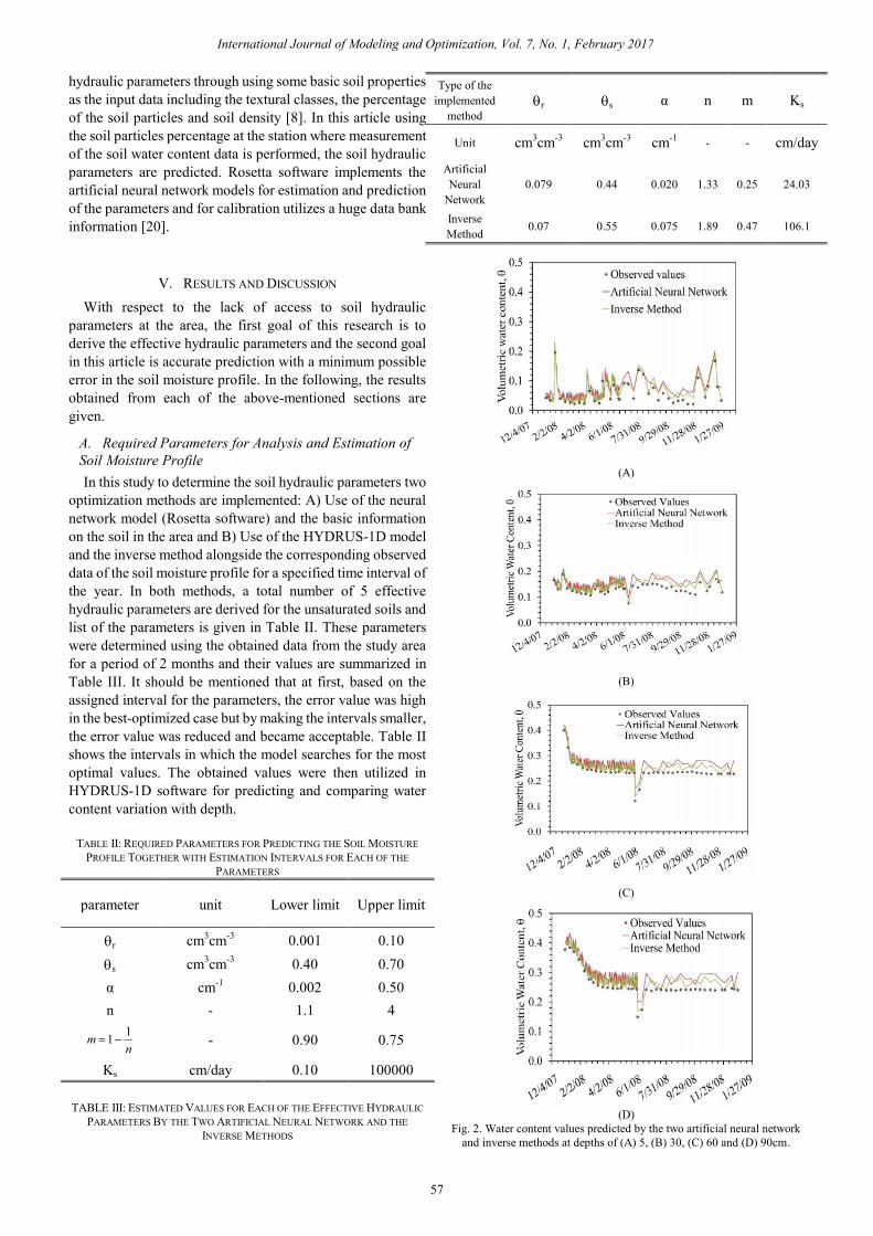
Fig. 2. Water content values predicted by the two artificial neural network
and inverse methods at depths of (A) 5, (B) 30, (C) 60 and (D) 90cm.
International Journal of Modeling and Optimization, Vol. 7, No. 1, February 2017
57
B. Comparison between the two Inverse and Artificial
Neural Network Methods
(A)
(B)
(C)
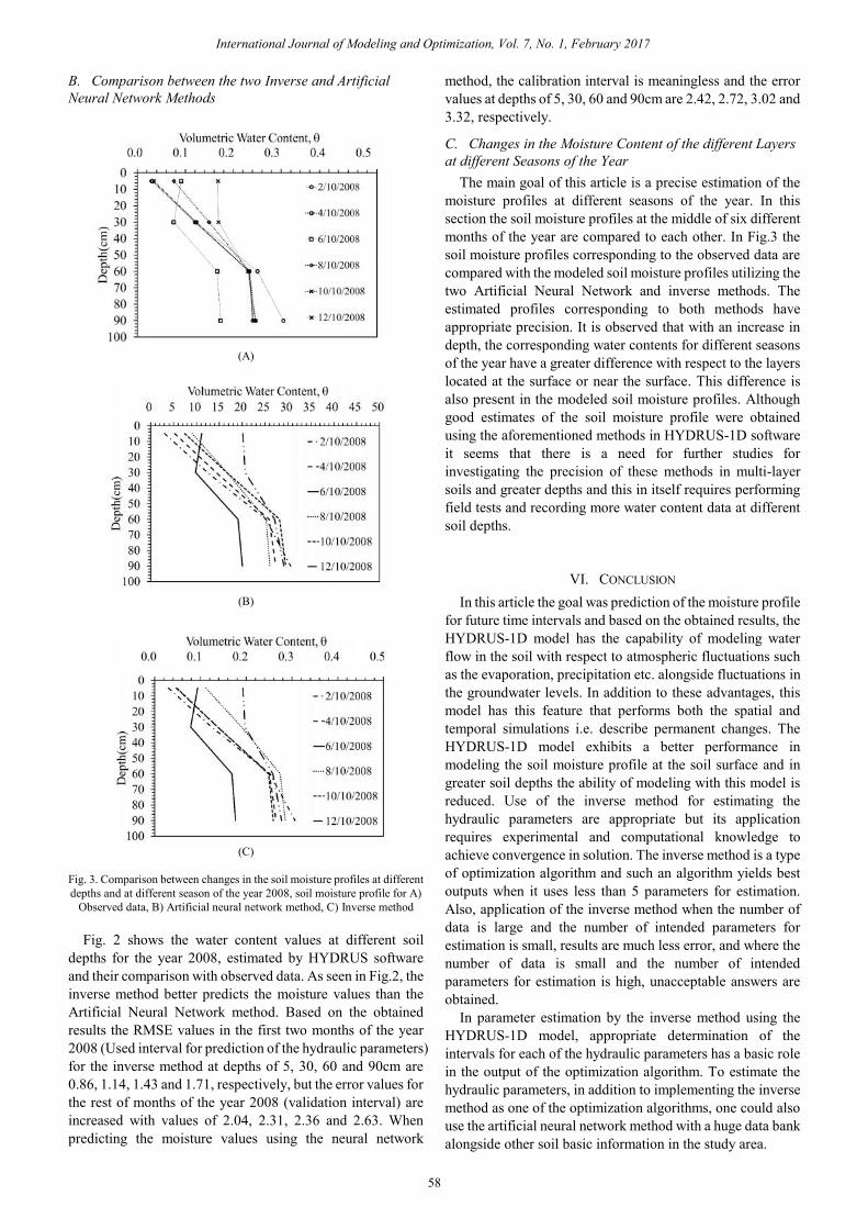
Fig. 3. Comparison between changes in the soil moisture profiles at different
depths and at different season of the year 2008, soil moisture profile for A)
Observed data, B) Artificial neural network method, C) Inverse method
Fig. 2 shows the water content values at different soil
depths for the year 2008, estimated by HYDRUS software
and their comparison with observed data. As seen in Fig.2, the
inverse method better predicts the moisture values than the
Artificial Neural Network method. Based on the obtained
results the RMSE values in the first two months of the year
2008 (Used interval for prediction of the hydraulic parameters)
for the inverse method at depths of 5, 30, 60 and 90cm are
0.86, 1.14, 1.43 and 1.71, respectively, but the error values for
the rest of months of the year 2008 (validation interval) are
increased with values of 2.04, 2.31, 2.36 and 2.63. When
predicting the moisture values using the neural network
method, the calibration interval is meaningless and the error
values at depths of 5, 30, 60 and 90cm are 2.42, 2.72, 3.02 and
3.32, respectively.
C. Changes in the Moisture Content of the different Layers
at different Seasons of the Year
The main goal of this article is a precise estimation of the
moisture profiles at different seasons of the year. In this
section the soil moisture profiles at the middle of six different
months of the year are compared to each other. In Fig.3 the
soil moisture profiles corresponding to the observed data are
compared with the modeled soil moisture profiles utilizing the
two Artificial Neural Network and inverse methods. The
estimated profiles corresponding to both methods have
appropriate precision. It is observed that with an increase in
depth, the corresponding water contents for different seasons
of the year have a greater difference with respect to the layers
located at the surface or near the surface. This difference is
also present in the modeled soil moisture profiles. Although
good estimates of the soil moisture profile were obtained
using the aforementioned methods in HYDRUS-1D software
it seems that there is a need for further studies for
investigating the precision of these methods in multi-layer
soils and greater depths and this in itself requires performing
field tests and recording more water content data at different
soil depths.
VI. CONCLUSION
In this article the goal was prediction of the moisture profile
for future time intervals and based on the obtained results, the
HYDRUS-1D model has the capability of modeling water
flow in the soil with respect to atmospheric fluctuations such
as the evaporation, precipitation etc. alongside fluctuations in
the groundwater levels. In addition to these advantages, this
model has this feature that performs both the spatial and
temporal simulations i.e. describe permanent changes. The
HYDRUS-1D model exhibits a better performance in
modeling the soil moisture profile at the soil surface and in
greater soil depths the ability of modeling with this model is
reduced. Use of the inverse method for estimating the
hydraulic parameters are appropriate but its application
requires experimental and computational knowledge to
achieve convergence in solution. The inverse method is a type
of optimization algorithm and such an algorithm yields best
outputs when it uses less than 5 parameters for estimation.
Also, application of the inverse method when the number of
data is large and the number of intended parameters for
estimation is small, results are much less error, and where the
number of data is small and the number of intended
parameters for estimation is high, unacceptable answers are
obtained.
In parameter estimation by the inverse method using the
HYDRUS-1D model, appropriate determination of the
intervals for each of the hydraulic parameters has a basic role
in the output of the optimization algorithm. To estimate the
hydraulic parameters, in addition to implementing the inverse
method as one of the optimization algorithms, one could also
use the artificial neural network method with a huge data bank
alongside other soil basic information in the study area.
International Journal of Modeling and Optimization, Vol. 7, No. 1, February 2017
58

Finally, one other conclusion in this research is that first the
soil effective hydraulic parameters are estimated by the two
artificial neural network and inverse methods and for the first
2-month interval in the year 2008 the corresponding
precisions of both methods were assessed and it was observed
that the inverse method yielded a better precision in
estimating the parameters and predicting the soil moisture
profile.
REFERENCES
[1] C. Yali et al., "Development and application of a regional land
subsidence model for the plain of Tianjin," Journal of Earth
Science, vol. 25, no. 3, 2014, pp. 550-562.
[2] D. Maryam et al., "Hybrid conventional and persistent scatterer SAR
interferometry for land subsidence monitoring in the Tehran Basin,
Iran," ISPRS Journal of Photogrammetry and Remote Sensing, vol.
79 , 2013, pp. 157-170.
[3] T. M. Trinh and D. G. Fredlund, "Modelling subsidence in the Hanoi
City area, Vietnam," Canadian Geotechnical Journal, vol. 37, no. 3,
2000, pp. 621-637.
[4] L. Robert and F. P. Brissette, "Soil moisture profile model for
two-layered soil based on sharp wetting front approach," Journal of
Hydrologic Engineering, 2001, pp. 141-149.
[5] P. W. Jeffrey, G. R. Willgoose, and J. D. Kalma, "One-dimensional soil
moisture profile retrieval by assimilation of near-surface
measurements: A simplified soil moisture model and field
application," Journal of Hydrometeorology, 2001, pp. 356-373.
[6] R. L. Adolph, "Capillary conduction of liquids through porous
mediums," Journal of Applied Physics, 1931, pp. 318-333.
[7] U. Wollschläger, T. Pfaff, and K. Roth, "Field-scale apparent hydraulic
parameterisation obtained from TDR time series and inverse
modelling," Hydrology and Earth System Sciences, 2009, pp.
1953-1966.
[8] S. G. Marcel, F. J. Leij, and M. T. V. Genuchten, "Rosetta: A computer
program for estimating soil hydraulic parameters with hierarchical
pedotransfer functions," Journal of Hydrology, 2001, pp. 163-176.
[9] M. W. Donald, "An algorithm for least-squares estimation of nonlinear
parameters," Journal of the Society for Industrial and Applied
Mathematics, 1963, pp. 431-441.
[10] R. Alain and M. Singer, "Mechanisms of sepsis-induced cardiac
dysfunction," Critical Care Medicine, 2007, pp. 1599-1608.
[11] M. Olivier et al., "The NAFE’06 data set: Towards soil moisture
retrieval at intermediate resolution," Advances in Water Resources,
2008, pp. 1444-1455.
[12] P. Rocco et al., "The NAFE'05/CoSMOS data set: Toward SMOS soil
moisture retrieval, downscaling, and assimilation," IEEE Transactions
on Geoscience and Remote Sensing, 2008, pp. 736-745.
[13] R. Majid and A. Pilpayeh, "Estimating unsaturated soil hydraulic
properties in sloping lands by numerical inversion," Journal of Food,
Agriculture & Environment, 2011, pp. 1067-1070.
[14] K. Y. Ernest and L. P. Choo, "Measurement of evaporative fluxes from
candidate cover soils," Canadian Geotechnical Journal, 1997, pp.
447-459.
[15] J. Simunek, M. T. V. Genuchten, and M. Sejna, "The HYDRUS-1D
software package for simulating the one-dimensional movement of
water, heat, and multiple solutes in variably-saturated
media," University of California-Riverside Research Reports, vol. 3,
2005, pp. 1-240.
[16] V. M. Genuchten, "A closed-form equation for predicting the hydraulic
conductivity of unsaturated soils," Soil Science Society of America
Journal, vol. 44, no. 5, 1980, pp. 892-898.
[17] V. Dam, C. Jos, and R. A. Feddes, "Numerical simulation of
infiltration, evaporation and shallow groundwater levels with the
Richards equation," Journal of Hydrology, vol. 233, no. 1, 2000, pp.
72-85.
[18] J. Šimůnek et al., "Solute tarnsport during variably saturated
flow–inverse modeling," Methods of Soil Analysis, SSSA, Madison,
Wisconsin, 2002, pp. 139-158.
[19] J. Simunek, M. T. V. Genuchten, and M. Sejna, "The HYDRUS-1D
software package for simulating the one-dimensional movement of
water, heat, and multiple solutes in variably-saturated
media," University of California-Riverside Research Reports, vol. 3,
2005, pp. 1-240..
[20] E. Bradley, "Bootstrap methods: another look at the
jackknife," Breakthroughs in Statistics, Springer New York, 1992, pp.
569-593.
S. Farid F. Mojtahedi received his bachelor`s degree
in civil engineering from SUT(Sharif University of
Technology) in 2014, and he is a geotechnical
engineering graduate student in Civil Engineering
Department at Sharif University of Technology,
Tehran, Iran.
Mohsen Sadoughi is undergraduate student in Civil
Engineering Department at Islamic Azad University,
Ardabil branch, Iran.
Author’s formal
photo
Author’s formal
photo
International Journal of Modeling and Optimization, Vol. 7, No. 1, February 2017
59