essential questions enduring glces district resources ...grade... · developments in the new...
TRANSCRIPT

Fifth Grade Colonization and Settlements Unit Overview
Essential Questions
Enduring
Understandings GLCEs Assessments
District Resources
How were the developments in the New England, Middle, and Southern Colonies significantly different? How did the slave system develop in the Americas? How was daily life viewed by different socio-economic groups in the same colonial community? How did colonial slavery impact the life of Africans?
The colonies were different based on the geographic location. People living together develop social systems and structure that reflect common values. Throughout history people and cultures have been exploited. Key Terms & Vocabulary Colonists Middle Passage Plantation Triangle Trade Slavery Abolitionists Investor Profit Mayflower Compact Tobacco Cash crop Indentured Servant
U2.1.2 Describe significant developments in the New England colonies, including: patterns of settlement and control including the impact of geography (landforms and climate) on settlement, relationships with American Indians(e.g., Pequot/King Phillip’s War), growth of agricultural (small farms) and non-agricultural (shipping and manufacturing) economies, the development of government including establishment of town meetings, development of colonial legislatures and growth of royal government, and religious tensions in Massachusetts that led to the establishment of other colonies in New England. (U2.3.1, U2.3.2, U2.3.3, U2.3.4, U2.3.5, U2.1.4) U2.1.3 Describe significant developments in the Middle Colonies, including: patterns of settlement and control including the impact of geography (landforms and climate) on settlement, the
Required: Fifth Grade Colonization and Settlements Unit Formative: Human timeline District:

Fifth Grade Colonization and Settlements Unit Overview
House of Burgesses Representatives Export Import Major colonies Slave auctions Overseer / Master Common Proprietor Merchant Meeting House Apprentice/Journeyman
growth of Middle Colonies economies (e.g., breadbasket), the Dutch settlements in New Netherlands, Quaker settlements in Pennsylvania, and subsequent English takeover of the Middle Colonies, and immigration patterns leading to ethnic diversity in the Middle Colonies. (U2.3.1, U2.3.2, U2.3.3, U2.3.4, U2.3.5, U2.1.4) U2.1.1 Describe significant developments in the Southern Colonies, including: patterns of settlement and control including the impact of geography (landforms and climate) on settlement, establishment of Jamestown, development of one-crop economies (plantation land use and growing season for rice in Carolinas and tobacco in Virginia), relationships with American Indians (e.g., Powhatan), development of colonial representative assemblies (House of Burgesses), and development of slavery. (U2.3.1, U2.3.2, U2.3.3, U2.3.4, U2.3.5, U2.1.4)
U2.3.1

Fifth Grade Colonization and Settlements Unit Overview
Locate the New England, Middle, and Southern colonies on a map.
U2.3.2 Describe the daily life of people living in the New England, Middle, and Southern colonies.
U2.3.3 Describe colonial life in America from the perspectives of at least three different groups of people (e.g., wealthy landowners, farmers, merchants, indentured servants, laborers and the poor, women, enslaved people, free Africans, and American Indians). U2.3.4 Describe the development of the emerging labor force in the colonies (e.g., cash crop farming, slavery, indentured servants).
U2.3.5 Make generalizations about the reasons for regional differences in colonial America.
U2.1.4
Compare the regional settlement patterns of the Southern colonies, New

Fifth Grade Colonization and Settlements Unit Overview
England, and the Middle Colonies.
U2.2.1
Describe Triangular Trade including: the trade routes, the people and goods that were traded, ant Middle Passage, and its impact on life in Africa.
U1.3.1 Use maps to locate the major regions of Africa (northern Africa, western Africa, central Africa, eastern Africa, southern Africa).
U1.3.2 Describe the life and cultural development of people living in western Africa before the 16th century with respect to economic ( the ways people made a living) and family structures, and the growth of states, towns, and trade.
U2.2.2
Describe the life of enslaved Africans and free Africans in the American colonies. U2.2.3 Describe how Africans living in North America drew upon their African past
(e.g., sense of family, role of oral tradition) and adapted elements of new cultures to develop a distinct African- American culture.
U1.4.1 Describe the convergence of Europeans, American Indians and Africans in North America after 1492 from the perspective of these three groups.
U1.4.4
Describe the Columbian Exchange and its impact on Europeans, American Indians, and Africans.
Essential Questions
Enduring Understandings
GLCEs Assessments
Fifth Grade Colonization and Settlements Unit Overview

Fifth Grade Colonization and Settlements Unit Overview

Calhoun ISD Social Studies Curriculum Design Project
Fifth Grade Colonization Unit Lessons Breakdown Unit 1 Title GLCEs Included
Resources Needed Resources Suggested Resources
Lesson 1 Roanoke U2.1.1 Images of Roanoke United Streaming video: New World Colonized
Roanoke, Mystery of the Lost Colony by Lee Miller
Lesson 2 Jamestown & Plymouth
U2.1.1 U2.1.2
Compare and contrast graphic organizer
United Streaming video: Exploring the World: The English Come to America: Jamestown and Plymouth
John Smith Escapes Again by Rosemary Schanzer
Lesson 3 Introduction to Colonies
U2.3.1 U2.3.2 U2.1.1 U2.1.2 U2.1.3
Graphic organizer for comparing and contrasting colony regions Map of colonies Background information sheets on the New England, Middle and Southern Colonies The Five Themes of Geography Worksheet: SCoPE SS050401
United Streaming video: Pilgrims and Puritans: The Struggle for Religious Freedom in England (1517-1692) Introduction segments of the United Streaming videos: Making the Thirteen Colonies: The Middle Colonies and Making the Thirteen Colonies: The Southern Colonies
Lesson 4 Geography, Resources, and Climate
U2.3.1 U2.3.2 U2.1.4. U2.3.5
Background information on the three colony regions Maps of the colony regions The Five Themes of
Materials for making 3-dimensional maps
Calhoun ISD Social Studies Curriculum Design Project
Geography Worksheet: SCoPE SS050401 from Lesson 1
Lesson 5 Economics U2.3.1 U2.3.2 U2.1.4 U2.3.5
Background information sheets on the New England, Middle and Southern Colonies Resources Overhead and Chart: SCoPE SS050407 The Five Themes of Geography Worksheet: SCoPE SS050401 from Lesson 1
http://www.history.org/Almanack/life/trades/tradehdr.cfm (trades in colonies)
Lesson 6 Government U2.3.5 Mayflower Compact Primary Source Analysis Worksheet
http://www.history.org/Almanack/life/trades/tradehdr.cfm (trades in colonies)
Lesson 7 (2-3 days)
Colonial Life U2.3.2 U2.3.3 U2.3.4
Reference sheets: Making the Thirteen Colonies: The Southern Colonies, The Middle Colonies, The New England Colonies from Lesson 3 Town Meeting Simulation Resources Sheet and Chart from Lesson 5
http://www.history.org/Almanack/life/trades/tradehdr.cfm (trades in colonies)
Lesson 8 Africa U1.3.1 U1.3.2
Story about life in Western Africa before the 16th century 5 Regions of Africa
Model of map made ahead Construction paper – blue, green, yellow
www.africa.upenn.edu/k-12/menu_eduMEDI.html Smithsonian web site
Calhoun ISD Social Studies Curriculum Design Project
Cutout Pattern 5 Regions of Africa Reference Map
Pipe cleaners Yarn
www.kidsnewsroom.org (choose info central, ancient civilizations, Africa, daily life)
Lesson 9 Slavery and Indentured Servants
U1.4.1 U2.2.2 U2.2.3
Molly Bannaky Sequence of Events and Venn Diagram worksheets Images of slave auction and ship
Molly Bannaky by Alice McGill
Amos Fortune Free Man by Elizabeth Yates
Lesson 10 African Influence on American Culture
U2.2.1 U2.2.2 U2.2.3
Informational reading on the slave trade and African-American culture
United Streaming: Section 1&2 of Atlantic Slave Trade video. Please review before you show to make sure it is appropriate for your community.

Fifth Grade Colonization and Settlement Unit
Lesson 1 Title: Roanoke Grade Level: 5th Unit of Study: Colonization and Settlements GLCE:
U2.1.1 Describe significant developments in the Southern colonies, including • patterns of settlement and control including the impact of geography (landforms and climate) on settlement (National Geography Standard 12, p. 167) • establishment of Jamestown (National Geography Standard 4, p. 150) • development of one-crop economies (plantation land use and growing season for rice in Carolinas and tobacco in Virginia) (National Geography Standard 11, p. 164) • relationships with American Indians (e.g., Powhatan) (National Geography Standard 10, p. 162) • development of colonial representative assemblies (House of Burgesses) (National Geography Standard 5, p. 152) • development of slavery
Abstract: Students will be able to identify the first attempts of settlement into the Southern Colonies. Key Concepts: People are coming to the new world for different reasons (land, wealth, power, religious freedom). Sequence of Activities: Introduction: Show students The New World Colonized, a United Streaming video, or another
overview of colonization 1. Show images (see below) of Roanoke to the class. 2. Ask the class to describe (either verbally or write) what is going on in the scenes. 3. Read a trade book or sample from district resources aloud to class (example: Roanoke, Mystery of the Lost Colony by Lee Miller – student version). 4. Formative Assessment: Have students write a journal entry from a Roanoke settlers’ point of view revealing what might have happened to the settlers. Connections: English Language Arts Have students pretend they are historians solving the mystery of Roanoke and write their findings. Read a biography.
Calhoun ISD Social Studies Curriculum Design Project
Fifth Grade Colonization and Settlement Unit
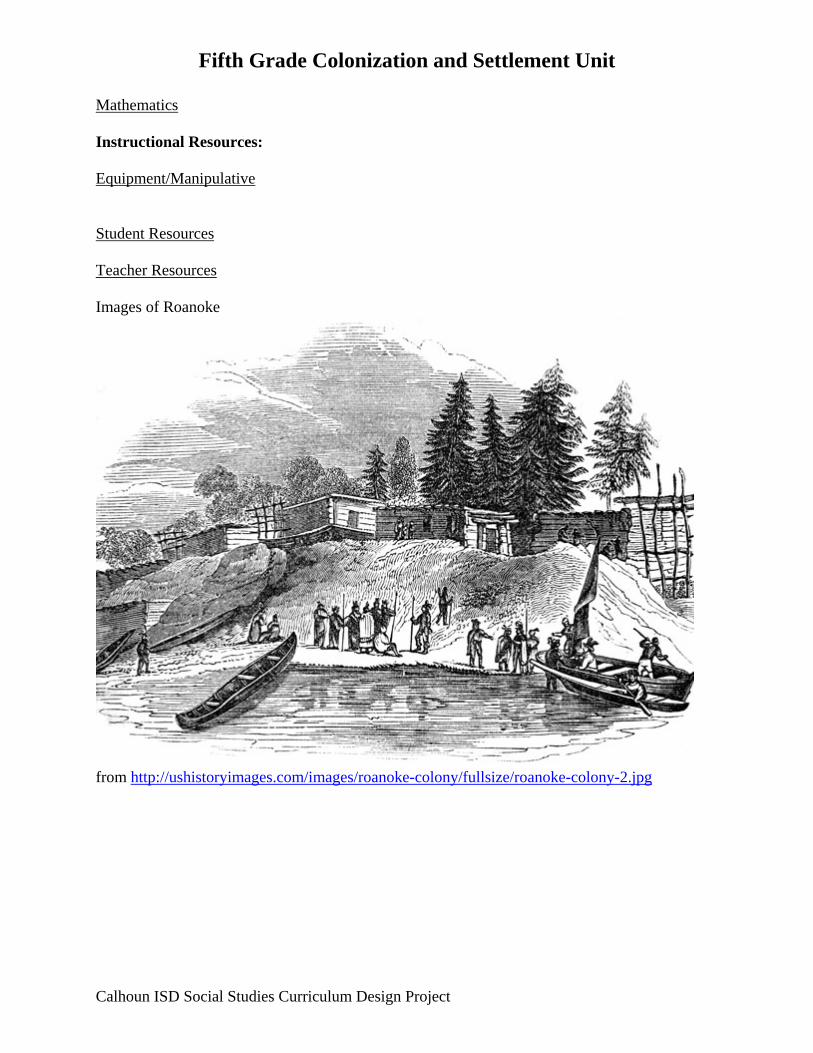
Mathematics Instructional Resources: Equipment/Manipulative Student Resources Teacher Resources Images of Roanoke
from http://ushistoryimages.com/images/roanoke-colony/fullsize/roanoke-colony-2.jpg
Calhoun ISD Social Studies Curriculum Design Project
Fifth Grade Colonization and Settlement Unit
Calhoun ISD Social Studies Curriculum Design Project
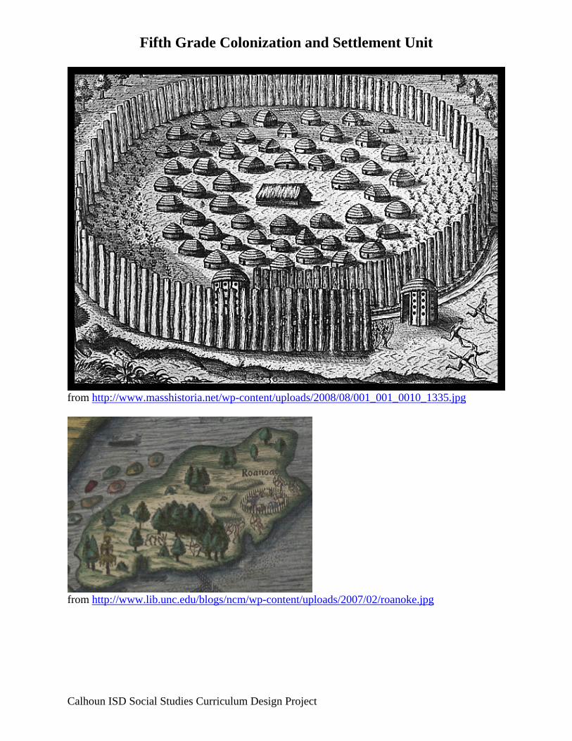
from http://www.masshistoria.net/wp-content/uploads/2008/08/001_001_0010_1335.jpg
from http://www.lib.unc.edu/blogs/ncm/wp-content/uploads/2007/02/roanoke.jpg

Fifth Grade Colonization and Settlements Unit Lesson 2 Title: Jamestown and Plymouth Grade Level: 5th Unit of Study: Colonization and Settlements GLCE:
U2.1.1 Describe significant developments in the Southern colonies, including • patterns of settlement and control including the impact of geography (landforms and climate) on settlement • establishment of Jamestown • development of one-crop economies (plantation land use and growing season for rice in Carolinas and tobacco in Virginia) • relationships with American Indians (e.g., Powhatan) • development of colonial representative assemblies (House of Burgesses) • development of slavery
U2.1.2 Describe significant developments in the New England colonies, including • patterns of settlement and control including the impact of geography (landforms and climate) on settlement • relations with American Indians (e.g., Pequot/King Phillip’s War) • growth of agricultural (small farms) and non-agricultural (shipping, manufacturing) economies • the development of government including establishment of town meetings, development of colonial legislatures and growth of royal government • religious tensions in Massachusetts that led to the establishment of other colonies in New England
Abstract: Students will be able to identify the first attempts of settlement into the New England Colonies. Key Concepts: People are coming to the new world for different reasons (land, wealth power, religious freedom). Sequence of Activities:
1. Show students the United Streaming video: Exploring the World: The English Come to America: Jamestown and Plymouth. Read aloud from a book such as John Smith Escapes Again by Rosemary Schanzer.
2. Have students break into small groups (one student named facilitator, one student named note taker) and discuss the differences between Jamestown and Plymouth.
3. Have groups report out and teacher record on a Venn diagram.
Calhoun ISD Social Studies Curriculum Design Project
Fifth Grade Colonization and Settlements Unit
4. Formative Assessment: Students will compare and contrast Jamestown and Plymouth using a graphic organizer (see below).
Connections: English Language Arts Read a biography of a child in Jamestown or Plymouth Mathematics Instructional Resources: Equipment/Manipulative Internet United Streaming Student Resources Teacher Resources United Streaming video: Exploring the World: The English Come to America: Jamestown and Plymouth John Smith Escapes Again by Rosemary Schanzer
Calhoun ISD Social Studies Curriculum Design Project

Fifth Grade Colonization and Settlements Unit
Calhoun ISD Social Studies Curriculum Design Project
Compare and Contrast Graphic Organizer Jamestown Plymouth When was it founded?
Who founded the colony?
Why did the settlers come to the region?
Why did the settlers stay in the colony?
How did the settlers adapt to the conditions in the New World?
Describe the daily life of the settlers.
How did the settlers change or modify the environment to fit their needs?
Describe some things that were important to the settlers.
What were some problems the settlers encountered?
Describe the settlers’ relationship with Native Americans.
Fifth Grade Colonization Unit Lesson 3 Title: Introduction to Colonies Grade Level: 5th Unit of Study: Colonization and Settlements GLCE: U2.3.1 Locate the New England, Middle, and Southern colonies on a map. U2.3.2 Describe the daily life of people living in the New England, Middle, and Southern
colonies. U2.1.1 Describe significant developments in the Southern colonies, including
• patterns of settlement and control including the impact of geography (landforms and climate) on settlement • establishment of Jamestown • development of one-crop economies (plantation land use and growing season for rice in Carolinas and tobacco in Virginia) • relationships with American Indians (e.g., Powhatan) • development of colonial representative assemblies (House of Burgesses) • development of slavery
U2.1.2 Describe significant developments in the New England colonies, including • patterns of settlement and control including the impact of geography (landforms and climate) on settlement • relations with American Indians (e.g., Pequot/King Phillip’s War) • growth of agricultural (small farms) and non-agricultural (shipping, manufacturing) economies • the development of government including establishment of town meetings, development of colonial legislatures and growth of royal government • religious tensions in Massachusetts that led to the establishment of other colonies in New England
U2.1.3 Describe significant developments in the Middle Colonies, including • patterns of settlement and control including the impact of geography (landforms and climate) on settlement • the growth of Middle Colonies economies (e.g., breadbasket) • The Dutch settlements in New Netherlands, Quaker settlement in Pennsylvania, and subsequent English takeover of the Middle Colonies • immigration patterns leading to ethnic diversity in the Middle Colonies
Abstract: Students will be able to identify the pattern of settlement, the impact of geography on settlement, native populations, and the growth of the New England Colonies economies. Students will understand that religious tensions in Massachusetts lead to the establishment of other colonies in New England
Calhoun ISD Social Studies Curriculum Design Project

Fifth Grade Colonization Unit Students will understand the types of government established in the New England colonies. Key Concepts: Regional differences in colonial America (development of emergent labor forces, resources, geography, climate, types of government, economy, ethnic population). Sequence of Activities:
1. Show United Streaming video Pilgrims and Puritans: The Struggle for Religious Freedom in England (1517-1692).
2. Introduce a map of the colonies and a graphic organizer for New England Colonies, Middle Colonies, and Southern Colonies (see below) that will be used throughout the unit.
3. Using the information from the video, background information sheets, and other resources, fill in the New England section of the graphic organizer on “why the colony was founded.”
4. Show the introduction segments of the United Streaming videos: Making the Thirteen Colonies: The Middle Colonies and Making the Thirteen Colonies: The Southern Colonies and/or utilize other resources to fill in the Middle Colonies and Southern Colonies sections on “why the colonies were founded” on the graphic organizer.
Connections: English Language Arts Have students write a paragraph to answer the question: Why did the colonists come to the New England Colonies, the Middle Colonies, and the Southern Colonies? Mathematics Instructional Resources: Equipment/Manipulative Student Resources Teacher Resources Background information sheets on the New England, Middle and Southern Colonies The Five Themes of Geography Worksheet: SCoPE SS050401
Calhoun ISD Social Studies Curriculum Design Project
Fifth Grade Colonization Unit
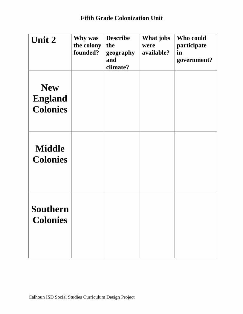
Unit 2 Why was the colony founded?
Describe the geography and climate?
What jobs were available?
Who could participate in government?
New
England Colonies
Middle
Colonies
Southern Colonies
Calhoun ISD Social Studies Curriculum Design Project

Fifth Grade Colonization Unit
Calhoun ISD Social Studies Curriculum Design Project

Important Ideas about the New England Colonies Teacher Reference Sheet
(SCoPE SS050401)
Geography: • Important natural resources included the region’s dense forests and the sea. • The soil was rocky and many areas were not very good for farming. The farms that
existed were small. • A lot of settlements grew up along rivers. • Most of the colonies were quite small compared to colonies like Pennsylvania and the
Carolinas.
Civics/Government: • Town meetings were an important part of New England government. This was the way
people often made decisions. They voted on laws and on matters that affected the whole community. In most cases everyone could attend a meeting but only men who owned property could vote. Town meetings were also held to elect people to public offices. These offices included: constable, town crier, digger of graves, drummer, sweeper of the meetinghouse, and fence viewer.
• Puritan laws in the region were often very strict.
Economics: • Fishing, including whaling, became an important economic activity. • Many New Englanders also made money in trading. Ships owned by New England
merchants carried trade goods to and from many ports. • Fishing, whaling, and trading helped build the shipbuilding industry. The forests of New
England supplied the necessary wood. • Over time many other kinds of goods were manufactured in New England.
Culture: • The Puritans thought schools and education were important because they believed
everyone needed to be able to read the Bible. As new colonies were formed when people left Massachusetts Bay, education was valued in these places also.
• Religion was very important in this region. • There was not as much diversity in this region as there was in the Middle Colonies. • Towns were often organized in a similar fashion with a common in the center. Other
buildings included the meetinghouse, general store, blacksmith, school, and houses.

Important Ideas about the Middle Colonies Teacher Reference Sheet
(SCoPE SS050402)
Geography: • This region had a longer growing season than New England and soil rich enough to grow
cash crops. • Crops that grew well included corn, wheat, rye, and other grains. • There were excellent harbors along the coast. Cities grew in these areas. • This region had fertile river valleys such as the Hudson River Valley.
Economics:
• Many people moved to this region to take advantage of the fertile farmland. • Most of the people in this region made their living by farming. • Immigrants such as those from Holland and Germany brought farming methods with
them. • Cash crops were grown especially different kinds of grain. For this reason, this region
became known as the ‘Breadbasket Colonies.” • Mills were very important in this region. • Crops were sold in coastal market towns. • Philadelphia had a lot of shipyards where ships were built and repaired.
Civics/Government:
• William Penn set up a Frame of Government for Pennsylvania which included a legislature. People in this colony had rights including freedom of religion, freedom of speech, and trial by jury. These rights were common throughout the region of the Middle Colonies.
• Although there were many towns in this region, town meetings like those of the New England region were not common.
• Each colony in the region had a governor, a council of advisors to advise him, and a legislature.
Culture:
• Immigrants from all over Europe came to this region. • Market towns were important in this region. • This region had a great diversity of people. • New York and Philadelphia were important cities. • Philadelphia had many large buildings including the statehouse which later became
Independence Hall. • There were many different religions in this region. • Since there was such variety in religion and language in this region, schools were
different than those of New England. Schools tended to be run by different types of churches. These were parish or parochial schools.

Possible answers for a Venn Diagram comparing and contrasting the Middle Colonies and the
New England Colonies
Similarities:
Many people in both regions were farmers. People came to both regions for both religious and economic reasons. Both regions were made up of proprietary colonies in the beginning. Both regions had port cities with good harbors. Towns were important in both regions. Religion was important in both regions. The colonies had colonial legislatures in each region.
Differences:
The soil was much better for farming in the Middle Colonies. There was also a longer growing season. There was more religious diversity in the Middle Colonies. There was more cultural diversity in the Middle Colonies. New England had more public schools than the Middle Colonies. Fishing and whaling was more important in New England. Town meetings were common in New England. New England towns were organized in much the same way. This was not true of the Middle Colonies. The Middle Colonies grew a lot of cash crops. This was not true of New England. Although manufacturing was done in both regions, more was done in New England.

Important Ideas about the Southern Colonies Teacher Reference Sheet
(SCoPE SS050403)
Geography: • This region had good soil and an almost year-round growing season that was ideal for
plantation crops. • There was a tidewater region of rich low-lying land along the coast where the first
plantations began. • There were lots of waterways in this area that made it easy for boats to get crops to
markets. • Crops like tobacco ruined fertile soil in only a few years. As land wore out near the coast,
planters began to move up the rivers to higher land. • Forests in the region provided a lot of wood for shipbuilding.
Economics:
• There were a lot of small farms but the region was known for its large plantations. • Crop buyers from England traveled the waterways with English-made goods like shoes
and tools, which they traded for cash crops. • Plantations needed a lot of workers. Enslaved Africans were used to do the work. • Plantations were largely self-sufficient. Everything needed was produced on the
plantation. • Over time this region became dependent on slave labor.
Civics/Government:
• Colonial assemblies, or legislatures, were found in all the colonies of this region. • Wealthy planters especially those in the tidewater region held most of the political power. • Planters were expected to provide some type of public service. They served in a colonial
legislature, as judges, etc. • Laws relating to slavery called “slave codes” were developed and enforced.
Culture:
• There were fewer towns and cities in this region. Plantations and farms were fairly spread out.
• A few towns had grown by the mid 1700s. These included Charles town and Savannah. • Later inland towns developed. Many of these were county seats that included a
courthouse and a jail. • Because people lived far apart and there were fewer towns, there were fewer schools in
this region. Wealthy planters had tutors for their children or built a small school right on their plantation.
• The Anglican Church, which was the Church of England, was the establish church in this region except for Maryland. Quakers and Puritans were often pushed out of the region.
• Wealthy planters built huge, ornate houses on their plantations.

Five Themes of Geography Worksheet Summer Assignment
Student Name: _____________________
Directions – Utilize the information from the indicated website to guide you in your answers to the questions below. Also, consult the rubric that will be used to evaluate your work (page 3). http://www2.una.edu/geography/statedepted/themes.html
Summary of Article – see rubric for expectations
1. (Location) The absolute location (you will have to find this on a map) of the story takes place at . . .
• Longitude = ____________________ • Latitude = ____________________
2. (Location) The relative location of the story takes place at . . .
Location
3. (Place) Identify two (2) physical characteristics and two (2) human characteristics of the place. Be sure to explain why you chose these characteristics.
Physical Characteristics Human Characteristics

4. (Region) Identify and describe one region in which this story is located.
5. (Human-Environmental Interaction) Answer one (1) of the following questions. a. Describe how the event(s) in the story illustrate(s) cooperation or conflict among people and
places? b. Describe how the event in the story will impact the place in which it occurred.
6. (Movement) Describe how the theme of movement may have impacted the story.

Student Name: ____________________________________________________________
Rubric for evaluating your article analysis
SHS Learning Expectation and Standard for Geography - Students are able to understand the locations of the physical features of the world in relationship to each other; the human and physical characteristics of a locality; and that regions are formed based on governmental boundaries, language, natural resources, and physical features. Students are able to understand that humans adapt, modify, and depend upon the physical environment for survival. Students are able to understand the concept of a global community through the movement of people, products, ideas, and beliefs.
Basic Proficient Distinguished Article is attached Summary is detailed The summary is related to the Five Themes of Geography
• Article is not included • The summary does
not provide enough information (who, what, where, when, why, and how)
• The student summary
makes no connection to the Five themes of Geography
• Article is included • The summary
provides enough information (who, what, where, when, why, and how)
• The student makes an
attempt to incorporate the Five Themes of Geography into the summary.
• Article is included • The summary
provides enough information (who, what, where, when, why, and how)
• The student summary
clearly makes connections to each of the Five Themes of Geography.
Questions • Less than four of the questions were answered correctly
• Understanding the
applicable Themes of Geography has not been demonstrated
• Four questions are answered correctly
• Understanding of the
applicable Themes of Geography is in development - based on student responses.
• All answers are correct
• Responses
demonstrate a clear understanding of the applicable Five Themes of Geography - based on student responses.
Teacher Comments
Student Self-Analysis and Comments

Fifth Grade Colonization and Settlements Unit Lesson 4 Title: Geography, Climate and Resources Grade Level: 5th Unit of Study: Colonization and Settlements GLCE: U2.3.1 Locate the New England, Middle, and Southern colonies on a map. U2.3.2 Describe the daily life of people living in the New England, Middle, and Southern colonies. U2.1.4 Compare the regional settlement patterns of the Southern colonies, New England, and the Middle Colonies. U2.3.5 Make generalizations about the reasons for regional differences in colonial America. Abstract: Students will be able to identify the pattern of settlement, the impact of geography on settlement, native populations, and the growth of the New England Colonies economies. Key Concepts: Regional differences in colonial America (development of emergent labor forces, resources, geography, climate, types of government, economy, ethnic population). Sequence of Activities:
1. Review the geography of each colonial region (New England Colonies, Middle Colonies, and Southern Colonies) with the class.
2. Break the class into three groups. Have each group research and collect materials for their regional colonies using the background sheets, videos, or internet resources.
3. Groups will create three-dimensional colonial maps of the three colony regions. Make sure they end up similar in scale so that they can be put together for a display.
4. Each group will present their colonial region map to the rest of the class highlighting their unique landforms and natural resources.
5. Display the maps. Connections: English Language Arts Mathematics Instructional Resources: Equipment/Manipulative Student Resources
Calhoun ISD Social Studies Curriculum Design Project

Fifth Grade Colonization and Settlements Unit
Calhoun ISD Social Studies Curriculum Design Project
Teacher Resources Reference Sheets: Making the Thirteen Colonies: The Middle Colonies Making the Thirteen Colonies: The Middle Colonies Making the Thirteen Colonies: The New England Colonies The Five Themes of Geography Worksheet: SCoPE SS050401

Third Grade Colonization and Settlement Unit Lesson 5 Title: Economics Grade Level: 5th Unit of Study: Colonization and Settlements GLCE: U2.1.2 Describe significant developments in the New England colonies, including
• patterns of settlement and control including the impact of geography (landforms and climate) on settlement • relations with American Indians (e.g., Pequot/King Phillip’s War) • growth of agricultural (small farms) and non-agricultural (shipping, manufacturing) economies • the development of government including establishment of town meetings, development of colonial legislatures and growth of royal government • religious tensions in Massachusetts that led to the establishment of other colonies in New England
Abstract: Students will be able to identify the patterns of settlement, the impact of geography on settlement, native populations, and the growth of the New England Colonies economies. Students will understand that religious tensions in Massachusetts lead to the establishment of other colonies in New England Students will understand the types of government established in the New England colonies. Key Concepts: Regional differences in colonial America (development of emergent labor forces, resources, geography, climate, types of government, economy, ethnic population). Sequence of Activities:
1. Using the website http://www.history.org/Almanack/life/trades/tradehdr.cfm and background information sheets, discuss the natural resources and economy of each colonial region.
2. Have students create a key on their unit map to define the different resources that the colonists used in their economies in each colonial region.
3. Have students color and draw the key symbols on their maps. 4. Students present or write about the differences in the regions.
Connections: English Language Arts
Calhoun ISD Social Studies Curriculum Design Project

Third Grade Colonization and Settlement Unit
Calhoun ISD Social Studies Curriculum Design Project
Mathematics Instructional Resources: Equipment/Manipulative Student Resources http://www.history.org/Almanack/life/trades/tradehdr.cfm (trades in colonies) Teacher Resources Reference Sheets: Making the Thirteen Colonies: The Middle Colonies Making the Thirteen Colonies: The Middle Colonies Making the Thirteen Colonies: The New England Colonies The Five Themes of Geography Worksheet: SCoPE SS050401 Resources Overhead: SCoPE SS050407 Resource Chart: SCoPE SS050407

Later Elementary Social Studies Colonial Life Early American History Other Resource
Resources Overhead #1 (SS050407)
Resources
What we use to make
goods and services
Human Resources
Workers
Natural Capital ResourcesResources
Things Goods used
to produce other
provided by nature goods
and services
July 31, 2006 SCoPE SS050407 Page 1 of 16
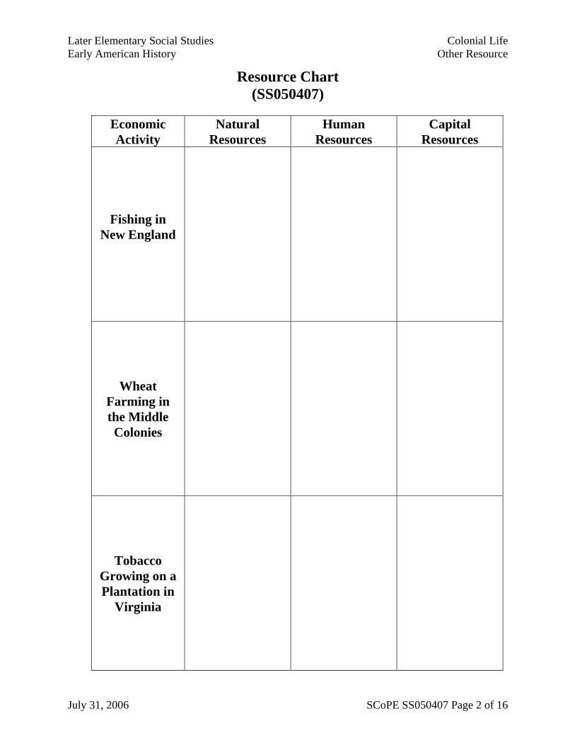
Later Elementary Social Studies Colonial Life Early American History Other Resource
Resource Chart (SS050407)
Economic Activity
Natural Resources
Human Resources
Capital Resources
Fishing in New England
Wheat Farming in the Middle Colonies
Tobacco Growing on a Plantation in
Virginia
July 31, 2006 SCoPE SS050407 Page 2 of 16

Later Elementary Social Studies Colonial Life Early American History Other Resource
Resource Chart – with Sample Answers (SS050407)
Economic Activity
Natural Resources
Human Resources
Capital Resources
Fishing in New England
fish water bait
fisherman shipbuilders
barrel makers
boats nets
barrels
Wheat Farming in the
Middle Colonies
good soil water seeds
farmers millers
blacksmith
plows wagons sacks
farm tools
Tobacco Growing
on a Plantation in Virginia
good soil water seeds
lots of land warm climate
enslaved people
plantation owners
indentured servants
drying barns
wagons farm tools
tobacco cutters
July 31, 2006 SCoPE SS050407 Page 3 of 16

Later Elementary Social Studies Colonial Life Early American History Other Resource
Colonial Occupations (SS050407)
Apothecary Gunsmith Basket maker
Miller Blacksmith Milliner
Brick maker Printer and Binder Cabinet maker
Saddler Carpenter Shoemaker
Cooper Silversmith Tailor
Wheelwright Wigmaker
July 31, 2006 SCoPE SS050407 Page 4 of 16

Later Elementary Social Studies Colonial Life Early American History Other Resource
SCARCITY Overhead #2 (SS050407)
LIMITED RESOURCES
UNLIMITEDWANTS
SCARCITY
July 31, 2006 SCoPE SS050407 Page 5 of 16

Later Elementary Social Studies Colonial Life Early American History Other Resource
Examples of Scarcity (SS050407)
In England
In the Colonies
July 31, 2006 SCoPE SS050407 Page 6 of 16

Later Elementary Social Studies Colonial Life Early American History Other Resource
Examples of Scarcity – Possible Answers (SS050407)
In England
• Scarcity of jobs • Scarcity of land for people to own • Scarcity of money • Scarcity of opportunity • Scarcity of lumber
In the Colonies
• Scarcity of good farm land in New England
• Scarcity of workers for plantations in the Southern Colonies
• Scarcity of manufactured goods • Scarcity of land from the Native
American viewpoint • Scarcity of good drinking water in
Jamestown • Scarcity of settlers at first
July 31, 2006 SCoPE SS050407 Page 7 of 16
Later Elementary Social Studies Colonial Life Early American History Other Resource
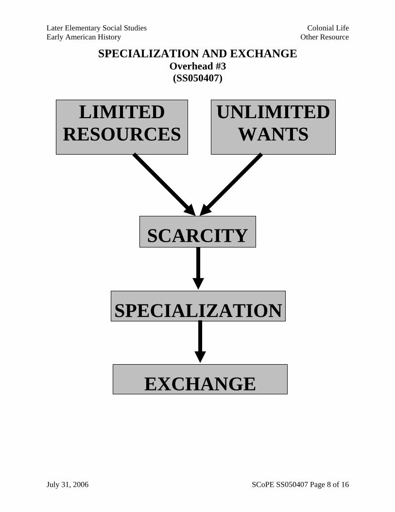
SPECIALIZATION AND EXCHANGE Overhead #3 (SS050407)
LIMITED RESOURCES
UNLIMITEDWANTS
SCARCITY
SPECIALIZATION
EXCHANGE
July 31, 2006 SCoPE SS050407 Page 8 of 16
Later Elementary Social Studies Colonial Life Early American History Other Resource
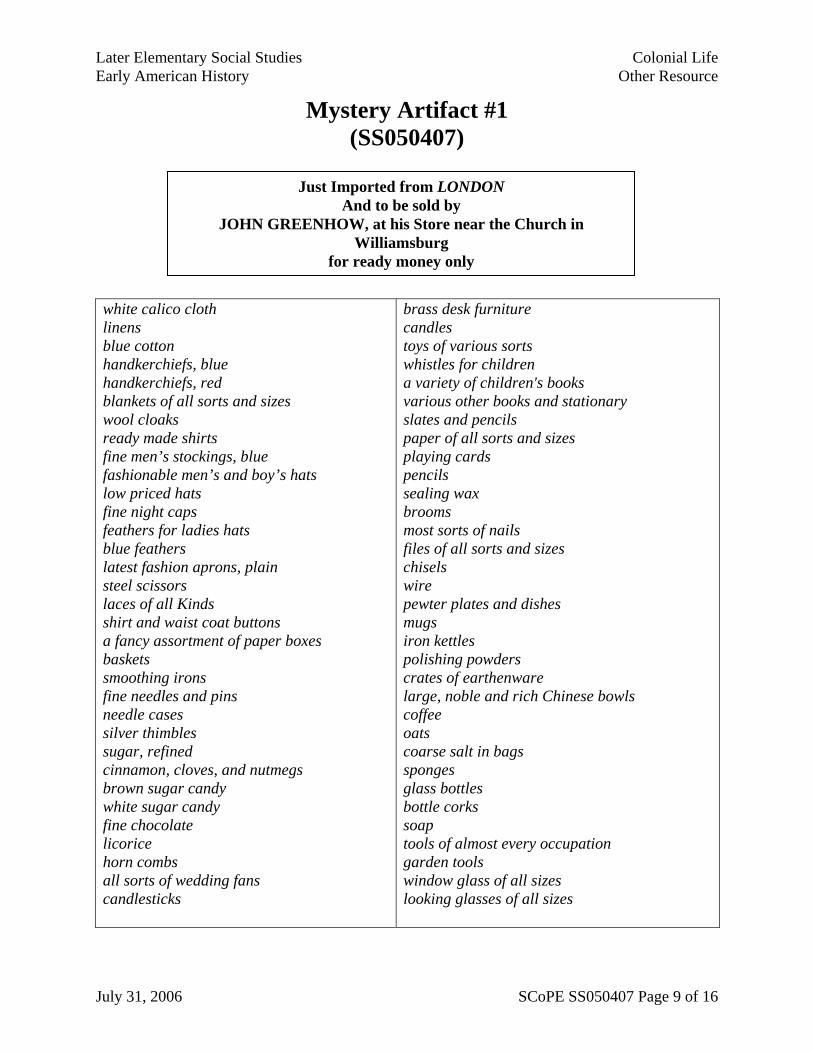
Mystery Artifact #1 (SS050407)
white calico cloth linens blue cotton handkerchiefs, blue handkerchiefs, red blankets of all sorts and sizes wool cloaks ready made shirts fine men’s stockings, blue fashionable men’s and boy’s hats low priced hats fine night caps feathers for ladies hats blue feathers latest fashion aprons, plain steel scissors laces of all Kinds shirt and waist coat buttons a fancy assortment of paper boxes baskets smoothing irons fine needles and pins needle cases silver thimbles sugar, refined cinnamon, cloves, and nutmegs brown sugar candy white sugar candy fine chocolate licorice horn combs all sorts of wedding fans candlesticks
brass desk furniture candles toys of various sorts whistles for children a variety of children's books various other books and stationary slates and pencils paper of all sorts and sizes playing cards pencils sealing wax brooms most sorts of nails files of all sorts and sizes chisels wire pewter plates and dishes mugs iron kettles polishing powders crates of earthenware large, noble and rich Chinese bowls coffee oats coarse salt in bags sponges glass bottles bottle corks soap tools of almost every occupation garden tools window glass of all sizes looking glasses of all sizes
Just Imported from LONDON And to be sold by
JOHN GREENHOW, at his Store near the Church in Williamsburg
for ready money only
July 31, 2006 SCoPE SS050407 Page 9 of 16
Later Elementary Social Studies Colonial Life Early American History Other Resource
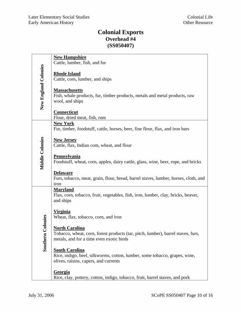
Colonial Exports Overhead #4 (SS050407)
New
Eng
land
Col
onie
s
New Hampshire Cattle, lumber, fish, and fur Rhode Island Cattle, corn, lumber, and ships Massachusetts Fish, whale products, fur, timber products, metals and metal products, raw wool, and ships Connecticut Flour, dried meat, fish, rum
Mid
dle
Col
onie
s
New York Fur, timber, foodstuff, cattle, horses, beer, fine flour, flax, and iron bars New Jersey Cattle, flax, Indian com, wheat, and flour Pennsylvania Foodstuff, wheat, corn, apples, dairy cattle, glass, wine, beer, rope, and bricks Delaware Furs, tobacco, meat, grain, flour, bread, barrel staves, lumber, horses, cloth, and iron
So
uthe
rn C
olon
ies
Maryland Flax, corn, tobacco, fruit, vegetables, fish, iron, lumber, clay, bricks, beaver, and ships Virginia Wheat, flax, tobacco, corn, and iron North Carolina Tobacco, wheat, corn, forest products (tar, pitch, lumber), barrel staves, furs, metals, and for a time even exotic birds South Carolina Rice, indigo, beef, silkworms, cotton, lumber, some tobacco, grapes, wine, olives, raisins, capers, and currents Georgia Rice, clay, pottery, cotton, indigo, tobacco, fruit, barrel staves, and pork
July 31, 2006 SCoPE SS050407 Page 10 of 16

Later Elementary Social Studies Colonial Life Early American History Other Resource
Trade Between the Colonies and England Overhead #5 (SS050407)
The Colonies
England
raw materials
such as trees
manufactured goods such as furniture and
barrels
July 31, 2006 SCoPE SS050407 Page 11 of 16

Later Elementary Social Studies Colonial Life Early American History Other Resource
Unfavorable Balance of Trade Overhead #6 (SS050407)
Exports
Imports
July 31, 2006 SCoPE SS050407 Page 12 of 16

Later Elementary Social Studies Colonial Life Early American History Other Resource
Mystery Artifacts #2 and #3 (SS050407)
July 31, 2006 SCoPE SS050407 Page 13 of 16

Later Elementary Social Studies Colonial Life Early American History Other Resource
Triangular Trade Overhead #7 (SS050407)
New England
West Africa
West Indies
Rum Guns Cloth Tools
Enslaved Africans
Lumber Fish
Flour
Sugar Molasses
July 31, 2006 SCoPE SS050407 Page 14 of 16

Later Elementary Social Studies Colonial Life Early American History Other Resource
Assessment Chart (SS050407)
Describe two examples of colonial economic activities
Describe an example of scarcity in the colonies and how the colonists reacted to it.
List two examples of colonial exports
List two examples of colonial imports
Describe the trade relationship between England and the colonies.
Describe a triangular trade route.
Describe one benefit of trade between Europe, Africa, and the colonies.
Describe one cost of trade between Europe, Africa, and the colonies.
July 31, 2006 SCoPE SS050407 Page 15 of 16

Later Elementary Social Studies Colonial Life Early American History Other Resource
July 31, 2006 SCoPE SS050407 Page 16 of 16
Assessment Chart - Possible Answers (SS050407)
Describe two examples of colonial economic activities
• Fishing • Trading • Farming • Ship-building
Describe an example of scarcity in the colonies and how the colonists reacted to it.
• New England had a scarcity of good soil for farming so people began to fish and trade.
• The Southern colonies had a scarcity of workers for plantations so they forced enslaved Africans to do the work.
List two examples of colonial exports
• Lumber • Tobacco • Rice • Fish
List two examples of colonial imports
• Furniture • Dishes and glasses • Enslaved Africans • A lot of manufactured goods like tools
Describe the trade relationship between England and the colonies.
• The colonies exported raw materials to England and England exported manufactured goods to the colonies.
Describe a triangular trade route.
• New England traders took goods like flour and lumber to the West Indies and brought back molasses and sugar.
• They made rum out of these goods and took it to West Africa and traded for enslaved Africans.
• They took the Africans to the West Indies and sold them there and bought more molasses and sugar.
Describe one benefit of trade between Europe, Africa, and the colonies.
• England gained wealth as a result of its favorable balance of trade with the colonies.
• New England traders got wealthy. • England had a good market for manufactured goods in both
the colonies and Africa.
Describe one cost of trade between Europe, Africa, and the colonies.
• The slave trade had terrible negative consequences for Africa.
• The colonies had an unfavorable balance of trade with England.
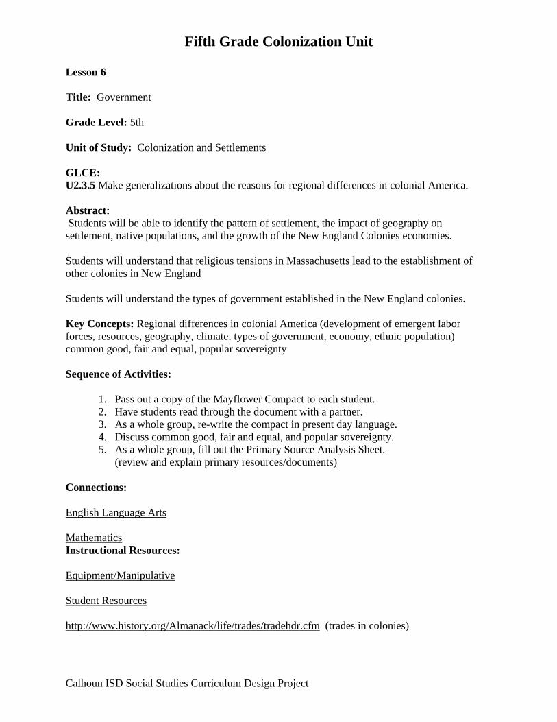
Fifth Grade Colonization Unit Lesson 6 Title: Government Grade Level: 5th Unit of Study: Colonization and Settlements GLCE: U2.3.5 Make generalizations about the reasons for regional differences in colonial America. Abstract: Students will be able to identify the pattern of settlement, the impact of geography on settlement, native populations, and the growth of the New England Colonies economies. Students will understand that religious tensions in Massachusetts lead to the establishment of other colonies in New England Students will understand the types of government established in the New England colonies. Key Concepts: Regional differences in colonial America (development of emergent labor forces, resources, geography, climate, types of government, economy, ethnic population) common good, fair and equal, popular sovereignty Sequence of Activities:
1. Pass out a copy of the Mayflower Compact to each student. 2. Have students read through the document with a partner. 3. As a whole group, re-write the compact in present day language. 4. Discuss common good, fair and equal, and popular sovereignty. 5. As a whole group, fill out the Primary Source Analysis Sheet.
(review and explain primary resources/documents)
Connections: English Language Arts Mathematics Instructional Resources: Equipment/Manipulative Student Resources http://www.history.org/Almanack/life/trades/tradehdr.cfm (trades in colonies)
Calhoun ISD Social Studies Curriculum Design Project

Fifth Grade Colonization Unit Teacher Resources Background information sheets
Calhoun ISD Social Studies Curriculum Design Project
Fifth Grade Colonization Unit
Calhoun ISD Social Studies Curriculum Design Project
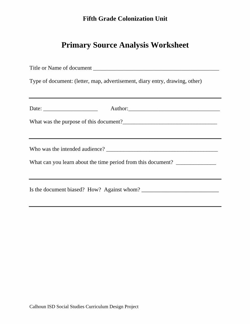
Primary Source Analysis Worksheet Title or Name of document ____________________________________________ Type of document: (letter, map, advertisement, diary entry, drawing, other) Date: ___________________ Author:________________________________ What was the purpose of this document?_________________________________ Who was the intended audience? _______________________________________ What can you learn about the time period from this document? ______________ Is the document biased? How? Against whom? ___________________________

Fifth Grade Colonization and Settlements Unit Lesson 7 Title: Colonial Life Grade Level: 5th Unit of Study: Colonization and Settlements GLCE: U2.3.2 Describe the daily life of people living in the New England, Middle, and Southern colonies. U2.3.3 Describe colonial life in America from the perspectives of at least three different groups of people (e.g., wealthy landowners, farmers, merchants, indentured servants, laborers and the poor, women, enslaved people, free Africans, and American Indians). U2.3.4 Describe the development of the emerging labor force in the colonies (e.g., cash crop farming, slavery, indentured servants). Abstract: Students will be able to identify the pattern of settlement, the impact of geography on settlement, native populations, and the growth of the New England Colonies economies. Students will understand that religious tensions in Massachusetts led to the establishment of other colonies in New England. Students will understand the types of government established in the New England colonies. Key Concepts: Regional differences in colonial America (development of emergent labor forces, resources, geography, climate, types of government, economy, ethnic population). Sequence of Activities (2-3 days): (Teachers: depending on your time and resources, choose either #1 or #2 – the objective of
this lesson is for the students to understand the different occupations in a colonial community. The GLCEs require students be able to describe colonial life from the perspectives of at least three different groups of people. There are two sets of sequences of activities; it is intended for teachers to use only one.
#1 1. Have students explore the website
http://www.history.org/Almanack/life/trades/tradehdr.cfm and complete the webquest sheet.
2. Discuss the results with the class in small or large groups. OR
Calhoun ISD Social Studies Curriculum Design Project

Fifth Grade Colonization and Settlements Unit
#2 1. Teacher: choose and create at least six stations to represent life in a colonial
community. 2. Distribute role-play cards to students. 3. Students will research the trade they have on their role cards. The website
http://www.history.org/Almanack/life/trades/tradehdr.cfm can be used. 4. Students then create activities for each station based on the guidelines on the cards. 5. Each group needs to have a color coding or numbering system so that some of the
groups are stationary and some are traveling. 6. Have groups of students travel through the stations in groups to experience some of
the roles/occupations of a colonial settlement. 7. Use the Town Meeting Simulation sheet to re-enact a discussion that might have
occurred in the colonies. 8. Closure: Review the three types of resources (use the resource sheets from lesson 5).
Connections: English Language Arts Mathematics Instructional Resources: Equipment/Manipulative Student Resources http://www.history.org/Almanack/life/trades/tradehdr.cfm (trades in colonies) Teacher Resources Reference sheets: Making the Thirteen Colonies: The Southern Colonies Making the Thirteen Colonies: The Middle Colonies Making the Thirteen Colonies: The New England Colonies Town Meeting Role Cards: SCoPE SS050406 Town Meeting Reflection Sheet: SCoPE SS050406 Resources: SCoPE SS050407 Resources Chart: SCoPE SS050407
Calhoun ISD Social Studies Curriculum Design Project

Fifth Grade Colonization and Settlements Unit
Colonial Role/Occupation
Wealthy Landowner
Farmers
Merchants –
Choose from the list provided
Indentured
Servants
Laborers and
the Poor
Women
Enslaved People
Free Africans
American Indians
Basket Maker
Milliner
Tailor/Seamstress
Printer/Binder
Cobbler
Cooper
Minister
Calhoun ISD Social Studies Curriculum Design Project

Fifth Grade Colonization and Settlements Unit
Calhoun ISD Social Studies Curriculum Design Project
Merchants - Apothecary Basket Maker Miller Blacksmith Milliner Brick Maker Printer and Binder Cabinet Maker Saddler Carpenter Cobbler Cooper Silversmith Tailor Seamstress Butcher Wigmaker Wheelwright Trapper/Trader Fisherman

Fifth Grade Colonization and Settlements
Lesson 8 Title: Africa Grade Level: 5th Unit of Study: Colonization and Settlements GLCE: U1.3.1 Use maps to locate the major regions of Africa (northern Africa, western Africa, central Africa, eastern Africa, southern Africa). U1.3.2 Describe the life and cultural development of people living in western Africa before the 16th century with respect to economic (the ways people made a living) and family structures, and the growth of states, towns, and trade. Abstract: Students will be able to locate the five major regions of Africa. Students will be able to describe the life and cultural development of people living in western Africa before the 16th century with respect to economic and family structures, and the growth of states, towns, and trade. Key Concepts: People living together develop social systems and structure that reflect common values. Throughout history people and cultures have been exploited. Sequence of Activities:
1. Complete the map activity attached below. 2. Read aloud a story about life in Western Africa before the 16th century and discuss. 3. Formative Assessment: Have students draw a picture of life in a West African Village.
Connections: English Language Arts Mathematics Instructional Resources: Equipment/Manipulative Student Resources
Calhoun ISD Social Studies Curriculum Design Project

Fifth Grade Colonization and Settlements
Teacher Resources www.africa.upenn.edu/K-12/menu_EduMEDI.html Smithsonian website www.kidsnewsroom.org (choose info central, ancient civilizations, Africa, daily life)
Calhoun ISD Social Studies Curriculum Design Project
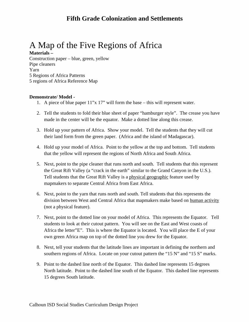
Fifth Grade Colonization and Settlements
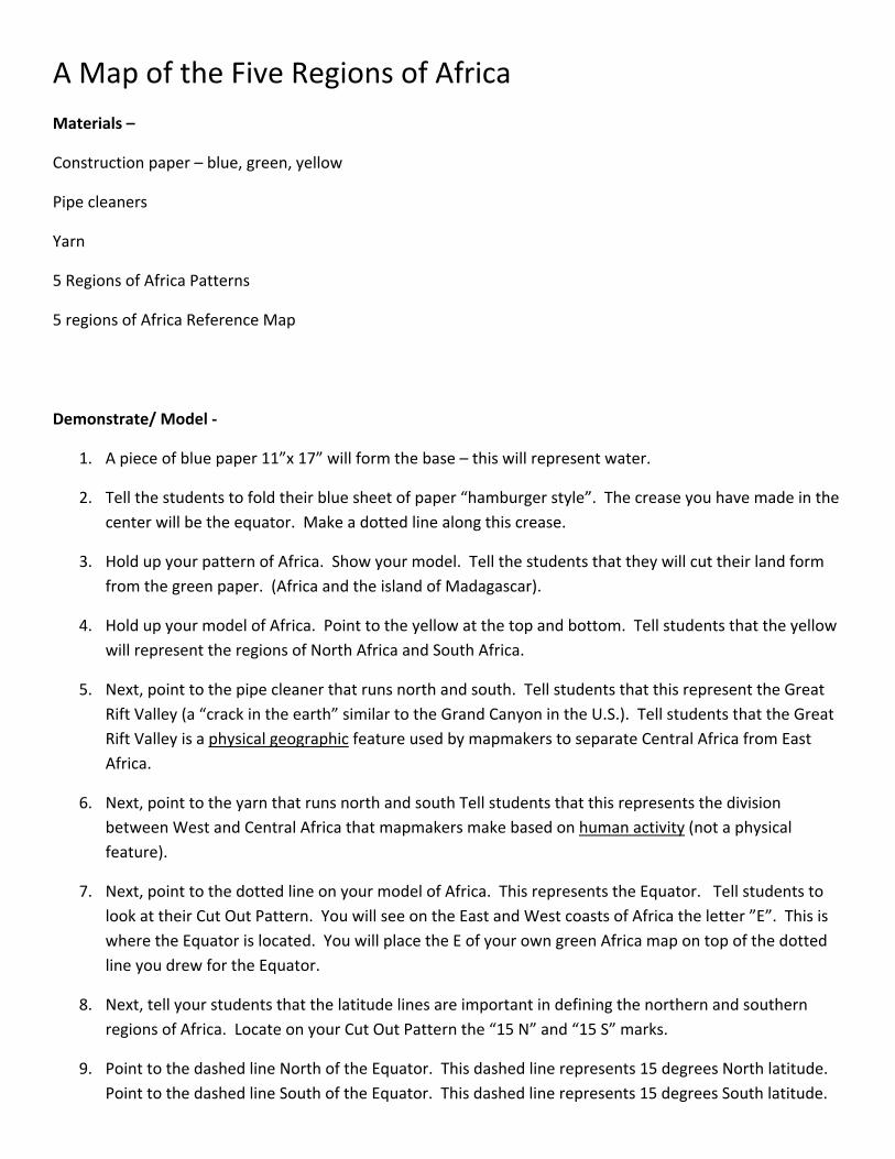
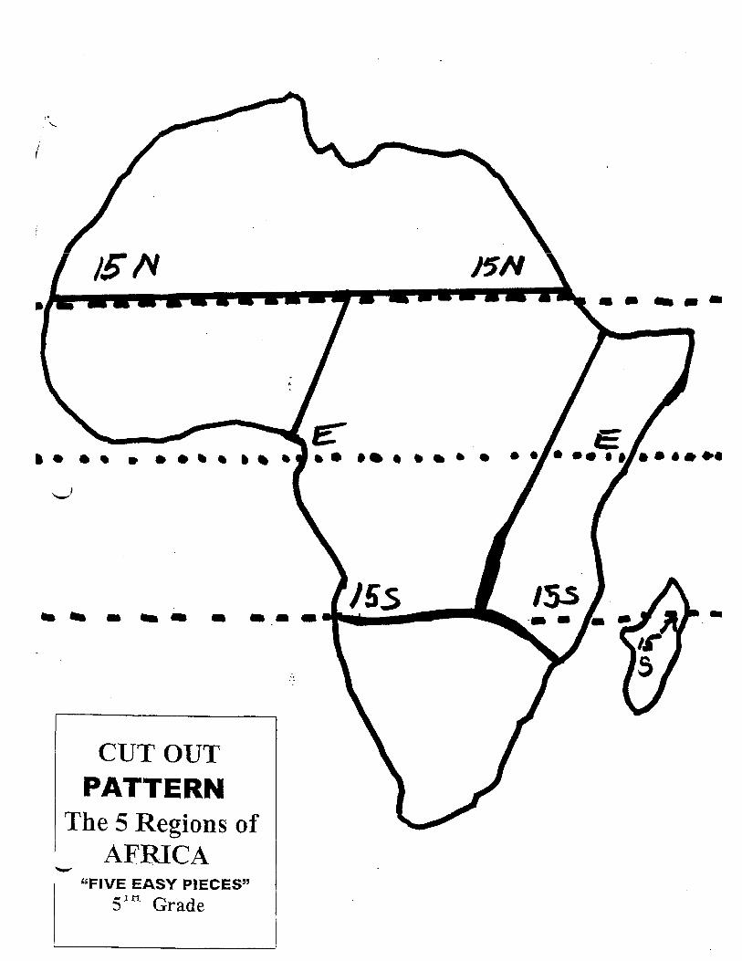
A Map of the Five Regions of Africa Materials – Construction paper – blue, green, yellow Pipe cleaners Yarn 5 Regions of Africa Patterns 5 regions of Africa Reference Map
Demonstrate/ Model -
1. A piece of blue paper 11”x 17” will form the base – this will represent water.
2. Tell the students to fold their blue sheet of paper “hamburger style”. The crease you have made in the center will be the equator. Make a dotted line along this crease.
3. Hold up your pattern of Africa. Show your model. Tell the students that they will cut their land form from the green paper. (Africa and the island of Madagascar).
4. Hold up your model of Africa. Point to the yellow at the top and bottom. Tell students that the yellow will represent the regions of North Africa and South Africa.
5. Next, point to the pipe cleaner that runs north and south. Tell students that this represent the Great Rift Valley (a “crack in the earth” similar to the Grand Canyon in the U.S.). Tell students that the Great Rift Valley is a physical geographic feature used by mapmakers to separate Central Africa from East Africa.
6. Next, point to the yarn that runs north and south. Tell students that this represents the division between West and Central Africa that mapmakers make based on human activity (not a physical feature).
7. Next, point to the dotted line on your model of Africa. This represents the Equator. Tell students to look at their cutout pattern. You will see on the East and West coasts of Africa the letter”E”. This is where the Equator is located. You will place the E of your own green Africa map on top of the dotted line you drew for the Equator.
8. Next, tell your students that the latitude lines are important in defining the northern and southern regions of Africa. Locate on your cutout pattern the “15 N” and “15 S” marks.
9. Point to the dashed line north of the Equator. This dashed line represents 15 degrees North latitude. Point to the dashed line south of the Equator. This dashed line represents 15 degrees South latitude.
Calhoun ISD Social Studies Curriculum Design Project
Fifth Grade Colonization and Settlements
Calhoun ISD Social Studies Curriculum Design Project
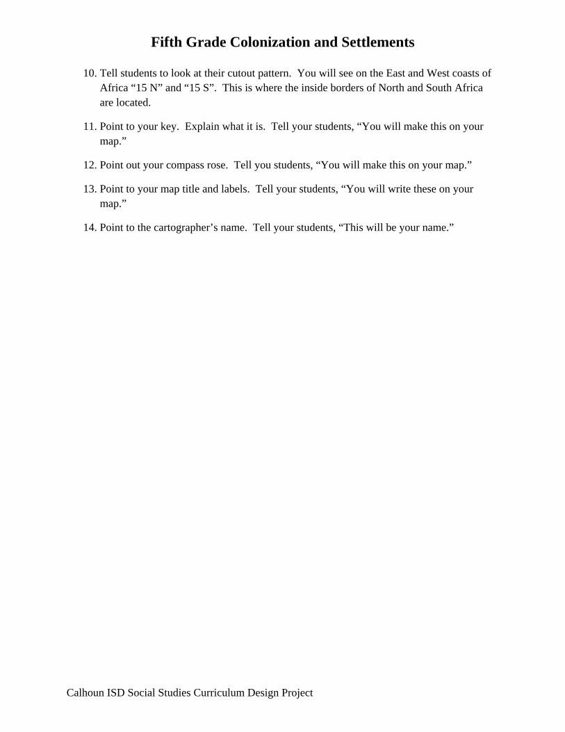
10. Tell students to look at their cutout pattern. You will see on the East and West coasts of Africa “15 N” and “15 S”. This is where the inside borders of North and South Africa are located.
11. Point to your key. Explain what it is. Tell your students, “You will make this on your map.”
12. Point out your compass rose. Tell you students, “You will make this on your map.”
13. Point to your map title and labels. Tell your students, “You will write these on your map.”
14. Point to the cartographer’s name. Tell your students, “This will be your name.”
A Map of the Five Regions of Africa Materials –
Construction paper – blue, green, yellow
Pipe cleaners
Yarn
5 Regions of Africa Patterns
5 regions of Africa Reference Map
Demonstrate/ Model ‐
1. A piece of blue paper 11”x 17” will form the base – this will represent water.
2. Tell the students to fold their blue sheet of paper “hamburger style”. The crease you have made in the center will be the equator. Make a dotted line along this crease.
3. Hold up your pattern of Africa. Show your model. Tell the students that they will cut their land form from the green paper. (Africa and the island of Madagascar).
4. Hold up your model of Africa. Point to the yellow at the top and bottom. Tell students that the yellow will represent the regions of North Africa and South Africa.
5. Next, point to the pipe cleaner that runs north and south. Tell students that this represent the Great Rift Valley (a “crack in the earth” similar to the Grand Canyon in the U.S.). Tell students that the Great Rift Valley is a physical geographic feature used by mapmakers to separate Central Africa from East Africa.
6. Next, point to the yarn that runs north and south Tell students that this represents the division between West and Central Africa that mapmakers make based on human activity (not a physical feature).
7. Next, point to the dotted line on your model of Africa. This represents the Equator. Tell students to look at their Cut Out Pattern. You will see on the East and West coasts of Africa the letter ”E”. This is where the Equator is located. You will place the E of your own green Africa map on top of the dotted line you drew for the Equator.
8. Next, tell your students that the latitude lines are important in defining the northern and southern regions of Africa. Locate on your Cut Out Pattern the “15 N” and “15 S” marks.
9. Point to the dashed line North of the Equator. This dashed line represents 15 degrees North latitude. Point to the dashed line South of the Equator. This dashed line represents 15 degrees South latitude.

10. Tell students to look at their Cut Out Pattern. You will see on the East and West coasts of Africa “15 N” and “15 S”. This is where the inside borders of North and South Africa are located.
11. Point to your key. Explain what it is. Tell your students, “You will make this on your map.”
12. Point out your compass rose. Tell you students, “You will make this on your map.”
13. Point to your map title and labels. Tell your students, “You will write these on your map.”
14. Point to the cartographer’s name. Tell your students, “This will be your name.”


Fifth Grade Colonization Unit Lesson 9 Title: Slavery and Indentured Servants Grade Level: 5th Unit of Study: Colonization and Settlements GLCE: U1.4.1 Describe the convergence of Europeans, American Indians and Africans in North America after 1492 from the perspective of these three groups. U2.2.2 Describe the life of enslaved Africans and free Africans in the American colonies. U2.2.3 Describe how Africans living in North America drew upon their African past (e.g., sense of family, role of oral tradition) and adapted elements of new cultures to develop a distinct African-American culture. Abstract: Students will be able to describe the development of the emerging labor force in the colonies (ex: cash crop farming, slavery, and indentured servants). Students will be able to describe the life and cultural development of people living in western Africa before the 16th century with respect to economic and family structures, and the growth of states, towns, and trade. Students will be able to describe the life of enslaved Africans and free Africans in the American colonies. Students will be able to describe how Africans living in North America drew upon their African past and adapted elements of new cultures to develop a distinct African-American culture. Students will be able to describe the perspective of the Europeans, American Indians, and Africans in North America after 1492. Key Concepts: People living together develop social systems and structure that reflect common values. Throughout history people and cultures have been exploited. Sequence of Activities:
1. Read the book Molly Bannaky aloud to students. 2. Have student partners complete the sequence of events sheet (attached). 3. As a whole group, facilitate the completion of a Venn diagram comparing and
contrasting the life of an indentured servant and the life of a slave.
Calhoun ISD Social Studies Curriculum Design Project
Fifth Grade Colonization Unit Connections: English Language Arts Students write a diary entry from the perspective of an indentured servant and a slave. Mathematics Instructional Resources: Equipment/Manipulative Student Resources Teacher Resources Amos Fortune Free Man by Elizabeth Yates
Calhoun ISD Social Studies Curriculum Design Project

Fifth Grade Colonization Unit
Molly Bannaky Sequence of Events
Initiating Event Event 2 Event 3 Event 4 Final Outcome
Using the events in the story Molly Bannaky, complete the Sequence of Events. Begin with Molly working as a milkmaid in England in the Initiating Event Box.
Calhoun ISD Social Studies Curriculum Design Project

Fifth Grade Colonization Unit
Calhoun ISD Social Studies Curriculum Design Project


Molly Bannaky
Sequence of Events
Initiating Event
Event 2
Event 3
Event 4
Final Outcome
Using the events in the story Molly Bannaky, complete the Sequence of Events. Begin with Molly working as a milkmaid in England in the Initiating Event Box.
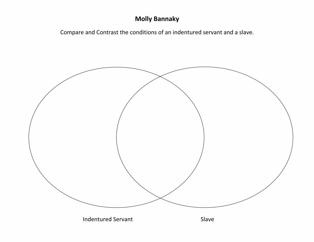
Molly Bannaky
Compare and Contrast the conditions of an indentured servant and a slave.
Indentured Servant Slave

Fifth Grade Colonization and Settlements Unit Lesson 10 Title: African Influence on American Culture Grade Level: 5th Unit of Study: Colonization and Settlements GLCE: U2.2.1 Describe Triangular Trade including
• the trade routes • the people and goods that were traded • the Middle Passage • its impact on life in Africa
U2.2.2 Describe the life of enslaved Africans and free Africans in the American colonies. U2.2.3 Describe how Africans living in North America drew upon their African past (e.g., sense of family, role of oral tradition) and adapted elements of new cultures to develop a distinct African-American culture. Abstract: Students will be able to describe and map Triangular Trade. Students will be able to describe how Africans living in North America drew upon their African past and adapted elements of new cultures to develop a distinct African-American culture. Students will be able to describe the perspective of the Europeans, American Indians, and Africans in North America after 1492. Key Concepts: People living together develop social systems and structure that reflect common values. Throughout history people and cultures have been exploited. Sequence of Activities:
1. Introduce African cultural influence on American culture by showing the United Streaming Video: Sections 1 & 2 of Atlantic Slave Trade listed below.
2. Jigsaw the informational reading attached. 3. Have groups or individuals report out information. 4. Formative Assessment: Have students create a trivia or board game with five questions
from each of Europeans, American Indians, and African perspective after 1492.
Calhoun ISD Social Studies Curriculum Design Project
Fifth Grade Colonization and Settlements Unit
Calhoun ISD Social Studies Curriculum Design Project
Connections: English Language Arts Mathematics Instructional Resources: Equipment/Manipulative Student Resources Teacher Resources United Streaming: Section 1&2 of Atlantic Slave Trade – Please review before you show to make sure it is appropriate for your community.

Unit 2 Resources
• The Discovery of the Americas by Betsy and Giulio Maestro ISBN 0‐688‐11512‐8 • Encounter by Jane Yolen ISBN 0‐15‐201389‐X • Where Do You Think You’re Going, Christopher Columbus? By Jean Fritz ISBN0‐399‐20734‐1 • Viking Explorers by Luigi Pruneti ISBN 0‐87226‐486‐6 • America in the Time of Columbus by Sally Senzel Isaacs ISBN 157572933‐4 • I Can Read About Columbus by David Knight ISBN 0‐89375‐206‐1 • Christopher Columbus by Ann McGovern ISBN 0‐590‐45765‐9 • Christopher Columbus by Stephen Krensky ISBN 0‐590‐11021‐7 • We Were There, Too! Young People in U. S. Historyby Philip Hoose ISBN 0‐374‐38252‐2 (Pages 2‐7:
Diego Bermudez: Sailing into the Unknown) and (pages 8‐11: The Tainos: Discovering Columbus) • Marco Polo and the Wonders of the East by Hal Marcovitz ISBN)‐7910‐5511‐6 • In 1492 by Jean Marzollo ISBN 0‐590‐44414‐X • Castillo: The Dramatic Story of Spain’s Great 17th Century Fortress in Saint Augustine by J. Carver
Harris • Vikings (Kids Discover 1995) • Columbus (Kids Discover 1994) • Cobblestone Magazine: The Legacy of Columbus, v13, no1, January, 1992 • Columbus: Discoverer of the New World by Matthew C. Grant ISBN 0‐87191‐286‐4 • Christopher Columbus: A Great Explorer by Carol Greene ISBN 0‐516‐04204‐1 Christopher Columbus: The First Voyage to America, From the Log of the Santa Maria (Primary Documents) by Christopher Columbus ISBN 0‐486‐26844‐6
• Adventure in Colonial America: Salem Days, Life in a Colonial Seaport by James E. Knight ISBN 0‐8167‐4803‐9
• Adventures in Colonial America: The Village by James E. Knight ISBN o‐8167‐4800‐4 • Adventures in Colonial America: The Farm, Life in Colonial Pennsylvania by James E. Knight ISBN 0‐
8167‐4801‐2 • A Coloring Book of the 13 Colonies by Harry Knill and N. Conkle ISBN 0‐88388‐103‐9 • Historic Communities: Settler Sayings by Bobbie Kalman ISBN 0‐86505‐518‐1 • Historic Communities: Life on a Planatation by Bobbie Kalman ISBN 0‐96505‐465‐7 • Daily Life on a Southern Plantation: 1853 By Paul Erickson ISBN 0‐14‐056668‐6 • If You Lived in Colonial Times by Ann McGovern ISBN 0‐590‐45160‐X • A Sourcebook on Colonial America: Daily Life edited by Carter Smith ISBN 1‐878841‐8 • Kids Discover: Colonial America Issue November 1993 • Emma’s Journal: The Story of a Colonial Girl by Marissa Moss ISBN o‐15‐202025‐X • A Colonial Quaker Girl: The Diary of Sally Wister, 1777‐1778 • National Geographic Reading Expeditions: Colonial Life, The Adventures of Benjamin Wilcox by
Barbara Burt ISBN 0‐7922‐8678‐2 • Cornerstones of Freedom Series: African‐Americans in the Thirteen Colonies by Deborah Kent ISBN
0‐516‐20065‐8 • Williamsburg: An Alphabet Coloring Book by Colonial Williamsburg Foundation • Picture the Past: Life in a Colonial Town by Sally Senzall Isaacs ISBN 158810297‐1

• Colonial People: The Milliner by Niki Walker and Bobbie Kalman ISBN 0‐7787‐0791‐1 • The Colonial Cook by Bobbie Kalman ISBN 0‐7787‐0794 • Historic Communities: Schoolyard Games by Bobbie Kalman ISBN 0‐86505‐471‐1 • Colonial People: The Woodworkers by Bobbie Kalman ISBN 0‐7787‐0790‐3 • Everyday Dress of the American Colonial Period: A Coloring Book, by Peter F Copeland by Peter F.
Copeland ISBN 0‐486‐23109‐7 • Historic Communities: 18th Century Clothing by Bobbie Kalman ISBN 0‐86505‐512‐2 • Historic Communities: Colonial Life by Bobbie Kalman ISBN 0‐86505‐511‐4 • Historic Communities: The Kitchen by Bobbie Kalman ISBN 0‐86505‐504‐1 • Historic Communities: Tools and Gadgets by Bobbie Kalman ISBN 0‐86505‐508‐4 • Hhistoric Communities: Colonial Crafts by Bobbie Kalman ISBN 0‐86505‐510‐6 • Colonial People: The Blacksmith by Bobbie Kalman 0‐7787‐0793‐8 • Benjamin Franklin: Extraordinary Patriot by Deborah Kent ISBN 0‐590‐46012‐9 • What’s the Big Idea, Ben Franklin? By Jean Fritz ISBN 0‐698‐20543‐X • We Were There, Too: Young People in U.S. History by Phillip Hoose ISBN 0‐374‐38252‐2 (pages 23‐
24, Orphans and Tobacco Brides: Feeding England’s Newest Habit), (Olaudah Equiano: Kidnapped into Slavery, pages 42)
• Life as a Colonist by Bob Rybak (Teacher Resource of Cooperative and Individual Activities) ISBN 0‐86734‐562‐4
• If you lived in Williamsburg in Colonial Days by Barbara Brenner ISBN 0‐590‐92922‐4 • American Revolution 1700‐1800 by Joy Masoff ISBN 0‐439‐05110‐X, pages 1‐24 (*book is stored
with unit 6) • The Hatmaker’s Sign: A Story by Benjamin Franklin retold by Candace Fleming ISBN 0‐531‐07174‐X • Young Americans in Colonial Williamsburg: Ann’s Story: 1747, by Joan Lowery Nixon ISBN 0‐385‐
32673‐4 • Young Americans in Colonial Williamsburg: Caesar’s Story: 1759, by Joan Lowery Nixon ISBN 0‐385‐
32676‐9 • Young Americans in Colonial Williamsburg: Nancy’s Story: 1765, by Joan Lowery Nixon ISBN 0‐385‐
32679‐3 • Young Americans in Colonial Williamsburg: Will’s Story: 1771, by Joan Lowery Nixon ISBN 0‐385‐
32682‐3 • Young Americans in Colonial Williamsburg: Maria’s Story: 1773, by Joan Lowery Nixon ISBN 0‐385‐
32685‐8 • Young Americans in Colonial Williamsburg: John’s Story: 1775, by Joan Lowery Nixon ISBN 0‐385‐
32688‐2 • Historic Communities: The Gristmill by Bobbie Kalman ISBN 0‐86505‐506‐8 • Cobblestone Magazine: Colonial Craftsmen, v11, no6, June 1990 • Colonial Americans: The Homemakers by Leonard Everett Fisher ISBN0‐531‐01047‐3 • American Communities: An Historical Community: Williamsburg, Virginia by Educational Resource
Council of America The Foundations of America: Slavery in the Colonial Chesapeake by David Brion Davis ISBN 0‐87935‐115‐2