erosion & sediment control inspector packet
TRANSCRIPT

Erosion & Sediment Control
Inspector Packet
Land Quality Section

Packet Contents What is Erosion and Sedimentation
Simplified Overview of the Sedimentation Pollution Control Act
of 1973
Site Inspection Overview
Brochures
− Sedimentation: Soil Erosion Facts
− 3 Reasons Why You Should Control Erosion On YourConstruction Site
− Controlling Erosion and Sedimentation on SingleFamily Home Construction Sites
Local Program Contact Information
NC DEQ – DEMLR – Regional Offices Contact Information
Appendix:
− NC Administrative Code Title 15A Chapter 4

1
WHAT IS EROSION AND SEDIMENTATION?
Erosion is the detachment and movement of soil particles by wind, water, and gravity. Natural erosion (geologic erosion) is a process that occurs slowly over millions of years. Geologic erosion has shaped the landscape around us.
Accelerated erosion is NOT a natural process. Accelerated erosion occurs when more soil than usual is detached and moved by water or some other force and is caused by land disturbing activities such as the construction of roads and buildings, commercial forestry, agriculture, and surface mining. These activities leave the land free of vegetation. Accelerated erosion strips the land of its topsoil, decreasing soil productivity and causing sedimentation in our lakes and rivers.
Sedimentation is the process by which eroded soil is deposited into our lakes and streams. Sediment can accumulate in the bottom of lakes, streams, estuaries, and nursery areas. It can smother fish habitats vital to reproduction and destroy aquatic insects that fish feed upon.
Sediment fills our rivers, lakes, and streams, decreasing their storage volume and increasing the frequency of floods and the damage caused by flooding. Sediment in our waters increases the costs of power production; this cost is passed on to you and me.
Sediment suspended in the water also increases the cost of treating municipal drinking water supplies. Sediment restricts the amount of sunlight reaching aquatic plants, reducing the amount of dissolved oxygen in our waters. Sediment degrades the beauty of our waters by increasing the cloudiness of the water.

2
What Can We Do About it? Accelerated erosion and sedimentation primarily result from agriculture, forestry, and construction practices. These activities clear the land of vegetation and expose the soil surface so that it is more easily eroded. However, we all benefit from these three activities. How can we protect our land, rivers, lakes, and streams from the damage caused by erosion and sedimentation?
We can control erosion and sedimentation from construction, forestry, and agriculture by using Best Management Practices (BMPs). BMPs are practices that either prevent erosion from happening or keep eroded sediment from entering rivers, lakes, and streams. By using best management practices, we can greatly reduce the amount of sediment entering our rivers, lakes, and streams. BMPs allow us to continue activities such as farming, forestry, and construction while protecting the quality of the water around us.
What Are Some Examples of Best Management Practices?
Agriculture: • No till or conservation tillage practices. • Leaving crop residue on fallow fields. • Strip cropping, contour farming, and use of terraces. • Taking land on steep topography out of production. • Use of natural buffer zones around rivers, lakes, and streams.
Forestry: • Natural buffer areas around rivers, lakes and streams • Replant vegetation on disturbed areas • Mulching • Control runoff on forestry roads and other affected areas
Construction: • Use of temporary ground cover • Leave natural buffer zones • Limit time of exposure • Use of phased grading plans • Control rates of runoff • Use devices such as sediment basins, rock dams, and
sediment traps
3
What Does the Law Say?
Sediment Control in North Carolina is governed by the Sedimentation Pollution Control Act of 1973. The Act requires anyone involved in a land disturbing activity of one acre or more to submit an erosion and sediment control plan to the Land Quality Section of the North Carolina Department of Environmental Quality or the appropriate delegated local program.
The erosion and sediment control plan must be submitted to the Land Quality Section at least 30 days before the land disturbing activity begins and must be approved before beginning the activity. The Act exempts land disturbing activities for forestry if the logging activity follows forestry BMPs adopted by the Department of Environmental Quality. Mine sites permitted under the Mining Act of 1971 are exempt since an erosion and sediment control plan is required by Mining permits. Agriculture also is exempt under the Act.
The Sedimentation Pollution Control Act has few limitations as to what goes into a plan. The approved plan must control sediment and keep it from leaving the site. This allows for effective technical innovations in erosion and sediment control and may also help lower the cost of erosion and sediment control.
The Act has 5 mandatory standards.
1. Buffer zones along streams or rivers must be sufficient to control visiblesiltation within the first 25% of the buffer zone closest to the landdisturbing activity. There must also be a 25-foot minimum width bufferalong trout waters.
2. Groundcover must be established on exposed slopes within 21 calendardays after completion of any phase of grading.
3. Permanent groundcover must be established within 15 working days or 90calendar days of completion of the project, whichever is shorter, andmeasures must be provided to keep sediment on site.
4. Any land disturbing activity of one acre or more must have an approvederosion and sediment control plan.
5. Any land disturbing activity must be done in accordance with the approvederosion and sediment control plan.

4
The Full Rules and RegulationsSedimentation Pollution Control Act of 1973
North Carolina General Statutes Chapter 113A Article 4
The Sedimentation Pollution Control Act (SPCA) is the enabling legislation that gives authority to the Sedimentation Control Commission (SCC) and the Land
Quality Section. It ‘sets the stage’.
Sedimentation Control Chapter 4 of Title 15A of the North Carolina Administrative Code (T15A.04)
The NC Administrative Code (Code) provides the administrative overview of how the SCC and Land Quality Section enforce the Act. It provides the ‘how to’.
Glossary of Terms Accelerated Erosion: Erosion that occurs more rapidly than natural geological
erosion: the result of farming, forestry, and land grading for construction.
BMPs: Best Management Practices: practices or measures that allow us to protect water quality from pollutants such as sediment while still continuing activities such as construction, forestry, and agriculture.
Buffer Zone: Strips of natural areas such as forest or grasses between a body of water and a land disturbing activity such as agriculture, construction, or forestry.
Dissolved Oxygen: The amount of oxygen dissolved in a specific volume of water. Sufficient amounts of dissolved oxygen are important to the survival of fish and other aquatic organisms. The turbidity caused by sediment suspended in the water restrict sunlight to aquatic plants thereby reducing the dissolved oxygen in the water.

5
Erosion: Detachment and movement of soil or rock by water, wind, ice, or gravity.
Estuary: A body of water where a freshwater river or stream empties into the sea. Estuaries are important breeding grounds for many types of fish but are damaged by the accumulation of sediments due to accelerated erosion.
Geological Erosion: Wearing away of the earth's surface by water, ice, or other natural agents under environmental conditions of climate, vegetation, and topography undisturbed by man.
Non-Point Source Pollution:
Pollution that is washed into rivers, lakes, and streams from runoff during rainfall events. Sediment is the largest non-point source pollutant.
Point Source Pollution:
Water pollution that is introduced into rivers, lakes, or streams directly from a single source, such as a pipe.
Pollutant: Any substance that reduces the quality of biological habitats. Sediment is a pollutant of water.
Pollution: Any physical, chemical, or biological change that adversely affects the health, survival, or activities of living organisms or alters the environment in undesirable ways.
Sediment: Solid particulate matter, mineral or organic, that has been or is being moved by water, air, gravity, or ice from its origin. Sediment typically consists of clay, silt or sand-sized particles.
Sedimentation: The process by which soils that have been washed into rivers, lakes, and streams, or onto the land surface are deposited.
Topsoil: The upper layer of soil. This layer holds most of a soil's nutrients and is the most productive layer of soil. Topsoil is the layer of soil that is usually lost due to accelerated erosion.
Turbidity: The "cloudiness" or discoloration of a body of water. Turbidity is caused by the suspension of solid particles such as clays in rivers, lakes, and streams.

6
Vegetation: The plants that cover the land surface. Vegetation helps protect soil from erosion by preventing the direct effect of rainfall on soil and holding onto soil with its roots.
Watershed: The land area that drains into a stream, river, or lake. A large river may have a watershed that encompasses many smaller watersheds.

Simplified Overview of the Sedimentation Pollution Control Act of 1973
PURPOSE
The objective of the Sedimentation Pollution Control Act of 1973 is to protect North Carolina land and natural watercourses from erosion and sedimentation impacts. The primary purposes are to: (1) keep sediment from entering our natural watercourses e.g. streams, rivers, lakes, swamps, and marshes; and (2) keep sediment from washing onto adjacent property.
MANDATORY STANDARDS
Buffer Zone Requirements If you are conducting a land-disturbing activity, such as construction, near a lake or natural watercourse, visible siltation should be kept in the 25% of the buffer zone nearest the land-disturbing activity. For example, land disturbance taking place 20 feet from a stream would be in compliance if the sediment from the construction site travels less than 5 feet into the buffer. If the stream is classified as a Trout Stream, the same requirement applies, but the undisturbed buffer must be at least 25 feet wide.
Slope Stabilization Requirements Any slope generated or disturbed during a land-disturbing activity may not be so steep that it is impossible to prevent erosion from them by providing a natural groundcover (such as grass) or other adequate erosion-control devices. Groundcover or other erosion-control devices on slopes must be in place within 21 calendar days of completion of any phase of grading. Example: A slope generated during highway construction is not in compliance if it has deep, eroded gullies in it.
Groundcover Requirements Groundcover may be plants, mulches, rocks, etc. that hold the soil in place. Grass is a common groundcover. Whenever land is disturbed, permanent groundcover must be in place within 15 working days or 90 calendar days, whichever is shorter.

This summary was created for educational purposes only, and does not preempt the law. Written by Mary Russell Robertson & Janet Paith
Revised: September 2018
Erosion and Sediment Control Plan Requirements If more than one acre of land on a tract is to be disturbed, an erosion and sediment control plan is required. Erosion and sedimentation control plan application approvals are issued by Land Quality Section Regional Offices or local government erosion and sedimentation control programs.
Adherence to Erosion and Sediment Control Plan The land disturbing activity must be done in accordance with the approved erosion and sediment control plan.
EXEMPTIONS
In general, agricultural lands used for the production of plants and animals useful to man are exempt from the Act. As long as best management practices in the Forest Practice Guidelines Related to Water Quality are followed, activities undertaken on forestland for the production and harvesting of timber are exempt. Lands used for mining are also exempt as they are subject to the Mining Act regulations. In emergency situations that threaten human lives, land may be disturbed without an immediate erosion and sedimentation control plan approval.
ENFORCEMENT
Failure to have an approved plan before the land disturbing activity can result in a fine of up to $5000 per day per violation. Failure to comply with the Sedimentation Pollution Control Act can result in fines up to $5000 per day per violation for each day of the violation, the issuance of a stop-work order, injunctive relief, a restoration order, or possible criminal prosecutions.
For additional information reference the following:
• The Sedimentation Pollution Control Act of 1973 (GS113A Article 4)
• The NC Department of Environmental Quality Division of Energy,Mineral and Land Resources website: NC DEQ DEMLR
• Contact the appropriate NCDEQ/DEMLR/Land Quality Section office:Regional Offices

1
Site Inspection Overview
The Inspector and the Law
Five Mandatory Standards of the SPCA
1. Plan must be approved prior to disturbing 1 acre or greater
2. Buffer Zones must be provided along all natural watercourses and lakes
3. Disturbed areas must be able to be stabilized by vegetation or othersuitable method
4. All sediment must be retained on-site for land-disturbances
5. Approved erosion and sediment control plan must be followed
Sedimentation Control Rules
• Identify critical areas
• Limit exposed areas
• Limit time of exposure
• Control surface water
• Control sedimentation
• Manage storm water runoff
Erosion and Sediment Control Program Structure
North Carolina Sedimentation
Control Commission
Land Quality Section
NC Department of Environmental
Quality
Local Programs
Regional Offices
State Agency Programs

2
Inspector’s Responsibilities
• Determine that an Erosion and Sediment Control (E&SC) plan for the site has been approved
• Determine that all specified practices have been installed and are being
maintained according to the plan • Determine that off-site sedimentation is being prevented
Principles of Erosion and Sediment Control Coordinating and Scheduling Construction
• Plan construction activities in phases to reduce areas that are exposed
• Plan installation of E&SC measures and practices before major
construction begins
Protect the Land Surface from Erosion
• Reduce duration of exposure • Direct runoff away from graded slopes • Establish or protect buffers around streams, lakes and other
watercourses • Use temporary vegetation and mulch when work is interrupted for
extended periods
Manage Runoff and Keep Velocities Low
• Protect disturbed area from off-site water • Direct runoff into stabilized channels with stable outlets • Break up long slopes with diversions
Capture Sediment Near the Source
• More practical to have several small well-maintained measures near the graded areas rather than a large basin capturing most of the runoff
• Need access to measures for maintenance and inspection

3
Maintenance and Inspection
• Lack of maintenance is the most common reason for failure
• Insist that the contractor inspects and repairs measures after eachrainfall event
Preparation for Site Inspections
Review plan and take with you to the site
Review previous inspection reports
Gather inspection tools
If site is under NOV or enforcement, contact responsible party
Inspection Tools for Your Office
Aerial photographs of your region of responsibility
Topographic maps of your region of responsibility
Engineering scales for appropriate scales of maps and photos
Drafting tools to properly measure sites from plans, topographic maps,and aerial photos
Soil survey or soils maps of your region of responsibility
River basin maps
HQW maps
Inspection tracking mechanism (computer program, calendar, etc.)
Calculator
Video Camera
Inspection Tools for Your Vehicle
Several copies of the Law and Rules
Hand level
Measuring wheel
Measuring tape, 100 feet
One-man surveyor’s rod and rod holders

4
Surveying level or transit
Surveying flags or stakes
Hardhat and safety vest
Camera
Calculator
Inspection reports
Scratch pad
Inspector Tracking Mechanisms
• Allows inspector to organize and prioritize projects and to trackdeadlines
• Need to track: Last inspection date Last NOV date and deadline Project info – location, financially responsible party, and size
Inspector’s Duties
Reviewing Plan
• Check for: Critical areas onsite – stream crossings, wetlands, steep cut and
fill slopes, etc. Access to maintain E&SC measures Construction and installation schedule – E&SC measures to be
installed first Maintenance plans Borrow and waste areas – adequate E&SC for these areas
Pre-construction Conference
• Establish lines of communication
• Clarify objectives of E&SC plan
• Establish procedures for changing the approved plan
• Discuss scheduling of clearing and grading and installation of E&SC
• Discuss maintenance of E&SC measures
• Inspect site with contractor and financially responsible party

5
Maintenance
• Single biggest cause of failure is lack of maintenance
• All devices and measures should be inspected after each storm event
• Access for maintenance
The Inspection Fundamental Questions
• Is the E&SC system installed as shown on the approved plan?
• Is erosion being controlled on the site?
• Is sediment being CONTAINED on the site?
• Are the 5 mandatory requirements of the SPCA being met?
All Answers YES = COMPLIANCE
• Site is incompliance with the SPCA
• Complete the inspection report
All Answers NOT YES = NONCOMPLIANCE
• If any one answer = NO, then site is in violation with the SPCA
• Complete the inspection report, noting specific violation and correctiveactions
• Determine course of action: Deadline for corrective actions to be finished Notice of violation outlining deadline and corrective actions Immediate enforcement
What to Do During an Inspection
• Carry set of approved plans
• Take detailed, orderly field notes Notes should be prepared so others can understand All documentation could potentially be used as evidence in court
• Check in with job superintendent, if available
• If off-site sedimentation is noted: Go downstream to assess the damage

6
Estimate sediment loading by measuring sizes of erosion gulliesonsite and sediment deposits off site
Take pictures or video and correlate them to a map Document Date, Time, and Stream information
• Measure basin and other measurable sizes
• Walk the perimeter of the site
• Note need for maintenance Basin clean out Rock check dam repair Silt fence replacement More gravel for construction entrance
• ALWAYS complete the inspection report at the site!
Causes of Noncompliance
Little or No Effort to Comply
• Inform responsible party of SPCA and note action to be taken
• Causes: Not submitting a plan Starting work without an approved plan Failing to follow the approved plan
Inadequate Design or Changes in Site Conditions
• Note in inspection report that a revised plan is needed with deadline
• Approved plan must be modified and approved if: Measures aren’t retaining sediment on-site Modifications have been made in the field that aren’t on
approved plan but could affect E&SC Slopes cannot be stabilized as set forth in approved plan Contributing drainage areas have increased in size The method of stabilization noted in the approved plan is
adequate
Faulty Installation or Poor Maintenance
• NUMBER ONE CAUSE FOR NONCOMPLIANCE!

7
Vegetation, Mulches, Nets, and Mats Inspecting Vegetation
• Proper selection of vegetation Is the plant type:
◦ Appropriate for the soil and the slope? ◦ Properly chosen given the climate and orientation of the
area? ◦ Properly chosen for the activity of the area?
• Seedbed preparation and soil amendment
Check to determine: ◦ That soils are not too compacted ◦ Adequate lime and fertilizer are being applied ◦ Correct seed is being applied
• Anchoring and Maintenance
Proper Mulching
• Rule of thumb: mulch should cover about 70-80% of surface • Make sure mulch is well anchored
Organic Mulches
• Straw 1-2 tons per acre Wheat or oat straw Dry, un-chopped, un-weathered; avoid weeds Spread by hand or machine; must be tacked or anchored
• Wood fiber or Wood cellulose
½ -1 ton per acre Use with hydro-seeder; may be used to tack straw Do not use in hot, dry weather
Nets and Mats
• Jute net Follow manufacturer’s recommendations for installation By itself, provides little moisture conservation; woven of single
jute yarn Install over organic mulch as tack or anchor Withstands higher velocities than just mulch

8
• Excelsior (wood fiber) mat Follow manufacturer’s recommendations for installation Protective mulch mat Can be installed without other mulch
• Chemical Mulches (Soil Binders) Follow manufacturer’s specifications Best used as mulch anchor
Maintenance of Vegetation Cover
• Additional lime and fertilizer• Over seeding• Mowing for adequate access
Inspecting Erosion and Sediment Control Practices, Measures and Devices
Structural Ground Covers
• Hard-Surface (pavement, concrete and revetments) Watch for accelerated erosion at the toe and top of hard-
surfaced slopes Must provide transition/dissipator where flow outlets onto natural
ground
• Semi-Hard Surfaces (stone or gravel) Make sure stone size is adequate to withstand velocity Should blend with surrounding land surface by undercutting Ensure that adequate flow area has been provided Must have geotextile fabric or a stone or sand filter under riprap
Entrance and Exit Stabilization
• Use coarse gravel or stone at least 6” deep, 50’ long, and 12’ wide• Unstable or wet soils may require a layer of geotextile fabric• Make sure runoff is diverted from these areas• Maintenance: more stone may be required
Diversions
• Dike and channel must be on proper grade to ensure that water flows inthe desired direction. Watch for abrupt changes in grade or direction
• Dikes must be compacted and channels stabilized• Channels must have a large enough flow area• As a rule, diversions should generally parallel the site contours• Maintenance: must remain cleaned out
9
Runoff Convergence
• Channels Provide channel until vegetation is fully established: mulch or
netting For riprap lined channels:
◦ Check for undercut channel to insure adequate flow area◦ Filter blanket or geotextile fabric
Check outlet for proper outlet protection Protect from sedimentation, once stabilized
• Slope Drains Slope drains frequently fail from piping around the inlet Ensure that slope drains are well anchored
• Chutes Chutes have steep slopes and high velocities. Check outlets to
ensure adequate protection Check inlets to ensure that water does not bypass the chute Chutes may require sub-drains to prevent uplifts and piping Avoid bends
• Problem Areas Gullies in channel bottom usually means velocities are too high
for stabilization method Sloughing of channel sides indicates the following causes:
◦ High water table◦ Side slopes too steep◦ Velocities are too high for stabilization method◦ Sediment at the outlet of a channel usually means a
problem with the channel
Outlet Protection
• Outlet protection should reduce velocity to permissible velocity ofchannel
• Apron of the outlet structure must be level with natural ground to preventundercutting
• Plunge pools – useful where dissipator lengths are excessive
Inlet Protection
• Excavated Drop-Inlet Protections Drainage area = 1 acre or less Excavated area must equal 1800 ft^3 per disturbed acre Check for method of draining Maintenance – clean sediment out

10
• Hardware Cloth and Gravel Inlet Protection Steel T posts at least 5 ft long must be used, and must be driven
at least 2 feet into the ground Washed stone (NC DOT #5 or #57) must be placed around the
wire, at a 2:1 slope and height of 16 inches Recommend placing 2 ft flap of wire mesh hardware cloth under
the gravel Total height of measure should be at least 2 feet Maintenance: inspect, repair and clean out sediment
• Block and Gravel Inlet Protection
Blocks must be set against the base of the inlet Must have block turned to allow dewatering: covered with wire
mesh and gravel No higher than 2 feet Dike on low side may be needed
• Rock Doughnut Inlet Protection
Should be at least 30 feet away from vehicular traffic Doughnut should be constructed with Class B riprap for inner
doughnut (at least 2 feet tall, with a 1.5 ft minimum crest and with slope of 2:1), covered by a 1-foot-thick layer of washed stone (NC DOT #5 or #57)
Dike may be needed on low side Maintenance: clean out sediment pool when half full
• Rock Pipe Inlet Protection
Only used for pipes with a maximum diameter of 36 inches Minimum height of 2 feet with 2:1 slope Horseshoe should be constructed with Class B or Class I riprap
(minimum crest 3 feet), covered by a 1-foot-thick layer of #5 or #57 washed stone
Sediment storage area upstream of pipe should be at least 1.5 feet below grade
Maintenance: inspect, repair and clean out sediment when sediment pool is half full
Sediment Fences, Traps and Basins
• Sediment Fences Sediment fences do not filter sediment Check that:
◦ Slows water and allows sediment deposition ◦ Fabric buried at least 12 inches and backfilled with
compacted soil ◦ Fencing adequately supported with steel posts

11
◦ Fences are not placed in areas of concentrated flow (i.e.in the path of drain outlets)
◦ Fences are maintained after every rainfall event, theaccumulated sediment removed and fence checked fordamage
◦ Total drainage area restricted so that water depth is nevergreater than 1.5 feet
• Sediment Traps Dike should be compacted and higher than the weir section Maintenance: cleaned out when one-half full of sediment Baffles (3) should be included in sediment pool
• Sediment Basins Check that:
◦ Total drainage should not be more than 100 acres◦ Sediment storage = 1800 ft^3 per disturbed acre of
drainage area◦ Constructed according to the plans◦ The primary spillway conduit: watertight and has anti-seep
collars to prevent piping along the conduit◦ Has stabilized outlet◦ Dewaters from surface (skimmer or flashboard riser)◦ Trash racks (guards) on riser◦ A minimum of 3 baffles must be included in sediment pool◦ Emergency spillway in natural ground with at least 1 foot
of freeboard◦ Access for frequent maintenance
Stream Crossings
• Should be avoided if possible. Sediment can enter stream directly
Culverts
• Check for: Adequate sizing Compacted soil around culvert to prevent piping In stream devices installed during construction Stabilized inlet and outlet
Fords
• Check for: Geotextile fabric covered with properly sized stone Approaches with 5:1 slope of flatter Stabilized approaches

12
Buffer Zones
• Check for: Visible sediment only in first 25% of buffer closest to disturbance Maintenance: fertilize, replant
Sedimentation and Erosion Control Inspection Report
Overview of the Inspection Report
• Legal documentation of onsite visits
• Clearly document onsite conditions that exist on the day of inspection
• Case # Include on the report if enforcement action has been requested
on a project Located in the upper right hand corner of the report
• County, Project, River Basin Record
◦ County◦ Project Name◦ River basin in which project is located
Take the project name from the FinancialResponsibility/Ownership Form (FRO)
• Financially Responsible Party/Address The actual person, firm, company, etc. that is financially
responsible for the project Include their mailing address in case of violation, or stop work
order enforcement
• Item 1: Project Location and Pictures Project Location
◦ Brief description of the project location to enable personsnot familiar with the site to locate the project
◦ Generally, you should start from a major highway, or road Pictures
◦ “YES”, note type of pictures (prints, slides, digital, video)◦ Include a site sketch showing location and direction of
photographs
• Item 2: Weather and Soil Conditions Note the weather conditions on the date of inspection and
indicate if soil conditions are suitable for work to be in progress
• Item 3: Is Site Currently Under Notice of Violation? “YES” if the site is currently under a Notice of Violation (NOV)

13
If “YES” is marked, then violations must be marked in Item 5 “NO” if a NOV will be issued as a result of the inspection, note
such in the comments section
• Item 4: Is the Site in Compliance? Note: A site cannot be marked in compliance until all violations
have been corrected If you check “NO”, you must note violations in Item 5 and note
corrective actions needed in Item 8; comments can be madeunder Item 8, as well
If you check “YES”, no violations can be marked in Item 5 andno corrective items can be noted; notes can be made incomment section
• Item 5: Violations Do not mark any violations if Item 4 is marked “YES” If Item 4 is marked “NO”, note which violations occurred at the
site
Overview of Violations in Item 5 of the Inspection Report
a) No approved plan, G.S. 113A-57(4) and 15A N.C.A.C 4B.0107(c)
When a land-disturbing activity greater than one acre isunderway without an approved erosion and sedimentationcontrol plan
b) Failure to follow approved plan, G.S. 113A-57.5(5) An approved erosion and sedimentation control plan has
not been followed Not providing timely ground cover is also a violation of this
statute
c) Failure to submit revised plan, G.S. 113A-54.1(b) and 15AN.C.A.C. 4B .0118(a)
Marked only when the responsible party has beenpreviously notified of the need to submit a revised planand has failed to do so
d) Failure to provide adequate groundcover, G.S. 113A-57(3) and15A N.C.A.C. 4B .0107(b) or 15A N.C.A.C. 4B .0124(e)
When the time limits provided in the statute and ruleshave expired
Time limit provided here is not the same as that forgraded slopes
e.) Insufficient measures to retain sediment on site, G.S. 113A-57(3)
14
Sediment damage must be observed beyond the projectboundary or into a stream; and
The land-disturbing activity must be greater than one acre
f) Failure to take all reasonable measures, 15A N.C.A.C. 4B .0105 When measures may not be sufficient to prevent
sedimentation damage When other measures may be needed Can be cited for sites less than one acre
g) Inadequate buffer zone, G.S. 113A-57(1) Buffers can be natural or mechanical If the buffer fails to function When grading has taken place within the natural buffer
and offsite sedimentation has occurred or can potentiallyoccur
h) Graded slopes and fills too steep, G.S. 113A-57(2) or 15AN.C.A.C. 4B .0124(d)
Graded cut and fill slopes are too steep to be stabilizedwith a vegetative cover or other erosion control measure
i) Unprotected exposed slopes, G.S. 113A-57(2) When the graded slopes have remained bare longer than
21 calendar days after completion of any phase of grading Note under “Comments” the date of completion of any
phase of grading for reference
j) Failure to maintain erosion control measures, 15A N.C.A.C. 4B.0113
When inspection finds measures in need of maintenance
k) Failure to self-inspect G.S. 113A-54.1(e) and 15A N.C.A.C.4B.01031
When the self-inspection sheet is not filled out or kept onsite and available to the inspector
l) Other Note any violation/s of the Act or rule that is not covered
by violations listed on report
• Item 6: Is There Potential for an NPDES Permit Violation If “YES”, then describe possible areas If “No”, then leave description black
Do not mark violations m – v if Item 6 is marked “YES” If Item 6 is marked “NO”, note which violations occurred at the
site
• Item 7: Has Sedimentation Damage Occurred Since Last Inspection

15
To check “YES”, document visible signs of sedimentationdamage
◦ Sediment deposits should be measured (depth, width,length)
◦ For enforcement cases, take pictures and reference alocation map or sketch
To check “NO”, no new visible signs of sedimentation deposits Check off appropriate violations in Item 5 and note corrective
actions needed in Item 9
• Item 8: Contact Made with Persons Include the name of any person(s) you had contact with and
indicate their title or position Note if the inspection report was given (in person) or sent to the
financially responsible partyRecord the date the report was given/sent
• Item 9: Corrective Actions Needed Note corrective actions needed to bring the site into compliance Relate corrective actions to violations noted in Item 5 Avoid designing measures If no violations are on the site, no comments in this section
• Item 10: Comments Use for general comments about the project or for additional
space for previous sections Helpful hints:
◦ Note here when a phase of grading has been completed◦ Note when a site has been seeded and mulched◦ Note any activity onsite
• Report by, Others Present Indicate the name of the person inspecting and filling out the
report Note others in attendance at the inspection and have them sign
the inspection report
• Date of Inspection, Time Arriving On Site, Time Leaving Site Note the date of the inspection Note the time you arrived on the site and the time you departed Used for verification purposes CC: Give names of other being sent the report Send copies of reports on enforcement cases to
• Additional Sheets Use when the 1-page report does not have room for all the info Reference the inspection report Note the site name and county, as a minimum

16
Human Relations Step 1 Maintain a friendly and professional manner
Step 2 Acknowledge that a difficult situation exists Step 3 Calm the individual by questioning and verifying Step 4 Involve the person in solving the problem Step 5 Handle the problem Being the Bearer of Bad News Step 1 Present the situation Step 2 Allow the person time to adjust Step 3 Accept the person’s reaction Step 4 Demonstrate acceptance of the person’s reaction Step 5 Restate positive points Step 6 Offer assistance Step 7 Clearly express that violations must be corrected Step 8 Allow for future contact and follow-up Summary
• It takes time to learn how to inspect a construction site properly
• You must be familiar with: The law The rules The erosion and sedimentation control practices
• Proper inspection requires planning and a systematic approach

Revised 10/5/2018
Where to Go for HELP?
• Land Quality Section Website https://deq.nc.gov/about/divisions/energy-mineral-land-resources/erosion-sediment-control/forms
• Or Contact Your: Local Program, Land Quality Section Regional Office or, Land Quality Section Headquarters.
Check Local Ordinance Listing, and Regional Office Map for contactsand phone numbers

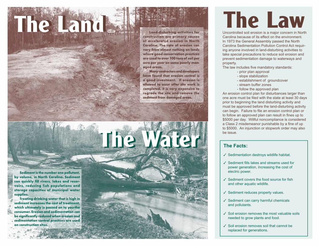
Soil Erosion FactsNorth Carolinians Are Paying For The Loss Of A Valuable Natural Resource
What can raise the cost of you water or electric bill? What can perma-nently close your favorite fishing or swimming lake or stream? What can destroy wildlife habitat overnight? What can change your valuable property into a worthless piece of land? Hint – it is the single largest polluter by volume of North Carolina’s lakes, rivers and streams – and it’s not radioactive waste or spilled chemicals. The answer – sedimen-tation caused by soil erosion.
In North Carolina It’s Against The Law
Any time an acre or more of land is cleared for commercial, residential, industrial or road construction purposes, a state or local govern-ment approved erosion control plan is required. Property owners must submit, and receive, approval of an erosion and sedimentation control plan before beginning a land disturbing activity. The plan must be followed until the land disturbing activity is complete and a permanent groundcover is established. The Sedimentation Pollution Control Act of 1973 also requires the use of erosion control measures to keep sedimentation out of streams and lakes and from washing onto adjacent property. Failure to have an approved plan before the land disturbing activity begins can result in a fine of up to $5,000 per day. Failure to follow the approved plan can also result in fines up to $5,000 per day, the issuance of a stop-work order, injunctive relief, restoration or possible criminal convictions.
The Facts✓ Sedimentation due to accelerated erosion is caused by land-
disturbing activities such as agriculture, mining, construction, and forestry
✓ Sedimentation fills streams and lakes used for water supply, increasing the cost of water treatment
✓ Sedimentation fills streams and lakes used for power genera-tion, increasing the cost of electric power
✓ Sedimentation fills streams and lakes, increasing the chances of flooding
✓ Sedimentation destroys fish and their food supply from moun-tain trout streams to coastal sounds
✓ Sedimentation destroys wildlife habitat
✓ Sedimentation can carry harmful chemicals and pollutants that are used on the land
✓ Erosion reduces property values
✓ Soil erosion removes the most valuable soils needed to grow food and plants
✓ Soil erosion removes soil that cannot be replaced forgenerations
How Can You Help?If you suspect an erosion and sedimentation control violation,
report it to the regional engineer of the Division of Energy, Mineral and Land Resources, Land Quality Section of the N.C.
Department of Environmental Quality nearest you.
Keep Our Waters Sediment Free! Report Possible Violations to 1-866-STOPMUD
For additional information visit the Land Quality Section website at:
https://deq.nc.gov/about/divisions/energy-mineral-land-resources

NORTH CAROLINA DIVISION OF ENERGY, MINERAL AND LAND RESOURCES LAND QUALITY SECTION
REGIONAL OFFICES
Asheville Regional Office 2090 US Highway 70 Swannanoa, NC 28778-8211(828) 296-4500
Fayetteville Regional Office 225 Green Street, Suite 714 Fayetteville, NC 28301-5095 (910) 433-3300
Mooresville Regional Office 610 East Center AvenueSuite 301Mooresville, NC 28115 (704) 663-1699
Raleigh Regional Office 3800 Barrett Drive1628 Mail Service CenterRaleigh, NC 27609(919) 791-4200
Washington Regional Office 943 Washington Square Mall Washington, NC 27889 (252) 946-6481
Wilmington Regional Office 127 Cardinal Drive Extension Wilmington, NC 28405 (910) 796-7215
Winston-Salem Regional Office 450 West Hanes Mill RoadSuite 300 Winston-Salem, NC 27105 (336) 776-9800
Raleigh Central OfficeLand Quality Section512 North Salisbury Street 1612 Mail Service Center Raleigh, NC 27699-1612 (919) 707-9220
Revised 7/18
The Water
The LandThe Land
The Water
The LawUncontrolled soil erosion is a major concern in North Carolina because of its effect on the environment. In 1973 the General Assembly passed the North Carolina Sedimentation Pollution Control Act requir-ing anyone involved in land-disturbing activities to take special precautions to reduce soil erosion and prevent sedimentation damage to waterways and property.The law includes five mandatory standards:
- prior plan approval- slope stabilization- establishment of groundcover- stream buffer zones- follow the approved plan
An erosion control plan for disturbances larger than one acre must be filed with the state at least 30 days prior to beginning the land disturbing activity andmust be approved before the land-disturbing activity can begin. Failure to file an erosion control plan or to follow an approved plan can result in fines up to $5000 per day. Willful noncompliance is considered a Class 2 misdemeanor punishable by a fine of up to $5000. An injunction or stopwork order may also be issue.
Sedimentisthenumberonepollutant,byvolume,inNorthCarolina.Sedimentcan quickly fill rivers, lakes and reser-voirs, reducing fish populations andstorage capacities of municipal watersupplies. Treatingdrinkingwaterthatishighinsedimentincreasesthecostoftreatment,whichultimatelyispassedontoyou-theconsumer.Erosionandsedimentationcanbesignificantlyreducedwhenerosionandsedimentationcontrolpracticesareusedonconstructionsites.
Land-disturbing activities forconstruction are primary causesof accelerated erosion in NorthCarolina. The rate of erosion canvaryfromalmostnothingonlandswheregoodconservationpracticesareusedtoover100tonsofsoilperacreperyearonsomepoorlyman-agedareas. Manycontractorsanddevelopershave found thaterosioncontrol isa good investment. If erosion isallowedtooccuraftersitework iscompleted, it isveryexpensive toregrade the site and remove thesedimentfromdamagedareas.
The Facts:
✓ Sedimentation destroys wildlife habitat.
✓ Sediment fills lakes and streams used forpower generation, increasing the cost ofelectric power.
✓ Sediment covers the food source for fishand other aquatic wildlife.
✓ Sediment reduces property values.
✓ Sediment can carry harmful chemicalsand pollutants.
✓ Soil erosion removes the most valuable soilsneeded to grow plants and food.
✓ Soil erosion removes soil that cannot bereplaced for generations.

REASONS
WhyYou ShouldControlErosion On YourConstructionSite
The Land Quality SectionRegional Offices
The Division of Energy, Mineral and Land Resources - Land Quality Section maintains a staff of engineers, geologists and technicians across the state to assist you in complying
with erosion and sedimentation control requirements.
WhyYou ShouldControlErosion On YourConstructionSite
Asheville: 2090 US Highway 70 Swannanoa, NC 28778 (828) 296-4500
Fayetteville: Systel Building225 Green St. Suite 714 Fayetteville, NC 28301(910) 433-3300
Mooresville: 610 East Center Ave.Suite 301Mooresville, NC 28115 (704) 633-1699
Washington: 943 Washington Square Mall Washington, NC 27889 (252) 946-6481
Winston-Salem: 450 West Hanes Mills Rd. Suite 300Winston-Salem, NC 27105 (336) 776-9800
Wilmington: 127 Cardinal Dr. Ext. Wilmington, NC 28405 (910) 796-7215
Raleigh: 3800 Barrett Dr. 1628 Mail Service CenterRaleigh, NC 27609 (919) 791-4200
Raleigh Central: 512 N Salisbury St. 1612 Mail Service Center Raleigh, NC 27699-1612 (919) 707-9220
The following manuals, publications and other resources
are available through the Land Quality Section Administrative office in
Raleigh:
The North Carolina Erosion and Sediment Control Planning and Design Manual
The North Carolina Erosion and Sediment Control Field Manual
The North Carolina Erosion and Sediment Control Inspector’s Guide
The North Carolina Erosion and Sediment
Control Practices: Video Modules
Other educational programs within the Land Quality Section:
The Erosion Patrol 3rd Grade Curriculum Supplement
Teacher and Student Packets
Erosion and Sedimentation Control Workshops
Visit our Web Site at: https://deq.nc.gov/about/divisions/energy-
mineral-land-resources
Revised 7/18
3

WHY EROSION CONTROL?What can raise the cost of your water or elec-tric bill? What can close your favorite fishing area, swimming lake or stream? What can destroy wildlife habitat overnight? What can change your valuable property into a worthless piece of land?
Hint - It is the single largest pollutant by volume of North Carolina’s lakes, rivers, and streams - and it’s not toxic waste or spilled chemicals.
The answer - sediment caused by soil erosion
Erosion from unprotected construction sites harm our rivers, lakes, and streams.
THE LAWThe Sedimentation Pollution Control Act (SPCA) and state rules require anyone involved in land-disturbing activities to take special precautions to reduce soil erosion and prevent sedimentation that damages waterways and property.Everyone must control erosion and sedimentation:
“Persons conducting land-disturbing activity shall take all reasonable measures to protect all public and private property from damage caused by such activities.” (15A NCAC 04B .0105)
Before any land-disturbing activity begins, check with your local government’s regulations on erosion and sedimentation control as well as those of the North Carolina Erosion and Sedimen-tation Control Program.
WHAT CAN BE DONE TO CONTROL SEDIMENTATION?Here are some simple devices that can be used during construction to reduce erosion and mini-mize sedimentation.• Temporary and permanent vegetation• Sediment fence on property border• Stone construction entrance• Grass-covered drainage ditches
Sedim
ent Fence Insp
ect sedim
ent fences after each rainfall and rem
ove sedim
ent dep
osits when they reach a height one-third
the height of the sed
iment fence. Sed
iment rem
oved from
behind
the fence should b
e placed
on the prop
erty and
prop
erly stabilized
.
Steel Post 24”

Asheville: 2090 US Highway 70 Swannanoa, NC 28778-8211 (828) 296-4500
Fayetteville: 225 Green St. Suite 714 Fayetteville, NC 28301-5095 (910) 433-3300
Mooresville: 610 E. Center Ave.Suite 301Mooresville, NC 28115 (704) 663-1699
Washington: 943 Washington Square Mall Washington, NC 27889 (252) 946-6481
Winston-Salem:
The gravel entrance/exit provid
es a stable entrance
condition from
the construction site and keep
s sedim
ent off p
ublic road
s.
Inspect entrance/exit p
ad and
sedim
ent disp
osal area w
eekly and after heavy rains or heavy use.
Reshape p
ad as need
ed for d
rainage and runoff control.
Topd
ress with clean stone as need
ed.
Imm
ediately rem
ove sedim
ent tracked or w
ashed onto
pub
lic roads.
Temp
orary G
ravel Entrance/Exit
North Carolina Erosion and
Sedimentation Control Program
CONTROLLING EROSIONAND SEDIMENTATION
ON SINGLE FAMILY HOMECONSTRUCTION SITES
https://deq.nc.gov/about/divisions/energy-mineral-land-resources
Report possible violations of the Sedimentation Pollution Control Act by calling:
1-866-STOPMUD (786-7683)
Revised: 7/18
459 West Hanes Mill RoadSuite 300Winston-Salem, NC 27105-7407 (336) 776-9800
Wilmington: 127 Cardinal Dr. Ext. Wilmington, NC 28405 (910) 796-7215
Raleigh: 3800 Barrett Dr. 1628 Mail Service CenterRaleigh, NC 27609 (919) 791-4200
Raleigh Central: 512 North Salisbury Street1612 Mail Service Center Raleigh, NC 27699-1612 (919) 707-9220

Last Revised 09/12/2018
Local Erosion and Sediment Control Ordinances Contact Information
Town of Apex Stan Fortier, PE, CPESC Senior Engineer P.O. Box 250 Apex, NC 27502 *Phone: (919) 249-1166Phone: (919) 249-3413Fax: (919) [email protected]
City of Archdale David Señeres, PE Stormwater Program Manager 307 Balfour Drive P.O. Box 14068 Archdale, NC 27263 Phone: (336) 439-7344 Fax: (336) 431- 2130 [email protected]
City of Asheville Monte Clampett Construction Coordinator P.O. Box 7148 Asheville, NC 28802 Phone: (828) 259-5434 Fax: (828) 232- 4517 [email protected]
Avery County Tommy Burleson, Director 200 Montezuma Street P.O. Box 596 Newland, NC 28657 Phone: (828) 733-8204 Fax: (828) 733-7003 [email protected]
Town of Beech Mountain Preston Yates Town Planner 403 Beech Mountain Parkway Beech Mountain, NC 28604 Phone: (828) 387-4236 Fax: (828) 387-4862 [email protected]
Town of Boone Brian Johnson Urban Design Specialist 680 West King Street, Suite C Boone NC 28607 Phone: (828) 268-6960 Fax: (828) 268-6961 [email protected]
Buncombe County Doug Sharp Erosion Control Officer 46 Valley Street Asheville, NC 28801 Phone: (828) 250-4848 Fax: (828) 250-6086 [email protected]
City of Burlington Brandon Holt, PE 425 S. Lexington Avenue Burlington, NC 27215 Phone: (336) 222-5050 Fax: (336) 513-5467 [email protected]
Town of Cary Kirk Stafford, CESSWI Stormwater Engineering Tech Water Resources Department Town of Cary P.O. Box 8005 Cary, NC 27512-8005 Phone: (919) 462-3886 [email protected]
Catawba County Toni Norton, PE Water Resources Engineer P.O. Box 389 Newton, NC 28658 Phone: (828) 465-8161 Fax: (828) 465-8392 [email protected]
Town of Chapel Hill Kiel Harms, PE, CFM Engineer III 208 N Columbia St Town of Chapel Hill Phone: (919)-968-2713 [email protected] Howard W. Fleming Engineering/Stormwater Division Supervisor P.O. Box 8181 Hillsborough, NC 27278 Phone: (919) 245-2586 [email protected]
City of Charlotte Jay Wilson, CPESC WQ/Erosion Control Administrator Engineering & Property Mgmt. 600 E. 4th Street Charlotte, NC 28202 Phone: (704) 517-1152 Fax: (704) 632-9964 [email protected]

Last Revised 09/12/2018
Chatham County Rachael Thorn Erosion & Sed. Control Officer P.O. Box 548 Pittsboro, NC 27312-0130 Phone: (919) 545-8343 Fax: (919) 542-8288 [email protected] Morgan DeWit Senior Watershed Specialist Phone: (919) 542-8268 [email protected]
Town of Columbus Timothy Barth, Town Manager P.O. Box 146 Columbus, NC 28722 Phone: (828) 894-8236 Fax: (828)894-2797 [email protected] Natalie Berry, PE Assistant County Engineer Phone: (828) 694-6521 [email protected]
Durham City/County Ryan Eaves Stormwater and Erosion Control Division Manager 120 E. Parrish Street Law Building, 1st Floor Durham, NC 27701 Phone: (919) 560-7992 Fax: (919) 328-6295 [email protected]
Town of Fuquay-Varina Jennifer Mitchell 401 Old Honeycutt Road Fuquay-Varina, NC 27526 Phone: (919) 753-1004 [email protected] [email protected]
Gaston County Joseph Alm Program Administrator 1303 Cherryville Highway Dallas, NC 28034 Phone: (704) 922-2157 Fax: (704) 922-2158 [email protected]
Grandfather Village Alan Shuping Director of Facilities and Infrastructure 2120 Highway 105 P.O. Box 368 Linville, NC 28646 Phone: (828) 898-4531 ext 127 Fax: (828) 898-7628 [email protected]
City of Greensboro Cass Heaton, Section Chief Sediment and Erosion Control Water Resources P.O. Box 3136 Greensboro, NC 27402-3136 Phone: (336) 373-2030 Fax: (336) 373-3119 [email protected]
City of Greenville Scott Godefroy Public Works Engineer 1500 Beatty Street P.O. Box 7207 Greenville, NC 27835-7207 Phone: (252) 329-4467 Fax: (252) 329-4535 [email protected]
Guilford County Earl Davis Erosion Control Section Chief Guilford County Planning Department P.O. Box 3427 Greensboro, NC 27402 Phone: (336) 641-3803 Fax: (336) 641-3880 [email protected]
Haywood County *Tim V. Surrett Development Services Specialist Erosion Control Director 157 Paragon Pkwy, Suite 200 Clyde, NC 28721 Phone: (828) 452-6706 Fax: (828) 452-6798 [email protected] Marc Pruett, CPESC Development Services Specialist [email protected]
City of Henderson Clark Thomas, PE City Engineer 900 S Beckford Dr. P.O. Box 1434 Henderson, NC 27536 Phone: (252) 430-5728 Fax: (252) 431-0124 [email protected]
Henderson County Natalie Berry, PE Assistant County Engineer 100 N. King Street, Suite 210 Hendersonville, NC 28792 Phone: (828) 694-6521 Fax: (828) 694-6610 [email protected]
Town of Highlands Andrew Bowen Planning & Dev. Director P.O. Box 460 Highlands, NC 28741 Phone: (828) 526-2118 Fax: (828) 526-2595 [email protected]
City of High Point Scott Dingus, CE II 211 S. Hamilton Street P.O. Box 230 High Point, NC 27261 Phone: (336) 883-3203 Fax: (336) 883-4118 [email protected]
Town of Holly Springs Daniel Colavito, CFM Environmental Specialist P.O. Box 8 Holly Springs, NC 27540 Phone: (919) 557-3938 Fax: (919) 552-9881 [email protected]

Last Revised 09/12/2018
Iredell County Randy Moore Erosion Control Inspector P.O. Box 788 Statesville, NC 28687 Phone: (704) 832-2352 Fax: (704) 928-2025 [email protected]
Jackson County Tony Elders, Director Permitting & Code Enforcement 401 Grindstaff Cove Road Suite 145 Sylva, NC 28779 Phone: (828) 631-2284 Fax: (828) 586-7563 [email protected]
City of Jacksonville Pat Donovan-Brandenburg Stormwater Manager 815 New Bridge Street PO Box 128 Jacksonville, NC 28540 Phone: (910) 938-6446 Fax: (910) 938-5278 [email protected]
Johnston County Charles Pender, Jr. Engineering and Environmental Technician Johnston County Public Utilities PO Box 2263 Smithfield, NC 27577 Phone: (919) 209-8333 [email protected] Jessica Batten, EI Development Engineer/Stormwater Manager Johnston County Public Utilities PO Box 2263 Smithfield, NC 27577 Phone: (919) 938-4717 [email protected]
Town of Lake Lure Garrett Murphy Development and Environmental Review Specialist PO Box 255 Lake Lure, NC 28746 Phone: (828) 625-9983 Fax: (828) 625-8371 [email protected]
City of Monroe *Jim Loyd, PEEngineering DirectorP.O. Box 69Monroe, NC 28111-0069*Phone: (704) 282-4529Fax: (704) [email protected] GriffinCivil Engineer 1-Plan ReviewerPhone: (704) [email protected]
City of Newton Alex Fulbright Asst. Planning Director Planning Department P.O. Box 550 Newton, NC 28658 Phone: (828) 695-4326 Fax: (828) 465-7412
Town of Kill Devil Hills Meredith Guns Asst. Planning Director P.O. Box 1719 Kill Devil Hills, NC 27948 Phone: (252) 449-5318 Fax: (252) 441-4102 [email protected]
Lincoln County Danielle Rudisill, CPESC Erosion and Sedimentation Control Administrator 115 West Main Street Lincolnton, NC 28092 Phone: (704) 736-8501 Fax: (704) 736-8504 [email protected]
Town of Nags Head Margaux Kerr Zoning Administrator P.O. Box 99 Nags Head, NC 27959 Phone: (252) 449-6045 Fax: (252) 441-4290 [email protected]
Orange County Wesley Poole Erosion Control & Stormwater Division Officer II P.O. Box 8181 Hillsborough, NC 27278 Phone: (919) 245-2587 Fax: (919) 644-3002 [email protected] Howard W. Fleming Engineering/Stormwater Division Supervisor Phone: (919) 245-2586 [email protected]
Town of Kitty Hawk Rob Testerman Director of Planning and Inspections PO Box 549 Kitty Hawk, NC 27949 Phone: (252) 261-3552 Fax: (252) 261-7900 [email protected]
Macon County Jack Morgan Erosion Control Officer 1834 Lakeside Drive Franklin, NC 28734 Phone: (828) 349-2170 Fax: (828) 524-2653 [email protected] Joe Allen Assistant Planer Phone: (828) 349-2518 [email protected]
Mecklenburg County Jason Klingler Senior Environmental Specialist Permitting and Compliance 700 N. Tryon Street Charlotte, NC 28202 *Cell: (980) 721-3567Phone: (704) 336-7837Fax: (704) [email protected]
New Hanover County Beth Easley Wetherill, CPESC Erosion Control Engineer 230 Government Center Drive, Suite 160 Wilmington, NC 28403 Phone: (910) 798-7139 Cell: (910) 520-0373 Fax: (910) 798-7051 [email protected]

Last Revised 09/12/2018
[email protected] City of Raleigh Ben Brown, PE, CFM Stormwater Development Supervisor One Exchange Plaza, 3rd Floor P.O. Box 590 Raleigh, NC 27602 Phone: (919) 996-3515 Fax: (919) 996-7633 [email protected] Ashley Rodgers, PE, CFM Stormwater Review Manager Phone: (919) 996-3970 [email protected]
Town of Southern Pines Brent Lockamy, PE Town Engineer 140 Memorial Park Court Southern Pines, NC 28387 Phone: (910) 692-1983 Fax: (910) 692-1085 [email protected]
Town of Wake Forest Scott Miles, PE Public Infrastructure Engineer 301 S. Brooks Street Wake Forest, NC 27587 Phone: (919) 435-9442 [email protected]
City of Wilson Michael Horan Erosion Control Specialist Engineering Department P.O. Box 10 Wilson, NC 27894 Phone: (252) 296-3434 Fax: (252) 399-2453 [email protected]
Town of Waxhaw Christopher Rice Sedimentation & Erosion Control Inspector 1150 N. Broome Street PO BOX 617 Waxhaw, NC 28173 Phone: (704) 843-2195 Fax: (704) 234-3276 [email protected]
* denotes main contact for local program
City of Rocky Mount Donald Perry, PE, CPESC Stormwater Engineer II Dept. of Engineering 331 South Franklin Street P.O. Box 1180 Rocky Mount, NC 27802-1180 Phone: (252) 972-1340 Fax: (252) 972-1176 [email protected]
Swain County Kevin Seagle Inspections Supervisor P.O. Box 2321 Bryson City, NC 28713 Phone: (828) 488-9134 Fax: (828) 488-9601 [email protected]
Watauga County Chris Grubb Property Dev. Coordinator 842 West King Street, Suite A Boone, NC 28607 Phone: (828) 265-8043 Fax: (828) 265-8080 [email protected]
Winston-Salem/Forsyth County Matthew Osborne, CPESC Erosion Control Engineer 100 E. First Street, Ste. 328 Winston-Salem, NC 27101 Phone: (336) 747-7453 Fax: (336) 747-6917 [email protected]
Pitt County Jonas Hill, Planner III 1717 W. Fifth Street Greenville, NC 27834 Phone: (252) 902-3250 Fax: (252) 830-2576 [email protected] Mark Nottingham, Planner III [email protected]
Rowan County Greg Greene, Environmental Specialist 2727-D Old Concord Road Salisbury, NC 28146 Phone: (704) 216-8591 Fax: (704) 216-8969 [email protected]
Wake County Melinda Clark Watershed Manager Wake County Env. Services 336 Fayetteville Street P.O. Box 550 Raleigh, NC 27602 Phone: (919) 856-5531 Fax: (919) 856-7407 [email protected]
Village of Whispering Pines Linda Christopher Assist. Village Manager 10 Pine Ridge Drive Whispering Pines, NC 28327 Phone: (910) 949-3141 Fax: (910) 949-3907 [email protected]
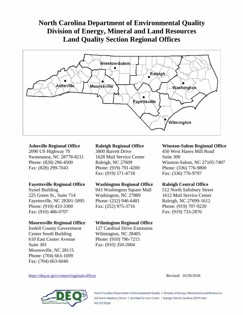
https://deq.nc.gov/contact/regional-offices Revised: 10/29/2018
North Carolina Department of Environmental Quality Division of Energy, Mineral and Land Resources
Land Quality Section Regional Offices
Asheville Regional Office 2090 US Highway 70 Swannanoa, NC 28778-8211 Phone: (828) 296-4500 Fax: (828) 299-7043
Fayetteville Regional Office Systel Building 225 Green St., Suite 714 Fayetteville, NC 28301-5095 Phone: (910) 433-3300 Fax: (910) 486-0707
Mooresville Regional Office Iredell County Government Center South Building 610 East Center Avenue Suite 301 Mooresville, NC 28115 Phone: (704) 663-1699 Fax: (704) 663-6040
Raleigh Regional Office 3800 Barrett Drive 1628 Mail Service Center Raleigh, NC 27609 Phone: (919) 791-4200 Fax: (919) 571-4718
Washington Regional Office 943 Washington Square Mall Washington, NC 27889 Phone: (252) 946-6481 Fax: (252) 975-3716
Wilmington Regional Office 127 Cardinal Drive Extension Wilmington, NC 28405 Phone: (910) 796-7215 Fax: (910) 350-2004
Winston-Salem Regional Office 450 West Hanes Mill Road Suite 300 Winston-Salem, NC 27105-7407 Phone: (336) 776-9800 Fax: (336) 776-9797
Raleigh Central Office 512 North Salisbury Street 1612 Mail Service Center Raleigh, NC 27699-1612 Phone: (919) 707-9220 Fax: (919) 733-2876

CHAPTER 04 - SEDIMENTATION CONTROL
This Chapter 4 of Title 15A of the North Carolina Administrative Code (T15A.04); SEDIMENTATION CONTROL;
has been transferred and recodified from Chapter 16 of Title 15 of the North Carolina Administrative Code (T15.16),
effective November 1, 1989. The recodification was pursuant to G.S. 143B-279.1.
SUBCHAPTER 04A - SEDIMENTATION CONTROL COMMISSION ORGANIZATION
15A NCAC 04A .0101 OFFICES OF THE SEDIMENTATION CONTROL COMMISSION
Persons may write or visit the North Carolina Sedimentation Control Commission offices at the Archdale Building, 512
N. Salisbury Street, P.O. Box 27687, Raleigh, North Carolina 27611. Persons may write or visit regional offices of the
Commission's staff in the Division of Energy, Mineral, and Land Resources at the following locations:
(1) Interchange Building
59 Woodfin Place
P.O. Box 370
Asheville, N.C. 28801
(2) 585 Waughtown Street
Winston-Salem, N.C. 27107
(3) 919 North Main Street
P.O. Box 950
Mooresville, N.C. 28115
(4) 3800 Barrett Drive
P.O. Box 27687
Raleigh, N.C. 27611
(5) Wachovia Building
Suite 714
Fayetteville, N.C. 28301
(6) 1424 Carolina Avenue
P.O. Box 2188
Washington, N.C. 27889
(7) 127 Cardinal Dr., Ext.
Wilmington, N.C. 28405-3845
History Note: Authority G.S. 143B-298;
Eff. February 1, 1976;
Amended Eff. August 1, 2012 (see S.L. 2012-143, s.1.(f)); October 1, 1995; February 1, 1992; May 1,
1990; December 1, 1988;
Pursuant to G.S. 150B-21.3A, rule is necessary without substantive public interest Eff. February 2,
2016.
15A NCAC 04A .0102 PURPOSES
15A NCAC 04A .0103 STRUCTURE
15A NCAC 04A .0104 DELEGATION
History Note: Authority G.S. 113A-54(b)(d)(3); 113A-56(a)(b); 113A-58(1); 113A-61(d); 143B-298;
Eff. February 1, 1976;
Amended Eff. August 1, 1985; November 1, 1984; June 5, 1981; January 31, 1979;
Repealed Eff. August 1, 1988.
15A NCAC 04A .0105 DEFINITIONS
As used in this Chapter, the following terms shall have these meanings:
(1) "Accelerated Erosion" means any increase over the rate of natural erosion, as a result of
land-disturbing activities.

(2) "Adequate Erosion Control Measure, Structure, or Device" means one which controls the soil
material within the land area under responsible control of the person conducting the
land-disturbing activity.
(3) "Borrow" means fill material which is required for on-site construction and is obtained from other
locations.
(4) "Buffer Zone" means the strip of land adjacent to a lake or natural watercourse.
(5) "Ground Cover" means any natural vegetative growth or other material which renders the soil
surface stable against accelerated erosion.
(6) "Lake or Natural Watercourse" means any stream, river, brook, swamp, sound, bay, creek, run,
branch, canal, waterway, estuary, and any reservoir, lake or pond, natural or impounded in which
sediment may be moved or carried in suspension, and which could be damaged by accumulation
of sediment.
(7) "Natural Erosion" means erosion as defined in G.S. 113A-52(5) under natural environmental
conditions undisturbed by man.
(8) "Person Who Violates", as used in G.S. 113A-64, means:
(a) the developer or other person who has or holds himself out as having financial or
operational control over the land-disturbing activity; or
(b) the landowner or person in possession or control of the land when he has directly or
indirectly allowed the land-disturbing activity or has benefitted from it or he has failed to
comply with any provision of the Sedimentation Pollution Control Act of 1973, G.S.
113A-50 to -66, the North Carolina Administrative Code, Title 15A, Chapter 4, or any
order or local ordinance adopted pursuant to the Sedimentation Pollution Control Act of
1973, G.S. 113A-50 to -66, as imposes a duty upon him.
(9) "Person Conducting Land Disturbing Activity" means any person who may be held responsible
for a violation unless expressly provided otherwise by the Sedimentation Pollution Control Act of
1973, G.S. 113A-50 to -66, the North Carolina Administrative Code, Title 15A Chapter 4, or any
order or local ordinance adopted pursuant to the Sedimentation Pollution Control Act of 1973,
G.S. 113A-50 to -66.
(10) "Phase of Grading" means one of two types of grading, rough or fine.
(11) "Plan" means an erosion control plan.
(12) "Sedimentation" means the process by which sediment resulting from accelerated erosion has
been or is being transported off the site of the land-disturbing activity or into a lake or natural
watercourse.
(13) "Storm Water Runoff" means the direct runoff of water resulting from precipitation in any form.
(14) "Being Conducted" means a land-disturbing activity has been initiated and permanent
stabilization of the site has not been completed.
(15) "Uncovered" means the removal of ground cover from, on, or above the soil surface.
(16) "Undertaken" means the initiating of any activity, or phase of activity, which results or will result
in a change in the ground cover or topography of a tract of land.
(17) "Waste" means surplus materials resulting from on-site construction and disposed of at other
locations.
(18) "Energy Dissipator" means a structure or a shaped channel section with mechanical armoring
placed at the outlet of pipes or conduits to receive and break down the energy from high velocity
flow.
(19) "Storm Drainage Facilities" means the system of inlets, conduits, channels, ditches and
appurtenances which serve to collect and convey stormwater through and from a given drainage
area.
(20) "Ten Year Storm" means the surface runoff resulting from a rainfall of an intensity expected to be
equaled or exceeded, on the average, once in 10 years, and of a duration which will produce the
maximum peak rate of runoff, for the watershed of interest under average antecedent wetness
conditions.

(21) "Velocity" means the average velocity of flow through the cross section of the main channel at
the peak flow of the storm of interest. The cross section of the main channel shall be that area
defined by the geometry of the channel plus the area of flow below the flood height defined by
vertical lines at the main channel banks. Overload flows are not to be included for the purpose of
computing velocity of flow.
(22) "Discharge Point" means that point at which runoff leaves a tract of land.
(23) "Completion of Construction or Development" means that no further land-disturbing activity is
required on a phase of a project except that which is necessary for establishing a permanent
ground cover.
(24) "High Quality Waters" means those classified as such in 15A NCAC 2B .0101(e)(5) - General
Procedures, which is incorporated herein by reference to include further amendments.
(25) "High Quality Water (HQW) Zones" means areas in the Coastal Counties that are within 575 feet
of High Quality Waters and for the remainder of the state areas that are within one mile of and
drain to HQW's.
(26) "Director" means the Director of the Division of Energy, Mineral, and Land Resources of the
Department of Environment, Health, and Natural Resources.
(27) "Coastal counties" means the following counties: Beaufort, Bertie, Brunswick, Camden, Carteret,
Chowan, Craven, Currituck, Dare, Gates, Hertford, Hyde, New Hanover, Onslow, Pamlico,
Pasquotank, Pender, Perquimans, Tyrrell and Washington.
(28) "Twenty-five Year Storm" means the surface runoff resulting from a rainfall of an intensity
expected to be equaled or exceeded, on the average, once in 25 years, and of a duration which
will produce the maximum peak rate of runoff, from the watershed of interest under average
antecedent wetness conditions.
History Note: Filed as a Temporary Amendment Eff. January 14, 1992 for a period of 180 days to expire
on July 11, 1992;
Filed as a Temporary Amendment Eff. November 1, 1990 for a period of 180 days to expire
on April 29, 1991;
Statutory Authority G.S. 113A-52; 113A-54;
Eff. November 1, 1984;
Amended Eff. May 1, 1990;
ARRC Objection Lodged November 14, 1990;
ARRC Objection Removed December 20, 1990;
Amended Eff. August 1, 2012 (see S.L. 2012-143, s.1.(f)); October 1, 1995; April 1, 1992; January 1,
1991.
_
SUBCHAPTER 4B - EROSION AND SEDIMENT CONTROL
15A NCAC 04B .0101 AUTHORITY
History Note: Authority G.S. 113A-54; 113A-64;
Eff. February 1, 1976;
Repealed Eff. November 1, 1984.
15A NCAC 04B .0102 PURPOSE
15A NCAC 04B .0103 SCOPE
History Note: Authority G.S. 113A-54(a)(b);
Eff. February 1, 1976;
Amended Eff. November 1, 1984;
Repealed Eff. August 1, 1988.
15A NCAC 04B .0104 DEFINITIONS
History Note: Authority G.S. 113A-52; 113A-54;
Eff. February 1, 1976;
Amended Eff. March 14, 1980; January 31, 1979; July 1, 1978;
Repealed Eff. November 1, 1984.
15A NCAC 04B .0105 PROTECTION OF PROPERTY
Persons conducting land-disturbing activity shall take all reasonable measures to protect all public and private
property from damage caused by such activities.
History Note: Authority G.S. 113A-54(b); 113A-54(d)(2);
Eff. February 1, 1976;
Amended Eff. August 1, 1988; November 1, 1984.
15A NCAC 04B .0106 BASIC CONTROL OBJECTIVES
(a) An erosion and sedimentation control plan may be disapproved pursuant to 15A NCAC 4B .0118 if the plan fails to
address the following control objectives:
(1) Identify Critical Areas: Identify site areas subject to severe erosion, and off-site areas especially
vulnerable to damage from erosion and sedimentation.
(2) Limit Exposed Areas. Limit the size of the area exposed at any one time.
(3) Limit Time of Exposure. Limit exposure to the shortest feasible time.
(4) Control Surface Water. Control surface water run-off originating upgrade of exposed areas in order to
reduce erosion and sediment loss during exposure.
(5) Control Sedimentation. All land-disturbing activity is to be planned and conducted so as to prevent
off-site sedimentation damage.
(6) Manage Storm Water Runoff. When the increased velocity of storm water runoff resulting from a
land-disturbing activity causes accelerated erosion of the receiving watercourse, plans shall include
measures to control the velocity to the point of discharge.
(b) When deemed necessary by the approving authority a preconstruction conference may be required.
History Note: Authority G.S. 113A-54(d)(4); 113A-54.1;
Eff. February 1, 1976;
Amended Eff. July 1, 2000; February 1, 1992; May 1, 1990; November 1, 1984; March 14, 1980.
15A NCAC 04B .0107 MANDATORY STANDARDS FOR LAND-DISTURBING ACTIVITY
(a) No land-disturbing activity subject to these Rules shall be undertaken except in accordance with the G.S. 113A-57.
(b) Pursuant to G.S. 113A-57(3), provisions for a ground cover sufficient to restrain erosion must be accomplished
within 15 working days or 90 calendar days following completion of construction or development, whichever period is
shorter, except as provided in 15A NCAC 4B .0124(e).
(c) Pursuant to G.S. 113A-57(4) and 113A-54(d)(4), an erosion and sedimentation control plan must be both filed and
approved by the agency having jurisdiction.
History Note: Authority G.S. 113A-54(d)(4); 113A-57; 113A-57(3)(4);
Eff. February 1, 1976;
Amended Eff. July 1, 2000; May 1, 1990; August 1, 1988; November 1, 1984; March 14, 1980.
15A NCAC 04B .0108 DESIGN AND PERFORMANCE STANDARD
Erosion and sedimentation control measures, structures, and devices shall be so planned, designed, and constructed
to provide protection from the run off of that 10 year storm which produces the maximum peak rate of run off as
calculated according to procedures in the United States Department of Agriculture Soil Conservation Service's

"National Engineering Field Manual for Conservation Practices" or according to procedures adopted by any other
agency of this state or the United States or any generally recognized organization or association.
History Note: Authority G.S. 113A-54;
Eff. February 1, 1976;
Amended Eff. November 1, 1984; July 1, 1978.
15A NCAC 04B .0109 STORM WATER OUTLET PROTECTION
(a) Persons shall conduct land disturbing activity so that the post construction velocity of the ten year storm run off in the
receiving watercourse to the discharge point does not exceed the greater of:
(1) the velocity established by the table in Paragraph (d) of this Rule; or
(2) the velocity of the ten year storm run off in the receiving watercourse prior to development.
If conditions (1) or (2) of this Paragraph cannot be met, then the receiving watercourse to and including the discharge
point shall be designed and constructed to withstand the expected velocity anywhere the velocity exceeds the "prior to
development" velocity by ten percent.
(b) Acceptable Management Measures. The commission recognizes that management of storm water run off to control
downstream erosion constitutes a developing technology and consequently invites the use of innovative techniques shown
to produce successful results. Alternatives include:
(1) Compensate for increased run off from areas rendered impervious by designing measures to promote
infiltration.
(2) Avoid increases in storm water discharge velocities by using vegetated or roughened swales and
waterways in place of closed drains and paved sections.
(3) Provide energy dissipators at storm drainage outlets to reduce flow velocities to the discharge points.
(4) Protect watercourses subject to accelerated erosion by improving cross sections and/or providing
erosion-resistant lining.
(c) Exceptions. This Rule shall not apply when storm water discharge velocities will not create an erosion problem in
the receiving watercourse.
(d) The following table sets maximum permissible velocity for storm water discharges:
Maximum Permissible
Material Velocities For
F.P.S. M.P.S.
Fine Sand (noncolloidal) 2.5 .8
Sandy Loam (noncolloidal) 2.5 .8
Silt Loam (noncolloidal) 3.0 .9
Ordinary Firm Loam 3.5 1.1
Fine Gravel 5.0 1.5
Stiff Clay (very colloidal) 5.0 1.5
Graded, Loam to Cobbles (noncolloidal) 5.0 1.5
Graded, Silt to Cobbles (colloidal) 5.5 1.7
Alluvial Silts (noncolloidal) 3.5 1.1
Alluvial Silts (colloidal) 5.0 1.5
Coarse Gravel (noncolloidal) 6.0 1.8
Cobbles and Shingles 5.5 1.7
Shales and Hard Pans 6.0 1.8
Source: Adapted from recommendations by Special Committee on Irrigation Research, American Society of Civil
Engineers, 1926, for channels with straight alignment. For sinuous channels multiply allowable velocity by 0.95 for
slightly sinuous, by 0.9 for moderately sinuous channels, and by 0.8 for highly sinuous channels.
History Note: Authority G.S. 113A-54(b)(c);
Eff. February 1, 1976;
Amended Eff. February 1, 1992; May 1, 1990; November 1, 1984; July 1, 1978.

15A NCAC 04B .0110 BORROW AND WASTE AREAS
If the same person conducts the land disturbing activity and any related borrow or waste activity, the related borrow
or waste activity shall constitute part of the land disturbing activity unless the borrow or waste activity is regulated
under the Mining Act of 1971, or is a landfill regulated by the Division of Solid Waste Management. If the land
disturbing activity and any related borrow or waste activity are not conducted by the same person, they shall be
considered separate land-disturbing activities.
History Note: Authority G.S. 74-67; 113A-54(b); 130A-166.21;
Eff. February 1, 1976;
Amended Eff. May 1, 1990; November 1, 1984.
15A NCAC 04B .0111 ACCESS AND HAUL ROADS
Temporary access and haul roads, other than public roads, constructed or used in connection with any
land-disturbing activity shall be considered a part of such activity.
History Note: Authority G.S. 113A-54;
Eff. February 1, 1976.
15A NCAC 04B .0112 OPERATIONS IN LAKES OR NATURAL WATERCOURSES
Land disturbing activity in connection with construction in, on, over, or under a lake or natural watercourse shall
minimize the extent and duration of disruption of the stream channel. Where relocation of a stream forms an
essential part of the proposed activity, the relocation shall minimize unnecessary changes in the stream flow
characteristics.
History Note: Authority G.S. 113A-54;
Eff. February 1, 1976;
Amended Eff. November 1, 1984.
15A NCAC 04B .0113 RESPONSIBILITY FOR MAINTENANCE
During the development of a site, the person conducting the land-disturbing activity shall install and maintain all
temporary and permanent erosion and sedimentation control measures as required by the approved plan or any
provision of the Act, these Rules, or any order or local ordinance adopted pursuant to the Act. After site
development, the land owner or person in possession or control of the land shall install and/or maintain all
necessary permanent erosion and sediment control measures, except those measures installed within a road or street
right of way or easement accepted for maintenance by a governmental agency.
History Note: Authority G.S. 113A-54;
Eff. February 1, 1976;
Amended Eff. November 1, 1984; July 1, 1978.
15A NCAC 04B .0114 GUIDELINES FOR EROSION AND SEDIMENT CONTROL PRACTICES
History Note: Authority G.S. 113A-54; 113A-64;
Eff. February 1, 1976;
Repealed Eff. November 1, 1984.
15A NCAC 04B .0115 ADDITIONAL MEASURES
Whenever the commission or a local government determines that significant erosion and sedimentation continues
despite the installation of protective practices, the person conducting the land disturbing activity will be required to
and shall take additional protective action.
History Note: Authority G.S. 113A-54(b);
Eff. February 1, 1976;
Amended Eff. November 1, 1984.

15A NCAC 04B .0116 EXISTING UNCOVERED AREAS
History Note: Authority G.S. 113A-54;
Eff. February 1, 1976;
Amended Eff. October 1, 1995; February 1, 1992; May 1, 1990; November 1, 1984;
Expired Eff. March 1, 2016 pursuant to G.S. 150B-21.3A.
15A NCAC 04B .0117 STATEMENT OF FINANCIAL RESPONSIBILITY AND OWNERSHIP
History Note: Authority G.S. 113A-54(b);
Eff. February 1, 1976;
Amended Eff. November 1, 1984;
Repealed Eff. May 1, 1990.
15A NCAC 04B .0118 APPROVAL OF PLANS
(a) Persons conducting land-disturbing activity on a tract which covers one or more acres shall file three copies of
the erosion and sedimentation control plan with the local government having jurisdiction or with the Commission if
no local government has jurisdiction, at least 30 days prior to beginning such activity and shall keep another copy
of the plan on file at the job site. After approving a plan, if the Commission or local government determines, either
upon review of such plan or on inspection of the job site, that a significant risk of accelerated erosion or off-site
sedimentation exists, the Commission or local government shall require a revised plan. Pending the preparation of
the revised plan, work shall cease or shall continue under conditions outlined by the appropriate authority.
(b) Commission Approval:
(1) The Commission shall review plans for all land-disturbing activity over which the Commission
has exclusive jurisdiction by statute and all other land-disturbing activity if no local government
has jurisdiction.
(2) The Commission shall complete its review of any completed plan within 30 days of receipt and
shall notify the person submitting the plan in writing that it has been:
(A) approved,
(B) approved with modification,
(C) approved with performance reservations, or
(D) disapproved.
(3) The Commission's disapproval, modification, or performance reservations of any proposed plan,
shall entitle the person submitting the plan to an administrative hearing in accordance with the
provisions of G.S. 150B-23. (This Section does not modify any other rights to a contested case
hearing which may arise under G.S. 150B-23).
(4) Subparagraph (b)(3) of this Rule shall not apply to the approval or modification of plans
reviewed by the Commission pursuant to G.S. 113A-61(c).
(5) Any plan submitted for a land-disturbing activity for which an environmental document is
required by the North Carolina Environmental Policy Act shall be deemed incomplete until a
complete environmental document is available for review. The Commission shall promptly
notify the person submitting the plan that the 30 day time limit for review of the plan pursuant to
Subparagraph (b)(2) of this Rule shall not begin until a complete environmental document is
available for review.
(c) Erosion and sedimentation control plans may also be disapproved unless they include an authorized statement
of financial responsibility and ownership. This statement shall be signed by the person financially responsible for
the land-disturbing activity or his attorney in fact. The statement shall include the mailing and street addresses of
the principal place of business of the person financially responsible and of the owner of the land or their registered
agents.
(d) Local Government Approval:
(1) Local Governments administering erosion and sedimentation control programs shall develop and
publish procedures for approval of plans. Such procedures shall respect applicable laws,

ordinances, and rules, and shall contain procedures for appeal consistent with the local
government's organization and operations.
(2) The secretary shall appoint such employee(s) of the Department as he deems necessary to
consider appeals from the local government's final disapproval or modification of a plan. Within
30 days following receipt of notification of the appeal, such departmental employee shall
complete the review and shall notify the local government and the person appealing the local
government's decision that the plan should be approved, approved with modifications, approved
with performance reservations, or disapproved.
(3) If either the local government or the person submitting the plan disagrees with the decision
reached by an employee of the Department then he may appeal the decision to the Commission
by filing notice within 15 days with the Director of the Division of Energy, Mineral, and Land
Resources. The director shall make the proposed erosion control plan and the records relating to
the local government's and departmental employees' review, available to an appeals review
committee consisting of three members of the Commission appointed by the chairman. Within
10 days following receipt of the notification of appeal, the appeals review committee shall notify
the local government and the person submitting the plan of a place and time for consideration of
the appeal, and shall afford both parties an opportunity to present written or oral arguments. The
appeals review committee shall notify both parties of its decision concerning the approval,
disapproval, or modification of the proposed plan within 30 days following such hearing.
(e) The applicant's right under G.S. 113A-54.1(d) to appeal the Director's disapproval of an erosion control plan
under G.S. 113A-54.1(c) gives rise to a right to a contested case under G.S. 150B, Article 3. An applicant desiring
to appeal the Director's disapproval of an erosion control plan shall file with the Office of Administrative Hearings
a contested case petition under G.S. 150B, Article 3. The general time limitation for filing a petition, and the
commencement of the time limitation, shall be as set out in G.S. 150B-23(f). Contested cases shall be conducted
under the procedures of G.S. 150B, Article 3 and applicable rules of the Office of Administrative Hearings. The
Commission shall make the final decision on any contested case under G.S. 150B-36.
History Note: Filed as a Temporary Amendment Eff. January 14, 1992 for a period of 180 days to expire
on July 11, 1992;
Statutory Authority G.S. 113A-2; 113A-54; 113A-54.1; 113A-60(a); 113A-61(b); 113A-61(c);
150B, Article 3; 150B-23;
Eff. February 1, 1976;
Amended Eff. August 1, 2012 (see S.L. 2012-143, s.1.(f)); June 1, 1995; February 1, 1992; May 1,
1990; August 1, 1988.
15A NCAC 04B .0119 COMPLIANCE WITH PLAN REQUIREMENT
History Note: Authority G.S. 113A-54(b);
Eff. February 1, 1976;
Amended Eff. November 1, 1984;
Repealed Eff. August 1, 1988.
15A NCAC 04B .0120 INSPECTIONS AND INVESTIGATIONS
(a) The Commission, Department of Environment, Health, and Natural Resources or local government may require
written statements, or the filing of reports under oath, concerning land disturbing activity.
(b) Inspection of sites shall be carried out by the staff of Department of Environment, Health, and Natural
Resources or other qualified persons authorized by the Commission or Department of Environment, Health, and
Natural Resources as necessary to carry out its duties under the Act.
(c) No person shall refuse entry or access to any representative of the Commission or any representative of a local
government who requests entry for purposes of inspection.
History Note: Authority G.S. 113A-54(b); 113A-58; 113A-61.1;
Eff. February 1, 1976;

Amended Eff. October 1, 1995; May 1, 1990; November 1, 1984.
15A NCAC 04B .0121 PENALTIES
History Note: Authority G.S. 113A-54; 113A-64;
Eff. February 1, 1976;
Repealed Eff. November 1, 1984.
15A NCAC 04B .0122 SEVERABILITY CLAUSE
If any of these provisions are held invalid or unenforceable, all of the other provisions shall nevertheless continue
in full force and effect.
History Note: Authority G.S. 113A-54;
Eff. February 1, 1976;
Amended Eff. November 1, 1984;
Pursuant to G.S. 150B-21.3A, rule is necessary without substantive public interest Eff. February 2,
2016.
15A NCAC 04B .0123 EFFECTIVE DATE
History Note: Authority G.S. 113A-54(b);
Eff. February 1, 1976;
Amended Eff. November 1, 1984; November 15, 1976;
Repealed Eff. August 1, 1988.
15A NCAC 04B .0124 DESIGN STANDARDS IN SENSITIVE WATERSHEDS
(a) Uncovered areas in HQW zones shall be limited at any time to a maximum total area within the boundaries of
the tract of 20 acres. Only the portion of the land-disturbing activity within a HQW zone shall be governed by this
Rule. Larger areas may be uncovered within the boundaries of the tract with the written approval of the Director.
(b) Erosion and sedimentation control measures, structures, and devices within HQW zones shall be so planned,
designed and constructed to provide protection from the runoff of the 25 year storm which produces the maximum
peak rate of runoff as calculated according to procedures in the United States Department of Agricultural Soil
Conservation Service's "National Engineering Field Manual for Conservation Practices" or according to procedures
adopted by any other agency of this state or the United States or any generally recognized organization or
association.
(c) Sediment basins within HQW zones shall be designed and constructed such that the basin will have a settling
efficiency of at least 70 percent for the 40 micron (0.04mm) size soil particle transported into the basin by the
runoff of that two-year storm which produces the maximum peak rate of runoff as calculated according to
procedures in the United States Department of Agriculture Soil Conservation Services "National Engineering Field
Manual for Conservation Practices" or according to procedures adopted by any other agency of this state or the
United States or any generally recognized organization or association.
(d) Newly constructed open channels in HQW zones shall be designed and constructed with side slopes no steeper
than two horizontal to one vertical if a vegetative cover is used for stabilization unless soil conditions permit a
steeper slope or where the slopes are stabilized by using mechanical devices, structural devices or other acceptable
ditch liners. In any event, the angle for side slopes shall be sufficient to restrain accelerated erosion.
(e) Pursuant to G.S. 113A-57(3) provisions for a ground cover sufficient to restrain erosion must be provided for
any portion of a land-disturbing activity in a HQW zone within 15 working days or 60 calendar days following
completion of construction or development, whichever period is shorter.
History Note: Authority G.S. 113A-54(b); 113A-54(c)(1);
Eff. May 1, 1990.
15A NCAC 04B .0125 BUFFER ZONE REQUIREMENTS

(a) Unless otherwise provided, the width of a buffer zone is measured from the edge of the water to the nearest
edge of the disturbed area, with the 25 percent of the strip nearer the land-disturbing activity containing natural or
artificial means of confining visible siltation.
(b) The 25 foot minimum width for an undisturbed buffer zone adjacent to designated trout waters shall be
measured horizontally from the top of the bank.
(c) Where a temporary and minimal disturbance is permitted as an exception by G.S. 113A-57(1), land-disturbing
activities in the buffer zone adjacent to designated trout waters shall be limited to a maximum of ten percent of the
total length of the buffer zone within the tract to be distributed such that there is not more than 100 linear feet of
disturbance in each 1000 linear feet of buffer zone. Larger areas may be disturbed with the written approval of the
Director.
(d) No land-disturbing activity shall be undertaken within a buffer zone adjacent to designated trout waters that
will cause adverse temperature fluctuations, as set forth in 15A NCAC 2B .0211 "Fresh Surface Water
Classification and Standards", in these waters.
History Note: Authority G.S. 113A-54(b); 113A-54(c)(1); 113A-57(1);
Eff. May 1, 1990;
Amended Eff. February 1, 1992.
15A NCAC 04B .0126 PLAN REVIEW FEE
(a) A nonrefundable plan review processing fee, in the amount stated in Paragraph (e) of this Rule, shall be paid when an
erosion and sedimentation control plan is filed in accordance with 15A NCAC 04B .0118.
(b) Each plan shall be deemed incomplete until the plan review processing fee is paid.
(c) The plan review processing fee shall be based on the number of acres, or any part of an acre, of disturbed land shown
on the plan.
(d) No plan review processing fee shall be charged for review of a revised plan unless the revised plan contains an
increase in the number of acres to be disturbed. If the revised plan contains an increase in the number of acres to be
disturbed, the plan review processing fee to be charged shall be the amount stated in Paragraph (e) of the Rule for each
additional acre (or any part thereof) disturbed.
(e) The nonrefundable plan review processing fee shall be fifty dollars ($50.00) for each acre or part of any acre of
disturbed land.
(f) Payment of the plan review processing fee may be by check or money order made payable to the "N.C. Department of
Environment and Natural Resources". The payment shall refer to the erosion and sedimentation control plan.
History Note: Authority G.S. 113A-54; 113A-54.2;
Filed as a Temporary Rule Eff. November 1, 1990, for a period of 180 days to expire on April 29,
1991;
AARC Objection Lodged November 14, 1990;
AARC Objection Removed December 20, 1990;
Eff. January 1, 1991;
Amended Eff. August 1, 2002; July 1, 2000.
15A NCAC 04B .0127 PLAN APPROVAL CERTIFICATE
(a) Approval of a sedimentation and erosion control plan will be contained in a document called "Certificate of Plan
Approval" to be issued by the Commission.
(b) The Certificate of Plan Approval must be posted at the primary entrance of the job site before construction begins.
(c) No person may initiate a land-disturbing activity until notifying the agency that issued the Plan Approval of the date
that the land-disturbing activity will begin.
History Note: Filed as a Temporary Rule Eff. November 1, 1990, for a period of 180 days to expire on April 29,
1991;
Authority G.S. 113A-54(b);
ARRC Objection Lodged November 14, 1990;
ARRC Objection Removed December 20, 1990;
Eff. January 1, 1991;

Amended Eff. July 1, 2000.
15A NCAC 04B .0128 RAILROAD COMPANIES
History Note: Authority G.S. 113A-52(6); 113A-54(b); 113A-54(c); 113A-54(d)(4); 113A-57(1);
Eff. August 1, 1995;
Expired Eff. March 1, 2016 pursuant to G.S. 150B-21.3A.
15A NCAC 04B .0129 EROSION CONTROL PLAN EXPIRATION DATE
An erosion control plan shall expire three years following the date of approval, if no land-disturbing activity has
been undertaken.
History Note: Authority G.S. 113A-54.1(a);
Eff. October 1, 1995.
15A NCAC 04B .0130 EMERGENCIES
Any person who conducts an emergency repair essential to protect human life, that constitutes a land-disturbing
activity within the meaning of G.S. 113A-52(6) and these Rules:
(1) shall notify the Commission of such repair as soon as reasonably possible, but in no event later
than five working days after the emergency ends; and
(2) shall take all reasonable measures to protect all public and private property from damage caused
by such repair as soon as reasonably possible, but in no event later than 15 working days after the
emergency ends.
History Note: Authority G.S. 113A-52.01(4); 113A-54(b);
Eff. October 1, 1995.
15A NCAC 04B .0131 SELF-INSPECTIONS
Where inspections are required by G.S. 113A-54.1(e), the following apply:
(1) The person who performs the inspection shall make a record of the site inspection by documenting the
following items:
(a) all of the erosion and sedimentation control measures, practices and devices, as called for in a
construction sequence consistent with the approved erosion and sedimentation control plan,
including but not limited to sedimentation control basins, sedimentation traps, sedimentation
ponds, rock dams, temporary diversions, temporary slope drains, rock check dams, sediment
fence or barriers, all forms of inlet protection, storm drainage facilities, energy dissipaters,
and stabilization methods of open channels, have initially been installed and do not
significantly deviate (as defined in Sub-item (1)(e) of this Rule) from the locations,
dimensions and relative elevations shown on the approved erosion and sedimentation plan.
Such documentation shall be accomplished by initialing and dating each measure or practice
shown on a copy of the approved erosion and sedimentation control plan or by completing,
dating and signing an inspection report that lists each measure, practice or device shown on
the approved erosion and sedimentation control plan. This documentation is required only
upon the initial installation of the erosion and sedimentation control measures, practices and
devices as set forth by the approved erosion and sedimentation control plan or if the
measures, practices and devices are modified after initial installation;
(b) the completion of any phase of grading for all graded slopes and fills shown on the approved
erosion and sedimentation control plan, specifically noting the location and condition of the
graded slopes and fills. Such documentation shall be accomplished by initialing and dating a
copy of the approved erosion and sedimentation control plan or by completing, dating and
signing an inspection report;
(c) the location of temporary or permanent ground cover, and that the installation of the ground
cover does not significantly deviate (as defined in Sub-item (1)(e) of this Rule) from the
approved erosion and sedimentation control plan. Such documentation shall be

accomplished by initialing and dating a copy of the approved erosion and sedimentation
control plan or by completing, dating and signing an inspection report;
(d) that maintenance and repair requirements for all temporary and permanent erosion and
sedimentation control measures, practices and devices have been performed. Such
documentation shall be accomplished by completing, dating and signing an inspection report
(the general storm water permit monitoring form may be used to verify the maintenance and
repair requirements); and
(e) any significant deviations from the approved erosion and sedimentation control plan,
corrective actions required to correct the deviation and completion of the corrective actions.
Such documentation shall be accomplished by initialing and dating a copy of the approved
erosion and sedimentation control plan or by completing, dating and signing an inspection
report. A significant deviation means an omission, alteration or relocation of an erosion or
sedimentation control measure that prevents the measure from performing as intended.
(2) The documentation, whether on a copy of the approved erosion and sedimentation control plan or an
inspection report, shall include the name, address, affiliation, telephone number, and signature of the
person conducting the inspection and the date of the inspection. Any relevant licenses and
certifications may also be included. Any documentation of inspections that occur on a copy of the
approved erosion and sedimentation control plan shall occur on a single copy of the plan and that plan
shall be made available on the site. Any inspection reports shall also be made available on the site.
(3) The inspection shall be performed during or after each of the following phases of a plan:
(a) installation of perimeter erosion and sediment control measures;
(b) clearing and grubbing of existing ground cover;
(c) completion of any phase of grading of slopes or fills that requires provision of temporary or
permanent ground cover pursuant to G.S. 113A-57(2);
(d) completion of storm drainage facilities;
(e) completion of construction or development; and
(f) quarterly until the establishment of permanent ground cover sufficient to restrain erosion or
until the financially responsible party has conveyed ownership or control of the tract of land
for which the erosion and sedimentation control plan has been approved and the agency that
approved the plan has been notified. If the financially responsible party has conveyed
ownership or control of the tract of land for which the erosion and sedimentation control plan
has been approved, the new owner or person in control shall conduct and document
inspections quarterly until the establishment of permanent ground cover sufficient to restrain
erosion.
History Note: Authority G.S. 113A-54; 113A-54.1(e);
Eff. October 1, 2010.
15A NCAC 04B .0132 DESIGN STANDARDS FOR THE UPPER NEUSE RIVER BASIN (FALLS LAKE
WATERSHED)
In addition to any other requirements of State, federal, and local law, land-disturbing activity in the watershed of the
drinking water supply reservoir that meets the applicability requirements of Session Law 2009-486, Section 3.(a), shall
meet all of the following design standards for sedimentation and erosion control:
(1) Erosion and sedimentation control measures, structures, and devices shall be planned, designed, and
constructed to provide protection from the runoff of the 25-year storm that produces the maximum
peak rate of runoff as calculated according to procedures set out in the United States Department of
Agriculture Soil Conservation Service's "National Engineering Field Manual for Conservation
Practices" or according to procedures adopted by any other agency of the State or the United States.
(2) Sediment basins shall be planned, designed, and constructed so that the basin will have a settling
efficiency of at least 70 percent for the 40-micron size soil particle transported into the basin by the
runoff of the two-year storm that produces the maximum peak rate of runoff as calculated according to
procedures in the United States Department of Agriculture Soil Conservation Service's "National
Engineering Field Manual for Conservation Practices" or according to procedures adopted by any
other agency of the State or the United States.

(3) Newly constructed open channels shall be planned, designed, and constructed with side slopes no
steeper than two horizontal to one vertical if a vegetative cover is used for stabilization unless soil
conditions permit steeper side slopes or where the side slopes are stabilized by using mechanical
devices, structural devices, or other ditch liners sufficient to restrain accelerated erosion. The angle for
side slopes shall be sufficient to restrain accelerated erosion.
(4) For an area of land-disturbing activity where grading activities have been completed, temporary or
permanent ground cover sufficient to restrain erosion shall be provided as soon as practicable, but in
no case later than seven days after completion of grading. For an area of land-disturbing activity where
grading activities have not been completed, temporary ground cover shall be provided as follows:
(a) For an area with no slope, temporary ground cover shall be provided for the area if it has not
been disturbed for a period of 14 days.
(b) For an area of moderate slope, temporary ground cover shall be provided for the area if it has
not been disturbed for a period of 10 days. For purposes of this Item, "moderate slope"
means an inclined area, the inclination of which is less than or equal to three units of
horizontal distance to one unit of vertical distance.
(c) For an area of steep slope, temporary ground cover shall be provided for the area if it has not
been disturbed for a period of seven days. For purposes of this Item, "steep slope" means an
inclined area, the inclination of which is greater than three units of horizontal distance to one
unit of vertical distance.
History Note: Authority S.L. 2009-486;
Eff. February 1, 2012.
_
SUBCHAPTER 4C - SEDIMENTATION CONTROL CIVIL PENALTIES
15A NCAC 04C .0101 PURPOSE AND SCOPE
History Note: Authority G.S. 113A-54(b); 113A-64(a);
Eff. February 1, 1976;
Amended Eff. November 1, 1984; October 5, 1980;
Repealed Eff. August 1, 1988.
15A NCAC 04C .0102 DEFINITIONS
History Note: Authority G.S. 143B-10;
Eff. February 1, 1976;
Amended Eff. January 31, 1979; September 3, 1976;
Repealed Eff. November 1, 1984.
15A NCAC 04C .0103 WHO MAY ASSESS
The director may assess civil penalties against any person responsible for a violation.
History Note: Authority G.S. 113A-55; 113A-64; 143B-10;
Eff. February 1, 1976;
Amended Eff. November 1, 1984.
15A NCAC 04C .0104 WHEN ASSESSABLE
History Note: Authority G.S. 113A-64;
Eff. February 1, 1976;

Amended Eff. November 1, 1984;
Repealed Eff. August 1, 1988.
15A NCAC 04C .0105 AMOUNT OF ASSESSMENT
History Note: Authority G.S. 113A-64;
Eff. February 1, 1976;
Repealed Eff. November 1, 1984.
15A NCAC 04C .0106 CRITERIA
In determining the amount of the civil penalty assessment, the director shall consider the following criteria:
(1) severity of the violation,
(2) degree and extent of the harm,
(3) type of violation,
(4) duration,
(5) cause,
(6) extent of any off-site damage which may have resulted,
(7) effectiveness of action taken by violator,
(8) adherence to plan submitted by violator,
(9) effectiveness of plan submitted by violator,
(10) cost of rectifying any damage,
(11) the violator's previous record in complying with rules of the commission,
(12) estimated cost of installing and/or maintaining corrective sediment control measures, and
(13) staff investigative costs.
History Note: Authority G.S. 113A-54(b); 113A-55; 113A-64(a);
Eff. February 1, 1976;
Amended Eff. November 1, 1984; April 1, 1978.
15A NCAC 04C .0107 PROCEDURES: NOTICES
(a) The notice of violation shall describe the violation with reasonable particularity, request that all illegal activity cease,
and inform the violator that a civil penalty may be assessed pursuant to G.S. 113A-64. If particular actions need to be
taken to comply with the Sedimentation Pollution Control Act, the notice shall specify the actions to be taken, shall
specify a time period for compliance, and shall state that upon failure to comply within the allotted time the person shall
become subject to the assessment of a civil penalty for each day of the continuing violation beginning with the date of the
violation.
(b) The stop work order provided in G.S. 113A-65.1 shall serve as the notice of violation for purposes of the assessment
of a civil penalty pursuant to G.S. 113A-64(a)(1). Copies of the stop work order shall be served upon persons the
Department has reason to believe may be responsible for the violation by any means authorized under G.S. 1A-1, Rule 4.
History Note: Filed as a Temporary Amendment Eff. January 14, 1992 for a period of 180 days to expire on July 11,
1992;
Authority G.S. 113A-54; 113A-61.1; 113A-64; 113A-65.1; 143B-10;
Eff. February 1, 1976;
Amended Eff. August 1, 2000; October 1, 1995; April 1, 1992; May 1, 1990; November 1, 1984;
Temporary Amendment Eff. August 1, 2000;
Amended Eff. April 1, 2001.
15A NCAC 04C .0108 REQUESTS FOR ADMINISTRATIVE HEARING
After receipt of notification of any assessment, the assessed person must select one of the following options within
30 days:
(1) tender payment; or
(2) file a petition for an administrative hearing in accordance with G.S. 150B-23.

History Note: Authority G.S. 113A-64; 143B-10; 150B-23;
Eff. February 1, 1976;
Amended Eff. October 1, 1995; October 1, 1988; October 5, 1980; April 1, 1978.
15A NCAC 04C .0109 TENDER OF PAYMENT
History Note: Authority G.S. 113A-55; 143B-10;
Eff. February 1, 1976;
Amended Eff. October 5, 1980; April 1, 1978;
Expired Eff. March 1, 2016 pursuant to G.S. 150B-21.3A.
15A NCAC 04C .0110 ADMINISTRATIVE HEARING
Administrative hearings shall be conducted in accordance with the procedures outlined in G.S. 150B-22 et seq. and
the contested case procedures in 15A NCAC 1B .0200.
History Note: Authority G.S. 113A-55; 150B-22 et seq.;
Eff. February 1, 1976;
Amended Eff. October 1, 1995; August 1, 1988; November 1, 1984; October 5, 1980;
Pursuant to G.S. 150B-21.3A, rule is necessary without substantive public interest Eff. February 2,
2016.
15A NCAC 04C .0111 FURTHER REMEDIES
No provision of this Subchapter shall be construed to restrict or impair the right of the secretary, the director, or the
Sedimentation Control Commission to pursue any other remedy provided by law for violations of the
Sedimentation Pollution Control Act.
History Note: Authority G.S. 113A-54; 113A-60; 113A-64 through 113A-66;
Eff. February 1, 1976;
Pursuant to G.S. 150B-21.3A, rule is necessary without substantive public interest Eff. February 2,
2016.
SUBCHAPTER 4D - LOCAL ORDINANCES
15A NCAC 04D .0101 SUBMISSION AND APPROVAL OF PROPOSED LOCAL ORDINANCES
History Note: Authority G.S. 113A-54; 113A-60;
Eff. February 1, 1976;
Repealed Eff. August 1, 1988.
15A NCAC 04D .0102 MODEL ORDINANCE
The commission has adopted a model ordinance. Local governmental units wishing to establish a local erosion and
sedimentation control program may obtain a copy of the model ordinance upon writing to:
North Carolina Department of Environment, Health, and Natural Resources
Land Quality Section
P.O. Box 27687
Raleigh, North Carolina 27611
History Note: Authority G.S. 113A-54(d); 113A-60;
Eff. February 1, 1976;
Amended Eff. March 14, 1980; February 23, 1979;
Summary Rule Filed January 26, 1982;

Amended Eff. October 1, 1995; May 1, 1990; August 1, 1988; November 1, 1984.
15A NCAC 04D .0103 REVISIONS TO APPROVED LOCAL ORDINANCES
History Note: Authority G.S. 113A-54(d); 113A-60;
Eff. May 1, 1990;
Amended Eff. January 4, 1993;
Repealed Eff. October 1, 1995.
SUBCHAPTER 04E - RULEMAKING PROCEDURES
SECTION .0100 - GENERAL PROVISIONS
15A NCAC 04E .0101 GENERAL PURPOSE
Rules at 15A NCAC 1B .0100 are adopted by reference and with the rules of this Subchapter shall govern rule-making
hearings conducted under the purview of the commission.
History Note: Authority G.S. 113A-54; 113A-55; 150B;
Eff. March 14, 1980;
Amended Eff. November 1, 1984;
Pursuant to G.S. 150B-21.3A, rule is necessary without substantive public interest Eff. February 2,
2016.
15A NCAC 04E .0102 DEFINITIONS
As used in this Subchapter:
(1) "Commission" means the North Carolina Sedimentation Control Commission.
(2) "Director" means the Director of the Division of Energy, Mineral, and Land Resources of the
Department of Environment, Health, and Natural Resources.
History Note: Authority G.S. 113A-54; 113A-55;
Eff. March 14, 1980;
Amended Eff. August 1, 2012 (see S.L. 2012-143, s.1.(f)); May 1, 1990;
Pursuant to G.S. 150B-21.3A, rule is necessary without substantive public interest Eff. February 2,
2016.
15A NCAC 04E .0103 ADDRESS
History Note: Authority G.S. 113A-54;
Eff. March 14, 1980;
Repealed Eff. November 1, 1984.
15A NCAC 04E .0104 COPIES OF RULES: INSPECTION
(a) Anyone desiring to obtain a copy of any or all of the rules of the commission may do so by requesting such from the
director at the address of the commission as set forth at Rule .0001 of Subchapter A of this Chapter. The request must
specify the rules requested, for example, 15A NCAC 4, Sedimentation Control, or 15A NCAC 4E, Rulemaking
Procedures. The director may charge reasonable fees to recover mailing and duplication costs for requests of more than
one copy of the same rule(s).
(b) The rules of the commission (15A NCAC 4) and other documents specified in G.S. 150B-11 are available for public
inspection at the Office of the Director (P.O. Box 27687, 512 N. Salisbury Street, Raleigh, N.C. 27611) during regular
office hours.
History Note: Authority G.S. 113A-54; 113A-55; 150B-11;
Eff. March 14, 1980;

Amended Eff. August 1, 1988; November 1, 1984;
Pursuant to G.S. 150B-21.3A, rule is necessary without substantive public interest Eff. February 2,
2016.
15A NCAC 04E .0105 DELEGATIONS OF AUTHORITY TO THE DIRECTOR
History Note: Authority G.S. 113A-54; 113A-55; 150B;
Eff. March 14, 1980;
Amended Eff. November 1, 1984; June 5, 1981;
Repealed Eff. August 1, 1988.
SECTION .0200 - PETITIONS FOR RULEMAKING
15A NCAC 04E .0201 PETITION FOR RULEMAKING HEARINGS
Any person wishing to submit a petition requesting the adoption, amendment, or repeal of a rule by the commission shall
forward the petition to the director at the address of the commission in Rule .0001 of Subchapter A of this Chapter. The
first page of the petition should clearly bear the notation: RULEMAKING PETITION RE and then the subject area (for
example, RE PLAN REQUIREMENTS, RE PENALTIES, RE INSPECTIONS) or an indication of any other area over
which the commission may have rulemaking authority.
History Note: Authority G.S. 113A-54; 150B-16;
Eff. March 14, 1980;
Amended Eff. November 1, 1984;
Pursuant to G.S. 150B-21.3A, rule is necessary without substantive public interest Eff. February 2,
2016.
15A NCAC 04E .0202 CONTENTS OF PETITION
History Note: Authority G.S. 113A-54; 150B-16;
Eff. March 14, 1980;
Repealed Eff. November 1, 1984.
15A NCAC 04E .0203 DISPOSITION OF PETITIONS
(a) The director will determine whether the petition contains sufficient information for the commission to determine
whether the public interest will be served by granting the request. The director may request additional information from
the petitioner(s), he may contact interested persons or persons likely to be affected by the proposed rule and request
comments, and he may use any other appropriate method for obtaining additional information.
(b) The commission will render a decision within 30 days after the petition is submitted. If the decision is to grant the
petition, the director, within 30 days of submission, will initiate a rulemaking proceeding. If the decision is to deny the
petition, the director will notify the petitioner(s) in writing, stating the reasons therefor.
(c) If the commission is not scheduled to meet within 30 days of submission of a petition the director may either:
(1) accept the petition and initiate a rulemaking proceeding; or
(2) Ask the chairman of the commission to call a special meeting of the commission so that a decision can
be made by the commission within the 30 day time period required by 150B-16 and in accordance with
the procedures set out in (b) of this Rule.
History Note: Authority G.S. 113A-54; 113A-55; 150B-16;
Eff. March 14, 1980;
Amended Eff. August 1, 1988; November 1, 1984; June 5, 1981;
Pursuant to G.S. 150B-21.3A, rule is necessary without substantive public interest Eff. February 2,
2016.
SECTION .0300 - NOTICE OF RULEMAKING HEARINGS
15A NCAC 04E .0301 TIMING OF NOTICE

History Note: Authority G.S. 113A-54; 150B-12;
Eff. March 14, 1980;
Repealed Eff. November 1, 1984.
15A NCAC 04E .0302 NOTICE MAILING LIST
History Note: Authority G.S. 113A-54; 150B-12(b);
Eff. March 14, 1980;
Amended Eff. November 1, 1984;
Repealed Eff. August 1, 1988.
15A NCAC 04E .0303 ADDITIONAL INFORMATION
History Note: Authority G.S. 113A-54; 150B-12;
Eff. March 14, 1980;
Repealed Eff. November 1, 1984.
SECTION .0400 - RULEMAKING HEARINGS
15A NCAC 04E .0401 REQUEST TO PARTICIPATE
15A NCAC 04E .0402 CONTENTS OF REQUEST: GENERAL TIME LIMITATIONS
History Note: Authority G.S. 113A-54; 150B-12(d),(e);
Eff. March 14, 1980;
Repealed Eff. November 1, 1984.
15A NCAC 04E .0403 WRITTEN SUBMISSIONS
(a) Any person may file a written submission containing data, comments, or arguments after distribution or publication
of a rulemaking notice until the day of the hearing, unless a longer period has been prescribed in the notice or granted
upon request. These written comments should be sent to the director at the address of the commission.
(b) The first page of any written submission shall clearly identify the rulemaking proceeding or proposed rule to which
the comments are addressed and include a statement of the position of the person making the submission (for example,
"In support of adopting proposed Rule .0000," "In opposition to adopting proposed Rule .0000").
(c) Upon receipt of written comments, acknowledgment will be made with an assurance that the comments therein will
be considered fully by the commission.
History Note: Authority G.S. 113A-54; 150B-12(e);
Eff. March 14, 1980;
Amended Eff. June 5, 1981;
Pursuant to G.S. 150B-21.3A, rule is necessary without substantive public interest Eff. February 2,
2016.
15A NCAC 04E .0404 PRESIDING OFFICER: POWERS AND DUTIES
History Note: Authority G.S. 113A-54; 150B-12;
Eff. March 14, 1980;
Repealed Eff. November 1, 1984.
15A NCAC 04E .0405 STATEMENT OF REASONS FOR DECISION
(a) Any interested person desiring a concise statement of the principal reasons for and against the adoption of a rule by
the commission and the factors that led to overruling the considerations urged for or against its adoption may submit a
request to the director of the address of the commission.
(b) The request must be made in writing and submitted prior to adoption of the rule or within 30 days thereafter.

History Note: Authority G.S. 113A-54; 150B-12(e);
Eff. March 14, 1980;
Pursuant to G.S. 150B-21.3A, rule is necessary without substantive public interest Eff. February 2,
2016.
15A NCAC 04E .0406 RECORD OF PROCEEDINGS
A record of all rulemaking proceedings will be maintained by the director for as long as the rule is in effect, and for five
years thereafter, following filing with the Office of Administrative Hearings. Record of rulemaking proceedings will be
available for public inspection during the hours of 8:30 AM to 5:30 PM on workdays.
History Note: Authority G.S. 113A-54; 150B-11(2);
Eff. March 14, 1980;
Amended Eff. August 1, 1988; November 1, 1984;
Pursuant to G.S. 150B-21.3A, rule is necessary without substantive public interest Eff. February 2,
2016.
SECTION .0500 - DECLARATORY RULINGS
15A NCAC 04E .0501 SUBJECTS OF DECLARATORY RULINGS
Any person aggrieved by a statute administered or rule promulgated by the commission may request a declaratory ruling
as to either the manner in which a statute or rule applies to a given factual situation, if at all, or whether a particular
agency rule is valid. For purposes of this Section, an aggrieved person means a person substantially affected by a statute
administered by the commission or a rule promulgated by the commission.
History Note: Authority G.S. 113A-54; 150B-17;
Eff. March 14, 1980;
Pursuant to G.S. 150B-21.3A, rule is necessary without substantive public interest Eff. February 2,
2016.
15A NCAC 04E .0502 SUBMISSION OF REQUEST FOR RULING
All requests for declaratory rulings shall be written and mailed to the director at the address of the commission. The first
page of the request should bear the notation: REQUEST FOR DECLARATORY RULING. The request must include
the following information:
(1) name and address of petitioner;
(2) statute or rule to which petition relates;
(3) concise statement of the manner in which petitioner is aggrieved by the rule or statute or its potential
application to him;
(4) a statement of whether an oral hearing is desired and, if so, the reason therefor.
History Note: Authority G.S. 113A-54; 150B-17;
Eff. March 14, 1980;
Pursuant to G.S. 150B-21.3A, rule is necessary without substantive public interest Eff. February 2,
2016.
15A NCAC 04E .0503 DISPOSITION OF REQUESTS
(a) Upon receiving a request, the director is authorized to initiate a declaratory ruling proceeding to receive information
concerning the request. A declaratory ruling proceeding may consist of written submissions, an oral hearing, or other
procedures as may be appropriate in the circumstances of the particular request. If the proceeding takes the form of an
oral hearing the director may direct that the proceeding take place before the commission.
(b) The director will compile the information collected in the proceeding, along with other relevant information, in a
recommendation to the commission on whether to issue the ruling and what the ruling should be.
(c) A decision whether to issue the ruling will be made by the commission at the next regularly scheduled meeting of the
commission within the 60 day period required by 150B-17 and after the director's recommendation is presented. If no
meeting is scheduled within that time period, the director will ask the chairman of the commission to call a special
meeting so that the commission can comply with the requirements of G.S. 150B-17.

(d) If the decision of the commission is to issue the ruling, the ruling will be issued by the commission with the 60 day
period required by G.S. 150B-17. If necessary, the chairman of the commission will call a special meeting so that the
commission can comply with this requirement.
(e) If the decision of the commission is to deny the request, the director will notify the petitioner(s) in writing stating the
reasons therefor.
(f) For purposes of this Rule, the commission will ordinarily refuse to issue a declaratory ruling:
(1) unless the rule is unclear on its face;
(2) unless the petitioner shows that the circumstances are so changed since the adoption of the rule that
such a ruling would be warranted;
(3) unless the petitioner shows that the agency did not give to the factors specified in the request for a
declaratory ruling a full consideration at the time the rule was issued;
(4) where there has been a similar controlling factual determination in a contested case or where the
factual context being raised for a declaratory ruling was specifically considered upon the adoption of
the rule or directive being questioned, as evidenced by the rulemaking record; or
(5) where the subject matter of the request is involved in pending litigation in any state or federal court in
North Carolina.
History Note: Authority G.S. 113A-54; 113A-55; 150B-17;
Eff. March 14, 1980;
Amended Eff. August 1, 1988; June 5, 1981;
Pursuant to G.S. 150B-21.3A, rule is necessary without substantive public interest Eff. February 2,
2016.
15A NCAC 04E .0504 RECORD OF DECISION
A record of all declaratory rulemaking proceedings will be maintained in the director's office for as long as the ruling is
in effect and for five years thereafter. This record will contain: the petition, the notice, all written submissions filed in
the request, whether filed by the petitioner or any other person, and a record or summary of oral presentations, if any.
Records of declaratory rulemaking proceedings will be available for public inspection during the regular office hours of
the director.
History Note: Authority G.S. 113A-54; 150B-11;
Eff. March 14, 1980;
Pursuant to G.S. 150B-21.3A, rule is necessary without substantive public interest Eff. February 2,
2016.