eponymy, encounters, and local knowledge in russian …€¦ · eponymy, encounters, and local...
TRANSCRIPT

EPONYMY , ENCOUNTERS , AND LOCALKNOWLEDGE IN RUSS IAN PLACE
NAMING IN THE PACIF IC ISLANDS ,–*
BRONWEN DOUGLA S A N D E L ENA GOVORThe Australian National University
A B S T R A C T . This history of Russian place naming in the Pacific Islands from to sys-tematically juxtaposes, correlates, and compares toponyms inscribed in varied genres of Russian texts:map, atlas, journal, narrative, and hydrographic treatise. Its empirical core comprises place namesbestowed or recorded by naval officers and naturalists in eastern and northern Pacific archipelagoesduring expeditions led by the Baltic German circumnavigators Krusenstern (–), Kotzebue(–), Bellingshausen (–), and Lütke (–). We address the interplay of person-ality, precedent, circumstance, and embodied encounters in motivating voyagers’ toponymic choicesand their material expressions. We consider diverse textual movements from located experience, tospecific inscription, to synthesis. Russian toponyms constituted part of the vast stock of historicalraw material from which Krusenstern later created the authoritative pioneer Atlas de l’Océanpacifique (–). This toponymic focus is scaffolding for a dual ethnohistorical inquiry: intothe implications for Russian toponymy of Indigenous agency during situated encounters withpeople and places; and into the relative significance of loca'l knowledge conveyed to Russian voyagersby Indigenous interlocutors, and its presence or absence in particular sets of toponyms or differentgenres of text.
Led by local guides across the Isthmus of Panama in , the Spaniard VascoNúñez de Balboa saw and named the ‘South Sea’. Europeans first sailed into thegreat ocean in with the Spanish expedition of Magellan, who called it the
* The authors gratefully acknowledge funding support from the Australian ResearchCouncil (project DP). They thank Matthew Spriggs for appointing them respectivelyas Honorary Professor and Adjunct Academic in his ARC Laureate Project on the CollectiveBiography of Archaeology in the Pacific, at the Australian National University. They are espe-cially grateful to Olga Fedorova for photographing rare maps held in the Central Naval Library,St Petersburg. Except where otherwise indicated, all translations are our own.
Centre for The Collective Biography of Archaeology in the Pacific, ANU College of Arts & Social Sciences,Sir Roland Wilson Building, McCoy Circuit, the Australian National University, Acton ACT ,Australia [email protected], [email protected]
The Historical Journal, , (), pp. – © Cambridge University Press doi:./SX
terms of use, available at https://www.cambridge.org/core/terms. https://doi.org/10.1017/S0018246X19000013Downloaded from https://www.cambridge.org/core. IP address: 54.39.106.173, on 23 Jun 2020 at 04:16:41, subject to the Cambridge Core

‘Pacific Sea’. In striking contrast, modern human beings have occupied NearOceania (Australia, New Guinea, and nearby islands) for ,–, years.Seafaring coastal dwellers, probably from Taiwan via Island Southeast Asia, com-menced their epic spread through the far-flung islands of Remote Oceaniaabout , years ago (Figure ). In ongoing Indigenous experience, theocean comprises an overlapping series of lived-in ‘native seas’ constituting a‘Sea of Islands’.
Before , the insular Pacific was scarcely known by Europeans, apart fromGuam which the Spanish visited regularly after and colonized from
as a port of call on the galleon route linking Acapulco and Manila. Globally, theocean was a cartographic vacuum, a zone of fantasy and speculation dimlyinformed by erratic palimpsests of sporadic Spanish, Dutch, or privateeringvoyages, which ‘discovered’ specks of land but mostly lost them again due totechnical incapacity to determine accurate longitude at sea. From to, French, British, and to a lesser extent Spanish navigators and savantsdominated the exploration, naming, and cartography of the Pacific. A seriesof grand scientific expeditions – notably those of Bougainville, Cook, LaPérouse, Malaspina, Bruni d’Entrecasteaux, Baudin, and Flinders – gave firmempirical substance, or at least reliable coastal outlines, to most of theislands, archipelagoes, and land masses of the central and western ocean, onthe back of technical advances in position-finding using marine chronometryor lunar distances with an almanac. Until , however, the vast coral archi-pelagoes of the northern and eastern Pacific were cartographic mysteries,dotted with fickle islands and real or imagined reefs which made navigationunpredictable and dangerous. The extent and limits of early nineteenth-century European knowledge of the Pacific Islands are epitomized in multi-
Antonio de Herrera y Tordesillas, Descripcion de las Indias Ocidentales (Madrid, ), p. ;Antonio Pigafetta, Magellan’s voyage around the world…, trans. and ed. James AlexanderRobertson ( vols., Cleveland, OH, ), I, p. .
Chris Clarkson et al., ‘Human occupation of northern Australia by , years ago’,Nature, ( July ), pp. –; Patrick V. Kirch, ‘Peopling of the Pacific: a holisticanthropological perspective’, Annual Review of Anthropology, (), pp. –.
Epeli Hau‘ofa, ‘Our Sea of Islands’, in Eric Waddell, Vijay Naidu, and Epeli Hau‘ofa, eds.,A new Oceania: rediscovering our Sea of Islands (Suva, Fiji, ), pp. –; Damon Salesa, ‘ThePacific in Indigenous time’, in David Armitage and Alison Bashford, eds., Pacific histories:ocean, land, people (Basingstoke, ), pp. –.
Bronwen Douglas, ‘Imagined futures in the past: empire, place, race and nation in themapping of Oceania’, in Warwick Anderson, Miranda Johnson, and Barbara Brookes, eds.,Pacific futures: past and present (Honolulu, HI, ), pp. –; Dava Sobel, Longitude(London, ), pp. –; Andrew Sharp, The discovery of the Pacific Islands (Oxford,), pp. –; O. H. K. Spate, The Pacific since Magellan ( vols., Canberra andRushcutters Bay, NSW, –). For a detailed critical evaluation of the historiography ofEuro-American voyaging in Oceania, see Bronwen Douglas, Science, voyages, and encounters inOceania, – (Basingstoke, ), pp. –.
B R O NW E N DOUG L A S A N D E L E N A GO V O R
terms of use, available at https://www.cambridge.org/core/terms. https://doi.org/10.1017/S0018246X19000013Downloaded from https://www.cambridge.org/core. IP address: 54.39.106.173, on 23 Jun 2020 at 04:16:41, subject to the Cambridge Core

Fig. . CartoGIS, ‘Oceania sub-regions’ (), CartoGIS Services, ANU College of Asia and the Pacific, Australian National University, Canberra, CAP –,http://asiapacific.anu.edu.au/mapsonline/base-maps/oceania-sub-regions
EPO
NYM
Y,ENCO
UNTERS,
LO
CAL
KNO
WLEDGE
terms of use, available at https://w
ww
.cambridge.org/core/term
s. https://doi.org/10.1017/S0018246X19000013D
ownloaded from
https://ww
w.cam
bridge.org/core. IP address: 54.39.106.173, on 23 Jun 2020 at 04:16:41, subject to the Cambridge Core

sheet charts published by the eminent British cartographer Arrowsmith and theSpaniard Espinosa.
A hiatus in Franco-British Oceanic voyaging after occasioned by theNapoleonic wars was filled by several Russian expeditions, despatched in theinterests of geopolitical and commercial advantage and imperial glory. Theirsignificance over the next quarter century is still inadequately acknowledgedin anglophone, francophone, or even Russian histories. By this stage, theEnlightenment era of heroic round-the-world voyages of ‘discovery’ was in transi-tion to a more mundane modern phase of survey and consolidation. However,Russian contributions to the surveying, charting, and systematic mapping of thestill little-known Tuamotu, Marshall, and Caroline archipelagoes transformedEuro-American practical and geographical knowledge of the world’s largest ocean.
Our general rubric is Russian place naming in the Pacific Islands undertakenduring successive imperial expeditions between and . We correlateRussian toponyms for Pacific places registered in diverse genres of cartographicand written texts: map, atlas, journal, narrative, and hydrographic treatise. Weprobe varied entanglements of precedent, personality, circumstance, andembodied encounters with people or places that motivated the toponymicchoices of individual voyagers and their material expressions. We consider aseries of textual moments involving place names: the dutiful default option ofhonorific eponymy (application of a person’s name to a place); located experi-ence (which generated many place names); inscription in specific charts andmaps (which fixed such practical knowledge); and synthesis in regional atlasor scientific treatise (which rendered the concrete abstract).
This toponymic focus is scaffolding for a threefold ethnohistorical inquiry:into the implications for Russian naming practices of Indigenous agency orthe power of place during situated encounters; into the geographical knowl-edge conveyed to Russian voyagers by Indigenous interlocutors; and into thepresence or absence of such knowledge in specific sets of toponyms or differenttextual genres. We argue that travellers’ names for Pacific places were ofteninfluenced by the perceived demeanour of Island populations met in situ;that the availability of Indigenous knowledge was a product of the degree of
Aaron Arrowsmith, Chart of the Pacific Ocean drawn from a great number of printed and ms. jour-nals ( sheets, London, ), https://search.sl.nsw.gov.au/primo-explore/fulldisplay?docid=SLNSW_ALMA&context=L&vid=SLNSW&search_scope=EEA&tab=default_tab&lang=en_US; José Espinosa y Tello, Carta general para las navegaciones a la IndiaOriental por el Mar del Sur y el Grande Oceano que separa el Asia de la America ( sheets, London,), http://nla.gov.au/nla.obj-, http://nla.gov.au/nla.obj-, http://nla.gov.au/nla.obj-.
For an overview in English of Russian Pacific voyaging, see Glynn Barratt, Russia and theSouth Pacific, – ( vols., Vancouver, –).
For comparative consideration of the impact of place and local agency on early Dutchtoponyms in the insular Pacific, in both empirical and theoretical perspective, see BronwenDouglas, ‘Naming places: voyagers, toponyms, and local presence in the fifth part of theworld, –’, Journal of Historical Geography, (), pp. –.
B R O NW E N DOUG L A S A N D E L E N A GO V O R
terms of use, available at https://www.cambridge.org/core/terms. https://doi.org/10.1017/S0018246X19000013Downloaded from https://www.cambridge.org/core. IP address: 54.39.106.173, on 23 Jun 2020 at 04:16:41, subject to the Cambridge Core

communication and emotional connection established between particular voya-gers and Islanders in specific contexts; and finally, that the value accorded localknowledge depended on the experience and inclinations of individual Russiansbut also on the genre of text in which it was recorded or ignored.
Our emphasis on the impact of located experience and Indigenous presencein the charting of the Pacific parallels important trends in global cartographichistory from the s, when a new critical literature began to challenge theEurocentrism of the orthodox historiography of cartography. Henceforth, thepower and ubiquity of Indigenous wayfinding capacities and geographic knowl-edge have increasingly been recognized. So too have dialogic elements inimperial and colonial mapping and their co-production with local experts orintermediaries. Much of this scholarship refers to early or putatively colonial set-tings, particularly in the Americas but also in South Asia.However, the contextsaddressed in this article, during fleeting encounters between resident PacificIslanders and transient European scientific voyagers, were in no sense colonial.They parallel those considered by Bravo in the Arctic and the North Pacific andby Eckstein and Schwarz in relation to the innovative cartography synthesized bythe Ra‘iatean priest-master navigator Tupaia, in collaboration with Cook and hisofficers, during the Endeavour’s Pacific voyage in –.
Our empirical base is the toponyms bestowed or recorded by naval officersand naturalists in the eastern and northern Pacific Islands during expeditionsled by the Baltic German circumnavigators Adam Johann von Krusenstern(–), Otto von Kotzebue (–), Fabian Gottlieb von Bellingshausen(–), and Friedrich von Lütke (–). These and other voyagers con-tributed over seventy Pacific place names to Russian cartography. Most never
See David Woodward and G. Malcolm Lewis, eds., Cartography in the traditional African,American, Arctic, Australian, and Pacific societies (Chicago, IL, and London, ), II, bk of J.B. Harley, David Woodward, and G. Malcolm Lewis, eds., The history of cartography ( vols.,Chicago, IL, and London, –).
E.g. D. Graham Burnett, ‘“It is impossible to make a step without the Indians”: nineteenth-century geographical exploration and the Amerindians of British Guiana’, Ethnohistory, (), pp. –; J. B. Harley, ‘New England cartography and the Native American’, inEmerson W. Baker, Edwin A. Churchill, and Richard D’Abate, eds., American beginnings: explor-ation, culture, and cartography in the land of the Norumbega (Lincoln, NE, ), pp. –; KapilRaj, Relocating modern science: circulation and the construction of knowledge in South Asia and Europe,– (Basingstoke, ), pp. –, –; John Rennie Short, Cartographic encoun-ters: Indigenous peoples and the exploration of the New World (London, ).
Michael T. Bravo, The accuracy of ethnoscience: a study of Inuit cartography and cross-culturalcommensurability, Manchester Papers in Social Anthropology, (Manchester, ); LarsEckstein and Anja Schwarz, ‘The making of Tupaia’s map: a story of the extent and masteryof Polynesian navigation, competing systems of wayfinding on James Cook’s Endeavour, andthe invention of an ingenious cartographic system’, Journal of Pacific History, DOI: ./...
V. O. Guretsky, ‘Russkoe toponimicheskoe nasledie v Okeanii’, in Avstralia i Okeaniia(Istoriia i sovremennost) (Moscow, ), p. . For a complete list of Russian toponyms inthe Pacific, see B. G. Maslennikov, Morskaia karta rasskazyvaet: spravochnik (nd edn, Moscow,).
E P O N Y M Y , E N COUN T E R S , L O C A L K NOW L E D G E
terms of use, available at https://www.cambridge.org/core/terms. https://doi.org/10.1017/S0018246X19000013Downloaded from https://www.cambridge.org/core. IP address: 54.39.106.173, on 23 Jun 2020 at 04:16:41, subject to the Cambridge Core

appeared in non-Russian maps and probably nomore than a dozen are still usedoutside Russia. But however ephemeral, Russian toponyms constituted part ofthe vast stock of historical raw material from which Krusenstern later createdthe authoritative pioneer atlas of the ‘South Sea’/‘Pacific Ocean’. Publishedin Russian and French editions in the mid-s and partly revised a decadelater, Krusenstern’s atlas was supplemented by dense companion volumes of‘hydrographic memoirs’. His confident, abstract naming of places in thesesynthesizing products of cosmopolitan scholarship contrasts with the oftenuncertain empirical practice of voyagers in situ, including his own.Krusenstern’s expedition and legacy are the focus of the next two sections.
I
Russia reached the ‘Pacific Sea’, as distinct from its northern littorals, in March, when Krusenstern entered the great ocean on the Nadezhda, in consortwith theNeva under Urey Lisiansky. By then, the Russian Empire had been grad-ually advancing eastward for years. The conquest of Siberia was followed bycolonization of the Far East from Sakhalin to Chukotka and the establishmentof colonies in north-western America. Various place-naming strategies materi-alized this expansion: re-use of existing Russian names, sometimes with theprefix Novo- (New) (Novoarchangelsk); eponyms of saints (Petropavlovsk),explorers (Bering), and conquerors (Khabarovsk); and local names(Chukotka Peninsula). The slow Russian advance meant that settlers livedand often intermixed with Indigenous populations. Some Indigenous names(such as Kadjak) were absorbed into regular Russian usage in a long-term,organic process.
Krusenstern’s expedition, although initially set up as a trade venture, gave anew direction to Russia’s imperial enterprise – pelagic exploration, emulatingthe voyages of Cook and La Pérouse. Krusenstern was scion of a cultivatedfamily in Estonia with wider European connections. Partly trained in theBritish Royal Navy, he had travelled widely, including to the East Indies,
Ivan Fedorovich Kruzenshtern [Krusenstern], Atlas Iuzhnogo moria ( vols., St Petersburg,–); Adam Johann von Krusenstern, Atlas de l’Océan pacifique ( vols., St Petersburg, –); idem, Recueil de mémoires hydrographiques, pour servir d’analyse et d’explication à l’Atlas de l’Océanpacifique ( vols., St Petersburg, –); idem, Atlas de l’Océan pacifique (nd edn, StPetersburg, []); idem, Supplémens au recueil des mémoires hydrographiques, publiés en et, pour servir d’analyse et d’explication à l’Atlas de l’Océan pacifique (St Petersburg, ).
A. I. Alekseev, Osvoenie russkimi liudmi Dalnego Vostoka i Russkoi Ameriki (Moscow, );Adam Johann von Krusenstern, Voyage round the world, in the years , , , &…on board the ships Nadeshda and Neva…, trans. Richard Belgrave Hoppner ( vols.,London, ), I, pp. xi–xxiv; Alexey V. Postnikov and Marvin Falk, Exploring and mappingAlaska: the Russian America era, –, trans. Lydia Black (Fairbanks, AK, ).
Alexey V. Postnikov, ‘Learning from each other: a history of Russian–Native contacts inlate eighteenth–early nineteenth century exploration and mapping of Alaska and theAleutian Islands’, International Hydrographic Review, (), pp. –.
B R O NW E N DOUG L A S A N D E L E N A GO V O R
terms of use, available at https://www.cambridge.org/core/terms. https://doi.org/10.1017/S0018246X19000013Downloaded from https://www.cambridge.org/core. IP address: 54.39.106.173, on 23 Jun 2020 at 04:16:41, subject to the Cambridge Core

China, and the United States. The physical presence of his expedition in thePacific confirmed the need for reliable, systematic mapping of the ocean’semergent geographical reality. Löwenstern, fourth lieutenant on theNadezhda, described his captain’s scholarly preoccupation after the vesselsentered Pacific waters:
Descriptions of voyages have piled up. One would need years to read them all. Theconfusion of names in the South Seas causes a lot of errors, and, since every countrycalculates longitude based on its capital city, errors arise in determining coordinates.Krusenstern has begun to sever this Gordian knot and has already filled severalnotebooks.
Krusenstern had impeccable credentials for this work of hydrographic andcartographic synthesis. As a practical navigator who knew ‘from experience’the importance of consistent, standardized nautical maps, he chose Greenwichas his prime meridian, despite publishing in French and Russian. As ascholar, fluent in several European languages, he was well connected inRussian and Western European maritime circles – notably by ‘friendship’ withhis distinguished predecessors Arrowsmith and Espinosa whose charts of thePacific Ocean, Krusenstern argued, were on ‘too small a scale’ for navigationaluse. His ‘more detailed’, groundbreaking atlas supplants these charts with‘special’ maps of individual island groups drawn on a consistent ‘large scale’.His hydrographic memoirs include systematic critique of earlier cartographers’geographical nomenclatures and co-ordinates.
In the event, Krusenstern’s own voyage was curtailed by tasks imposed in the farnorth Pacific by the Russian emperor and the expedition’s sponsors, the Russian-American Company. Its scope was further circumscribed by an ongoing conflictaboard the Nadezhda with the emperor’s representative Nikolai Rezanov.
These constraints gave Krusenstern little time for new ‘discoveries’. His eyesightfailed after his return to Russia, leaving him unable to lead new expeditions.However, his protégés Kotzebue and Bellingshausen, who served under him onthe Nadezhda, later fulfilled his aspiration to map uncharted areas of the Pacific.Their voyages and that of Lütke constitute the high points of Russian Pacificexploration in the first three decades of the nineteenth century: in total, twenty-five Russian voyages crisscrossed the Pacific Ocean from to .
Ewert von Krusenstjern, Weltumsegler und Wissenschaftler: Adam Johann von Krusenstern,–, ein Lebensbericht (Gernsbach, ), pp. –, –; V. M. Pasetsky, IvanFedorovich Kruzenshtern (Moscow, ), pp. –.
Hermann Ludwig von Löwenstern, The first Russian voyage around the world: the journal ofHermann Ludwig von Löwenstern, –, trans. Victoria Joan Moessner (Fairbanks, AK,), pp. -.
Krusenstern, Recueil, I, pp. iii–viii, –. Elena Govor, Twelve days at Nuku Hiva: Russian encounters and mutiny in the South Pacific
(Honolulu, HI, ), pp. –. A. I. Massov, Andreevskii flag pod Iuzhnym krestom (Iz istorii russko-avstraliiskikh sviazei pervoi
treti XIX veka) (St Petersburg, ), p. , from N. A. Ivashintsov, Russian round-the-world
E P O N Y M Y , E N COUN T E R S , L O C A L K NOW L E D G E
terms of use, available at https://www.cambridge.org/core/terms. https://doi.org/10.1017/S0018246X19000013Downloaded from https://www.cambridge.org/core. IP address: 54.39.106.173, on 23 Jun 2020 at 04:16:41, subject to the Cambridge Core

I I
Like most voyagers, these Russians routinely imposed eponyms extraneous toplaces thus named: they recognized sponsors and supporters, expedition parti-cipants or vessels, or military heroes of the Napoleonic wars. Eponymy was aprominent strategy in place naming during the twelve-day stopover ofKrusenstern’s expedition at Nuku Hiva in the Marquesas, especially in theearly stages and by Krusenstern himself. This was the first Pacific archipelagoencountered by the Nadezhda and the only one visited more than fleetingly bythe expedition. Having explored a spectacular harbour, Krusenstern claimed inthe published narrative of his voyage: ‘The natives had no particular name forthis harbour…I have therefore named it Port Tschitschagoff in honor of the min-ister ofmarine.’ Yet his unpublished journal indicates that he initially named thebay ‘Port L.’, probably after Löwenstern, the officer who first saw it. A few dayslater, Krusenstern and most of his officers rebelled against the emperor’s repre-sentative Rezanov and thus against the emperor’s own authority. Perhaps pru-dently, Krusenstern later opted for the conciliatory official eponym Chichagov(Tschitschagoff). In contrast, the visitors were charmed by the rivulet Vai’oa,which reaches the sea at this port. Lisiansky called it Nevka (Little Neva) after abranch of the Neva River in St Petersburg, for which his own ship was named.
This toponym, which appears only in the Russian version of Lisiansky’s atlas(Figure ), was probably prompted by the personal appeal of the site, ratherthan the pragmatic discretion which induced Port Chichagov.
In keeping with the ethos of scientific voyaging imbibed in particular fromCook, these voyagers tried to learn Indigenous place names, albeit with variedinterest and commitment. Krusenstern recorded the name Schegua for thevalley around the western cove of Port Chichagov; Lisiansky called it Zhegauein Russian and Jegawe in English; while Löwenstern called the port GekauveBay. The German naturalists Langsdorff and Tilesius provided especially valu-able traces of local names, no doubt because such information fell within theirscientific remit and they spent more time ashore interacting personally with the
voyages, –: with a summary of later voyages to , trans. Glynn R. Barratt, ed. RichardA. Pierce (Kingston, ON, ).
Jan Tent and Helen Slatyer, ‘Naming places on the “Southland”: European place-namingpractices from to ’, Australian Historical Studies, (), pp. –, at p. .
Krusenstern, Voyage, I, p. . Idem, ‘Reise Journal. . Buch. Von Cap Horn bis Kamtschatka. N. ’, Estonian Historical
Archives, National Archives of Estonia, Tartu (EAA), Fond Perekond von Krusenstiern, font, nimitsu , säilik , fo. r–v.
Iurii Lisianskii [Lisiansky], Puteshestvie vokrug sveta v , , i godakh…na korableNeva ( vols., St Petersburg, ), I, p. ; Urey Lisiansky, A voyage round the world in the years, , & …in the ship Neva… (London, ), p. .
Iurii Lisianskii, Sobranie kart i risunkov, prinadlezhashchikh k puteshestviiu…na korable Neva (StPetersburg, ), plate [].
Krusenstern, Voyage, I, pp. –; Lisianskii, Puteshestvie, I, p. ; Lisiansky, Voyage, p. ;Löwenstern, The first Russian voyage, p. .
B R O NW E N DOUG L A S A N D E L E N A GO V O R
terms of use, available at https://www.cambridge.org/core/terms. https://doi.org/10.1017/S0018246X19000013Downloaded from https://www.cambridge.org/core. IP address: 54.39.106.173, on 23 Jun 2020 at 04:16:41, subject to the Cambridge Core

inhabitants. According to Langsdorff, correcting Krusenstern, the Indigenousname of Port Chichagov was Hapoa while the valley near this harbour was‘called Schegua and another nearby bordering it Thanahui’. Tilesius listedlocal toponyms as Tschequa for the valley and Janaue, Janaui, or Schanaui for
Fig. . Iurii Lisianskii, ‘Guba Zhegaue’ (Zhegaue Cove) (), inset showing ‘R. Nevka’, inSobranie kart i risunkov, prinadlezhashchikh k puteshestviiu…na korable Neva (Collection of mapsand drawings from the voyage of…the Neva), plate [], National Library of Russia, StPetersburg, К -Тих /, https://vivaldi.nlr.ru/ca/view#page=
Georg Heinrich von Langsdorff, Bemerkungen auf einer Reise um die Welt in den Jahren bis ( vols., Frankfurt am Mayn, ), I, pp. –.
E P O N Y M Y , E N COUN T E R S , L O C A L K NOW L E D G E
terms of use, available at https://www.cambridge.org/core/terms. https://doi.org/10.1017/S0018246X19000013Downloaded from https://www.cambridge.org/core. IP address: 54.39.106.173, on 23 Jun 2020 at 04:16:41, subject to the Cambridge Core

the bay. The western cove and the valley running north from it are knowntoday as Hakaui, perhaps anticipated in the visitors’ Thanahui/Janaui/Schanaui. Their struggles to record Indigenous names at Nuku Hiva demon-strate, as Langsdorff acknowledged, ‘how difficult it must be for a stranger toexpress the correct sounds’.
I I I
Eponymy also figured largely in Kotzebue’s place naming during his voyage onthe Riurik, but this nod to obligation was ultimately qualified by his experienceof longer, more intimate relations with local people and places. Undertakenwith the explicit object of making ‘new discoveries’, Kotzebue’s expeditionultimately fulfilled his mentor Krusenstern’s thwarted dream. In ,during a rapid passage from Chile to Kamchatka, Kotzebue saw and namedseveral purportedly ‘unknown’ islands in the Tuamotu, northern Cook, andMarshall groups – unaware that most had been previously, if inaccurately,recorded by Europeans under diverse toponyms. At this point, all his placenames honoured Russian eponyms – officials, war heroes, or naval officers.
Chamisso, a naturalist on the expedition, commented dryly: ‘we call most ofthese people and tribes, mentioned by us, by names which they did not givethemselves, but which were imposed upon them by strangers. And this is thecase with most people on the earth’.
Overall, however, Kotzebue’s toponymy differs markedly from Krusenstern’s,because Kotzebue was deeply influenced by more or less lengthy stays at severalatolls in the Marshall Islands in . After initial trepidation, having not pre-viously encountered such foreigners, the inhabitants warmly welcomed theRussians. Some communicated detailed geographical knowledge whichKotzebue transcribed in the atlas of his voyage. In a map of ‘the coral islandsfound by Riurik’, he used a double nomenclature for newly ‘discovered’
Wilhelm Gottlieb Tilesius von Tilenau, ‘Zweite Abtheilung des Reise Journals nachKrusenstern’ (), Stadtarchiv, Mühlhausen, Tilesius Bibliothek /Nr. , pp. –;idem, ‘Skizzenbuch des Hofrath Dr Tilesius v. Tilenau Naturforchers der KrusensternischenReise um die Welt in den Jahren –’, Russian State Library, Moscow, Fond , Mb, fos. , v.
Langsdorff, Bemerkungen, I, p. . Otto von Kotzebue, A voyage of discovery into the South Sea and Beering’s Straits, for the purpose
of exploring a north-east passage undertaken in the years –…in the ship Rurick…, trans.Hannibal Evans Lloyd ( vols., London, ), I, p. ; Adam Johann von Krusenstern,‘Analysis of the islands discovered by the Rurick in the Great Ocean, July ’, in ibid.,II, pp. –.
Kotzebue, A voyage, I, pp. –; Otto Kotsebu [Kotzebue], Atlas k puteshestviiu leitenantaKotsebu na korable Riurike v Iuzhnoe more i v Beringov proliv (St Petersburg, [–]), plates[]–[].
Adelbert von Chamisso, ‘Remarks and opinions, of the naturalist of the expedition’, inKotzebue, A voyage, II, pp. –, III, pp. –, at p. .
Kotzebue, A voyage, II, pp. –, –.
B R O NW E N DOUG L A S A N D E L E N A GO V O R
terms of use, available at https://www.cambridge.org/core/terms. https://doi.org/10.1017/S0018246X19000013Downloaded from https://www.cambridge.org/core. IP address: 54.39.106.173, on 23 Jun 2020 at 04:16:41, subject to the Cambridge Core
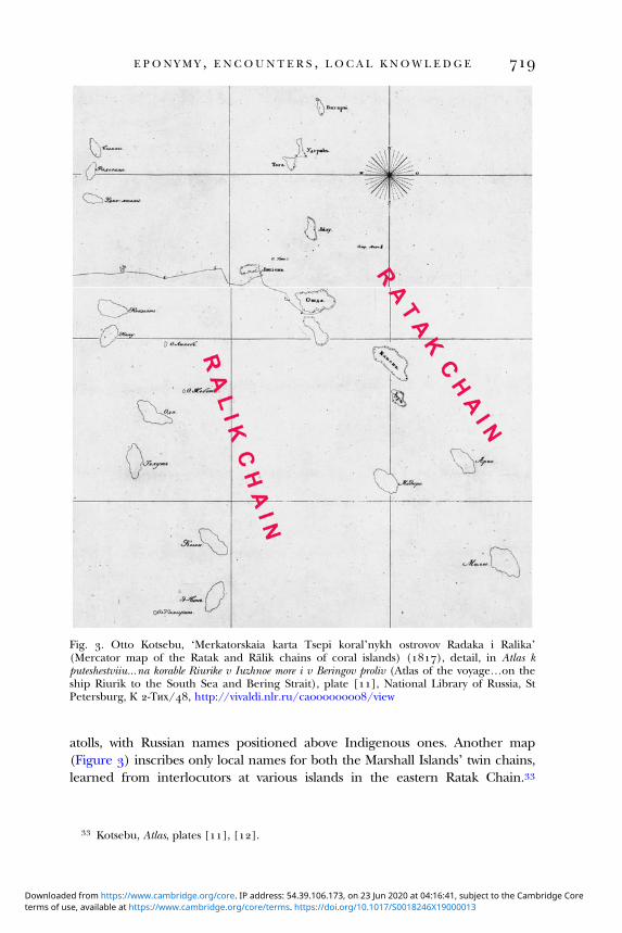
atolls, with Russian names positioned above Indigenous ones. Another map(Figure ) inscribes only local names for both the Marshall Islands’ twin chains,learned from interlocutors at various islands in the eastern Ratak Chain.
Fig. . Otto Kotsebu, ‘Merkatorskaia karta Tsepi koral’nykh ostrovov Radaka i Ralika’(Mercator map of the Ratak and Ralik chains of coral islands) (), detail, in Atlas kputeshestviiu…na korable Riurike v Iuzhnoe more i v Beringov proliv (Atlas of the voyage…on theship Riurik to the South Sea and Bering Strait), plate [], National Library of Russia, StPetersburg, К -Тих/, http://vivaldi.nlr.ru/ca/view
Kotsebu, Atlas, plates [], [].
E P O N Y M Y , E N COUN T E R S , L O C A L K NOW L E D G E
terms of use, available at https://www.cambridge.org/core/terms. https://doi.org/10.1017/S0018246X19000013Downloaded from https://www.cambridge.org/core. IP address: 54.39.106.173, on 23 Jun 2020 at 04:16:41, subject to the Cambridge Core

Kotzebue did not visit the western Ralik Chain until , during a subsequentexpedition to the Pacific.
Kotzebue’s more detailed charts equally reflect his emerging personal experi-ence of specific places and populations. On January , sailing south-westfrom Hawai’i, he made a ‘new discovery’ and memorialized it as ‘New Year’sIsland’. He later learned that the Islanders called it Miadi (Mejit Island). Asubsequent French global atlas gives the island the dual appellation Miadi oude la nouvelle année (Miadi or New Year (Island)). Russian naming of the‘Group of Count Rumiantsev’ (Wotje Atoll) was more convoluted. This largeatoll in the central Ratak Chain was the axis of Kotzebue’s interactions withIslanders during a month-long stay. He dedicated this major ‘discovery’ to dip-lomatic commemoration, calling the atoll collectively after the expedition’sinfluential sponsor Nikolai Petrovich Rumiantsev. Conversely, he modifiedhis naming practice with respect to individual islands in accord with experienceand his developing relations with the inhabitants. Entering the large innerlagoon through the south-western passage, Kotzebue initially used banaldescriptive names for two uninhabited islands: Kozii (Goat) Island, where heleft goats for local use, and Ptichii (Bird) Island. The ship’s anchorage nearGoat Island was named Christmas Harbour – the date it was first seen accordingto the Russian calendar. As he sailed to the eastern, more densely populatedpart of the atoll and learned words of the Indigenous language, Kotzebue’snomenclature reflected his emerging grasp of local usage and celebratedIslanders’ conduct: he noted the island names Ormed (Wormej), Otdia(Wotje), and Egmedio (Bodao) and called the whole north-eastern groupthe Islands of Friendly Reception because the inhabitants were peaceful andhospitable towards the foreigners. Though informed that ‘Otdia’ was theIndigenous name for the ‘whole island group’, he nonetheless retained thehonorific ‘Romanzoff’ (Rumiantsev) as the atoll’s formal umbrella designation(Figure ).
The key to Kotzebue’s growing familiarity with Indigenous geographicalknowledge, both at Wotje and elsewhere in the central Pacific, was hismeeting and developing friendship with Islanders, notably Lagediack andKadu. In different ways, both men fit the category of Indigenous ‘intermediar-ies’ or ‘brokers’, identified in recent scholarship as shadowy but potent co-
Otto von Kotzebue, A new voyage round the world, in the years , , , and ( vols.,London, ), II, pp. –.
Kotzebue, A voyage, II, pp. –, . Philippe Vandermaelen, ‘Océanique: Iles Radak et îles Ralik’, in Atlas universel de
géographie physique, politique, statistique et minéralogique… ( vols., Brussels, ), VI, plate . Kotzebue, A voyage, II, p. . Ibid., pp. –, , . Ibid., pp. , , , , . Kotsebu, Atlas, plate [].
B R O NW E N DOUG L A S A N D E L E N A GO V O R
terms of use, available at https://www.cambridge.org/core/terms. https://doi.org/10.1017/S0018246X19000013Downloaded from https://www.cambridge.org/core. IP address: 54.39.106.173, on 23 Jun 2020 at 04:16:41, subject to the Cambridge Core

Fig. . Otto Kotsebu, ‘Ploskaia karta gruppy koral’nykh ostrovov grafa Rumiantsova’ (Flat map of the Rumiantsev Group of coral islands) (), in Atlas kputeshestviiu…na korable Riurike v Iuzhnoe more i v Beringov proliv (Atlas of the voyage…on the ship Riurik to the South Sea and Bering Strait), plate [],
Estonian Historical Archives, National Archives of Estonia, Tartu, EAA....
EPO
NYM
Y,ENCO
UNTERS,
LO
CAL
KNO
WLEDGE
terms of use, available at https://w
ww
.cambridge.org/core/term
s. https://doi.org/10.1017/S0018246X19000013D
ownloaded from
https://ww
w.cam
bridge.org/core. IP address: 54.39.106.173, on 23 Jun 2020 at 04:16:41, subject to the Cambridge Core

producers of knowledge with European travellers or colonizers. Kotzebue methis ‘friend and teacher’ Lagediack at Wotje Island and found him adept inteaching local words. Once Lagediack understood that Kotzebue was interestedin the location of other atolls, he ‘took a pencil’ and drew maps of Wotje Atolland a nearby group of islands on the ship’s azimuth tables. Quickly grasping theprinciple of the azimuth compass, he used it to indicate the direction of two reefpassages unknown to Kotzebue, who named one after his instructor. Lagediacklater ‘invented a very clever method’ for a geography lesson, using a sand mapand different sized stones to show Kotzebue the position of other named atollsin the Ratak Chain. Lagediack’s accurate directions and distances helpedKotzebue to make and identify several subsequent ‘discoveries’. AnotherIslander at a nearby atoll later redrew Kotzebue’s sand map to modify andextend the information he had received from Lagediack. Kotzebue ‘accuratelycopied’ this map in his notebook and found it ‘very correct’. At yet anotheratoll, a ‘venerable old man’ named as Langemui used ‘a mat spread out, withthe assistance of small stones’, to demonstrate the relationship of the Ratakand Ralik Chains. Kotzebue subsequently drew his own chart of the RalikChain (Figure ) ‘according to’ this man’s information, hoping that it wouldbe ‘pretty correct’.
Lagediack, as resident expert in Wotje, materialized on paper and in sand hisempirical and inherited knowledge of the relative position of his own and sur-rounding islands. Kadu (Figure ), in contrast, was an ongoing embodiedpresence as travelling companion aboard the Riurik during an eight-monthcruise in from the Ratak Chain to Bering Strait, Hawai’i, and back toWotje. He was thus one of a handful of named Islanders who joinedEuropean scientific expeditions, were variously acknowledged by voyagers ascontributors of local knowledge, and have achieved some prominence inrecent Pacific historiography. If Tupaia is now by far the most celebrated
E.g. Felix Driver and Lowry Jones, Hidden histories of exploration: researching the RGS–IBG col-lections (London, ); Shino Konishi, Maria Nugent, and Tiffany Shellam, eds., Indigenousintermediaries: new perspectives on exploration archives (Canberra, ); Raj, Relocating modernscience, pp. –, –; Simon Schaffer et al., eds., The brokered world: go-betweens and globalintelligence, – (Sagamore Beach, MA, ); Tiffany Shellam et al., eds., Brokers andboundaries: colonial exploration in Indigenous territory (Canberra, ).
Kotzebue, A voyage, II, pp. –, . Ibid., pp. –. Ibid., pp. –. A parallel episode of Indigenous map-drawing in sand in the north-east Pacific island of
Sakhalin during La Pérouse’s expedition of – is made axial to opposed interpretations ofthe significance of such encounters in the construction of scientific knowledge. See BrunoLatour, Science in action: how to follow scientists and engineers through society (Cambridge, MA,), pp. –; cf. Bravo, ‘The accuracy of ethnoscience’, pp. –; Michael T. Bravo,‘Ethnographic navigation and the geographical gift’, in David N. Livingstone and CharlesW. J. Withers, eds., Geography and Enlightenment (Chicago, IL, and London, ), pp. –.
B R O NW E N DOUG L A S A N D E L E N A GO V O R
terms of use, available at https://www.cambridge.org/core/terms. https://doi.org/10.1017/S0018246X19000013Downloaded from https://www.cambridge.org/core. IP address: 54.39.106.173, on 23 Jun 2020 at 04:16:41, subject to the Cambridge Core

such traveller, they also include the Tahitian Ahutoru, the Ra‘iatean Ma‘i, andthe Bora Boran Mahine. Originally from Woleai in the Caroline Islands and
Fig. . Louis Choris, ‘Kadou, habitant des îles Carolines’ (), lithograph, in Voyage pittoresqueautour du monde…, plate , National Library of Australia, Canberra, PIC Volume #S,http://nla.gov.au/nla.obj-
E.g. Eckstein and Schwarz, ‘The making of Tupaia’s map’; Glyndwr Williams, ‘Tupaia:Polynesian warrior, navigator, high priest – and artist’, in Felicity A. Nussbaum, ed., The globaleighteenth century (Baltimore, MD, ), pp. -.
For a discussion of these men under the rubric ‘Collaborators’, see Harry Liebersohn, Thetravelers’ world: Europe to the Pacific (Cambridge, MA, ), pp. –. For an overview andbibliography of Indigenous travellers on European scientific voyages, including Kadu, see
E P O N Y M Y , E N COUN T E R S , L O C A L K NOW L E D G E
terms of use, available at https://www.cambridge.org/core/terms. https://doi.org/10.1017/S0018246X19000013Downloaded from https://www.cambridge.org/core. IP address: 54.39.106.173, on 23 Jun 2020 at 04:16:41, subject to the Cambridge Core

widely travelled across that archipelago, Kadu had reached Aur Atoll, south-eastof Wotje, with his friend Edock after spending several months adrift in a canoefollowing a storm. Kadu insisted on joining the Riurik, despite Edock’s oppos-ition. According to the artist Choris, he made himself ‘loved by the officersand esteemed by the sailors’. He supplied Chamisso with much geographical,ethnographic, and linguistic information, particularly about the CarolineIslands.
Like most experienced scientific voyagers, Kotzebue’s toponymic practiceranged between the twin poles of duty and personal experience, mediated bythe pragmatic necessity to acknowledge superiors, sponsors, and colleagues,by professional amour-propre or ambition, by relative familiarity with specificplaces, and by the impact of situated encounters with Indigenous people. Inthe Ratak Chain, Kotzebue reserved celebratory labels for higher level geo-graphical features such as a group of islands. In contrast, his recordednames for particular islands depend mainly on the nature and extent of hisacquaintance with places and their inhabitants. Proximity during a two-months’ stay in and around Wotje transformed anonymous ‘savages’, fleetinglyencountered, into well-informed named persons, whose interest and capacity toconvey their expertise enabled Kotzebue to absorb, process, and map local geo-graphical wisdom. Similarly, the even greater intimacy and burgeoning mutualcomprehension in Russian and Woleaian established with ‘our friend andinstructor’ Kadu during a long sea voyage enabled Chamisso to amass muchprecise geographical information, rooted in the Islander’s extensive travels inand beyond the Carolines. The naturalist expressed admiration for the‘seamen of these islands’, whose ‘navigation embraces a space…which isalmost the greatest breadth of the Atlantic Ocean’. Reinforced by conversa-tions with Edock in Aur and a knowledgeable Spaniard in Guam, the intellec-tual bounty of this astonishing maritime expertise was manifested in thecommander’s then authoritative maps of the Carolines (Figure ), an archipel-ago he had never seen.
Bronwen Douglas, ‘Agency, affect, and local knowledge in the exploration of Oceania’, inKonishi, Nugent, and Shellam, eds., Indigenous intermediaries, pp. –.
Kotzebue, A voyage, II, pp. –. Louis Choris, Voyage pittoresque autour du monde, avec des portraits de sauvages d’Amérique,
d’Asie, d’Afrique, et des îles du Grand Océan…, [trans. J. B. B. Eyriès] (Paris, ), ‘Iles Radak’,pp. –.
Chamisso, ‘Remarks and opinions’, III, pp. –. Krusenstern, ‘Analysis of the islands’, pp. –. Chamisso, ‘Remarks and opinions’, II, p. , III, pp. –. Ibid., III, p. . Kotzebue, A voyage, II, pp. –, , –. Otto von Kotzebue, ‘Chart of the Caroline Islands, after the statement of Edock’ and
‘Chart of the Caroline Islands, after Don Luis de Torres’, in A voyage, II, III, endmaps.
B R O NW E N DOUG L A S A N D E L E N A GO V O R
terms of use, available at https://www.cambridge.org/core/terms. https://doi.org/10.1017/S0018246X19000013Downloaded from https://www.cambridge.org/core. IP address: 54.39.106.173, on 23 Jun 2020 at 04:16:41, subject to the Cambridge Core

Fig. . Otto von Kotzebue, ‘Chart of the Caroline Islands, after the statement of Edock’ (), in A voyage of discovery into the South Sea and Beering’s Straits,for the purpose of exploring a North-east Passage undertaken in the years –…in the ship Rurick…, II, endmap, National Library of Australia, Canberra, NK
EPO
NYM
Y,ENCO
UNTERS,
LO
CAL
KNO
WLEDGE
terms of use, available at https://w
ww
.cambridge.org/core/term
s. https://doi.org/10.1017/S0018246X19000013D
ownloaded from
https://ww
w.cam
bridge.org/core. IP address: 54.39.106.173, on 23 Jun 2020 at 04:16:41, subject to the Cambridge Core

I V
At this point, we digress to consider the uneven incorporation of elements ofKotzebue’s experience in Krusenstern’s scholarly synthesis. The Russianedition of his seminal South Sea atlas includes detailed geographical informa-tion about the Ratak Chain. The map of the Marshall Islands, published in, features many of the local names carefully conveyed to Kotzebue byIndigenous interlocutors in . This display of confident empirical expert-ise no doubt flattered the national pride of a domestic audience.
The following year, another version of themap was printed in the atlas’s Frenchedition and dedicated to Kotzebue. While atolls, islands, and their co-ordinatesare similar, the French nomenclature is strikingly different. Inscribing a history ofEuropean ‘discovery’ to , every island name memorializes a Europeanvoyage, usually with a date of passage. The map registers several of Kotzebue’s tri-butes to Russian eponyms, including Krusenstern himself. Only one Indigenousname, derived from Kotzebue, is printed as an alternative to a Europeantoponym. Krusenstern handwrote radical amendments to this map in his personalcopy of the French atlas, held in the National Archives of Estonia. They includetwo of Kotzebue’s local island names in the Ratak Chain and another two inthe Ralik Chain learned by a Russian voyager in (Figure ). However,none of these addendums features in Krusenstern’s re-engraved version of the‘Map of the Archipelago of the Marshall Islands’ published in .
As a showcase for its author’s cosmopolitan credentials, Krusenstern’s Frenchatlas is positioned within an urbane ‘civilized’ discourse which allowed littlespace for the words or works of ‘savages’. This stance was verbalized byKrusenstern in ‘supplements’ to his hydrographic memoirs, published in together with revised maps from the atlas. Notwithstanding his shipmates’painstaking efforts to record Indigenous place names in Nuku Hiva, or his owncareful rehearsal of Kotzebue’s local toponyms in both the Russian map ofthe Marshall Islands and the French edition of the memoirs, Krusensternhere rejected their global usage. He expatiated on the ‘advantages’ of theEuropean names given by navigators to ‘their discoveries’, expressed ‘littleconfidence’ in the ‘information provided by the Islanders’, and complainedof the ‘difficult pronunciation’ of Indigenous names.
Krusenstern’s wide multilingual scholarship in the service of metropolitan,mainly hydrographic, priorities is encapsulated in his map and parallel
Kruzenshtern, Atlas Iuzhnogo moria, II, plate . Krusenstern, Atlas de l’Océan pacifique, II, plate . Ibid., EAA..... Krusenstern, Atlas de l’Océan pacifique (nd edn), II, plate . Idem, Recueil, II, pp. –. Idem, Supplémens, p. .
B R O NW E N DOUG L A S A N D E L E N A GO V O R
terms of use, available at https://www.cambridge.org/core/terms. https://doi.org/10.1017/S0018246X19000013Downloaded from https://www.cambridge.org/core. IP address: 54.39.106.173, on 23 Jun 2020 at 04:16:41, subject to the Cambridge Core

memoir of the ‘Low Islands’ (Tuamotu Archipelago) – Johann ReinholdForster’s descriptive name for this far-flung atoll chain. The map’s many,
Fig. . Adam Johann von Krusenstern, ‘Carte de l’Archipel des îles Marshall’ (), annotatedby author in pencil and red ink, detail, in Atlas de l’océan pacifique, II, plate , EstonianHistorical Archives, National Archives of Estonia, Tartu, EAA....
Johann Reinhold Forster, Observations made during a voyage round the world, on physical geog-raphy, natural history, and ethic philosophy (London, ), p. .
E P O N Y M Y , E N COUN T E R S , L O C A L K NOW L E D G E
terms of use, available at https://www.cambridge.org/core/terms. https://doi.org/10.1017/S0018246X19000013Downloaded from https://www.cambridge.org/core. IP address: 54.39.106.173, on 23 Jun 2020 at 04:16:41, subject to the Cambridge Core
meticulously located, islands are inscribed with names and dates marking theirEuropean ‘discovery’. The memoir exhaustively summarizes, identifies, andsets co-ordinates for the deeply uncertain results of three centuries ofEuropean voyaging through the archipelago, culminating in the recent pas-sages of Krusenstern’s compatriots Kotzebue in and Bellingshausen in. Both map and memoir are almost devoid of Indigenous presence.
V
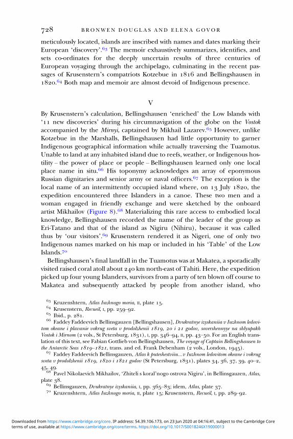
By Krusenstern’s calculation, Bellingshausen ‘enriched’ the Low Islands with‘ new discoveries’ during his circumnavigation of the globe on the Vostokaccompanied by the Mirnyi, captained by Mikhail Lazarev. However, unlikeKotzebue in the Marshalls, Bellingshausen had little opportunity to garnerIndigenous geographical information while actually traversing the Tuamotus.Unable to land at any inhabited island due to reefs, weather, or Indigenous hos-tility – the power of place or people – Bellingshausen learned only one localplace name in situ. His toponymy acknowledges an array of eponymousRussian dignitaries and senior army or naval officers. The exception is thelocal name of an intermittently occupied island where, on July , theexpedition encountered three Islanders in a canoe. These two men and awoman engaged in friendly exchange and were sketched by the onboardartist Mikhailov (Figure ). Materializing this rare access to embodied localknowledge, Bellingshausen recorded the name of the leader of the group asEri-Tatano and that of the island as Nigiru (Nihiru), because it was calledthus by ‘our visitors’. Krusenstern rendered it as Nigeri, one of only twoIndigenous names marked on his map or included in his ‘Table’ of the LowIslands.
Bellingshausen’s final landfall in the Tuamotus was at Makatea, a sporadicallyvisited raised coral atoll about km north-east of Tahiti. Here, the expeditionpicked up four young Islanders, survivors from a party of ten blown off course toMakatea and subsequently attacked by people from another island, who
Kruzenshtern, Atlas Iuzhnogo moria, II, plate . Krusenstern, Recueil, I, pp. –. Ibid., p. . Faddey Faddeevich Bellinsgauzen [Bellingshausen], Dvukratnye izyskaniia v Iuzhnom ledovi-
tom okeane i plavanie vokrug sveta v prodolzhenii , i godov, sovershennyye na shlyupakhVostok i Mirnom ( vols., St Petersburg, ), I, pp. –, II, pp. –. For an English trans-lation of this text, see Fabian Gottlieb von Bellingshausen, The voyage of Captain Bellingshausen tothe Antarctic Seas –, trans. and ed. Frank Debenham ( vols., London, ).
Faddey Faddeevich Bellinsgauzen, Atlas k puteshestviiu…v Iuzhnom ledovitom okeane i vokrugsveta v prodolzhenii , i godov (St Petersburg, ), plates , , , , –,, .
Pavel Nikolaevich Mikhailov, ‘Zhiteli s koral’nogo ostrova Nigiru’, in Bellinsgauzen, Atlas,plate .
Bellinsgauzen, Dvukratnye izyskaniia, I, pp. –; idem, Atlas, plate . Kruzenshtern, Atlas Iuzhnogo moria, II, plate ; Krusenstern, Recueil, I, pp. –.
B R O NW E N DOUG L A S A N D E L E N A GO V O R
terms of use, available at https://www.cambridge.org/core/terms. https://doi.org/10.1017/S0018246X19000013Downloaded from https://www.cambridge.org/core. IP address: 54.39.106.173, on 23 Jun 2020 at 04:16:41, subject to the Cambridge Core

allegedly killed and ate all but the four boys. The eldest told Bellingshausen thattheir own island was called ‘Anna’ (Anaa). Asked its direction, the boy firstenquired where Tahiti lay and then pointed insistently to the south-east, ‘inthe direction of Chains Island’, so named by Cook in . At this point,Bellingshausen spurned the boy’s advice, preferring the authority of
Fig. . Pavel Nikolaevich Mikhailov, ‘Zhiteli s koral’nogo ostrova Nigiru’ (Inhabitants from thecoral island Nigiru) (n.d.), lithograph, Prints Department, National Library of Russia, StPetersburg
E P O N Y M Y , E N COUN T E R S , L O C A L K NOW L E D G E
terms of use, available at https://www.cambridge.org/core/terms. https://doi.org/10.1017/S0018246X19000013Downloaded from https://www.cambridge.org/core. IP address: 54.39.106.173, on 23 Jun 2020 at 04:16:41, subject to the Cambridge Core
Arrowsmith’s chart which locates ‘Oanna’ north-east of ‘Recreation’ (probablyMakatea).
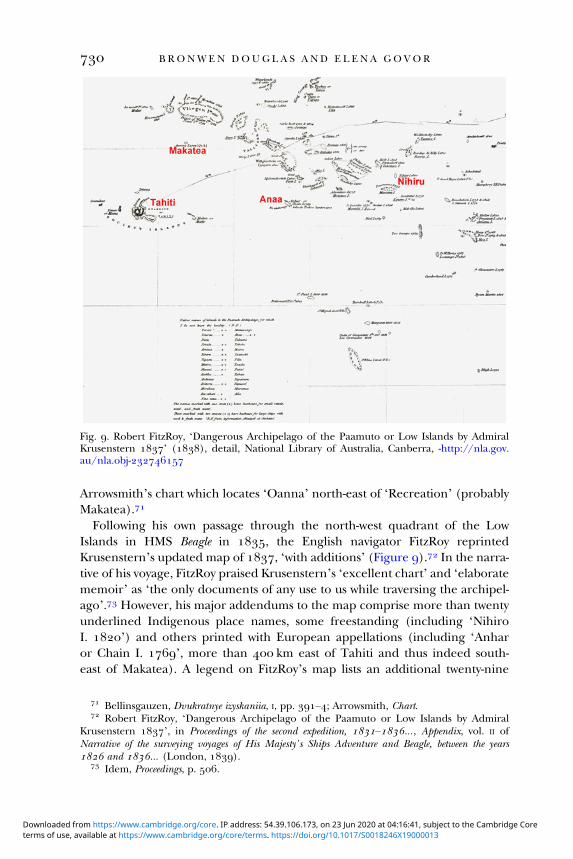
Following his own passage through the north-west quadrant of the LowIslands in HMS Beagle in , the English navigator FitzRoy reprintedKrusenstern’s updated map of , ‘with additions’ (Figure ). In the narra-tive of his voyage, FitzRoy praised Krusenstern’s ‘excellent chart’ and ‘elaboratememoir’ as ‘the only documents of any use to us while traversing the archipel-ago’. However, his major addendums to the map comprise more than twentyunderlined Indigenous place names, some freestanding (including ‘NihiroI. ’) and others printed with European appellations (including ‘Anharor Chain I. ’, more than km east of Tahiti and thus indeed south-east of Makatea). A legend on FitzRoy’s map lists an additional twenty-nine
Fig. . Robert FitzRoy, ‘Dangerous Archipelago of the Paamuto or Low Islands by AdmiralKrusenstern ’ (), detail, National Library of Australia, Canberra, -http://nla.gov.au/nla.obj-
Bellinsgauzen, Dvukratnye izyskaniia, I, pp. –; Arrowsmith, Chart. Robert FitzRoy, ‘Dangerous Archipelago of the Paamuto or Low Islands by Admiral
Krusenstern ’, in Proceedings of the second expedition, –…, Appendix, vol. II ofNarrative of the surveying voyages of His Majesty’s Ships Adventure and Beagle, between the years and … (London, ).
Idem, Proceedings, p. .
B R O NW E N DOUG L A S A N D E L E N A GO V O R
terms of use, available at https://www.cambridge.org/core/terms. https://doi.org/10.1017/S0018246X19000013Downloaded from https://www.cambridge.org/core. IP address: 54.39.106.173, on 23 Jun 2020 at 04:16:41, subject to the Cambridge Core

‘Native names of islands’, for which he did ‘not know the locality’, attributed to‘information obtained at Otaheite [Tahiti]’.
Shortly after passing through the Tuamotus in July , Bellingshausenhimself spent a week in Tahiti where, like FitzRoy, he actively sought localknowledge about the archipelago. A resident American sailor with some knowl-edge of Russian served as his interpreter. Bellingshausen began to admit thevalidity of Indigenous geographical knowledge when the boy from Anaapointed out the identity of his own body tattoos with those of one of his ‘coun-trymen’, persuading Bellingshausen that both came from the same island.These figures also resembled the markings he had seen at Nihiru Island onthe thighs of Eri-Tatano (Figure ), whom he concluded must also be fromAnaa. Bellingshausen eventually resolved the conundrum of Anaa’s location –and fully acknowledged Indigenous expertise – in further conversation withmen from that island met in Tahiti, whose ‘intrepid seafaring’ he lauded.They ‘laughed’ at his assertion, following Arrowsmith, that Anaa was north ofTahiti and supplied him with convincing ‘proof’ of its identity with ChainIsland. The second Indigenous toponym in Krusenstern’s map and table ofthe Tuamotus is ‘Matia’ (Makatea), presumably following Bellingshausen.However, Krusenstern failed to make the link between Chain Island andAnaa, neither in his memoir supplement nor in the re-engraved ‘Map of theArchipelago of the Low Islands’, which he revised after the publication ofBellingshausen’s narrative.
V I
Further variations on the voyagers’ Pacific place-naming continuum from obli-gation to experience are manifest in the cartographic production of Lütke, whocircumnavigated the globe on the Senyavin in –. During two cruises fromKamchatka in –, Lütke surveyed sectors of the Caroline Islands littleknown to Europeans. He claimed to have ‘reconnoitred twenty-six groupsor separate islands, of which ten or twelve are new discoveries’.
In late , the expedition spent three weeks at the ‘interesting’ high islandof Ualan (Kosrae). Lütke and his men were enchanted by the conduct of the‘good and friendly inhabitants’ – as were the members of Duperrey’s French
Idem, ‘Dangerous Archipelago’. Bellinsgauzen, Dvukratnye izyskaniia, II, pp. –. Unlike most of the Russian navigators
discussed in this article, including Lazarev, Bellingshausen himself apparently did not speakEnglish (Debenham, ‘Introduction’, in Bellingshausen, Voyage, p. xxi–xxii).
Bellinsgauzen, Dvukratnye izyskaniia, II, pp. –, –. Krusenstern, Supplémens, pp. –, ; idem, Atlas de l’océan pacifique (nd edn), II, plate
. Frédéric Lütke, Voyage autour du monde, exécuté…sur la corvette Le Séniavine, dans les années
, , et : Partie historique ( vols., Paris, –), I, pp. –, II, pp. –, –.
Ibid., II, p. .
E P O N Y M Y , E N COUN T E R S , L O C A L K NOW L E D G E
terms of use, available at https://www.cambridge.org/core/terms. https://doi.org/10.1017/S0018246X19000013Downloaded from https://www.cambridge.org/core. IP address: 54.39.106.173, on 23 Jun 2020 at 04:16:41, subject to the Cambridge Core

expedition, who had stayed for ten days in June and believed they were thefirst Europeans to land there. Lütke’s nautical atlas of the voyage, printed withtwin Russian and French cartouches, captions, and place names, includes adetailed map of ‘Ualan’ (Figures , a). His toponyms and related debtsor challenges to his predecessors are mixed. As the ship approached theisland, local people – including at least one high-ranking ‘chief’ – came outin canoes. They tried to direct the visitors to the east coast, ‘repeating lella,lella’. When Lütke, like Duperrey, headed instead for an anchorage in theisland’s north-west, the Islanders reiterated ‘incessantly’ that this was
Fig. . Fedor Litke, ‘Plan ostrova Yualana (Arkhipelaga Karolinskogo)/Plan de l’île Ualan(Archipel des Iles Carolines)’ ([]), in Atlas k puteshestviiu vokrug sveta shliupa Seniavina…v , i godakh/Atlas du voyage autour du monde de la corvette Séniavine fait en, , et , plate , National Library of Australia, Canberra, MAP Rm /, http://nla.gov.au/nla.obj-
Ibid., I, pp. , ; Louis-Isidore Duperrey, ‘Mémoire sur les opérations géographiquesfaites dans la campagne de la corvette de S.M. la Coquille, pendant les années , , et ’, Annales maritimes et coloniales , e partie, tome (), pp. –, at pp. –;René-Primevère Lesson, ‘Ile de Oualan ou Strong: observations sur le sol, sur les productionsde cette île, et sur ses habitans, leur langage, leurs mœurs, faites du juin , au dumêmemois’, Journal des voyages, découvertes et navigations modernes…, (), pp. –, –,at pp. –.
Fedor Litke [Lütke], Atlas k puteshestviiu vokrug sveta shliupa Seniavina…v , i godakh/Atlas du voyage autour du monde de la corvette Séniavine fait en , , et ([St Petersburg, []), plate .
B R O NW E N DOUG L A S A N D E L E N A GO V O R
terms of use, available at https://www.cambridge.org/core/terms. https://doi.org/10.1017/S0018246X19000013Downloaded from https://www.cambridge.org/core. IP address: 54.39.106.173, on 23 Jun 2020 at 04:16:41, subject to the Cambridge Core

‘Ualan’. Like the French, Lütke took the word to be the island’s name, dis-puting only their transliteration ‘Oualan’. Both sets of Europeans described asmall island off the north-east coast as ‘the common residence of the principalchiefs’. The French recorded its name as Lélé but Lütke heard the word ratheras Lella (Lelu or Leluh). All were astounded by the massive coral sea walls envel-oping Lelu, its extensive canal system, and its monumental architecture featur-ing huge basalt megaliths – centuries-old material productions in a profoundlystratified social system, only dimly evident to the visitors. A modern doctoralthesis explains that Ualan ‘is not strictly the name of the big island’, butmeans ‘“away from Lelu”’. The voyagers evidently mistook an Indigenous
Fig. a. Fedor Litke, [northern part of Ualan (Kosrae)], in ‘Plan ostrova Yualana (ArkhipelagaKarolinskogo)/Plan de l’île Ualan (Archipel des Iles Carolines)’ ([]), National Library ofAustralia, Canberra, MAP Rm /, http://nla.gov.au/nla.obj-
Lütke, Voyage, I, pp. , . Duperrey, ‘Mémoire’, p. ; Lesson, ‘Ile de Oualan’, p. . Lütke, Voyage, I, pp. –. Ibid., pp. , –; Duperrey, ‘Mémoire’, pp. –; Lesson, ‘Ile de Oualan’, pp. ,
, . On Lelu, its extraordinary architecture, and the complex social hierarchy in Kosraewhich collapsed in the mid-nineteenth century in contexts of conversion to Christianity anddrastic depopulation, see Ilma O’Brien, ‘Cultural continuity and conversion in the EasternCarolines: a study of interaction between Islanders and Christian missionaries in Ponape andKosrae’ (Ph.D. thesis, Bundoora, VIC, ), pp. –; David Hanlon, ‘Histories of thebefore: Lelu, Nan Madol, and deep time’, in Elfriede Hermann, ed., Changing contexts, shiftingmeanings: transformations of cultural traditions in Oceania (Honolulu, HI, ), pp. –; PaulRainbird, The archaeology of Micronesia (Cambridge, ), pp. –; Zoe Richards et al.,‘New precise dates for the ancient and sacred coral pyramidal tombs of Leluh (Kosrae,Micronesia)’, Science Advances, (), e, http://doi.org/./sciadv..
Walter Scott Wilson, ‘Land, activity and social organization of Lelu, Kusaie’ (Ph.D. thesis,Philadelphia, ), p. , cited O’Brien, ‘Cultural continuity’, p. n. .
E P O N Y M Y , E N COUN T E R S , L O C A L K NOW L E D G E
terms of use, available at https://www.cambridge.org/core/terms. https://doi.org/10.1017/S0018246X19000013Downloaded from https://www.cambridge.org/core. IP address: 54.39.106.173, on 23 Jun 2020 at 04:16:41, subject to the Cambridge Core

instruction to go directly to the seat of governing authority for an insulartoponym.
Lütke’s map retains Duperrey’s French eponyms –mostly honouring hisshipmates – for Kosrae’s two main peaks and prominent coastal features.
Lütke printed them in lower case with Russian translations superposed. In retro-spective eponymy, he called another peak ‘Mertens Monument’ in memory ofthe expedition’s naturalist, who died after his return to Russia. In contrast, thelittoral of the island is garlanded with Indigenous names of districts, printed inupper case, phonetically French, with Russian transcription. As in Wotje, theseplace names render local geographical knowledge conveyed to a visiting naviga-tor by an Indigenous ‘friend’ – in this case, Kaki, an ‘old chief’ of the settlementof Lual (Lacl), opposite the Russian anchorage, who dictated to Lütke a‘detailed’ list of the island’s ‘village’ and ‘district’ names, together with those
Fig. . Fedor Litke, ‘Ploskaia karta ostrovov Seniavina (Arkhipelaga Karolinskogo)/Carte desîles Séniavine (Archipel des îles Carolines)’ ([]), in Atlas k puteshestviiu vokrug sveta shliupaSeniavina…v , i godakh/Atlas du voyage autour du monde de la corvette Séniavine faiten , , et , plate , National Library of Australia, Canberra, MAP Rm /, http://nla.gov.au/nla.obj-
Louis-Isidore Duperrey, ‘Plan de l’île Oualan’, in Voyage autour du monde…sur la corvette deSa Majesté, La Coquille, pendant les années , , et …Hydrographie, Atlas (Paris,), plate .
Lütke, Voyage, I, pp. xv, .
B R O NW E N DOUG L A S A N D E L E N A GO V O R
terms of use, available at https://www.cambridge.org/core/terms. https://doi.org/10.1017/S0018246X19000013Downloaded from https://www.cambridge.org/core. IP address: 54.39.106.173, on 23 Jun 2020 at 04:16:41, subject to the Cambridge Core
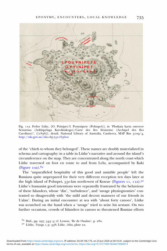
of the ‘chiefs to whom they belonged’. These names are doubly materialized inschema and cartography: in a table in Lütke’s narrative and around the island’scircumference on the map. They are concentrated along the north coast whichLütke traversed on foot en route to and from Lelu, accompanied by Kaki(Figure a).
The ‘unparalleled hospitality of this good and amiable people’ left theRussians quite unprepared for their very different reception ten days later atthe high island of Pohnpei, km north-west of Kosrae (Figures , a).
Lütke’s humanist good intentions were repeatedly frustrated by the behaviourof these Islanders, whose ‘din’, ‘turbulence’, and ‘savage physiognomies’ con-trasted so disagreeably with ‘the mild and decent manners of our friends inUalan’. During an initial encounter at sea with ‘about forty canoes’, Lütkewas scratched on the hand when a ‘savage’ tried to seize his sextant. On twofurther occasions, crowds of Islanders in canoes so threatened Russian efforts
Fig. a. Fedor Litke, [O. Pyinipet/I. Pouynipete (Pohnpei)], in ‘Ploskaia karta ostrovovSeniavina (Arkhipelaga Karolinskogo)/Carte des îles Séniavine (Archipel des IlesCarolines)’, ([]), detail, National Library of Australia, Canberra, MAP Rm /,http://nla.gov.au/nla.obj-
Ibid., pp. , –; cf. Lesson, ‘Ile de Oualan’, p. . Lütke, Voyage, I, p. ; Litke, Atlas, plate .
E P O N Y M Y , E N COUN T E R S , L O C A L K NOW L E D G E
terms of use, available at https://www.cambridge.org/core/terms. https://doi.org/10.1017/S0018246X19000013Downloaded from https://www.cambridge.org/core. IP address: 54.39.106.173, on 23 Jun 2020 at 04:16:41, subject to the Cambridge Core

to reconnoitre potential anchorages that they had to retreat. One man threw asmall spear at the launch commander who retaliated with a shot over theIslander’s head. The assailants, momentarily disconcerted, allowed the boatto escape unscathed to the ship. Refusing to resort to firearms except ‘in thelast extremity’, Lütke openly acknowledged how his options were controlledby Indigenous agency. He recognized that ‘these turbulent islanders’ mightnot have had ‘hostile intentions’, but been motivated merely by ‘curiosity’,desire for ‘extraordinary objects’, or trepidation. But he also admitted that‘their conduct was such…that we could not even manage the search for ananchorage’ in the time available. He thus regretfully abandoned the attemptto land on Pohnpei, ‘renouncing the pleasure of setting foot on the land thatwe had just discovered’.
Lütke’s reluctance to make the Islanders ‘feel the power of firearms’ left himonly symbolic recourse to punish the insults and apprehension suffered by theRussians in Pohnpei. His figurative vengeance for the ‘turbulent character’ andunpredictable actions of Pohnpeians was expressed in directly toponymic andmore insidious racial terms. In exasperated response to disapproved localactions, he inflicted the name ‘Port of Hostile Reception’ on the second baywhere the launch was repelled (Figure a), surely a negative echo ofKotzebue’s ‘Islands of Friendly Reception’ in Wotje.
Lütke exacted indirect symbolic revenge by racial denigration. He deploredthe Pohnpeians’ speech as ‘rude’, ‘strange and savage’ and averred that, sincethey differed ‘strikingly’ in external appearance from Kosraeans or otherCaroline Islanders, they must belong to ‘another race of men’. He chose toidentify them with ‘the race of the Papuans’ – the inhabitants of New Guineaand nearby islands – and further surmised that their ‘true’ place of originmight be New Ireland. Douglas has elsewhere identified a rhetorical correl-ation between European travellers’ relief at approved Indigenous conductand their positive depictions of the physical appearance and character ofsuch people, who are distanced from the adverse stereotype of ‘the Negro’ ofAfrica. Lütke’s bitter experience of Pohnpeians’ behaviour saw him invertthat rhetorical sequence by maligning their speech and demeanour and align-ing them physically with an Oceanic ‘race’ – ‘the Papuans’ – which was oftenlabelled Negro or Negro-like. He thus attributed to Pohnpeians a conventionalset of physical characters evocative of that reviled stereotype, with implied moralcorollaries: ‘the large, flat face, the large, flattened nose, the thick lips, the frizzyhair in some cases; [and] great bulging eyes, expressing mistrust and ferocity’.
Lütke, Voyage, II, pp. , –, –. Ibid., pp. –. Ibid., pp. , –, –. Douglas, Science, pp. , –, , –. Duperrey’s naturalist René-Primevère
Lesson specifically labelled the inhabitants of New Ireland ‘Papuan negroes’ (Voyage autourdu monde entrepris par ordre du gouvernement sur la corvette la Coquille ( vols., Paris, ), II,pp. , ).
B R O NW E N DOUG L A S A N D E L E N A GO V O R
terms of use, available at https://www.cambridge.org/core/terms. https://doi.org/10.1017/S0018246X19000013Downloaded from https://www.cambridge.org/core. IP address: 54.39.106.173, on 23 Jun 2020 at 04:16:41, subject to the Cambridge Core

In other respects, Lütke’s toponymy of Pohnpei followed familiar Russianpractice for places where Indigenous names were largely unknown. He calledthe island group as a whole the Senyavin Islands, memorializing his own shipand its eponym, the Russian admiral Dmitry Senyavin who had defeated theTurks in . Freed by ignorance of local usage to follow duty or fancywhen charting the coasts of Pohnpei Island itself, Lütke conferred the descrip-tor Bashenka (La Guérite, Sentry Box) on ‘an isolated and very distinct mass ofbasalt’, bestowed Aegean toponyms associated with Senyavin’s victories on twomountains, and named Point Tverdy (hard, resilient) in honour of Senyavin’sship. Further eponymic impositions celebrated Lütke’s own lieutenantZavalishin and their shipmate Kittlitz, a retired Prussian naval officer-naturalistwho accompanied the expedition.
Notwithstanding these eclectic choices, Lütke’s over-riding toponymicconcern in this group was to know ‘the name that the natives give to thelarge island’. He thought it was probably ‘Pouynipète’, an opinion confirmedduring a brief shipside encounter with several men ‘of the common sort’,who seemed ‘more reserved and more intelligent than the others’. They alsotaught him local names for the two small atolls and their constituent islandswhich complete the Senyavin group. Lütke duly inscribed Pouynipète/Pyinipet (Pohnpei), Andema (And or Ant), Paguenema/Pagenema (Pakin),and several islands within Pakin, as the only Indigenous names on his ‘Mapof the Senyavin Islands’ (Figure ). His faith in the accuracy of the termPouynipète was further licensed by comparison with homophones inKotzebue’s maps of the Caroline Islands (Figure ) and others heard subse-quently at islands elsewhere in the archipelago.
In sharp contrast to Krusenstern, Lütke professed the firm principle that ‘thenames the natives give to the places they inhabit, are necessary for the systematicdescription of a country’. This was especially so in far-flung groups of tinyislands like the Carolines, where several centuries of erratic European ‘discov-ery’, mislocation, and idiosyncratic naming had created geographic ‘chaos’.
Whereas Krusenstern relied on static knowledge of Pacific geography acquiredfrom European voyage narratives, Kotzebue in the Marshalls and particularlyLütke in the Carolines engaged in active, in situ learning from Indigenousexperts, who taught them local toponyms and sailing directions for particularislands and atolls. The precise co-ordinates and systematic nomenclature inLütke’s ‘General map of the Carolines Archipelago’ testify not only to hishydrographic expertise, but to the efficacy of his collaboration in situ with
Litke, Atlas, plate ; Lütke, Voyage, II, pp. –; see also Guretsky, ‘Russkoe toponimiches-koe nasledie v Okeanii’, p. .
Lütke, Voyage, II, pp. –, , –. Ibid., pp. –. Litke, Atlas, plate , https://nla.gov.au/nla.obj-.
E P O N Y M Y , E N COUN T E R S , L O C A L K NOW L E D G E
terms of use, available at https://www.cambridge.org/core/terms. https://doi.org/10.1017/S0018246X19000013Downloaded from https://www.cambridge.org/core. IP address: 54.39.106.173, on 23 Jun 2020 at 04:16:41, subject to the Cambridge Core

at least ten named and several unnamed Indigenous navigator counterparts.
He deemed earlier European cartography of the Carolines by Cantova, Chamisso,Freycinet, and Duperrey as being ‘not of great use for geography’ or ‘imperfect’.However, they provided ‘bearings’ in relation to his own work and:
especially to the information gathered gradually from islanders in several places,which helped guide our navigation so as to leave the fewest possible islands undeter-mined. Thus the geographic knowledge of the Caroline islanders, insufficient forscience, if extended for savages, which had produced such great confusion in themaps, served to enlighten itself.
Lütke paid sincere tribute to the skill of these men and the ‘accuracy’ of theirknowledge of the relative position of islands in the archipelago, even if their (tohim) ‘vague’ grasp of distance made ‘their verbal information’ far more usefulthan the maps they drew at European behest. Beyond empirical toponymy, hemade an effort to grasp Indigenous epistemology. He perceptively contrastedthe embodied expertise of Carolinian navigators, reliant on ‘memory and tradi-tions’, with the ‘mechanical methods’ which made European navigatorsdependent on material instruments and maps: ‘in their eyes these lines[traced on paper or sand] serve only as support to memory; they are for usthe main thing, and it is through them that we confirm our memory’.
Krusenstern’s hydrographic supplement ambivalently acknowledges the‘judicious system’ whereby Lütke established the geographical position ofmost of the individual groups and islands comprising the Carolines. However,Krusenstern was clearly unimpressed by his compatriot’s careful assemblageof local place names. This text, together with Krusenstern’s three radicallyrevised maps of ‘the Archipelago of the Caroline Islands’ in the secondedition of his atlas, only allows Lütke’s Indigenous names as the primary desig-nations for places classed by Krusenstern as Lütke’s personal discoveries.Otherwise, earlier European nomenclature is privileged over local toponyms,which are mostly downgraded as Lütke’s own bestowals. In the case of UlithiAtoll, Krusenstern explicitly rejected Ouluthy – Lütke’s rendition of theIslanders’ ‘general name’ for the group – in favour of conserving ‘that of theNavigator who discovered them’, a passing British sea captain who had nocontact with the inhabitants and no idea what he had ‘discovered’.
Apart from Kaki in Kosrae, Lütke acknowledged toponyms and orientations of Carolinianplaces or islands learned in Lukunor (from Eboung, Feliaour/Taliaour, and Peseng),Namonuito (Rekeil and Soukkizeum of Satawan), Guam (Oralitaou of Elato), Lamotrek,Elato, and Lamolior (unnamed ‘islanders’), Faraulep (Alaberto), Murilo (‘some’), Woleai(Tapeligar), and Fais (Timaï) (Voyage, II, pp. –, , , , –, , , –, ,, , –, –).
Ibid., pp. –. Ibid., pp. –, –. Krusenstern, Supplémens, pp. –; idem, Atlas de l’Océan pacifique (nd edn), II, plates
–; see also idem, Recueil, II, pp. –.
B R O NW E N DOUG L A S A N D E L E N A GO V O R
terms of use, available at https://www.cambridge.org/core/terms. https://doi.org/10.1017/S0018246X19000013Downloaded from https://www.cambridge.org/core. IP address: 54.39.106.173, on 23 Jun 2020 at 04:16:41, subject to the Cambridge Core

V I I
A key theme of this history of early nineteenth-century Russian place naming inthe Pacific Islands is the relative salience of Indigenous agency and local knowl-edge. To this end, we have systematically sampled toponymic and cartographicimplications of encounters between Russian scientific voyagers and specificpeople and places in the insular Pacific. The Russians’ default position – asfor European voyagers generally – was the easy option of eponymy, with itsbenefits of flattering masters or sponsors or rewarding subordinates.
Except in Lütke’s work on the Carolines, eponymy reigned supreme at themetalevel of atoll, island group, or archipelago, complicated by the relative dis-tance between encounter and inscription – particularly between voyage chartsor atlases and Krusenstern’s synthesizing regional atlas.
The individual preferences or idiosyncrasies of particular voyagers clearlyaffected their naming strategies. Krusenstern, preoccupied with managing hisship, his expedition, and his fraught relations with Rezanov, forged few, ifany, intimate bonds with Marquesans, did not value Indigenous expertise,and discounted local knowledge on principle. In contrast, his naturalists andjunior officers spent much time ashore, acquired Marquesan ‘friends’, andsought nominal tokens of having been there. None of the protégés and succes-sors of Krusenstern discussed in this article shared his expressed aversion toIndigenous place names. Indeed, challenging experience as maritime explorersin remote Pacific archipelagoes convinced them, to varying degrees, of the taxo-nomic importance of local names and all sought to know them when theycould – though never questioning the intellectual or practical superiority ofEuropean science and technology. Kotzebue learned to appreciate local knowl-edge in situ in the Marshalls, under the influence of Chamisso and their closeencounters with resident experts. Bellingshausen dabbled with its acquisition inand of the Tuamotus, but had limited opportunity and moderate conviction.Only Lütke in the Carolines appreciated the profound significance ofIndigenous empirical wisdom and sought methodically to tap and record it.
Personality, prejudice, ethnocentrism, and circumstance aside, the insulartoponymies of European voyagers in Oceania were generated in contexts ofhuman encounters or their absence. Two conditions consistently shaped thenexus of encounter and nomenclature: the conduct and demeanour of popula-tions met in situ; and the extent of embodied emotional connection establishedbetween particular Indigenous interlocutors and visitors. In these Russian cases,the impacts of Indigenous agency are doubly materialized: in the affective loadembedded in particular names (as in ‘Friendly’ or ‘Hostile Reception’ in Wotjeand Pohnpei); and in the relative extent of local toponymic knowledge regis-tered in voyagers’ charts, maps, journals, and narratives.
Tent and Slatyer, ‘Naming places’, p. .
E P O N Y M Y , E N COUN T E R S , L O C A L K NOW L E D G E
terms of use, available at https://www.cambridge.org/core/terms. https://doi.org/10.1017/S0018246X19000013Downloaded from https://www.cambridge.org/core. IP address: 54.39.106.173, on 23 Jun 2020 at 04:16:41, subject to the Cambridge Core

In an ocean now largely anglophone or francophone in terms of global com-munication, the significance of early nineteenth-century Russian voyaging isoften inadequately known or appreciated. Yet successive Russian voyages inthe eastern and northern Pacific Islands before left important legaciesin natural history and ethnography, as well as the signal achievements in hydrog-raphy and cartography discussed here. All but Bellingshausen’s expedition wereaccompanied by distinguished naturalists who made considerable contributionsto recording Pacific flora, fauna, and geology: Langsdorff and Tilesius sailedwith Krusenstern; Chamisso and Eschscholtz with Kotzebue; and Mertens,Postels, and Kittlitz with Lütke. Some of their published works were widelydisseminated in translations. Chamisso, informed by Kadu, wrote usefulethnographic descriptions of the Marshall and Caroline Islands, while hisethnological and linguistic reflections on ‘the Great Ocean’ earned justifiedrespect from his peers. Lütke’s description of Lelu and his ethnographicimpressions of Kosrae’s complex social hierarchy remain an invaluable resourcefor modern Kosraeans seeking to understand their vanished ancestral world.
Russian navigators transformed global knowing of the Tuamotu, Marshall,and Caroline archipelagoes by surveying, charting, and naming most of the con-stituent atolls and islands. The towering scholarship of Krusenstern’s atlas wasrespectfully acknowledged by fellow navigators and remained an importantresource for cartographers for much of the nineteenth century. He inspired,guided, and influenced his compatriots whose empirical work – often producedin collaboration with Indigenous interlocutors unrecognized by Krusenstern –provided important building blocks for his syntheses of the cartography andhydrography of these island chains.
E.g. Adelbert von Chamisso, Johann Friedrich von Eschscholtz, et al., ‘Appendix by otherauthors’, in Kotzebue, A voyage, III, pp. –; Georg Heinrich von Langsdorff, Voyages andtravels in various parts of the world, during the years , , , , and ( vols.,London, –); Alexander Postels, Les travaux de MM. les naturalistes, vol. III of Lütke,Voyage (Paris, ).
Chamisso, ‘Remarks and opinions’; idem, ‘Du grand Océan, de ses îles et de ses côtes…’,trans. René-Primevère Lesson, Annales maritimes et coloniales, , e partie, tome (), pp. –; Jules Dumont d’Urville, ‘Sur les îles du grand Océan’, Bulletin de la Société de Géographie, ,no (), pp. –, at pp. –; René-Primevère Lesson, ‘Considérations générales surles îles du grand-Océan, et sur les variétés de l’espèce humaine qui les habitent’, in idem andProsper Garnot, Voyage autour du monde…sur la corvette…La Coquille, pendant les années ,, et …Zoologie, I, part I (Paris, ), pp. , .
O’Brien, ‘Cultural continuity’, pp. –. E.g. Adrien-Hubert Brué, ‘Carte particulière de la Polynésie (partie de l’Océanie)’, in
Atlas universel de géographie physique, politique, ancienne & moderne… (nd edn, Paris, ),plate ; Jules Dumont d’Urville, Voyage de la corvette l’Astrolabe exécuté…pendant les années–––…Histoire du voyage ( vols., Paris, –), I, p. lxxi; FitzRoy,Proceedings, p. ; Great Britain Hydrographic Department, South Pacific: Solomon Islands, com-piled from the works of Captains d’Entrecasteaux, Dumont d’Urville, & Krusenstern… (London, –); Adolf Stieler, ‘Australien nach Krusenstern u[nd] A[rrowsmith]’, in Hand-Atlas über alleTheile der Erde… (Gotha, []), plate ; Carl Ferdinand Weiland, Australien entworfen undgezeichnet , nach dem Krusenstern’schen Atlasse umgearbeitet (Weimar, ).
B R O NW E N DOUG L A S A N D E L E N A GO V O R
terms of use, available at https://www.cambridge.org/core/terms. https://doi.org/10.1017/S0018246X19000013Downloaded from https://www.cambridge.org/core. IP address: 54.39.106.173, on 23 Jun 2020 at 04:16:41, subject to the Cambridge Core