epa region 7 - usgs missouri water science center · epa region 7 response action contract contract...
TRANSCRIPT

EPA Region 7 RESPONSE ACTION CONTRACTContract No. 68-W5-0004
BLACK & VEATCH Special Projects Corp.
U.S. Environmental Protection Agency
DRAFTECOLOGICAL RISK ASSESSMENT
REVISION 0
RIVERFRONT SUPERFUND SITEOperable Units 1 through 4
New Haven, Missouri


Ecological Risk Assessment Revision 0
Riverfront Superfund Site
City of New Haven Franklin County, Missouri
Black & Veatch Project No. 046127.0107
Prepared under
EPA Contract No. 68-W5-0004
July 12, 2002
Prepared by:
Black & Veatch Special Projects Corp.
Prepared for:
U.S. Environmental Protection Agency, Region 7 Kansas City, Kansas

Riverfront Superfund Site July 2002 Ecological Risk Assessment
Table of Contents
1.0 Introduction ......................................................................................................1-1 2.0 Site Characterization ........................................................................................2-1
2.1 Site Description and History ............................................................................2-1 2.2 Environmental Setting......................................................................................2-2 2.3 Ecological Habitats ..........................................................................................2-4
2.3.1 Developed Terrestrial Habitats.................................................................2-4 2.3.2 Cultivated/Agricultural Habitats ..............................................................2-5 2.3.3 Forested Habitats......................................................................................2-5 2.3.4 Streams .....................................................................................................2-5 2.3.5 Rivers .......................................................................................................2-6 2.3.6 Ponds ........................................................................................................2-7 2.3.7 Threatened and Endangered Species........................................................2-7
2.4 Contaminants at the Site...................................................................................2-9 2.5 Potentially Complete Exposure Pathways......................................................2-10
3.0 Exposure Assessment.......................................................................................3-1 3.1 Direct Exposure Concentrations.......................................................................3-1
3.1.1 Floodplain Surface Soil............................................................................3-1 3.1.2 Sediment...................................................................................................3-2 3.1.3 Surface Water...........................................................................................3-2 3.1.4 Plant Tissue ..............................................................................................3-2
3.2 Food Chain Ingestion Model for Herbivores ...................................................3-2 4.0 Toxicological Assessment................................................................................4-1
4.1 Surface Soil ......................................................................................................4-1 4.2 Sediment...........................................................................................................4-2 4.3 Surface Water...................................................................................................4-2 4.4 Wildlife.............................................................................................................4-3
5.0 Risk Characterization .......................................................................................5-1 5.1 Floodplain Surface Soil Risk Characterization ................................................5-1 5.2 Sediment Risk Characterization .......................................................................5-1 5.3 Surface Water Risk Characterization ...............................................................5-2 5.4 Risk Characterization for Herbivores...............................................................5-2
6.0 Uncertainty .......................................................................................................6-1 6.1 Analytical Data Uncertainties ..........................................................................6-1 6.2 Food Chain Variables.......................................................................................6-1
7.0 Conclusions ......................................................................................................7-1 8.0 Preliminary Remedial Goals (PRGs) ...............................................................8-1 9.0 References ........................................................................................................9-1
Revision 0 ii
Riverfront Superfund Site July 2002 Ecological Risk Assessment
Table of Contents (continued)
Tables
Table 3-1 Analytical Results for Constituents Detected in Surface Soils and Comparison to ESVs
Table 3-2 Analytical Results for Constituents Detected in Sediment and Comparison to ESVs
Table 3-3 Analytical Results for Constituents Detected in Surface Water and Comparison to ESVs
Table 3-4 Analytical Results for Constituents Detected in Plant Tissue Table 3-5 Food Chain Exposure Model for Mammalian Herbivores Table 3-6 Food Chain Exposure Model for Avian Herbivores Table 4-1 ESVs Selected for Surface Soil Table 4-2 ESVs Selected for Sediment Table 4-3 ESVs Selected for Surface Water Table 4-4 ESVs Selected for Wildlife Table 5-1 Risk Characterization for Food Chain Exposure to Mammalian Herbivores Table 5-2 Risk Characterization for Food Chain Exposure to Avian Herbivores
Figures
Figure 2-1 Site Location Map Figure 2-2 Ecological Habitats in the Riverfront Site Study Area Figure 2-3 Potential Sources of Contamination Figure 3-1 Ecological Exposure Model Figure 3-2 Sample Locations
Appendices
Appendix A Site Photographs
Revision 0 iii

Riverfront Superfund Site July 2002 Ecological Risk Assessment
1.0 Introduction
The objective of this Ecological Risk Assessment (ERA) is to present an evaluation of the analytical data generated during investigations conducted during the Remedial Investigation (RI) as they relate to ecological risks at the Riverfront Superfund (Riverfront) Site. This ERA is intended to be evaluated in conjunction with the Riverfront Remedial Investigation/Feasibility Study (RI/FS) Report. The methodology used in this ERA will be based on and complies with the latest guidance described in the Ecological Risk Assessment Guidance for Superfund: Process for Designing and Conducting Ecological Risk Assessments (USEPA 1997). The guidance outlines eight steps to complete the ecological risk assessment process at Superfund sites. The ERA process is generally organized as follows:
• Screening Level Ecological Risk Assessment (Steps 1 through 2 of the Process Document)
• Baseline Ecological Risk Assessment (Steps 3 through 7 of the Process Document)
The screening-level ERA is initially performed to identify and discuss the potentially affected natural environment, distribution of contamination, fate and transport of contaminants, relevant exposure pathways, and to develop a list of preliminary contaminants of potential ecological concern (PCOPC), identifying those that present a potential ecological risk. Generally, the baseline ERA is conducted to provide additional detail to support development of more site-specific preliminary remedial goals (PRGs). In some cases, depending on the remedial options available, acceptable PRGs can be determined for media of concern after the completion of the screening-level ERA. Based on the evaluation of the data presented in Steps 1 and 2 of this ERA by Black & Veatch (B&V) and the Region 7 EPA Biological Technical Assistance Group (BTAG), it was determined that adequate PRGs could be developed for the site based on the screening-level ERA. Therefore, Steps 3 through 6 of the ERA process will not be initiated and the screening-level ERA will essentially be a Baseline ERA.
Revision 0 1-1

Riverfront Superfund Site July 2002 Ecological Risk Assessment
2.0 Site Characterization
The objectives of this section are to compile and summarize the relevant environmental information from the site history and previous investigations conducted at the site. This section includes a brief discussion of the site and its history, environmental setting, ecological habitats observed at the site, identification of potentially complete exposure pathways, screening of contaminated media against ecological screening criteria, preliminary risk characterization, and a discussion of uncertainty. 2.1 Site Description and History The New Haven Riverfront Site was placed on the National Priorities List (NPL) or "Superfund" on December 01, 2000. Since first proposed to the NPL, the extent of known tetrachloroethene (PCE) contamination in ground water has increased beyond the initial site in downtown New Haven. Concentrations of PCE have now been detected in the bedrock aquifer at a depth in excess of 400 ft (feet) along Orchard Street about 800 feet south of city well W2 and in shallow (less than 100 ft deep) bedrock monitoring wells in the south part of the city along Industrial Drive. Although the term “Riverfront Site” has been used to refer to an investigation in downtown New Haven near the Missouri River, the Riverfront Superfund investigation includes four separate investigation areas or operable units within the city of New Haven, Missouri (Figure 2-1). Four OUs have been designated for the Riverfront RI Site:
• The Riverfront Site in downtown New Haven, OU-1. The Riverfront Site (OU-1) is located in the eastern part of downtown New Haven. The site is underlain by the Missouri River alluvial aquifer (about 30 feet thick at the site). The principle feature of the site is a one-story industrial building (Riverfront building). Interviews conducted by the Missouri Department of Natural Resources (MDNR) and the U.S. EPA indicate that industrial activities that occurred at the Riverfront site include metal fabrication, furniture assembly and painting, metal tempering, and automotive repair. During the 1950s, 1960s, and early 1970s, PCE was used at the facility and PCE-contaminated wastes were reportedly dumped on the land surface near the building. Given the types of industrial uses at the facility, the types of waste expected include scrap metal and metal shavings (aluminum and steel), chlorinated solvents (used to degrease metals), paints and paint solvents, and hydrocarbons (fuels and oils).
Revision 0 2-1
Riverfront Superfund Site July 2002 Ecological Risk Assessment
• The Kellwood Site on Industrial Drive in southern New Haven, OU-2. The U.S.
EPA and MDNR have determined that PCE was used as a cleaning solvent for metal cutting and metal tubing fabrication processes and disposed on the ground north of the building and into the sanitary sewer system. The former building owner conducted a cleanup of PCE contaminated soils on the gravel lot north of the building in the 1990s.
• The old city dump in eastern New Haven, OU-3. OU-3 resides on a 1.5 acre lot in
the southeast part of New Haven. The dump is situated in a ravine on the north side of Highway 100 and is approximately 320 ft. wide by 200 feet deep. The north face of the dump is more than 35 ft high and debris including rusted metal 55-gallon drums are exposed near the toe of the slope. The surface of the dump has been covered with more than 5 feet of yard wastes and demolition debris.
• The undeveloped area south and east of monitoring well BW-02 (hereinafter referred
to as East New Haven), OU-4. The East New Haven site refers primarily to the area east of Miller Street, south of Orchard Street and north of State Highway 100. The site is located roughly between the old city dump (OU-3) and downtown New Haven. The detection of large PCE concentrations (more than 200 micrograms per liter) in monitoring well BW-02 during the ESI/RI indicated the possibility of an unknown PCE source south (upgradient) of BW-02.
2.2 Environmental Setting New Haven, Missouri (population about 1,600), is located along the southern bank of the Missouri River in Franklin County, about 50 miles west of St. Louis, Missouri. The city is similar in character to other small towns and cities along the Missouri River with historic late-1800’s era homes along the steep river valley slopes overlooking a downtown business district adjacent to the river. The principal road in the city is State Highway 100, which runs along part of an east-west trending ridge about 1 mile south of the Missouri River. The ridge forms a topographic divide between the Missouri River valley to the north and the Boeuf Creek valley to the south. The two major towns near New Haven are Washington (approximately 15 miles to the east) and Hermann (approximately 20 miles to the west). The downtown business district is located within a narrow (less than 600-foot wide) strip of floodplain and consists of several small shops and restaurants, a few homes, and several
Revision 0 2-2
Riverfront Superfund Site July 2002 Ecological Risk Assessment small old manufacturing facilities. This area of New Haven is surrounded by a flood protection levee that is maintained by the U.S. Army Corps of Engineers (USACE). Land use north of the State Highway 100, including the downtown area, is mostly residential, and land use outside the city is mostly pasture with some row crops. An industrial park (developed in the mid-1970s) containing several large manufacturing facilities is located south of this ridge and State Highway 100. New Haven is located along the northern boundary of the Salem Plateau physiographic subprovince. The Salem Plateau is characterized by a moderate to rugged terrain of thin soils and narrow steep walled valleys. Topographic relief is the result of gradual uplift of the Ozark Dome in southern Missouri and erosion of the uplifted rocks by precipitation, runoff, and stream flow. The relief in the New Haven area is accentuated because of proximity to the Missouri River, which controls the base level for most streams in western and central Missouri. The land surface altitude ranges from a low of 470 feet above sea level at the Missouri River to about 920 feet on a ridge about 3 miles west of the city. In the upland areas of New Haven, loess deposits as much as 15 feet thick overlie the cherty, silty, clay residuum that is characteristic of surficial materials throughout most of the Salem Plateau. The average annual precipitation for this area is about 37 inches. There are two primary aquifers in the New Haven area:
• The Missouri River alluvial aquifer, and • The Ozark aquifer (bedrock)
Downtown New Haven lies in the Missouri River Valley. Unconsolidated sediments beneath downtown are part of the Missouri River alluvial aquifer. Beneath downtown New Haven, the alluvial aquifer is about 30 to 40 feet thick with the thickness increasing toward the Missouri River. At normal stages of the Missouri River, the water table in the alluvial aquifer beneath downtown New Haven is about 20 feet below the land surface and slopes northeast toward the river channel. The upper 5 to 15 feet of aquifer consists of silt and clayey silt that grades into sand and gravel near the base of the alluvium. The Missouri River alluvial aquifer can be more than 100 feet thick and is used extensively for public, domestic, and industrial water supplies in Missouri. The alluvial aquifer is not used for water supply in the immediate vicinity of New Haven. The bedrock beneath New Haven is part of the Ozark aquifer. This aquifer is more than 1,000 feet thick beneath New Haven and consists mostly of limestone and dolostone with some cherty dolostone and sands. This aquifer is used extensively for public, industrial, and
Revision 0 2-3

Riverfront Superfund Site July 2002 Ecological Risk Assessment domestic water supplies throughout southern Missouri. Domestic, industrial, and public supply wells in the New Haven area obtain their water from this aquifer. 2.3 Ecological Habitats Based on a review of previous site investigations and an ecological site reconnaissance performed by B&V in April 2002, several aquatic and terrestrial habitats were observed in the Riverfront study area. The study area was defined as all watersheds potentially affected by the Riverfront Site, based on a review of surficial topography (Figure 2-2). Most terrestrial habitats within the study area are developed residentially or commercially; however, there are isolated areas of industrial development. Most of the undeveloped terrestrial habitat includes forest areas located adjacent to streams or floodplains. Additional undeveloped terrestrial habitats in the study area include agricultural lands located in the periphery of the study area and the city of New Haven. Aquatic habitats in the study area include the Missouri River (which flows adjacent to OU1) and several small streams that originate within the study area. The small streams that flow within and from OU3 and OU4 flow directly into the Missouri River. A small stream that received runoff and groundwater associated with OU2 flows southward into Boeuf Creek. Boeuf Creek continues to flow for approximately 8 river miles where it discharges into the Missouri River. The general location of these habitats relative to the Riverfront Site OUs is presented in Figure 2-2. 2.3.1 Developed Terrestrial Habitats
The developed habitats within the study area include residential, commercial, and industrial areas. The residential areas generally consist of ¼ to ½ acre properties that include maintained lawns and both native and ornamental trees and shrubs. Commercial areas tend to be adjacent to the state highways traversing the study area and the downtown area of New Haven. Industrial areas are generally concentrated in specific areas within the study area. These commercial and industrial areas are largely completely paved and contain very little usable habitat; however, some birds and mammal species have adapted to these habitats. The residential areas may provide habitat for seed-eating and insectivorous bird and mammal species (i.e. swallows, sparrows, squirrels, chipmunks), vermivorous mammals, birds, and reptiles (i.e. shrews, robins, garter snakes), herbivorous mammals and birds (i.e. meadow voles), carnivorous mammals, birds, and reptiles (i.e. red fox, kestrel, rat snakes).
Revision 0 2-4

Riverfront Superfund Site July 2002 Ecological Risk Assessment Some of these species may occasionally be found in commercial and industrial areas. Developed terrestrial habitats are not critical habitat for these species; however, these species may be present in these habitats. Photographs 01 and 02 in Appendix A show the typical developed terrestrial habitats in the study area. 2.3.2 Cultivated/Agricultural Habitats
The agricultural habitats include active cropping areas and abandoned agricultural fields in various stages of succession. In the study area, these areas range from small (less than 1 acre) portions of larger properties to large fields exceeding 50 acres. Windbreaks or hedgerows of deciduous trees that are useful to some species as edge habitat border most of the fields. Within the fields themselves, the dominant vegetative species include goldenrods (Solidago spp.), asters (Aster spp.), a variety of thistles. These areas provide habitat for most of the species also likely to be present in the developed areas; however, these areas are more likely to provide habitat for larger species such as deer, hawks, and larger snakes. Photograph 03 in Appendix A shows a typical agricultural habitat in the study area. 2.3.3 Forested Habitats
The forested habitats are generally located in ravines associated with the streams that traverse the study area. The most extensive forested habitats are associated with the areas in the vicinity of OU3 and OU4. Another large forested area is located to the east of OU1 and is associated with the Missouri River floodplain. In the more upland areas, the dominant tree species include hickories (Carya spp.), oaks, (Quercus spp.), and American elm (Ulmus americana). In the lower areas, these trees mix with and transition to box elder (Acer negundo), green ash (Fraxinus pennsylvanica), sycamore (Platanus occidentalis), and silver maple (Acer saccharinum). Most areas contain a moderately dense understory dominated by blackberries (Rubus spp.) and saplings of the overstory trees. These areas provide habitat for most of the species also likely to be present in the other habitats; however, these areas are more likely to provide habitat for larger species such as deer, hawks, and larger snakes. Photographs 04, 05, and 06 in Appendix A show several of the forested habitats located within the study area. 2.3.4 Streams
There are several intermittent and first- and second-order perennial streams that traverse the study area. In general, the areas to the south of State Highway 100 flow southward through these first- and second-order streams into Boeuf Creek. Areas to the north of State Highway
Revision 0 2-5

Riverfront Superfund Site July 2002 Ecological Risk Assessment 100 generally flow northward through these first- and second-order streams into the Missouri River. The first- and second-order streams in the study area are generally small streams between 6 and 10 feet in width with water depths ranging from a few inches to two feet. The substrate of these streams consists mostly of shaly cobbles with occasional boulders and silt deposits in low-energy areas. The banks of these streams are generally well defined and are two to three feet high. In the more heavily developed areas (generally those streams that flow northward directly into the Missouri River, the banks show some signs of erosion associated with high rates of runoff. These streams were observed to support a variety of benthic invertebrate species and some areas of deeper water contained small fish and amphibians. Photographs 07 and 08 in Appendix A show some of the first- and second order streams in the study area. 2.3.5 Rivers
There are two rivers that receive drainage from smaller streams or OUs within the study area. These include the Missouri River and Boeuf Creek, a fourth-order river that flows directly in to the Missouri River approximately 4 miles downstream of the study area. The Missouri River is a very large river that drains most of the mid-western United States. As such, it is highly susceptible to flooding and most of the river along the New Haven waterfront has been diked and engineers for flood protection purposes. At New Haven, the Missouri river is at its narrowest (less than 200 feet), resulting in very high flow rates and a deep bottom. Areas along the shoreline contained several jetties and these areas had accumulated flotsam. Between the jetties there appeared to be sediment deposition; however approximately 30 feet out into the river, the depth increase to over 30 feet and the flow rates probably preclude sediment deposition. In the sediments within the depositional areas between the jetties, there are likely to be Tubificerid worms. The Missouri River contains a wide variety of fish species. Crappie (Pomoxis annularis), bluegill (Lepomis macrochirus), sunfish (Lepomis spp.), and largemouth bass (Micropterus salmoides) are located primarily in off-channel waters. Species preferring swift water, such as freshwater drum (Aplodinotus grunniens), white bass (Morone chrysops), channel catfish (Ictalurus punctatus), walleye (Stizostedion vitreum vitreum) and sauger (Stizostedion canadense) are found in tailwater or main channel border habitats. Based on a visual reconnaissance of the Missouri River, birds and mammals would be expected to utilize the open water and
Revision 0 2-6

Riverfront Superfund Site July 2002 Ecological Risk Assessment shoreline habitats for foraging. Photographs 09 and 10 in Appendix A show the Missouri River in the vicinity of the study area. Boeuf Creek is third-order stream that drains the area south of New Haven in Franklin County. In the study area, Boeuf Creek is 15 and 25 feet in width with water depths ranging from a few inches to several feet and a variety of in-stream habitats including riffles, runs, and pools. The substrate of Boeuf Creek consists mostly of shaly cobbles with occasional boulders and silt deposits in low-energy areas. The banks of the Boeuf Creek are generally well defined and are several feet high. Boeuf Creek was observed to support a variety of benthic invertebrate species, small fish and amphibians. Based on a visual reconnaissance of the available habitat, birds, reptiles, and mammals would be expected to utilize the open water and shoreline habitats for foraging. Photographs 11 and 12 in Appendix A show the Boeuf Creek in the vicinity of the study area. 2.3.6 Ponds
Several small ponds are located throughout the study area. Most of these ponds are excavated farming ponds and contain shallow water with no discernable inflow of outflow. Based on these observations, these ponds are likely to be recharged by shallow groundwater. In general, most of the ponds are round, with shallow banks and fringe vegetation. These ponds are likely to provide habitat for small fish species and waterfowl. 2.3.7 Threatened and Endangered Species
Documentation was requested from the Missouri Department of Conservations Natural Heritage Program database (MDC 2002) and the U.S. Fish and Wildlife Service – Region 3 County List (USFWS 2001) concerning federal- and state-threatened and endangered species potentially present at the Riverfront Site. The federal status is derived from the provisions of the Endangered Species Act of 1973, as amended, which is administered by the U.S. Fish and Wildlife Service. Passage of the Endangered Species Act of 1973 gave the United States one of the most far-reaching laws ever enacted by any country to prevent the extinction of imperiled animals and plants. Protecting endangered and threatened species and restoring them to the point where their existence is no longer jeopardized is the primary objective of the Fish and Wildlife Service’s Endangered Species Program.
Revision 0 2-7

Riverfront Superfund Site July 2002 Ecological Risk Assessment Rule 3CSR10-4.111 of the Wildlife Code of Missouri and certain state statutes apply to state Code listed species. The state status “endangered” is determined by the Department of Conservation under constitutional authority. The following table provides a list of species in Franklin County, MO that are federal- and/or state-threatened and endangered species potentially present at the Riverfront Site.
State and Federal Threatened and Endangered Species In Franklin County, Missouri
Common Name
Scientific Name State Status
Federal Status
Habitat
Decurrent false aster
Boltonia decurrens E T Disturbed alluvial soils
Grey bat Myotis grisiscens E E Caves
Indiana bat Myotis soldalis E E Hibernacula: Caves and mines.
Maternity and foraging habitat: small stream corridors with well developed riparian woods; upland forests
Bald eagle Haliaeetus leucocephalus NL T Large river corridors
Pink mucket Lampsilis abrupta E E Usually found in streams with cobble-gravel bottom in water 1-10 feet deep. Has not been observed in streams within the study area.
Elephant-ear Elliptio crassidens E NL Large rivers in mud, sand, or fine gravel.
Pallid sturgeon Scaphirhynchus albus NL E Missouri River
Crystal darter Crystallaria asprella E NL Occur in streams and ditches with slow current, clear water, and sand or pebble bottom.
Sturgeon chub Macrhybopsis gelida NL C Inhabits streams with swift current and sand or gravel bottom. Missouri river.
Sicklefin chub Macrhybopsis meeki NL C Inhabits the main channels of large turbid rivers with sand or fine
Gravel bottoms and strong current. Missouri River.
Sheepnose Plethobasus cyphyus E NL Medium to large rivers in gravel or mixed sand and gravel.
Revision 0 2-8

Riverfront Superfund Site July 2002 Ecological Risk Assessment
State and Federal Threatened and Endangered Species In Franklin County, Missouri
Common Name
Scientific Name State Status
Federal Status
Habitat
T = Threatened species E = Endangered species C = Candidate for federal listing
NL = Not Listed
None of these species are known to occur within the study area; however, their presence within Franklin County, and the presence of suitable habitat within the study area, indicates that there is a potential for these species to be present. 2.4 Contaminants at the Site Results of previous studies have detected PCE-contaminated soils and shallow ground water at two facilities in New Haven--the Riverfront site (OU-1) and the Kellwood site (OU-2). Trace concentrations of PCE were detected in soils at the old city dump (OU-3) and in a seep at the city dump sampled during a previous study called an Expanded Site Investigation-Remedial Investigation (ESI-RI). In addition, PCE has recently (2000) been detected in a bedrock monitoring well south of city well W2 (BW-02) and a small tributary (210 tributary) south of this monitoring well, indicating a potential source of PCE south of city well W2 in the area designated as OU-4. Because the scope of the RI is based on the known discharges of PCE, the potential contaminants at the site are limited to PCE and related volatile organic compounds. RI activities began in June 2000. A field gas chromatograph (GC) was used to screen samples of soil, surface water, and groundwater to identify areas with contamination for further evaluation in the ERA. A selection of samples from key areas for use in the risk assessments were also analyzed under EPA’s contract laboratory program using EPA Method 8260B (volatile organic compounds). Based on the site history, previous investigations, and the results of the field GC, the following were identified as target contaminants at the Riverfront site:
• Tetrachloroethene (PCE)
Revision 0 2-9

Riverfront Superfund Site July 2002 Ecological Risk Assessment
• Trichloroethene (TCE) • cis-Dichloroethene (cis-DCE) • trans-Dichloroethene (t-DCE) • Vinyl chloride (VC) • Toluene • Benzene
2.5 Potentially Complete Exposure Pathways For an exposure pathway to be complete, a chemical must be able to travel from the source to ecological receptors (the migration pathway) and be taken up by the receptors via one or more exposure routes (EPA 1997). Incomplete exposure pathways are characterized by either a disruption in chemical transport to plants or animals or by the absence of chemicals in a medium to which an ecological receptor is exposed. Identifying complete migration pathways before the analysis step focuses the exposure and ecological effects analyses on only those chemicals that can reach ecological receptors. For the purposes of this ERA, exposure pathways to the potential receptors will not include inhalation or dermal absorption because of a general lack of quantifiable information. Therefore, this ERA focuses on the ingestion exposure pathway. Based on the investigations conducted at the site, there are several known or suspected sources of contamination (Figure 2-3):
• The buildings in the southeast portion of OU1 (Source A). • The Kellwood facility at OU2 (Source B). • The residence of a former Kellwood employee suspected of dumping chlorinated
solvents (Source C). • A former dry cleaning facility located just south of OU1 (Source D). • The city dump located at OU3 (Source E). • Unidentified locations of isolated dumping throughout the study area.
Shallow and deep groundwater near the Riverfront OUs has been shown to contain chlorinated solvents and volatile organic compounds. While there may have been historical surficial contamination of soils at these sites, the target contaminants rapidly volatilize in the atmosphere. Based on these properties, recharge of groundwater into surface water bodies is the only significant migration pathway of concern for ecological receptors. There are two primary aquifers in the New Haven area:
Revision 0 2-10

Riverfront Superfund Site July 2002 Ecological Risk Assessment
• The Missouri River alluvial aquifer, and • The Ozark aquifer (bedrock)
Downtown New Haven lies in the Missouri River Valley. Unconsolidated sediments beneath downtown are part of the Missouri River alluvial aquifer. Beneath downtown New Haven, the alluvial aquifer is about 30 to 40 ft (feet) thick with the thickness increasing toward the Missouri River. At normal stages of the Missouri River, the water table in the alluvial aquifer beneath downtown New Haven is about 20 ft below the land surface and slopes northeast toward the river channel. The upper 5 to 15 ft of aquifer consists of silt and clayey silt that grades into sand and gravel near the base of the alluvium. The Missouri River alluvial aquifer can be more than 100 ft thick and is used extensively for public, domestic, and industrial water supplies in Missouri. The alluvial aquifer is not used for water supply in the immediate vicinity of New Haven. The alluvial aquifer is a main source of water for surface water features in the study area and the flow directions are generally consistent with the surficial topography. The bedrock beneath New Haven is part of the Ozark aquifer. This aquifer is more than 1,000 ft thick beneath New Haven and consists mostly of limestone and dolostone with some cherty dolostone and sands. This aquifer is used extensively for public, industrial, and domestic water supplies throughout southern Missouri. Domestic, industrial, and public supply wells in the New Haven area obtain their water from this aquifer. This aquifer does not charge local streams. The general flow direction for this aquifer is toward the north and the discharge point (if present) for this has not been identified. Detailed information regarding groundwater migration pathways at the site can be obtained in the RI/FS report (BVSPC 2002).
Revision 0 2-11

Riverfront Superfund Site July 2002 Ecological Risk Assessment
3.0 Exposure Assessment
Based on the evaluation of potential migration and exposure pathways at the Riverfront site, floodplains, surface waters, and sediments associated with several small streams, Boeuf Creek, and the Missouri River may contain concentrations of the target contaminants at levels that could present a risk to ecological receptors that use these habitats. The most significant exposure pathway for exposure to the target contaminants is by direct exposure to contaminated media. The exposure routes would include ingestion of contaminated media, trans-dermal absorption of the contaminants, or inhalation/respiration of contaminants. The target chemicals, which are all volatile organic compounds, have very low bioconcentration factors are not generally considered to be bioaccumulative. Based on the site conditions and the physical properties of the target contaminants, this ERA will consider the direct exposure risks associated with floodplain soil, surface water, and sediment. Since information on plant tissue concentrations is readily available based on information gathered during the RI, a conservative ingestion model for a representative herbivore will also be included in this ERA. A schematic exposure model for the site is presented in Figure 3-1. 3.1 Direct Exposure Concentrations In March 2002, additional samples of floodplain soil, sediment, and surface water were collected in areas of expected contamination to allow an estimation of risk in this ERA. This data was combined with previous data where appropriate to form the data set evaluated in this ERA. This ERA considers contamination in floodplain surface soil, sediment, surface water, and plant tissue. 3.1.1 Floodplain Surface Soil
Ten samples of floodplain surface soil were collected during the 2002 sampling event. There were no samples of floodplain surface soil collected during the previous investigations. Eight of the floodplain surface soils were co-located with surface water and sediment samples collected along streams within the study area. These samples were collected from adjacent overbank areas. The two remaining samples were collected from the broad forested floodplain habitat along the Missouri River located east of OU-1. A total
Revision 0 3-1

Riverfront Superfund Site July 2002 Ecological Risk Assessment of 10 floodplain surface soils samples were evaluated in the ERA. The location of these samples is presented in Figure 3-2. The data for the samples is presented in Table 3-1. 3.1.2 Sediment
Eight samples of sediment were analyzed from investigations during 2000 and 2001 along the Missouri River shoreline within the study area, adjacent to OU-1. An additional eight samples were collected along streams within the study area and were co-located with surface water and floodplain surface soil samples. A total of 16 sediment samples were evaluated in the ERA. The location of these samples is presented in Figure 3-2. The data for the samples is presented in Table 3-2. 3.1.3 Surface Water
Surface water samples have been collected at various times from streams within the study during previous investigations and the RI. Surface water samples have been collected from 24 locations streams within the study area as part of the RI. Where multiple surface water samples have been collected at one location over a period of time, the data from the most recent sample was used in this ERA. The location of these samples is presented in Figure 3-2. The data for the samples is presented in Table 3-3. 3.1.4 Plant Tissue
Cores and fruit samples from trees growing throughout the study area were collected to estimate the concentration of chemicals of concern absorbed by trees through either volatilization or uptake. During the previous investigations, 305 samples of tree core and fruit were collected. These samples were collected from trees suspected to be along contaminant migration pathways and include trees along sewer lines and drainageways. The location of these samples is presented in Figure 3-2. The data for the samples is presented in Table 3-4. 3.2 Food Chain Ingestion Model for Herbivores As stated previously, since there is a large data set to address concentrations of target compounds in plant tissue (specifically trees), that data will be used to assess the risks to herbivores that may be present in the study area.
Revision 0 3-2

Riverfront Superfund Site July 2002 Ecological Risk Assessment Ingestion doses were based on both the average and maximum concentrations of each of these target compounds and were determined by the following equation derived from EPA’s Wildlife Exposure Factors (EPA, 1993):
ADD = [CPF * FDPF * AUF * NFIR] (dose from prey)
Where: ADD = Average daily dose (mg/kgBW-day) CPF = Estimated concentration of contaminant in prey (mg/kg) NFIR = Normalized food ingestion rate (g/gBW-day) FDPF = Dietary fraction comprised of item (assume 100%) AUF = Area usage factor of receptor species (assume 100% usage)
The herbivore community was selected as an important community to evaluate using the food chain ingestion model based on the potential exposure pathway where target compounds are incorporated into the tissue of plants and the plant is ingested by an herbivore. An eastern cottontail rabbit was selected as a representative mammal for this pathway. A northern bobwhite was selected as a representative bird for this pathway. The eastern cottontail (Sylvilagus floridanus) uses the habitat (woodlands, abandoned fields, residential landscaping) found in the study area, eats, leaves, shoots, seeds and fruit, and is likely to be present. Given these characteristics the meadow vole probably maximizes the exposure potential for a mammalian herbivore. The northern bobwhite (Colinus virginianus) uses the habitat (woodlands, abandoned fields, residential landscaping) found in the study area, eats, leaves, shoots, seeds and fruit, and is likely to be present. Given these characteristics the northern bobwhite probably maximizes the exposure potential for an avian herbivore. To determine the food chain exposure to typical herbivore, it is first necessary to determine the concentration of target compounds in the tissues of the herbivore prey species (e.g. plants). This information is presented in Table 3-4. The estimated average daily dose (ADD) to herbivores (using the representative surrogate species), based on the average and maximum soil concentrations, and the various exposure model variables used to estimate ADD, is presented in Table 3-5 (mammals) and 3-6 (birds).
Revision 0 3-3

Riverfront Superfund Site July 2002 Ecological Risk Assessment
4.0 Toxicological Assessment
Based on the evaluation of potential migration and exposure pathways at the Riverfront site, floodplains, surface waters, and sediments associated with several small streams, Boeuf Creek, and the Missouri River may contain concentrations of the target contaminants at levels that could present a risk to ecological receptors that use these habitats. Concentrations of target compounds in these media were compared to toxicological reference values (referred to as ecological screening values [ESVs]) to determine if these media presented a risk to ecological receptors. ESVs for surface soil, sediment, surface water, and wildlife were developed from available literature sources. It is important to note that the database of ESVs for target compounds is very limited because volatile organic compounds are not generally considered to be significant in terms of ecological risk. 4.1 Surface Soil Surface soil ESVs for the target compounds were found in several sources of ecological toxicity including:
1. EPA Region 4 screening values as published in EPA Region 4 Ecological Risk Assessment Bulletins -- Supplement to RAGS [1999].
2. EPA Region 5 RCRA Environmental Data Quality Levels (EDQLs; EPA 1999).
3. Efroymson, R.A., M.E, Suter, G.W., and Wooten A.C. 1997a. Toxicological
Benchmarks for Screening Potential Contaminants of Concern for Effects on Terrestrial Plants: 1997.
4. CCMOE, 1999. Canadian Council of Ministers of the Environment, Canadian
Environmental Quality Guidelines, Canadian Soil Quality Guidelines for the Protection of Environmental and Human Health – Summary Tables, 1999.
In selecting these soil ERVs, the screening values from EPA Region 4 and Region 5 were preferred since these are accepted and commonly used toxicity values in adjacent EPA regions. When considering between values from both regions, the most conservative (that is, protective) value was selected at the ESV. When neither Region 4 nor Region 5 data
Revision 0 4-1

Riverfront Superfund Site July 2002 Ecological Risk Assessment were available, the data presented in Efroymson et al. (1997) was preferred because it summarized the data from a large variety of studies and recommended the most conservative value from those studies. In addition, this data evaluated the protection of the plants themselves, which is likely to be a key element in the ecosystem at the Riverfront Park Site. Finally, the data presented in Efroymson is largely accepted for screening ecological risks by other EPA regions and most other regulatory agencies. The last order of preference is the Canadian Soil Quality Guideline (SQG) for parklands (1999). The Canadian SQGs for parklands were developed to consider the ecological risks to organisms using these parklands; however, the data used in developing these SQGs is biased toward protection of human receptors. ESVs for floodplain surface soils at the Riverfront site are presented in Table 4-1. 4.2 Sediment Sediment ESVs for the target compounds were found in two sources of ecological toxicity including:
1. EPA Region 5 RCRA Environmental Data Quality Levels (EDQLs; EPA 1999).
2. EPA 1996. Eco Update (Ecotox Thresholds). Interim Bulletin Volume 3, Number 2. EPA 540/f-95/038, January 1996 - Freshwater Sediment Values.
When considering between values from both sources of data, the most conservative (that is, protective) value was selected at the ESV. ESVs for sediments at the Riverfront site are presented in Table 4-2. 4.3 Surface Water Surface water ESVs for the target compounds were found in two sources of ecological toxicity including:
1. EPA Region 5 RCRA Environmental Data Quality Levels (EDQLs; EPA 1999).
2. EPA 1996. Eco Update (Ecotox Thresholds). Interim Bulletin Volume 3, Number 2. EPA 540/f-95/038, January 1996 - Freshwater Sediment Values.
Revision 0 4-2

Riverfront Superfund Site July 2002 Ecological Risk Assessment When considering between values from both sources of data, the most conservative (that is, protective) value was selected at the ESV. ESVs for surface water at the Riverfront site are presented in Table 4-3. 4.4 Wildlife Wildlife ESVs were developed to allow a comparison of the calculated doses of target compounds to which representative herbivores would be exposed. Unlike the ESVs presented for abiotic media, these ESVs are present as ingestion doses, not exposure concentrations. Two types of doses are considered in this ERA:
• The No-Observed-Adverse-Effect-Level (NOAEL), which is the highest tested dose of a compound that did not produce a discernable affect, and
• The Low-Observed-Adverse-Effect-Level (LOAEL), which is the lowest tested dose
of a compound that did produce a discernable affect. These NOAEL and LOAEL, were obtained from the U.S. Department of Energy’s “Toxicological Benchmarks for Wildlife” (Sample et al. 1996). In selecting TRVs for contaminants with multiple studies in this reference, reproductive affects were the preferred endpoints, and dietary ingestion was the preferred exposure route. ESVs for wildlife at the Riverfront site are presented in Table 4-4.
Revision 0 4-3

Riverfront Superfund Site July 2002 Ecological Risk Assessment
5.0 Risk Characterization
In the risk characterization, risks to ecological receptors are evaluated by generating hazard quotients (HQs) for each target compound in each media. The HQ is the ratio that is expressed as an exposure concentration or dose (maximum detected concentration) divided by an effects concentration (ESV) as shown below. HQ = Maximum Compound Concentration or Dose ÷ Screening Value A HQ less then one indicates that the compound alone is unlikely to cause adverse ecological effects. This risk calculation is a conservative estimate to ensure that potential ecological threats are not overlooked (EPA 1997). The results of this risk calculation serve to determine whether a compound presents negligible risk or whether additional site-specific information needs to be further evaluated. 5.1 Floodplain Surface Soil Risk Characterization Floodplain surface soil analytical results were compared to the selected ESVs for surface soil and are presented in Table 3-1. Target compounds were not detected in these surface soils samples; therefore, there are no significant risks presented by surface soils sampled in the study area. It is important to note that the reporting limits for TCE and VC are higher than the ESVs; therefore, there is a potential for the concentrations of these two compounds to be between the reporting limit and the ESV. This will be discussed in more detail in the Uncertainty (Section 6.0) of this ERA. 5.2 Sediment Risk Characterization Sediment analytical data results were compared to the selected ESVs for sediment and are presented in Table 3-2. PCE and toluene were detected in two of these samples; however, the concentrations of these detections were all well below the ESVs for sediment. Based on this comparison, there are no significant risks presented by sediment sampled in the study area. It is important to note that the reporting limits for VC are higher than the ESVs; therefore, there is a potential for the concentrations VC to be between the reporting limit and the ESV. This will be discussed in more detail in the Uncertainty (Section 6.0) of this ERA.
Revision 0 5-1

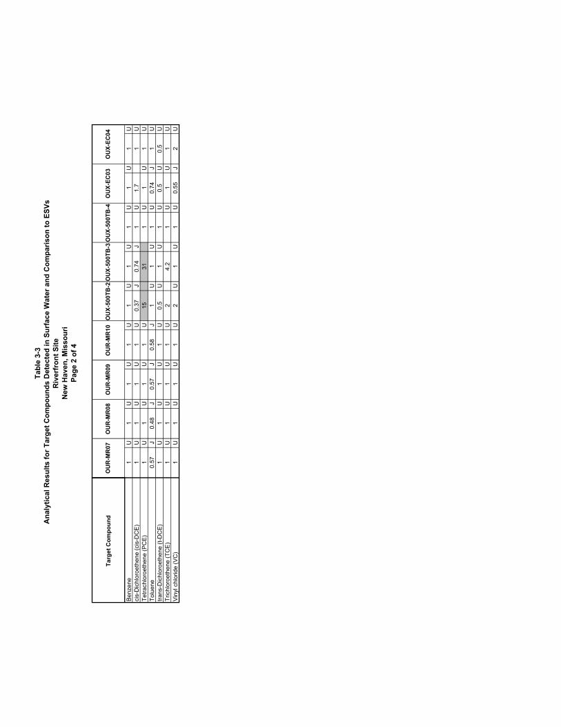
Riverfront Superfund Site July 2002 Ecological Risk Assessment 5.3 Surface Water Risk Characterization Surface water analytical data results were compared to the selected ESVs for surface water and are presented in Table 3-3. PCE, cis-DCE, toluene, TCE, and VC were detected in several of these water samples; however, the concentrations of most detections were all well below the ESVs for surface water. Samples OUX-500TB-2 and OUX-500TB-3 contained PCE at concentrations 1.7 and 3.5 times greater than the ESVs, respectively. These two samples are located on a tributary of Boeuf Creek located downgradient of OU2. Based on known surface aquifer flow patterns and the location of these two locations in the landscape, it is likely that this tributary is charged by contaminated groundwater from OU2. It is important to note that laboratory data for the next downstream sample (OUX-500TB-4) did not detect PCE. Give the high volatility of PCE in surface water, it is likely to rapidly volatilize into the atmosphere from surface water, especially in a shallow, fast moving stream. 5.4 Risk Characterization for Herbivores Analytical results of tree and fruit samples were converted to exposure doses based on the equation and discussion presented in Section 3.4 and shown in Tables 3-5 and 3-6. All seven target compounds were detected in these samples of plant tissue. The estimated ADD for the representative mammal and bird species were compared to the wildlife ESVs presented in Table 4-3. Based on this comparison for the representative mammal and bird presented in Tables 5-1 and 5-2, respectively, none of the target compounds were present at levels that indicate a significant risk to herbivores.
Revision 0 5-2

Riverfront Superfund Site July 2002 Ecological Risk Assessment
6.0 Uncertainty
ESVs and ingestions dose exposure parameters for the food chain exposure models were all based on approved guidance from EPA or other commonly accepted sources. Any uncertainties associated with these variables considered in this ERA are consistent with those normal scientific uncertainties commonly accepted in ecological risk assessment. However, the development and selection of these variables has been intentionally designed to minimize the potential for the under-estimation of ecological risk at the site. 6.1 Analytical Data Uncertainties The data for the target compounds have been provided by an EPA-approved analytical laboratory and have been validated in accordance with EPA standards. Several target compounds were reported as J-qualified data in the data set. J-qualified data indicate that the identification of the analyte is acceptable, but quality assurance criteria indicate that the quantitative values may be outside the normal range of precision, i.e., the quantitative value is considered estimated. J-qualified data is generally accepted for risk assessment purposes and it is unlikely that data quality is adds significant uncertainty in the assessment of surface soils. In the case of floodplain surface soil and sediment, the reporting values for TCE and VC were above the ESV for these respective media. Typically, analytical laboratories report detections below the reporting limit down to the method detection limit (MDL) with a J-qualifier. For soil and sediment, the MDL for TCE and VC are 1.2 and 1.6 ug/kg, respectively. The MDL for VC is below the ESVs for soil and sediment; therefore, it is unlikely that VC is present in these media at levels of concern. The MDL for TCE is only slightly above the ESVs for soil and sediment; therefore, even if it were present in these media, it would be at levels only slightly higher than the most conservative ecological criteria. Based on this information, the uncertainty associated with the reporting limits for TCE and VC is minor. 6.2 Food Chain Variables The exposure equation used in the food chain model relies on several variables that add uncertainty in the identification and assessment of target compounds. For the purposes of this ERA, these variables are biased toward conservatism to over-estimate the exposure dose
Revision 0 6-1
Riverfront Superfund Site July 2002 Ecological Risk Assessment to avoid the elimination of risk-producing contaminants or exposure pathways. The FCM presented in the previous refinement makes the following conservative assumptions:
• The area usage factor (AUF) for receptor species is assumed to be 100 percent. This means that the receptor is assumed to spend all of its time in the contaminated area,
• The dietary fraction of the target food item (plant material) is assumed to be 100 percent for herbivores.
The selection of TRVs is based, when possible, on wildlife toxicity tests that were focused on the effects of a chronic oral ingestion of a contaminant on a reproductive endpoint. For several receptors, tests conducted under these conditions could not be obtained. In addition, the TRV species were never the same as the FCM species (which is not uncommon given the lack of ecological toxicity data available as a whole). This may result in over- or under-estimation of the food chain exposure risks. It is important to note only two target compounds (cis- and trans-1,2-DCE) had toxicity information for birds; therefore, toxicity and risks from the other five target compounds could not be quantified. The ADD for the representative bird and mammal species are comparable and the toxicity of these target compounds is not expected to be significantly variable between birds and mammals (based on the comparison of data for cis-1,2-DCE). Based on this information, it is reasonable to assume that these compounds do not present a significant risk to herbivorous birds.
Revision 0 6-2
Riverfront Superfund Site July 2002 Ecological Risk Assessment
7.0 Conclusions
Based on the evaluation conducted in this ERA, surface waters in a portion of a tributary of Boeuf Creek, downstream of OU-2, may contain PCE at levels that could present a risk to ecological receptors. Floodplain surface soils, sediments, and plant tissue samples collected throughout the Riverfront Site’s study are do not indicate a significant risk to the environment. The risks presented by PCE in surface water collected at OUX-500TB-2 and OUX-500TB-3 are relatively minimal, having only produced HQs of 1.7 and 3.5, respectively. These two samples are located on a tributary of Boeuf Creek located downgradient of OU2. Based on known surface aquifer flow patterns and the location of these two locations in the landscape, it is likely that this tributary is charged by contaminated groundwater from OU2. It is important to note that laboratory data for the next downstream sample (OUX-500TB-4) did not detect PCE. Give the high volatility of PCE in surface water, it is likely to rapidly volatilize into the atmosphere from surface water, especially in a shallow, fast moving stream. This information suggests that PCE in groundwater being discharged at this location drives the ecological risk at this location. There is sufficient information available to fully evaluate effect of the site on ecological receptors in the study area, and the risks are well defined given the data available. As a result, no further ecological investigation or analyses are recommended at the Riverfront Site. Section 8.0 of this ERA presents Preliminary Remedial Goals (PRGs) for PCE in surface water based on the information currently available. If lower remedial goals are required, additional ecological investigations will be required.
Revision 0 7-1

Riverfront Superfund Site July 2002 Ecological Risk Assessment
8.0 Preliminary Remedial Goals (PRGs)
A PRG were developed for PCE in surface water at the Riverfront site. This PRG were based on the assumptions and limitations of this ERA for direct exposure. The PRGs present a concentration of PCE in surface water that is assumed to be protective of aquatic organisms in the habitats of the study area. A PRG for PCE of 8.9 ug/L was based on the EPA Region 5 environmental data quality limit.
Revision 0 8-1

Riverfront Superfund Site July 2002 Ecological Risk Assessment
9.0 References
BVSPC/USGS (Black & Veatch Special Projects Corp. and United States Geological Survey) 2002. Remedial Investigation and Feasibility Study. Riverfront Site. Prepared for EPA, Region 7. July 2002. CCMOE, 1999. Canadian Council of Ministers of the Environment, Canadian Environmental Quality Guidelines, Canadian Soil Quality Guidelines for the Protection of Environmental and Human Health – Summary Tables, 1999. Efroymson, R.A., Will, M.E, Suter, G.W., and Wooten A.C. 1997a. Toxicological Benchmarks for Screening Potential Contaminants of Concern for Effects on Terrestrial Plants: 1997 Revision. ES/ER/TM-85/R3, Oak Ridge National Laboratory, Oak Ridge, TN. EPA 1993. U.S. Environmental Protection Agency, Office of Research and Development, Wildlife Exposure Factors Handbook, Vol. 1 of 2, EPA/600/R-93/187a, 1993. EPA 1996. Eco Update (Ecotox Thresholds). Interim Bulletin Volume 3, Number 2. EPA 540/f-95/038, January 1996 - Freshwater Sediment Values. EPA 1997. U.S. Environmental Protection Agency Environmental Response Team, Ecological Risk Assessment Guidance for Superfund: Process for Designing and Conducting Ecological Risk Assessments - Interim Final. EPA 540-R-97-006. June 5, 1997. EPA 1999. Ecological Screening Values. EPA Region 4 Ecological Risk Assessment Bulletins -- Supplement to RAGS. EPA 1999. Region 5 RCRA Environmental Data Quality Levels. MDC (Missouri Department of Conservation) 2002. Missouri Natural Heritage Database. Sample, B.E., Opresko, D.M., and Suter, G.W. Toxicological Benchmarks for Wildlife: 1996 Revision, U.S. Department of Energy.
Revision 0 9-1

Riverfront Superfund Site July 2002 Ecological Risk Assessment USFWS (U.S. Fish and Wildlife Service) 2001. County Distribution of Missouri’s Federally-Listed Threatened, Endangered, Proposed, and Candidate Species. USFWS Region 3, Columbia, MO.
Revision 0 9-2

This page intentionally left blank

Tables

This page intentionally left blank

Tabl
e 3-
1A
naly
tical
Res
ults
for T
arge
t Com
poun
ds D
etec
ted
in F
lood
plai
n Su
rfac
e So
ils a
nd C
ompa
rison
to E
SVs
Riv
erfr
ont S
iteN
ew H
aven
, Mis
sour
iPa
ge 1
of 2
Targ
et C
ompo
und
Benz
ene
6.9
U6.
4U
7.2
U6.
7U
7U
7U
6.5
U6.
5U
6.3
Uci
s-D
ichl
oroe
then
e (c
is-D
CE)
3.4
U3.
2U
3.6
U3.
3U
3.6
U3.
5U
3.2
U3.
2U
3.2
UTo
luen
e6.
9U
6.4
U7.
2U
6.7
U7
U7
U6.
5U
6.5
U6.
3U
Tetra
chlo
roet
hene
(PC
E)6.
9U
6.4
U7.
2U
6.7
U7.
1U
7U
6.4
U6.
5U
6.3
Utra
ns-D
ichl
oroe
then
e (t-
DC
E)3.
4U
3.2
U3.
6U
3.3
U3.
6U
3.5
U3.
2U
3.2
U3.
2U
Tric
hlor
oeth
ene
(TC
E)6.
9U
6.4
U7.
2U
6.7
U7.
1U
7U
6.4
U6.
5U
6.3
UVi
nyl c
hlor
ide
(VC
)14
U13
U14
U13
U14
U14
U13
U13
U13
U
OU
X-SO
-EC
06O
UX-
SO-E
C05
OU
X-SO
-EC
11O
UX-
SO-E
C08
OU
X-SO
-EC
09O
UX-
SO-E
C01
OU
X-SO
-EC
02O
UX-
SO-E
C03
OU
X-SO
-EC
04

Tabl
e 3-
1A
naly
tical
Res
ults
for T
arge
t Com
poun
ds D
etec
ted
in F
lood
plai
n Su
rfac
e So
ils a
nd C
ompa
rison
to E
SVs
Riv
erfr
ont S
iteN
ew H
aven
, Mis
sour
iPa
ge 2
of 2
Targ
et C
ompo
und
Benz
ene
cis-
Dic
hlor
oeth
ene
(cis
-DC
E)To
luen
eTe
trach
loro
ethe
ne (P
CE)
trans
-Dic
hlor
oeth
ene
(t-D
CE)
Tric
hlor
oeth
ene
(TC
E)Vi
nyl c
hlor
ide
(VC
)
Tota
l Sa
mpl
esTo
tal
Det
ectio
nsM
inim
um
Det
ecte
dM
axim
um
Det
ecte
d
Ecol
ogic
al
Scre
enin
g Va
lue
Tota
l D
etec
tions
>
Sc
reen
ing
Valu
e
Scre
enin
g H
Q
Bas
ed o
n M
axim
um
Sele
cted
as
PCO
PEC
?
6.2
U10
0na
na50
00.00
YES
3.1
U10
0na
na40
00
0.00
NO
6.2
U10
0na
na10
00.00
NO
6.2
U10
0na
na50
00.00
NO
3.1
U10
0na
na40
00
0.00
NO
6.2
U10
0na
na1
00.00
NO
13U
100
nana
100
0.00
NO
OU
X-SO
-EC
07

Tabl
e 3-
2A
naly
tical
Res
ults
for T
arge
t Com
poun
ds D
etec
ted
in S
edim
ent a
nd C
ompa
rison
to E
SVs
Riv
erfr
ont S
iteN
ew H
aven
, Mis
sour
iPa
ge 1
of 3
Targ
et C
ompo
und
Benz
ene
4.25
U3.
05U
3.05
U4.
7U
3.35
U4.
45U
3.75
U3.
95U
cis-
Dic
hlor
oeth
ene
(cis
-DC
E)2.
15U
1.55
U1.
5U
2.35
U1.
65U
2.25
U1.
85U
2U
Tetra
chlo
roet
hene
(PC
E)4.
25U
3.05
U3.
05U
4.7
U3.
35U
4.45
U3.
75U
3.95
UTo
luen
e4.
25U
3.05
U3.
05U
193.
35U
4.45
U27
03.
95U
trans
-Dic
hlor
oeth
ene
(t-D
CE)
4.3
U3.
1U
3U
4.7
U3.
3U
4.5
U3.
7U
4U
Tric
hlor
oeth
ene
(TC
E)4.
25U
3.05
U3.
05U
4.7
U3.
35U
4.45
U3.
75U
3.95
UVi
nyl c
hlor
ide
(VC
)8.
5U
6U
6U
9.5
U6.
5U
9U
7.5
U8
U
OU
R-S
D-M
R07
OU
R-S
D-M
R08
OU
R-S
D-M
R09
OU
R-S
D-M
R10
OU
R-S
D-M
R01
OU
R-S
D-M
R04
OU
R-S
D-M
R05
OU
R-S
D-M
R06

Tabl
e 3-
2A
naly
tical
Res
ults
for T
arge
t Com
poun
ds D
etec
ted
in S
edim
ent a
nd C
ompa
rison
to E
SVs
Riv
erfr
ont S
iteN
ew H
aven
, Mis
sour
iPa
ge 2
of 3
Targ
et C
ompo
und
Benz
ene
cis-
Dic
hlor
oeth
ene
(cis
-DC
E)Te
trach
loro
ethe
ne (P
CE)
Tolu
ene
trans
-Dic
hlor
oeth
ene
(t-D
CE)
Tric
hlor
oeth
ene
(TC
E)Vi
nyl c
hlor
ide
(VC
)
4.1
U2.
95U
3.65
U3.
15U
3.05
U3.
55U
3.6
U3.
15U
2.05
U1.
5U
1.8
U1.
55U
1.55
U1.
75U
1.8
U1.
55U
4.1
U2.
95U
2.8
J1.
8J
3.05
U3.
55U
3.6
U3.
15U
4.1
U2.
95U
3.65
U3.
15U
3.05
U3.
55U
3.6
U3.
15U
4.1
U3
U3.
6U
3.1
U3.
1U
3.5
U3.
6U
3.1
U4.
1U
2.95
U3.
65U
3.15
U3.
05U
3.55
U3.
6U
3.15
U8
U6
U7.
5U
6.5
U12
U7
U7
U6.
5U
OU
X-SD
-EC
03O
UX-
SD-E
C04
OU
X-SD
-EC
05O
UX-
SD-E
C11
OU
X-SD
-EC
06O
UX-
SD-E
C07
OU
X-SD
-EC
08O
UX-
SD-E
C09

Tabl
e 3-
2A
naly
tical
Res
ults
for T
arge
t Com
poun
ds D
etec
ted
in S
edim
ent a
nd C
ompa
rison
to E
SVs
Riv
erfr
ont S
iteN
ew H
aven
, Mis
sour
iPa
ge 3
of 3
Targ
et C
ompo
und
Benz
ene
cis-
Dic
hlor
oeth
ene
(cis
-DC
E)Te
trach
loro
ethe
ne (P
CE)
Tolu
ene
trans
-Dic
hlor
oeth
ene
(t-D
CE)
Tric
hlor
oeth
ene
(TC
E)Vi
nyl c
hlor
ide
(VC
)
Tota
l Sa
mpl
esTo
tal
Det
ectio
nsM
inim
um
Det
ecte
dM
axim
um
Con
cent
ratio
n
Ecol
ogic
al
Scre
enin
g Va
lue
Tota
l Det
ectio
ns
> Sc
reen
ing
Valu
e
Scre
enin
g H
Q B
ased
on
Max
imum
Sele
cted
as
PCO
PEC
?
160
nana
570
naN
O16
0na
na20
8.94
0na
NO
162
1.7
4.7
195.
830
0.02
NO
162
1.7
270
670
00.40
NO
160
nana
208.
940
naN
O16
0na
na17
9.56
0na
NO
160
nana
20
naN
O

Tabl
e 3-
3A
naly
tical
Res
ults
for T
arge
t Com
poun
ds D
etec
ted
in S
urfa
ce W
ater
and
Com
paris
on to
ESV
sR
iver
fron
t Site
New
Hav
en, M
isso
uri
Page
1 o
f 4
Targ
et C
ompo
und
Benz
ene
1U
1U
1U
1U
1U
1U
1U
1U
1U
cis-
Dic
hlor
oeth
ene
(cis
-DC
E)0.
95J
0.4
J0.
23J
1U
1U
1U
1U
1U
1U
Tetra
chlo
roet
hene
(PC
E)7.
45
0.36
J1
U1
U1
U1
U1
U1
UTo
luen
e1
U1
U1
U0.
98J
0.76
J0.
76J
0.59
J0.
65J
0.5
Jtra
ns-D
ichl
oroe
then
e (t-
DC
E)1
U0.
5U
1U
1U
1U
1U
1U
1U
1U
Tric
hlor
oeth
ene
(TC
E)0.
57J
0.36
J1
U1
U1
U1
U1
U1
U1
UVi
nyl c
hlor
ide
(VC
)1
U2
U1
U1
U1
U1
U1
U1
U1
U
OU
4-21
0TB
-C5
OU
4-21
0TB
-C6
OU
4-21
0TB
-C7
OU
R-M
R01
OU
R-M
R02
OU
R-M
R03
OU
R-M
R04
OU
R-M
R05
OU
R-M
R06
Tabl
e 3-
3A
naly
tical
Res
ults
for T
arge
t Com
poun
ds D
etec
ted
in S
urfa
ce W
ater
and
Com
paris
on to
ESV
sR
iver
fron
t Site
New
Hav
en, M
isso
uri
Page
2 o
f 4
Targ
et C
ompo
und
Benz
ene
cis-
Dic
hlor
oeth
ene
(cis
-DC
E)Te
trach
loro
ethe
ne (P
CE)
Tolu
ene
trans
-Dic
hlor
oeth
ene
(t-D
CE)
Tric
hlor
oeth
ene
(TC
E)Vi
nyl c
hlor
ide
(VC
)
1U
1U
1U
1U
1U
1U
1U
1U
1U
1U
1U
1U
1U
0.37
J0.
74J
1U
1.7
1U
1U
1U
1U
1U
1531
1U
1U
1U
0.57
J0.
48J
0.57
J0.
58J
1U
1U
1U
0.74
J1
U1
U1
U1
U1
U0.
5U
1U
1U
0.5
U0.
5U
1U
1U
1U
1U
24.
21
U1
U1
U1
U1
U1
U1
U2
U1
U1
U0.
55J
2U
OU
R-M
R07
OU
R-M
R08
OU
R-M
R09
OU
R-M
R10
OU
X-50
0TB
-2O
UX-
500T
B-3
OU
X-50
0TB
-4O
UX-
EC03
OU
X-EC
04

Tabl
e 3-
3A
naly
tical
Res
ults
for T
arge
t Com
poun
ds D
etec
ted
in S
urfa
ce W
ater
and
Com
paris
on to
ESV
sR
iver
fron
t Site
New
Hav
en, M
isso
uri
Page
3 o
f 4
Targ
et C
ompo
und
Benz
ene
cis-
Dic
hlor
oeth
ene
(cis
-DC
E)Te
trach
loro
ethe
ne (P
CE)
Tolu
ene
trans
-Dic
hlor
oeth
ene
(t-D
CE)
Tric
hlor
oeth
ene
(TC
E)Vi
nyl c
hlor
ide
(VC
)
1U
1U
1U
1U
1U
1U
0.41
J1
U1
U1
U1
U1
U2.
7
8.9
1.3
0.33
J1
U1
U1
U1
U1
U1
U1
U1
U0.
5U
0.5
U0.
5U
0.5
U0.
5U
0.5
U1
U1
U1
U1
U1
U1
U2
U2
U2
U2
U2
U2
U
OU
X-EC
05O
UX-
EC06
OU
X-EC
07O
UX-
EC08
OU
X-EC
09O
UX-
EC11

Tabl
e 3-
3A
naly
tical
Res
ults
for T
arge
t Com
poun
ds D
etec
ted
in S
urfa
ce W
ater
and
Com
paris
on to
ESV
sR
iver
fron
t Site
New
Hav
en, M
isso
uri
Page
4 o
f 4
Targ
et C
ompo
und
Benz
ene
cis-
Dic
hlor
oeth
ene
(cis
-DC
E)Te
trach
loro
ethe
ne (P
CE)
Tolu
ene
trans
-Dic
hlor
oeth
ene
(t-D
CE)
Tric
hlor
oeth
ene
(TC
E)Vi
nyl c
hlor
ide
(VC
)
Tota
l Sa
mpl
esTo
tal
Det
ectio
nsM
inim
um
Det
ecte
dM
axim
um
Con
cent
ratio
n
Ecol
ogic
al
Scre
enin
g Va
lue
Tota
l Det
ectio
ns
> Sc
reen
ing
Valu
e
Scre
enin
g H
Q
Bas
ed o
n M
axim
um
Sele
cted
as
PCO
PEC
?
240
nana
460
naN
O24
70.
231.
731
00
0.00
5N
O24
80.
3331
8.9
23.
48YE
S24
110.
481
130
00.
01N
O24
0na
na31
00
naN
O24
40.
364.
275
00.
06N
O24
10.
552
9.2
00.
22N
O

Table 3-4Analytical Results for Target Compounds Detected in Plant Tissue
Riverfront SiteNew Haven, Missouri
Page 1 of 2
Description LOCATION Date PCEinit TCE cis-DCE t-DCE VC Benzene Toluene CommentsTree core OU1-DF-1 10/20/1999 0.155 tree core sample, refer to field book for locationTree core OU1-DF-1 10/21/1999 0.133 tree core sample, refer to field book for locationtreecore OU1-DF101 1/31/2002 0.110treecore OU1-DF102 1/31/2002 0.115treecore OU1-DF103 1/31/2002 treecore OU1-DF104 1/31/2002 5. 48 treecore OU1-DF105 1/31/2002 8.999Tree core OU1-DF-1A 10/20/1999 2.483 tree core sample, refer to field book for locationTree core OU1-DF-2 10/20/1999 0.350 tree core sample, refer to field book for locationTree core OU1-DF-2 10/21/1999 .3 9 tree core sample, refer to field book for locationTree core OU1-DF-3 10/20/1999 tree core sample, refer to field book for locationTree core OU1-DF-3 10/20/1999 tree core sample, refer to field book for locationTree core OU1-HS-1 9/9/1999 2 - 2 x 1/4 inch coresTree core OU1-HS-2 9/9/1999 2 - 2 x 1/4 inch coresTree core OU1-HS-3 9/9/1999 2 - 2 x 1/4 inch coresTree core OU1-HS-4 9/9/1999 2 - 2 x 1/4 inch coresTree core OU1-HS-5 9/9/1999 2 - 2 x 1/4 inch corestree core OU1-JS113 9/5/2001 0.254 .1 2 20 in. apple near levee on Wilson'sJS62 OU1-JS62 4/18/2001 0.257 10" ornamental cherryJS62, 48 hr OU1-JS62 4/18/2001 0.132 10" ornamental cherryJS63 OU1-JS63 4/18/2001 0.145 20" boxelderJS63 OU1-JS63 4/18/2001 . 61 20" boxelderJS64 OU1-JS64 4/18/2001 1 .29 . 75 13" pecanJS64 OU1-JS64 4/18/2001 8.310 . 42 13" pecanapple coring OU1-JS64 9/5/2001 0.441 apple core NW side of treeapple coring OU1-JS64 9/5/2001 0.266 apple core NW side of treeapple coring OU1-JS64 9/5/2001 0.331 apple core, S side of treeinit. Label BW-W in field OU1-JS64 9/5/2001 35.850 . 21 .1 1 13 in. pecan north of pool cored prev.JS65 OU1-JS65 4/18/2001 1.350 0.223 1.000 10" triple mulberryJS66 OU1-JS66 4/18/2001 .2 2 . 26 . 9 11" appleJS66 OU1-JS66 4/18/2001 0.239 . 46 .1 9 11" appleapple coring OU1-JS66 9/5/2001 apple core, side of treeapple coring OU1-JS66 9/5/2001 apple core, side of treeapple coring OU1-JS66 9/5/2001 . 99 apple core, side of treeinit label BWA1 in field OU1-JS66 9/5/2001 .1 2 .4 6 10 in. apple E. of pool cored prev.JS67 OU1-JS67 4/18/2001 5.294 . 15 . 41 13" pecanJS67 OU1-JS67 4/18/2001 2.733 . 15 . 41 13" pecanJS68 OU1-JS68 4/18/2001 17" silver mapleJS70 OU1-JS70 4/19/2001 8" ashJS77 OU1-JS77 4/21/2001 26.860 0.317 18" Buckeye, Wilson's garageJS78 OU1-JS78 4/21/2001 7. 9 . 53 10" Mulberry, Wilson, 15' E. drop boxJS79 OU1-JS79 4/21/2001 2.343 9" Walnut NE cor Wilson's red barnJS80 OU1-JS80 4/21/2001 31.130 0.264 34" sweet gum E. Wilson's houseTree core OU1-T201 7/13/1999 sample 11 w/o waterTree core OU1-T201 7/13/1999 sample 11 w/o waterTree core OU1-T202 8/11/1999 no heater blockTree core OU1-TA01 8/11/1999 0.273 Ta01 - Hackberry, no heater blockTree core OU1-TA02 8/11/1999 0.116 Ta02 - Triple Birch, no heater blockJS69 OU1-TA02 4/19/2001 0.124 10" birchTree core OU1-TA04 8/26/1999 1.953 no heater blockTree core OU1-TB01 8/11/1999 7. 78 0.199 Tb01 - Walnut, no heater blockTree core OU1-TB02 7/13/1999 0.184 sample 9 w/o waterTree core OU1-TB02 8/11/1999 0.197 Tb02 - Silver Maple, no heater blockTree core OU1-TC01 8/20/1999 Tc01 - Boxelder, no heater blockTree core OU1-TCR01 11/27/2000 8" sycamore next to TW-G
Tree core OU1-TCR02 11/27/2000 14" boxelder west TW-G, m-xylene and ethyl benzeneTree core OU1-TCR03 11/27/2000 twin 10" & 16" boxelder west TW-GTree core OU1-TCR04 11/27/2000 0.195 .4 5 8 in twin sycamore west TW-GTree core OU1-TCR05 11/27/2000 14" sycamore west TW-G edge of bankTree core OU1-TCR06 11/27/2000 8 in unknown tree west TW-GTree core OU1-TCR07 11/27/2000 30" rock elm west TW-GTree core OU1-TCR08 11/27/2000 twin 6" sycamore 60ft E. boat rampTree core OU1-TG01 8/11/1999 0.461 Tg01 - Chinese Elm, no heater blockTree core OU1-TG02 8/11/1999 0.926 Tg02 - Chinese Elm, no heater blockTree core OU1-TG03 8/11/1999 3.123 1.548 Tg03 - Chinese Elm, no heater blockTree core OU1-TG04 8/11/1999 Tg04 - Silver Maple, no heater blockTree core OU1-TM01 8/20/1999 .2 9 Tm01 - Meyers' Boxelder, no heater blockTree core OU1-TM02 8/20/1999 Tm02 - Meyers' Silver Maple, no heater blockTree core OU1-TM03 8/20/1999 Tm03 - Meyers' Hard Maple, no heater blockTree core OU1-TR01 8/11/1999 Tr01 - Hackberry, no heater blockTree core OU1-TR02 8/11/1999 0.114 Tr02 - Chinese Elm, no heater blockTree core OU1-TR03 8/11/1999 Tr03 - Triple Hackberry, no heater blockTree core OU1-TR04 8/11/1999 Tr04 - Hackberry, no heater blockTree core OU1-TW01 8/11/1999 0.135 Tw01 - Twin Mulberry, no heater block#1 Twin 11" Mullberry OU1-TW01 4/11/2001 #1 Twin 11" Mullberry OU1-TW01 4/11/2001 . 6 0.170 1.800 Tree core OU1-TW02 8/11/1999 7.368 0.464 Tw02 - Cedar, no heater blockTree core OU1-TW02 10/22/1999 1 .56 . 67 0.829 tree core sample, refer to field book for locationTree core OU1-TW02 10/22/1999 4.781 0.182 tree core sample, refer to field book for location
tree core OU1-TW02 6/29/2000 39. 7 8.750 10-in cedar previously sampled. NE corner Wisers buildingtree core wiser OU1-TW02 2/6/2001 7. 3 . 4 . 7 . 2 1.180 10" cedar (dry wgt 29.583, wgt 31.026; dwgt 30.153)#8 10" Cedar OU1-TW02 4/11/2001 27.450 .1 2 1. 3 1.740#8 10" Cedar OU1-TW02 4/11/2001 32.600 0.480 2.600 1 .9#8 10" Cedar OU1-TW02 4/11/2001 15.190 0.231 5.474
OU1-TW02 6/27/2001 25.780 0.123 . 52 0.917 2.640tree core OU1-TW02 9/5/2001 7.440 0.294 0.856 Cedar NE cor Riverfront bldgtree core OU1-TW02 11/27/2001 8.478 0.912 . 7 2.760 tree core N. side wiserscedar OU1-TW02 2/12/2002 8.67 0.529 0.772Tree core OU1-TW03 8/11/1999 1.972 0.670 .6 5 Tw03 - Chinese Elm, no heater blockTree core OU1-TW03 10/22/1999 1.974 0.459 tree core sample, refer to field book for locationtree core wiser OU1-TW03 2/6/2001 2.870 . 7 . 5 . 9 Elm (dry wgt 30.795, wgt 32.544; dwgt 31.522)#7 6" Chinese elm OU1-TW03 4/11/2001 2.787 . 7 #7 6" Chinese elm OU1-TW03 4/11/2001 0.320 . 6 #7 6" Chinese elm OU1-TW03 4/11/2001 0.330 0.340 6in Ch. Elm OU1-TW03 2/12/2002 0.90 . 9 0.825 Tree core OU1-TW04 8/11/1999 9.441 . 25 . 17 Tw04 - Mulberry, no heater block#9 Twin 3" Mullberry OU1-TW04 4/11/2001 5.150 0.611 #9 Twin 3" Mullberry OU1-TW04 4/11/2001 4.800 2.600 #9 Twin 3" Mullberry OU1-TW04 4/11/2001 0.239 0.776 Tree core OU1-TW05 8/11/1999 6.851 Tw05 - Walnut, no heater blockTree core OU1-TW06 8/11/1999 15. 7 0.480 0.200 Tw06 - Mulberry, no heater blockTree core OU1-TW06 6/29/2000 1 .46 0.245 small mulberry prev. sampled North side Wiser'sTree core OU1-TW06 2/6/2001 5.400 . 4 1.840 . 5 Mulberry (dry wgt 29.963; wwgt 31.845; dwgt 30.742)
OU1-TW06 6/27/2001 16.300 2.647 .3 7 . 16 tree core OU1-TW06 9/5/2001 7.117 0.118 0.541 mullberry north side bldg
OU1-TW06 11/27/2001 4.599 1.5 4 0.674 tree core N. side wisersrerun OU1-TW06 2/12/2002 14.92 .3 7 Tree core OU1-TW07 8/11/1999 8.161 0.354 Tw07 - Birch, no heater block#10 10" Cottonwood OU1-TW07 4/11/2001 1.490 #10 10" Cottonwood OU1-TW07 4/11/2001 0.920 0.300 #10 10" Cottonwood OU1-TW07 4/11/2001 . 67 1.274
OU1-TW07 11/27/2001 0.990 11.580 tree core N. side wisersTree core OU1-TW08 7/13/1999 1 .99 . 44 sample 10 w/o waterTree core OU1-TW08 7/13/1999 16.670 .1 9 sample 10 w/o waterTree core OU1-TW08 8/11/1999 32.140 0.813 0.843 0.154 Tw08 - Mulberry, no heater block
tree core OU1-TW08 6/29/2000 29.990 0.536 Mulberry prev. sampled north side of Wiser's near 55 gdrum.
OU1-TW08 11/27/2001 14.910 2. 5 tree core N. side wisersmullberry OU1-TW08 2/12/2002 15.84 0.387 rerun OU1-TW08 2/12/2002 11.28 0.298 Tree core OU1-TW09 8/11/1999 . 64 . 22 Tw09 - Hackberry, no heater blockTree core OU1-TW10 8/11/1999 . 51 Tw10 - two twin Chinese Elms, no heater block
tree core OU1-TW11 6/29/2000 189.000 16.970 1.520
3-in elm south side Wiser's facing Front Street neaproposed water line removal. 1st shot w/250 ul had 770 ppb PCE.
TW-11 OU1-TW11 6/29/2000 747.70 64.510 5.653 2.121 4-in elm on south side of wiser'sTW-11 OU1-TW11 6/29/2000 189.20 16.970 1.525 0.936 3-in elm south side of wiser'stree core OU1-TW11 11/27/2000 38.000 37.200 78. 2 4" elm south side riverfront bldgJS61 (4/19 @1500) OU1-TW11 4/18/2001 43 .3 34.670 41.790 . 38 27.310JS61 (4/20 @1800) OU1-TW11 4/18/2001 43. 4 4.970 7. 65 27.310
OU1-TW11 6/27/2001 76.540 8.857 13.820 . 33 tree core OU1-TW11 9/5/2001 7.448 0.294 0.545 0.856 chinese elm along south side bldg3" ch. Elm S side OU1-TW11 2/12/2002 3 .12 7.530 . 85 . 25 . 9
tree core OU1-TW12 6/29/2000 5.870 small elm in Wiser's loading dock growing at base of Nwall 1/3 from top of slope.
#2 Quad 6" Mullberry OU1-TW13 4/11/2001 0.270 #2 Quad 6" Mullberry OU1-TW13 4/11/2001 #3 6" Mullberry OU1-TW14 4/11/2001 #3 6" Mullberry OU1-TW14 4/11/2001 0.260 4.400 #4 4" Mullberry OU1-TW15 4/11/2001 #4 4" Mullberry OU1-TW15 4/11/2001 2.800 #5 4" Cawtawba OU1-TW16 4/11/2001 0.192 0.995 #5 4" Cawtawba OU1-TW16 4/11/2001 0.190 0.380 #6 3" Chinese elm OU1-TW17 4/11/2001 0.170 #6 3" Chinese elm OU1-TW17 4/11/2001 0.310 JF61 OU2-JF61 4/18/2001 .1 4 . 46 . 23 0.132 6" hackberryJF62 OU2-JF62 4/18/2001 0.190 . 28 8.948 6" cedarJF63 OU2-JF63 4/18/2001 . 35 0.432 0.297 12"elmJF65 OU2-JF65 4/18/2001 . 42 8" hackberryJF66 OU2-JF66 4/18/2001 6" unknown, has citrus smellJF68 OU2-JF68 4/18/2001 10" elmJF70 OU2-JF70 4/18/2001 . 43 . 39JF72 OU2-JF72 4/18/2001 3. 6 . 9 . 36 1.8 3 8" cedar3" willow 30' NE BW21A OU2-JS223T 4/30/2002 trace xylene and TCE?5" catawlba 40' N BW21A OU2-JS224T 4/30/2002 4" catawlba NW BW21 OU2-JS225T 4/30/2002 . 4 . 4 JS72 OU2-JS72 4/21/2001 6.464 1.548 . 5 POPULAR w. side Indust. Dr @ OU2JS73 OU2-JS73 4/21/2001 35.350 0.741 0.760 3" cedar 40' N. Geotech MW @ SW cor landfarmOld TK05 cored prev. OU2-JS73 6/13/2001 55.400 0.560 . 3 1.930 6 inch cedar, cored beforeJS74 OU2-JS74 4/21/2001 37.660 6.789 . 29 11" elm 100" fenceline W. detention pondJS75 OU2-JS75 4/21/2001 5.436 0.992 5. 21 9" cedar 20' E. cedar cored by jackJS76 OU2-JS76 4/21/2001 8" elm 75' W. jack cedartree core from Kellwood landfarm area OU2-TK01 6/13/2001 1.590 0.120 0.120 22 inch chinese elm on slope NE land farmtree core from Kellwood landfarm area OU2-TK02 6/13/2001 1.240 0.640 4 inch poplartree core from Kellwood landfarm area OU2-TK03 6/13/2001 0.840 0.520 8 inch sycamoretree core from Kellwood landfarm area OU2-TK04 6/13/2001 1.270 0.270 0.700 mulberry bushtree core from Kellwood landfarm area OU2-TK06 6/13/2001 19.610 0.214 .3 7 2 inch mulberry, several other small unknownstree core from Kellwood landfarm area OU2-TK07 6/13/2001 111.500 9.767 5.452 2 inch sycamore, possible VCtree core from Kellwood landfarm area OU2-TK08 6/13/2001 1. 1 . 5 1. 6 6 inch cedar, cored before
tree core from Kellwood landfarm area OU2-TK09 6/13/2001 1.780 . 3 0.860 2.000 . 84 inch mulberry 0.5 inch sycamore, 4 ft tall, 3 ft from BW-to the SW
tree core from Kellwood landfarm area OU2-TK10 6/13/2001 5.400 12.800 35.600 . 3 1/2-in sycamore sprout (2 ft tall) center of land farm area
tree core from field across from Kellwood OU2-TK11 6/13/2001 0.160 . 6 2.23014 inch cedar, located in field between BW-21 and BW-2the east, possible VC
JF53 OU3-JF53 4/18/2001 . 8 10" SE cor dumpJF54 OU3-JF54 4/18/2001 . 41 0.146 . 8 multiple cottonwoodsJF55 OU3-JF55 4/18/2001 . 88 JF56 OU3-JF56 4/18/2001 14" elmJF57 OU3-JF57 4/18/2001 . 34 18" HackberryJF58 OU3-JF58 4/18/2001 . 8 twin 8" elm west side of dumpJF59 OU3-JF59 4/18/2001 JS51 OU3-JS51 4/18/2001 . 54 . 15 0.191 7" sycamoreJS52 OU3-JS52 4/18/2001 . 8 4" hackberry, NW toe dumpJS53 OU3-JS53 4/18/2001 4" hackberry, NE side dumpJS56 OU3-JS56 4/18/2001 twin 7" hackberryJS57 OU3-JS57 4/18/2001 7" walnutJS58 OU3-JS58 4/18/2001 6" twin cottonwoodJS59 OU3-JS59 4/18/2001 twin 6" cottonwoodTree core OU3-TC-1 7/13/1999 sample 1 w/o waterTree core OU3-TC-1 7/13/1999 sample 1 w/o waterTree core OU3-TC-1 7/13/1999 3.652 sample 1 w/ waterTree core OU3-TC-1 7/13/1999 sample 1 w/ waterTree core OU3-TC-2 7/13/1999 sample 2 w/ waterTree core OU3-TC-2 7/13/1999 sample 2 w/ waterTree core OU3-TC-2 7/13/1999 1.359 sample 2 w/o waterTree core OU3-TC-3 7/13/1999 sample 3 w/o waterTree core OU3-TC-3 7/13/1999 sample 3 w/ waterTree core OU3-TC-4 7/13/1999 sample 4 w/o waterTree core OU3-TC-4 7/13/1999 sample 4 w/ waterTree core OU3-TC-5 7/13/1999 0.127 sample 5 w/o waterTree core OU3-TC-5 7/13/1999 sample 5 w/ waterTree core OU3-TC-6 7/13/1999 . 63 sample 6 w/o waterTree core OU3-TC-6 7/13/1999 sample 6 w/ waterTree core OU3-TC-7 7/13/1999 0.151 sample 7 w/o waterTree core OU3-TC-7 7/13/1999 sample 7 w/ waterTree core OU3-TC-8 7/13/1999 0.142 sample 8 w/o waterTree core OU3-TC-8 7/13/1999 sample 8 w/ water216 Trib OU4-216TB-1 3/28/2000 tree core sample, refer to field book for locationSunfield, tree core OU4-BS01 12/17/2001 5" basswood/boxelder in fenceline, 5 ft west JSH03
Sunfield, tree core OU4-BS02 12/17/2001 0.115 .2 2 0.176 18" scotch pine east side of greenhouse near JSH06
Sunfield, tree core OU4-BS03 12/17/2001 . 9 0.285 34" sycamore between greenhouse of house (30' E. JSH07JF19 OU4-JF19 4/16/2001 10" oakJF20 OU4-JF20 4/16/2001 12" WalnutJF21 OU4-JF21 4/16/2001 14" OakJF22 OU4-JF22 4/16/2001 16" WalnutJF23 OU4-JF23 4/17/2001 0.537 0.565 0.354 28.238JF24 OU4-JF24 4/17/2001 . 25 4.226 . 16 . 93 27.880JF25 OU4-JF25 4/17/2001 . 84 . 26 0.150 28.267JF26 OU4-JF26 4/17/2001 . 5 . 3 28.272JF27 OU4-JF27 4/17/2001 . 57 . 46 27.543JF28 OU4-JF28 4/17/2001 . 19 B . 12 27.882JF29 OU4-JF29 4/17/2001 . 33 .4 2 . 25 . 1 0.789 27.848JF29 OU4-JF29 4/17/2001 . 34 0.353 . 4 0.619 0.691 27.848JF30 OU4-JF30 4/17/2001 . 44 . 24 . 44 27.943JF31 OU4-JF31 4/17/2001 0.361 27.958JF32 OU4-JF32 4/17/2001 . 21 JF33 OU4-JF33 4/17/2001 . 64 . 1 JF34 OU4-JF34 4/17/2001 . 41 28.453JF35 OU4-JF35 4/17/2001 .2 9 . 39 28.489JF36 OU4-JF36 4/17/2001 . 5 . 8 . 56 . 4 27.505JF37 OU4-JF37 4/17/2001 . 63 . 31 . 51 27.540JF38 OU4-JF38 4/17/2001 0.166 . 8 27.802JF39 OU4-JF39 4/17/2001 . 17 . 18 28.518

Table 3-4Analytical Results for Target Compounds Detected in Plant Tissue
Riverfront SiteNew Haven, Missouri
Page 2 of 2
8" walnut OU4-JFTC01 5/11/2000 5" hackberry OU4-JFTC02 5/11/2000 composite, 10" elm, 7" elm, 5" Hackberry OU4-JFTC03 5/11/2000 composite, 2 softwood, 7" Hackberry OU4-JFTC04 5/11/2000 composite around pond, 6" walnut, 11" Hack, 16" Cotton, 4OU4-JFTC05 5/11/2000
OU4-JGD-01 1/3/2002 0.146 0.685 1.176 10-in diaOU4-JGD-02 1/3/2002 0.149 1.228 10-in diaOU4-JGD-03 1/3/2002 . 97 8.277 8-in diaOU4-JGD-04 1/3/2002 5.288 8-in diaOU4-JGD-05 1/3/2002 . 63 0.683 10-in dia
OU4-JST01 12/17/2001 mullberry near drum behind old barn at xxx Miller (nburied drum)
OU4-JST02 12/17/2001 mullberry near drum behind old barn at xxx Miller (nburied drum)
OU4-JST03 12/17/2001 OU4-JST04 12/17/2001
210 Trib OU4-JSTC01 4/3/2000 tree core sample, refer to field book for location210 Trib OU4-JSTC02 4/3/2000 tree core sample, refer to field book for location210 Trib OU4-JSTC03 4/3/2000 tree core sample, refer to field book for location210 Trib OU4-JSTC04 4/3/2000 tree core sample, refer to field book for location210 Trib OU4-JSTC05 4/3/2000 tree core sample, refer to field book for location210 Trib OU4-JSTC06 4/3/2000 tree core sample, refer to field book for location
OU4-JSTC06 4/3/2000 134.900 210 Trib OU4-JSTC07 4/3/2000 tree core sample, refer to field book for location
OU4-JSTC07 4/3/2000 .4 3 210 Trib OU4-JSTC08 4/3/2000 tree core sample, refer to field book for location
OU4-JSTC08 4/3/2000 142.900 210 Trib OU4-JSTC09 4/3/2000 tree core sample, refer to field book for location
OU4-JSTC09 4/3/2000 0.271 14.570 3.831 210 Trib OU4-JSTC10 4/3/2000 tree core sample, refer to field book for location210 Trib OU4-JSTC11 4/3/2000 tree core sample, refer to field book for location1" walnut next to back door hat factory OU5-JS222T 4/29/2002 treecore OUL- 6/6/2000 4.482 1.457 treecore OUL- 6/6/2000 treecore OUL- 6/6/2000 treecore OUL- 6/6/2000 treecore OUL- 6/6/2000 tree core OUX-JS100 9/5/2001 2.554 0.212 . 1 26 in. sweet gum 108 Maiden Lanetree core OUX-JS101 9/5/2001 . 36 10 in. oak behind 108 Maiden Lanetree core OUX-JS102 9/5/2001 1.915 0.680 7 in. Mullberry behind 108 Maiden Lanetree core OUX-JS103 9/5/2001 . 37 . 29 cluster 10 in. mullberrys 100 ft south Maiden lanetree core OUX-JS104 9/5/2001 2.761 5.675 0.125 . 3 cluster large Mullberrys south side Maiden Lanetree core OUX-JS105 9/5/2001 . 4 0.123 . 18 . 9 Pair Walnuts N. side Circle Drivetree core OUX-JS106 9/5/2001 23.260 5.464 2.832 1.773 30 in. Hedge behind 411 Roberta St.
tree core OUX-JS107 9/5/2001 2.150 2. 5 5.834 . 2 2-1/2 in. chinese elm sprout behind Laune's green garagetree core OUX-JS108 9/5/2001 . 22 .1 5 . 5 14 in. Hackberry behind 411 Riberta St.tree core OUX-JS109 9/5/2001 . 17 7.129 0.365 6 in. mimosa behind metal garage at 408 Maupintree core OUX-JS110 9/5/2001 0.221 0.176 . 21 twin 10 in. poplar? Near garage behind 408 Maupintree core OUX-JS111 9/5/2001 . 3 0.293 . 29 34 in. pecan? Near garage behind 408 Maupintree core OUX-JS112 9/5/2001 19.660 2. 13 0.519 36 in. Cotton NE garage behind 408 MaupinAssumption Catholic Church, Father Mosley OUX-JS114 9/10/2001 1.10 20 in. pin oak, 603 Miller St.Assumption Catholic Church, Father Mosley OUX-JS115 9/10/2001 26 in. pin oak, 603 Miller St.Rich Deck OUX-JS116 9/10/2001 20 in. pin oak, 604 Miller St.Mike, Brandenburg OUX-JS117 9/10/2001 22 in. rock elm 602 MillerElfrieda Wolfe OUX-JS118 9/10/2001 22 in. chinese elm, 600 MillerElfrieda Wolfe OUX-JS119 9/10/2001 18 in. silver maple, 600 MillerLaune OUX-JS120 9/10/2001 7.50 0.12 20 in. silver maple Laune OUX-JS121 9/10/2001 3.18 1.58 1 in. mullberryJennifer Theissen OUX-JS122 9/10/2001 18 in. silver maple, 102 Maiden LaneJennifer Theissen OUX-JS123 9/10/2001 0.49 19 in. silver maple, 102 Maiden LaneAssumption Catholic Church, Father Mosley OUX-JS124 9/10/2001 26 in. pin oak, 603 Miller St., street sideAssumption Catholic Church, Father Mosley OUX-JS125 9/10/2001 26 in. pin oak, 603 Miller St., street sideAssumption Catholic Church, Father Mosley OUX-JS126 9/10/2001 26 in. pin oak, 603 Miller St., street sideAssumption Catholic Church, Father Mosley OUX-JS127 9/10/2001 18 in. Boxelder?, 603 Miller st.Earnest Johnson OUX-JS128 9/11/2001 36 in. silver maple, 909 Miller St., EAST SIDE TREEEarnest Johnson OUX-JS129 9/11/2001 6 in. mullberry, 909 Miller St.Teresa Boehmer OUX-JS130 9/11/2001 14 in. red bed, 909 Miller St.Christene Zeiss OUX-JS131 9/11/2001 0.15 14 in. basswood, 808 Miller St., next to MH079Christene Zeiss OUX-JS132 9/11/2001 0.11 5 in. mullberry, 808 Miller St., 25 ft W. MH079
city of New Haven OUX-JS133 9/11/2001 94.00 4.10 9.10 0.5 in. sycamore sapling SE cor landfarm 25 ft W. geotewell
city easement OUX-JS135 9/11/2001 . 2 . 7 11 in. hackberry, city easement E. Maupincity easement OUX-JS136 9/11/2001 . 4 16 in. tulip tree 20 ft NW old Maupin lift stationcity easement OUX-JS137 9/11/2001 6 in. ornamental ??, easement east of Maupincity easement OUX-JS138 9/11/2001 . 3 4 in. mullberry, along creekcity easement OUX-JS139 9/11/2001 24 in. boxelder south side of Circle Dr.Fidelity Comm. Maupin facility OUX-JS140 9/11/2001 18 in. rock elm, east of MaupinFidelity Comm. Maupin facility OUX-JS141 9/11/2001 . 7 twin 14 in. catawlba21" walnut SE hat factory OUX-JS220T 4/29/2002 3" mulberry SE hat factory OUX-JS221T 4/29/2002
8" cedar from USGS OUX-QC 4/20/2001 . 9 0.148 5.150 Cedar trees naturally have a compound detected as toluene20" elm from USGS OUX-QC 4/20/200 . 22 0.183 . 38
97 48 58 11 3 12 39747.700 64.510 142.900 4.482 4.226 3.123 8.99922.372 5.582 7.851 1.155 2.300 0.726 2.001
No. of DetectionsMaximumAverage

Table 3-5Food Chain Exposure Model for Mammalian Herbivores
Riverfront SiteNew Haven, Missouri
Average ADD (mg/kgBW-day) Maximum ADD (mg/kgBW-day)
Data Source ----> Table 3-4 Table 3-4 See Eq. 1 See Eq. 1BENZENE 0.002 0.004 0.000 0.000cis-1,2-DICHLOROETHYLENE 0.008 0.143 0.001 0.013TETRACHLOROETHYLENE(PCE) 0.022 0.748 0.002 0.070TOLUENE 0.002 0.090 0.000 0.008trans-1,2-DICHLOROETHYLENE 0.001 0.005 0.000 0.000TRICHLOROETHYLENE 0.006 0.065 0.001 0.006VINYL CHLORIDE 0.002 0.004 0.000 0.000
Ingestion Model:
Eq. 1) ADD = [CPF * FDPF * AUF * NFIR]where:
CPF = Concentration of contaminant in food item (mg/KG)FDPF = Fraction of diet comprised of item.AUF = Area use factor (assume 1, most conservative)
NFIR = Normalized ingestion rate (g/gBW-day, from USEPA Wildlife Exposure Factors Handbook)
Exposure Variables:
Surrogate Receptor: Eastern Cottontail
Variable Value Units Reference NotesAUF 1 unitless Assumed for conservatism
NFIR 0.094 g/gBW-day a wet-weight basisFDPF 1 a 100% of cottontail diet is plants
References:
a) EPA. 1993. U.S. Environmental Protection Agency, Office of Research and Development, Wildlife Exposure Factors Handbook, Vol. 1 of 2, EPA/600/R-93/187a, 1993.
Maximum Plant Tissue Concentration (mg/KG)
Mammalian HerbivoreAverage Plant Tissue
Concentration (mg/KG)Target Compounds
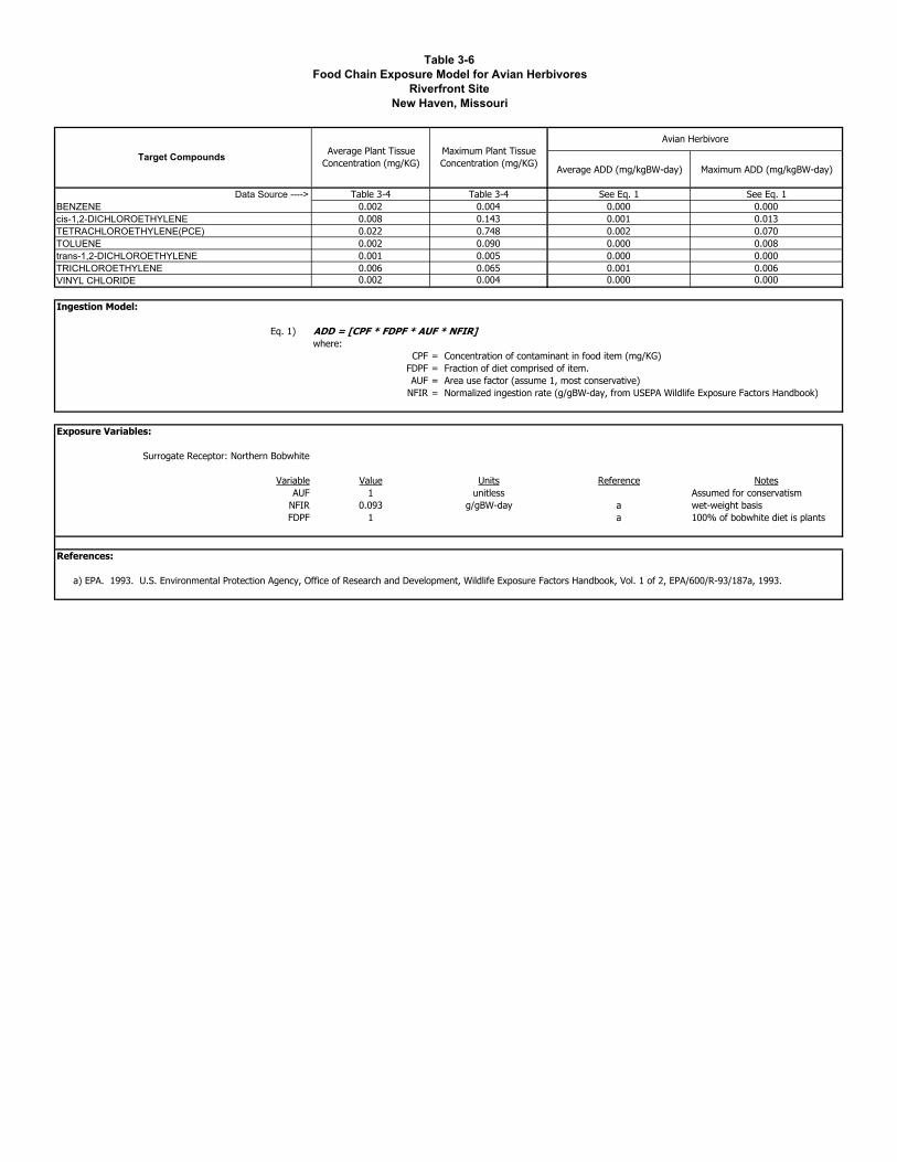
Table 3-6Food Chain Exposure Model for Avian Herbivores
Riverfront SiteNew Haven, Missouri
Average ADD (mg/kgBW-day) Maximum ADD (mg/kgBW-day)
Data Source ----> Table 3-4 Table 3-4 See Eq. 1 See Eq. 1BENZENE 0.002 0.004 0.000 0.000cis-1,2-DICHLOROETHYLENE 0.008 0.143 0.001 0.013TETRACHLOROETHYLENE(PCE) 0.022 0.748 0.002 0.070TOLUENE 0.002 0.090 0.000 0.008trans-1,2-DICHLOROETHYLENE 0.001 0.005 0.000 0.000TRICHLOROETHYLENE 0.006 0.065 0.001 0.006VINYL CHLORIDE 0.002 0.004 0.000 0.000
Ingestion Model:
Eq. 1) ADD = [CPF * FDPF * AUF * NFIR]where:
CPF = Concentration of contaminant in food item (mg/KG)FDPF = Fraction of diet comprised of item.AUF = Area use factor (assume 1, most conservative)
NFIR = Normalized ingestion rate (g/gBW-day, from USEPA Wildlife Exposure Factors Handbook)
Exposure Variables:
Surrogate Receptor: Northern Bobwhite
Variable Value Units Reference NotesAUF 1 unitless Assumed for conservatism
NFIR 0.093 g/gBW-day a wet-weight basisFDPF 1 a 100% of bobwhite diet is plants
References:
a) EPA. 1993. U.S. Environmental Protection Agency, Office of Research and Development, Wildlife Exposure Factors Handbook, Vol. 1 of 2, EPA/600/R-93/187a, 1993.
Maximum Plant Tissue Concentration (mg/KG)
Avian HerbivoreAverage Plant Tissue
Concentration (mg/KG)Target Compounds

Tabl
e 4-
1Ec
otox
icity
Scr
eeni
ng V
alue
s fo
r Sur
face
Soi
lsR
iver
fron
t Site
New
Hav
en, M
isso
uri
Page
1 o
f 1
EPA
Reg
ion
4EP
A R
egio
n 5
Plan
t Tox
icity
Can
adia
n So
il Q
ualit
y
Oth
er
Sour
ces
Scre
enin
g Va
lue
Use
d in
ER
AD
ata
Sour
ce
Ref
eren
ce --
->a
bc
dVo
latil
e O
rgan
ic C
ompo
unds
(ug/
KG
)BE
NZE
NE
5025
5-
500
-50
-50
050
aci
s-1,
2-D
ICH
LOR
OET
HYL
ENE
400
784
--
-40
0-
783.
7340
0a
TETR
ACH
LOR
OET
HYL
ENE(
PCE)
1099
20-
200
-10
-99
2010
aTO
LUEN
E50
5450
2000
0080
0-
50-
2000
0050
atra
ns-1
,2-D
ICH
LOR
OET
HYL
ENE
400
784
--
-40
0-
783.
7340
0a
TRIC
HLO
RO
ETH
YLEN
E (T
CE)
112
400
3000
112
400
1a
VIN
YL C
HLO
RID
E10
646
1064
6.14
10a
Ref
eren
ces:
d) C
CM
OE,
199
9. C
anad
ian
Cou
ncil
of M
inis
ters
of t
he E
nviro
nmen
t, C
anad
ian
Envi
ronm
enta
l Qua
lity
Gui
delin
es,
Can
adia
n So
il Q
ualit
y G
uide
lines
for t
he P
rote
ctio
n of
b) E
PA 1
999.
EPA
Reg
ion
5 R
CR
A Ec
olog
ical
Dat
a Q
ualit
y Le
vels
(ED
QLs
), U
pdat
ed A
pril
1999
.c)
Efro
ymso
n, R
.A.,
M.E
, Sut
er, G
.W.,
and
Woo
ten
A.C
. 19
97a.
Tox
icol
ogic
al B
ench
mar
ks fo
r Scr
eeni
ng P
oten
tial C
onta
min
ants
of C
once
rn fo
r Effe
cts
on T
erre
stria
l Pla
nts:
199
7
Ran
ge o
f Tox
icity
Val
ues
a) E
PA 1
999.
U.S
. Env
ironm
enta
l Pro
tect
ion
Agen
cy R
egio
n 4
Ecol
ogic
al R
isk
Asse
ssm
ent B
ulle
tins
– Su
pple
men
tal t
o R
AGS
– D
raft.
Aug
ust 1
1, 1
999.
Para
met
erN
ame
Ecot
oxic
ity V
alue
s

Tabl
e 4-
2Ec
otox
icity
Scr
eeni
ng V
alue
s fo
r Sed
imen
tR
iver
fron
t Site
New
Hav
en, M
isso
uri
Page
1 o
f 1
EPA
Reg
ion
5
EPA
Ecot
ox
Fres
hSc
reen
ing
Valu
e U
sed
in E
RA
Dat
a So
urce
Ref
eren
ce --
->a
bVo
latil
e O
rgan
ic C
ompo
unds
(ug/
KG
)BE
NZE
NE
142
5757
-14
1.57
57b
cis-
1,2-
DIC
HLO
RO
ETH
YLEN
E20
9-
208.
94-
208.
9420
9a
trans
-1,2
-DIC
HLO
RO
ETH
YLEN
E20
9-
208.
94-
208.
9420
9a
TETR
ACH
LOR
OET
HYL
ENE(
PCE)
196
530
195.
83-
530
196
aTO
LUEN
E52
500
670
670
-52
500
670
bTR
ICH
LOR
OET
HYL
ENE
180
1600
179.
5616
0018
0a
VIN
YL C
HLO
RID
E2
-2
22
a
Ref
eren
ces:
b) U
SEPA
199
6. E
co U
pdat
e (E
coto
x Th
resh
olds
). In
terim
Bul
letin
Vol
ume
3, N
umbe
r 2.
EPA
540/
f-95/
038,
Jan
uary
199
6 - F
resh
wat
er
Ran
ge o
f Tox
icity
Va
lues
Para
met
erN
ame
Ecot
oxic
ity V
alue
s
a) E
PA 1
999.
EPA
Reg
ion
5 R
CR
A Ec
olog
ical
Dat
a Q
ualit
y Le
vels
(ED
QLs
), U
pdat
ed A
pril
1999
.

Tabl
e 4-
3Ec
otox
icity
Scr
eeni
ng V
alue
s fo
r Sur
face
Wat
erR
iver
fron
t Site
New
Hav
en, M
isso
uri
Page
1 o
f 1
EPA
Reg
ion
5
EPA
Ecot
ox
Fres
h
Scre
enin
g Va
lue
Use
d in
ER
AD
ata
Sour
ce
Ref
eren
ce --
->a
bBE
NZE
NE
114
4646
-11
446
bci
s-1,
2-D
ICH
LOR
OET
HYL
ENE
310
-31
0-
310
310
aTE
TRAC
HLO
RO
ETH
YLEN
E(PC
E)8.
912
08.
9-
120
8.9
aTO
LUEN
E25
313
013
0-
253
130
btra
ns-1
,2-D
ICH
LOR
OET
HYL
ENE
310
-31
0-
310
310
aTR
ICH
LOR
OET
HYL
ENE
(TC
E)75
350
75-
350
75a
VIN
YL C
HLO
RID
E9.
2-
9.2
-9.
29.
2a
Ref
eren
ces:
b) U
SEPA
199
6. E
co U
pdat
e (E
coto
x Th
resh
olds
). In
terim
Bul
letin
Vol
ume
3, N
umbe
r 2.
EPA
540/
f-95/
038,
Jan
uary
199
6 - F
resh
wat
er S
urfa
ce W
ater
a)
EPA
199
9. E
PA R
egio
n 5
RC
RA
Ecol
ogic
al D
ata
Qua
lity
Leve
ls (E
DQ
Ls),
Upd
ated
Apr
il 19
99.
Ran
ge o
f Tox
icity
Va
lues
Para
met
erN
ame
Scre
enin
g Ec
otox
icity
Val
ues
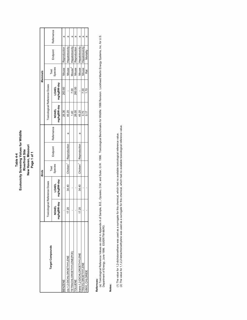
Tabl
e 4-
4Ec
otox
icity
Scr
eeni
ng V
alue
s fo
r Wild
life
Riv
erfr
ont S
iteN
ew H
aven
, Mis
sour
iPa
ge 1
of 1
NO
AEL
m
g/kg
BW
-day
LOA
EL
m
g/kg
BW
-day
NO
AEL
m
g/kg
BW
-day
LOA
EL
m
g/kg
BW
-day
BEN
ZEN
E-
-26
.36
263.
60M
ouse
Rep
rodu
ctio
na
cis-
1,2-
DIC
HLO
RO
ETH
YLEN
E17
.20
34.4
0C
hick
en1
Rep
rodu
ctio
na
45.2
0-
Mou
seH
epat
otox
icity
aTE
TRAC
HLO
RO
ETH
YLEN
E(PC
E)-
-1.
407.
00M
ouse
2H
epat
otox
icity
aTO
LUEN
E-
-26
.00
260.
00M
ouse
Rep
rodu
ctio
na
trans
-1,2
-DIC
HLO
RO
ETH
YLEN
E17
.20
34.4
0C
hick
en1
Rep
rodu
ctio
na
45.2
0-
Mou
seH
epat
otox
icity
aTR
ICH
LOR
OET
HYL
ENE
--
0.70
7.00
Mou
seH
epat
otox
icity
aVI
NYL
CH
LOR
IDE
--
0.17
1.70
Rat
Mor
talit
ya
Ref
ernc
es:
Not
es:
Test
Sp
ecie
s
Toxi
colo
gica
l Ref
eren
ce D
oses
Toxi
colo
gica
l Ref
eren
ce D
oses
Test
Sp
ecie
sEn
dpoi
ntR
efer
nenc
e
(2) T
he v
alue
for 1
,1,2
,2-te
trach
loro
ethy
lene
was
use
d as
a s
urro
gate
for t
his
chem
ical
, whi
ch h
ad n
o av
aila
ble
toxi
colo
gica
l ref
eren
ce v
alue
.
Endp
oint
(1) T
he v
alue
for 1
,2-d
icho
loro
etha
ne w
as u
sed
as a
sur
roga
te fo
r thi
s ch
emic
al, w
hich
had
no
avai
labl
e to
xico
logi
cal r
efer
ence
val
ue.
(a) T
oxic
olog
ical
Ref
eren
ce V
alue
s as
cite
d in
App
endi
x A
of S
ampl
e, B
.E.,
Opr
esko
, D.M
., an
d Su
ter,
G.W
. 19
96.
Toxi
colo
gica
l Ben
chm
akrs
for W
ildlif
e: 1
996
Rev
isio
n. L
ockh
eed
Mar
tin E
nerg
y Sy
stem
s, In
c. fo
r U.S
. D
epar
tmen
t of E
nerg
y, J
une
1996
. ES
/ER
/TM
-86/
R3.
Ref
erne
nce
Targ
et C
ompo
unds
Birds
Mammals

Tabl
e 5-
1R
isk
Cha
ract
eriz
atio
n fo
r Foo
d C
hain
Exp
osur
e to
Mam
mal
ian
Her
bivo
res
Riv
erfr
ont S
iteN
ew H
aven
, Mis
sour
iPa
ge1
of 1
NO
AEL
LOAE
LN
OAE
LLO
AEL
BEN
ZEN
E0.
0023
0.00
4226
.426
3.6
0.00
0087
0.00
0009
0.00
0159
0.00
0016
cis-
1,2-
DIC
HLO
RO
ETH
YLEN
E0.
008
0.14
345
.2-
0.00
0175
-0.
0031
64-
TETR
ACH
LOR
OET
HYL
ENE(
PCE)
0.02
20.
748
1.4
7.0
0.01
5714
0.00
3143
0.53
4286
0.10
6857
TOLU
ENE
0.00
20.
090
26.0
260.
00.
0000
770.
0000
080.
0034
620.
0003
46tra
ns-1
,2-D
ICH
LOR
OET
HYL
ENE
0.00
120.
0045
45.2
-0.
0000
27-
0.00
0100
-TR
ICH
LOR
OET
HYL
ENE
0.00
60.
065
0.7
7.0
0.00
8571
0.00
0857
0.09
2857
0.00
9286
VIN
YL C
HLO
RID
E0.
0023
0.00
400.
21.
70.
0135
290.
0013
530.
0235
290.
0023
53
Targ
et C
ompo
unds
Expo
sure
Expo
sure
Toxi
city
Aver
age
ADD
(m
g/kg
BW-d
ay)
Max
imum
AD
D
(mg/
kgBW
-day
)LO
AEL
m
g/kg
BW-d
ay
Risk
Cha
ract
eriz
atio
n
HQ
= E
xpos
ure/
Toxi
city
Toxi
city
Max
imum
AD
D
NO
AEL
m
g/kg
BW-d
ayAv
erag
e AD
D

Tabl
e 5-
2R
isk
Cha
ract
eriz
atio
n fo
r Foo
d C
hain
Exp
osur
e to
Avi
an H
erbi
vore
sR
iver
fron
t Site
New
Hav
en, M
isso
uri
Page
1 of
1
NO
AEL
LOAE
LN
OAE
LLO
AEL
BEN
ZEN
E0.
0002
0.00
04-
--
--
-ci
s-1,
2-D
ICH
LOR
OET
HYL
ENE
0.00
10.
013
17.2
34.4
0.00
0043
0.00
0021
0.00
0773
0.00
0387
TETR
ACH
LOR
OET
HYL
ENE(
PCE)
0.00
20.
070
--
--
--
TOLU
ENE
0.00
00.
008
--
--
--
trans
-1,2
-DIC
HLO
RO
ETH
YLEN
E0.
0001
0.00
0417
.234
.40.
0000
060.
0000
030.
0000
240.
0000
12TR
ICH
LOR
OET
HYL
ENE
0.00
10.
006
--
--
--
VIN
YL C
HLO
RID
E0.
0002
0.00
04-
--
--
-
NO
AEL
m
g/kg
BW-d
ayAv
erag
e AD
D
LOAE
L
mg/
kgBW
-day
Risk
Cha
ract
eriz
atio
n
HQ
= E
xpos
ure/
Toxi
city
Toxi
city
Max
imum
AD
D
Targ
et C
ompo
unds
Expo
sure
Expo
sure
Toxi
city
Aver
age
ADD
(m
g/kg
BW-d
ay)
Max
imum
AD
D
(mg/
kgBW
-day
)

This page intentionally left blank

Figures