us environmental protection agency (epa) region 9
TRANSCRIPT

1
US Environmental Protection Agency (EPA) Region 9
Underground Injection Control (UIC) Program
AQUIFER EXEMPTION RECORD OF DECISION This Record of Decision (ROD) provides the EPA’s decision to approve an expansion of the aquifer exemption (AE) for the Santa Margarita Formation of the Fruitvale Oil Field, background information concerning the AE request, and the basis for the AE decision.
Primacy Agency: California Division of Oil, Gas, & Geothermal Resources (DOGGR)
Date of Aquifer Exemption Request: November 8, 2016
Exemption Criteria: DOGGR requests this exemption because it has determined that it meets the criteria at 40 CFR § 146.4(a) and § 146.4(c).
Substantial or Non-Substantial Program Revision: Non-Substantial
Although the EPA must approve all revisions to the EPA-approved state UIC programs, the process differs depending on whether the EPA finds the revision to be a substantial or non-substantial program revision. EPA determined this is a non-substantial program revision because it is associated with an expansion to an existing aquifer exemption in an active oil field and is not a state-wide programmatic change or a program revision with unique or significant implications for the State’s UIC program. The decision to treat this AE request as a non-substantial program revision is also consistent with the EPA’s “Guidance for Review and Approval of State Underground Injection Control (UIC) Programs and Revisions to Approved State Programs” (“Guidance 34”), which explains that the determination whether a program revision is substantial or non-substantial is made on a case-by-case basis.
Operator: Hathaway LLC.
Well/Project Name: Santa Margarita Formation, Fruitvale Oil Field. (Refer to Figure 1).
Well/Project Permit Number: The exemption is requested for a portion of the aquifer in the area of the Fruitvale Oil Field. There are no current Class II permits for injection wells in the portion of the formation proposed for exemption.
Well/Project Location: The AE is located in: Township 28S Range 27E, Sections 32-34; Township 29S Range 26E, Sections 11-14, 23-26, 35, 36; Township 29S Range 27E, Sections 2-11, 14-24, 26-34; and Township 30S Range 26E, Sections 1-2 MDB&M (Mount Diablo Base and Meridian). [Refer to Figure 2].
County: Kern State: California
Well Class/Type: Class II Enhanced Oil Recovery (EOR) and Waste Disposal (WD) wells.

2
DESCRIPTION OF PROPOSED AQUIFER EXEMPTION
Aquifer to be Exempted: A portion of the Santa Margarita Formation within the area of the Fruitvale Oil Field.
Areal Extent of Aquifer Exemption: The areal extent of the AE is approximately 19,300 acres, including the hydrocarbon producing area which was exempted at the time of DOGGR’s primacy approval (comprised of approximately 4,150 acres), the current hydrocarbon producing area outside of the productive boundaries approved at primacy, and planned future commercially producible areas and zones. DOGGR has provided a GIS shape file that delineates the AE boundary, which is incorporated in the administrative record of this ROD. Refer to Figure 2 for a depiction of the proposed exemption.
Lithology, Total Dissolved Solids (TDS), Depth, Thickness, Porosity, and Permeability of the Aquifer: Sampling data provided in the operator’s AE request reflects samples taken between 1986 and 2006 at various depths within the Santa Margarita Formation. The following table presents the lithology, TDS levels, depth, thickness, and average porosity and permeability information about the aquifer proposed for exemption.
Aquifer Santa Margarita Formation
Lithology The upper two-thirds of the formation consists of fine to coarse-grained, unconsolidated, generally subangular, moderately sorted sand. The lower third of the formation is comprised of shaley sand with a matrix of well-sorted sand, with interbedded silty and clayey sands.
TDS (mg/L) 7,179 mg/L (average of 6 samples ranging from 5,630 mg/L to 10,000 mg/L)
Depth to Top (feet bgs) 3,500 to 6,400 feet
Thickness (feet) 780 to 1,030 feet
Average Porosity and Permeability
Porosity averages 26%. Permeability is <10 to 6,400 millidarcies (mD), averaging 975 mD. Lower values are associated with clay interbedded layers.
Confining Zone(s): The upper confining zone is a 10 to 50-foot thick shale layer at the base of the Chanac Formation, which conformably overlies the Santa Margarita Formation. The permeability of the shale layer in the Chanac Formation is 2-3 mD. The lower confining zone is the Fruitvale Shale, which is 100 to 1,500 feet thick in the area proposed for exemption with an average permeability of 2 mD. The Santa Margarita Formation is laterally bounded by sealing faults on the east (by the Fairhaven Fault), and to the north and south (by unnamed faults). The formation is confined on the west by a facies change to the impermeable McLure Shale. [Refer to Figure 3, Parts A-C].

3
BACKGROUND
On November 8, 2016, DOGGR submitted a request for EPA Region 9 approval to expand the current AE designation for the Santa Margarita Formation of the Fruitvale Oil Field in the City of Bakersfield, Kern County, California. DOGGR reviewed the operator’s request and proposed this AE based on the criteria at 40 CFR § 146.4(a): that it does not currently serve as a source of drinking water; and at 40 CFR § 146.4(c): that the TDS content of the ground water is more than 3,000 milligrams per liter (mg/L) and less than 10,000 mg/L and it is not reasonably expected to supply a public water system. Subsequent to the EPA’s approval of the AE, the exempt formation would not be protected as an “underground source of drinking water” (USDW) under the Safe Drinking Water Act (SDWA) and therefore, would allow DOGGR, subject to state regulatory requirements, to approve Class II injection into the identified formation, either for EOR and/or for disposal of fluid associated with oil and gas production.
The Fruitvale Oil Field has been producing hydrocarbons since 1929. Production peaked in the middle of the 20th century when improved EOR techniques were developed and deployed. The Fruitvale Oil Field is currently divided into three areas: the Main Area, the Calloway Area, and the Greenacres Area. Formations beneath the Main, Calloway, and Greenacres Areas have existing aquifer exemptions (of the Etchegoin, Chanac and Santa Margarita Formations) approved at the time of Class II primacy in 1983, based on commercial petroleum production boundaries depicted in the document, “California Oil and Gas Fields, Vol. I, North and East Central California, 1973.” In the Fruitvale Field’s Main Area, only the Santa Margarita formation was exempted at primacy.
Historic production (pre-1973) occurred outside of the 1973 productive area boundaries, however, production since 1973 has occurred only within these boundaries. The Santa Margarita Formation remains an active producer in the Fruitvale Oil Field. Oil is also produced from the basal Etchegoin and Chanac Formations.
BASIS FOR DECISION
Regulatory Criteria under which the AE is Requested and Approved
40 CFR § 146.4(a) It does not currently serve as a source of drinking water.
In their concurrence on this AE package, the State Water Resources Control Board (State Board) determined that the portion of the Santa Margarita Formation to be exempted is not currently a source of drinking water, and it is not hydraulically connected to domestic or public water supply wells. This is based on the evaluation of information about water supply wells in the area, the formation’s properties, ground water flow patterns, and confinement of the formation to ground water flow. These reviews demonstrate that the aquifer identified for exemption does not currently serve as a source of drinking water because there are no identified current drinking water supply wells, public or private that currently or in the future would draw water from the portion of the Santa Margarita Formation proposed for exemption, the formation is vertically and laterally confined (separated) from other USDWs, and no aquifers that serve as sources of drinking water are hydraulically connected to the aquifer. Further, within the state’s search area

4
described more fully below, there are no drinking water wells in the Santa Margarita Formation outside the area proposed for exemption. All drinking water supply wells are in the shallow Kern River Formation.
Water Supply Wells: The State’s AE proposal included information about water wells in the area proposed for exemption to confirm that no drinking water wells or other water supply wells draw from the aquifer proposed for exemption. To ensure a complete evaluation of all water wells in the area, the State Board reviewed Department of Water Resources’ data files, and also conducted a review of aerial imaging and ground surveillance information. The state noted that typical water well surface locations are reported as a distance from the property or section corner, street center line and/or California coordinates. Because of this, the State Board noted that the true location of water wells may vary based on the accuracy of reported data. To address this, the state reviewed information about water wells within the area proposed for exemption as well as an area that encompasses an additional one-quarter mile buffer around the surface of the proposed exempted area. The analysis also included a search for any wells that might be completed in the Santa Margarita formation for six miles to the east of the proposed exemption boundary. This well search area was utilized because the portion of the Santa Margarita proposed for exemption is hydraulically isolated by structural faulting to the north, south, and east, and by a facies change to the west and known water supply wells are completed in formations over 1,500 feet above the Santa Margarita. Reports on water chemistry and pumping rates of the identified wells was not included because none of the water wells are hydraulically connected to the Santa Margarita Formation proposed for exemption. Data regarding these water wells, all of which are completed within the shallower Kern River Formation and alluvium, is summarized in Appendix 1 of the Application.
No public drinking water supplies or private wells within the area studied currently use the Santa Margarita Formation as a source of drinking water. The area proposed for exemption is within Bakersfield city limits, and the City is serviced with water supplied by the City of Bakersfield and the California Water Service. This water is sourced from the Central Valley Project and utility-owned wells that draw from the shallower and hydraulically isolated Kern River Formation.
Within a one-quarter mile distance around the area proposed for exemption, a total of 1,248 active water wells (including 44 public water supply wells) and 1,228 abandoned water wells were identified. All of these identified domestic and public water supply wells are completed in formations above the Santa Margarita Formation and upper sealing formation within the alluvium and Kern River series, which are over 1,500 feet shallower than the Santa Margarita Formation.
DOGGR and the State Board conducted additional investigations outside of the one-quarter mile study area to confirm that the Santa Margarita Formation does not currently serve as a water supply up-dip past the adjacent Round Mountain Oil Field. Specifically, the Santa Margarita Formation is not present to the west of the Fruitvale Field, therefore the search extended only in the eastern direction. In the eastern direction the search extended to the Round Mountain Field administrative boundary which is approximately 6 miles from the proposed Fruitvale aquifer exemption boundary. Available data on active water supply wells (including domestic wells and

5
other types of water wells) were gathered from the Department of Water Resources and field inspections. This expanded investigation confirmed there are no water supply wells in that portion of the Santa Margarita Formation, and provided further support for the State Board’s determination that the formation proposed for exemption is not currently a source of drinking water and is not hydraulically connected to domestic or public water supply wells. Ground Water Flow Patterns: DOGGR evaluated available hydrogeologic information on the Santa Margarita Formation, including ground water flow maps, surface elevation, and composite water elevation from water depths in water wells in the formation reported at the time those wells were drilled.
The Santa Margarita Formation in the area proposed for exemption is hydrogeologically isolated from its surroundings, as it is confined by structural faulting to the north, south, and east, and by a facies change to the west. The formation is not in contact with surface recharge. Therefore, the fluid formation gradients within the formation in the area proposed for exemption are controlled by the hydrocarbon production activities and disposal (i.e., injection) activities in the formation from active Class V wells. Based on the hydrodynamic effects of injection and pumping operations, groundwater flow is presumed to be away from the injection wells and inward, toward the production wells.
Confinement of the Formation to Ground Water Flow: The Fruitvale Oil Field consists of a series of rock layers dipping in the same direction (known as a “homocline”), cut by sealing cross-faulting that creates barriers (“traps”) to fluid and hydrocarbon migration within the productive areas. Above the production zone is an upper sealing layer, the 10- to 50-foot thick Basal Chanac Shale, which has a permeability of 2-3 mD and prevents vertical migration of fluids. In addition, more than 1,500 feet separate the top of the Santa Margarita Formation and the lowermost USDW currently in use, the Kern River Formation, providing additional confinement. Downward migration of fluid is prevented by the Fruitvale Shale, which varies in thickness from 100 to 1,500 feet thick in the area proposed for exemption and has a permeability of 2 mD. These impermeable layers prevent vertical migration out of the area proposed for exemption.
In the area proposed for exemption, the Santa Margarita Formation is geologically contained by sealing faults to the north, south, and east. To the west, the facies change into the McLure Shale prevents lateral migration. DOGGR evaluated well data, water quality data, hydrocarbon production data, and geologic information about the faults, which demonstrate that the fault systems provide horizontal confinement between the aquifer proposed for exemption and drinking water supplies in the area:
• Unnamed Fault/Northern Boundary: Offsets in stratigraphy across the fault and differences in producible hydrocarbons across the fault support the sealing nature of the fault.
• Fairhaven Fault/Eastern Boundary: Differences in hydrocarbon production across the fault support the sealing nature of the fault. Wells on the eastern side of the fault are nonproductive for hydrocarbons, while wells to the west are productive.
6
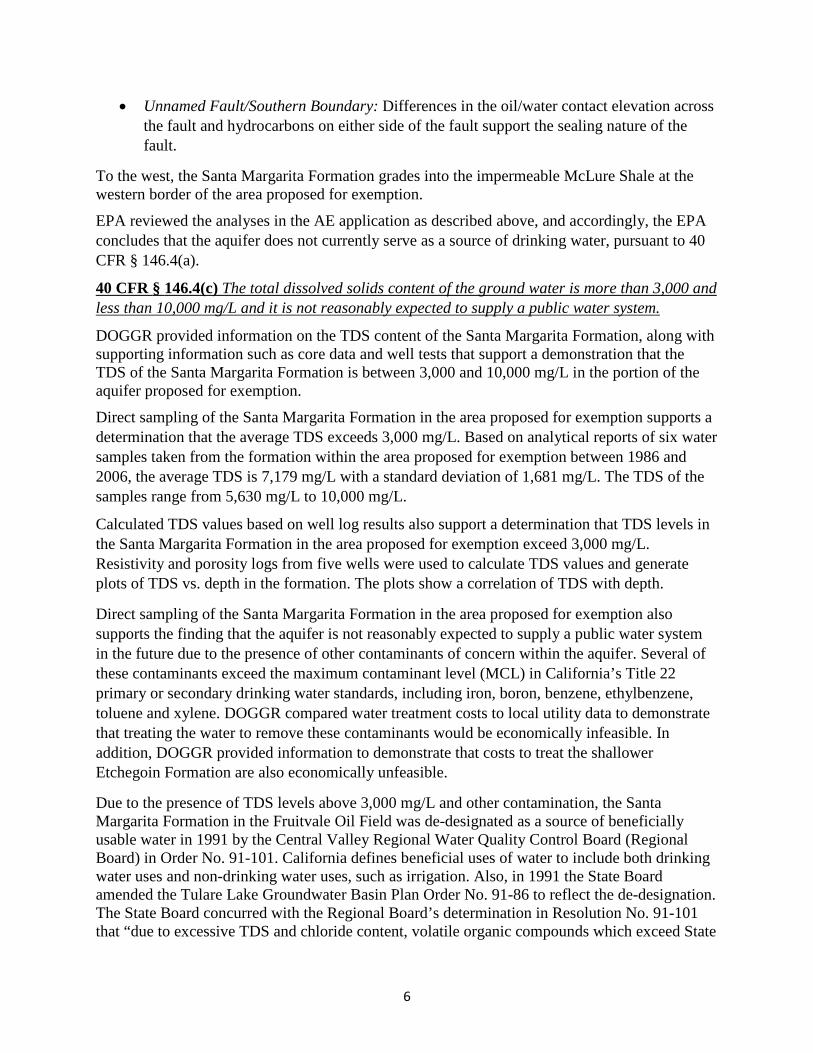
• Unnamed Fault/Southern Boundary: Differences in the oil/water contact elevation across the fault and hydrocarbons on either side of the fault support the sealing nature of the fault.
To the west, the Santa Margarita Formation grades into the impermeable McLure Shale at the western border of the area proposed for exemption.
EPA reviewed the analyses in the AE application as described above, and accordingly, the EPA concludes that the aquifer does not currently serve as a source of drinking water, pursuant to 40 CFR § 146.4(a).
40 CFR § 146.4(c) The total dissolved solids content of the ground water is more than 3,000 and less than 10,000 mg/L and it is not reasonably expected to supply a public water system.
DOGGR provided information on the TDS content of the Santa Margarita Formation, along with supporting information such as core data and well tests that support a demonstration that the TDS of the Santa Margarita Formation is between 3,000 and 10,000 mg/L in the portion of the aquifer proposed for exemption.
Direct sampling of the Santa Margarita Formation in the area proposed for exemption supports a determination that the average TDS exceeds 3,000 mg/L. Based on analytical reports of six water samples taken from the formation within the area proposed for exemption between 1986 and 2006, the average TDS is 7,179 mg/L with a standard deviation of 1,681 mg/L. The TDS of the samples range from 5,630 mg/L to 10,000 mg/L.
Calculated TDS values based on well log results also support a determination that TDS levels in the Santa Margarita Formation in the area proposed for exemption exceed 3,000 mg/L. Resistivity and porosity logs from five wells were used to calculate TDS values and generate plots of TDS vs. depth in the formation. The plots show a correlation of TDS with depth.
Direct sampling of the Santa Margarita Formation in the area proposed for exemption also supports the finding that the aquifer is not reasonably expected to supply a public water system in the future due to the presence of other contaminants of concern within the aquifer. Several of these contaminants exceed the maximum contaminant level (MCL) in California’s Title 22 primary or secondary drinking water standards, including iron, boron, benzene, ethylbenzene, toluene and xylene. DOGGR compared water treatment costs to local utility data to demonstrate that treating the water to remove these contaminants would be economically infeasible. In addition, DOGGR provided information to demonstrate that costs to treat the shallower Etchegoin Formation are also economically unfeasible.
Due to the presence of TDS levels above 3,000 mg/L and other contamination, the Santa Margarita Formation in the Fruitvale Oil Field was de-designated as a source of beneficially usable water in 1991 by the Central Valley Regional Water Quality Control Board (Regional Board) in Order No. 91-101. California defines beneficial uses of water to include both drinking water uses and non-drinking water uses, such as irrigation. Also, in 1991 the State Board amended the Tulare Lake Groundwater Basin Plan Order No. 91-86 to reflect the de-designation. The State Board concurred with the Regional Board’s determination in Resolution No. 91-101 that “due to excessive TDS and chloride content, volatile organic compounds which exceed State
7
Action Levels, high oil and grease content, and cost of treatment, the ground water contained in the basal Etchegoin, Chanac and Santa Margarita formations within the Fruitvale Oil Field and within one-quarter mile outside the boundary of the Fruitvale Oil Field cannot reasonably be expected to supply a public water system.” The de-designation further stated that the ground water in the Santa Margarita Formation “could not reasonably be treated for domestic use by using best management practices or best economically achievable treatment practices.” Based on the history of oil production and injection of wastes into the zone in the area proposed for exemption, and the State Board’s concurrence with the proposed exemption as submitted by DOGGR, re-designation of the Santa Margarita Formation for future beneficial use, as defined by the State, is not reasonably expected. In addition, the potential costs required to treat water from the Santa Margarita Formation for a future public water source indicate it would not be reasonably likely to be used as a drinking water source. Pre-treatment costs were obtained for produced water from the Fairhaven Zone, which is stratigraphically approximately 1,000 feet above the Santa Margarita Formation and it has better water quality (lower levels of TDS and other constituents). Including removal of oil and grease, the cost estimate would be $0.105 per barrel (bbl). With capital costs as well as installation, start up, labor and taxes, water treatment expenses would exceed $0.25 a bbl. This estimate does not account for electricity costs to pump the formation water from 4,000 feet below ground surface. Shallower zones typically cost less to utilize for drinking water sources, and higher water quality is less expensive to treat. Therefore, water supply cost estimates for the Fairhaven Zone would be less than potential costs of treatment of the Santa Margarita Formation for use as a public drinking water supply. According to the California Water Service, which serves the nearby residents of Bakersfield, the average homeowner spends $910 per year for water. The State verified the conclusions in the AE application that treatment of water from the shallow Fairhaven Zone within the footprint of the proposed exemption area alone would result in more than a doubling of existing residential water bills. As a result, it is not reasonably expected that the Santa Margarita Formation would be used as a public water source in the future. Based on a review of this information, the EPA concludes that the Santa Margarita Formation in the Fruitvale Oil Field contains greater than 3,000 but less than or equal to 10,000 mg/L TDS and it is not reasonably expected to supply a public water system. As such, the EPA has determined that the aquifer proposed for exemption meets the criteria at 40 CFR § 146.4(c).
PUBLIC NOTICE AND COMMENT DOGGR provided public notice of this proposed AE on July 15, 2016. A public hearing was held on August 15, 2016 in Bakersfield, CA. The written comment period closed on August 29, 2016. DOGGR provided the EPA a summary of the public comments, copies of the public comments submitted, a transcript of the public hearing, and their responses to the written and verbal comments. In making this decision, the EPA considered all of the information submitted by the State, including all the written and oral comments submitted to the State during its public comment process. In two public comment letters to DOGGR, which were also provided to the EPA, the Center for Biological Diversity (CBD) raised concerns regarding protection of species under the

8
federal Endangered Species Act. This issue is outside the scope of EPA’s AE decision as this action does not authorize future injection activities at the surface. Approval of this aquifer exemption concerns groundwater over 3,500 feet below the surface, and a review of materials submitted by the commenter indicate that there are no subsurface listed threatened or endangered species that would be affected by the EPA’s approval. Additionally, the EPA considered written comments in an unsolicited letter from the Center for Biological Diversity submitted directly to the EPA outside the public comment process provided by DOGGR. In the letter, CBD requested that the EPA conduct formal notice and provide an opportunity for public comment and a public hearing for the proposed aquifer exemption. However, federal UIC regulations do not require the EPA to provide an additional opportunity for public comment for a non-substantial program revision, and it was determined that an additional public comment period would not likely yield additional comments that were not already raised during the State’s process, which was conducted consistent with 40 CFR § 144.7. While the EPA is not required to conduct public notice on non-substantial program revisions submitted by a primacy state, the EPA is exercising its discretion to respond to the comments that pertain to the EPA’s action and authority. The majority of the issues raised in the unsolicited comment letter from CBD are addressed above in this decision document; additional responses are below. The commenter questioned whether the current technical criteria to consider future drinking water uses is adequate to consider changing climate conditions and new technology available for water treatment. In considering whether the area proposed for exemption cannot now and will not in the future serve as a source of drinking water, the EPA reviewed data regarding the level of contaminants in the groundwater and information on the economic infeasibility of treatment of this water for human consumption. Even with the potential for improved treatment technology and higher demand for drinking water due to drought or scarcity, shallower aquifers than the Santa Margarita Formation would provide higher quality water for public water systems. In addition, the State’s AE application included information on availability of higher quality water in shallower aquifers currently used for drinking water and the de-designation of this aquifer as a potential source of drinking water by the State Board. As a result, the EPA concluded this aquifer is not reasonably expected to supply a public water system. The commenter also requested the EPA reject the exemption request before environmental review has occurred under the National Environmental Policy Act (NEPA). The EPA believes that the public comment and hearing procedures afforded by DOGGR and the in-depth technical analysis to protect USDWs required in the aquifer exemption proposal process under the EPA’s UIC regulations and the enabling legislation in the SDWA provide a functionally equivalent environmental review for this action. The commenter noted that the proposed exemption overlaps with the administrative boundary of the Kern Front oil field and expressed concern that the proposed exemption area would jeopardize the water quality of the non-exempt portions of the formation underlying that field. On December 29, 2016 DOGGR submitted a letter to the EPA to clarify that the portion of the Kern Front Oil field administrative boundary, which is included within the area proposed for exemption, is hydraulically isolated from the main portion of the Santa Margarita Formation

9
beneath the administrative boundary of the Kern Front field. The Santa Margarita Formation underlying the Kern Front field has been historically treated as exempt, but under current state regulations (14 CCR § 1779.1(b)), injection must cease unless and until the EPA determines, subsequent to April 20, 2015 that the aquifer or portion of the aquifer meets the criteria for exemption. An additional comment suggested that the aquifer exemption request should be considered “substantial” by EPA guidance as the proposed changes are less stringent under Section 1425 of SDWA due to endangerment of nearby USDWs. The EPA is approving this aquifer exemption as it meets the criteria found at 40 CFR § 146.4. The State’s proposed aquifer exemption is not a program revision to DOGGR’s approved primacy program for Class II that makes the program less stringent than SDWA Section 1425. In this case, the EPA’s approval of the State’s identification of a portion of Santa Margarita Formation as exempt relies on the geologic and hydrogeologic information provided by the State about the area proposed for exemption. The EPA agrees that the State’s information demonstrates that the aquifer is not a current source of drinking water and will not serve as a future source of drinking water under 40 CFR § 146.4. Therefore, this aquifer exemption is not a “substantial” change to DOGGR’s primacy program that is less stringent than required by Section 1425 of SDWA. The commenter suggest that even if the EPA determines this aquifer exemption request is non-substantial, that it is a “complex” exemption request and should be subject to notice and comment. In the EPA’s 1983 Proposed UIC Rule cited by the commenter for this assertion, the EPA identified aquifer exemptions under 40 CFR § 146.4(c) as the types of exemption requests that could be considered “minor ” and further, that the EPA may choose whether “significant and far-reaching” effects of a proposed exemption should be subject to additional rulemaking procedures.1 This exemption request was made under 40 CFR § 146.4(c), as it was determined by the State that the portion of the aquifer cannot now and will not in the future serve as a source of drinking water because the TDS content is between 3,000-10,000 mg/L and it is not reasonably expected to supply a public water system. The EPA’s determination to treat a program revision consisting of an aquifer exemption as a substantial or non-substantial program revision is made on a case-by case basis. The EPA determined this aquifer exemption request is non-substantial as it is a geographically specific expansion of an existing aquifer exemption in an active oil field, and it does not include changes to the statewide UIC primacy program or present unique or significant implications for the State’s UIC program. In addition, the portion of the Santa Margarita aquifer proposed for exemption has already been de-designated as a source of drinking water by the State due to high levels of contaminants that render it not reasonably expected to be used as a public water source. Upon review of the proposed exemption the EPA does not view this exemption request as presenting unusual risks to USDWs, unique policy considerations or other circumstances that have “significant and far reaching effects” to the State’s UIC program and therefore has determined it should be treated as a non-substantial program revision. The commenter expressed concern about an evaluation of the cumulative effects of this exemption with potential future exemption requests for the same formations. The commenter 1 See, “US EPA Underground Injection Control: Federally Administered Programs,” 48 Fed. Reg. 40098 (Sept. 2, 1983).

10
also raised concern over the lack of state environmental review under CEQA due to potential land use changes in Kern County, and the absence of an evaluation of potential seismicity risk from injection activities. These issues are outside of the scope of the EPA’s review in approving an aquifer exemption. DOGGR has primary permitting and enforcement authority over the Class II program in California, and operators may seek permits from DOGGR in the future, which authorize activities such as Class II injection well permits. The State’s consideration of these permits, in accordance with applicable state and federal requirements, is expected to address these issues at the time of permitting.
CONCLUSION AND DECISION Based on a review of the entire record, including all the written and oral comments submitted to DOGGR during its public comment process, the EPA finds that the exemption criteria at 40 CFR § 146.4(a) and § 146.4(c) have been met and the EPA approves the aquifer exemption request as a non-substantial program revision.
Effective Date: February 9, 2017
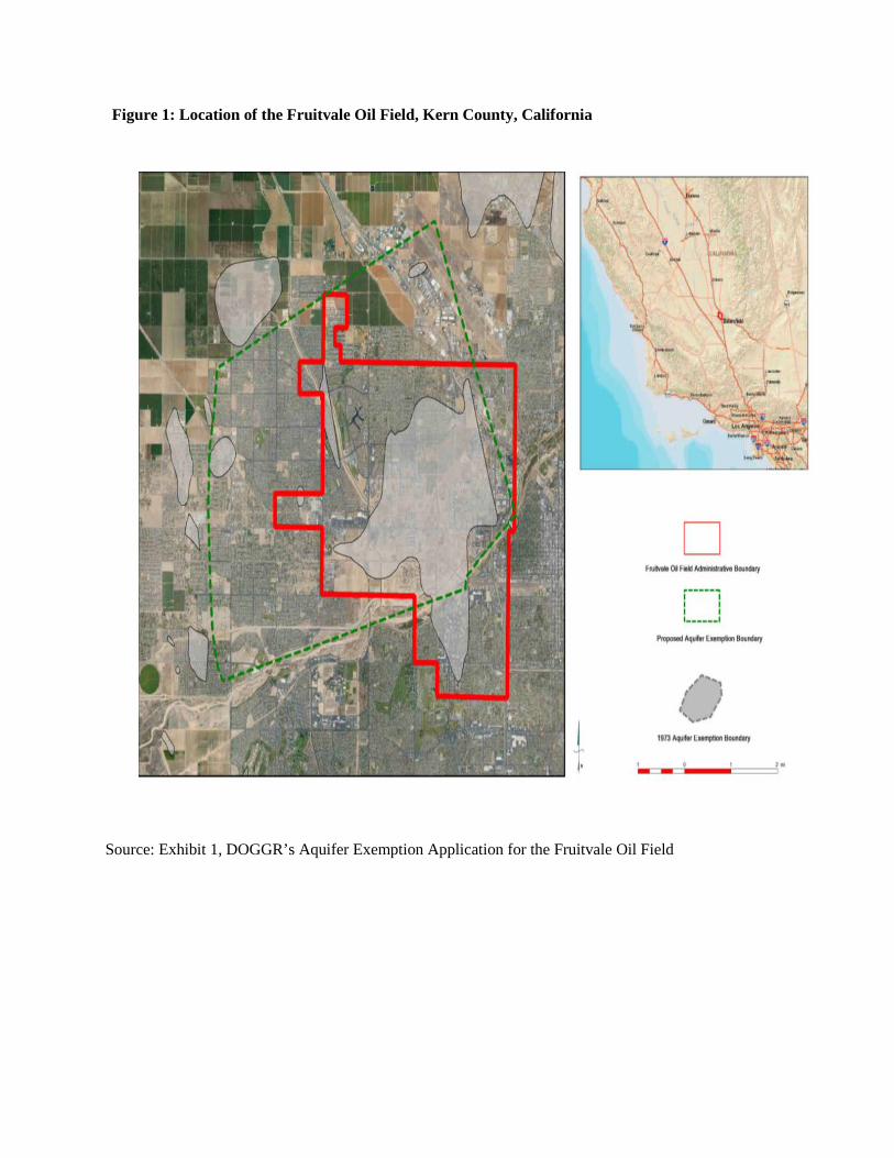
Figure 1: Location of the Fruitvale Oil Field, Kern County, California
Source: Exhibit 1, DOGGR’s Aquifer Exemption Application for the Fruitvale Oil Field

Figure 2: Santa Margarita Formation Aquifer Exemption Location Map with Identifying Features, Fruitvale Oil Field, Kern County, California
Source: DOGGR’s Aquifer Exemption Application for the Fruitvale Oil Field
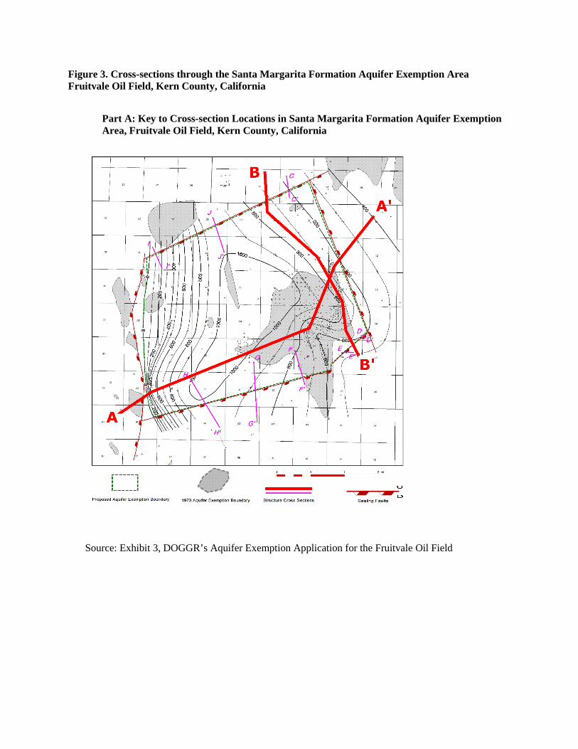
Figure 3. Cross-sections through the Santa Margarita Formation Aquifer Exemption Area Fruitvale Oil Field, Kern County, California
Part A: Key to Cross-section Locations in Santa Margarita Formation Aquifer Exemption Area, Fruitvale Oil Field, Kern County, California
Source: Exhibit 3, DOGGR’s Aquifer Exemption Application for the Fruitvale Oil Field

Part B: Cross Section A-A’ across the Santa Margarita Formation Aquifer Exemption Area Fruitvale Oil Field, Kern County, California
Source: Exhibit 4, DOGGR’s Aquifer Exemption Application for the Fruitvale Oil Field

Part C: Cross Section B-B’ across the Santa Margarita Formation Aquifer Exemption Area Fruitvale Oil Field, Kern County, California
Source: Exhibit 4, DOGGR’s Aquifer Exemption Application for the Fruitvale Oil Field