environmental impact statement (eis) assessment report
TRANSCRIPT

Environmental Impact Statement (EIS) assessment report under the
Environmental Protection Act 1994
Isaac Downs Project
proposed by Stanmore IP South Pty Ltd
March 2021

ii
Prepared by: Environmental Impact Assessment, Department of Environment and Science
© State of Queensland, 2021. The Department of Environment and Science acknowledges Aboriginal peoples and Torres Strait Islander peoples as the Traditional Owners and custodians of the land. We recognise their connection to land, sea and community, and pay our respects to Elders past, present and emerging.
The department is committed to respecting, protecting and promoting human rights, and our obligations under the Human Rights Act 2019.
The Queensland Government supports and encourages the dissemination and exchange of its information. This work is licensed under a Creative Commons Attribution 4.0 International License.
Under this licence you are free, without having to seek our permission, to use this publication in accordance with the licence terms. You must keep intact the copyright notice and attribute the State of Queensland as the source of the publication.
For more information on this licence, visit https://creativecommons.org/licenses/by/4.0/
Disclaimer
This document has been prepared with all due diligence and care, based on the best available information at the time of publication. The department holds no responsibility for any errors or omissions within this document. Any decisions made by other parties based on this document are solely the responsibility of those parties. Information contained in this document is from a number of sources and, as such, does not necessarily represent government or departmental policy.
If you need to access this document in a language other than English, please call the Translating and Interpreting Service (TIS National) on 131 450 and ask them to telephone Library Services on +61 7 3170 5470.
This publication can be made available in an alternative format (e.g. large print or audiotape) on request for people with vision impairment; phone +61 7 3170 5470 or email <[email protected]>.
March 2021

EIS assessment report for the Isaac Downs Project
iii
Contents Contents ................................................................................................................................................. iii
List of tables .......................................................................................................................................... vi
List of figures ......................................................................................................................................... vi
1 Introduction ...................................................................................................................................... 1
2 Project description........................................................................................................................... 2
2.1 Project location ........................................................................................................................... 2
2.2 Tenure ........................................................................................................................................ 5
2.3 Relationship with Isaac Plains Mine ........................................................................................... 5
2.4 Sensitive receptors ..................................................................................................................... 5
2.5 Workforce ................................................................................................................................... 6
2.6 Mine plan ................................................................................................................................... 6
2.7 Levee ......................................................................................................................................... 9
2.8 Mine infrastructure .................................................................................................................... 10
2.9 Construction ............................................................................................................................. 10
2.10 Mining operation ....................................................................................................................... 11
2.11 Site disturbance and cumulative impacts .................................................................................. 11
3 Environmental impact assessment process ................................................................................ 13
3.1 Environmental Protection Act 1994 .......................................................................................... 13
3.2 Environment Protection and Biodiversity Conservation Act 1999 .............................................. 14
3.3 Consultation ............................................................................................................................. 15
3.3.1 Commonwealth Department of the Environment and Energy ............................................ 15
3.3.2 Public consultation ............................................................................................................ 16
3.3.3 Advisory body .................................................................................................................... 16
3.3.4 Public notification .............................................................................................................. 17
3.3.5 Key matters raised in submissions .................................................................................... 18
3.4 Matters considered in the EIS assessment ............................................................................... 20
4 Assessment of the EIS .................................................................................................................. 21
4.1 Project alternatives ................................................................................................................... 21
4.2 Climate ..................................................................................................................................... 21
4.2.1 Assessment....................................................................................................................... 22
4.2.2 Conclusions....................................................................................................................... 22
4.3 Land ......................................................................................................................................... 22
4.3.1 Assessment....................................................................................................................... 23
4.3.2 Conclusions and recommendations ................................................................................... 25
4.4 Rehabilitation ........................................................................................................................... 25
4.4.1 Assessment....................................................................................................................... 26
4.4.2 Conclusions and recommendations ................................................................................... 28

EIS assessment report for the Isaac Downs Project
iv
4.5 Water ....................................................................................................................................... 29
4.5.1 Assessment....................................................................................................................... 29
4.5.2 Water resources ................................................................................................................ 34
4.5.3 Flooding ............................................................................................................................ 36
4.5.4 Conclusions and recommendations ................................................................................... 37
4.6 Regulated structures ................................................................................................................ 37
4.6.1 Assessment....................................................................................................................... 38
4.6.2 Conclusions and recommendations ................................................................................... 39
4.7 Flora and fauna ........................................................................................................................ 39
4.7.1 Assessment – existing environmental values .................................................................... 39
4.7.2 Assessment – potential impacts and proposed mitigation measures ................................. 46
4.7.3 Conclusions and recommendations ................................................................................... 50
4.7.4 Biosecurity ........................................................................................................................ 51
4.7.5 Offsets ............................................................................................................................... 52
4.8 Air ............................................................................................................................................ 53
4.8.1 Environmental Protection (Air) Policy 2019 (EPP Air) ........................................................ 54
4.8.2 Assessment....................................................................................................................... 54
4.8.3 Conclusions and recommendations ................................................................................... 55
4.9 Noise and vibration ................................................................................................................... 55
4.9.1 Environmental Protection (Noise) Policy 2019 (EPP noise) ............................................... 56
4.9.2 Assessment....................................................................................................................... 56
4.9.3 Conclusions and recommendations ................................................................................... 57
4.10 Waste management ................................................................................................................. 57
4.10.1 Assessment....................................................................................................................... 58
4.10.2 Conclusions and recommendations ................................................................................... 59
4.11 Hazards and safety .................................................................................................................. 60
4.11.1 Assessment....................................................................................................................... 60
4.11.2 Conclusions and recommendations ................................................................................... 61
4.12 Cultural heritage ....................................................................................................................... 61
4.12.1 Assessment....................................................................................................................... 61
4.12.2 Conclusions and recommendations ................................................................................... 62
4.13 Social ....................................................................................................................................... 63
4.13.1 Social impact assessment process .................................................................................... 63
4.13.2 Social impacts and submission issues............................................................................... 63
4.13.3 Management measures ..................................................................................................... 64
4.13.4 Assessment and conclusions ............................................................................................ 65
4.13.5 Project approvals and recommended conditions ............................................................... 65
4.14 Economic ................................................................................................................................. 66
4.14.1 Assessment....................................................................................................................... 66

EIS assessment report for the Isaac Downs Project
v
4.14.2 Conclusions and recommendations ................................................................................... 67
4.15 Transport .................................................................................................................................. 67
4.15.1 Assessment....................................................................................................................... 68
4.15.2 Conclusions and recommendations ................................................................................... 69
4.16 Matters of national environmental significance ......................................................................... 69
4.16.1 EPBC referral .................................................................................................................... 70
4.16.2 Listed threatened species and communities ...................................................................... 70
4.16.3 Water resources ................................................................................................................ 90
5 Recommendation on the suitability of the project ..................................................................... 105
6 Project approvals and recommended conditions ...................................................................... 107
6.1 Environmental authority (EP Act) ............................................................................................ 107
6.2 Australian Government approval (EPBC Act) ......................................................................... 107
6.3 Approvals ............................................................................................................................... 108
7 Approved by ................................................................................................................................. 113
Appendix 1—Recommended conditions for an environmental authority (resource activity) ....... 114
Schedule A: General ......................................................................................................................... 114
Schedule B: Air ................................................................................................................................. 118
Schedule C: Surface water ................................................................................................................ 121
Schedule D: Groundwater ................................................................................................................. 134
Schedule E: Noise ............................................................................................................................. 144
Schedule F: Waste ............................................................................................................................ 148
Schedule G: Land ............................................................................................................................. 150
Schedule H: Regulated structures ..................................................................................................... 155
Schedule I: Nature conservation........................................................................................................ 161
Appendix 2—Coordinator-General’s stated conditions under the SSRC Act and proponent commitments ...................................................................................................................................... 190
Appendix 3—Department of Natural Resources Mines and Energy recommendations ................ 198
Appendix 4—Department of Agriculture and Fisheries recommendations .................................... 199
Appendix 5—Department of Transport and Main Roads recommendations .................................. 200
Bibliography ....................................................................................................................................... 201

EIS assessment report for the Isaac Downs Project
vi
List of tables
Table 1 Key steps undertaken during the EIS process for the project ..................................................... 14
Table 2 Key matters raised in submissions ............................................................................................. 18
Table 3 Regional ecosystems ground-truthed within the project area (adapted from Table 10-2 of the EIS) ........................................................................................................................................................ 40
Table 4 Significant residual impacts on MSES ........................................................................................ 48
Table 5 Identified significant impacts from clearing on MNES threatened species and communities ...... 88
Table 6 EIS proposed mitigation measures for water resources ............................................................. 99
Table 7 Key IESC advice and AEIS/proponent response ..................................................................... 101
Table 8 Key known and potential impacts of the project ....................................................................... 105
Table 9 Approvals required for the proposed Isaac Downs Project ....................................................... 109
List of figures
Figure 1 Project location ........................................................................................................................... 3
Figure 2 Proposed project layout .............................................................................................................. 4
Figure 3 Year 1 mining and rehabilitation ................................................................................................ 8
Figure 4 Year 26 rehabilitation .................................................................................................................. 9
Figure 5 Final landform ........................................................................................................................... 12
Figure 6 GDE areas 1 and 2 ................................................................................................................... 45

EIS assessment report for the Isaac Downs Project
vii
List of acronyms and abbreviations
ACH Act Aboriginal and Cultural Heritage Act 2003
AEIS Amended Environmental Impact Statement
AEP Annual exceedance probability
AHD Australian height datum
ASS Acid sulfate soils
BBAC Barada Barna Aboriginal Corporation
BGL Below ground level
BOM Bureau of Meteorology
BOS Biodiversity Offset Strategy
CBA Cost-benefit analysis
CCA Consequence category assessments
CG Coordinator General
CHMA Cultural Heritage Management Agreement
CHMP Cultural Heritage Management Plan
CHPP Coal handling preparation plant
DAF Department of Agriculture and Fisheries
DATSIP Department of Aboriginal and Torres Strait Islander Partnerships
DAWE Department of Agriculture, Water and Environment
DES Department of Environment and Science
DIDO Drive-in drive-out
DNRME Department of Natural Resources, Mines and Energy
DSDTI Department of State Development, Tourism and Innovation
EA Environmental authority
EC Electrical conductivity
EIS Environmental impact statement
EO Act Environmental Offsets Act 2014
EO Regulation Environmental Offsets Regulation 2014
EP Act Environmental Protection Act 1994
EPBC Act Environment Protection and Biodiversity Conservation Act 1999
EPBC EOP EPBC Act Environmental Offsets Policy
EPC Exploration permits for coal
EPP (Air) Environmental Protection (Air) Policy 2019
EPP (Noise) Environmental Protection (Noise) Policy 2019
EPP (Water) Environmental Protection (Water) Policy 2019
EP Regulation Environmental Protection Regulation 2008
ERA Environmentally relevant activity
ERI Electrical resistivity imaging

EIS assessment report for the Isaac Downs Project
viii
ESA Environmentally sensitive area
ESCP Erosion and sediment control plan
EV Environmental Value
FIFO Fly-in fly-out
FOS Factors of safety
GDE Groundwater dependent ecosystems
GDEMMP Groundwater Dependent Ecosystem Monitoring and Management Plan
GHG Greenhouse gas
GRP Gross regional product
GSP Gross state product
HES High ecological significance
IESC Independent Expert Scientific Committee
IP Coal Stanmore Isaac Plains Coal Pty Ltd
IPE Isaac Plains Extension
IPEE Isaac Plains East Extension
IPM Isaac Plains Mine
IRC Isaac Regional Council
LGA Local Government Area
LWP Leaf water potential
MAW Mine affected water
MDL Mining development lease
MERFP Act Mineral and Energy Resources (Financial Provisioning) Act 2018
MIA Mine infrastructure area
ML Mining lease
MLA Mining lease application
MLCA Mining Lease Consent Agreement
MNES Matters of National Environmental Significance
MR Act Mineral Resources Act 1989
MSES Matters of State Environmental Significance
Mtpa million tonnes per annum
MWD Mine water dam
NC Act Nature Conservation Act 1992
NGER National Greenhouse and Energy Reporting Act 2007
NPV Net present value
NT Act Native Title Act 1993
NTU Nephelometric Turbidity Units
PM Particular matter (e.g. PM2.5, PM10)
PMF Probable maximum flood
PRCP Progressive Rehabilitation and Closure Plan

EIS assessment report for the Isaac Downs Project
ix
QAS Queensland Ambulance Service
QFES Queensland Fire and Emergency Services
QWQG Queensland Water Quality Guidelines
RE Regional ecosystems
REDD Regional Ecosystems Description Database
REMP Receiving Environment Monitoring Program
ROM Run-of-mine
RRC Resource Recovery Centre
RUMP Road Use Management Plan
SDPWO Act State Development and Public Works Organisation Act 1971
SEVT Semi-evergreen vine thickets
SIA Social Impact Assessment
SIMP Social impact management plan
SIMR Social impact management report
SMP Species management program
SPRAT Species Profile and Threats Database
SRI Significant residual impact
SSRC Act Strong and Sustainable Resource Communities Act 2017
STP Sewage treatment plant
TAP Threat abatement plan
TDS Total dissolved solids
TEC Threatened Ecological Community
TIA Traffic impact assessment
TMR Department of Transport and Main Roads
TOR Terms of reference
TSP Total suspended particles
TSS Total suspended solids
TSSC Threatened Species Scientific Committee
UWIR Underground water impact report
VM Act Vegetation Management Act 1999
WAV Worker accommodation village
WQO Water Quality Objectives

EIS assessment report for the Isaac Downs Project
1
1 Introduction
This Environmental Impact Statement (EIS) assessment report (‘assessment report’ hereafter) for the Isaac Downs Project (the project) was prepared by the Department of Environment and Science (the department) pursuant to Chapter 3 of the Environmental Protection Act 1994 (EP Act). It provides an evaluation of the EIS prepared by Stanmore IP South Pty Ltd (‘the proponent’ hereafter). The scope of the matters dealt with in the EIS were defined in the terms of reference (TOR) published by the department in October 2019.
This report is an assessment of the EIS prepared by the proponent. It outlines the findings of the EIS and information provided through the public and agency consultation. This assessment report:
summarises the proposed project, the EIS process and the approvals that would be necessary
for the project’s commencement
evaluates the key issues associated with the potential environmental, economic and social
impacts of the proposed project
assesses the potential impact on prescribed environmental matters under State legislation and
matters of national environmental significance (MNES) under Commonwealth legislation
outlines assessment of avoidance, planning, management, monitoring and other measures
proposed to minimise adverse environmental impacts
evaluates the commitments proposed to minimise adverse environmental impacts in the EIS
documents
assesses the suitability of the project and identifies matters required to be dealt with for the
proposed project to proceed
identifies matters that were not resolved or that require specific conditions should the
proposed project proceed
recommend conditions relevant to operational, monitoring, management, offset and other
requirements
completes the EIS assessment process for the Isaac Downs Project under the EP Act.
This assessment report has been prepared and completed in accordance with the requirements of the EP Act and will assist the department in making decisions regarding the granting of an environmental authority (see Chapter 5 of the EP Act) and other departments in making decisions under their respective legislation. The EP Act EIS process is accredited for the assessment of MNES under the Environment Protection and Biodiversity Conservation Act 1999 (EPBC Act) in accordance with the Bilateral Agreement between the Commonwealth of Australia and the State of Queensland (2014). A copy of this assessment report will be given to the Commonwealth Minister for the Environment, who will make a decision with respect to the controlled action under Part 9 of the EPBC Act.
EIS assessment report for the Isaac Downs Project
2
2 Project description
A detailed description of the project is provided in Chapter 4, Project Description of the amended EIS dated November 2020 (AEIS). A summary of the key project elements is provided below.
The proponent, Stanmore IP South Pty Ltd, a wholly owned subsidiary of Stanmore Coal Ltd (Stanmore), is proposing to develop an open cut metallurgical (steel making) coal mine and associated infrastructure. Up to 4 million tonnes per annum (Mtpa) of material would be mined with a total of 35 million tonnes over a mine life of 16 years.
The location is on a greenfield site located approximately 10 kilometres (km) south east of the town of Moranbah, in Queensland’s Bowen Basin coal field, within the Isaac Regional Council local government area (LGA). The proposed project footprint is approximately 1,157 hectares (ha), partially within the floodplain of the Isaac River. The mine area is on mining lease application (MLA) MLA700046 with mine infrastructure also located on MLA700047 and MLA700048 with a total mining lease area of 2,366ha.
The proposed project would entail a single open cut mining pit with north-south aligned strips and blocks to be sequentially mined, then backfilled and rehabilitated. Overburden from the initial box cut and from prior to backfilling would be placed in an out of pit dump to the west of the pit. This dump is proposed to be an elevated landform at the end of operations. A void would also remain at mine closure, sited beyond the probable maximum flood level (PMF). During operation the mine pit would be protected from flooding by a levee progressively constructed along the Isaac River, beyond the high bank. The levee would be maintained until the final landform is established and then graded into the adjoining landform and rehabilitated.
Run of mine (ROM) coal would be stockpiled at the site then trucked on a haul road to the adjacent Isaac Plains Mine (IPM) under an arrangement with the operator, Stanmore IP Coal Pty Ltd, for processing at an existing coal handling preparation plant (CHPP). The haul road will include a purpose built underpass beneath the Peak Downs Highway. Coal will be loaded via the existing rail loop at IPM and transported to Dalrymple Bay Coal Terminal for export.
The proposed project would employ approximately 250 people during construction and approximately 300 people once operational. The workforce for Isaac Downs will be transitioned from IPM, with a steady state workforce retained at IPM to operate the CHPP and train loading facility. Workforce accommodation will be primarily mining village accommodation for drive in drive out (DIDO) workers and in local towns such as Moranbah.
Additional revenue for Queensland, primarily from royalties, is estimated at $470.6 million over the mine life. The future economic benefits of the proposed project are estimated to provide a Net Present Value (NPV) to Queensland of $421.1 million (at a 7% discount rate).
2.1 Project location
The proposed project would be located approximately 25km southeast (by road) of Moranbah, in Central Queensland, within the Isaac Regional Council LGA. Regionally the proposed project is located within the Bowen Basin and is approximately 170km southwest of Mackay. The closest town, Moranbah, has a population of approximately 8,735 people, as recorded in 2016 (Figure 1).
The mine would be sited south of the Peak Downs Highway adjacent to the Isaac River on its western boundary and partially on the floodplain. The site is bounded by hills and outcrops to the east which rise to 310m Australian Height Datum (AHD) then slope gently westward from their base at 250m AHD to 205m AHD along the Isaac River. There is a rocky outcrop within the MLA rising to 285m AHD that is a quarry reserve, northwest of the proposed mining area. The Isaac River is within the Fitzroy River Basin, which has the largest catchment in eastern Australia and which ultimately drains into Coral Sea near Port Alma. The project is within the Brigalow Belt bioregion and the project footprint totals approximately 1,157ha (which includes approximately 22ha of project infrastructure on IPM leases) (Figure 2).

EIS assessment report for the Isaac Downs Project
3
The proposed project site comprises two privately owned freehold lots, operated as a single pastoral property, a State quarry reserve and the Peak Downs Highway (also a nominated stock route). Native title has not been extinguished over the State quarry reserve and the Barada Barna Aboriginal Corporation (BBAC) is the registered native title holder for that land. The project site extends north across the Peak Downs Highway, including a highway underpass with haul road, utilities corridor and dragline walkway, to the IPM, where coal would be processed and loaded for transport, and mine affected water (MAW) and tailings from the proposed project would be managed and stored.
Figure 1 Project location
Source: AEIS Figure 4-1

EIS assessment report for the Isaac Downs Project
4
Figure 2 Proposed project layout
Source: AEIS Figure 4-2

EIS assessment report for the Isaac Downs Project
5
2.2 Tenure
The proponent has made application for three mining leases (MLs) for the project totalling 2,366ha. The MLAs overlay exploration permits for coal (EPC) held by the parent company Stanmore and by Anglo Coal Pty Ltd and petroleum-related tenements held by CH4 Pty Ltd and Eureka Petroleum Pty Ltd. The proponent has indicated that they have agreements with the overlapping EPC holders to lodge the MLA and that they have engaged with the petroleum tenement holders as required under relevant resource legislation. The proposed haul road and linear infrastructure would intersect with an existing petroleum pipeline. The proponent also states that they have engaged with the pipeline owner to identify requirements for safe construction above the pipeline. Infrastructure including haul roads and water pipelines for the project will also be constructed on IPM MLs.
2.3 Relationship with Isaac Plains Mine
IPM is operated by Stanmore IP Coal Pty Ltd (IP Coal), another subsidiary of Stanmore. The proponent states that they intend to enter into an arrangement with IP Coal to provide infrastructure and services for the project. These include:
coal washing
rejects management and disposal
raw water supply
power supply
mine water management.
Coal production at IPM would cease after the first year of production at the project, restarting as production declines at the project after 10 years. Tailings and rejects from the proposed project would be managed under the IPM disposal management plan and disposed of in-pit at IPM. The capacity of the residual void at IPM is considered sufficient to contain the proposed projects tailings and rejects. Note that IPM has several residual voids.
The existing coal storage, loading and rail loop infrastructure at IPM would be used for the proposed project product storage and handling for transport to the Dalrymple Bay Coal Terminal at Hay Point, near Mackay.
The proponent proposes an integrated water management system between the two mines, with two-way movement of MAW between the mines and raw water supply from IPM to the proposed project. Excess MAW would be transferred from the proposed project to IPM for storage in an existing IPM void or released in accordance with approved water release criteria. MAW could be transferred from IPM to the proposed project if required for dust suppression purposes. The proposed project would have water storage and release infrastructure for MAW that is not transferred to IPM.
Raw water for vehicle washdowns and firefighting would be supplied from IPM, who have an existing supply under contract with Sunwater that would be sufficient for the proposed projects’ requirements. The project’s total water demand is estimated to be up to 820ML/year for dust suppression (from mine affected and sediment affected water) and 40ML/year for vehicle wash down and fire-fighting water storage (raw water piped from IPM).
Power would be supplied through the electricity supply grid from a substation at IPM using overhead powerlines and telecommunications would also be extended from IPM.
Changes, through amendments, would need to be made to the environmental authority (EA) held by IPM to enable this proposed integration.
2.4 Sensitive receptors
In the EIS, 17 sensitive receptors were identified within a 10km radius of project activities. There were no existing buildings within the project MLAs but there is a homestead 0.3km to the northeast. Sensitive receptors are mainly residences but include Moranbah Airport, 8.7km, and Moranbah

EIS assessment report for the Isaac Downs Project
6
Township, 6.7km separation distance from the MLA boundaries.
The closest sensitive receptors are located on properties that underlie existing IPM MLs which the proponent states are subject to existing compensation agreements between Stanmore and their owners, including for amenity impacts. The main impacts on sensitive receptors were identified in the EIS as noise, vibration and impacts to air quality (dust).
The EIS did not recognise other types of sensitive receptors such as terrestrial fauna and flora that could be vulnerable to noise or dust impacts from construction and operation of the mine pit and infrastructure. These were considered indirect impacts that would be managed to the extent that they are unlikely to have a significant impact on those species. The project also did not identify where the nearest protected areas are to the mine site. It is noted that the closest protected area, Mazeppa National Park, is located approximately 70km to the southwest, outside the area of potential impacts.
2.5 Workforce
The EIS stated that the workforce would comprise approximately 250 people during the construction
phase (6–12 months duration) and 300 people during the operations phase. The IPM workforce of
220 persons will be transitioned from IPM to the proposed project, including workers at the IPM CHPP and train loading facility, providing them long-term stability of employment. The project would create an additional 70–80 long term operations positions and would occasionally require additional short-
term operations employees (for between 1–5 years).
The construction workforce will be of short duration and is expected to be largely accommodated at local mining village accommodation unless already living locally. The proportion of the construction workforce to be sourced from nearby regional communities is estimated at 20%. Accommodation for the majority of the operational workforce is also expected to be in mining village accommodation, with workers driving in, DIDO to major centres like Mackay. Of the current IPM workforce, 10% (22) employees live locally in Moranbah. However the proponent has expressed a commitment to provide support and incentives such as the ‘live local’ annual financial subsidies of $12,480 per worker who lives in or is seeking to move to, local communities. As a result, the proportion of locally living workers is anticipated to increase to 15%.
The proponent also expects a greater proportion (25%) of the 80 additional long-term operations employees to be sourced locally as a result of recruitment strategies which maximise local employment and the ‘live local’ incentives with concomitant increase in housing demand of up to 20 houses. The proponent has also committed the funding and development of additional dwellings in Moranbah.
The mine would operate 24 hours a day, seven days a week. An estimated maximum of 60 persons would be on site at any one time.
A proposed workforce management plan would manage potential impacts and enhance potential benefits to local and regional communities. The plan would include gender-neutral recruitment strategies and the provision of employment opportunities for local and Indigenous peoples, training and development, and improved access to childcare. The EIS committed to an employee code of conduct will be developed and implemented to establish expected standards of behaviour by all workers including in their interactions with the local community.
2.6 Mine plan
The coal resource to be mined is located in the Rangal Coal Measures and found in Triassic/Permian sediments. The target Leichardt and Vermont coal seams dip towards the east to north east away from the Isaac River Channel in the direction of the Isaac Thrust Fault to the east, and are found at depths from just below ground level to approximately 100m below ground level.
The mining sequence would commence with an initial box cut along the north western edge of the pit footprint (Figure 3), with strip and block mining running north-south and generally progressing

EIS assessment report for the Isaac Downs Project
7
eastwards. The out of pit dump would be sited between the Isaac River and the northwest pit boundary, separated from the pit by a haul road. The dump would be mainly utilised for the first 5 years with in-pit dumping and progressive rehabilitation after that. Year 16 would mark the final year of mining, with rehabilitation anticipated until year 26 when the final landform criteria is predicted to be achieved (Figure 4).
For the post-mining landform, the EIS proposes that the south-eastern end of the pit would be backfilled to approximately the original ground level and the out-of-pit dump would be recontoured to a maximum height of 225m AHD with slopes <8.5°, before topsoiling and revegetating. Grazing has been identified as the preferred final land use for the rehabilitated overburden dumps and infrastructure areas. A 65.4ha, and approximately 80m depth residual void is proposed and would be sited above the PMF level on the eastern margin of the pit. The water quality in the void would limit future uses.

EIS assessment report for the Isaac Downs Project
8
Figure 3 Year 1 mining and rehabilitation
Source: AEIS figure 5-28

EIS assessment report for the Isaac Downs Project
9
Figure 4 Year 26 rehabilitation
Source: AEIS figure 5-36
2.7 Levee
A 6.3km (approximately) length levee, 1–8m height, with a flood immunity of 1:1000 year flood event,
would be progressively constructed between the pit and the Isaac River for flood protection (Figure 2).

EIS assessment report for the Isaac Downs Project
10
The levee would commence 50–200m inland from the high bank of the Isaac River and be
constructed from site borrow or overburden materials with rock armouring for erosion protection. The inner toe of the levee is at least 50m from the edge of the pit wall in accordance with geotechnical assessments for the risk of failure. The levee would remain until the final landform is imposed, then be graded into the adjoining landform.
2.8 Mine infrastructure
A mine infrastructure area (MIA) would be situated to the north of the mine pit and out of pit dump, within MLA 700046 and linked to the Peak Downs Highway via an access road (Figure 2). All mine infrastructure has a total footprint of approximately 357ha. The MIA would be located above the 1:1000 year flood event. It would consist of fuel, lubricant and other storage, washdown pad and vehicle parking, and will include controls for capture and treatment of runoff. Other nearby mine infrastructure includes:
mine administration offices (prefabricated buildings)
potable water and sewage management system
ROM pad
blast magazine
mine water dam
sedimentation dams
clean water diversion drain
clean water dam
water release point.
A 5.5km long and 20m wide haul road would be constructed between the proposed project pit and IPM for transport of ROM coal by road trains. The haul road would cross the Peak Downs Highway via a concrete underpass constructed for the project. Construction materials for the haul road would be overburden and quarry materials sourced on site or locally. Creek crossings would need to be constructed.
The access road would be approximately 2.5km length and 15m width and separate from the haul road to cater for light vehicles and freight deliveries and would intersect the Peak Downs Highway from the western side of the ML.
The dragline would be walked from IPM to the proposed project for the commencement of mining and returned upon completion of mining. The dragline route would be likely to differ from the haul road and would necessitate crossing the Peak Downs Highway (within one day duration), with a return journey following completion of mining.
Above ground water pipelines would be installed between IPM and the proposed project, parallel to the haul road, except where they cross creeks, where they would be trenched and buried below bed level. Telecommunications would similarly be run from IPM in underground cables, while power would be supplied from the IPM substation and further distributed around the mine site via overhead powerlines.
A clean water diversion drain would divert upslope catchment runoff water around the mining area and southwards. A clean water dam would hold diverted water for release into the Isaac River.
2.9 Construction
Construction activities are largely civil works such as the levee, haul road, access road, water management infrastructure and the MIA and offices. Construction activities would occur seven days a week during the day with potentially some night works.

EIS assessment report for the Isaac Downs Project
11
2.10 Mining operation
Mining operations are planned to commence in 2021 and occur on a continuous 24 hr 7 day a week cycle. The mining process is summarised below:
Progressive removal of vegetation—preclearance surveys and clearing of vegetation.
Removal and storage of topsoil—stockpiled or directly used in rehabilitation.
Removal of overburden—removal of drilled and blasted overburden layers using truck and shovel fleets and a dragline with use of overburden for construction of infrastructure, rehabilitation or placement in out of pit dump.
Coal recovery—using front end loaders and excavators, with placement into dump trucks for haulage to the ROM coal stockpile.
Transport of material—the ROM coal would be transported using off road truck trains along the haul road and via the highway underpass to the CHPP for processing at IPM. Processed coal would be transported by rail on coal wagons from IPM to Dalrymple Bay Coal Terminal for export.
Levee construction—a 6.3km levee would be progressively constructed to protect mining activities
Dust control—dust emissions would be monitored using real-time monitoring and managed using water and chemical suppressants and veneering and adjustments to project activities
Sediment and erosion measures—would be constructed and managed.
Rehabilitation—mined areas would be progressively rehabilitated to meet agreed final land use criteria. Overburden material would be placed and shaped, before being covered with topsoil and revegetated.
Final landform—the final landform would achieve a suitable profile for a preferred end land use of grazing across the overburden dumps and infrastructure areas. Land at the original contour would be restored in the southern portion of the disturbance footprint. There would also be a non-use, residual void area, sited beyond the PMF level (Figure 5).
2.11 Site disturbance and cumulative impacts
The total disturbance area for the proposed project is approximately 1157ha, including 22 ha within the IPM ML. Mining infrastructure (MIA, mine water dam, access road, ROM coal pad, explosives magazine, haul road, dragline walk route, clean water diversion drain and linear infrastructure) would have a footprint of 357 ha, and the levee would result in 13ha of vegetation clearance. A minimum 50m buffer plus a 10–15m disturbance boundary for construction access would be implemented
between the high bank of the Isaac River and the upstream toe of the levee.
Approximately 122.2ha of remnant vegetation would be cleared for the project as well as 1035ha of non-remnant vegetation. This includes destruction of a wetland within the pit area. Both remnant and non-remnant vegetation at the site provide habitat for threatened fauna.
Cumulative impacts on remnant vegetation and groundwater drawdown have been discussed in the EIS.

EIS assessment report for the Isaac Downs Project
12
Figure 5 Final landform
Source: AEIS Figure 5-15

EIS assessment report for the Isaac Downs Project
13
3 Environmental impact assessment process
The EIS for the proposed project was jointly assessed under Queensland’s EP Act and the Commonwealth EPBC Act. The EIS process under the EP Act was used in accordance with the assessment bilateral agreement between the Commonwealth of Australia and the State of Queensland. Further information on the EIS process under the EP Act is described in the department Guideline titled ‘The EIS process for resource projects under EP Act’ which is available on the department’s website at www.des.qld.gov.au.
3.1 Environmental Protection Act 1994
The key steps in the proposed project’s EIS assessment process are provided in Table 1.
On 6 March 2019, the proponent applied under the EP Act for a voluntary EIS for metallurgical coal mining on EPC 755, EPC 728, mining development lease (MDL) 137. On 5 April 2019, the department approved the application for a voluntary EIS.
Mining lease applications MLA 700046, MLA 700047 and MLA 700048 for the project were subsequently lodged to the then Department of Natural Resources and Mines (DNRME) by the proponent on 27 May 2019.
On 3 June 2019, the proponent lodged a draft TOR for the project and following a public comment period, the TOR for the EIS was finalised on 1 October 2019.
On 28 June 2019, the proponent applied for a site-specific EA under the EP Act and on 22 July 2019 the department advised that the assessment of the EA would recommence following completion of the EIS process.
The proponent submitted an EIS on 29 October 2019 and submitted an amended EIS on 21 January 2020. A decision was made by the department under section 49 of the EP Act that the amended EIS substantially addressed the TOR and could progress to public notification. A 30-day submission period was nationally and regionally advertised and commenced on 9 March 2020 and ended 21 April 2020.
A total of 26 submissions were received (including one from the department) and forwarded to the proponent. Of these, 20 were properly made submissions (received on or before the closing date of the submission period) and 6 were received after the closing date. On 12 November 2020, the proponent provided a response to submissions and an amended EIS to the department.
On 18 December 2020, the department decided under section 56A of the EP Act that the response to submissions and the submitted EIS were adequate for the EIS process to proceed to the assessment report stage. Providing the assessment report to the proponent completes the EIS process under Chapter 3 of the EP Act.
Upon completion of the EIS process under Chapter 3, any current application process suspended by the EIS process resumes pursuant to their respective law. For the proposed project, the EA application resumes to Chapter 5 of the EP Act. Under section 172 of the EP Act, the department must then decide if the EA application is approved subject to conditions or is refused. If approved, the draft EA and conditions would then be provided to the proponent and EIS submitters who are given the opportunity to object and have the matter referred to the Land Court (see Chapter 5 of the EP Act).

EIS assessment report for the Isaac Downs Project
14
Table 1 Key steps undertaken during the EIS process for the project
Step in the EIS process Date executed
The proponent submitted a voluntary EIS application to the department 6 March 2019
Proponent referred the project to the Commonwealth Environment Minister
6 March 2019
The department approved the voluntary EIS application 5 April 2019
Commonwealth Minister for the Environment determined the project to be a ‘controlled action’ under EPBC Act
14 May 2019
Mining lease applications lodged (MLA700046; MLA700047; MLA700048)
27 May 2019
The proponent applied for a site-specific EA 28 June 2019
The department approved the voluntary EIS application 27 November 2017
The proponent prepared and submitted a draft TOR to the department 3 June 2019
Draft TOR comment period 1 July 2019 to 9 August 2019
The department finalised the TOR 1 October 2019
Proponent submitted the EIS 29 October 2019; with an amended EIS on 21 January 2020
The EIS submission period 9 March 2020 to 21 April 2020
Submissions were forwarded to the proponent 6 May 2020 and 23 June 2020
The period within which the proponent had to prepare a response to submissions was changed by agreement 3 June 2020 to 3 December 2020
The proponent responded to the submissions, provided any amendments of the EIS; and submitted an EIS amendment notice to the department
12 November 2020
The department decided that the response to submissions and amended EIS were adequate for the EIS process to proceed
18 December 2020
The department prepared the EIS assessment report 20 January 2021
EIS assessment finalised and issued to the proponent completing the EIS process
3 March 2021
3.2 Environment Protection and Biodiversity Conservation Act 1999
The proposed project was referred on 6 March 2019 to the former Commonwealth Department of Environment and Energy (now Department of Agriculture, Water and Environment; DAWE) (EPBC 2019/8413). On 14 May 2019, a delegate of the Minister determined the proposed project to be a controlled action to be assessed by EIS in accordance with the bilateral agreement with the State of

EIS assessment report for the Isaac Downs Project
15
Queensland. The controlling provisions for the project are:
sections 18 and 18A (listed threatened species and communities)
sections 24D and 24E (a water resource in relation to a large coal mining development or coal seam gas development.
The potential impacts of the project on the controlling provisions were assessed under Queensland’s EIS process which has been accredited for the assessment under the EPBC Act in accordance with the Bilateral Agreement between the Commonwealth of Australia and the State of Queensland (2014).
Based on the information available in the referral the Commonwealth Environment Department decided that the proposed project would be likely to have a significant impact on MNES including:
Koala (Phascolarctos cinereus) (combined populations of Queensland, NSW and the ACT) – Vulnerable
Greater Glider (Petauroides volans) – Vulnerable
Squatter Pigeon (Southern) (Geophaps scripta scripta) – Vulnerable
Ornamental Snake (Denisonia maculata) – Vulnerable
Australian Painted Snipe (Rostratula australis) – Endangered
Brigalow (Acacia harpophylla dominant and co-dominant) ecological community (Brigalow TEC) – Endangered
Groundwater and surface water resources, including groundwater-dependent ecosystems.
On 1 October 2019, the department finalised the TOR for the project which included a specific appendix for MNES.
On 21 January 2020, the proponent submitted an amended EIS to the department that was subsequently released for public notification between 9 March 2020 and 21 April 2020. The department, as the assessing agency, reviewed the submitted EIS for the proposed project against the information requirements outlined in Appendix 3 of the TOR, EPBC Act guidelines and other relevant recovery plans, conservation advices and technical information.
As per the Bilateral Agreement, DAWE (formerly the Department of Environment and Energy) carried out its own review of the EIS assessment documentation and provided the department with a submission on the EIS. DAWE and the department jointly also sought technical advice from the Independent Expert Scientific Committee on Coal Seam Gas and Large Coal Mining Development (IESC) about the EIS content on groundwater, groundwater dependent ecosystems (GDEs), surface waters and aquatic ecosystems.
DAWE also provided comments to the department on this draft EIS assessment report as required by the administrative arrangements for the bilateral agreement. Section 4.16 of this report explains the extent to which the Queensland Government EIS process addresses the actual or likely impacts of the project on the controlling provisions under the EPBC Act, characterises the potential impacts and provides a conclusion about the acceptability of the impacts in light of the commitments to undertake mitigation and management measures.
A copy of the final EIS assessment report will be given to the Minister for the Environment who will decide whether to approve or refuse the controlled action under part 9 of the EPBC Act and if relevant, apply conditions necessary to protect MNES.
3.3 Consultation
3.3.1 Commonwealth Department of the Environment and Energy
DAWE was consulted throughout the assessment and attended meetings with the department and the proponent. DAWE, in its capacity as an advisory agency to the department, provided adequacy reviews of the TOR and EIS prior to public notification. DAWE was also invited to make a formal

EIS assessment report for the Isaac Downs Project
16
submission during the public consultation timeframes and to review the response to its submission when the amended EIS was submitted.
On 25 March 2020 a joint referral from the department and DAWE was submitted to the IESC. The IESC considered the request for advice at its meeting of 6 and 7 May 2020 and its advice was provided to the department and DAWE on 12 May 2020 and published on the IESC website on 26 May 2020.
3.3.2 Public consultation
Chapter 3 of the EIS outlined the public consultation program carried out by the proponent in detail. The proponent completed the statutory requirements for advertising the TOR and EIS notices and the mailing of those notices to interested and affected parties. The ESI described the community consultation with members of the public and other stakeholders before, during and after the public submission period of the EIS in accordance with the Coordinator-General’s Social Impact Assessment (SIA) guideline as described in the TOR.
Community and stakeholder consultation was mainly through face-to-face meetings with:
landholders
native title holder representatives
overlapping and neighbouring resource tenement holders
local community groups
government agency regulators
local government elected representatives and officers
regional natural resource management bodies.
Consultation for the SIA and development of the social impact management plan (SIMP) was undertaken through semi-structured interviews with follow-up phone conversations and emails and targeted:
State government agencies
local government elected representatives and officers
Indigenous groups
employment and training providers
housing and accommodation providers
social and public service providers
local and regional commerce and community development groups.
Other actions have included
statutory consultation and public notice advertisements published in local and national newspapers
information provided on the proponent’s website; including making the EIS available online.
3.3.3 Advisory body
The department consulted the following organisations to assist in the assessment of the TOR and/ or EIS for the Isaac Downs Project:
Department of Aboriginal and Torres Strait Islander Partnerships (DATSIP)
Department of Agriculture and Fisheries (DAF)
Department of Child Safety, Youth and Women (now Department of Children, Youth Justice and Multicultural Affairs)
Department of Communities, Disability Services and Seniors (now Department of Communities, Housing and Digital Economy)
Department of Education (DoE)
Department of Employment, Small Business and Training

EIS assessment report for the Isaac Downs Project
17
Department of Housing and Public Works (now Department of Communities, Housing and Digital Economy)
Department of Local Government, Racing and Multicultural Affairs (now Department of State Development, Infrastructure, Local Government and Planning)
Department of Natural Resources, Mines and Energy (now Department of Resources)
Department of State Development, Tourism and Innovation (now Department of State Development, Infrastructure, Local Government and Planning)
Department of Transport and Main Roads
Office of the Coordinator-General
Office of Industrial Relations, Workplace Health and Safety
Queensland Ambulance Service
Queensland Fire and Emergency Services
Queensland Health
Queensland Police Service
Department of Agriculture, Water and Environment (Commonwealth)
Great Barrier Reef Marine Park Authority
Isaac Regional Council
Mackay Regional Council
The Greater Whitsunday Council of Mayors
Aurizon
Energy Queensland
Sunwater
Dalrymple Bay Coal Terminal
Construction, Forestry, Mining and Energy Union
Capricorn Conservation Council
Capricornia Catchments
Fitzroy Basin Association
Fitzroy Partnership for River Health
Mackay Conservation Group
Reef Catchments
Road Accident Action Group,
Not all of these organisations provided comments. Note that Queensland Government department names used in the remainder of this report are correct as at the time of submissions on the EIS, however there have been subsequent machinery of government changes resulting in alterations to departmental names, which have been provided in brackets above.
3.3.4 Public notification
The EIS assessment process provides the public notification requirements for the site-specific and amendment applications for the EA.
In accordance with the statutory requirements, public notices were placed in The Australian and in The Central Queensland News newspapers to notify the availability of the draft TOR and EIS for review and public comment. In addition, notices advising the availability of the draft TOR and the EIS for public comment were displayed on the department’s website. The EIS was available to the public on the proponent’s webpage.
The draft TOR and the EIS was also placed on public display at the following locations during their respective public comment and submission periods:
the department’s offices at Level 3, 400 George Street, Brisbane QLD 4000

EIS assessment report for the Isaac Downs Project
18
the Queensland Government website: https://www.qld.gov.au/environment/pollution/management/eis-process/projects/current-projects/isaac-downs-project
the proponent’s website: https://stanmorecoal.com.au/project/isaac_downs (EIS only).
3.3.5 Key matters raised in submissions
The department finalised the TOR after considering comments from the proponent, the advisory body, the public and others.
Submissions on the published EIS were received from 26 submitters, including one from the department, one from DAWE, 13 from other state government organisations and the remainder from local government and non-government submitters
All government agencies that made submissions which raised matters were given the opportunity to review and provide comments on the adequacy of any amendments made to the EIS addressing their submission. The department also sought comments and recommendations on conditions that should apply to the project.
Key matters raised in submissions are summarised in Table 2. These matters, as well as other comments and recommendations made in submissions were responded to by the proponent in their response to submissions and in changes made to the EIS. The matters raised, together with other comments and recommendations made by the advisory bodies on the EIS documents, were considered by the department in assessing the EIS and the drafting of this assessment report.
Table 2 Key matters raised in submissions
Topic Issue summary
Project description and alternatives
Clarification of the environmentally relevant activities (ERAs) that will be undertaken for the project.
Clarification of the relationship and integration with IPM.
Need for additional options analysis, taking into account existing environmental values, for: o the location of the out of pit dump o alternatives to a final void.
Land and rehabilitation
Details and consultation on impacts to stock routes.
Impacts from use of the quarry resource.
Additional analysis of overburden geochemistry.
Characterisation of the geomorphology and soil permeability at the site.
Potential impacts from seepage and percolation of contaminants from the out of pit dump.
Stability of the levee and final landform.
Completion criteria that address water quality and erosion rates.
Water Limitations of the modelled groundwater drawdown and conceptual model.
Fluvial geomorphology and hydraulic connectivity inputs in the groundwater drawdown model.
Limited baseline data for: o instream surface water flows o surface water quality o groundwater quality o groundwater levels.
Water contaminants of concern.
Proposed water quality release limits.
Cumulative impacts on groundwater and surface waters from mining activities and releases in the region.
Adequacy of the proposed bore monitoring network.

EIS assessment report for the Isaac Downs Project
19
Topic Issue summary
Viability of the proposed surface water gauging station for mine water release triggers.
Potential for contamination as a result of proposed bulk sampling.
Accrual of MAW from Isaac Downs in the IPM voids.
Ecology Inadequate aquatic ecology survey and the need for additional field surveys.
Potential impacts to Matters of State Environmental Significance (MSES) including waterways providing for fish passage and MNES including significant residual impacts on the greater glider, koala, ornamental snake and squatter pigeon and presence of MNES aquatic species.
Separation of MNES and MSES in assessment and mitigation, particularly for offsets.
Interpretation of GDEs utilisation of water sources.
Impact prediction for GDEs as a result of drawdown in the alluvium and Permian/Triassic strata.
Monitoring, management and mitigation of impacts to GDEs.
Deviation from the State regional ecosystem mapping as a result of field mapping.
Proposed offset sites and acquittal of offset requirements.
Hazards and safety
Implementation of Queensland Emergency Risk Management Framework and State Planning Policy–bushfire guidance.
Emergency response procedures require stakeholder engagement at a local and regional level.
Access and communications for emergency services.
Impacts on capacity of emergency services and delays to responders.
Provision of safe potable water for the project.
Social and economic
Proportion of FIFO and DIDO workers for the construction and operation phases of the project.
Up to date information on rental housing in Moranbah.
Housing and accommodation for the workforce, including the capacity of Civeo Coppabella.
Financial contributions to affordable housing, childcare services, training, mental health and youth services.
Local general practitioner capacity to service the project.
Impacts on childcare services.
Engagement with the native title holders.
Consultation with adjacent landowners.
Procurement arrangements and interactions with local businesses.
Indigenous employment numbers and targets.
Training and development initiatives.
Employment conditions and impacts from automation.
Viability of the project for supplying chosen export markets.
Cost benefit analysis and public interest considerations about emissions from the project and coal product.
Cultural heritage Indigenous cultural heritage surveys and arrangements.
Impacts on culturally significant ecosystems, natural resources, and flora and fauna.
Agreement on a Cultural Heritage Management Plan with the traditional owners.
Other Enclosure of coal conveyor.
Management and monitoring of dust exceedances and impacts arising from the project including to schools.
Deployment of relevant Australian Standards for air monitoring equipment.
Contribution to emissions and dust issues at Moranbah.
Impacts from fossil fuel emissions on global climates and the Great Barrier Reef.
Characterisation of emissions.
Management of noise exceedances at the adjacent Wotonga homestead sensitive receptor.
Road diversions and speed restrictions during construction.
Impacts of increased traffic on local roads.

EIS assessment report for the Isaac Downs Project
20
3.4 Matters considered in the EIS assessment
The following matters were considered by the department in the assessment of the EIS and in the preparation of this report:
1. The final TOR for the project, issued on 1 October 2019, set out the key information requirements to be considered in the EIS including critical and routine matters. While they were not exhaustive, the TOR outlined the scope of critical matters that should be given detailed treatment in the EIS. The TOR stated that if significant matters arose during the course of preparation of the EIS that were not incorporated in the TOR (e.g. currently unforeseen issues that emerge as important or significant from environmental studies) then these issues should also be fully addressed in the EIS.
2. Additional matters to those listed in the final TOR that were identified and addressed in the EIS including advice from the IESC on Coal Seam Gas and Large Coal Mining Development (IESC) and the Queensland Herbarium.
3. The submitted EIS which refers to the combined submitted documents provided by the proponent. The submitted EIS comprised:
the EIS that was made available for public submissions from 9 March 2020 to 21 April 2020
the proponent’s summary of the submissions, received by the department on 12 November 2020
a statement of the proponent’s response to the submissions EIS (referred to as the ‘Response to Submissions’ in this assessment report), received by the department on 12 November 2020
amendments made to the submitted EIS because of the submissions (referred to as the ‘amended EIS’ in this assessment report), received by the department on 12 November 2020
any other information provided to the department prior to the assessment report being completed as per section 66 of the EP Act.
4. All properly made submissions and any other submissions accepted by the chief executive.
5. The standard criteria listed in schedule 4 of the EP Act.
6. Matter(s) prescribed under a regulation. For the purpose of assisting the decision stage of the EA assessment, the regulatory requirements, which the department is required to comply with for all environmental management decisions, are listed in Chapter 4 of the Environmental Protection Regulation 2008 (EP Regulation) and include:
assessment against the environmental objectives and performance outcomes specified in schedule 8, part 3 of the EP Regulation for the operational assessments of air, water, wetlands, groundwater, noise, waste and land, and the land use assessment of site suitability, location on site and critical design requirements.
environmental values declared under the regulation
the attributes for the area under the Regional Planning Interests Act 2014
environmental protection policies
MNES under the EPBC Act (listed threatened species and ecological communities; a water resource, in relation to a large coal mining development).
7. Section 59 of the EP Act requires that an EIS assessment report must:
address the adequacy of the EIS in addressing the final terms of reference
make recommendations about the suitability of the project
recommend any conditions on which any approval required for the project may be given
contain another matter prescribed under a regulation.

EIS assessment report for the Isaac Downs Project
21
4 Assessment of the EIS
This section provides a summary of the environmental values, potential impacts and avoidance, mitigation and management measures, commitments and any recommendations and regulatory requirements for the project to be suitable to proceed.
This section of the assessment report discusses in more detail the adequacy of the EIS, taking into account key matters of concern identified in the EIS and particularly those of significant concern raised in submissions. The level of detail of the assessment considers the significance of the potential impacts of the project, having regard to the affected environmental values.
4.1 Project alternatives
The project description provided in the submitted EIS was considered adequate for the purposes of public consultation and met the requirements of the TOR. The EIS described the alternatives to the project in terms of location and types of activities, design and utilisation of infrastructure, integration with IPM, mine planning and final landform. A number of scenarios were considered to evaluate the relative social, economic and environmental advantages and disadvantages of different project alternatives and to select the final project proposal. The project design has been further refined within physical and economic constraints in an effort to avoid environmental impacts (see 4.3, 4.4 below). Locality and operational (technological) alternatives were documented in the EIS:
No development scenario – the EIS identified social and economic benefits from the project including direct employment of up to 300 people, revenue for the State and Commonwealth, ongoing supply chains in the local region and other flow on economic and social benefits. Should the project not proceed, these benefits would not be realised and continuity of employment for the current IPM workforce would be diminished although grazing use of the site would be maintained.
Location alternatives of mine pits, dumps and infrastructure – the EIS identified that the mine pit and out of pit dump locations would be limited by the geology (location and depth of the coal deposits and faults), the Isaac River to the west and other waterways, and by economic constraints (the cost of handling and transport). The out of pit dump would be located so that there are no economic coal resources beneath it and the EIS states that the project would not result in the sterilisation of coal or coal seam gas resources. Power, water and communications infrastructure to the site would align with the haul road and be buried at watercourse crossings. Section 4.4 evaluates the avoidance and minimisation of impacts on environmental values by the project’s mine planning.
Final landform – an assessment of landform options was completed in the EIS using scoring criteria relating to ability to support a post mining land use on a stable landform; ability to facilitate progressive rehabilitation; social and community benefits; and impacts on project economics. Section 4.4 evaluates the avoidance and minimisation of impacts on environmental values in the design of the final landform.
Post mining land use – post-mining land use options were assessed for the preferred final landform, including use of the residual void, overburden dumps and infrastructure areas. The constraints of different land use were discussed and the EIS concluded that the residual void would be unlikely to support a long-term use without treatment of the void water. Grazing was considered one of the feasible land use options for suitable slopes on the overburden dumps and infrastructure areas, which reflects the current use of much of the mine site.
4.2 Climate
The key EIS document used to assess climate was Chapter 6 – Land and Climate. Additional

EIS assessment report for the Isaac Downs Project
22
information was also sourced from Appendix A14 – Air Quality and Greenhouse Gas Technical Report. Natural events (e.g. heatwave, flood and cyclone) are further described in Chapter 12 – Hazards and Safety of the EIS and section 4.10 of this assessment report.
The TOR required the EIS to describe the existing local climate of the proposed project area, assess the vulnerability of the proposed project area to natural or induced climatic hazards or impacts from climate change in the region, and describe possible adaptation strategies to minimise the risk of impacts from climate change.
4.2.1 Assessment
The EIS adequately, if succinctly, described the regional climatic conditions and the potential impacts of climate, natural disasters, natural hazards (including floods, bushfires and cyclones) and climate change. It also sets out climate change adaptation strategies.
Potential changes to annual rainfall, mean surface temperatures and annual evapotranspiration were assessed for 2035 (the end of mining operations, selected as the representative year) and for 2090 being 50 years post mine life. A climate risk assessment presented potential impacts to the project from climate change and extreme climate events, including bushfire, cyclone and flood hazards. Potential impacts include impacts on water supply, revegetation, damage to infrastructure and equipment and from flooding.
The EIS has committed to a range of mitigation measures including design and engineering standards for infrastructure and equipment to cope with extreme climatic conditions and events, adaptive management of revegetation during establishment and emergency response and fire management plans. For example, measures to secure a water supply if the projected worst case 15% decline in annual rainfall eventuates, would include reduced releases of MAW and utilisation of existing contracted water supplies to IPM which are currently not fully utilised.
With the implementation of proposed mitigation measures the risk ranking for impacts from extremes of climate and climate change was presented as low to medium and climatic changes during the life of the project were considered unlikely to significantly impact on the operations or rehabilitation phase of the project.
4.2.2 Conclusions
The EIS adequately addressed the requirements of section 9.1 of the TOR in relation to climate. The values and the potential risks have been adequately described. Climate factors have been also assessed in relation to the proposed project’s discharges to water and air, and the propagation of noise.
The proposed project included design controls and strategies to adequately mitigate risks of climate factors. Climate change risk would continue to be assessed during further stages of the proposed project’s implementation. The EIS has considered adaptation measures in the design and operation of the proposed project, including measures to assist the re-establishment of vegetation depending on climatic and monitoring outcomes. Commitments have been made in the EIS relating to mitigation and management of climate change risk and extreme climatic events including the development of bushfire management plans, fire, emergency response plans and evacuation procedures. Providing these commitments are implemented, climate based risks would be adequately managed.
4.3 Land
EIS chapters used to assess land included Chapter 6 – Land and Climate, Chapter 4 – Project Description, Chapter 5 – Rehabilitation and Decommissioning, Chapter 2 - Approvals and Chapter 17 – Cultural Heritage, with additional information from Appendix 4 – Soil and Land Resource Assessment, Appendix 5 – Geochemical Assessment and Appendix 6 – Phase 1 Site Contamination Assessment.
Section 9.2 of the TOR required the EIS to describe the use and value of site quarry material, any

EIS assessment report for the Isaac Downs Project
23
changes to the landscape and visual amenity; tenure arrangements including State lands; temporary or permanent land use changes; any conflicts in land use; conservation of soil and landform stability; impacts to the existing stock route; whether there is contaminated land on the site; existing or potential native title rights impacted by the proposed project; and measures to avoid and minimise impacts.
4.3.1 Assessment
The project has a total disturbance footprint of approximately 1157ha, which includes 22ha within the IPM MLs. The MIA is sized at 357ha, with a pit shell area of approximately 500ha, quarrying disturbance of 19ha and the final void sized at approximately 75ha. The project is located in a rural area with low intensity grazing as the primary land use, but with multiple operational coal mines in the vicinity and the urban area of Moranbah approximately 10km to the west.
The following is a discussion of key matters that were raised in submission comments on the EIS and recommended measures to address those issues.
4.3.1.1 Realignment of stock route
The EIS identified potential interactions with a part of the State’s stock route network along the Peak Downs Highway as a result of the proposed haul road underpass, access road and dragline walk route. To mitigate this, a potential alternative stock route through the ML (within the State-owned reserve that is Lot 8 on GV196) is proposed. In a submission on the EIS, DNRME recommended that the process for stock route realignment, including engagement with the Stock Route Management Team within DNRME should be clarified. In addition DNRME recommended that the proponent should continue to engage with all parties (Isaac Regional Council, Department of Transport and Main Roads (TMR) and DNRME) to broker an agreed outcome.
The AEIS set out the process that has been followed and that permission has been confirmed by TMR as the reserve trustee. However further information is required by DNRME in relation to the plan of the proposed stock route. DNRME also requested that proposed timeframes should be provided prior to any construction works. Further consultation is also required between the proponent and DNRME and engagement with all parties as set out in DNRME recommendations in Appendix 3.
4.3.1.2 Quarry material
In the January 2020 EIS, the proponent proposed to investigate the suitability of quarry material in the State owned reserve on Lot 8 Plan GV196, within the ML, to meet the project’s requirements for haul road and access road construction. Further details were sought in the department’s submission on the EIS regarding potential impacts and proposed management and rehabilitation measures for quarrying activities.
In the AEIS the proponent stated that the project would not be sourcing material from the reserve and had identified other quarry materials within the MLs and on freehold land, that may be used, together with possible utilisation of external sources. The location (to the north west of 5 Mile Gully) and extents (approximately 19ha footprint, maximum 5m depth) and proposed volumes (100,000m3) were provided. EVs at the quarry sites (including vegetation and terrestrial ecological values and MNES) and potential impacts on air and noise were included in the respective assessments. There would be no interaction with groundwater, and management of runoff and sedimentation is proposed under the project Erosion and Sediment Control Plan (ESCP). Traffic impacts for haulage of quarry material have been conservatively assessed on the basis that all quarry material would come from external sources (although this may not be the case). Quarry areas have been included in the schedule of progressive rehabilitation.
In their submission on the EIS, DAF raised the issue of impacts on access to State-owned quarry resources by the project and the potential for compensation for impacted State-owned quarry material to be sought by the State. The submission advised the proponent to resolve any access impacts on State-owned quarry materials in consultation with DAF.

EIS assessment report for the Isaac Downs Project
24
As discussed above, the AEIS cancelled plans for any take of quarry material from the State-owned reserve. However DAF still considers that the project impacts access to the quarry resources, both physically and also in terms of use of the resource for the purpose it was reserved. Removal of current impacts on access to the State-owned reserve and further consultation with DAF is recommended to arrive at an agreed outcome as set out in DAF recommendations in Appendix 4.
4.3.1.3 Overburden management
While the EIS identified attributes of the overburden that require management, appropriate management and mitigation measures for the overburden were not considered adequately described by the department. The AEIS detailed further ‘aged leach’ testing of the overburden, which simulated seepage from stockpiled overburden and found that the pH was neutral to alkaline and soil salinity was in the medium range and similar to or lower than (median) surface and groundwaters at the site and upstream of the site. Sulfur levels were also very low and the EIS concluded that there was negligible capacity for the overburden to generate acidity and seepage from the overburden dump was considered low risk to receiving waters.
Management measures proposed in the AEIS included selective handling and placement of any highly sodic and dispersive overburden away from final landform surfaces; limited use of overburden for construction; design and rehabilitation of overburden landforms; management of surface run-off including collection of seepage in a drain at the toe of the dump and through flows into the pit.
EA conditions would require the development of an ESCP (committed to in the EIS) and a Water Management Plan for the project to implement appropriate overburden management measures, as well as a surface water and groundwater monitoring program to monitor the performance of the management and mitigation measures. EA conditions would also set out rehabilitation requirements and completion criteria for the overburden dump to ensure it is stable, safe, non-polluting and sustainable for any proposed land use in the long term.
4.3.1.4 Out of pit dump location
The department’s submission on the EIS raised concerns about the siting of the overburden dump adjacent to the Isaac River, with the potential for impacts from erosion and seepage on the Isaac River surface and groundwaters, aquatic ecosystems and riparian habitats, and the implications of the landform on fluvial processes and the floodplain.
A comprehensive options analysis was presented in the AEIS for different dump locations that considered costs and benefits for a suite of factors including geomorphology. This is discussed below in section 4.4. In relation to impacts from erosion and seepage, the AEIS presented the results of additional hydraulic conductivity testing of the underlying soils for the spoil dump footprint. Results indicated that 90% of the dump footprint was overlying soils of low to moderate hydraulic conductivity (Chromosols and Vertosols), with the remainder (Dermosols) equivalent to high hydraulic conductivity. There is no alluvium beneath the proposed dump but it is found immediately adjacent to the dump. Annual seepage volumes were estimated based on the footprint area of the dump and permeability of the underlying soil horizon and were relatively low (4.28ML/annum) compared with the volume of groundwater flow from the catchment of the dump site to the Isaac River, which provides a dilution factor of 3.6 to the seepage.
Conditions in the EA will require targeted monitoring and management of seepage and erosion based on the geochemical properties of the spoil and conditions for surface and groundwater quality monitoring with triggers and limits.
4.3.1.5 Land contamination
Surveys conducted for the EIS found no evidence of existing land contamination within the project area. Further details were provided in the AEIS on the proposed management procedures for the project should land contamination occur or be encountered. These procedures would be implemented by a suitably qualified site assessor and have regard to the Department and Environment and Heritage Protection Guideline for contaminated land professionals (EHP 2006), and the National

EIS assessment report for the Isaac Downs Project
25
Environmental Protection (Assessment of Site Contamination) Measure 1999 (NEPM 1999).
Activities that may lead to land contamination are required to be listed as notifiable activities under Schedule 3 of the EP Act. Seven potential notifiable activities for the project were identified in the EIS. One of these notifiable activities – storing or disposing of regulated waste – is assessed in section 4.10 Waste management.
4.3.1.6 Native Title
The TOR required the EIS to identify native title rights potentially impacted by the project. The EIS identified that native title rights had not been extinguished on the State-owned reserve on Lot 8 on GV196 that is covered by the projects ML 700048 and that the Barada Barna People are the native title holders for the land, with the Barada Barna Aboriginal Corporation (BBAC) being the registered native title body corporate for the land. The EIS described the ‘right to negotiate’ process required under the Native Title (Queensland) Act 1993 (NT Act) to reach a native title agreement through the negotiations between the proponent, BBAC and the State. A submission on the EIS by the BBAC noted that a native title agreement had not been executed at the time of public notification.
The AEIS also provided an update on the status of the ‘right to negotiate’ process, namely that the negotiations have reached a native title agreement under the NT Act and executed an associated Mining Lease Consent Agreement (MLCA) and Cultural Heritage Management Plan (CHMP) for the project. The MLCA will compensate the BBAC for the impact of the project on their native title rights. The CHMP is further discussed in section 4.12.
4.3.2 Conclusions and recommendations
The AEIS adequately described most aspects relating to the TOR requirements and commitments are made regarding handling and management of soil, overburden and tailings to minimise environmental risks and measures to avoid or minimise contamination from hydrocarbons.
Recommendations and conditions for land matters would include the following:
Realignment of existing stock route: DNRME considered further information and consultation would be required on the proposed design and implementation of the realigned stock route. DNRME have provided their recommendations on these issues in Appendix 3.
Access to quarry materials: DAF have recommended the matter of impacts on access to State-owned quarry resources by the project should be resolved by the proponent prior to approval of the AEIS and that this should be done in consultation with DAF, to arrive at an agreed outcome, as set out in Appendix 4.
Potential impacts from overburden and the out of pit dump: conditions on the EA would require management and monitoring of seepage and runoff from the overburden and out of pit dump. Conditions would stipulate surface and groundwater quality monitoring programs sufficient to detect impacts, together with triggers and limits at monitoring points and actions in the event of exceedances.
4.4 Rehabilitation
EIS chapters used to assess rehabilitation include: Chapter 5 – Rehabilitation. Supporting technical studies that were also assessed include: Appendix 4 – Soil and Land Resource Assessment; Appendix 5 – Geochemical Assessment; Appendix 7 – Surface Water Assessment; Appendix 8 – Pit Wall Stability Assessment; Appendix 9 – Groundwater Impact Assessment.
Section 9.3 of the TOR required the EIS to address the Mineral and Energy Resources (Financial Provisioning) Act 2018 (MERFP Act), including transitional arrangements, to the extent that it applies to the proposed project. This Act introduced provisions that replaced existing financial assurance arrangements for resource activities with an estimated rehabilitation cost under the EP Act and introduced new requirements for progressive rehabilitation and closure plans (PRCP) for mined land.

EIS assessment report for the Isaac Downs Project
26
The EIS and EA applications for the project both predate the commencement of the provisions relating to PRCPs and therefore the project would not be subject to PRCP requirements until after an EA was granted. However in recognition of future transition of any EA into a PRCP schedule, the TOR included requirements to provide a progressive rehabilitation plan reflective of the PRCP framework.
4.4.1 Assessment
The EIS addressed the three components for a progressive rehabilitation plan, providing:
an overview of the plan with tenure details, a description of the activities, and figures showing the project progress and associated changes to the site and surrounding landscape over time. Information was provided on consultation with stakeholders relevant to the rehabilitation and decommissioning of the site (including site and adjacent landholders, TMR and DNRME as well as Isaac Regional Council) and how their input was considered
justification of the plan, with consideration of hydrology and water management, environmental values, land use, landholder and community preferences, mining operations and safety and economics
a rehabilitation program including milestones, timing and completion criteria
technical studies underpinning the proposed programme and supporting its implementation in the EIS appendices
The proximity of the site to the Isaac River was a key physical and environmental constraint for the mine planning and final landform.
The EIS describes an unconstrained mining schedule (i.e. mine layout plan), where the only environmental consideration was avoidance of diverting the Isaac River, that would result in three residual voids, with one located within the (pre and post mining) floodplain of the Isaac River. However. the proponent determined that any void should be located beyond the PMF level of Isaac River, with a minimal footprint. These were the primary drivers of the constrained schedule where in-pit disposal of overburden is used to progressively fill in the southern pit and partially restore pre-mining topographic levels (including floodplain).
The preferred final land uses and landforms were identified, with a residual void comprising a ‘non-use’ area rehabilitated to be safe, stable and non-polluting, and overburden dumps and infrastructure areas rehabilitated to provide for grazing where slopes are at 8.5 degrees or less. Slope angles for the high wall have been assessed and a factor of safety calculated under high groundwater levels. The factor of safety is considered acceptable by the department on the basis of final land use, access and proximity to infrastructure.
Submissions to the EIS about mine planning and rehabilitation sought further information on how environmental values and processes had been factored in when developing the mine plan and final landform and justification for the proposed residual void and location of the out of pit dump. Issues were also raised regarding the rehabilitation goals and completion criteria.
4.4.1.1 Mine plan
The TOR requires the EIS to demonstrate that all reasonable attempts have been made to revise mine planning and schedule rehabilitation activities in a way that optimises the final land use for the rehabilitated landform. The department in its submission on the EIS commented that the information as presented did not sufficiently demonstrate environmental considerations underlying the proposed mine plan and final landform. The submission recommended that the EIS should provide a discussion of how environmental costs and benefits of alternative mine plans and final landforms have been considered, including through providing overlays of environmental values on figures illustrating mine layout options and any realignments or mitigations adopted for environmental considerations.
Dump design and location
The AEIS provided further modelling and a detailed discussion of the considerations for the final dump design, including modifications from the EIS design to pull back the southern toe by 100-150m

EIS assessment report for the Isaac Downs Project
27
away from the river, which results a landform up to 30-40m high with the toe of the dump adjacent to the Isaac River approximately 3000 m in length. The requirement for landforms in the floodplain is explained by the logistics of mining with the dragline, which results in dragline dumps being above natural ground level as opposed to the alternative of mining with excavators and trucks in this area. The AEIS assessed three alternative satellite dump locations beyond the 1:1000 year flood event (i.e. with negligible impacts on the hydrology or geomorphology of the Isaac River and floodplain) that would reduce the encroachment of the out of pit dump to back beyond the 1:100 year flood event. The AEIS showed that disturbance footprints of the scenarios with additional dumps would be larger than the footprint of the preferred constrained schedule, due to mine scheduling changes and spoil storage requirements. As a minimum two satellite dumps would be required in addition to the adjacent out of pit dump. Cost comparisons of dump options incorporating satellite dumps were presented with an additional estimated cost between $93-139M compared to the proposed constrained schedule.
A full options analysis was also presented comparing the constrained schedule with three other dump combination options using criteria that considered: changes to hydrology and geomorphology of the Isaac River; MSES and other ecological values in the dump locations; stability and post-mining landuse of the final landform; impacts to surface and groundwater from seepage; landholder and community preferences; logistics and safety; and economics, including costs, impact on the project NPV and potential to sterilise coal resources.
Technical investigations for the project such as flood modelling and hydrological assessment (of the constrained schedule); ecological mapping (including overlays showing MSES, MNES and REs at the dump sites); geochemistry of the overburden; as well as consultation outcomes, detailed in other chapters and appendices of the AEIS were used for the options analysis.
Results from the options analysis identified that risks from impacts to the Isaac River (hydrology, geomorphology, water quality) were marginally higher for the constrained schedule, risks from the stability of the landform, mine safety and impacts on ecosystems and habitats were lower. Scoring for landholder preference and economics was also best for the constrained schedule. The analysis concluded that there were only marginal benefits for potential impacts on the Isaac River with the other dump options and that the constrained schedule was least impact overall with reduced impacts on sensitive ecosystems and mine operations and safety.
Residual void
The department’s EIS submission also sought further justification for the proposed final void in the constrained schedule, and how it aligns with best practice mine planning, layout design and environmental mine management, given recent Queensland Government legislative and policy changes for rehabilitating mined land. In their response to submissions the proponent reiterated the statutory context for the project pre-dates the MERFP Act, however an analysis was provided of the proposed residual void against considerations of the PRCP Guideline (DES 2019) on rehabilitation and closure and included public interest considerations.
Points included:
an options analysis for the out of pit dump design and location has been performed which looked at the risks from an unconstrained and constrained rehabilitation schedule taking into account environmental, social, economic and safety considerations to determine the preferred dump design
potential post mining landforms options incorporating the constrained dump option were assessed and ranked using a similar options analysis in relation to use, environmental risk, social benefits and economic impacts and this includes a residual void
similarly alternative land uses for the dumps and void have been assessed and ranked using an options analysis
the residual void may have an ecological use for approximately 115 years after the end of project life but for the purposes of the EIS is considered to have low potential or no post-mining use’

EIS assessment report for the Isaac Downs Project
28
complete or partial backfilling of the mine pit would not allow for progressive rehabilitation or would delay its commencement, with concomitant environmental risks
complete backfilling of the mine pit would result in additional emissions to air from the vehicles
the costs of complete backfilling would exceed the NPV for the project and the project could not proceed
the pit lake and high wall are entirely within the projects MLs and modelled impacts from the void are constrained to the pit lake which will act as a sink and is not predicted to overtop
management milestones and completion criteria have been developed for the void
the high wall will be geotechnically stable, with limited access (fencing) and the landform will not require active management
the extent of the void has been minimised by regrading the low wall to a lower slope angle and maximising the allowable landform area for a post-mining use such as grazing
the void will be outside of the pre-mining floodplain extent
social and economic factors have been considered including in relation to benefits to the community and impacts from the landform as well as the costs to the community of the project not proceeding
4.4.1.2 Rehabilitation goals and completion criteria
Rehabilitation goals and objectives for each domain (overburden dumps, infrastructure and residual void) are set out in the EIS, together with indicators and completion criteria. The department’s submission raised issues with completion criteria for the rehabilitation of the overburden dumps, in particular the requirement to address the risk of overburden seepage into receiving waters (surface and groundwaters).
The AEIS amended the completion criteria for surface and groundwater receiving environments. The proposed completion criteria included downstream surface water to be within the 95th percentile of background surface water quality (pre-mining or from upstream data sets); and groundwater quality (at monitoring bores) is within the 95th percentile of baseline (pre-mining) bore monitoring results. This is based on the guideline 'Using monitoring data to assess groundwater quality and potential environmental impacts' DSITI (2017) methodology for groundwater but is not appropriate for surface water quality criteria, which should meet the 80th percentile of background surface water quality. EA conditions will require that the completion criteria are site specific, measurable and evidence based.
The submission also questioned how the criteria for erosion rates for the overburden dumps (and infrastructure) were suitable for a site next to the aquatic habitats of the Isaac River and its tributaries. The AEIS characterises the Isaac River system as containing high sediment loads and unable to transport all of the sediment available for transport. Regional water quality (from the upstream and downstream State-managed Goonyella and Deverill gauging stations) presented shows TSS and NTU levels significantly greater than regional water quality guideline levels. Erosion rates were modelled for various landforms under different levels of vegetation cover (in Chapter 6) and compared to sediment inputs established for the Fitzroy region, with findings that within 2- 8 years with 70% groundcover, the rehabilitation would achieve comparable erosion rates to pre-mining sediment inputs to the Isaac River.
4.4.2 Conclusions and recommendations
The amended EIS has provided additional detailed information on the considerations underlying the preferred mine schedule and post-mining landform for the project. The steps from an unconstrained schedule to the preferred constrained schedule showed a reduction in the potential number and area of voids and an increase in the potential usable land area. The preferred dump design was justified on the basis that impacts on ecosystems and habitats were reduced and risks from the stability of the landform and mine safety and operations were lowest of the four options assessed. Impacts on hydrology and geomorphology were marginally higher than the other options but these have been described in the EIS as minor or negligible under most flow conditions.
The proponent response to submissions provided a consolidated justification drawn from the AEIS for

EIS assessment report for the Isaac Downs Project
29
the residual void that will be a non-use area against current (subsequent) rehabilitation legislation, and policy guidance.
Completion criteria for the post mining landform/use have been provided for the three project rehabilitation domains. The EA conditions should include site specific and quantitative completion criteria where possible.
4.5 Water
EIS documents used to assess potential impacts to water environmental values (EVs) include Chapter 7 – Surface Water and Water Management; Chapter 8 – Groundwater; Chapter 9 – Hydrology and Hydraulics; and the appendices: Appendix 5 – Geochemical Assessment; Appendix 7 – Surface Water Assessment; Appendix 9 – Groundwater Impact Assessment; Appendix 22 – Receiving Environment Monitoring Program..
Section 9.4 of the TOR required the EIS to conduct an impact assessment in accordance with departmental guidelines for both water quality, water resources, and flooding.
Environmental Protection (Water and Wetland Biodiversity) Policy 2019 (EPP Water and Wetland Biodiversity)
The project site is situated in the Lower Isaac River Sub-basin within the greater Fitzroy Basin.
The majority of the mine area drains directly to the Isaac River. A local tributary of the Isaac River,
Five Mile Gully, also drains the local catchment in the vicinity of the project. Local catchments,
drainage lines and watercourses include (from north to south):
Billy’s Gully
Five Mile Gully
an unnamed gully, referred to in this report as Southern Gully.
The waterways that comprise the Lower Isaac River sub-basin are generally classified as slightly to
moderately disturbed under the Queensland Water Quality Guidelines (QWQG) (DEHP 2009). EVs
and WQOs are provided in the regulatory document Environmental Protection (Water) Policy 2009
Isaac River Sub-basin Environmental Values and Water Quality Objectives Basin No. 130 part,
including all waters of the Isaac River Sub-basin (including Connors River) (2011).
Both the Isaac River and its tributaries are ephemeral systems. As such flows only tend to occur following major or prolonged rainfall events. During periods of no flow, ponding of water occurs at lower points in the river either due to intersection of the water table or occurrence of perched systems overlying shallow bedrock or clay.
4.5.1 Assessment
The water chapters in the EIS described the existing surface water and groundwater resources and identified the relevant site-specific EVs that have the potential to be impacted by the proposed project. The EIS discussed whether guideline values and WQOs would be met by the project and where sufficient baseline data was available, proposed project-specific triggers and limits to be incorporated into the EA for a number of parameters.
Water management at the site is interconnected with IPM through transfer of MAW between mines and the supply of raw water from IPM to the project. The main water requirements for the site are for dust suppression and vehicle washdown, as well as potable water for onsite use. The source of water supply for the site is proposed to be from MAW, accessing the IPM allocation for raw water and purchase of potable water trucked to the site during construction and operations and managed under a drinking water management plan.
The EIS describes three types of water that form the main components of the surface water

EIS assessment report for the Isaac Downs Project
30
management system:
1. A clean water management system consisting of a staged clean water diversion drain that will divert clean water away from the mining advance and the residual void in the final landform either into 5 Mile or Southern Gully, or into a 25 ML clean water dam for direct release into the Isaac River. The clean water dam (CWD) capacity is within the 50 ML threshold for the take of overland flow under the Water Plan (Fitzroy Basin) 2011. No stream diversions are proposed for the project.
2. A sediment water management system for runoff from spoil, incomplete rehabilitated areas and haul roads, in accordance with the site ESCP. Infrastructure includes a gravity drain between the toe of the out-of-pit dump and the levee, leading to one of two sediment dams constructed to capture runoff from the overburden dump and sized in accordance with best practice guidance, together with sediment basins and sediment traps (for haul roads). Following settlement, water will be pumped into the mine water dam (MWD) or into the Isaac River in accordance with the requirements of the ESCP.
3. A mine water management system integrated with the IPM water management system for MAW from the mining pit. Primary containment will be in a ROM dam adjacent to the ROM pad and in the onsite MWD. All project mine water would be collected from open mine pits and drainage from the ROM pad. MAW will be used for dust suppression on site. Excess MAW would be transferred via a two-way, dedicated pipeline to IPM for storage in existing residual voids in accordance with the IPM water management plan. If MAW is depleted at the project site, this can also be supplied from IPM to the project along the same pipeline. IPM voids have sufficient capacity for all MAW generated by the project including under wet climatic conditions and sufficient MAW to supply the project under dry conditions.
Controlled releases of MAW are proposed at a discharge point in 5 Mile Gully. The mine water balance model predicted no uncontrolled releases from the MWD or ROM dam over the life of the project. Overflows will occur from sediment dams as per the design standard and these have been quantified and impacts on receiving waters salinities have been assessed.
The key strategy of the proposed water management strategy is based on:
separation of water from different sources and water qualities; and
prioritisation of the reuse of poor quality water over better quality water that can be released.
For example, the EIS outlines that all potential MAW will be diverted to dedicated MWDs to allow for transfer to IPM. These dams will be used as the primary water source for the dust suppression requirements. Where possible, sediment water runoff collected in sediment dams will be retained (and reused on site). Should there be an excess, the water will be released it in a controlled manner (i.e. in accordance with the ESCP and following settlement.
The EIS outlines that there are three key mechanisms through which water from the project can enter the receiving environment:
controlled release through authorised release points
pumped overflows from sediment dams
pumped overflows from the CWD.
Both controlled releases and pumped overflows from sediment dams and CWD are point sources.
A surface water and groundwater monitoring program is described for baseline data collection and ongoing monitoring during operation and rehabilitation of the site. Nine surface water monitoring points have been proposed which include upstream and downstream points within the Isaac River, Five Mile Gully and Southern Gully. However, only one monitoring point (IR2) is proposed to have receiving water quality contaminant triggers.
The EIS adequately described most aspects relating to the TOR requirements. Key risks raised in

EIS assessment report for the Isaac Downs Project
31
submissions to the EIS are discussed below and recommendations to mitigate those risks are proposed.
4.5.1.1 Water quality
Surface water quality
Baseline surface water quality sampling for the project commenced in March/April 2019 to define the pre-mining physio-chemical qualities of surface waters and to develop site-specific water quality objectives for the project. The EIS noted that there were limited times when sampling could occur to be representative of flow conditions due to the prolonged dry conditions during the baseline monitoring period. It was noted the majority of samples were taken from pooled water and as such may not be representative of flow conditions.
The EIS noted that data from the adjacent IPM water quality monitoring program exceeded some of the WQOs for the sub-basin including total nitrogen, turbidity and several metals.
Surface water quality baseline data
The department’s submission on the January 2020 EIS identified that insufficient water quality baseline data had been collected to determine site-specific WQOs when only a single sampling event had been recorded . The department requested collection of additional surface water quality data in accordance with the sample number and duration set out in the QWQG (EHP 2009) and described and separated by flow, in order to derive locally relevant WQOs. The amended EIS stated that an additional two rounds of sampling had been undertaken since the January 2020 EIS but that data collection is limited by periods of flow in an ephemeral system.
Acknowledging these efforts, the department still considers that there is insufficient baseline to define natural variation.
Water quality limits and triggers
Given the limited site specific data, water quality limits and triggers have been proposed in the EIS based on several sources. For some indicators, how the limits and triggers were derived is not supported by the department. For instance in the EIS, the (ANZG 2018) toxicant trigger derived value proposed for ammonia is significantly higher than both the prescribed WQO and levels recorded in local data supplied by the EIS. The use of default water quality objectives in accordance with the hierarchy set out in the EPP (Water) is recommended until sufficient local data is collected and supported.
Conditions in the EA would detail limits and triggers for relevant water quality indicators in accordance with the EPP (Water) hierarchy until sufficient local water quality data has been collected.
Water discharge
Salt accumulation
The department’s submission raised the issue of accruing additional poor quality hypersaline water in voids under the proposed strategy of exporting MAW to IPM. The amended EIS provided an analysis of the cumulative salt load transferred between mines and predicted an overall reduction in stored water and salt load at IPM as a result of the supply of MAW to the project. The EIS also proposes controlled releases of MAW which are supported by the department provided the releases are made in such a way that the risks to environmental values are low and in accordance with the department’s technical guideline Wastewater release to Queensland waters (DES 2016). However the department would advocate a mine water management and reuse strategy that incorporates other measures which limit salt accrual in pits and the final void, based on the waste and resource management hierarchy.
The department recommends that the water management plan for the project should outline strategies to avoid salt accumulation in dams and pits and seek ongoing and active planning to

EIS assessment report for the Isaac Downs Project
32
minimise salt accumulation on site.
5 Mile Gully
The proposed location of the controlled discharge point for MAW is in 5 Mile Gully, 400m upstream from the confluence with the Isaac River. No baseline water quality or flow data has been collected for 5 Mile Gully. The proposed discharge criteria in the EIS are based on current EA conditions for IPM and conditions downstream of the discharge point within the Isaac River. It is not clear what the potential impacts to EVs are and whether these conditions are appropriate for the receiving waters within 5 Mile Gully given that this waterway is significantly smaller (bed width 1-2m) than the Isaac River (average 45m bed width). While there are water quality monitoring points upstream and downstream of the release point, no flow gauging or water quality limits are proposed for 5 Mile Gully. Instead potential impacts to EVs and proposed release criteria are extrapolated from flow conditions in the Isaac River which is located approximately 400m downstream at the confluence.
Additionally, the department notes that flow data for triggering controlled releases will be sourced from the Goonyella gauging station located approximately 30 km upstream on the main Isaac River. This is currently operated by the Department of Resources and given that this asset is not under the control of the proponent there is no guarantee that the gauge will be maintained and available as required for the duration of the project.
The flow data from Goonyella may not be representative of flows within 5 Mile Gully so it is recommended that release conditions in 5 Mile Gully include a receiving waterway water quality limit at FG2 to ensure that EVs within 5 Mile Gully are protected. It is also recommend that the upstream monitoring point proposed for Five Mile Gully (FG1) is located further upstream to ensure the water quality is not influenced by potential diffuse releases related to the project. These measures, in addition to the proposed REMP and riparian monitoring program, provide adequate monitoring and management measures to protect the surface water and riparian EVs of 5 Mile Gully.
In addition the department recommends that the proponent install a flow gauge for 5 Mile Gully or the Isaac River at the project site in order to collect flow data to better inform controlled releases. Another option is to have continuous online monitoring at both monitoring points (FG2 and IR2).
4.5.1.2 Groundwater quality
In chapter 8, the EIS characterises the water quality for the different aquifers at the site based on their geology. The quality of water is described as poor (e.g. in the alluvium and Triassic Rewan strata) and its use limited as a result of e.g. high TDS and salinities. The department’s submission raised the issue that this might be interpreted as the groundwater having limited environmental values, when the intent of the EPP (Water) is considered to be that the current groundwater quality should be protected even if it exceeds WQOs for the site. The department considers that the AEIS and response to submissions did not explicitly include this intent in its objectives and outcomes for groundwater management. In determining appropriate triggers and limits for groundwater quality, the department will reflect the intent of the EPP that groundwater quality is maintained within the range of natural quality variations established through baseline characterisation.
Groundwater quality and levels baseline data
The department’s submission, together with IESC advice and DNRME considered that insufficient groundwater quality data and levels was presented in the January 2020 EIS, with only two rounds of water quality sampling and at a subset of bores. In addition, groundwater standing water levels were only provided for bores in the alluvium and not the other hydrostratigraphic units (Weathered Triassic Sediments Bores and Permian Coal Measures). The data was considered temporally and spatially insufficient to characterise the different aquifers and their natural variation.
Additional data from further rounds of sampling (up to 11 samples) was collected and presented in the AEIS. This data was considered by the AEIS as sufficient to establish interim groundwater

EIS assessment report for the Isaac Downs Project
33
quality limits for all hydrostratigraphic units. In addition, continuous groundwater level loggers have been installed in 20 monitoring bores and all bores are now being monitored for water quality (except for the piezometer). A total of 33 months of data across 3 wet seasons is anticipated prior to the commencement of overburden removal. The AEIS also presented an expanded monitoring network which included additional spatial coverage and bores screened in all three identified hydrostratigraphic units. Given that some of these bores were constructed during the response period, limited or insufficient data was presented for the proposed new bores.
Interim triggers and limits for groundwater levels and quality at monitoring bores have been proposed based on the limited temporal baseline data, however it is recommended that during the EA finalisation stage, subsequent groundwater baseline data is incorporated to finalise triggers and limits. The new bores (proposed as a result of the revised modelled drawdown contours) should be separately conditioned to collect adequate baseline data, in order to derive site specific water quality limits and groundwater level thresholds in line with the DSITI (2017) guideline.
Impact of the bulk sampling on groundwater data
Bulk sample operations to evaluate and demonstrate the mineral resource are proposed for MDL 137 prior to the commencement of Isaac Downs mine. This will involve the extraction of up to 970,000 tonnes of ROM coal from an open pit with a total (including infrastructure) disturbance area of 17ha. The department’s submission on the EIS raised concerns about the potential for the bulk sampling to impact on the baseline data for groundwater quality and levels being collected during the bulk sampling operation. While not specifically addressed in the AEIS, the proponent’s response to submissions predicted no impact on water quality due to the constrained area of the bulk sample compared to the overall footprint but conceded that there may be some impact on groundwater levels. The department granted an EA for the bulk sampling in August 2020 with conditions for surface and groundwater quality and levels monitoring and triggers for investigating exceedances, as well as notification and reporting requirements to the department. This data would be considered when setting site specific water triggers and limits for the Isaac Downs mining project.
Void and pit as groundwater sinks
The EIS did not predict impacts on groundwater quality as a result of the pit and residual void, on the basis that these would act as a permanent sink with one-way groundwater flow direction from Permian sediments, alluvium and weathered Triassic/Permian into the pit and void, thus containing any saline enrichment due to evaporation. The IESC raised concerns about the potential for seepage pathways along faults that intersected with the pit and void. However, the AEIS provided additional physical and observational information from drilled surveys and from assessments undertaken at the adjacent IPM and Isaac Plains Extension (IPE), showed no evidence of groundwater pathways, concluding that relevant fault structures were instead acting as a barrier to groundwater flow. Conditions in the EA will require monitoring of groundwater levels and quality in hydrostratigraphic units adjacent to the pit that would monitor changes in groundwater quality and detect any flow from the pit into adjacent groundwater.
Groundwater contamination
The department’s submission on the January 2020 EIS raised concerns about impacts on groundwater arising from seepage from the out-of-pit spoil dump, in particular where groundwater contributes to flows in the Isaac River. The AEIS provided further assessment of this risk. In situ permeability testing of the underlying soils for the majority (90%) of the spoil dump footprint indicated low to moderate permeability. Seepage volumes were estimated based on the footprint area of the dump and permeability of the underlying soil horizon and compared with the volume of groundwater flow from the catchment of the dump site to the Isaac River, which provide a dilution factor of 3.6 to the seepage.
A geochemical analysis of the overburden material destined for the out-of-pit dump found that leachate from the spoil would be low risk for contaminating groundwaters on the basis that: it was

EIS assessment report for the Isaac Downs Project
34
neutral to alkaline pH; non-acid forming; would generate low to moderate (fresh to brackish) salinity seepage; would be low in concentrations of soluble metals and metalloids due to non-acid forming conditions; receiving groundwaters in the alluvium and Permian sediments adjacent and beneath the dump are characterised as having higher salinity than the seepage.
Groundwater and surface water monitoring conditioned in the EA will be targeted based on the geochemical characterisation of the overburden in order to detect potential impacts related to seepage.
4.5.2 Water resources
The geology of the project area has been described and a conceptual geological section in the EIS shows the main geological units. A hydrogeological conceptual model was developed for the EIS to assess the project impact on groundwater resources and in particular the connectivity between strata. The geological units were grouped into 6 hydrostratigraphic units. These were: Isaac River alluvium (aquifers of varying permeability); Cainozoic sediments (aquifers of generally low permeability); Tertiary basalt flows (fractures aquifers of variable permeability); Triassic/Permian weathered zone (permeable); unweathered Triassic sediments (aquitard); unweathered Permian sediments divided into non-coal (aquitard) and coal seams (low to moderately permeable). The main aquifers are the Isaac River alluvium and the Permian coal seams, although the Triassic/Permian weathered zone also contains fractured aquifer systems. Perched aquifers are also found within the Isaac River alluvium overlying aquitards, however these can be temporary. Fault structures may also provide groundwater flow pathways.
6 landholder water supply bores in the vicinity (within 5km radius) of the project have been identified with only 3 bores currently active for stock water supply. Of these, two are on the southern side of the Isaac River at the southern end of the site and these intersect the Triassic weathered zone. Observations of the responses of monitoring bores water levels on the northern side of the river during landholder bore pumping to the south of the river led the EIS to conclude that there was good connectivity within approximately 150 m, but the connectivity did not extend to within the pit footprint. Following questions raised by the department about the lithology of the landholder bores, further investigations for the AEIS better characterised these as screened in the weathered Triassic aquifer. The AEIS concluded that there was connectivity within a fractured system in the Triassic weathered zone across and underneath the river channel but this connectivity did not extend inland to the pit footprint. Additionally there was no response from adjacent alluvial bores, with the conclusion that there is limited connectivity from the Triassic fracture network to the alluvium on the other side of the river.
The conceptual model also described surface water and groundwater interactions. The EIS concluded that for the majority of time the Isaac River at the site is a dry river or a losing river, with flows only 25% of days (long-term average) when the water table rises above bed level. Recharge to groundwater was described, via downslope flow within the catchment and substrata leakage, and from river channel leakage. Upwelling from coal seams into the alluvium was also suggested under dry conditions. Perched groundwater systems in the study area were described in the AEIS where bedrock occurs above the alluvium water table. This was used to explain the persistence of a waterhole in the Isaac River channel near the southern end of the pit. Water chemistry of the waterhole and nearby monitoring bores were compared to distinguish whether the waterhole was groundwater fed. The AEIS concluded that this persistent waterhole was perched with little or no groundwater contribution. The AEIS also concluded that one of the two riparian GDEs identified adjacent to in the project area was utilising a perched aquifer and therefore not subject to impacts from groundwater drawdown (see section 4.7 and 4.16 below).
Groundwater levels and quality at Isaac Downs have been investigated for the EIS utilising existing monitoring and landholder bores with an additional 21 monitoring bores and a piezometer drilled for the project in key potential aquifer strata. Continuous groundwater level loggers have been installed in 20 monitoring bores between the pit edge and Isaac River, upstream and downstream of the pit footprint and beyond the pit for reference .

EIS assessment report for the Isaac Downs Project
35
Groundwater quality sampling has been conducted at 26 monitoring bores and 5 landholder bores. Alluvial groundwater salinity is highly variable (mildly brackish to saline), and pH varies from slightly acidic to slightly alkaline. Similarly in the weathered Triassic where low salinity landholder bores use water for stock. Piper diagrams show that water quality of alluvium and weathered Triassic samples at the project site were similar suggesting hydraulic connectivity between the strata there. The Rangal Coal Measures groundwater at the project site was saline.
A mine water management system has been described and mine water balance has been modelled for the project. No take of surface or groundwater is proposed other than associated water (groundwater inflows into the pit area).
4.5.2.1 Groundwater model
Modelling of groundwater flow and drawdown was undertaken for the EIS using the conceptual hydrogeological model to inform the hydrostratigraphic framework for the model, with model extent 20km north-south and east-west. A peer review of the model for the January 2020 EIS found the model was fit for purpose and that the level of error in the calibration (9.1%) was acceptable and the uncertainty analysis was very good. However the peer review and submissions from the department and DNRME did identify deficiencies in the period of baseline data for groundwater levels. The departments’ submissions on the EIS also identified deficiencies in the characterisation of the stratigraphy and assumptions in the conceptual model. These issues were referred to the IESC for their advice on the adequacy of the model (see below). For the AEIS the groundwater model was improved through:
inputs of additional temporal baseline groundwater level data
input of additional spatial groundwater level data from the drilling of additional bores
adjustments to the thickness of the alluvium and weathered zone around the Isaac River following additional field surveys using electrical resistivity imaging (ERI)
The calibration margin of error was reduced from 9.1% to 3.39% in the revised model and the spatial extent and depth of modelled drawdown in the alluvium was reduced. This revision was considered adequate by DNRME. The monitoring program was also revised based on the revised modelled drawdown to take into account the southern extent of the drawdown contours and monitoring of sensitive receptors. It is recommended that these additional monitoring bores are incorporated into the EA.
4.5.2.2 Underground water impact report
The underground water management framework is established under Chapter 3 of the Water Act 2000 (Water Act). When a mine pit is dewatered or experiences evaporative loss, groundwater levels in the area decline and may affect active landholder bores. Under the Water Act, a resource holder is required to prepare an underground water impact report (UWIR) to identify groundwater impacts and set out monitoring and management strategies for the project. Where potential impacts are predicted for landholder bores, a ‘make good’ process must be entered into between the resource holder and the landholder and a ‘make good’ agreement between parties is required. The resource holder is required to provide ‘make good’ measures to bores that are likely to be impaired. The EIS acknowledges the underground management requirements under Chapter 3 of the Water Act will apply to this project, including requirements to prepare UWIRs, conduct baseline assessments and enter make good agreements as described. Conditioning of this requirement was also a recommendation for the project by DNRME (see Appendix 3).
IESC
The TOR requirement for the EIS to include a specific section responding to the information requirements contained in the IESC’s Information guidelines for proposals relating to the development of coal seam gas and large coal mines where there is a significant impact on water resources (Commonwealth of Australia, 2013) was addressed in Appendix I of Appendix 9 of the

EIS assessment report for the Isaac Downs Project
36
EIS. The project’s EIS was referred to the IESC in accordance with the EPBC Act in a joint request from the department and DAWE. IESC advice and the AEIS responses to that advice are set out in Table 7 in section 4.16 below.
4.5.3 Flooding
A hydrological model of the Isaac River was developed and calibrated to hydrographs from the upstream (approximately 30km) Goonyella and downstream (approximately 25km) Deverill stream gauging stations on the Isaac River. A TUFLOW hydraulic model for the project has been used to characterize existing flooding and assess changes to flood flow characteristics (such as extent, depth, velocities and shear stress) and impacts on beds, banks and floodplains during operational and post-mining flood conditions. The model takes into account changes to the landform including the levee and proposed post-mining landform and has been run for a suite of flood recurrence intervals.
The extent of the flood model domain (7km upstream and 13km downstream) was shown however subsequent figures with modelling results were not provided for the full extent of the model. This discrepancy was raised in the departments submission on the EIS. The proponent clarified that the framing (extent) of output maps extended only as far as predicted impacts upstream and downstream. However this was not explicit in the EIS or AEIS.
Changes to flood levels and velocities and associated impacts on channel morphology and floodplain inundation from the levee during operations were predicted to be zero or minor up to the 2% annual exceedance probability (AEP) (1 in 50 year) flow event for flood levels and with no impacts on infrastructure predicted up and including the 0.1% AEP (1 in 1000 year) flow event. Reductions in (remaining) floodplain lateral extents were up to 1km for the 0.1 % AEP but no reduction for 5% AEP and greater. Velocity impacts as a result of the levee were generally confined to the Isaac River and only predicted for flows greater than 5% AEP. Impacts on channel formation and floodplain geomorphology from these changes in velocities were considered minor. Results and predicted impacts were similar for the post-mining landform and potential impacts on channel and floodplain geomorphologies from the final landform were considered negligible overall. Changes to velocities, bed shear stress and stream power levels were also modelled during operations and findings were similar with negligible to minor changes predicted.
For the post-mining scenario, in their submission on the January 2020 EIS, the department raised the potential for scouring and erosion of the western edge of the out of pit dump and southern benches of the final dump area, noting that a structure that requires ongoing monitoring and maintenance would not be considered stable. The design of the post-mining landform was adjusted in the AEIS so that the toe was further away from the Isaac River and above the 2% AEP. The shear stress thresholds for the proposed revegetation (with buffel grass) were assessed in the AEIS up to 1% AEP as stable. At 0.1% AEP there is the potential for erosion but not for undermining the landform. Rehabilitation criteria conditions for the landform will be included in the EA which require that the landform is safe, stable and non-polluting and able to support the designated post-mining land use.
The probability of impacts as a result of flooding and overland flow on the following site elements were also considered low or extremely low:
overtopping of the final void – no incidence predicted, the void is located above the PMF level
failure of mine water management infrastructure – very low potential, dam located above Q1000 flood level and engineering certification of infrastructure designs
accidental chemical, fuel and hydrocarbon releases – certified containment and management controls
The department noted in their submission on the EIS that areas of increased hydraulics are predicted for floodplain and tributaries outside of the mining lease extent including on other private properties and queried how these changes would be managed. The proponent response reiterated negligible to minor impacts on the geomorphology of the Isaac River floodplain under all modelled

EIS assessment report for the Isaac Downs Project
37
flow events including the 0.1% AEP and did not propose additional mitigation or compensation. The proponent noted that adjacent landholders had not raised concerns about impacts to their property during consultation.
4.5.4 Conclusions and recommendations
The proponent has addressed many of the issues relating to water that were raised in submissions on the EIS and advice from the IESC. The project as described in the AEIS and associated monitoring management and mitigation measures will form the basis of EA conditions relevant to water to manage environmental risks.
The department recommends:
Surface water quality o further baseline data should be collected to provide sufficient local water quality data
for deriving triggers and limits
o conditions in the EA would detail limits and triggers for relevant water quality indicators in accordance with the EPP (Water) hierarchy until sufficient local data has been collected.
Water management
o water management at the site should actively avoid and minimise salt accumulation on and off site as a result of the project
Contaminated water releases
o conditions in the EA would set receiving water quality limits within 5 Mile Gully to protect environmental values within the waterway
Receiving environment data for release purposes
o collection of flow volume data in 5 Mile Gully or the Isaac River at the project site to better inform controlled releases; or
o undertake continuous online surface water quality monitoring downstream of the release point within 5 Mile Gully and the Isaac River
Groundwater quality
o incorporate the most up to date baseline data set to finalise groundwater triggers and limits for the EA conditions
o include a separate EA condition to collect adequate baseline data from the additional bores that have been proposed as a result of the modelled drawdown contours and incorporate the bores as monitoring points in the EA
o consider groundwater quality data collected under the EA for bulk sampling when setting site specific triggers and limits
UWIR
o the proponent must adhere to their obligations under Chapter 3 of the Water Act 2000.
4.6 Regulated structures
EIS documents used to assess regulated structures included Chapter 7 – Surface water and Water Management, Chapter 9 –Hydrology and Hydraulics, Chapter 4 – Project Description, with additional information from Appendix 7 – Surface Water Assessment, Appendix 8 – Pit Wall Stability Assessment.
Section 9.5 of the TOR required the EIS to conduct impact assessments in accordance with departmental guidelines for regulated structures and the Manual for assessing hazard consequence

EIS assessment report for the Isaac Downs Project
38
categories and hydraulic performance of structures (DES 2016) (the Manual), including consequence category assessments (CCAs) for each dam or levee. The TOR also required: a description of the purpose, location and design features of dams and levees for the project; cross-sections to show the stratigraphy exposed on the pit walls adjacent to the levee; and avoidance and mitigation of risks from flooding and failure.
It is noted that the preliminary CCA worksheets for the dams were provided in Appendix 7 of the January 2020 EIA but not in Appendix 7 of the AEIS.
4.6.1 Assessment
The project proposes five dams, including a MWD, ROM dam, two sediment dams and a clean water runoff dam structure, as well as the flood protection levee. Design details for the dams in the EIS are preliminary such as proposed capacity and footprint, although design (turkeys nest) and sizing of the MWD has been undertaken for the mine water balance. General design details for the levee are also provided and a long section the length of the 6.3km levee showing the footprint of the levee in relation to the Isaac River high bank, a 50m riparian zone behind the high bank and the proposed 10-15m disturbance boundary between the levee and the buffer zone. The MWD and ROM dam are the only storages that can overflow offsite as the others are located behind the levee. CCAs are required to determine the risk of failure of the proposed project’s water storages and levee due to seepage, overtopping or breakages of the structure and the potential level of harm to people, property and the environment from such a failure. This includes impacts from the quality and volume of the stored water.
A preliminary CCA has been undertaken for the dams and levee. For all the dams, consequences from failure to contain as a result of seepage and overtopping were determined to be low. This was on the basis that seepage to groundwaters would be of similar quality to receiving waters, and seepage to a watercourse (Isaac River) is unlikely given the location of the dams, with low potential volumes. Overtopping into a watercourse was only relevant to the MWD and ROM dam. Risk of overtopping of these dams is controlled through the pumping of water to IPM or releases. Failure of the pump system is considered unlikely or would be quickly detected before significant volumes were discharged to the environment and consequences were scored as low. Consequences from a dam break were considered low for all dams except the MWD which was considered significant and therefore would be a regulated structure. Hydraulic design criteria for spillway sizing at this dam will therefore need to meet the significant consequence category with a minimum spillway capacity of 1:1000 year flood and suitable freeboard. The department supports the EIS recommended minimum spillway capacity of 1:50 year flow event for the other dams.
A category assessment for the levee determined that it will be a regulated structure that would be designed with a crest level above 1:1000 year flood and appropriate freeboard. Model conditions for regulated structures would be applicable in the EA for the regulated structures. An engineering assessment of the risk of piping failure and embankment stability was also undertaken for the EIS and the January 2020 EIS proposed additional measures to mitigate the risk of piping failure that included increasing the distance between the levee and the mining area. This measure was not specified in the AEIS however the department recommends that the total setback width from the Isaac River high bank as shown in the AEIS should not be reduced as a result of such a measure.
The CCA is preliminary and the EIS committed to undertaking a CCA for all the dams during the detailed design phase of the project as more information becomes available. It is recommended that the CCA reports are developed prior to design and construction of each dam and the levee and certified copies are provided to the department.
A pit wall stability assessment was also undertaken which provided cross sections showing the stratigraphy in the pit endwalls and highwalls, structural features and potential failure modes, at various low medium, high and (Q1000) flood groundwater conditions. The lowest factors of safety (FOS) surface was modelled at 10m from the toe of the levee under flood conditions. There was a discussion in the body about minimum acceptable FOS for the structures as the stability analyses included FOS below 1.5. The FOS are deemed acceptable for short term conditions.

EIS assessment report for the Isaac Downs Project
39
4.6.2 Conclusions and recommendations
Certified CCAs will be required for each of the regulated structures for the project, to ensure that sufficient investigation work has been undertaken, and that all foreseeable environmental and safety risks of the structures are identified and suitably assessed before construction. In line with the proponent commitment, design spillway capacity for all dams should be a minimum of 1:50 flows.
Any measures to reduce the risks of levee failure such as increasing the distance between the levee and the mining area should not decrease the total setback width from the Isaac River high bank as shown in the AEIS. The levee footprint in relation to the Isaac River high bank should be defined in the disturbance limits for the EA.
4.7 Flora and fauna
A number of EIS documents described flora and fauna of the project area, primarily Chapter 10 – Terrestrial Ecology, Chapter 11 – Aquatic Ecology and Chapter 20 – Matters of National Environmental Significance. In addition, Appendix 10 - Terrestrial Ecology Impact Assessment, Appendix 11 – Groundwater Dependent Ecosystem Assessment, Appendix 12 - Biodiversity Offset Strategy; Appendix 13 – Aquatic Ecology, Appendix 14 - Stygofauna Assessment, Appendix 22 – Receiving Environment Monitoring Program and Appendix 23 – Groundwater Dependent Ecosystem Monitoring and Management Plan also dealt with impacts on flora and fauna.
This section assesses the EIS description and impacts on terrestrial and aquatic ecology. It focuses on the Queensland regulatory requirements and MSES. Environmental offsets for MSES are also discussed. MNES and the Commonwealth regulatory requirements are discussed separately in section 4.16.
The TOR required the EIS to describe the biodiversity and existing environmental values of the project area, the effectiveness of any proposed avoidance, mitigation or management measures and propose suitable offsets for any significant residual impacts (SRIs) consistent with the Queensland Government and Commonwealth’s environmental offsets framework. It also required the EIS to identify and adequately assess biosecurity matters, including detailing measures to effectively remove, control and limit the spread of pests and weeds on the proposed project area.
4.7.1 Assessment – existing environmental values
The following section is a summary of the predicted occurrence of environmental values based on database searches, field surveys and habitat assessments as documented in the EIS. A number of site surveys and studies were undertaken as part of the EIS process to gather data about ecological and flora and fauna values.
The EIS identified that the proposed mine area is within the Northern Bowen Basin sub-region of the Brigalow Belt bioregion which is characterised by undulating to rugged ranges and alluvial plains, with primarily acacia open forests and eucalypt woodlands.
4.7.1.1 Environmentally sensitive areas
Environmentally sensitive areas (ESA) that are endangered regional ecosystems (REs) were identified for the project using the department’s mapping. Impacts on these ESAs have been assessed as MSES (Regulated vegetation - endangered and of concern REs) below.
4.7.1.2 High Ecological Value waters/wetlands
No high ecological value waters or wetlands listed under the Environmental Protection (Water and Wetland Biodiversity) Policy 2019 are mapped or ground-truthed within or adjacent to the project study area. A wetland identified on the vegetation management wetlands map (in accordance with the Vegetation Management Act 1999 (VM Act), is located within the project footprint and intersects the disturbance area (see below).

EIS assessment report for the Isaac Downs Project
40
4.7.1.3 Vegetation communities
The proponent undertook ground-truthing of the Queensland Regional Ecosystem (RE) mapping (version 10.1) to accurately assess the REs within the project area. The field-validated RE mapping generated from the field surveys was accepted by the Queensland Herbarium (with minor amendments) and identified 18 REs in total. The proponent adopted the ground-truthed maps for the purpose of the EIS.
The majority of the study area consists of non-remnant vegetation (cleared areas) used for grazing. Remnant vegetation in the study area was mainly associated with the Isaac River and Billy’s Gully with areas of least concern and of concern REs within the southeast of the study area and near where the Peak Downs Highway crosses the study area. Three REs are listed as ‘endangered’ under the VM Act with four listed as ‘of concern’ and the remainder ‘least concern’. Biodiversity status was also provided, taken from the RE Description Database (REDD). Ground-truthed REs identified in the study area are shown in Table 3.
Table 3 Regional ecosystems ground-truthed within the project area (adapted from Table 10-2 of the EIS)
RE code Short description1
Status
VM Act Biodiversity
11.3.1 Brigalow (Acacia harpophylla) and/or Belah (Casuarina cristata) open forest on alluvial plains.
Endangered Endangered
11.3.2 Poplar Box (Eucalyptus populnea) woodland on alluvial plains.
Of concern Of concern
11.3.4 Queensland Blue Gum (Eucalyptus tereticornis) and/or Eucalyptus spp. woodland on alluvial plains.
Of concern Of concern
11.3.7 Corymbia spp. woodland on alluvial plains. Least
concern Of concern
11.3.25 Queensland Blue Gum or River Red Gum (E. camaldulensis) woodland fringing drainage lines.
Least concern
Of concern
11.3.27b Freshwater wetlands. Vegetation is variable including open water with or without aquatic species and fringing sedgelands and eucalypt woodlands.
Least concern
Of concern
11.4.8
Dawson River Gum (Eucalyptus cambageana) woodland to open forest with Brigalow or Blackwood (A. argyrodendron) on Cainozoic clay plains.
Endangered Endangered
11.4.9 Brigalow shrubby woodland with Yellowwood (Terminalia oblongata) on Cainozoic clay plains.
Endangered Endangered
11.4.13 Eucalyptus orgadophila open woodland on Cainozoic clay plains.
Least concern
Of concern
11.5.3
Poplar Box +/- Silver-leaved Ironbark (E. melanophloia) +/- Long-fruited Bloodwood (Corymbia clarksoniana) woodland on Cainozoic sand plains and/or remnant surfaces.
Least concern
No concern at present
11.5.3b Poplar Box woodland on closed depressions. Occurs on closed depressions in sandplains.
Least concern
No concern at present

EIS assessment report for the Isaac Downs Project
41
11.5.9b Narrow-leaved Red Ironbark (Eucalyptus crebra E. tenuipes, Lysicarpus angustifolius +/-. Woodland on Cainozoic sand plains and/or remnant surfaces.
Least concern
No concern at present
11.5.12 Long-fruited Bloodwood woodland and other Corymbia spp. and Eucalyptus spp. on Cainozoic sand plains and/or remnant surfaces.
Least concern
No concern at present
11.7.1 Brigalow and/or Belah and Napunyah (Eucalyptus thozetiana) or E. microcarpa woodland on lower scarp slopes on Cainozoic lateritic duricrust.
Least concern
Of concern
11.7.2 Acacia spp. woodland on Cainozoic lateritic duricrust. Scarp retreat zone.
Least concern
No concern at present
11.7.3
Eucalyptus persistens, Mitchell Grass (Triodia mitchellii)
open woodland on stripped margins of Cainozoic lateritic duricrust.
Least concern
No concern at present
11.8.11 Bluegrass (Dichanthium sericeum) grassland on Cainozoic igneous rocks.
Of concern Of concern
11.9.7a Poplar Box, False Sandalwood (Eremophila mitchellii) shrubby woodland on fine-grained sedimentary rocks.
Of concern Of concern
*conservation status used for assessments under the EP Act.
4.7.1.4 Terrestrial flora
Desktop searches identified multiple threatened or near threatened flora species listed under the Nature Conservation Act 1992 (NC Act) potentially present within the study area. A likelihood of occurrence assessment was undertaken for significant flora species which concluded that all species identified as being potentially present had a low likelihood of occurring, except Bertya pedicallata, a near threatened species under the NC Act.
There were no high risk areas mapped for the study area on the Protected Plants Flora Survey Trigger Map. Field surveys were conducted over seven days in the dry season and five days in the wet season in accordance with the Queensland Herbarium methodology (Neldner et al 2020) as detailed in the EIS. The only listed species found during field surveys was Bertya pedicallata with a total of six individuals in two locations. A clearing permit for protected plants under the NC Act would be required for clearing at these locations. The EIS noted that near threatened species are not considered MSES and therefore the provisions of the Environmental Offsets Act 2014 (EO Act) do not apply to Bertya pedicallata.
4.7.1.5 Terrestrial fauna
Fauna surveys were conducted on the study area over nine days in the dry season and eight days in the wet season were in accordance with Commonwealth and State fauna survey guidelines. The EIS includes a comparison of threatened species survey guidelines against survey effort, which has been further assessed for MNES threatened species in section 4.16 of this report. Survey methods included traps, spotlighting, call playback, infrared cameras, sound recordings and visual surveys and searches.
A total of 154 species of native terrestrial vertebrate fauna were recorded including 93 birds, 28 mammals and 33 reptiles. Five introduced species were also sampled. An assessment of project impacts on MNES threatened species is found in section 4.16.
A likelihood of occurrence of significant terrestrial fauna in the study area identified two listed threatened bird species (squatter pigeon, Australian painted snipe); three listed mammal species (Koala, greater glider and short-beaked echidna) and one listed reptile (ornamental snake) as

EIS assessment report for the Isaac Downs Project
42
present. All of these animals except the short-beaked echidna are both MSES and MNES. Habitat values, potential impacts and their management have been assessed in section 4.16 of this report.
All remnant and high-value regrowth vegetation in the study area is considered to provide habitat for the echidna. Approximately 122.2ha of echidna habitat would need to be cleared for the proposed project.
Two bird species listed under the EPBC Act as migratory species, the satin flycatcher and black-faced monarch were also sampled at the study area. The Rufous fantail was considered a high likelihood of occurring, while glossy ibis, Latham’s snipe, white-throated needletail and common greenshank and fork-tailed swift were all considered moderately likely to occur. These species are all listed as special least concern under the NC Act recognising their status under international migratory bird agreements.
4.7.1.6 Habitat values and connectivity
The study area was considered in a moderate condition with poorer quality habitat associated with historic clearing for ongoing cattle grazing. Weeds and pests were identified within the study area (see Biosecurity below).
Broad habitat types based on the 774.4ha of remnant vegetation communities within the study area were identified. The most extensive were the riparian woodlands along the Isaac River and Billy’s and Southern gullies. These were described as in moderate condition with a number of hollow bearing trees, fallen timber but with a ground layer often dominated by exotic grasses.
Remnant eucalypt woodlands were also considered to be in a moderate condition with low to moderate quality habitat features such as hollow bearing trees, fallen timber, native grasses and rocky habitat, providing habitat for a range of fauna including squatter pigeon, greater glider and koala.
Two areas of brigalow communities in moderate condition with well-developed gilgai and cracking soils are found on the project site, with others on the opposite site of the Isaac River. These were identified as MNES threatened ecological communities (TECs) and impacts to these have been assessed in section 4.16.
These three remnant habitats intersect with the disturbance footprint of the mine, as well as the cleared paddocks with gilgai formations. The gilgai in cleared paddocks were found generally in poor condition but would hold water and provide temporary foraging habitat for the ornamental snake and Australian painted snipe.
Natural grasslands associated with cracking clay soils provide habitat for a range of small vertebrates, and lateritic jump-up communities, which offer fallen timber and leaf litter as well as deep cracks and crevices in the surface rocks are also found in the study area and on the MLs.
Seasonal wetlands (RE 11.3.27b) were found within the study area but not within the proposed minesite, while one wetland community (RE 11.5.3b – poplar box on closed depressions) is within the disturbance footprint of the mine. Deep soil cracks and hollow bearing trees provide fauna habitat, with indications that the wetlands could hold water for an extended period after recharge.
Water points within the study area for fauna include a farm dam, seasonal wetlands and instream pools in the Isaac River. The remnant communities along waterways at the site provide fauna movement opportunities into adjacent remnant vegetation. The EIS undertook analysis of the proposed vegetation clearing on local and regional connectivity using the State’s Landscape Habitat Connectivity and Fragmentation Tool. The Tool is used for calculating whether a project’s clearing is considered to be a SRI under the State’s environmental offsets framework. The result of the analysis using the Tool is that local connectivity (within 5km of the proposed project) and regional connectivity (within 20km of the proposed project) would not be significantly changed. The threshold for significant impact is 10% clearing of local connectivity and the proposed project would result in a potential 1.68%

EIS assessment report for the Isaac Downs Project
43
impact. The Brigalow Belt (Northern Bowen Basin) subregion is mapped as consisting of 59.4%1 remnant vegetation.
4.7.1.7 Waterways
The mine area is situated in the headwaters of the Isaac sub-catchment (area approximately 22,364 km2) of the Fitzroy basin (covering an area of 142,665 km2). The Fitzroy basin discharges into the waters of the Great Barrier Reef Marine Park at the mouth of the Fitzroy River, approximately 640 km downstream of Isaac Downs. The project area adjoins the Isaac River (stream order 6) to the west and is traversed by Billy’s Gully (stream order 3) to the north, Five Mile Gully (stream order 2) in the middle and Southern Gully (stream order 3) to the south. The Isaac River and these tributaries are ephemeral waterways. The Isaac River (stream order 6 at the site) has an average bed width of 45m and flows 22%-27% of days at the closest gauges, with highest flows December to April, while the smaller waterways range between 1-3m bed width and are considered slightly to moderately disturbed. There is at least one farm dam within the project footprint (used as a monitoring site for aquatic ecology).
Ecological values of the Isaac River, smaller waterways and floodplains were described (floodplains were considered land up to 1:1000 year flood level). The Isaac River riparian corridor supports remnant vegetation that includes habitat for threatened species such as koala, squatter pigeon and greater glider as well as a potential movement corridor through the study area. The corridor may act as a refuge for fauna during dry periods as well.
The three waterways running across the mining leases have been exposed to varying levels of disturbance. The riparian vegetation of Five Mile Gully has been extensively cleared and grazed in the upper reaches but more intact riparian vegetation at the confluence with the Isaac River is mapped as essential habitat for threatened fauna. Billy’s Gully and Southern Gully both support riparian corridors with varying levels of disturbance.
Floodplain habitat includes remnant eucalypt woodlands, brigalow (with gilgai), natural wetlands and gilgai in cleared paddocks. It was noted that a significant portion of the floodplain in the study area does not support remnant vegetation or gilgais, being cleared grazing areas.
4.7.1.8 Wetlands
A 2.1ha palustrine wetland within the disturbance footprint was confirmed during field surveys as a wetland community and mapped as RE 11.5.3b. The entire extent of this wetland would be within the disturbance footprint of the project. This wetland was described as a moderate sized basin subject to sustained inundation with aquatic sedges and rushes towards the centre of the wetland. The wetland was in a moderate condition with some tree dieback and disturbance due to cattle grazing.
Other REs at the study area were described as having wetland values (RE 11.3.25, 11.3.2, 11.3.4, 11.4.8,11.4.9). The EIS determined that these were unlikely to hold water for extended periods and that the vegetation was not dependent on or adapted to wet conditions. These would be not considered wetlands under the VM Act.
No high ecological significance (HES) wetlands or wetland protection areas are mapped in the study area although there is one HES wetland mapped downstream in the Isaac River floodplain at the confluence with Cherwell Creek.
4.7.1.9 Groundwater dependent ecosystems
The EIS has mapped GDEs within the study area adjacent to the Isaac River although not within the mining lease area (Figure 6). The GDE investigation basis and techniques are described in more
1 DES, Subregions – remnant vegetation, https://www.publications.qld.gov.au/dataset/subregions-remnant-veg sourced on
19 February 2021.

EIS assessment report for the Isaac Downs Project
44
detail in section 4.16 of this report. The investigation concentrated on riparian vegetation that is RE 11.3.25 and RE 11.3.4 with two sampling sites among RE 11.5.3 as well. Two distinct GDEs comprising 11.3.4 (GDE Area 1) and RE 11.3.25 (GDE Area 2) were mapped along the Isaac River adjacent to the western boundary of the disturbance area but not intersecting with it. These GDEs comprise riparian vegetation including river red gum and forest red gum (upper canopy), with Moreton Bay ash, Clarkson’s bloodwood up the riverbanks and poplar box on upper terraces. GDE Area 1 is located adjacent to the out of pit dump, GDE Area 2 extends the length of the river from the confluences with Five Mile Gully and Southern Gully adjacent to the project site. Area 2 is also mapped as extending upstream in the lower reaches of Southern Gully near the confluence. Both areas are associated with RE 11.3.4 and 11.3.25 and include mapped habitat for threatened fauna including koala, greater glider and squatter pigeon.
The EIS stated that the level of groundwater dependence differed between the two GDEs. At Area 1 most trees were thought to be permanently interacting with shallow groundwater in a perched system. The perched aquifer is described as being over elevated bedrock (as evidenced from geophysical surveys) and on a broad secondary alluvial terrace confined to Area 1. For GDE Area 2, trees lower down the river bank are more likely to be interacting with groundwater. A significant proportion of GDE Area 2 trees were considered to have no or limited dependence on groundwater.
A stygofauna pilot study at 10 bores in the study area found only two individuals at the one bore (a copepod and a nematode) and stated that neither taxon are considered obligate stygofauna. Although water quality at the study area for pH and electrical conductivity (EC) was within the known range for diverse stygofauna communities, the EIS considered that TDS values were generally unsuitable for stygofauna, with the exception of two nearby bores screened in the weathered Triassic sediments, one of which contained the two stygofauna individuals sampled.

EIS assessment report for the Isaac Downs Project
45
Figure 6 GDE areas 1 and 2
Source: AEIS Figure 10-10
4.7.1.10 Instream ecology surveys
Instream habitats and targeted aquatic fauna (fish, turtles and macroinvertebrates) and flora in the

EIS assessment report for the Isaac Downs Project
46
study area for the January 2020 EIS were surveyed in a post-wet survey. While the wet season samples were taken after 3 days of flows (and then a further 6 days) in the Isaac River near the site, approximately 95 days of zero flow preceded the surveys (and 9 months elapsed to the next flows). The EIS commented that these were the only flows for that calendar year and the magnitude and duration of flows were smaller than previous years.
Using the Australian Government Aquatic Ecosystems Toolkit (AETG 2012), the EIS assessed the Isaac River as having moderate ecological values; Billy’s Gully, Five Mile Gully and Southern Gully as having low aquatic ecological values; and the palustrine wetland and gilgais having very low aquatic value. However, the conclusion of low and very low aquatic ecological values for the tributaries and wetland may not account for their role in an ephemeral system.
The department’s submission on the January 2020 EIS noted that there was no flow at any of the survey sites with no water in the tributary sampling sites and full aquatic ecology surveys only undertaken within the Isaac River. An additional dry season survey was undertaken for the AEIS that provided additional information on pool dimensions and habitat values, and further desktop analysis. However, only one sample site (which was on the Isaac River) held water at the time of these surveys. Further investigation of water chemistry at the pool and additional geophysical surveys concluded that the pool was fed by a perched aquifer, distinct from underlying groundwater. It is noted that this pool also dried out subsequent to the dry season survey. Sampling methods for fish and turtle were limited by the lack of flow and may not adequately characterise the fish and turtle community for the site. While further biological monitoring is proposed under the REMP for macroinvertebrates and aquatic habitat, this would not include aquatic macrofauna such as turtles and fish. An additional aquatic ecology wet season survey is therefore proposed for the project by the EIS, following a notable flow event to better characterise the aquatic habitat values and this recommendation would be a condition of the EA approval.
Two species of turtle (white-throated snapping turtle and Fitzroy River turtle) and one species of fish (Murray cod) were identified as potentially present through the EPBC online search tool. The turtle species are listed as endangered and vulnerable respectively under the NC Act and also listed under the EPBC Act. Section 4.16 discusses the habitat requirements of these fauna and likelihood of their occurrence at the site. The department accepts that due to the lack of appropriate habitat these species are unlikely to be present in the Isaac River near Isaac Downs, however the recommended additional wet season aquatic ecology survey would provide more certainty.
4.7.1.11 Matters of State Environmental Significance
The following MSES were identified in the EIS for the study area:
regulated vegetation (endangered and of concern REs, REs intersecting with a wetland, REs located within a defined distance from a watercourse, essential habitat)
connectivity area
protected wildlife habitat.
The MSES ‘Waterways providing for fish passage’ was not identified for the study area. However, waterways for fish passage are mapped on the study area and there are proposed waterway crossings to be constructed at Billy’s Gully, 5 Mile Gully and an unnamed tributary as part of the authorised activity. The department considers these are MSES requiring assessment within the study area.
4.7.2 Assessment – potential impacts and proposed mitigation measures
4.7.2.1 Impacts on terrestrial ecosystem values
A major direct impact on terrestrial habitat would be the clearing of vegetation for mining and associated infrastructure. The total disturbance footprint for the project is 1157ha. Approximately 122.2ha of remnant vegetation would be cleared, including the on-site wetland. This comprises 0.5ha of endangered and 63.8ha of concern remnant vegetation, with 57.9ha of remnant least concern. Approximately 1035ha of non-remnant vegetation consisting predominantly of grazing land would be

EIS assessment report for the Isaac Downs Project
47
cleared.
The EIS states that the location of mining infrastructure has been selected to minimise vegetation clearance (e.g. potential quarry areas have been sited to avoid impacts to RE 11.8.11 with a buffer of 50m to minimise risks of indirect impacts). Implementation of vegetation clearing management measures to minimise impacts on vegetation communities and their habitat values are also proposed such as:
clear demarcation of the clearance area
sequential clearing
felling towards the centre of the approved clearing area to minimise encroachment into the adjacent remaining vegetation
continual monitoring of clearing activities to check for compliance with measures.
regular monitoring of cleared areas for erosion and weed establishment.
A key mitigation measure for riparian vegetation (including GDEs) is the proposed buffer between the levee toe and high bank. A minimum 50m buffer is proposed in addition to a 10-15m disturbance boundary between the levee and the buffer zone. The distance from the highbank to the toe of the levee varies along its length. The median buffer width is approximately 70-80m and the maximum buffer width is approximately 200m. The department recommends that any changes to the pit boundary or levee design should not encroach on the total setback from the high bank.
The EIS also proposes a riparian corridor monitoring program to monitor any impacts on the values of the Isaac River as a result of the project activities. Habitat quality scoring plots have been established including in Southern Gully and Billy’s Gully, however there is no site in 5 Mile Gully, where controlled release of MAW is proposed. The department recommends that an additional habitat quality site is established in the lower reaches of 5 Mile Gully near the confluence with the Isaac River to monitor the health of the riparian vegetation (including GDEs) that is regulated vegetation and essential habitat. The EIS states that program will be implemented in conjunction with the Groundwater Dependent Ecosystem Monitoring and Management Plan (GDEMMP). It is noted that riparian vegetation and GDEs in the study area also support essential habitat and protected wildlife habitat for threatened species.
Direct impacts on threatened and special least concern fauna during clearing would also be managed with the implementation of a Species Management Program (SMP) under the Queensland Nature Conservation (Wildlife Management) Regulation 2006 that would include pre-clearance surveys and the presence of spotter catchers. Vehicle strike was also identified as a potential impact.
Potential indirect impacts on terrestrial fauna, flora and habitat values include impacts from dust, noise, sedimentation, light and facilitation of weeds and pests. Minimisation strategies for dust, noise and sedimentation have been assessed in sections 4.3, 4.4, 4.5, 4.8 and 4.9 of this report. Noise mitigation measures beyond noise limits at sensitive receptors were not proposed for the project unless requested by the affected landholder. The EIS stated that it was not possible to quantify the proportion of local fauna that would be adversely affected by noise. The EIS concluded that noise and vibration would impact on a minority of species and would be temporary and localised. Light spill into the riparian and riverine zone would be reduced by the levee. Lighting would be confined to the operating areas of the mine at night. Control of weeds and pests at the site is a critical management measure for the protection of fauna, flora and habitat values at the site (see below).
A SRI assessment (Table 4) was undertaken in the EIS for impacts on MSES that are:
of concern and endangered regulated vegetation,
regulated vegetation within a defined distance of a watercourse,
regulated vegetation within a defined distance of a wetland
connectivity area
protected wildlife habitat. SRIs have been identified for regulated vegetation - of concern and endangered REs 11.3.2, 11.3.4

EIS assessment report for the Isaac Downs Project
48
and 11.4.9; regulated vegetation within a defined distance of a watercourse; regulated vegetation within a defined distance of a wetland; protected wildlife habitat for squatter pigeon, greater glider, koala and ornamental snake. The EIS did not conclude an SRI for the dual listed (EPBC and NC Act) Australian painted snipe or migratory bird species at the site. For the Australian painted snipe this was on the basis that the quantum loss of 2.6ha breeding and foraging habitat was small given the habitat in the study area and wider region and the loss of temporary foraging habitat that was used occasionally and opportunistically is unlikely to cause a significant impact. The study area was considered unlikely to provide important habitat for migratory birds and unlikely to contain an ecologically significant proportion of a population, as set out in the EPBC Significant Impact Guidelines (Cwlth 2013) (see section 4.16.) Additionally no SRI was concluded for MSES short-beaked echidna despite the clearance of 122.2ha of its identified habitat. This was on the basis that the echidna is widespread in the region, mobile and utilises a broad range of habitats. The EIS also stated that connectivity between habitats and populations was not considered significantly impacted by the project and there was no evidence of ecologically significant locations within the impacted area. No SRI assessment was provided for MSES waterways providing for fish passage. In their submission on the EIS, DAF noted the EIS states that the design and construction of the crossings will only meet accepted development requirements for waterway barrier works where possible. DAF considers that if this is not possible then the works could constitute an SRI. No SRI assessment was provided for MSES essential habitat for the ornamental snake and greater glider. While any offset for these threatened species habitat would be decided and administered under the EPBC Act, essential habitat is still an MSES that would be impacted by the project and should therefore be subject to an SRI assessment. In the absence of this assessment the department considers that the impact area for both the ornamental snake and greater glider accords with the MNES assessment.
Table 4 Significant residual impacts on MSES
MSES Description Significant residual impact
Regulated vegetation
(of concern)
RE 11.3.2 62.4ha
RE 11.3.4 1.4ha
Regulated vegetation
(essential habitat)
ornamental snake (REs 11.3.2, 11.3.7, 11.3.25 and 11.5.3)*
173.5ha
greater glider (RE 11.3.25)*
120.9ha
Regulated vegetation (within a defined distance from a watercourse)
VMA Act watercourses
RE 11.3.4
0.3ha in a 65 m wide corridor
RE 11.3.25 0.4ha across two 50 m wide linear corridors
0.7ha in a 100 m wide linear corridor
RE 11.5.3 0.05ha in 50 m wide corridor
Regulated vegetation RE 11.5.3b 2.1ha

EIS assessment report for the Isaac Downs Project
49
MSES Description Significant residual impact
(intersects with a wetland)
VMA Act wetland
Protected wildlife habitat:
habitat for an animal that is endangered, vulnerable or special least concern wildlife
squatter pigeon (vulnerable)*
122.1ha
greater glider (vulnerable)*
120.9ha
koala (vulnerable)*
131.86ha
ornamental snake (vulnerable)*
173.5ha
* The matter is the same or substantially the same also identified as an MNES and was assessed in accordance with the bilateral agreement under the EPBC Act. Any offsets required for the matter would be decided and administered under the EPBC Act.
4.7.2.2 Impacts on GDE and aquatic ecosystem values
Potential impacts on GDEs and stygofauna have been assessed in section 4.16. The key potential impact on GDEs is the indirect impact of groundwater drawdown as a result of mining. Groundwater modelling predicted drawdown of the water table by up to 10m in places including at GDE Area 2. However, the EIS concluded that given the low diversity, sparse distribution and low numbers the risk of impacts to stygofauna populations in the region from the project was low to very low.
The risk of impacts to riparian corridors mapped as GDEs was assessed in relation to likelihood and severity of impact. Within GDE Area 2, there were zones where the likelihood of impact to GDEs adjacent to the pit boundary were considered possible, likely or highly likely as a result of modelled drawdown depth and rate. But when this was combined with the evaluated magnitude of impacts (predicted ecological and condition response to drawdown), the overall risk of impacts to GDEs adjacent to the pit boundary were considered low to moderate, with the risk rating further reduced through proposed mitigations, to low.
This assessment does not specifically address the scenario of compounding impacts from protracted drought conditions overlain on top of impacts from groundwater drawdown. Although the likelihood of impact assessment assumes drought conditions coinciding with groundwater drawdown, the EIS does not present a comprehensive drought history relevant to the site to assess the recurrence of these conditions.
Monitoring and mitigations are proposed under the GDEMMP such as supplementary watering or replanting riparian vegetation. The EIS predicted groundwater drawdown rates to be greatest in the first 6 years of mining declining to a steady rate of 0 to 0.03m/yr drawdown from year 17 onwards. Ongoing monitoring of short and long-term impacts to GDES through implementation of the GDEMMP would be conditioned in the EA. Results from this monitoring may be considered in the calculation of residual risk payments. The department would recommend a condition on the EA that requires no impacts to GDEs in the study area as a result of the activities of the project beyond a threshold established by baseline monitoring under the GDEMMP.
Impacts on floodplain hydrology and hydraulics during mining and post-mining have been discussed in section 4.5. A portion of the disturbance area will be within the pre-mining floodplain which will be excised behind the levee and largely cleared. Modelled changes to the remaining floodplain include minor increases to floodplain extent on the opposite side of the Isaac River (outside the disturbance

EIS assessment report for the Isaac Downs Project
50
area) in non-remnant vegetation and cleared paddocks with gilgai. Modelled changes to depth, velocities and flood durations on floodplains were minor to negligible during and after mining compared with pre-mining. Impacts on floodplain geomorphologies as a result of the project were considered minor during operation and negligible post-mining. The design of the final landform includes partial restoration of pre-mining topographic levels, including floodplain. The proposed residual void is sited beyond the PMF, out of the floodplain. The EIS concluded that indirect impacts on floodplain geomorphology and by extension, floodplain ecology would be minimal. This finding is supported except for the need to ensure there are no impacts on GDEs.
Section 4.16 discusses potential impacts from the project on instream aquatic ecosystems. These include impacts as a result of groundwater drawdown in the alluvium on surface water flows and instream drought refugia. The EIS stated that for the majority of time the Isaac River at the site is a dry river or a losing river although [minor] upwelling from coal seams into the alluvium was also suggested under dry conditions. Perched groundwater systems in the study area were described in the AEIS and used to explain the persistence of a waterhole in the Isaac River channel near the southern end of the pit and the source of water in GDE Area 1. Water chemistry of the waterhole and nearby monitoring bores were compared to distinguish whether the waterhole was groundwater fed. The EIS concluded that this persistent waterhole was perched with little or no groundwater contribution.
Changes in surface and groundwater quality as a result of the project e.g. from controlled releases of MAW, seepage from the out of pit dump and from groundwater ingress from the residual void have also been discussed in section 4.5 and 4.16. Water management conditions would be included in the EA and would set water quality triggers and limits for releases and receiving waters to protect aquatic ecosystems. The REMP would monitor impacts on receiving waters and aquatic ecosystems (macroinvertebrates and aquatic habitats).
Instream infrastructure proposed for the project is limited to discharge infrastructure in 5 Mile Gully and three haul road stream crossings. The EIS sets out construction protocols in or adjacent to watercourses to minimise impacts from disturbance to the bed and banks.
4.7.3 Conclusions and recommendations
Environmental values identified at the study area for the project have the potential to be both directly and indirectly impacted as a result of the proposed project. Direct impacts from clearing of vegetation for mining and related infrastructure would result in the loss of 122.2ha of remnant vegetation. The EIS asserts that mine planning and final landform design has sought to minimise the direct disturbance area of the project. Broadscale potential indirect impacts from changes to hydrology including impacts on floodplain and instream ecosystems and impacts on GDEs have been assessed in the EIS as low risk.
A range of environmental management measures such as management and monitoring plans proposed in the EIS would be conditions of project approval in any future EA. Limits and triggers for air, noise and water quality would also be included in the EA for compliance purposes. Additional recommendations are set out below.
Terrestrial Flora
Despite only one near threatened flora species under the NC Act being recorded in the proposed project area, the department recommends that pre-clearance surveys are undertaken. If during the pre-clearing survey protected plants are identified in areas to be cleared a Clearing Permit (Protected Plants) would be required. Protected plants found in the impact zone should be considered for translocation into adjacent suitable habitat away from direct and indirect impacts. Relevant approvals under the NC Act would be required for translocation.
Terrestrial Fauna
Terrestrial fauna species that were found to be present or considered likely to occur were given detailed assessment in the EIS. SRIs were predicted on four threatened species listed under the NC

EIS assessment report for the Isaac Downs Project
51
Act, all are also listed under the EPBC Act. The assessment of EPBC listed species has been undertaken under the bilateral agreement and is set out in section 4.16.
The department recommends that if approved, any Australian Government approval for the proposed project should contain suitable offset conditions for these species. The department also recommends that targeted pre-clearance surveys be undertaken prior to clearing habitat. A SMP under the NC Act, to manage impacts of interfering with animal breeding places, must be completed.
Floodplain, and riparian ecosystems
Floodplain, riparian and GDEs are at risk from indirect impacts from the mine due to changes in hydrology and hydraulics, as well as edge effects from the levee. The department recommends that any changes to the pit boundary or levee design should not encroach on the total setback distance from the Isaac River high bank and riparian vegetation. The riparian vegetation also provides threatened species habitat. Hydraulic modelling and field investigations in the EIS determined the risks to riparian and GDE communities was low with proposed monitoring and mitigation measures.
The EA would condition implementation of the riparian corridor monitoring program to monitor any impacts on ecosystems as a result of the project and the department recommends the inclusion of an additional habitat quality site in remnant vegetation at the lower reaches of 5 Mile Gully, downstream of the MAW discharge point. To protect the habitat values of GDEs along the Isaac River the department recommends a condition that requires no change to GDEs in the study area as a result of the project beyond a threshold established by baseline monitoring under the GDEMMP. Ongoing implementation of the GDEMMP for the duration of the project would also be conditioned in the EA.
Aquatic ecology
Baseline sampling of riverine ecosystems was undertaken during unusually dry conditions and following a prolonged period of no flows in the Isaac River. The department considers that sampling methods for fish and turtle were limited by the lack of flow and may not adequately characterise the fish and turtle community for the site. In order to better characterise the aquatic habitat values of the project area, an additional aquatic ecology wet season survey following a notable flow would be conditioned for the department’s assessment and approval.
Water management conditions would be included in the EA establishing water quality triggers and limits for releases and receiving waters in order to protect aquatic ecosystems.
Waterway crossings have the potential to result in direct impacts to aquatic habitats and fauna including on fish passage. The department considers that failing to adequately provide fish passage at these sites would constitute an SRI requiring a potential offset condition in the project EA. The department recommends that any waterway crossings meet accepted development requirements or are subject to a certified design that enables fish passage and that redundant crossings should be removed and the site rehabilitated as per DAF recommended conditions (see Appendix 4).
4.7.4 Biosecurity
The EIS identified eight weeds listed as restricted invasive plants under the Queensland Biosecurity Act 2014 (Biosecurity Act), six of which are also listed as Weeds of National Significance. A total of 57 non-restricted exotic plant species were also recorded for the study area with exotic grasses widely distributed throughout.
Five introduced fauna species listed under the Biosecurity Act were recorded in fauna surveys including cane toad, rabbit, and feral dog, cat and pig. The proponent has general biosecurity obligations to minimise risks from invasive animals and plants and specific restriction requirements for listed species.
In considering the impacts and activities from the project, the control of weeds and pests has been identified as critical for the protection of environmental values at the site, in particular threatened species and their habitats.
A weed and pest management plan is proposed for the project that includes activities such as wash

EIS assessment report for the Isaac Downs Project
52
down procedures, disposal of vegetative matter containing weeds, mapping of weeds on site, weed treatment and control program, pest animal management in consultation with Isaac Regional Council (IRC) and the Fitzroy Basin Association and monthly monitoring and reporting requirements. A condition requiring the preparation and long-term implementation of the weed and pest management plan is recommended.
4.7.5 Offsets
4.7.5.1 Assessment
Under Schedule 1 of the Environmental Offsets Regulation 2014 (EO Regulation), a resource activity carried out under an EA under the EP Act is a prescribed activity for the purposes of the EO Act. Any MSES values listed in Schedule 2 of the EO Regulation subject to mining activities are therefore required to be assessed.
A significant residual impact (SRI) assessment was undertaken in the EIS for impacts on MSES that are:
of concern and endangered regulated vegetation,
regulated vegetation within a defined distance of a watercourse,
regulated vegetation within a defined distance of a wetland
connectivity area
protected wildlife habitat No SRI assessment was included for MSES essential habitat. In the absence of this assessment the department considers that the impact area for both the ornamental snake and greater glider accords with the MNES assessment. Additionally no SRI assessment was included for MSES waterways providing for fish passage.
The EO Act requires offsets to compensate for SRIs on MSES after all onsite avoidance and mitigation measures have been applied. Avoidance and mitigation measures were described in the EIS however direct impacts from the pit and mine infrastructure would occur. Based on the material provided in the EIS the department considers that for the following MSES there would be SRIs: of concern and endangered REs 11.3.2, 11.3.4 and 11.4.9; regulated vegetation within a defined distance of a watercourse; regulated vegetation within a defined distance of a wetland; regulated vegetation that is essential habitat for ornamental snake and greater glider; protected wildlife habitat for squatter pigeon, greater glider, koala and ornamental snake.
An SRI for the MSES regulated vegetation within a defined distance of a watercourse was only identified for impacts from clearing for the installation of linear infrastructure, roads and the dragline walkway on tributary streams. No SRI was identified for the GDEs within the riparian corridor of the Isaac River. As stated above, the department recommends that this finding is reflected in an EA condition for no impacts to GDEs in the study area as a result of the activities of the project beyond a baseline established under the GDEMMP.
The department also considers that an SRI may occur on the MSES waterways providing for fish passage at the sites of the haul road crossings, where the crossings do not adequately provide for fish passage and access to habitat. The department recommends that any waterway crossings meet accepted development requirements or are subject to a certified design that enables fish passage and that redundant crossings should be removed and the site rehabilitated as per DAF recommended conditions (see Appendix 4).
Section 14 of the EO Act states that the administering agency must consider any offset condition that has been imposed under another Act. Since the protected wildlife habitat and essential habitat are for species also listed as threatened under the EPBC Act, the department recommends that DAWE impose a condition requiring offsets for substantially the same matters. Hence, the proponent would not be required to provide offsets under Queensland’s EO Act for these matters. In addition, the regulated vegetation that is RE 11.4.9 is considered to be substantially the same matter as the threatened ecological community Brigalow (Acacia harpophylla dominant and co-dominant) (Brigalow

EIS assessment report for the Isaac Downs Project
53
TEC) listed under the EPBC Act. It should be noted that DAWE recommended that the extent of significant impacts on koala habitat should be expanded to 131.86ha. The department recommends that any EA condition for offsets reflects the revised SRI extent. Refer to section 4.16 MNES of this assessment report for the detailed assessment of MNES offset requirements.
In its submission on the EIS, the department did not agree with the proponent’s approach that all regulated vegetation was substantially the same matter as habitat for the threatened species at the site under the EPBC Act. This approach was amended in the AEIS and separate offsets for MSES are proposed for SRI to regulated vegetation RE 11.3.2, 11.3.4, regulated vegetation within a defined distance of a watercourse and regulated vegetation within a defined distance of a wetland (Table 4).
The proponent must note that regardless of the requirement under the EPBC Act, there are also requirements under the NC Act for tampering with any breeding places for NC Act listed species. This would require management of any potential impacts under an approved SMP.
A biodiversity offset strategy (BOS) for carrying out offset obligations has been included in the EIS. Habitat quality assessments were undertaken for MSES in the AEIS. Offset areas investigation has also considered MSES but only one site has been subject to field investigations and none have been subject to habitat quality scoring to allow comparison with the impacted areas. Co-location of threatened species offsets is proposed for IPE, Isaac Plains East Extension (IPEE) and Isaac Downs at the Mt Spencer property however it was not clear from the biodiversity offset strategy whether there would be sufficient space for all offset obligations at the one property. The department also noted in their submission that there was an intersection between the potential offset areas and mining tenements. The proponent response that overlap with a mining lease was only the case for one property, however it remains unclear how an offset area would be established or would function within a mining lease.
Two submissions from conservation groups raised the same concern, that biodiversity offsets for threatened species were unlikely to be of any value. Biodiversity offsets relevant to threatened species would be administered under the EPBC Act and in accordance with the principles of the EPBC Environmental Offsets Policy (EOP), which include the delivery of an overall conservation outcome that improves or maintains the viability of a matter. Section 4.16 of this report assesses the BOS provided and recommends the provision of a BOS that fully complies with the EPBC EOP.
4.7.5.2 Conclusions and recommendations
Offsets are applicable for the project under the EP Act and Environmental Offsets Act (EO Act) for the significant impact on MSES regulated vegetation - of concern, regulated vegetation within a defined distance of a watercourse and regulated vegetation within a defined distance of a wetland. This offset requirement would be reflected in the recommended conditions in an EA.
The department recommends that DAWE impose conditions requiring offsets for significant impacts to substantially the same matters being regulated vegetation – endangered (RE 11.4.9) substantially the same as Brigalow TEC, essential habitat for ornamental snake and greater glider, and protected wildlife habitat for greater glider, koala, ornamental snake and squatter pigeon. Section 14 of the EO Act states that the administering agency must consider any offset condition that has been imposed under another Act. Hence, the proponent would not be required to provide offsets under Queensland’s EO Act for these matters. Refer to section 4.16 MNES of this assessment report for the assessment of MNES offset requirements.
The proponent must note that regardless of the requirement under the EPBC Act, there are also requirements under the NC Act for tampering with any breeding places for NC Act listed species. This would require management of any potential impacts under an approved SMP.
4.8 Air
The relevant sections of the EIS used to assess impacts to air and their management were EIS Chapter 12 – Air Quality and Greenhouse Gas, Chapter 6 – Land and Climate and Appendix 15 – Air

EIS assessment report for the Isaac Downs Project
54
Quality and Greenhouse Gas Assessment.
Section 9.7 of the TOR required the EIS to: describe existing air environments at the site and surrounds; provide an emissions inventory for the project; predict risks and impacts as a result of the project including cumulative impacts and impacts on human health; outline and demonstrate environmental objectives and performance outcomes for air emissions; describe mitigation measures and their application and monitoring, reporting and corrective actions. The TOR also explicitly required and emissions inventory, assessment of impacts and minimisation measures for greenhouse gases (GHG).
4.8.1 Environmental Protection (Air) Policy 2019 (EPP Air)
The EIS outlines that the air quality objectives from the EPP Air were adopted for the project assessment. The EIS also outlines that dust deposition objectives are not defined in the EPP Air, and therefore the Model Mining Conditions were applied. Objectives for dust deposition were taken from the Model Mining Conditions guidance levels for total insoluble solids.
4.8.2 Assessment
Background air quality data for the selected indicators (TSP, PM10, PM2.5) was sourced from several ambient air quality monitoring data sets from in and around Moranbah and dust deposition data collected at IPM. It was noted in the EIS that the dust deposition data included data collected during periods when dust storms or bushfires may have contributed to particulate levels and the most recent exceedances of guideline dust deposition levels.
In the EIS, emissions inventories were predicted for years 4, 7 and 9 of operation (years of maximum ROM and overburden extraction). Year 9 was determined to have the highest overall emission rate and on this basis was selected to be incorporated into the impact assessment as it represented the worst case emissions scenario for any year. Activities associated with IPM as a result of the project such as truck dumping and loading, stockpiling, coal and rejects handling and train loading were also included in the assessment. Key emissions for the project are dust.
The effects of standard dust control measures proposed for the project are accounted for in the emissions inventory. These include watering and water sprays, chemical suppressants, an underground (fully enclosed) conveyor and progressive rehabilitation measures targeted at dust sources for the project (including on IPM). Combustion emissions and chemical emissions from blasting were considered transient and low in magnitude and were not assessed within the predictive model.
A dispersion model for the project was developed that incorporated a three dimensional meteorological dataset of one representative calendar year (2015) generated for the project area based on five years of Bureau of Meteorology (BOM) observations at the Moranbah Airport and some IPM weather data. The model predicted maximum ground level concentrations of TSP, PM10 and PM2.5 and deposition rates of dust and these were presented as contours overlying the 17 mapped sensitive receptors potentially impacted by the project. The model was considered conservative and potentially over-predicted downwind dust deposition.
Results from the model showed that with the implementation of standard dust control measures, predicted year 9 ground level concentrations comply with the EPP Air quality objectives and guideline levels. However it was noted in the department’s submission that the predicted ground level concentration of PM10 at sensitive receptor R16 (Wotonga Homestead) was very close to the EPP Air health based objective for this indicator, with the potential risk of exceeding it. The AEIS clarified that R16 (Wotonga Homestead) was subject to a compensation agreement for the project including compensation that could be used to address amenity impacts. It was noted that the potential risks of exceedances will be managed under the dust management plan described in the AEIA. This includes the use of real time air quality monitoring at R16 to inform adjustments to project activities and mitigation measures.
The potential for cumulative impacts from the project in addition to other proposed mining projects was considered minimal due to distances between mines, although some sensitive receptors could be

EIS assessment report for the Isaac Downs Project
55
subject to impacts from more than one mine, at different times depending on the prevailing wind direction, which could be relevant to deposition impacts. The department’s submission recommended the use of contemporaneous background data for PM10 concentrations, available for Moranbah. In response, the proponent analysed 24-hour average PM10 data recorded at Moranbah air quality monitoring station during 2015. In 2015, there were 4 exceedances of 24-hour average PM10 recorded at Moranbah. The analysis predicted that a few additional exceedances of PM10 objectives are possible at a number of receptors that can be ascribed to the project. The proponent recommended that additional mitigation measures would be required to prevent dust concentrations exceeding the air quality objective.
The departments submission to the EIS also noted that air monitoring equipment described for managing site operation would not be appropriate for compliance-based air monitoring and recommended updating the Dust Management Plan to reference the appropriate Australian Standards specifying the type of dust deposition monitoring equipment. An EA condition would require adherence to these Australian Standard for complaints-driven air monitoring.
Submissions were also received regarding the potential for dust impacts on the Moranbah East State school. However modelling predicted that the air quality objectives would be met at the school and there is separation from any impact contour. Two submissions also raised concerns about recent increases in the scale of IPM emissions and its management. Site specific EA conditions with limits would be applied requiring air quality objectives under the EPP Air and departmental objectives for dust deposition are met.
Odour impacts were not anticipated due to separation distances and proposed waste management measures.
The EIS identified that there will be reporting obligations under the National Greenhouse and Energy Reporting Act 2007 (NGER). Emissions estimates for annual scope 1 (diesel combustion (including explosives) and fugitive methane emissions) and scope 2 (electricity usage including the CHPP) GHGs have been provided for year 1-17 of mine life as required by the TOR and in accordance with the NGER methodology (Method 1). Estimates of Scope 3 emissions were not a requirement for this EIS, although a need to quantify these and their potential impacts were raised in submissions on the EIS. Estimates do not include land clearing emissions on the basis of progressive rehabilitation occurring. The majority of emissions are associated with diesel combustion. The relative contribution of the project to State (0.13%) and National (0.04%) emissions is estimated.
Measures that reduce GHG emissions by the project have been detailed and are committed to in the project Commitments Register.
4.8.3 Conclusions and recommendations
The department determined that the EIS adequately addressed the TOR.
The dispersion model did not predict exceedances of air quality objectives at sensitive receptors however the department considers that there are the potential for exceedances in PM10 for the Wotonga Homestead (given its proximity to the modelled 50ug/m3) and dust deposition from cumulative impacts.
Site specific EA conditions are recommended to specify air quality limits and how the proponent must respond to any exceedances. Implementation of real time monitoring and proactive management measures under the dust management plan to minimise the risk of exceedances should also be the subject of EA conditions. The EA would also require that monitoring in response to complaints would use the appropriate equipment in accordance with Australian Standards.
Implementation by the proponent of all commitments for the mitigation and management of air quality impacts, including measures to minimise emissions of GHGs, is also recommended.
4.9 Noise and vibration
EIS Chapter 13 – Noise and Vibration and Appendix 16 - Noise and Vibration Impact Assessment

EIS assessment report for the Isaac Downs Project
56
were used to assess the potential impacts of noise and vibration emissions by the project on sensitive receptors and the surrounding environment.
Section 9.8 of the TOR required the EIS to:
describe sensitive receptors defined in the Environmental Protection (Noise) Policy 2019 (EPP Noise);
describe sources and characteristics of noise and vibrations and background noise conditions; conduct noise and vibration assessments including potential cumulative impacts from existing and known future developments;
identify any potential exceedances of noise and vibration goals and criteria and measures to ensure that mining and related activities would operate in a way that protects the environmental and land use values of the acoustic environment; and
how the management of noise and vibration impacts would be monitored, audited and reported to meet management objectives.
4.9.1 Environmental Protection (Noise) Policy 2019 (EPP noise)
The EPP (Noise) (Qld) lists the environmental values and the acoustic quality objectives to enhance or protect the environmental values. As described in the EPP (Noise), environmental values of the acoustic environment have been developed to protect the health and biodiversity of ecosystems, human health and wellbeing, and community amenity
The EPP Noise includes acoustic quality objectives to protect environmental values for sensitive receptors which include residential and other premises including protected areas. Cumulative noise criteria proposed for the sensitive receptors identified for the project are taken from the EPP Noise acoustic quality objectives as are construction noise levels.
Model Mining Conditions include noise limits for sensitive places. Noise limits (criteria) for the operational project (only), including for low frequency noise for the project, have been proposed for sensitive receptors based on modified model mining conditions (e.g. using IPM EA noise criteria) and used by the EIS for impact assessment purposes.
Vibration and airblast overpressure limits have been adopted from the criteria for surface mining in the Noise and Vibration from Blasting Guideline (DES 2006) by the EIS for assessment purposes.
4.9.2 Assessment
The EIS followed the assessment framework outlined in the department’s EIS Noise and Vibration guideline (DES 2020). 17 sensitive receptors at or within a 10km radius have been identified and mapped for the project. Background noise levels were defined for all sensitive receptors and incorporated noise survey data collected for previous projects within the region (Caval Ridge Mine (2008-2009), Moranbah South (2012) and Isaac Plains East (2017)) and also specifically for the project (data collection at two sites over a period of two weeks in 2019). Measured background noise levels have been presented although minimum values below 30 LA90,15min were not included, reflective of minimum values in the Model Mining Conditions.
Predicted noise levels produced by the project were obtained using industry-recognised Environmental Noise Model software The EIS states that the model was run for representative years which was defined by inclusion of mining activities near all pit boundaries. As such, it was suggested that these years represent a collective worst-case scenario. Noise levels for operational equipment incorporated into the model were obtained from IPM as it was assumed operational levels would be similar to the project. Noise source locations included project activities and activities at IPM associated with the project (e.g. operation of the CHPP, rail loadout). Noise from highly mobile machines such as truck, graders and water carts were generally distributed over a number of locations (haul roads etc.) in the noise model. Blast effects were also modelled based on typical values for coal mines in the absence of site specific data.
Modelled predicted noise levels were compared to the proponents proposed noise limits. The only

EIS assessment report for the Isaac Downs Project
57
exceedances from project-only noise are night-time noise at the Wotonga Homestead, a sensitive receptor closest to the site (0.3km). Low frequency noise was not predicted to exceed the proposed external noise criterion.
Cumulative noise impacts were modelled and there were exceedances against the EPP Noise acoustic quality objective at the majority of sensitive receptors. These were existing exceedances from cumulative noise at other mines. The additional contribution from the proposed project would be less than 1 dBA. However the project is potentially a significant contributor of noise at three sensitive receptors (although within EPP Noise acoustic quality objectives) and to Wotonga Homestead, where the acoustic quality objective would be exceeded.
The EIS model predicted noise levels related to the project construction activities and with the exception of Wotonga Homestead, there would be no exceedances of noise objectives at the remaining sensitive receptors. Predicted blast impacts were also predicted to be below the guideline criteria for all sensitive receptors.
A compensation agreement has been executed with the Wotonga Homestead owner for amenity impacts as part of the mining lease application. As such, this is the only sensitive receptor where there may be exceedances of noise limits. Options for mitigation measures to reduce noise are also identified however the EIS considered that it was unlikely these would be required for other sensitive receptors and implementation would be as required by the Wotonga Homestead owner, in accordance with the compensation agreement.
A Blast Management Plan will be developed as blasts may affect domestic animals and residents.
A risk assessment found a medium risk of impact from noise to the acoustic environment after the implementation of mitigation measures, however it is not clear that mitigation measures will be applied except in the event of an exceedance or as negotiated with the landowner. Risks from vibration are low.
Noise impacts on fauna have been assessed in section 4.7 and section 4.16.
4.9.3 Conclusions and recommendations
The requirements of the TOR in relation to noise and vibration potential impacts were adequately addressed in the amended EIS. The EIS has provided information on the baseline noise levels, predicted noise levels at sensitive receptors and proposed noise limit criteria. Based on the outcomes of the noise modelling, it was concluded that the Wotonga homestead was the only sensitive receptor that would be potentially impacted by noise generated by the Project above EPP Noise acoustic quality objectives. The EIS confirms that a compensation agreement, including for amenity impacts is in place.
Mitigation measures for noise would be applied in the instance of an exceedance as a result of the project or at the request of the Wotonga Homestead owner. It is not clear whether noise management and mitigation measures identified in the EIS would be applied proactively.
The EIS assessment of vibration impacts from the project determined that objectives for airblast overpressure and ground vibration would not be exceeded at any sensitive receptors. Additionally, it is proposed that a blast management plan will be developed to ensure all blasts are adequately controlled and potentially affected receptors are notified in advance of planned blast events.
While it is acknowledged that the model is generally conservative, given the limited up-to-date site specific background monitoring data, the department does not consider noise measurements presented are sufficient to justify an agreed value for background. It is therefore recommended that EA noise conditions set appropriate noise limits for the project in accordance with the EPP Noise.
4.10 Waste management
EIS Chapter 14 – Non-mining Waste addressed the TOR for describing non-mining waste streams expected to be generated by the project’s activities including sewage and associated management

EIS assessment report for the Isaac Downs Project
58
infrastructure and measures, Chapter 6 – Land and Climate provided information on the geochemistry of overburden, rejects and tailings and their management, Chapter 7 - Surface Water and Water Management addressed the mine water balance, MAW and potential discharges; Chapter 12 – Air Quality and Greenhouse Gas addressed air emissions. Relevant appendices are Appendix 4 – Soil and Land Resource Assessment; Appendix 5 – Geochemical Assessment; Appendix 7 – Surface Water Assessment; Appendix 15 – Air Quality and Greenhouse Gas Assessment; and Appendix 22 – Receiving Environment Monitoring Program.
4.10.1 Assessment
The main waste streams anticipated to be generated from the project have been identified in the EIS as:
non-mining waste: o gases, being emissions from fuel burning equipment
o liquids, being waste oil and fluids; and wastewater from ablutions
o solids, being construction, regulated and general wastes
mine waste generated during the mining and the processing of coal, including:
o overburden (up to 35 million bank cubic metres (Mbcm) per annum)
o rejects and tailings (approximately 8.658Mbcm for the project);
o mine affected water (up to 247ML for very wet years)
Non-mining waste
The EIS adequately described the characteristics and volume of general waste predicted to be generated through the project, proposed handling and storage, potential recycling and disposal options and proposed waste management strategy for each waste.
The objective for the waste management strategy for the project is to minimise impacts on land, water and air and avoid impacts on the environment and health of workers and the community. The main strategies include waste minimisation, cleaner production and appropriate disposal. Measures to avoid waste creation, implementation of waste reuse and recycling and proposed waste transport and disposal have been described.
Non-mining waste generated by the project will be separated and stored appropriately prior to disposal e.g. putrescible wastes will be secured from vermin; flammable wastes will be stored within facilities designed and operated in accordance with Australian standards. Non-mining waste that is general, recyclable and regulated waste will be removed from site by licensed waste transport contractor for recycling, treatment, and/or disposal at licensed facilities. The project will not be receiving waste or transporting regulated waste as part of the project.
Existing local government waste disposal facilities were listed in the EIS, with the Moranbah Resource Recovery Centre (RCC) closest to the project. A submission raised the issue of capacity of waste disposal facilities to accommodate the project waste, which was estimated at approximately 171t of waste for disposal to landfill (together with 424t recyclable and 341t of regulated wastes.) The EIS provided information on the current capacity of the Moranbah RCC and demonstrated that the project would produce approximately 1% additional waste to the cumulative waste disposal requirements from mines and other industries and residential waste and this could be accommodated. The EIS also concluded that cumulative waste requirements from the proposed coal projects in the region would be able to be accommodated across the RRCs within the Isaac Regional Council area.
Onsite disposal of non-mining waste is limited to tyres that would be placed in onsite dumps. The proponent confirmed that mention of onsite disposal of contaminated spoil was an error in the EIS. The department submission identified that onsite disposal of tyres would likely trigger ERA 60 – Waste Disposal because tyres are classified a category 2 regulated waste as per Schedule 9 of the EP Regulation 2019. It is recommended that disposal of tyres for the project is undertaken in
EIS assessment report for the Isaac Downs Project
59
accordance with the departmental policy ‘Disposal and storage of scrap tyres at mine sites’ (DES 2015).
An onsite sewage management system is proposed to cater for an estimated 60 persons per shift from a total workforce of 300. The EIS outlines that the sewage treatment plant (STP) will be designed to treat a daily flow of 6,000L (120 persons x 50L per person per day). This equates to a loading of 30 equivalent persons (EP) of wastewater per day which is proposed to be irrigated overland. As such ERA 63 1 (a) (i) is triggered for this activity. The EIS shows how the design and operation of the STP complies with the eligibility criteria and standard conditions for ERA 63 Sewage treatment at threshold 1(a)(i) (DES 2015). No variations to the standard conditions are proposed. It is recommended that the EA reflects the eligibility criteria and standard conditions for ERA 63 Sewage treatment at threshold 1(a)(i).
The EIS commits to the development and implementation of a waste management for non-mining waste with regard to the waste management hierarchy as defined under the Waste Reduction and Recycling Act 2011, prior to construction with the objectives of minimising the generation of waste.
The department notes that the EIS identifies that biosolids produced from the STP have a potential use as fertiliser under an existing end of waste code and this use would be considered. However he EIS also states that all sludge and grit produced from the STP would be routinely removed offsite and disposed of at an approved biosolids facility. Any future reuse opportunities identified for biosolids would require an EA amendment for appropriate conditioning.
Mining waste
Characterisation and disposal of overburden has been discussed in section 4.3 and 4.4 of this report. Issues relating to MAW management, use, and discharges (controlled and uncontrolled) have been assessed in section 4.5 of this report.
The integration of IPM and the project is described in section 2.3. Mining waste such as tailings and rejects are proposed to be disposed of within the residual void N1 at IPM and MAW can also be stored within voids at IPM if necessary.
Tailings and rejects disposed in the IPM voids would be managed under the current IPM Tailings and Rejects In-pit Disposal Management Plan (a subsidiary of the Mining Waste Management Plan required in the IPM EA). The plan would need to be updated to include rejects and tailings from the project. Characterisation of coal reject material identified low sulphur and metalloid concentrations with associated low risk of acid mine drainage.
The EIS demonstrates that there is sufficient capacity in the IPM voids for disposal of the volumes of these wastes. Management of the receiving voids would be accommodated under current EA conditions for IPM however the Mining Waste Management Plan and Water Management Plan would require updating to reflect the additional tailings and rejects and MAW volumes from the project. The disposed solid material also contributes to the filling of the existing voids at IPM
4.10.2 Conclusions and recommendations
Waste streams have been identified and assessed in terms of type, source and risk to the environment and management options have been identified in line with the waste hierarchy under the Waste Reduction and Recycling Act 2011.
The onsite disposal of tyres would trigger ERA 60 – Waste Disposal. It is recommended that disposal of tyres for the project is undertaken in accordance with the departmental policy ‘Disposal and storage of scrap tyres at mine sites’ (DES 2015).
Non-mining waste that cannot be reused would be sent offsite to be would be managed in accordance with licenced transport and recycling and disposal facilities where required by law. Handling and storage of waste has been described to minimise the risk of contamination and attraction of vermin. An STP at the site meets the eligibility criteria for standard conditions. It is recommended that the EA reflects the eligibility criteria and standard conditions ERA 63 Sewage treatment at threshold 1(a)(i).

EIS assessment report for the Isaac Downs Project
60
The proposed disposal of mine affected waste at IPM would require amendments to the Water Management Plan and Mining Waste Management Plan which should be provided to the department for review prior to the commencement of mining.
4.11 Hazards and safety
EIS Chapter 16 – Hazards and Safety was used to assess the potential hazards and risks to people and property associated with the project. Additional chapters referred to were: Chapter 3 – Consultation; Chapter 6 – Land and Climate for information on climate risk including as a result of climate change; Chapter 9 – Hydrology and Hydraulics, and Appendix 7 Surface Water Assessment for an assessment of flooding; Chapter 15 – Transport; Chapter 18 – Social for impacts on local community health and safety.
Section 9.10 of the TOR required the EIS to describe the potential risks to people and property associated with the proposed project in the form of a risk assessment; and details of the proposed safeguards that would reduce the likelihood and severity of hazards. Details of emergency planning and communication and consultation with emergency services were also required.
4.11.1 Assessment
As well as in this chapter, hazard and safety concerns have been assessed in other sections of this report, for instance: road safety and impacts on emergency vehicle access during roadworks and the dragline walk have been addressed in section 4.15 - Transport of this assessment report; increased demand on emergency services as a result of the project workforce have been addressed in section 4. 13 - Social of this assessment report; regulated structure and landform stability has been addressed in section 4.6 - Regulated structures and section 4.3 - Land; impacts from flooding have been addressed in section 4.5 - Water; and potential health and safety issues from project waste have been addressed in section 4.10 – Waste management.
The EIS identified three types of potential hazards:
project hazards being hazardous incidents generated by the project;
hazards associated with the transport use, storage and disposal of hazardous substances; and
external hazards including natural hazards over the project’s lifespan.
Key hazard areas were identified for the project including chemicals and hazardous substances, explosives, gravitational (e.g. high wall, flood levee failure), mechanical (e.g. transport and equipment), work environment (e.g. wildlife, noise, biological) and thermal (spontaneous combustion).
The project context that would influence hazards was also described, including location, activities, sensitive receptors, land use and the environmental context (water, flooding, ambient air and noise quality). The relevance of natural hazards to the project, including flood, bushfires, earthquake, wildlife and disease, and risks associated with climate change, were assessed.
The type and quantity of hazardous and dangerous substances to be used during the project were identified, together with their Australian Dangerous Goods rating. The proposed project would store and use a number of hazardous substances, however the AEIS clarified that the project would not trigger an approval requirement for ERA 8 for chemical storage.
Details were provided about the quantity of explosives used over the life of the mine for blasting. Proposed transport and storage of explosives was described in reference to the relevant Australian Standard. Hazards identification for all activities and phases, together with risk control measures were presented. These measures have been included as proponent commitments for the project.
A hazard risk assessment was conducted on hazard ‘events’ or scenarios and risk levels measured. Transportation was considered a medium risk level while a low to medium risk level was evaluated for hydrocarbon storage, construction mining operations, non-mining waste management, infrastructure, and external factors (such as bushfire, flood, cyclone, trespass, sabotage etc.)

EIS assessment report for the Isaac Downs Project
61
A risk management plan is proposed to provide a framework for the implementation of risk control measures identified for each hazard including: construction health and safety; operational health, safety and environmental management systems; and emergency management planning.
The key potential impacts for the project relating to hazards and safety issues that were the subject of submissions included chemical storage; spontaneous combustion; waste disposal; stock route usage; road use safety; increased emergency services usage; and potential increase in flood levels.
The department considered insufficient detail was provided on the management plan for spontaneous combustion, in particular whether it would be developed for the commencement of mining. The AEIS committed to its development prior to mining and implementation. An EA condition is recommended to set out the timing and requirements for a spontaneous combustion management plan.
Submissions from the Queensland Ambulance Service (QAS) and Queensland Fire and Emergency Services (QFES) were received concerning emergency response planning and management and heatwave and bushfire management. The AEIS was updated by the proponent with consideration of the State Heatwave Risk Assessment management measures and additional details on the bushfire management plan. Also a commitment was included to provide plans to QFES with any updates as made, as well as ongoing consultation with QFES Central Region to allow distribution of information and plans to relevant sections of QFES.
Commitments were also made to QAS including: consultation at regional, local and state level on emergency response and management planning (including with the Queensland Chemical Hazards and Emergency Management Unit and Medical Director); provision of relevant emergency management and response plans; notification of high risk activities and date of project commencement; allowance for an additional call group to minimise impacts on QAS dispatch call groups. The proponent also proposed that QAS could utilise (piggy back) communication towers installed for the project.
4.11.2 Conclusions and recommendations
The department determined that the EIS adequately assessed the potential impacts of natural and project induced hazards on people and property and their management, addressing section 9.10 of the TOR. Commitments have been made in the EIS to address hazard and safety issues raised in emergency services submissions.
An EA condition would require development and implementation of a spontaneous combustion management plan before mining commences.
4.12 Cultural heritage
The EIS documents used to assess Indigenous and non-indigenous cultural heritage for the project area were EIS Chapter 17 – Cultural Heritage, together with Appendix 18 – Non-indigenous Cultural Heritage Assessment. Proposed management and mitigation measures were also described.
Section 9.11 of the TOR required that the EIS was to conduct the impact assessment in accordance with the department’s EIS information guidelines: Indigenous cultural heritage; and non-Indigenous cultural heritage and to develop a CHMP.
4.12.1 Assessment
Indigenous cultural heritage
The operational land for the project consists of privately owned freehold land, the Peak Downs Highway (road) and a State-owned reserve (Lot 8 GV196). The first two tenure types extinguish native title but native title has not been extinguished over the State-owned reserve. The Barada Barna Aboriginal Corporation (BBAC) is the registered native title holder for this land. A ‘right to negotiate’ process under the Native Title Act 1993 (NT Act) was completed between the proponent and BBAC in October 2019. This process allows agreement to be reached between parties on what could occur on

EIS assessment report for the Isaac Downs Project
62
the reserve and what compensation would be offered for any impacts.
The Aboriginal Cultural Heritage Act 2003 (ACH Act) imposes a duty of care on proponents when carrying out an activity to take all reasonable and practicable measures to ensure the activity does not harm Aboriginal cultural heritage. One of the duty of care matters is the extent to which the proponent has consulted with Aboriginal parties. Offences under the ACH Act in relation to unlawful harm to Aboriginal cultural heritage, and the excavation, relocation or taking away of Aboriginal cultural heritage by a corporation are not committed if the person is acting under an approved CHMP.
A detailed submission on the January 2020 EIS by the BBAC identified several concerns requiring further consultation including:
BBAC did not agree with the record of consultation between BBAC and the proponent presented in the EIS and requested additional consultation.
Threatened ecological communities, water resources, terrestrial and aquatic fauna and flora of cultural significance to the Barada Barna would be potentially impacted by the project and should be the subject of additional consultation.
No CHMP had been agreed to.
Indigenous cultural heritage should be assessed and identified with additional indigenous cultural heritage surveys to be implemented following consultation with BBAC.
Subsequently, the proponent undertook proactive engagement with BBAC and the AEIS details this engagement. A CHMP was executed in August 2020 between the BBAC and proponent, with agreed actions and provisions to identify Aboriginal cultural heritage matters in the project area (including through engagement of BBAC for this purpose) and for the protection of Aboriginal cultural heritage at the site. Written confirmation from BBAC of their satisfaction with further consultation and that the native title agreement and CHMP have addressed their concerns with the project has been provided to the department by the proponent.
Non-Indigenous cultural heritage
The non-indigenous cultural heritage assessment was undertaken as a desktop assessment only. No items of heritage significance were identified through a search of Australian and State heritage registers. Historic (1960s-2000) aerial photos were also reviewed for any historic features or potentially significant environmental features for heritage assessment. Evidence from the Queensland State Library and Queensland State Archives was presented that indicates the study area (project mining leases) was not subject to development or improvement beyond fencing for cattle grazing in historic times. Items of interest in the study area or within proximity included historic wells and an historic grave site. The EIS concluded that the grave site was not historically significant. The grave site is located outside the project disturbance area and it was not predicted to be impacted by the project, with restrictions applying to it under the Minerals and Energy Resources (Common Provisions) Act 2014. The EIS dated the wells from the late 1930s-1940s and referenced an earlier study that concluded they were not historically significant and placed outside of the direct impacts footprint of the project.
The department considers this study as appropriate and supports the recommendations in the EIS for
developing and implementing a protocol for unexpected archaeological finds
providing cultural heritage inductions for employees and contractors
4.12.2 Conclusions and recommendations
The EIS in conjunction with the AEIS has adequately addressed the TOR and submissions received on cultural heritage issues and impacts for the project. The department notes the execution of the native title agreement and CHMP prior to the AEIS and that aboriginal cultural heritage surveys are being completed in conjunction with the native title holders, BBAC for the site.
The department considers the non-indigenous cultural heritage assessment sufficient for the project. The department recommends the development and implementation of a protocol for unexpected

EIS assessment report for the Isaac Downs Project
63
archaeological finds and the provision of cultural heritage inductions for employees and contractors, in accordance with the Queensland Heritage Act 1992.
4.13 Social
4.13.1 Social impact assessment process
Chapter 18 – Social and Appendix 19 – Social Impact Assessment (SIA) of the EIS provided a detailed SIA for the project. The SIA described the potential social impacts (both positive and negative) of the proposed project and identified relevant impact mitigation and benefit enhancement measures.
The Coordinator-General required the SIA to address the requirements of the Strong and Sustainable Resource Communities Act 2017 (SSRC Act) and the Coordinator-General’s SIA Guideline (SIA Guideline), which outlines five key matters that must be addressed in the SIA:
community and stakeholder engagement
workforce management
housing and accommodation
local business and industry procurement
health and community wellbeing.
The following social assessment does not report on all social matters identified in Chapter 18 of the EIS, rather it identifies the key social issues for the project and identifies outstanding matters requiring further information and for which the Coordinator-General has stated conditions. The Coordinator-General completed a full evaluation of the project’s SIA under section 11 of the SSRC Act. The Coordinator-General’s evaluation report is available online at the DSDILGP website2.
4.13.2 Social impacts and submission issues
The SIA determined the project is likely to have impacts and provide opportunities for the local communities of Moranbah (located approximately 10 km north east from the mine), Dysart, Coppabella and Nebo. These towns are located within a safe daily commute distance (maximum one-hour drive time) from the project site and are likely to experience most of the social impacts and benefits from the project. The proposed project would support local employment with the proponent committing to a recruitment strategy that would preferentially employ residents of these towns. Employment and procurement opportunities are also likely to benefit the greater Isaac and Mackay regions.
The SIA also identified the project presents opportunities for local, regional and Aboriginal and Torres Strait Islander businesses to benefit economically from increased procurement and trade generated by the project.
A summary of the key social issues raised by submitters included:
impacts on community facilities and social services
local employment and business opportunities
commitment to housing availability and affordability in Moranbah
education and training opportunities
road safety
opportunities for Aboriginal and Torres Strait Islander employment and owned businesses
2 https://www.statedevelopment.qld.gov.au/coordinator-general/strong-and-sustainable-resource-communities/social-impact-
assessment/social-impact-assessments-for-resource-projects.

EIS assessment report for the Isaac Downs Project
64
workforce recruitment and management
workforce wellbeing including fatigue management and mental health
safety and emergency response.
The proponent responded to the EIS submissions on the social issues in the amended EIS.
4.13.3 Management measures
In the EIS, the proponent proposed suitable measures to avoid potential social impacts and enhance potential social benefits. These measures were collated in a SIMP as part of the SIA. The SIMP provides for the management of social impacts throughout the construction and operation of the project.
The Coordinator-General’s proposed conditions to manage the potential social impacts of the project are discussed below.
Workforce and Housing for new local workers
The project’s operational phase requires a peak workforce of 300 workers comprising 80 new long-term workers in addition to the existing 220 operational workers transferring from the IPM to the project. The SIA estimates that 19 per cent (56 workers) of the total operational workforce would be sourced from the towns within a one hour commute distance to the project (Moranbah, Dysart, Coppabella and Nebo), with the remaining 81 per cent (244 workers) on a DIDO or fly-in, fly-out (FIFO) arrangement, based on the recruitment hierarchy.
Historically, housing availability and affordability in Moranbah has fluctuated in line with the level of surrounding resource sector activities. The SIA estimates a total of 20 additional houses is needed to accommodate operational workers that choose to live locally. While the project’s additional housing demand is not anticipated to significantly affect the local housing market, the proponent acknowledges that the project would contribute to the cumulative demand for housing. Therefore, the proponent’s Housing and Accommodation Plan includes commitments to increase the permanent housing stock and availability of affordable housing in Moranbah.
The SIA identifies the project may accommodate its non-local workforce at Civeo Coppabella WAV, however this has not been confirmed yet and would be subject to a tender process. Other local accommodation options in Moranbah would be considered depending on cumulative demand from surrounding resource projects and WAV capacities. The Coordinator-General has stated conditions requiring the proponent to update the Housing and Accommodation Plan to include the outcomes of arrangements to secure workforce accommodation.
Aboriginal and Torres Strait Islander employment and local procurement targets
The Department of Aboriginal and Torres Strait Islander Partnerships (DATSIP) and Barada Barna Aboriginal Corporation (BBAC) requested in their submission on the EIS that the proponent should develop targets for Aboriginal and Torres Strait Islander employment and business procurement. The Coordinator-General has stated a condition requiring the proponent to develop Aboriginal and Torres Strait Islander employment and procurement targets in consultation with DATSIP and the Barada Barna Traditional Owners.
Pressure on local social services in Moranbah
Operational workers relocating with their families (new locals) to the IRC LGA would generate an increase in demand for local social services, facilities, and infrastructure. While non-local workers would stay in a largely self-contained WAV while on shift, it is recognised that they might still access and generate additional demand on local services, such as local general practitioners (GP) and emergency services. Some services, such as childcare, were identified as being in critical short supply. The lack of childcare availability can act as a barrier to accessing employment opportunities and living locally.
Social service providers engaged as part of the SIA identified issues with mental health, domestic

EIS assessment report for the Isaac Downs Project
65
violence, and suicide prevention as key areas of concern in local communities. Mental health support services are limited and demand is growing.
4.13.4 Assessment and conclusions
The department has considered the Coordinator-General’s evaluation3 of the EIS and determined that the EIS adequately addressed the TOR by preparing an SIA that was consistent with the requirements of the SSRC Act and SIA Guideline (DSDMIP, 2018).
The effective implementation of the SIMP will address the potential negative social impacts identified in the SIA, such as impacts to housing, childcare, health care and emergency services, and enhance potential social benefits such as local employment, community investment and Aboriginal and Torres Strait Islander employment and business procurement.
The Coordinator-General has stated conditions and listed the proponent’s commitments in Appendix 2 of this report, to ensure that potential negative social impacts of the project are avoided, minimised and/or mitigated, and potential social benefits are realised. The Coordinator-General requires that outstanding social matters are addressed by the proponent through the stated conditions prior to commencement of the project and that the proponent delivers on commitments made in the EIS.
4.13.5 Project approvals and recommended conditions
4.13.5.1 Nomination of project’s workforce
During the evaluation of an EIS for a resource project, the Coordinator-General is required to decide whether to nominate the project as a large resource project for which the 100 per cent FIFO prohibition (section 6 of the SSRC Act) and anti-discrimination provisions (section 8 of the SSRC Act) also apply to the project’s construction workforce.
A large resource project must have a least one nearby regional community for the SSRC Act provisions to apply to the project. A nearby regional community is defined by the SSRC Act as a town within a 125 km radius of the main access to the project, with a population of more than 200 people. The Coordinator-General may however decide to include a town within a greater or lesser radius or with a population of less than 200 people.
Eleven towns, Capella, Clermont, Dysart, Eton, Finch Hatton, Glenden, Middlemount, Mirani, Moranbah, Nebo and Tieri, meet the definition of a nearby regional community for the proposed project under Schedule 1 of the SSRC Act. Coppabella has also been included as a nearby regional community for the proposed project by the Coordinator-General as it is located in the vicinity of the project and identified in the SIA as a potentially impacted town with potential to source relevant skilled labour. Accordingly, the Coordinator-General has included 12 towns (including Coppabella) as nearby regional communities for the purposes of the SSRC Act.
On 11 February 2021, the Coordinator-General decided to nominate the proposed project as a large resource project for which the 100 per cent FIFO prohibition and anti-discrimination provisions of the SSRC Act apply to the project’s construction workforce.
In making this decision, the Coordinator-General considered the scale and duration of the proposed project’s construction phase and the capacity of local communities to provide workers for the construction phase and determined that:
while the scale and duration of construction is relatively condensed (with up to 250 workers over 12 months), local employment opportunities offered by the project would support regional Queensland’s economic recovery following the COVID-19 pandemic
3 Available at https://www.statedevelopment.qld.gov.au/coordinator-general/strong-and-sustainable-resource-communities/social-impact-assessment/social-impact-assessments-for-resource-projects.
EIS assessment report for the Isaac Downs Project
66
the 12 towns identified are potential sources of labour for the project’s construction phase with the capacity to provide residents with skills conducive to the construction and mining sectors.
inclusion of the 12 towns as nearby regional communities would support the local community by providing opportunities for local supply of goods and services by local businesses
ensuring employment opportunities from the mine would counter-balance the potential negative impacts associated with the project, particularly in Moranbah (primary impact town), Coppabella, Dysart and Nebo which were identified in the SIA as potentially being the most impacted by the proposed project.
4.14 Economic
An economic assessment of the project was provided in EIS Chapter 19 – Economic, and Appendix 20 – Economic Impact Assessment.
Section 9.13 of the TOR required the EIS to identify the potential adverse and beneficial economic impacts of the proposed project on the local and regional area and the state; and to estimate the costs and benefits and economic impacts of the proposal using both regional impact analysis and cost-benefit analysis. Analysis was required to be done in accordance with the Economic Impact Assessment Guideline (DSD 2017).
4.14.1 Assessment
A regional impact assessment and a cost-benefit analysis were undertaken for the EIS to determine the economic benefits and impacts of the project. The proponent selected input-output (IO) modelling for regional impact analysis model as agreed for the project by DSDMIP and presented a cost benefit analysis (CBA) to evaluate the overall benefits and costs for the project. The use of these models met the guideline requirements and the department notes that the choice of inputs into the models takes account of mitigation measures proposed elsewhere in the EIS (e.g. groundwater and surface water impacts were not included, as proposed mitigation measures would localise and ameliorate impacts to water resources.)
The analyses recognise the linkages between IPM (including a future underground mining component) and the project. Analyses were conducted for scenarios; 1. The proposed project in addition to the existing Isaac Plains Mine (IPM) where operations are transitioned between mines (‘with project’), 2. Without the proposed project, where IPM continues operations (‘without project’). The ‘with project’ and ‘without project’ scenarios seeks to not overstate the economic benefits and impacts that could occur if looking at the proposed project in isolation.
The description of existing economic conditions and baseline economic data focused on the Moranbah area, where localised impacts of the proposed project are expected to be primarily felt, as well as the regional catchment that includes Isaac LGA and Mackay LGA. The CBA focuses on the benefits and impacts of the project to Queensland.
Regional modelling output for gross regional product (GRP) and gross state product (GSP) was presented for all stages of the project. Total project contribution (and total net change) to GRP was estimated at an additional $2.58 billion and $457.9 million to GSP ‘with project’.
For the proposed project, construction is estimated to provide employment for 250 people over the 12 month construction period with 200 sourced from within the region. Operations workforce is estimated at 300 persons with 220 sourced from IPM staff. Employment figures through supporting businesses were generated through IO modelling. Employee and flow-on income was presented for all project stages. Net change in employment ‘with project‘ varies with mine stage between 50 (yrs 1-10) to 300 (yrs 17-26) persons on the basis of extension of the life of IPM. Contributions to wages and salaries were also presented. The modelling also showed that the proposed project will add 10 years to operation of the combined mining activities (IPM and IDM).
Estimates of benefits to businesses in the supply chains, export infrastructure providers and worker

EIS assessment report for the Isaac Downs Project
67
accommodation providers were provided. Impacts from competition for resources, increase in exchange rates and balance of payments (as a result of product export) and agricultural production were also discussed, as well as the ‘with project’ scenario contribution to Government from tax revenue and royalties.
The CBA modelling was run over 100 years to account for long term impacts on land. A base discount rate of 7% was used although alternative discount rates were examined. The department notes that the modelling was not re-run between the EIS and AEIS when there was a 37ha (3%) increase in project footprint but that the impact of this on the CBA is likely to be negligible.
Inputs into the CBA included costs from scope 1 and scope 2 GHG emissions. The environmental and social costs of potential increases in GHG and global warming as a result of the mine were the subject of several submissions on the EIS. Assessment of impacts from the export and burning of the coal product (scope 3) were not a requirement of the TOR and were not included in the CBA.
While costs were incorporated for the loss of ecosystem services within the project disturbance footprint, the benefits of biodiversity offsets were also factored in at the same estimated value per hectare offset area. Impacts on groundwater and surface water were not included, or impacts on GDEs as these were anticipated to be local or minor.
The CBA results gave an NPV of $421.1 million at 7% discount rate with a benefit cost ratio of 1.45 and concluded that the project is economically desirable. It is noted that a positive result was also returned for both other modelled discount rates.
A risk assessment of the economic benefits and impacts detailed potential impacts and benefits from the project. The proponent has summarised the potential impacts and cumulative impacts from the proposed project to be medium to low with benefits medium to very high. Mitigation measures including sourcing local labour, using local business as suppliers, providing training, and assisting the local property market were proposed and have been assessed in section 4.18. Following mitigation measures, the residual economic impacts of the proposed project were assessed as very low.
Submissions made on the EIS raised concerns that the risks to the export market for the project product as a result of emissions targets in destination countries and questioned the viability of the project. The proponent’s response to the department on submissions concluded that the continuation of an export market is likely as there are currently no viable alternatives for metallurgical coal and there are several alternative destination countries for the product. This response was deemed adequate by the department for the EIS process to proceed.
4.14.2 Conclusions and recommendations
The EIS has provided an adequate assessment of economic impacts against the TOR. The proponent has addressed comments made during the public notification process related to economics of the project.
The department considers the project was found to be economically desirable with a very low risk of residual economic impacts. The residual impacts rating of very low takes into account mitigation measures identified in the EIS and set out in the Commitments Register. The department recommends implementation of all mitigation measures by the proponent.
4.15 Transport
A transport assessment for the project was provided in EIS Chapter 15 – Transport, and Appendix 17 – Traffic Impact Assessment.
Section 9.14 of the TOR required that the EIS undertake an impact assessment in accordance with the department’s EIS information guideline –Transport and undertake a road impact assessment in accordance with Guide to traffic impact assessment (DTMR, 2018). The EIS should summarise the total transport task for the project and present an assessment for each relevant mode of transport, together with mitigation strategies prepared in consultation with relevant authorities.

EIS assessment report for the Isaac Downs Project
68
4.15.1 Assessment
The project proposes to use the existing State controlled road (Peak Downs Highway) and local roads for supply of materials, equipment and personnel to the project site. It also proposes to use an existing rail loop at IPM between the Goonyella rail line and the Dalrymple Bay Coal Terminal. As a ‘FIFO’ workforce is not proposed, there would be negligible impacts on air traffic. The EIS did not identify any public transport or active transport systems that would be impacted by the project.
The EIS assessed the project’s proposed transport related impacts on existing transport activities and infrastructure. The EIS stated that there would be minimal changes to rail and port services on the basis that the coal from Isaac Downs substitutes the coal from IPM. However, IPM is currently authorised to extract up to 4Mtpa ROM ore while the proposed EA condition A4 in the AEIS sets ROM ore volume for Isaac Downs at 5Mtpa. Aurizon Network is the railway manager for the Goonyella rail system that will be used to transport product coal to the Dalrymple Bay Coal Terminal. In their submission on the EIS, Aurizon raised the lack of specific details, including absence of rail operations modelling, to support the EIS conclusion that there would be minimal changes. Aurizon recommended the proponent contact them directly to confirm the project could and would adhere to current access agreements for the rail network.
A traffic impact assessment (TIA) was undertaken and presented in the EIS. The TIA was considered conservative as it did not factor in the likely transition of vehicle movements from IPM to Isaac Downs as operations shifted between mines. In addition, quarry movements from external suppliers were included although quarry materials may be sourced on site. Cumulative impacts were also assessed, including future nearby mining projects with the exception of Winchester South.
The TIA found that impacts from project traffic did not exceed 5% of the annual average daily traffic for any State controlled road segment during peak construction and operation of the project. The EIS concluded that impacts on State controlled road links would therefore be negligible.
Turn warrant assessments of the project access road and Highway intersection and other intersections were undertaken. While specified treatments are required at the project access road intersection, the introduction of project traffic would not result in a change in turn warrant assessments of existing intersections on State Controlled Roads. Cumulative impacts of assessed development may result in a marginal change in turn warrant assessments.
The pavement impact assessment identified an additional loading of >5% on the Highway near the project site during construction. The proponent notes a monetary contribution to the State has been calculated for this and TMR has provided a recommended condition requiring mitigations.
In their review of the EIS and AEIS, TMR identified additional information needed in the TIA and have recommended conditions to address the update requirements for the TIA prior to project commencement.
Mackay and Isaac Regional Council both identified interests in the impact of the project on regional and local road networks in their submissions on the EIS. A traffic impact assessment for local roads was also completed for the AEIS. The assessment found that impacts on local roads would not result in intersection or other upgrade requirements to maintain acceptable function and overall would have negligible pavement impact. However potential pavement impacts during one year of construction were predicted to be 10.1% of baseline, depending on the source of quarry material. No specific mitigation or offset is proposed for this level of impact.
The project would involve the construction of a haul road underpass beneath the Peak Downs Highway for vehicle access and possibly also housing linear infrastructure such as power lines and water pipelines between Isaac Downs and IPM. The project also proposes installation of an access road off the highway to the site and a temporary dragline walk route that would cross the Highway over a period of less than a day to two weeks and may require temporary diversion of traffic around the crossing site. The EIS notes that approval is required for these works under the Transport Infrastructure Act 1994, administered by TMR. Approvals for transport of oversized loads may also be sought.

EIS assessment report for the Isaac Downs Project
69
The design of the underpass proposal was modified in the AEIS to remove the requirement for a temporary bypass. The current proposal would require a permanent realignment of the Peak Downs Highway (a pavement realignment). TMR indicated their support for a realignment as opposed to a diversion as this would reduce impacts on the safety and efficiency of the Peak Downs Highway.
While the AEIS states that this realignment would be wholly within the cadastral boundary of the Highway, removing the need for a diversion, TMR advice to the department in their review of the AEIS was that the most recent concept plans submitted by the proponent to TMR for the realignment included a land requirement from Lot 8 GV196 i.e. outside of the Highway cadastre and noted the discrepancy between the plans and the text of the EIS.
In their review of the January 2020 EIS, TMR also commented that a Road Use Management Plan (RUMP) had not been provided for the EIS. The AEIS subsequently included a draft RUMP whose purpose is to provide management measures for road impacts as a result of the project during construction and operation, in particular road usage and road safety.
The RUMP would also need to address the management of safety issues raised by emergency services in their submissions on the EIS including: ongoing consultation and communication about diversions and closures; impacts on ambulance and other emergency vehicles as a result of roadworks, diversions and increased traffic; haulage of dangerous and hazardous goods; and access to site for emergency vehicles. Management under the RUMP would be in accordance with commitments set out in the plan.
4.15.2 Conclusions and recommendations
The AEIS has undertaken an impact assessment as required under the TOR with a focus on roads and provided a RUMP and local roads assessment in response to submissions. The draft RUMP and EIS set out commitments to continue consulting and communicating with key regulators including TMR, IRC and emergency services in the finalisation of the haul road underpass design and construction and during construction and operation. Notification to emergency services of road disruption such as the dragline walk would also be required.
The State and local roads impact assessments found minimum impacts on traffic and turn warrants but potential pavement impacts on State and local roads. A monetary contribution for impacts on State road pavements has been mentioned in the AEIS and is required under TMR conditions (see Appendix 5). The assessment was a ‘worst case’ assessment and incorporated quarry haulage traffic that may not eventuate. It is recommended that the proponent continues to consult with IRC as the quarry source is finalised, regarding pavement impacts on local roads from the project to identify any appropriate mitigation measures should a significant increase above baseline loading occur.
The department also advises the proponent to consult with Aurizon Network in order to confirm that the project would adhere to current access agreements for the rail network.
The department recommends that the proponent clarifies to TMR whether there is a land requirement beyond the Highway cadastre for the proposed Highway realignment and provides an updated design concept if required.
TMR recommended conditions and advice regarding updates to the TIA and the RUMP and a condition regarding the implementation of road and road access works and mitigation strategies prior to project commencement have been provided in Appendix 5.
4.16 Matters of national environmental significance
The EIS documents used to assess MNES included EIS Chapter 20 – Matters of National Environmental Significance, Chapter 10 – Terrestrial Ecology, Chapter 11 – Aquatic Ecology, Appendix 10 – Terrestrial Ecology Impact Assessment, Appendix 11 – Groundwater Dependent Ecosystem Assessment, Appendix 12 – Biodiversity Offsets Strategy, Appendix 13 – Aquatic Ecology and Appendix 14 – Stygofauna Assessment.
This section assesses the potential impacts of the proposed project on MNES protected under the

EIS assessment report for the Isaac Downs Project
70
EPBC Act. The department and DAWE have considered the information provided in the EIS, AEIS and other relevant information to assess the likelihood of occurrence and potential impacts on MNES.
The assessment and recommendations in this Assessment Report have been made by the department in accordance with the bilateral agreement. DAWE will consider these recommendations and decide on the acceptability of identified and potential impacts on MNES, and if approved, the conditions that would apply to an approval under the EPBC Act.
4.16.1 EPBC referral
On 6 March 2019 the proponent referred the project under the EPBC Act to the Commonwealth Minister for the Environment for the development and operation of an open cut coal mine and associated infrastructure at the referral area (MLA 700046, MLA 700047 and MLA 700048).
On 14 May 2019 the project was determined to be a controlled action requiring assessment and approval under the EPBC Act. A delegate of the Minister determined that the proposed action was likely to have a significant impact on the following controlling provisions:
sections 18 and 18A (listed threatened species and communities)
sections 24D and 24E (a water resource in relation to a large coal mining development or coal seam gas development)
The MNES appendix in the TOR required habitat assessments and impact assessments for listed threatened species and communities including but not limited to the:
Koala (Phascolarctos cinereus) (combined populations of Queensland, NSW and the ACT) – listed as vulnerable
Greater Glider (Petauroides volans) – listed as vulnerable
Squatter Pigeon (Southern) (Geophaps scripta scripta) – listed as vulnerable
Ornamental Snake (Denisonia maculata) – listed as vulnerable
Australian Painted Snipe (Rostratula australis) – listed as endangered
Brigalow (Acacia harpophylla dominant and co-dominant) ecological community (Brigalow threatened ecological community (TEC)) – listed as endangered
4.16.2 Listed threatened species and communities
In deciding whether or not to approve the taking of an action and what conditions to attach to such an approval, for the purposes of sections 18 and 18A of the EPBC Act, it is noted that the Commonwealth Minister for the Environment must not act inconsistently with Australia’s obligations under a recovery plan or threat abatement plan (TAP).
The Minister must also, in deciding whether to approve the taking of the action, have regard to any approved conservation advice for the threatened species or ecological community that are likely to be or would be significantly impacted by the project.
This section assesses the project against the objectives and priority actions of conservation advices, recovery plans and TAPs for the relevant threatened species and communities. The significant impacts of the project on threatened species and TECs are also considered in this section.
4.16.2.1 Existing environmental values (MNES) identified in the EIS
The following section is a summary of the predicted occurrence of MNES relevant to the project based on database searches, field surveys and habitat assessments documented in the EIS.
4.16.2.2 Threatened ecological communities
The EIS contained an EPBC Protected Matters Report that identified four endangered TECs that have the potential to occur in the project area:

EIS assessment report for the Isaac Downs Project
71
Brigalow (Acacia harpophylla dominant and co-dominant) (Brigalow TEC)
Natural Grasslands of the Queensland Central Highlands and the northern Fitzroy Basin (Natural Grasslands TEC)
Semi-evergreen vine thickets of the Brigalow Belt (North and South) and Nandewar Bioregions (SEVT TEC)
Weeping Myall Woodlands.
Field flora surveys were carried out in September-October 2018 (dry season) and February-March 2019 (wet season) across 160 sites within the study area. The study area comprised most of the mining leases and extended beyond the mining lease boundaries to the north, east and west. Surveys complied with the Queensland Herbarium methodology for surveys (Neldner et al 2020). The surveys examined the accuracy of current RE mapping and looked for TECs. There were some differences in the ground-truthed mapping for the project from the State government RE mapping. The Queensland Herbarium reviewed these proposed changes to the RE mapping and approved a new version of the mapping which was used in the AEIS assessment.
The flora survey design collected specific structural and floristic characteristics that allowed assessment against diagnostic criteria for TECs, set out by DAWE. The EIS work identified REs that are equivalent to Brigalow and Natural Grasslands TECs. A total of 8.2 ha of Brigalow TEC and 27.9 ha of Natural Grassland TEC was mapped in the study area. None of the vegetation communities identified within the study area were found to support the structural or floristic elements associated with the SEVT TEC or the Weeping Myall Woodlands TEC or any other listed TEC. While present at the site, the ‘Poplar Box on Alluvium’ TEC was not listed as a TEC under the EPBC Act at the time of the decision on the project referral. It has therefore not been assessed as a TEC by the project EIS.
4.16.2.3 Terrestrial Flora
The following threatened flora species listed under the EPBC Act were identified as being potentially present from desktop searches of databases including the EPBC Act Protected Matters Search Tool, conducted within a 25km radius of the boundary of the study area:
Marlborough Blue (Cycas ophiolitica) – listed as endangered
King Bluegrass (Dichanthium queenslandicum) – listed as endangered
Dichanthium setosum (no common name) – listed as vulnerable
Black Ironbox (Eucalyptus raveretiana) – listed as vulnerable
Quassia (Samadera bidwillii) – listed as vulnerable
Field surveys conducted in the study area during wet and dry seasons did not identify any threatened flora species listed under the EPBC Act. Results of a likelihood of occurrence assessment, informed by desktop information and field surveys, were also presented and from this, no EPBC listed threatened flora species were considered likely to occur. Based on the results of flora field surveys and an assessment of the likelihood of occurrence, the department is satisfied that the project is unlikely to significantly impact EPBC listed threatened flora species.
4.16.2.4 Terrestrial Fauna
The following 16 listed threatened fauna species were predicted to occur within the study area based on database searches including from Queensland Wildlife Online, Atlas of Living Australia, Atlas of Australian Birds, Queensland Museum Zoology Database and the EPBC Protected Matters Search Tool:
Birds
Australian Painted Snipe (Rostratula australis) – listed as endangered
Curlew Sandpiper (Calidris ferruginea) – listed as critically endangered
Painted Honeyeater (Grantiella picta) – listed as vulnerable
Red Goshawk (Erythrotriorchis radiatus) – listed as vulnerable (EPBC Act)

EIS assessment report for the Isaac Downs Project
72
Southern black-throated Finch (Southern) (Poephila cincta cincta) - listed as endangered
Squatter Pigeon (Southern) (Geophaps scripta scripta) – listed as vulnerable
Star Finch (Neochmia ruficauda ruficauda) – listed as endangered.
Mammals
Corben’s Long-eared Bat (Nyctophilus corbeni) – listed as vulnerable
Ghost Bat (Macroderma gigas) – listed as vulnerable
Greater Glider (Petauroides volans) – listed as vulnerable
Koala (Phascolarctos cinereus) – listed as vulnerable
Northern Quoll (Dasyurus hallucatus) – listed as endangered.
Reptiles
Allan’s Lerista (Lerista allanae) – listed as endangered
Dunmall’s Snake (Furina dunmalli) – listed as vulnerable
Ornamental Snake (Denisonia maculata) – listed as vulnerable
Yakka Skink (Egernia rugosa) – listed as vulnerable.
Using results of field surveys, nearest records, species information, habitat preference and habitat suitability assessments, the EIS undertook a likelihood of occurrence assessment of the 16 threatened fauna species for the project site. Five of these listed threatened fauna species with a moderate or present likelihood of occurrence in the study area were further assessed for impacts from the project.
4.16.2.5 Migratory fauna
16 listed migratory fauna (bird) species were predicted from desktop surveys. A likelihood of occurrence assessment identified eight migratory species with a moderate, high or present likelihood of occurrence in the study area. Two migratory bird species, the Black-faced Monarch and Satin Flycatcher, were recorded during the project fauna surveys. As provisions for this project were determined to be 18/18A and 24D/24E, migratory species are not further assessed in this section.
4.16.2.6 Aquatic fauna
The following listed threatened aquatic fauna species were identified in the EPBC Act online search tool as potentially occurring in or surrounding the project study area:
Reptiles
Fitzroy River Turtle (Rheodytes leukops) – listed as vulnerable
White-throated Snapping Turtle (Elseya albagula) – listed as critically endangered
Fish
Murray Cod (Maccullochella peelii) – Iisted as vulnerable
The nearest confirmed records for all three species were a significant distance from the study area (180km downstream for the turtles and 390km for Murray Cod) and there are no records in the Isaac River. Habitat preferences for the turtles point to near-permanent flowing streams and the introduced Murray Cod are considered a main channel specialist likely to extend only as far upstream as Tartrus

EIS assessment report for the Isaac Downs Project
73
Weir in the Mackenzie River.
4.16.2.7 Conclusion on description of values
The department considers that the MNES in the project area have been adequately identified and described in the AEIS. Threatened species with a moderate, high or present likelihood of occurrence considered at risk of impacts from the project were subject to impact assessment. Species that were considered unlikely to occur in the project site were not considered to be at risk of impacts from the project and are not further assessed.
4.16.2.8 Potential impacts on EPBC Act listed species and communities
The following assessment includes MNES threatened species and communities that the department considers are likely to occur in the project area due to the presence of suitable habitat, modelled species habitat or nearby records. The following impact assessment is confined to the threatened species and communities with a moderate, high or present likelihood of occurrence at the site.
4.16.2.8.1 Threatened ecological communities
Brigalow (Acacia harpophylla dominant and co-dominant) (Brigalow TEC)
EPBC Act Listing Status
Endangered
Distribution
The listed Brigalow TEC extends from south of Charters Towers in Queensland and in a broad swathe east of Blackall, Charleville and Cunnamulla south to northern NSW near Narrabri and Bourke.
Description
The Brigalow TEC is characterised by the presence of Acacia harpophylla as one of the three most abundant tree species. It is either dominant in the tree canopy or co-dominant with species such as Casuarina cristata, other Acacias or eucalypts. The community has a wide range of vegetation structure and composition united by a suite of species that tend to occur on acidic and salty clay soils.
Occurrence in study area
The Brigalow community at the study area is highly fragmented and exists mostly in relatively small patches in the study area, including within the disturbance area footprint. A total of 8.2ha of the Brigalow TEC has been mapped in the study area.
Impacts of the proposed action
The project will result in the direct clearing of 0.5 ha of Brigalow TEC in order to excavate the mine pit and access the coal resource. The remainder of the mapped Brigalow TEC is outside the clearance footprint area. The EIS identified indirect impacts including attraction of predatory feral animals and the introduction of weeds as a result of vehicles, workers and materials on site and exposed soils. Other potential indirect impacts include erosion and sedimentation and changes to water quality. Brigalow TEC are not considered to be dependent on groundwater and therefore unlikely to be impacted by groundwater drawdown as a result of the project. The EIS also considered the cumulative impacts of clearing and fragmentation on remnant vegetation in the region as a result of development generally and from recent (past 5 years) nearby (within 25km) projects. It concluded that the project will contribute at a comparable or lesser level to an on-going reduction in remnant vegetation at a local scale.
Mitigation of impacts
The EIS has proposed the following mitigation measures that may be relevant to the mitigation of impacts on the Brigalow TEC:

EIS assessment report for the Isaac Downs Project
74
procedures to manage weeds and pest animals.
implementation of vegetation clearing management measures to minimise impacts on vegetation communities and their habitat values such as: o clear demarcation of the clearance area o sequential clearing o felling towards the centre of the approved clearing area to minimise encroachment into the
adjacent remaining vegetation
erosion and sediment control measures
monitoring, reporting and corrective actions for vegetation clearing
Assessment
The Commonwealth Approved Conservation Advice for the Brigalow (Acacia harpophylla dominant
and co-dominant) ecological community (2013) (Brigalow Conservation Advice) lists the main threats
to the Brigalow TEC as (in order of importance) clearing, fire, weeds, feral animals, inappropriate
grazing and climate change. TAPs that are relevant to management of the species in the community
include the following:
Threat abatement plan for the biological effects, including lethal toxic ingestion, caused by cane
toads (Commonwealth of Australia, 2011).
There is no adopted or made Recovery Plan for this TEC.
The EIS provides an assessment of project impacts on the Brigalow TEC against the EPBC
significant impact criteria. For every criteria it concludes that the project is unlikely to significantly
impact the Brigalow TEC as it will not substantially reduce the extent of the Brigalow TEC within the
study area. The direct impacts through clearing will reduce one of the two patches within the MLs by
approximately half. While this reduction will not lead to the remaining half patch falling below the
minimum patch size threshold (0.5 ha), the Brigalow Conservation Advice recommends avoiding
dissection of patches and considers that smaller linear patches of Brigalow are more vulnerable to
threats such as fire damage and pest invasions.
Other threat reduction actions identified by the Brigalow Conservation Advice include minimising
hydrological disruption, implementing sediment erosion control and establishing buffer zones to
protect remnants. While modifications to abiotic factors such as erosion and water quality are
identified as a result of the project, in the light of proposed management measures and controls, the
EIS concludes that these potential impacts will not be significant. The highest risk to the TEC integrity
as a result of the project appears to be from degradation due to weed incursion, mainly due to edge
effects. Implementation of weed control is cited as a mitigation of this risk, but the duration of this
measure is not clear and how it would address long term degradation.
Conclusion
The EIS concludes that the project will result in the clearance of 0.5 ha of Brigalow TEC but that this does not constitute an SI on the MNES, therefore an offset for the impact is not proposed. While the remaining patches will still meet the minimum patch size threshold, the activity does dissect a small patch leaving the remainder close to the minimum size threshold. There is a risk that indirect impacts from weed incursion as a result of the activity could further degrade the remaining TEC to the point that its integrity is substantially reduced and significantly impacted. Long-term weed control should be required to avoid this potential impact.

EIS assessment report for the Isaac Downs Project
75
Natural Grasslands of the Queensland Central Highlands and the northern Fitzroy Basin (Natural
Grasslands TEC)
EPBC Act Listing Status
Endangered
Distribution
The Natural Grasslands TEC occurs entirely within Queensland from Collinsville in the north to Carnarvon National Park in the south.
Description
The Natural Grasslands TEC are typically composed of perennial native grasses found on fine textured (often cracking clays ) soils, on flat or undulating topography. Tree canopies are generally absent or consist <10% crown cover.
Occurrence in study area
Three patches of Natural Grasslands TEC were identified in the north-western part of the study area and within the mining lease. Approximately 27.9ha of Natural Grasslands TEC has been mapped in the study area.
Impacts of the proposed action
All areas of Natural Grassland TEC are located outside of the project disturbance area so the project
will not have a direct impact on this TEC. Potential indirect impacts include sedimentation and weed
and pest animal incursions.
Mitigation of impacts
The EIS has proposed the following mitigation measures:
The disturbance footprint including from potential quarry areas has been designed specifically to avoid impacts to areas of Natural Grassland TEC.
A 50m buffer between the proposed quarry locations and mapped Natural Grasslands TECs has been incorporated to minimise the risk of indirect impacts.
Project-wide procedures to manage weeds and pest animals
Erosion and sediment control measures
Dust suppression measures
Assessment
The Commonwealth Approved Conservation Advice for Natural grasslands of the Queensland Central Highlands and the northern Fitzroy Basin (2008) (Natural Grasslands Conservation Advice) lists the main identified threats to the Natural Grasslands TEC as: grazing, cropping and pasture improvement; weeds and pest animals; mining activities; construction of roads and other infrastructure; and potential threats from lack of knowledge about grasslands and climate change. TAPs that are relevant to management of the species in the community include the following:
Threat abatement plan for the biological effects, including lethal toxic ingestion, caused by cane
toads (Commonwealth of Australia, 2011)
Threat abatement advice for predation, habitat degradation, competition and disease transmission
by feral pigs (Commonwealth of Australia, 2014)
There is no adopted or made Recovery Plan for this TEC.

EIS assessment report for the Isaac Downs Project
76
The EIS did not identify any direct impacts on the Natural Grasslands TEC as a result of the project and therefore did not undertake and assessment of project impacts on the Natural Grasslands TEC against the EPBC significant impact criteria.
The Natural Grasslands Conservation Advice identified priority recovery and threat abatement actions relevant to the project including the importance of survey and identifying areas of Natural Grasslands TECs and the importance of managing invasive weeds that could become a threat to the TEC.
Conclusion
The department is satisfied that the project is unlikely to directly impact the Natural Grasslands TEC. The implementation of the management measures in the weed and pest management plan will be consistent with the Conservation Advice and will adequately mitigate potential impacts.
4.16.2.8.2 Terrestrial fauna
The EIS conducted significant impact assessments for EPBC listed threatened fauna species that were known to occur on the project site or considered likely to occur based on field assessments, including:
Present:
Denisonia maculata – (ornamental snake) – vulnerable
Geophaps scripta (squatter pigeon southern subspecies) – vulnerable
Petauroides volans (greater glider) - vulnerable
Phascolarctos cinereus (koala) (combined populations of Qld, NSW and the ACT) – vulnerable
Moderately likely to occur:
Rostratula australis (Australian painted snipe) – endangered
The EIS found that the project will result in the clearance of habitat of all of the above threatened terrestrial fauna and significant impacts were predicted to all species except the Australian painted snipe. These assessments, impacts and proposed mitigations are set out below.
Ornamental snake – Denisonia maculata
EPBC Act Listing Status
Vulnerable
Distribution and population
The ornamental snake is endemic to Queensland and occurs within the Brigalow Belt Bioregion, primarily in the Fitzroy River basin. The distribution of the species is associated with the Brigalow TEC. The population size is unknown but ornamental snakes are considered sparsely distributed and the extent of habitat clearance in their range is considered likely to be threatening their long term survival (Department of the Environment 2014).
Habitat
Ornamental snakes are found on floodplains, clay pans and along margins of watercourses and wetlands. They can also be found on adjacent elevated ground including open woodlands associated with gilgai mounds and depressions. During dry periods, refuge habitats consist of soil cracks on gilgai mounds (SPRAT 2021). Microhabitat features include logs, coarse woody debris and leaf litter. Ornamental snakes feed almost exclusively on frogs.
Surveys
Habitat
The habitat definitions for ornamental snake used in the EIS did not include riparian vegetation REs in the study area (REs 11.3.2, 11.3.4, 11.3.25). Riparian communities were associated with sandy soils

EIS assessment report for the Isaac Downs Project
77
and lacked the cracking clay soils, abundance of logs and wood debris, leaf litter and gilgai that formed ideal wetland frog habitat when inundated.
Suitable habitat included non-remnant vegetation supporting gilgai, seasonal wetland communities and Brigalow communities with gilgai. Gilgai was mapped using aerial photography and field validation. In accordance with the Draft Referral guidelines for the nationally listed Brigalow Belt reptiles (Commonwealth of Australia 2011), habitat at the study area would be considered ‘important habitat’ and the ornamental snake population at the study area, an important population. The AEIS identified 214.5 ha of suitable/important habitat for the ornamental snake in the study area.
Fauna
Two individuals were identified during the fauna surveys during spotlighting and active search respectively, one during the dry season survey within non-remnant vegetation supporting gilgai and one during the wet season survey in mid-mature Brigalow with shallow gilgai formations.
Impacts of the proposed action
173.5 ha of ornamental snake habitat has been mapped within the project disturbance area and will be directly impacted, 99% of which is gilgai in cleared grasslands with the remainder in remnant Brigalow and wetland habitats. These habitats are considered ‘important habitat’ in accordance with the Draft Referral guidelines for the nationally listed Brigalow Belt reptiles (Commonwealth of Australia 2011) and consequently the population of ornamental snake within the project area is an important population under the EPBC Act.
A significant impact (SI) assessment found that the project would potentially result in a significant impact on 173.5ha of core habitat for an important ornamental snake population.
Other potential impacts from the project include:
dust and noise impacts
erosion and sedimentation of habitats
disruption of breeding
increased predation, including by feral species
impacts on hydrology of floodplains
The EIS concluded that impacts on hydrology of floodplains and their associated ecosystems from the project would not be significant (see section 4.4).
Mitigation of impacts
The EIS proposed the following mitigation measures relevant to impacts on the ornamental snake:
implementation of vegetation clearing management measures to minimise impacts on vegetation communities and their habitat values such as: o clear demarcation of the clearance area o sequential clearing o felling towards the centre of the approved clearing area to minimise encroachment into the
adjacent remaining vegetation
dust minimisation strategies
erosion and sediment control measures
implementation of a Species Management Program under the Queensland Nature Conservation (Wildlife Management) Regulation 2006 (this would include pre-clearance surveys and presence of spotter catchers during clearing)
procedures to manage weeds and pest animals
Assessment
The Approved Conservation Advice for Denisonia maculata (Ornamental Snake) (DoE 2014) lists broadscale land clearing and habitat degradation, habitat modification through agricultural and urban development, destruction of wetland habitat by feral pigs and associated destruction of frog habitat

EIS assessment report for the Isaac Downs Project
78
and consumption of frogs, with ingestion of cane toads a potential threat. No TAPs have been identified as relevant for this species.
There is no adopted or made Recovery Plan for this species.
The fauna surveys were only partially compliant with the Commonwealth and State guidelines. The surveys did not meet the required person hours of active searching and targeted survey techniques were used to survey gilgai habitat, as opposed to systematic trapping. However the species was recorded twice during the surveys.
The EIS provides a significant impact assessment against the Commonwealth Significant Impact Guidelines. As the habitat in the study area is considered important habitat and the ornamental snake population is considered an important population and seven significance criteria were met, the EIS concludes that the project will result in an SI.
Conclusion
The EIS concludes that the clearing of 173.5ha of ornamental snake habitat would have an SI on the important habitat critical for the survival of an important population of this species.
The EIS commits to offset the clearing impacts on ornamental snake habitat and proposes a biodiversity offsets strategy to address this, which is considered in more detail in section 4.16.6.
The department recommends that an offset for 173.5ha of ornamental snake habitat is supplied and the mitigation measures proposed in the EIS, particularly for vegetation clearance, dust, erosion and sediment control, weed and pest control and species management plans are implemented and reviewed regularly to assess their success.
Squatter pigeon (southern subspecies) - Geophaps scripta – vulnerable
EPBC Act Listing Status
Vulnerable
Distribution and population
The squatter pigeon (southern subspecies) historically occurred from central NSW north to the Burdekin catchment in the southern region of Cape York Peninsula but its range has been contracting since the 1870s with few sightings in NSW since the 1970s and only 3 confirmed reports since 2000. The species’ current range extends from the Burdekin-Lynd divide to south-east Queensland and north-west through Goondiwindi and the Brigalow Belt to Charleville, as well as parts of north-east NSW.
The subspecies is considered common north of the Carnarvon Ranges in Central Queensland (the project site is north of the Carnarvon Ranges) with an estimated total population of 40,000 adult birds although this estimate is of low reliability. Eight individuals were recorded at one location in the study area within remnant poplar box woodland close to the Isaac River, during the dry season fauna survey.
Habitat
The squatter pigeon is a seed-eater that forages and nests on the ground.
Natural foraging habitat for the species is open woodlands and open forests or scrub dominated by Eucalyptus, Corymbia, Acacia or Callitris species, on sandy or gravelly soils and typically within 3km of permanent or seasonal water bodies or watercourses. Squatter pigeons feed primarily on seeds that have fallen to the ground from low vegetation such as grasses herbs and shrubs and even from Acacia species.
Breeding habitat occurs on stony rises within 1km of permanent water. The species also occurs in heavily grazed country and in regrowth or partly modified vegetation communities.

EIS assessment report for the Isaac Downs Project
79
Dispersal habitat is considered any forest or woodland occurring between foraging or breeding habitat that facilitate the local movement of the subspecies between these habitats or in the wider search for water sources.
The EIS identified approximately 745.6ha of squatter pigeon breeding and/or foraging habitat and 360.3 ha of dispersal habitat in the study area. This included 483.7ha of breeding and foraging habitat (overlapping), 261.9ha of foraging habitat and 360.3ha of dispersal habitat.
Surveys
Habitat
The habitat definitions used for the initial squatter pigeon habitat identification in the January 2020 version of the EIS did not consider breeding habitat proximity to seasonal water bodies or drainage lines. This was raised in a submission by DAWE and a revised definition was included in the amended EIS (November 2020) where squatter pigeon breeding and foraging habitat was identified on the basis of remnant vegetation on particular land zones (geology) and proximity to:
for breeding habitat, land zones 5 and 7, within 1km of seasonal (seasonal farm dams and drainage lines of stream order 2 or greater) and permanent water sources (permanent sources were restricted to farm dams and a single pool within the Isaac River)
for foraging habitat, land zones 3, 4, 5 and 7 with seasonal and permanent water sources as above; and
for dispersal habitat, forest or woodland occurring between breeding and foraging habitat.
The EIS has confined its identification of squatter pigeon habitat to remnant vegetation although the SPRAT database considers regrowth and partly modified vegetation communities to be squatter pigeon habitat. However the site has been largely cleared and is currently used for grazing, with open forest and woodland habitats confined to the remnant vegetation on site.
In their submission on the EIS, DAWE noted that the identification of squatter pigeon breeding habitat should also include seasonal water bodies and watercourses and requested a revision to calculations and mapping. The amended EIS revised the definition and extent of breeding habitat within the study area.
Fauna
The EIS provides a comparison of the squatter pigeon field survey effort with Australian and State government survey guidelines. The total survey effort was partially compliant with survey guidelines. Notably, there were no flushing surveys undertaken as required by the Australian government guidelines. However multiple sightings of squatter pigeon were recorded during the surveys so the absence of flushing surveys in this instance was not considered to be an issue.
Impacts of the proposed action
Squatter pigeon habitat that will be directly impacted by the project consists of:
66.6ha of breeding and foraging habitat (overlap <1 km from a water source)
55.5ha of foraging habitat (1-3km from a water source)
107.6ha of dispersal habitat
Notwithstanding these impacts, the EIS (January 2020 version) concluded that the project is unlikely to have a significant impact on the squatter pigeon on the basis that:
the species remains common in the northern portion of its distribution
the study area is unlikely to support an important population
this species is commonly known to occur in disturbed habitats
a large corridor of suitable habitat in the vicinity of Isaac River and Southern Gully will not be cleared for the Project
indirect impacts will be appropriately managed
extensive similar suitable habitat occurs elsewhere in the region.

EIS assessment report for the Isaac Downs Project
80
In their submission on the EIS, DAWE disputed these findings and considered that given the number of species records in the project area and the extent of clearance, the action would be likely to adversely affect habitat critical to the survival of the species and result in an SI. In the amended EIS, a revised assessment concluded there would be an SI for 66.6 ha of squatter pigeon breeding habitat and 55.5 ha of foraging habitat, but that the clearing of 107.6 ha of dispersal habitat would not constitute an SI.
Other potential impacts from the project include:
dust, noise and light impacts
erosion and sedimentation of habitats
disruption of breeding
increased predation, including by feral species
impacts on hydrology and geomorphology of waterways and associated riparian habitat
The assessment concluded that impacts on hydrology and geomorphology would not be significant (see section 4.4).
Potential impacts and their mitigation as a result of groundwater drawdown are discussed in section 4.16.3 below.
Mitigation of impacts
The EIS has proposed the following mitigation measures relevant to impacts on the squatter pigeon:
implementation of vegetation clearing management measures to minimise impacts on vegetation communities and their habitat values such as: o clear demarcation of the clearance area o sequential clearing o felling towards the centre of the approved clearing area to minimise encroachment into the
adjacent remaining vegetation
dust minimisation strategies
erosion and sediment control measures
implementation of a Species Management Program under the Queensland Nature Conservation (Wildlife Management) Regulation 2006 (this would include pre-clearance surveys and presence of spotter catchers during clearing)
procedures to manage weeds and pest animals
In addition a riparian monitoring program will be implemented adjacent to and within the mining lease area and also on Billy’s Gully within the IPM mining lease. This program will assess whether the squatter pigeon riparian habitat values and population are impacted by the project and propose corrective or adaptive management actions to address any declines that are detected.
Assessment
The approved Conservation Advice Geophaps scripta squatter pigeon (southern) (Threatened Species Scientific Committee, 2015) lists ongoing vegetation clearance and fragmentation, overgrazing of habitat, introduction of weeds, inappropriate fire regimes, thickening of understorey vegetation, predation by feral cats and foxes, trampling of nests by livestock and illegal shooting as the primary current threats to the species population. Threat abatement plans that are relevant to management of the squatter pigeons include the following:
Threat abatement plan for predation by feral cats (Department of Environment, 2015)
Threat abatement plan for competition and land degradation by rabbits (Department of
Environment and Energy, 2016)
Threat abatement plan for predation by the European red fox (Department of the Environment,
Water Heritage and the Arts, 2008)

EIS assessment report for the Isaac Downs Project
81
There is no adopted or made Recovery Plan for this species.
While the Survey guidelines for Australia’s threatened birds (Commonwealth of Australia, 2010) recommend the usefulness of flushing surveys these were not employed for this species. However 8 individuals were recorded using seasonal transect searches and opportunistic surveys while undertaking other activities, confirming the species presence at the site.
The EIS provides a significant impact assessment against the Commonwealth Significant Impact Guidelines. The EIS does not consider the population of squatter pigeon at the study area to be an ‘important population’ as per the significant impact criteria and those significance criteria relating to important populations would not apply. The assessment also did not identify the other significance criteria as being met for impacts on this species. This conclusion was not supported by DAWE in their submission to the EIS (see above) on the basis of the extent of habitat clearance and the presence of the species and the proponent amended their conclusion to identify a significant impact on 66.6 ha of breeding and 55.5ha of foraging habitat. DAWE supported the evaluation of a total area of significantly impacted squatter pigeon habitat to be 122.1ha for which an offset will be required under the EPBC Act.
Conclusion
The department agrees with the AEIS conclusion that a significant residual impact will occur to the species as a result of the proposed action. The department recommends that an offset is provided for the permanent loss of 122.1 ha of squatter pigeon habitat. The department also recommends that the mitigation measures proposed in the EIS, particularly for vegetation clearance, weed and pest control, species management plans and dust, erosion and sediment control are implemented and reviewed regularly to assess their success.
Greater glider - Petauroides volans - vulnerable
EPBC Act Listing Status
Vulnerable
Distribution and population
The greater glider is found in eastern Australia from the Windsor Tableland in North Queensland through to central Victoria from sea level to 1200 m above sea level. There are isolated inland subpopulations in the Gregory Range west of Townsville and the Einasleigh Uplands (TSSC 2016).
Population declines have been recorded in all states within the greater glider range although there is no estimate of population sizes or trends across its total distribution. In the Emerald district of Central Queensland an 89% decline was recorded between the mid-1970s and 2001-2. The Threatened Species Scientific Committee concluded that an overall population decline in greater gliders of 30% over three generations has taken place and that the decline is ongoing (TSSC 2016).
Habitat
The EIS describes the greater glider as an arboreal nocturnal species that utilises tree hollows during the day to rest. It prefers taller, montane and moist eucalypt forests with older trees providing hollows. It does not use rainforest habitats. West of the Dividing Range it also occurs in low woodlands. Greater glider feed almost exclusively on eucalypt leaves, with occasional flowers or buds.
Surveys
Habitat
The EIS reported that a review of records of greater glider records from the Moranbah region indicated that the majority of records were from alluvial or riparian communities dominated by River Red Gum and Queensland Blue Gum, with Poplar Box and Carbeen. In the January 2020 EIS, greater glider habitat was mapped for riparian vegetation (RE 11.3.2, RE 11.3.4, RE 11.3.7 and RE 11.3.25) and wetland communities (RE 11.3.27b and RE 11.5.3b). In their submission on the EIS,

EIS assessment report for the Isaac Downs Project
82
DAWE advised that greater glider can also use dry eucalypt woodland habitats and considered the remnant eucalypt woodland (RE 11.5.3) in the project area as likely greater glider habitat. DAWE noted that there were recent records of greater glider in comparable woodland (RE 11.5.3) within 25km of the project area. In response to this information the AEIS included 259.4 ha of this habitat that either supports or has the potential to develop hollow bearing trees, in its mapping of greater glider habitat. Other vegetation communities that support emergent eucalypt (RE 11.7.1, RE 11.7.2 and RE 11.4.9) were excluded because of their patchy nature and lack of connectivity or low density of feed trees. As a result, a total of 702.5 ha of suitable habitat for the greater glider has been mapped in the study area.
The EIS also provided an assessment of the density of tree hollows in different vegetation communities that were recorded at habitat quality plots during vegetation surveys. The highest density was recorded at a single survey site in the wetland RE 11.5.3b (which will be cleared), with second highest in the riparian RE 11.3.25 (although there were multiple plots within this RE).
Fauna
Fauna surveys were conducted over nine days in one dry season and eight days in one wet season. The EIS provides a comparison of the greater glider field survey effort with Australian and State government survey guidelines. The total survey effort was partially compliant with survey guidelines. Stag watching and cage traps were not used as required by the Australian guidelines and minimum three replicate trap sites per assessment unit/habitat type required under Queensland guidelines were not applied. However greater gliders were recorded in the study area during surveys at three sites.
Impacts of the proposed action
A total of 120.9ha of mapped greater glider habitat will be cleared for the project with the majority in RE 11.3.2 on the Isaac River floodplain and RE 11.5.3 in the southern portion of the site. There will also be clearing in riparian areas (RE 11.3.25) at crossings over Billy’s Gully resulting in habitat fragmentation.
The EIS (January 2020 version) concluded that the project is unlikely to have a significant impact on the greater glider on the basis that:
the study area is unlikely to support an important population
a large corridor of higher quality habitat in the vicinity of Isaac River (where the majority of animals were recorded) and Southern Gully will not be cleared for the Project
indirect impacts will be appropriately managed
extensive similar suitable habitat occurs elsewhere in the region.
In their submission on the EIS, DAWE did not agree with these findings. Given the number of species records in the project area and the extent of clearance, the action was considered likely to interfere with the recovery of the species, due to further fragmentation of habitat for a species with a small home range. DAWE therefore considered that the action would result in an SI. The AEIS amended the SI to 120.9ha of habitat.
Other potential impacts from the project on greater gliders include:
dust, noise and light impacts
disruption of breeding
increased predation, including by feral species
impacts to greater glider habitats that are GDEs as a result of groundwater drawdown
impacts on hydrology and geomorphology of waterways and associated riparian habitat
The assessment concluded that impacts on hydrology and geomorphology would not be significant (section 4.4).
Potential impacts and their mitigation as a result of groundwater drawdown are discussed in section 4.16.3 below.

EIS assessment report for the Isaac Downs Project
83
Mitigation of impacts
The EIS has proposed the following mitigation measures relevant to impacts on the greater glider:
implementation of vegetation clearing management measures to minimise impacts on vegetation communities and their habitat values such as: o clear demarcation of the clearance area o sequential clearing o felling towards the centre of the approved clearing area to minimise encroachment into the
adjacent remaining vegetation
dust minimisation strategies
implementation of a Species Management Program under the Queensland Nature Conservation (Wildlife Management) Regulation 2006 (this would include pre-clearance surveys and presence of spotter catchers during clearing)
procedures to manage weeds and pest animals.
In addition a riparian monitoring program will be implemented adjacent to and within the mining lease area and also on Billy’s Gully within the IPM ML. This program will assess whether the greater glider riparian habitat values and population are impacted by the project and propose corrective or adaptive management actions to address any declines that are detected.
Assessment
The approved Conservation Advice Petauroides Volans (greater glider) (Threatened Species Scientific Committee, 2016) lists habitat loss and fragmentation as a primary current threat to the species population.
No Threat Abatement Plans have been identified as relevant for this species. There is no adopted or made Recovery Plan for this species.
Habitat mapping in the AEIS included both riparian and wetland vegetation and dry eucalypt woodlands at the study area. 120.9ha of this habitat would be disturbed by the project. An assessment of hollows in different vegetation communities identified wetland and riparian REs as having the greatest density, with no hollows identified in RE 11.5.3, although the sampling effort was not calibrated between vegetation types for this assessment.
Surveys for greater gliders partially complied with the Survey guidelines for Australia’s threatened mammals (SEWPaC 2011) and State guidelines, however spotlight records confirmed the species presence at three survey sites.
The EIS provides a significant impact assessment against the Commonwealth Significant Impact Guidelines. The EIS does not consider the population of greater glider at the study area to be an ‘important population’ as per the significant impact criteria and those significance criteria relating to important populations would not apply. The assessment also did not identify the other five significance criteria as being met for impacts on this species. This conclusion was not supported by the department or DAWE on the basis that the action would result in extensive habitat clearance and further fragmentation of greater glider habitat. Given the confirmed presence of the species and their limited home ranges, this was considered likely to interfere with the recovery of the species, resulting in an SI as per the criteria. The area of significantly impacted greater glider habitat is 120.9ha, for which an offset will be required under the EPBC Act.
Conclusion
The department agrees with the AEIS conclusion that a significant residual impact will occur to the greater glider as a result of the proposed action. The department recommends that an offset is provided for the permanent loss of 120.9ha of greater glider habitat. The department recommends that an offset for 120.9ha is provided and the mitigation measures proposed in the EIS, particularly for vegetation clearance and species management plans and dust, erosion and sediment control are implemented and reviewed regularly to assess their success.

EIS assessment report for the Isaac Downs Project
84
Koala – Phascolarctos cinereus (combined populations of Qld, NSW and the ACT) - vulnerable
EPBC Act Listing Status
Vulnerable
Distribution and population
The combined populations of Queensland, NSW and ACT koalas’ range extends from approximately the latitude of Cairns in northern Queensland to the NSW-Victoria border, and includes inland and island populations. The distribution is not continuous and some populations are isolated due to development or unsuitable habitat.
In Queensland the koala population extends over the eastern half of the state from the NSW border to the Wet Tropics bioregion and inland bioregions, including the Brigalow Belt bioregion. Koalas occur at naturally low density (>0.01 koalas/ha) and have large home ranges in the central Queensland region, where the project is located.
Population estimates by the SPRAT database for the Brigalow Belt koalas range from 69,000-80,500 individuals in 2010 with an estimated decline of 30-40% since 1990 (TSSC 2012).
Habitat
The koala inhabits a range of temperate, sub-tropical and tropical forest, woodland and semi-arid vegetation communities dominated by Eucalyptus species.
Habitat is broadly defined as any forest or woodland that contains known koala food tree species, or shrubland with emergent food trees, including modified and regenerating native vegetation. Shelter trees are also considered important habitat components for koala however there is no identified sub-set of trees known to be shelter trees.
Surveys
Habitat
Koala habitat was defined for the purposes of the survey as any forest or woodland, or shrubland with emergent food trees of the genera Eucalyptus, Corymbia, Angophora, Melaleuca and Lophostemon. The EIS considered all areas of remnant vegetation within the study area (except natural grassland communities) to be koala habitat. Areas of non-remnant vegetation with >10% cover of habitat trees and connectivity to remnant woodlands were also considered habitat although delineated as ‘marginal’ habitat. A total of 783.2ha of koala habitat was mapped in the study area, of which 38.7ha was considered ‘marginal’ habitat by the EIS.
Fauna
Spotlighting surveys observed one individual at a site within the study area but outside of the disturbance footprint and scats and scratch marks at three sites within the study area but outside of the disturbance area. All observations were associated with waterways.
Impacts of the proposed action
The EIS concluded that a total of 126.6ha of mapped koala habitat will be cleared for the project. The EIS assessed the mapped habitat using the Koala Habitat Assessment Tool (Commonwealth of Australia 2014) giving a score of 9 which means that the study area is considered to support habitat crucial to the survival of the koala due to:
presence of koalas and scats
presence of 14 potential food tree species
habitat on site is contiguous with more than 1000 ha of habitat in the surrounding area
refuge habitats in remnant vegetation along waterways is important for achieving recovery objectives for the species
This habitat is considered critical habitat. Under the EPBC Act referral guidelines for the vulnerable koala (Commonwealth of Australia 2014), the removal of greater than 20ha of critical koala habitat

EIS assessment report for the Isaac Downs Project
85
has the potential to result in a significant residual impact. The EIS concluded that 126.6ha of critical koala habitat will be removed and therefore the project will have a have a significant impact on koalas.
Other potential impacts from the project include:
dust, noise and light impacts
disruption of breeding
increased predation, including by feral species
impacts to koala habitats that are GDEs as a result of groundwater drawdown
impacts on hydrology and geomorphology of waterways and associated riparian corridors
The assessment concluded that impacts on hydrology and geomorphology would not be significant (section 4.4).
Potential impacts and their mitigation as a result of groundwater drawdown are discussed in s 4.16.3 below.
Mitigation of impacts
The EIS has proposed the following mitigation measures relevant to impacts on the koala:
implementation of vegetation clearing management measures to minimise impacts on vegetation communities and their habitat values such as: o clear demarcation of the clearance area o sequential clearing o felling towards the centre of the approved clearing area to minimise encroachment into the
adjacent remaining vegetation
dust minimisation strategies
implementation of a Species Management Program under the Queensland Nature Conservation (Wildlife Management) Regulation 2006 (this would include pre-clearance surveys and presence of spotter catchers during clearing)
procedures to manage weeds and pest animals.
In addition a riparian monitoring program will be implemented adjacent to and within the ML area and also on Billy’s Gully within the IPM ML. This program will assess whether the riparian koala habitat values and population are impacted by the project and propose corrective or adaptive management actions to address any declines that are detected.
Assessment
The Approved Conservation Advice for Phascolarctos cinereus (combined populations of Queensland, New South Wales and the Australian Capital Territory) (Threatened Species Scientific Committee, 2012) lists habitat loss and fragmentation as a primary current threat to the species population. Drought and extreme heat events can also cause very significant mortality and Bell Miner Associated Dieback and myrtle rust can also damage forests containing koalas. No Threat Abatement Plans have been identified as relevant for this species.
There is no recovery plan adopted or made for koala however a recovery plan is currently required following the expiration of the National Koala Conservation and Management Strategy in 2014.
In their review of the proponent’s response to submissions, DAWE advised that they considered the ‘marginal habitat’ definition should be included in a single habitat definition. DAWE also advised that both remnant and non-remnant vegetation that provides important connectivity to other koala habitat in the landscape should be considered koala habitat. DAWE identified an additional area of important habitat connecting remnant habitat and also containing viable regrowth for koalas. DAWE considered that an area of 5.26ha should be added to the disturbance area for koala habitat giving a new total disturbance area of 131.86ha.
Conclusion
The department recommends that an offset is provided for the permanent loss of 131.86ha of koala

EIS assessment report for the Isaac Downs Project
86
habitat. The department recommends that the mitigation measures proposed in the EIS, particularly for vegetation clearance, weed and pest control, species management plans and dust control are implemented and reviewed regularly to assess their success.
Australian painted snipe - Rostratula australis – endangered
EPBC Act Listing Status
Endangered
Distribution and population
The Australian painted snipe has been recorded at wetlands in all states of Australia but is most common in eastern Australia. While the extent of occurrence is not considered to have changed, the area of occupancy is considered likely to have declined given the removal of approximately 50% of wetlands in Australia since European settlement (SPRAT 2021). Additionally there has been a prolonged and widespread decline by more than 90% in reporting rates of Australian painted snipe since the 1950s. The total population estimate is between a few hundred and 500 breeding adults.
Habitat
Australian painted snipe occur in shallow terrestrial freshwater or occasionally brackish wetlands, typically with a good cover of emergent vegetation, low scrub, grasses etc. Breeding habitats are described as shallow wetlands with areas of bare wet mud and nearby canopy cover, with nearly all nest records from or near island in freshwater wetlands (SPRAT 2021). The Fitzroy Basin and Channel Country in Queensland are identified as important (past) areas for the species. The EIS describes the birds as cryptic and crepuscular. Snipe feed on a range of invertebrates as well as seeds and vegetation.
Surveys
The EIS considered that the shallow wetland and seasonally inundated areas, including remnant Brigalow supporting gilgai (REs 11.3.1, 11.4.8 and 11.4.9) as well as remnant seasonal wetland communities (RE 11.3.27b and .RE 11.5.3b) in the study area provided potential breeding and foraging habitat for Australian painted snipe. Non-remnant vegetation supporting gilgai in the study area lacked canopy cover that forms part of the breeding habitat requirements but may be used for foraging during the wet season. A total of 214.5ha of habitat was mapped in the study area consisting of 12.8ha of potential breeding and foraging habitat and 201.7ha of temporary foraging habitat. Potential snipe habitats were not considered to be GDEs.
The EIS noted that the nearest record of Australian painted snipe is from approximately 9 km south-west of the study area. The species was not recorded in the study area during seasonal field surveys. However wetland and gilgai habitats were dry during both wet and dry season surveys.
Impacts of the proposed action
The EIS considered that the project would result in the clearing of approximately 173.5ha of potential habitat consisting of:
2.6ha of breeding and foraging habitat
170.9ha of temporary foraging habitat (non-remnant)
The EIS concluded that the removal of 2.6ha of breeding and foraging habitat is not likely to be significant because it represents a small reduction in potential breeding and foraging habitat in the study area and wider region. The EIS also concluded that the removal of 170.9ha of temporary foraging habitat, used opportunistically and occasionally by Australian painted snipe, is unlikely to cause a significant impact.
Other potential impacts from the project include:
dust, noise and light impacts

EIS assessment report for the Isaac Downs Project
87
erosion and sedimentation
disruption of breeding
increased predation, including by feral species
impacts on hydrology and inundation of floodplains.
The assessment concluded that impacts on hydrology and geomorphology would not be significant (section 4.4).
Mitigation of impacts
The EIS has proposed the following mitigation measures relevant to impacts on the Australian painted snipe:
implementation of vegetation clearing management measures to minimise impacts on vegetation communities and their habitat values such as: o clear demarcation of the clearance area o sequential clearing o felling towards the centre of the approved clearing area to minimise encroachment into the
adjacent remaining vegetation
dust minimisation strategies
erosion and sediment control measures
implementation of a Species Management Program under the Queensland Nature Conservation (Wildlife Management) Regulation 2006 (this would include pre-clearance surveys and presence of spotter catchers during clearing)
procedures to manage weeds and pest animals.
Assessment
The Approved Conservation Advice for Rostratula australis (Australian painted snipe) (Threatened Species Scientific Committee, 2013) lists loss and degradation of wetlands, changes to wetland hydrology, mining and invasive weeds as current and potential threats to this species. No Threat Abatement Plans have been identified as relevant for this species.
There is no Recovery Plan adopted or made for Australian painted snipe.
Fauna surveys for Australian painted snipe were assessed as compliant with Commonwealth and State guidelines by the EIS. However DAWE noted in their submission on the EIS that fauna surveys were all undertaken at a time when wetlands and gilgai were dry. Consideration of the need for further surveys when these habitats were holding water was requested. The AEIS noted that further surveys following high rainfall may increase the probability of recording the species. The proponent adopted a precautionary approach that the Australian painted snipe has the potential to occur in the study area.
Conclusion
The department concludes that the project is not likely to result in a significant residual impact on Australian painted snipe provided that the management and mitigation measures proposed in the EIS to minimise impacts on remaining habitat are implemented.
4.16.2.9 Cumulative impacts
The EIS provided information sourced from the Queensland Herbarium on the current extent of remnant vegetation in the Brigalow Belt bioregion, estimated at 41.2% of pre clearing cover. The project estimated clearance of remnant vegetation was calculated as 0.02% of its remaining extent. This includes threatened species habitat and TEC. Clearing has resulted from agriculture as well as mining in the region. The EIS also presented the potential cumulative remnant vegetation clearance as a result of nearby proposed mining development. While the contribution of Isaac Downs is relatively small compared to other proposed mines, there are potential cumulative impacts to MSES and MNES associated with the loss of remnant vegetation.

EIS assessment report for the Isaac Downs Project
88
4.16.2.10 Conclusion and recommendations – listed threatened species.
Approximately 122.2ha of remnant vegetation will be cleared within the proposed project’s 1157ha disturbance footprint. Approximately 1035ha of non-remnant vegetation will also be cleared in the remainder of the footprint. Additional impacts on habitat identified by DAWE have been incorporated in the final impact areas listed in Table 5.
All listed threatened species and communities that were present or considered likely to occur in the project area were subject to an impact assessment. All recovery plans, threat abatement plans and approved conservation advices relevant to these species were considered in the assessment process.
For all MNES matters potentially impacted by the project, the department recommends that all mitigation measures stated in the EIS and offset requirements set out in this assessment report are implemented. A statement is included for each matter below.
4.16.2.10.1 Threatened ecological communities
The project would have no significant impact on the Brigalow TEC and would not impact on the Natural Grasslands TEC.
The department recommends that the priority recovery and threat abatement action of long-term weed control should be implemented at the site to protect the remaining Brigalow TEC.
Table 5 Identified significant impacts from clearing on MNES threatened species and communities
Matter of concern Description Impact area (ha)
Listed threatened species Ornamental snake habitat 173.5
Listed threatened species Squatter pigeon habitat 122.1
Listed threatened species Greater glider 120.9
Listed threatened species Koala habitat. 131.86
4.16.2.10.2 Terrestrial flora
The EIS concluded that the project would not impact on EPBC Act threatened flora because all listed flora species have a low likelihood of occurrence within the study area. In addition, field surveys conducted in the study area during wet and dry seasons did not identify any threatened flora species listed under the EPBC Act.
Based on the results of flora field surveys and an assessment of the likelihood of occurrence, the department is satisfied that the project is unlikely to significantly impact EPBC listed threatened flora species.
4.16.2.10.3 Terrestrial fauna
The EIS undertook significant impact assessments for the five threatened fauna species listed in Appendix 3 of the TOR that were considered likely to occur in the project area. Based on the impact assessments, the EIS concluded that the project would be unlikely to significantly impact on the Australian painted snipe and likely to significantly impact on the ornamental snake, squatter pigeon, greater glider and koala.
The department accepts the EIS conclusion of no SI to the Australian painted snipe. The department also agrees with the conclusion that the project would result in significant impacts to the ornamental snake, squatter pigeon, greater glider and koala as a result of disturbance to suitable breeding and/or

EIS assessment report for the Isaac Downs Project
89
foraging and/or dispersal habitat in the project area for these species.
The EIS commits to providing offsets for clearing impacts and mitigation of indirect impacts. The department recommends that offsets are provided to the extent of SIs for these species as set out Table 5. The department recommends that the provision of offsets for SIs as set out in Table 5 to threatened species is a condition of approval.
A SMP under the Queensland NC Act would be required for interfering with the breeding place of any species in the project area. The development of the significant species management plan must be in accordance with both the EPBC Act and the NC Act.
4.16.2.10.4 Aquatic species
No threatened aquatic fauna have been recorded from the vicinity of the project and it is unlikely that there is suitable habitat for threatened aquatic fauna in the vicinity of the project. The department is satisfied that the project is unlikely to have unacceptable impacts on listed aquatic species.
4.16.2.11 Additional recommendations
Management of impacts on threatened species and communities
The proponent must implement measures to avoid, mitigate and manage impacts on EPBC listed species and their habitat during vegetation clearing, construction, operation, and decommissioning of the project. The proponent should undertake vegetation clearing for each project phase in a manner that avoids or minimises the potential for impacts on EPBC listed fauna species. The proponent must ensure that management actions are carried out in a manner that takes into consideration approved conservation advices and is consistent with relevant recovery plans and threat abatement plans.
The department recommends that clearance activities must follow protocols stipulated in the relevant approved Species Management Plans for the project.
Disturbance limits
The EPBC approval should set limits on the disturbance of habitat for EPBC Act listed threatened species and communities based on the significant impact totals presented in Table 5 of this report. The EIS presents the total disturbance footprint as 1157ha within MLA 700046, MLA 700047, MLA 700048 as well as within the existing IPM MLs for IPM, ML (ML 70342, ML 700016, ML700017).
Commitments
Where the proponent’s commitments outlined in the amended EIS do not conflict with any subsequent approval conditions and any recommendations of this assessment report, the proponent must implement the commitments as stated.
4.16.2.12 EPBC offset requirements
The EIS concludes that there will be significant impacts on four threatened species and includes a BOS which sets out the offset obligations and initial investigations into how the offsets might be delivered. The EPBC EOP requires that offsets packages include a minimum 90% direct offsets that result in a measureable conservation gain for the matter.
For Isaac Downs the offset strategy would be built around creating, improving, protecting or managing similar habitat for the identified four significantly impacted threatened species. Indirect offsets (up to 10% of the offset) based on recovery actions or actions identified under conservation advices and action plans have been suggested for all species in the BOS and may also be considered in the offset delivery.
The BOS refers to the Offsets Assessment Guide, which provides guidance for estimating the scope of impacts and associated offset quantum, taking into consideration the habitat quality score (based on site condition, site context and species stocking rates). The methodology used for the calculation of habitat quality scores was developed in consultation with DAWE for the IPE project. While use of this method was accepted by DAWE, in their submission on the EIS, DAWE noted that the site

EIS assessment report for the Isaac Downs Project
90
condition and site context scores did not appear to be specific to MNES (they were based on REs) and that these scores should only be used for attributes specific to that species. DAWE referenced the SPRAT database for information on those attributes. In the AEIS, for scoring site condition, species specific ecological condition requirements were captured by the assessment of the quality and availability of food/foraging habitat and shelter attributes in line with the Guide to determining terrestrial habitat quality (DES 2020) (with modifications recommended by DAWE) and based on the SPRAT profile, published research and field-based knowledge of the target species. The site context factor incorporated the threats to species and species mobility capacity attributes of the Habitat Quality Guide.
The department considers that the habitat scoring methodology in the AEIS reflects Commonwealth requirements. However the calculation will need to be re-run incorporating the revised impact area of 131.86ha for koala. In addition, fauna survey methodologies for offset areas should align with the survey methodology used to assess impacts, to ensure that the species stocking rate is comparable.
The EIS describes four offset investigation areas. Field surveys have been undertaken at the Mt Spencer Station site/property with desktop assessments of the other three. The investigations are establishing the presence of species habitats at these sites. However, there has been no habitat quality scoring at any of the sites. MLs have been granted over a section of one of the investigation areas. The department raised the concern that MLs may be incompatible with offset areas. The EIS provided examples of other conservation protection within MLs being nature refuges established under the NC Act. However no information or other examples were provided on the establishment of offset areas within MLs.
It is not clear how the BOS would provide a conservation outcome. The BOS implies that a conservation outcome would be provided through establishing protection over the offset sites and managing those sites and does not discuss habitat creation or improvement. Further details should be provided on how the properties would be used to provide the offset and result in a measureable conservation gain for the impacted species. The EIS also identified five further potential offset sites in the broader region, demonstrating additional opportunities for providing an offset in the event that the investigation areas are not viable.
The EIS proposes that as far as possible, offsets for Isaac Downs should be co-located within the same property as offsets for IPE and IPEE, as this potentially improves conservation outcomes and efficiencies in terms of offset management. There was no discussion of the capacity of the preferred Mt Spencer property to provide offsets for all mines. This capacity would need to be demonstrated in any delivery plan. No offset management plan was provided.
The proponent must provide a final environmental offset strategy that fully complies with the EPBC EOP. The offset strategy must be submitted to DAWE for assessment and approval by the Minister for the Environment prior to commencement of the project. The resulting offsets must be provided prior to the commencement of the action.
4.16.3 Water resources
The EPBC Act includes water resources as an MNES. The size and purpose of the Isaac Downs project meant that it was referred as being a potential controlled action for the purposes of the water trigger. On 14 May 2019 a delegate of the Minister determined that the proposed action was likely to have a significant impact on the controlling provisions under the EPBC Act that are sections 24D and 24E (a water resource in relation to a large coal mining development or coal seam gas development). The EIS is required to describe current water resources and their use in the region and assess impacts on water resources as a result of the project:
giving consideration to the ‘Guidelines for Proposals Relating to the Development of Coal Seam Gas and Large Coal Mines where there is a Significant Impact on Water Resources and Significant Impact Guidelines 1.3: Coal seam gas and large coal mining developments—impacts on water’

EIS assessment report for the Isaac Downs Project
91
addressing the information requirements in the Information Guidelines for the Independent Expert Scientific Committee advice on coal seam gas and large coal mining development proposals (IESC Guidelines)
The EIS refers to both guidelines in its assessment and provides a table showing how the IESC Guidelines have been addressed.
4.16.3.1 Existing environmental values identified in the EIS
4.16.3.1.1 Surface water
The mine area is situated in the headwaters of the Isaac sub-catchment (area approximately 22,364 km2) of the Fitzroy basin (covering an area of 142,665 km2). The project area adjoins the Isaac River (stream order 6) to the west and is traversed by Billy’s Gully (stream order 3) to the north, Five Mile Gully (stream order 2) in the middle and Southern Gully (stream order 3) to the south. The Isaac River and these tributaries are ephemeral waterways. The Isaac River (stream order 6 at the site) has an average bed width of 45m and flows 22%-27% of days at the closest gauges, while the gullies range between 1-3m bed width and are considered slightly to moderately disturbed. There is at least one farm dam within the project footprint (used as a monitoring site for aquatic ecology).
There are seven licenses to take water from the Isaac River for mining, irrigation, stock and domestic, all between 40km and 165km downstream of the project. The EIS concludes that there is currently minimal use of surface water from the Isaac River downstream of the project area, however it does not detail the take from upstream of the project area.
Publicly available water quality and flow datasets from gauging stations on the Isaac River upstream and downstream of the project site were analysed. There are several mines potentially discharging into the Isaac River upstream of the project site so upstream water quality and flow records may be affected by mine releases although the EIS concluded that typically most MAW was conserved on site for use. Background review of regional water quality indicated that some water quality indicators are consistently above default guideline values or water quality objectives (WQOs). Water quality data from IPM monitoring (including within Billy’s Gully) and also from two sampling events at sites in the Isaac River adjacent to the project area was also presented and showed exceedances for similar indicators.
A hydraulic model for the project has been used to characterize existing flooding and assess changes to flooding characteristics (such as extent, depth, velocities and shear stress) and impacts on beds, banks and floodplains during operational and post-mining flood conditions.
4.16.3.1.2 Groundwater
The geology of the project area has been described and a conceptual geological section in the EIS shows the main geological units. A hydrogeological conceptual model was developed for the EIS to assess the project impact on groundwater resources and in particular the connectivity between strata. The geological units were grouped into six hydrostratigraphic units. These were: Isaac River alluvium (aquifers of varying permeability); Cainozoic sediments (aquifers of generally low permeability); Tertiary basalt flows (fractures aquifers of variable permeability); Triassic/Permian weathered zone (permeable); unweathered Triassic sediments (aquitard); unweathered Permian sediments divided into non-coal (aquitard) and coal seams (low to moderately permeable). The main aquifers are the Isaac River alluvium and the Permian coal seams, although the Triassic/Permian weathered zone also contains fractured aquifer systems. Perched aquifers are also found within the Isaac River alluvium overlying aquitards, however these can be temporary. Fault structures may also provide groundwater flow pathways.
Six landholder water supply bores in the vicinity (within a 5km radius) of the project have been identified with only three bores currently active for stock water supply. All are on the southern side of the Isaac River with two at the southern end of the site and these intersect the Triassic weathered zone. Observations of the responses of monitoring bores water levels on the northern side of the river during landholder bore pumping to the south of the river led the EIS to conclude that there was good

EIS assessment report for the Isaac Downs Project
92
connectivity within approximately 150m, but the connectivity did not extend to within the pit footprint. Following questions raised by the department about the lithology of the landholder bores, further investigations for the AEIS better characterised these as screened in the weathered Triassic aquifer. The AEIS concluded that there was connectivity within a fractured system in the Triassic weathered zone across and underneath the river channel but this connectivity did not extend inland to the pit footprint. Additionally there was no response from adjacent alluvial bores, with the conclusion that there is limited connectivity from the Triassic fracture network to the alluvium on the other side of the river.
The conceptual model also described surface water and groundwater interactions. The EIS concluded that for the majority of time the Isaac River at the site is a dry river or a losing river, with flows only 25% of days (long-term average) when the water table rises above bed level. Recharge to groundwater was described, via downslope flow within the catchment and substrata leakage, and from river channel leakage. Upwelling from coal seams into the alluvium was also suggested under dry conditions. Perched groundwater systems in the study area were described in the AEIS where bedrock occurs above the alluvium water table and used to explain the persistence of a waterhole in the Isaac River channel near the southern end of the pit. Water chemistry of the waterhole and nearby monitoring bores were compared to distinguish whether the waterhole was groundwater fed. The AEIS concluded that this persistent waterhole was perched with little or no contribution from the broader aquifer associated with the Isaac River alluvium.
Groundwater levels and quality at Isaac Downs have been investigated for the EIS utilising existing bores with an additional 21 monitoring bores and a piezometer drilled for the project in key potential aquifer strata. Continuous groundwater levels have been installed in 20 monitoring bores between the pit edge and Isaac River, upstream and downstream of the pit footprint and beyond the pit for reference.
Groundwater quality sampling has been conducted at 26 monitoring bores and 5 landholder bores. Alluvial groundwater salinity is highly variable (mildly brackish to saline), and pH varies from slightly acidic to slightly alkaline. Similarly in the weathered Triassic where low salinity landholder bores use water for stock. Piper diagrams show that water quality of alluvium and weathered Triassic samples at the project site were similar suggesting hydraulic connectivity between the strata there. The Rangal Coal Measures groundwater at the project site was saline.
4.16.3.1.3 Groundwater dependent ecosystems
Groundwater dependent ecosystems (GDEs) were defined in the EIS using the GDE Toolbox (Richardson et al 2011) 20 and method outlined by Eamus et al (2006) as recommended in the IESC Guidelines. Mapping of GDEs was based on REs that would typically coincide with GDEs mapped by the BOM Groundwater Dependent Ecosystem Atlas (BOM 2020). The EIS has focussed on the riparian vegetation, RE 11.3.25 in the study area.
The GDE investigation area was selected on the basis of the geomorphic settings and vegetation communities within the BOM mapped GDEs and 8 sites were surveyed along the Isaac River banks (including within elevated alluvial terraces >10m above the river bed) and near Five Mile Gully. Hand auger and monitoring bore results were used to collect samples for isotope analysis as well as observations of soil moisture, structure and root matter. Leaf water potential (LWP) was measured in tree leaves as an indicator of whether the tree was sourcing water from the water table (groundwater) or from a less saturated zone (above the water table). Stable isotope samples were also compared between plant twig xylems at the sites, groundwater from monitoring bores and soil moisture through the soil profile collected using hand augers. Auger samples reached down to a maximum depth of 2.25 m.
GDEs were identified at sites 1 and 2 on the banks of the Isaac River, reliant on a shallow alluvial aquifer, disconnected from the broader Isaac River alluvial aquifer. Trees sampled at sites 1 and 2 (Eucalyptus tereticornis and Brachychiton rupestris) were considered likely to be accessing water from a perched aquifer.

EIS assessment report for the Isaac Downs Project
93
GDEs were also identified at site 6, also on the banks of the Isaac River, where there was variable use of groundwater, with lower LWP and greater isotope alignment when located on the lower reaches of the river bank but not further up the river bank. Lower LWPs for trees at site 6 (Eucalyptus tereticornis) could also indicate access to more saline groundwater.
On this basis, and the underlying geomorphology, the EIS proposed two riparian GDE areas: GDE Area 1, where most trees are permanently interacting with shallow groundwater in a perched system; and GDE Area 2, where trees lower down the river bank are more likely to be interacting with groundwater (Figure 6). A significant proportion of GDE Area 2 trees were considered to have no or limited dependence on groundwater. GDE Area 1 is located adjacent to the out of pit dump, GDE Area 2 extends the length of the river from the confluences with Five Mile Gully and Southern Gully adjacent to the project site. Both areas are associated with RE 11.3.4 and 11.3.25 and include mapped habitat for the threatened fauna koala, greater glider and squatter pigeon.
Other potential GDEs were mentioned at Conrock Gully on the opposite side of the river, downstream from the MLs and Southern Gully, at the confluence of the Isaac River although neither sites were sampled, however these areas will be included in the dedicated GDE monitoring as part of the GDEMMP and ongoing monitoring of riparian vegetation health as part of the riparian corridor monitoring program.
Conceptual ecohydrological models were presented in the EIS illustrating hydrological interactions with riparian and floodplain ecosystems including during operations and post-mining.
4.16.3.1.4 Stygofauna
A desktop review identified the taxa and habitat attributes (geology, aquifer types, groundwater depth and water quality) for stygofauna in the Bowen Basin region. A pilot study of 10 bores in the study area sampled for stygofauna over a two day period in April 2019 in the alluvial, weathered Triassic and Leichardt coal seam strata and water depth and quality (TDS, EC, pH) were also recorded. Only one bore contained stygofauna. Two individuals were captured (a copepod and a nematode). Neither taxon are considered obligate stygofauna (stygobitic) and neither taxon are listed as threatened under the EPBC Act.
Water quality and depth at the 10 bores was compared with the findings of the desktop review in relation to stygofauna preferences and limits. The shallow groundwater at the study area (<15m) was considered a suitable depth. EC values were within the known range of stygofauna, although the individuals sampled were in water that was at the low end of their range and closer to the mean EC of 4000uS/cm generally reported for stygofauna samples. pH at the sample sites was conducive to diverse stygofauna communities however TDS values were generally unsuitable for stygofauna except at two bores screened in the weathered Triassic sediments, one of which contained the two individuals sampled.
4.16.3.1.5 Aquatic habitats
A mapped palustrine wetland (not groundwater dependent) in the southern portion of the study area (and within the project disturbance footprint) was the only wetland identified within the project footprint. The wetland was considered highly disturbed from cattle grazing and with low habitat diversity (field mapped RE 11.5.3b). Several REs associated with wetland values were investigated but found to be unlikely to hold water for extended periods. These included brigalow with gilgai formations, floodplain poplar box woodlands and riparian habitats.
Instream habitats and aquatic fauna and flora in the study area were surveyed in a post-wet and dry season survey. Using the Australian Government Aquatic Ecosystems Toolkit (AETG 2012), the EIS assessed the Isaac River as having moderate ecological values; Billy’s Gully, Five Mile Gully and Southern Gully as having low aquatic ecological values; and the palustrine wetland and gilgais having very low aquatic value.
4.16.3.1.6 Conclusion on description of values
EIS assessment report for the Isaac Downs Project
94
The fieldwork for the Isaac Downs Project has been conducted during a period of low rainfall years and the EIS and the department noted the limitations for establishing baseline conditions. Limited flow events during baseline collection has meant that local water quality objectives have not been established, with expected reliance on guideline values and regional water quality data in the short term for setting triggers and limits. The closest flow data is from the upstream and downstream government gauges, there are no flow gauges in the vicinity of the site or on the tributaries.
The department’s submission on the EIS identified deficiencies in the January 2020 EIS conceptual groundwater model in particular the characterisation of the lithology at the landholder bores and assumptions about the permeability and connectivity of the alluvium across the river and along the length of the river adjacent to and south of the mine pit. Further work was undertaken including further bore and drilling investigations, geophysical ERI transects and interpretation of additional water level data and other information. The conceptual model in the AEIS was revised and used to inform the groundwater drawdown model. Modelling results in indicated reduced predicted levels and extent of groundwater drawdown. The model also illustrated the variability of facies (i.e. sediment layering) in the Isaac River with clay-rich limited permeability layers in the alluvium impeding lateral connectivity onto the floodplain.
The EIS noted that the GDE survey undertaken was a single snapshot when climatic conditions were extremely dry and with no rainfall falling in the preceding four weeks. The GDEMMP proposes repeats of these surveys to inform management and mitigation measures. Aquatic habitat and fauna surveys were also limited by the lack of rainfall and flow events during the survey period. The EIS (Appendix 13) recommended additional wet season surveys and this is supported by the department. Additional baseline data could then be used to monitor and inform management and mitigation of any unforeseen impacts.
While the EIS stated that the stygofauna assessment was in accordance with the Queensland Guideline for the Environmental Assessment of Subterranean Aquatic Fauna (DSITIA 2016), the guideline requires that where the pilot survey confirms the presence of stygofauna, a comprehensive survey is required. The AEIS did not undertake further survey work. The proponent justified this in terms of the low environmental values identified for stygofauna in the project area on the basis of: absence of listed taxon; absence of obligate stygofauna taxa; low diversity and numbers of stygofauna sampled; and some groundwater quality indicators higher than the preferred range of stygofauna within the project site.
Taking into consideration the above limitations, the department considers that, based on the information provided in the submitted EIS, AEIS and submissions made on the EIS, that the environmental values for water resources as a controlling provision have been sufficiently identified and described for the purposes of this assessment. Conceptual ecohydrological models were presented in the EIS for use in assessing potential impacts on water resources and associated ecosystems.
4.16.3.2 Potential impacts on water resources
The EIS presented a comprehensive assessment of potential impacts on water resources and related ecosystem functions and environmental assets.
4.16.3.2.1 Surface water
Potential impacts to surface water resources include changes to flooding extent and hydraulics and impacts on channel morphology and floodplain inundation and associated ecosystems as a result of the levee and final landform. Modelling was presented to demonstrate minor or negligible impacts in flow events up to the 2% AEP (1 in 50 year) flow event. Impacts detected at the 0.1% AEP were also considered minor in the context of the flow conditions during such a major event. Potential impacts on channel and floodplain geomorphologies from the operational and final landform were considered negligible overall for channel forming flows and larger flood events.
Potential impacts on surface water quality from the project have been identified from controlled

EIS assessment report for the Isaac Downs Project
95
releases of MAWs, overflows from sediment dams, contaminated stormwater run-off and leaching and seepage from the out of pit dump. There was no predicted uncontrolled release from the final void. probability of impacts from overtopping of the final void.
4.16.3.2.2 Groundwater
The key potential impacts on groundwater from the project have been identified in the EIS as:
dewatering of the mined area and concomitant lowering of groundwater levels in the vicinity of the mined area, leading to impacts including loss of baseflow and on GDEs
a permanent residual void in the final mine landform, with potential long term impacts on groundwater levels
changes in groundwater quality as a result of leachate from the overburden dump or accidental contamination
Groundwater flow and drawdown
Modelling of groundwater flow and drawdown was undertaken for the EIS using the conceptual hydrogeological model to inform the hydrostratigraphic framework for the model, with model extent 20km north-south and east-west. A peer review of the model for the January 2020 EIS found the model was fit for purpose and that the level of error in the calibration (9.1%) was acceptable and the uncertainty analysis was very good. However, the peer review did identify deficiencies in the temporal baseline data for groundwater levels. The department’s submission on the EIS also identified deficiencies in the characterisation of the stratigraphy and assumptions in the conceptual model. These issues were referred to the IESC for their advice on the adequacy of the model (see below). For the AEIS the groundwater model was improved through:
inputs of additional temporal baseline groundwater level data
input of additional spatial groundwater level data from the drilling of additional bores
adjustments to the thickness of the alluvium and weathered zone around the Isaac River following additional field surveys using ERI
The calibration margin of error was reduced from 9.1% to 3.39% in the revised model and the spatial extent and depth of modelled drawdown in the alluvium was reduced.
Modelled results for impact assessment that were presented in the EIS included:
Estimates of project drawdown (levels and extent) and cumulative drawdown in the water table (uppermost saturated layer) during mining and at maximum extent for different hydrostratigraphic layers, presented as contour maps.
o Groundwater drawdown of the water table during operation is predicted spanning the Isaac River and is predicted to be up to 10m drawdown adjacent to the northern part of the mine pit where it abuts the river, with a predicted drawdown of 2-5m along the southern boundary of the mine pit, across the banks and bed of the Isaac River and the lower reaches of Southern Gully. Deeper groundwater drawdown up to 50m is predicted within the vicinity of the open cut pit and also spanning the Isaac River in the coal seams.
o Impacts of drawdown on landholder water supply bores within 5km of the project were assessed using the modelling and a potential impact was predicted for two operational bores (RN162818 and RN168217 due to groundwater drawdowns of 2.18m and 2.20m respectively).
o Given the proposed residual void, long-term groundwater levels and recovery were also modelled. The void water levels were predicted to slowly recover over 700 years and reach an equilibrium at about 50m below the pre-mining water table. Remnant drawdown (after 935 years) was also modelled for the Isaac River alluvium with >2m and <5m drawdown adjacent to the southern pit boundary, and for the water table, with 2-10m drawdown across the Isaac River and 2m drawdown across most of the lower reaches of Southern Gully. The EIS considered the void would act as a groundwater sink in perpetuity and

EIS assessment report for the Isaac Downs Project
96
would depress groundwater levels permanently.
Loss of baseflow in the Isaac River from groundwater flow into the alluvium, during project activities. The EIS showed that during prolonged dry periods with low rainfall there would be negligible groundwater baseflow contribution. Predicted baseflow loss increases over time to a maximum of 74 ML/year (0.2 ML/day) although the curve flattens by the end of operations (data was not provided beyond year 16 of operations). The EIS notes that this represents a loss of <0.1% of streamflow during baseflows and that baseflows only occur after significant rainfall or river flow events, as the Isaac River is a losing system during dry periods.
Rates of groundwater drawdown along the Isaac River banks, where GDEs have been predicted during mining. Rates were only calculated for GDE Area 2. A rapid decline in groundwater table levels can disconnect tree roots from accessing the wetted area and limit further downward root growth. The results presented during mining (average rates over 5 year intervals) showed greatest drawdown rates during mining and at the northern end of the pit adjacent to the river (up to 1.18m/year). Rates post mining were within root growth rates.
Groundwater quality
The EIS did not predict impacts on groundwater quality as a result of the pit and residual void, on the basis that these would act as a sink with groundwater flow direction from Permian sediments, alluvium and weathered Triassic/Permian into the pit and void, thus containing any saline enrichment due to evaporation.
The department’s submission on the EIS raised concerns about impacts on groundwater arising from seepage from the out of pit spoil dump, in particular where groundwater contributes to flows in the Isaac River. The AEIS provided further assessment of this risk. In situ permeability testing of the underlying soils for the majority (90%) of the spoil dump footprint indicated low to moderate permeability. Seepage volumes were estimated based on the footprint area of the dump and permeability of the underlying soil horizon and compared with the volume of groundwater flow from the catchment of the dump site to the Isaac River, which provide a dilution factor of 3.6 to the seepage.
A geochemical analysis of the overburden material destined for the out of pit dump found that leachate from the spoil would be low risk for contaminating groundwaters on the basis that: it was neutral to alkaline pH; non-acid forming; would generate low to moderate (fresh to brackish) salinity seepage; would be low in concentrations of soluble metals and metalloids due to non-acid forming conditions; receiving groundwaters in the alluvium and Permian sediments adjacent and beneath the dump are characterised as having higher salinity than the seepage.
Potential impacts from hydrocarbon and accidental chemical release were also assessed. Coal processing will be done at the existing IPM facility in accordance with current management and regulatory practices. The EIS proposes conditioning of safe oils storage, with adequate bunding and spill clean-up procedures in the EA in line with existing IPM procedures.
4.16.3.2.3 Groundwater dependent ecosystems
Potential impact pathways on GDEs were identified in accordance with Richardson et al 2011. Impacts from changes to water quality as a result of operations were considered low, based on enforcement of MAW release criteria, low risk of impacts from overburden seepage and (post-mining) the void acting as a groundwater sink.
The key impact pathway drawdown as a result of the activity on GDEs for the project was identified as the level and rate of groundwater. Modelling predicted drawdown of the water table by between 1m-10m in places within GDE Area 2. The EIS concludes no drawdown is predicted in GDE Area 1 during operations but with a potential 1m drawdown post mining along its south-eastern boundary. There is limited cumulative drawdown on GDE Area 1 or Area 2 as a result of combined mines in the area. In

EIS assessment report for the Isaac Downs Project
97
GDE Area 2, the greatest potential impact was predicted around the sub-cropping coal seams where drawdown up to 10m would lower the water table beyond the current rooting zone of groundwater dependent vegetation. The AEIS clarified that root penetration of the GDE vegetation was predicted to extend to the highest standing level of groundwater (e.g. at the alluvial/Triassic interface, 10-20m bgl) after the department’s submission pointed out that roots of species such as the river red gum and poplar box have been found at >20m depth.
The rate of drawdown was greatest during operations with a negligible rate of drawdown occurring post mining. There is almost no drawdown post mining in locations where drawdown is greatest during operations.
Risks of impact to GDE Area 1 were considered to be minimal as the area is largely outside the region of predicted drawdown. Additionally the EIS concluded that the vegetation was reliant on a perched groundwater system, disconnected from the broader alluvium. This assessment was supported by the results from stable isotope ration and LWP analyses.
Risks of unmitigated impact to GDE Area 2 were considered low to moderate, with zones of moderate risk adjacent to the pit boundary where the greatest rate and extent of drawdown occur during operations. Groundwater reliance also varied within the breadth of the GDE, with greater reliance of vegetation on groundwater lower down on the riverbank, closer to alluvial groundwater resources, decreasing up the bank.
The EIS noted that the model did not account for recharge of the river banks from overbank river flow or direct infiltration of rainfall events, and therefore was conservative. The EIS concluded these surface water sources were the primary recharge mechanisms for restoring groundwater availability to GDEs and that the project would not affect these processes. The potential for impacts in GDE Area 2 would therefore be ameliorated by flood and rain events and the EIS discussion linked the risk of impacts to their recurrence intervals. However there is no discussion of drought history for the site or the potential for future protracted droughts exacerbated by climate change.
The EIS also assessed the ecological traits of river red gum, Eucalyptus camaldulensis (justified as representative of GDE vegetation on the riparian fringe of the Isaac River) and how these predict GDE vegetation responses to groundwater drawdown. The assessment was informed by results from the stable isotope and LWP investigation as well as existing literature and found that this species is adapted to arid and semi-arid conditions, can tolerate high levels of water deficit, is opportunistic in which water sources it uses (groundwaters or soil or surface water), has a preference for (deeper) saline groundwaters, genetically selects for drought tolerant trees in a population and can shed or regain leaves depending on water availability.
The likelihood of impact to GDEs was assessed in relation to: the degree, strata and rate of modelled water table drawdown; the capacity of a GDE to utilise other water sources in the soil; and the condition response of the GDE species to water table drawdown. This assessment did not account for significant recharge events or perched aquifers (i.e. assumed drought conditions) and was therefore considered conservative. Within GDE Area 2, there were zones where the likelihood of impact to GDEs adjacent to the pit boundary were considered possible, likely or highly likely as a result of modelled drawdown depth and rate. Magnitude of impacts were described in terms of predicted ecological and condition response, ranging from negligible (no change to baseline ecological condition) to severe (>50% loss of mature trees with significant impacts to habitat values for threatened fauna). Risks of impacts were a combination of likelihood and magnitude of impact. Overall the risk of impacts to GDEs adjacent to the pit boundary were considered low to moderate, with the risk rating further reduced through proposed mitigations, to low. However this assessment does not specifically address the issue of compounding impacts from protracted drought conditions overlain on top of impacts from groundwater drawdown.
4.16.3.2.4 Stygofauna
Potential impacts on stygofauna in the project area include direct disturbance to groundwater habitat, groundwater drawdown, impacts from vegetation clearance reducing habitat quality, compaction

EIS assessment report for the Isaac Downs Project
98
impacts from haul roads and coal transport, and localised contamination from hydrocarbon or chemical spills. Drawdown in the Triassic weathered sediments, where water quality is considered most likely to be suitable for stygofauna, is modelled at up to 10m in the vicinity of the pit with lesser drawdown levels of 1-2m beyond the pit. The EIS noted that the only site where stygofauna were found is expected to be dewatered as a result of drawdown. The EIS considered that the stygofauna population in the project area were of low environmental value due to the low diversity, sparse distribution (found at 1 site only) and low numbers of fauna (2 individuals) that were stygoxenes (i.e. not groundwater dependent). The overall risk to the stygofauna population in the region and cumulative impacts was assessed as low to very low.
4.16.3.2.5 Aquatic habitats
Potential impacts on aquatic habitats and ecosystems from the project include direct impacts on wetlands and gilgai, impacts on water quality, changes to hydrology and fluvial geomorphology in the Isaac River, waterway crossings and introduction of weeds and pests.
The EIS has assessed the impacts from water quality changes and changes to hydrology and fluvial geomorphology as minor or negligible (taking into account proposed management systems). The department’s submission on the EIS raised the issue of changes in hydrology (in particular groundwater drawdown) affecting the duration of instream drought refugia in the ephemeral Isaac River. The AEIS found that the Isaac River is generally a losing system with ephemeral aquatic habitats and that the only persistent instream waterhole following a prolonged dry period was likely to rely on a perched aquifer with limited or no connection to impacted groundwaters.

EIS assessment report for the Isaac Downs Project
99
4.16.3.3 Cumulative impacts
4.16.3.3.1 Surface water
The EIS has identified 18 existing resource projects and nine proposed resource projects within 5km upstream and 70km downstream of the project site, within the Isaac River catchment.
Estimates of the cumulative captured catchment waters of the Isaac River by the existing and proposed coal mines is up to 3% of the Isaac River catchment to Phillips Creek confluence, although some captured water will be discharged back to the river. The EIS concludes that the cumulative impacts on volume of water flow in the Isaac River as a result of loss of catchment area would be undetectable.
4.16.3.3.2 Groundwater
The EIS presented contour maps of modelled predictions of the cumulative drawdown from the project and five other regional mines, of groundwater for different hydrostratigraphic layers. These showed the project contribution (%) to cumulative drawdown in the alluvium and Triassic/Permian weathered zone and coal seams. The project contributes >90% of drawdown in the alluvium and Triassic/Permian weathered zone to the west and south-west of the pit. There is overlap of drawdown with other mines of the water table with up to 5m additional contribution from the project, and Triassic/Permian weathered zone (up to 2m) and coal seams (up to 10m) to the northwest, east and south of the project within the model extent.
4.16.3.4 Proposed mitigation measures
There are a suite of measures proposed in the EIS to manage and mitigate potential impacts on water resources. These are summarised in Table 6.
Table 6 EIS proposed mitigation measures for water resources
Potential impacts Proposed avoidance and mitigation measures
Changes to surface water quality and hydrology
uncontrolled releases of contaminants
overtopping of mine water dam and the residual void
stormwater runoff taking sediment and contaminants into waterways
leaching from waste rock dumps degrading water quality
Storage of hazardous materials in accordance with Australian Standards
Mine water management system for containing contaminated mine water in dams
Mine affected water dams appropriately designed and certified to prevent flooding
Annual inspection of dams
Operation, maintenance and monitoring of dams to meet design storage allowance volumes
No overtopping of void is predicted
Design and installation of water pipelines to minimise risk of leakages and damage (e.g. bury or encase pipeline; isolation valves, pressure release valves, flow meters; allowance for thermal flexing) Use of mine affected water for dust suppression
Water releases in accordance with permitted release limits for discharge rates and water quality
Separation of clean runoff from mine affected stormwaters
On-site stormwater management system
Diversion drains for capture and management of surface seepage at the out-of-pit dump
Management of stormwater and sediment dams in accordance with an Erosion and Sediment Control Plan
Surface water monitoring program and network and receiving environment monitoring program (REMP) within and external to the site
Implement water management plan

EIS assessment report for the Isaac Downs Project
100
Potential impacts Proposed avoidance and mitigation measures
Changes to fluvial geomorphology
Design and installation of crossings include stabilisation measures and aim to maintain natural bed and bank profiles
Changes to groundwater quantity and quality
drawdown of aquifers
drawdown of water supply bores
leachates from out of pit dump into groundwater
accidental release contaminants
Groundwater water monitoring program o quarterly field measurements of suite of water quality indicators at 21
bores o monitoring of groundwater levels including continuous monitoring at 20
bores o trigger levels (water quality and levels) for investigation and
management response o annual review to assess trends and any required modifications to the
program o 5 yearly updates to groundwater model
Make good agreements with landholders
Groundwater Dependent Ecosystem Monitoring and Management Plan
o direct water injection into root zones o infiltration of surface irrigation
Hydrocarbon and chemical containment infrastructure, handling and spill management procedures implemented
GDEs
level and rate of drawdown of groundwater supplies beyond root access
changes in groundwater quality
changes in recharge
dieback
Avoidance of direct impacts on GDEs
Mine design and final landform having negligible to minor impacts on hydrology and geomorphology
Groundwater and surface water management and monitoring
Riparian vegetation condition monitoring
Hydrocarbon and chemical containment measures
Implementation of a GDEMMP o establish vegetation health impact thresholds o define triggers for investigation o monitoring of impact and upstream and downstream control sites o direct water injection into root zones o infiltration of surface irrigation o infill planting o follow up surveys 2, 4, 6 years post mining
Offset in the event of significant residual impact
In their review of the proposed GDEMMP, DAWE noted that the trigger for implementing mitigation measures was linked to impacts on GDEs as a result of groundwater drawdown, although there could be other potential impacts on GDEs from the project, such as changes in water quality and changes to the surface water recharge of aquifers. The GDEMMP should therefore be amended to state that mitigation measures will be implemented in the case that any impacts to GDEs are detected and are determined to be as a result of the project.
4.16.3.5 IESC advice
In their response to the joint referral on the project from the department and DAWE, the IESC provided detailed advice on the adequacy of the: groundwater and surface water assessments; assessments of impacts to water-dependent ecological assets; assessment of the impacts on hydrology and hydraulics of the levee and out of pit waste dump; and the adequacy of mitigation,

EIS assessment report for the Isaac Downs Project
101
management and monitoring measures presented in the January 2020 EIS. The advice and IESC recommendations were addressed in the AEIS and the proponent’s response to submissions (Table 7.)
Table 7 Key IESC advice and AEIS/proponent response
IESC Advice AEIS/proponent response
Improve confidence in the groundwater model
Better characterise the geology and hydrogeology at the study area, in particular heterogeneity of alluvium
This was addressed through the additional field work using ERI and additional bore drilling. Results were translated into the conceptual hydrogeological model, forming the framework for the groundwater response modelling
Address spatiotemporal mismatch in the model output and observed groundwater levels and responses
Additional groundwater level data has been incorporated from further rounds of surveys and loggers that has resulted in an improved uncertainty analysis score
Additional field testing of hydraulic conductivity
Falling/rising head tests within monitoring bores were conducted, while slug testing was completed on additional bores installed in the alluvium
24 months baseline water data
The data presented in the AEIS was collected between November 2018 to July 2020, from 15 continuous bore loggers, 10 groundwater level and 9 groundwater quality manual sampling
Review bore network 4 additional bores installed with a further 4 proposed to be installed
Provide Isaac Plains Mine data
IPM data provided and included in the groundwater model
Provide further information on hydraulic connectivity through faults
Additional information from drill cores and nearby mine containing the Isaac Thrust Fault
Long term impacts of the residual void
Modelling confirmed void will always be a groundwater sink
Surface waters
Site specific monitoring and event based sampling required for all contaminants
Additional surface water quality data provided but additional data will be collected to support interim and final site specific WQOs

EIS assessment report for the Isaac Downs Project
102
IESC Advice AEIS/proponent response
Add to suite of analytes in monitoring
Suite expanded to incorporate IESC recommended analytes
Sodic spoil management and seepage at out of pit dump
Clarification provided on soil permeability, salinity of receiving waters, flow direction of groundwaters from the landform, erosion and seepage management measures as basis for risk assessment
Monitoring and management of discharges from sediment dams
REMP will be implemented
Implementation of ESCP
Sediment assessed as very low risk for contaminants and toxicity
Water dependent ecosystems
Impacts from drawdown on GDEs
Increased confidence in groundwater model due to additional input data
Expanded assessment of impacts based on additional hydrogeological information, conservative risk assessment using drought conditions
GDEMMP developed with long term monitoring proposed beyond mining operations
Mitigation and management measures for impacts to GDEs
GDEMMP to be implemented but direct injection watering is unproven
Water management plans and other site management plans contribute
Offset
Buffer width may be inadequate
Width meets State guidance
Undertake aquatic surveys during flows
No flows in Isaac River during AEIS period
EIS recommends additional surveys under flow conditions
Insufficient stygofauna sampling given data showing stygofauna from the locality
No further surveys proposed on the premise that the habitat conditions are sub-optimal
Insufficient replicates of stable isotope and LWP sampling under different climatic conditions
Further sampling rounds proposed under the GDEMMP
Cumulative impacts
Cumulative impacts on the Isaac River and riparian zone
Minimal cumulative impacts on groundwater drawdown in the alluvium and Triassic/Permian weathered zone, including the riparian zone
Baseline surface water data will provide reference water quality conditions

EIS assessment report for the Isaac Downs Project
103
The department, DAWE and DNRME reviews were satisfied with the modelling undertaken in the AEIS and the response by the proponent to the IESC advice.
4.16.3.6 Conclusions and recommendations – water resources
4.16.3.6.1 Surface Water
Water sources for the project will be derived from dewatering and through a mine water management system and water balance that integrates with the IPM water management system. IPM will provide any additional water sources and MAW containment required by the project. The project does not require an additional water allocation except in the event of potential future climatic change and therefore is low risk of impacting on availability of water resources in the region.
Potential impacts from the project on surface water comprise catchment capture, changes to flood levels, baseflows and flow characteristics as a result of the operational and final landforms and impacts of these on fluvial geomorphology. The EIS provided evidence that impacts on flow hydraulics, channel and floodplain geomorphologies from the operational and final landforms were likely to be negligible and confined to reaches adjacent to the site. Impacts from catchment capture on flows in the Isaac River and minor tributaries by the project are considered negligible and temporary. Because the Isaac River is a losing system and baseflows only occur after significant rain or flow events, the impacts on baseflows as a result of groundwater drawdown are likely to be insignificant.
The EIS has identified zero or minor impacts on surface water flood levels (heights and extents) during operations up to the 5% AEP. At less frequent (1%, 0.1% AEP) flow events, impacts on flood levels and lateral extent are greater but unlikely to be ecologically significant because of the infrequency of the impact. No impacts on infrastructure are predicted. Post-mining, the frequency and level of impacts are further reduced.
While there are no anticipated uncontrolled releases of MAW, there are other potential impacts on water quality as a result of the project. Impacts will be avoided and minimised through land and water management measures including plans for erosion and sediment control, a mine site water management system and progressive rehabilitation. The suite of contaminants to be monitored has been extended in response to the department’s comments and the IESC advice. Controlled releases of mine water are proposed at a release point in 5 Mile Gully during threshold flow events in the Isaac River in accordance with conditions of the EA. Modelling found increases in EC from these releases in receiving waters of the Isaac River were within regional WQOs including when IPM was simultaneously releasing upstream. However, there is no baseline flow data or water quality data presented for 5 Mile Gully and its relationship to the Isaac River receiving waters is not established, although water quality monitoring is proposed upstream and downstream of the release point as part of the REMP. The department recommends that the proponent is also required to collect baseline and ongoing water quality data upstream and downstream of the release point in order to inform release triggers and limits into the receiving waters in the creek, in addition to REMP monitoring.
The department considers the surface water quality impacts from the project can be adequately managed through the implementation of land and water management plans and measures, the proposed monitoring network, data and feedback and in accordance with the conditions of the EA.
4.16.3.6.2 Groundwater
Confidence in the groundwater model presented in the AEIS was increased due to the additional input data, expansion of the bore network, better characterisation of the hydrogeology following additional field work and inclusion of the IPM data, in line with IESC recommendations. Drawdown of groundwater is predicted for underlying strata as a result of the project. However the groundwater drawdown is not predicted to significantly impact on baseflows in the Isaac River or associated aquatic habitat. Drawdown is also not predicted to significantly impact GDEs although risk of impacts in some places were moderate in the absence of mitigation measures. While the groundwater model did not allow for recharge due to rainfall or flow events and was therefore considered conservative,

EIS assessment report for the Isaac Downs Project
104
the department and DAWE still have concerns about the compounding effects of drawdown and drought on the GDEs at the site. Conditions relating to impacts on GDEs have been recommended by DAWE and included in draft conditions for the EA (see Appendix 1). Groundwater levels and quality will be monitored under the groundwater monitoring plan, using manual and continuous sampling for the life of the project and until surrender of the EA.
Two landholder bores may be affected by drawdown. The proponent will be required under Chapter 3 of the Water Act to negotiate and enter into a ‘make good agreement’ with the owner of the bore. This agreement would address the measures the holder will take to ensure the bore owner has access to a reasonable quantity and quality of water for the authorised use and purpose of the bore and any monetary or non-monetary compensation payable to the bore owner for impacts on the bore. The content of make good agreements is a matter for negotiation between the proponent of the project and the affected groundwater users. Consequently, this EIS report makes no recommendations about the content of any such agreements.
4.16.3.6.3 GDEs
The EIS concluded that the project would not result in a SI on the GDEs in the study area. For GDE Area 1 this was on the basis that vegetation was accessing groundwater in a perched aquifer and not subject to drawdown.
In GDE Area 2, GDEs would be subject to drawdown in the water table of up to 10m and drawdown rates up to 1.18m/yr during mining. However, the EIS did not predict an SI. This was on the basis that field surveys concluded that GDE Area 2 vegetation was: largely utilising surface and sub-surface water sources even after a prolonged dry period; was drought tolerant with the capacity to shed or regain leaves depending on water availability; were largely facultative groundwater users; groundwater use was confined to trees on the lower banks; and that the project would not significantly impact on surface water (rain and flood events) recharge of banks and sub-surface water sources.
The impact assessment took a broad view of GDE Area 2 as a contiguous GDE along the length of the Isaac River adjacent to the ML. The highest potential for impacts would be to zones subject to depressurisation, high rate of drawdown and to vegetation lower down the bank that is more reliant on groundwater. DAWE noted that, given an SI will have already occurred to the relevant MNES threatened species habitat due to the project footprint, any further impact to GDEs will be cumulative where they intersect with those habitats.
Management and mitigation of potential impacts will be through water management systems and measures to prevent impacts on water quality; the buffer between the mine and Isaac River; flood reinstatement considerations in the final landform design; and the implementation of mitigations such as watering and infill planting under the GDEMMP and associated monitoring. The AEIS noted that there is limited evaluation of the efficacy of direct water injection as a mitigation measure and its application may also be limited. The AEIS did not provide examples of the successful application of surface watering. The proposed GDEMMP states that, should mitigation measures not be effective, then an assessment will be undertaken to determine whether an SI has occurred. It should be noted that GDEs are considered MNES in their own right under the EPBC Act and not only to the extent they intersect with MNES threatened species habitat.
In addition, the GDEMMP should be amended to state that mitigation measures will be implemented in the case that any impacts to GDEs are detected and are determined to be as a result of the project, not limited to impacts from groundwater drawdown.
Given the potential for a suite of impacts to GDEs and the uncertainty of proposed mitigation measures the department recommends the following should be conditions of approval regarding the GDEMMP:
Develop trigger levels and disturbance thresholds for GDEs with consideration of the proposed 2 years baseline monitoring.
Propose trigger levels and disturbance thresholds in a revised GDEMMP to be submitted to DAWE within 2.5 years for approval.

EIS assessment report for the Isaac Downs Project
105
Notify DAWE if a trigger level is breached and unless evidence can be provided that demonstrates the breach was not as a result of mining activities, then corrective actions must be implemented within 60 business days.
Provide environmental offsets within 24 months of a detected disturbance threshold breach for each MNES associated with, and including, the GDE, should corrective actions not be successful.
Provide a report to DAWE at the completion of follow-up surveys (stated in the GDEMMP as 2, 4 and 6 years following completion of mining operation) that sets out the final habitat quality scores of GDEs, along with a comparison to the baseline dataset to identify any significant departure in habitat quality, and detail any requirements for future monitoring.
4.16.3.6.4 Stygofauna
The field evaluation for stygofauna did not meet the recommended guidelines as only a pilot study was performed. However the low numbers and diversity of stygofauna sampled together with the relatively high salinities suggests that there is limited habitat value at the site and in the vicinity of the project. The only bore where stygofauna were found will be dewatered by the project. The department is therefore satisfied that impacts will be localised and not significant in a species or regional sense.
4.16.3.6.5 Cumulative impacts
Cumulative impacts on groundwater resources found in the coal seam will occur on site as a result of the project and existing projects in the area. Contribution to cumulative impacts on surface water volumes is negligible as a result of limited catchment capture, and the integrated mine water management system. Cumulative impacts on water quality in the Isaac River as a result of releases from Isaac Downs can be regulated through EA conditions.
5 Recommendation on the suitability of the project
The proponent has met the statutory requirements of Chapter 3 of the EP Act for the EIS process.
This assessment acknowledges that the implementation of the project will result in immediate impacts on the local environment that will need to be managed and the longer-term changes would need to provide for a sustainable regional landscape.
The department has considered the submitted material and concludes that the project would significantly contribute to the regional and Queensland economy, provide social and economic benefits and opportunities for direct and flow-on employment and export trade for Queensland and Australia. Impacts to land, water, flora and fauna, air, noise, waste, cultural heritage, social, economic and transport were identified. Key impacts are summarised in Table 8.
Table 8 Key known and potential impacts of the project
Matter Key impacts
Land and waste
Direct disturbance of 1157ha of land
Out of pit dump located adjacent to the Isaac River
Operational landform includes a 6km levee along the Isaac River
Final landform includes:
30m to 45m high waste dumps above original contours with associated loss of floodplain and residual void above PMF level
residual void above PMF
reinstatement of floodplain topography for part of ML
Generation of overburden and tailings and rejects for disposal
Generation and disposal of mine affected water and sediment affected water
Generation and disposal of general waste in local government waste disposal facilities

EIS assessment report for the Isaac Downs Project
106
Matter Key impacts
Water
Potential changes to surface water and groundwater quantity, quality and flows
Predicted permanent groundwater drawdown including in the adjacent alluvium
Potential impacts on fluvial geomorphology and river and floodplain hydrology from the levee and final landform
Discharge of mine affected waters into 5 Mile Gully in the Isaac River catchment
Ecology
Significant impacts on MNES and MSES including threatened fauna and vegetation communities
MNES threatened ecological communities – Brigalow TEC
MNES listed threatened species – ornamental snake, squatter pigeon, greater glider, koala
MSES protected wildlife habitat - ornamental snake, squatter pigeon, greater glider, koala
MSES regulated vegetation – endangered and of concern, watercourse, wetland
Potential impacts on riparian vegetation and groundwater dependent ecosystems adjacent to the project footprint.
Social and economic
Contribution to the local, regional, state and national economies through royalties, taxes, charges and wages
Potential opportunities and flow-on effects for local businesses, regional development and investment
The value of the project to the Queensland economy would be approximately $421.1 million (at a 7% discount rate) NPV
Employ an estimated 250 people during construction 300 operational staff over the 16 year life of the mine
Provide ongoing employment through utilisation of a similar workforce to IPM for the project
There is a likely increased pressure on local social and emergency services
Contribute to cumulative impacts on local housing demand in Moranbah
Adverse dust and noise impacts to the Wotonga Homestead
Potential impacts on indigenous cultural heritage to be managed under a Cultural Heritage Management Plan
Other impacts:
Potential impacts on existing roads during the construction phase
Realignment of the Stock Route at the Peak Downs Highway
Proposed measures to avoid and minimise adverse social and environmental impacts were considered adequate. The department is satisfied that with the implementation of appropriate and effective avoidance, mitigation, management measures (called commitments in the AEIS), the potential impacts to environmental values can be minimised consistent with State and Commonwealth legislation and policy.
The AEIS has addressed the TOR and provided sufficient detail for most aspects of the project, however additional and ongoing actions would need to be undertaken in the planning, design and implementation of the project to address data deficiencies and management measures including:
1. collection of the following baseline data and provision of the additional data to the department as it is finalised, to enable EA conditions and management plans to be updated:
a) receiving water flow rates and water quality to inform calculation of site specific water quality objectives
b) groundwater quality and levels to inform specific water quality objectives including additional monitoring bores proposed in the AEIS.
c) flows in 5 Mile Gully or the Isaac River at the project site to better manage controlled releases
d) GDE monitoring to establish vegetation health impact thresholds and define triggers for investigation within the GDE Management and Monitoring Program with outcomes of the baseline monitoring program required to be submitted to DAWE for review and

EIS assessment report for the Isaac Downs Project
107
approval
e) establish and monitor an additional riparian monitoring site
f) undertake an aquatic ecology survey following flow events sufficient with full aquatic ecosystem surveys to be undertaken at all sampling sites
2. revision of the Biodiversity Offset Strategy to demonstrates an offset outcome that fully complies with the requirements of the EPBC EOP and the Queensland Environmental Offsets Policy
3. amendment of the IPM EA and update IPM Water Management Plan and Mining Waste Management Plan prior to the commencement of the project
4. continued engagement with key stakeholders to resolve transport and access matters including Isaac Regional Council, the Stock Route Management Team, QAS, QFES, Queensland Police and TMR
5. Indigenous cultural heritage surveys in accordance with the Cultural Heritage Management Plan for the project
Despite the matters raised in this assessment, no issues of sufficient magnitude have been identified that are contrary to Queensland government legislation or policy that would prevent the project from proceeding. The outstanding matters are proposed to be resolved by recommending conditions on subsequent approvals that would require the proponent to meet required levels of environmental and social performance and to take any necessary actions.
In determining the suitability of the project, the department considered all commitments made by the proponent in the AEIS including, but not limited to, Appendix 1 Commitments Register of the AEIS. A substantial number of these commitments would be regulated through the recommended conditions in an EA and other State, Commonwealth legislation and Australian Standards. If the project proceeds, the department expects all commitments made by the proponent to be delivered where they do not conflict with any subsequent regulatory approval conditions.
Consequently, the proposed project has been determined to be suitable to proceed to obtaining all necessary approvals, including those required under the EP Act, as per Table 9.
6 Project approvals and recommended conditions
6.1 Environmental authority (EP Act)
Appendix 1 of this report contains recommended conditions for an environmental authority. These conditions have been tailored for the project to regulate risks to environmental values and capture key commitments made by the proponent in the EIS. The recommended conditions outlined in Appendix 1 are considered necessary to achieve the environmental objectives and desirable for the regulation of identified and potential environmental impacts identified in this assessment. The recommended conditions are not considered complete or finalised until all outstanding matters have been adequately addressed by the proponent.
6.2 Australian Government approval (EPBC Act)
The EIS provided an assessment of the likelihood of occurrence of MNES and significant impacts. These matters have been assessed in this report and recommendations have been made for the Commonwealth Minister for the Environment to consider when making a decision about the action and any conditions that might be placed on such an approval.

EIS assessment report for the Isaac Downs Project
108
6.3 Approvals
A number of approvals other than those under the EP Act and the EPBC Act are required for the proposed project, these have been identified in Table 9. Where possible, advice and recommendations have been made concerning key matters regulated by these approvals. Specific conditions for these approvals would be developed during the application and assessment processes under the relevant legislation. There may be additional approval requirements not included in this table.

EIS assessment report for the Isaac Downs Project
109
Table 9 Approvals required for the proposed Isaac Downs Project
Approval Legislation (administering authority)
Detail
Key state approvals
Granting of MLs Mineral Resources Act 1989
(Resources formerly DNRME) Resource tenure is sought in the form of three MLs (MLA 700046, MLA 700047, and MLA 700048) for minerals and infrastructure pursuant to the MR Act.
Environmental authority (mining activities) (EA)
Environmental Protection Act 1994 (the department)
A granted site-specific EA for the proposed project would allow the proponent to mine under schedule 3 (ERA 13, mining black coal) of the Environmental
Protection Regulation 2019 (EP Regulation).
The EA would also cover the following activities that are directly associated with, or facilitate or support, the mining activities, and which would otherwise require approval under the EP Act as ‘prescribed ERAs’, listed under schedule 2 of the EP Regulation:
ERA 38 – Surface coating– anodising, electroplating, enamelling or galvanising using, in a year, the following quantity of surface coating materials – more than 100t but not more than 1000t (1)(b).
ERA 60 – Waste Disposal - operating a facility for disposing of the waste mentioned in subsection (1)(a) at less than 50,000t in a year
ERA 63 – Sewage Treatment – operating sewage treatment works, other than no-release works with a total daily peak design capacity of -more than 21 but not more than 100EP equivalent persons - if treated effluent discharged from works to an infiltration trench or irrigation scheme(1)(a)(i).
Commonwealth approvals
Approval to undertake an action that may impact on MNES
(Controlled Action)
Environment Protection and Biodiversity Conservation Act 1999 (DAWE):
listed threatened species and communities (sections 18 & 18A)
a water resource, in relation to a large coal mining development or coal seam gas development (sections 24D & 24E)
The project was referred on 6 March 2019 (EPBC 2019/8413) and on 14 May 2019, DAWE declared the Project a controlled action under the EPBC Act.
This assessment report includes an assessment of impacts on MNES as a result of the proposed action. This assessment would be provided to the Commonwealth Environment Minister to inform decision-making about whether or not to approve the proposed action and any conditions that should be applied under part 9 of the EPBC Act.
This assessment report also includes the department’s recommended conditions of approval for the project to manage and offset impacts to MNES (not addressed through State imposed conditions).
Indigenous heritage Aboriginal and Torres Strait Islander Heritage Protection Act 1984 (Commonwealth)
Any requirements for the proponent to take actions under the Act will be determined during Project activities if and when the need arises. Notification to the Commonwealth Department as soon as practical and to include location and description of discovery.
Native title Native Title Act 1993 (Commonwealth)
The Barada Barna are the native title holders for the land, determined in June 2016.
Native title has been extinguished on all properties on which Project activities will occur, except for Lot 8 GV196, for which a native title process under the NT

EIS assessment report for the Isaac Downs Project
110
Approval Legislation (administering authority)
Detail
Act is required to be completed prior to mining lease grant on the property.
A ‘right to negotiate’ process under the Native Title Act 1993 (NT Act) was completed between the proponent and the Barada Barna Aboriginal Corporation in October 2019.
Greenhouse gas emissions, energy production and consumption reporting
National Greenhouse and Energy Report Act 2007
National Greenhouse and Energy Reporting (Safeguard
Mechanism) Rule 2015
A single national framework for the reporting of information relating to greenhouse gas emissions requires the submission of an annual report to the relevant Commonwealth Department recording GHG emissions, energy produced and energy consumed.
Offsets (State and Commonwealth)
Offset requirements for MNES and MSES
Commonwealth Environment Protection and Biodiversity Conservation Act 1999; EPBC Act Environmental Offsets Policy 2012 (DAWE) - assessment of MNES
Queensland Environmental Offsets Act 2014 (EO Act), Environmental Offsets Regulation 2014, Queensland Environmental Offsets Policy (the department) -
assessment of MSES
Offsets would be required under State and Commonwealth legislation (refer to sections 4.7 and 4.16 of this report).
However, under the EO Act an offset condition cannot be required by the State if the Commonwealth has imposed a condition for the same, or substantially the same, impact on the same matter OR if the Commonwealth has decided an offset is not required.
Other State Approvals
Progressive rehabilitation and closure plan
Mineral and Energy (Financial Provisioning) Act 2017
As a site specific EA application related to a mining lease was made for the Project before PRCP start date (1 November 2019) the application does not require a separate PRCP application. Following grant of the EA for the Project, the proponent will be required to transition EA conditions relevant to rehabilitation and closure into a PRCP schedule.
Obligations and approvals for hazards and safety
Coal Mining Safety and Health Act 1999
The proponent is required to comply with the obligations and approvals of the Act to protect the health and safety of people at, or who may be impacted by, a coal mine and to monitor and ensure that the risk of injury or illness is at an acceptable level.
Management of the stock route network
Stock Route Management Act 2002
There are potential Project interactions with the stock route along the Peak Downs Highway associated with the proposed haul road underpass beneath the Highway, access road off the Highway and temporary dragline walk route crossing. The proponent should continue engagement with regulatory agencies on the realignment of the stock route.
Operations to construct, maintain, operate or conduct ancillary works
Transport Infrastructure Act 1994
The project will involve works to construct, maintain, operate or conduct ancillary works and encroachment on the Peak Downs Highway, which is a State road. The proposed works are the haul road underpass beneath the Highway (which will also contain linear infrastructure), access road off the Highway and temporary dragline walk route crossing.
Approval for transport of heavy loads by road
Transport Operations (Road Use Management) Act 1995
The project may require transport of over dimensional loads and may therefore require approval for transport of over-dimension loads by road, for which the proponent will obtain the necessary permits. The dragline walk route crosses the Peak Downs Highway

EIS assessment report for the Isaac Downs Project
111
Approval Legislation (administering authority)
Detail
and will require permits for the temporary (e.g. less than 1 day) closure of the Peak Downs Highway.
End of waste codes Waste Reduction and Recycling Act 2011
End of waste codes have been made for associated water and irrigation of associated water. If the proponent identifies a suitable use for associated water, the relevant requirements of the Act and the end of waste code will be implemented. Any future reuse opportunities identified for associated water would require an EA amendment for appropriate conditioning.
Land use planning and development assessments
Planning Act 2016
If any activities are proposed off the Project’s MLs, a development approval under Planning Act 2016 may be required. No off tenement activities are currently proposed.
Clearing of vegetation Vegetation Management Act 1999
The clearing of native vegetation for the Project will be exempt from the provisions of the VM Act where clearing occurs within the Project’s ML areas for a mining activity. Clearing of vegetation outside of the ML is not proposed.
Social impacts Strong and Sustainable Resource Communities Act 2017
The Project will be a ‘large resource project’, and therefore requires a social impact assessment. The CG has provided conditions to manage social impacts of large resource projects..
Species management program for tampering with animal breeding places
Nature Conservation Act 1994 SMP “high risk of impacts” for tampering with a protected animal breeding place will be required.
Protected Plants permit Nature Conservation Act 1994
A flora survey is required prior to clearing, and if the flora survey identifies the presence of protected plants in the clearing impact area then a clearing permit is required. A clearing permit is not required if impacts to protected plants can be avoided (i.e. there is no clearing to take place within 100m of the protected plants).
Water licence – to take or interfere with water
Water permit to take water (surface water or groundwater) for a activity with a reasonably foreseeable conclusion date
Riverine protection permit – for the excavation or placement of fill in a watercourse (applies to non-tidal watercourses,
lakes and springs)
Water Act 2000 (DNRME)
Water Plan (Fitzroy Basin) 2011
The proponent does not propose to take surface water or groundwater, other than associated water (groundwater inflows into the pit area) which is allowable without a licence under the Water Act. The environmental impacts of the take of associated water
will be assessed as part of the EA application.
Chapter 3 of the Water Act, which regulates the take of underground water, will apply to Project activities. The proponent will be required to prepare underground water impact reports (UWIRs), conduct baseline assessments and enter make good agreements with owners of affected bores.
The investigation into potential post mining land uses for the residual void includes options for take of surface water or groundwater. If these options are progressed, then the relevant water licences will be sought under
the Water Plan (Fitzroy Basin) 2011.
Placing fill or excavating in a watercourse, as required for works associated with construction of haul road crossings of 5 Mile Gully and Billy’s Gully, or with the temporary crossing required for the dragline walk, will

EIS assessment report for the Isaac Downs Project
112
Approval Legislation (administering authority)
Detail
require a Riverine Protection Permit (RPP) if they do not comply with riverine protection permit exemption requirements.
Biosecurity management strategies, e.g. weeds and pests
Biosecurity Act 2014 (DAF)
The proponent would have an obligation to undertake all reasonable steps to ensure no spread of pest, disease or contaminants. There are seven categories of restricted matters listed under the Biosecurity Act. Each category places restrictions on the biosecurity matter or requires actions to be taken to minimise the spread and adverse impact of the matter.
Cultural heritage management plan
Aboriginal Cultural Heritage Act 2003 (Department of Aboriginal and Torres Strait Islander
Partnerships - DATSIP)
A CHMP was executed between the Barada Barna Aboriginal Corporation and the proponent in August 2020.
Assessment reporting of previously unrecorded sites of non–Indigenous cultural heritage significance
Queensland Heritage Act 1992 (the department)
No areas have been identified on the project site which are listed on the Queensland Heritage Register. The proponent is required to notify the department in accordance with the Act’s requirements if any non–Indigenous cultural heritage artefacts are found as soon as practical and must include location and description of discovery.

EIS assessment report for the Isaac Downs Project
113
7 Approved by
3 March 2021
Signature Date
Christopher Loveday Enquiries: EIS Coordinator
Director, Technical and Assessment Services 13QGOV (13 74 68)
Department of Environment and Science Email: [email protected]
Delegate of the chief executive
Environmental Protection Act 1994

EIS assessment report for the Isaac Downs Project
114
Appendix 1—Recommended conditions for an environmental authority (resource activity)
Obligations under the Environmental Protection Act 1994
In addition to the requirements found in the conditions of the environmental authority, the holder must
also meet their obligations under the EP Act, and the regulations made under the EP Act. For
example, the holder must comply with the following provisions of the Act:
general environmental duty (section 319);
duty to notify environmental harm (section 320-320G);
offence of causing serious or material environmental harm (sections 437-439);
offence of causing environmental nuisance (section 440);
offence of depositing prescribed water contaminants in waters and related matters (section 440ZG); and
offence to place contaminant where environmental harm or nuisance may be caused (section 443).
Recommended conditions of an environmental authority
The environmentally relevant activities for the project must be conducted in accordance with the
following site specific conditions of approval.
Schedule A: General
Agency interest: General
Condition
number
Condition
A1 General
This environmental authority authorises environmental harm referred to in the conditions.
Where there is no condition or this environmental authority is silent on a matter, the lack of a
condition or silence does not authorise environmental harm.
A2 Authorised activities
In carrying out the mining activities authorised by this environmental authority, disturbance of
land:
a) is authorised in the areas marked ‘A’; and
b) is not authorised in the areas marked ‘B’; and
c) is only authorised in areas marked ‘C’ to the extent reasonably necessary for infrastructure.
The areas stated in a) to c) of this condition, are shown in Addendum 1, Figure 1: Authorised
mining activities – Isaac Downs of this environmental authority.
A3 Scope of activity

EIS assessment report for the Isaac Downs Project
115
This environmental authority authorises the mining of five (5) million tonnes of run of mine
(ROM) coal per annum.
A4 Prevent and/or minimise likelihood of environmental harm
In carrying out the mining activity the environmental authority holder must take all reasonable
and practicable measures to prevent and/or to minimise the likelihood of environmental harm
being caused.
A5 Maintenance of measures, plant and equipment
The holder of this environmental authority must:
a) install all measures, plant and equipment necessary to ensure compliance with the
conditions of this environmental authority;
b) maintain such measures, plant and equipment in a proper and efficient condition;
c) operate such measures, plant and equipment in a proper and efficient manner; and
d) ensure all instruments and devices used for the measurement or monitoring of any
parameter under any condition of this environmental authority are properly calibrated.
A6 Monitoring records
Except where specified otherwise in another condition of this environmental authority, all
monitoring records or reports required by this environmental authority must be kept for a period
of not less than five (5) years.
A7 Management Plans and Reports
Management plans and reports required under any condition of this environmental authority
must be developed by an appropriately qualified person.
A8 All records, reports, plans and programs required by this environmental authority, must be
made available to the administering authority within five (5) business days of the
administering authority’s request.
A9 Monitoring and determinations required under any condition of this environmental authority
must be conducted by an appropriately qualified person(s).
A10 Notification of emergencies, incidents and exceedances
The administering authority must be notified in writing within twenty-four (24) hours after the
environmental authority holder becomes aware of any emergency; or incident that results in the
release of contaminants not in accordance, or is reasonably expected to be not in accordance
with the conditions of this environmental authority.
A11 If the administering authority is required to be notified of an event or incident under Condition
A13, the notification must include the following information:
a) the environmental authority number;
b) the holder/s of the environmental authority;

EIS assessment report for the Isaac Downs Project
116
c) the name and telephone number of a designated contact person who is authorised to talk
with the administering authority on behalf of the environmental authority holder in relation to
the event or release;
d) the location of the event or release, including a physical address, lot on plan description (if
available), GPS coordinates and any other information necessary to identify the specific
location of the event or release;
e) the time and date of the event or release (if known);
f) the time the holder of the environmental authority became aware of the event or release;
g) if the event or release has impacted, or may impact on, a person’s land — whether the
person whose land has been, or may be, impacted by the event or release has been
notified;
h) the suspected cause of the incident;
i) the environmental harm caused, threatened, or suspected to be caused by the incident; and
j) actions taken to prevent any further incident and mitigate any environmental harm caused
by the incident.
A12 Within ten (10) business days following the initial notification as per Condition A10 of an
emergency or incident, or receipt of monitoring results, whichever is the latter, further written
advice must be provided to the administering authority, including the following:
a) results and interpretation of any samples taken and analysed;
b) outcomes of actions taken at the time to prevent or minimise unlawful environmental harm;
and
c) proposed actions to prevent a recurrence of the emergency or incident.
A13 Complaints
All environmental complaints received must be recorded and include the following details:
a) name, address and contact details for the complainant;
b) time and date of complaint;
c) time and date of notification to the administrating authority;
d) reasons for the complaint, including the location of the issue subject to the complaint;
e) investigations undertaken;
f) conclusions formed;
g) actions taken to resolve the complaint;
h) any abatement measures implemented; and
i) person responsible for resolving the complaint.
A14 Any complaint of nuisance or environmental harm must be investigated. If the complaint is
validated, immediately implement abatement measures so that the environmental harm or
nuisance to which the complaint relates ceases or no longer negatively impacts the

EIS assessment report for the Isaac Downs Project
117
complainant.
A15 When requested by the administering authority to undertake relevant specified monitoring to
investigate any complaint of environmental harm or nuisance the environmental authority holder
must:
a) within a timeframe nominated or agreed to by the administering authority, commence
monitoring;
b) undertake the monitoring for a duration nominated or agreed to by the administering
authority; and
c) provide the results of the investigation (including an analysis and interpretation of the
monitoring results) and abatement measures, where implemented, to the administering
authority within ten (10) business days of completion of the investigation or monitoring, or
no later than ten (10) business days after the end of the timeframe nominated by the
administering authority to undertake the investigation.
A16 If the monitoring undertaken in accordance with Condition A15 indicates the occurrence of
environmental harm or nuisance then the environmental authority holder must:
a) address any complaint including the use of appropriate dispute resolution if required; and
b) immediately implement abatement measures so that the environmental harm or nuisance to
which the complaint relates ceases or no longer negatively impacts the sensitive receptor.
A17 In consultation with the administering authority, the environmental authority holder must
cooperate with and participate in any community environmental liaison committee established
in respect of either the licensed place specifically or the industrial estate where the licensed
place is located.
A18 Risk management
A risk management system must be developed and implemented for all stages of mining
activities and mirror the content requirements of the Standards Australia Risk management –
Principles and guidelines (AS/NZS ISO 31000), or the latest edition of a Standards Australia for
risk management.
A19 Third-party reporting
An appropriately qualified independent, third party auditor must be nominated to audit
compliance with the conditions of this environmental authority. The third party audit must be
completed one year from commencement of the mining activity, and then at regular intervals
not exceeding thirty-six (36) months.
A20 Within ninety (90) days of completing the audit, a written report must be provided to the
administering authority that has been certified by the appropriately qualified independent third
party auditor, detailing any non-compliance issues that were found (if no non-compliance issues
were found this should be stated in the report). If non-compliance issues were found the report
must also address:
a) actions taken by the holder of this environmental authority to ensure compliance with this
environmental authority; and

EIS assessment report for the Isaac Downs Project
118
b) actions taken to prevent a recurrence of any identified non-compliance.
A21 Where a condition of this environmental authority requires compliance with a standard, policy or
guideline and the standard is amended or changed subsequent to the issue of this
environmental authority, the holder of this environmental authority must:
a) comply with the amended or changed standard, policy or guideline within two (2) years of
the amendment or change being made, unless a different period is specified in the amended
standard or relevant legislation, or where the amendment or change relates specifically to
regulated structures referred to in Conditions G1 to G37, the time specified in that
condition; and
b) until compliance with the amended or changed standard, policy or guideline is achieved,
continue to remain in compliance with the corresponding provision that was current
immediately prior to the relevant amendment or change.
A22 Definitions
Words and phrases used throughout this environmental authority are defined in the Definitions
section of this environmental authority. Where a definition for a term used in this environmental
authority is sought and the term is not defined within this environmental authority, the definitions
in the Environmental Protection Act 1994, its Regulations and Environmental Protection
Policies are to be used.
Schedule B: Air
Agency interest: Air
Condition
number
Condition
B1 The release of dust or particulate matter or both resulting from the authorised mining activities
must not cause an environmental nuisance, at any sensitive receptor or commercial place.
B2 When requested by the administering authority or as a result of a complaint, dust and
particulate monitoring must be undertaken, and the results thereof notified to the administering
authority within fourteen (14) days following completion of the monitoring period. Dust and
particulate matter emissions generated by the authorised mining activities must not exceed the
following levels when measured at any sensitive receptor or commercial place:
a) Dust deposition of 120 milligrams per square metre per day, averaged over 1 month, when
monitored in accordance with the most recent version of Australian Standard AS3580.10.1
Methods for sampling and analysis of ambient air—Determination of particulate matter—
Deposited matter – Gravimetric method.
b) A concentration of particulate matter with an aerodynamic diameter of less than 10
micrometres (PM10) suspended in the atmosphere of 50 micrograms per cubic metre over a
24-hour averaging time, monitored in accordance with the most recent version of either:

EIS assessment report for the Isaac Downs Project
119
i. Australian Standard AS3580.9.6 Methods for sampling and analysis of ambient air—
Determination of suspended particulate matter— PM10 high volume sampler with size-
selective inlet – Gravimetric method; or
ii. Australian Standard AS3580.9.9 Methods for sampling and analysis of ambient air—
Determination of suspended particulate matter— PM10 low volume sampler—
Gravimetric method; or
iii. Australian Standard AS3580.9.11 Methods for sampling and analysis of ambient air—
Determination of suspended particulate matter— PM10 beta attenuation monitors.
c) A concentration of particulate matter with an aerodynamic diameter of less than 2.5
micrometres (PM2.5) suspended in the atmosphere of 25 micrograms per cubic metre over a
24-hour averaging time, when monitored in accordance with the most recent version of
AS/NZS3580.9.10 Methods for sampling and analysis of ambient air—Determination of
suspended particulate matter—PM (sub)2.5(/sub) low volume sampler—Gravimetric
method.
d) A concentration of particulate matter suspended in the atmosphere of 90 micrograms per
cubic metre over a 1 year averaging time, when monitored in accordance with the most
recent version of AS/NZS3580.9.3:2003 Methods for sampling and analysis of ambient air-
Determination of suspended particulate matter - Total suspended particulate matter (TSP) -
High volume sampler gravimetric method. Where possible the sampling frequency will be 1
day in 3 as required, or two days per week based on 6 days of operation per week.
B3 If the monitoring indicates an exceedance of the relevant limits in Condition B2, then an
investigation must be undertaken to determine whether the exceedance is due to emissions
from the activity. If the authorised mining activities are found to be the cause of the exceedance
then dust abatement measures must be implemented immediately so that emissions of dust
from the mining activity do not result in further environmental nuisance.
B4 If during the monitoring period nominated as per Condition B2, there is an exceedance of the
relevant limits listed in Condition B2, the environmental authority holder must notify the
administering authority within twenty-four (24) hours of the exceedance occurring. The
notification must also include the actions taken in accordance with Condition B3.
B5 Dust Management Plan
At least two (2) months prior to the commencement of mining activities for the project, a Dust
Monitoring Plan must be developed and submitted to the administering authority for comments.
The administering authority’s comments must be addressed in the final management plan
which must be implemented. The Plan must include, but not necessarily be limited to:
a) procedures for monitoring dust emissions from the project, in accordance with the conditions
of this approval;
b) details of locations, frequencies and methods for monitoring PM10, PM2.5, TSP and deposited
particulate matter (dust deposition);
c) details of monitoring in response to a complaint using equipment approved under the
relevant Australian Standards; and
d) details of at least one meteorological station capable of monitoring wind direction and speed;

EIS assessment report for the Isaac Downs Project
120
e) detail how real‐time monitoring data will be utilised to inform environmental management
decisions associated with the mining activity; and
f) a framework for identifying actual and potential dust impacts, and for applying pro‐active and
reactive mitigation and management measures to address those impacts.
B6 The Dust Management Plan required by Condition B5 must also include:
a) a preventative management system for PM10, PM2.5 and TSP;
b) real time monitoring program for PM10 and PM2.5 between the Isaac Downs Coal Mine and
the Township of Moranbah;
c) trigger action response program; and
d) procedures for updating the Isaac Downs Coal Mine website to enable public access to the
monitoring results.
B7 An annual report on the dust management plan required by Condition B5 must be developed
by an appropriately qualified person and submitted to the administering authority with each
annual return. The report must include:
a) a review of the suitability of the preventative dust management system and the trigger action
response program;
b) recommendations or improvements to the dust management plan, including whether
additional monitoring locations are required; and
c) the results of the real time monitoring program and the actions taken to reduce potential
impacts on sensitive receptor and commercial places from the authorised mining activities.
B8 Spontaneous Combustion
A Spontaneous Combustion Management Plan must be developed and implemented prior to
the commencement of the mining activity. The Spontaneous Combustion Management Plan
must:
a) identify potential and actual spontaneous combustion heating areas;
b) involve inspections of spontaneous combustion heating areas;
c) include a risk assessment that will guide and prioritise management actions;
d) include remedial actions where a high risk has been identified; and
e) describe a program for the review of the effectiveness of the Spontaneous Combustion
Management Plan.
B9 Odour
The release of noxious or offensive odour(s) or any other noxious or offensive airborne
contaminant(s) resulting from the mining activity must not cause an environmental nuisance at
any sensitive receptor or commercial place.

EIS assessment report for the Isaac Downs Project
121
Schedule C: Surface water
Agency interest: Surface Water
Condition
number
Condition
C1 Contaminant release
Contaminants that will, or have the potential to cause environmental harm must not be released
directly or indirectly to any waters as a result of the authorised mining activities, except as
permitted under the conditions of this environmental authority.
C2 Unless otherwise permitted under the conditions of this environmental authority, the release of
mine affected water to waters must only occur from the release points specified in Table C1:
Mine Affected Water Release Points, Sources and Receiving Waters as depicted in
Addendum 1, Figure 2: Location of Water Release Points and Monitoring Points attached
to this environmental authority.
Table C1: Mine Affected Water Release Point, Sources and Receiving Waters
Release Point (RP)
Easting
(GDA94 – Zone 55)
Northing (GDA94 – Zone 55)
Mine Affected Water Source and Location
Monitoring Point Receiving Waters Description
RP 1 620661 7563311 Release dam 1
Spillway of release dam 1
5 Mile Gully
C3 The release of mine affected water to waters in accordance with Condition C2 must not
exceed the release limits for each water quality characteristic stated in Table C2: Mine
affected water release limits and Table C3: Release contaminant trigger investigation
levels.
C4 The release of mine affected water to waters from the release point must be monitored at the
locations specified in Table C1: Mine Affected Water Release Points, Sources and
Receiving Waters for each quality characteristic and at the frequency specified in Table C2:
Mine Affected Water Release Limits and Table C3: Release Contaminant Trigger
Investigation Levels.
Note: The administering authority will take into consideration any extenuating circumstances
prior to determining an appropriate enforcement response in the event Condition C4 is
contravened due to a temporary lack of safe or practical access. The administering authority
expects the environmental authority holder to take all reasonable and practicable measures to
maintain safe and practical access to designated monitoring locations.

EIS assessment report for the Isaac Downs Project
122
Table C2: Mine Affected Water Release Limits
Quality Characteristic
Release Limits Monitoring Frequency
Electrical conductivity (µS/cm)
Release limits specified in Table 4 for variable flow criteria.
Daily during release (the first sample must be taken within 2 hours of commencement of release)
pH (pH Unit) 6.5 (minimum)
9.0 (maximum)
Daily during release (the first sample must be taken within 2 hours of commencement of release)
Total Suspended Solids (mg/L)
Release limits specified in Table
4 for variable flow criteria
Daily during release (first sample within 2 hours of commencement of release)
Sulphate
(SO42-) (mg/L)
Release limits specified in Table 4 for variable flow criteria.
Daily during release (first sample within 2 hours of commencement of release)
Table C3: Release Contaminant Trigger Investigation Levels.
Quality Characteristic
Trigger Levels (µg/L)
Comment on Trigger Level Monitoring Frequency
Aluminium 55 For aquatic ecosystem protection, based on SMD
guideline
The first sample
must be taken
as soon as
practicable and
within two (2)
hours following
commencement
of release and
thereafter
weekly
Antimony 9 For aquatic ecosystem protection, based on low
reliability guideline
Arsenic 13 For aquatic ecosystem protection, based on SMD
guideline
Cadmium 0.2 For aquatic ecosystem protection, based on SMD
guideline
Chromium IV 1.0 For aquatic ecosystem protection, based on SMD
guideline
Copper 1.4 For aquatic ecosystem protection, based on SMD
guideline
Iron 300 For aquatic ecosystem protection, based on low
reliability guideline
Lead 3.4 For aquatic ecosystem protection, based on SMD
guideline
Mercury 0.2 For aquatic ecosystem protection, based on LOR for
CV FIMS
Nickel 11 For aquatic ecosystem protection, based on SMD
guideline
Zinc 8.0 For aquatic ecosystem protection, based on SMD
guideline
Boron 940 For aquatic ecosystem protection, based on SMD guideline
Cobalt 1.4 For aquatic ecosystem protection, based on low

EIS assessment report for the Isaac Downs Project
123
Notes:
1. All metals and metalloids must be measured as total (unfiltered) and dissolved (filtered). Trigger levels for
metal/metalloids apply if dissolved results exceed trigger.
2. The list of quality characteristics required to be monitored as per Table C3 will be reviewed once the results of the
monitoring data is gathered for the interim period until 30 June 2022 or an earlier date if the data is, or becomes, available
and if it is determined that there is no need to monitor for certain individual quality characteristics these can be removed from
Table C3.
3. SMD – slightly moderately disturbed level of protection; guideline refers ANZG (2018).
4. LOR – typical reporting for method stated. ICPMS/CV FIMS – analytical method required to achieve LOR.
reliability guideline
Manganese 1900 For aquatic ecosystem protection, based on SMD guideline
Molybdenum 34 For aquatic ecosystem protection, based on low reliability guideline
Selenium 5 For aquatic ecosystem protection, based on SMD
guideline
Silver 1.0 For aquatic ecosystem protection, based on LOR for
ICPMS
Uranium 1.0 For aquatic ecosystem protection, based on LOR for
ICPMS
Vanadium 10 For aquatic ecosystem protection, based on LOR for
ICPMS
Ammonia 38 8oth percentile for Red Hill Mining lease gauge in the Upper Isaac River
Nitrate 1100 For aquatic ecosystem protection, based on ambient Qld WQ Guidelines (2006) for TN
Total recoverable hydrocarbons (TRC) C6-C9
20 Model Mining Conditions
Total recoverable hydrocarbons (TRC) C10-C36
100 Model Mining Conditions
Fluoride (total) 320 80th percentile for Isaac River at Goonyella gauge
Sodium 188,000 80th percentile for Isaac River at Goonyella gauge

EIS assessment report for the Isaac Downs Project
124
C5 If any trigger levels specified in Table C3: Release Contaminant Trigger Investigation Levels
are exceeded for any quality characteristic at the release point specified in Table C1: Mine
Affected Water Release Points, Sources and Receiving Waters during the release the
downstream results must be compared to the water quality recorded at monitoring points FG2
and IR2 specified in Table C7: Receiving Water Upstream Background Sites and Down
Stream Monitoring Points to the trigger values specified in Table C3: Release Contaminant
Trigger Investigation Levels and:
a) where the downstream results do not exceed the trigger values then no action is to be taken;
or
b) where the downstream results exceed the trigger values specified in Table C3: Release
Contaminant Trigger Investigation Levels for any quality characteristic, compare the
results of the downstream sites to the results from the respective upstream monitoring site i.e.
FG1 and IR1A listed in Table 8: Receiving Water Upstream Background Sites and Down
Stream Monitoring Points and;
i. where the downstream result is the same or a lower value than the upstream value for
the quality characteristic then no action is to be taken; or
ii. where the downstream result is greater than the upstream result, complete an
investigation into the potential for environmental harm and provide a written report to the
administering authority via WaTERS by 1 March each year, outlining:
1) details of the investigations carried out; and
2) actions taken to prevent environmental harm.
Note: Where an exceedance of a trigger level has occurred and is being investigated, in
accordance with Condition C5(b)(ii), no further reporting is required for subsequent trigger
events for that quality characteristic.
C6 If an exceedance in accordance with condition C5 (b) (ii) is identified, the administering authority
must be notified via WaTERS in writing within twenty-four (24) hours of receiving the result.
C7 Mine affected water release events
An automatic stream flow gauging station/s must be installed, operated and maintained to
determine and record stream flows at the locations and flow recording frequency specified in
Table 4: Mine Affected Water Release During Flow Events.

EIS assessment report for the Isaac Downs Project
125
Table C4: Mine Affected Water Release During Flow Events
Receiving
waters/
stream
Release
Point
(RP)
Gauging
station
Gauging
Station
Easting
(GDA94
–
Zone55)
Gauging
Station
Northing
(GDA94 –
Zone 55)
Receiving
Water
Flow
Recording
Frequency
Receiving
Water Flow
Criteria for
discharge
(m3/s)
Maximum
release rate
(for all
combined RP
flows)
Release Limits
Isaac
River
(via 5 Mile
Gully)
RP1 TBD TBD TBD Continuous
(minimum
daily)
Very Low
Flow
<4m3/s for a
period of 28
days after
natural flow
events that
exceed 4
m3/s
< 2m3/s
Electrical
conductivity
(µS/cm):
720µS/cm
Sulphate (SO42-):
250 mg/L
TSS: 55 mg/L
Low Flow
4m3/sec
0.142m3/sec
Electrical
conductivity
(µS/cm):
3,000µS/cm
Sulphate (SO42-):
300mg/L
TSS: 55 mg/L
Medium
Flow
10m3/sec
0.257m3/sec Electrical
Conductivity
(µS/cm):
4,000
Sulphate (SO42-):
300mg/L
TSS: 200 mg/L
High Flow
50m3/sec
1.09m3/sec Electrical
conductivity
(µS/cm):
5,000µS/cm
Sulphate (SO42-):
400mg/L
TSS: 200 mg/L
Very High
Flow
100m3/sec
2.02m3/sec Electrical
conductivity
(µS/cm):
5,000µS/cm

EIS assessment report for the Isaac Downs Project
126
Sulphate (SO42-)
400mg/L
TSS: 300 mg/L
Flood Flow
250m3/sec
3.07m3/sec Electrical
conductivity
(µS/cm):
8,000µS/cm
Sulphate (SO42-)
400mg/L
TSS: 400 mg/L
C8 Notwithstanding any other condition of this environmental authority, the release of mine affected
water to waters in accordance with Condition 2 must only take place during periods of natural
flow in accordance with the receiving water flow criteria for discharge specified in Table C1:
Mine affected water release points, sources and receiving waters. Table C4: Gauging
Stations for the release point(s) specified in Table C1: - Mine affected water release points,
sources and receiving waters.
C9 The daily quantity of mine affected water released from the authorised release point (RP1) must
be measured and recorded at the monitoring points specified in Table C1: Mine affected water
release points, sources and receiving waters.
C10 Releases to waters must be undertaken so as not to cause erosion of the bed and banks of the
receiving waters or cause a material build-up of sediment in such waters.
C11 The release of mine affected water to waters in accordance with Condition C2 must not exceed
the Release Limits or the Maximum Release Rate (for all combined release point flows) for each
receiving water flow criteria for discharge specified in Table C4: Mine Affected Water Release
During Flow Events when measured at the monitoring points specified in Table C1: Mine
Affected Water Release Points, Sources and Receiving Waters.
C12 Notification of release event
The administering authority must be notified via WaTERS within twenty-four (24) hours after
commencing to release mine affected water in accordance with Condition C2. Notification must
include the following information:
a) release commencement date and time; release location (release point/s);
b) release rate;
c) water quality of the release including salinity and pH.
d) receiving water/s including flow rate when release occurred.
e) estimated duration and volume of the release.

EIS assessment report for the Isaac Downs Project
127
C13 The administering authority must be notified via WaTERS within twenty-four (24) hours after
cessation of a release event under Condition C14 and within twenty-eight (28) days provide
the following information in writing:
a) release cessation date and time;
b) details of the receiving waters; including the natural flow rate;
c) volume of water released;
d) all in-situ water quality monitoring results; and
e) any other matters pertinent to the water release event.
Note: Successive or intermittent releases occurring within twenty-four (24) hours of the
cessation of any individual release can be considered part of a single release event and do not
require individual notification for the purpose of compliance with Conditions C15 and C16,
provided the relevant details of the release are included within the notification provided in
accordance with Conditions C15, C16 and C17.
C14 Within twenty-eight (28) days of notification under Condition C13, the following information
must be provided to the administrating authority via WaTERS:
a) confirmation of:
i. the release commencement date and time;
ii. the release cessation date and time;
iii. details of the receiving water/s including the natural flow rate;
iv. volume of water released;
b) all in-situ and laboratory water quality monitoring results;
c) details regarding the compliance of the release with the conditions of Schedule C: Water of
this environmental authority (i.e. contamination limits, natural flow, discharge volume);
d) whether the release resulted in any impacts to the receiving environment; and;
any other matter(s) pertinent to the water release event.
C15 Notification of release event exceedance
If the release limits defined in Table 2: Mine Affected Water Release Limits are exceeded, the
administering authority must be notified via WaTERS within twenty-four (24) hours of receiving
the results.

EIS assessment report for the Isaac Downs Project
128
C16 Within twenty-eight (28) days of a release that is not compliant with the conditions of this
environmental authority, a report to the administering authority must be provided via WaTERS
detailing:
a) the reason for the release;
b) the location of the release;
c) the total volume of the release and the daily quantity of mine affected water released from
each release point, and which (if any) part of these releases were non-compliant;
d) the total duration of the release and which (if any) part of this period was non-compliant;
e) all in situ and any water quality monitoring results (including all laboratory analyses);
f) all calculations; and
g) identification of any environmental harm as a result of the non-compliance; and
any other matters pertinent to the water release event.
C17 Monitoring of water storage quality
Water storages stated in Table C5: Water Storage Monitoring1,2 which are associated with the
release points must be monitored quarterly for:
a) the water quality characteristics specified in Table C2: Mine Affected Water Release Limits
and Table 3: Release Contaminant Trigger Investigation Levels at the monitoring
locations and at the monitoring frequency specified in Table C5: Water Storage Monitoring;
and
the volume of water held in the each of the water storages listed in Table C5: Water Storage
Monitoring.
Table C5: Water Storage Monitoring
Notes:
1. Monitoring against receiving environment limits is for interpretation only to ensure adequate management of water storages to
prevent environmental harm.
2. All metals and metalloids must be measured as total (unfiltered) and dissolved (filtered).
Water Storage Description
Easting
(GDA94 – Zone 55)
Northing
(GDA94 – Zone 55)
Monitoring Location
Frequency of Monitoring
Release Dam 1 TBA TBA Spillway Quarterly
ROM pad Dam TBA TBA Spillway Quarterly

EIS assessment report for the Isaac Downs Project
129
C18 Receiving environment monitoring and contaminant trigger levels
The quality of the receiving waters must be monitored at the locations specified in Table C7:
Receiving Water Upstream Background Sites and Down Stream Monitoring Points and
depicted in Addendum 1, Figure 2: Location of Water Release Points and Monitoring Points
attached to this environmental authority, for each quality characteristic and at the monitoring
frequency stated in Table C8: Receiving Waters Contaminant Trigger Levels.
Table C7: Receiving Water Upstream Background Sites and Down Stream Monitoring Points
Note: The data from background monitoring points must not be used where they are affected by
releases from other mines
Table C8: Receiving Waters Contaminant Trigger Levels
Quality Characteristic
Trigger Level (FG2)
Trigger Level (IR2) Monitoring Frequency
pH 6.5-8.51 6.5 – 8.51 Daily during the release
Monitoring Points Receiving Waters Location Description
Easting
(GDA94 – Zone 55)
Northing
(GDA94 – Zone 55)
Upstream Background Monitoring Points
IR1 Isaac River U/S 616,631 7,561,243
IR1A Isaac River U/S - 850m upstream of Five Mile Gully confluence
619,733 7,562,012
FG1 Five Mile Gully U/S 620,992 7,563,869
SG1 Southern Gully U/S 624,282 7,559,618
Downstream Monitoring Points
IR2 Isaac River Site 2 620,581 7,562,203
IR4 Isaac River Site 4 623,099 7,558,587
IR5 Isaac River D/S 624,270 7,558,237
FG2 Five Mile Gully D/S 620,227 7,562,725
SG2 Southern Gully D/S 624,366 7,558,723

EIS assessment report for the Isaac Downs Project
130
Electrical Conductivity (µS/cm)
TBD
TBD
Total Suspended Solids
TBD
TBD
Sulphate (SO42-)
(mg/L)
TBD
TBD
Note:
1 Isaac River Sub-basin Water Quality Objectives.
C19 If quality characteristics of the receiving water at the downstream Monitoring Points FG2 or IR2 –
Isaac River exceed any of the trigger levels specified in Table C7: Receiving Waters
Contaminant Trigger Levels during a release event the downstream results must be compared
to the upstream results in the receiving waters and:
a) where the downstream result is the same or a lower value than the upstream value for the
quality characteristic then no action is to be taken; or
b) where the downstream result exceed the upstream results complete an investigation into the
potential for environmental harm and provide a written report to the administering authority
via WaTERS by 1 March each year, outlining:
i. details of the investigations carried out; and
ii. actions taken to prevent environmental harm.
Note: Where an exceedance of a trigger level has occurred and is being investigated, in
accordance with Condition C19 b) ii, no further reporting is required for subsequent trigger
events for that quality characteristic.
C20 Receiving environment monitoring program (REMP)
A Receiving Environment Monitoring Program (REMP) must be developed and implemented to
monitor, identify and describe any adverse impacts to surface water environmental values,
quality and flows due to the authorised mining activity. This must include monitoring the effects of
the mine on the receiving environment periodically (under natural flow conditions) and while mine
affected water is being discharged from the site.
For the purposes of the REMP, the receiving environment is the waters of the Isaac River within
ten (10) kilometres downstream of the release. The REMP should encompass any sensitive
receiving waters or environmental values downstream of the authorised mining activity that will
potentially be directly affected by an authorised release of mine affected water.
C21 The REMP must:
a) assess the condition or state of receiving waters, including upstream conditions, spatially
within the REMP area, considering background water quality characteristics based on
EIS assessment report for the Isaac Downs Project
131
accurate and reliable monitoring data that takes into consideration temporal variation (e.g.
seasonality); and
b) be designed to facilitate assessment against water quality objectives for the relevant
environmental values that need to be protected; and
c) include monitoring from background reference sites (e.g. upstream or background) and
downstream sites from the release (as a minimum, the locations specified in Table C7:
Receiving Water Upstream Background Sites and Down Stream Monitoring Points);
and
d) specify the frequency and timing of sampling required in order to reliably assess ambient
conditions and to provide sufficient data to derive site specific background reference values
in accordance with the Queensland Water Quality Guidelines 2006. This should include
monitoring during periods of natural flow irrespective of mine or other discharges; and
e) include monitoring and assessment of dissolved oxygen saturation, temperature and all
water quality parameters listed in Table C2: Mine Affected Water Release Limits and
Table 3: Release Contaminant Trigger Investigation Levels; and
f) include, where appropriate, monitoring of metals/metalloids in sediments (in accordance with
ANZECC & ARMCANZ 2000, BATLEY and/or the most recent version of AS5667.1
Guidance on Sampling of Bottom Sediments); and
g) include, where appropriate, monitoring of macroinvertebrates in accordance with the
AusRivas methodology, and
h) incorporate a riparian corridor monitoring program to monitor impacts on riparian
ecosystems; and
i) undertake an additional aquatic ecosystem survey to be representative of flow conditions;
and
j) apply procedures and/or guidelines from ANZECC & ARMCANZ 2000 and other relevant
guideline documents; and
k) describe sampling and analysis methods and quality assurance and control; and
l) incorporate stream flow and hydrological information in the interpretations of water quality
and biological data.
C22 A report outlining the findings of the REMP, including all monitoring results and interpretations in
accordance with Conditions C20 and C21 must be prepared annually and submitted to the
administrating authority via WaTERS. This must include an assessment of background reference
water quality, the condition of downstream water quality compared against water quality
objectives, and the suitability of current discharge limits to protect downstream environmental
values.
C23 The release of mine affected water to internal water management infrastructure is permitted provided the infrastructure is installed and operated in accordance with a water management plan required by Conditions C31 to C35 inclusive.
C24 Water reuse
Mine affected water may be piped or trucked or transferred by some other means that does not
contravene the conditions of this environmental authority and deposited into artificial water

EIS assessment report for the Isaac Downs Project
132
storage structures, such as farm dams or tanks, or used directly at properties owned by the
environmental authority holder or a third party for the purpose of:
a) supplying irrigation water subject to compliance with quality release limits in Table C9:
Irrigation Water Release Limits; or
b) supplying water for construction and/or road maintenance in accordance with the conditions
of this environmental authority.
Table C9: Irrigation Water Release Limits
Quality characteristic
Units Minimum Maximum
pH pH units 6.5 8.5
Electrical Conductivity µS/cm N/A 2900
C25 Mine affected water may be piped or trucked or transferred by some other means that does not
contravene the conditions of this environmental authority and deposited into artificial water
storage structures, such as voids, dams or tanks, for the purpose of supplying water to, or
transferred from, an adjoining mine. The volume, pH and electrical conductivity of water
transferred to an adjoining mine must be monitored and recorded.
C26 If mine affected water is given or transferred to another person in accordance with Condition
24 or Condition 25, the transfer must be in accordance with a written agreement (the third
party agreement) that:
a) includes a commitment from the transferee to use it in such a way so as to prevent
environmental harm or public health incidents;
b) reflects the General Environmental Duty (GED) under section 319 of the Environmental
Protection Act 1994, environmental sustainability of the water disposal and protection of
environmental values of waters; and
c) is signed by both parties to the agreement.
C27 The release of any contaminants as permitted by this environmental authority, directly or
indirectly to waters, must not result in any:
a) visible discolouration of receiving waters; and
b) slick or other visible or odorous evidence of oil, grease or petrochemicals nor contain visible
floating oil, grease, scum, litter or other objectionable matter.
C28 Annual water monitoring reporting
The following information must be recorded in relation to all water monitoring required under the
conditions of this environmental authority via WaTERS by 1 March each year:
a) the date on which the sample was taken;
b) the time at which the sample was taken;
c) the monitoring point at which the sample was taken;
d) the measured or estimated daily quantity of mine affected water released from all release
points;

EIS assessment report for the Isaac Downs Project
133
e) the release flow rate at the time of sampling for each release point;
f) the results of all monitoring and details of any exceedances of the conditions of this
environmental authority; and
water quality monitoring data where required by the environmental authority (release, receiving
environment, REMP, water storages, sewage treatment plants and groundwater) must be
provided to the administering authority in the specified electronic format via WaTERS.
C29 Water Management Plan
A Water Management Plan must be developed by an appropriately qualified person and
implemented at all times that the mining activities are carried out.
C30 The Water Management Plan required by Condition C29 must:
a) provide for effective management of actual and potential environmental impacts resulting
from water management associated with the mining activity carried out under this
environmental authority; and
b) include:
i. a study of the source of contaminants;
ii. a water balance model for the site;
iii. a water management system for the site;
iv. measures to manage and prevent saline drainage;
v. measures to manage and prevent acid rock drainage;
vi. contingency procedures for emergencies; and
vii. a program for monitoring and review of the effectiveness of the water management plan.
C31 The Water Management Plan required by Condition C29 must be reviewed each calendar year
and a report prepared by an appropriately qualified person. The report must:
a) assess the plan against the requirements under Condition C30;
b) include recommended actions to ensure actual and potential environmental impacts are
effectively managed for the coming year; and
c) identify any amendments made to the water management plan following the review.
C32 A written response must be attached to the review report required by Condition C31, detailing
the actions taken or to be taken by the environmental authority holder on stated dates:
a) to ensure compliance with this environmental authority; and
b) to prevent a recurrence of any non-compliance issues identified.
C33 The review report required by Condition C31 and the written response to the review report
required by Condition C32 must be submitted to the administering authority via Waters by 01
March of each year.
C34 Saline drainage

EIS assessment report for the Isaac Downs Project
134
Proper and effective measures must be taken to avoid or otherwise minimise the generation
and/or release of saline drainage.
C35 Acid rock drainage
Proper and effective measures must be taken to avoid or otherwise minimise the generation
and/or release of acid rock drainage.
C36 Stormwater and water sediment controls
An Erosion and Sediment Control Plan must be developed by an appropriately qualified person
and implemented for all stages of the authorised mining activities on the site to minimise
erosion and the release of sediment to receiving waters and contamination of stormwater.
C37 Stormwater, other than mine affected water, is permitted to be released to waters from:
a) erosion and sediment control structures that are installed and operated in accordance with
the Erosion and Sediment Control Plan required by Condition C36; and
b) water management infrastructure that is installed and operated, in accordance with a Water
Management Plan that complies with Condition C29, for the purpose of ensuring water
does not become mine affected water.
C38 The maintenance and cleaning of any vehicles, plant or equipment must not be carried out in
areas from which contaminants can be released into any receiving waters.
C39 Any spillage of wastes, contaminants or other materials must be cleaned up as quickly as
practicable to minimise the release of wastes, contaminants or materials to any stormwater
drainage system or receiving waters.
C54 Sewage Treatment
Sewage treatment activities must be undertaken in accordance with the standard conditions for
ERA 63 Sewage treatment at threshold 1(a)(i) (ESR/2015/1710).
Schedule D: Groundwater
Agency interest: Groundwater
Condition
number
Condition
D1 Groundwater
Contaminants must not be released directly or indirectly to groundwater.
D2 Groundwater quality and levels must be monitored at the locations and frequencies defined in
Table D1: Groundwater monitoring locations and frequency.

EIS assessment report for the Isaac Downs Project
135
D3 Groundwater quality monitoring required by Condition D2, must be monitored for the
parameters outlined in Table D2: Groundwater quality limits. Results and analysis of
groundwater monitoring must be submitted annually to the administering authority with the
report required by Condition D14(c).
D4 A baseline groundwater monitoring program must be developed and implemented by a suitably
qualified person(s) and be provided to the administering authority. The baseline groundwater
monitoring program must:
a) include bores MBID19, MBID25, MBID26 and MBID27.
b) include at least twelve (12) sampling events that are no more than two (2) months apart
over a two (2) year period, so as to determine background groundwater quality;
c) include a conceptual model used to determine the location of ground water bores;
d) allow for the identification of natural groundwater level trends and groundwater contaminant
limits;
e) identify remaining groundwater quality limits and groundwater level trigger limits as per
Table D2: Groundwater quality limits and Table D3: Groundwater level monitoring to
support an EA amendment submitted within two (2) years of the EA being granted.
D5 Results of monitoring of groundwater quality bores identified in Table D1: Groundwater
monitoring locations and frequency must not exceed any of the contaminant limits specified
in Table D2: Groundwater quality limits for the same monitoring bore on three (3)
consecutive occasions quarterly occasions.
D6 If the contaminant limits specified Table D2: Groundwater quality limits are exceeded at the
same monitoring bore on three (3) consecutive quarterly occasions the holder of the
environmental authority must notify the administering authority via WaTERS within 24 hours of
receiving the results.
D7 If the contaminant limits specified in Table D2: Groundwater quality limits, or groundwater level
requirements in Table D3: Groundwater level trigger threshold are exceeded at any
monitoring bore:
a) an investigation must be completed within fourteen (14) days of becoming aware of the
exceedance; and
b) a report on the investigation must be submitted to the administering authority via WaTERS
within 14 days of completion of the investigation; and
c) the report must include a determination of whether the exceedance is caused by
I. mining activities authorised under this environmental authority; or
II. natural variation; or
III. neighbouring land use resulting in groundwater impacts.
D8 If the investigation under Condition D7 determines that the exceedance was caused by the
mining activities including construction and rehabilitation activities, authorised under this
environmental authority, then a further investigation must be undertaken which must determine
whether environmental harm has occurred or may occur, and the extent thereof.

EIS assessment report for the Isaac Downs Project
136
D9 If the investigation undertaken under Condition D8 determines that environmental harm has
occurred, or may occur, the following action must be taken within twenty-eight (28) days after
completing the investigation under Condition D8:
a) implementation of immediate measures to reduce environmental harm including potential
environmental harm; and
b) development of long-term mitigation measures to address any existing groundwater
contamination and prevent recurrence of groundwater contamination which is implemented
in a reasonable time period; and
c) if environmental harm has occurred as a result of groundwater drawdown exceedances,
I. determine any actions required to reduce the potential for environmental harm; and
II. determine any mitigation measures required to limit the drawdown in the affected
groundwater resource.
d) document the steps taken under Condition D9 (a), (b), and (c), and provide the
documentation to the administering authority.

EIS assessment report for the Isaac Downs Project
137
D10 Groundwater Management and Monitoring Program
A Groundwater Monitoring and Management Program (GMMP) must be developed,
implemented and provided to the administering authority at least ninety (90) days prior to
commencement of mining activities including construction (excluding exploration and ecological
monitoring activities). The GMMP will:
a) identify all potential sources of contamination to groundwater from construction, mining
activities and rehabilitation activities;
b) provides a hydrogeological conceptual groundwater model; and
c) identifies all environmental values that must be protected;
d) details groundwater levels in all identified aquifers present across and adjacent to the site
to confirm existing groundwater flow paths;
e) estimates the groundwater inflow to rehabilitated landforms and surface water ingress to
groundwater from flooding events using the groundwater model;
f) ensures all potential groundwater impacts due to mining activities and rehabilitation
activities are identified, monitored and mitigated;
g) ensures adequate groundwater monitoring and data analysis is undertaken to achieve the
following objectives:
I. detect any impacts to groundwater level due to the mining activities and rehabilitation
activities;
II. detect any impacts to groundwater quality due to the mining activities and
rehabilitation activities;
III. determine compliance with Conditions D5 and D6; and
IV. determine trends in groundwater quality;
h) documents groundwater management and monitoring methodologies undertaken for the
duration of all mining activities and rehabilitation activities;
i) provides an appropriate quality assurance and quality control program; and
j) includes a review process to identify improvements to the program that includes addresses
any comments provided by the administering authority.

EIS assessment report for the Isaac Downs Project
138
D11 The Groundwater Management and Monitoring Program required by Condition D7 and the
data collected must be reviewed on an annual basis by an appropriately qualified person. The
review must:
a) include the assessment of all groundwater levels and quality data for all groundwater bores
listed within Table D1: Groundwater monitoring locations and frequency to determine
long term trends;
b) assess the suitability of the groundwater monitoring network, including an assessment of
whether additional groundwater quality parameter limits, trigger values or compliance bores
are required for all groundwater aquifers potentially impacted by the authorised mining
activities; and
c) be in a report submitted to the administering authority within twenty-eight (28) days of
receiving annual groundwater data.
D12 The following information must be recorded in relation to all groundwater water sampling:
a) the date on which the sample was taken;
b) the time at which the sample was taken;
c) the monitoring point at which the sample was taken; and
d) the results of all monitoring.
D13 Monitoring and sampling of groundwater must comply with the latest edition of the
administering authority’s Monitoring and Sampling Manual.
D14 Bore construction and maintenance and decommissioning
The construction, maintenance and management of groundwater bores (including groundwater
monitoring bores) must be undertaken in a manner that prevents or minimises impacts to the
environment and ensures the integrity of the bores to obtain accurate monitoring.

EIS assessment report for the Isaac Downs Project
139
Table D1: Groundwater Monitoring Locations and Frequency (Water Quality and Levels)
Site Monitoring unit Easting
(GDA94) Northing (GDA94)
Top of casing (mAHD)
Screening interval (mbgl)
Monitoring frequency
MBID01 Alluvium 620649 7562169 203.23 11-17 Quarterly
MBID02 Alluvium/ weathered Permian Coal Measures
622135 7559499 200.77 11-17 Quarterly
MBID03 Alluvium 622014 7559511 201.95 14-20 Quarterly
MBID04 Leichhardt Seam/ Vermont Seam 622010 7559519 202.02 56-62 Quarterly
MBID05 Alluvium/ weathered Triassic sediments
622511 7558982 200.32 12-18 Quarterly
MBID06 Weathered Triassic sediments 622890 7558822 198.85 13-19 Quarterly
MBID07 Weathered Triassic sediments 622883 7558685 198.86 20-26 Quarterly
MBID08 Alluvium/ weathered Triassic sediments
623187 7558824 198.68 11-17 Quarterly
MBID10 Leichhardt Seam/ Vermont Seam 621866 7559833 201.80 37-43 Quarterly
MBID11 Alluvium 621769 7560252 201.98 11-17 Quarterly
MBID12 Alluvium 621654 7560452 202.46 13-16 Quarterly
MBID13 Leichhardt Seam/ Vermont Seam 621989 7561377 204.22 42-48 Quarterly
MBID14 (VWP1, 2 & 3)
Multilevel vibrating wire piezometer grouted in the overburden, Leichhardt and Vermont seams
623473 7558924 n/a - VWP n/a - VWP
n/a - VWP
MBID15 Leichhardt Seam 622395 7559910 202.74 95-101 Quarterly
MBID16 Alluvium/ weathered Permian sediments
621733 7560791 202.73 18.7-24.7 Quarterly
MBID17 Alluvium 619794 7562476 201.33 9-15 Quarterly
MBID18 Leichhardt Seam 623334 7561702 222.17 54-66 Quarterly
MBID19 Alluvium 620776 7561523 TBA TBA Quarterly
MBID21 Alluvium 621647 7560244 200.00 9-16.5 Quarterly
MBID22 Weathered Triassic sediments 622907 7558533 199.10 24-36 Quarterly
MBID23 Alluvium 621795 7559591 194.00 7.5-13.5 Quarterly
MBID25 Alluvium 623923 7558582 TBA TBA Quarterly
MBID26 Alluvium 624171 7559434 TBA TBA Quarterly
MBID27 Alluvium 622212 7557635 TBA TBA Quarterly
MBID28 Alluvium 622911 7558534 198 12-15 Quarterly

EIS assessment report for the Isaac Downs Project
140
Site Monitoring unit Easting
(GDA94) Northing (GDA94)
Top of casing (mAHD)
Screening interval (mbgl)
Monitoring frequency
593 Vermont Seam 622613 7555055 218 93.3 Quarterly
594 Leichhardt Seam 622613 7555054 217 46.8 Quarterly
584D Vermont Seam 622672 7556692 215 101.2 Quarterly
584S Leichhardt Seam 622672 7556692 215 70.5 Quarterly
592D Vermont Seam 622281 7558539 201 85.2 Quarterly
592S Leichhardt Seam 622281 7558539 201 57.5 Quarterly

EIS assessment report for the Isaac Downs Project
141
Table D2: Groundwater Quality Limits: Where: A ‘Isaac River Sub-basin EVs and WQOs’, A ‘Isaac River Sub-basin EVs and WQOs’ and D Model mining limit.
Bore
Parameter
pH EC Sulfate Iron Arseni
c Aluminium
Molybdenum
Selenium
*TRH
C6-C9
*TRH
C10-C36 Major ions
Sample Range Max Max Max Max Max Max Max Max Max Interpretation Only
Unit pH units (µS/cm) (mg/L) (mg/L) (mg/L) (mg/L) (mg/L) (mg/L) (µg/L) (µg/L) N/A
MBID01 6.5 – 8.5A
6,375B 48B 1.91B 0.013C 0.055C 0.034C 0.01C 20D 100D
Bic
arb
on
ate
, so
diu
m, ca
rbon
ate
, ca
lciu
m,
ch
loride,
pota
ssiu
m,
ma
gn
esiu
m.
MBID03 10,823B 174B 1.95B
MBID11 19,031B 458B 0.7C
MBID17 8,276 B 162B 0.7C
MBID19 TBA TBA TBA
MBID25 TBA TBA TBA
MBID26 TBA TBA TBA
MBID27 TBA TBA TBA
MBID07 3,764B 251B 0.7C
RN162817 13,237B 914B 1.53B
MBID04 24,113B 75 B 0.7C
MBID13 17,110B 529B 1.33A
MBID15 27,886B 3B 2.21A

EIS assessment report for the Isaac Downs Project
142
584S 18,142B 721B 10.16A
593 14,883B 1B 4.52B
594 22,533 B 845 a 2.00B

EIS assessment report for the Isaac Downs Project
143
Table D3: Groundwater Level Thresholds
Bore No. Hydrostratigraphic Unit Standing Water Levels (mAHD)
Drawdown threshold (m)
MBID01 Alluvium TBD 2.0
MBID03 Alluvium TBD 2.0
MBID11# Alluvium TBD 6.0
MBID17 Alluvium TBD 2.0
MBID19 Alluvium TBD 2.0
MBID21# Alluvium TBD 3.0
MBID23# Alluvium TBD 1.0
MBID25 Alluvium TBD 3.0
MBID26 Alluvium TBD 2.0
MBID27 Alluvium TBD 2.0
MBID28 Alluvium TBD 5.0
MBID22 Weathered Triassic sediments TBD 5.0
MBID04 Leichhardt Seam / Vermont Seam TBD 42.0
MBID18 Leichhardt Seam TBD 46.0
584S Leichhardt Seam TBD 24.0
584D Vermont Seam TBD 23.0
594 Leichhardt Seam TBD 10.0
593 Vermont Seam TBD 7.0
RN162817 Weathered Triassic sediments TBD 5.0
RN162818 Weathered Triassic sediments TBD 5.0

EIS assessment report for the Isaac Downs Project
144
Schedule E: Noise
Agency interest: Noise and Vibration
Condition
number
Condition
E1 Noise, vibration and airblast overpressure resulting from the authorised mining activities
must not cause a nuisance, at any sensitive receptor or commercial place.
E2 Noise monitoring
When requested by the administering authority, or as a result of a complaint, noise
monitoring must be undertaken and the results thereof notified to the administering authority
within fourteen (14) days following completion of the monitoring period. Noise from the
authorised mining activities must not exceed the limits specified in Table E1: Noise limits at
any sensitive receptor or commercial place.
E3 Monitoring required by Condition E2 must include:
a) LA10, adj, 10 mins;
b) LA1, adj, 10 mins;
c) the level and frequency of occurrence of impulsive or tonal noise;
d) atmospheric conditions including wind speed and direction;
e) effects due to extraneous factors such as traffic noise; and
f) location date and time of recording.
E4 If the monitoring indicates an exceedance of the relevant limits in Table E1: Noise limits, an
investigation must be undertaken to determine whether the exceedance is due to the
authorised mining activity. If the authorised mining activities are found to be the cause of the
exceedance then noise abatement measures must be implemented immediately so that
noise from the activity does not result in further environmental nuisance.
E5 If during monitoring as required by Condition E2, there is an exceedance of the relevant
limits listed in Table E1: Noise limits, the administering authority must be notified within
seven (7) days of the exceedance occurring. The notification must also include the actions
taken in accordance with Condition E4.

EIS assessment report for the Isaac Downs Project
145
Table E1: Noise limits
Noise level dB(a) Monday to Sunday (including public holidays)
7am - 6pm 6pm - 10pm 10pm - 7am
Noise measured at a ‘Sensitive Receptor’
LAeq 15min 45 42 37
LA1 15 mins 50 47 42
E6 The method of measurement and reporting of noise monitoring must comply with the current
edition of the administering authority’s Noise Measurement Manual.
E7 Vibration nuisance
When requested by the administering authority, or as a result of a complaint, vibration
monitoring must be undertaken, and the results thereof notified to the administering authority
within fourteen (14) days following completion of the monitoring period. Vibration from the
authorised mining activities must not exceed the limits specified in Table E2: Vibration
Limits, at any sensitive receptor or commercial place
E8 Monitoring required by Condition E7 must include:
a) peak particle velocity (mm/s);
b) air blast overpressure level (dB linear peak);
c) location of the blast/s within the mining area (including which bench level);
d) atmospheric conditions including temperature, relative humidity and wind speed and
direction; and
e) location, date and time of recording.
Table E2: Vibration limits
Vibration Parameter
Vibration measured at a sensitive or commercial place
Monday to Sunday 9am - 7pm Other times and public
holidays
Peak particle velocity (mm/s) Maximum 5 mm/s for 9 out of 10
consecutive blasts No blasting to occur
Peak particle velocity (mm/s) 10 mm/s maximum No blasting to occur
E9 If the monitoring indicates an exceedance of the relevant limits in Table E2: Vibration Limits
then an investigation must occur as to whether the exceedance is due to the authorised
mining activity. If the authorised mining activities are found to be the cause of the exceedance

EIS assessment report for the Isaac Downs Project
146
then abatement measures must be implemented immediately so that vibration from the activity
does not result in further environmental nuisance.
E10 If during monitoring as required by Condition E7, there is an exceedance of the relevant limits
listed in Table E2: Vibration limits, the administering authority must be notified within seven
(7) days of the exceedance occurring. The notification must also include the actions taken in
accordance with Condition E9.
E11 Every explosive blast for the mining activity shall be designed by a competent person to
achieve the criteria specified in Table E2: Vibration limits and Table E3: Airblast
overpressure level.
E12 All relevant information pertaining to the design of every explosive blast for the mining activity
in relation to the criteria specified in Table E2: Vibration limits and Table E3: Airblast
overpressure level shall be kept in written and diagrammatic form.
E13 Airblast overpressure nuisance
When requested by the administering authority, or as a result of a complaint, airblast
overpressure monitoring must be undertaken and the results thereof notified to the
administering authority within fourteen (14) days following completion of the monitoring
period. The airblast overpressure level from blasting operations must not exceed the limits
defined in Table E3: Airblast overpressure level at any sensitive receptor or commercial
place.
Table E3: Airblast overpressure level
Parameter
Airblast overpressure measured at a sensitive receptor or
commercial place
Monday to Sunday 9am - 7pm Other times and public
holidays
Air blast overpressure level
(dB [Lin] Peak)
Maximum 115 dB for 9 out of 10
consecutive blasts No blasting to occur
Air blast overpressure level
(dB [Lin] Peak) 120 dB maximum No blasting to occur

EIS assessment report for the Isaac Downs Project
147
E14 Airblast overpressure monitoring required by Condition D13 must include the following
descriptors, characteristics and conditions:
a) location of the blast(s) within the mining area (including which bench level);
b) atmospheric conditions including temperature, relative humidity and wind speed and
direction; and
c) location, date and time of recording.
E15 If the monitoring indicates an exceedance of the relevant limits in Table E3: Airblast
overpressure level then an investigation must be completed as to whether the exceedance
is due to the authorised mining activity. If the authorised mining activities are found to be the
cause of the exceedance then airblast overpressure abatement measures must be
implemented immediately so that vibration from the activity does not result in further
environmental nuisance.
E16 If during monitoring as required by Condition E13, there is an exceedance of the relevant
limits listed in Table E3: Airblast overpressure level, the administering authority must be
notified within seven (7) days of the exceedance occurring. The notification must also
include the actions taken in accordance with Condition E15.
E17 The method of measurement and reporting of airblast overpressure levels must comply with
the current edition of the administering authority’s Noise Measurement Manual.

EIS assessment report for the Isaac Downs Project
148
Schedule F: Waste
Agency interest: Waste
Condition number
Condition
F1
Storage and disposal of tyres
Scrap tyres stored awaiting disposal or transport for take-back and recycling, or waste-to-energy options must be stored in stable stacks and at least ten (10) metres from any other scrap tyre storage area, or combustible or flammable material, including vegetation.
F2
Where no feasible recycling or waste-to-energy options are available, disposing of scrap tyres resulting from the authorised mining activities in spoil emplacements is acceptable, provided tyres are placed as deep in the spoil as reasonably practicable. A record must be kept of the number and location for tyres disposed.
F3 Scrap tyres resulting from the authorised mining activities disposed within the operational land must not impede saturated aquifers or compromise the stability of the consolidated landform.
F4 Waste management
Unless otherwise permitted by a condition of this environmental authority or with prior approval from the administering authority and in accordance with a relevant standard operating procedure, waste must not be burnt.
F5 Waste disposal
Waste, other than any spoil, tailings or overburden removed as part of the authorised mining activity or permitted by another condition of the environmental authority, must not be disposed of within any void created by this activity.
F6 Waste Management
A Waste Management Plan must be implemented that:
a) describes how the Isaac Downs mine recognises and applies the waste management
hierarchy;
b) characterises wastes generated from the project and identifies general volume trends
over the past five (5) years;
c) contains a program for safe recycling or disposal of all wastes - reusing and recycling
where possible;
d) contains waste commitments with auditable targets to reduce, reuse and recycle;
e) has waste management control strategies which addresses:
I. the type of wastes;
II. segregation of the wastes;
III. storage of the wastes;
IV. transport of the wastes;
f) monitoring and reporting matters concerning the wastes;
g) emergency response planning;
h) disposal, reused and recycling options;
i) identifies the potential adverse and beneficial impacts of the wastes generated;

EIS assessment report for the Isaac Downs Project
149
j) details the hazardous characteristics of the waste generated (if any);
k) contains a disposal procedure for hazardous wastes;
l) outlines the process to be implemented to allow for continuous improvement of the
waste management systems;
m) identifies responsible staff (positions) for implementing, managing and reporting the
Waste Management Plan; and
contains a staff awareness and induction program that encourages re-use and recycling.
F7 A designated area must be set aside for the segregation of economically viable, recyclable
solid and liquid waste.
F8 Mine Waste Management Plan
A Mining Waste Management Plan must be developed and implemented by an
appropriately qualified person for every stage of the mining activities. The Mining Waste
Management Plan must be submitted to the administering authority three (3) months prior
to commencement of overburden removal for review and comment. The Mining Waste
Management Plan must at a minimum include:
a) characterisation programs to ensure that all mining waste is progressively characterised
during disposal for net acid producing potential, salinity and the following contaminants:
pH, Electrical Conductivity (EC), Acid Neutralising Capacity (ANC), Net Acid Generation
(NAG) (reporting NAG capacity and NAG pH after oxidation), Total Sulphur (S),
Chromium Reducible Sulphur (Scr), Boron (B) Cadmium (Cd), Iron (Fe), Aluminium (Al),
Copper (Cu), Magnesium (Mg), Manganese (Mn), Calcium (Ca), Sodium (Na), Zinc (Zn)
and Sulphate (SO4);
b) characterisation programs to ensure that the physical properties of the mining waste is
progressively characterised during disposal;
c) the availability or leachability of metals from the mining waste;
d) quantification of PAF from mining waste present;
e) review impacts of the PAF mining waste on the rehabilitation;
f) management actions for mining waste that has been identified as having a high
availability or leachability of metals;
g) management actions for mining waste that has been defined as PAF;
h) identification of environmental impacts and potential environmental impacts;
i) control measures for routine operations to minimise likelihood of environmental harm;
j) contingency plans and emergency procedures for non-routine situations; and
periodic review of environmental performance and continual improvement.
F9 Within twenty (20) business days of receiving comments from the administering authority
as per Condition F8, the Mining Waste Management Plan must be updated to address
the comments, amended to adopt any recommendations and submitted to the
administering authority for approval.

EIS assessment report for the Isaac Downs Project
150
Schedule G: Land
Agency interest: Land
Condition
number
Condition
G1 Preventing contaminant release to land
Contaminants must not be released to land unless otherwise authorised by a condition of
this environmental authority.
G2 Topsoil
Topsoil must be strategically stripped ahead of mining in accordance with a topsoil
management plan.
G3 A topsoil inventory which identifies the topsoil requirements for the authorised
mining activities and availability of suitable topsoil on site must be maintained.
G4 Land disturbed by the authorised mining activities must be rehabilitated in accordance with:
a) Addendum 2, Table 1: Rehabilitation Requirements;
b) Table G1: Residual Void Design;
c) the rehabilitation management plan required by Condition G7.
G5 Only items of infrastructure which are beneficial to the post-mining land use can be retained,
when there is written agreement between the environmental authority holder and the post-
mining landowner/holder.
Where the post-mining landowner/holder, is also the environmental authority holder,
infrastructure cannot remain without the administering authority’s agreement.
G6 Only the residual void detailed in Table G1: Residual Void Design, is permitted at the
approved place located generally as per Figure 6: Indicative location of final landform
domains. The residual void must comply with its design requirements specified in Table G1:
Residual Void Design.

EIS assessment report for the Isaac Downs Project
151
G7 Rehabilitation Management Plan
A Rehabilitation Management Plan for all areas disturbed by the authorised mining activities
must be developed and implemented by an appropriately qualified person that includes, at a
minimum, the following:
a) a map of existing areas of rehabilitation including classification and status of
rehabilitation;
b) a strategy and schedule for the progressive rehabilitation of all disturbance during the life
of mine;
c) a strategy for weed and pest management which includes disturbed and rehabilitated
areas;
d) a strategy for successfully achieving rehabilitation requirements of this environmental
authority;
e) details of the grazing trials that are to be undertaken on overburden emplacement areas
as per Condition G11;
f) details of the objectives and success criteria for rehabilitation of each mining domain to
achieve rehabilitation outcomes listed in Addendum 2, Table 1: Rehabilitation
Requirements and Table G1: Residual Void Design;
g) details of landform design to achieve rehabilitation outcomes listed in Addendum 2,
Table 1: Rehabilitation Requirements including end of mine design and schematic
representation of final landform inclusive of:
i. drainage design and features;
ii. slope designs;
iii. cover design;
iv. erosion controls proposed on reformed land;
h) details of how landform design will be consistent with surrounding topography;
i) details of how the final land uses will align with local planning scheme requirements;
j) specify the spoil characteristics, soil analysis and soil separation for use on rehabilitation;
k) specify the topsoil requirements for the site and how topsoil will be managed for use in
rehabilitation;
l) details of any topsoil deficit and how any deficit will be managed for successful
rehabilitation;
m) details of rehabilitation methods to be applied to each domain;
n) describe the monitoring of reference sites inclusive of identification of at least three (3)
reference sites for each mine domain for use in rehabilitation monitoring and completion
of Table G2: Reference Sites in this environmental authority;
o) description of rehabilitation indicators and how these will be monitored;
p) description of management actions to address unsuccessful rehabilitation or redesign;
q) description of wastewater collection and reticulation and treatment systems;

EIS assessment report for the Isaac Downs Project
152
r) description of any risks to groundwater and how these will be managed; and
s) description of seepage and leachate management considerations, including the
prevention and management of acid mine drainage.
G8 The Rehabilitation Management Plan required by Condition G7 must be submitted to the
administering authority for review and comment three (3) months prior to commencement of
overburden removal.
G9 Within twenty (20) business days of receiving comments from the administering authority
as per Condition G8, the Rehabilitation Management Plan must be updated to address the
comments, amended to adopt any recommendations and submitted to the administering
authority for approval,
G10 Where there is an inconsistency between the rehabilitation management plan and this
environmental authority, the requirements of this environmental authority prevail.
G11 Rehabilitation must commence and be undertaken progressively in accordance with the
Rehabilitation Management Plan required by Condition G7
Table G1: Residual Void Design
Void
identification
Void high
wall –
competent
rock slope
Void high wall
incompetent
rock slope
Void low wall
Void
maximum
surface area
(ha)
Void
maximum
depth (m)
Void
volume
(Mm3) (+/-
2.5%)
Pit 1 215% (65o) 100% (45o) 25% (14o) 75 170 72

EIS assessment report for the Isaac Downs Project
153
G12 Rehabilitation monitoring program
A Rehabilitation Monitoring Program must be developed and implemented by an appropriately
qualified person for the life of this environmental authority.
G13 The Rehabilitation Monitoring Program required by Condition G12 must be submitted to the
administering authority for review and comment 3 months prior to commencement of
overburden removal.
G14 Within twenty (20) business days of receiving comments from the administering authority on
the Rehabilitation Monitoring Program submitted in accordance with Condition G12, the
Rehabilitation Monitoring Program must be updated to address the comments and resubmitted
to the administering authority for approval.
G15 Where there is an inconsistency between the Rehabilitation Monitoring Program and this
environmental authority, the requirements of this environmental authority prevail.
G16 The review of the Rehabilitation Monitoring Program required by Condition G12 must occur at
intervals no greater than thirty-six (36) months from commencement of the mining activity. If
changes to the Rehabilitation Monitoring Program are necessary, the following action must
occur:
a) submit the Rehabilitation Monitoring Program to the administering authority for review and
comment; and
b) within twenty (20) business days of receiving comments from the administering authority,
the Rehabilitation Monitoring Plan must be updated to address the comments and
resubmitted to the administering authority for approval
G17 Every three (3) years, a report of the findings of the rehabilitation monitoring program must be
submitted to the administering authority. The report must contain the following:
a) how the rehabilitation objectives in the rehabilitation management plan required by
Condition G7 are being met;
b) if the rehabilitation objectives are not being met, the corrective actions to be taken;
c) a statistical analysis of how areas of rehabilitation compare to analogue sites listed in Table
G2: Reference Sites;
d) a statistical analysis of how areas of rehabilitation are meeting the requirements of
Condition G4;
e) the sampling and monitoring intensity used in the Rehabilitation Monitoring Program required
by Condition G13; and
f) justification of the sampling and monitoring intensity used in the Rehabilitation Monitoring
Program required by Condition G12.

EIS assessment report for the Isaac Downs Project
154
Table G2: Reference Sites
Reference Site Domain Reference Easting
(GDA94 – Zone 55)
Northing
(GDA94 – Zone 55) Description
TBA All domains, other than residual void
TBA TBA Buffel grass pasture with very sparse shrubs
TBA All domains, other than residual void TBA TBA
Buffel grass pasture with very sparse shrubs
TBA All domains, other than residual void TBA TBA
Buffel grass pasture with very sparse shrubs
G18 Vegetation management
Cleared vegetation from the site must be managed in accordance with the following hierarchy:
a) recycle, e.g. mulching of vegetation and use in rehabilitation on the site; and
b) other alternative management options implemented in a way that causes the least amount of
environmental harm.
G19 Chemical Storage
Chemicals and fuels stored, must be effectively contained and where relevant, meet Australian
Standards, where such a standard is applicable. Where no storage exists, storage of such
materials must be within an effective on-site containment system.

EIS assessment report for the Isaac Downs Project
155
Schedule H: Regulated structures
Agency interest: Regulated Structures
Condition
number
Condition
H1 The consequence category of any structure must be assessed by a suitably qualified and
experienced person in accordance with the Manual for Assessing Consequence Categories
and Hydraulic Performance of Structures (ESR/2016/1933) or its successor at the following
times:
a) prior to the design and construction of the structure, if it is not an existing structure; or
b) prior to any change in its purpose or the nature of its stored contents.
H2 A consequence assessment report and certification must be prepared for each structure
assessed and the report may include a consequence assessment for more than one structure.
H3 Certification must be provided by the suitably qualified and experienced person who undertook
the assessment, in the form set out in the Manual for Assessing Consequence Categories and
Hydraulic Performance of Structures (ESR/2016/1933) or its successor.
H4 Design and Construction of a Regulated Structure
Conditions H5 to H9 inclusive do not apply to existing structures.
H5 All regulated structures must be designed by, and constructed under the supervision of, a
suitably qualified and experienced person in accordance with the requirements of the Manual
for Assessing Consequence Categories and Hydraulic Performance of Structures
(ESR/2016/1933) or its successor.
Note:
construction of a dam includes modification of an existing dam – refer to the definitions. certification of design and
construction may be undertaken by different persons
H6 Construction of a regulated structure is prohibited unless:
a) the holder has submitted a consequence category assessment report, and certification to
the administering authority; and
b) certification for the design, design plan, and the associated operating procedures has been
certified by a suitably qualified and experienced person in compliance with the relevant
condition of this authority.
H7 Certification must be provided by the suitably qualified and experienced person who oversees
the preparation of the design plan, in the form set out in the Manual for Assessing
Consequence Categories and Hydraulic Performance of Structures (ESR/2016/1933) or its
successor, and must be recorded in the Register of Regulated Structures.

EIS assessment report for the Isaac Downs Project
156
H8 Regulated Structures must:
a) be designed and constructed in accordance with the Manual for Assessing Consequence
Categories and Hydraulic Performance of structures (ESR/2016/1933) or its successor;
b) be designed and constructed with due consideration given to ensuring that the design
integrity would not be compromised on account of:
i. floodwaters from entering the regulated dam from any watercourse or drainage line;
and
ii. wall failure due to erosion by floodwaters arising from any watercourse or drainage
line.
H9 Certification by a suitably qualified and experienced person who supervises the construction
must be submitted to the administering authority on the completion of construction of the
regulated structure, and state that:
a) the ‘as constructed’ drawings and specifications meet the original intent of the design plan
for that regulated structure; and
b) construction of the regulated structure is in accordance with the design plan.
H10 Notification of affected persons
All affected persons must be provided with a copy of the emergency action plan in place for
each regulated structure:
a) for existing structures that are regulated structures, within ten (10) business days of this
condition taking effect;
b) prior to the operation of the new regulated structure; and
c) if the emergency action plan is amended, within five (5) business days of it being
amended.

EIS assessment report for the Isaac Downs Project
157
H11 Operation of a regulated structure
Operation of a regulated structure, except for an existing structure, is prohibited unless the
holder has submitted to the administering authority in respect of regulated structure, all of the
following:
a) one paper copy and one electronic copy of the design plan and certification of the design
plan in accordance with Condition H6, and
b) a set of ‘as constructed’ drawings and specifications, and
c) certification of the ‘as constructed drawings and specifications’ in accordance with
Condition H9;
d) where the regulated structure is to be managed as part of an integrated containment system
for the purposes of sharing the DSA volume across the system, a copy of the certified
system design plan;
e) the requirements of this authority relating to the construction of the regulated structure have
been met; and
f) the holder has entered the details required under this authority, into a Register of Regulated
Structures; and
g) there is a current operational plan for the regulated structures.
H12 For existing structures that are regulated structures:
a) where the existing structure that is a regulated structure is to be managed as part of an
integrated containment system for the purposes of sharing DSA volumes across the system,
the holder must submit to the administering authority within twelve (12) months of the
commencement of this condition a copy of the certified system design plan including that
structure; and
b) there must be a current operational plan for the existing structures.
H13 Each regulated structure must be maintained and operated, for the duration of its operational
life until decommissioned and rehabilitate, in a manner that is consistent with the current design
plan and, if applicable, the associated certified ‘as constructed’ drawings.
H14 Mandatory Reporting Level
Conditions H15 to H18 inclusive only apply to Regulated Structures which have not been
certified as low consequence category for ‘failure to contain – overtopping’.
H15 The Mandatory Reporting Level (the MRL) must be marked on a regulated dam in such a way
that during routine inspections of that dam, it is clearly observable.
H16 The holder must, as soon as practical and within forty-eight (48) hours of becoming aware,
notify the administering authority when the level of the contents of a regulated dam reaches the
MRL.
H17 The holder must immediately on becoming aware that the MRL has been reached, act to
prevent occurrence of any unauthorised discharge from the regulated dam.

EIS assessment report for the Isaac Downs Project
158
H18 The holder must record any changes to the MRL in the Register of Regulated Structures.
H19 Design Storage Allowance
The holder must assess the performance of each regulated dam or linked containment system
over the preceding November to May period based on actual observations of the available
storage in each regulated dam or linked containment system taken prior to 1 March each year.
H20 By 1 November of each year, storage capacity must be available in each regulated dam (or
network of linked containment systems with a shared DSA volume), to meet the Design Storage
Allowance (DSA) volume for the dam (or network of linked containment systems).
H21 The holder must, as soon as practicable but within forty-eight (48) hours of becoming aware
that the regulated dam (or network of linked containment systems) will not have the available
storage to meet the DSA volume on 1 November of any year, notify the administering authority.
H22 The holder must, immediately on becoming aware that a regulated dam (or network of linked
containment systems) will not have the available storage to meet the DSA volume on 1
November of any year, act to prevent the occurrence of any unauthorised discharge from the
regulated dam or linked containment system.
H23 Annual Inspection Report
Each regulated structure must be inspected each calendar year by a suitably qualified and
experienced person.
H24 At each annual inspection, the condition and adequacy of all components of the regulated
structure must be assessed and a suitably qualified and experienced person must prepare an
annual inspection report containing details of the assessment and include a recommendations
section, with any recommended actions to ensure the integrity of the regulated structure or a
positive statement that no recommendations are required.
H25 The suitably qualified and experienced person who prepared the annual inspection report must
certify the report in accordance with the Manual for Assessing Consequence Categories and
Hydraulic Performance of Structures (ESR/2016/1933) or its successor.
H26 Within twenty (20) business days of receipt of the annual inspection report, provide the
administering authority with :
a) the recommendations section of the inspection report; and
b) if applicable, any actions being taken in response to those recommendation; and.
c) if, following receipt of the recommendations and (if applicable) action, the administering
authority requests a full copy of the annual inspection report from the holder, provide this to
the administering authority within ten (10) business days of receipt of the request.

EIS assessment report for the Isaac Downs Project
159
H27 Transfer Arrangements
A copy of any reports, documentation and certifications prepared under this authority must be
provided, including but not limited to any Register of Regulated Structures, consequence
assessment, design plan and other supporting documentation, to a new holder on transfer of
this authority.
H28 Register of Regulated Structures
A Register of Regulated Structures must be established and maintained by the holder for each
regulated structure.
H29 The required information must be provisionally entered in the Register of Regulated Structures
when a design plan for a regulated dam is submitted to the administering authority.
H30 A final entry of the required information in the Register of Regulated Structures must be made
once compliance with Conditions H11 and H12 has been achieved.
H31 The information contained in the Register of Regulated Structures must be current and
complete on any given day.
H32 All entries in the Register of Regulated Structures must be approved by the chief executive
officer for the holder of this authority or their delegate, as being accurate and correct.
H33 On provision of the annual return, the administering authority must also be provided with a
copy of the records contained in the Register of Regulated Structures, in the electronic format
required by the administering authority.
Table H1: Transitional hydraulic performance requirements for existing structures
Transition period required for existing structures to achieve the requirements of the Manual
for Assessing Consequence Categories and Hydraulic Performance of Dams
Compliance with
criteria High consequence
Significant
consequence Low consequence
>90% and a history of
good compliance
performance in last 5
years
No transition required No transition required
No transitional
conditions apply.
Review consequence
assessment every 7
years.
>70%-≤90%
Within 7 years, unless
otherwise agreed with
the administering
authority, based on no
history of unauthorised
releases.
Within 10 years,
unless otherwise
agreed with the
administering
authority, based on no
history of unauthorised
No transitional
conditions apply.
Review consequence
assessment every 7
years.

EIS assessment report for the Isaac Downs Project
160
releases.
˃50-≤70%
Within 5 years unless
otherwise agreed with
the administering
authority, based on no
history of unauthorised
releases.
Within 7 years unless
otherwise agreed with
the administering
authority, based on no
history of unauthorised
releases.
Review consequence
assessment every 7
years.
≤50%
Within 5 years or as
per compliance
requirements (e.g.
TEP timing)
Within 5 years or as
per compliance
requirements (e.g.
TEP timing)
Review consequence
assessment every 5
years.
Regulated levee
designed to prevent
the ingress of clean
flood water <100%
compliant7
Within 5 years unless otherwise agreed with the administering authority.

EIS assessment report for the Isaac Downs Project
161
Schedule I: Nature conservation
Agency interest: Nature Conservation
Condition
number
Condition
I1 Significant residual impacts to prescribed environmental matters are not authorised under this
environmental authority unless the impacts are specified in Table I1 – Significant residual
impacts to prescribed environmental matters and Addendum 1, Figures 7 - 11.
I2 An environmental offset made in accordance with the Environmental Offsets Act 2014 and
Queensland Environmental Offsets Policy, as amended from time to time, must be undertaken
for the maximum extent of impact to each prescribed environmental matter authorised in Table
I1: Significant residual impacts to prescribed environmental matters, for which an offset is
required.
Table I22: Significant residual impacts to prescribed environmental matters
Prescribed environmental matter Location of impact**
Maximum extent of impact (ha)
Offset Required
Of concern Regional Ecosystem 11.3.2 Figure 4 62.8 Yes
Of concern Regional Ecosystem 11.3.4 Figure 4 1.4 Yes
Regional ecosystems within the defined distance from the defining banks of a relevant watercourse on the vegetation management watercourse map: RE 11.3.25
Figure 4 1.1 Yes
Regional ecosystems within the defined distance from the defining banks of a relevant watercourse on the vegetation management watercourse map: RE 11.3.4
Figure 4 0.3 Yes
Regional ecosystems within the defined distance from the defining banks of a relevant watercourse on the vegetation management watercourse map: RE 11.5.3
Figure 4 0.1 Yes
Regional ecosystems that intersects with an area shown as a wetland on the vegetation management wetlands map RE 11.5.3b
Figure 4 2.1 Yes
Regulated vegetation that is essential habitat for Greater Glider– Petauroides volans*
Figure 4 120.9 No*
Regulated vegetation that is essential habitat for Ornamental snake – Denisonia
Figure 4 173.5 No*

EIS assessment report for the Isaac Downs Project
162
Prescribed environmental matter Location of impact**
Maximum extent of impact (ha)
Offset Required
maculate*
Habitat for an animal that is vulnerable wildlife – Squatter Pigeon – Geophaps scripta scripta*
Figure 5 122.1 No*
Habitat for an animal that is vulnerable wildlife – Greater Glider– Petauroides volans*
Figure 6 120.9 No*
Habitat for an animal that is vulnerable wildlife – Koala- Phascolarctos cinereus
Figure 7 131.86 No*
Habitat for an animal that vulnerable wildlife – Ornamental snake – Denisonia maculata*
Figure 8 173.5 No*
Notes:
* These matters will be offset under the Environment Protection and Biodiversity Conservation Act 1999 (EPBC).
**Insert georeferenced scaled maps at the site scale showing area of impact for each of the prescribed environmental matters listed .
I3 An environmental offset made in accordance with the Environmental Offsets Act 2014 and
Queensland Environmental Offset Policy, must be undertaken for the maximum extent of
impact to each prescribed environmental matter authorised in Table I1 – Significant residual
impacts to prescribed environmental matters.
I4 The significant residual impacts to prescribed environmental matters authorised in Condition I1
for which an environmental offset is required by Condition I2, may be carried out in stages. An
environmental offset can be delivered for each stage of the impacts to prescribed
environmental matters.
I5 Prior to the commencement of each stage, a report completed by an appropriately
qualified person, that includes an analysis of the following must be provided to the
administering authority:
a) For the forthcoming stage – the estimated significant residual impacts to each prescribed
environmental matter; and
b) For the previous stage, if applicable – the actual significant residual impacts to each
prescribed environmental matter, to date.
I6 The report required by Condition I5 must be approved by the administering authority before a
notice of election for the forthcoming stage, if applicable, is given to the administering authority.
I7 A notice of election for the staged environmental offset referred to in Condition I4, if applicable,
must be provided to the administering authority no less than three (3) months before the
proposed commencement of that stage, unless a lesser timeframe has been agreed to by the

EIS assessment report for the Isaac Downs Project
163
administering authority.
I8 Within six (6) months from the completion of the final stage of the project, a report completed
by an appropriately qualified person, that includes the following matters must be provided to the
administering authority:
a) An analysis of the actual impacts on prescribed environmental matters resulting from the
final stage; and
b) If applicable, a notice of election to address any outstanding offset debits for the authorised
impacts.
I9 Groundwater Dependent Ecosystems (GDE)
A baseline groundwater dependant ecosystem monitoring program must be competed and
submitted to the administering authority for approval in writing prior to the commencement of
the mining activity.
I10 A Groundwater Dependent Ecosystem Monitoring and Management Plan (GDEMMP) must be
developed and implemented prior to commencement of overburden removal. The GDEMMP
must detail the management of threats to defined environmental values and to identify trigger
levels, disturbance thresholds and corrective actions for each GDE over the full period of
mining activities and for a period of five years post mining rehabilitation.
I11 A report of the findings of the GDEMP, including all monitoring results and interpretations, must
be prepared annually and made available on request to the administering authority. The report
must include:
a) an assessment of background reference groundwater levels;
b) the condition of each GDE compared with baseline results;
c) the suitability of current groundwater level thresholds in Table D3: Groundwater level
thresholds;
d) detail on the effectiveness of avoidance, mitigation and management actions in curtailing
adverse impacts on GDEs; and
e) a description of any adaptive management initiatives implemented.
I12 No impacts to GDEs are authorised.
End of Conditions

EIS assessment report for the Isaac Downs Project
164
DEFINITIONS
20th percentile flow means the 20th percentile of all daily flow measurements (or estimations) of
daily flow over a 10 year period for a particular site. The 20th percentile calculation should only
include days where flow has been measured (or estimated), i.e. not dry weather days.
accepted engineering standards in relation to dams, means those standards of design,
construction, operation and maintenance that are broadly accepted within the profession of
engineering as being good practice for the purpose and application being considered. In the case of
dams, the most relevant documents would be publications of the Australian National Committee on
Large Dams (ANCOLD), guidelines published by Queensland government departments, and relevant
Australian and New Zealand Standards.
acceptance criteria means the measures by which the actions implemented to rehabilitate the land
are deemed to be complete. The acceptance criteria indicate the success of the rehabilitation
outcome or remediation of areas which have been significantly been disturbed by the mining
activities. Acceptance criteria may include information regarding:
a) vegetation establishment, survival and succession;
b) vegetation productivity, sustained growth and structure development;
c) fauna colonisation and habitat development;
d) ecosystem processes such as soil development and nutrient cycling, and the recolonisation of
specific fauna groups such as collembola, mites and termites which are involved in these
processes;
e) microbiological studies including recolonisation by mycorrhizal fungi, microbial biomass and
respiration;
f) effects of various establishment treatments such as deep ripping, topsoil handling, seeding and
fertiliser application on vegetation growth and development;
g) resilience of vegetation to disease, insect attack, drought and fire; and
h) vegetation water use and effects on ground water levels and catchment yields.
acid rock drainage means any contaminated discharge emanating from a mining activity formed
through a series of chemical and biological reactions, when geological strata is disturbed and
exposed to oxygen and moisture as a result of mining activity.
administering authority means the Department of Environment and Heritage protection or its
successor within the Queensland Government.
AEP means the Annual Exceedance Probability: the probability that at least one event in excess of a
particular magnitude will occur in any given year.
Affected person is someone whose drinking water can potentially be impacted as a result of
discharges from a dam or their life can be put at risk due to dwellings or workplaces being in the path
of a dam break flood.
airblast overpressure means energy transmitted from the blast site within the atmosphere in the
form of pressure waves. The maximum excess pressure in this wave, above ambient pressure is the
peak airblast overpressure measured in decibels linear (dBL).
ambient (or total) noise at a place, means the level of noise at the place from all sources (near and
far), measured as the Leq for an appropriate time interval.
annual inspection report means an assessment prepared by a suitably qualified and experienced
person containing details of the assessment against the most recent consequence assessment report

EIS assessment report for the Isaac Downs Project
165
and design plan (or system design plan):
a) against recommendations contained in previous annual inspections reports;
b) against recognised dam safety deficiency indicators;
c) for changes in circumstances potentially leading to a change in consequence category;
d) for conformance with the conditions of this authority;
e) for conformance with the ‘as constructed’ drawings;
f) for the adequacy of the available storage in each regulated dam, based on an actual observation
or observations taken after 31 May each year but prior to 1 November of that year, of accumulated
sediment, state of the containment barrier and the level of liquids in the dam (or network of linked
containment systems);
g) for evidence of conformance with the current operational plan.
ANZECC means the Australian and New Zealand Guidelines for Fresh Marine Water Quality 2000
appropriately qualified person means a person who has professional qualifications, training, skills
or experience relevant to the nominated subject matter and can give authoritative assessment, advice
and analysis on performance relative to the subject matter using the relevant protocols, standards,
methods or literature.
approved place means the mining project that consists of the mining leases listed on the title page of
this environmental authority.
artesian bore includes a shaft, well gallery, spear or excavation, and any works constructed in
connection with the shaft, well gallery, spear or excavation, that taps an aquifer and the water flows or
has flowed, naturally to the surface.
assess or assessed or assessment by a suitably qualified and experienced person in relation to a
consequence assessment of a dam, means that a statutory declaration has been made by that
person and, when taken together with any attached or appended documents referenced in that
declaration, all of the following aspects are addressed and are sufficient to allow an independent audit
at any time:
a) exactly what has been assessed and the precise nature of that assessment;
b) the relevant legislative, regulatory and technical criteria on which the assessment has been
based;
c) the relevant data and facts on which the assessment has been based, the source of that material,
and the efforts made to obtain all relevant data and facts; and
d) the reasoning on which the assessment has been based using the relevant data and facts, and
the relevant criteria.
associated works in relation to a dam, means:
a) operations of any kind and all things constructed, erected or installed for that dam; and
b) any land used for those operations.
authority means an environmental authority granted under the Environmental Protection Act 1994.
bed and banks for a waters, river, creek, stream, lake, lagoon, pond, swamp, wetland or dam means
land over which the water of the waters, lake, lagoon, pond, swamp, wetland or dam normally flows or
that is normally covered by the water, whether permanently or intermittently; but does not include land
adjoining or adjacent to the bed and banks that is from time to time covered by floodwater.
beneficial use in respect of dams means that the current or proposed owner of the land on which a
dam stands, has found a use for that dam that is:

EIS assessment report for the Isaac Downs Project
166
a) of benefit to that owner in that it adds real value to their business or to the general community,
b) in accordance with relevant provisions of the Environmental Protection Act 1994,
c) sustainable by virtue of written undertakings given by that owner to maintain that dam, and
d) the transfer and use have been approved or authorised under any relevant legislation.
biosolids means the treated and stabilised solids from sewage.
blasting means the use of explosive materials to fracture-
a) rock, coal and other minerals for later recovery; or
b) structural components or other items to facilitate removal from a site or for reuse.
bunded means within bunding consistent with Australian Standard 1940.
certify or certification or certified or certifying means assessment and approval must be
undertaken by a suitably qualified and experienced person in relation to any assessment or
documentation required by this environmental authority, including design plans, ‘as constructed’
drawings and specifications, construction, operation or an annual report regarding regulated
structures, undertaken in accordance with the Board of Professional Engineers of Queensland Policy
Certification by RPEQs (ID:1.4(2A)).
chemical means –
a) an agricultural chemical product or veterinary chemical product within the meaning of the
Agricultural and Veterinary Chemicals Code Act 1994 (Commonwealth); or
b) a dangerous good under the dangerous goods code; or
c) a lead consequenceous substance within the meaning of the Workplace Health and Safety
Regulation 1997; or
d) a drug or poison in the Standard for the Uniform Scheduling of Drugs and Poisons prepared by
the Australian Health Ministers’ Advisory Council and published by the Commonwealth; or
e) any substance used as, or intended for use as –
i. a pesticide, insecticide, fungicide, herbicide, rodenticide, nematocide, miticide, fumigant or
related product; or
ii. a surface active agent, including, for example, soap or related detergent; or
iii. a paint solvent, pigment, dye, printing ink, industrial polish, adhesive, sealant, food additive,
bleach, sanitiser, disinfectant, or biocide; or
iv. a fertiliser for agricultural, horticultural or garden use; or
f) a substance used for, or intended for use for –
i. mineral processing or treatment of metal, pulp and paper, textile, timber, water or
wastewater; or
ii. manufacture of plastic or synthetic rubber.
competent person means a person with the demonstrated skill and knowledge required to carry out
the task to a standard necessary for the reliance upon collected data or protection of the
environment.
commercial place means a work place used as an office or for business or commercial purposes,
which is not part of the mining activity and does not include employees accommodation or public
roads.
consequence in relation to a structure as defined, means the potential for environmental harm

EIS assessment report for the Isaac Downs Project
167
resulting from the collapse or failure of the structure to perform its primary purpose of containing,
diverting or controlling flowable substances.
consequence category means a category, either low, significant or high, into which a dam is
assessed as a result of the application of tables and other criteria in the Manual for Assessing
Consequence Categories and Hydraulic Performance of Structures (ESR/2016/1933).
consequenceous waste means any substance, whether liquid, solid or gaseous, derived by or
resulting from, the processing of minerals that tends to destroy life or impair or endanger health.
construction or constructed in relation to a dam includes building a new dam and modifying or
lifting an existing dam, but does not include investigations and testing necessary for the purpose of
preparing a design plan.
contaminate means to render impure by contact or mixture.
contaminated means the substance has come into contact with a contaminant.
contaminant A contaminant can be –
a) a gas, liquid or solid; or
b) an odour; or
c) an organism (whether alive or dead), including a virus; or
d) energy, including noise, heat, radioactivity and electromagnetic radiation; or
e) a combination of contaminants.
control measure means any action or activity that can be used to prevent or eliminate a
consequence or reduce it to an acceptable level.
cover material means any soil or rock suitable as a germination medium or landform armouring.
dam means a land-based structure or a void that contains, diverts or controls flowable substances,
and includes any substances that are thereby contained, diverted or controlled by that land-based
structure or void and associated works.
dam crest volume means the volume of material (liquids and/or solids) that could be within the walls
of a dam at any time when the upper level of that material is at the crest level of that dam. That is, the
instantaneous maximum volume within the walls, without regard to flows entering or leaving (for
example, via spillway).
design plan is the documentation required to describe the physical dimensions of the dam, the
materials and standards to be used for construction of the dam, and the criteria to be used for
operating the dam. The documents must include design and investigation reports, specifications and
certifications, together with the planned decommissioning and rehabilitation works and outcomes. A
design plan may include ‘as constructed’ drawings.
design storage allowance or “DSA” means the minimum storage required in a dam at the first of
November each year in order to meet the hydraulic performance requirements.
designer for the purposes of a regulated dam, means the certifier of the design plan for the regulated
dam.
domestic waste means waste, other than domestic clean-up waste, green waste, recyclable waste,
interceptor waste or waste discharged to a sewer, produced as a result of the ordinary use or
occupation of domestic premises.
dwelling means any of the following structures or vehicles that is principally used as a residence –

EIS assessment report for the Isaac Downs Project
168
a) a house, unit, motel, nursing home or other building or part of a building; or
b) a caravan, mobile home or other vehicle or structure on land; or
c) a water craft in a marina.
effluent treated waste water discharged from sewage treatment plants.
end of pipe means the location at which water is released to waters or land.
environmental authority means an environmental authority granted in relation to an environmentally
relevant activity under the Environmental Protection Act 1994.
environmental authority holder means the holder of this environmental authority.
environmental offset has the meaning in section 7 of the Environmental Offsets Act 2014.
environmentally relevant activity means an environmentally relevant activity as defined in the
Environmental Protection Act 1994 and listed in the Environmental Protection Regulation 2008.
existing structure means a structure that was in existence prior to the adoption of this schedule of
conditions under the authority.
extreme Storm Storage – means a storm storage allowance determined in accordance with the
criteria in the Manual for Assessing Consequence Categories and Hydraulic Performance of
Structures (ESR/2016/1933) published by the administering authority
floodwater means water overflowing, or that has overflowed, from waters, river, creek, stream, lake,
pond, wetland or dam onto or over riparian land that is not submerged when the watercourse or lake
flows between or is contained within its bed and banks.
flowable substance means matter or a mixture of materials which can flow under any conditions
potentially affecting that substance. Constituents of a flowable substance can include water, other
liquids fluids or solids, or a mixture that includes water and any other liquids fluids or solids either in
solution or suspension.
foreseeable future is the period used for assessing the total probability of an event occurring.
Permanent structures and ecological sustainability should be expected to still exist at the end of a 150
year foreseeable future with an acceptable probability of failure before that time.
general waste means waste other than regulated waste.
hydraulic performance means the capacity of a regulated dam to contain or safely pass flowable
substances based on a probability (AEP) of performance failure specified for the relevant
consequence category in the Site Water Management Technical Guideline for Environmental
Management of Exploration and Mining in Queensland (DME 1995).
infrastructure means water storage dams, sediment dams, powerlines, pipelines, haul roads and
bitumen roads and light vehicle tracks, buildings and other structures built for the purpose of mining
activities but does not include other facilities required for the long term management of mining
impacts or the protection of potential resources.
LA 10, adj, 10 mins means the A-weighted sound pressure level, (adjusted for tonal character and
impulsiveness of the sound) exceeded for 10% of any 10-minute measurement period, using Fast
response.
LA 1, adj, 10 mins means the A-weighted sound pressure level, (adjusted for tonal character and
impulsiveness of the sound) exceeded for 1% of any 10-minute measurement period, using Fast
response

EIS assessment report for the Isaac Downs Project
169
LA, max adj, T means the average maximum A-weighted sound pressure level, adjusted for noise
character and measured over any 10 minute period, using Fast response.
lake includes –
a) lagoon, swamp or other natural collection of water, whether permanent or intermittent; and
b) the bed and banks and any other element confining or containing the water.
land in the “land schedule” of this document means land excluding waters and the atmosphere.
land capability as defined in the DME 1995 Technical Guidelines for the Environmental Management
of Exploration and Mining in Queensland.
land suitability as defined in the DME 1995 Technical Guidelines for the Environmental Management
of Exploration and Mining in Queensland.
landfill means land used as a waste disposal site for lawfully putting solid waste on the land.
land use term to describe the selected post mining use of the land, which is planned to occur after
the cessation of mining operations.
levee means a dam, dyke or bund that is designed only to provide for the containment and diversion
of stormwater or flood flows from a contributing catchment, or containment and diversion of flowable
materials resulting from unplanned releases from other works of infrastructure, during the progress of
those stormwater or flood flows or those unplanned releases; and does not store any significant
volume of water or flowable substances at any other times.
low consequence dam means any dam that is not a high or significant consequence category as
assessed using the Manual for Assessing Consequence Categories and Hydraulic Performance of
Structures (ESR/2016/1933);
mandatory reporting level means the volume below the spillway crest, equivalent to the lower of the
AEP, 72 hour storm or the AEP wave allowance (AEP is the natural exceedance probability).
manual means the Manual for Assessing Consequence Categories and Hydraulic Performance of
Structures (ESR/2016/1933) published by the administering authority.
maximum extent of impact means the total, cumulative, residual extent and duration of impact to a
prescribed environmental matter that will occur over a project’s life after all reasonable avoidance and
reasonable on-site mitigation measures have been, or will be, undertaken.
mine affected water means the following types of water:
a) means the following types of water:
i. pit water, tailings dam water, processing plant water;
ii. water contaminated by a mining activity which would have been an environmentally relevant
activity under Schedule 2 of the Environmental Protection Regulation 2008 if it had not formed
part of the mining activity;
iii. iii) rainfall runoff which has been in contact with any areas disturbed by mining activities which
have not yet been rehabilitated, excluding rainfall runoff discharging through release points
associated with erosion and sediment control structures that have been installed in accordance
with the standards and requirements of an Erosion and Sediment Control Plan to manage such
runoff, provided that this water has not been mixed with pit water, tailings dam water,
processing plant water or workshop water;
iv. groundwater which has been in contact with any areas disturbed by mining activities which
have not yet been rehabilitated;

EIS assessment report for the Isaac Downs Project
170
v. groundwater from the mine’s dewatering activities;
vi. a mix of mine affected water (under any of paragraphs i)-v) and other water.
b) does not include surface water runoff which, to the extent that it has been in contact with areas
disturbed by mining activities that have not yet been completely rehabilitated, has only been in
contact with:
i. land that has been rehabilitated to a stable landform and either capped or revegetated in
accordance with the acceptance criteria set out in the environmental authority but only still
awaiting maintenance and monitoring of the rehabilitation over a specified period of time to
demonstrate rehabilitation success; or
ii. land that has partially been rehabilitated and monitoring demonstrates the relevant part of the
landform with which the water has been in contact does not cause environmental harm to
waters or groundwater, for example:
a. areas that are been capped and have monitoring data demonstrating hazardous material
adequately contained with the site;
b. evidence provided through monitoring that the relevant surface water would have met the
water quality parameters for mine affected water release limits in this environmental
authority, if those parameters had been applicable to the surface water runoff; or
iii. both.
mineral means a substance which normally occurs naturally as part of the earth’s crust or is
dissolved or suspended in water within or upon the earth’s crust and includes a substance which may
be extracted from such a substance, and includes—
a) clay if mined for use for its ceramic properties, kaolin and bentonite;
b) foundry sand;
c) hydrocarbons and other substances or matter occurring in association with shale or coal and
necessarily mined, extracted, produced or released by or in connection with mining for shale or
coal or for the purpose of enhancing the safety of current or future mining operations for coal or
the extraction or production of mineral oil there from;
d) limestone if mined for use for its chemical properties;
e) marble;
f) mineral oil or gas extracted or produced from shale or coal by in situ processes;
g) peat;
h) salt including brine;
i) shale from which mineral oil may be extracted or produced;
j) silica, including silica sand, if mined for use for its chemical properties;
k) rock mined in block or slab form for building or monumental purposes;
l) But does not include—
m) living matter;
n) petroleum within the meaning of the Petroleum Act 1923;
o) soil, sand, gravel or rock (other than rock mined in block or slab form for building or monumental
purposes) to be used or to be supplied for use as such, whether intact or in broken form;
p) water.
mining activities means the activities:
a) authorised as per the definition in section 110 of the Environmental Protection Act 1994; and

EIS assessment report for the Isaac Downs Project
171
b) all environmentally relevant activities authorised under this environmental authority
modification or modifying (see definition of ‘construction’)
natural flow means the flow of water through waters caused by nature.
nature includes:
a) ecosystems and their constituent parts; and
b) all natural and physical resources; and
c) natural dynamic processes.
notice of election has the meaning in section 18(2) Environmental Offsets Act 2014.
noxious means harmful or injurious to health or physical well being, other than trivial harm.
offensive means causing reasonable offence or displeasure; is disagreeable to the sense; disgusting,
nauseous or repulsive, other than trivial harm.
operational land means the land associated with the project for which this environmental authority
has been issued.
operational plan includes:
a) normal operating procedures and rules (including clear documentation and definition of process
inputs in the DSA allowance);
b) contingency and emergency action plans including operating procedures designed to avoid and/or
minimise environmental impacts including threats to human life resulting from any overtopping or
loss of structural integrity of the regulated structure.
overburden means rock or soil, other than the topsoil (e.g. top 1m of soil) overlying the coal deposit
over-burden Emplacement - means the 2D view of the area from the top of the low wall in the void
to toe of the external slopes of the over-burden emplacement.
palletised means stored on a movable platform on which batteries are placed for storage or
transportation.
peak particle velocity (ppv) means a measure of ground vibration magnitude which is the maximum
rate of change of ground displacement with time, usually measured in millimetres/second (mms-1).
Prescribed Environmental Matters has the meaning in section 10 of the Environmental Offsets Act
2014, limited to the matters of State environmental significant listed in schedule 2 of the
Environmental Offsets Regulation 2014.
process water means water used or produced during the mineral development activities.
protected area means - a protected area under the Nature Conservation Act 1992; or
a) a marine park under the Marine Parks Act 1992; or
b) - a World Heritage Area.
progressive rehabilitation means rehabilitation (defined below) undertaken progressively or a
staged approach to rehabilitation as mining operations are ongoing.
receiving environment means all groundwater, surface water, land, and sediments that are not
disturbed areas authorised by this environmental authority.
receiving waters means all groundwater and surface water that are not disturbed areas authorised
by this environmental authority.

EIS assessment report for the Isaac Downs Project
172
recycled water means appropriately treated effluent and urban stormwater suitable for further use.
reference site (or analogue site) may reflect the original location, adjacent area or another area
where rehabilitation success has been completed for a similar biodiversity. Details of the reference
site may be as photographs, computer generated images and vegetation models etc.
Register of Regulated Structures includes:
a) Date of entry in the register;
b) Name of the structure, its purpose and intended/actual contents;
c) The consequence category of the structure as assessed using the Manual for Assessing
Consequence Categories and Hydraulic Performance of Structures (ESR/2016/1933);
d) Dates, names, and reference for the design plan plus dates, names, and reference numbers of all
document(s) lodged as part of a design plan for the dam;
e) Name and qualifications of the suitably qualified and experienced person who certified the design
plan and 'as constructed' drawings;
f) For the regulated dam, other than in relation to any levees –
i. The dimensions (metres) and surface area (hectares) of the dam measured at the footprint of
the dam;
ii. Coordinates (latitude and longitude in GDA94) within five metres at any point from the outside
of the dam including its storage area
iii. Dam crest volume (megalitres);
iv. Spillway crest level (metres AHD).
v. Maximum operating level (metres AHD);
vi. Storage rating table of stored volume versus level (metres AHD);
vii. Design storage allowance (megalitres) and associated level of the dam (metres AHD);
viii. Mandatory reporting level (metres AHD);
g) The design plan title and reference relevant to the dam;
h) The date construction was certified as compliant with the design plan;
i) The name and details of the suitably qualified and experienced person who certified that the
constructed dam was compliant with the design plan;
j) Details of the composition and construction of any liner;
k) The system for the detection of any leakage through the floor and sides of the dam;
l) Dates when the regulated dam underwent an annual inspection for structural and operational
adequacy, and to ascertain the available storage volume for 1 November of any year;
m) Dates when recommendations and actions arising from the annual inspection were provided to
the administering authority;
n) Dam water quality as obtained from any monitoring required under this authority as at 1
November of each year.
regulated dam means any dam in the significant or high consequence category as assessed using
the Manual for Assessing Consequence Categories and Hydraulic Performance of Structures
(ESR/2016/1933) published by the administering authority.
regulated structure includes land-based containment structures, levees, bunds and voids, but not a
tank or container designed and constructed to an Australian Standard that deals with strength and
structural integrity.

EIS assessment report for the Isaac Downs Project
173
rehabilitation the process of reshaping and revegetating land to restore it to a stable landform and in
accordance with the acceptance criteria set out in this environmental authority and, where relevant,
includes remediation of contaminated land.
representative means a sample set which covers the variance in monitoring or other data either due
to natural changes or operational phases of the mining activities.
residual void means an open pit resulting from the removal of ore and/or waste rock which will
remain following the cessation of all mining activities and completion of rehabilitation processes.
saline drainage means the movement of waters, contaminated with salt(s), as a result of the mining
activity.
seasonal variation means groundwater level fluctuation that is a direct result of seasonal conditions.
For example, above average rainfall over an extended period, resulting in aquifer recharge and
subsequent rises in groundwater levels. Conversely, below average rainfall periods may result in
groundwater level decline due to the lack of recharge over this period. Seasonal variation is most
readily observed in shallow unconfined aquifers where a direct connection to surface waters exists,
however variations in water levels due to seasonal conditions can occur in other aquifer types where
hydraulic linkages to surface waters and other aquifers are more complex.
self-sustaining means an area of land which has been rehabilitated and has maintained the required
acceptance criteria without human intervention for a period nominated by the administering
authority.
sensitive receptor means:
a) a dwelling, residential allotment, mobile home or caravan park, residential marina or other
residential premises; or
b) a motel, hotel or hostel; or
c) an educational institution; or
d) a medical centre or hospital; or
e) a protected area under the Nature Conservation Act 1992, the Marine Parks Act 1992 or a World
Heritage Area; or
f) a public park or gardens.
sewage means the used water of person’s to be treated at a sewage treatment plant.
significant disturbance – includes land
a) if it is contaminated land; or
b) it has been disturbed and human intervention is needed to rehabilitate it
i. to a state required under the relevant environmental authority; or
ii. if the environmental authority does not require the land to be rehabilitated to a particular state,
to a state immediately before its disturbance.
Some examples of disturbed land include:
- areas where soil has been compacted, removed, covered, exposed or stockpiled;
- areas where vegetation has been removed or destroyed to an extent where the land has
been made susceptible to erosion; (vegetation & topsoil)
- areas where land use suitability or capability has been diminished;
- areas within a watercourse, waterway, wetland or lake where mining activities occur;

EIS assessment report for the Isaac Downs Project
174
- areas submerged by tailings or consequenceous contaminant storage and dam walls in all
cases;
- areas under temporary infrastructure. Temporary infrastructure includes any infrastructure
(roads, tracks, bridges, culverts, dams, bores, buildings, fixed machinery, hardstand areas,
airstrips, helipads etc.) which is to be removed after mining activities have ceased; or
- areas where land has been contaminated and a suitability statement has not been issued.
significant residual impacts has the meaning in section 8 Environmental Offsets Act 2014.
spillway means a weir, channel, conduit, tunnel, gate or other structure designed to permit
discharges form the dam, normally under flood conditions or in anticipation of flood conditions.
stable means geotechnical stability of the rehabilitated landform where instability related to the
excessive settlement and subsidence caused by consolidation / settlement of the wastes deposited,
and sliding / slumping instability has ceased.
storm water means all surface water runoff from rainfall.
structure means dam or levee.
suitably qualified and experienced person in relation to regulated structures means a person who
is a Registered Professional Engineer of Queensland (RPEQ) under the provisions of the
Professional Engineers Act 2002, and has demonstrated competency and relevant experience:
a) for regulated dams, an RPEQ who is a civil engineer with the required qualifications in dam safety
and dam design.
b) for regulated levees, an RPEQ who is a civil engineer with the required qualifications in the design
of flood protection embankments.
Note: It is permissible that a suitably qualified and experienced person obtain subsidiary certification
from an RPEQ who has demonstrated competence and relevant experience in either
geomechanics, hydraulic design or engineering hydrology.
system design plan means a plan that manages an integrated containment system that shares the
required DSA and/or ESS volume across the integrated containment system.
trackable waste means a waste or combination of waste stated in Schedule 1 of the Environmental
Protection (Waste Management) Regulation 2000.
void means any man-made, open excavation in the ground.
void maximum surface area means the 2D view of the top of the low wall to the top of the highwall.
waste as defined in section 13 of the Environmental Protection Act 1994.
waste management hierarchy has the meaning given by the Environmental Protection (Waste
Management) Policy 2000.
water means –
a) water in waters or spring;
b) underground water;
c) overland flow water; or
d) water that has been collected in a dams.

EIS assessment report for the Isaac Downs Project
175
watercourse has the meaning in Schedule 4 of the Environmental Protection Act 1994 and means
1. a river, creek or stream in which water flows permanently or intermittently—
a) in a natural channel, whether artificially improved or not; or
b) in an artificial channel that has changed the course of the watercourse.
2. Watercourse includes the bed and banks and any other element of a river, creek or stream confining or
containing water.
water quality means the chemical, physical and biological condition of water.
waters includes river, stream, lake, lagoon, pond, swamp, wetland, unconfined surface water,
unconfined water natural or artificial watercourse, bed and bank of any waters, dams, non-tidal or tidal
waters (including the sea), stormwater channel, stormwater drain, and groundwater and any part
thereof.
µg/L means micrograms per litre
µS/cm means microsiemens per centimetre
END OF DEFINITIONS
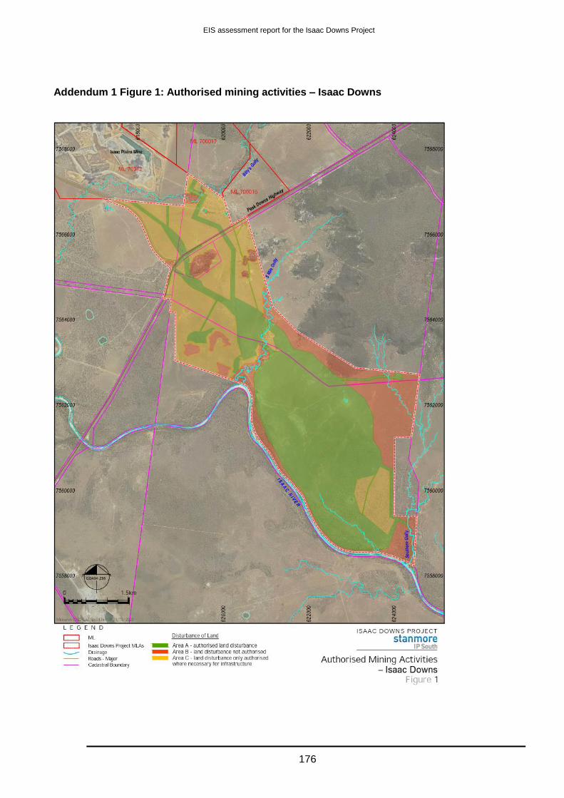
EIS assessment report for the Isaac Downs Project
176
Addendum 1 Figure 1: Authorised mining activities – Isaac Downs

EIS assessment report for the Isaac Downs Project
177
Addendum 1 Figure 2: Location of Water Release Points and Monitoring Points

EIS assessment report for the Isaac Downs Project
178
Addendum 1
Placeholder - Figure 3: Indicative location of final landform domains
Placeholder - Figure 4 Authorised impacts to regulated vegetation
Placeholder - Figure 5: Authorised impacts to protected wildlife habitat, Squatter Pigeon
(Geophaps scripta scripta)
Placeholder - Figure 6: Authorised impacts to protected wildlife habitat, Greater Glider
(Petauroides volans)
Placeholder - Figure 7: Authorised impacts to protected wildlife habitat, Koala (Phascolarctos
cinereus)
Placeholder - Figure 8: Authorised impacts to protected wildlife habitat, Ornamental Snake
(Denisonia maculata)

EIS assessment report for the Isaac Downs Project
179
Addendum 2 Table 1: Rehabilitation Requirements
Mine
Domain
Mine Domain Goal Objectives Indicators Completion Criteria
1 Exploration Rehabilitation of
exploration drill
holes and
groundwater
monitoring bores
All exploration drill
holes have been
rehabilitated
Requirements for Water
Bores in Australia’
(Australian Government,
February 2012) or latest
edition.
All exploration drill holes have been rehabilitated in accordance with the
applicable Australian Standard or guideline.
All aquifers have been isolated where exploration drill holes have intersected more
than one water bearing strata, in accordance with the ‘Minimum Construction
2 Overburden
dumps and low
wall.
Indicative location
generally in
accordance with
Addendum 1
Figure 6
(Note:
Overburden
dumps and levee
(to be
incorporated into
the final dump
landform)
Safe Safety hazards in
rehabilitation are
similar to surrounding
unmined landscapes
Hazard assessment by a
suitably qualified and
experienced person
0 (zero) significant difference as defined in AS/NZS ISO 31000:2009 Risk Management.
Stable Landforms are both
geotechnically and
erosionally stable
Factor of safety ≥ 1.5
Slope of Gradient All external draining slopes are ≤15% (8.5°);
All internal draining slopes, other than void low wall and void high wall are
≤15% (8.5°);
Low wall overall slope angle is ≤ 25% (14°)
All rehabilitated areas are geo-technically stable for the intended post mining
grazing land use and no active areas of rill or gully erosion and drainage
follows appropriate drainage paths
Groundcover Foliage and groundcover is comparable to reference sites;
No bare surfaces >20 m2 in any area or >10 m2 in length down any slope ≥
5.3% (30);
≥80% (390) established and persistent vegetative groundcover for all slopes
15-25%;
Minimum of 70% established and persistent vegetative groundcover for all
slopes 0-15% or 50% if rocks, logs or other effective erosion control cover is
present.

EIS assessment report for the Isaac Downs Project
180
Mine
Domain
Mine Domain Goal Objectives Indicators Completion Criteria
Non-polluting No environmental
harm
Surface runoff leaving
rehabilitation is non-
polluting to land and
receiving waters
Results that demonstrate the absence of potential for acid mine drainage from
the rehabilitated landform.
Results confirming that residual soil contamination on the mining leases has
been removed, neutralized or isolated
pH 6.5-8.5
EC <403 μs/cm
Total Suspended Solids
(TSS)
<405 mg/L
Arsenic ≤13 μg/L
Molybdenum ≤34 μg/L
Selenium ≤5 μg/L
Sulfate 16.34 mg/L
Petroleum Hydrocarbons
C6-C9
< 20 µg/L
Petroleum Hydrocarbons
C10-C36
< 100 µg/L
Groundwater aquifers
maintain their current
water quality and levels
Regional groundwater aquifers maintain their current water quality and groundwater
monitoring bores do not exceed the water quality limits detailed in Table D2 –
Groundwater quality limits and Table D3 Groundwater level trigger values as a
result of mining activities.

EIS assessment report for the Isaac Downs Project
181
Mine
Domain
Mine Domain Goal Objectives Indicators Completion Criteria
Land use Rehabilitation is
suitable for
sustainable cattle
light grazing
Establishment of fit for
purpose vegetation cover
and diversity
Results, that rehabilitated areas meet the following land suitability classification
for cattle grazing as defined by the Guideline for Agricultural Land Evaluation in
Queensland (State Department of Queensland 2015).
Class 3 on areas of overburden dumps with slopes less than 8.5°
Class 4 on slopes 8.5° and above.
Perennial grass species diversity spp greater than 3 species per ha
Removal and
appropriate disposal of
contaminated materials
of contaminated soil
and/or on-site
remediation of
hydrocarbon
contaminated soils.
Validation testing to confirm that contaminated soils have been
removed/remediated.
Establish self-
sustaining grazing
vegetation
Topsoil and subsoil support
the proposed vegetation
and land use
Results that demonstrate soil properties (e.g. pH, salinity, nutrient content, sodium
content) and soil characteristics (e.g. surface roughness, infiltration capacity) support
the post mining grazing land use and land classification.
Results that demonstrate that ameliorants and fertilizer have been applied at a
suitable application and topsoil has been respread to a suitable depth (min 200mm)
in rehabilitated areas to sustain the post mining light grazing land use.
Plant regeneration Results that demonstrate that species in rehabilitated areas show evidence of
flowering, viable seed setting, germination and emergence, and will continue to do so
for the foreseeable future.

EIS assessment report for the Isaac Downs Project
182
Mine
Domain
Mine Domain Goal Objectives Indicators Completion Criteria
3 Landholder
retained
infrastructure on
mining
infrastructure
areas:
Roads
Sediment dams
Mine water
dams
Located generally
in accordance
with Addendum 1:
Figure 6.
Safe Safety hazards in
rehabilitation are
similar to surrounding
unmined landscapes
Hazard assessment by a
suitably qualified and
experienced person.
0 (zero) significant difference as defined in AS/NZS ISO 31000:2009 Risk Management.
Non-polluting Surface runoff leaving
domain is non-
polluting to receiving
waters
pH 6.5-8.5
EC ≤403 μs/cm
Total Suspended Solids
(TSS)
≤405 mg/L
Arsenic ≤13 μg/L
Molybdenum ≤34 μg/L
Selenium ≤5 μg/L
Sulfate ≤16.34 mg/
Petroleum Hydrocarbons
C6-C9
< 20 µg
Petroleum Hydrocarbons
C10-C36
< 100 µg
Stable Minimise erosion and
low probability of
slope slippage
Structural and
geotechnical stability
No infrastructure with structural instability retained

EIS assessment report for the Isaac Downs Project
183
Mine
Domain
Mine Domain Goal Objectives Indicators Completion Criteria
Landholder accepts
the condition of the
infrastructure
including its
structural integrity
Legally binding agreement Executed by each party
Land use Landholder formally
accepts infrastructure
for his/her ongoing
beneficial use
Legally binding agreement Executed by each party
Rehabilitation is
suitable for
sustainable cattle
light grazing
All retained water sources
(excluding the residual
void) in the rehabilitated
areas provide water
suitable for stock.
As per water quality objectives below.
pH 6..5-8.5
TDS ≤5000 mg/L
Arsenic ≤13 μg/L
Molybdenum ≤34 μg/L
Selenium ≤5 μg/L
Sulfate ≤16.34 mg/
Petroleum Hydrocarbons
C6-C9
< 20 µg/L

EIS assessment report for the Isaac Downs Project
184
Mine
Domain
Mine Domain Goal Objectives Indicators Completion Criteria
Petroleum Hydrocarbons
C10-C36
< 100 µg/L
Removal and appropriate
disposal of contaminated
materials of contaminated
soil and/or on-site
remediation of
hydrocarbon contaminated
soils
Validation testing to confirm that contaminated soils have been
removed/remediated.
4 Infrastructure
areas not subject
to landholder
agreement:
MIA and
Office
Rom Coal
stockpile
STP
Located generally
in accordance
with Addendum 1:
Figure 6.
Safe
Site is safe for
humans, stock and
wildlife.
Geotechnical adequacy
Services disconnected
No exposed hazardous
material or chemicals.
No contaminated mine
drainage or discharges.
Wastes removed
Risk assessment that demonstrates the site is safe and all infrastructure has
been decommissioned appropriately and in accordance with the conditions of
the environmental authority and any applicable Australian Standard or
guideline.
Treat or remove waste/ hazardous materials
Remediate contaminated
land
Evidence, that demonstrates residual soil contamination on the mining leases
has been removed, neutralized or isolated.
Safety assessment of
landform stability
(geotechnical issues)
Certification by an appropriately qualified person, that the land is safe for the
post-mining land use.
Stable
Erosion rates are
appropriate for the
Landforms are both
geotechnically and
erosionally stable
Factor of Safety ≥ 1.5
Slope of gradient Evidence, which has been certified by an appropriately qualified person, that:
All external draining slopes are ≤15% (8.5°);

EIS assessment report for the Isaac Downs Project
185
Mine
Domain
Mine Domain Goal Objectives Indicators Completion Criteria
post mining
grazing land use
All internal draining slopes, other than void low wall and void high wall are
≤15% (8.5°);
The low wall overall slope angle is ≤ 25% (14°).
All rehabilitated areas are geo-technically stable for the intended post mining
grazing land use and No active areas of rill or gully erosion and drainage
follows appropriate drainage paths
Plant regeneration Evidence which has been certified by an appropriately qualified person that
topsoil has been respread to a suitable depth in rehabilitated areas to sustain
the post mining grazing land use.
Evidence, which has been certified by an appropriately qualified person, that
species in rehabilitated areas show evidence of flowering, viable seed setting,
germination and emergence, and will continue to do so for the foreseeable
future.
Groundcover Foliage and groundcover is comparable to reference sites;
No bare surfaces >20 m2 in any area or >10 m2 in length down any slope ≥
5.3% (30);
≥80% (390) established and persistent vegetative groundcover for all slopes
15-25%;
Minimum of 70% established and persistent vegetative groundcover for all
slopes 0-15%; or 50% if rocks, logs or other effective erosion control cover is
present.
Non-polluting Surface runoff leaving
rehabilitation is non-
polluting to land or
receiving waters
pH 6.5-8.5
EC ≤403 μs/cm
Total Suspended Solids
(TSS)
<405 mg/L
Arsenic ≤13 μg/L

EIS assessment report for the Isaac Downs Project
186
Mine
Domain
Mine Domain Goal Objectives Indicators Completion Criteria
Molybdenum ≤34 μg/L
Selenium ≤5 μg/L
Sulfate ≤16.34 mg/
Petroleum Hydrocarbons
C6-C9
< 20 µg/L
Petroleum Hydrocarbons
C10-C36
< 100 µg/L
Groundwater aquifers
maintain their current
water quality and levels
Regional groundwater aquifers maintain their current water quality and
groundwater monitoring bores do not exceed the water quality limits plus 10%
as detailed in Table C2 – Groundwater quality limits and Table C3 -
Groundwater level trigger values as a result of mining activities.
Land use Rehabilitation is
suitable for
sustainable cattle
light grazing.
Establishment of
adequate vegetation
cover and diversity
Evidence, that rehabilitated areas meet the following percentage breakdown of
the land suitability classification for cattle grazing as defined by the Guideline
for Agricultural Land Evaluation in Queensland (State Department of
Queensland 2015), or any subsequent version, and will continue to sustain
these suitability classifications for the foreseeable future:
Class 3 on areas of overburden dumps with slopes less than 8.5°
Class 4 on slopes 8.5° and above.
Species diversity spp./ha ≥3
Appropriate
vegetation cover
Vegetation type and
density
Evidence, , that the vegetation type and density of species in rehabilitated
areas are suited to the soil composition, slope, aspect, climate and post mining
grazing land use.
Evidence, which has been certified by an appropriately qualified person, that
the variety of vegetation species and their density in rehabilitated areas is

EIS assessment report for the Isaac Downs Project
187
Mine
Domain
Mine Domain Goal Objectives Indicators Completion Criteria
comparable to reference sites, and are suited to the post mining grazing land
use.
Foliage and ground cover Evidence which has been certified by an appropriately qualified person that:
Foliage and ground cover is comparable to reference sites;
Minimum of 70% ground cover is present (or 50% if rocks, logs or other
features of cover are present); and
No bare surfaces >20 m2 in any rehabilitated area or >10 m in length down
any rehabilitated slope ≥3o.
Soil properties
support the
nominated post
mining land use
Topsoil and subsoil
support the proposed
vegetation and land use
Evidence, which has been certified by an appropriately qualified person, that
soil properties (e.g. pH, salinity, nutrient content, sodium content) and soil
characteristics (e.g. surface roughness, infiltration capacity) support the post
mining grazing land use.
Evidence which has been certified by an appropriately qualified person that
ameliorants and fertilizer have been applied at a suitable application and
topsoil has been respread to a suitable depth (min 200mm) in rehabilitated
areas to sustain the post mining light grazing land use.
Establish self-
sustaining grazing
vegetation
Plant regeneration Evidence, which has been certified by an appropriately qualified person, that
species in rehabilitated areas show evidence of flowering, viable seed setting,
germination and emergence, and will continue to do so for the foreseeable
future.
5 Final void, end
wall and high wall
The only area
authorised to
have a residual
void is the area
located generally
in accordance
Safe Safety hazards in
rehabilitation are
similar to
surrounding
unmined
landscapes
Hazard assessment by a
suitably qualified and
experienced person
Certification by an appropriately qualified and experienced person, that final
voids are stable, including:
Certification that the high wall and end wall (where not backfilled) have:
I. 215% (65°) void high wall with 10m wide benches every 30m to 50m
vertical lift in competent (unweathered) rock.
II. 100% (45°) high wall in less competent (weathered) rock above the
final bench slope.

EIS assessment report for the Isaac Downs Project
188
Mine
Domain
Mine Domain Goal Objectives Indicators Completion Criteria
with Addendum
1:Figure 6
Geotechnically stable for the foreseeable future;
Safety bund constructed in accordance with engineering requirements for
height, based on crest width.
No public access to high wall or end wall areas.
Fence entire perimeter and bund to high wall areas.
Stable Minimise erosion
and low probability
of slope slippage,
rock falls
Structural and
geotechnical soundness
No major erosion
Certification by an appropriately qualified and experienced person that the
final void is stable in the foreseeable future.
Steep slopes only in competent rock
Absence of active rill/gully erosion
Certification that drainage measures and structures have been appropriately
established and are directing overland flow away from the highwall edge;
and
Certification that erosion and sediment control measures have been
installed and are operating as designed.
Non-polluting No contamination of
land, surface waters
or groundwater
resources
Deep drainage from the
domain is non-polluting to
regional groundwater
resources and any potential
regional groundwater
dependent ecosystems.
Ensure groundwater in this
domain remain a sink into
perpetuity.
For the avoidance of
doubt accumulation of
contaminants in this
domain is authorised.
Final void located outside of the Isaac River PMF floodplain
Evidence, which has been certified by an appropriately qualified person,
based on up to date groundwater modelling, that any final void lakes will
not overflow nor potentially contaminate any other surface water bodies.
Evidence, that voids do not discharge to land or receiving waters, including
surface water and groundwater.
Regional groundwater aquifers maintain their current water quality and
groundwater monitoring bores do not exceed the water quality limits detailed in
Table D12 – Groundwater quality limits and Table D13 Groundwater level
trigger values as a result of mining activities.

EIS assessment report for the Isaac Downs Project
189
Mine
Domain
Mine Domain Goal Objectives Indicators Completion Criteria
Land use Existing No land use beyond
containment of water
Note for the avoidance of
doubt, regrading, top
soiling and seeding is not
required.
Single residual void area of 75 ha, void maximum depth 170 m and void
maximum volume 72 (Mm3 ±2.5%).

EIS assessment report for the Isaac Downs Project
190
Appendix 2—Coordinator-General’s stated conditions under the SSRC Act and proponent commitments
This appendix includes conditions stated by the Coordinator-General under section 11(2) of the Strong and Sustainable Resource Communities Act 2017 (SSRC Act). In accordance with section 11(3)(a) of the SSRC Act, these conditions are enforceable conditions under the State Development and Public Works Organisation Act 1971 (SDPWO Act). The entity with jurisdiction for conditions in this Appendix is the Coordinator-General.
All the conditions stated in this appendix take effect from the date the Department of Environment and Science completes the EIS assessment report for the Isaac Downs project.
Condition 1. General conditions—construction
(a) The proponent must advise the Coordinator-General in writing within five (5) business days of the commencement of construction.
The advice must include the date that the construction activities commenced. This date will be taken as the commencement of construction of the project for reporting purposes.
Condition 2. General conditions—operation
(a) The proponent must advise the Coordinator-General in writing that operation of the project has commenced within five (5) business days of commencing operation.
Condition 3. Social impact management plan
(a) The proponent must submit to the Coordinator-General for approval a social impact management plan (SIMP) at least two (2) months prior to commencing construction.
(b) The SIMP must include the following updated plans:
(i) Community and Stakeholder Engagement Plan in accordance with Condition 4
(ii) Workforce Management Plan
(iii) Housing and Accommodation Plan in accordance with Condition 5
(iv) Local Business and Industry Procurement Plan (including Local Content Strategy)
(v) Health and Community Wellbeing Plan.
(c) The SIMP must be made publicly available on the proponent’s website within (30) business days of the Coordinator-General approval of the SIMP.
Condition 4. Community and stakeholder engagement plan
(a) The updated community and stakeholder engagement plan must provide a program of ongoing stakeholder engagement including the outcomes of consultation on the implementation of the proposed management strategies. The results of consultation should inform the above updated plans.
Condition 5. Non-local construction and operational workforce arrangements
(a) Update the Housing and accommodation plan to confirm the arrangements for housing the project’s non-local workforce including the location of the workers’ accommodation village and beds secured for construction and operational workforce.
Condition 6. Maximising Aboriginal and Torres Strait Islander outcomes
(a) Prior to commencing construction of the project, the proponent must consult with the Department of Aboriginal and Torres Strait Islander Partnerships to develop:
(i) A target for Aboriginal and Torres Strait Islander employment on the project
(ii) A target for Aboriginal and Torres Strait Islander business procurement on the project

EIS assessment report for the Isaac Downs Project
191
(iii) A local content strategy which includes actions to maximise Aboriginal and Torres Strait Islander business opportunities.
(b) The Aboriginal and Torres Strait Islander employment target, including justification for the target, must be included within the workforce management plan (Condition 3(b)(ii)) as part of the SIMP).
(c) The Aboriginal and Torres Strait Islander business procurement target, including justification for the target, and local content strategy must be included within the local business and industry procurement plan (Condition 3(b)(iv)) as part of the SIMP.
Condition 7. Reporting on the implementation and effectiveness of social impact management measures
(a) The proponent must prepare an annual social impact management report (SIMR) for each year of construction and for the first five (5) years of operation.
(b) The annual SIMR must be submitted to the Coordinator-General for approval within twenty (20) business days after the end of the relevant twelve (12) month period from the commencement of construction of the project.
(c) Using the monitoring protocol described in the SIMP, the SIMR must detail:
(i) an assessment of the social impacts of the project against the potential social impacts identified in the SIA, including consideration of impacts of other proposed developments in the local communities
(ii) the progress and effectiveness of the social impact management measures identified in the SIMP
(iii) how social impact management measures have been modified, where monitoring indicates measures have not been effective or in response to changed circumstances or greater knowledge of potential impacts
(iv) the actions taken to implement commitments made by the proponent listed in Appendix 2.
(d) The SIMR must present the workforce profile of the project including:
(i) total number of workers employed
(ii) proportion of local workers, new local workers, Aboriginal and Torres Strait Islander workers and FIFO workers.
(e) Each SIMR must be made publicly available on the proponent’s website with thirty (30) business days of the Coordinator-General approval of the relevant SIMR.
(f) The proponent must notify the Coordinator-General within five (5) business days of the SIMR being published on the proponent’s website.

EIS assessment report for the Isaac Downs Project
192
Definitions
‘construction activities’ includes pre-construction activities such as clearing and grubbing, topsoil and subsoil removal, earthworks, grading works, establishment of site offices and installing temporary amenities
‘FIFO worker’ is a worker for the Isaac Downs project who does not live in one of the local communities and must commute to work (could be DIDO, BIBO or FIFO) and stay at the workforce accommodation village while on shift
‘local communities’ are the twelve nearby regional communities identified in the evaluation report
‘local worker’ is a worker for the Isaac Downs project who lives in one of the local communities
‘new local worker’ is a worker for the Isaac Downs project who moves to a local community ‘operation’ is mining and processing of coal
‘worker’, for a large resource project, means a person employed, or to be employed, to perform work—
(a) during the operational phase of the project; or
(b) for a large resource project nominated by the Coordinator-General under section 12 and the name
of which is published on the department’s website under section 13 —during the construction
phase of the project.
Proponent commitments
Source: EIS Appendix 1 – Commitments Register (November 2020)
Commitments
The SIMP details the actions the proponent has committed to in order to respond to social impacts and opportunities.
A SIMP has been prepared as part of the SIA which includes sub-plans for:
workforce management
housing and accommodation
local business and industry content
health and community wellbeing
community and stakeholder engagement.
Workforce Management Plan (WMP)
The recruitment hierarchy is:
– the ‘local’ towns of Moranbah, Dysart, Nebo and Coppabella
– nearby regional communities within 125km radius from the Project entrance
– the Isaac region as per the Isaac Regional Council LGA
– the Mackay Whitsunday region
– the State of Queensland.
The scheduling of recruitment will be staggered in accordance with the recruitment hierarchy -
administrative costs associated with this approach will be met by the proponent.
Employment opportunities are dispersed to local community groups through online sources and in
physical locations to allow local access.
Job positions are advertised through online media such as community Facebook pages, and
company website etc.
Financial contribution of up to $55,000 per year for the life of the Project to improve availability of childcare services in partnership with IRC and / or other relevant parties.

EIS assessment report for the Isaac Downs Project
193
Commitments
Execution of a MLCA, inclusive of a (non-binding) employment target of 5 per cent of the operational
workforce and two Barada Barna People invited to participate in a mine induction training
programme for each year of Project construction and operation.
The Proponent funds Indigenous cultural heritage surveys by the Barada Barna for the Project in
accordance with the executed CHMP.
Development of a Reconciliation Action Plan which outlines Stanmore’s ongoing commitment to the
creation of employment and other opportunities for Indigenous People.
The proponent will maintain as many of the existing core operations workforce through to Project completion.
Invest in the ‘Live Local’ Program to encourage members of the workforce to live locally. The commitment currently equates to subsidising housing costs up to $12,480 per worker annually. There will be no cap applied to the number of employees able to access the ‘Live Local’ Program.
The proponent will work with the principal operations contractor to maximise the proportion of the
operations workforce who are in salary supported positions rather than on casual contracts.
The proponent is committed to working with the principal operations contractor to provide ongoing
training and skills development for the workforce.
The proponent is committed to developing an Equal Employment Opportunity (EEO) Policy which will apply to all employment aspects of the Isaac Downs Project, and will be based on Stanmore’s existing EEO Policy.
The proponent is committed to applying the Equal Employment Opportunity policy in accordance with
applicable regulations.
No job opportunities will be advertised as a FIFO only position.
Preparation and implementation of a Progressive Rehabilitation and Closure Plan
Assist with transition from the Project to IPM.
The proponent is committed to providing workers with advanced notice as to the conclusion of
operations.
The proponent is committed to engaging with employees regarding potential impacts and identify
strategies to avoid economic impact for those affected.
The Proponent will attempt to redeploy workers to other proponent-operated projects.
The proponent is committed to providing annual financial contribution of $10,000/year to fund local youth development programs through the Moranbah Youth and Community Centre (MYCC).
The proponent will undertake ongoing consultation with local educational institutions, training groups, and government agencies to identify potential concerns and employment opportunities.
The proponent is committed to implementing the swipe on/ swipe off system and continuing to improve fatigue management training for workers.
The proponent will implement mandatory drug and alcohol testing and improving the testing systems.
The proponent is committed to providing on-site medical and first aid facilities for workers.
The proponent is committed to engaging with camp accommodation providers to provide high quality
of workforce accommodation.
The proponent is committed to providing annual financial contribution of $10,000/year to support
employees and families through mental health and suicide prevention programs.
The proponent is committed to ongoing consultation and collaboration with police, camp accommodation providers and other stakeholders to identify and address any antisocial or disruptive workforce behaviour in local communities.

EIS assessment report for the Isaac Downs Project
194
Commitments
The proponent will comply with all relevant health and safety legislation.
The proponent is committed to the rollout of the safety training program already in place at IPM.
The proponent is committed to provision of on-site first aid and medical facilities, as established at
IPM.
The proponent (or its principal contractor) will provide a dedicated Site Senior Executive (SSE),
responsible for safety on site.
The proponent is committed to exploring flexible work arrangements such as job sharing to which enable improved work/ family balance for local employees.
Housing and Accommodation Plan (HAP)
Increase availability of affordable housing by way of a contribution commensurate with the estimated impact of the Project (approximately equates to provision of one additional unit of affordable accommodation in Moranbah).
The Proponent will fund the development of up to six additional houses in Moranbah through a funding arrangement (e.g. guaranteed annual rental contribution) to one or more developers; with an estimated value of $4,000,000 made up of the building cost and associated interest/finance costs, over the Project life. Refer to Chapter 18 for details on the proposed timing of housing construction.
The Proponent is committed to maximising local employment through applying the recruitment
hierarchy.
Employment opportunities are disseminated to local communities through online and local media.
The proponent is committed to actively engaging and collaborating with the IRC and other stakeholders with respect to housing and accommodation impacts.
The proponent is committed to providing support to members of workforce seeking to move to local communities through providing connections to the highest quality local advice and support networks.
The Proponent is committed to implementing the ‘Live Locally Initiative’ which offers employees real choice on where to base their families and provides subsidies for housing costs for members of the workforce who choose to live locally. Contributions of approximately $12,500 per worker per annum, to each worker who chooses to live locally, are proposed, with estimated contributions of approximately $8,000,000 over the life of the Project.
The proponent is committed to providing high quality workforce accommodation to non-resident personnel.
The proponent is committed to providing high quality workforce accommodation to non-local personnel.
Local Business and Industry Procurement Plan (LBIPP)
The Proponent is committed to developing a tailored Local Content Strategy which:
outlines the proponent’s approach for how it will communicate with and encourage local industry to participate within its supply chains.
describes how the proponent will encourage local industry to register as a supplier, pre-qualify, tender for supply opportunities and develop the required capabilities
identifies how the proponent will resource, implement and report on its local content practices.
Costs associated with the development and implementation of the Procurement Policy and Local
Content Strategy will be met by the proponent.
As implemented through the Local Content Strategy, the proponent is committed to maximising opportunities for local business to provide goods and services to the Project.
As implemented through the Local Content Strategy, the proponent is committed to providing a fair and reasonable opportunity for local and regional businesses to participate in the supply chain.

EIS assessment report for the Isaac Downs Project
195
Commitments
The proponent is committed to enabling Indigenous businesses to access supply change opportunities.
The proponent is committed to facilitating and supporting delivery of a tender readiness program for local businesses in collaboration with the Department of Education, Barada Barna Aboriginal Corporation and DATSIP.
As implemented through the Local Content Strategy, the proponent is committed to providing an open and transparent procurement process.
Health and Community Wellbeing Plan (HCWP)
Equivalent financial contribution of up to $55,000 per year for the life of the Project to improve availability of childcare services in partnership with IRC and / or other relevant parties.
The proponent is committed to being an active participant in any forum created to better manage cumulative impacts associated with childcare.
The proponent is committed to the provision of on-site first aid and medical facilities along with upgrading existing facilities at IPM as required.
The proponent is committed to monitoring the workforce demands on childcare and education services and working with Council to support solutions to cumulative demands on social services.
The proponent is committed to providing an annual financial contribution of $10,000/year for the life of the Project to local mental health and suicide prevention programs. The proponent will decide on the annual recipient of the funding based on advice received from key sector stakeholders.
The proponent is committed to reducing the risk of Project related vehicle accidents through actively
managing workforce fatigue and providing bus transportation for workforces residing in camp
accommodation.
The proponent is committed to protecting road safety through implementing the swipe on/ swipe off
fatigue management system and mandatory random alcohol and drug testing.
The proponent is committed to monitoring and managing dust, noise and vibration issues associated
with the Project.
The proponent will participate in any community groups assessing and monitoring cumulative dust
emissions, including potential contributions to additional dust monitoring stations.
The proponent is committed to developing and adopting a Code of Conduct.
The proponent is committed to providing an annual financial contribution of $30,000 per annum through the Community Grants Program for the life of the Project. In determining grant allocations, consideration is given to supporting existing collaborative programs and the principles of adaptive management.
Community and Stakeholder Engagement Plan (CSEP)
The proponent will seek to involve the community during the planning, construction, operation and decommissioning of the Project. In particular, the proponent will seek to understand and address community concerns about the environmental and social impacts of the Project’s activities. The proponent will also seek to actively and effectively deal with community expectations around employment, and economic and community development opportunities, whilst engaging with nearby regional communities to manage any amenity and access issues.
An engagement program is outlined in Table 18-9 which summarises key engagement activities during the construction and operation phases of the Project following the Project’s approval. The engagement program will be adapted in response to ongoing engagement. Responsibility for engagement and monitoring of the engagement process rests with the proponent. Monitoring will be undertaken on a bi-annual basis during construction and operation, with annual reporting.

EIS assessment report for the Isaac Downs Project
196
Commitments
To facilitate open communication and active complaint resolution, stakeholders will be able to raise issues and complaints. The proponent will work proactively towards preventing complaints through the implementation of impact mitigation and through community liaison.
The Project will be supported by an officer who will provide a contact point for the community and stakeholders and be available to receive and respond to complaints. This officer will ensure that all issues are conveyed to the appropriate management levels. Anyone will be able to submit a complaint to the Project. They may also submit comments and suggestions.
Concerns and issues raised will be recorded and responded to in a timely and consistent manner, and in accordance with regulatory standards and company policies. A Project community contact phone number for the purpose of receiving complaints and enquiries from stakeholders will be provided. Stanmore’s website provides the community with up-to-date information on the Project and its activities.
The SIMP includes a monitoring framework which details the KPIs to be used to measure the Project’s success in meeting the actions sought for each key impact and/or benefit area over the life of the Project.
Stakeholder feedback will be incorporated into the ongoing implementation and monitoring of SIMP actions.
The SIMP would also be reviewed regularly to assess the effectiveness and relevancy of the overall SIMP. Stanmore will review, and if necessary revise, the SIMP every three years throughout the Project life. The SIMP may be reviewed and revised within a shorter period of time should Stanmore consider the amendment of the SIMP necessary.
Consultation
Future stakeholder engagement and consultation activities will be undertaken by the proponent with the stakeholders identified in Chapter 3, and any other stakeholders who may be identified. This will include statutory consultation and other consultation methods as described in Chapter 3.
The proponent will develop information on the types of skills required for construction and operation, and the means by which people can obtain those skills. The proponent will continue to consult with identified stakeholders.
Details of all engagement and consultation activities undertaken and feedback provided will be recorded in a stakeholder management system.
All data collated will be used to generate reports according to a range of fields. The generation of these reports will assist the Project team to track work performance, the types of issues affecting the community and key areas of impact.
A report will be prepared prior to Project commencement to detail stakeholder engagement and consultation undertaken during the Project planning phase.
The ongoing analysis of all data recorded in the stakeholder management system will be used to identify and track emerging issues and changes in stakeholder perceptions.
All issues, or potential issues, relating to key stakeholders or community members will be reported to the proponent’s senior management immediately, who will then work with key Project staff to assess the issue, determine the potential implications and assign appropriate responses.
The proponent will work proactively towards preventing complaints through the implementation of impact mitigation and through community liaison. The Project will be supported by an officer who will provide a contact point for the community and stakeholders and be available to receive and respond to complaints.
Concerns and issues raised will be recorded and responded to in a timely and consistent manner, and in accordance with regulatory standards and company policies.

EIS assessment report for the Isaac Downs Project
197
Commitments
A Project community contact phone number, for the purpose of receiving complaints and enquiries from stakeholders, will be provided.

EIS assessment report for the Isaac Downs Project
198
Appendix 3—Department of Natural Resources Mines and Energy recommendations Stock route
The Department of Natural Resource and Mines requires the following specific details for consideration prior to the granting of the mining lease.
Dimensions of the proposed new route including maps and drawings of both the proposed new route and the proposed facilities.
A proposed timeline including dates for consultation and implementation of the new route and associated infrastructure. This includes any alternate routes identified during construction to ensure connectivity is maintained at all times.
In relation to the plan Southern Alignment – alternative stock route and stock route works. Project No. BI18029, Drawing No. BI18029-CIV-SKT-1031, Revision B, dated 27-11-19, this requires further consultation to ensure functionality is maintained and all times safety aspects have been addressed. For example, notification processes and contact procedures.
It should be noted that additional consultation and approval of the agreed design, materials and infrastructure will also require Isaac Regional Council involvement as the Road Manager.
The continued stakeholder discussions need to include all stakeholders (Stanmore Coal, Isaac Regional Council, TMR and DR (Stock Routes).
Stanmore Coal will need to develop policy and procedures in consultation with Isaac Regional Council on how they will ensure stock move safely across the Haul Road. For example notice is requested from Isaac Regional Council to Stanmore Coal within 7 days prior, advising travelling stock are en route, notification to mine to cease use on haul road during this time, mine personnel present to oversee safe stock crossing over haul road etc.
Water
Conditioning of the project should include consideration of the proponent requirements for monitoring, reporting and make good under Chapter 3 of the Water Act 2000 (administered by the Department of Environment and Science).

EIS assessment report for the Isaac Downs Project
199
Appendix 4—Department of Agriculture and Fisheries recommendations
Quarry material
Recommendation 1:
The project is amended to remove current impacts on access to Lot 8 Plan GV196
Recommendation 2:
The proponent is advised to consult with DAF to arrive at an agreed outcome
Waterway barriers
Condition 1.
All waterway crossings are to be constructed in accordance with Fisheries Queensland’s Accepted Development Requirements for operational work that is constructing or raising waterway barrier works or otherwise be certified by a suitably qualified and experienced person in fish passage biology to demonstrate that the waterway crossing provides for adequate fish passage.
Condition 2.
Any waterway crossings no longer required are to be removed completely from waterways prior to relinquishment.
Condition 3.
After waterway barrier works have been removed, disturbed areas of the bed and banks of the waterway must be returned to their original profile and stabilised to promote regeneration of natural fish habitats.
Condition 3.
Waterways that are Matters of State Environmental Significance must be returned to pre-development condition or better.

EIS assessment report for the Isaac Downs Project
200
Appendix 5—Department of Transport and Main Roads recommendations
TMR RECOMMENDED CONDITIONS
No Condition
1
The Transport Impact Assessment, prepared by GTA Consultants (QLD) Pty Ltd, dated 9/10/2020, reference Q166580, Issue C be amended as required and approved in writing by the Department of Transport and Main Roads (TMR) (Mackay/Whitsunday District) office no later than three (3) months prior to commencement of construction, unless otherwise agreed by the proponent and the Department of Transport and Main Roads, Program Delivery and Operations Unit, Mackay/Whitsunday District Office ([email protected]).
2
The draft Road Use Management Plan, prepared by GTA Consultants (QLD) Pty Ltd, dated 09/10/2020, reference Q192950, Issue A, be amended as required and approved in writing by the Department of Transport and Main Roads no later than three (3) months prior to the commencement of construction activities for the project that are outside of the state controlled road corridor, or as otherwise agreed between the proponent and the Department of Transport and Main Roads, Program Delivery and Operations Unit, Mackay/Whitsunday District Office ([email protected]).
3
Undertake any required road and road access works and any other impact mitigation strategies (including payment of identified monetary contributions) identified in the finalised Transport Impact Assessment prior to the commencement of construction activities for the project that are outside of the state controlled road corridor. Works may include the upgrade of any necessary intersection/ accesses to project sites or links in State-controlled road reserves, in accordance with the current by the Department of Transport and Main Roads road planning and design policies, principles and manuals, unless otherwise agreed in writing with the Department of Transport and Main Roads, Program Delivery and Operations Unit, Mackay/Whitsunday District Office ([email protected]).
TMR ADVICE
TMR recommends that the Proponent update the TIA to include quantitative estimates of the inputs and outputs to be transported to and from the project for each phase of the project as this information becomes available. This information would be in tabular form showing estimates of:
(a) annual volumes of project consumables and wastes (for example, fuel, explosives, truck
tyres, workforce consumables), number of truck movements for each consumable and
truck type.
(b) machinery and equipment, number of truck movements and truck type.
(c) over-size and over mass truck movements.

EIS assessment report for the Isaac Downs Project
201
Bibliography
Aquatic Ecosystems Task Group (AETG), 2012. Aquatic Ecosystems Toolkit. Module 3: Guidelines for Identifying High Ecological Value Aquatic Ecosystems (HEVAE). Canberra: Australian Government Department of Sustainability, Environment, Water, Population and Communities (Aquatic Ecosystems Task Group).
ANZG 2018. Australian and New Zealand Guidelines for Fresh and Marine Water Quality. Australian and New Zealand Governments and Australian state and territory governments, Canberra ACT, Australia. Available from: www.waterquality.gov.au/anz-guidelines
Bureau of Meteorology (BOM), (2020). Groundwater Dependent Ecosystems Atlas. Canberra: BOM. Available from: http://www.bom.gov.au/water/groundwater/gde/map.shtml
Commonwealth of Australia, 1999. (NEPM) National Environment Protection (Assessment of Site Contamination) Measure. Section 4.3.1.5. Canberra: Australian Government. Available from: https://www.legislation.gov.au/Details/F2013C00288
Commonwealth of Australia 2012. EPBC Act Environmental Offsets Policy. Available from: https://www.environment.gov.au/epbc/publications/epbc-act-environmental-offsets-policy
Commonwealth of Australia, 2014. EPBC Act Referral Guidelines for the vulnerable koala (combined populations of Queensland, New South Wales and the Australian Capital Territory). Canberra: Department of the Environment. Available from: https://www.environment.gov.au/system/files/resources/dc2ae592-ff25-4e2c-ada3-843e4dea1dae/files/koala-referral-guidelines.pdf
Commonwealth of Australia, 2014. Threat abatement advice for predation, habitat degradation, competition and disease transmission by feral pigs. Canberra: Department of the Environment. Available from: https://www.environment.gov.au/system/files/resources/b022ba00-ceb9-4d0b-9b9a-54f9700e7ec9/files/tap-feral-pigs-2017.pdf
Commonwealth of Australia, 2013. Commonwealth Conservation Advice for Brigalow Ecological Community. Canberra: Commonwealth of Australia. Available from: http://www.environment.gov.au/biodiversity/threatened/communities/pubs/028-conservation-advice.pdf
Commonwealth of Australia, 2013. Significant Impact Guidelines 1.3 - Coal seam gas and large coal mining developments - impacts on water resources. Available from: https://www.environment.gov.au/system/files/resources/d078caf3-3923-4416-a743-0988ac3f1ee1/files/sig-water-resources.pdf
Commonwealth of Australia, 2011. Draft Referral guidelines for the nationally listed Brigalow Belt reptiles. Canberra: Department of Sustainability, Environment, Water, Population and Communities Public Affairs. Available from: http://www.environment.gov.au/system/files/resources/570964ac-15bf-4e07-80da-848fead7b0cd/files/draft-referral-guidelines-comment-brigalow-reptiles.pdf
Commonwealth of Australia, 2011. Threat abatement plan for the biological effects, including lethal toxic ingestion, caused by cane toads. Canberra: Threatened Species Scientific Committee Available from: https://www.environment.gov.au/system/files/resources/2dab3eb9-8b44-45e5-b249-651096ce31f4/files/tap-cane-toads.pdf
Commonwealth of Australia 2010. Survey Guidelines for Australia’s threatened birds: Guidelines for detecting birds listed as threatened under the Environment Protection and Biodiversity Conservation Act 1999. Department of Environment, Water, Heritage and the Arts. Available from: https://www.environment.gov.au/epbc/publications/survey-guidelines-australias-threatened-birds-guidelines-detecting-birds-listed-threatened
Commonwealth of Australia, 2008. Approved Conservation Advice for Natural grasslands of the Queensland Central Highlands and the northern Fitzroy Basin. Canberra: Department of Sustainability, Environment, Water, Population and Communities Public Affairs. Available from: https://www.environment.gov.au/system/files/resources/347c5d4e-cef8-411c-b53c-bed3ed1d3e1c/files/bio237-0512-natural-grasslands-guide.pdf
EIS assessment report for the Isaac Downs Project
202
Department of the Environment (SPRAT), 2021. Denisonia maculata Ornamental Snake in Species Profile and Threats Database, Department of the Environment, Canberra. Available from: http://www.environment.gov.au/cgi-bin/sprat/public/publicspecies.pl?taxon_id=1193
Department of the Environment (SPRAT), 2021. Geophaps scripta Squatter pigeon (southern) in Species Profile and Threats Database, Department of the Environment, Canberra. Available from: http://www.environment.gov.au/cgi-bin/sprat/public/publicspecies.pl?taxon_id=64440
Department of the Environment (SPRAT), 2021. Rostratula australis Australian Painted Snipe in Species Profile and Threats Database, Department of the Environment, Canberra. Available from: http://www.environment.gov.au/cgi-bin/sprat/public/publicspecies.pl?taxon_id=77037
Department of Environment, 2015.Threat abatement plan for predation by feral cats. Canberra: Threatened Species Scientific Committee Available from: https://www.environment.gov.au/system/files/resources/78f3dea5-c278-4273-8923-fa0de27aacfb/files/tap-predation-feral-cats-2015.pdf
Department of the Environment, 2014. Approved Conservation Advice for Denisonia maculata (Ornamental Snake). Canberra: Threatened Species Scientific Committee.
Department of Environment and Energy, 2016. Threat abatement plan for competition and land degradation by rabbits. Canberra: Department of the Environment and Energy Available from: https://www.environment.gov.au/system/files/resources/bf9352c2-35ae-4a80-8828-96de630731a9/files/tap-rabbit-2016.pdf
Department of Environment and Heritage Protection (EHP), 2009. Queensland Water Quality Guidelines. Available from: https://environment.des.qld.gov.au/management/water/quality-guidelines#document_availability
Department of Environment and Heritage Protection (EHP), 2006. Guideline for contaminated land professionals. Brisbane: Department of Environment and Heritage Protection, Queensland Government.
Department of the Environment and Science (DES), 2020. EIS Information Guideline- Noise and Vibration (ESR 2020/5305). Available from: https://www.qld.gov.au/__data/assets/pdf_file/0029/87941/eis-tm-noise-vibration-information-guide.pdf
Department of the Environment and Science (DES), 2020. Guide to determining terrestrial habitat quality. Available from: https://environment.des.qld.gov.au/__data/assets/pdf_file/0017/102833/habitat-quality-assessment-guide-v1-3.pdf
Department of the Environment and Science (DES), 2019. Terms of Reference for the Isaac Downs Project. Available from: https://www.qld.gov.au/environment/pollution/management/eis-process/projects/current-projects/isaac-downs-project
Department of Environment and Science, 2019. Guideline – Progressive rehabilitation and closure plans (PRC plans). Available from: https://www.business.qld.gov.au/running-business/environment/licences-permits/rehabilitation/progressive-rehabilitation-closure-plans
Department of Environment and Science (DES), 2016. Technical guideline – Wastewater release to Queensland waters. Available from: https://environment.des.qld.gov.au/__data/assets/pdf_file/0031/88636/pr-gl-wastewater-to-waters.pdf
Department of Environment and Science (DES), 2016. Manual for assessing consequence categories and hydraulic performance of structures (ESR/2016/1933). Available from: https://www.ehp.qld.gov.au/assets/documents/regulation/era-mn-assessing-consequence-hydraulic-performance.pdf
Department of Environment and Science (DES), 2015. Eligibility criteria and standard conditions for sewage treatment works (ERA 63) – Version 2. Available from: https://environment.des.qld.gov.au/__data/assets/pdf_file/0035/88919/pr-es-irrigate-treated-sewage.pdf
Department of the Environment and Science (DES), 2015. Operational Policy- Disposal and storage of

EIS assessment report for the Isaac Downs Project
203
scrap tyres at mine sites (ESR/2015/1836). Available from: https://environment.des.qld.gov.au/__data/assets/pdf_file/0027/88911/rs-op-scrap-tyres-mine-sites.pdf
Department of Environment and Science (DES), 2006. Noise and Vibration from Blasting Guideline. Brisbane: Department of Environment and Science, Queensland Government.
Department of the Environment, Water Heritage and the Arts, 2008. Threat abatement plan for predation by the European red fox. Canberra: Department of the Environment, Water Heritage and the Arts. Available from: https://www.environment.gov.au/system/files/resources/1846b741-4f68-4bda-a663-94418438d4e6/files/tap-fox-background.pdf
Department of Science, Information Technology, Innovation and the Arts (DSITIA), 2016. Guideline for the Environmental Assessment of Subterranean Aquatic Fauna. Available from: https://www.publications.qld.gov.au/dataset/subterranean-aquatic-fauna
Department of Science, Information Technology and Innovation (DSITI), 2017. Using monitoring data to assess groundwater quality and potential environmental impacts. Available from: https://www.publications.qld.gov.au/dataset/groundwater-quality-assessment-guideline/resource/472cc88a-000a-4bb8-a60d-204cfe7e0238
Department of State Development (DSD), 2017. Economic Impact Assessment Guideline. Available from: https://www.statedevelopment.qld.gov.au/__data/assets/pdf_file/0012/33420/economic-impact-assessment-guideline.pdf
Department of State Development, Manufacturing, Infrastructure and Planning (DSDMIP), 2018. Social Impact Assessment Guideline. Available from: http://dsdmip.qld.gov.au/resources/cg/social-impact-assessment-guideline.pdf
Department of Sustainability, Environment, Water, Population and Communities (SEWPaC), 2011. Survey guidelines for Australia’s threatened mammals. Canberra: Department of Environment, Water, Heritage and the Arts. Available from: https://www.environment.gov.au/system/files/resources/b1c6b237-12d9-4071-a26e-ee816caa2b39/files/survey-guidelines-mammals.pdf
Department of Transport and Main Roads (DTMR), 2018. Guide to Traffic Impact Assessment. Available from: https://www.tmr.qld.gov.au/business-industry/Technical-standards-publications/Guide-to-Traffic-Impact-Assessment
Eamus D, Froend F, Loomes R, Hose G, Murray B, 2006. A functional methodology for determining the groundwater regime needed to maintain the health of groundwater dependent vegetation. Australian Journal of Botany, Volume 54, Pages 97 -114.
Neldner, V, Wilson, B, Dillewaard, H, Ryan, T, Butler, D, McDonald, W, Addicott, E and Appelman, C, 2020. Methodology for survey and mapping of regional ecosystems and vegetation communities in Queensland. Version 4.0. Brisbane: Queensland Herbarium, Queensland Department of Environment and Science.
Richardson S, Irvine E, Froend R, Boon P, Barber S, and Bonneville B, 2011. Australian groundwater-dependent ecosystem toolbox part 1: assessment framework, Waterlines report. Canberra: National Water Commission.
Threatened Species Scientific Committee (TSSC), 2015. Commonwealth Conservation Advice on Geophaps scripta (Squatter Pigeon (southern)). Canberra: Department of the Environment, Water, Heritage and the Arts. Available from: http://www.environment.gov.au/biodiversity/threatened/species/pubs/64440-conservation-advice.pdf
Threatened Species Scientific Committee (TSSC), 2016. Conservation Advice Petauroides volans greater glider. Canberra: Department of the Environment. Available from: http://www.environment.gov.au/biodiversity/threatened/species/pubs/254-conservation-advice-05052016.pdf
Threatened Species Scientific Committee (TSSC), 2013. Approved Conservation Advice for Rostratula australis (Australian painted snipe). Canberra: Department of the Environment, Water, Heritage and the Arts.

EIS assessment report for the Isaac Downs Project
204
Threatened Species Scientific Committee (TSSC), 2012. Listing advice for Phascolarctos cinereus (Koala). Canberra: Department of the Environment, Water, Heritage and the Arts. Available from: http://www.environment.gov.au/biodiversity/threatened/species/pubs/197-listing-advice.pdf