environmental impact assessment guidelines for ports and
TRANSCRIPT

1
Environmental Impact Assessment Guidelines forPorts and Harbours
for
The Department of Ocean Development
Under the
Integrated Coastal and Marine Area Management Program
Prepared byNational Institute of Ocean Technology
IIT Madras CampusChennai – 600036
October 2003

2
Foreword
� The ‘EIA Guidelines for Ports and Harbours’ has been developed as a part ofthe Coastal and Marine Area Management Component under the Project“Environment Management and Capacity Building” funded by the WorldBank.
� The Technical Advisory Committee consisted of
� Mr. Roy Paul, Additional Secretary (Impact Assessment Division),
MoEF
� Dr. S.K. Agarwal, Additional Director, MoEF
� Dr. S. Gopalan, Development Advisor (Ports), Ministry of Surface
Transport
� Dr. P. Vaidhyaraman, Retd. Director, Central Water & Power Research
Station
� Dr. A.V. Raman, Prof & Head of the Dept. of Zoology, Andhra
University
� Dr. B.R. Subramaniam, Project Director (ICMAM)
� Dr. Rajat Roy Chaudhury, Joint Project Director, National Institute of
Ocean Technology
� Participating institutions
� The guidelines were reviewed by the following members in addition toreview by the Technical Advisory Committee
� Dr. M. Baba, Director, Centre for Earth Science Studies, Dr. M.D.
Zingde, National Institute of Oceanography, Dr. L.K Ghosh, Central
Water and Power Research Station, Dr. R.Jayamohan Pillai, Director,
National Institute of Port Management, Dr. B.A. Giridhar, Tata AIG Risk
Management
� The project team from NIOT consisted of Dr. Rajat Roy Chaudhury, ChithraSrinivasan and Vijaya Ravichandran
� This Guideline was developed on the basis of an initial assessment of

3
� EIA’s conducted in India since 1995 for coastal and offshore activities
� Relevant Guidelines available in India and abroad
� A manual to aid in the EIA of Ports and Harbours has also been developed.This manual is essentially a detailed version of the guideline

4
1.0 INTRODUCTION
Environmental impact assessment (EIA) is the process of examining theenvironmental, social and health effects of a proposed development. It assesses theimpacts of the proposed development on the environment and enables decisionmaking with respect to environmental clearance.
Environmental Impact Assessment (EIA) for ports and harbours is a mandatoryrequirement as per the Ministry of Environment & Forests (MoEF) EIA notification(1994) and CRZ Notification (1991) since these projects can cause potentiallysignificant environmental impacts.
The objectives of this guideline are
� To aid in the preparation of reports that are comprehensive in their
content and to reduce cost of EIA.
� To protect the environment from costly and irreversible mistakes.
� To aid review of the reports
� To avoid time delays and cost overruns
1.1 Objective of an EIA
� To determine environmental compatibility of the project
� To evaluate and select the best project alternative from the options
available
� To identify and evaluate the significant environmental impacts of the
project
� To incorporate environmental management plans and monitoring
mechanisms.
� To assess the environmental costs and benefits of the project to the
community

5
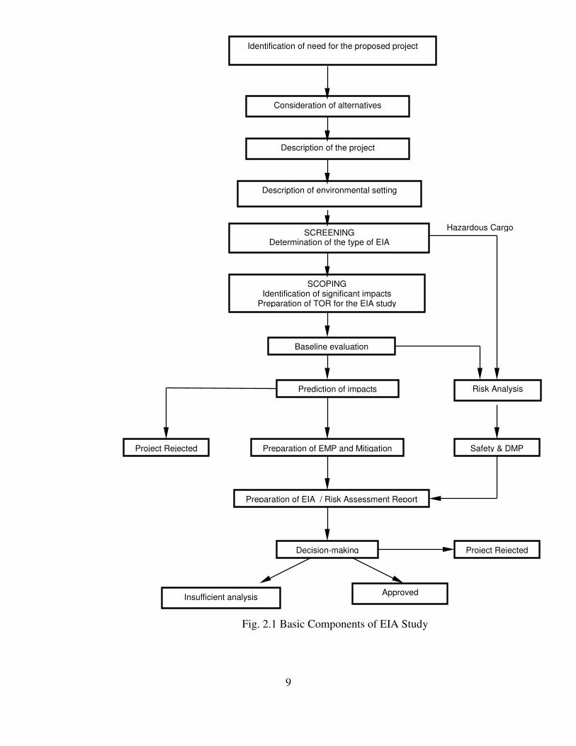
1.2 Environmental Impact Assessment Process
The typical tasks involved in the EIA process are illustrated in Figure 1.1. These maybe followed sequentially to perform a good EIA. The chapters that follow provideguidance to apply these tasks specifically to port and harbour projects.
1.3 Environmental considerations in project feasibility
The feasibility of a project is based on technical, economic and environmentalconsiderations. While the technical and economic aspects address the specific projectneeds, the environmental aspect addresses the common resources to be shared andpossibly, protected in an area. An EIA aims to incorporate environmentally soundmeasures during the planning, construction and operation phases.
EIA can be applied at all steps in the planning process – from conception to operationand to project decommissioning – with different levels of complexity. Incorporatingthe EIA process at the beginning of the project planning process will identify thepossibility of a definite “no-go” alternative. Hence it is necessary that EIA beperformed in parallel with technical and economic feasibility studies.
1.4 Concept of Screening
The process of determining the type of EIA required for a project is called screening.The extent of assessment required is also determined in this process.
Extent of EIA
A Rapid EIA report is submitted to the Impact Assessment Agency (IAA) based onone season data (other than monsoon) for examination of the project. ComprehensiveEIA report may be submitted later, under the directions of the IAA
a. Rapid EIA: Is carried out for projects that are likely to cause only a limited
number of adverse impacts. It is a preliminary assessment that involves limited
baseline evaluation (i.e. collection of one season data), broad identification of
impacts and prediction of impacts with simple methods. It is a quick process in
terms of time spent on assessments of impact characteristics. Rapid EIA’s are
done for projects like captive jetty or projects that do not involve ancillary growth,

6
resettlement issues, induced developments and projects located in non-critical
habitats.
b. Comprehensive EIA: Some projects are likely to cause a range of significant
adverse impacts affecting a number of environmental parameters. A
comprehensive EIA is generally required when the project results in
significant/seasonal changes (requiring the need for a three seasonal baseline
data), ancillary or induced development, resettlement & rehabilitation and is
located at close proximity to ecologically sensitive areas. For example, breakwater
projects, port and harbour projects initiated for the sake of industries, projects
involving resettlement and rehabilitation issues, projects located in critical habitats
etc require an extensive or comprehensive EIA. The characteristics of the impacts
of these projects can be determined only with a detailed study.
Types of EIA
a. Project specific EIA: Some projects cause a limited number of adverse impacts
and do not result in ancillary activities or induced developments. For example, a
container terminal, which handles only containers, may not have associated
developments
b. Regional EIA: Projects resulting in development of an entire region in terms of
ancillary industries and/or induced developments require a regional EIA. It
involves assessment of the cumulative environmental impacts of a number of
projects proposed in that region. For example, a port and harbour project might

7
trigger off the growth of industries and consequently rapid industrialisation and
urbanisation of the region.
c. Sectoral EIA: When a long-term development plan of a particular sector (for
example, port sector) is proposed, environmental impacts need to be evaluated in a
broader framework.
d. Risk Analysis: Is the process of identifying the probability of occurrence of an
accident and its consequence, when ports handle hazardous cargo or involve risky
operations.
In general a project specific rapid EIA with or without risk analysis is conducted forany project requiring an EIA. Regional/sectoral /comprehensive EIA is initiated bythe IAA if it considers the project to have a significant environmental impact.
1.5 Participants in an EIA
EIA Study
A team of cross-functional professionals shall conduct EIA. The team leader shall becapable of addressing issues with a broad overview and shall collate the findings ofthe EIA team. The team shall consist of professionals with experience in
� Environmental sciences/process designs
� Coastal engineering (Marine structures, foundations, dredging etc.)
� Chemical/ Mechanical engineering (Hazardous material
handling/operations)
� Oceanography
� Water resources
� Marine biology
� Socio/Environmental/Natural Resource – economics
� Sociology
8
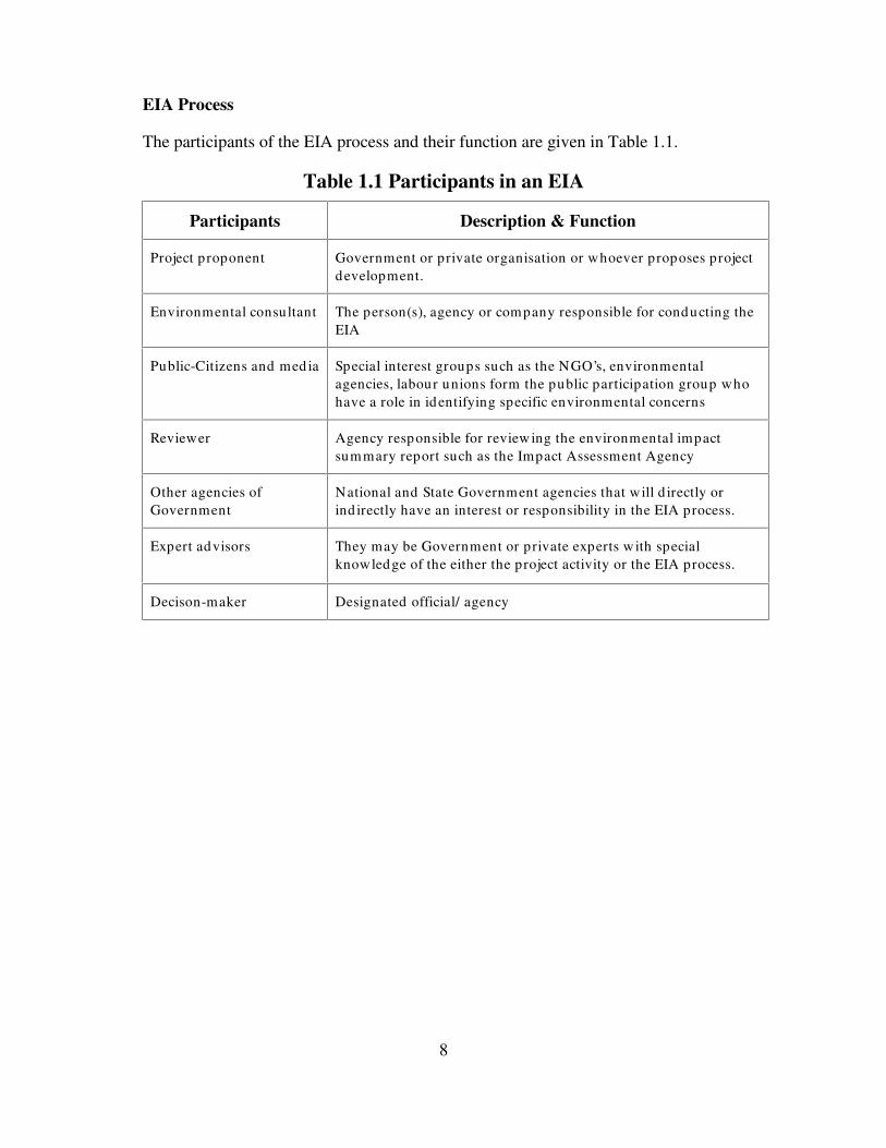
EIA Process
The participants of the EIA process and their function are given in Table 1.1.
Table 1.1 Participants in an EIA
Participants Description & Function
Project proponent Government or private organisation or whoever proposes projectdevelopment.
Environmental consultant The person(s), agency or company responsible for conducting theEIA
Public-Citizens and med ia Special interest groups such as the NGO’s, environmentalagencies, labour unions form the public participation group whohave a role in identifying specific environmental concerns
Reviewer Agency responsible for reviewing the environmental impactsummary report such as the Impact Assessment Agency
Other agencies ofGovernment
National and State Government agencies that will d irectly orind irectly have an interest or responsibility in the EIA process.
Expert advisors They may be Government or private experts w ith specialknowledge of the either the project activity or the EIA process.
Decison-maker Designated official/ agency
9
Identification of need for the proposed project
Description of the project
Description of environmental setting
SCREENINGDetermination of the type of EIA
Prediction of impacts
Baseline evaluation
Preparation of EMP and Mitigation
Decision-making
Approved
Risk Analysis
Hazardous Cargo
Consideration of alternatives
Project Rejected
Insufficient analysis
SCOPINGIdentification of significant impacts
Preparation of TOR for the EIA study
Preparation of EIA / Risk Assessment Report
Project Rejected
Fig. 2.1 Basic Components of EIA Study
Safety & DMP

10
Environmental Clearance
Port and harbour projects fall under Schedule-1 of the MoEF EIA notification, 1994and hence require an EIA. These projects are also categorised as site specific underthe notification, and hence also require site clearance by the MoEF. Therefore, theEIA Notification provides for two-stage clearance for site-specific projects. Siteclearance is given in the first stage and the final environmental clearance in thesecond stage. Ports and harbours require waterfront and foreshore facilities and fall inthe Coastal Regulation Zone (CRZ) and therefore require environmental clearancefrom the Ministry of Environment & Forests under the CRZ notification, 1991. In thecase of projects within the existing port limits except areas classified as CRZ-I, thepower to grant clearance under the Coastal Regulation Zone Notification has beendelegated to the Ministry of Surface Transport (MoST).
Public hearing has been made mandatory for all the cases where the environmentalclearance is required. It is, however, not needed for site clearance or permission toconduct surveys.
Figure 2.1 explains the stepwise process involved in environmental clearance of theprojects.
1.6 Documents required for Clearance
Project proponents applying for environmental clearance of projects are required tosubmit twenty sets of the following documents to the concerned State PollutionControl Board.
� An executive summary containing the salient features of the project both
in English as well as local language
� Form XIII prescribed under Water (Prevention and Control of Pollution)
Rules, 1975 where discharge of sewage, trade effluents, treatment of
water in any form, is required
� Form I prescribed under Air (Prevention and Control of Pollution) Union
Territory Rules, 1983 where discharge of emissions are involved in any
process, operation or industry
� Any other information or document, which is necessary in the opinion of
the Board for their final disposal of the application.

11
Project proponents are required to furnish the following information to the UnionMinistry of Environment and Forests for environmental appraisal
� EIA/EMP report (20 copies);
� Risk Analysis report (20 copies): however, such reports if normally not
required for a particular category of project, project proponents can state
so accordingly, but the IAA’s decision in this regard will be final;
� NOC from the State Pollution Control Board;
� Commitment regarding availability of water and electricity from the
competent authority;
� Summary of Project report/feasibility report (one copy);
� Filled in questionnaire (as prescribed by the IAA from time to time) for
environmental appraisal of the project;
� Comprehensive rehabilitation plan, if more than 1000 people are likely to
be displaced, otherwise a summary plan would be adequate.
� Comments of the State Department of environment regarding CRZ
classification of the area and that the proposal conform to the approved
CZMP of the area;
� NOC from the Chief Directorate of Explosives in case it involves
storage/handling of hazardous substances;
� Demarcation of HTL/LTL by one of the authorized agencies;
� Comments of the Chief Wildlife Warden if in the proximity of marine
parks, breeding and nesting grounds etc;
� Location map showing various activities with reference to the high tide
line
1.7 Environmental Regulations relevant to Port and HarbourProjects
The Ministry of Environment and Forests (MoEF) is the nodal agency in theadministrative structure of the Central Government and is the primary agency forregulating environmental protection in the country. The Central and the StatePollution Control Boards are the administrative bodies for exercising promotional and

12
regulatory functions under the Water, Air and Environmental Acts.Notifications/standards that are applicable to a port and harbour project have beenlisted herein.
a. Environmental Protection Act 1986
� EIA Notification (1994 as amended on 27th Jan 2000) http://envfor.nic.in/
� Coastal Regulation Zone Notification, (1991, as amended upto 4th Aug
2000) http://envfor.nic.in/
� The Water, (Prevention and Control of Pollution) Act, 1974 as amended
upto 1988 http://envfor.nic.in/
� Hazardous Wastes (Management & Handling) Rules (1989)
http://envfor.nic.in/
� Manufacture, storage & import of hazardous chemicals Rules (1989)
http://envfor.nic.in/
b. Others
� The Air (Prevention and Control of Pollution) Act, 1981 as amended by
amendment Act 1989 (http://envfor.nic.in/ )
� Forest (Conservation) Act, 1980
� Indian Ports Act 1908

13
Submit projectquestionnaire1 to concerned
SPCB for review
SPCB to review and initiatepublic hearing
No Objection Certificate issued
Projectrejected
Submit application form2 to the MoEF asper Schedule-II or MoST**
Project falls under the Schedule–I of the EIA Notification
Evaluation and Assessment by theImpact Assessment Agency3
Expert committee4 review
Environmental issues can be resolved
Submit application to MoEF for siteclearance /CRZ clearance
Site/CRZ clearance granted
Investor advised to lookfor alternate site
Project Rejected
Insu
ffici
ent o
r ina
dequ
ate
data
Project cleared with or withoutstipulations
If de
emed
nece
ssar
y
Fig. 2.1 Procedure for obtaining environmental clearance
List of documents to be submitted to the SPCB is as per Schedule-IV of the EIA notification
List of documents consist of EIA report/EMP and details of public hearing as specified in Schedule-IV
Impact Assessment Agency is the Union Ministry of Environment and Forests
Expert committee composition is according to the Schedule-III of the EIA notification

14
1.8 International Treaties
Shipping is an international activity and hence national specifications and regulationrelating to loading and safety at sea are largely based on international agreements andconventions. International regulations relevant to port and harbours are given herein.India is a signatory to these International agreements/conventions.
a. Shipping
� International Maritime Dangerous Goods Code (IMDG-code)http://hazmat.dot.gov.imdg.htm
The IMDG code relates to methods of safe transport of dangerous cargoes andrelated activities. It sets out procedures for documentation, storage, segregation,packing, marking and labelling of dangerous goods.
� International Convention for the Prevention of Pollution from ships(MARPOL) http://www.imo.org/imo/convent/pollute.htm
The main objectives of this convention are to prevent the pollution of themarine environment by the operational discharges of oil and other harmfulsubstances and the minimisation of the accidental discharges of such substances
� United Nations Convention on the Law of the Sea (UNCLOS), 1982.http://www.tufts.edu/departments/fletcher/multi/texts/BH825.txt
The main objective is the obligation to prevent pollution damage by addressingparticular sources of pollution, including those from land based activities,seabed activities, dumping, vessels and from or through the atmosphere.
b. Others
� Ramsar Convention on Wetlands: http://www.ramsar.org/
The Convention requires states to designate at least one wetland site on the basis ofecology, botany, zoology, limnology or hydrology and requires the conservation of allwetlands by establishing nature reserves. There is also a requirement that any loss of awetland should be compensated for by creation of new habitat.
For details, the reader is advised to refer to “Wetlands, biodiversity and Ramsarconvention – The role of convention on wetland in the conservation and wise use ofbio-diversity”, edited by A.J.Hails, Ramsar convention Bureau, MoEF, 1996(1997).

15
2.0 PORTS AND HARBOURS
2.1 Need for the project
Necessity for a port and harbour project, including expansion of existing port arisesdue to one or more of the following
� Location of industries requiring the raw product, which can be imported.
� Location of mines/industries at close proximity to enable export the
goods
� Port of entry for passengers
� Strategic importance
� Fisheries
2.2 Consideration of alternatives
Project alternatives
There are number of port and harbour types. A choice has to be made considering thevarious types of port and harbour facilities. Alternatively, an entirely differentproject, which is more suitable to be located at that particular site, could also beproposed. Different port and harbour alternatives are given herein
� Natural harbours normally offer sheltered locations for berthing of ships, theconstruction of which may not result in any change to the shoreline andestuarine ports
� Artificial harbours are constructed in open sea where breakwaters areconstructed to provide tranquil conditions for ship operations. Breakwaterconstructions could result in major shoreline changes as well as alter thehydraulic characteristics resulting in major impacts like accretion and erosion.
� Use of single point mooring system which does not involve any jetty or dockconstruction, but only consists of a catenary platform, from where tankers canunload liquid cargo into submarine pipelines, which take the cargo across tothe tank farm located onshore.
� Construction of open jetties, offshore, where the cargo is offloaded ontoconveyors or pipelines and carried to the shore using trestles. Open jetties donot involve extensive dredging and do not change coastal hydraulics. Climatic

16
and hydraulic characteristics will dictate the window of operation at an openjetty.
Location Alternatives
Siting of a Port and Harbour is characterised by a number of technical and economiccriteria like easy access, physical and topographical features, hydrographic,meteorological and hydrological factors. The following environmental and ecologicalcriteria must be taken into account before siting is done.
� The location shall be away from sensitive and critical habitats on land
and coastal waters (mangroves, coral reefs, breeding and nesting grounds,
sand dunes, fishing zones, marine parks, migratory routes of birds and
mammals etc)
� There shall be minimal displacement of local population, diversion of
forest and agricultural lands
� There shall be minimum depletion of available resources due to direct
and induced development
� There shall be minimal disturbance and losses to existing socio-economic
activities
� Location in brackish water regions shall be carefully planned.
Environmental setting is required to identify the environmental components at the sitethat are likely to be affected by the project activities. This enables to determine thesignificance of impacts and identify the recipients. The description shall contain thecurrent uses of the area and the future developments. It shall include
� Presence/proximity to ecologically sensitive areas, critical habitats,
wetlands, endangered species, etc
� Designated water usage at the project site vis-à-vis its availability from
different sources
� Existing solid and liquid waste disposal sites/treatment facilities
� Designated landuse in and around the project site including anticipated
future developments
� Proximity to residential, industrial, commercial and institutional areas

17
� Occupation and means of livelihood of the population near the project
site
A questionnaire provided in Annexure-A enables detailed description ofenvironmental setting at the project site
Technology Alternatives
� Alternative process designs to minimise resource consumption and waste
generation
� Incorporation of environmentally sound alternatives in the project design
� Environmental Management Plans
2.3 Project Description
Project description involves description of the project activities and infrastructurerequirements. Annexure A gives a questionnaire for describing the project setting. Fora typical port and harbour project, the harbour infrastructure requirements arebreakwaters; tug boats, lighthouse, fire fighting equipments, facilities to combat oilslick (oil skimmers, booms), buoys and marine police. Dock requirements are dictatedby the vessel types, cargo type and storage and handling requirements. Generalconsiderations for the overall layout of the facility depend on berth length, number ofvessels, loading/unloading points, apron width, short-term storage on the pier orwharf, cargo-handling equipment requirements, exposure to sea conditions, deckelevation and traffic movements.
Port requirements can be classified as landside and waterside requirements. Figure 3.1gives the facilities involved in a Port and Harbour project.
A broad list of activities (though not exhaustive) involved in a port and harbourconstruction and operation are given in Table 3.1. All these activities involve anumber of tasks or sub-activities.

18
Landside Facilities Waterside Facilities
Roads, Railways andCrane Tracks
Storage & Stacking
Pipeline for liquid cargotransfers Tank farm
Water supply & Waste waterdisposal
Berthing Facilities
Dry-docks
Breakwater
UnderwaterPipelines
SewageOutfall
Ports and Harbours

18

19
Table 2.1 Activities typical to ports and harbours
Phase Landside Activity Waterside activity
� Construction � Site clearing/deforestation
� Resettlement
� Rehabilitation
� Soil excavation / Quarrying
� Transportation of raw materials*
� Construction/ Precasting /
Fabrication/Welding Laying of
roads/railways/crane tracks
� Land reclamation/ disposal of dredged
material on-shore
� Labour camps for all activities
� Capital dredging
� Disposal of dredged material into sea
� Berth/wharf/jetty/trestle Construction
(Piling operations/ Construction of gravity
foundation/ diaphragm walls)
� Breakwater Construction *
� Single Point Mooring (SPM)
� Trenching the seabed for underwater
pipeline /intake/ outfalls / underwater
blasting
� Operation � Afforestation
� Vehicular traffic (roads & railways)
� Storage of dry cargo
� Loading and unloading of dry cargo
� Loading and unloading of liquid cargo
� Storage of wet cargo/ Tankfarm
operation
� Pipeline operation
� Disposal of dredged material on land /
Land reclamation
� Waste management and effluent
discharge
� Maintenance dredging
� Disposal of dredged material into sea
� Maintenance of Breakwater/water-front
structures
� Brine discharge from desalination plants
� Cooling water discharge from power
plants
� Ship operations (bunkering,
ballasting/deballasting, discharges)
� Fishing Activities

20
Phase Landside Activity Waterside activity
� Maintenance Infrastructure
� Desalination plants
� Captive power plants
� Induced development
* Raw materials like gravel /boulders/sand for construction shall be obtained only from approved
quarry sites
Construction Period
The construction of any port and harbour involves a time period of 4-6 years or even more due to thecomplexity of structures and foundations involved and the hostile marine environment where thesetasks have to be carried.
3.0 CONCEPT OF SCOPING
3.1 Scoping
Scoping is a priority-setting activity in the EIA process, which identifies environmental parametersthat are likely to be adversely affected by the proposed project activities and focuses the assessmenton important issues. It typically follows screening.
Scoping is synonymous to identifying the significant impacts and needs to be done systematicallybased on the activities that are involved in a port and harbour project
Timing of scoping
Scoping ideally begins early in the EIA. However, the process of evaluating the importance of issuesshould be reviewed throughout the EIA process. It is recommended that scoping be undertaken priorto hiring a consultant for EIA study. It is also essential that scoping be performed during the pre-feasibility stage of the project, in parallel with the technical and economic pre-feasibility studies, sothat environmental concerns are incorporated in the project at the planning stage itself.
Advantages of Scoping
� It enables integrated project planning

21
� It helps to identify key issues and environmental concerns in the early project planning
stage
� It helps in confining the study to an essential set of significant environmental
parameters thereby allowing judicious allocation of time and money for assessing
relevant environmental issues.
� It reduces the likelihood of a deficient EIA
Participants in a scoping process
Scoping can be done by the environmental consultant while developing the proposal for theproponent, or while designing the EIA study. The project proponent can also do scoping.
The proponent may
� Do the scoping in-house based on prior experience and in the process he will prepare
the Terms of Reference for the environmental consultant
� Appoint an environmental consultant to develop a Terms of Reference for the EIA
� Request potential EIA consultants for scoping the proposals while providing
background information of the project during the tender process. The EIA consultant
may conduct scoping in the preparation of the proposal such that it is cost effective and
technically complete.
The proponent/environmental consultant may consult,
� The relevant administrative authority for the statutory and procedural requirements,
such as MOEF, SPCB, CPCB etc
� The educational, research and government agencies, for their specific knowledge of
impacts from similar projects and specific issues within their jurisdiction. This may
include specific legislation, standards, data collections, methodologies, local knowledge
and experience
� Local inhabitants for details of the site, the surrounding environment, means of
livelihood, available resources, local knowledge and experience
22
Scoping must be presented in sufficient detail to permit the decision-maker to understand theprocedure for priority setting, particularly for the environmental parameters that are likely to bestudied in greater detail. In addition, the decision-maker may also do, examine/evaluate scopingbefore assessing the EIA report so as to confine his assessment to key issues of project only.
Siting
Environmental impacts of projects are influenced by the project location and therefore theenvironmental acceptability of the project site is of primary concern in any development. It isessential that the project proponent assess the site for its environmental suitability thereby savingtime, efforts, investment and risk.
3.2 Steps in a scoping process
1. Identify the activities of the proposed project and the location
2. Identify key environmental issues of concern that are likely to be triggered by the project
� Identification of insignificant impacts must be justified by quoting precedence from
similar projects/activities where the same activity has not resulted in adverse
environmental impacts.
3. Identify available information sources
4. Identify baseline data requirement
� It is recommended to carry out a detailed primary data collection program only if the
secondary data does not provide adequate information required for impact analysis
5. Compile information on environmental setting at the site (Annexure A)
6. Consider scenarios for impact analysis
7. Prepare a Terms of Reference for the EIA study
3.3 Scenarios to be considered for assessing environmental impact
Table 3.1 Scoping Scenarios
Scenario Type Description Inference
A Withoutproject infuture
To assess the impact of allenvironmentally cleared futuredevelopments and associateddemographic changes at the proposedproject site without the proposed projectin the future.
The scenarios A & B will help assessthe add itional environmental impactof the proposed project in futurewithout mitigation measuresincorporated in it
The scenario B & C will help assessthe add itional environmental impactdue to the proposed project & therole of EMP/ RMP in mitigating theimpacts and risks associated with theproject
Scenario C will help assess the

23
Scenario Type Description Inference
B ProjectwithoutEMP/ RMP
To assess the likely impact of theproposed project without theincorporation of an environmentalmanagement plan and / or a riskmanagement plan
C Project withEMP / RMP
To assess the likely environmental impactof the proposed project with anenvironmental management p lan and / orrisk management plan incorporated intoit.
3.4 Characteristics of Impacts
Impacts of proposed activity affect the environment depending upon how, when, where and by howmuch they occur. Impacts are characterised by
� Nature (positive, negative, direct, indirect, cumulative, synergistic)
� An increased employment opportunity is a direct- positive impact.
� Loss of wetlands, destruction of eco-systems, coastal erosion or change in the shoreline,
impact on water quality and its availability, relocation of households, increased air
emissions are some direct-negative impacts, which occur around the same time as the
action that causes them.
� Human health problems, impacts on marine organisms due to water quality
deterioration or dredging are indirect-negative impacts, which occur later in time or in a
place other than where the original impacts occurred.
� Impacts from various activities and subprojects can be additive and result in cumulative
impacts
� Impacts from various activities and subprojects can interact with other sources and
create new or larger impacts than those originally occurring resulting in synergistic
impacts
� Magnitude
EMP - Environmental Management Plan RMP - Risk Management

24
� Estimation of the size of impact; eg. Small quantities of release of toxic substances can
cause large scale impacts on human and aquatic life
� Extent/location (area/volume covered, distribution)
� Spatial distribution of toxic/hazardous substance release (risk contours), extent of area
affected due to overpressures from explosions, emissions from DG sets, dredging
activities, breakwater construction etc.
� Timing (during construction, operation, decommissioning, immediate, delayed, rate ofchange)
� Duration (long-term, short-term, intermittent, continuous)
� Noise arising from equipments during construction are typical short term impacts
� Inundation of land, accretion, erosion etc are typical long-term impacts
� Blasting operations may be intermittent while noise due to pile driving operations may
be continuous.
� Discharge of wastewater may be continuous, while spills during transfer operations
may be short-term.
� Reversibility/irreversibility
� Restoration of the environmental quality to pre-existing stage is defined as reversible
� Air pollution due to transportation of raw material occurs only during construction
stage and hence reversible, whereas construction of breakwaters causes an irreversible
change to the coastline.
� Likelihood (risk, uncertainty)
� Some impacts can be predicted to occur more likely, whereas others are less certain.
Examples are, release of cargo, oil spills etc., during transfer operations.
� Significance (Refer Section 6.8 for details)
� Assessment of the acceptability of the impact in terms of existing criteria/ standards.

25
3.5 Methods to identify impacts
A number of methodologies have been developed to improve the effectiveness and efficiency ofidentification of impacts. A good methodology should also be simple to understand and disseminatethe information to the public. Common methods are as follows.
� Ad hoc procedures: It generally consists of assessments by a team of experts and based on acombination of experience and intuition. This method indicates broad areas of the generalimpacts and their nature
� Checklists: Consist of a list of environmental parameters that are affected by the proposeddevelopment. This method is generally adopted by regulatory agencies since it insures thatthe major impacts have been adequately covered
� Matrices: Identifies interaction between the various project activities and the environmentalparameters. The project activities are listed on one axis and the environmental parameteron the other axis. This is an improvement from the checklist as the impact on a parameter(e.g. water quality) may be due to more than one activity of the project. This method can bequantitative as well as qualitative as a value can be assigned to the interaction. There areover a hundred methods of matrix method of analysis. One such popular and widelyaccepted method is the matrix method developed by Leopold et al. (1971)
� Networks: Begin with project activities and then form a network of cause-effect network.Thus, for an action, a series of impacts will be seen.
� Overlay techniques generally consist of several thematic maps, each of which depictscomponents of the environmental inventory. By placing sets of these in an organised andscientific manner, it is possible to visualise the impact on the environmental parameters.This has now become substantially easier with the computer based "GeographicalInformation Systems (GIS)”.
4.0 BASELINE STUDIES
Baseline studies help establish site characteristics such as those,
1. environmentally critical, worthy of conservation
2. environmentally sensitive, requiring substantial management plans
3. environmentally tolerant requiring routine control measures and good housekeeping practices
4. environmentally degraded area due to existing development requiring remediation.
The baseline studies may be designed based on the results of the scoping process and should addresstwo major issues
� Sampling parameters and attributes (Sec 5.2.1)

26
� Sampling plan - locations and frequency (Sec 5.2.2)
4.1 Data types
Primary data
The data collected at first-hand, by undertaking field visits/surveys, collecting samples andconducting analyses are referred to as primary data. Standard procedures are to be used for analysisand quality control. Quality assurance reports are recommended to support the results.
Secondary data
Secondary data are those already collected by others for various purposes. These are available indepartments or institutions, which undertake studies routinely for various purposes, includingmonitoring the quality of the environment, scientific and research activities. Secondary data can alsobe obtained from published reports.
4.2 Environmental Attributes
Environmental attributes are defined as variables that represent characteristics of the environment,and changes in these attributes provide indicators of changes in the environment. Table 5-1 givessome of the environmental parameters and attributes.

27
Table 4.1 Environmental Attributes
Parameter Attribute
� Air � Diffusion factor – atmospheric (wind speed & direction, temperature, temperature
gradient, humidity, rainfall, frequency of inversion, stability) & topographic (hills,
valleys, buildings) factors and climatology
� Quality factors – Particulates, Sulphur oxides, Hydrocarbons, Oxides of Nitrogen,
Carbon monoxide
� Noise � Attenuation factors- atmospheric & topographic factors
� Noise levels
� Marine
environment
� Diffusion factor –hydrodynamics (tides and tidal ranges, waves, current velocity)
� Marine soil characteristics
� Water quality factors - physical (pH, salinity, temperature, oil & grease, TSS,
turbidity), chemical (DO/BOD, nutrients, heavy metals/toxic compounds), biological
(faecal coliforms,)
� Sediment quality (Benthos, toxicity, SOD, phytoplankton, zooplankton)
� Land � Soil characteristics, hydrology, land-use patterns, waste management practice,
topography including geomorphology, coastal stability, archaeological monuments
etc.
� Ecology � Natural vegetation including forest, endangered species, marine organisms
including fisheries, ecologically sensitive species (eg. mangroves, sea grass, corals
etc.)
� Socio-
Economics
� Regional economic stability, population statistics, per-capita consumption, standard
of living, resettlement and rehabilitation issues, marine resources like fisheries etc.
� Resources � Fuel resources, non-fuel resources, aesthetics, water supply etc.

28
Typical baseline parameters for Port and Harbour projects
Air quality attributes
� Atmospheric diffusion factors (wind speed & direction, temperature, humidity, rainfall,stability, mixing depth) & topographic diffusion factors (hills, valleys, buildings) areessential for any air quality study since they determine the transport and dispersion of airpollutants in the atmosphere.
Table 4.2 Air quality attributes
Air quality attribute Activities that require assessment
SPM, RPM Site clearing, soil excavation, construction activities, transportation of rawmaterial, captive power generation, d ry cargo hand ling, port basedindustry etc.
CO, NOx & SO2 Vehicular traffic, emissions from construction equipment, ship operations,& captive power generation
Hydrocarbons Handling of petrochemicals, captive power generation, d iesel operatedconstruction equipment and vehicular traffic
Hazardous toxicants Spillage or leakage of hazardous cargo.
� The type of toxicants to be measured is characterised by the cargo proposed to behandled
Noise quality attributes
� Noise attenuating factors such as atmospheric factors (humidity, pressure, wind speed &direction) and topographic factors (hills & valleys) and vegetation are essential to assess anoise quality impact
Activities that require assessment for impacts on noise quality are site clearing, soil excavation,quarrying, dredging, underwater blasting, use of power tools for construction, captive power plantsand piling operations.
Water quality attributes
� Oceanographic diffusion factors such as tides, currents and waves and physical parameterslike bathymetry are essential for any water quality study since they determine the transportand dispersion of pollutants in water. Past record on tidal information can be obtained from

29
the Indian tide tables, published by the Survey of India. Bathymetry of the region can beobtained from the Naval Hydrographic Office Charts (NHO Charts)
Table 4.3 Water quality attribute
Water quality attribute Activities that require assessment
pH, salinity,temperature, TSS,turbid ity, oil &grease
pH, salinity, temperature etc. need to be measured for waste d ischarge fromlabour camps, d redging, dumping, breakwater construction, d ischarge ofbrine from desalination plants
Oil and grease need to be measured for petrochemical and petroleumhandling operations, ship operations & pipeline transfer operationsinvolving oil.
Physical
Turbid ity & TSS Site clearing, quarrying, soil excavation, construction activities, wasted ischarge from labour camps, d redging, dumping, breakwaterconstruction, ship operations, trenching for pipelines
DO/ BOD,Nutrients
Waste d ischarge from labour camps and port bu ild ings, d redging, dumpingof d redged materials into sea, trenching and underwater blasting, shipoperations, breakwater construction
Chemical
Heavy metals &toxic compounds
Dredging, dumping of d redged materials into sea, trenching andunderwater blasting, cargo storage and hand ling operations, p ipelineoperations etc.
� However assessment of heavy metals is also characterised by the industrialdischarges & geological features in the region
Faecal coliforms Waste d ischarges from labour camps , port bu ild ings and ships
Phytoplankton,zooplankton,benthic organisms
Dredging, dumping of d redged materials into sea, trenching, underwaterblasting, ship operations, breakwater construction, accidental spillage ofcargo, d ischarge of brine from desalination plants etc.
Biological
Species d iversity Introduction of non-indegenious species during deballasting, thermald ischarges, brine d ischarges
Groundwaterquality
TSS/ salinity,organic chemicalsand heavy metals
Cargo hand ling/ storage operations, dump sites, seepage

30
Sediment
Sediment transport and sediment quality form the sediment parameters. For the assessment ofimpact of project on sediment it is essential to collect data on
� Soil characteristics (clay, sand, silt) and sediment transport phenomena or littoral driftwhich influences erosion and sedimentation
� Sediment quality (sediment oxygen demand, toxicity, carbon and phosphorus, sedimentorganisms) which affects the water quality and ecology
Sediment sampling locations are to be situated based on dredging, dumping, trenching locations,outfalls etc. Sediment/hydrography surveys must also address the possibility of marinearchaeological sites.
Land attribute
The extent of assessment of the landuse shall be concentrated within a 10 Km radius around theproject area. The extent of landuse within a 25Km radius is required when the project is situatednear an ecologically sensitive area.
Assessment of aesthetics and landscape is required for site clearing, quarrying, land reclamation,breakwater construction, dry cargo handling and storage, conveyor system etc.
Table 4.4 Land attribute
Land attribute Activities that require assessment
Land-use patterns &Geomorphological features
Site clearing, quarrying, labour camps, land reclamation, & induceddevelopment (major industries in the area)
Topography Site clearing, quarrying, activities generating noise, hazardous cargohandling operations, and pipeline operations
Soil characteristics Site clearing, quarrying, storage of cargo, and pipeline operations
Groundwater hydrology Water supply for construction activities, water supply for labour camps,land reclamation, and storage of d ry and wet cargo.
Ecology.
� Natural vegetation, endangered species, marine organisms including benthic andecologically sensitive species, breeding and spawning grounds, sanctuaries and protectedareas help define the environmental setting at the site. These attributes are critical inassessing the suitability of the project at a selected site.

31
� While collecting baseline information on the flora and fauna of the area, species which areendemic to the area shall be obtained from the Red Book of Botanical Survey of India (BSI)and Zoological Survey of India (ZSI)
Socio-economic attributes
Table 4.5 Socio-economic attributes
SocioeconomicAttributes
Activities that require assessment
Regional economicstability
Existing infrastructure
Cargo hand ling operations that result in employment and induced development
Population statistics Quarrying operations, hazardous cargo hand ling operations to stud y population
Per-capitaconsumption ofvaluable attributes
Labour camps, requ irements during operational phase of the project, ind uceddevelopment etc
Standard of living Beneficial aspects of the project in terms of increased employment opportunities,water supply and sanitation, power supp ly, medical facilities, educationalinstitu tions, recreational facilities,
Resettlement andrehabilitation
Land acquisition
Resources
� Water, fuel & non-fuel resources are assessed for labour camps, construction activities,operational power requirement and induced development
� Raw material requirement and resources for land reclamation, breakwater construction etcneeds to be assessed. Location of authorised quarry sites may be identified.
Guidance to baseline data collection
� Water sampling stations shall be selected based on the basis of hydrodynamics and locationof port/harbour, alignment of berths and ancillary activities, effluent discharge points,sewage outfalls, dredging/dumping sites, etc, and shall be based on the environmentalsetting of the project site.

32
� Water quality samples may be collected during high and low tides (for understanding tidalvariability and collected over a tidal cycle). Data shall be collected for one season for rapidEIA and three seasons for comprehensive EIA excepting during monsoon.
� Hydro-geological report is required where the project requires withdrawal of large quantityof ground water or storage of water
� Ambient air quality and meteorological data should be collected for one season for rapidEIA and 3 seasons for comprehensive EIA as per the guidelines published by the CPCB inJune 1998.
� Sampling stations shall be representative to indicate average conditions. For air and noisequality measurement, criteria specified by CPCB may be followed.
� Air sampling stations shall be selected based on emission discharge locations such as nearDG sets, captive power plants, industrial emissions, peak hour/heavy traffic locations, and atsensitive receptor locations, wind direction.
� In respect of meteorological data, a weather station may be required during the period ofdata collection, while the past data can be obtained from the Indian MeteorologicalDepartment
� Noise quality stations shall be selected based on noise emitting equipment/sources such asDG sets, peak hour / heavy traffic locations etc and at noise sensitive receptors. In generalnoise quality shall be measured at air quality sampling locations
� Biological sampling shall
� concentrate on benthic fauna for locations that are already developed
� be conducted in fishing, breeding and polluted zones
� include analyses at various trophic levels and
� aim to identify endangered species/critical habitats
� consist of intertidal sampling for studying mangroves (flora & fauna)
� Bio-diversity/wildlife study may be required in case of projects having impact on floraand/or fauna over a large area
� Rehabilitation and resettlement is essential in the EIA report of any project that is likely todisplace people from their homestead and/or farmlands
� The questionnaire for environmental setting covers an exhaustive list of parameters essentialfor baseline assessment.

33
4.3 Validation of Data
Validation is a process of checking the correctness of data. When primary data is collected, it can bechecked by
� standard procedures for repeatability, variance, confidence limits, expected error based onsample size and comparison with secondary data.
� satellite imageries / GIS
Any deviation in data observed could be correlated with the environmental changes that haveoccurred in the time interval that has elapsed between secondary and primary data collection.
5.0 PREDICTION OF IMPACTS
Estimation of impacts is called prediction. It gives an estimate of magnitude and spatial distributionof impact. Predictions can be quantitative or qualitative. Quantitative methods give an estimate ofthe impact using mathematical expressions/computer models and experimental/physical models.Qualitative methods are based on professional judgement and are supported by examples of similaroccurrences/events in other locations/projects or cited in literature.
Predictions must incorporate the precautionary principle to account for scientific uncertainty, inrepresentations of natural processes, especially when the risk of serious or irreversibleenvironmental damage is high.
5.1 Scenarios for prediction
The scenarios typically employed in predicting an impact are
Most probable case scenario
Characterised by the combination of discharges/emissions and hydrodynamic/atmosphericinteractions that produce the most frequently encountered impact. Examples are discharges/routinespillage during cargo transfers, ship/vehicular discharges during normal climatological conditions
Worst case scenario
Characterised by the combination of discharges/emissions and hydrodynamic/atmosphericinteractions that produce maximum adverse impact. Examples are accidental releases fromtanks/vessels / pipelines, DG set emissions with stable to strongly stable atmosphere.

34
5.2 Marine Water Environment
The typical significant water environment impacts in a port and harbour project are those ofsediment transport and water quality. These are influenced by the oceanographic parameters likewaves, tides, currents and bathymetry. The sediment transport issues are related to the physicalalterations of the coastline such as a presence of breakwater, seawall or reclamation, the waterquality issues are related to the pollutants generated from dredging activities, oil spills, wastewaterdischarges and runoff from land areas.
Sediment Transport
Waves arriving at an angle to a shoreline generate longshore currents parallel to the shore in thenearshore zone. The current flows in this zone have the highest velocities and turbulence,transporting sand in suspension along the bottom surface. Long-shore currents for a stretch ofcoastline have certain capacity to carry sediment, depending on the long-shore current velocity,wave climate and sediment characteristics. When coastal structures obstruct this along-shoretransport, it causes deposition behind the obstruction. As a result, the sediment in down drift side ofthe obstruction is considerably reduced. To fulfil the requirement of the sediment carrying capacity,the upstream shoreline supplies sediment, resulting in erosion.
The impact of coastal structures on the shoreline can be simulated using physical models ormathematical models. Mathematical models require the long-shore current component, which istypically generated from wave radiation models. The long-shore sediment transport is calculatedusing the continuity equation for sediment volumes. The primary inputs for the computation are thewave climate, cross-shore profile, sediment properties and the coastline orientation.
Water quality
When a pollutant is discharged into a water body, the water quality in the surrounding area is afunction of the currents, mixing, water chemistry and biological processes of the natural water body.
The simplest method available for predicting concentrations is for a continuous discharge into areceiving water body under steady state conditions. The currents in the water body will transport thepollutant downstream; spreading the waste by molecular and turbulent diffusion processes and forsome pollutants, transforms the pollutant by chemical and biological processes. The typical waterquality model is one that simulates the advection and dispersion of the pollutant, with the use ofspecific modules for simulating the fate of the various pollutants. These models are often linked tohydrodynamic models that provide the current magnitude and direction for the advective term.
The concentration of some pollutants such as pathogenic bacteria and BOD may be modelled bysimple ‘first-order’ decay equations, where the mass of the pollutant decreases with time. Dredgespoils may also be simulated using the first-order equations when the grain size is fairly uniform.
Behaviour of trace metals and organic chemicals are more complex to predict, requiring sedimentconcentrations in water to estimate the partitioning of the pollutant in its dissolved and particulatephases. Dissolved Oxygen is an important water quality and ecosystem health indicator. DO models

35
include many complex ecosystem components such as nutrient uptake, algal photosynthesis, primaryproductivity, benthic processes, etc.
Oil spill models use the advection-dispersion model base and include processes such asvolatilisation, settling of tars and wind dispersion. Temperature models for thermal discharges havemodules to define the heat exchange with the atmosphere, which is a function of evaporation, solarradiation and convective losses.
5.3 Air Environment
In a port and harbour project, the typical air quality problems arise due to emissions from DG sets,ships, transportation of raw materials, vehicular traffic, leakage during cargo handling and pipelinetransfer operations, dry cargo storage in open yards and transfer in conveyors, site clearing, soilexcavation, quarrying, construction activities, evaporation of oil spilled on water etc.
The simplest method available for predicting concentrations is the steady state Gaussian equation,designed for conditions where a continuous stream of pollutant is released into a steady wind in anopen atmosphere. In nature, the pollutant plume will rise and bend over, get transported by thewind, and concentrations will decrease away from the source. The plume spread will be influencedby molecular diffusion, turbulent eddies of the average wind flow, thermal gradients, randomshifting of winds and mechanical mixing of the air moving over the land. The dispersion of an airpollutant released into the atmosphere depends on the following factors
� Properties of pollutant (stable, unstable)
� SO2, CO and SPM are stable pollutants, as they do not participate in chemical processes
in the atmosphere.
� NOx and certain hydrocarbons are unstable pollutants which actively participate in
chemical reactions thereby forming secondary pollutants
� Release rate & type (puff, plume)
� An accidental release of chemical from a pipeline or hose is an example of puff release
(instantaneous)
� Emissions from power plants, vehicles are continuous and an example of plume release
� Meteorology (Atmospheric stability)
� Atmospheric stability is defined by wind speed and vertical temperature gradient and
influences mixing of pollutant
� Wind speed influences the horizontal diffusion/dispersion of an air pollutant while wind
direction determines the region and receptor of impact.

36
� Temperature gradient affects vertical mixing of pollutants
� Local terrain conditions (hills, valleys, buildings)
� The local terrain conditions influence the mechanical mixing of the pollutants.
� Height of release above the ground
� Emissions from a DG set may occur at different heights based on stack height, while
releases from pipeline occur at ground level. Releases from a lower height will have
greater ground level pollutant concentrations than releases from a greater height
� Release geometry (point, line, area source)
� Emissions from ships, DG sets, pinhole leakage from pipeline are point sources
� Emissions from vehicular traffic during peak hours are line sources
� Particulate emissions from soil excavation, site clearing, quarrying, dry cargo
storage/transfers are area sources. Even evaporation from oil spills on water form an
area source.
5.4 Noise Environment
In a port and harbour project, the typical noise problems arise from DG sets, ships, transportation ofraw materials, vehicular traffic, site clearing, soil excavation, quarrying, dredging, pile driving, andconstruction activities.
Sound or noise is a disturbance, which propagates away from the source through an elastic medium,namely air, water or solids, until it reaches a receiver. Models to predict noise, estimate the noiselevel (dB) at the receiver’s location and is a function of the characteristics of the sound source(power, intensity and frequency spectra), the properties of the transmission medium and thepresence of objects or barriers.
For simple cases, such as a point source, the sound energy is radiated over spherical surfaces, awayfrom the source, and the presence of objects in the path of sound propagation will result in adecrease in the sound pressure level. For a source located on the ground, the sound will propagate ina hemispherical pattern. Wave divergence causes the sound pressure level to decrease withincreasing distance.
The prediction of noise should address the type of source, type of environmental conditions at thesite and the receptors.
� Type of source:
� Impulsive or sudden: e.g. Blasting for quarrying/soil excavation

37
� Intermittent-unsteady: e.g. Vehicular traffic
� Continuous- steady noise: e.g. pile driving, dredging, DG sets
� Types of environment or attenuating factors: Atmospheric conditions like humidity, winddirection, wind speed, trees, vegetation, barriers such as walls form the attenuating factor.For example site clearing can remove trees/vegetation and hence reduce attenuation. Greenbelt development can result in greater attenuation.
� Type of receptors: Insensitive, sensitive zones. For example hospitals, bird sanctuaries,aquatic species are sensitive noise receptors while industrial, commercial areas areinsensitive.
5.5 Biological Environment
Ship operations, dredging, pile driving, breakwater construction, underwater blasting, pipelinetrenching, disposal of wastes from labour camps, brine discharge from desalination plants, oil spills,hazardous cargo spills are some of the activities of a port that have an impact on the aquatic biology.
The most common method of prediction is the qualitative approach by an expert. Prediction is basedon baseline ecology, knowledge of the plant & animal life and their habitat requirements. Byutilising the changes predicted for air, noise, water and land environment, an estimate of the abilityof the biological community to tolerate the change can be assessed. This is best performed when thedata on the biological environment is available for different trophic levels. Tools to assist the expertin the prediction of impacts are:
� Statistical estimates of bio-diversity such as the Shannon-Weiver Diversity Index or speciesrichness indices from the rarefaction method or Jack-Knife estimates. These statisticalestimates should be compared with other values for similar environments only. The morerecent trends in this direction are the species – abundance – biomass comparison curves.
� Biomass and energy pyramids are aids to define the food chains and the health of theecosystem. The baseline structure will help in the assessment of the impact of the abioticenvironment on the ecosystem.
� Nutrient cycles that can help define potential impacts such as eutrophication, contribution togreen house gases.
� Ecological models have also been developed for specialised ecosystem. If an EIA consultantuses these models, appropriateness to the tropical coastal ecosystem of India must beensured.
Assessment criteria shall consist of species and structural diversity, incidence of rare or threatenedspecies of animals and plants, natural characteristics and irreplaceability of habitats, representativequality etc.

38
5.6 Land Environment
A port and harbour project usually involves acquisition of significant areas of land and also attractsindustries leading to rapid growth of the region. In this perspective the most significant elements ofland have been broadly classified into the following
� Soil Erosion: Site clearing, soil excavation, quarrying, and construction wastes lead to soilerosion. Methods like Universal Soil Loss Equation (USLE) are useful to make estimationsof soil erosion
� Soil Permeability: Land disposal of effluents and solid waste/ hazardous wastes may lead toground leaching. The permeability characteristic is essential to design the lining of the soilfor disposal of wastes
� Land-use patterns: Induced development, land reclamation, resettlement etc lead to changesin landuse patterns in and around the project site. Evaluation or interpretation of whether aproposed use of certain parcels of land conforms or conflicts with the existing or proposedlanduse plans needs to be done in order to assess landuse compatibility.
� Hydrology: Groundwater may be a source of water for labour camps and constructionactivities. Alternative sources for water must be identified to protect against depletion ofresource & saltwater intrusion. Land-use pattern may significantly increase the surfacerunoff and reduce the groundwater recharge. Leaching of pollutants into the groundwatercan also be of serious concern.
5.7 Socio-Economic Environment
Acquisitions of land, resettlement/rehabilitation, loss of commercial fishing grounds, restriction onfishing activities, infrastructure requirements, induced development etc.are activities that affect thesocio-economic environment. Predicting socio-economic impacts can best be done by means ofscientifically planned surveys with questionnaires to the public. This survey can help quantifyingmany of the likely responses of the community to the project.
It is possible to make estimates on the change to the socio-economic environment with a detaileddescription of the project. The starting point for these estimates is human population & economicmodels. Population forecasts can involve simple forecasts of historical trends to complex cohortanalysis. Econometric models relate the population & economic characteristics of the study areaswith interrelationships of the change of economics & population. Table 6.1 gives a list of social andeconomic impacts that require prediction (as applicable to the project)

39
Table 5.1 Prediction for Socio-economic Impacts
Social impacts Economic impacts
� Resettlement of coastal population and loss oflivelihood
� Increased risk of accidents to adjacentneighbourhood
� Increase in traffic flow and congestion at andaround the project location
� Disruption in area due to construction activities
� Increase in population /transient population in thearea
� Health and life style impairment because of noiseeffects
� Increased housing requirements
� Loss of fishing grounds� New jobs created from the project� General growth in commercial and industrial
activity in the area� Potential loss of taxable property due to
acquisition of private lands� Increased cost for public services such as police
and fire protection� Change in adjacent property values� Increased energy consumption of port facilities� Increase in local sales tax revenues and other
tourist oriented revenues
Impact on human health and materials
Any development can have associated health impacts that can result directly from changes to thebiophysical environment (such as exposure to toxic pollutants) or indirectly as the result of otherchanges caused by the project (eg lowered socio-economic status).
The health impact could also be due to the risk of accidents and disasters. Potential health-relatedeffects of development can be predicted, mitigated and managed. Health impacts are in general,secondary effects of air, noise and water pollution and listed in Table 6.2.

40
Table 5.2 Health Impacts
ParameterAffected
Cause
(Primaryattribute)
Effect Type ofImpact
Human health
Vegetation
Materials
Risk to humans
Air attributes
Particulate
matter
Sulphur oxides
Hydrocarbons
Nitrogen oxides
Lead
Carbon monoxide
Photo-chemical
oxidants
� Increased mortality & morbidity in
exposed population
� Aggravates bronchitis, respiratory
diseases, emphysema, cardio-
vascular diseases, eye irritation
� Chronic plant injury, excessive leaf
dropping, reduced productivity in
plants & trees
� Soils clothes & structures
� Deterioration, corrosion of steel &
other metal structures
� Visibility problems, increased
accidents
Long-
term
Human Health
Material
Noise attributes
Physiological
effects
Psychological
effects
� Increased tension and fatigue
� Increased pulse and respiration rates
� Dizziness and loss of balance
� Anger, irritation and nervousness
� Partial hearing loss
Long-
term

41
Communicating
effects
� Sleep loss
� Degradation/effect on structures
� Detrimental effects on worker
performance
Health
Aquatic life
Aesthetics
Socio-
economics
Water attributes
Water quantity
Suspended solids
BOD
DO
Oil
Dissolved solids
Nutrients
Faecal coliform
� Coating of free oil on algae and
plankton causing destruction
� Interference with re-aeration and
photosynthesis
� Water soluble fractions of oil likely to
cause direct toxic action
� Destruction of benthic organisms
� Direct deleterious effect on fish due
to coating on gills and blanketing
bottom organisms by suspended
solids
� Interference with fish spawning areas
and loss of fish production
� Reduced recreational and economic
benefits
Long
term

42
5.8 Significance of impacts
Determination of significance of impacts is to check whether the impacts are acceptable, requiremitigation or unacceptable to the community. Significance of impact is determined by theconsideration of the impact characteristic and the importance (value) attached to them.
The predicted impacts need to superimposed on the existing background concentrations andcompared with standards. There may, however, be no appropriate technical standard for a social or avisual impact and resources that require sustainability. Significance in such cases must be derivedfrom community preferences and can be discovered through public involvement or other specialmethods. (E.g. Delphi techniques).
The key basis for assessing impact significance are: level of public concern over health and safety,scientific and professional judgement, disturbance/destruction of valued ecological systems anddegree of negative impact on social values and quality of life.
Significance can be determined based on ecological importance, social importance andenvironmental standards.
6.0 RISK ASSESSMENT
The density of traffic movements, nature of cargo handled, configuration of channels, compositionof channel beds etc influence risk in a port and harbour facility. The risk of grounding increases asships approach relatively shallow waters and restricted channels of port areas. Also, there is a risk ofcollision with port installations in the final approach.
Risk analysis is a tool to determine the consequence of operational failures (e.g. failure of pipelinecarrying hazardous liquid) in a project. It is therefore undertaken to enable port authorities determinethe action that needs to be taken to improve safety of navigation and deal with the probable effectsof an incident in the area.
6.1 Methodology
Risk is typically defined as the product of the frequency of hazard and its consequence.
Risk = Frequency x Consequence
Risks can be divided into two groups, viz., daily risk from routine operations and major riskconnected to disastrous accidental events. Daily risks resulting from routine operations of a similarnature that make it possible to predict for the future based on past experience. Major risk is
Impact characteristic Impact importance SignificanceX

43
determined by few severe accidents at large time intervals and cannot be predicted by pastexperience since each severe accident is unique.
Basic steps involved in assessment of risk
Typical incident and consequence in ports are
� An instantaneous release or release over a period of time of the entire quantity of liquidcargo of largest class of vessel using the port
� The dispersion range of the gas cloud under various climatic conditions and the effects ofimmediate or delayed ignition
� Probability factor of a non-ignited gas cloud approaching populated areas under variousclimatic conditions
The following steps are required for such risk assessments
1. Study of characteristics of hazardous substances (flammable, toxic, reactive, radioactive,corrosive, explosive, combustible, poisonous, material compatibility)
2. Identify failure scenarios (worst case scenario, most credible loss scenario)
� The most credible loss scenario (MCLS) is the most likely failure scenario, which isinherent to port activities. Failures will occur with a certain probability despite followingcertain safety procedures and regulations. The common cases of MCLS in a Port andHarbour facility are flange joint failure, pipeline leakage, unloading arm failure, tankrupture, safety valve failure, tank overflow and conveyor belt damage.

44
� The worst-case scenario (WCS) involves release of maximum quantity of material, underworst weather conditions. The cases of WCS are snapping of flexible hoses, pipelinerupture, catastrophic failure of barge/vessel/tank, ship collisions and cascading effects instorage tanks etc.
3. Estimate probability or frequency of failure (historical records and application of fault tree orevent tree techniques)
� Fault tree is a methodology that represents backward logic since it starts with the effect andseeks the causes. Here, the final fault or failure (e.g. the release of hazardous chemical) isassumed, and all the causes that lead to the failure are identified. Frequencies for all thecauses are assigned based on experience and historical occurrences. From this the frequencyof occurrence of the final fault/failure is obtained.
� Event tree is a methodology that identifies all component failures or causes that would leadto a set of final faults/failures. It represents forward logic and begins with initial event andpresents all possible outcomes of the event. Frequency of occurrence of the finalfault/failure is obtained by assigning appropriate frequencies to component failures.
� Frequency tables from literature
4. Perform consequence analysis
� Estimate rate & duration of release
� Obtain dispersion parameters such as wind speed, wind direction, atmospheric stability,wave, current velocity and tide.
� Identify material properties such as specific gravity, molecular weight, vapour pressure,flash point, lower & upper flammability limits, stoichiometric concentration, heat ofcombustion, latent heat of vapourisation, & burning rate
� Quantify impact using models/mathematical calculations. There are various equations andmodels for dispersion calculations for
� Liquid spill on water or land
� Evaporation of the spill to the atmosphere or seepage into soil
� Pool fire burning & radiation intensity
� Vapour cloud dispersion/ dense gas dispersion
� Vapour cloud explosion & overpressure
5. Estimate impact of release on people, property or environment (overpressure, toxic dosage).Risk measure can be made in terms of

45
� Risk indices
� Individual risk measure
� Societal risk estimate
Quantitative risk analysis provides a numerical measure of the risk any facility poses to the public.The bases for the quantification of risk are the outputs obtained from the assessment of risk viz.,
� Hazard distances and directions
� Concentrations as functions of time and location
� Concentration isopleths map
� Hazard zone map (contours for various damage distances shall be plotted on the map)
7.0 ENVIRONMENTAL MANAGEMENT PLAN (EMP)
An EMP is an implementation plan to mitigate and offset the adverse environmental impacts of theproject and to protect and where possible, enhance the environment. Based on the potential impactsidentified, it sets out in detail, the process of implementing mitigation and compensatory measures,the timing of these measures and indicative costs. EMP should be viewed as a legal commitment onthe part of the proponent to minimise environmental impacts.
Ports that successfully integrate full consideration of environmental resources, including mitigationof unavoidable adverse impacts, into the planning and construction of port development projectsstand to benefit from:

46
� Reduced uncertainty with respect to approval of projects
� Reduced permit delays and associated costs
� Increased public support for port development projects
� Reduced operational and insurance costs.
In many instances, it has been found that successful implementation of EMP has resulted inreduction in project costs in the long run. This is because the EMP contains
� Proposals for optimum usage of available resources
� Plans to address minor faults at the initial stage (spills, leakage etc. can be minimised
using components like safety valves, pressure relief valves)
� Disaster management plans to respond to accidents.
� Countermeasures and recovery plans for spills
Since communities rely on the marine resources for their livelihood, it becomes absolutely necessaryto maintain a clean and usable waterfront. Environmental management is essential for sustainableuse of the coastal ecosystem to preserve its rich diversity.
7.1 Environmental Management Process
The environmental management process consists of
� Defining an environmental policy
� Developing plans for environmental management
� Implementation of the EMP
� Monitoring the EMP and incorporating corrective action
� Review of the policy, EMP and improvement
Environmental auditing and life cycle assessments may also be incorporated as an integralcomponent of the EMP.
Environmental Policy
In principle any port should define its environmental policy and ensure commitment to itsenvironmental system. The policy shall be displayed at prominent points in the port so that thepeople visiting the area are made aware of the do’s and don’ts involved in the operation andmaintenance.

47
EMP
Inputs for developing an EMP are:
� Significant environmental impacts that have been identified
� Regulatory requirements
� Proposed environmental policy
Implementation
The following steps are involved in EMP implementation
Step 1: Develop an organisational structure for EMP implementation
Step 2: Assign responsibilities for implementation
Step 3: Define timing of the implementation
Step 4: Define monitoring responsibilities
Monitoring
Environmental monitoring is essential and should be undertaken during the construction andoperation phases (Post project monitoring & evaluation) of the project.
The responsibility of implementation shall lie with the construction contractor during theconstruction phase and the project proponent during the operations phase, while the overallresponsibility of monitoring shall always lie with the project proponent. A department/section/cellwith trained personnel shall be set up and shall be responsible for the environmental managementand monitoring.
Environmental policy (An example)� To develop projects, in a manner that provides for sustainable use of the marine ecosystem and design
infrastructure in such a way as to minimise their environmental impacts.
� To minimise significant adverse environmental impacts through the preparation and implementation of
comprehensive environmental management plans
� To develop indicators of environmental performance by the authority concerned, and include statistics on these
indicators in annual reports to government.
� To run maintenance operations in ways that, adhere to environmental regulations, prevent pollution and reduce
waste, recover and recycle materials wherever possible.
48
External monitoring/auditing is required to be done by the local Pollution Control board or arecognised appointee (by the MoEF) of the project proponent.
7.2 Costs of EMP
Wherever responsibility of EMP action items lies with construction contractors, the cost could bepart of the construction contract rates and prices. The cost of EMP shall be a part of the project cost.The funds to be allocated for the various EMP costs are:
� Personnel: Training, periodic health check-up, protective devices like masks, helmets,earplugs etc
� Rehabilitation: Compensation for resettlement, afforestation, habitat restoration,compensation as a result of accidents
� Air Pollution Control: Maintenance and pollution check for emission levels from exhausts,shields for restricting material being flown, dust control measures
� Water Management: Water procurement for construction, workforce etc, construction ofdykes, berms etc.
� Waste Management: Collection and treatment of run-off from ore storage units and spills,construction of sludge tanks, slop pits, associated piping and treatment, construction oftanks for wastes and treatment, incinerators for waste disposal
� Sediment/Erosion control: Sand deposition for erosion mitigation, sedimentation control(by dredging or pumping)
� Safety measures: Components like safety valves, pressure relief valves, equipment forliquid cargo handling like skimming equipment, fire-fighting systems with hydrants,sprinkler systems, foam generation systems, emergency power supplies during accidents
� Environmental Quality Planning/maintenance: Monitoring agencies (Involvement ofthird party monitoring), hiring experts
7.3 Disaster Management Plan (DMP)
In the case of accidental spillage of hazardous substances, immediate reporting and response arenecessary to contain and limit damage. The DMP shall include all types of accidents and it shouldbe geared to meet the worst-case scenario.
Emergency Response Procedure
An emergency response should be developed with the following criteria

49
� Investigate available resources (including local, regional, national and international groups,and the scale of spillage at which they should be contacted). There shall be a protocol forresponding to emergencies. A list of local resources for emergency response, address,telephone numbers shall be made available at strategic locations.
� Emergency services available on site and in local area (site response team, fire departmentetc.)
� Investigate the location and deployment of available equipment (hydrants, fireextinguishers, absorbent materials, etc)
� Identify suitable means for disposal of contaminated debris
� Define special equipment and product requirements and provide for their acquisition,deployment and maintenance
� Provide for training of personnel
� Establish the authority and responsibilities of individuals in the event of a spill or otheroccurrence
� Individual employee actions required (especially if employee safety is threatened)
� Emergency personnel and/or management actions required
� Establish a policy for response, including the legal framework for damage assessment,compensation and clean-up costs
Contingency plan
Following is the list of information required for responding to spills and should be clearly displayedat strategic locations.
� Name, CAS number (world’s largest and comprehensive database of chemical information)of substance released or markings on tank, car, truck or vessel
� Physical state of released substance (solid, liquid, vapour)
� Source of release (i.e., tank, truck, barge, stationary installations)
� Approximate volume of release and/or total volume of source
� Media into which release may occur and anticipated movement of spill
� Local terrain/accessibility, topography, porosity of ground surface
50
� Distance to drinking water supplies, population centres and public areas such as schools,churches, public buildings, busy intersections, shopping centres, recreational facilities,sewers and watercourses, other hazardous substances, food and feed processing facilities
� Weather conditions currently at site or forecast over next 24 hours, wind speed anddirection, air/ground/water temperature as applicable, precipitation.
8.0 WRITING AN EIA REPORT
8.1 Introduction
The final step in the EIA process is the preparation of an Environmental Impact Statement (EIS) oran EIA report, which summarises all the s
Studies carried out for the environmental impact assessment. EIS shall contain a summary, whichshould stress major conclusions, areas of controversy (issues raised by the public) and issues to beresolved (including the choice among alternatives). In order to stress and highlight these points, it isdesirable to cover these topics, as distinct sub-sections.
Decision-makers, planners and scientists read an EIS. To cater to these diverse groups, the EIS mustbe written in simple language. In all likelihood the summary will be read by all, especially decision-makers and planners, while the technical content will be scrutinised by stakeholders with specificinterests. It is therefore imperative that the summary be written carefully and thoughtfully. Thesummary must clearly state the advantages and disadvantages of the project with a statement on therecommendations. Ambiguous statements that use phrases such as "may occur" etc must be avoidedas much as possible.
8.2 Contents of an EIS
Brief description of the project
� Need for the project
� Project activities
Description of the existing environment
� Natural Setting, Resource availability, Sensitive areas
� Social Setting

51
Consideration of alternatives
� Project alternative
� Site alternative
� No Project alternative
Identification of impacts
� Methodology of impact identification
� Impacts during the construction phase
� Impacts during the operation phase
� Impacts without the project in future
� Characterisation of impacts
Baseline study
� Baseline parameters
� Sampling criteria
� Methodology of analysis
� Validation
Prediction of impacts
� Area/receptors subject to potential impacts
� Summary of prediction/calculations
� Significance of impacts
� Without project
� With project with/without EMP
Risks due to the project
� Area/receptors subject to risks
� Frequency of risk
� Consequence analysis
52
Mitigation, protection and enhancement measures
� Environmental Management Plan
� Monitoring
� Disaster Management Plan (DMP)
� Safety measures & emergency procedures
Summary and conclusions
� Summary of impacts and comparison with baseline and regulatory standards.
� Summary of project with environmental management plan
� Conclusions shall contain answers to questions like
� Will the implementation of the project have significant adverse effect on the quality of
the environment?
� Is the project environmentally friendly/controversial?
8.3 Considerations in the preparation of EIS
� EIS shall be concise and written in simple language, and shall contain appropriateillustrations/flowcharts to enable the reviewer and public understand the document.Examples are
� Illustrations/maps providing details about the location, landuse, and ecologically
sensitive areas.
� Illustrations/drawings of the layout and proposed facilities.
� Process flow diagrams, management hierarchy, cause-effect relationship between
project activities and impacts etc
� An EIS shall be analytic rather than subjective
� Impacts shall be discussed in proportion to its significance
� EIS shall assess the environmental impact of the proposed action and not justify decisionsthat have been already taken.

53
Bibliography
� Ministry of Environment and Forests’ EIA Notification New Delhi, the 27th January 1994(As amended on 04/05/1994, 10/04/1997 and 27/1/2000), CRZ Notification (19th February1991 as amended upto August 2000).
� Indian Environmental Legislations
� ‘Environmental Guidelines for Ports and Harbour Projects’ , Ministry of Environment andForests, Govt. of India
� MARPOL (International Convention for the Prevention of Pollution from ships) 73/78,1992 Amendment, International Maritime Organisation
� United Nations Environmental Program (UNEP) EIA Training Resource Manual, byEnvironment Australia (Environmental Protection Group) Canberra, Australia under theguidance and technical support of UNEP International Working Group on EIA (URL:http://www.environment.gov.au/epg/eianet/manual/manual/title.htm) February 1997
� World Bank Technical Paper Number 154, Environmental Assessment Sourcebook,Volume III ‘Guidelines for Environmental Assessment of Energy and Industry Projects’ ,Environment Department, The World Bank
� ‘Environmental Assessment’ A guide to procedures, London, HMSO, Dept. of Environment
� ‘Environmental Impact Assessment for Developing Countries in Asia’ , Asian DevelopmentBank
� Environmental Handbook, ‘Documentation on monitoring and evaluating environmentalimpacts’ Volume 1 Introduction, Cross-sectoral Planning, Infrastructure, German FederalMinistry for Economic Cooperation and Development, vieweg
� ‘A Handbook of Environmental Impact Assessment Guidelines’ – 1988 MalaysianGuidelines
� IAPH, ‘Guidelines for Environmental Planning and Management in Ports and Coastal AreaDevelopment’ 1991, The International Association of Ports and Harbours
� IAPH, ‘Guidelines for Port Planning and Design’ 1993, The International Association ofPorts and Harbours
� IAPH, ‘Guidelines on Port Safety and Environmental Protection’ May 1989, TheInternational Association of Ports and Harbours

54
� ‘Air Pollution – An Introduction’ , Jeremy Colls, E & FN SPON
� ‘Chemical Reactivity worksheet’ (Software package), National Oceanic & AtmosphericAdministration
� ‘Chemodynamics and Environmental Modeling -An introduction’ , Part 1, Stefan Trapp,Michael Matthies, Springer
� ‘Dispersion in Estuaries and Coastal Waters’ , Roy Lewis, John Wiley & Sons
� ‘Dredging - A Handbook for Engineers’ , R.N. Bray, A. D. Bates & J.M. Land, Published byArnold
� ‘Encyclopaedia of Environmental Science & Engineering’ , III edition, Parker Corbitt,McGraw-Hill
� ‘Environmental Assessment’ , R.K. Jain, L.V. Urban, G.S. Stacey, H.E.Balbach., McGraw-Hill, Inc
� ‘Environmental Engineering - A design approach’ , Arcadio P. Sincero, Gregoria A. Sincero,Prentice Hall
� ‘Environmental Impact Analysis Handbook’ , Edited by John G. Rau and David C. Wooten,University of California at Irvine, McGraw-Hill Book Company
� ‘Fuel Barge Oil Spill Plan’ , Shipping and Air operation Section, Australian Antarctic Div.
� ‘Handbook of dredging, a dredging reference manual’ , Volume I and II, by AppliedDredging Consultancy, The Hague, The Netherlands 1989
� ‘Handbook of environmental laws, acts, guidelines, compliances and standards’ , Vol 1 & 2R.K. Trivedy
� ‘Hazardous Material Information System’ , Office of hazardous materials safety researchand special programs administration, U.S. Department of Transportation, 1998. Publication.
� Hazop and Hazan, ‘ Identifying and Assessing Process Industry Hazards’ , Trevor Kletz,Institution of Chemical Engineers
� ‘ISO 14001 EMS Implementation Handbook’ , Hewitt Roberts & Gary Robinson,Butterworth Heinemann
� IS: 4651-1974 Parts I-IV, Indian Standards, Code of Practice for planning and design ofports and harbours
� Lakes environmental software URL: http://www.lakes-environmental.com

55
� ‘Manual for preventing spills of hazardous substances at fixed facilities’ , Walter Unterberg,Robert W. Melvold, Kathleen S.Roos, Patricia A.Scofield, Combustion Engineering,Environmental Monitoring and Services, Inc
� ‘Manual of methods in aquatic environment research’ . Part II: Biological assessment ofmarine pollution with particular reference to benthos. Gray J.S., McIntyre A.D. and StirnJ.FAO Fisheries Technical Paper 324, FAO Rome, 49pp
� ‘Marine Pollution’ , J. Albaiges, Hemisphere Publishing Corporation
� ‘Oil spill simulation model’ , Jen-Men Lo, Journal of Waterway, Port, Coastal and OceanEngineering, Vol. 117, 3, May/June 1991.
� ‘Perry's Chemical Engineers’ Handbook’ , Robert H. Perry & Don.W. Green, SeventhEdition
� ‘Port and Harbour Engineering’ , Volume 1 & 2, Per Brunn, Gulf Publishing Company
� ‘Principles of surface water quality modelling and control’ , Thomann and Mueller
� ‘Process safety management of highly hazardous chemicals’ , Occupational Safety andHealth Agency (OSHA)
� ‘Reference Manual of Countermeasures for Hazardous Substance Releases’ , WalterUnterberg, Robert W. Melvold, Scott L. Davis, Frank J. Stephens, Fitzhugh G. Bush, III,Hemisphere Publishing Corporation
� ‘Surface Water Quality Modelling’ , CE series, Steven C. Chapra, McGraw-Hill
� The ISO 14001 Implementation Guide, ‘ Creating an Integrated Management System’ ,Suzan L. Jackson, John Wiley & Sons, Inc.
� ‘The mathematical theory of communication’ , Shannon C.E. and Weaver W (1949).University of Illinois Press, 117 pp
� ‘The measurement of diversity in different types of biological collections’ , J. Theor. Biol,13:131-144.

56
List of Abbreviations
BOD Biochemical Oxygen Demand
CAS Chemical Abstract Services
CPCB Central Pollution Control Board
CRZ Coastal Regulation Zone
dB Decibels
DG Diesel Generator
DMP Disaster Management Plan
DO Dissolved Oxygen
EIA Environmental Impact Assessment
EIS Environmental Impact Statement
EMP Environmental Management Plan
GIS Geographical Information System
IAA Impact Assessment Agency
IMDG International Maritime Dangerous Goods
MARPOL Marine Pollution
MCLS Most Credible Loss Scenario
MOEF Ministry of Environment and Forests
MOST Ministry of Surface Transport
NAAQS National Ambient Air Quality Standards
NGO Non Governmental Organisation
RMP Risk Management Plan

57
SPCB State Pollution Control Board
SPM Suspended Particulate Matter
TDS Total Dissolved Solids
TOR Terms of Reference
TSS Total Suspended Solids
UNEP United Nations Environmental Program
USLE Universal Soil Loss Equation
WCS Worst Case Scenario

58
Guidelines
for
Wastewater disposal through marine outfalls
for
The Department of Ocean Development
Under the
Integrated Coastal and Marine Area Management Program
Prepared by
National Institute of Ocean Technology IIT Madras CampusChennai – 600036
October 2003
59
Chapter 1
Introduction
9.0 WASTEWATER DISPOSAL
Most of the largest population centres in the world are sited in coastal areas and more than half ofthe world’ s population currently lives within 60 km from the coastline. It is anticipated that by theyear 2020, the coastal inhabitants will constitute 75% of the global population. The projected coastalpopulation growth shall be accompanied by an increase in sewage and subsequent increase in healthproblems if wastewater discharges are not controlled. (World Bank, 1996)
Increased industrialization and rapid urbanization of the coastal cities has stressed marine resources,with polluted discharges from industries, domestic sources and urban runoff. While municipalsewage contains pathogens and nutrients, industrial effluents and urban runoff may contain tracemetals, organics and chemicals.
Discharge of wastewater into the oceans with minimal treatment is the preferred option worldwideas dilution is considered to be an alternative to treatment. Yet, coastal areas are the most productiveand thus wastewater discharge in coastal waters must consider long term secondary impacts ofuntreated effluent discharge or if effluents are discharged after primary treatment. .
Controlled disposal of wastewater is an essential component of water quality management in orderto ensure guaranteed quality for the general public as well as for trade, fishing communities andindustry..
9.1 Need for marine outfalls
The primary need for disposal of wastewaters in deep waters through marine outfalls rises out ofgrowing environmental concerns associated with the discharge of partially treated/ untreated sewageinto natural streams, rivers and estuaries. Subsequent pollution of these water bodies has asignificant negative impact on the health, environment and aesthetics of the society. Ocean disposalis therefore the most preferred option as its objective is to transfer wastewater from a region of highimpact to a region of localized low impact. Wastewater disposal through marine outfalls isbeneficial and provides a net positive impact to the region because of
Improved water quality at coastal locationsImproved physiochemical quality of water due to
� Reduced BOD and nutrient loading

61
� Elimination of colour and odourEnhanced aestheticsReduced ecological impact
These benefits would therefore result in
Increased property valuesImproved safety & health conditionsImproved surface & groundwater qualityCreation of business opportunities like tourism
However, environmental concerns at the outfall location need to be addressed in the marine outfallproject design, construction and operation phases.
9.2 Marine outfalls
Principle
A marine outfall is a pipe that conveys wastewater/liquid effluent from a treatment plant to thereceiving (marine) waters, possibly located several kilometers offshore in deep waters.
Wastewater consists of municipal sewage and/or industrial trade effluents like cooling water frompower generation plants, brine from desalination plants, effluent from manufacturing processes etcand is usually subject to treatment so as to conform to the national standards for discharge before itsfinal disposal into the coastal waters.
The treated wastewater is pumped (against the hydraulic pressures of tidal and wave motion in themarine environment) to an outfall system. A diffuser section is provided at the end of the outfall andis the final location of wastewater disposal. The diffuser section is provided with one or morenumber of ports and is a mechanism for providing rapid mixing of the effluent during its dischargeinto the sea.
Dilution mechanism
Mechanisms that govern the dilution characteristics of the marine outfall are considered in threephases
(a) Initial dilution phase (near field)
This occurs in the first few minutes as the wastewater leaves the outfall diffuser and rises in thewater column. Initial dilution is caused by
� Jet mixing due to momentum of wastewater as it leaves the diffuser port

62
� Buoyancy effect resulting from density differences between the wastewater and the ambientsea water (temperature and salinity differences) which causes the wastewater to rise upwardin the water column as an expanding plume thus mixing with sea water
� Current effect causing the lateral entrainment of sea water into the wastewater plume
The wastewater plume may rise to the water surface or may be trapped below the surface dependingon the density stratification of the water column. The initial dilution is a function of the water depthat the point of disposal; diffuser length; number, orientation and spacing of ports; port diameter; exitvelocity and density differences between wastewater and ambient seawater.
(b) Transport and dispersion of the sewage field (far field)
The hydrodynamics such as water depths, ocean currents, turbulence etc., govern the moleculardiffusion, advection and dispersion of the sewage plumes after the initial dilution.
(c) Kinetic reactions that take place in the sea (water quality)
Reactions on wastewater are influenced by water quality parameters such as salinity, temperature,pH, presence of toxic substances, nutrients etc. For example, salinity and temperature influence thebacterial (E-coli) die-off rates, which is regarded as an important indicator of fecal pollution in themarine environment.
9.3 Considerations in marine outfall design
The primary considerations of wastewater disposal through marine outfalls are:
� Characteristics of wastewater (quantity & quality)
� Applicable discharge standards for industrial wastewater and receiving water qualitystandards upon disposal;
� Siting of the treatment facilities, landfall and discharge points for outfalls and pipelinerouting;
� Significance of climatic and oceanographic factors and their seasonal variations
� Requirement of minimal levels of treatment before discharge;
� Location and size of outfall structure
� Projected population growth (short and long term)
� Impact on existing and future water uses and marine ecology;

63
The basic objective in design is to reduce adverse effects at one location, thus resulting in a netbenefit to that region. Some of the adverse impacts during the construction and operation phases ofa marine outfall are listed in the following section.
Adverse impacts
Construction phase
Minor temporary impacts are:
Particulate emissions from site clearing, transportation of raw materials and other constructionactivities;
Noise generation from site clearing, transportation of raw materials, underwater blasting andtunneling at the project site; and
Soil and beach erosion due to site clearing and removal of beach vegetation.Water pollution due to increased suspended solids, turbidity, nutrient release from sediments from
trenching of seabed.
Major temporary impacts are:
Loss of valuable flora and fauna (benthic organisms, fishing and spawning grounds) due totrenching on seabed for pipeline
Impact on sediment transport due to trenching, pipeline laying and backfillingImpact due to tunneling/dredging and disposal of excavated dump.
Operational phase
Water quality impact on adjacent water uses due to wastewater disposal causing temporary or evenpermanent displacement of users
Impacts from discharge of wastewaters in offshore locations (domestic and industrial) are
� Bacterial contamination due to disposal of partially treated wastewaters
� DO decrease in the coastal waters and its impact on fishes
� Increased BOD, COD, suspended solids and nutrients near the outfall location
� Increase in heavy metals, non-biodegradable organic matter and persistent chemicals
� Increased temperature of cooling water discharges, salinity from brine discharges fromdesalination plants
Magnitude and Extent of impacts
The degree or magnitude of impact during construction will mainly depend on
� Type of outfall (pipeline or tunnel)

64
� Size of pipelines/ tunnel
� Installation techniques and type of equipment
� Soil properties
� Type of environment
The extent of impact is determined by the area/region of impact distribution. A localized impactshall be observed during trenching or tunneling due to:
� Sediment resuspension causing an increased turbidity;
� Nutrients in the sediments causing increased productivity and DO uptake;
� Release of heavy metals (if any in the sediments);
� Noise generated from the equipments driving sensitive marine organisms away from site ofconstruction activity;
� Benthic impacts.
All these impacts are however short term and confined to the project location.
9.4 Alternative theory
Currently, in large coastal cities of India, land price is high and secondary treatment is expensive.Hence municipal wastewater discharge through deepwater marine outfalls are being recommended.Deepwater outfalls aim to avoid the need for secondary treatment by significant dilution of sewage,discharge at a remote location where aesthetic requirements are marginal assimilating the sewagewith minimal side effects.
In such cases wastewater after preliminary treatment (screening and grit removal) or primarytreatment (primary clarification) areconveyed through the pipeline or tunnel anddisposed off at a deepwater location at about4-5 km from offshore. The combined effectof the diffusers, the depth and mixing withthe cold seawater is designed to ensure thatthe sewage seldom surfaces, but remainssubmerged in deep waters.
The principal problem associated withpartially treated municipal sewage
The concept of deepwater marine outfalls is that “when thesewage is discharged into deeper water, and at a lower level,it will at once be mixed with a larger quantity of salt water,and be thus to a greater extent diluted and disseminated,being more exposed to the action of the tide, instead of beingdischarged upon the foreshore, where it festers in the sunand air, and hence becomes offensive, or spread over thesurface of the water with almost equally bad effect” [SydneyCity and Suburban Sewage and Health Board, SixthProgress Report, 1875, p5].

65
(bypassing secondary treatment) is the faecal coliforms, BOD and the total suspended solids.Dilutions in deep waters reduces BOD mass and suspended solids concentration in a matter of a fewminutes or hours after disposal.
Bacteria and viruses could die in the hostile sea environment or reduced by sedimentation,adsorption, normal biological mortality and sunlight, but the primary concern is the time taken forthem to die. While 90% of fecal coliforms die-off in 1-7 hours, viruses can live for months in theseawater and build up over time. The presence of such organisms in the coastal waters is detrimentalto the health of bathers, swimmers and recreational and other users of coastal waters.
A single sewage particle contains a large number of microorganisms because of the tendency forparticles to attract bacteria and viruses on their surfaces and hence dilution mechanism is inadequateand inappropriate to deal with such organisms that cause water borne diseases.
World over the concept of deepwater outfalls for partially treated municipal sewage is beingquestioned due to problems associated with such disease causing organisms. Hence in future, largemetropolitan areas along coastlines have to re-evaluate the current approach to treatment beforemarine disposal of wastewater.
9.5 Need for guidelines
Pollution of marine coastal waters with sewage, effluents and wastes from the hinterland and shipsis an important problem associated with industrial development, growth of coastal towns andnavigational activities in ports and harbors.
In India, though it is mandatory for various types of industries to obtain environmental clearance byconducting EIAs, a wastewater disposal facility does not independently require an EIA. Wastewatercollection, treatment and disposal form a part of every municipality and industry. Environmentalclearance for the industry takes care of this issue. However, specific guidelines for wastewaterdisposal and optimal location of wastewater disposal facility (such as marine outfalls) do not existfor either industry or municipalities.
Since the coastal zones are ecologically fragile and commercially valuable and as coastal waters areput to various types of beneficial uses such as bathing, contact sports, fishing, swimming, harbors,navigation, etc it is essential that adequate steps be taken for sustainable use the of coastal resourceswith minimum pollution. It is essential to ensure that a wastewater disposal through marine outfallsis sustainable in a long term and from this perspective there is a requirement for a guideline thathelps developers and environmental consultants understand the importance of optimally locating thedischarges so that the coastal environment is sustainable.
9.6 Guidelines for wastewater disposal through marine outfalls
The guideline for wastewater disposal through marine outfalls shall address the following issues

66
1. Environmental legislations applicable to locating an outfall facility in the coastal zone,discharge standards of treated wastewater and coastal water quality criteria fordifferent uses
6. Optimisation of the location of the outfall and design - Analysis of alternatives� Alternative location i.e. selection of the pipeline route ‘� Alternative technology i.e. alternative wastewater treatment and disposal option
7. Marine outfall facilities construction and operational activities
8. Environmental impacts of marine outfall
9. Baseline assessment
10. Prediction of environmental impacts during construction and operation stages
11. Monitoring the performance of a marine outfall.
The primary criterion for an outfall location (depth of pipeline and length of pipeline from shore) isthe ecological characteristics of the site and the “designated use classification” of the coastal waters,which shall be determined based on the water quality in the receiving waters after dispersion of theeffluent. The effluent characteristics (rate, quality parameters such as temperature, BOD, suspendedsolids, salinity, fecal coliforms etc), the hydrodynamics (currents, waves and tides) and bathymetrygovern the dispersion mechanism in the receiving waters.

67
Chapter 2
Environmental Legislations
10.0 INTRODUCTION
The section gives a broad outline of the existing national environmental legislations relevant towastewater disposal through marine outfalls. It includes legislations that govern the location ofwastewater disposal facilities and standards for discharge of effluents into the marine coastal areas.However, the reader needs to refer to the latest acts/rules and standards.
Wastewater disposal can adversely affect water uses in the coastal areas and therefore theenvironmental quality objectives for outfalls call for protection of
� Marine life;
� Recreational waters;
� Aesthetic quality of water by avoiding slicks and floating matters; and
� Water quality for industrial and other uses
10.1 Environmental legislations
Environmental Impact Assessment Notification, 27th January 1994, (as amended upto 21st ofNovember 2001) by the Ministry of Environment and Forests (MoEF)
“Various types of industries” are categorized under the Schedule I of the EIA notification andrequire an EIA. Item (5) of Schedule II of the EIA notification is relevant to wastewater disposal.
Schedule-I consists of twenty-nine different activities falling under nine sectors for whichEnvironmental Impact Assessment (EIA) is statutory. These twenty-nine activities are broadlycategorized under the following sectors.
� Various types of industries
� Mining Projects
� Thermal power plants
� River valley projects

68
� Ports, harbours and airports
� Communication projects
� Atomic energy projects
� Transport projects (rail, road and highway)
� Tourism projects (including hotels, beach resorts etc.)

69
Submit projectquestionnaire1 to concerned
SPCB for review
SPCB to review and initiatepublic hearing
No Objection Certificate issued
Projectrejected
Submit application form2 to the MoEF asper Schedule-II or MoST**
Project falls under the Schedule–I of the EIA Notification
Evaluation and Assessment by theImpact Assessment Agency3
Expert committee4 review
Environmental issues can be resolved
Submit application to MoEF for siteclearance /CRZ clearance
Site/CRZ clearance granted
Investor advised to lookfor alternate site
Project Rejected
Insu
ffici
ent o
r ina
dequ
ate
data
Project cleared with or withoutstipulations
If de
emed
nece
ssar
y
Fig. 2.1 Procedure for obtaining environmental clearance
List of documents to be submitted to the SPCB is as per Schedule-IV of the EIA notification
List of documents consist of EIA report/EMP and details of public hearing as specified in Schedule-IV
Impact Assessment Agency is the Union Ministry of Environment and Forests
Expert committee composition is according to the Schedule-III of the EIA notification
** Expansion and modernization of existing ports and harbours in areas within the existing port limits shall require environmental clearance from the
Government of India in the Ministry of Surface Transport (MoST) (As per Para 3, Subpara 2 Clause II of the CRZ notification dated 9th July 1997)

70
Coastal Regulation Zone Notification, 19th February 1991 (as amended upto 3rd of October2001) by the Ministry of Environment and Forests (MoEF)
The Government of India in the MOEF notification dated 19th February 1991 declares coastalstretches as Coastal Regulation Zones (CRZ). According to the notification, coastal stretches of sea,bays, estuaries, creeks, rivers and backwaters, which are influenced by tidal action upto 500 metresfrom the High Tide Line (HTL) and land between the Low Tide Line (LTL) and the HTL aredeclared as Coastal Regulation Zone. Restrictions are imposed on the setting up and expansion ofindustries, operations and processes in the CRZ. (http://envfor.nic.in/) Projects in the coastal zoneof value greater than Rs. 5 crores require EIA clearance
Activities in the coastal zone are regulated under the CRZ Notification as permissible and prohibitedactivities. Permissible activities require environmental clearance from the MoEF. Wastewaterdisposal facilities and activities that lie within the CRZ are regulated as given below
i. Permissible activities
� Facilities for discharging treated effluents into the water course, provided approval has beenobtained under the Water (Prevention & Control of Pollution) Act, 1974
� Facilities for carrying treated effluents and wastewater discharges into the sea
� Facilities for intake and outfall for wastewater/cooling water
ii. Prohibited activities
� Setting up and expansion of units/mechanisms for disposal of wastes and effluents
� Discharge of untreated wastes and effluents from industries, cities, towns or humansettlements
� Construction in ecologically sensitive areas
Compliance with CZMP for the region
The Coastal States and Union Territory Administrations shall prepare the Coastal Zone ManagementPlan (CZMP), which identifies and classifies the CRZ areas within their respective territories inaccordance with the “Coastal Area Classification and Development Regulations” (Annexure I) ofthe CRZ notification and obtain approval from the Central Government in the MoEF. Anydevelopment and activities within the CRZ shall therefore comply with the CZMP for the region.

71
The Water (Prevention and Control of Pollution) Act, 1974
This act demands approval for new outlets and new discharges (section 25). As per the act ‘Noperson shall, without the previous consent of the State Board
� Establish or take any steps to establish any industry, operation or process, or any treatmentand disposal system or an extension or addition thereto, which is likely to discharge sewageor trade effluent into a stream or well or sewer or on land; or
� Bring into use any new or altered outlets for the discharge of sewage; or
� Begin to make any new discharge of sewage; ‘
“Stream” includes river, water course (whether flowing or for the time being dry), inland water(whether natural or artificial), subterranean waters, sea or tidal waters
“Trade effluent" includes any liquid, gaseous or solid substance, which is discharged from anypremises, used for carrying on any ["Industry, operation or process, or treatment and disposalsystem"] other than domestic sewage.
10.2 Water quality standards
Standards for receiving waters
In a coastal segment marine water is subject to several types of uses. Water quality standards havebeen specified to determine its suitability for a particular purpose. Among the various types of usesthere is one use that demands highest level of water quality/ purity and that is termed as “designatedbest use” in that stretch of the coastal segment. Based on this, the primary water quality standardshave been specified for the following five designated best uses.
Table 2.1 Water Quality standardsClass Designated best use
SW-I Salt pans, shell fishing, maricu lture and ecologically sensitive areas
SW-II Bathing, contact water sports, and commercial fishing
SW-III Industrial cooling, recreation (non-contact) and aesthetics
SW-IV Harbour waters
SW-V Navigation and controlled waste d isposal

72
Indian standard (IS-7967-1976) “Criteria for controlling pollution of marine coastal areas”
This standard lays down the criteria for controlling pollution of marine coastal areas caused by thedischarge of sewage, effluents and wastes from hinterland and from ships.
Discharge limits and standards for industries
The treated industrial effluent shall conform to
� The Indian Standards (if any for that particular industry) before disposal; and
� The tolerance limits for water quality after receiving discharges as per the Indian StandardIS – 7967-latest edition “ Criteria for controlling pollution of marine coastal areas”
� The domestic/ municipal wastewater after treatment shall conform to the IS – 7967-latestedition.
EPA Standards for wastewater
The USEPA regulates the discharge and treatment of wastewater under the Clean Water Act. TheNational Pollutant Discharge Elimination System (NPDES) issues permits to all wastewaterdischargers and treatment facilities. These permits establish specific discharge limits, monitoringand reporting requirements and may also require these facilities to undertake special measures toprotect the environment from harmful pollutants.
For detailed information on laws/regulations, water quality standards, implementation criteria andtechnological background, water quality criteria with respect to aquatic life, human health,biological, nutrient and microbial requirements, the reader is referred to the EPA WebPages athttp://www.epa.gov/waterscience/standards/laws.htm
73
Chapter 3
Outfall design
11.0 INTRODUCTION
This chapter discusses selection of route for pipeline based on environmental engineering and sitingcriteria and the various components of the marine outfalls. The environmental concerns need to beintegrated in the early stages of the project engineering design.
11.1 Design of outfall
The design of any waste disposal facility is based on evaluation of the limits to acceptable change ineach environmental parameter, including health related risks, which can be obtained throughestimation of impacts or prediction. For marine outfalls, these limits correspond to meetingreceiving water quality standards, principally for bathing areas, shellfish and fishing grounds, areasof sensitive aquatic flora and fauna etc.
� The first step in designing an outfall is basic configuration of the port diffuser for the
effluent discharge, i.e., number of ports, diameter, spacing, height from the bottom,
orientation of the ports etc. using model studies. The objective of design shall be to
maximize the mixing in the near field.
� The next step is to identify the outfall locations based on criteria such as (i) Minimization
of construction and maintenance costs and (ii) Water quality standards required for
“designated best uses”.
11.2 Components/facilities of a marine outfall
Pumping station/headwork
The pumping station provides necessary pumping head or force for transporting wastewater againstthe hydraulic pressures generated through tidal and wave motion in the marine environment

74
The outfall system
The outfall is essentially the conveyance system that transfers the effluent from the headwork to thedisposal point, which is about a few thousand meters or more from the shore in deep waters (say 5-100 meters). The ideal profile is that with a drop shaft to below low tide level that continues down aseaward slope until it breaks through the seabed at the start of the diffuser section (Fig. 3.2).
The diffuser section
The diffuser section is a mechanism for providing rapid mixing of wastewater during its dischargeinto the sea. It is provided with a large number of ports and the diffuser design is such that itprovides an even flow distribution at peak discharge so that all the ports achieve similar initialdilution and adequate secondary dispersion to achieve the receiving water quality standards;minimizes the head loss; and provides adequate flushing of the sediment, slime and grease.
11.3 Optimization of outfall location
Appropriate locations for outfall shall be identified based on results of both Hydrodynamic andAdvection-Dispersion modeling studies. Several alternatives with various outfall locations (distancefrom shore) and water depths need to be assessed. Simulations shall comprise different outfalllocations, with outlet direction along the ambient current flow and away from the shore. The outletdirection away from the shore needs to be checked to determine environmental benefits. Fig. 3.1shows the steps in the optimization of outfall location.
Outfalls are required to be sited based on considerations such as (i) distance, level of treatment andmethod of discharge to meet receiving water quality standards throughout the site and (ii) costeffectiveness of the location
Outfall location design
Choice of the outfall location can be made based on pollutant concentration excesses at variousdistances from the shore for several alternative locations considering water quality criteria. Velocitychanges in the vicinity of the outfall also need to be assessed to avoid erosion or mobilization ofsediments. The outfall shall be beyond the surf zone, catering to peak wave conditions
Diffuser design
The considerations for selecting a diffuser configuration include temperature increase, well-mixedconditions in the near field and stratification. Several combinations of diffuser configurations suchas, (i) diffuser block located at different water depths, (ii) varying the number of ports, (iii) spacing,and (iv) outlet directions, shall be modeled before selecting a particular diffuser configuration.
Optimization of the diffuser design shall ensure mechanical and structural stability, constructionease and material availability, while ensuring well-mixed conditions of the effluent plume.

75
Fig 11.1 Steps in outfall design
Initial modeling todetermine receivingwater quality & initial
dilution
Water depth, current patterns,density of effluent, exit
velocity anddensity/temperature of
effluent and stratification ofreceiving waters
Assessment of ecological characteristics (critical habitats,breeding and spawning grounds etc.) along the shoreline, landfallpoint, proposed pipeline corridor and on either side of the corridor
Detailed field investigations forhydrodynamics (current speeds and
direction, circulation patterns),bathymetry, temperature & salinity
stratification.Evaluation of water quality such as
nutrients, BOD, Fecal coliform
Detailed modeling of hydrodynamics,advection-dispersion and water quality
Design of outfall location & diffuserconfiguration
Detailed seabed engineering surveysconsisting of geophysical and
geotechnical investigations at theproposed location for evaluation of site
suitability for pipeline laying and stability
Consideration of location andtechnology alternatives
Detailed Design of outfalllocation, water depth,
construction methods andtiming
Preliminary design of basicdiffuser configuration, water depth
and distance from landfall point
76
11.4 Assessment of receiving water quality
Effluent discharged from outfalls undergoes rapid initial dilution, typically within a few hundredmeters of the outfall, before reaching either a level of neutral buoyancy or the ocean surface. Itundergoes a number of physical, chemical and biological processes in the water column beforebeing transported out of the region or settling down into the sediments or being accumulated bybiota.
Mixing and dilution of the effluent occur due to turbulence that causes entrainment and diffusion.The source of this turbulence changes with distance from the discharge point. Near the diffuser, theprimary source of turbulence is shear, induced by the discharge momentum and buoyancy. Localcurrents and local boundaries may modify this “ self induced” turbulence. This region is often callednear field or initial mixing region. Farther from the diffuser, this self-induced turbulence decays, andmixing becomes primarily due to turbulence naturally present in the ocean. This region is called farfield [Roberts et al].
A prerequisite for estimating the changes to the water environment is the understanding of themovement of the water mass as defined by the waves and tides, otherwise called wave and tidalhydrodynamics and current circulation patterns. Behavior of plumes from ocean outfalls can bepredicted using numerical models and assessment needs to be made of the three different stages,viz., initial dilution (near field modeling), transport (advection and dispersion modeling) and decay(fate) of pollutants (water quality modeling).
Near-field modeling
When wastewater is ejected from the outfall diffusers, the plume rises/slumps through the watercolumn depending on its buoyancy relative to the surrounding ocean waters and the momentum ofthe jet. As the plume mixes in the water column, it is diluted by entrainment of the ambient oceanwater resulting in gradual increase in plume density. Eventually, a trap level is reached, either at thesurface or at a point in the water column where the plume attains neutral buoyancy.
Behavior of effluent in the immediate vicinity of the outfall is a function of outfall geometry(number, size, orientation and spacing of diffuser ports), water depth, current patterns, buoyancy ofeffluent, exit momentum and density/temperature stratification of receiving waters, all of whichneed to optimized in the near field modeling studies.
The first step in the modeling process is to maximize the dilution by attaining well-mixed conditionsfor the given ambient discharge conditions. This can be achieved by designing/providing the basicdiffuser configuration necessary to meet well-mixed conditions. The considerations for selecting adiffuser configuration include temperature/pollutant increase, well-mixed conditions in the near fieldand stratification.
Near field models are used to predict, where the plume will eventually reach a trap level, thethickness of the plume, and the dilution achieved at the end of the near field zone. There are simplemodels [like USEPA’ s CORMIX] available for modeling wastewater discharges from diffuserblock.

77
� CORMIX can be used for preliminary design of the diffuser. (Number of ports, diameter,spacing, height from the bottom and orientation). The diffuser design shall aim to optimizecomplete mixing with the ambient waters.
� CORMIX models the discharge of wastewater from outfalls, providing an estimate of initialjet mixing and the plume configuration in the immediate vicinity of the outfall
Also semi-empirical equations formulated based on experiments conducted with T-shaped risers(ports perpendicular to the diffuser axis in both directions), negligible port spacing and jetmomentum flux are available for obtaining initial dilution at the end of the near field [Roberts et al1989]
Considerations in diffuser design
The standard hydraulic design criteria for diffusers comprise uniform effluent distribution along thediffuser, minimum velocity in the diffuser pipe between 0.61and 0.91 m/s at peak flow to preventdeposition within pipe, port densimetric Froude numbers greater than 1 to prevent saline intrusionand total area of ports downstream of a diffuser pipe section not greater than 1/2 to 2/3 of the area ofthat section [Grace 1978]. However beyond these internal hydraulics designs, following are someimportant considerations that shall be ensured.
� The diffuser location and orientation shall be such as they do not block normal ambient
sediment transport;
� The diffuser’s internal condition shall be readily and quickly assessed through accessible
inspection ports or inspection risers;
� Ports shall be easily capped as needed, during periods of low flow early in the outfall’s
life.
11.5 Consideration of alternatives
Preliminary studies are required to identify possible routes/sites for the outfall. The selection ofroute/site is based on technical, economical and environmental considerations.
Location Alternatives
The objective of route selection is to determine the best route to the desired water depth. Coastaltopography, shoreline configuration, landfall location etc are some of the factors that dictateselection of a route.

78
Nautical charts, oceanographic maps, SONAR charts and sounding as well as bottom samples aresources of information, which are useful for preliminary evaluation of a route. It is essential that adetailed route survey be conducted along the route evaluated from preliminary survey, as manyfeatures, which are too small to show up on maps, are required while detailing the route.
While generally, route selection is based on technical and economic criteria, assessment of potentialimpacts on biological, physical and cultural environments during construction and operations shallbe made for alternative routes. Following are some of the factors that shall be checked and screenedduring site selection and route evaluation.
c. Ecology and culture
� Existence of critical habitats, breeding and spawning grounds, migration routes, aquaticvegetation, endangered species etc., along the route or in close proximity to the proposedsite.
� Routes through existing marine parks, coral reefs, dive sites, swimming beaches, otherrecreational beaches, archaeological, historical and cultural interests
d. Oceanography and climate
� Site vulnerable to cyclones and hurricanes
� Sites with strong wave action and bottom currents
e. Bathymetry
� Routes with uneven and steeply sloping sea floors that may give rise to integrity andstability problems for pipelines along them.
� Obstacles like rocks etc.
f. Sediment transport
� Geomorphologic processes at the site such as progradation (advance of shoreline resultingfrom near shore deposition of sediments brought into the sea by rivers), accretion (sedimentaccumulation due to inflow of sediment from external sources) and erosion (removal ofmaterial from shoreline due to wave action).
79
g. Siesmicity
� Sites at close proximity to active geological faults having increased risk of disruption due toearthquakes.
h. Geotechnics
� Areas with shoreline and seafloor instability.
� Soil (especially rocks) poses problems for trenching and burial of pipelines.
Technology Alternatives
Marine outfalls are piped structures designed to convey wastewater into the coastal environment.Essential components of an outfall are the headwork for providing necessary pumping head for thetransport of wastewater and the diffuser section for providing rapid mixing of wastewater after itsdischarge into the sea.
Alternative outfall designs
The prime structure in an ocean outfall system is the longitudinal section of the outfall itself andimmediately follows the headwork. The outfall is either laid in a trench (pipeline) in the seabed ortunneled (tunnel outfall) through the subsea strata. The major emphasis of a marine outfall design ison the outfall profile, as it influences the hydraulic performance of the system.
� For a piped outfall, generally, trestles and sheet pile trenches are constructed through thesurf zone, and from thereon the pipelines are laid on the surface or in a trench. Riprap isprovided on both sides to prevent lateral displacement and to prevent uplift and damagefrom ship anchors. Pipelines are sometimes installed by pre-assembling them in longlengths on a beach or in a protected harbour, then floating them to the site and lowering bycombinations of ballasting and support from surface pontoons.
� A tunnelled outfall (Fig. 3.2) is laid in a tunnel under the sea floor. There is an initial dropshaft and a final riser assembly. The advantages of tunnelled outfalls is that it eliminates theuse of construction trestles and reduces the impact within the surf zone, minimises impactson local salt marshes, reduces potential for liquefaction and seismic impacts and requiresreduced energy during operations.

80
(Source http://www.parsons.com/about/press_rm/potm/01-2001/)
Fig 11.2 Example of a tunnelled outfall
Selection of appropriate pipeline material
Selection of the most appropriate type of material is essential in designing submarine pipelines. Thepipe material needs to be evaluated for the following.
� Durability and immunity in the extreme corrosive environment.
� Joint strength and tightness.
� Flexibility to bend without causing structural failure to enable span across low areas in siteswhere the seabed is uneven and flexibility of construction
� Toughness to withstand accidental impacts of boats, anchors etc and resistance to abrasion.
� Strength to sustain high operating pressures, externally as well as internally.

81
11.6 Far field modeling
Beyond the point of initial dilution, further dilution occurs from turbulent mixing by currentcirculations, eddies and shear induced by water movement, as the effluent is transported away fromthe near field-mixing zone by ambient ocean currents. This region is called the far field-mixingzone. The rate of mixing in the far field is however slower than in the near field.
Hydrodynamic modeling
Behavior of effluent in the far field mixing zone is a function of current velocities, direction andcirculation patterns, bathymetry, tidal ranges i.e., hydrodynamics, the understanding of which is aprerequisite for estimating the changes to the water environment. The complexity of the system canbe studied using hydrodynamic models, which simulate ocean currents in the region.
Computer based mathematical models are based on differential equations that were developed fromthe understanding of processes observed from natural or physical modeling exercises. Mathematicalmodels help in reviewing various options and layouts and obtain optimized solutions. Varioussolutions exist within the mathematical models and the choice can be based on the complexity of theproject and environment. The predictions of hydrodynamic models need to be calibrated andvalidated from field measurements. A hydrodynamic model predicting velocities and direction is anecessary input to advection-dispersion models.
Advection and dispersion modeling
Additional dilution of the wastewater occurs due to lateral dispersion of the effluent duringhorizontal travel. In a coastal environment, advection is governed by the current speeds anddirection while dispersion is characterized by molecular diffusion and turbulence. A typical waterquality model is one that simulates the advection and dispersion of the pollutant.
While advection of effluent can also be computed directly from current meter records there areseveral computer models for advection and dispersion modeling. One the model is the Brooks’model, for computing the centerline plume dilution due to dispersion, assuming spatially uniformcurrents in stratified waters.
An advection-dispersion model simulates the spreading of a dissolved or suspended substance in anaquatic environment under the influence of the fluid transport and associated natural dispersionprocesses. The substance may be a pollutant, which may be treated conservatively or first orderdecay: salt, heat and dissolved/suspended contaminants.
Water quality modeling
Significant water quality/marine environmental issues associated with marine outfalls are:
� Pathogens in plumes;

82
� Toxic persistent organic and inorganic pollutants;
� Presence of oil and grease;
� Minor changes in abundance of certain bottom dwelling organisms and swimming fish
near outfalls;
� Accumulation of sewage particles and associated contaminants in offshore sediments.
� Nutrient enrichment.
When wastewater is discharged to the open ocean through properly designed outfalls and diffusersystems, environmental issues such as BOD, suspended solids, salinity and nutrients have lessersignificance, relative to discharge in inland channels and creeks.
Decay of the waste field i.e., the water quality in the surrounding area is a function of the currents,mixing, water chemistry, biological processes of the natural water body and decay rates of pollutantsthemselves. Today, simple planning type models to sophisticated computer based water qualitymodels simulate these processes. It is necessary to recognize the significance of decay rate of apollutant in relation to flushing characteristics of receiving waters. For example, while decay rate offecal coliform is high and 90% decay occurs within a few hours of discharge, decay rate of organicchemicals (with long half-lives) are slow and persist in the system.
The concentration of some pollutants such as pathogenic bacteria or all non-conservative substancesmay be modeled by simple ‘first-order’ decay equations, where the mass of the pollutant decreaseswith time. Effective dilution factors can be computed from simple expression where, subject tospatially uniform current assumptions, travel time can be computed from as function of outfalllength and current velocity.
Parameters such as trace metals and organic chemicals are more complex, requiring sedimentconcentrations in water to estimate the partitioning of the pollutant in its dissolved and particulatephases.
Dissolved Oxygen is an important water quality and ecosystem health indicator and is alwaysindicated in water quality standards. The origin of DO modeling began with the Streeter-Phelpsequation that modelled DO as a function of Biochemical Oxygen Demand (BOD) and re-aeration ofoxygen from the atmosphere. Today, DO models include many complex ecosystem componentssuch as nutrient uptake, algal photosynthesis, primary productivity, benthic processes, etc.

83
The water quality (WQ) module of typical 2-D and 3-D models simulate resulting concentrations ofbacteria threatening bathing water quality, oxygen depletion due to the release of BOD, excessconcentrations of nutrients (ammonia and phosphate) and chemical substances. The processes,which influence these concentrations, are functions of the environmental conditions eg lightintensity, water temperature and salinity.
11.7 Risk analysis
Risks to outfalls may occur from seabed instability around pipelines due to natural hazards such ashurricanes and cyclones and from liquefaction of the seabed soils. Other hazards like slope failuresnear the shoreline and possible seafloor slides are also issues of concern. Design of marine pipelinesfrom stability point of view is important due to the environmental issues associated with the failuresof these pipelines.
Liquefaction may result in long spans of pipelines becoming unsupported. Shocks, vibrations, waveactions (cyclic loads) may possibly cause liquefaction of the sediments around pipelines. Parameterssuch as grain size analysis, permeability characteristics and liquid limit enables prediction ofliquefaction potential of sediments.
Laying of pipelines on seafloor may result in local increase in the speed of current and hence ofscour. The vertical and horizontal instabilities can occur around pipelines as a result of scour.Calculation of stability of a bottom-laid pipeline is therefore essential in pipeline design.
Slope failures near shorelines may also affect the structural stability of pipelines and is therefore animportant issue of concern.
11.8 Outfall Description
A marine outfall project description shall include existing infrastructure and additional requirementsIt shall also clearly state the various assumptions made in the design and justification for decisionsmade on aspects such as treatment levels, outfall location and water depths, type of outfall etc.Description shall address the following details
� Need and justification for the project.
� Reasons for the choice of the main components (pumping station, treatment plants etc.) anddescription of main features of the project such as length of outfall, type, diameter andmaterial of outfall, depth below sea level, distance from shore, process description such asrisers, diffusers etc., service life of outfall, capacity to handle average dry weather flows andpeak flows etc.
� Description of effluent characteristics and discharge conditions.
� Identification of construction (pipeline installation/tunnelling methods etc) and operationprocesses (tidal reversal/seawater intrusion and accumulation of sewage gas).

84
� Anticipated timing of the project and schedule of construction activities.
A detailed description of the wastewater disposal project or a wastewater disposal plan within aproject is essential for determination of impacts of the project.
Identification of project activities
Table 3.1 gives a list of activities that are typical of a wastewater disposal project. Activities havebeen identified for the construction and operational phases of the project. Construction may involvea time-period of several years due to dynamic marine environment where the tasks have to becarried out and is a function of the length and type of the outfall.
Table 11.1 ActivitiesPhase Landside Waterside
Construction � Site clearing, Soil excavation/Quarrying� Transportation of raw materials
� Construction (including headwork) &Precasting / Fabrication & welding
� Labour force for all activities
� Tunnelling under the seabed for tunneloutfall and disposal of excavated muck
(OR)� Trenching of sea bed for piped outfalls
� Laying of pipes on the seabed� Backfilling on laid pipelines
Operation � Treated wastewater conveyance� Captive power generation
� Wastewater disposal
85
Chapter 4
Identification of likely impacts of a marine outfall project
12.0 PRELIMINARY EVALUATION OF IMPACTCHARACTERISTICS (SCOPING)
While a marine outfall improves the environmental quality of the nearshore areas and the landenvironment substantially by transferring pollutants to a region of low impact, they have certainadverse impacts associated during the construction and operation stages. These impacts need to beidentified through an EIA study and management options devised to mitigate the effects. .
Scoping is an exercise to focus the study on significant issues. The objective of scoping is toconduct an EIA study efficiently and effectively. This is done by judiciously allocating timeand resources to baseline assessment and prediction of impacts thereby focusing the study onissues of concern.
Scoping involves identification of the most obvious impacts and exclusion of impacts that areconsidered insignificant, from the knowledge of baseline environment and proposeddevelopment.
� Significance determination is based on receptor locations and sensitivity such as presence ofcritical habitats, fishing grounds, desalination plants etc., in the project vicinity
12.1 Environmental setting
Following are the most important questions related to the existence of critical habitats in theproposed project site.
1. Is there a national park, sanctuary or reserved forest in the area?
2. Are there any coral reefs in the area?
3. Are there mangroves/seagrass beds in the area?
4. Are there significant areas of breeding/spawning grounds in the vicinity?
5. Does the area form a part of migratory route or nesting grounds for aquatic and avi-fauna?
6. Are there endangered species in the area?
12.2 Project setting
Scoping is usually based on a preliminary site survey, which involves visual inspection of theproject site and its surroundings for the existing infrastructure/conditions and shall address issuessuch as

86
1. Air pollutant sources, Air quality (good, medium, poor)
2. Background noise levels (high, medium, low)
3. Water bodies and sources of water supply
4. General water quality (good, medium, bad)
5. Wastewater/effluent discharge sources, disposal methods/location of disposal
6. General aesthetics (good, medium, poor)
7. Landuse (rural, urban, residential, industrial, commercial, agriculture etc)
8. Landscape and terrain (slope, hilly, plain)
9. History of natural hazards (cyclones, floods, earthquakes, landslides etc)
10. Nature of soil (clayey, silty, sandy)
11. Flora and fauna (terrestrial, aquatic & endemic species)
12.3 Identification of likely impacts
Identification of the likely impacts of a project is essential to determine the issues of environmentalconcern and aid in the selection of appropriate route and outfall location. An overview of parameterslikely to be affected due to the activities of a wastewater disposal project is given in Table 4.1
Table 12.1 Overview of likely impactsEnvironmental Parameters affectedActivities
Air Noise Land Water* Sediment Ecology Socio-EconomicsSite clearing/landdevelopment / Soilexcavation
¥ ¥ ¥ ¥ ¥ ¥
Transportation of rawmaterials
¥ ¥Construction activities ¥ ¥ ¥ ¥Labour force ¥ ¥ ¥Tunneling the seabed anddisposal of muck**
¥ ¥ ¥ ¥ ¥Pipeline laying on the seabed ¥ ¥ ¥ ¥Wastewater discharge fromoutfalls
¥ ¥ ¥
* Water environment consists of marine & fresh water resources; ** Land or water and ecology shall beimpacted depending on the location where d redge d isposal occurs; ground vibration due to blasting shall beassessed .
Table 4.2 gives details of the parameters likely to be affected by each of the activity, impactcharacteristics and their level of significance, from which a scoping exercise is performed to identifyissues of environmental concern.

87
Extent of environmental impact
Siting and/or development of projects result in environmental impacts, which are not confined to theproject location and its environs alone, but shall extend spatially over zones such as (a) Beach andshoreline (b) Coastal waters (c) Estuaries, backwaters and lagoons and (d) Offshore waters
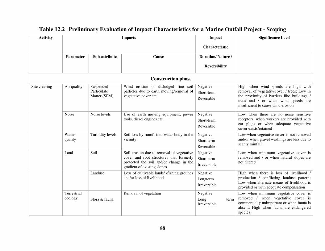
88
Table 12.2 Preliminary Evaluation of Impact Characteristics for a Marine Outfall Project - ScopingImpacts Impact
Characteristic
Activity
Parameter Sub-attribute Cause Duration/ Nature /
Reversibility
Significance Level
Construction phaseAir quality Suspended
ParticulateMatter (SPM)
Wind erosion of dislodged fine soilparticles due to earth moving/removal ofvegetative cover etc
NegativeShort-termReversible
High when wind speeds are high withremoval of vegetativecover / trees; Low inthe proximity of barriers like buildings /trees and / or when wind speeds areinsufficient to cause wind erosion
Noise Noise levels Use of earth moving equipment, powertools, diesel engines etc.
NegativeShort-termReversible
Low when there are no noise sensitivereceptors, when workers are provided withear plugs or when adequate vegetativecover exists/retained
Waterquality
Turbidity levels Soil loss by runoff into water body in thevicinity
NegativeShort termReversible
Low when vegetative cover is not removedand/or when gravel washings are less due toscanty rainfall.
Soil Soil erosion due to removal of vegetativecover and root structures that formerlyprotected the soil and/or change in thegradient of existing slopes
NegativeShort termIrreversible
Low when minimum vegetative cover isremoved and / or when natural slopes arenot altered
Land
Landuse Loss of cultivable lands/ /fishing groundsand/or loss of livelihood
NegativeLongtermIrreversible
High when there is loss of livelihood /production / conflicting landuse pattern;Low when alternate means of livelihood isprovided or with adequate compensation
Site clearing
Terrestrialecology Flora & fauna
Removal of vegetation NegativeLong termIrreversible
Low when minimum vegetative cover isremoved / when vegetative cover iscommercially unimportant or when fauna isabsent; High when fauna are endangeredspecies

89
Impacts Impact
Characteristic
Activity
Parameter Sub-attribute Cause Duration/ Nature /
Reversibility
Significance Level
Site clearing(contd)
Socioeconomics
Economicstability
Ressetlement, removal of vegetationand/or change or loss of livelihood
NegativeLong termIrreversible
High when there is loss of commerciallyvaluable area/ resettlement of populationand changes in livelihood
Air SPM, NOx, HC,CO
Vehicular emissions & generation of dustdue to handling and transport of fine &coarse gravel in uncovered trucks
Short termNegativeReversible
Low with low cost EMP such as use oftarpaulin sheets for covering trucks orwater sprays for dust suppression andregular emission checks; High whentransported through unpaved/poorlymaintained roads
Transportation ofraw materials
Noise Noise levels Vehicular noise Short termNegativeReversible
High when heavy trucks ply through noisesensitive areas especially at nightLow when there are no noise sensitivereceptors
Air SPM, NOx, SO2,HC and CO
Fugitive dust generation due to concretemixing, cement handling, & gaseousemissions from welding, asphalt heating,mixing, and laying, operation ofconstruction machinery
Short termNegativeReversible
Low, with low cost EMP such assprinkling water and wearing masks andwhen regular emission checks are done forthe construction machinery, and/or whenconstruction area is protected by barriers
Constructionactivities
Noise Noise levels Use of construction equipment and powertools
Short termNegativeReversible
Medium when there are noise sensitivereceptors in the vicinity;Low, with low cost EMP like providingworkers with ear plugs or when there are nonoise sensitive receptors in the vicinity
Constructionactivities (contd)
Water Water QuantityTurbidity
Water consumption for constructionTurbid runoff from construction sitewashings
Short termNegativeReversible
Low, if groundwater is not tapped andwhen runoff is minimized by constructionof small bunds

90
Impacts Impact
Characteristic
Activity
Parameter Sub-attribute Cause Duration/ Nature /
Reversibility
Significance Level
Water Water QuantityDO, BOD, TSS,Nutrients, FecalColiform
Water consumption for domestic usageDisposal of untreated waste
Short termNegativeReversible
Low, if workers are local as the usagepattern is maintained or when waterresource is not a constraintLow, with basic treatment units such assoak pits, septic tanks etc
Land Landuse patternand aesthetics
Generation of solid wastes, haphazardgrowth of temporary buildings /dwellings/hutments
Short termNegativeReversible
Low, when proper collection and disposalof solid wastes is practisedLow when the proponent provides adequateshelter, basic resources and sanitation forthe workers or when temporaryconstruction is regulated
Labour force
Socio-Economics
Employment Increased employment opportunities Short termPositiveReversible
Low, if the employment is temporary andonly during the construction phase
Noise Noise levels Use of dredging equipment and powertools
Short termNegativeReversible
Low if the soil at the dredging location issoft and of clayey nature with no noisesensitive marine species at close proximityMedium for a rocky profile
Pipeline layingon the seabed
Water TSS,Nutrients,Toxicity
Sediment resuspensionRelease of toxic substances and nutrientsfrom the sediments
Short termNegativeReversible
Medium for turbidity when the material isclay and low for toxicity when sedimenttoxiciy is minimal
Pipeline layingon the seabed(contd)
Ecology Micro andMacrobenthos
Disturbance of bottom sediments andremoval or destruction of spawninggrounds
Short termNegativeReversible
Low, when commercially valuable species/breeding/spawning grounds are not present
Disposal ofdredged materialalong the coastor landreclamation
Ecology Benthos Trapping of benthos Long termNegativeIrreversible
Low if the area is a barren and devoid ofecologically sensitivespecies/commericially valuable species

91
Impacts Impact
Characteristic
Activity
Parameter Sub-attribute Cause Duration/ Nature /
Reversibility
Significance LevelSignificance Level
Sedimenttransport
Shorelinechanges
Change in hydrodynamics due to materialdumping
Long termNegativeIrreversible
Low if dumping site is not close to thewater front
Disposal oftunneledmaterial at sea
Water TSSTurbidityNutrientsToxicity
Dumping of dredged material Short termNegativeReversible
Low when the dredged material conformsto the sediment properties at the disposalsite. High when dredged material is toxic orin the presence of fishing / breeding /spawning grounds
Operations phaseAir CO, NOx, SPM,
SO2 and HCEmissions from DG sets Operation
phaseLong termNegativeIrreversible
Low when the DG sets are used onlyfor emergency purposes and whenfrequent emission checks are made andwhen there are no sensitive receptors inthe downwind direction
Power plants
Noise Noise levels Noise generation from DGsets
Operationphase
Long termNegativeIrreversible
Low when the DG sets are used onlyfor emergency purposes and when thereare no sensitive receptors in thedownwind direction
Wastewaterdischarges(municipal) fromoutfalls
Water TSS, DO, BOD,Nutrients &Fecal coliforms
Discharge of treated oruntreated sewage into thewater body
Operationphase
Long termNegativeIrreversible
Low when the wastewater is treatedbefore discharge
Wastewaterdischarges(municipal) fromoutfalls (contd)
Ecology Marine flora andfauna
Discharge of wastes Operationphase
Negative Low when the wastewater is treatedbefore discharge

92
Impacts Impact
Characteristic
Activity
Parameter Sub-attribute Cause Duration/ Nature /
Reversibility
Significance Level
Waterquality
Salinity, DO Discharge of brine Operationphase
Long termNegativeReversible
Low when the brine is sufficientlydiluted with fresh water
Effluentdischarge fromdesalinationplants
Ecology Marineorganisms
Discharge of water withhigher salinity
Operationphase
Long termNegativeReversible
Low when there are no ecologicallysensitive species at and near thelocation of disposal
Waterquality
Temperature Discharge of effluent whichhas higher temperature thanthat of the water body
Operationphase
Long termNegativeIrreversible
Low when the cooling water issufficiently diluted and when there areno ecologically sensitive species at andnear the location of disposal
Cooling waterdischarge fromthe power plants
Ecology Marineorganisms
Discharge of effluent whichhas higher temperature thanwhat the organisms areacclimated to
Operationphase
Long termNegativeIrreversible
Low when there are no ecologicallysensitive species at and near thelocation of disposal
93
Chapter 5
Baseline study
13.0 INTRODUCTION
For route-planning and site-specific detailed engineering design, it is essential to have theexisting (baseline) status of the project location. The study of baseline status and the site-specificdata is useful in determining the
� environmental design considerations for the project and
� environmental parameters that are likely to be impacted by the project.
13.1 Engineering design considerations
The following sections describe site-specific data required for detailed engineering design andfor incorporating environmentally appropriate considerations at the planning stage.
Route survey
Several routes are generally considered for a proposed pipeline route based on desk study.Survey of the alternative routes is essential to assess the viability of the best option. Appropriatesite-specific measurements may be required in addition to details in maritime charts, to ascertainthe local current patterns and seabed contours at suitable intervals.
Route survey shall be carried out with the following objectives:
� To establish vertical route profiles, contour plan and seabed features, particularlynearshore rock outcrops;
� To obtain accurate bathymetry, locate all obstructions and identify other seabed featureswhich may affect the laying, trenching and stability of the pipeline;
� To define geology of the sub-seabed by geophysical surveys;
� To define the geotechnical properties of the seabed soils by in-situ testing and sampling.

94
Seabed engineering surveys
Hydrodynamics
Site-specific measurements shall consist of current speeds, directions; wave heights, verticalcurrents along the pipeline route, circulation patterns etc.
Geophysical investigation
Geophysical surveys for pipeline installations are normally carried out with the purpose ofdetermining
� Bathymetry, topography, wrecks and obstacles on the surficial soils by acoustic methodssuch as echo sounder, side-scan sonar and/or magnetometers
� Sub seabed geological information comprising structure, geometry and configuration ofapproximately the first hundred metres of subsoil for tunnelled pipelines, using seismicreflection methods (seismic prospecting).
Marine geotechnical investigation
Comprehensive soil investigations shall include in-situ tests, grain-size distribution, plasticityand strength parameters. Results of geotechnical investigation shall include recommendations onslope stability, suitability of soil from trench excavation, recommended soil-pipeline frictionfactors, liquefaction potential, possibilities of scour around pipelines, stability / mobility ofsediments, comments regarding lay barge anchoring etc.
13.2 Environmental Parameters
Air, water and sediment quality, noise levels, ecological characteristics and socio-economicconditions are some of the quantifiable parameters that define environmental setting in andaround the project location. Baseline studies characterize the existing condition before theproposed project and needs to be designed to represent site-specific conditions. . Baselinemonitoring must be representative of the typical conditions at site and can include both averageand peak (such as spring and neap) conditions. However, care should be taken to avoid samplingduring an unusual event that is not representative of baseline, such as sampling air quality closeto a transient source, sampling noise levels near piling operation sites or water quality neardredging sites etc.
Air Environment
For assessing ambient air quality status, the parameters measured are:
� Existing air quality at the site i.e. the background concentrations of suspendedparticulate matter (SPM), SO2, NOx, etc;

95
� Wind direction to determine the receptor;
� Wind speed which influences the horizontal mixing of pollutants;
� Wind speed, temperature gradients and rainfall that determine the atmospheric stability(inversion, mixing heights etc) which further affects the vertical mixing of pollutants;
� Topography (hills, buildings, trees etc) which influences the mechanical mixing ofpollutants; and
� Land use to determine receptors
Table 5.1 gives details of air quality data collection. Sampling stations for air quality shall beselected based on emission discharge locations such as near DG sets, captive power plants,industrial emissions, peak hour/heavy traffic locations, and at recipient locations.
Table 13.1 Air quality data collectionSampling criteriaComponent Parameter
Specification Frequency
Source
Wind direction Distribution withheight
1 year daily data IMD
Wind speed Distribution withheight
1 year daily data IMD
Temperature gradient Distribution withheight
1 year daily data IMD
Atmospheric stability Distribution withheight
1 year daily data IMD
Meteorology
Rainfall Distribution 1 year daily data IMD
Air quality Suspended particulate matter(SPM), SO2, NOx,
24-hr average for oneseason other thanmonsoon
Twice a week for 3months
Primary data
Topography Hills, buildings, trees andother mechanical obstructions
Layout map of thearea
Present data Secondary data/visual observation
Baseline studies for air quality assessment shall include study of bacterial contamination throughaerosols and odour problems due to location of head works.
Noise
To determine the impact on noise levels due to a project, baseline data collection shall consist of
� Existing noise levels at the site i.e. the background concentrations
� Noise attenuating factors such as hills, trees, barriers, humidity etc

96
� Land use map to locate the noise sensitive receptors such as schools, hospitals,residential areas, concert halls, etc.
Table 5.2 gives details of data collection for noise levels. Noise levels shall be measured at theproject site and at noise sensitive receptor locations.
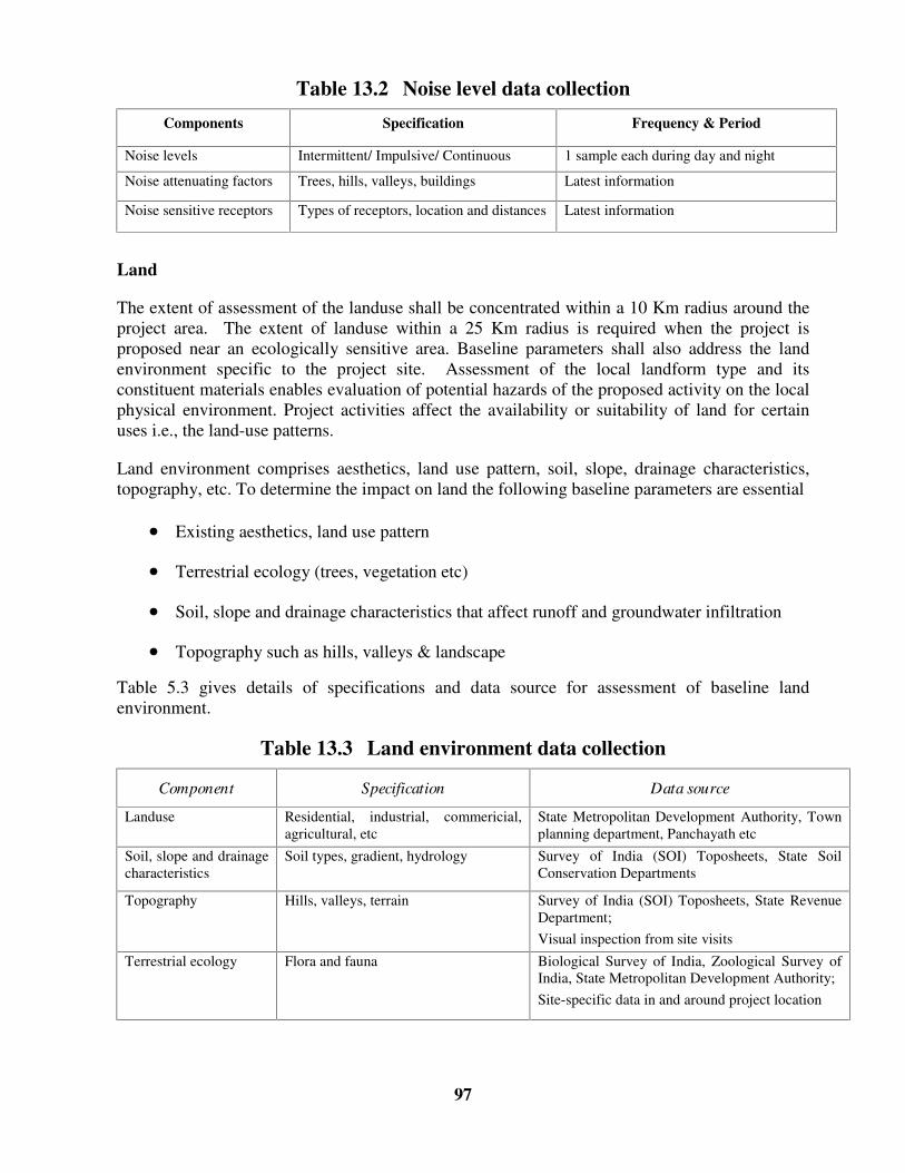
97
Table 13.2 Noise level data collectionComponents Specification Frequency & Period
Noise levels Intermittent/ Impulsive/ Continuous 1 sample each during day and night
Noise attenuating factors Trees, hills, valleys, buildings Latest information
Noise sensitive receptors Types of receptors, location and distances Latest information
Land
The extent of assessment of the landuse shall be concentrated within a 10 Km radius around theproject area. The extent of landuse within a 25 Km radius is required when the project isproposed near an ecologically sensitive area. Baseline parameters shall also address the landenvironment specific to the project site. Assessment of the local landform type and itsconstituent materials enables evaluation of potential hazards of the proposed activity on the localphysical environment. Project activities affect the availability or suitability of land for certainuses i.e., the land-use patterns.
Land environment comprises aesthetics, land use pattern, soil, slope, drainage characteristics,topography, etc. To determine the impact on land the following baseline parameters are essential
� Existing aesthetics, land use pattern
� Terrestrial ecology (trees, vegetation etc)
� Soil, slope and drainage characteristics that affect runoff and groundwater infiltration
� Topography such as hills, valleys & landscape
Table 5.3 gives details of specifications and data source for assessment of baseline landenvironment.
Table 13.3 Land environment data collection
Component Specification Data source
Landuse Residential, industrial, commericial,agricultural, etc
State Metropolitan Development Authority, Townplanning department, Panchayath etc
Soil, slope and drainagecharacteristics
Soil types, gradient, hydrology Survey of India (SOI) Toposheets, State SoilConservation Departments
Topography Hills, valleys, terrain Survey of India (SOI) Toposheets, State RevenueDepartment;Visual inspection from site visits
Terrestrial ecology Flora and fauna Biological Survey of India, Zoological Survey ofIndia, State Metropolitan Development Authority;Site-specific data in and around project location

98
Water and sediment quality
Water environment consists of oceanographic, water quality (physical, chemical) parameters andbiological characteristics. Oceanographic parameters are tide, wave height, current speed anddirection etc. Water quality parameters are turbidity, temperature, suspended solids, salinity, pH,DO, BOD, nutrients etc. Biological characteristics are categorized as pathogenic (fecalcoliforms) and ecological like benthos, phytoplankton, zooplankton, fish etc. Transportmechanism of pollutants is influenced by advection - diffusion factors due to tides, waves, andcurrents.
For assessing the impact on water environment the following baseline information is essential
� Existing water quality at the project location (sea, creek) i.e. the backgroundconcentrations
� Oceanographic parameters such as tides, waves, current speed and direction andbathymetry that influence mixing and diffusion of water quality parameters
Tables 5.4 and 5.5 give sampling specifications, frequency for site-specific water quality andsediment quality data collection. Sampling stations shall be selected based on the effluentdischarge points, sewage outfalls, dredging/dumping sites etc, and shall be based on theenvironmental setting of the project site. Sampling shall not be conducted during cyclones orduring dredging operations, i.e., sampling shall represent average conditions.
Table 13.4 Water EnvironmentSampling criteriaComponent Parameter
Specification Frequency & Period
Oceanography
Hydrodynamics Tides, waves & currents (speed &direction)
1 to 3 season sampleexcepting monsoon
15 days / season
Bathymetry Water depths Once
Water quality
Physical parameters pH, salinity, temperature (thermalstratification) TSS, TDS, Oil andgrease
1 to 3 season sampleexcepting monsoon
1 sample each duringhigh and low tides
Chemical parameters DO, BOD & Nutrients, Cadmium,Lead, Mercury TOC, Pesticides*,Silicate, Heavy metals*,Organochlorine* and phosphorouscompounds*
1 to 3 season sampleexcepting monsoon
1 sample each duringhigh and low tides
Biological Characteristics
Biologicalcharacteristics
Phytoplankton, Zooplankton, Fisherypotential, Bacteriology work, Intertidalfauna (Bioassay test, primaryproductivity, species diversity, speciesabundance)
1 to 3 season sampleexcepting monsoon
1 sample each duringhigh and low tides
* Optional items – depends on type of discharges in the location
99
Table 13.5 Sediment quality dataSampling criteriaComponent Parameter
Specification Frequency & PeriodPhysical quality pH, Sediment granulometry 1 to 3 season sample
excepting monsoon1 sample / season
Chemical quality Nutrients, organic carbon, heavymetal* / pesticide analysis*, detergents
1 to 3 season sampleexcepting monsoon
1 sample / season
Biological quality Macrobenthos, Microbenthos,Meiobenthos
1 to 3 season sampleexcepting monsoon
1 sample / season
* Optional items – depends on type of industrial discharges in the location
13.3 Ecology
Natural vegetation, endangered species, marine organisms and ecologically sensitive species helpdefine the ecological setting at site. These attributes are critical in assessing the suitability of theproject at the selected site.
All areas of ecology are very difficult to quantify. However, qualitative analysis of thecharacteristics can be done on the basis of knowledge and experience in a broad range ofanalogous systems. Quantifiable methods such as biodiversity and/or species richness indices,biomass energy pyramids, nutrient cycles for biology provide sufficient information onecological status of a location.
Measurement of ecological characteristics shall
� Be conducted in fishing, breeding and polluted zones
� Include analyses at various trophic levels and
� Identify endangered species/critical habitats
13.4 Socio-economics
Wastewater disposal projects are likely to have impacts on socio-economics of a region duringconstruction stages. However, the operation of outfalls shall have a net beneficial impacts to thesocio-economics of the region. Receptors / beneficiaries of impacts may be local population,fishing communities and beach users.
Assessments of baseline socio-economic conditions comprise, study of demography, healthstatus, living conditions etc. To assess impact on socio-economic environment, it is essential tocollect the following data
� Livelihood of the population, fishing practice, location of fishing grounds etc.
� Details on level of education of the population surrounding the project site, likelyreceptors of impact;

100
� Standard of living at the site i.e. the infrastructure available to local population such aswater supply, sanitation, electricity, transportation, education, medical treatment etc;
� Health status of the population especially those suffering from infectious diseases.
� Commercially valuable species and materials at the project site
Resources
� Water, power, fuel & non-fuel resources are assessed for labour camps, constructionactivities, operational requirement etc.
13.5 Typical baseline requirement
Table 5.6 gives typical baseline parameters required for various activities of a wastewaterdisposal project. The extent of baseline study is a function of the nature of activities and theenvironmental status at the project location.
Table 13.6 Activity-specific baseline ParametersEnvironmental ParametersActivity
Air Noise Land Water Sediment Ecology Socio-Economics
Site clearing/Landdevelopment/
SPM NoiseLevels
Landuse,layout ofbuildings
TSS in waterbodies in thevicinity
Terrestrialflora & fauna
Rehabilitationissues,Livelihood¸health status
Transportationof rawmaterials
SPM,NOx,SO2
NoiseLevels
Constructionactivities
SPM Noiselevels
TSS, Water source& availability
Labour camps Aesthetics, solidwastedisposallocation
pH, Temp, salinity,TSS, DO, BOD,Nutrients, Fecalcoliforms, Watersource&availability
Number ofpeople likelyto beemployed
Tunnelling theseabed anddisposal ofmuck1
Noiselevels,Noisesensitivereceptors
Extent ofland,Landuse,soil type
DO, TSS, Nutrients Benthos,nutrients
Plankton Identificationofcommerciallyvaluablemarine species
Pipeline layingon the seabed
Noiselevels,Noisesensitivereceptors
TSS, nutrients Macro-benthos,Micro-benthos,nutrients
Plankton,breedinggrounds
Identificationofcommerciallyvaluablemarine species

101
Environmental ParametersActivity
Air Noise Land Water Sediment Ecology Socio-Economics
Wastewaterdischarge fromoutfalls
pH, Temp, salinity,TSS, DO, BOD,Nutrients,Cadmium, Lead,Mercury TOC,Pesticides3,Silicate, Heavymetals3Organocholrine3and phosphorouscompounds3
MPD,nutrients,organiccarbon,heavymetal3 /pesticideanalysis3 ,detergents
Plankton,breedinggrounds,Fisherypotential,Bacteriology,Intertidalfauna
Identificationofcommerciallyvaluablemarine species
Emissionsfrom DG sets
SPM,NOx,SO2,
HC2,CO2
Noiselevels
Cooling wasterdischarge frompower plants
Temp, DO Macro &Micro-benthos,
Plankton,breedinggrounds,Fisherypotential,Bacteriology;Intertidalfauna
Identificationofcommerciallyvaluablemarine species
1 Land or water, sediment and ecology parameters required only when such disposal is
involved.
2 Optional Parameters- shall be measured when such emissions are expected depending on
fuel used
3 Optional items – depends on type of discharges in the location
102
Chapter 6
Prediction of impacts
14.0 PREDICTION
Goal of prediction is to establish/forecast the difference in environmental quality due to a newdevelopment
Predictions consist of estimating impacts of all the activities of the proposed project andoverlaying the baseline on it, from which change in each environmental parameter due to theproject can be evaluated, which essentially gives a measure of “ how much can be changed”whilst still maintaining the present environmental conditions. Comparison with nationalstandards for air, noise and water quality can be made from these estimates and change from newdevelopment determined.
Predictions can be quantitative and/or qualitative. Quantitative methods give an estimate of theimpact using mathematical expressions/computer models and experimental/physical models.Simple quantitative methods are typically analytical with broad assumptions requiring handcalculations, while the complex models are computer based and address many of thecomplexities of the natural environment. Qualitative methods are based on professionaljudgment/examples of similar occurrences/events in other locations/projects or cited in literature.
Results of prediction can be illustrated with contours or plots showing critical concentrations, inconjunction with receptor locations to determine the significance of impacts.
Scenarios for prediction
Prediction must be done for climatologically critical conditions, i.e., when stress on theenvironment is the greatest. The critical conditions must be clearly indicated in the EIA report.An example for air pollution is the period of inversion, when the pollutants do not disperseeasily. For a water quality, the critical scenario may be the hottest period of the year. Thechoice of an appropriate scenario for the study depends on the climatological history of the areaand requires a database of long-term measurements. The scenarios typically employed inpredicting an impact are:
� Most probable case scenario
� Worst case scenario
Most probable case scenario:
This is characterized by the combination of discharges/emissions and hydrodynamic/atmosphericinteractions that produces the frequently encountered impact.
103
Worst case scenario
This is characterized by the combination of discharges/emissions and hydrodynamic/atmosphericinteractions that produce maximum adverse impact.
14.1 Assessment of ground vibrations due to underground blasting
A tunneled outfall may require blasting of the sub seabed rock layer. Blasting results invibration, which may cause damage of structures adjacent to the site. Though vibration relatedproblems are difficult and complex to identify, it is essential to consider the combined effect offactors such as characteristics of vibration sources and site, propagation of surface and bodywaves in the ground and response of structures. There are techniques to predict air and groundvibration levels theoretically, to assist in the control of blasting operations, thereby reducing thelevel of operating risk concerning blast vibration. In coastal and marine areas, it is appropriate toidentify and consider the response of foreshore and offshore structures while planning blastingoperations. Prediction of safe inhabitant building distance can be made from peak particlevelocity (PPV) of ground motion which shall also take into consideration the soil conditions,structural type and ground motion frequency contents.
14.2 Assessment of air quality impacts
The air pollutants emitted into the atmosphere will be diluted and dispersed depending on localmeteorological and geographical conditions. A continuous stream of pollutants when releasedinto the atmosphere will rise, bend and then travel in the direction of the wind, which enablesdilution and carries the pollutants away from the source. This plume of pollutants will alsospread out or disperse in both horizontal and vertical directions from its centerline.
The simplest method available for predicting concentrations is the steady state Gaussianequation, designed for conditions where a continuous stream of pollutant is released into a steadywind in an open atmosphere. In nature, the pollutant plume will rise and bend over, gettransported by the wind, and concentrations will decrease away from the source. The plumespread will be influenced by molecular diffusion, turbulent eddies of the average wind flow,thermal gradients, random shifting of winds and mechanical mixing of the air moving over theland. The dispersion of an air pollutant released into the atmosphere depends on the followingfactors
� Properties of pollutant (stable, unstable)
� SO2, CO and SPM are stable pollutants, as they do not participate in chemical
processes in the atmosphere.
� NOx and certain hydrocarbons are unstable pollutants which actively participate in
chemical reactions thereby forming secondary pollutants
� Release rate & type (puff, plume)

104
� An accidental release of chemical from a pipeline or hose is an example of puff
release (instantaneous)
� Emissions from power plants, stream of vehicles are continuous and an example
of plume release
� Meteorology (Atmospheric stability)
� Atmospheric stability is defined by wind speed and vertical temperature gradient
which influence mixing of pollutant
� Wind speed influences the horizontal diffusion/dispersion of an air pollutant
while wind direction determines the region and receptor of impact.
� Temperature gradient affects vertical mixing of pollutants
� Local terrain conditions (hills, valleys, buildings)
� The local terrain conditions influence the mechanical mixing of the pollutants.
� Height of release above the ground
� Emissions from a DG set may occur at different heights based on stack height,
while releases from pipeline occur at ground level. Releases from a lower height
will have greater ground level pollutant concentrations than releases from a
greater height
� Release geometry (point, line, area source)
� Emissions from DG sets are point sources
� Emissions from vehicular traffic during peak hours are line sources
Modeling of pollutant dispersion needs to take into consideration, the thermal stratificationexisting in the atmosphere, particularly in the ground layer. Differential heating/cooling of thedifferent layers result in density stratifications, the most critical of which is the ‘thermalinversion’ which block vertical diffusion/dispersion across them (vertically). The inversionoccurring close to the ground surface almost each night to pre-dawn periods, caused by the backradiation from heated earth-surface and building structures are termed ‘ground-based inversion’and significantly affect pollutant-dispersions and consequent environmental impacts. Byblocking vertical dispersion of pollutants, inversions limit the height of atmosphere within whichmixing is allowed to take place i.e., ‘mixing heights’ of the atmosphere.
The understanding and characterization of these inversions is absolutely essential to anymeaningful modeling of pollutant dispersions. Thermal stratification and consequent mixingheights can be taken into account by using ‘stability classes’ . IS: 8829-1978 gives themethodology for determination of stability classes.

105
The activities of the coastal tourism project that cause an air quality impact are
1. Site clearing / Soil excavation
2. Transportation of raw materials
3. Construction activities
4. DG sets / Captive Power Plant emissions
Items 1 to 3 primarily relate to generation of fugitive dust during operations. These areconstruction phase activities and will cease to contribute pollutants after construction iscomplete. Vehicular emissions from traffic during construction and operational phases can bemodeled using Guassian line models. Emissions from DG sets/ captive power plants are pointsources and released at their stack heights, which can be appropriately modeled by Guassianpoint models.
Guassian models, which determine the spatial distribution of pollutant concentrations, are basedon the Guassian equation, which applies to a single steady state continuous point source. Thebasic inputs for this model in predicting the concentration are
� Emission rate of pollutant
� Vertical and horizontal dispersion coefficients which are a function of the downwinddistance
� Wind velocity in the downwind direction
� Vertical distance above ground
� Lateral distance from the centreline of the plume
� Length of the line source (in case of line source emissions)
Meteorological data needed for pollutant dispersion modeling shall include:
a. Average wind direction: to define co-ordinates
b. Average wind speed: to provide velocity
c. Atmospheric stability: to determine the vertical and horizontal
dispersion coefficients
d. Ambient temperature: to calculate the effective height of (stack)
emission above ground level
e. Atmospheric temperature lapse rate: to determine stability classes

106
14.3 Assessment of noise level impacts
Sound or noise is a disturbance, which propagates away from the source through an elasticmedium, namely air, water or solids and reaches a receiver. The noise level (dB) at thereceiver’ s location is a function of the characteristics of the sound source (power, intensity andfrequency spectra), the properties of transmission medium and the presence of objects orbarriers.
For simple cases, such as point source, the sound energy is radiated over spherical surfaces awayfrom the source. The presence of objects in the path of sound propagation results in reduction inthe sound pressure level. For a source located on the ground, the sound will propagate in ahemispherical pattern.
The prediction of noise should address the type of source, type of environmental conditions atthe site and the receptors
Type of noise source
Noise sources may be classified as impulsive or sudden; intermittent-unsteady; continuous-steady noise. Table 6.2 gives the types of noise sources for coastal tourism project activities.
Table 14.1 Noise pollution source characteristicsActivity Source type
Site clearing / Soil excavation Conitinuous-SteadyTransportation of raw materials Intermittent-unsteadyConstruction activities Continuous – unsteadyBlasting operations Intermittent-unsteadyDG sets/Captive Power Plant emissions Conitinuous-Steady
Types of environment or attenuating factors
The type of environment determines the degree of noise attenuation, where the greater theattenuation, the lesser the impact on the receptor. Examples of attenuating factors are:
� Atmospheric conditions like humidity, wind direction, wind speed etc; and
� Barriers such as walls, vegetation etc.
Type of receptors
Receptors could be insensitive or sensitive. For example inmates of hospitals or bird sanctuaries,aquatic species etc., are sensitive noise receptors while industrial, commercial areas are relativelyinsensitive. Limits of acceptable noise levels for each category of receptor or areas/zones arespecified in the National Ambient Air Quality Standards in respect of noise (Section 2.1).

107
14.4 Ecological Environment
The ecosystem comprises of both the abiotic (non-living) and the biotic (living) assemblages.Coastal zones are considered to be the most productive ecosystems on earth. In rural areas orindustrially undeveloped areas, the primary economic activities such as agriculture, forestry andfisheries are based upon the living natural resources or the biological environment.
The most common method of prediction is the qualitative approach by a qualified expert. Anexpert bases the prediction on the basis of baseline ecology, knowledge of the plant & animallife, their habitat requirements, and utilises the changes predicted for air, noise, water and landenvironment to estimate the ability of the biological community to tolerate the change. Thisprediction is best performed when the data on the biological environment is available fordifferent tropic levels.
Tools to assist the expert in the prediction of impacts are,
iii. Statistical estimates of bio-diversity such as the Shannon-Weavers Diversity
Index or species richness indices from the rarefaction method or Jack-Knife
estimates. These statistical estimates should be compared with other values for
similar environments only.
iv. Biomass and energy pyramids that are aids to define the food chains and the
health of the ecosystem. The baseline structure helps in the assessment of the
impact of the abiotic environment on the ecosystem.
v. Nutrient cycles that can help define potential impacts such as Eutrophication,
contribution to green house gases.
Mathematical models have also been developed for ecological energetic or the study of the flowof energy within an ecosystem and ecological modeling for specialized ecosystem. However,while using these methods, determination must be made to ensure appropriateness to the tropicalcoastal ecosystem of India
14.5 Land Environment
Though a wastewater disposal project, may not involve acquiring significant areas of land,clearing the site, soil excavation and activities such as disposal of muck from tunnels, may affectland directly. In this perspective the most significant elements of land that require predictionhave been broadly classified into
� Soil Erosion

108
� Salt water intrusion
Erosion is the process through which soil particles are dislodged and transported to otherlocations by actions of water and/or wind. Removal of vegetative cover exposes the soil toerosive forces of water and wind. Soil erosion will lead to an unproductive land, change thedrainage pattern of the area, increase the sediment load reaching the neighboring water bodies,and the resulting landscape will be aesthetically unappealing. Methods like Universal Soil LossEquation (USLE) are useful to make estimations of soil erosion.
Groundwater may be a source of water for labor camps and construction activities. If the rate ofwithdrawal exceeds the rate of groundwater recharge, the yield of the aquifer (or the availablewater resource) will decrease and subsequently salt-water intrusion may be observed. Alternativesources for water must be identified to protect against depletion of freshwater resource &/orsaltwater intrusion.
If land reclamation is proposed, it is necessary to determine the composition of the fill materialand the topsoil at the reclamation site to evaluate the impacts on flora, fauna and groundwaterdue to contrast in the soil types and leaching characteristics.
14.6 Socio-economic Environment
Socio-economic impacts can be assessed by means of scientifically planned surveys likeobtaining public response through questionnaires. Public hearings also help in cost-benefitanalysis of the project and its location.
It is possible to make estimates on the change to the socio-economic environment with a detaileddescription of the project. The starting point for these estimates is human population andeconomic models.
Associated health impacts that can result directly from changes to the biophysical environmentmay result in increased exposure to toxic pollutants by fish in the region, increased health relatedrisks (such as high incidences of skin irritation, abdominal rashes, tuberculosis and respiratoryproblems) amongst the local population. Following are some of the salient issues, which need tobe assessed before the commencement of the project.
� Resettlement of coastal population
� Increased risk of accidents possibly from blasting or leakages in sewer systems.
� Disruption in area due to construction activities
� Health impairment
� Reduced value for fish-catch in the region
14.7 Significance of impacts
Determination of significance of impacts is to check whether the impacts are acceptable, requiremitigation or unacceptable to the community. Significance of impact is determined by theconsideration of the impact characteristic and the importance (value) attached to them.
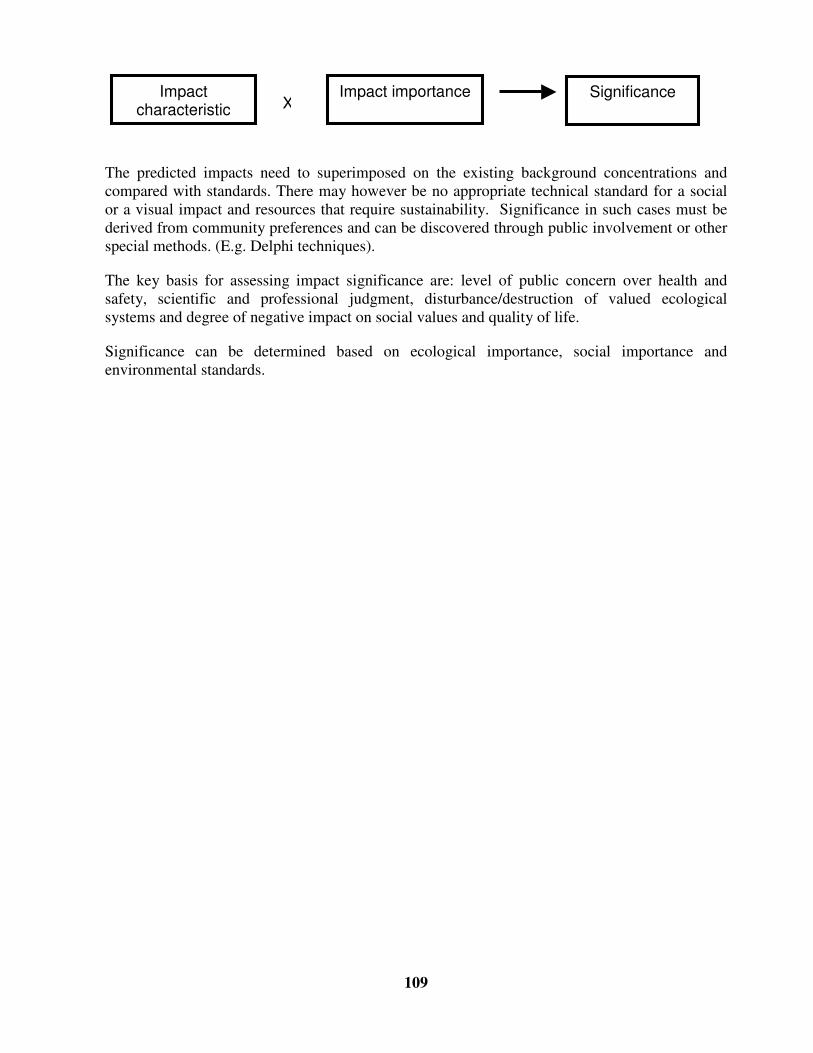
109
The predicted impacts need to superimposed on the existing background concentrations andcompared with standards. There may however be no appropriate technical standard for a socialor a visual impact and resources that require sustainability. Significance in such cases must bederived from community preferences and can be discovered through public involvement or otherspecial methods. (E.g. Delphi techniques).
The key basis for assessing impact significance are: level of public concern over health andsafety, scientific and professional judgment, disturbance/destruction of valued ecologicalsystems and degree of negative impact on social values and quality of life.
Significance can be determined based on ecological importance, social importance andenvironmental standards.
Impactcharacteristic
Impact importance SignificanceX
110
Chapter 7
Monitoring performance of outfall
15.0 INTRODUCTION
Monitoring functioning of outfalls is imperative for environmental management of the region inorder to ensure that the outfall is performing its duty of transferring impacts to a region oflocalized negligible receptors. Operational performance monitoring provides information for (i)management of commercial fisheries and tourist resources in the region and (ii) evaluation ofcompliance to designated standards. Performance monitoring needs to be carried out forstructural stability, hydraulic performance, public health and ecology.
15.1 Monitoring plans/procedures
Monitoring requirements are defined by the (i) receiving water quality requirements and (ii)findings of baseline survey (data interpretations, trends, fishing grounds. Selection of appropriatewater quality parameters, sampling station locations, oceanographic parameters (diurnalfluctuations in tidal movements, current speeds and directions) forms the crux of a well-designedmonitoring program. Monitoring needs to be carried out in critical seasons that reflect thehighest stress on water quality. Important considerations in monitoring program are theoptimum number of sampling stations and replication of biological samples. Careful selection ofmethods and their calibration within the particular environment to be monitored are essential fora successful data collection program.
15.2 Pipeline monitoring
Records of information such as “ As Built” drawings of pipelines, route maps, vertical andhorizontal alignment of pipelines etc. shall be maintained for operation purpose. Other recordsshall include
� Procedure containing
� Description of system components;
� Details of operating manuals and personnel;
� Documentation of operations procedures for start-up and shut down of pipelines;
Marine outfall pipelines shall be manually inspected atleast once in a year essentially when theyextend beneath navigational (shipping) channels, trawling areas (fishing gears) or over shallowsurf zones. An established methodology may be followed for inspection maintaining routineschedule and log sheets.
111
Site and project specific procedures shall be planned taking into consideration, factors such aspipeline material, water depths, effluent characteristics, sensitivity of the environment etc.Diffusers shall be frequently monitored and inspected to ensure proper functioning. Regularflushing of the pipeline can ensure removal of any grease or grit accumulation. Inspection shallbe carried out to check loss of diffuser risers, anchor blocks etc., which may cause lateraldisplacement of the pipeline.
15.3 Hydraulic performance
Seasonal and/or annual monitoring of discharge of wastewater, average concentrations ofselected dissolved and suspended constituents needs to be monitored. Extreme conditions fromspills or overflows during wet weather also need to be monitored.
15.4 Ecological requirements
Effluent characteristics
The treated wastewater characteristics shall be monitored to comply with discharge standards,from which treatment efficiency and better source control can be monitored.
Water and sediment quality
In order to assess impacts of outfalls on beach and coastal water quality, monitoring shall beundertaken for the following:
� Pathogens, nutrients and suspended solids in water column;
� Contaminants and sediment characteristics;
� Pathogens and grease on beaches
Ecology
Monitoring needs to measure the impacts of wastewater on the marine ecosystems particularlyfish and benthos and utilization of marine resources with reference to seafood contamination(chemical contamination in fish, oysters etc.).

112
Changes in diversity, species richness, community structure and decrease/increase in abundanceof biological communities in the receptor locations of outfalls and any significant changes inchlorophyll-a levels needs to be assessed through surveys. Alternatively, indicator organisms thatare capable of providing a measure of the environmental sensitivity of the site may be identifiedduring baseline surveys and monitored subsequently.
15.5 Public Health
Survey of health related issues in the local fishing population and beach users (especiallyswimmers) are some social concerns that require monitoring.

113
Bibliography
� Ministry of Environment and Forests’ EIA Notification New Delhi, the 27th January1994 (As amended on 04/05/1994, 10/04/1997 and 27/1/2000), CRZ Notification (19th
February 1991 as amended upto August 2000).
� Indian Environmental Legislations
� United Nations Environmental Program (UNEP) EIA Training Resource Manual, byEnvironment Australia (Environmental Protection Group) Canberra, Australia under theguidance and technical support of UNEP International Working Group on EIA (URL:http://www.environment.gov.au/epg/eianet/manual/manual/title.htm) February 1997
� World Bank Technical Paper Number 77, Integrated Resource Recovery, ‘ Wastewatermanagement in coastal cities – The ocean disposal option‘, WPT77, February 1988,(UNDP Project Management Report No. 8)
� World Bank Technical Paper Number 154, Environmental Assessment Sourcebook,Volume III ‘Guidelines for Environmental Assessment of Energy and Industry Projects’ ,Environment Department, The World Bank
� ‘Guidelines for Marine Outfalls and Alternative Disposal and Reuse Options’ ,Environmental Assessment Sourcebook, Update, Environment Department, The WorldBank
� ‘Environmental Assessment’ A guide to procedures, London, HMSO, Dept. ofEnvironment
� ‘Environmental Impact Assessment for Developing Countries in Asia’ , AsianDevelopment Bank
� Environmental Handbook, ‘Documentation on monitoring and evaluating environmentalimpacts’ Volume 1 Introduction, Cross-sectoral Planning, Infrastructure, GermanFederal Ministry for Economic Cooperation and Development, vieweg
� NRCA Guidelines for the Construction, Maintenance and Monitoring of UnderwaterPipelines & Cables in the Coastal Zone, Cowell L. Lyn, Natural Resources ConservationAuthority, http://www.nrca.org/CZM
� ‘A Handbook of Environmental Impact Assessment Guidelines’ – 1988 MalaysianGuidelines
114
� “ An Overview of Numerical Modelling of the Sydney Deepwater Outfall Plumes” , B.M.Miller, W.L. Peirson, Y.C, Wang and R.J. Cox, PIJ: S00025-326X (97) 00077-5,Pergamon
� ‘Air Pollution – An Introduction’ , Jeremy Colls, E & FN SPON
� “ Blast vibration control and assessment techniques” , A.B. Richards, R. Evans & A.J.Moore in: Managing risk, Proc. 4th Open Pit conference, Perth, 1994, (AIMM), pp 209-215.
� ‘Construction of Marine and Offshore Structures’ , Second edition, Ben C. Gerwick, Jr.,CRC Press
� “ Design Procedures for Effluent Discharge to Estuaries during Ebb Tide” , Tony Webband Rodger B. Tomlinson, Journal of Environmental Engineering, Vol. 118, No.3,May/June, 1992. ASCE.
� ‘Dispersion in Estuaries and Coastal Waters’ , Roy Lewis, John Wiley & Sons
� ‘Dredging - A Handbook for Engineers’ , R.N. Bray, A. D. Bates & J.M. Land, Publishedby Arnold
� ‘Encyclopaedia of Environmental Science & Engineering’ , III edition, Parker Corbitt,McGraw-Hill
� ‘Environmental Assessment’ , R.K. Jain, L.V. Urban, G.S. Stacey, H.E.Balbach.,McGraw-Hill, Inc
� ‘Environmental Engineering - A design approach’ , Arcadio P. Sincero, Gregoria A.Sincero, Prentice Hall
� ‘Environmental Impact Analysis Handbook’ , Edited by John G. Rau and David C.Wooten, University of California at Irvine, McGraw-Hill Book Company
� ‘Handbook of dredging, a dredging reference manual’ , Volume I and II, by AppliedDredging Consultancy, The Hague, The Netherlands 1989
� ‘Handbook of environmental laws, acts, guidelines, compliances and standards’ , Vol 1 &2 R.K. Trivedy
� ‘Manual of methods in aquatic environment research’ . Part II: Biological assessment ofmarine pollution with particular reference to benthos. Gray J.S., McIntyre A.D. and StirnJ.FAO Fisheries Technical Paper 324, FAO Rome, 49pp
� ‘Marine Pollution’ , J. Albaiges, Hemisphere Publishing Corporation

115
� “ Mixing Zone Analysis for Coastal Wastewater Disrcharge” , Philip J.W. Roberts andRafael Sternau, Journal of Environmental Engineering, Vol. 123, No. 12, December,1997, ASCE.
� “ Natural Disinfection of Wastewater in Marine Outfall fields” , Lei Yang, Wen-ShiChang and Mong-Na Lo Huang, PIJ: S0043-1354 (99) 00209-2, Pergamon.
� “ Ocean Outfall System for Dense and Buoyant Effluents” , Philip J.W. Roberts and G.Toms, Journal of Environmental Engineering, Vol ¼, No. 5, October, 1988 ASCE
� ‘Oil spill simulation model’ , Jen-Men Lo, Journal of Waterway, Port, Coastal and OceanEngineering, Vol. 117, 3, May/June 1991.
� “ Predicting Organic Accumulation in Sediments near Marine Outfalls” , Kevin J. Farley,Journal of Environmental Engineering, Vol. 116, No.1, February 1990, ASCE.
� ‘Principles of surface water quality modelling and control’ , Thomann and Mueller
� “ Propagation and attenuation characteristics of various ground vibrations” , Dong-SooKim, Jin-Sun Lee, Soil Dynamics and Earthquake Engineering 19 (2000) 115-126
� “ Probabilistic Analysis of Ocean Outfall Mixing Zones” , Hening Huang, Robert E.Fergen, John R. Proni and John J. Tsai, Journal of Environmental Engineering/March1996/359
� “ Rapid Sizing and Performance Evaluation of Submarine Outfalls with Line Diffusers” ,Maria A. Economopoulou and Alexander P. Economopoulos, 38/Journal ofEnvironmental Engineering/February 1998
� “ Returning Impaired Marine Outfall Diffusers to Full Service” , Robert A. Grace, Journalof Environmental Engineering/March 1997/297
� ‘Seabed Reconnaissance and Offshore Soil Mechanics for the installation of PetroleumStructures’ , Pierre Le Tirant, Gulf Publishing Company, Texas
� ‘Surface Water Quality Modelling’ , CE series, Steven C. Chapra, McGraw-Hill
� ‘The mathematical theory of communication’ , Shannon C.E. and Weaver W (1949).University of Illinois Press, 117 pp
� ‘The measurement of diversity in different types of biological collections’ , J. Theor.Biol, 13:131-144.

116
Guidelines for
Environmental Impact Assessment
of
Coastal Tourism Projects
for
The Department of Ocean Development
Under the
Integrated Coastal and Marine Area Management Program
Prepared by
National Institute of Ocean Technology IIT Madras Campus
Chennai – 600036
January 2003

117
Chapter 1
Introduction
1.0 COASTAL TOURISM IN INDIA
The Indian Peninsula, including the two emerald archipelagos of Lakshadweep and Andaman,bounded by the Arabian Sea, the Bay of Bengal and the Indian Ocean has a long coastline ofover 7500 km, with spectacular golden beaches, pristine natural beauty, lush green tropicalforests, and unique fauna and flora. This provides immense scope for development of coastaltourism, basically marketing the “ sand, sea and sun” (3S) phenomenon.
There is also high population density in the coastal belt of India with most of the major cities andmetros situated on the coast. The coastal cities are well connected domestically andinternationally through highways, railways, harbours and airports. This infrastructure providesaccess to domestic and international travellers, laying the foundation for increased coastaltourism.
The tourism sector is one of the fastest growing sectors in the country’ s economy. Althoughtourism activity consists of both domestic and international tourism, tourism developmentstrategy places primary emphasis upon international tourists, as international tourism providesforeign exchange earnings to the destination country while domestic tourism leads largely to aredistribution of national income.
1.1 Typical Coastal Tourism Industry
The origin, transit and destination regions constitute the basic tourism system. Components ofthis system have complex inter-relationship between and among several sectors (transportation,commerce, water supply etc.), service providers (travel agents, tour operators, hotels,merchandisers) and stakeholders (tourists, local population). The distribution of each of thesecategories of the tourism sector varies from origin to transit to destination as shown in Fig. 1.1.
While the primary attraction of the coastal tourism industry is the pristine natural environment,present-day coastal tourism includes large-scale constructed facilities such as theme/amusementparks, resorts, marinas, fishing piers and recreational boating harbours. Typical attributes oftourism sites are provided in the following sections.
2.0 Tourist Attractions
Tourist attractions can be based on:
� Natural sites (beaches, coral reefs, mangrove forests, lakes, rivers, waterfalls etc);

118
� Natural events (tides, bird migrations etc.);
� Cultural / heritage sites (historical monuments, ancient temples, ethnic neighbourhood etc);
� Cultural events (festivals, fairs); and
� Constructed sites/Recreational events (resorts, theme/amusement parks, golf courses, skihills, stadium, sports etc.).
A clean environment is the primary resource for the tourism industry, without which the tourismsite will lose its value.
Traveller generating region
Transit route regionTourist destination region
RETURNING TRAVELLERS
DEPARTING TRAVELLERS
Environments: human, sociocultural, economical, technological, physical, political, legal, etc.
Location of travellers/tourists and the travel and tourism industry
[Source: Fig. 2.1 A basic whole tourism system (Source:Leiper 1995) -‘Tourism Management’ by David Weaver &Martin Oppermann)]
Fig. 1.1 TOURISM SECTOR COMPONENTS
3.0 Accessibility
Accessibility can be classified as spatial and seasonal. Spatial accessibility to tourist destinationis a key criterion for siting of a tourist facility. Accessibility can be provided by construction ofroads, airstrips, piers, landing jetties etc.
4.0 Infrastructure
Land is the primary requirement for tourism industry while other infrastructure requirementsinclude transportation, water and sanitation, power, accommodation, food and beverages.
4.1 Tourism industry life-cycle
Tourist spots along coasts develop and gain popularity within a very short period of time,resulting in concentrated activity in a complex, spatially constrained and vulnerable
119
environment. Each destination can sustain a specific level of acceptance of tourist developmentand use, beyond which further development can result in environmental and social deteriorationor a decline in the quality of the experience gained by visitors. In other words, the carryingcapacity of a destination is determined (i) by its ability to absorb tourist development beforenegative impacts are felt by the host community; and (ii) by the level of tourist developmentbeyond which tourist flows will decline because the destination area ceases to satisfy and attractthem. [Alexis Saveriades – Tourism Management 21 (2000) 147-156]
One of the most discussed models for destination development is the Butler’ s life cycle model asa device to assist tourism project proponents as well as decision-makers to assess the variousphases of the industry’ s life cycle in conjunction with carrying capacity threshold. Fig. 1.2illustrates the life cycle of tourism development in a high demand location on the environment.
� Exploration is the initial stage, characterised by very few tourists with little or no adverseimpact
� Involvement is the stage, where the local community responds to opportunities created bytourism by offering specialised services, associated with a gradual increase in tourists.
� Development is the stage when growth is accelerated within a relatively short period oftime.
� Consolidation phase is the stage when tourism totally dominates the destination and localcarrying capacities are exceeded with decrease in growth rate.
� Stagnation is the stage where the tourism industry stagnates due to deterioration of thedestination.
� Declination is the likely scenario if appropriate measures are not taken to restore thedestination or reduce the stress on the environment.
� Rejuvenation is possible if appropriate measures are taken to restore the destination orincrease the carrying capacity, resulting in renewed development.

120
Development
Exploration
Critical Carrying Capacity Threshold
Num
ber
of v
isito
rs
Stagnation
[Decline]
[Rejuvenation]
Time
Consolidation
Involvement
[Continued stagnation]
[Source: Fig. 10.1 Butler sequence -‘Tourism Management’ by David Weaver & Martin Oppermann]Fig. 1.2 TOURISM INDUSTRY LIFE CYCLE
4.2 Techno-economic feasibility study for tourism development
Techno-economic feasibility study helps identify tourism investment options before committingtime and money, by evaluating alternative proposals (which may be alternative projects oralternative processes for a single project). It is imperative that promoters plan tourismdevelopment in consultation with local or regional authorities, in order to ensure compatibilitywith regional plans, environment and ecology.
The end product of a complete feasibility study shall be a sustainable tourism product with aclearly identified market and form. Unlike other industries, tourism industry’ s main resource isthe natural environment. In a popular tourist site, there could be a spurt of several tourismprojects (Fig. 1.2), using the same resource, i.e., the environment. In the absence of self-regulatory mechanisms by tourism promoters, quality of the natural environment shallcontinuously deteriorate. This deterioration of environmental quality beyond the carryingcapacity threshold could lead to collapse of the tourism market or impact the profile of touristsvisiting a location, thereby altering the economics of a project. Promoters should bear in mindthat environmental protection is cheaper than environmental rehabilitation for sustainability ofthe tourism market.
For long-term sustainability of tourism industry, it is critical to consider environmentally sounddesigns and approaches right at the techno-economic feasibility stage. A number of alternativesshall be considered at the planning stage, including the “ no project” alternative and each of themshall be subject to a qualitative environmental review, so as to identify the environmentallypreferable alternative, which addresses the sustainability of the industry.
Key data (Table 1.1) required for the proposed development are collected during the techno-economic feasibility stage. The data in most cases can be obtained from local planning agencies,

121
revenue departments’ research and educational institutions etc. It must be recognised that thetechno-economic feasibility and the environmental impact assessment have common goals andthus common data requirements.
Since tourism activities are site-specific, the general tendency is to confine the study to thesite/premises, where environmental management can be attained through proper housekeepingpractices. However, incremental loads on existing traffic network, water supply, sewer systemetc. from project needs, extend impacts over the region, necessitating integrated planning of thetourism project within a regional development perspective.
Table 1.1 Data required for feasibility study
Economic Technical Environmental
1. Market potential
2. Growth potential and likelyreturns
3. Existing competition
4. Proposed type of products andservices
5. Costs of economic, social,political and environmental risks,
6. Costs of environmentalmanagement and compliancerequirements
7. Time delays and correspondingcosts in obtaining approvals,finance and construction
1. Accessibility, public roads
2. Site suitability for construction (suchas in sand dunes)
3. Slope, soil type, drainage patterns,water table
4. Availability of infrastructure(sewerage, water and power supply)
5. Risks from natural hazards(inundation and unstable cliffs, slopesetc.)
6. Seasons, climate, precipitation etc.
7. Topography, coastal features
8. Hydrodynamic information (data onwaves, tides, currents etc.)
9. Aesthetics and landscape
10. Standard of living of thecommunity at the site
11. Ecological sensitivity of thesite such as location of coralreefs, mangroves,endangered species etc.
12. Existence of indigenoustribes etc.
13. Baseline environmentalquality
5.0 Summary of feasibility studies
The feasibility stage is like a preliminary assessment to identify technical, environmental, socialand economic issues pertinent to the proposed development that might influence its siting,design, construction and management to make the project economically workable andenvironmentally appropriate.
The feasibility studies shall address queries like
What is the planned recuperation period of the invested capital?
A short period of recuperation means that there may be little or no incentive to
manage the industry and the environment in the long term.
What is the extent of short-term and long-term environmental effects including secondaryeffects of tourism development?

122
Some impacts may be short-term and easily mitigable, while long-term impacts
could be permanent. Tourism development may stimulate significant secondary
environmental impacts. For example, tourism development may promote large-scale
tourism and in turn put pressure on the existing transportation network, landuse, water
and power resources etc., i.e., carrying capacity of the region. (Fig. 1.2)
What is the extent of cumulative effects of the proposal?
During the feasibility study it is necessary to focus on combined effects of a series of
activities occurring over a longer period of time, compared to the project specific action.
Some impacts may not be significant when considered at project specific level, but may
assume significance when considering the cumulative effect of a series of activities.
What is the degree to which the current project proposal may establish precedent for futureproposals or shut out future proposals?
Project proposals may form a precedent to other future developments or may
represent a decision in shutting out future proposals due to its environmental significance,
thus focussing on viability of tourism development in the region.
5.1 Coastal Tourism industry impacts
Tourism projects may result in resource consumption, socio-cultural conflicts, increasedpollution and waste generation thus, putting a stress on the existing infrastructure such as roads,effluent treatment works, power and water supply which may not have been designed to handlethe increased requirements of the tourism industry. Major impacts may be loss of biodiversity,increased carbon-dioxide emissions due to energy use in tourism related transportation and air-conditioning and heating of tourism facilities
Examples of beneficial and adverse impacts of coastal tourism are listed below:
Beneficial Impacts
12. Improved facilities like ports, roads and infrastructure, communication, recreational
facilities
13. Increased revenues, employment opportunities, patronage for arts and crafts

123
14. Preservation of historic and archaeological sites
Adverse Impacts
15. Overcrowding of public transportation system and road network.
16. Over-exploitation of water resources/groundwater
17. Physical degradation of the coasts due to pressure on beaches (e.g. beach or coastal
erosion; disappearance of beaches due to encroachment of structures).
18. Exploitation of precious natural resources for craft items
19. Impact on ecologically sensitive and endangered species
20. Removal of sea grass for swimming beaches
21. Use of sea/wetlands for treated and untreated wastewater disposal resulting in
environmental pollution
22. Visual impairment and decreased aesthetics due to disposal of solid wastes and
possible haphazard development at the tourist spot.
23. Air and noise pollution from DG sets etc
24. Blocking of visual and public access to the coast
25. Socio-cultural and lifestyle conflicts with the locals
26. Socio-economic impacts like high land costs, loss of agricultural productivity etc.
5.2 Need for an EIA
Planned and cautious tourism development can prevent costly mistakes so that tourism issustainable and the environmental quality is within its carrying capacity. Environmental ImpactAssessment (EIA) identifies potential impacts and proposes actions to avoid, reduce or mitigatethem. The functions of an EIA is to
� Identify pre-project environmental status and project activities that may affect theenvironment,
� Estimate the impacts of the proposed development,
� Evaluate the consequences of impacts on human life and environment,
� Assess the need for alternative actions and remedial measures.
A thorough EIA shall provide decision makers and the general public with sufficient informationto determine whether:

124
� a tourism project could be initiated in its proposed format, balancing environmentalconsiderations with the social and economic benefits of the project; or
� certain restrictions, design considerations or process alternatives could reduce/mitigateenvironmental impacts without seriously affecting tourism benefits.
It is appropriate that EIAs be carried out early in the project cycle, i.e., conceptual or master planstage allowing significant impacts to be filtered out of the projects. This process helps planningmitigation measures whilst avoiding adverse impacts.
5.3 Type of Coastal Tourism EIA
Depending on the type of the project, the coastal tourism EIA can be classified as one of thefollowing.
2. Project-specific when an individual beach resort/amusement park etc is developed
3. Sectoral, when a carrying capacity type of study is undertaken when a StateGovernment or State/Union Territory Tourism Department aims to provideapproval for a large scale tourism development.
4. Regional, when the development of coastal tourism projects form a part of plansfor regional development. For example developing a region with landing jetty, air-field, roads, hotels, industries and also tourism projects.
Project-specific EIAs often miss impacts that occur off the development site and the cumulativeimpacts of other projects at the same destination. Typically, a project-specific EIA for coastaltourism project shall address the following issues, depending on the scale of development
1. Local environmental impacts at the project site due to27. resource (energy and water) use
28. waste generation (liquid effluent and solidwaste)
29. increased air and noise pollution
30. alteration of the habitat/ecosystem
31. alteration of beach and shoreline
32. alteration of landscape and aesthetics
33. socio-economic and socio-cultural changes
2. Regional impacts of the project due to34. Resource (energy and water) use
35. Traffic congestion due to additional vehicles
36. Stress on existing waste treatment plants
37. Conflicting landuse patterns
3. Existing conditions at the tourist site such as

125
38. Type and number of tourism projects at the tourist site
39. Future development proposals
40. Traffic volume and traffic network
41. Source of water and power and utilisation pattern
42. Waste treatment and disposal facilities
43. Air and noise pollution sources
Tourism planning shall not be carried out in isolation as the industry revolves around issues suchas landuse, protected area, and infrastructure and transportation network of the tourism region.Therefore it is imperative that a comprehensive form of assessment occurs while planningtourism destinations so that all the attributes and their sensitivities in a region/destination can beidentified and weighed appropriately.
Sectoral and regional EIAs shall involve the inventory of all assets of an area/region andassessment of each asset’ s sensitivity to different levels or types of development. An evaluationof the limits to acceptable change in each environmental attribute based on the fragility of theenvironment shall be based on estimates, which essentially gives a measure of “ how much canbe changed” whilst still utilisation of resources is within the carrying capacity.
5.4 Components of EIA
The EIA for a coastal tourism project shall consist of the following components
� Need for the project at the location.
� Analysis of location (siting), activity and process alternatives.
� Description of project facilities and break-up of activities at the facility, consisting ofconstruction and operation details and time-period.
� Scoping to identify the significant impacts of the project and to confine the baseline study tothe required set of parameters.
� Baseline study to assess the environmental status of the project site.
� Prediction or assessment of impacts on the environment due to the project activities.
� Environmental/Area management plan for maintaining/ managing the environmental qualityat the project site thereby mitigating the adverse impacts if any.

126
Chapter 2
Environmental Regulations
6.0 ENVIRONMENTAL CLEARANCE
The area from 0 to 200m from the HTL of CRZ III is a no development zone. All tourismprojects located between 200 to 500 m of the High Tide Line (HTL) i.e., in CRZ-III, or atlocations with an elevation of more than 1000 meters with an investment of more than Rs.5crores, fall under Schedule-1 of the MoEF EIA notification, 1994 and hence require an EIA.[The reader is advised to refer to http://envfor.nic.in/ for the latest CRZ notification, which isupdated from time to time].
Construction of hotels/beach resorts between 200 and 500 from the HTL in designated areas ofCRZ-III requires Coastal Regulation Zone (CRZ) clearance from the MoEF. Guidelines fordevelopment of beach resorts /hotels in the designated areas of CRZ-III for temporaryoccupation of tourists/visitors is given in Annexure II of the CRZ Notification, 1991 (Extractprovided in Table 2.1).
� Siting of tourism project shall be based on the Coastal Zone Management Plan(CZMP) for the area.
� Public hearing has been made mandatory for all the cases where the environmentalclearance is required. Figure 2.1 explains the stepwise process involved in environmentalclearance of tourism projects.
6.1 Environmental Regulations relevant to tourism projects
National legislations applicable to a tourism project have been listed herein to give a brief idea ofthe existing laws and regulations. It is recommended that the reader refer to the latest rules andstandards available at http://envfor.nic.in/
a. Environmental Protection Act 1986
44. EIA Notification (1994 as amended on 27th Jan 2000)
45. Coastal Regulation Zone Notification, (1991, as amended upto 3rd Oct 2001)
46. Municipal Solid Wastes (Management & Handling) Rules, 2000
47. Hazardous Wastes (Management & Handling) Rules (1989)
48. Noise Pollution (Prevention and Control) Rules, 2000
� Others

127
49. The Air (Prevention and Control of Pollution) Act, 1981 as amended by amendment
Act 1989
50. The Water (Prevention and Control of Pollution) Act, 1974 as amended upto 1988
51. The Indian Wildlife (Protection) Act, 1972 as amended upto 1993
52. Forest (Conservation) Rules, 1981 amended upto 1992

128
Table 2.1 Annexure –II of the CRZ Notification, 1991 by the MoEF(as amended upto 3rd October 2001)
GUIDELINES FOR DEVELOPMENT OF BEACH RESORTS/HOTELS IN THE DESIGNAED AREAS OF CRZ-IIIFOR TEMPORARY OCCUPATION OF TOURIST/VISITORS, WITH PRIOR APPROVAL OF THE MINISTRY OFENVIRONMENT & FORESTS.
7(1) Construction of beach resorts/hotels with prior approval of MEF in the designated areas of CRZ-III for temporaryoccupation of tourists/visitors shall be subject to the following conditions:
(i) The project proponents shall not undertake any construction (including temporary constructions and fencing or suchother barriers) within 200 metres (in the landward wide) from the High Tide Line and within the area between the LowTide and High Tide Line;
(ia) live fencing and barbed wire fencing with vegetative cover may be allowed around private properties subject to thecondition that such fencing shall in no way hamper public access to the beach;
(ib) no flattening of sand dunes shall be carried out;
(ic) no permanent structures for sports facilities shall be permitted except construction of goal posts, net posts and lampposts.
(id) construction of basements may be allowed subject to the condition that no objection certificate is obtained from theState Ground Water Authority to the effect that such construction will not adversely affect free flow of ground water inthat area. The State Ground Water Authority shall take into consideration the guidelines issued by the CentralGovernment before granting such no objection certificate.
Explanation:
Though no construction is allowed in the no development zone for the purposes of calculation of FSI, the area ofentire plot including 50% of the portion which falls within the no development zone shall be taken into account.
(ii) The total plot size shall not be less than 0.4 hectares and the total covered area on all floors shall not exceed 33 percent of the plot size i.e. the FSI shall not exceed 0.33. The open area shall be suitably landscaped with appropriate vegetalcover;
(iii) The construction shall be consistent with the surrounding landscape and local architectural style;
(iv) The overall height of construction upto highest ridge of the roof, shall not exceed 9 metres and the construction shallnot be more than 2 floors (ground floor plus one upper floor);
(v) Ground water shall not be tapped within 200m of the HTL; within the 200 metre – 500 metre zone, it can be tappedonly with the concurrence of the Central/State Ground Water Board;
(vi) Extraction of sand, levelling or digging of sandy stretches except for structural foundation of building, swimmingpool shall not be permitted within 500 metres of the High Tide Line;
(vii) The quality of treated effluents, solid wastes, emissions and noise levels, etc. from the project area must conform tothe standards laid down by the competent authorities including the Central/State Pollution Control Board and under theEnvironment (Protection) Act, 1986;
(viii) Necessary arrangements for the treatment of the effluents and solid wastes must be made. It must be ensured thatthe untreated effluents and solid wastes are not discharged into the water or on the beach; and no effluent/solid wasteshall be discharged on the beach;
(ix) To allow public access to the beach, at least a gap of 20 metres width shall be provided between any two hotels/beachresorts; and in no case shall gaps be less than 500 metres apart; and
(x) If the project involves diversion of forestland for non-forest purposes, clearance as required under the Forest

129
53.
+
1. List of documents to be submitted to the SPCB is as per Schedule-IV of the EIA notification
2. Based on the guidelines for development of beach resorts in CRZ-III as per Annexure II of the CRZ notification, 1991
3. List of documents consist of EIA report/EMP and details of public hearing as specified in Schedule-IV
4. Impact Assessment Agency is the Union Ministry of Environment and Forests
5. Expert committee composition is according to the Schedule-III of the EIA notification
Fig. 6.1 PROCEDURE FOR OBTAINING ENVIRONMENTAL CLEARANCE
Submit projectquestionnaire1 to concerned
SPCB for review
SPCB to review and initiatepublic hearing
No Objection Certificateissued
Projectrejected
Submit application form3 to the MoEF asper Schedule-II
Project falls under the Schedule–I of the EIA Notification
Evaluation and Assessment by theImpact Assessment Agency4
Expert committee5review
Environmental issues can be resolved
Submit application form2 to MoEFfor CRZ clearance
CRZ clearance granted
Investor advised to lookfor alternate site
Project Rejected
Insu
ffici
ent o
r ina
dequ
ate
data
Project cleared with or withoutstipulations
If de
emed
nece
ssar
y

130
Chapter 3
Siting and project alternatives
7.0 INTRODUCTION
Tourism projects are generally located in regions with natural, cultural and ecological features.This chapter aims to provide a brief insight into the siting requirements/restrictions, alternativesand facilities of a tourism project and is a precursor to the impacts of such projects.
7.1 Siting
Eco-tourism based projects and recreational tourism require pristine natural environments suchas beaches, coral reefs, mangroves, lagoons, backwaters and visual landscape. For constructedsites such as recreational/ amusement/ theme parks infrastructure, access and clean environmentare desired attributes. Tourism development needs to be planned in conformance with existingland use pattern of the area.
While the legal requirement for siting a coastal tourism project is governed by the CoastalRegulation Zone Notification of the MoEF, the suitability of the site for the intended tourismproposal shall be based on a detailed investigation of technical, economic and environmentalsiting considerations.
8.0 Economic siting criteria
Economic viability consists of forecasting the long-term performance of the proposeddevelopment and balances a range of factors including target market, the envisaged facilities, andthe site’ s environment. Economic considerations for siting depends on the following factors
� Accessibility determines the potential target market (i.e. the tourist’ s visiting the site). Forexample, a site in a remote location may be inconvenient to the tourists who may not returnagain or recommend the location to others. Cost of accessibility will also affect the tourist‘sdecision to visit.
� Seasonality determines the peak tourist inflow. Seasonal and spatial concentration oftourists has serious implications in terms of resource availability and management at thedestination. For example, drinking water supplies, transport services, power supplies etcmay be inadequate during peak tourist period and management during such periods consistsof procuring additional water, providing additional bus services, provision of DG sets etc.Seasonal variations shall also involve planning for heating and cooling systems. Seasonalrough weather and dangerous sea conditions will also reduce tourist influx.

131
� Clean environment like good air quality, landscape and aesthetics, healthy habitats andliving resources, sufficiently high quality of coastal waters (so as to provide a healthy andaesthetically pleasing environment for water-based recreation) is utmost essential at thetourist location. A polluted tourist location will prompt tourists to seek alternative locations.
� Environmental complexity determined by fragile ecosystem needs extensive managementinvolving environmental rehabilitation and regeneration during development and operationalphases. Additional costs are incurred by establishing and maintaining an EnvironmentalManagement System (EMS). For example, an inadequate economic analysis of anenvironmentally complex site may involve cost overruns due to EMP and Monitoring.
� Resource availability includes land, water supply (drinking, washing, etc), power supply,construction materials etc. (gravel, sand, timber, etc).
� Safety concerns consists of weather-related risks (such as high waves, undertows, dangerouscurrents, etc.) for recreational boating and underwater recreation (e.g. diving, snorkellingetc); availability of adequate lifeguard systems, first aid facilities, telephones, hospitals etc;hazards such as jellyfish, underwater obstructions, unstable cliffs, inundation etc.
9.0 Technical siting criteria
The technical requirements for siting depend on the type of facilities that are planned to cater tothe tourists visiting natural, cultural sites or recreational facilities for a constructed site.Technical suitability of a tourist site shall be based on
� Study of existing transport network, volume of traffic, suitability of the transport system tohandle the increased traffic, scope for expansion etc.
� Study of topographical features (slopes, soil types for foundation and soak pits), drainagepatterns (location of water table for foundations), precipitation (rainwater harvesting), waterresource (surface and groundwater), land use (rural, urban, wetlands, forest etc),hydrodynamics (tidal variations, littoral drift, wave heights, currents, etc), coastal features(natural inlets / sheltered bays or exposed coasts).
� Study of the existing public water supply, sewerage system, wastewater and solid wastedisposal system, suitability of the system to handle additional loads.
� Standard, volume, type, and capacity of accommodation and type of facilities such asrecreational, sports etc and scope for any possible future expansion.
� Orientation of buildings to wind (passive cooling, power generation, etc) and sun (solarheating).
10.0 Environmental siting criteria
For tourism industry, economic sustainability depends largely on environmental conditions andtherefore, the environmental sensitivity/complexity is an integral part of economic siting criteria.However, the following environmental considerations needs to be assessed

132
� Fragility of the environment due to the presence of
54. ecologically sensitive areas such as coral reefs, mangroves, sea grass,
55. endangered marine species such as sea turtles,
56. breeding and spawning grounds etc.
� Construction in sand dunes, beach/ dune vegetation etc.
� Socio-cultural aspects such as traditional practices, presence of indigenous tribes etc.
11.0 Site Design
Site design is a process of location of structures and utilities in a manner that natural and culturalvalues are made available to visitors. A responsible site design is based on the needs of the site’ senvironment, as it shall integrate the natural features and the constructed environment.Landscape development shall be planned in conformance with the surroundings rather than byoverlaying routine designs and solutions.
A preliminary site survey of the local tourist spot can include
� Proximity analysis where optimal locations are identified for proposed facilities
based on the site’s environmental setting and the proximity to environmentally
sensitive resources (mangroves, coral reefs) and cultural resources (religious,
historical), which could be affected by development.
� Line of sight analyses to recommend where certain facilities should not or should
be located given visibility from key attractions and scenic view locations.
� Topographic analyses to identify favourable building sites as indicated by slope.
� Flow analyses to identify probable paths of water flow and therefore locations
subject to erosion or flooding.
� Density analyses to determine clusters of ecological and/or cultural values that
might be threatened by development
General guidelines to be followed in siting tourism facilities are
1. Retain ecological features

133
� Avoid changing or damaging ecological (mangroves, corals, wetlands, sand dunes,estuaries, nesting sites) and cultural (religious, historical) features.
� Locate facilities, paths, and roads such that visitors are directed away from sensitive areas
2. Create or use existing buffer zones
� Buffer areas (trees, shrubs) could be naturally present at the tourist location or can beartificially created. The site can be zoned around existing buffers without removing trees,vegetation and dune covers. Artificial buffers can however be created to limit visitor accessto ecologically sensitive zones or for public recreation.
� Minimise or eliminate clearance of trees, vegetation. Disturbances to natural vegetation canbe achieved by minimising earthworks, avoiding steep slopes, confining development toareas of previous disturbance and protecting existing vegetation.
3. Locate facilities in conformance with existing natural, cultural and architecturalenvironment
� Locate small buildings between existing vegetation
� Avoid visually prominent areas such as undeveloped cliffs, ridges etc.
� Locate electricity and telecommunication lines underground and work around naturaldrainage patterns. Roads can be designed to follow natural contours and building roads onsteep slopes, drainage lines and areas requiring extensive cut and fill can be avoided
� Car parks, toilet blocks can be located to blend with the natural setting. Locate roads, carparks and other facilities away from areas prone to shoreline erosion.
� Provide waste disposal facilities at locations away from well locations, swimming beaches,fishing areas and other water intake locations
� Locate cottages and guest rooms away from areas of recreation activity as noise and lightdisturbances can have negative impact
� Maintain public access to beaches and other ocean frontages
� Provide safe access in case of severe weather conditions and avoid creating dead end routesthat are a potential fire trap
11.1 Alternatives
12.0 Project alternatives
The facilities in a coastal tourism project depend on the attraction available at the site (Section1.1.1). There are several coastal tourism project alternatives. Depending on the scale ofdevelopment they can be classified as follows

134
� Beach resorts with hotels, guest rooms, cottages, conference halls etc with a variety ofancillary services (like swimming pools, health club, amusement facilities etc).
� Marinas, harbour cruises, submarines, sport fishing, scuba diving, snorkelling, day sailing,reef tours on glass bottom boats, pools, jet skis etc which require piers, cruise ship docksetc.
� Amusement parks, aquarium, restaurants, open-air theatres, food and beverage servicefacilities etc on the beach.
� Resorts/hotels/restaurants in religious/historical places/protected areas.
Any coastal tourism project may be a combination of one or more of the above alternatives. Forexample, a large beach resort may alone form a project or it could have associated waterside,landside amusement / entertainment facilities.
13.0 Technology alternatives
Appropriate planning of layout and design, construction of buildings and facilities are some ofthe technology alternatives. In addition, there should be sound management procedures duringthe operation of the facilities.
� Alternative designs to minimise resource consumption and waste generation
The directions of wind (passive cooling, power generation, etc) and sun (solar heating) need tobe taken into account while planning buildings. Construction on shoreline (causing interferencewith the coastal processes) and on steep slopes, sand dunes etc. may be avoided by appropriateplanning of structures, considering the site layout. Also existing drainage patterns may bemaintained while undertaking levelling of the site. Landfilling especially in wetlands and marineareas shall be avoided.

135
� Incorporation of environmentally sound alternatives in the project
Unpaved parking areas enable groundwater recharge. Providing basic wastewater treatmentfacilities and incineration of solidwastes or linking the solidwaste disposal to the local municipalcollection system shall prevent degradation of the aesthetics and landscape while preservinggroundwater quality. Organic solidwastes can be composted.
� Area management plans and/or sound house-keeping practice (EMP)
Landscaping, waste management techniques such as recycling, reuse and composting, powerconservation measures such as use of thermostats, timers, use of solar water heaters etc., waterconservation measures such as low flow valves, rainwater harvesting and change in purchasingpolicies for “ closing the recycling loop” etc., are some of the practices which may be adopted atthe planning stage to reduce capital investments in environmental mitigation/management.
13.1 Project facilities
Possible facility requirements for coastal tourism projects are presented in Table 3.1. Activitiesindependent of these facilities are surfing, windsurfing, hiking, scuba diving, bathing,religious/historical sites, scenic sites, national parks etc.
Table 7.1 Facility requirements for coastal tourism projects
Basic facilities Infrastructure requirements Recreational facilities
Hotels/ resorts/ guestrooms/ cottages
Multi-cuisinerestaurants
Parking lots
Shops, fast-food stalls
Transportation system
Water supply & storage system
Wastewater treatment and d isposalsystem
Power supply (Generator sets)
Communication systems.
Solid waste management system
Party/ conference halls/ open airinstallations
Marinas, recreational boating harbours,beaches, fishing facilities
Swimming pools
Golf areas & tennis courts
Amusement parks
14.0 Project Activities
Activities of coastal tourism projects can be broadly categorised under construction phase andoperations phase as given in the Table 3.2
Table 7.2 Project Activities
Phase Land-side Activity Water-side activity

136
Phase Land-side Activity Water-side activity
Construction � Land acquisition and development� Site clearing
� Transportation of raw materials� Construction activities
� Labour camps� Land reclamation / Disposal of dredged
material on land
� Dredging� Disposal of dredged material at sea
� Construction of piers, landing jetties etc
Operation � Vehicular traffic� Wastewater discharge from hotels and
from employees quarters & treatment– Sewage treatment facilities� Solid waste disposal� Beach maintenance
� Brine discharge from desalination plants� Discharge from power plants (cooling
water and gaseous emissions)� Sport fishing
� Scuba diving and snorkelling� Swimming� Yachting
� Motor boating & water skiing

137
Chapter 4
Identification of likely impacts
15.0 PRELIMINARY EVALUATION OF IMPACTCHARACTERISTICS (SCOPING)
Environmental impacts of coastal tourism are generally small, often dispersed, critically placed.Scoping emphasises identification of the most obvious, given the preliminary knowledge ofbaseline environment and type of development. Scoping is a key to fixing the scope of baselineassessment and level of impact prediction.
Significance of an impact is a function of the relative change to an environmental attribute andthe sensitivity to that change. While planning for the baseline study, activities with potentiallyinsignificant impacts need to be de-emphasised and potentially significant impacts need to bestudied in detail.
Following are the most important questions related to the existence of critical habitats in theproposed project site.
7. Is there a national park, sanctuary or reserved forest in the area?
8. Are there any coral reefs in the area?
9. Are there mangroves/seagrass beds in the area?
10. Are there significant areas of breeding/spawning grounds in the vicinity?
11. Does the area form a part of migratory route or nesting grounds for aquatic and avi-fauna?
12. Are there endangered species in the area?
Scoping is usually based on a preliminary site survey, which shall involve visual inspection ofthe project site and its surroundings for the existing conditions and address issues such as
12. Groundwater, other sources of water supply
13. General water quality (good, medium, bad)
14. Air pollutant sources
15. Air quality (good, medium, poor)
16. Background noise levels (high, medium, low)
17. Wastewater/effluent discharge sources, disposal methods/location of disposal
18. Types of solid waste generated (refuse, garbage) and their management
19. General aesthetics (good, medium, poor)
20. Landuse (rural, urban, residential, industrial, commercial, agriculture etc)
21. Landscape and terrain (slope, hilly, plain)

138
22. History of natural hazards (cyclones, floods, earthquakes, landslides etc)
23. Nature of soil (clayey, silty, sandy)
24. Flora and fauna (terrestrial, aquatic & endemic species)
25. Traffic system and transportation facilities (roads, railways, airways, waterways)
26. Socioeconomic conditions (occupation, health care, schools, water and power supply etc)
27. Socioculture (historical, religious, traditions, indegenous tribes etc)
15.1 Identification of likely impacts
Identification of likely impacts of a project is essential in planning an EIA study. This identifiesproject activities that have an environmental impact, provides parameters for baseline datacollection and helps incorporate mitigative measures in the project/process design at the planningstage itself
The environmental parameters likely to be affected due to the activities of the coastal tourismproject are listed in Table 4.1
Table 15.1 Overview of likely impacts
Primary environmental aspects affectedProject Activities
Air Noise Land Water* Sediment Ecology Socio-Economics
Land development / Siteclearing
¥ ¥ ¥ ¥ ¥ ¥
Transportation of rawmaterials
¥ ¥
Construction activities ¥ ¥ ¥ ¥
Labour force ¥ ¥ ¥
Land reclamation/dumping of d redgedmaterial on land
¥ ¥ ¥ ¥
Capital d redging ¥ ¥ ¥ ¥
Disposal of d redgedmaterial at sea
¥ ¥ ¥
Pier Construction ¥ ¥ ¥ ¥
Vehicular traffic ¥ ¥

139
Primary environmental aspects affectedProject Activities
Air Noise Land Water* Sediment Ecology Socio-Economics
Wastewater d ischargefrom hotels andemployee quarters
¥ ¥ ¥ ¥
Solid waste d isposal ¥ ¥
Beach maintenance ¥ ¥ ¥
Brine d ischarge fromdesalination plants
¥ ¥ ¥
Cooling water d ischargefrom power plants &gaseous emissions
¥ ¥ ¥ ¥
Sport fishing, Scubad iving and snorkelling,Swimming, Yachting,Motor boating & waterskiing
¥ ¥ ¥ ¥ ¥ ¥
Boat maintenance ¥ ¥ ¥ ¥ ¥ ¥
* Water environment consists of marine & fresh water resources
Table 4.2 gives details of the parameters likely to be affected by each of the activity, impactcharacteristics and their level of significance, from which a scoping exercise is performed toidentify issues of environmental concern.
16.0 Characteristics of Impacts
Impacts of proposed activity affect the environment depending upon how, when, where and byhow much they occur. Impacts are characterised by
� Nature (positive, negative, direct, indirect, cumulative, synergistic)
57. An increased employment opportunity is a direct- positive impact.
58. Loss of wetlands, destruction of eco-systems, coastal erosion or changes in
shoreline, impact on water quality and its availability, relocation of households,
increased air emissions are some direct-negative impacts, which occur around the
same time as the action that causes them.

140
59. Human health problems, impacts on marine organisms due to water quality
deterioration or dredging are indirect-negative impacts, which occur later in time or
in a place other than where the original impacts occurred.
60. Impacts from various activities and subprojects can be additive and result in
cumulative impacts
61. Impacts from various activities and subprojects can interact with other sources and
create new or larger impacts than those originally occurring resulting in synergistic
impacts
� Magnitude
62. Estimation of the size of impact; e.g. Small quantities of release of toxic substances
can cause large scale impacts on human and aquatic life
� Extent/location (area/volume covered, distribution)
63. Spatial distribution of toxic/hazardous substance release (risk contours), extent of
area affected due to emissions from DG sets, dredging activities, etc.
� Timing (during construction, operation,)
� Duration (long-term, short-term, intermittent, continuous)
64. Noise arising from equipments during construction are typical short term impacts
65. Inundation of land, accretion, erosion etc are typical long-term impacts
66. Blasting operations may be intermittent while noise due to pile driving operations
may be continuous.
67. Discharge of wastewater may be continuous, while spills during transfer operations
may be short-term.
� Reversibility/irreversibility
68. Restoration of the environmental quality to pre-existing stage is defined as
reversible. Air quality impacts due to transportation of raw material occurs only
during construction stage and hence reversible, whereas construction of on
shorelines causes an irreversible change to the coastline.
� Likelihood (risk, uncertainty)
69. Some impacts occur less frequently but have a high consequence while others occur
more frequently and have less consequence.

141
17.0 Extent of environmental impact
Siting and/or development of tourism projects result in environmental impacts, which may notconfine to the project location and its environs, but may extend spatially over the followingzones:
� Source region, i.e., the tourist generating region
� Beach and shoreline
� Coastal waters
� Coastal plains
� Estuaries, backwaters and lagoons
� Offshore waters
Table 4.2 gives the evaluation of impact characteristics, i.e., scoping to enable filtering ofimpacts that may be insignificant based on the environmental setting of the project.

142
Table 15.2Preliminary Evaluation of Impact Characteristics for a Coastal Tourism Project - ScopingImpacts Apparent Impact
Characteristic
Activity
Parameter Component Cause
Timing
Duration/ Nature /
Reversibility
Significance Level
Landuseand/ or socio-economics
Loss of cultivable lands /forest areas / fishinggrounds and / or loss oflivelihood
Pre -construction phase
Negative
Long-term
Irreversible
High when there is loss oflivelihood / production /conflicting landuse pattern;Low when alternate means oflivelihood is provided or withadequate compensation
Landacquisition anddevelopment
Land
Water quality Increased impervioussurfaces causing morerunoff containing toxics,suspended particles andoil and grease.Groundwater recharge isalso reduced
Construction &OperationsPhase
Negative
Long-term
Irreversible
High when wetlands aredeveloped and when surfacesare sealed or impervious
Site clearing Air quality SuspendedParticulateMatter (SPM)
Wind erosion ofd islodged fine soilparticles due to earthmoving/ removal ofvegetative cover etc
Construction Phase
Negative
Short-term
Reversible
High when wind speeds arehigh with removal of vegetativecover / trees; Low in theproximity of barriers likebuild ings / trees and / or whenwind speeds are insufficient tocause wind erosion

143
Impacts Apparent Impact
Characteristic
Activity
Parameter Component Cause
Timing
Duration/ Nature /
Reversibility
Significance Level
Noise Noise levels Use of earth movingequipment, power tools,d iesel engines etc.
Construction Phase
Negative
Short-term
Reversible
Low when there are no noisesensitive receptors, whenworkers are provided with earmasks or when adequatevegetative coverexists/ retained
Significance Level
Water Water quality Soil loss by runoff intowater body in the vicinitycausing increasedturbid ity
Construction phase
Negative
Short term
Reversible
Low when vegetative cover isnot removed and / or whengravel washings are less due toscanty rainfall.
Land Soil Removal of vegetativecover and root structuresthat protect soil and / orchange in the grad ient ofexisting slopes causes soilerosion
Construction phase
Negative
Short term
Irreversible
Low when minimum vegetativecover is removed and / orwhen natural slopes are notaltered
Site clearing(contd)
Terrestrialecology
Flora & fauna Removal of vegetation Construction phase
Negative
Long term
Irreversible
Low when minimum vegetativecover is removed / whenvegetative cover iscommercially unimportant orwhen fauna is absent; Highwhen fauna are endangeredspecies

144
Impacts Apparent Impact
Characteristic
Activity
Parameter Component Cause
Timing
Duration/ Nature /
Reversibility
Significance LevelSignificance Level
Socioeconomics
Livelihood Resettlement, removal ofvegetation and / orchange or loss oflivelihood
Construction phase
Negative
Long term
Irreversible
High when there is loss ofcommercially valuable area/resettlement of population andchanges in livelihood
Air SPM, SO2,NOx,
Vehicular emissions &generation of dust due tohandling and transport offine & coarse gravel inuncovered trucks
Construction Phase
Short term
Negative
Reversible
Low with low cost EMP such asuse of tarpaulin sheets forcovering trucks or water spraysfor dust suppression andregular emission checks; Highwhen transported throughunpaved or poor cond itionroads
Transportationof rawmaterials
Noise Noise levels Vehicular noise Construction Phase
Short term
Negative
Reversible
High when heavy trucks plythrough noise sensitive areasespecially at night. Low whenthere are no noise sensitivereceptors
Constructionactivities
Air SPM, NOx,SO2,
Fugitive dust generationdue to concrete mixing,cement hand ling, &gaseous emissions fromweld ing, asphalt heating,mixing, and laying,operation of constructionmachinery
Construction Phase
Short term
Negative
Reversible
Low, when construction area isprotected by barriers and / orwith low cost EMP such assprinkling water and wearingmask. Low when regularemission checks are done forthe construction machinery.

145
Impacts Apparent Impact
Characteristic
Activity
Parameter Component Cause
Timing
Duration/ Nature /
Reversibility
Significance Level
Noise Noise levels Use of constructionequipment and powertools
Construction Phase
Short term
Negative
Reversible
Medium when there are noisesensitive receptors in thevicinity;
Low, with low cost EMP likeprovid ing workers w ith earplugs or when there are nonoise sensitive receptors in thevicinity
Significance Level
Water Water, qualityand quantity
Water consumption forconstruction impactswater availability
Turbid runoff fromconstruction sitewashings
Construction Phase
Short term
Negative
Reversible
Low, if groundwater is nottapped . Low turbid ity levelswhen runoff is minimized byconstruction of small bunds
Labour camps Water Water Quantity
& Quality (DO,BOD, TSS,Nutrients,FaecalColiform)
Water consumption fordomestic usage
Disposal of untreatedliqu id waste.
Construction Phase
Short term
Negative
Reversible
Low, if workers are local as theusage pattern is maintained orwhen water resource is not aconstraint
Low, with basic treatment unitssuch as soak pits, septic tanksetc

146
Impacts Apparent Impact
Characteristic
Activity
Parameter Component Cause
Timing
Duration/ Nature /
Reversibility
Significance LevelSignificance Level
Land Landuse andAesthetics
Generation of solidwastes, Haphazardgrowth of temporarybuild ings /dwellings/ hutments
Construction Phase
Short term
Negative
Reversible
Low, when proper collectionand d isposal of solid wastes ispractised ; Low when shelter,basic requirements andsanitation for the workers areprovided or when temporaryconstruction is regulated
Labour camps(contd)
Socio-Economics
Employment Increased employmentopportunities
Construction Phase
Short term
Positive
Reversible
Low, if the employment istemporary and only during theconstruction phase
Ecology Micro &Macrobenthos
Trapping of intertidalbenthos
Construction phase
Long term
Negative
Irreversible
Low if the area is a barren anddevoid of ecologically sensitivespecies / commerciallyvaluable species. Low ifd redged material is notcontaminated .
Disposal ofdredgedmaterial alongthe coast orLandreclamation
Sedimenttransport,shorelineslopes (land)
Hydrodynamics
Change inhydrodynamics due tomaterial dumping maycause shoreline changes
Construction phase
Long term
Negative
Irreversible
Low if the site is not close to thewater front

147
Impacts Apparent Impact
Characteristic
Activity
Parameter Component Cause
Timing
Duration/ Nature /
Reversibility
Significance LevelSignificance Level
Groundwatersources,quality
Waterresources
Dumping of toxicsed iments may impactgroundwater resourcesfrom leaching
Construction
Long term
Negative
Irreversible
Low if there is no groundwaterresource or if d redged materialis not contaminated .
Noise Noise levels Use of d redgingequipment and powertools
Construction phase
Short term
Negative
Reversible
Low if the soil at the d redginglocation is soft and of clayeynature or with no noisesensitive marine species at closeproximity
Medium for a rocky profile
Water Water quality Sed iment resuspension;Release of toxicsubstances and nutrientsfrom the sed iments
Construction phase
Short term
Negative
Reversible
Medium for turbid ity when thematerial is clay and low fortoxicity when sed iment toxicityis minimal
Capitald redging
Ecology Micro andMacro benthos
Disturbance of bottomsed iments and removalor destruction ofspawning grounds
Construction phase
Short term
Negative
Reversible
Low, when commerciallyvaluable species/breed ing/ spawning groundsare not present

148
Impacts Apparent Impact
Characteristic
Activity
Parameter Component Cause
Timing
Duration/ Nature /
Reversibility
Significance Level
Disposal ofdredgedmaterial at sea
Water Water quality Dumping of d redgedmaterial increases totalsuspended solid s,turbid ity levels, mayrelease nutrients andtoxics.
Construction phase
Short term
Negative
Reversible
Low when the d redgedmaterial conforms to thesed iment properties at thed isposal site. High whendredged material is toxic or inthe presence of fishing /breed ing / spawning grounds
Noise Noise levels Use of pile d rivers,boring equ ipment, powertools, d rill bits etc.
Construction phase
Continuous for aShort period
Negative
Reversible
Medium when noise sensitivereceptors are in the vicinity
Low, with low cost EMP suchas ear protection devices
Water Water quality Increased suspendedsolid s and turbid ityduring piling
Construction phase
Short term
Negative
Reversible
Low, when piled foundationsare used as it is localised andarea of impact is negligible
Construction ofpiers, land ingjetties
Sed imenttransport
Hydrodynamics
Change inhydrodynamics maycause accretion /deposition
Construction &OperationPhase
Long term
Negative
Irreversible
Low, if the structure does notalter flow pattern

149
Impacts Apparent Impact
Characteristic
Activity
Parameter Component Cause
Timing
Duration/ Nature /
Reversibility
Significance LevelSignificance Level
Ecology Micro andMacro benthos
Disturbance of bottomsed iments and coveringup or destruction ofspawning grounds
Construction phase
Short term
Negative
Reversible
Low, when commerciallyvaluable species/breed ing/ spawning groundsare not present or whenstructures are found on piles.
Air SPM SO2 andNOx,
Vehicular emissions dueto combustion of fuel
Vehicles on dusty roads
Operationphase
Long term
Negative
Irreversible
Low, if there is no receptors ofimpact
Vehiculartraffic (use ofmotor vehiclesand speedboats)
Noise Noise levels Generation of noise fromvehicles
Operationphase
Long term
Negative
Irreversible
Low, when vehicles do nottraverse through thicklypopulated areas and with lowcost EMP like regular emissionchecks.
Power plants Air CO, NOx, SPM,SO2 and HC
Emissions from DG sets Operationphase
Long term
Negative
Irreversible
Low when the DG sets are usedonly for emergency purposesand when frequent emissionchecks are made and whenthere are no sensitive receptorsin the downwind d irection

150
Impacts Apparent Impact
Characteristic
Activity
Parameter Component Cause
Timing
Duration/ Nature /
Reversibility
Significance LevelSignificance Level
Noise Noise levels Noise generation fromDG sets
Operationphase
Long term
Negative
Irreversible
Low when the DG sets are usedonly for emergency purposesand when there are no sensitivereceptors in the downwinddirection
Water Water quality Discharge of treated oruntreated sewage into thewater bod ies
Operationphase
Long term
Negative
Irreversible
Low when the wastewater istreated before d ischarge
Wastewaterd ischargesfrom hotels andemployeequarters.
Ecology Marine floraand fauna
Discharge of wastes Operationphase
Negative Low when the wastewater istreated before d ischarge
Water Water quality
(Groundwater& otherresources)
Ground leaching ofpollu tants fromsolid waste
Operationphase
Long term
Negative
Irreversible
Low when solid waste isincinerated or dumped inapproved landfills
Solidwasted isposal
Land Aesthetics Solidwaste generationfrom hotels, resorts andcruises and recreationalboats
Operationphase
Long term
Negative
Reversible
Low when the proponentpractises solidwaste hand lingand d isposal system suchsegregation, compostingand/ or incineration.

151
Impacts Apparent Impact
Characteristic
Activity
Parameter Component Cause
Timing
Duration/ Nature /
Reversibility
Significance Level
Presence ofphysicalstructures
Land Groundwater Sealing of the areas withbuild ings, roads, parkinglots restricting therecharge capacity andchanging the d rainagepattern
Operationphase
Long term
Negative
Irreversible
High when the region is themain recharge area for the localtown, Medium whengroundwater is the mainresource.
Sed iment Hydrodynamics
Construction nearbeaches, removal ofnatural coastlineprotection, interferencewith balance of materialsnear the beaches, removalof protective beachvegetation etc. causeserosion
Operationphase
Long term
Negative
Irreversible
Low when the construction isnot too close to the coast, whereremoval of sand forconstruction is minimal andwhen beach vegetation is notd isturbed
Water Salinity, DO Discharge of brine Operationphase
Long term
Negative
Irreversible
Low when d ischarge location isat sufficient depth to facilitated ilution
Discharge fromdesalinationplants
Ecology Marineorganisms
Discharge of water thathas greater salinity thanwhat is available to theorganisms
Operationphase
Long term
Negative
Irreversible
Low when there are noecologically sensitive species atand near the location ofd isposal

152
Impacts Apparent Impact
Characteristic
Activity
Parameter Component Cause
Timing
Duration/ Nature /
Reversibility
Significance Level
Water quality Temperature Discharge of effluentwhich has highertemperature than that ofthe water body
Operationphase
Long term
Negative
Irreversible
Low when the cooling water issufficiently d iluted with coldwater and when there are noecologically sensitive species atand near the location ofd isposal
Cooling waterd ischarge fromthe powerplants(seawaterwithdrawal forcooling)
Ecology Marineorganisms
Discharge of effluentwith temperatures abovethe ambient
Operationphase
Long term
Negative
Irreversible
Low when there are noecologically sensitive species atand near the location ofd isposal
Tourist Influx Socio cultural Trad itionalvalues andculture
Influx of tourists andintrod uction of capitalbased economy mayaffect trad itional values
Operationphase
Long term,Negative,Irreversible
Medium to high depending onthe location of the touristindustry

153
Impacts Apparent Impact
Characteristic
Activity
Parameter Component Cause
Timing
Duration/ Nature /
Reversibility
Significance Level
Tourist influx(contd .)
Socioeconomics
Economicstability andemployment
Influx of add itionalpopulation, traders andjob-seekers
Resettlement of localpopulation
Priority to tourists andhence limited beachaccess and trad itionalfishing opportunities tothe local population
Loss of valuableagricultural areas
Abandoning agricu lturalprofessions
Restricted supplies ofessential crops, fruits andvegetables to locals
Increased land prices,cost of living, energycosts
Operationphase
Long term
Negative
Irreversible
Medium to high depending onthe location of the touristindustry
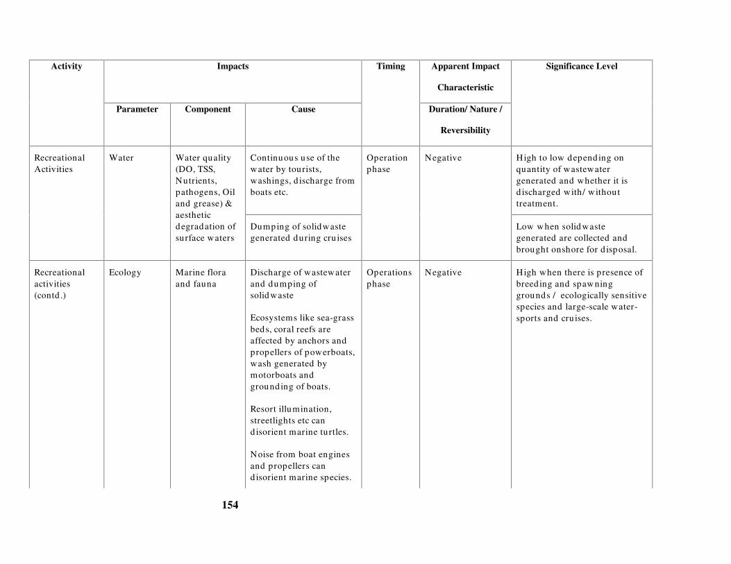
154
Impacts Apparent Impact
Characteristic
Activity
Parameter Component Cause
Timing
Duration/ Nature /
Reversibility
Significance Level
Continuous use of thewater by tourists,washings, d ischarge fromboats etc.
High to low depending onquantity of wastewatergenerated and whether it isd ischarged with/ withouttreatment.
RecreationalActivities
Water Water quality(DO, TSS,Nutrients,pathogens, Oiland grease) &aestheticdegradation ofsurface waters
Dumping of solidwastegenerated during cru ises
Operationphase
Negative
Low when solid wastegenerated are collected andbrought onshore for d isposal.
Recreationalactivities(contd .)
Ecology Marine floraand fauna
Discharge of wastewaterand dumping ofsolid waste
Ecosystems like sea-grassbeds, coral reefs areaffected by anchors andpropellers of powerboats,wash generated bymotorboats andgrounding of boats.
Resort illumination,streetlights etc cand isorient marine turtles.
Noise from boat enginesand propellers cand isorient marine species.
Operationsphase
Negative High when there is presence ofbreed ing and spawninggrounds / ecologically sensitivespecies and large-scale water-sports and cru ises.

155
Impacts Apparent Impact
Characteristic
Activity
Parameter Component Cause
Timing
Duration/ Nature /
Reversibility
Significance Level
Coastal area Shoreline Erosion along theshoreline due to wakesfrom speedboats. Use ofskiis, motorbikes or carsand animal rides in closeproximity to theshoreline.
Operationsphase
Negative Medium to low dependingupon the type of soil or whenspeed restrictions on boats areimposed .
Significance Level
Land Aesthetics Generation and dumpingof solid waste
Operationsphase
Negative Low when solid waste isincinerated or d isposed off inapproved landfills.

156
Chapter 5
Baseline assessment
18.0 BASELINE STUDIES
Baseline studies help define the existing environmental conditions at the project site. Thisinvolves identification of environmental parameters that are environmentally critical andsensitive at that location and those that might be affected by development of coastal tourismprojects. Though not exhaustive, this chapter gives an introduction to overall baseline data typesand requirements for an EIA study. However, project specific baseline data collection needs tobe designed on the basis of scoping. The results of scoping would result in a partial list ofparameters (listed in this chapter) and in very special cases would require detailed studiesdesigned by experts which is beyond the scope of this guideline.
19.0 Data types for baseline studies
The data collected at first-hand, by undertaking field visits/surveys, collecting samples andconducting analyses are referred to as primary data. However, the likely impact of a particularactivity shall determine the baseline study requirement. Generally secondary information onlanduse, census, standard of living (socio-economic conditions), water availability etc., and datafrom preliminary site visits should be considered sufficient for projects that do not have largescale facilities like DG sets, desalination units or involve activities like capital dredging, landfilling/reclamation etc.
Secondary data are those already collected by others for various purposes. These are available indepartments or institutions, which undertake studies routinely for various purposes, includingmonitoring the quality of the environment, scientific and research activities.
Tourism projects generally require Rapid EIA (REIA) where primary data are required for water;air and noise quality parameters for one season other than monsoon. It is also necessary toundertake secondary data collection programmes and concentrate on the availability of waterresources; presence of coral reefs, mangroves and other ecologically sensitive areas; existingsolid waste disposal system; source of energy; socio economics and socio cultural details at thesite etc.
The REIA report shall be reviewed by the MoEF and the consultant for acceptance and approval.Depending on the site and proposed activities, the MoEF may also choose to advise theproponent to further undertake a comprehensive EIA, which is a one year- three-season baselinestudy.

157
19.1 Typical environmental attributes for coastal tourism projects
Environmental attributes are defined as characteristics of the environment where changes tothese attributes indicate impacts. The project activities and environmental setting define theenvironmental attributes to be assessed.
The basic environmental attributes are classified under air, water, land, ecology, sound, andsocio-economics, and consist of a number of measurable parameters. Baseline studies thatcharacterise the existing condition need to be designed according to the local conditions. At thesame time, baseline study will be used to compare the change in the environmentalcharacteristics due the project during the construction/operation phases. Tables 5.1 to 5.5represent indicative requirements for a baseline study and do not necessarily indicate aregulatory requirement, unless specified. It is also recommended that average and peakmeasurements must be considered in planning a sampling schedule.
20.0 Air Environment
The air environment consists of meteorological parameters (wind direction, wind speed,temperature gradients, atmospheric stability, daily rainfall) and air quality parameters (gaseousand particulate matter). The meteorological parameters influence the transport and dispersion ofthe air quality parameters in the atmosphere.
Table 5.1 gives details of air quality data collection. For assessing an air quality impact thefollowing baseline parameters are required
� Existing air quality at the site i.e. the background concentrations of suspended particulatematter, SO2, NOx, CO, HC etc
� Wind direction to determine the receptor
� Wind speed which influences the horizontal mixing of pollutants
� Wind speed, temperature gradients and rainfall that determine the atmospheric stabilitywhich further affects the vertical mixing of pollutants
� Topography (hills, buildings, trees etc) which influences the mechanical mixing ofpollutants
� Land use at the project site to determine receptors
Table 18.1 Air quality data collection
Sampling criteriaAttribute Sub-attribute
Specification Frequency &Period
Source
Wind d irection Distribution with height 1 year daily data IMDMeteorology
Wind speed Distribution with height 1 year daily data IMD

158
Sampling criteriaAttribute Sub-attribute
Specification Frequency &Period
Source
Temperaturegrad ient
Distribution with height 1 year daily data IMD
Atmosphericstability
Distribution with height 1 year daily data IMD
Sub-attribute
Rainfall Distribution 1 year daily data IMD
Air quality Suspendedparticulate matter(SPM), SO2, NOx,CO and HC
24-hr average for oneseason other thanmonsoon
Twice a week for 3months
Baseline stud y
Topography Hills, bu ild ings,trees and othermechanicalobstructions
Layout map of the area Present data Visualexamination
Sampling stations for air quality may be located at the project site, peak hour/heavy trafficlocations, and at receptor locations.
21.0 Noise
Table 5.2 gives details of data collection for noise. To determine the impact on noise levels dueto a project, it is essential to collect baseline data on
� Existing noise levels at the site i.e. the background concentrations
� Noise attenuating factors such as hills, trees, barriers, humidity etc
� Land use map to locate the noise sensitive receptors such as schools, hospitals, residentialareas, concert halls, etc
Table 18.2 Noise level data collection
Attribute Specification Frequency & Period Source
Noise levels Intermittent/ Impulsive/Continuous
1 sample each duringday and night
Baseline stud y
Noise attenuatingfactors
Trees, hills, valleys, build ings Latest information
Future developmentplans
Site Visit
SOI Toposheet
Town planningdepartment

159
Noise sensitivereceptors
Types of receptors, locationand d istances
Latest information
Future developmentplans
Site visit
Layout maps of projectsite
Town planningdepartment
Noise levels may be measured at the proposed site, peak hour / heavy traffic periods/locations,noise sensitive receptor locations etc.
22.0 Land
The extent of assessment of the landuse shall be concentrated within a 10 Km radius around theproject area. The extent of landuse within a 25 Km radius is required when the project isproposed near an ecologically sensitive area.
Land environment comprises land use pattern, soil, slope, drainage characteristics, topography,etc. To determine the impact on land, the following baseline parameters are essential
� Existing land use pattern
� Terrestrial ecology (trees, vegetation etc)
� Soil, slope and drainage characteristics that affect runoff and groundwater infiltration
� Topography such as hills, valleys & landscape
Baseline parameters shall also address the land environment specific to the project site. Typicalsampling data type, specifications and data source for the above parameters are given in Table5.3. When secondary data is not available, primary surveys may be conducted.

160
Table 18.3 Land environment data collection
Sampling criteriaAttribute Specification
Frequency & Period Source
Landuse Residential,Industrial,commercial,agricultural, etc
Latest information State MetropolitanDevelopment Authority,Town planning department,Panchayat etc
Soil, slope anddrainagecharacteristics
Soil types, grad ient,hydrology
Latest information Survey of Ind ia (SOI)Toposheets, State SoilConservation Departments
Topography Hills, valleys, terrain Latest information � Survey of India (SOI)Toposheets, State Revenue
Department� Site specific data collection
by project personnel
Terrestrialecology
Flora and fauna Latest information � Biological Survey of India,Zoological Survey of India,
State MetropolitanDevelopment Authority
� Site specific data collectionby project personnel
Type of groundwatersources (open wells,tube wells)
Latest information � Public Works Department,Corporation, Panchayats
� Primary data from sitevisits
Well yield , Waterlevels, Consumptionrates
Data for last 1 year � Public Works Department,Corporation, Panchayat
� Primary data frompumping tests
Ground waterhydrology*
Quality – pH,Turbid ity, Salinity
One season data � PWD, Corporation etc� Primary water quality
analysis*A detailed survey may be required depending on level of extraction and background information of availableresource
Assessment of the local landform type and its constituent materials enables evaluation ofpotential hazards of the proposed activity on the local physical environment. Landform types arebased upon the characteristics of topography, viz., local relief and slope. Project activities affectthe availability or suitability of land for certain uses i.e., the land-use patterns.
23.0 Water
Water environment (coastal waters) consists of oceanographic, water quality and biologicalattributes. Oceanographic/hydrographic parameters are depth, tide, wave height, current speedand direction, shoreline profile etc. Water quality attributes are turbidity, temperature, suspendedsolids, salinity, pH, DO, BOD, nutrients etc. Biological attributes could be categorised aspathogenic (faecal coliforms) and ecological like benthos, phytoplankton, zooplankton, fish etc.

161
Transport mechanism of pollutants is influenced by advection - diffusion factors due to tides,waves, and currents. For assessing the impact on water environment, the following baselineinformation is essential
� Existing water quality at the project location (sea, creek) i.e. the background concentrations
� Water resources available at the project site
� Water utilisation/requirement at the site without the project
� Oceanographic parameters such as tides, waves, current speed, current direction andbathymetry that influence mixing and diffusion of water quality parameters
� Sensitive receptors at the site such as coral reefs, mangroves, breeding areas, water intakelocations, etc
The sampling data type, specifications, frequency and data source for the above parameters aregiven in Table 5.4. Water sampling stations shall be selected based on the effluent dischargepoints, sewage outfalls, dredging/dumping sites etc, and shall be based on the environmentalsetting of the project site. Sampling stations shall be representative to indicate averageconditions.
Table 18.4 Water Environment
Sampling criteriaAttribute Sub-attribute
Specification Frequency &Period
Source
Hydrodynamic Current, tidesand waves
High and lowtide
Wave heights
Current speedand d irection
15 days for one season* NavalHydrographicOffice (NHO)charts, Ind ianTide Tables,Ocean R&DInstitu tes, DOD
Bathymetry Depths Contours up to30m depth
Once NHO charts
Physical quality pH, salinity,temperatureTSS, TDS, Oiland grease
1 season sample 1 sample* each duringhigh and low tides
Baseline data
Chemical quality DO, BOD &Nutrients
1 season sample 1 sample* each duringhigh and low tides
Baseline data
Biological quality Fecal coliforms,Streptoccocci,phytoplankton,zooplankton
1 season sample 1 sample* each duringhigh and low tides
Baseline data
*If impacts are significant, MoEF may suggest that a comprehensive EIA with three season date be conducted

162
24.0 Ecology
An ecological environment consists of terrestrial and aquatic ecology. This section covers floraland faunal characteristics that are not addressed in sections 5.2.3 and 5.2.4
Attributes critical in assessing the suitability of the project at the selected site are:
� Natural vegetation, endemic and endangered/ ecologically sensitive species such asseagrass, corals, mangroves etc.,
� Fisheries data for the last five years – secondary data can be obtained from the FisheriesDept.
Biological sampling shall
70. Be conducted in fishing, breeding and polluted zones
71. Include analyses at various trophic levels and
72. Identify endangered species/critical habitats
25.0 Socio-economics and Socio-culture
Social environment refers to people and their surroundings, human beings and their products,their property, groups, heritage etc. The effects of a project on people and their responses may bedirect and immediate or remote and attenuated. Estimation of the change in the income in anarea, value of structures, equipment, standard of living, statistical information on populationgrowth etc form socio-economic studies. To assess impact on socio-economic environment andculture, it is essential to collect the following data
� Details on occupation, level of education of the population surrounding the project site,likely receptors of impact
� Traditional practices, customs, beliefs, values, etc
� Standard of living at the site i.e. the infrastructure available to local population such aswater supply, sanitation, electricity, transportation, education, medical treatment etc
� Commercially valuable species and materials at the project site
Information of socio-economic and cultural environment can be obtained from revenuedepartment, fisheries and by undertaking site visits.
26.0 Resources
� Water, power, fuel & non-fuel resources are assessed for labour camps, constructionactivities, operational requirement etc.

163
26.1 Typical baseline requirement
Table 5.5 gives typical baseline parameters required for various activities of a large coastaltourism project. The extent of baseline study is a function of the nature of activities. Annexure Agives an example study requirement of a small-scale and a large-scale resort.
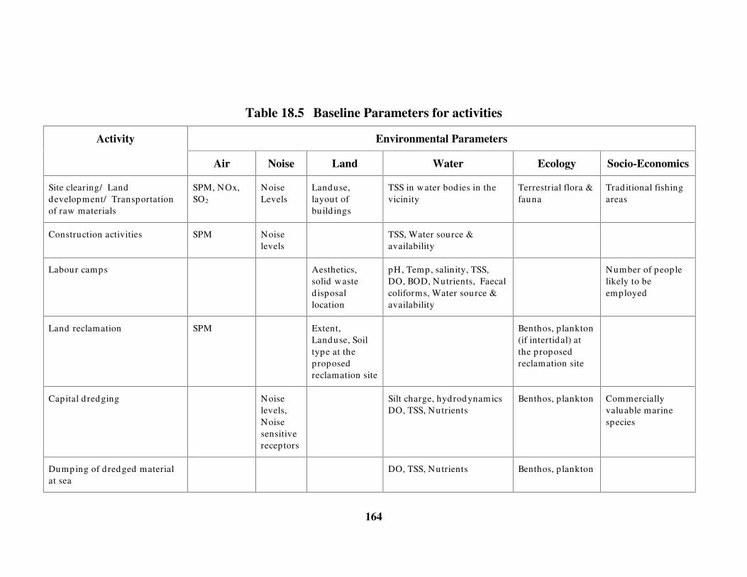
164
Table 18.5 Baseline Parameters for activities
Environmental ParametersActivity
Air Noise Land Water Ecology Socio-Economics
Site clearing/ Landdevelopment/ Transportationof raw materials
SPM, NOx,SO2
NoiseLevels
Landuse,layout ofbuild ings
TSS in water bod ies in thevicinity
Terrestrial flora &fauna
Trad itional fishingareas
Construction activities SPM Noiselevels
TSS, Water source &availability
Labour camps Aesthetics,solid wasted isposallocation
pH, Temp, salinity, TSS,DO, BOD, Nutrients, Faecalcoliforms, Water source &availability
Number of peoplelikely to beemployed
Land reclamation SPM Extent,Landuse, Soiltype at theproposedreclamation site
Benthos, p lankton(if intertidal) atthe proposedreclamation site
Capital d redging Noiselevels,Noisesensitivereceptors
Silt charge, hydrod ynamicsDO, TSS, Nutrients
Benthos, p lankton Commerciallyvaluable marinespecies
Dumping of d redged materialat sea
DO, TSS, Nutrients Benthos, p lankton

165
Environmental ParametersActivity
Air Noise Land Water Ecology Socio-Economics
Construction of jetty on piles Noiselevels,Noisesensitivereceptors
TSS
Vehicular traffic SPM, NOx,SO2
Noiselevels
Wastewater d ischarge fromhotels and employee quarters
pH, Temp, salinity, TSS,DO, BOD, Nutrients, Faecalcoliforms, Water source &availability
Number of peoplelikely to beemployed
Solid waste d isposal Aesthetics,solid wasted isposallocation
Beach Maintenance Aesthetic,dunes, slopes
Hydrodynamics Benthos
Brine d ischarge fromdesalination plants
pH, Temp, salinity, TSS, DO Benthos, p lankton
Emissions from DG sets SPM, NOx,SO2
HC*, CO*
Noiselevels

166
Environmental ParametersActivity
Air Noise Land Water Ecology Socio-Economics
Cooling waster d ischarge frompower plants
Temp, DO Benthos, p lankton
Recreational activities / cruise CO, NOx,SO2
Noiselevels
Faecal coliform, nutrients
Oil & grease
Boat maintenance Aesthetics,solid wasted isposallocation
Oil & grease
* Optional Parameters- shall be measured when such emissions are expected depending on fuel used

167
Chapter 6
Prediction of impacts
27.0 PREDICTION
Prediction or analysis of impacts gives an estimate of magnitude and spatial distribution ofimpact enabling assessment of future condition of the environment with the project. Prediction isan essential component of any EIA as it provides a measure of sustainability of a project.
Predictions can be quantitative and/or qualitative. Quantitative methods give an estimate of theimpact using mathematical expressions/computer models and experimental/physical models.Simple quantitative methods are typically analytical with broad assumptions requiring handcalculations, while the complex models are computer based and address many of thecomplexities of the natural environment. Qualitative methods are based on professionaljudgement/examples of similar occurrences/events in other locations/projects or cited inliterature.
Results of prediction can be illustrated with contours or plots showing critical concentrations, inconjunction with receptor locations to determine the significance of impacts.
27.1 Scenario for prediction
Predictions must consider the worst case and most probable case scenarios for eachenvironmental parameter. Examples of worst-case scenarios can be periods of inversion for airquality, storm surges for inundation or festivals/religious events that attract a large number ofpeople. Most probable scenarios can be air quality during normal conditions (based on statistics),discharge of wastewater during peak season and traffic during peak tourist season.
27.2 Water environment
The two broad areas of impact on the water environment by coastal tourism projects are thewater resources and the coastal waters. While water resource concerns may arise fromoverexploitation of potable water, the impact on marine environment primarily arise fromshoreline changes and marine water quality deterioration.
28.0 Impact on water resources
In coastal areas that rely on groundwater, excessive pumping can cause saltwater intrusion due tolowered water tables or depleted freshwater lenses.
Construction of buildings, roads, paving parking areas etc lead to increased impervious areas andchange in top soil characteristics, which may significantly reduce infiltration and groundwaterrecharge.

168
In general, the annual extraction of groundwater must be less than or equal to the recharge, elseover pumping will gradually deplete the stored resource causing existing wells to run dry, attimes requiring expensive deep drilling to locate new wells. Landuse consisting of productivefarms may lose irrigation water as wells go dry.
Groundwater tests must be conducted to assess safe yield and ensure that neighbouring wellshave minimum drawdown. The depth and pumping rate must be such that there is no upcomingof saltwater.
However, if water supply is made from remote sources, to meet peak tourist demand, anassessment of water table lowering and resource-use conflict in the remote location is necessary.
29.0 Impacts of sediment transport
The sediment transport issues are generally related to the physical alterations of the coastlinesuch as construction on shoreline, presence of breakwater, seawall or reclamation. Whenstabilizing beach vegetation is removed for construction on the shoreline or when construction iscarried out on slopes, changes may occur to the shoreline and the along-shore wave movement,causing erosion and depositional patterns.
The most important factor controlling coastal processes and coastal engineering design is thewaves generated by winds. Waves result in large forces on coastal structures, near-shorecurrents, long-shore currents and control beach profiles. Typically the data requirements forprediction of waves (for projects requiring marine infrastructure such as jetties, slipways etc.) arethe site area bathymetry and wave characteristics (wave heights for various periods). Theseaspects will be addressed in the technical feasibility of a project and may be made available tothe EIA consultant by the engineering consultant.
The impact of a coastal structure on the shoreline can be simulated using physical models ormathematical models. Mathematical models require the long-shore current component, which istypically generated from wave radiation models. The long-shore sediment transport is calculatedusing the continuity equation for sediment volumes. The primary input for the computation isthe wave climate, cross-shore profile, sediment properties and the coastline orientation.
30.0 Impacts on marine water quality
When a pollutant is discharged into a water body, the water quality in the surrounding area is afunction of the currents, mixing, water chemistry and biological processes of the natural waterbody. Today, these processes can be represented by models ranging from simple planning typemodels to sophisticated computer based water quality models.
The simplest method available for predicting concentrations is for a continuous discharge into areceiving water body under steady state conditions. The currents in the water body will transportthe pollutant downstream; spreading the waste by molecular and turbulent diffusion processesand for some pollutants, transforms the pollutant by chemical and biological processes. Whilethe steady state assumption is useful for an “ order of magnitude” estimate, it may not beacceptable to the coastal environment, which is dynamic. This has resulted in the utilisation ofmathematical models that are capable of simulating the dynamic nature.

169
In a coastal environment, advection is governed by current speeds and direction while dispersionis characterised by turbulence and molecular diffusion. A typical water quality model is one thatsimulates the advection and dispersion of the pollutant.
Hydrodynamic models contain sub modules to estimate the concentration of pollutant in thewater body due to wastewater discharges. The concentration of some pollutants such aspathogenic bacteria and BOD may be modelled by simple ‘first-order’ decay equations, wherethe mass of the pollutant decreases with time. Dredge spoils may also be simulated using thefirst-order equations when the grain size is fairly uniform, sediments are non cohesive andcurrents are low
Parameters such as trace metals and organic chemicals are more complex, requiring sedimentconcentrations in water to estimate the partitioning of the pollutant in its dissolved andparticulate phases.
Dissolved Oxygen is an important water quality and ecosystem health indicator and is alwaysindicated in water quality standards. The origin of DO modelling began with the Streeter-Phelpsequation that modelled DO as a function of Biochemical Oxygen Demand (BOD) and re-aerationof oxygen from the atmosphere. Today, DO models include many complex ecosystemcomponents such as nutrient uptake, algal photosynthesis, primary productivity, benthicprocesses, etc.
Simple oil spill models use wind and steady state currents to estimate dispersion and surficialspreading. More complex models generally use advection-dispersion model base and includeprocesses such as volatilisation, settling of tars and wind dispersion.
Brine discharges have high concentrations of salt, turbidity and certain chemicals that are usedfor the pre-treatment of feed water & cleaning of filters. There are simple models (like USEPA’ sCORMIX) available for modeling small quantities of saline water discharges.
Cooling water discharges have higher temperature than receiving waters, potentially causingdepletion of oxygen and thermal shock to marine life. Temperature also affects rate of chemicaland biological reactions, solubility of oxygen and other gases in water and may induce densitystratification. Water temperatures can be modelled by adding all the heat inputs and subtractingall heat losses. The inputs to these models include heat exchange with the atmosphere, which is afunction of evaporation, solar radiation and convective losses.
30.1 Air environment
The air pollutants emitted into the atmosphere will be diluted and dispersed depending on localmeteorological and geographical conditions. A continuous stream of pollutants when releasedinto the atmosphere will rise, bend and then travel in the direction of the wind, which enablesdilution and carries the pollutants away from the source. This plume of pollutants will alsospread out or disperse in both horizontal and vertical directions from its centreline.
The simplest method available for predicting concentrations is the steady state Gaussianequation, designed for conditions where a continuous stream of pollutant is released into a steadywind in an open atmosphere. In nature, the pollutant plume will rise and bend over, gettransported by the wind, and concentrations will decrease away from the source. The plumespread will be influenced by molecular diffusion, turbulent eddies of the average wind flow,
170
thermal gradients, random shifting of winds and mechanical mixing of the air moving over theland. The dispersion of an air pollutant released into the atmosphere depends on the followingfactors
� Properties of pollutant (stable, unstable)
73. SO2, CO and SPM are stable pollutants, as they do not participate in chemical
processes in the atmosphere.
74. NOx and certain hydrocarbons are unstable pollutants which actively participate in
chemical reactions thereby forming secondary pollutants
� Release rate & type (puff, plume)
75. An accidental release of chemical from a pipeline or hose is an example of puff
release (instantaneous)
76. Emissions from power plants, stream of vehicles are continuous and an example of
plume release
� Meteorology (Atmospheric stability)
77. Atmospheric stability is defined by wind speed and vertical temperature gradient
which influence mixing of pollutant
78. Wind speed influences the horizontal diffusion/dispersion of an air pollutant while
wind direction determines the region and receptor of impact.
79. Temperature gradient affects vertical mixing of pollutants
� Local terrain conditions (hills, valleys, buildings)
80. The local terrain conditions influence the mechanical mixing of the pollutants.
� Height of release above the ground
81. Emissions from a DG set may occur at different heights based on stack height, while
releases from pipeline occur at ground level. Releases from a lower height will have
greater ground level pollutant concentrations than releases from a greater height
� Release geometry (point, line, area source)
82. Emissions from ships, DG sets, pinhole leakage from pipeline are point sources
83. Emissions from vehicular traffic during peak hours are line sources
A critical scenario for air pollution predictions is when temperature in the ground levels is higherthan the upper layers. This prevents the air pollutants from rising vertically, thus dispersing thepollutants along the ground and exposing receptors to dangerous levels of pollutantconcentrations.

171
Modelling of pollutant dispersion needs to take into consideration, the thermal stratificationexisting in the atmosphere. Differential heating/cooling of the different layers result in densitystratifications, the most critical of which is the ‘thermal inversion’ , which prevent verticaldiffusion/dispersion across them (vertically). The inversion occurring close to the ground surfacealmost each night to pre-dawn periods, caused by the back radiation from heated earth-surfaceand building structures are termed ‘ground-based inversion’ and significantly affect pollutant-dispersions resulting in increased ground level concentrations.
The understanding and characterisation of these inversions is absolutely essential to anymeaningful modelling of pollutant dispersions. Thermal stratification and consequent mixingheights can be taken into account by using ‘stability classes’ . IS: 8829-1978 gives themethodology for determination of stability classes.
Air quality issues can be modelled using Guassian models, which provide concentrationdistribution in vertical and horizontal directions using simple dispersion coefficients. Basicinputs for this model in predicting the concentration are
� Emission rate of pollutant
� Vertical and horizontal dispersion coefficients which are a function of the downwinddistance
� Wind velocity in the downwind direction
� Vertical distance above ground
� Lateral distance from the centreline of the plume
� Length of the line source (in case of line source emissions)
Meteorological data needed for pollutant dispersion modelling shall include:
� Average wind direction: to define co-ordinates
� Average wind speed: to provide velocity
� Atmospheric stability: to determine the vertical and horizontal dispersion coefficients
� Ambient temperature: to calculate the effective height of (stack) emission above groundlevel
� Atmospheric temperature lapse rate: to determine stability classes
Table 6.1 gives the characteristics of pollutants and their source geometry for coastal tourismproject activities.
Table 27.1 Air pollution source characteristics
Activity Geometry ofsource
Location ofsource
Pollutant type
Site clearing Area Ground level SPM and RPM

172
Soil excavation Area Ground level SPM and RPM
Transportation of raw materials Line Ground level NOx, RPM, and SPM
Construction activities Area Ground level SPM and RPM
Vehicular traffic duringoperation
Line Ground level Nox, SPM and RPM
Boat operation Point Ground level NOx, SPM and RPM
DG sets/ Captive Power Plantemissions
Point Stack height NOx, HC, CO, SO2 and SPM
Respirable Particulate Matter – RPM; Suspended Particulate Matter - SPM
30.2 Noise Environment
Sound or noise is a disturbance, which propagates away from the source through an elasticmedium, namely air, water or solids and reaches a receiver. The noise level (dB) at thereceiver’ s location is a function of the characteristics of the sound source (power, intensity andfrequency spectra), the properties of transmission medium and the presence of objects orbarriers.
For simple cases, such as point source, the sound energy is radiated over spherical surfaces awayfrom the source. The presence of objects in the path of sound propagation results in reduction inthe sound pressure level. For a source located on the ground, the sound will propagate in ahemispherical pattern.
The prediction of noise should address the type of source, type of environmental conditions atthe site and the receptors
Type of noise source
Noise sources may be classified as impulsive or sudden; intermittent-unsteady; continuous-steady noise. Table 6.2 gives the types of noise sources for coastal tourism project activities.
Table 27.2 Noise pollution source characteristics
Activity Source type
Site clearing Continuous-Steady
Soil excavation Continuous-Steady
Transportation of rawmaterials
Intermittent-unsteady
Construction activities Continuous – unsteady
Vehicular traffic duringoperation
Intermittent-unsteady

173
Activity Source type
Boat operation Intermittent-unsteady
DG sets/ Captive Power Plantemissions
Continuous-Steady
Types of environment or attenuating factors
The type of environment determines the degree of noise attenuation, where the greater theattenuation, the lesser the impact on the receptor. Examples of attenuating factors are:
� Atmospheric conditions like humidity, wind direction, wind speed etc; and
� Barriers such as walls, vegetation etc.
Type of receptors
Receptors could be insensitive or sensitive. For example inmates of hospitals or bird sanctuaries,aquatic species etc., are sensitive noise receptors while industrial, commercial areas are relativelyinsensitive. Limits of acceptable noise levels for each category of receptor or areas/zones arespecified in the National Ambient Air Quality Standards in respect of noise (Section 2.1).
30.3 Land Environment
Tourism industry usually involves extensive land and infrastructure development. In thisperspective impact on soil, land use and hydrology are the most significant elements that arerequired to be evaluated.
� Soil Erosion: Site clearing, soil excavation etc., lead to soil erosion. . Erosion rates maychange during construction phase of a project when large areas of land may be cleared andleft exposed. Methods like Universal Soil Loss Equation (USLE) are useful to makeestimations of soil erosion
� Soil Permeability: Land disposal of wastewater, solidwaste / hazardous wastes, dredgedmaterial, oily wastes from boat maintenance etc., may lead to leaching into groundwater.The permeability characteristics are essential to design the lining of the soil for disposal ofwastes. Also leaching characteristics of the site needs to be evaluated to assess impact onwater resources and recharge areas and soil microorganisms.
� Land-use patterns: Labour force affects the aesthetics due to construction of temporaryhutment and disposal of solid wastes. However, assessment of whether the labour forcebelongs to the local region or needs to be brought in can be made, based on which areamanagement can be planned and implemented.
� Hydrology: Prediction of impact on hydrology can be made by assessing the projects waterrequirements during the construction and operation phases and determination of permissible

174
safe yields, i.e, the maximum sustained withdrawal rate from an aquifer. Runoff from thesite can also be evaluated using empirical equations and simple models
30.4 Impacts on biology/ecology
The productivity of a coastal area is enhanced by the presence of the mud flats, mangroves, coralreefs, lagoons and other ecologically sensitive species and a function of nature of tides, currentsetc. Productivity can be evaluated by estimating the phytoplankton, zooplankton and fishpopulation. The loss of biomass due to piling, dredging, land reclamation, etc can be evaluatedby simple mathematical equations. Professional and scientific judgement can be used to estimatethe impact of temperature, salinity, DO and suspended solids on ecology.
Tools to assist the expert in the prediction of impacts are:
� Statistical estimates of bio-diversity such as the Shannon-Weavers Diversity
Index or species richness indices from the rarefaction method or Jack-Knife
estimates. These statistical estimates should be compared with other values for
similar environments only;
� Biomass and energy pyramids that are aids to define the food chains and the
health of the ecosystem. The baseline structure helps in the assessment of the
impact of the abiotic environment on the ecosystem;
� Nutrient cycles that can help define potential impacts such as eutrophication,
contribution to green house gases.
Mathematical models have also been developed for ecological energetic or the study of the flowof energy within an ecosystem and ecological modelling for specialised ecosystem. If an EIAconsultant uses these methods, a determination must be made to ensure appropriateness to thetropical coastal ecosystem of India.
30.5 Impact on socio-economics / socio culture
Construction activities provide temporary employment opportunities for skilled and unskilledlabour. Some of the social impacts that need to be assessed are:
Socio-economics
� Additional employment opportunities to the locals and the improved infrastructure;

175
� Additional population increase (service sector) due to the project and data on tourist influxduring peak season;
� Resettlement issues due to the displacement of indigenous population;
� Restriction on fishing due to constrained access to private beaches;
� Loss of rural areas and agricultural lands and exodus of indigenous population fromagricultural profession into service sector;
� Increased cost of living for the locals due to competition from the tourist influx;
� High energy costs due to requirement of increased power supply demands
Socio-cultural
Qualitative assessment from professional experience needs to be made for the effects of:
� Change in lifestyle for local ethnic population with market economics.
� Possible increase in alcohol, drug abuse, prostitution, allied to major health risks
30.6 Summary of prediction
Predictions consist of estimating the impacts of the proposed project and overlaying the baselineon it, from which impacts of the project can be evaluated. Comparison with national standardsfor air, noise and water quality can be made from these estimates. Significance of impacts needsto be assessed with proposed environmental management plans and/or with best housekeepingpractises.
However this summary must be compared with other sites where similar summaries weregenerated. The other method is to compare the impact magnitude against known standards. Thedrawback with this is that standards are not available for all cases. Given these constraints, theEIA consultant can choose to provide a matrix of adverse impacts and state their significance.Impacts need to be summarised in an EIA study to determine whether they are significant,manageable or insignificant.
31.0 Significance of impacts
One method to determine impact significance is by consideration of the impact characteristic(Section 4.1.1) and the importance (weightage) attached to them.
Significance = f {Impact characteristic, importance}
The predicted impacts need to superimposed on the existing background concentrations andcompared with standards. There may however be no appropriate technical standard for a socialor a visual impact and resources that require sustainability. Significance in such cases must bederived from community preferences and can be discovered through public involvement or otherspecial methods. (E.g. Delphi techniques).

176
The key basis for assessing impact significance are: level of public concern over health andsafety, scientific and professional judgement, disturbance/destruction of valued ecologicalsystems and degree of negative impact on social values and quality of life.
Significance can be determined based on ecological importance, social importance andenvironmental standards.
32.0 Example of Summary of Prediction
Issues considered forprediction1
Results of Prediction Impact Significance
Air quality Impacts
Vehicular emissionsduring transportation ofraw materials for 137numbers/ day ofadd itional vehicles
The increase in the concentration of NOx, CO andHC at a d istance of 500m is negligible and theoverall concentrations conform to NAAQS
Low
Noise quality Impacts
Piling operations Noise levels are reduced to background levelswithin 50m from the source and conform toNAAQS. No noise sensitive receptors w ithin 500m
Low
Water quality Impacts
Release of bilge, oilywastes and wastewatersfrom cruise liners
The baseline levels near the pier show signals ofWQ standard violations.
The d ischarge needs tobe monitored andregulated
Land / Biology / benthic Ecology
Ecological impacts ofdredge dump d isposalon land
Non toxic sed iments shall not impact groundwaterquality at the dump location
No flora/ fauna at the dump location
No benthos as dumping is not carried out inintertidal areas
Low
Socio Economics
Employment Temporary employment during constructionphase and employment for unskilled jobs duringoperations phase
Positive impact
Net Significance Low and requiresregular monitoring

177
Chapter 7
Environmental Management
33.0 INTRODUCTION
Poor tourism management can damage natural resources, which in turn shall adversely affect thetourism industry. In order to achieve sustainable tourism and economic growth, it is essential thatstrategic plans be developed at the planning level and environmental controls are implemented atthe tourism site.
Broad areas, which need to be covered at the planning level, are:
� Standards for tourism resort ambience (density, building height, landscaping etc.) governedby the CRZ Notification, 1991 by the MoEF Annexure–II (Table 2.1);
� Site selection and site and building design including water and wastewater managementsystems, drainage etc;
� Management of construction activities; and
� Evaluation of supporting infrastructure such as transportation and road networks, wastecollection and disposal etc. (State coastal development & management plans – e.g. CZMP)
� Carrying capacity studies before designating an area for tourism development.
Site-specific areas of environmental control are:
� Limiting the number of tourists or promoting off-season tourism, i.e., capacity management.
� Promotion of public transport or shuttle services during peak seasons to minimise largenumber of private vehicles and consequent congestion.
� Improvement of infrastructure like water, wastewater, solid waste and other such services tohandle peak tourist requirements.
� Restriction on amount of water pumped from aquifers, installation of water recycling andrainwater harvesting systems.
� Designation of “ no anchoring” areas in coral, sea grass beds, or other fragile habitats.
� Educating the tourists and tourist industries about environmentally sound practices.

178
33.1 Best Management Practice
Pollution prevention and control is required to mitigate or eliminate the impacts of tourism, sincepollution prevention is more cost effective than repairing damage caused by uncontrolledtourism. Mitigation/planning measures shall be followed for minimising environmental impactsfor each category of the tourism project during construction and operational stages of the project.Additionally, attitudes promoted and information shared with guests, help reduce impacts on thenatural system.
Requirements for best management practice (BMP) at the planning level shall cover:
� Site and building design
� Construction / operations phase mitigation measures
Area of operations for which BMP have to be identified include:
� Facilities maintenance
� Recreation
� Waste management
� Water and energy usage
� Public/social interaction
34.0 Site and building design
The objective of site management is to maintain the attributes of the site by managing theimpacts through design improvements as suggested below.
� Integration of site and building designs with the environmental setting of the location.
� Provision of beach access to locals shall be planned.
� Construction on slopes shall be avoided in order to minimise/prevent erosion; Buildingsshall be sufficiently away from the beach.
� Direct discharge into water bodies from drains, roadways and parking lots etc. shall beavoided. Roads shall be designed so as to reduce runoff from the site.
� Design and materials that improve conservation of energy shall be used
� Water conservation designs and strategies shall be followed. Use of permeable surfaceswherever possible shall be made. Rainwater harvesting measures shall be implemented.

179
35.0 Construction & operation phase mitigation measures
The impacts of the various activities of the project and the specific measures that need to beimplemented during construction and operation phases of the project are suggested in tables 7.1to 7.5
Table 33.1 Transportation of raw materials
PotentialImpacts
Mitigation Implementedby
Timing
Generation ofNoise
� Periodic maintenance of vehicles shall beensured Contractor Construction
Generation of dust � Materials shall be covered with tarpaulinsheets during transport Contractor Construction
Vehicularemissions
� There shall be periodic emission checkfor vehicles Contractor Construction
Table 33.2 Construction activities / fabrication and welding
PotentialImpacts
Mitigation Implementedby
Timing
Generationof Noise
� Ear protection devices and helmets shall beprovided for workers Contractor Construction
Generationof dust
� Concrete mixing plants shall be located atleast500m away from dwellings/offices
� Masks shall be provided for workers� Waste materials shall not be burnt
Contractor Construction
Equipmentemissions
� Equipment/ machinery shall be periodicallychecked for emission levels
� Regular maintenance of equipment shall bedone
Contractor Construction
Exploitationof waterresources
� Water shall be obtained only from approvedlocations Contractor Construction
Increasedturbidrunoff
� Stockpile of materials shall be located atleast100m away from waterfront
� Sediment runoff shall be intercepted by haybales or detention trenches
Contractor Construction
Table 33.3 Labour Force
PotentialImpacts
Mitigation Implementedby
Timing
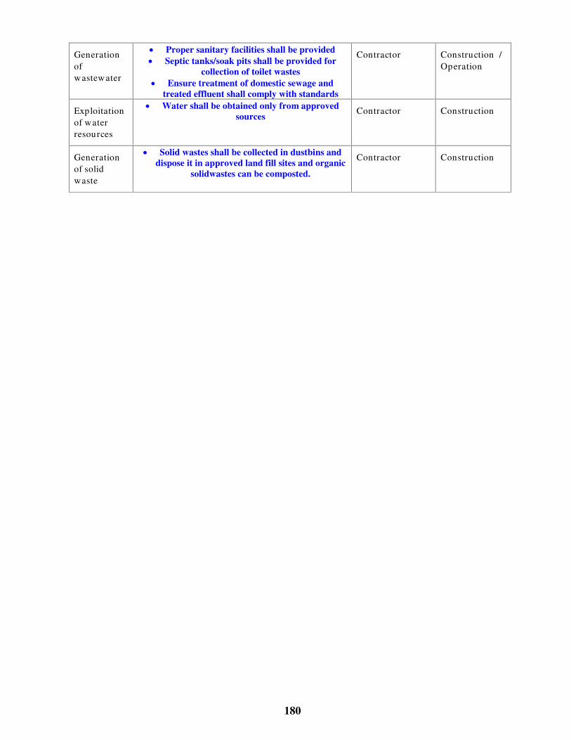
180
Generationofwastewater
� Proper sanitary facilities shall be provided� Septic tanks/soak pits shall be provided for
collection of toilet wastes� Ensure treatment of domestic sewage and
treated effluent shall comply with standards
Contractor Construction /Operation
Exploitationof waterresources
� Water shall be obtained only from approvedsources Contractor Construction
Generationof solidwaste
� Solid wastes shall be collected in dustbins anddispose it in approved land fill sites and organic
solidwastes can be composted.
Contractor Construction

181
Table 33.4 Marina development/Capital / Maintenance Dredging
PotentialImpacts
Mitigation Implementedby
Timing
Turbid ity/ waterqualitydeterioration
� Confined method of dredging with turbidityreduction measures such as hopper dredging, or
silt fences� Disposal shall be done in designated areas
Contractor Construction
Coastal erosion � Limited number of boats shall be used to limitwakes
� Coastal vegetation shall bepreserved/rehabilitated/regenerated
Contractor Construction
Generation ofnoise
� Workers shall be provided with ear plugs Contractor Construction
Emissions fromdredgingequipment
� Emission check on equipment shall be donebefore every operation Contractor Constructio
n
Accumulation ofanti-fouling agentsshall harmshellfish and othermarine life
� Anti-fouling paints shall not be used� Boat maintenance shall be restricted to approved
areas
Proponent Construction

182
Table 33.5 Boat operations/Cruise ships
Potential Impacts Mitigation Implementedby
Timing
Water quality impactsfrom d ischarge of oiland oil sludge,domestic refuse (rawsewage, p lastics),engine room waste,wastewater, bilgewater etc.
� All liquids containing oil shall pass into the seaonly via oil separation systems
� Sludge shall not be discharged. The sludge andthe separated oil residues are either to be
incinerated on board in special furnaces ordischarged to oil collection facilities
� Adequate facilities for discharging oily residuesshall be provided and effective supervision andmonitoring of adherence to the regulations shall
be done� Different types of refuse shall be collected in
separate containers and temporarily stored tillthey are disposed to appropriate facilities on
shore
Proponent Operation
Exhaust emissions � Exhausts shall be frequently cleaned� Use of fuel of approved quality
� Correct adjustment and maintenance of enginesand boilers shall be ensured
Proponent Operation
Destructin of coral, seagrass beds due todropping of anchors.
� Designation of “no anchoring” areas in fragilehabitat areas, placement of stable mooring
buoys in reef/lagoon areas� Distribution of maps of the area for
identification of fragile areas.
Proponent Operation
Shoreline erosion fromboat wakes andsed iment d isturbancefrom large boats
� Control on boat speeds in narrow stretches� Designated areas for anchoring of large boats
Proponent Operation
36.0 Facilities maintenance
Implementation of effective management systems can occur along every point in the supplychain comprising the sectors providing accommodation, transportation, travel agents, suppliesand the tourists themselves. For example, hotels can exert influence on suppliers to provideproducts that minimize environmental impacts. Similarly travel agents can influence touriststhrough education and provision of options to reduce resource use. The following sectionsdescribe some specific measures for effective management.
Waste Management
Collection, treatment and removal of wastewater and solidwaste shall either be the responsibilityof the tourism project proponent or shall be integrated in the local waste disposal plan. However,if the local Panchayat/municipalities are not equipped to handle such wastes, it is theresponsibility of the project proponent to provide sewage treatment and solidwaste disposalfacilities.
Issues to be considered while planning solidwaste handling can be:

183
� Segregation of different kinds of solidwastes
� Type of disposal (incineration, composting, landfill etc.)
Implementation of environmentally acceptable purchase policies, effective staff training,environmental management etc. is necessary for reducing the amount of wastes, recycling andtreating, the responsibility of which lies with the project proponent. Some possible measures toreduce the amount of solidwaste are:
� Purchase of liquids in bulk, eliminating the supply of canned drinks, disposable bottles orpackaged foodstuffs, plastic plates, cups, containers etc., use of linen / hand towels insteadof paper napkins
� Recycling of organic wastes by composting
� Education of staff / tourists in environmental awareness
Management of effluents include:
� Designing the wastewater system to permit separation of grey water from sewage, whichcan be used in irrigation, green belt development and flush toilets.
� Eliminating the use of detergent containing phosphates.
Water conservation:
� Regular checks of plumbing fixtures to reduce leaks shall be carried out
� Low flow showerheads, low flush toilets etc., shall be used
� Recycling of water (laundry water and grey water for flushing toilets, watering lawns etc.)shall be practised
� Groundwater recharge measures such as rainwater harvesting, leaving parking lots unpavedetc. shall be adopted
Energy conservation
� Wherever possible, solar energy shall be utilised for water heating and exterior lighting.
� Routine maintenance of electrical appliances (refrigerators, air conditioners etc) shall becarried out
� Fluorescent lighting shall be used instead of incandescent bulbs
� Wherever possible, public areas shall be designed to be open spaces
Recreation facilities management
� Heavily used beaches shall have night cleanup for garbage.

184
� Jet skis or other motorised equipment shall not be operated in swimming areas
� Piers and moorings shall be placed with minimal or no obstruction to the coastalhydrodynamics
� Dune vegetation and seagrass shall not be removed from the beach
� Boat maintenance shall be done away from the seashore
36.1 Monitoring and EMP implementation
Monitoring is a tool to identify environmental damage and propose changes when a project is notmeeting the environmental standards. Audits can be used to identify significant wastage of waterand energy at sites with poor environmental practice Regular data collection can identifyenvironmental deterioration and/or improvement.
Implementation of EMP can be done effectively by defining responsibilities for which thefollowing points shall be taken into consideration
� A management representative for e.g., an Environmental Management Cell (EMC) headshall be made responsible for implementing and maintaining the EnvironmentalManagement System (EMS) who shall have clearly defined roles, responsibilities andauthorities.
� An organization structure may be developed for implementing the EMP with responsibilitiesand authorities assigned.
� Job functions that could have an impact on the environment can be identified and jobdescriptions written for each of them
� Operating procedures may be prepared to define specific responsibilities and criticalfunctions of each position in a single paragraph or a small series of bulleted points
� Training can be provided such that each person/operator understands his/her responsibilitiesand the extent of his/her authority, as well as general roles of others.
It must be recognised that it is not be feasible to employ personnel exclusively for EMPimplementation and/or monitoring, or the EMC head cannot be solely responsible for all issuespertaining to environmental management. Environmental responsibilities shall form an integralpart of each personnel’ s job. For this approach to be successful, employees have to understandexactly how their jobs impact the environment. While the EMC head is responsible for overallenvironmental management and quality, key personnel in the implementation of theEnvironmental Management Plans (EMP) are:
84. Managers, engineers’ in-charge of various development activities (site engineer,
estate managers, safety officers etc.);
85. Contractors, machinery / equipment operators or marina, boat operators etc;
86. Operators who maintain and test various sporting equipments and boats;

185
87. Maintenance staff.
For example, the estate manager could do routine monitoring of sporting equipment / boats usinghis judgement. The responsibility of advising the operator in maintaining the equipment shouldform an integral part of the estate manager’ s job. Only in the event of non-compliance or due toreasons beyond the estate manager’ s control will he report to the EMC/management to initiateappropriate action
For effective implementation of the EMP, it is the management’ s direct responsibility tounderstand what resources are necessary for routine operations and special operations and toensure that they are made available.
186
Bibliography
� Ministry of Environment and Forests’ EIA Notification New Delhi, the 27th January 1994(As amended on 04/05/1994, 10/04/1997 and 27/1/2000), CRZ Notification (19th February1991 as amended upto August 2000).
� Indian Environmental Legislations
� ‘Environmental Guidelines for Development of Beaches’ , Ministry of Environment andForests, Govt. of India
� MARPOL (International Convention for the Prevention of Pollution from ships) 73/78,1992 Amendment, International Maritime Organisation
� United Nations Environmental Program (UNEP) EIA Training Resource Manual, byEnvironment Australia (Environmental Protection Group) Canberra, Australia under theguidance and technical support of UNEP International Working Group on EIA (URL:http://www.environment.gov.au/epg/eianet/manual/manual/title.htm) February 1997
� World Bank Technical Paper Number 154, Environmental Assessment Sourcebook, VolumeIII ‘Guidelines for Environmental Assessment of Energy and Industry Projects’ ,Environment Department, The World Bank
� ‘Environmental Assessment’ A guide to procedures, London, HMSO, Dept. of Environment
� ‘Environmental Impact Assessment for Developing Countries in Asia’ , Asian DevelopmentBank
� Environmental Handbook, ‘Documentation on monitoring and evaluating environmentalimpacts’ Volume 1 Introduction, Cross-sectoral Planning, Infrastructure, German FederalMinistry for Economic Cooperation and Development, vieweg
� ‘A Handbook of Environmental Impact Assessment Guidelines’ – 1988 MalaysianGuidelines
� ‘Air Pollution – An Introduction’ , Jeremy Colls, E & FN SPON
� “ Coastal tourism – A manual for sustainable development” , URL:http://www.environment.gov.au/marine/information/reoirts/coastal_tourism/index.html
� “ Coastal tourism in the Wider Caribbean Region: Impacts and Best Management Practices”UNEP CEP Technical Report No. 38 1997, URL:http://www.cep.unep.org/pubs/techreports/tr38en/section1.html
� ‘Dispersion in Estuaries and Coastal Waters’ , Roy Lewis, John Wiley & Sons
� ‘Environmental Impact Analysis Handbook’ , Edited by John G. Rau and David C. Wooten,University of California at Irvine, McGraw-Hill Book Company

187
� “ Establishing the social tourism carrying capacity for the tourist resorts of the east coast ofthe Republic of Cyprus” , Alexis Saveriades, Tourism Management 21 (2000) 147-156,Pergamon
� ‘Handbook of environmental laws, acts, guidelines, compliances and standards’ , Vol 1 & 2R.K. Trivedy
� ‘ISO 14001 EMS Implementation Handbook’ , Hewitt Roberts & Gary Robinson,Butterworth Heinemann
� Lakes environmental software URL: http://www.lakes-environmental.com
� ‘Manual of methods in aquatic environment research’ . Part II: Biological assessment ofmarine pollution with particular reference to benthos. Gray J.S., McIntyre A.D. and StirnJ.FAO Fisheries Technical Paper 324, FAO Rome, 49pp
� ‘Oil spill simulation model’ , Jen-Men Lo, Journal of Waterway, Port, Coastal and OceanEngineering, Vol. 117, 3, May/June 1991.
� “ Pollution prevention/environmental impact reduction checklist for recreation and tourism” ,page 1 to 4, EPA publication
� ‘Perry's Chemical Engineers’ Handbook’ , Robert H. Perry & Don.W. Green, SeventhEdition
� ‘Principles of surface water quality modelling and control’ , Thomann and Mueller
� ‘Surface Water Quality Modelling’ , CE series, Steven C. Chapra, McGraw-Hill
� The ISO 14001 Implementation Guide, ‘ Creating an Integrated Management System’ ,Suzan L. Jackson, John Wiley & Sons, Inc.
� ‘The measurement of diversity in different types of biological collections’ , J. Theor. Biol,13:131-144.
� “ Tourism Management” , David Weaver & Martin Oppermann, Wiley
� “ Tourism and coastal resources degradation in the Wider Caribbean” , A study by ‘IslandResources Foundation, St.Thomas, Virgin Islands, December 1996[http://www.irf.org/irtourdg.html ]
� “ Tourism development trends and their impact on coastal and marine spaces” , Ivor Jackson,Environmental, Land use and tourism planning, Landscape architecture, ‘Regionalconference on managing space for sustainable development in SIDS’ , Port of Spain,Trinidad, October 16-17, 2000
� “ Tourism and sustainable development – The global importance of tourism” , backgroundpaper#1, The World Travel and Tourism Organisation and International Hotel andRestaurant Association.

177
A n n e x u r e A
SAMPLE EIA
&
BASELINE STUDY DESIGN

178
Sample EIA
The extent of baseline study requirement is a function of the project activities. A small-scale touristfacility may consist of a resort; a restaurant etc and use the existing infrastructure at the site. Alarge-scale facility may consist of resorts, cottages, swimming pools, multi-cuisine restaurants,amusement parks etc, which may require additional infrastructure such as DG sets for powergeneration, desalination plant for water supply etc.
A small-scale development requires only a limited amount of pre-project environmental assessment.While most of the data required for the analysis can be obtained as secondary information from themunicipalities, town panchayats, town-planning authorities etc., a few parameters may be requiredto be analysed on-site depending on the project and environmental setting. The baseline studyrequirement is determined from the scoping process.
A sample EIA study for a small scale and a large-scale facility is described in the following sectionsto give a brief insight into the process.

120
SAMPLE EIA FOR LARGE SCALE BEACH RESORT
Table A-1 Baseline Study Design
Proposed facility Project setting Environmental setting Resource requirement/ waste generation
Parameter to be assessed
200 cum of water / day
3500 kW / day
40 double bedroom,8 single bedroom,Swimming pool,Parking facility,Landscaping,Internal accessroads, Multi-cuisinerestaurant, 20 singlebedroom staffquarters foremployees
Existing infrastructuresuch as roads, watersupply, wastewater andsolid waste collectionsystem etc.
Terrain, coastal features,vegetation, sand dunes,d rainage pattern, slopes,land use, land cover etc.
Sources of water supp ly /quality.
Solidwaste d isposal sitesin the locality
200 cum of wastewater
20 tons of solidwaste
Quantity/ quality (pH, DO, Suspended solids,TDS, Chlorides, Sulphates, Calcium,magnesium, iron, fecal coliforms)
Soil type, permeability
Specific fauna / vegetation
Visual inspection for land use pattern,secondary data from revenue department,municipality, Town panchayat, Town planningauthority
DG sets Two numbers (onestandby) of capacities750 KVA;
Available power fromSEB_________
Sources of air pollutionand noise generation.
Present air quality &noise level status(comparison withNAAQS)
Peak d iesel consumption160litres/ hour
Air Quality (SPM, SO
Noise sensitive receptors, noise levels
Temperature, wind speed , predominant w inddirection, monsoon & seasons
Desalination plant Intake and d ischargelocations.
Process andInstrumentation details.
Presence of ecologicallysensitive mangroves,corals, seagrass etc.
Capacity of desalinationunit 300 cum/ day
Details of add itionalfacilities like settlingtanks etc.
Quantity of brinegenerated 200cum/ day.
Current speeds and d irections, wave heights,tides
Depth contours up to 30m
Marine water quality such as temperature, Totalsuspended solid s, pH, salinity, DO, BOD,chlorides,
Biological characteristics of Phytoplankton,zooplankton
Sediment quality,:benthic flora & fauna
Wastewatertreatment facility
Process andInstrumentation details.Additional facilities likesettling tanks, clarifiers,sludge d rying bedsexist.
Location of potable watersources in the vicinity
Quality of treatedeffluent
Capacity of treatmentunit 200cum/ day
Water quality of groundwater or any source inthe plant’ s vicinity (pH, DO, Suspended solid s,TDS, Chlorides, Sulphates, Calcium, nu tirents,fecal coliforms)
Amusement parks Existing infrastructuresuch as roads, watersupply, wastewater andsolid waste collectionsystem etc.
Terrain, coastal features,vegetation, sand dunes,d rainage pattern, slopes,land use, land cover etc.
Sources of water supp ly/quality.
10 cum of water / day
50 kW / day
Noise sensitive receptors, noise levels
Landuse pattern
Air Quality (SPM, SO

121
Proposed facility Project setting Environmental setting Resource requirement/ waste generation
Parameter to be assessed
5 cum of wastewater
2 tons of solid waste
10 cum of water / day
10 kW / day
Marina development Existing infrastructuresuch as land ing piers,jetties.
Coastal features, sanddunes
5 cum of wastewater
2 tons of solid waste
Quantity/ quality (pH, DO, Suspended solids,nutrients, faecal coliforms, oil & grease, PHC)
Aesthetics, solid waste d isposal locations
Air Quality (SPM, SO
Noise sensitive receptors, noise levels
Summary of baseline
Baseline investigations on water quality, noise levels, ecology and socio-economic revealed thefollowing:
� Ground water does not indicate any pollution
� Marine water quality meets the appropriate standards and does not indicate any pollutionstress
� Air quality and noise levels conform to NAAQS
� There is dense vegetation in the project location. Rare or endemic species of fauna are notreported. There are some stunted mangroves located 5 Km south off the proposed site
� There are no sand dunes
� Traditional occupation of the locals are fishing and agriculture. Literacy levels are low andinfrastructure is poor

122
Summary of prediction
� Construction phase impacts on air quality shall be negligible and limited to the projectvicinity
� Local labour shall be used for construction so that there shall be no water demand orsanitation problems.
� Pier construction for marina development shall be done on piles and therefore there shall beno change to hydrodynamics. Boat repairs shall be carried out in designated areas and theaesthetics shall be maintained
� Water is obtained from municipal water supply. There shall be no groundwater withdrawaland therefore groundwater will not be affected. Additional water requirements shall be metfrom desalination plant. Modeling of the dishcarge of brine water indicates that theconcentrations of brine shall return to background levels within 500 m of the dischargelocation.
� Feedwater for desalination plants shall be obtained from infiltration well to eliminatechemical pretreatment
� Desalination shall use Reverse Osmosis process which is considered to be energy efficient.Sludge, coagulants etc., from desalination plant shall not be disposed in coastal waters buttransferred to a landfill site identified
� Wastewater treatment facility shall be designed for handling peak discharges. There shall beroutine maintenance of the treatment facilities. Treated water shall be used for green beltdevelopment..
� Air quality modeling for DG set operation was carried out using Guassian dispersionmodels. The air quality issues associated with the facility operation would be negligible andwithin standards during wind speeds of 4m/s.. However, DG sets shall not be operatedduring periods of inversion or when wind speeds drop below 2m/s..
� The additional number of vehicles due to the facility shall be about 50 cars and 5-10 heavyvehicles/day. This will have a limited impact on the local traffic system and createcongestion during peak seasons. Modeling of air quality and noise levels using Guassianmodels indicate that the pollution associated with the additional numbers of vehicles shallbe incremental over the existing levels and conform to NAAQS
� There is no dredging or dumping. Also the discharge from desalination plant reachesbackground levels within 500m and therefore there shall not be any impact on stuntedmangroves located 5 Km away.
� Solidwaste shall be segregated. Organic wastes shall be composted and others shall beincinerated.

123
Environmental Management Practice
� Twice the number of vegetative cover removed shall be planted before the commencementof construction
� Parking lots shall not be paved. Rainwater harvesting shall be done from rooftops and gentlygraded open areas.
� Liquids shall be procured in bulk. Canned items shall not be procured
� Plastic disposable cups / bottles shall not be used
� Locals shall be employed for jobs like gardening, cleaning etc.
Conclusions
� The project generates negligible pollution during construction phase from transportation ofraw materials
� There shall be temporary employment for the locals during construction phase
� The facility requires an efficient environmental management system for regular monitoringof the wastewater treatment plant and DG set operation and shall cause an incrementalimpact on the existing environment which is within acceptable limits.
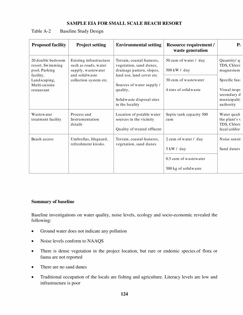
124
SAMPLE EIA FOR SMALL SCALE BEACH RESORT
Table A-2 Baseline Study Design
Proposed facility Project setting Environmental setting Resource requirement /waste generation
Parameter to be assessed
50 cum of water / day
500 kW / day
20 double bedroomresort, Swimmingpool, Parkingfacility,Landscaping,Multi-cuisinerestaurant
Existing infrastructuresuch as roads, watersupply, wastewaterand solid wastecollection system etc.
Terrain, coastal features,vegetation, sand dunes,d rainage pattern, slopes,land use, land cover etc.
Sources of water supp ly /quality,
Solidwaste d isposal sitesin the locality
30 cum of wastewater
4 tons of solid waste
Quantity/ quality (pH, DO, Suspended solids,TDS, Chlorides, Sulphates, Calcium,magnesium, iron, fecal coliforms)
Specific fauna / vegetation
Visual inspection for land use pattern,secondary data from revenue department,municipality, Town panchayat, Town planningauthority
Wastewatertreatment facility
Process andInstrumentationdetails
Location of potable watersources in the vicinity
Quality of treated effluent
Septic tank capacity 500cum
Water quality of groundwater or any source inthe plant’ s vicinity (pH, DO, Suspended solid s,TDS, Chlorides, Sulphates, Calcium, nu tirents,fecal coliforms)
2 cum of water / day
5 kW / day
Beach access Umbrellas, lifeguard ,refreshment kiosks.
Terrain, coastal features,vegetation, sand dunes
0.5 cum of wastewater
500 kg of solidwaste
Noise sensitive receptors, noise levels.
Sand dunes
Summary of baseline
Baseline investigations on water quality, noise levels, ecology and socio-economic revealed thefollowing:
� Ground water does not indicate any pollution
� Noise levels conform to NAAQS
� There is dense vegetation in the project location, but rare or endemic species.of flora orfauna are not reported
� There are no sand dunes
� Traditional occupation of the locals are fishing and agriculture. Literacy levels are low andinfrastructure is poor
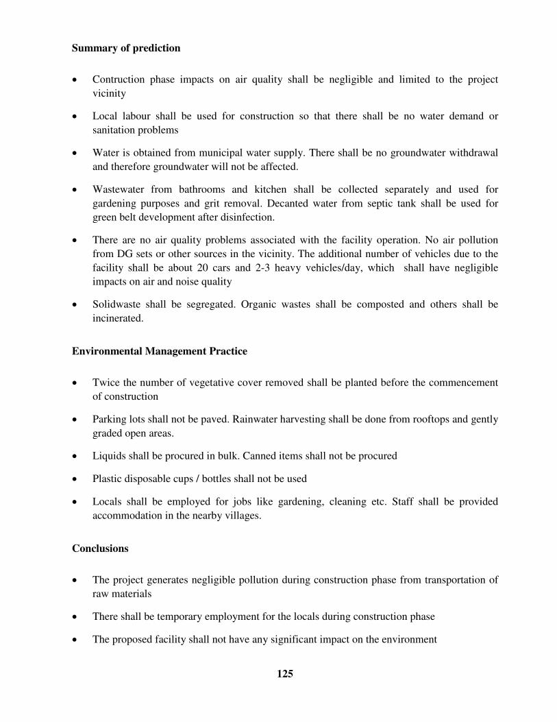
125
Summary of prediction
� Contruction phase impacts on air quality shall be negligible and limited to the projectvicinity
� Local labour shall be used for construction so that there shall be no water demand orsanitation problems
� Water is obtained from municipal water supply. There shall be no groundwater withdrawaland therefore groundwater will not be affected.
� Wastewater from bathrooms and kitchen shall be collected separately and used forgardening purposes and grit removal. Decanted water from septic tank shall be used forgreen belt development after disinfection.
� There are no air quality problems associated with the facility operation. No air pollutionfrom DG sets or other sources in the vicinity. The additional number of vehicles due to thefacility shall be about 20 cars and 2-3 heavy vehicles/day, which shall have negligibleimpacts on air and noise quality
� Solidwaste shall be segregated. Organic wastes shall be composted and others shall beincinerated.
Environmental Management Practice
� Twice the number of vegetative cover removed shall be planted before the commencementof construction
� Parking lots shall not be paved. Rainwater harvesting shall be done from rooftops and gentlygraded open areas.
� Liquids shall be procured in bulk. Canned items shall not be procured
� Plastic disposable cups / bottles shall not be used
� Locals shall be employed for jobs like gardening, cleaning etc. Staff shall be providedaccommodation in the nearby villages.
Conclusions
� The project generates negligible pollution during construction phase from transportation ofraw materials
� There shall be temporary employment for the locals during construction phase
� The proposed facility shall not have any significant impact on the environment

126
Guidelines for
Environmental Impact Assessment
of
Coastal Tourism Projects
for
The Department of Ocean Development
Under the
Integrated Coastal and Marine Area Management Program
Prepared by
National Institute of Ocean Technology IIT Madras Campus
Chennai – 600036
January 2003

121
Chapter 1
Introduction
37.0 COASTAL TOURISM IN INDIA
The Indian Peninsula, including the two emerald archipelagos of Lakshadweep and Andaman,bounded by the Arabian Sea, the Bay of Bengal and the Indian Ocean has a long coastline ofover 7500 km, with spectacular golden beaches, pristine natural beauty, lush green tropicalforests, and unique fauna and flora. This provides immense scope for development of coastaltourism, basically marketing the “ sand, sea and sun” (3S) phenomenon.
There is also high population density in the coastal belt of India with most of the major cities andmetros situated on the coast. The coastal cities are well connected domestically andinternationally through highways, railways, harbours and airports. This infrastructure providesaccess to domestic and international travellers, laying the foundation for increased coastaltourism.
The tourism sector is one of the fastest growing sectors in the country’ s economy. Althoughtourism activity consists of both domestic and international tourism, tourism developmentstrategy places primary emphasis upon international tourists, as international tourism providesforeign exchange earnings to the destination country while domestic tourism leads largely to aredistribution of national income.
37.1 Typical Coastal Tourism Industry
The origin, transit and destination regions constitute the basic tourism system. Components ofthis system have complex inter-relationship between and among several sectors (transportation,commerce, water supply etc.), service providers (travel agents, tour operators, hotels,merchandisers) and stakeholders (tourists, local population). The distribution of each of thesecategories of the tourism sector varies from origin to transit to destination as shown in Fig. 1.1.
While the primary attraction of the coastal tourism industry is the pristine natural environment,present-day coastal tourism includes large-scale constructed facilities such as theme/amusementparks, resorts, marinas, fishing piers and recreational boating harbours. Typical attributes oftourism sites are provided in the following sections.
38.0 Tourist Attractions
Tourist attractions can be based on:
� Natural sites (beaches, coral reefs, mangrove forests, lakes, rivers, waterfalls etc);

122
� Natural events (tides, bird migrations etc.);
� Cultural / heritage sites (historical monuments, ancient temples, ethnic neighbourhood etc);
� Cultural events (festivals, fairs); and
� Constructed sites/Recreational events (resorts, theme/amusement parks, golf courses, skihills, stadium, sports etc.).
A clean environment is the primary resource for the tourism industry, without which the tourismsite will lose its value.
Traveller generating region
Transit route regionTourist destination region
RETURNING TRAVELLERS
DEPARTING TRAVELLERS
Environments: human, sociocultural, economical, technological, physical, political, legal, etc.
Location of travellers/tourists and the travel and tourism industry
[Source: Fig. 2.1 A basic whole tourism system (Source:Leiper 1995) -‘Tourism Management’ by David Weaver &Martin Oppermann)]
Fig. 37.1 TOURISM SECTOR COMPONENTS
39.0 Accessibility
Accessibility can be classified as spatial and seasonal. Spatial accessibility to tourist destinationis a key criterion for siting of a tourist facility. Accessibility can be provided by construction ofroads, airstrips, piers, landing jetties etc.
40.0 Infrastructure
Land is the primary requirement for tourism industry while other infrastructure requirementsinclude transportation, water and sanitation, power, accommodation, food and beverages.
40.1 Tourism industry life-cycle
Tourist spots along coasts develop and gain popularity within a very short period of time,resulting in concentrated activity in a complex, spatially constrained and vulnerable

123
environment. Each destination can sustain a specific level of acceptance of tourist developmentand use, beyond which further development can result in environmental and social deteriorationor a decline in the quality of the experience gained by visitors. In other words, the carryingcapacity of a destination is determined (i) by its ability to absorb tourist development beforenegative impacts are felt by the host community; and (ii) by the level of tourist developmentbeyond which tourist flows will decline because the destination area ceases to satisfy and attractthem. [Alexis Saveriades – Tourism Management 21 (2000) 147-156]
One of the most discussed models for destination development is the Butler’ s life cycle model asa device to assist tourism project proponents as well as decision-makers to assess the variousphases of the industry’ s life cycle in conjunction with carrying capacity threshold. Fig. 1.2illustrates the life cycle of tourism development in a high demand location on the environment.
� Exploration is the initial stage, characterised by very few tourists with little or no adverseimpact
� Involvement is the stage, where the local community responds to opportunities created bytourism by offering specialised services, associated with a gradual increase in tourists.
� Development is the stage when growth is accelerated within a relatively short period oftime.
� Consolidation phase is the stage when tourism totally dominates the destination and localcarrying capacities are exceeded with decrease in growth rate.
� Stagnation is the stage where the tourism industry stagnates due to deterioration of thedestination.
� Declination is the likely scenario if appropriate measures are not taken to restore thedestination or reduce the stress on the environment.
� Rejuvenation is possible if appropriate measures are taken to restore the destination orincrease the carrying capacity, resulting in renewed development.

124
Development
Exploration
Critical Carrying Capacity Threshold
Num
ber
of v
isito
rs
Stagnation
[Decline]
[Rejuvenation]
Time
Consolidation
Involvement
[Continued stagnation]
[Source: Fig. 10.1 Butler sequence -‘Tourism Management’ by David Weaver & Martin Oppermann]Fig. 37.2 TOURISM INDUSTRY LIFE CYCLE
40.2 Techno-economic feasibility study for tourism development
Techno-economic feasibility study helps identify tourism investment options before committingtime and money, by evaluating alternative proposals (which may be alternative projects oralternative processes for a single project). It is imperative that promoters plan tourismdevelopment in consultation with local or regional authorities, in order to ensure compatibilitywith regional plans, environment and ecology.
The end product of a complete feasibility study shall be a sustainable tourism product with aclearly identified market and form. Unlike other industries, tourism industry’ s main resource isthe natural environment. In a popular tourist site, there could be a spurt of several tourismprojects (Fig. 1.2), using the same resource, i.e., the environment. In the absence of self-regulatory mechanisms by tourism promoters, quality of the natural environment shallcontinuously deteriorate. This deterioration of environmental quality beyond the carryingcapacity threshold could lead to collapse of the tourism market or impact the profile of touristsvisiting a location, thereby altering the economics of a project. Promoters should bear in mindthat environmental protection is cheaper than environmental rehabilitation for sustainability ofthe tourism market.
For long-term sustainability of tourism industry, it is critical to consider environmentally sounddesigns and approaches right at the techno-economic feasibility stage. A number of alternativesshall be considered at the planning stage, including the “ no project” alternative and each of themshall be subject to a qualitative environmental review, so as to identify the environmentallypreferable alternative, which addresses the sustainability of the industry.
Key data (Table 1.1) required for the proposed development are collected during the techno-economic feasibility stage. The data in most cases can be obtained from local planning agencies,

125
revenue departments’ research and educational institutions etc. It must be recognised that thetechno-economic feasibility and the environmental impact assessment have common goals andthus common data requirements.
Since tourism activities are site-specific, the general tendency is to confine the study to thesite/premises, where environmental management can be attained through proper housekeepingpractices. However, incremental loads on existing traffic network, water supply, sewer systemetc. from project needs, extend impacts over the region, necessitating integrated planning of thetourism project within a regional development perspective.
Table 37.1 Data required for feasibility study
Economic Technical Environmental
14. Market potential
15. Growth potential and likelyreturns
16. Existing competition
17. Proposed type of products andservices
18. Costs of economic, social,political and environmental risks,
19. Costs of environmentalmanagement and compliancerequirements
20. Time delays and correspondingcosts in obtaining approvals,finance and construction
21. Accessibility, public roads
22. Site suitability for construction (suchas in sand dunes)
23. Slope, soil type, drainage patterns,water table
24. Availability of infrastructure(sewerage, water and power supply)
25. Risks from natural hazards(inundation and unstable cliffs, slopesetc.)
26. Seasons, climate, precipitation etc.
27. Topography, coastal features
28. Hydrodynamic information (data onwaves, tides, currents etc.)
29. Aesthetics and landscape
30. Standard of living of thecommunity at the site
31. Ecological sensitivity of thesite such as location of coralreefs, mangroves,endangered species etc.
32. Existence of indigenoustribes etc.
33. Baseline environmentalquality
41.0 Summary of feasibility studies
The feasibility stage is like a preliminary assessment to identify technical, environmental, socialand economic issues pertinent to the proposed development that might influence its siting,design, construction and management to make the project economically workable andenvironmentally appropriate.
The feasibility studies shall address queries like
What is the planned recuperation period of the invested capital?
A short period of recuperation means that there may be little or no incentive to
manage the industry and the environment in the long term.
What is the extent of short-term and long-term environmental effects including secondaryeffects of tourism development?

126
Some impacts may be short-term and easily mitigable, while long-term impacts
could be permanent. Tourism development may stimulate significant secondary
environmental impacts. For example, tourism development may promote large-scale
tourism and in turn put pressure on the existing transportation network, landuse, water
and power resources etc., i.e., carrying capacity of the region. (Fig. 1.2)
What is the extent of cumulative effects of the proposal?
During the feasibility study it is necessary to focus on combined effects of a series of
activities occurring over a longer period of time, compared to the project specific action.
Some impacts may not be significant when considered at project specific level, but may
assume significance when considering the cumulative effect of a series of activities.
What is the degree to which the current project proposal may establish precedent for futureproposals or shut out future proposals?
Project proposals may form a precedent to other future developments or may
represent a decision in shutting out future proposals due to its environmental significance,
thus focussing on viability of tourism development in the region.
41.1 Coastal Tourism industry impacts
Tourism projects may result in resource consumption, socio-cultural conflicts, increasedpollution and waste generation thus, putting a stress on the existing infrastructure such as roads,effluent treatment works, power and water supply which may not have been designed to handlethe increased requirements of the tourism industry. Major impacts may be loss of biodiversity,increased carbon-dioxide emissions due to energy use in tourism related transportation and air-conditioning and heating of tourism facilities
Examples of beneficial and adverse impacts of coastal tourism are listed below:
Beneficial Impacts
88. Improved facilities like ports, roads and infrastructure, communication, recreational
facilities
89. Increased revenues, employment opportunities, patronage for arts and crafts

127
90. Preservation of historic and archaeological sites
Adverse Impacts
91. Overcrowding of public transportation system and road network.
92. Over-exploitation of water resources/groundwater
93. Physical degradation of the coasts due to pressure on beaches (e.g. beach or coastal
erosion; disappearance of beaches due to encroachment of structures).
94. Exploitation of precious natural resources for craft items
95. Impact on ecologically sensitive and endangered species
96. Removal of sea grass for swimming beaches
97. Use of sea/wetlands for treated and untreated wastewater disposal resulting in
environmental pollution
98. Visual impairment and decreased aesthetics due to disposal of solid wastes and
possible haphazard development at the tourist spot.
99. Air and noise pollution from DG sets etc
100. Blocking of visual and public access to the coast
101. Socio-cultural and lifestyle conflicts with the locals
102. Socio-economic impacts like high land costs, loss of agricultural productivity etc.
41.2 Need for an EIA
Planned and cautious tourism development can prevent costly mistakes so that tourism issustainable and the environmental quality is within its carrying capacity. Environmental ImpactAssessment (EIA) identifies potential impacts and proposes actions to avoid, reduce or mitigatethem. The functions of an EIA is to
� Identify pre-project environmental status and project activities that may affect theenvironment,
� Estimate the impacts of the proposed development,
� Evaluate the consequences of impacts on human life and environment,
� Assess the need for alternative actions and remedial measures.
A thorough EIA shall provide decision makers and the general public with sufficient informationto determine whether:

128
� a tourism project could be initiated in its proposed format, balancing environmentalconsiderations with the social and economic benefits of the project; or
� certain restrictions, design considerations or process alternatives could reduce/mitigateenvironmental impacts without seriously affecting tourism benefits.
It is appropriate that EIAs be carried out early in the project cycle, i.e., conceptual or master planstage allowing significant impacts to be filtered out of the projects. This process helps planningmitigation measures whilst avoiding adverse impacts.
41.3 Type of Coastal Tourism EIA
Depending on the type of the project, the coastal tourism EIA can be classified as one of thefollowing.
5. Project-specific when an individual beach resort/amusement park etc is developed
6. Sectoral, when a carrying capacity type of study is undertaken when a StateGovernment or State/Union Territory Tourism Department aims to provideapproval for a large scale tourism development.
7. Regional, when the development of coastal tourism projects form a part of plansfor regional development. For example developing a region with landing jetty, air-field, roads, hotels, industries and also tourism projects.
Project-specific EIAs often miss impacts that occur off the development site and the cumulativeimpacts of other projects at the same destination. Typically, a project-specific EIA for coastaltourism project shall address the following issues, depending on the scale of development
4. Local environmental impacts at the project site due to103. resource (energy and water) use
104. waste generation (liquid effluent and solidwaste)
105. increased air and noise pollution
106. alteration of the habitat/ecosystem
107. alteration of beach and shoreline
108. alteration of landscape and aesthetics
109. socio-economic and socio-cultural changes
5. Regional impacts of the project due to110. Resource (energy and water) use
111. Traffic congestion due to additional vehicles
112. Stress on existing waste treatment plants
113. Conflicting landuse patterns
6. Existing conditions at the tourist site such as

129
114. Type and number of tourism projects at the tourist site
115. Future development proposals
116. Traffic volume and traffic network
117. Source of water and power and utilisation pattern
118. Waste treatment and disposal facilities
119. Air and noise pollution sources
Tourism planning shall not be carried out in isolation as the industry revolves around issues suchas landuse, protected area, and infrastructure and transportation network of the tourism region.Therefore it is imperative that a comprehensive form of assessment occurs while planningtourism destinations so that all the attributes and their sensitivities in a region/destination can beidentified and weighed appropriately.
Sectoral and regional EIAs shall involve the inventory of all assets of an area/region andassessment of each asset’ s sensitivity to different levels or types of development. An evaluationof the limits to acceptable change in each environmental attribute based on the fragility of theenvironment shall be based on estimates, which essentially gives a measure of “ how much canbe changed” whilst still utilisation of resources is within the carrying capacity.
41.4 Components of EIA
The EIA for a coastal tourism project shall consist of the following components
� Need for the project at the location.
� Analysis of location (siting), activity and process alternatives.
� Description of project facilities and break-up of activities at the facility, consisting ofconstruction and operation details and time-period.
� Scoping to identify the significant impacts of the project and to confine the baseline study tothe required set of parameters.
� Baseline study to assess the environmental status of the project site.
� Prediction or assessment of impacts on the environment due to the project activities.
� Environmental/Area management plan for maintaining/ managing the environmental qualityat the project site thereby mitigating the adverse impacts if any.

130
Chapter 2
Environmental Regulations
42.0 ENVIRONMENTAL CLEARANCE
The area from 0 to 200m from the HTL of CRZ III is a no development zone. All tourismprojects located between 200 to 500 m of the High Tide Line (HTL) i.e., in CRZ-III, or atlocations with an elevation of more than 1000 meters with an investment of more than Rs.5crores, fall under Schedule-1 of the MoEF EIA notification, 1994 and hence require an EIA.[The reader is advised to refer to http://envfor.nic.in/ for the latest CRZ notification, which isupdated from time to time].
Construction of hotels/beach resorts between 200 and 500 from the HTL in designated areas ofCRZ-III requires Coastal Regulation Zone (CRZ) clearance from the MoEF. Guidelines fordevelopment of beach resorts /hotels in the designated areas of CRZ-III for temporaryoccupation of tourists/visitors is given in Annexure II of the CRZ Notification, 1991 (Extractprovided in Table 2.1).
� Siting of tourism project shall be based on the Coastal Zone Management Plan(CZMP) for the area.
� Public hearing has been made mandatory for all the cases where the environmentalclearance is required. Figure 2.1 explains the stepwise process involved in environmentalclearance of tourism projects.
42.1 Environmental Regulations relevant to tourism projects
National legislations applicable to a tourism project have been listed herein to give a brief idea ofthe existing laws and regulations. It is recommended that the reader refer to the latest rules andstandards available at http://envfor.nic.in/
b. Environmental Protection Act 1986
120. EIA Notification (1994 as amended on 27th Jan 2000)
121. Coastal Regulation Zone Notification, (1991, as amended upto 3rd Oct 2001)
122. Municipal Solid Wastes (Management & Handling) Rules, 2000
123. Hazardous Wastes (Management & Handling) Rules (1989)
124. Noise Pollution (Prevention and Control) Rules, 2000
� Others

131
125. The Air (Prevention and Control of Pollution) Act, 1981 as amended by
amendment Act 1989
126. The Water (Prevention and Control of Pollution) Act, 1974 as amended upto 1988
127. The Indian Wildlife (Protection) Act, 1972 as amended upto 1993
128. Forest (Conservation) Rules, 1981 amended upto 1992

132
Table 2.1 Annexure –II of the CRZ Notification, 1991 by the MoEF(as amended upto 3rd October 2001)
GUIDELINES FOR DEVELOPMENT OF BEACH RESORTS/HOTELS IN THE DESIGNAED AREAS OF CRZ-IIIFOR TEMPORARY OCCUPATION OF TOURIST/VISITORS, WITH PRIOR APPROVAL OF THE MINISTRY OFENVIRONMENT & FORESTS.
7(1) Construction of beach resorts/hotels with prior approval of MEF in the designated areas of CRZ-III for temporaryoccupation of tourists/visitors shall be subject to the following conditions:
(i) The project proponents shall not undertake any construction (including temporary constructions and fencing or suchother barriers) within 200 metres (in the landward wide) from the High Tide Line and within the area between the LowTide and High Tide Line;
(ia) live fencing and barbed wire fencing with vegetative cover may be allowed around private properties subject to thecondition that such fencing shall in no way hamper public access to the beach;
(ib) no flattening of sand dunes shall be carried out;
(ic) no permanent structures for sports facilities shall be permitted except construction of goal posts, net posts and lampposts.
(id) construction of basements may be allowed subject to the condition that no objection certificate is obtained from theState Ground Water Authority to the effect that such construction will not adversely affect free flow of ground water inthat area. The State Ground Water Authority shall take into consideration the guidelines issued by the CentralGovernment before granting such no objection certificate.
Explanation:
Though no construction is allowed in the no development zone for the purposes of calculation of FSI, the area ofentire plot including 50% of the portion which falls within the no development zone shall be taken into account.
(ii) The total plot size shall not be less than 0.4 hectares and the total covered area on all floors shall not exceed 33 percent of the plot size i.e. the FSI shall not exceed 0.33. The open area shall be suitably landscaped with appropriate vegetalcover;
(iii) The construction shall be consistent with the surrounding landscape and local architectural style;
(iv) The overall height of construction upto highest ridge of the roof, shall not exceed 9 metres and the construction shallnot be more than 2 floors (ground floor plus one upper floor);
(v) Ground water shall not be tapped within 200m of the HTL; within the 200 metre – 500 metre zone, it can be tappedonly with the concurrence of the Central/State Ground Water Board;
(vi) Extraction of sand, levelling or digging of sandy stretches except for structural foundation of building, swimmingpool shall not be permitted within 500 metres of the High Tide Line;
(vii) The quality of treated effluents, solid wastes, emissions and noise levels, etc. from the project area must conform tothe standards laid down by the competent authorities including the Central/State Pollution Control Board and under theEnvironment (Protection) Act, 1986;
(viii) Necessary arrangements for the treatment of the effluents and solid wastes must be made. It must be ensured thatthe untreated effluents and solid wastes are not discharged into the water or on the beach; and no effluent/solid wasteshall be discharged on the beach;
(ix) To allow public access to the beach, at least a gap of 20 metres width shall be provided between any two hotels/beachresorts; and in no case shall gaps be less than 500 metres apart; and
(x) If the project involves diversion of forestland for non-forest purposes, clearance as required under the Forest

133
129.
+
1. List of documents to be submitted to the SPCB is as per Schedule-IV of the EIA notification
2. Based on the guidelines for development of beach resorts in CRZ-III as per Annexure II of the CRZ notification, 1991
3. List of documents consist of EIA report/EMP and details of public hearing as specified in Schedule-IV
4. Impact Assessment Agency is the Union Ministry of Environment and Forests
5. Expert committee composition is according to the Schedule-III of the EIA notification
Fig. 42.1 PROCEDURE FOR OBTAINING ENVIRONMENTAL CLEARANCE
Submit projectquestionnaire1 to concerned
SPCB for review
SPCB to review and initiatepublic hearing
No Objection Certificateissued
Projectrejected
Submit application form3 to the MoEF asper Schedule-II
Project falls under the Schedule–I of the EIA Notification
Evaluation and Assessment by theImpact Assessment Agency4
Expert committee5review
Environmental issues can be resolved
Submit application form2 to MoEFfor CRZ clearance
CRZ clearance granted
Investor advised to lookfor alternate site
Project Rejected
Insu
ffici
ent o
r ina
dequ
ate
data
Project cleared with or withoutstipulations
If de
emed
nece
ssar
y

134
Chapter 3
Siting and project alternatives
43.0 INTRODUCTION
Tourism projects are generally located in regions with natural, cultural and ecological features.This chapter aims to provide a brief insight into the siting requirements/restrictions, alternativesand facilities of a tourism project and is a precursor to the impacts of such projects.
43.1 Siting
Eco-tourism based projects and recreational tourism require pristine natural environments suchas beaches, coral reefs, mangroves, lagoons, backwaters and visual landscape. For constructedsites such as recreational/ amusement/ theme parks infrastructure, access and clean environmentare desired attributes. Tourism development needs to be planned in conformance with existingland use pattern of the area.
While the legal requirement for siting a coastal tourism project is governed by the CoastalRegulation Zone Notification of the MoEF, the suitability of the site for the intended tourismproposal shall be based on a detailed investigation of technical, economic and environmentalsiting considerations.
44.0 Economic siting criteria
Economic viability consists of forecasting the long-term performance of the proposeddevelopment and balances a range of factors including target market, the envisaged facilities, andthe site’ s environment. Economic considerations for siting depends on the following factors
� Accessibility determines the potential target market (i.e. the tourist’ s visiting the site). Forexample, a site in a remote location may be inconvenient to the tourists who may not returnagain or recommend the location to others. Cost of accessibility will also affect the tourist‘sdecision to visit.
� Seasonality determines the peak tourist inflow. Seasonal and spatial concentration oftourists has serious implications in terms of resource availability and management at thedestination. For example, drinking water supplies, transport services, power supplies etcmay be inadequate during peak tourist period and management during such periods consistsof procuring additional water, providing additional bus services, provision of DG sets etc.Seasonal variations shall also involve planning for heating and cooling systems. Seasonalrough weather and dangerous sea conditions will also reduce tourist influx.

135
� Clean environment like good air quality, landscape and aesthetics, healthy habitats andliving resources, sufficiently high quality of coastal waters (so as to provide a healthy andaesthetically pleasing environment for water-based recreation) is utmost essential at thetourist location. A polluted tourist location will prompt tourists to seek alternative locations.
� Environmental complexity determined by fragile ecosystem needs extensive managementinvolving environmental rehabilitation and regeneration during development and operationalphases. Additional costs are incurred by establishing and maintaining an EnvironmentalManagement System (EMS). For example, an inadequate economic analysis of anenvironmentally complex site may involve cost overruns due to EMP and Monitoring.
� Resource availability includes land, water supply (drinking, washing, etc), power supply,construction materials etc. (gravel, sand, timber, etc).
� Safety concerns consists of weather-related risks (such as high waves, undertows, dangerouscurrents, etc.) for recreational boating and underwater recreation (e.g. diving, snorkellingetc); availability of adequate lifeguard systems, first aid facilities, telephones, hospitals etc;hazards such as jellyfish, underwater obstructions, unstable cliffs, inundation etc.
45.0 Technical siting criteria
The technical requirements for siting depend on the type of facilities that are planned to cater tothe tourists visiting natural, cultural sites or recreational facilities for a constructed site.Technical suitability of a tourist site shall be based on
� Study of existing transport network, volume of traffic, suitability of the transport system tohandle the increased traffic, scope for expansion etc.
� Study of topographical features (slopes, soil types for foundation and soak pits), drainagepatterns (location of water table for foundations), precipitation (rainwater harvesting), waterresource (surface and groundwater), land use (rural, urban, wetlands, forest etc),hydrodynamics (tidal variations, littoral drift, wave heights, currents, etc), coastal features(natural inlets / sheltered bays or exposed coasts).
� Study of the existing public water supply, sewerage system, wastewater and solid wastedisposal system, suitability of the system to handle additional loads.
� Standard, volume, type, and capacity of accommodation and type of facilities such asrecreational, sports etc and scope for any possible future expansion.
� Orientation of buildings to wind (passive cooling, power generation, etc) and sun (solarheating).
46.0 Environmental siting criteria
For tourism industry, economic sustainability depends largely on environmental conditions andtherefore, the environmental sensitivity/complexity is an integral part of economic siting criteria.However, the following environmental considerations needs to be assessed

136
� Fragility of the environment due to the presence of
130. ecologically sensitive areas such as coral reefs, mangroves, sea grass,
131. endangered marine species such as sea turtles,
132. breeding and spawning grounds etc.
� Construction in sand dunes, beach/ dune vegetation etc.
� Socio-cultural aspects such as traditional practices, presence of indigenous tribes etc.
47.0 Site Design
Site design is a process of location of structures and utilities in a manner that natural and culturalvalues are made available to visitors. A responsible site design is based on the needs of the site’ senvironment, as it shall integrate the natural features and the constructed environment.Landscape development shall be planned in conformance with the surroundings rather than byoverlaying routine designs and solutions.
A preliminary site survey of the local tourist spot can include
� Proximity analysis where optimal locations are identified for proposed facilities
based on the site’s environmental setting and the proximity to environmentally
sensitive resources (mangroves, coral reefs) and cultural resources (religious,
historical), which could be affected by development.
� Line of sight analyses to recommend where certain facilities should not or should
be located given visibility from key attractions and scenic view locations.
� Topographic analyses to identify favourable building sites as indicated by slope.
� Flow analyses to identify probable paths of water flow and therefore locations
subject to erosion or flooding.
� Density analyses to determine clusters of ecological and/or cultural values that
might be threatened by development
General guidelines to be followed in siting tourism facilities are
4. Retain ecological features

137
� Avoid changing or damaging ecological (mangroves, corals, wetlands, sand dunes,estuaries, nesting sites) and cultural (religious, historical) features.
� Locate facilities, paths, and roads such that visitors are directed away from sensitive areas
5. Create or use existing buffer zones
� Buffer areas (trees, shrubs) could be naturally present at the tourist location or can beartificially created. The site can be zoned around existing buffers without removing trees,vegetation and dune covers. Artificial buffers can however be created to limit visitor accessto ecologically sensitive zones or for public recreation.
� Minimise or eliminate clearance of trees, vegetation. Disturbances to natural vegetation canbe achieved by minimising earthworks, avoiding steep slopes, confining development toareas of previous disturbance and protecting existing vegetation.
6. Locate facilities in conformance with existing natural, cultural and architecturalenvironment
� Locate small buildings between existing vegetation
� Avoid visually prominent areas such as undeveloped cliffs, ridges etc.
� Locate electricity and telecommunication lines underground and work around naturaldrainage patterns. Roads can be designed to follow natural contours and building roads onsteep slopes, drainage lines and areas requiring extensive cut and fill can be avoided
� Car parks, toilet blocks can be located to blend with the natural setting. Locate roads, carparks and other facilities away from areas prone to shoreline erosion.
� Provide waste disposal facilities at locations away from well locations, swimming beaches,fishing areas and other water intake locations
� Locate cottages and guest rooms away from areas of recreation activity as noise and lightdisturbances can have negative impact
� Maintain public access to beaches and other ocean frontages
� Provide safe access in case of severe weather conditions and avoid creating dead end routesthat are a potential fire trap
47.1 Alternatives
48.0 Project alternatives
The facilities in a coastal tourism project depend on the attraction available at the site (Section1.1.1). There are several coastal tourism project alternatives. Depending on the scale ofdevelopment they can be classified as follows

138
� Beach resorts with hotels, guest rooms, cottages, conference halls etc with a variety ofancillary services (like swimming pools, health club, amusement facilities etc).
� Marinas, harbour cruises, submarines, sport fishing, scuba diving, snorkelling, day sailing,reef tours on glass bottom boats, pools, jet skis etc which require piers, cruise ship docksetc.
� Amusement parks, aquarium, restaurants, open-air theatres, food and beverage servicefacilities etc on the beach.
� Resorts/hotels/restaurants in religious/historical places/protected areas.
Any coastal tourism project may be a combination of one or more of the above alternatives. Forexample, a large beach resort may alone form a project or it could have associated waterside,landside amusement / entertainment facilities.
49.0 Technology alternatives
Appropriate planning of layout and design, construction of buildings and facilities are some ofthe technology alternatives. In addition, there should be sound management procedures duringthe operation of the facilities.
� Alternative designs to minimise resource consumption and waste generation
The directions of wind (passive cooling, power generation, etc) and sun (solar heating) need tobe taken into account while planning buildings. Construction on shoreline (causing interferencewith the coastal processes) and on steep slopes, sand dunes etc. may be avoided by appropriateplanning of structures, considering the site layout. Also existing drainage patterns may bemaintained while undertaking levelling of the site. Landfilling especially in wetlands and marineareas shall be avoided.

139
� Incorporation of environmentally sound alternatives in the project
Unpaved parking areas enable groundwater recharge. Providing basic wastewater treatmentfacilities and incineration of solidwastes or linking the solidwaste disposal to the local municipalcollection system shall prevent degradation of the aesthetics and landscape while preservinggroundwater quality. Organic solidwastes can be composted.
� Area management plans and/or sound house-keeping practice (EMP)
Landscaping, waste management techniques such as recycling, reuse and composting, powerconservation measures such as use of thermostats, timers, use of solar water heaters etc., waterconservation measures such as low flow valves, rainwater harvesting and change in purchasingpolicies for “ closing the recycling loop” etc., are some of the practices which may be adopted atthe planning stage to reduce capital investments in environmental mitigation/management.
49.1 Project facilities
Possible facility requirements for coastal tourism projects are presented in Table 3.1. Activitiesindependent of these facilities are surfing, windsurfing, hiking, scuba diving, bathing,religious/historical sites, scenic sites, national parks etc.
Table 43.1 Facility requirements for coastal tourism projects
Basic facilities Infrastructure requirements Recreational facilities
Hotels/ resorts/ guestrooms/ cottages
Multi-cuisinerestaurants
Parking lots
Shops, fast-food stalls
Transportation system
Water supply & storage system
Wastewater treatment and d isposalsystem
Power supply (Generator sets)
Communication systems.
Solid waste management system
Party/ conference halls/ open airinstallations
Marinas, recreational boating harbours,beaches, fishing facilities
Swimming pools
Golf areas & tennis courts
Amusement parks
50.0 Project Activities
Activities of coastal tourism projects can be broadly categorised under construction phase andoperations phase as given in the Table 3.2
Table 43.2 Project Activities
Phase Land-side Activity Water-side activity

140
Phase Land-side Activity Water-side activity
Construction � Land acquisition and development� Site clearing
� Transportation of raw materials� Construction activities
� Labour camps� Land reclamation / Disposal of dredged
material on land
� Dredging� Disposal of dredged material at sea
� Construction of piers, landing jetties etc
Operation � Vehicular traffic� Wastewater discharge from hotels and
from employees quarters & treatment– Sewage treatment facilities� Solid waste disposal� Beach maintenance
� Brine discharge from desalination plants� Discharge from power plants (cooling
water and gaseous emissions)� Sport fishing
� Scuba diving and snorkelling� Swimming� Yachting
� Motor boating & water skiing

141
Chapter 4
Identification of likely impacts
51.0 PRELIMINARY EVALUATION OF IMPACTCHARACTERISTICS (SCOPING)
Environmental impacts of coastal tourism are generally small, often dispersed, critically placed.Scoping emphasises identification of the most obvious, given the preliminary knowledge ofbaseline environment and type of development. Scoping is a key to fixing the scope of baselineassessment and level of impact prediction.
Significance of an impact is a function of the relative change to an environmental attribute andthe sensitivity to that change. While planning for the baseline study, activities with potentiallyinsignificant impacts need to be de-emphasised and potentially significant impacts need to bestudied in detail.
Following are the most important questions related to the existence of critical habitats in theproposed project site.
13. Is there a national park, sanctuary or reserved forest in the area?
14. Are there any coral reefs in the area?
15. Are there mangroves/seagrass beds in the area?
16. Are there significant areas of breeding/spawning grounds in the vicinity?
17. Does the area form a part of migratory route or nesting grounds for aquatic and avi-fauna?
18. Are there endangered species in the area?
Scoping is usually based on a preliminary site survey, which shall involve visual inspection ofthe project site and its surroundings for the existing conditions and address issues such as
28. Groundwater, other sources of water supply
29. General water quality (good, medium, bad)
30. Air pollutant sources
31. Air quality (good, medium, poor)
32. Background noise levels (high, medium, low)
33. Wastewater/effluent discharge sources, disposal methods/location of disposal
34. Types of solid waste generated (refuse, garbage) and their management
35. General aesthetics (good, medium, poor)
36. Landuse (rural, urban, residential, industrial, commercial, agriculture etc)
37. Landscape and terrain (slope, hilly, plain)

142
38. History of natural hazards (cyclones, floods, earthquakes, landslides etc)
39. Nature of soil (clayey, silty, sandy)
40. Flora and fauna (terrestrial, aquatic & endemic species)
41. Traffic system and transportation facilities (roads, railways, airways, waterways)
42. Socioeconomic conditions (occupation, health care, schools, water and power supply etc)
43. Socioculture (historical, religious, traditions, indegenous tribes etc)
51.1 Identification of likely impacts
Identification of likely impacts of a project is essential in planning an EIA study. This identifiesproject activities that have an environmental impact, provides parameters for baseline datacollection and helps incorporate mitigative measures in the project/process design at the planningstage itself
The environmental parameters likely to be affected due to the activities of the coastal tourismproject are listed in Table 4.1
Table 51.1 Overview of likely impacts
Primary environmental aspects affectedProject Activities
Air Noise Land Water* Sediment Ecology Socio-Economics
Land development / Siteclearing
¥ ¥ ¥ ¥ ¥ ¥
Transportation of rawmaterials
¥ ¥
Construction activities ¥ ¥ ¥ ¥
Labour force ¥ ¥ ¥
Land reclamation/dumping of d redgedmaterial on land
¥ ¥ ¥ ¥
Capital d redging ¥ ¥ ¥ ¥
Disposal of d redgedmaterial at sea
¥ ¥ ¥
Pier Construction ¥ ¥ ¥ ¥
Vehicular traffic ¥ ¥

143
Primary environmental aspects affectedProject Activities
Air Noise Land Water* Sediment Ecology Socio-Economics
Wastewater d ischargefrom hotels andemployee quarters
¥ ¥ ¥ ¥
Solid waste d isposal ¥ ¥
Beach maintenance ¥ ¥ ¥
Brine d ischarge fromdesalination plants
¥ ¥ ¥
Cooling water d ischargefrom power plants &gaseous emissions
¥ ¥ ¥ ¥
Sport fishing, Scubad iving and snorkelling,Swimming, Yachting,Motor boating & waterskiing
¥ ¥ ¥ ¥ ¥ ¥
Boat maintenance ¥ ¥ ¥ ¥ ¥ ¥
* Water environment consists of marine & fresh water resources
Table 4.2 gives details of the parameters likely to be affected by each of the activity, impactcharacteristics and their level of significance, from which a scoping exercise is performed toidentify issues of environmental concern.
52.0 Characteristics of Impacts
Impacts of proposed activity affect the environment depending upon how, when, where and byhow much they occur. Impacts are characterised by
� Nature (positive, negative, direct, indirect, cumulative, synergistic)
133. An increased employment opportunity is a direct- positive impact.
134. Loss of wetlands, destruction of eco-systems, coastal erosion or changes in
shoreline, impact on water quality and its availability, relocation of households,
increased air emissions are some direct-negative impacts, which occur around the
same time as the action that causes them.

144
135. Human health problems, impacts on marine organisms due to water quality
deterioration or dredging are indirect-negative impacts, which occur later in time or
in a place other than where the original impacts occurred.
136. Impacts from various activities and subprojects can be additive and result in
cumulative impacts
137. Impacts from various activities and subprojects can interact with other sources
and create new or larger impacts than those originally occurring resulting in
synergistic impacts
� Magnitude
138. Estimation of the size of impact; e.g. Small quantities of release of toxic
substances can cause large scale impacts on human and aquatic life
� Extent/location (area/volume covered, distribution)
139. Spatial distribution of toxic/hazardous substance release (risk contours), extent of
area affected due to emissions from DG sets, dredging activities, etc.
� Timing (during construction, operation,)
� Duration (long-term, short-term, intermittent, continuous)
140. Noise arising from equipments during construction are typical short term impacts
141. Inundation of land, accretion, erosion etc are typical long-term impacts
142. Blasting operations may be intermittent while noise due to pile driving operations
may be continuous.
143. Discharge of wastewater may be continuous, while spills during transfer
operations may be short-term.
� Reversibility/irreversibility
144. Restoration of the environmental quality to pre-existing stage is defined as
reversible. Air quality impacts due to transportation of raw material occurs only
during construction stage and hence reversible, whereas construction of on
shorelines causes an irreversible change to the coastline.
� Likelihood (risk, uncertainty)
145. Some impacts occur less frequently but have a high consequence while others
occur more frequently and have less consequence.

145
53.0 Extent of environmental impact
Siting and/or development of tourism projects result in environmental impacts, which may notconfine to the project location and its environs, but may extend spatially over the followingzones:
� Source region, i.e., the tourist generating region
� Beach and shoreline
� Coastal waters
� Coastal plains
� Estuaries, backwaters and lagoons
� Offshore waters
Table 4.2 gives the evaluation of impact characteristics, i.e., scoping to enable filtering ofimpacts that may be insignificant based on the environmental setting of the project.

146
Table 51.2Preliminary Evaluation of Impact Characteristics for a Coastal Tourism Project - ScopingImpacts Apparent Impact
Characteristic
Activity
Parameter Component Cause
Timing
Duration/ Nature /
Reversibility
Significance Level
Landuseand/ or socio-economics
Loss of cultivable lands /forest areas / fishinggrounds and / or loss oflivelihood
Pre -construction phase
Negative
Long-term
Irreversible
High when there is loss oflivelihood / production /conflicting landuse pattern;Low when alternate means oflivelihood is provided or withadequate compensation
Landacquisition anddevelopment
Land
Water quality Increased impervioussurfaces causing morerunoff containing toxics,suspended particles andoil and grease.Groundwater recharge isalso reduced
Construction &OperationsPhase
Negative
Long-term
Irreversible
High when wetlands aredeveloped and when surfacesare sealed or impervious
Site clearing Air quality SuspendedParticulateMatter (SPM)
Wind erosion ofd islodged fine soilparticles due to earthmoving/ removal ofvegetative cover etc
Construction Phase
Negative
Short-term
Reversible
High when wind speeds arehigh with removal of vegetativecover / trees; Low in theproximity of barriers likebuild ings / trees and / or whenwind speeds are insufficient tocause wind erosion

147
Impacts Apparent Impact
Characteristic
Activity
Parameter Component Cause
Timing
Duration/ Nature /
Reversibility
Significance Level
Noise Noise levels Use of earth movingequipment, power tools,d iesel engines etc.
Construction Phase
Negative
Short-term
Reversible
Low when there are no noisesensitive receptors, whenworkers are provided with earmasks or when adequatevegetative coverexists/ retained
Significance Level
Water Water quality Soil loss by runoff intowater body in the vicinitycausing increasedturbid ity
Construction phase
Negative
Short term
Reversible
Low when vegetative cover isnot removed and / or whengravel washings are less due toscanty rainfall.
Land Soil Removal of vegetativecover and root structuresthat protect soil and / orchange in the grad ient ofexisting slopes causes soilerosion
Construction phase
Negative
Short term
Irreversible
Low when minimum vegetativecover is removed and / orwhen natural slopes are notaltered
Site clearing(contd)
Terrestrialecology
Flora & fauna Removal of vegetation Construction phase
Negative
Long term
Irreversible
Low when minimum vegetativecover is removed / whenvegetative cover iscommercially unimportant orwhen fauna is absent; Highwhen fauna are endangeredspecies
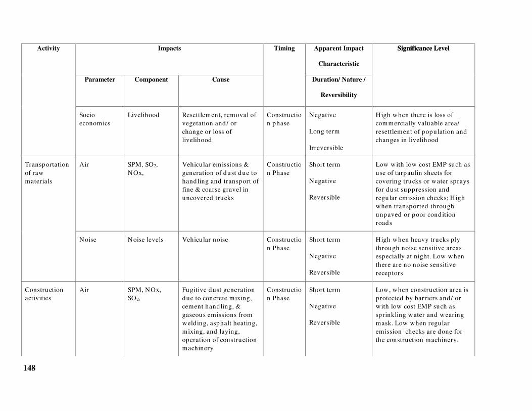
148
Impacts Apparent Impact
Characteristic
Activity
Parameter Component Cause
Timing
Duration/ Nature /
Reversibility
Significance LevelSignificance Level
Socioeconomics
Livelihood Resettlement, removal ofvegetation and / orchange or loss oflivelihood
Construction phase
Negative
Long term
Irreversible
High when there is loss ofcommercially valuable area/resettlement of population andchanges in livelihood
Air SPM, SO2,NOx,
Vehicular emissions &generation of dust due tohandling and transport offine & coarse gravel inuncovered trucks
Construction Phase
Short term
Negative
Reversible
Low with low cost EMP such asuse of tarpaulin sheets forcovering trucks or water spraysfor dust suppression andregular emission checks; Highwhen transported throughunpaved or poor cond itionroads
Transportationof rawmaterials
Noise Noise levels Vehicular noise Construction Phase
Short term
Negative
Reversible
High when heavy trucks plythrough noise sensitive areasespecially at night. Low whenthere are no noise sensitivereceptors
Constructionactivities
Air SPM, NOx,SO2,
Fugitive dust generationdue to concrete mixing,cement hand ling, &gaseous emissions fromweld ing, asphalt heating,mixing, and laying,operation of constructionmachinery
Construction Phase
Short term
Negative
Reversible
Low, when construction area isprotected by barriers and / orwith low cost EMP such assprinkling water and wearingmask. Low when regularemission checks are done forthe construction machinery.
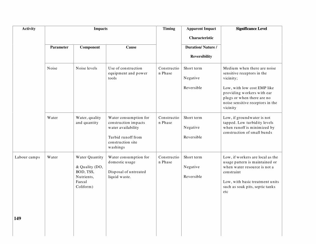
149
Impacts Apparent Impact
Characteristic
Activity
Parameter Component Cause
Timing
Duration/ Nature /
Reversibility
Significance Level
Noise Noise levels Use of constructionequipment and powertools
Construction Phase
Short term
Negative
Reversible
Medium when there are noisesensitive receptors in thevicinity;
Low, with low cost EMP likeprovid ing workers w ith earplugs or when there are nonoise sensitive receptors in thevicinity
Significance Level
Water Water, qualityand quantity
Water consumption forconstruction impactswater availability
Turbid runoff fromconstruction sitewashings
Construction Phase
Short term
Negative
Reversible
Low, if groundwater is nottapped . Low turbid ity levelswhen runoff is minimized byconstruction of small bunds
Labour camps Water Water Quantity
& Quality (DO,BOD, TSS,Nutrients,FaecalColiform)
Water consumption fordomestic usage
Disposal of untreatedliqu id waste.
Construction Phase
Short term
Negative
Reversible
Low, if workers are local as theusage pattern is maintained orwhen water resource is not aconstraint
Low, with basic treatment unitssuch as soak pits, septic tanksetc

150
Impacts Apparent Impact
Characteristic
Activity
Parameter Component Cause
Timing
Duration/ Nature /
Reversibility
Significance LevelSignificance Level
Land Landuse andAesthetics
Generation of solidwastes, Haphazardgrowth of temporarybuild ings /dwellings/ hutments
Construction Phase
Short term
Negative
Reversible
Low, when proper collectionand d isposal of solid wastes ispractised ; Low when shelter,basic requirements andsanitation for the workers areprovided or when temporaryconstruction is regulated
Labour camps(contd)
Socio-Economics
Employment Increased employmentopportunities
Construction Phase
Short term
Positive
Reversible
Low, if the employment istemporary and only during theconstruction phase
Ecology Micro &Macrobenthos
Trapping of intertidalbenthos
Construction phase
Long term
Negative
Irreversible
Low if the area is a barren anddevoid of ecologically sensitivespecies / commerciallyvaluable species. Low ifd redged material is notcontaminated .
Disposal ofdredgedmaterial alongthe coast orLandreclamation
Sedimenttransport,shorelineslopes (land)
Hydrodynamics
Change inhydrodynamics due tomaterial dumping maycause shoreline changes
Construction phase
Long term
Negative
Irreversible
Low if the site is not close to thewater front

151
Impacts Apparent Impact
Characteristic
Activity
Parameter Component Cause
Timing
Duration/ Nature /
Reversibility
Significance LevelSignificance Level
Groundwatersources,quality
Waterresources
Dumping of toxicsed iments may impactgroundwater resourcesfrom leaching
Construction
Long term
Negative
Irreversible
Low if there is no groundwaterresource or if d redged materialis not contaminated .
Noise Noise levels Use of d redgingequipment and powertools
Construction phase
Short term
Negative
Reversible
Low if the soil at the d redginglocation is soft and of clayeynature or with no noisesensitive marine species at closeproximity
Medium for a rocky profile
Water Water quality Sed iment resuspension;Release of toxicsubstances and nutrientsfrom the sed iments
Construction phase
Short term
Negative
Reversible
Medium for turbid ity when thematerial is clay and low fortoxicity when sed iment toxicityis minimal
Capitald redging
Ecology Micro andMacro benthos
Disturbance of bottomsed iments and removalor destruction ofspawning grounds
Construction phase
Short term
Negative
Reversible
Low, when commerciallyvaluable species/breed ing/ spawning groundsare not present

152
Impacts Apparent Impact
Characteristic
Activity
Parameter Component Cause
Timing
Duration/ Nature /
Reversibility
Significance Level
Disposal ofdredgedmaterial at sea
Water Water quality Dumping of d redgedmaterial increases totalsuspended solid s,turbid ity levels, mayrelease nutrients andtoxics.
Construction phase
Short term
Negative
Reversible
Low when the d redgedmaterial conforms to thesed iment properties at thed isposal site. High whendredged material is toxic or inthe presence of fishing /breed ing / spawning grounds
Noise Noise levels Use of pile d rivers,boring equ ipment, powertools, d rill bits etc.
Construction phase
Continuous for aShort period
Negative
Reversible
Medium when noise sensitivereceptors are in the vicinity
Low, with low cost EMP suchas ear protection devices
Water Water quality Increased suspendedsolid s and turbid ityduring piling
Construction phase
Short term
Negative
Reversible
Low, when piled foundationsare used as it is localised andarea of impact is negligible
Construction ofpiers, land ingjetties
Sed imenttransport
Hydrodynamics
Change inhydrodynamics maycause accretion /deposition
Construction &OperationPhase
Long term
Negative
Irreversible
Low, if the structure does notalter flow pattern

153
Impacts Apparent Impact
Characteristic
Activity
Parameter Component Cause
Timing
Duration/ Nature /
Reversibility
Significance LevelSignificance Level
Ecology Micro andMacro benthos
Disturbance of bottomsed iments and coveringup or destruction ofspawning grounds
Construction phase
Short term
Negative
Reversible
Low, when commerciallyvaluable species/breed ing/ spawning groundsare not present or whenstructures are found on piles.
Air SPM SO2 andNOx,
Vehicular emissions dueto combustion of fuel
Vehicles on dusty roads
Operationphase
Long term
Negative
Irreversible
Low, if there is no receptors ofimpact
Vehiculartraffic (use ofmotor vehiclesand speedboats)
Noise Noise levels Generation of noise fromvehicles
Operationphase
Long term
Negative
Irreversible
Low, when vehicles do nottraverse through thicklypopulated areas and with lowcost EMP like regular emissionchecks.
Power plants Air CO, NOx, SPM,SO2 and HC
Emissions from DG sets Operationphase
Long term
Negative
Irreversible
Low when the DG sets are usedonly for emergency purposesand when frequent emissionchecks are made and whenthere are no sensitive receptorsin the downwind d irection

154
Impacts Apparent Impact
Characteristic
Activity
Parameter Component Cause
Timing
Duration/ Nature /
Reversibility
Significance LevelSignificance Level
Noise Noise levels Noise generation fromDG sets
Operationphase
Long term
Negative
Irreversible
Low when the DG sets are usedonly for emergency purposesand when there are no sensitivereceptors in the downwinddirection
Water Water quality Discharge of treated oruntreated sewage into thewater bod ies
Operationphase
Long term
Negative
Irreversible
Low when the wastewater istreated before d ischarge
Wastewaterd ischargesfrom hotels andemployeequarters.
Ecology Marine floraand fauna
Discharge of wastes Operationphase
Negative Low when the wastewater istreated before d ischarge
Water Water quality
(Groundwater& otherresources)
Ground leaching ofpollu tants fromsolid waste
Operationphase
Long term
Negative
Irreversible
Low when solid waste isincinerated or dumped inapproved landfills
Solidwasted isposal
Land Aesthetics Solidwaste generationfrom hotels, resorts andcruises and recreationalboats
Operationphase
Long term
Negative
Reversible
Low when the proponentpractises solidwaste hand lingand d isposal system suchsegregation, compostingand/ or incineration.

155
Impacts Apparent Impact
Characteristic
Activity
Parameter Component Cause
Timing
Duration/ Nature /
Reversibility
Significance Level
Presence ofphysicalstructures
Land Groundwater Sealing of the areas withbuild ings, roads, parkinglots restricting therecharge capacity andchanging the d rainagepattern
Operationphase
Long term
Negative
Irreversible
High when the region is themain recharge area for the localtown, Medium whengroundwater is the mainresource.
Sed iment Hydrodynamics
Construction nearbeaches, removal ofnatural coastlineprotection, interferencewith balance of materialsnear the beaches, removalof protective beachvegetation etc. causeserosion
Operationphase
Long term
Negative
Irreversible
Low when the construction isnot too close to the coast, whereremoval of sand forconstruction is minimal andwhen beach vegetation is notd isturbed
Water Salinity, DO Discharge of brine Operationphase
Long term
Negative
Irreversible
Low when d ischarge location isat sufficient depth to facilitated ilution
Discharge fromdesalinationplants
Ecology Marineorganisms
Discharge of water thathas greater salinity thanwhat is available to theorganisms
Operationphase
Long term
Negative
Irreversible
Low when there are noecologically sensitive species atand near the location ofd isposal

156
Impacts Apparent Impact
Characteristic
Activity
Parameter Component Cause
Timing
Duration/ Nature /
Reversibility
Significance Level
Water quality Temperature Discharge of effluentwhich has highertemperature than that ofthe water body
Operationphase
Long term
Negative
Irreversible
Low when the cooling water issufficiently d iluted with coldwater and when there are noecologically sensitive species atand near the location ofd isposal
Cooling waterd ischarge fromthe powerplants(seawaterwithdrawal forcooling)
Ecology Marineorganisms
Discharge of effluentwith temperatures abovethe ambient
Operationphase
Long term
Negative
Irreversible
Low when there are noecologically sensitive species atand near the location ofd isposal
Tourist Influx Socio cultural Trad itionalvalues andculture
Influx of tourists andintrod uction of capitalbased economy mayaffect trad itional values
Operationphase
Long term,Negative,Irreversible
Medium to high depending onthe location of the touristindustry

157
Impacts Apparent Impact
Characteristic
Activity
Parameter Component Cause
Timing
Duration/ Nature /
Reversibility
Significance Level
Tourist influx(contd .)
Socioeconomics
Economicstability andemployment
Influx of add itionalpopulation, traders andjob-seekers
Resettlement of localpopulation
Priority to tourists andhence limited beachaccess and trad itionalfishing opportunities tothe local population
Loss of valuableagricultural areas
Abandoning agricu lturalprofessions
Restricted supplies ofessential crops, fruits andvegetables to locals
Increased land prices,cost of living, energycosts
Operationphase
Long term
Negative
Irreversible
Medium to high depending onthe location of the touristindustry

158
Impacts Apparent Impact
Characteristic
Activity
Parameter Component Cause
Timing
Duration/ Nature /
Reversibility
Significance Level
Continuous use of thewater by tourists,washings, d ischarge fromboats etc.
High to low depending onquantity of wastewatergenerated and whether it isd ischarged with/ withouttreatment.
RecreationalActivities
Water Water quality(DO, TSS,Nutrients,pathogens, Oiland grease) &aestheticdegradation ofsurface waters
Dumping of solidwastegenerated during cru ises
Operationphase
Negative
Low when solid wastegenerated are collected andbrought onshore for d isposal.
Recreationalactivities(contd .)
Ecology Marine floraand fauna
Discharge of wastewaterand dumping ofsolid waste
Ecosystems like sea-grassbeds, coral reefs areaffected by anchors andpropellers of powerboats,wash generated bymotorboats andgrounding of boats.
Resort illumination,streetlights etc cand isorient marine turtles.
Noise from boat enginesand propellers cand isorient marine species.
Operationsphase
Negative High when there is presence ofbreed ing and spawninggrounds / ecologically sensitivespecies and large-scale water-sports and cru ises.

159
Impacts Apparent Impact
Characteristic
Activity
Parameter Component Cause
Timing
Duration/ Nature /
Reversibility
Significance Level
Coastal area Shoreline Erosion along theshoreline due to wakesfrom speedboats. Use ofskiis, motorbikes or carsand animal rides in closeproximity to theshoreline.
Operationsphase
Negative Medium to low dependingupon the type of soil or whenspeed restrictions on boats areimposed .
Significance Level
Land Aesthetics Generation and dumpingof solid waste
Operationsphase
Negative Low when solid waste isincinerated or d isposed off inapproved landfills.

160
Chapter 5
Baseline assessment
54.0 BASELINE STUDIES
Baseline studies help define the existing environmental conditions at the project site. Thisinvolves identification of environmental parameters that are environmentally critical andsensitive at that location and those that might be affected by development of coastal tourismprojects. Though not exhaustive, this chapter gives an introduction to overall baseline data typesand requirements for an EIA study. However, project specific baseline data collection needs tobe designed on the basis of scoping. The results of scoping would result in a partial list ofparameters (listed in this chapter) and in very special cases would require detailed studiesdesigned by experts which is beyond the scope of this guideline.
55.0 Data types for baseline studies
The data collected at first-hand, by undertaking field visits/surveys, collecting samples andconducting analyses are referred to as primary data. However, the likely impact of a particularactivity shall determine the baseline study requirement. Generally secondary information onlanduse, census, standard of living (socio-economic conditions), water availability etc., and datafrom preliminary site visits should be considered sufficient for projects that do not have largescale facilities like DG sets, desalination units or involve activities like capital dredging, landfilling/reclamation etc.
Secondary data are those already collected by others for various purposes. These are available indepartments or institutions, which undertake studies routinely for various purposes, includingmonitoring the quality of the environment, scientific and research activities.
Tourism projects generally require Rapid EIA (REIA) where primary data are required for water;air and noise quality parameters for one season other than monsoon. It is also necessary toundertake secondary data collection programmes and concentrate on the availability of waterresources; presence of coral reefs, mangroves and other ecologically sensitive areas; existingsolid waste disposal system; source of energy; socio economics and socio cultural details at thesite etc.
The REIA report shall be reviewed by the MoEF and the consultant for acceptance and approval.Depending on the site and proposed activities, the MoEF may also choose to advise theproponent to further undertake a comprehensive EIA, which is a one year- three-season baselinestudy.

161
55.1 Typical environmental attributes for coastal tourism projects
Environmental attributes are defined as characteristics of the environment where changes tothese attributes indicate impacts. The project activities and environmental setting define theenvironmental attributes to be assessed.
The basic environmental attributes are classified under air, water, land, ecology, sound, andsocio-economics, and consist of a number of measurable parameters. Baseline studies thatcharacterise the existing condition need to be designed according to the local conditions. At thesame time, baseline study will be used to compare the change in the environmentalcharacteristics due the project during the construction/operation phases. Tables 5.1 to 5.5represent indicative requirements for a baseline study and do not necessarily indicate aregulatory requirement, unless specified. It is also recommended that average and peakmeasurements must be considered in planning a sampling schedule.
56.0 Air Environment
The air environment consists of meteorological parameters (wind direction, wind speed,temperature gradients, atmospheric stability, daily rainfall) and air quality parameters (gaseousand particulate matter). The meteorological parameters influence the transport and dispersion ofthe air quality parameters in the atmosphere.
Table 5.1 gives details of air quality data collection. For assessing an air quality impact thefollowing baseline parameters are required
� Existing air quality at the site i.e. the background concentrations of suspended particulatematter, SO2, NOx, CO, HC etc
� Wind direction to determine the receptor
� Wind speed which influences the horizontal mixing of pollutants
� Wind speed, temperature gradients and rainfall that determine the atmospheric stabilitywhich further affects the vertical mixing of pollutants
� Topography (hills, buildings, trees etc) which influences the mechanical mixing ofpollutants
� Land use at the project site to determine receptors
Table 54.1 Air quality data collection
Sampling criteriaAttribute Sub-attribute
Specification Frequency &Period
Source
Wind d irection Distribution with height 1 year daily data IMDMeteorology
Wind speed Distribution with height 1 year daily data IMD

162
Sampling criteriaAttribute Sub-attribute
Specification Frequency &Period
Source
Temperaturegrad ient
Distribution with height 1 year daily data IMD
Atmosphericstability
Distribution with height 1 year daily data IMD
Sub-attribute
Rainfall Distribution 1 year daily data IMD
Air quality Suspendedparticulate matter(SPM), SO2, NOx,CO and HC
24-hr average for oneseason other thanmonsoon
Twice a week for 3months
Baseline stud y
Topography Hills, bu ild ings,trees and othermechanicalobstructions
Layout map of the area Present data Visualexamination
Sampling stations for air quality may be located at the project site, peak hour/heavy trafficlocations, and at receptor locations.
57.0 Noise
Table 5.2 gives details of data collection for noise. To determine the impact on noise levels dueto a project, it is essential to collect baseline data on
� Existing noise levels at the site i.e. the background concentrations
� Noise attenuating factors such as hills, trees, barriers, humidity etc
� Land use map to locate the noise sensitive receptors such as schools, hospitals, residentialareas, concert halls, etc
Table 54.2 Noise level data collection
Attribute Specification Frequency & Period Source
Noise levels Intermittent/ Impulsive/Continuous
1 sample each duringday and night
Baseline stud y
Noise attenuatingfactors
Trees, hills, valleys, build ings Latest information
Future developmentplans
Site Visit
SOI Toposheet
Town planningdepartment

163
Noise sensitivereceptors
Types of receptors, locationand d istances
Latest information
Future developmentplans
Site visit
Layout maps of projectsite
Town planningdepartment
Noise levels may be measured at the proposed site, peak hour / heavy traffic periods/locations,noise sensitive receptor locations etc.
58.0 Land
The extent of assessment of the landuse shall be concentrated within a 10 Km radius around theproject area. The extent of landuse within a 25 Km radius is required when the project isproposed near an ecologically sensitive area.
Land environment comprises land use pattern, soil, slope, drainage characteristics, topography,etc. To determine the impact on land, the following baseline parameters are essential
� Existing land use pattern
� Terrestrial ecology (trees, vegetation etc)
� Soil, slope and drainage characteristics that affect runoff and groundwater infiltration
� Topography such as hills, valleys & landscape
Baseline parameters shall also address the land environment specific to the project site. Typicalsampling data type, specifications and data source for the above parameters are given in Table5.3. When secondary data is not available, primary surveys may be conducted.

164
Table 54.3 Land environment data collection
Sampling criteriaAttribute Specification
Frequency & Period Source
Landuse Residential,Industrial,commercial,agricultural, etc
Latest information State MetropolitanDevelopment Authority,Town planning department,Panchayat etc
Soil, slope anddrainagecharacteristics
Soil types, grad ient,hydrology
Latest information Survey of Ind ia (SOI)Toposheets, State SoilConservation Departments
Topography Hills, valleys, terrain Latest information � Survey of India (SOI)Toposheets, State Revenue
Department� Site specific data collection
by project personnel
Terrestrialecology
Flora and fauna Latest information � Biological Survey of India,Zoological Survey of India,
State MetropolitanDevelopment Authority
� Site specific data collectionby project personnel
Type of groundwatersources (open wells,tube wells)
Latest information � Public Works Department,Corporation, Panchayats
� Primary data from sitevisits
Well yield , Waterlevels, Consumptionrates
Data for last 1 year � Public Works Department,Corporation, Panchayat
� Primary data frompumping tests
Ground waterhydrology*
Quality – pH,Turbid ity, Salinity
One season data � PWD, Corporation etc� Primary water quality
analysis*A detailed survey may be required depending on level of extraction and background information of availableresource
Assessment of the local landform type and its constituent materials enables evaluation ofpotential hazards of the proposed activity on the local physical environment. Landform types arebased upon the characteristics of topography, viz., local relief and slope. Project activities affectthe availability or suitability of land for certain uses i.e., the land-use patterns.
59.0 Water
Water environment (coastal waters) consists of oceanographic, water quality and biologicalattributes. Oceanographic/hydrographic parameters are depth, tide, wave height, current speedand direction, shoreline profile etc. Water quality attributes are turbidity, temperature, suspendedsolids, salinity, pH, DO, BOD, nutrients etc. Biological attributes could be categorised aspathogenic (faecal coliforms) and ecological like benthos, phytoplankton, zooplankton, fish etc.

165
Transport mechanism of pollutants is influenced by advection - diffusion factors due to tides,waves, and currents. For assessing the impact on water environment, the following baselineinformation is essential
� Existing water quality at the project location (sea, creek) i.e. the background concentrations
� Water resources available at the project site
� Water utilisation/requirement at the site without the project
� Oceanographic parameters such as tides, waves, current speed, current direction andbathymetry that influence mixing and diffusion of water quality parameters
� Sensitive receptors at the site such as coral reefs, mangroves, breeding areas, water intakelocations, etc
The sampling data type, specifications, frequency and data source for the above parameters aregiven in Table 5.4. Water sampling stations shall be selected based on the effluent dischargepoints, sewage outfalls, dredging/dumping sites etc, and shall be based on the environmentalsetting of the project site. Sampling stations shall be representative to indicate averageconditions.
Table 54.4 Water Environment
Sampling criteriaAttribute Sub-attribute
Specification Frequency &Period
Source
Hydrodynamic Current, tidesand waves
High and lowtide
Wave heights
Current speedand d irection
15 days for one season* NavalHydrographicOffice (NHO)charts, Ind ianTide Tables,Ocean R&DInstitu tes, DOD
Bathymetry Depths Contours up to30m depth
Once NHO charts
Physical quality pH, salinity,temperatureTSS, TDS, Oiland grease
1 season sample 1 sample* each duringhigh and low tides
Baseline data
Chemical quality DO, BOD &Nutrients
1 season sample 1 sample* each duringhigh and low tides
Baseline data
Biological quality Fecal coliforms,Streptoccocci,phytoplankton,zooplankton
1 season sample 1 sample* each duringhigh and low tides
Baseline data
*If impacts are significant, MoEF may suggest that a comprehensive EIA with three season date be conducted

166
60.0 Ecology
An ecological environment consists of terrestrial and aquatic ecology. This section covers floraland faunal characteristics that are not addressed in sections 5.2.3 and 5.2.4
Attributes critical in assessing the suitability of the project at the selected site are:
� Natural vegetation, endemic and endangered/ ecologically sensitive species such asseagrass, corals, mangroves etc.,
� Fisheries data for the last five years – secondary data can be obtained from the FisheriesDept.
Biological sampling shall
146. Be conducted in fishing, breeding and polluted zones
147. Include analyses at various trophic levels and
148. Identify endangered species/critical habitats
61.0 Socio-economics and Socio-culture
Social environment refers to people and their surroundings, human beings and their products,their property, groups, heritage etc. The effects of a project on people and their responses may bedirect and immediate or remote and attenuated. Estimation of the change in the income in anarea, value of structures, equipment, standard of living, statistical information on populationgrowth etc form socio-economic studies. To assess impact on socio-economic environment andculture, it is essential to collect the following data
� Details on occupation, level of education of the population surrounding the project site,likely receptors of impact
� Traditional practices, customs, beliefs, values, etc
� Standard of living at the site i.e. the infrastructure available to local population such aswater supply, sanitation, electricity, transportation, education, medical treatment etc
� Commercially valuable species and materials at the project site
Information of socio-economic and cultural environment can be obtained from revenuedepartment, fisheries and by undertaking site visits.
62.0 Resources
� Water, power, fuel & non-fuel resources are assessed for labour camps, constructionactivities, operational requirement etc.

167
62.1 Typical baseline requirement
Table 5.5 gives typical baseline parameters required for various activities of a large coastaltourism project. The extent of baseline study is a function of the nature of activities. Annexure Agives an example study requirement of a small-scale and a large-scale resort.

168
Table 54.5 Baseline Parameters for activities
Environmental ParametersActivity
Air Noise Land Water Ecology Socio-Economics
Site clearing/ Landdevelopment/ Transportationof raw materials
SPM, NOx,SO2
NoiseLevels
Landuse,layout ofbuild ings
TSS in water bod ies in thevicinity
Terrestrial flora &fauna
Trad itional fishingareas
Construction activities SPM Noiselevels
TSS, Water source &availability
Labour camps Aesthetics,solid wasted isposallocation
pH, Temp, salinity, TSS,DO, BOD, Nutrients, Faecalcoliforms, Water source &availability
Number of peoplelikely to beemployed
Land reclamation SPM Extent,Landuse, Soiltype at theproposedreclamation site
Benthos, p lankton(if intertidal) atthe proposedreclamation site
Capital d redging Noiselevels,Noisesensitivereceptors
Silt charge, hydrod ynamicsDO, TSS, Nutrients
Benthos, p lankton Commerciallyvaluable marinespecies
Dumping of d redged materialat sea
DO, TSS, Nutrients Benthos, p lankton

169
Environmental ParametersActivity
Air Noise Land Water Ecology Socio-Economics
Construction of jetty on piles Noiselevels,Noisesensitivereceptors
TSS
Vehicular traffic SPM, NOx,SO2
Noiselevels
Wastewater d ischarge fromhotels and employee quarters
pH, Temp, salinity, TSS,DO, BOD, Nutrients, Faecalcoliforms, Water source &availability
Number of peoplelikely to beemployed
Solid waste d isposal Aesthetics,solid wasted isposallocation
Beach Maintenance Aesthetic,dunes, slopes
Hydrodynamics Benthos
Brine d ischarge fromdesalination plants
pH, Temp, salinity, TSS, DO Benthos, p lankton
Emissions from DG sets SPM, NOx,SO2
HC*, CO*
Noiselevels

170
Environmental ParametersActivity
Air Noise Land Water Ecology Socio-Economics
Cooling waster d ischarge frompower plants
Temp, DO Benthos, p lankton
Recreational activities / cruise CO, NOx,SO2
Noiselevels
Faecal coliform, nutrients
Oil & grease
Boat maintenance Aesthetics,solid wasted isposallocation
Oil & grease
* Optional Parameters- shall be measured when such emissions are expected depending on fuel used

171
Chapter 6
Prediction of impacts
63.0 PREDICTION
Prediction or analysis of impacts gives an estimate of magnitude and spatial distribution ofimpact enabling assessment of future condition of the environment with the project. Prediction isan essential component of any EIA as it provides a measure of sustainability of a project.
Predictions can be quantitative and/or qualitative. Quantitative methods give an estimate of theimpact using mathematical expressions/computer models and experimental/physical models.Simple quantitative methods are typically analytical with broad assumptions requiring handcalculations, while the complex models are computer based and address many of thecomplexities of the natural environment. Qualitative methods are based on professionaljudgement/examples of similar occurrences/events in other locations/projects or cited inliterature.
Results of prediction can be illustrated with contours or plots showing critical concentrations, inconjunction with receptor locations to determine the significance of impacts.
63.1 Scenario for prediction
Predictions must consider the worst case and most probable case scenarios for eachenvironmental parameter. Examples of worst-case scenarios can be periods of inversion for airquality, storm surges for inundation or festivals/religious events that attract a large number ofpeople. Most probable scenarios can be air quality during normal conditions (based on statistics),discharge of wastewater during peak season and traffic during peak tourist season.
63.2 Water environment
The two broad areas of impact on the water environment by coastal tourism projects are thewater resources and the coastal waters. While water resource concerns may arise fromoverexploitation of potable water, the impact on marine environment primarily arise fromshoreline changes and marine water quality deterioration.
64.0 Impact on water resources
In coastal areas that rely on groundwater, excessive pumping can cause saltwater intrusion due tolowered water tables or depleted freshwater lenses.
Construction of buildings, roads, paving parking areas etc lead to increased impervious areas andchange in top soil characteristics, which may significantly reduce infiltration and groundwaterrecharge.

172
In general, the annual extraction of groundwater must be less than or equal to the recharge, elseover pumping will gradually deplete the stored resource causing existing wells to run dry, attimes requiring expensive deep drilling to locate new wells. Landuse consisting of productivefarms may lose irrigation water as wells go dry.
Groundwater tests must be conducted to assess safe yield and ensure that neighbouring wellshave minimum drawdown. The depth and pumping rate must be such that there is no upcomingof saltwater.
However, if water supply is made from remote sources, to meet peak tourist demand, anassessment of water table lowering and resource-use conflict in the remote location is necessary.
65.0 Impacts of sediment transport
The sediment transport issues are generally related to the physical alterations of the coastlinesuch as construction on shoreline, presence of breakwater, seawall or reclamation. Whenstabilizing beach vegetation is removed for construction on the shoreline or when construction iscarried out on slopes, changes may occur to the shoreline and the along-shore wave movement,causing erosion and depositional patterns.
The most important factor controlling coastal processes and coastal engineering design is thewaves generated by winds. Waves result in large forces on coastal structures, near-shorecurrents, long-shore currents and control beach profiles. Typically the data requirements forprediction of waves (for projects requiring marine infrastructure such as jetties, slipways etc.) arethe site area bathymetry and wave characteristics (wave heights for various periods). Theseaspects will be addressed in the technical feasibility of a project and may be made available tothe EIA consultant by the engineering consultant.
The impact of a coastal structure on the shoreline can be simulated using physical models ormathematical models. Mathematical models require the long-shore current component, which istypically generated from wave radiation models. The long-shore sediment transport is calculatedusing the continuity equation for sediment volumes. The primary input for the computation isthe wave climate, cross-shore profile, sediment properties and the coastline orientation.
66.0 Impacts on marine water quality
When a pollutant is discharged into a water body, the water quality in the surrounding area is afunction of the currents, mixing, water chemistry and biological processes of the natural waterbody. Today, these processes can be represented by models ranging from simple planning typemodels to sophisticated computer based water quality models.
The simplest method available for predicting concentrations is for a continuous discharge into areceiving water body under steady state conditions. The currents in the water body will transportthe pollutant downstream; spreading the waste by molecular and turbulent diffusion processesand for some pollutants, transforms the pollutant by chemical and biological processes. Whilethe steady state assumption is useful for an “ order of magnitude” estimate, it may not beacceptable to the coastal environment, which is dynamic. This has resulted in the utilisation ofmathematical models that are capable of simulating the dynamic nature.

173
In a coastal environment, advection is governed by current speeds and direction while dispersionis characterised by turbulence and molecular diffusion. A typical water quality model is one thatsimulates the advection and dispersion of the pollutant.
Hydrodynamic models contain sub modules to estimate the concentration of pollutant in thewater body due to wastewater discharges. The concentration of some pollutants such aspathogenic bacteria and BOD may be modelled by simple ‘first-order’ decay equations, wherethe mass of the pollutant decreases with time. Dredge spoils may also be simulated using thefirst-order equations when the grain size is fairly uniform, sediments are non cohesive andcurrents are low
Parameters such as trace metals and organic chemicals are more complex, requiring sedimentconcentrations in water to estimate the partitioning of the pollutant in its dissolved andparticulate phases.
Dissolved Oxygen is an important water quality and ecosystem health indicator and is alwaysindicated in water quality standards. The origin of DO modelling began with the Streeter-Phelpsequation that modelled DO as a function of Biochemical Oxygen Demand (BOD) and re-aerationof oxygen from the atmosphere. Today, DO models include many complex ecosystemcomponents such as nutrient uptake, algal photosynthesis, primary productivity, benthicprocesses, etc.
Simple oil spill models use wind and steady state currents to estimate dispersion and surficialspreading. More complex models generally use advection-dispersion model base and includeprocesses such as volatilisation, settling of tars and wind dispersion.
Brine discharges have high concentrations of salt, turbidity and certain chemicals that are usedfor the pre-treatment of feed water & cleaning of filters. There are simple models (like USEPA’ sCORMIX) available for modeling small quantities of saline water discharges.
Cooling water discharges have higher temperature than receiving waters, potentially causingdepletion of oxygen and thermal shock to marine life. Temperature also affects rate of chemicaland biological reactions, solubility of oxygen and other gases in water and may induce densitystratification. Water temperatures can be modelled by adding all the heat inputs and subtractingall heat losses. The inputs to these models include heat exchange with the atmosphere, which is afunction of evaporation, solar radiation and convective losses.
66.1 Air environment
The air pollutants emitted into the atmosphere will be diluted and dispersed depending on localmeteorological and geographical conditions. A continuous stream of pollutants when releasedinto the atmosphere will rise, bend and then travel in the direction of the wind, which enablesdilution and carries the pollutants away from the source. This plume of pollutants will alsospread out or disperse in both horizontal and vertical directions from its centreline.
The simplest method available for predicting concentrations is the steady state Gaussianequation, designed for conditions where a continuous stream of pollutant is released into a steadywind in an open atmosphere. In nature, the pollutant plume will rise and bend over, gettransported by the wind, and concentrations will decrease away from the source. The plumespread will be influenced by molecular diffusion, turbulent eddies of the average wind flow,

174
thermal gradients, random shifting of winds and mechanical mixing of the air moving over theland. The dispersion of an air pollutant released into the atmosphere depends on the followingfactors
� Properties of pollutant (stable, unstable)
149. SO2, CO and SPM are stable pollutants, as they do not participate in chemical
processes in the atmosphere.
150. NOx and certain hydrocarbons are unstable pollutants which actively participate
in chemical reactions thereby forming secondary pollutants
� Release rate & type (puff, plume)
151. An accidental release of chemical from a pipeline or hose is an example of puff
release (instantaneous)
152. Emissions from power plants, stream of vehicles are continuous and an example
of plume release
� Meteorology (Atmospheric stability)
153. Atmospheric stability is defined by wind speed and vertical temperature gradient
which influence mixing of pollutant
154. Wind speed influences the horizontal diffusion/dispersion of an air pollutant
while wind direction determines the region and receptor of impact.
155. Temperature gradient affects vertical mixing of pollutants
� Local terrain conditions (hills, valleys, buildings)
156. The local terrain conditions influence the mechanical mixing of the pollutants.
� Height of release above the ground
157. Emissions from a DG set may occur at different heights based on stack height,
while releases from pipeline occur at ground level. Releases from a lower height
will have greater ground level pollutant concentrations than releases from a greater
height
� Release geometry (point, line, area source)
158. Emissions from ships, DG sets, pinhole leakage from pipeline are point sources
159. Emissions from vehicular traffic during peak hours are line sources
A critical scenario for air pollution predictions is when temperature in the ground levels is higherthan the upper layers. This prevents the air pollutants from rising vertically, thus dispersing the

175
pollutants along the ground and exposing receptors to dangerous levels of pollutantconcentrations.
Modelling of pollutant dispersion needs to take into consideration, the thermal stratificationexisting in the atmosphere. Differential heating/cooling of the different layers result in densitystratifications, the most critical of which is the ‘thermal inversion’ , which prevent verticaldiffusion/dispersion across them (vertically). The inversion occurring close to the ground surfacealmost each night to pre-dawn periods, caused by the back radiation from heated earth-surfaceand building structures are termed ‘ground-based inversion’ and significantly affect pollutant-dispersions resulting in increased ground level concentrations.
The understanding and characterisation of these inversions is absolutely essential to anymeaningful modelling of pollutant dispersions. Thermal stratification and consequent mixingheights can be taken into account by using ‘stability classes’ . IS: 8829-1978 gives themethodology for determination of stability classes.
Air quality issues can be modelled using Guassian models, which provide concentrationdistribution in vertical and horizontal directions using simple dispersion coefficients. Basicinputs for this model in predicting the concentration are
� Emission rate of pollutant
� Vertical and horizontal dispersion coefficients which are a function of the downwinddistance
� Wind velocity in the downwind direction
� Vertical distance above ground
� Lateral distance from the centreline of the plume
� Length of the line source (in case of line source emissions)
Meteorological data needed for pollutant dispersion modelling shall include:
� Average wind direction: to define co-ordinates
� Average wind speed: to provide velocity
� Atmospheric stability: to determine the vertical and horizontal dispersion coefficients
� Ambient temperature: to calculate the effective height of (stack) emission above groundlevel
� Atmospheric temperature lapse rate: to determine stability classes
Table 6.1 gives the characteristics of pollutants and their source geometry for coastal tourismproject activities.
Table 63.1 Air pollution source characteristics
Activity Geometry of Location of Pollutant type

176
source source
Site clearing Area Ground level SPM and RPM
Soil excavation Area Ground level SPM and RPM
Transportation of raw materials Line Ground level NOx, RPM, and SPM
Construction activities Area Ground level SPM and RPM
Vehicular traffic duringoperation
Line Ground level Nox, SPM and RPM
Boat operation Point Ground level NOx, SPM and RPM
DG sets/ Captive Power Plantemissions
Point Stack height NOx, HC, CO, SO2 and SPM
Respirable Particulate Matter – RPM; Suspended Particulate Matter - SPM
66.2 Noise Environment
Sound or noise is a disturbance, which propagates away from the source through an elasticmedium, namely air, water or solids and reaches a receiver. The noise level (dB) at thereceiver’ s location is a function of the characteristics of the sound source (power, intensity andfrequency spectra), the properties of transmission medium and the presence of objects orbarriers.
For simple cases, such as point source, the sound energy is radiated over spherical surfaces awayfrom the source. The presence of objects in the path of sound propagation results in reduction inthe sound pressure level. For a source located on the ground, the sound will propagate in ahemispherical pattern.
The prediction of noise should address the type of source, type of environmental conditions atthe site and the receptors
Type of noise source
Noise sources may be classified as impulsive or sudden; intermittent-unsteady; continuous-steady noise. Table 6.2 gives the types of noise sources for coastal tourism project activities.
Table 63.2 Noise pollution source characteristics
Activity Source type
Site clearing Continuous-Steady
Soil excavation Continuous-Steady
Transportation of rawmaterials
Intermittent-unsteady

177
Activity Source type
Construction activities Continuous – unsteady
Vehicular traffic duringoperation
Intermittent-unsteady
Boat operation Intermittent-unsteady
DG sets/ Captive Power Plantemissions
Continuous-Steady
Types of environment or attenuating factors
The type of environment determines the degree of noise attenuation, where the greater theattenuation, the lesser the impact on the receptor. Examples of attenuating factors are:
� Atmospheric conditions like humidity, wind direction, wind speed etc; and
� Barriers such as walls, vegetation etc.
Type of receptors
Receptors could be insensitive or sensitive. For example inmates of hospitals or bird sanctuaries,aquatic species etc., are sensitive noise receptors while industrial, commercial areas are relativelyinsensitive. Limits of acceptable noise levels for each category of receptor or areas/zones arespecified in the National Ambient Air Quality Standards in respect of noise (Section 2.1).
66.3 Land Environment
Tourism industry usually involves extensive land and infrastructure development. In thisperspective impact on soil, land use and hydrology are the most significant elements that arerequired to be evaluated.
� Soil Erosion: Site clearing, soil excavation etc., lead to soil erosion. . Erosion rates maychange during construction phase of a project when large areas of land may be cleared andleft exposed. Methods like Universal Soil Loss Equation (USLE) are useful to makeestimations of soil erosion
� Soil Permeability: Land disposal of wastewater, solidwaste / hazardous wastes, dredgedmaterial, oily wastes from boat maintenance etc., may lead to leaching into groundwater.The permeability characteristics are essential to design the lining of the soil for disposal ofwastes. Also leaching characteristics of the site needs to be evaluated to assess impact onwater resources and recharge areas and soil microorganisms.
� Land-use patterns: Labour force affects the aesthetics due to construction of temporaryhutment and disposal of solid wastes. However, assessment of whether the labour forcebelongs to the local region or needs to be brought in can be made, based on which areamanagement can be planned and implemented.

178
� Hydrology: Prediction of impact on hydrology can be made by assessing the projects waterrequirements during the construction and operation phases and determination of permissiblesafe yields, i.e, the maximum sustained withdrawal rate from an aquifer. Runoff from thesite can also be evaluated using empirical equations and simple models
66.4 Impacts on biology/ecology
The productivity of a coastal area is enhanced by the presence of the mud flats, mangroves, coralreefs, lagoons and other ecologically sensitive species and a function of nature of tides, currentsetc. Productivity can be evaluated by estimating the phytoplankton, zooplankton and fishpopulation. The loss of biomass due to piling, dredging, land reclamation, etc can be evaluatedby simple mathematical equations. Professional and scientific judgement can be used to estimatethe impact of temperature, salinity, DO and suspended solids on ecology.
Tools to assist the expert in the prediction of impacts are:
� Statistical estimates of bio-diversity such as the Shannon-Weavers Diversity
Index or species richness indices from the rarefaction method or Jack-Knife
estimates. These statistical estimates should be compared with other values for
similar environments only;
� Biomass and energy pyramids that are aids to define the food chains and the
health of the ecosystem. The baseline structure helps in the assessment of the
impact of the abiotic environment on the ecosystem;
� Nutrient cycles that can help define potential impacts such as eutrophication,
contribution to green house gases.
Mathematical models have also been developed for ecological energetic or the study of the flowof energy within an ecosystem and ecological modelling for specialised ecosystem. If an EIAconsultant uses these methods, a determination must be made to ensure appropriateness to thetropical coastal ecosystem of India.
66.5 Impact on socio-economics / socio culture
Construction activities provide temporary employment opportunities for skilled and unskilledlabour. Some of the social impacts that need to be assessed are:
Socio-economics
� Additional employment opportunities to the locals and the improved infrastructure;

179
� Additional population increase (service sector) due to the project and data on tourist influxduring peak season;
� Resettlement issues due to the displacement of indigenous population;
� Restriction on fishing due to constrained access to private beaches;
� Loss of rural areas and agricultural lands and exodus of indigenous population fromagricultural profession into service sector;
� Increased cost of living for the locals due to competition from the tourist influx;
� High energy costs due to requirement of increased power supply demands
Socio-cultural
Qualitative assessment from professional experience needs to be made for the effects of:
� Change in lifestyle for local ethnic population with market economics.
� Possible increase in alcohol, drug abuse, prostitution, allied to major health risks
66.6 Summary of prediction
Predictions consist of estimating the impacts of the proposed project and overlaying the baselineon it, from which impacts of the project can be evaluated. Comparison with national standardsfor air, noise and water quality can be made from these estimates. Significance of impacts needsto be assessed with proposed environmental management plans and/or with best housekeepingpractises.
However this summary must be compared with other sites where similar summaries weregenerated. The other method is to compare the impact magnitude against known standards. Thedrawback with this is that standards are not available for all cases. Given these constraints, theEIA consultant can choose to provide a matrix of adverse impacts and state their significance.Impacts need to be summarised in an EIA study to determine whether they are significant,manageable or insignificant.
67.0 Significance of impacts
One method to determine impact significance is by consideration of the impact characteristic(Section 4.1.1) and the importance (weightage) attached to them.
Significance = f {Impact characteristic, importance}
The predicted impacts need to superimposed on the existing background concentrations andcompared with standards. There may however be no appropriate technical standard for a socialor a visual impact and resources that require sustainability. Significance in such cases must bederived from community preferences and can be discovered through public involvement or otherspecial methods. (E.g. Delphi techniques).

180
The key basis for assessing impact significance are: level of public concern over health andsafety, scientific and professional judgement, disturbance/destruction of valued ecologicalsystems and degree of negative impact on social values and quality of life.
Significance can be determined based on ecological importance, social importance andenvironmental standards.
68.0 Example of Summary of Prediction
Issues considered forprediction2
Results of Prediction Impact Significance
Air quality Impacts
Vehicular emissionsduring transportation ofraw materials for 137numbers/ day ofadd itional vehicles
The increase in the concentration of NOx, CO andHC at a d istance of 500m is negligible and theoverall concentrations conform to NAAQS
Low
Noise quality Impacts
Piling operations Noise levels are reduced to background levelswithin 50m from the source and conform toNAAQS. No noise sensitive receptors w ithin 500m
Low
Water quality Impacts
Release of bilge, oilywastes and wastewatersfrom cruise liners
The baseline levels near the pier show signals ofWQ standard violations.
The d ischarge needs tobe monitored andregulated
Land / Biology / benthic Ecology
Ecological impacts ofdredge dump d isposalon land
Non toxic sed iments shall not impact groundwaterquality at the dump location
No flora/ fauna at the dump location
No benthos as dumping is not carried out inintertidal areas
Low
Socio Economics
Employment Temporary employment during constructionphase and employment for unskilled jobs duringoperations phase
Positive impact
Net Significance Low and requiresregular monitoring

181
Chapter 7
Environmental Management
69.0 INTRODUCTION
Poor tourism management can damage natural resources, which in turn shall adversely affect thetourism industry. In order to achieve sustainable tourism and economic growth, it is essential thatstrategic plans be developed at the planning level and environmental controls are implemented atthe tourism site.
Broad areas, which need to be covered at the planning level, are:
� Standards for tourism resort ambience (density, building height, landscaping etc.) governedby the CRZ Notification, 1991 by the MoEF Annexure–II (Table 2.1);
� Site selection and site and building design including water and wastewater managementsystems, drainage etc;
� Management of construction activities; and
� Evaluation of supporting infrastructure such as transportation and road networks, wastecollection and disposal etc. (State coastal development & management plans – e.g. CZMP)
� Carrying capacity studies before designating an area for tourism development.
Site-specific areas of environmental control are:
� Limiting the number of tourists or promoting off-season tourism, i.e., capacity management.
� Promotion of public transport or shuttle services during peak seasons to minimise largenumber of private vehicles and consequent congestion.
� Improvement of infrastructure like water, wastewater, solid waste and other such services tohandle peak tourist requirements.
� Restriction on amount of water pumped from aquifers, installation of water recycling andrainwater harvesting systems.
� Designation of “ no anchoring” areas in coral, sea grass beds, or other fragile habitats.
� Educating the tourists and tourist industries about environmentally sound practices.

182
69.1 Best Management Practice
Pollution prevention and control is required to mitigate or eliminate the impacts of tourism, sincepollution prevention is more cost effective than repairing damage caused by uncontrolledtourism. Mitigation/planning measures shall be followed for minimising environmental impactsfor each category of the tourism project during construction and operational stages of the project.Additionally, attitudes promoted and information shared with guests, help reduce impacts on thenatural system.
Requirements for best management practice (BMP) at the planning level shall cover:
� Site and building design
� Construction / operations phase mitigation measures
Area of operations for which BMP have to be identified include:
� Facilities maintenance
� Recreation
� Waste management
� Water and energy usage
� Public/social interaction
70.0 Site and building design
The objective of site management is to maintain the attributes of the site by managing theimpacts through design improvements as suggested below.
� Integration of site and building designs with the environmental setting of the location.
� Provision of beach access to locals shall be planned.
� Construction on slopes shall be avoided in order to minimise/prevent erosion; Buildingsshall be sufficiently away from the beach.
� Direct discharge into water bodies from drains, roadways and parking lots etc. shall beavoided. Roads shall be designed so as to reduce runoff from the site.
� Design and materials that improve conservation of energy shall be used
� Water conservation designs and strategies shall be followed. Use of permeable surfaceswherever possible shall be made. Rainwater harvesting measures shall be implemented.

183
71.0 Construction & operation phase mitigation measures
The impacts of the various activities of the project and the specific measures that need to beimplemented during construction and operation phases of the project are suggested in tables 7.1to 7.5
Table 69.1 Transportation of raw materials
PotentialImpacts
Mitigation Implementedby
Timing
Generation ofNoise
� Periodic maintenance of vehicles shall beensured Contractor Construction
Generation of dust � Materials shall be covered with tarpaulinsheets during transport Contractor Construction
Vehicularemissions
� There shall be periodic emission checkfor vehicles Contractor Construction
Table 69.2 Construction activities / fabrication and welding
PotentialImpacts
Mitigation Implementedby
Timing
Generationof Noise
� Ear protection devices and helmets shall beprovided for workers Contractor Construction
Generationof dust
� Concrete mixing plants shall be located atleast500m away from dwellings/offices
� Masks shall be provided for workers� Waste materials shall not be burnt
Contractor Construction
Equipmentemissions
� Equipment/ machinery shall be periodicallychecked for emission levels
� Regular maintenance of equipment shall bedone
Contractor Construction
Exploitationof waterresources
� Water shall be obtained only from approvedlocations Contractor Construction
Increasedturbidrunoff
� Stockpile of materials shall be located atleast100m away from waterfront
� Sediment runoff shall be intercepted by haybales or detention trenches
Contractor Construction
Table 69.3 Labour Force
PotentialImpacts
Mitigation Implementedby
Timing

184
Generationofwastewater
� Proper sanitary facilities shall be provided� Septic tanks/soak pits shall be provided for
collection of toilet wastes� Ensure treatment of domestic sewage and
treated effluent shall comply with standards
Contractor Construction /Operation
Exploitationof waterresources
� Water shall be obtained only from approvedsources Contractor Construction
Generationof solidwaste
� Solid wastes shall be collected in dustbins anddispose it in approved land fill sites and organic
solidwastes can be composted.
Contractor Construction

185
Table 69.4 Marina development/Capital / Maintenance Dredging
PotentialImpacts
Mitigation Implementedby
Timing
Turbid ity/ waterqualitydeterioration
� Confined method of dredging with turbidityreduction measures such as hopper dredging, or
silt fences� Disposal shall be done in designated areas
Contractor Construction
Coastal erosion � Limited number of boats shall be used to limitwakes
� Coastal vegetation shall bepreserved/rehabilitated/regenerated
Contractor Construction
Generation ofnoise
� Workers shall be provided with ear plugs Contractor Construction
Emissions fromdredgingequipment
� Emission check on equipment shall be donebefore every operation Contractor Constructio
n
Accumulation ofanti-fouling agentsshall harmshellfish and othermarine life
� Anti-fouling paints shall not be used� Boat maintenance shall be restricted to approved
areas
Proponent Construction

186
Table 69.5 Boat operations/Cruise ships
Potential Impacts Mitigation Implementedby
Timing
Water quality impactsfrom d ischarge of oiland oil sludge,domestic refuse (rawsewage, p lastics),engine room waste,wastewater, bilgewater etc.
� All liquids containing oil shall pass into the seaonly via oil separation systems
� Sludge shall not be discharged. The sludge andthe separated oil residues are either to be
incinerated on board in special furnaces ordischarged to oil collection facilities
� Adequate facilities for discharging oily residuesshall be provided and effective supervision andmonitoring of adherence to the regulations shall
be done� Different types of refuse shall be collected in
separate containers and temporarily stored tillthey are disposed to appropriate facilities on
shore
Proponent Operation
Exhaust emissions � Exhausts shall be frequently cleaned� Use of fuel of approved quality
� Correct adjustment and maintenance of enginesand boilers shall be ensured
Proponent Operation
Destructin of coral, seagrass beds due todropping of anchors.
� Designation of “no anchoring” areas in fragilehabitat areas, placement of stable mooring
buoys in reef/lagoon areas� Distribution of maps of the area for
identification of fragile areas.
Proponent Operation
Shoreline erosion fromboat wakes andsed iment d isturbancefrom large boats
� Control on boat speeds in narrow stretches� Designated areas for anchoring of large boats
Proponent Operation
72.0 Facilities maintenance
Implementation of effective management systems can occur along every point in the supplychain comprising the sectors providing accommodation, transportation, travel agents, suppliesand the tourists themselves. For example, hotels can exert influence on suppliers to provideproducts that minimize environmental impacts. Similarly travel agents can influence touriststhrough education and provision of options to reduce resource use. The following sectionsdescribe some specific measures for effective management.
Waste Management
Collection, treatment and removal of wastewater and solidwaste shall either be the responsibilityof the tourism project proponent or shall be integrated in the local waste disposal plan. However,if the local Panchayat/municipalities are not equipped to handle such wastes, it is theresponsibility of the project proponent to provide sewage treatment and solidwaste disposalfacilities.
Issues to be considered while planning solidwaste handling can be:
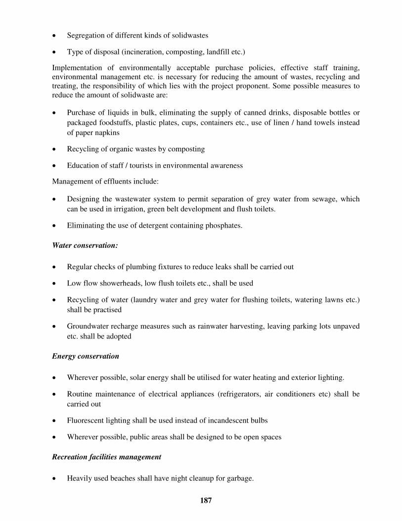
187
� Segregation of different kinds of solidwastes
� Type of disposal (incineration, composting, landfill etc.)
Implementation of environmentally acceptable purchase policies, effective staff training,environmental management etc. is necessary for reducing the amount of wastes, recycling andtreating, the responsibility of which lies with the project proponent. Some possible measures toreduce the amount of solidwaste are:
� Purchase of liquids in bulk, eliminating the supply of canned drinks, disposable bottles orpackaged foodstuffs, plastic plates, cups, containers etc., use of linen / hand towels insteadof paper napkins
� Recycling of organic wastes by composting
� Education of staff / tourists in environmental awareness
Management of effluents include:
� Designing the wastewater system to permit separation of grey water from sewage, whichcan be used in irrigation, green belt development and flush toilets.
� Eliminating the use of detergent containing phosphates.
Water conservation:
� Regular checks of plumbing fixtures to reduce leaks shall be carried out
� Low flow showerheads, low flush toilets etc., shall be used
� Recycling of water (laundry water and grey water for flushing toilets, watering lawns etc.)shall be practised
� Groundwater recharge measures such as rainwater harvesting, leaving parking lots unpavedetc. shall be adopted
Energy conservation
� Wherever possible, solar energy shall be utilised for water heating and exterior lighting.
� Routine maintenance of electrical appliances (refrigerators, air conditioners etc) shall becarried out
� Fluorescent lighting shall be used instead of incandescent bulbs
� Wherever possible, public areas shall be designed to be open spaces
Recreation facilities management
� Heavily used beaches shall have night cleanup for garbage.

188
� Jet skis or other motorised equipment shall not be operated in swimming areas
� Piers and moorings shall be placed with minimal or no obstruction to the coastalhydrodynamics
� Dune vegetation and seagrass shall not be removed from the beach
� Boat maintenance shall be done away from the seashore
72.1 Monitoring and EMP implementation
Monitoring is a tool to identify environmental damage and propose changes when a project is notmeeting the environmental standards. Audits can be used to identify significant wastage of waterand energy at sites with poor environmental practice Regular data collection can identifyenvironmental deterioration and/or improvement.
Implementation of EMP can be done effectively by defining responsibilities for which thefollowing points shall be taken into consideration
� A management representative for e.g., an Environmental Management Cell (EMC) headshall be made responsible for implementing and maintaining the EnvironmentalManagement System (EMS) who shall have clearly defined roles, responsibilities andauthorities.
� An organization structure may be developed for implementing the EMP with responsibilitiesand authorities assigned.
� Job functions that could have an impact on the environment can be identified and jobdescriptions written for each of them
� Operating procedures may be prepared to define specific responsibilities and criticalfunctions of each position in a single paragraph or a small series of bulleted points
� Training can be provided such that each person/operator understands his/her responsibilitiesand the extent of his/her authority, as well as general roles of others.
It must be recognised that it is not be feasible to employ personnel exclusively for EMPimplementation and/or monitoring, or the EMC head cannot be solely responsible for all issuespertaining to environmental management. Environmental responsibilities shall form an integralpart of each personnel’ s job. For this approach to be successful, employees have to understandexactly how their jobs impact the environment. While the EMC head is responsible for overallenvironmental management and quality, key personnel in the implementation of theEnvironmental Management Plans (EMP) are:
160. Managers, engineers’ in-charge of various development activities (site engineer,
estate managers, safety officers etc.);
161. Contractors, machinery / equipment operators or marina, boat operators etc;
162. Operators who maintain and test various sporting equipments and boats;

189
163. Maintenance staff.
For example, the estate manager could do routine monitoring of sporting equipment / boats usinghis judgement. The responsibility of advising the operator in maintaining the equipment shouldform an integral part of the estate manager’ s job. Only in the event of non-compliance or due toreasons beyond the estate manager’ s control will he report to the EMC/management to initiateappropriate action
For effective implementation of the EMP, it is the management’ s direct responsibility tounderstand what resources are necessary for routine operations and special operations and toensure that they are made available.

190
Bibliography
� Ministry of Environment and Forests’ EIA Notification New Delhi, the 27th January 1994(As amended on 04/05/1994, 10/04/1997 and 27/1/2000), CRZ Notification (19th February1991 as amended upto August 2000).
� Indian Environmental Legislations
� ‘Environmental Guidelines for Development of Beaches’ , Ministry of Environment andForests, Govt. of India
� MARPOL (International Convention for the Prevention of Pollution from ships) 73/78,1992 Amendment, International Maritime Organisation
� United Nations Environmental Program (UNEP) EIA Training Resource Manual, byEnvironment Australia (Environmental Protection Group) Canberra, Australia under theguidance and technical support of UNEP International Working Group on EIA (URL:http://www.environment.gov.au/epg/eianet/manual/manual/title.htm) February 1997
� World Bank Technical Paper Number 154, Environmental Assessment Sourcebook, VolumeIII ‘Guidelines for Environmental Assessment of Energy and Industry Projects’ ,Environment Department, The World Bank
� ‘Environmental Assessment’ A guide to procedures, London, HMSO, Dept. of Environment
� ‘Environmental Impact Assessment for Developing Countries in Asia’ , Asian DevelopmentBank
� Environmental Handbook, ‘Documentation on monitoring and evaluating environmentalimpacts’ Volume 1 Introduction, Cross-sectoral Planning, Infrastructure, German FederalMinistry for Economic Cooperation and Development, vieweg
� ‘A Handbook of Environmental Impact Assessment Guidelines’ – 1988 MalaysianGuidelines
� ‘Air Pollution – An Introduction’ , Jeremy Colls, E & FN SPON
� “ Coastal tourism – A manual for sustainable development” , URL:http://www.environment.gov.au/marine/information/reoirts/coastal_tourism/index.html
� “ Coastal tourism in the Wider Caribbean Region: Impacts and Best Management Practices”UNEP CEP Technical Report No. 38 1997, URL:http://www.cep.unep.org/pubs/techreports/tr38en/section1.html
� ‘Dispersion in Estuaries and Coastal Waters’ , Roy Lewis, John Wiley & Sons
� ‘Environmental Impact Analysis Handbook’ , Edited by John G. Rau and David C. Wooten,University of California at Irvine, McGraw-Hill Book Company

191
� “ Establishing the social tourism carrying capacity for the tourist resorts of the east coast ofthe Republic of Cyprus” , Alexis Saveriades, Tourism Management 21 (2000) 147-156,Pergamon
� ‘Handbook of environmental laws, acts, guidelines, compliances and standards’ , Vol 1 & 2R.K. Trivedy
� ‘ISO 14001 EMS Implementation Handbook’ , Hewitt Roberts & Gary Robinson,Butterworth Heinemann
� Lakes environmental software URL: http://www.lakes-environmental.com
� ‘Manual of methods in aquatic environment research’ . Part II: Biological assessment ofmarine pollution with particular reference to benthos. Gray J.S., McIntyre A.D. and StirnJ.FAO Fisheries Technical Paper 324, FAO Rome, 49pp
� ‘Oil spill simulation model’ , Jen-Men Lo, Journal of Waterway, Port, Coastal and OceanEngineering, Vol. 117, 3, May/June 1991.
� “ Pollution prevention/environmental impact reduction checklist for recreation and tourism” ,page 1 to 4, EPA publication
� ‘Perry's Chemical Engineers’ Handbook’ , Robert H. Perry & Don.W. Green, SeventhEdition
� ‘Principles of surface water quality modelling and control’ , Thomann and Mueller
� ‘Surface Water Quality Modelling’ , CE series, Steven C. Chapra, McGraw-Hill
� The ISO 14001 Implementation Guide, ‘ Creating an Integrated Management System’ ,Suzan L. Jackson, John Wiley & Sons, Inc.
� ‘The measurement of diversity in different types of biological collections’ , J. Theor. Biol,13:131-144.
� “ Tourism Management” , David Weaver & Martin Oppermann, Wiley
� “ Tourism and coastal resources degradation in the Wider Caribbean” , A study by ‘IslandResources Foundation, St.Thomas, Virgin Islands, December 1996[http://www.irf.org/irtourdg.html ]
� “ Tourism development trends and their impact on coastal and marine spaces” , Ivor Jackson,Environmental, Land use and tourism planning, Landscape architecture, ‘Regionalconference on managing space for sustainable development in SIDS’ , Port of Spain,Trinidad, October 16-17, 2000
� “ Tourism and sustainable development – The global importance of tourism” , backgroundpaper#1, The World Travel and Tourism Organisation and International Hotel andRestaurant Association.

177
A n n e x u r e A
SAMPLE EIA
&
BASELINE STUDY DESIGN

178
Sample EIA
The extent of baseline study requirement is a function of the project activities. A small-scale touristfacility may consist of a resort; a restaurant etc and use the existing infrastructure at the site. Alarge-scale facility may consist of resorts, cottages, swimming pools, multi-cuisine restaurants,amusement parks etc, which may require additional infrastructure such as DG sets for powergeneration, desalination plant for water supply etc.
A small-scale development requires only a limited amount of pre-project environmental assessment.While most of the data required for the analysis can be obtained as secondary information from themunicipalities, town panchayats, town-planning authorities etc., a few parameters may be requiredto be analysed on-site depending on the project and environmental setting. The baseline studyrequirement is determined from the scoping process.
A sample EIA study for a small scale and a large-scale facility is described in the following sectionsto give a brief insight into the process.

179
SAMPLE EIA FOR LARGE SCALE BEACH RESORT
Table A-1 Baseline Study Design
Proposed facility Project setting Environmental setting Resource requirement/ waste generation
Parameter to be assessed
200 cum of water / day
3500 kW / day
40 double bedroom,8 single bedroom,Swimming pool,Parking facility,Landscaping,Internal accessroads, Multi-cuisinerestaurant, 20 singlebedroom staffquarters foremployees
Existing infrastructuresuch as roads, watersupply, wastewater andsolid waste collectionsystem etc.
Terrain, coastal features,vegetation, sand dunes,d rainage pattern, slopes,land use, land cover etc.
Sources of water supp ly /quality.
Solidwaste d isposal sitesin the locality
200 cum of wastewater
20 tons of solidwaste
Quantity/ quality (pH, DO, Suspended solids,TDS, Chlorides, Sulphates, Calcium,magnesium, iron, fecal coliforms)
Soil type, permeability
Specific fauna / vegetation
Visual inspection for land use pattern,secondary data from revenue department,municipality, Town panchayat, Town planningauthority
DG sets Two numbers (onestandby) of capacities750 KVA;
Available power fromSEB_________
Sources of air pollutionand noise generation.
Present air quality &noise level status(comparison withNAAQS)
Peak d iesel consumption160litres/ hour
Air Quality (SPM, SO2, NOx, HC)
Noise sensitive receptors, noise levels
Temperature, wind speed , predominant w inddirection, monsoon & seasons
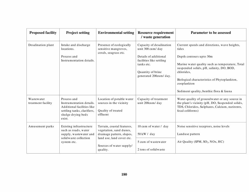
180
Proposed facility Project setting Environmental setting Resource requirement/ waste generation
Parameter to be assessed
Desalination plant Intake and d ischargelocations.
Process andInstrumentation details.
Presence of ecologicallysensitive mangroves,corals, seagrass etc.
Capacity of desalinationunit 300 cum/ day
Details of add itionalfacilities like settlingtanks etc.
Quantity of brinegenerated 200cum/ day.
Current speeds and d irections, wave heights,tides
Depth contours up to 30m
Marine water quality such as temperature, Totalsuspended solid s, pH, salinity, DO, BOD,chlorides,
Biological characteristics of Phytoplankton,zooplankton
Sediment quality,:benthic flora & fauna
Wastewatertreatment facility
Process andInstrumentation details.Additional facilities likesettling tanks, clarifiers,sludge d rying bedsexist.
Location of potable watersources in the vicinity
Quality of treatedeffluent
Capacity of treatmentunit 200cum/ day
Water quality of groundwater or any source inthe plant’ s vicinity (pH, DO, Suspended solid s,TDS, Chlorides, Sulphates, Calcium, nu tirents,fecal coliforms)
10 cum of water / day
50 kW / day
Amusement parks Existing infrastructuresuch as roads, watersupply, wastewater andsolid waste collectionsystem etc.
Terrain, coastal features,vegetation, sand dunes,d rainage pattern, slopes,land use, land cover etc.
Sources of water supp ly/quality.
5 cum of wastewater
2 tons of solid waste
Noise sensitive receptors, noise levels
Landuse pattern
Air Quality (SPM, SO2, NOx, HC)
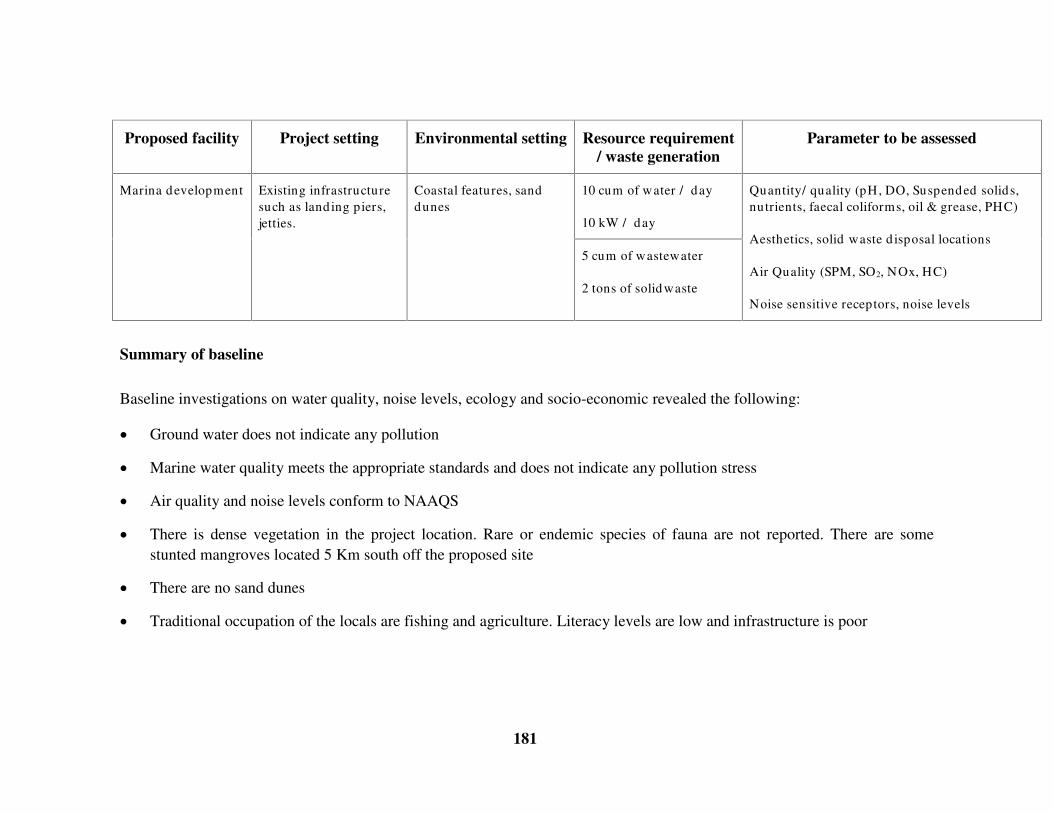
181
Proposed facility Project setting Environmental setting Resource requirement/ waste generation
Parameter to be assessed
10 cum of water / day
10 kW / day
Marina development Existing infrastructuresuch as land ing piers,jetties.
Coastal features, sanddunes
5 cum of wastewater
2 tons of solid waste
Quantity/ quality (pH, DO, Suspended solids,nutrients, faecal coliforms, oil & grease, PHC)
Aesthetics, solid waste d isposal locations
Air Quality (SPM, SO2, NOx, HC)
Noise sensitive receptors, noise levels
Summary of baseline
Baseline investigations on water quality, noise levels, ecology and socio-economic revealed the following:
� Ground water does not indicate any pollution
� Marine water quality meets the appropriate standards and does not indicate any pollution stress
� Air quality and noise levels conform to NAAQS
� There is dense vegetation in the project location. Rare or endemic species of fauna are not reported. There are somestunted mangroves located 5 Km south off the proposed site
� There are no sand dunes
� Traditional occupation of the locals are fishing and agriculture. Literacy levels are low and infrastructure is poor

182
Summary of prediction
� Construction phase impacts on air quality shall be negligible and limited to the project vicinity
� Local labour shall be used for construction so that there shall be no water demand or sanitation problems.
� Pier construction for marina development shall be done on piles and therefore there shall be no change to hydrodynamics.Boat repairs shall be carried out in designated areas and the aesthetics shall be maintained
� Water is obtained from municipal water supply. There shall be no groundwater withdrawal and therefore groundwater willnot be affected. Additional water requirements shall be met from desalination plant. Modeling of the dishcarge of brinewater indicates that the concentrations of brine shall return to background levels within 500 m of the discharge location.
� Feedwater for desalination plants shall be obtained from infiltration well to eliminate chemical pretreatment
� Desalination shall use Reverse Osmosis process which is considered to be energy efficient. Sludge, coagulants etc., fromdesalination plant shall not be disposed in coastal waters but transferred to a landfill site identified
� Wastewater treatment facility shall be designed for handling peak discharges. There shall be routine maintenance of thetreatment facilities. Treated water shall be used for green belt development..
� Air quality modeling for DG set operation was carried out using Guassian dispersion models. The air quality issuesassociated with the facility operation would be negligible and within standards during wind speeds of 4m/s.. However, DGsets shall not be operated during periods of inversion or when wind speeds drop below 2m/s..
� The additional number of vehicles due to the facility shall be about 50 cars and 5-10 heavy vehicles/day. This will have alimited impact on the local traffic system and create congestion during peak seasons. Modeling of air quality and noiselevels using Guassian models indicate that the pollution associated with the additional numbers of vehicles shall beincremental over the existing levels and conform to NAAQS

183
� There is no dredging or dumping. Also the discharge from desalination plant reaches background levels within 500m andtherefore there shall not be any impact on stunted mangroves located 5 Km away.
� Solidwaste shall be segregated. Organic wastes shall be composted and others shall be incinerated.
Environmental Management Practice
� Twice the number of vegetative cover removed shall be planted before the commencement of construction
� Parking lots shall not be paved. Rainwater harvesting shall be done from rooftops and gently graded open areas.
� Liquids shall be procured in bulk. Canned items shall not be procured
� Plastic disposable cups / bottles shall not be used
� Locals shall be employed for jobs like gardening, cleaning etc.
Conclusions
� The project generates negligible pollution during construction phase from transportation of raw materials
� There shall be temporary employment for the locals during construction phase
� The facility requires an efficient environmental management system for regular monitoring of the wastewater treatmentplant and DG set operation and shall cause an incremental impact on the existing environment which is within acceptablelimits.

184
SAMPLE EIA FOR SMALL SCALE BEACH RESORT
Table A-2 Baseline Study Design
Proposed facility Project setting Environmental setting Resource requirement /waste generation
Parameter to be assessed
50 cum of water / day
500 kW / day
20 double bedroomresort, Swimmingpool, Parkingfacility,Landscaping,Multi-cuisinerestaurant
Existing infrastructuresuch as roads, watersupply, wastewaterand solid wastecollection system etc.
Terrain, coastal features,vegetation, sand dunes,d rainage pattern, slopes,land use, land cover etc.
Sources of water supp ly /quality,
Solidwaste d isposal sitesin the locality
30 cum of wastewater
4 tons of solid waste
Quantity/ quality (pH, DO, Suspended solids,TDS, Chlorides, Sulphates, Calcium,magnesium, iron, fecal coliforms)
Specific fauna / vegetation
Visual inspection for land use pattern,secondary data from revenue department,municipality, Town panchayat, Town planningauthority
Wastewatertreatment facility
Process andInstrumentationdetails
Location of potable watersources in the vicinity
Quality of treated effluent
Septic tank capacity 500cum
Water quality of groundwater or any source inthe plant’ s vicinity (pH, DO, Suspended solid s,TDS, Chlorides, Sulphates, Calcium, nu tirents,fecal coliforms)
2 cum of water / day
5 kW / day
Beach access Umbrellas, lifeguard ,refreshment kiosks.
Terrain, coastal features,vegetation, sand dunes
0.5 cum of wastewater
500 kg of solidwaste
Noise sensitive receptors, noise levels.
Sand dunes

185
Summary of baseline
Baseline investigations on water quality, noise levels, ecology and socio-economic revealed the following:
� Ground water does not indicate any pollution
� Noise levels conform to NAAQS
� There is dense vegetation in the project location, but rare or endemic species.of flora or fauna are not reported
� There are no sand dunes
� Traditional occupation of the locals are fishing and agriculture. Literacy levels are low and infrastructure is poor
Summary of prediction
� Contruction phase impacts on air quality shall be negligible and limited to the project vicinity
� Local labour shall be used for construction so that there shall be no water demand or sanitation problems
� Water is obtained from municipal water supply. There shall be no groundwater withdrawal and therefore groundwater willnot be affected.
� Wastewater from bathrooms and kitchen shall be collected separately and used for gardening purposes and grit removal.Decanted water from septic tank shall be used for green belt development after disinfection.
� There are no air quality problems associated with the facility operation. No air pollution from DG sets or other sources inthe vicinity. The additional number of vehicles due to the facility shall be about 20 cars and 2-3 heavy vehicles/day, whichshall have negligible impacts on air and noise quality
� Solidwaste shall be segregated. Organic wastes shall be composted and others shall be incinerated.

186
Environmental Management Practice
� Twice the number of vegetative cover removed shall be planted before the commencement of construction
� Parking lots shall not be paved. Rainwater harvesting shall be done from rooftops and gently graded open areas.
� Liquids shall be procured in bulk. Canned items shall not be procured
� Plastic disposable cups / bottles shall not be used
� Locals shall be employed for jobs like gardening, cleaning etc. Staff shall be provided accommodation in the nearbyvillages.
Conclusions
� The project generates negligible pollution during construction phase from transportation of raw materials
� There shall be temporary employment for the locals during construction phase
� The proposed facility shall not have any significant impact on the environment
�