environmental assessment paonia dam intake structure … · environmental assessment . paonia dam...
TRANSCRIPT
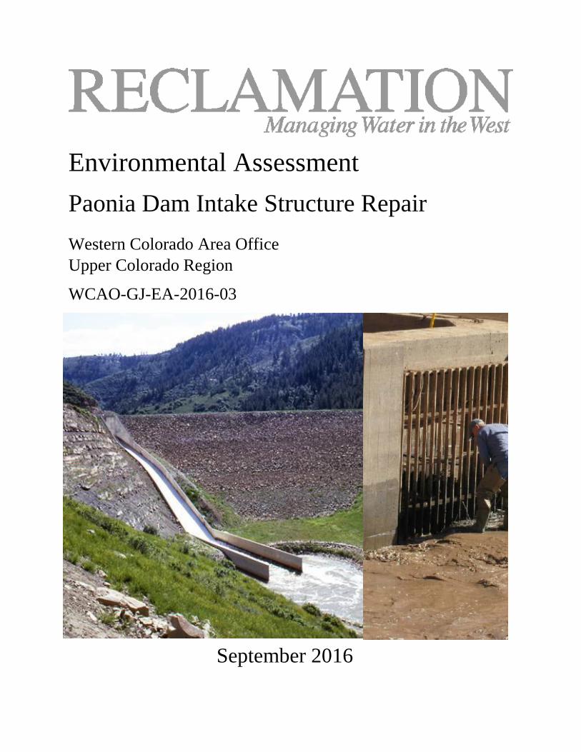
Environmental Assessment Paonia Dam Intake Structure Repair Western Colorado Area Office
Upper Colorado Region
WCAO-GJ-EA-2016-03
September 2016

ii | Page
Mission Statements The mission of the Department of the Interior is to protect and manage the Nation’s natural resources and cultural heritage; provide scientific and other information about those resources; and honor its trust responsibilities or special commitments to American Indians, Alaska Natives, and affiliated island communities.
The mission of the Bureau of Reclamation is to manage, develop, and protect water and related resources in an environmentally and economically sound manner in the interest of the American public.

iii | Page

iv | Page
Introduction
In compliance with the National Environmental Policy Act of 1969, as amended (NEPA), the Bureau of Reclamation (Reclamation) has conducted an environmental assessment (EA) for a proposed action of authorizing the use of Federal funds to repair and stabilize the intake structure at Paonia Dam. Reclamation is providing partial funding for the project, which is located on a federal facility, and is therefore the lead agency for the purposes of compliance with the NEPA for this proposed action.
The EA was prepared by Reclamation to address the potential impacts to the human environment due to implementation of the proposed action.
Alternatives
The EA analyzed the No Action Alternative and the Proposed Action Alternative to authorize and partially fund the repair of the Paonia Dam intake structure.
Decision and Finding of No Significant Impact
Based upon a review of the EA and supporting documents, Reclamation has determined that implementing the proposed action will not significantly affect the quality of the human environment, individually or cumulatively with other actions in the area. No environmental effects meet the definition of significance in context or intensity as defined at 40 CFR 1508.27. Therefore, an environmental impact statement is not required for this proposed action. This finding is based on consideration of the context and intensity as summarized in the EA. Reclamation’s decision is to implement the Proposed Action Alternative.
Context
The affected locality is within Paonia Reservoir and downstream in Muddy Creek and the North Fork Gunnison River. Paonia Reservoir is located in Gunnison County, Colorado. Affected interests include Reclamation, the Fire Mountain Canal and Reservoir Company, the North Fork Water Conservancy District, shareholders, adjacent landowners, and recreationists. The project does not have national, regional, or state-wide importance.
Intensity
The following discussion is organized around the 10 significance criteria described in 40 CFR 1508.27. These criteria were incorporated into the resource analysis and issues concerned in the EA.
1. Impacts may be both beneficial and adverse. The proposed action would impact resources as described in the EA. Mitigating measures were incorporated into the design of the action alternatives to reduce impacts. The predicted short-term effects of the proposed action include impacts to water quality, fish and wildlife resources, and recreation due to an expected increase in turbidity and sedimentation within the North

v | Page
Fork Gunnison River during construction and throughout the winter until spring flows flush the sediment downstream. The only predicted long-term effect is an adverse effect to the intake structure as a cultural resource eligible for listing in the National Register of Historic Places (NRHP). This long term effect is being mitigated by the preparation of archival documentation on the intake structure. Beneficial effects include repair of the dam’s intake structure, which will help ensure the use of the dam’s outlet works and delivery of project water downstream.
None of the environmental effects discussed in detail in the EA are considered significant. None of the effects from the proposed action, together with other past, current, and reasonably foreseeable actions, rise to a significant cumulative impact.
2. The degree to which the selected alternative will affect public health or safety or a minority or low-income population. The proposal will have no significant impacts on public health or safety. No minority or low income populations would be disproportionately affected by the proposed action.
3. Unique characteristics of the geographic area. There are no park lands, prime farmlands, wetlands, wild and scenic rivers, or ecologically critical areas that would be negatively affected by the proposal.
4. The degree to which the effects on the quality of the human environment are likely to be highly controversial. Reclamation contacted representatives of other federal agencies, state and local governments, public and private organizations, and individuals regarding the proposal and its effects on resources. Based on the responses received, the effects of the proposal on the quality of the human environment are not highly controversial.
5. The degree to which the possible effects on the human environment are highly uncertain or involve unique or unknown risks. There are no predicted effects on the human environment that are considered highly uncertain or that involve unique or unknown risks.
6. The degree to which the action may establish a precedent for future actions with significant effects or represents a decision in principle about a future consideration. Implementing the action will not establish a precedent for future actions with significant effects and will not represent a decision in principle about a future consideration.
7. Whether the action is related to other actions which are individually insignificant but cumulatively significant. Cumulative impacts are possible when the effects of the proposed action are added to other past, present, and reasonable foreseeable future actions as described under related NEPA documents above; however, significant cumulative effects are not predicted, as described in the EA.
8. The degree to which the action may adversely affect sites, districts, buildings, structures, and objects listed in or eligible for listing in the National Register of

vi | Page
Historic Places. The State Historic Preservation Officer has concurred with a determination of adverse effect to the intake structure, which is a component of the eligible Paonia Dam. Reclamation has entered into a Memorandum of Agreement with the State Historic Preservation Officer and the North Fork Water Conservancy District to mitigate the impacts to the intake structure.
9. The degree to which the action may adversely affect an endangered or threatened species of its habitat that has been determined to be critical under the Endangered Species Act of 1973. There are no Threatened or Endangered Species or critical habitat that will be directly or indirectly affected by the proposed action. Therefore, a no effect determination was made.
10. Whether the action threatens a violation of Federal, state, local, or tribal law, regulation or policy imposed for the protection of the environment. The project does not violate any federal, state, local, or tribal law, regulation, or policy imposed for the protection of the environment. In addition, this project is consistent with applicable land management plans, policies, and programs. State, local, and interested publics were given the opportunity to participate in the environmental analysis process.
Environmental Commitments
The following environmental commitments will be implemented as an integral part of the Proposed Action:
● Existing roads will be used to access the construction and staging areas. The long-reach excavator will access the construction area along the rock/sediment interface of the reservoir. No new roads will be constructed.
● All construction equipment will be power-washed and free of soil and debris prior to entering the project site to reduce the spread of noxious and invasive weeds.
● To help minimize noise impacts near the construction area, construction activities will occur during the daylight hours.
● Concrete removed from the bulkhead will be taken to an existing landfill for disposal. ● The public will be notified of construction dates prior to construction via press releases to
local newspapers and informative flyers posted in the Towns of Hotchkiss and Paonia. ● Stipulations in the Memorandum of Agreement with the SHPO are incorporated by
reference. ● Terms and conditions contained in the CWA Section 404 permit are incorporated by
reference. ● If previously undiscovered cultural or paleontological resources are discovered during
construction, construction activities must immediately cease in the vicinity of the discovery and Reclamation must be notified. The SHPO will be consulted, and work will not be resumed until consultation has been completed, as outlined in the Unanticipated Discovery Plan in the attached MOA.

vii | Page
● In the event that threatened or endangered species are discovered during construction, construction activities will halt until consultation is completed with the U.S. Fish and Wildlife Service and protection measures are implemented.
● In order to mobilize and disperse any sediment deposited in Muddy Creek and North Fork Gunnison River downstream of the dam during the proposed repair work, high flows will be released from the dam as soon as practicable during spring runoff, in the April through June timeframe.

viii | Page
Table of Contents
CHAPTER 1 – INTRODUCTION ................................................................................................. 1
1.1 – Project Location and Legal Description ............................................................................ 1
1.2 – Need for and Purpose of the Proposed Action ................................................................... 1
1.3 – Decision to be Made .......................................................................................................... 3
1.4 – Background ........................................................................................................................ 3
1.4.1 – Paonia Project ............................................................................................................. 3
1.4.2 – Sedimentation ............................................................................................................. 4
1.5 – Relationship to Other Projects ........................................................................................... 5
1.5.1 – Paonia Modification Alternatives Study ..................................................................... 5
1.6 – Public Scoping ................................................................................................................... 6
CHAPTER 2 – PROPOSED ACTION AND ALTERNATIVES .................................................. 6
2.1 – No Action Alternative ........................................................................................................ 6
2.2 – Proposed Action ................................................................................................................. 6
2.2.1 – Construction Procedures ............................................................................................. 7
2.2.1.1 – Reservoir Drawdown ........................................................................................... 7
2.2.1.2 – Equipment ............................................................................................................ 8
2.2.1.3 – Access .................................................................................................................. 8
2.2.1.4 – Staging Areas ....................................................................................................... 9
2.2.1.5 – Construction Sequence......................................................................................... 9
2.2.1.6 – Construction Timeframe ...................................................................................... 9
2.3 – Permits and Authorizations ................................................................................................ 9
2.3.1 – Natural Resource Protection Laws....................................................................... 10
2.3.2 – Cultural Resource Laws ....................................................................................... 10
2.3.3 – Paleontological Resource Laws ................................................................................ 10
CHAPTER 3 – AFFECTED ENVIRONMENT & ENVIRONMENTAL CONSEQUENCES .. 10
3.1 - Introduction ...................................................................................................................... 10
3.2 – Resources Eliminated from Further Analysis .................................................................. 11
3.3 – Affected Environment and Environmental Consequences .............................................. 12
3.3.1 – Water Resources ....................................................................................................... 12
3.3.1.1 – Surface Water..................................................................................................... 12

ix | Page
3.3.1.2 – Drinking Water .................................................................................................. 14
3.3.2 –Water Quality ............................................................................................................. 14
3.3.3 – Air Quality ................................................................................................................ 18
3.3.4 – Wetland and Riparian Resources .............................................................................. 18
3.3.5 – Upland Vegetation .................................................................................................... 19
3.3.6 – Fish and Wildlife Resources ..................................................................................... 19
3.3.6.1 – Terrestrial Wildlife ............................................................................................. 19
3.3.6.2 – Aquatic Wildlife ................................................................................................. 20
3.3.7 – Special Status Species ............................................................................................... 23
3.3.7.1 – Threatened and Endangered Species ................................................................. 23
3.3.7.2 – Migratory Birds .................................................................................................. 25
3.3.8 – Recreation ................................................................................................................. 26
3.3.9 –Social, Economic, Environmental Justice .................................................................. 27
3.3.10 – Public Safety, Access, and Transportation ............................................................. 28
3.3.11 – Cultural Resources .................................................................................................. 28
3.3.12 – Indian Trust Assets and American Indian Sacred Sites .......................................... 29
3.4 – Cumulative Impacts ......................................................................................................... 30
3.5 – Summary .......................................................................................................................... 30
CHAPTER 4 – ENVIRONMENTAL COMMITMENTS ............................................................ 33
CHAPTER 5 – CONSULTATION AND COORDINATION ..................................................... 34
5.1 – Introduction ...................................................................................................................... 34
5.2 – Public Involvement .......................................................................................................... 34
5.3 – Colorado State Historic Preservation Office.................................................................... 35
5.4 – U.S. Army Corps of Engineers ........................................................................................ 36
5.5 – Colorado Parks and Wildlife ............................................................................................ 36
CHAPTER 6 – PREPARERS ....................................................................................................... 36
CHAPTER 7 – REFERENCES .................................................................................................... 37
CHAPTER 8 – ABBREVIATIONS AND ACRONYMS ............................................................ 41

x | Page
Figures
1 - Map of Paonia Dam intake location. ...............................................................................xi
2 - Diagram of the intake structure. ......................................................................................2
3 - Photograph of damage to the intake bulkhead. ................................................................3
4 - Photograph of Paonia Reservoir sediment in October 2014. ...........................................5
5 - Diagram of repair work. ..................................................................................................7
6 - Existing access routes and project staging area. ..............................................................8
7 - Map of lands receiving irrigation water from Paonia Reservoir. ....................................13
8 - Hydrograph of Paonia Dam releases with and without a functioning outlet. ..................13
9 - Map of major stream segments which influence or are influenced by the project. .........16
Tables
1 - Resources eliminated from further analysis. ...................................................................11
2 - Major stream segments which influence or are influenced by the project. .....................15
3 - Use classification categories for identified stream segments. ........................................15
4 - Federally-listed species occurring in or near the proposed action area. ..........................23
5 - Summary of impacts for the No Action and the Proposed Action Alternatives. .............31
Appendices
A - Memorandum of Agreement. ..........................................................................................43

xi | Page
Figure 1. Location of Paonia Dam Intake Structure
Town of Paonia is approximately 16.5 miles southwest.
1 | P a g e
CHAPTER 1 – INTRODUCTION
This Environmental Assessment (EA) has been prepared to disclose and evaluate the potential environmental effects of the Bureau of Reclamation’s (Reclamation) proposed Paonia Dam Intake Structure Repair Project (“Project” or “Proposed Action”). The Federal action evaluated in this EA is whether to authorize and provide partial funding to the North Fork Water Conservancy District (NFWCD) to make repairs to the intake structure at the Paonia Dam. This document has been prepared in compliance with the National Environmental Policy Act (NEPA), the Council on Environmental Quality (CEQ), and the U.S. Department of Interior’s (Interior) NEPA implementing regulations. If potentially significant impacts to environmental resources are identified, an Environmental Impact Statement (EIS) will be prepared. If no significant impacts are identified, a Finding of No Significant Impact (FONSI) will be issued.
1.1 – Project Location and Legal Description The project is located at Paonia Dam and Reservoir, approximately 16 miles northeast of Paonia, within Sections 8 and 9, Township 13 South, Range 89 West, Sixth Principal Meridian, Gunnison County, Colorado. Paonia Reservoir is located on Muddy Creek, upstream of its confluence with Anthracite Creek. The two creeks together form the North Fork Gunnison River (see Figure 1).
1.2 – Need for and Purpose of the Proposed Action The proposed action is to dismantle the damaged upper concrete portions of the intake structure and replace it with modified aluminum support members and a trash rack (Figure 2). The Paonia Dam outlet works intake structure has sustained significant damage and the concrete bulkhead cannot currently function for its designed purpose. When functioning properly, the concrete bulkhead can be closed to prevent flows from entering the outlet works conduit in order to allow for repair and maintenance of the outlet gate or conduit upstream of the gates. The need for the proposed action is to maintain the functionality of the Paonia Dam outlet works so that dam operations are not compromised. The purpose of the proposed action is to make repairs to the concrete bulkhead and trash rack in order to temporarily stabilize the intake structure until a long-term solution is developed and can be implemented. The proposed repairs would not restore full functionality to the intake structure bulkhead because they would not enable the bulkhead to close and prevent water from flowing into the outlet conduit.

2 | Page
Figure 2. Diagram of the intake structure.
Under certain conditions, air can become entrained in the water as it moves down the intake structure. Pockets of air can then develop and, if they become large enough, the water and air pocket travel upstream and out of the intake structure, imparting an explosive force on the intake structure. These blowback events have damaged the concrete bulkhead of the intake structure (Figure 3). In recent years, Reclamation, in joint effort with the water users, has developed a procedure to drawdown the reservoir with minimal blowback to the intake structure. However, it is necessary to remove the damaged concrete bulkhead and repair the trash rack to keep the intake structure operable.

3 | Page
Figure 3. Photograph of some of the damage to the Paonia Dam intake structure bulkhead. Yellow arrows show exposed rebar.
1.3 – Decision to be Made Reclamation must decide whether to authorize and provide partial funding to the NFWCD to make temporary repairs to the outlet works intake structure at Paonia Dam.
1.4 – Background 1.4.1 – Paonia Project
Development of the Paonia Project was authorized in 1956 as a participating project with the Colorado River Storage Project. Construction of Paonia Dam was completed in January 1962. Operation and maintenance of the Paonia Project was assumed by the NFWCD in June 1962. By contract, NFWCD transferred the physical operation and maintenance of the project to the Fire Mountain Canal and Reservoir Company (FMCRC).
Paonia Dam and Reservoir provide irrigation water to approximately 15,300 acres of land in the vicinity of Paonia and Hotchkiss. In addition, the reservoir provides recreational and flood control benefits. The outlet works on the right abutment of the dam consists of a concrete intake tower, concrete-lined tunnel, gate chamber near the dam axis, and a combination stilling basin for both the outlet works and spillway.
Construction of the Paonia Project included enlargement and extension of the Fire Mountain Canal. The Fire Mountain Diversion Dam, located on the North Fork Gunnison River near the Town of Somerset, diverts flows from the river for delivery to project lands in the Fire Mountain Division. The Fire Mountain Canal extends 34.7 miles along the north side of the valley. This

4 | Page
water is used by the FMCRC and the Leroux Creek Water Users Association for irrigation purposes. (Reclamation, 2009 and 2011.)
The outlet works of Paonia Dam pass through the bedrock which forms the right abutment of the dam. It consists of a trashracked intake tower, a pressurized 11-foot-diameter concrete lined upstream tunnel, a gate chamber with two pairs of 2-foot 9-inch by 2-foot 9-inch hydraulic controlled slide gates (two upstream emergency gates and two downstream regulating gates), and a 10-foot 6-inch by 10-foot 6-inch horseshoe-shaped discharge tunnel. The discharge tunnel empties through the spillway chute into a common stilling basin.
1.4.2 – Sedimentation
When construction of the Paonia Dam was completed in 1962, the reservoir had an active storage capacity of 18,150 acre-feet (AF). Since that time sediment from Muddy Creek, which flows into Paonia Reservoir, has accumulated within the reservoir basin and reduced the water storage capacity of the reservoir to approximately 15,600 AF. In addition, most of the 70-foot high concrete intake tower is buried in the accumulated sediment, leaving only about the top 6 feet exposed. Sediment accumulation within the reservoir is affecting the intake and outlet structures and adversely impacting operations.
Although occasional sediment flushing was performed as early as 1997, beginning in 2011 Paonia Reservoir has been drawn down in late fall for inspection of the outlet works, and again in early spring for sediment flushing prior to the irrigation season. In October 2014, reservoir drawdown revealed that a sediment delta front, which had been located in the reservoir approximately 1,250 feet upstream of the intake structure, had quickly moved towards the dam, completely filling the reservoir’s dead pool and raising the lake bottom six feet above the sill of the intake structure (Figure 4). The combination of the reservoir drawdown and removing sediment away from the intake structure resulted in the unanticipated release of approximately 137,000 cubic yards (CY) of sediment into Muddy Creek and the North Fork Gunnison River downstream of Paonia Dam (Reclamation 2015, Reclamation 2016). The released sediment filled the dam’s 30-foot deep stilling basin, and approximately 200 yards of the Muddy Creek streambed downstream of the dam was buried under about 6 to 7 feet of sediment. Reports from the public of high turbidity in the North Fork Gunnison River were received as far downstream as Hotchkiss, Colorado. After high flow releases in the spring of 2015, the sediment deposits were dispersed and no longer observed downstream in Muddy Creek or North Fork Gunnison River.
Reclamation’s Technical Service Center (TSC) in Denver, Colorado, has been conducting bathymetric surveys and sediment sampling at Paonia Reservoir in an effort to understand potential effects of sedimentation at Paonia Reservoir. In June 2016, a bathymetric survey was conducted, and results from that survey show a cone of depression in the sediment around the intake structure. TSC used its One Dimension (SRH-1D) Model to simulate the transport of incoming and outgoing sediment through Paonia Reservoir when the reservoir is completely drained and free flow conditions are occurring during the proposed intake repairs in fall. The

5 | Page
2016 model simulations give a sediment erosion volume of approximately 45,100 CY over a two month period during drawdown and repairs. Comparing the anticipated conditions to the fall 2014 intake clearing effort, the estimated amount of sediment released downstream would most likely be less than what occurred in 2014, assuming the presence of a cone of depression around the intake structure and a low-flow channel through the reservoir basin. However, there is the potential that sediment releases could range as high as 137,000 CY (Reclamation 2016).
Figure 4. Paonia Reservoir in October 2014, prior to excavation work. The intake structure (black arrow) is nearly buried in sediment, and sediment has filled the reservoir’s dead pool.
1.5 – Relationship to Other Projects 1.5.1 – Paonia Modification Alternatives Study
The Sedimentation and River Hydraulics Group of Reclamation’s TSC in Denver, Colorado, is leading an effort to study the past and current sediment issues at Paonia Dam and Reservoir, evaluate feasible sediment management alternatives, and formulate a plan for future operations and monitoring. The objectives of the study are to rehabilitate the outlet works of the dam; maintain water supply for users; maintain the current reservoir storage; manage debris and abrasion issues; and minimize downstream impacts. Reclamation expects to start the NEPA process on the alternatives study to gather ideas and public input on the Paonia Dam modification alternatives during winter 2016 or during 2017.

6 | Page
1.6 – Public Scoping Scoping for this EA was completed by Reclamation, in consultation with the following agencies and organizations, during the planning stages of the proposed action to identify the potential environmental and human environment issues and concerns associated with implementation of the Proposed Action and No Action Alternatives:
● North Fork Water Conservancy District, Hotchkiss, CO ● Fire Mountain Canal and Reservoir Company, Hotchkiss, CO ● Colorado Department of Public Health and Environment, Denver, CO ● Colorado River Water Conservation District, Glenwood Springs, CO ● Colorado Office of Archaeology and Historic Preservation, Denver, CO ● Colorado Parks & Wildlife, Montrose, CO ● U.S. Geological Survey, Grand Junction, CO ● U.S. Army Corps of Engineers, Colorado West Regulatory Branch, Grand Junction, CO ● U.S. Fish & Wildlife Service, Ecological Services, Grand Junction, CO
CHAPTER 2 – PROPOSED ACTION AND ALTERNATIVES
Alternatives evaluated in this EA include the No Action Alternative and the Proposed Action Alternative.
2.1 – No Action Alternative Under the No Action Alternative, repair of the damaged bulkhead of the intake tower would not be completed. The concrete bulkhead is located internal to the frame of the intake structure and is severely damaged. There is a substantial risk that a piece of concrete or the entire bulkhead could collapse and cause further damage to the outlet works, potentially plugging the outlet and rendering it inoperable. If the outlet works become inoperable, the only other means of releasing water from the reservoir currently in place would be uncontrolled releases over the spillway.
2.2 – Proposed Action Under the proposed action, Reclamation would authorize the intake repair and the use of Federal funds to stabilize the intake structure at Paonia Dam. The damaged upper concrete portions of the intake would be dismantled and replaced with a modified aluminum trash rack and support members (Figure 5). Removed concrete pieces will be taken to a landfill for disposal. The action is expected to maintain the function of the outlet works to deliver water from the reservoir to downstream water users.

7 | Page
The reservoir would be drawn down prior to construction. Repair activities are currently scheduled to be performed in October through November, during the non-irrigation season, but before freezing conditions.
In order to mobilize and disperse any sediment deposited in Muddy Creek and North Fork Gunnison River downstream of the dam during the proposed repair work, high flows would be released from the dam as soon as practicable during spring runoff, in the April through June timeframe.
Figure 5. The bulkhead (shown in grey at top) is damaged and must be removed. Aluminum bars will be placed through the intake structure to support platforms to enable workers to remove the bulkhead as well as to prevent materials from falling into the intake structure during removal. After removal is complete, the aluminum bars will be attached to the top of the intake structure to act as a trash rack during reservoir operation.
2.2.1 – Construction Procedures
2.2.1.1 – Reservoir Drawdown
Reservoir drawdown would begin in about mid-September, after irrigation season. To avoid blowback through the intake structure during drawdown of the reservoir, outlet releases would be made slowly, staying below 200 cubic feet per second (cfs). When the water level reaches the top of the trash rack of the intake, releases would be limited to 30 cfs to prevent conditions that could result in blowback and further damage to the intake structure. During construction, the entire natural reservoir inflow would need to be passed through the outlet works. Based on

8 | Page
Colorado Division of Water Resources gage data from the last 10 years, the average inflow from Muddy Creek into the reservoir during the construction timeframe (October and November) is expected to be approximately 29 cfs (CDWR 2016).
2.2.1.2 – Equipment
Construction equipment would include a 65-foot long reach excavator, mini-excavator, tracked skid loader, UTV, and an air compressor.
2.2.1.3 – Access
Access for all construction equipment and personnel would be from existing roads and disturbed areas. No new roads would be constructed. The project area would be accessed from County Road 12 and onto the existing two-track access road downstream of the left abutment of the dam, down the upstream left groin, and then across the upstream toe of the dam. (Figure 6.) No heavy equipment would travel on the reservoir sediment deposits.

9 | Page
Figure 6. Existing access routes and project staging area.
2.2.1.4 – Staging Areas
Staging areas for equipment and materials would be located in disturbed areas adjacent to the work areas, as depicted in Figure 6.
2.2.1.5 – Construction Sequence
● After the reservoir is drawn down, minor grading along the reservoir shoreline would be completed if needed to create a working platform for the excavator. A long-reach excavator would be used, in combination with manual labor, to remove sediment and debris from around the intake structure and to support removal of concrete from the bulkhead.
● The intake structure would be cleared of sediment or debris, if any, built up on the structure as a result of draining the reservoir. The excavated sediment and debris will be discharged within the work area adjacent to the intake structure.
● Temporary working and support platforms will be constructed manually on the intake structure to enable manual labor and prevent broken pieces of concrete from falling into the intake structure.
● The concrete bulkhead will be broken up and/or cut into small sections and removed. Removing small sections at a time will help to prevent overloading of the support platform and allow the broken pieces of concrete to be handled manually. The long-reach excavator will be used as necessary for support of this work.
● The support platform aluminum members will then be removed and reinstalled to act as a trashrack over the top opening and bracing for the damaged concrete at the top of the structure.
● The working platform will be disassembled and removed.
● Removed concrete pieces will be taken to a landfill for disposal.
2.2.1.6 – Construction Timeframe
Construction would be completed during the non-irrigation season after the reservoir is drawn down and before the reservoir freezes, and is anticipated to be carried out in October through November. High flow releases from the dam would be made during spring runoff in the April through June timeframe.
2.3 – Permits and Authorizations If the proposed action is approved, the following permit would be required prior to project implementation:

10 | Page
● Section 404 Clean Water Act, Nationwide Permit No. 3 - Maintenance Activities
Compliance with the following laws and Executive Orders (E.O.) are also required prior to and during project implementation:
2.3.1 – Natural Resource Protection Laws
● Endangered Species Act (ESA) of 1973 as amended (16 U.S.C. 1531-1544, 87 Stat. 884) ● Clean Water Act (CWA) of 1972 as amended (33 U.S.C. 1251 et seq.) ● Migratory Bird Treaty Act (MBTA) of 1918 (16 U.S.C. 703-712) ● Bald and Golden Eagle Protection Act (BGEPA) of 1940 (16 U.S.C. 668- 668c)
2.3.2 – Cultural Resource Laws
● National Historic Preservation Act (NHPA) of 1966 (16 U.S.C. 470 et seq.) ● Archaeological Resources Protection Act (ARPA) of 1979 (16 U.S.C. 470aa-
470mm et seq.) ● Native American Graves Protection and Repatriation Act (NAGPRA) of 1990 (25
U.S.C. 3001 et seq.) ● Archaeology and Historic Preservation: Secretary of the Interior’s
Standards and Guidelines (48 FR 44716) ● American Indian Religious Freedom Act (AIRF) of 1978 (42 U.S.C. Public
Law 95-341)
2.3.3 – Paleontological Resource Laws ● Paleontological Resources Preservation Act (PRPA) of 2009 [Section 6301-6312 of the
Omnibus Land Management Act of 2009 (Public Law 111-11 123 Stat. 991-1456)]
CHAPTER 3 – AFFECTED ENVIRONMENT & ENVIRONMENTAL CONSEQUENCES
3.1 - Introduction This chapter discusses resources that may be affected by the Proposed Action and the No Action Alternatives. For each resource, the potentially affected area and/or interests are identified, existing conditions described, and potential impacts predicted under the No Action and Proposed Action Alternatives. This section is concluded with a summary of impacts and a list of environmental commitments.

11 | Page
3.2 – Resources Eliminated from Further Analysis Resources that do not exist or would not be affected within the project area and were not carried forward for additional analysis are described in Table 1.
Table 1. Resources Eliminated from Further Analysis
Resource Rationale for Elimination from Further Analysis
Greenhouse Gases and Climate Change
Given the short duration and limited use of equipment required to implement the proposed action, there would be negligible increases in greenhouse gases during construction, and no increases in greenhouses gases post-construction. Climate change would not be noticeably impacted or influenced by implementation of the proposed action.
Groundwater Groundwater would not be impacted or influenced by implementation of the proposed action.
Land Use Paonia Reservoir is used for water storage and recreational activities. There would be no change in land use as a result of the proposed action.
Noise
There would be no long-term increases to the ambient noise levels from the implementation of the proposed action. However, there would be a temporary increase in noise levels during construction. Noise impacts would be minimized by limiting construction activities to daylight hours.
Floodplains
Downstream of Paonia Dam, the mapped floodplain along Muddy Creek and the North Fork Gunnison River closely follows the top of the stream bank, indicating the stream channel is deeply entrenched (FEMA 2016). Because both channels are deeply entrenched and minimal flows (15-30 cfs) are expected to be released from Paonia Dam during construction, there is no potential for impacts to floodplains as a result of implementation of the proposed action.
Paleontology
The project area is located entirely within Reclamation facilities, atop the sediment bed which is accumulating within Paonia Reservoir, and along an existing, previously disturbed access road. There is no potential for paleontological resources within the project area.
Prime, Unique, and Statewide Important Farmland
There are no farmlands of prime, unique, or statewide importance within the project area.
Urban Quality and Design of the Built Environment
The project area is located entirely within Reclamation facilities. There are no urban resources or infrastructure that would be impacted by the proposed action.
Visual Resources
There would be no long term impact to visual resources from the implementation of the proposed action. However, there would be a temporary increase in sediment accumulation, primarily in Muddy Creek downstream of Paonia Reservoir, during and after construction until flows increase with spring runoff and releases from the dam.

12 | Page
Resource Rationale for Elimination from Further Analysis
Wastes, Solid and Hazardous
There are no solid or hazardous wastes located within the vicinity of the project, and the proposed action would not result in the production of solid or hazardous wastes.
Wilderness and Wild and Scenic Rivers
There are no designated Wilderness or Wild and Scenic Rivers within or adjacent to the project area.
3.3 – Affected Environment and Environmental Consequences 3.3.1 – Water Resources
3.3.1.1 – Surface Water
Paonia Reservoir had an original capacity of 18,150 AF; however, that number has been reduced to approximately 15,600 AF due to sediment build-up in the reservoir. The majority of this water is used to irrigate lands and water livestock downstream of Paonia Dam. Paonia Dam and Reservoir provide irrigation water to approximately 15,300 acres of land in the vicinity of Paonia and Hotchkiss (Figure 7). Major crops in the area include livestock feed and fruit, such as apples, peaches, and cherries. Dairy cows and beef cattle are the principal livestock of the area.
No Action Alternative: Under the No Action Alternative, normal operations and periodic reservoir drawdown would continue until the outlet works become inoperable. At that time, water releases from the reservoir would be limited to water which flows over the spillway. Figure 8 depicts the amount of water which would be released from Paonia Dam with and without an operational intake structure and outlet works, based on average releases from 2002 to 2015. The blue line shows average releases with a fully operational dam outlet. The red line shows what average releases would be if the dam’s outlet works were inoperable and the only releases from Paonia Dam were over the unregulated spillway. There would be nearly 100 cfs less water released from Paonia Dam from August 1st through October 1st in the event the outlet works is rendered inoperable, which would have impacts on downstream irrigation. Long term solutions are being evaluated in the Paonia Modification Alternatives Study, discussed above in Section 1.5.1.
Proposed Action: Under the proposed action, the repair work would be completed, allowing the intake structure to remain functional, thus enabling the continuation of reservoir operations. Water would continue to be delivered through the outlet works to provide irrigation and livestock water downstream.

13 | Page
Figure 7. Map of lands receiving irrigation water from Paonia Reservoir.
Figure 8. Hydrograph of Paonia Dam releases with a functioning outlet compared to predicted releases without a functioning outlet, based on the 2002-2015 average releases.

14 | Page
3.3.1.2 – Drinking Water
The Town of Somerset obtains its drinking water from the North Fork Gunnison River, approximately 6.5 miles downstream of Paonia Dam. The Town of Somerset’s drinking water supply is managed by Oxbow Mine. Oxbow Mine has a pump in the river which pumps river water to an infiltration gallery so sediments may settle out of the water. This water is then pumped uphill to a tank for storage. The next town downstream of Somerset is the Town of Paonia, located approximately 16.5 miles downstream of the dam. The Town of Paonia does not use river water and obtains its drinking water from wells located on Mount Lamborn. The next town downstream of Paonia is Hotchkiss, located approximately 24.5 miles downstream of the dam. The Town of Hotchkiss does not use river water and obtains its drinking water from water stored in lakes on the Grand Mesa.
No Action Alternative: Under the No Action Alternative, there would be no effect on the Town of Somerset’s ability to continue diverting its drinking water from the North Fork Gunnison River, nor the Town of Paonia’s ability to continue obtaining their drinking water from wells on Mount Lamborn, nor the Town of Hotchkiss’ ability to continue obtaining their drinking water from lakes on the Grand Mesa.
Proposed Action: Under the Proposed Action Alternative, turbidity in the North Fork Gunnison River would temporarily increase while repairs to the intake structure are being made. The Towns of Paonia and Hotchkiss do not obtain their drinking water from the North Fork Gunnison River. An increase in turbidity in the North Fork Gunnison River would have no effect on the Town of Paonia’s or the Town of Hotchkiss’ drinking water.
Oxbow Mine is not concerned about a temporary increase in turbidity in the North Fork River. If the turbidity increases to a level which concerns the Oxbow Mine, they could temporarily turn their pump off. The Town of Somerset could be supplied with water for two weeks without running Oxbow Mine’s pump. (Personal Communication, Chuck Sheldon, August 17, 2016.)
3.3.2 –Water Quality
The Water Quality Control Division (Division) of the Colorado Department of Public Health and Environment (CDPHE), under the authority of federal and Colorado statutes, administers state programs which implement the federal Clean Water Act (CWA). The CWA establishes the basic structure for protection of the quality of Colorado’s ambient water bodies – its rivers, streams, lakes, reservoirs, and ground waters. Use classifications and numeric water quality standards have been adopted for streams, lakes, and reservoirs throughout each of the state’s river basins. Within each basin, waters are divided into individual stream segments for classification and standard-setting purposes. Major stream segments which influence and are influenced by the project area are described in Table 2 and Figure 9 (CDPHE 2016A). (CDPHE 2013)

15 | Page
Table 2. Description of major stream segments which influence and are influenced by the project area.
Segment ID Number Description of Segment
COGUNF02 Mainstem of North Fork Gunnison River from its inception at the confluence of Muddy Creek and Coal Creek to the Black Bridge above Paonia.
COGUNF03 Mainstem of North Fork Gunnison River from the Black Bridge above Paonia to the confluence with the Gunnison River.
COGUNF04 Muddy Creek and all tributaries, Coal Creek and all tributaries; all tributaries to the North Fork Gunnison within the national forest boundary.
COGUNF07 Paonia Reservoir and Overland Reservoir
Site-specific water quality classifications are intended to protect all existing uses of state waters and any additional uses for which waters are suitable or are intended to become suitable. The current use classification categories for each stream segment which influence and are influenced by the project area are defined in Table 3 (CDPHE 2016B, CDPHE 2013).
Table 3. Current use classification categories for each stream segment which influence and are influenced by the project area.
Segment ID Number Use Classification Categories1
COGUNF02
Agriculture Aq Life Cold 1 Recreation E Water Supply
COGUNF03
Agriculture Aq Life Cold 1 Recreation E – April 1 – September 302 Recreation P – October 1 – March 31 Water Supply
COGUNF04
Agriculture Aq Life Cold 1 Recreation E Water Supply
COGUNF07
Agriculture Aq Life Cold 1 Recreation E Water Supply
1 Agriculture: These surface waters are suitable or intended to become suitable for irrigation of crops usually grown in Colorado and are not hazardous as drinking water for livestock. Aq Life Cold 1: These are waters that (1) currently are capable of sustaining a wide variety of cold water biota, including sensitive species, or (2) could sustain such biota but for correctable water quality conditions. Recreation E: These surface waters are used for primary contact recreation. These surface waters are suitable or intended to become suitable for recreational activities in or on the water when the ingestion of small quantities of water is likely to occur. Recreation P: These surface waters have the potential for primary contact recreation. Water Supply: These surface waters are suitable or intended to become suitable for potable water supplies. (BASIN 2016) 2 A “seasonal” qualifier can be adopted to limit applicability of a classification to certain periods of the year.

16 | Page
Figure 9. Map of major stream segments which influence and are influenced by the project area.
17 | Page
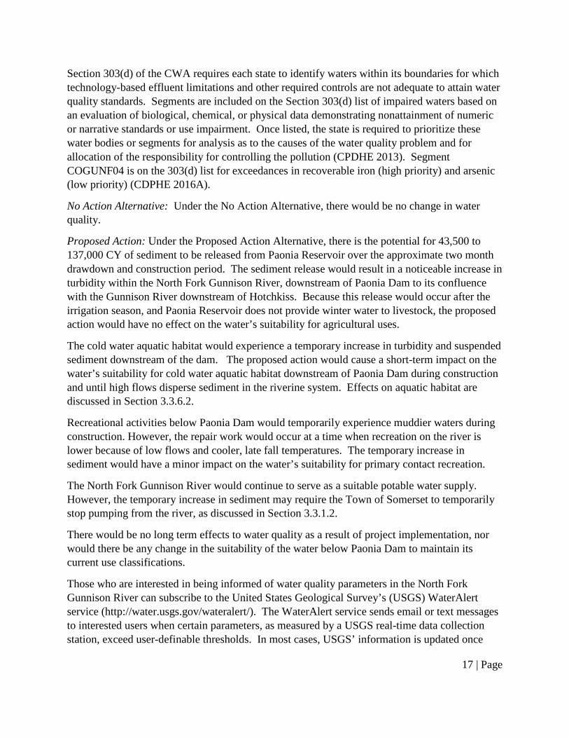
Section 303(d) of the CWA requires each state to identify waters within its boundaries for which technology-based effluent limitations and other required controls are not adequate to attain water quality standards. Segments are included on the Section 303(d) list of impaired waters based on an evaluation of biological, chemical, or physical data demonstrating nonattainment of numeric or narrative standards or use impairment. Once listed, the state is required to prioritize these water bodies or segments for analysis as to the causes of the water quality problem and for allocation of the responsibility for controlling the pollution (CPDHE 2013). Segment COGUNF04 is on the 303(d) list for exceedances in recoverable iron (high priority) and arsenic (low priority) (CDPHE 2016A).
No Action Alternative: Under the No Action Alternative, there would be no change in water quality.
Proposed Action: Under the Proposed Action Alternative, there is the potential for 43,500 to 137,000 CY of sediment to be released from Paonia Reservoir over the approximate two month drawdown and construction period. The sediment release would result in a noticeable increase in turbidity within the North Fork Gunnison River, downstream of Paonia Dam to its confluence with the Gunnison River downstream of Hotchkiss. Because this release would occur after the irrigation season, and Paonia Reservoir does not provide winter water to livestock, the proposed action would have no effect on the water’s suitability for agricultural uses.
The cold water aquatic habitat would experience a temporary increase in turbidity and suspended sediment downstream of the dam. The proposed action would cause a short-term impact on the water’s suitability for cold water aquatic habitat downstream of Paonia Dam during construction and until high flows disperse sediment in the riverine system. Effects on aquatic habitat are discussed in Section 3.3.6.2.
Recreational activities below Paonia Dam would temporarily experience muddier waters during construction. However, the repair work would occur at a time when recreation on the river is lower because of low flows and cooler, late fall temperatures. The temporary increase in sediment would have a minor impact on the water’s suitability for primary contact recreation.
The North Fork Gunnison River would continue to serve as a suitable potable water supply. However, the temporary increase in sediment may require the Town of Somerset to temporarily stop pumping from the river, as discussed in Section 3.3.1.2.
There would be no long term effects to water quality as a result of project implementation, nor would there be any change in the suitability of the water below Paonia Dam to maintain its current use classifications.
Those who are interested in being informed of water quality parameters in the North Fork Gunnison River can subscribe to the United States Geological Survey’s (USGS) WaterAlert service (http://water.usgs.gov/wateralert/). The WaterAlert service sends email or text messages to interested users when certain parameters, as measured by a USGS real-time data collection station, exceed user-definable thresholds. In most cases, USGS’ information is updated once

18 | Page
every hour (USGS 2013). Users may subscribe to be alerted when water quality parameters (including turbidity) in the North Fork River exceed certain thresholds, including during the time that repair work would be conducted at Paonia Reservoir.
3.3.3 – Air Quality
Air quality in the State of Colorado is regulated by the U.S. Environmental Protection Agency (EPA) and the CDPHE Air Quality Control Commission. The National Ambient Air Quality Standards (NAAQS) established by the EPA under the Clean Air Act (CAA) specify limits of air pollutants levels for several criteria pollutants: carbon monoxide, particulate matter (PM) 10, PM 2.5, ozone, sulfur dioxide, lead, and nitrogen. When an area exceeds the specified pollutant limits, that area is said to be a non-attainment area.
Air quality is generally excellent in the project area, and there are no air quality non-attainment areas in the vicinity (EPA 2016).
No Action Alternative: Under the No Action Alternative, there would be no change in air quality.
Proposed Action: Under the Proposed Action Alternative, there would be a minor, short-term effect on air quality in the immediate vicinity of the intake structure as a result of exhaust which may be created by construction equipment. There would be no long-term impacts on air quality from the proposed action.
3.3.4 – Wetland and Riparian Resources
The Paonia Reservoir is a man-made feature that collects and stores irrigation water resources from several drainages including Muddy Creek, Williams Creek, and Deep Creek. Sediment deposition in the reservoir has provided the substrate for willows to establish in isolated areas within the reservoir, concentrated near the boat ramp and the reservoir inlet, about 2.5 miles upstream of the intake structure. Narrowleaf cottonwood (Populus angustifolia) and hawthorn (Crataegus spp) occur in isolated locations around the perimeter of the reservoir and can be found interspersed with conifers. The project area in the vicinity of the intake structure is devoid of vegetation. Releases from the reservoir provide a consistent water source to the riparian corridor downstream throughout the year with fluctuations in flow being highest in spring during snow melt runoff and lowest during fall and winter.
No Action Alternative: Sediment deposition within the Paonia Reservoir basin is an historic and ongoing occurrence. Under the No Action Alternative, sediment deposition would continue to occur within the reservoir at the current rate of approximately 100 AF per year, creating more substrate for riparian vegetation to establish within the reservoir sediments. If the outlet works fail and become inoperable, a potential consequence of the No Action Alternative, sediment deposition in the reservoir would occur at an accelerated rate.

19 | Page
Proposed Action: Under the Proposed Action Alternative, no direct impacts to wetland or riparian resources would occur as a result of the repair work on the intake structure. Sediment released downstream would be dispersed during high flows the following spring, and effects, if any, on downstream wetlands and riparian areas that may occur below the ordinary high water mark of the river would be minimal and short-term.
3.3.5 – Upland Vegetation
The proposed project is located within the reservoir boundary. The area surrounding the intake structure is devoid of vegetation. Vegetation surrounding the reservoir consists of mixed deciduous-coniferous forest, consisting of oak (Quercus gambelii), spruce (Picea spp), and fir (Abies spp and Pseudotsuga spp) with an understory including snowberry (Symphoricarpos spp) and wild rose (Rosa spp). The reservoir dam outside of the rock riprap and high water mark contains sparse vegetation, including: common mullein (Verbascum Thapsus), raspberry (Rubus spp), clover (Melilotus spp), milkweed (Asclepias spp), and thistle (Cirsium spp). Narrowleaf cottonwood (Populus angustifolia) and hawthorn (Crataegus spp) are intermixed with deciduous and coniferous species.
No Action Alternative: Under the No Action Alternative, there would be no effects to upland vegetation if the proposed project does not occur.
Proposed Action: Under the Proposed Action Alternative, no vegetation removal is proposed. Impacts to upland vegetation would be minimal and isolated to vegetation on the access roads utilized during project work.
3.3.6 – Fish and Wildlife Resources
3.3.6.1 – Terrestrial Wildlife
The habitat surrounding the reservoir is utilized by coyote (Canis latrans), mountain lion (Puma concolor), turkey (Meleagris gallopavo), beaver (Castor canadensis), bobcat (Lynx rufus), reptiles, birds, and a variety of small mammals. In addition, the reservoir and surrounding area are within black bear (Ursus americanus) summer concentration range, moose (Alces americanus) summer range, mule deer (Odocoileus hermionus) summer and winter range and elk (Cervus elaphus) summer and severe winter range (CPW 2016A).
No Action Alternative: Under the No Action Alternative, no impacts to terrestrial wildlife are anticipated.
Proposed Action: The project area currently experiences disturbance from boaters, campers, and other recreational users, as well as vehicles travelling on the highway. The proposed action would temporarily affect terrestrial wildlife through direct disturbance and human presence in the project area. Temporary displacement and habitat avoidance of some terrestrial species would be short-term. There would be no permanent impacts on terrestrial wildlife under the proposed action.

20 | Page
3.3.6.2 – Aquatic Wildlife
In 2012, Colorado Parks and Wildlife (CPW) successfully completed a chemical reclamation of the Paonia Reservoir to remove northern pike (Esox lucius), in order to protect native fish downstream in the Gunnison River. CPW manages Paonia Reservoir as a coldwater fishery and has stocked it annually with Rainbow Trout (Oncorhynchus mykiss) since the treatment in 2012. Under normal reservoir operation procedures, water is periodically drawn down in the fall to inspect the integrity of the intake structure of the reservoir’s outlet works. Despite these drawdown procedures, CPW’s gill netting survey in 2015 revealed the fisheries makeup in the reservoir consisted of white sucker (Catostomus commersonii), flannelmouth sucker (Catostomus latipinnis), longnose sucker (Catostomus catostomus), sucker hybrids, brook trout (Salvelinus fontinalis), and rainbow trout. These species are thought to be persisting in nearby tributaries, such as Deep Creek, or upstream in Muddy Creek during low water episodes in the reservoir.
The reservoir flows into Muddy Creek approximately 0.4 mile upstream of its confluence with Anthracite Creek; this junction creates the North Fork Gunnison River. Anthracite Creek contains multiple sport fish species including: Brook Trout (Salvelinus fontinalis), Brown Trout (Salmo trutta), Cutthroat Trout (Oncorhynchus clarkia), and Rainbow Trout (CPW 2016B). The North Fork Gunnison River has the following sport fish: Brown Trout and Rainbow Trout. In addition, CPW reports the following native fish in the North Fork Gunnison River: Mottled Sculpin (Cottus bairdii), Longnose Dace (Rhinichthys cataractae), Bluehead Sucker (Catostomus discobolus), Flannelmouth Sucker (Catostomus latipinnis), and Roundtail Chub (Gila robusta) (personal communication, Eric Gardunio, August 18, 2016). All but the Brook Trout and Brown Trout spawn during the spring and summer.
In addition to fish, the reservoir and downstream waters harbor an assemblage of macroinvertebrates or aquatic insects. Aquatic invertebrates are aquatic animals without backbones that live on the bottom of freshwater habitats during all or part of their life cycle and that are large enough to be seen with the naked eye. Major groups of macroinvertebrates include arthropods (i.e., crustaceans and insects), mollusks, sponges and nematode worms. The most abundant are typically immature life states (larvae) of aquatic insects such as mayflies, stoneflies, and caddis flies. The benthic macroinvertebrate community or “assemblage” is largely determined by the range of habitat conditions, such as water quality, vegetation structure and bottom substrate. More complex habitats generally support a more diverse assemblage than more uniform habitats. Aquatic insects are important in the food web of many species including fish, some avian species, bats, some mammals, spiders, and amphibians.
Amphibians may also be present along waters upstream and downstream of the reservoir and the perimeter of the reservoir itself. Common species include western chorus frogs (Pseudaeris triseriata), tiger salamanders (Ambystoma tigrinum), Woodhouse’s toads (Anaxyrus woodhousii), and American bullfrogs (Rana catesbeiana).
No Action Alternative: Under the No Action Alternative, sediment would continue to be released downstream at rates associated with normal reservoir operations and periodic

21 | Page
drawdown. The effects of turbidity and suspended sediment on aquatic wildlife are discussed in greater detail under the Proposed Action section below. Any additional sediment that may be generated from repair activities would not be released downstream; therefore, there would be no change in effect from turbidity and suspended sediment compared to periodic reservoir drawdown events that have occurred since 2011.
Without repairs, there is the potential for the reservoir outlet works to become inoperable. If that occurs, the only way for water to exit the reservoir is over the spillway. Under this scenario there would no longer be drawdown procedures in the fall and the release of sediment downstream would be greatly reduced. Aquatic species in the reservoir would no longer be impacted by low water levels in the fall. A reduction in turbidity and sediment downstream would be beneficial to sport fish and certain macroinvertebrates, but harmful to native fish and macroinvertebrate species that prefer more turbid waters. Flows below the dam would no longer be controlled and downstream flows would be reduced during the late summer to early fall months. Reduced flows have the potential to decrease the habitat available for spawning and increase water temperatures. The roughly 2,000 foot section of Muddy Creek below the dam above the confluence of Anthracite Creek is the area of greatest impact.
Proposed Action: The proposed action could affect aquatic wildlife within the reservoir from the drawdown associated with normal operations and also associated with the proposed action. Additionally, the drawdown process and proposed work on the intake structure would release sediment downstream into Muddy Creek and the North Fork Gunnison River. The proposed action would have the greatest effect on species such as Brown Trout that breed and reproduce in Muddy Creek below the dam and the North Fork Gunnison River during the October-November timeframe. In 2014, sediment releases from the reservoir in the fall showed the greatest accumulation of sediment directly below the dam to the confluence with Anthracite Creek (approximately 0.4 mile). These sediment accumulations were flushed the following spring when the reservoir spilled during high flows. Modeling data associated with the proposed project work show the estimated total suspended sediment concentration could range from 200 mg/l to 7,000 mg/l depending on the inflows to the reservoir and the sediment accumulations around the intake structure (Reclamation 2016). Higher suspended sediment concentrations are anticipated if there is not a depression or pool around the intake structure to collect sediment, and lesser concentrations are projected if a pool exists.
The effect of suspended sediment on aquatic biota is dependent on several key factors. These include: concentration, duration of exposure, chemical composition, and particle-size distribution of the solids (Bilotta and Brazier, 2008). However these key factors also vary between organisms and between environments.
Significant suspended sediment levels have been observed to alter fish community composition from salmonid to nonsalmonid fish, which better tolerate or prefer more turbid water (Gradall and Swenson 1982). Salmonids are fish in the Salmonidae family, including salmon, trout, grayling, and whitefish. Significant mortality of salmonid (>50 percent) usually occurs at suspended sediment concentrations in the range of 500 to 6,000 mg/l (Lloyd 1987; Sigler et al.

22 | Page
1984). Older, larger salmonids are generally more tolerant of high suspended sediment concentrations (200 to 20,000 mg/l) than juvenile salmonids, eggs, and larvae (Sigler et al. 1984). An 85% reduction in a Brown Trout population was observed when exposed to a suspended sediment concentration of 5,838 mg/l for 8,670 hours (Herbert et al. 1961). Sedimentation can cause high losses of incubating eggs and fry in redds (trout spawning area), particularly by interfering with oxygen exchange. Fine sediment deposits may also seal rubble and gravel substrates, decreasing spawning area, egg survival, emergence of fry, and hiding cover for fingerlings (Hall and Lantz 1969; Satterlund and Adams 1992). Sand, silt, and fines in the makeup of the substrate can reduce intergravel water flow, decrease intergravel dissolved oxygen concentrations, and result in high Biological Oxygen Demand (BOD) over long periods (Chamberlin 1982). A dissolved oxygen concentration of at least 11.0 mg/l is needed in the water column to maintain an intergravel dissolved oxygen concentration of at least 8.0 mg/l (EPA 1987). Sedimentation without cleansing and scouring flows can result in permanent rearing and spawning habitat changes (Platts et al. 1987). However, turbidity can be beneficial to some fish species. Fish that remain in turbid water experience a reduction in predation from fish and birds (Gregory and Levings 1998). A study done regarding the effects of turbidity on fish predation showed that prey are more active in turbid water and utilize areas in the turbid water column that would otherwise be unsafe in clear water. The results of this study show that turbid water acts as protective cover and allows fish to exist in otherwise “riskier” habitat (Gregory 1993). A laboratory study that looked at the effects of turbidity and predation by rainbow and brown trout on native chubs found that an increase in turbidity resulted in less predation (Ward et al. 2016).
The short-term direct effects of the proposed action is mortality of salmonid (brown trout) juveniles, eggs, and larvae due to anticipated suspended sediment concentrations and turbidity during spawning season. While the Brown Trout population is expected to be the most impacted, other fish species are expected to be negatively impacted by the suspended sediment concentration and turbidity due to the concentration levels and potential duration. The extent of these impacts is expected to be more extreme in Muddy Creek below the reservoir to the confluence of Anthracite Creek and decreasing downstream towards the towns of Somerset, Paonia, and Hotchkiss. Other than the drawdown procedures, the impacts of suspended sediment and turbidity are anticipated to be greatest during repair work but have the potential to last until high flow events, which are projected to occur as soon as April or as late as end of June the following year. A temporary reduction in the fishery population is anticipated, but expected to recover within one or two breeding seasons.
The suspended sediment and downstream sediment deposition due to proposed repairs would also affect aquatic biota, including gill breathing aquatic invertebrates. The insect orders Ephemeroptera (mayflies), Plecoptera (stoneflies), and some Trichoptera (caddisflies) (EPT taxa) are all gill breathers. These EPT taxa are less tolerant to environmental stressors than other aquatic invertebrate groups and are a major component in the trout diet. For filter-feeding invertebrates, high levels of suspended sediment can clog feeding structures, reducing feeding efficiency and therefore reducing growth rates, stressing and even killing these organisms (Hynes, 1970). Suspended sediment can affect benthic invertebrates by subjecting them to

23 | Page
abrasion and scouring as suspended sediment being carried in the flow move over the channel bed. This can damage exposed respiratory organs or make the organism more susceptible to predation through dislodgement (Langer, 1980). A number of studies have shown that increased suspended sediment are associated with an increase in invertebrate drift (down- or up-channel migration of organism). Benthic invertebrates exposed to suspended sediment concentrations of 743 mg/L for 2400 hours showed a population reduction of 85% Wagener and LaPerriere, 1985).
Sediment deposition and suspended sediment from the proposed repair work until high flows occur are expected to adversely affect benthic macroinvertebrates, especially within the stream reach below the reservoir until the confluence with Anthracite Creek. The macroinvertebrate resources within the project area and downstream would be expected to re-establish the following year after high flows. Nearby tributary streams, springs, and seeps, would serve as sources for recolonization. As a result, no taxa are expected to be lost, and re-establishment is expected to occur within a few months, resulting in temporary, short-term impacts.
Potential indirect impacts on amphibians include loss of prey species from downstream sedimentation, turbidity, and suspended sediment. For example, reductions in emerging aquatic insects could occur, particularly if suspended sediment levels are too high; however, aquatic insect abundance is expected to recover quickly through drift from untreated upstream areas, by immigration of adults from non- impacted downstream reaches, or from life stages of existing bugs not in a gill breathing life stage.
3.3.7 – Special Status Species
3.3.7.1 – Threatened and Endangered Species
The Endangered Species Act (ESA) of 1973 protects federally listed endangered, threatened and candidate plant and animal species and their critical habitats. Table 4 summarizes the federally-listed species that may occur within or near the project area (FWS 2016) and explains habitat requirements and potential effects of the proposed action on each species. Species with suitable habitat in the proposed action area, or otherwise potentially affected by the proposed action, are discussed following Table 4. Unless otherwise specified, all information related to the species below was obtained from resources available on FWS’ Environmental Conservation Online System (ecos.fws.gov).
Table 4. Federally-listed species occurring in or near the proposed action area. Common Name Status General Habitat
Bonytail Chub (Gila elegans) Endangered
Although no habitat is present within the project area, there is downstream designated critical habitat on the Gunnison and Colorado Rivers.
Canada Lynx (Lynx canadensis)
Threatened Moist boreal forests with cold, snowing winters and a high-density snowshoe hare prey base.

24 | Page
Common Name Status General Habitat Colorado Pikeminnow (Ptychocheilus lucius)
Endangered Although no habitat is present within the project area, there is downstream designated critical habitat on the Gunnison and Colorado Rivers.
Greenback Cutthroat Trout (Oncorhynchus clarki stomias)
Threatened High elevation cold water streams and cold water lakes with adequate stream spawning habitat present during spring.
Humpback Chub (Gila cypha) Endangered
Although no habitat is present within the project area, there is downstream designated critical habitat on the Gunnison and Colorado Rivers.
Razorback Sucker (Xyrauchen texanus)
Endangered Although no habitat is present within the project area, there is downstream designated critical habitat on the Gunnison and Colorado Rivers.
Yellow-Billed Cuckoo (Coccyzum americanus)
Threatened Breeds in low elevation river corridors with fairly extensive mature cottonwood galleries with dense shrub understory.
The endangered bonytail, Colorado pikeminnow, humpback chub, and razorback sucker are found in the Gunnison and Colorado Rivers downstream from the project area, and are influenced by water use activities in the basin that affect both the quantity of flows and quality of water. Designated critical habitat for the Colorado pikeminnow and razorback sucker occurs downstream at the confluence of the Gunnison and Uncompahgre Rivers (approximately 55 miles west of the project area), and designated critical habitat for the bonytail and humpback chub occurs downstream of Fruita, Colorado (approximately 112 miles west of the project area). In accordance with Section 7 of the ESA, as amended (16 U.S. C. 1531 et seq.), and the Interagency Cooperation regulations (50 CFR 402), the U.S. Fish and Wildlife Service issued a Programmatic Biological Opinion (PBO) for the Gunnison River and effects on the four endangered Colorado River fishes and their critical habitats (FWS 2009). Consultation for the Gunnison River Basin included the continued operations and depletions associated with existing Reclamation projects, including the Paonia Project, other Federal projects, and existing non-federal water depletions.
The Canada Lynx habitat can generally be described as moist boreal forests that have cold, snowy winters and a high-density snowshoe hare prey base. The predominant vegetation of boreal forest is conifer trees, primarily species of spruce (Picea spp.) and fir (Abies spp.). The project area is approximately 150 miles west of the nearest designated critical habitat.
Greenback cutthroat trout inhabit cold water streams and cold water lakes which have adequate spawning habitat present during the spring. There is no suitable habitat within the project area. The upper portions of Deep Creek have cutthroat trout but access to the project area is prevented by a fish barrier. There is no designated or proposed critical habitat listed for this species.

25 | Page
The preferred breeding habitat of the yellow-billed cuckoo is low elevation old-growth cottonwood forests or woodlands with dense, scrubby understories of willows or other riparian shrubs. There is no potential habitat within the project area. The project area is approximately 13 miles east of the nearest proposed critical habitat.
No Action Alternative: Under the No Action Alternative, there would be no effect to any threatened, endangered, or candidate species or their designated or proposed critical habitat.
Proposed Action: Since there is no critical habitat or suitable habitat, the species are not expected to occur in the project area. The proposed action would have no effect on any federally threatened, endangered, or candidate species or their designated or proposed critical habitat.
3.3.7.2 – Migratory Birds
The Migratory Bird Treaty Act of 1981 (MBTA) prohibits the take, capture, or killing of any migratory birds, and any parts, nests, or eggs of any such birds [16 U.S.C. 703 (a)]. Under the MBTA, Federal agencies are liable for both intentional and unintentional take of migratory birds.
The 1988 amendment to the Fish and Wildlife Conservation Act mandates the USFWS to “identify species, subspecies, and populations of all migratory nongame birds that, without additional conservation actions, are likely to become candidates for listing under the Endangered Species Act (ESA) of 1973.” The “Birds of Conservation Concern 2008” (FWS 2008) is the most recent effort to carry out this mandate. The conservation concerns are the result of population declines - natural or human-caused, small ranges or population sizes, threats to habitat, or other factors.
Although there are general patterns that can be inferred, there is no single reason why any species is included on the Birds of Conservation Concern list. Habitat loss is believed to be the major reason for the decline of many species. When considering potential impacts to migratory birds, the degree of impact on habitat must be taken into account, including:
1) the degree of fragmentation/connectivity expected from the proposed project relative to before the proposed project; and
2) the fragmentation/connectivity within and between habitat types (e.g., within nesting habitat or between nesting and feeding habitats).
Continued private land development, surface disturbing activities in key habitats (e.g. riparian areas) and the proliferation of roads, pipelines, power lines and trails are local factors that can reduce habitat quality and quantity for many species.
The project area is within the Southern Rockies/Colorado Plateau Bird Conservation Region (BCR). The habitat around the Paonia Reservoir consists of a mixed coniferous and montane riparian forest. Within the reservoir boundary there is a narrow willow dominated area around the boat ramp and at the inlet of the reservoir. Migratory birds of conservation concern that have suitable habitat or are known to occur in the area include: Bald Eagle (Haliaeetus leucocephalus), Peregrine Falcon (Falco peregrines), Cassin’s Finch (Carpodacus cassinii),

26 | Page
Lewis’s Woodpecker (Melanerpes lewis), Veery (Catharus fuscescens), and Willow Flycatcher (Empidonax traillii). Cassin’s Finch and Lewis’s Woodpecker are associated with mixed coniferous woodland habitats. Bald Eagles, Veery, Peregrine Falcon, and Willow Flycatchers are associated with riparian areas near streams, reservoirs, and other bodies of water. According to the CPW Species Account Map, the Paonia Reservoir is within Bald Eagle winter and winter forage range; the nearest roost site is over 9 miles from the project area (CPW 2016A). The nearest potential Peregrine Falcon nest is 4 miles away and 8 miles from an active nesting area. With the exclusion of the Bald Eagle, Peregrine Falcon, and Veery, these species’ populations are considered to either be secure or apparently secure in Colorado (Natureserve 2016). The Veery population in Colorado is vulnerable, the Peregrine Falcon population is imperiled, and the Bald Eagle population is critically imperiled (Natureserve 2016).
No Action Alternative: Under the No Action Alternative, no direct disturbance to migratory birds from construction activities would take place. Downstream sediment deposition has the potential to negatively affect certain migratory bird prey species and habitat due to sediment flushing from normal reservoir operations.
Proposed Action: The proposed action does not require the removal of vegetation. In addition, the timing of project work is planned for October and November which is outside of migratory bird breeding season. Migratory birds may experience short-term disturbance and displacement during construction activities. Downstream sediment deposition has the potential to temporarily affect migratory bird prey species, such as benthic invertebrate species and fish. Permanent long-term effects on migratory birds due to this project are not expected.
3.3.8 – Recreation
Paonia Reservoir is within Paonia State Park, which has been administered by CPW since 1965. The park offers recreational opportunities such as waterskiing, fishing, boating, camping, sightseeing, and picnicking. There are two separate campgrounds in the park: Spruce Campground, located next to Highway 133, and Hawsapple Campground, located across the river. Both campgrounds are located over 3 miles from the project area. Boating is allowed from mid-June until mid-August. There are no hiking trails at the park. Fishing in the reservoir is best from mid-June to mid-August; no ice fishing is allowed. Streams below the reservoir provide for better fly fishing opportunities than at the reservoir; however public access to Muddy Creek approximately 1,050 feet downstream from the dam is prohibited, and access to the river farther downstream from the reservoir is limited due to private landownership.
No Action Alternative: Under the No Action Alternative, low flows and sediment releases associated with normal reservoir operations and periodic drawdown procedures would continue to occur. The low flows, turbidity and suspended sediment would continue to impact recreational opportunities, such as fishing. Any additional turbidity that may be generated from and associated with repair maintenance activities would not be released downstream. There would be no additional effects to recreation. If the reservoir outlet structure becomes inoperable, the reservoir would remain full which offers improved sightseeing opportunities. The amount of

27 | Page
sediment released downstream would be greatly reduced, improving the recreational fishing experiences below the dam in the North Fork Gunnison River.
Proposed Action: The timing of the construction activities is outside the allowed boating times at the reservoir and would, therefore, have no effect on boating opportunities. The release of sediment downstream due to drawdown and construction activities would adversely affect late fall fishing opportunities below the dam and on the North Fork Gunnison River. Prior to any repairs, appropriate notifications would be implemented regarding the planned activities, including notifying local fishing shops and fishing websites. Notifications may include signing, press releases, and/or other public announcements to inform the public about planned activities. Notifications would alert recreationists as to dates the activities would occur. Turbidity below the dam is associated with normal reservoir drawdown operations, and the impacts to recreation associated directly with repairs are expected to be similar to normal operations. Since the reservoir is long and narrow, there is no direct line of sight to the project area from the campgrounds, and therefore it is not anticipated that the proposed action would impede camping or sightseeing opportunities at the park. Noise associated with project work would be temporary and limited to daylight hours and is anticipated to have minimal effects to recreationists.
3.3.9 –Social, Economic, Environmental Justice
Executive Order 12898 on Environmental Justice provides that Federal agencies analyze programs to assure that they do not disproportionately adversely affect minority or low income populations or Indian Tribes.
Paonia Reservoir is located in Gunnison County, Colorado and provides full and supplemental irrigation water supplies for 15,300 acres of land in the vicinity of Paonia and Hotchkiss. Paonia and Hotchkiss are both small towns located in Delta County of western Colorado. According to the 2010 U.S. Census Bureau statistics, the population for this area is 3,792. Minorities make up 12% of the population (EPA 2016). The Center for Disease Control reports that 15.1% of residents in Delta County live below the poverty line which is slightly higher than the 12.9% average for the state (CDC 2016). In 2014, the Colorado Department of Local Affairs reported that agriculture employed roughly 11% of the residents in Delta County, surpassed only by government which makes up approximately 19% of the work force (DOLA 2016).
No Action Alternative: Under the No Action Alternative, there would be no adverse human health or environmental effects on minority or low-income populations. If the reservoir becomes inoperable, there would be negative impacts to the agricultural community, which represents one of the larger employers in Delta County.
Proposed Action: Repairs to the outlet works of the reservoir would help continue water delivery to 15,300 acres of agricultural land the reservoir serves. The proposed action would not involve any relocations, health hazards, hazardous waste, property takings, or substantial economic impacts. The project would not have disproportionately high or adverse human health or environmental effects on minority or low-income populations or Indian Tribes.

28 | Page
3.3.10 – Public Safety, Access, and Transportation
The major transportation route in the general vicinity of the project area is U.S. Highway 133. The Colorado Department of Transportation applies restrictions on Extra Large Vehicles or Loads on certain portions of highway. There are no such restrictions on Highway 133 or Highway 50 between Grand Junction, Colorado, and its junction with Highway 133. There are two existing access roads to the project area (figure 6, above). The access roads are located on Reclamation land.
No Action Alternative: Under the No Action Alternative, there would be no change in public safety, access, and transportation.
Proposed Action: Equipment necessary for project implementation include a long-reach excavator, ATV, tracked skid loader, and a mini excavator. This equipment would be hauled in from Grand Junction along Highway 50 and Highway 133, and hauled away along the same route. Equipment would be staged at the project area during the repair work; therefore, there would be minimal effects to transportation associated with equipment hauling on and off-site and construction personnel’s vehicles. The equipment would be stored on Reclamation land in the project area during the repair work. The project area is behind two locked gates, and the public would not have access to the equipment or construction area. There would be no effects on public safety as a result of implementation of the proposed action.
Access possibilities include entering the project site with small vehicles on the existing road on top of the dam, and entering the project site with the long-reach excavator via an existing road along the south side of Muddy Creek. Vehicles would need to utilize approximately 0.3 miles of County Road 12, including transporting equipment across the County Road 12 Bridge over Muddy Creek, to access the southern access road. The bridge is a county road bridge, and meets the standard HS20 rating; therefore, the bridge is equipped to withstand the weight of the long-reach excavator. The long-reach excavator would be unloaded directly onto the southern access road to ensure the metal tracks of the excavator do not travel across the paved roadway. The long-reach excavator would access the work area along the rock/sediment interface at the toe of the dam. This route would also be used by ATVs to deliver construction materials to the project site. There would be no construction of new access routes or impacts to existing access routes as a result of implementation of the proposed action.
3.3.11 – Cultural Resources
Cultural resources are defined as physical or other expressions of human activity or occupation. Section 106 of the National Historic Preservation Act (NHPA) requires Federal agencies to take into account the potential effects of a proposed Federal undertaking on historic properties. Historic properties are any prehistoric or historic district, site, building, structure, or object included in, or eligible for inclusion in, the National Register of Historic Places (NRHP).
The affected environment for cultural resources is identified as the area of potential effect (APE) in compliance with the regulations in Section 106 of the NHPA (36 CFR 800.16). The APE is

29 | Page
defined as the geographic area within which Federal actions may directly or indirectly cause alterations in the character or use of historic properties. The APE for the proposed action encompasses the area of potential ground disturbance associated with the intake structure repair, including all staging areas and access routes.
In accordance with 36 CFR 800.4, the site was evaluated for significance in terms of NRHP eligibility. The significance criteria applied to evaluate cultural resources are defined in 36 CRF 60.4 as the quality of significance in American history, buildings, structures and objects that possess integrity of location, design, setting, materials, workmanship, feeling, and association, and:
A. that are associated with events that have made a significant contribution to the broad patterns of our history; or
B. that are associated with the lives of persons significant in our past; or
C. that embody the distinctive characteristics of a type, period, or method of construction, or that represent the work of a master, or that possess high artistic values, or that represent a significant and distinguishable entity whose components may lack individual distinction; or
D. that have yielded, or may be likely to yield, information important in prehistory or history.
Paonia Dam, recorded as Colorado Site 5GN1334, was determined eligible for the NRHP under Criteria A and C, as a result of consultation with the Colorado State Historic Preservation Officer (SHPO) completed in 2016. Site 5GN1334 consists of the dam embankment, outlet works, spillway, and the intake structure for the outlet.
No Action Alternative: Under the No Action Alternative, there would be no effect to eligible cultural resources.
Proposed Action: Reclamation has determined that the dismantling and modification of the intake structure is an adverse effect to a historic property under 36 CFR 800.5. Reclamation will enter into a Memorandum of Agreement (MOA) with the SHPO for resolution of adverse effects to the Paonia Dam intake structure (Appendix A).
3.3.12 – Indian Trust Assets and American Indian Sacred Sites
Indian Trust Assets (ITAs) are legal interests in property held by the United States for Indian Tribes or individuals. Reclamation and other Federal agencies share the responsibility to protect these assets. In managing Federal lands, Federal agencies must, to the extent practicable, permitted by law, and not clearly inconsistent with essential agency functions, accommodate access to and ceremonial use of American Indian sacred sites by Indian religious practitioners and avoid adversely affecting the physical integrity of such sacred sites. No ITAs have been

30 | Page
identified within the project area. No American Indian Sacred Sites are known within the project area.
No Action Alternative: Under the No Action Alternative, there would be no change to ITAs or American Indian Sacred Sites.
Proposed Action: The proposed action would not impact ITAs or American Indian Sacred Sites.
3.4 – Cumulative Impacts NEPA requires federal agencies to consider the cumulative effects of proposals under their review. Cumulative effects are defined in the Council on Environmental Quality (CEQ) regulations 40 CFR §1508.7 as “…the impact on the environment that results from the incremental impact of the action when added to other past, present, and reasonably foreseeable actions regardless of what agency…or person undertakes such other actions.” The CEQ states that the “cumulative effects analyses should be conducted on the scale of human communities, landscapes, watersheds, or airsheds” using the concept of “project impact zone” or more simply put, the area that might be affected by the proposed action.
The general cumulative impacts analysis area is defined as Paonia Reservoir, Muddy Creek below the Paonia Dam, and the North Fork Gunnison River. Past, present and reasonably foreseeable future actions within the analysis area that affect and are affected by river-related resources in the area include irrigation, mining, fishing and other recreational activities, residential and commercial development, and municipal water use.
The proposed action involves limited disturbance and impacts in the form of an increase in suspended sediment, turbidity, and sediment deposition in Muddy Creek and in the North Fork Gunnison River. Impacts would be short-term during construction and until high flows disperse sediment deposits the following spring. Given the short duration and limited effects associated with the repair work, no cumulative impacts are anticipated from the proposed action when added to other actions already occurring and expected to continue to occur within the cumulative impacts analysis area.
3.5 – Summary Table 5 provides a summary of environmental consequences for the resources evaluated in this EA. Resource impacts are outlined for both the No Action and the Proposed Action Alternatives. Mitigation, if required, is also described.

31 | Page
Table 5. Summary of Impacts for the No Action and Proposed Action Alternatives.
Resource Impacts: No Action Alternative
Impacts: Proposed Action Alternative
Water Resources
Downstream water deliveries would continue to be made until the intake structure becomes inoperable, at which time delivery of water would no longer occur through the dam’s outlet works and would only occur when the reservoir spills.
The maintenance work would allow the intake structure to remain functional, and thus maintain the existing reliable water source in the North Fork Gunnison River. Oxbow Mine may have to temporarily shut off their pump which provides drinking water to the Town of Somerset if the river’s sediment load becomes too high during construction.
Water Quality
Downstream water quality would continue to be impacted when the reservoir is drawn down.
Temporary increases in turbidity would have a short term effect on the cold water aquatic habitat and recreational water classification uses. There would be no long-term effect to water quality.
Air Quality No Effect Minor short-term impacts due to equipment exhaust from construction activities.
Wetland and Riparian Resources
Sediment deposition would continue to occur within the reservoir at the current rate of approximately 100 AF per year, creating more substrate for riparian and wetland vegetation. If the outlet works fail, the rate of sediment deposition within the reservoir would accelerate. Sediment deposition downstream of the reservoir would continue to occur during normal reservoir operations and drawdown.
Any sediment released downstream would be scoured during high flows the following spring, and effects, if any, on downstream wetlands and riparian areas that may occur below the ordinary high water mark of the river would be minimal and short-term.

32 | Page
Resource Impacts: No Action Alternative
Impacts: Proposed Action Alternative
Upland Vegetation No Effect
Impacts to upland vegetation would be minimal and limited to vehicles and equipment driving over vegetation on the existing access roads utilized during project work.
Fish and Wildlife Resources
Increased turbidity and suspended sediments and associated impacts to fish and wildlife resources would continue to occur in Muddy Creek and the North Fork Gunnison River during reservoir drawdown until the outlet works become inoperable. After the outlet works are inoperable, turbidity and suspended sediment levels attributable to releases from Paonia Reservoir would decrease, and adverse effects to fish and wildlife resources would be less extensive and of shorter duration.
Temporary, short-term effects may occur to terrestrial wildlife through direct disturbance from human presence in the project area. The greatest effect on aquatic species would be to species that breed and reproduce in Muddy Creek below the dam and in the North Fork Gunnison River during the October-November timeframe, such as Brown Trout. Increased suspended sediment would adversely affect aquatic biota, including gill breathing aquatic invertebrates, and benthic invertebrates due to abrasion and scouring. Sediment deposition would also adversely affect benthic macroinvertebrates. There would be potential indirect, temporary impacts on amphibians due to reduction in prey, and increased turbidity and suspended sediment.
Special Status Species
No Effect to Threatened and Endangered Species. No direct disturbance to migratory birds from construction activity. Downstream sediment deposition has the potential to negatively affect certain migratory bird prey species and habitat due to sediment flushing from normal reservoir operations.
No Effect to Threatened and Endangered Species. Migratory birds may experience short-term disturbance and displacement during construction activities. Downstream sediment deposition has the potential to temporarily negatively affect migratory bird prey species, such as benthic invertebrates and fish.

33 | Page
Resource Impacts: No Action Alternative
Impacts: Proposed Action Alternative
Recreation No change from existing operation.
No effect on boating and camping at Paonia Reservoir. Temporary adverse effects to fishing below Paonia Dam beginning in fall and extending to the spring runoff. No long-term effects to recreation.
Social, Economic, Environmental Justice
No Effect No Effect
Public Safety, Access, and Transportation
No Effect No Effect
Cultural Resources No Effect
There would be an adverse effect to the intake structure, which is a component to the NRHP-eligible Paonia Dam. Reclamation will enter into an MOA with the SHPO and NFWCD to mitigate the adverse effect.
Indian Trust Assets and American Indian Sacred Sites
No Effect No Effect
Cumulative Impacts n/a
Given the short duration and limited effects associated with repair work as proposed, there would be no cumulative impacts anticipated from the proposed action when added to other actions already occurring and expected to continue to occur within the cumulative impacts analysis area.
CHAPTER 4 – ENVIRONMENTAL COMMITMENTS
The following measures will be implemented by Reclamation and the NFWCD if the proposed action is implemented.
● Existing roads will be used to access the construction and staging areas. The long-reach excavator will access the construction area along the rock/sediment interface of the reservoir. No new roads will be constructed.
● All construction equipment will be power-washed and free of soil and debris prior to entering the project site to reduce the spread of noxious and invasive weeds.
● To help minimize noise impacts near the construction area, construction activities will occur during the daylight hours.
● The public will be notified of construction dates prior to construction via press releases to local newspapers and informative flyers posted in the Towns of Hotchkiss and Paonia.

34 | Page
● Concrete removed from the bulkhead will be taken to an existing landfill for disposal. ● Stipulations in the Memorandum of Agreement with the SHPO are incorporated by
reference. ● If previously undiscovered cultural or paleontological resources are discovered during
construction, construction activities must immediately cease in the vicinity of the discovery and Reclamation must be notified. The SHPO will be consulted, and work will not be resumed until consultation has been completed, as outlined in the Unanticipated Discovery Plan in the attached MOA.
● Terms and conditions outlined in the CWA Section 404 permit are incorporated by reference.
● In the event that threatened or endangered species are discovered during construction, construction activities will half until consultation is completed with the U.S. Fish and Wildlife Service and protection measures are implemented.
● In order to mobilize and disperse any sediment deposited in Muddy Creek and North Fork Gunnison River downstream of the dam during the proposed repair work, high flows will be released from the dam as soon as practicable during spring runoff, in the April through June timeframe.
CHAPTER 5 – CONSULTATION AND COORDINATION
5.1 – Introduction Reclamations’ public involvement process presents the public with opportunities to obtain information about a given project, and allows interested parties to participate in the project through written comments. The key objective is to create and maintain a well-informed, active public that assists decision makers throughout the process, culminating in the implementation of an alternative. This chapter discusses public involvement activities taken to date for the proposed action.
5.2 – Public Involvement News Releases announced the availability of the EA and draft FONSI, and the documents were placed on Reclamation’s website at: www.usbr.gov/uc/ under environmental documents. The EA and draft FONSI were also announced with request for comments in a distribution letter mailed to agencies, downstream ditch companies, stakeholders, and landowners adjacent to Muddy Creek and the North Fork Gunnison River from Paonia Dam down to Hotchkiss, Colorado, as shown below:
● State Representative Jared Polis

35 | Page
● State Representative Ken Buck ● State Representative Mike Coffman ● State Representative Diana DeGette ● State Representative Ed Perlmutter ● State Representative Scott Tipton ● State Representative Doug Lamborn ● State Senator Cory Gardner ● State Senator Michael Bennet ● U.S. Fish and Wildlife Service, Grand Junction, CO ● U.S. Army Corps of Engineers, Grand Junction, CO ● U.S. Geological Survey, Grand Junction, CO ● U.S. Forest Service, Gunnison, CO ● Natural Resources Conservation Service, Gunnison, CO ● Colorado Department of Public Health and Environment, Denver, CO ● Colorado Historical Society, Denver, CO ● Colorado Parks and Wildlife, Gunnison & Crawford, CO ● Colorado Water Conservation Board, Denver, CO ● Colorado River Water Conservation District, Glenwood Springs, CO ● Gunnison County Commissioners, Gunnison, CO ● Gunnison County Planning Commission, Gunnison, CO ● Gunnison County Road & Bridge, Marble, CO ● Town of Paonia, CO ● Town of Hotchkiss, CO ● Western Slope Conservation Center, Paonia, CO ● Trout Unlimited, Denver, CO ● Delta Conservation District, Delta, CO ● West Elk Mine, Somerset, CO ● Oxbow Mine - Somerset Water Supply, Somerset, CO ● Fire Mountain Canal & Reservoir Company, Hotchkiss, CO ● North Fork Water Conservancy District, Hotchkiss, CO ● 144 Interested Parties and Adjacent Landowners
5.3 – Colorado State Historic Preservation Office Reclamation submitted a consultation letter to the SHPO on August 24, 2016 with a determination of historic properties affected by the proposed action. SHPO concurred on the finding of adverse effect. Reclamation, the NFWCD, and the SHPO will enter into an MOA to mitigate adverse effects to historic properties as a result of the proposed action.

36 | Page
5.4 – U.S. Army Corps of Engineers Reclamation met with the U.S. Army Corps of Engineers (USACE) on August 24, 2016. Based on the information provided by Reclamation at that time, USACE determined that submittal of a pre-construction notification (PCN) for a Nationwide Permit (NWP) No. 3-Maintenance would be needed. Reclamation will submit a PCN in order to obtain NWP No. 3 verification from the USACE prior to starting the intake repair work.
5.5 – Colorado Parks and Wildlife Reclamation accessed Colorado Parks and Wildlife websites to acquire species activity data for the project area. Multiple personal communications with the Area Aquatic Biologist (Eric Gardunio) occurred to document the occurrence and status of fish populations, management strategies for Paonia State Park fisheries, and effects to aquatic species.
CHAPTER 6 – PREPARERS
The following list contains the Reclamation employees who participated in the preparation of this EA.
Name Title Area of Responsibility
Lesley McWhirter Environmental and Planning Group Chief
NEPA Coordinator, Clean Water Act Permitting
Jenny Ward Environmental Protection Specialist
Cultural Resources, Native American Religious Concerns, Soils, Air Quality, Water Resources, Water Quality, Land Use, Environmental Justice
Amanda Ewing Biologist
T&E Species, Migratory Bird Treaty Act, Terrestrial & Aquatic Wildlife, Vegetation, Recreation, Wetland and Riparian
John Sottilare Hydrologist Water Quality Ernie Rheaume Archaeologist SHPO Consultation
Phil Ipson Civil Engineer Operations, Construction Procedures, Review
Tom Fowlds Facilities Group Chief Operations, Construction Procedures, Review
Bill Dressel Civil Engineer Project Lead
37 | Page
CHAPTER 7 – REFERENCES
Bilotta, G., & Brazier, R. 2008. Understanding the influence of suspended solids on water quality and aquatic biota. Water Research, 42(12), 2849-2861. doi:10.1016/j.watres.2008.03.018
CDC 2016. Centers for Disease Control and Prevention. National Center for Environmental Health, Environmental Health Tracking Branch. Environmental Public Health Tranking – Info by Location [Online]. Available at http://ephtracking.cdc.gov/InfoByLocation/. Accessed on August 29, 2016.
CDPHE 2013. Colorado Department of Public Health and Environment. A Guide to Colorado Programs for Water Quality Management and Safe Drinking Water. August 2013. [Online version https://www.colorado.gov/pacific/sites/default/files/A-Guide-To-Colorado-Programs.pdf.]
CDPHE 2016A. Colorado Department of Public Health and Environment. 5CCR 1002-93, Regulation #93, Colorado’s Section 303(D) List of Impaired Waters and Monitoring and Evaluation List. January 11, 2016. [Online version https://www.colorado.gov/pacific/sites/default/files/93_2016%2803%29.pdf.]
CDPHE 2016B. Colorado Department of Public Health and Environment. 5CCR 1002-35 Regulation No. 35 Classifications and Numeric Standards for Gunnison and Lower Dolores River Basins Appendix 35-1: Stream Classifications and Water Quality Standards Tables. June 30, 2016. [Online version https://www.colorado.gov/pacific/sites/default/files/35_2016%2806%29-Appendix35-1_.pdf.]
CDWR 2016. Colorado Department of Natural Resources, Division of Water Resources. Colorado’s Surface Water Conditions; Station Name: Muddy Creek Above Paonia Reservoir (MUDAPRCO) [Online]. Available at http://www.dwr.state.co.us/SurfaceWater/data/detail_graph.aspx?ID=MUDAPRCO. Accessed on: August 23, 2016.
Chamberlin, T.W. 1982. Influence of Forest Management on Anadromous Fish Habitat in Western North America. Timber Harvest. USDA Forest Service Anadromous Fish Habitat Program. U.S. Department of Agriculture, Pacific Northwest Forest and Range Experiment Station. General Technical Report PNW-136 April. 27pp.
DOLA 2016. Colorado Department of Local Affairs, State Demography Office. Jobs by Sector (NAICS) [Online]. Available at https://demography.dola.colorado.gov/economy-labor-force/data/jobs-by-sector/. Accessed on: August 29, 2016.

38 | Page
EPA 1987. U.S. Environmental Protection Agency. Quality Criteria for Water 1986. 44015-86-001. Updated May 1, 1987.
EPA 2016. Environmental Justice Screening and Mapping Tool [Online]. U.S. Environmental Protection Agency. Generated August 29, 2016.
CPW 2016A. Colorado Parks and Wildlife. Colorado Parks and Wildlife: Wildlife GIS Unit. 2016. All Species Activity Mapping Data [Online]. Available at http://www.arcgis.com/home/group. Accessed on: August 15, 2016.
CPW 2016B. Colorado Parks and Wildlife. Colorado Parks and Wildlife: Colorado Fishing Atlas. [Online]. Available at http://ndismaps.nrel.colostate.edu/index.html?app=FishingAtlas. Accessed on: August 15, 2016.
EPA 2016. U.S. Environmental Protection Agency. Criteria Pollutant Nonattainment Summary Report [Online]. June 17, 2016. Available at https://www3.epa.gov/airquality/greenbook/ancl3.html. Accessed on: June 8, 2016.
FEMA 2016. U.S. Federal Emergency Management Agency. FEMA GeoPlatform [Online]. Available at http://fema.maps.arcgis.com/home/. Accessed on: August 17, 2016.
FWS 2008. U.S. Fish and Wildlife Service, Division of Migratory Bird Management. Birds of Conservation Concern 2008. Arlington, Virginia. 85 pp. 2008. [Online version https://www.fws.gov/birds/management/managed-species/birds-of-conservation-concern.php.]
FWS 2009. U.S. Fish and Wildlife Service, Ecological Services, Colorado Field Office. Final Gunnison River Basin, Programmatic Biological Opinion. Denver, Colorado. December 4, 2009. [Online version http://www.coloradoriverrecovery.org/documents-publications/section-7-consultation/GUPBO.pdf.]
FWS 2016. U.S. Fish and Wildlife Service. Endangered Species Act Species List [Online]. 2013. Available at https://ecos.fws.gov/ipac/project/S57CN-FLMBN-ENRJ2-LO5Y3-6QTXAI. Accessed on: August 12, 2016.
Gradall, K.S., and W.A. Swenson. 1982. Responses of Brook Trout and Creek Chubs to Turbidity. Transactions of the American Fisheries Society 111: 392-395.
Gregory, R.S. 1993. Effect of Turbidity on the Predator Avoidance Behavior of Juvenile Chinook Salmon (Oncorhynchus tshawytscha). Canadian Journal of Fisheries and Aquatic Sciences 50: 241-246.
Gregory, R.S., and C.D. Levings. 1998. Turbidity Reduces Predation on Migrating Juvenile Pacific Salmon. Transaction s of the American Fisheries Society 127: 275-285.
Hall, J.D. and R.L. Lantz. 1969. Effects of Logging on the Habitat of Coho Salmon and Cutthroat Trout in Coastal Streams. In H.R. MacMillan Lectures In Fisheries. A

39 | Page
symposium held at the University of British Columbia February 22-24, 1968. University of British Columbia, Vancouver, Canada. pp. 355-375.
Hynes, H.B.N., 1970. The Ecology of Running Waters. Liverpool University Press, Liverpool.
Langer, O.E., 1980. Effects of sedimentation on salmonid stream life. In: Weagle, K. (Ed), Report on the Technical Workshop on Suspended Solids and the Aquatic Environment. Whitehorse.
Lloyd, D.S. 1987. Turbidity as a Water Quality standard for Salmonid Habitats in Alaska. North American Journal of Fisheries Management. 7: 34-45.
NatureServe 2016. NatureServe. NatureServe Explorer: An online encyclopedia of life. Version 7.1. Arlington, Virginia. [Online]. Available at http://www.natureserve.org/explorer. Accessed on: August 15, 2016
NRCS 2016. Natural Resources Conservation Service. Custom Soil Resource Report for Paonia Area, Colorado, Parts of Delta, Gunnison, and Montrose Counties. Generated August 15, 2016.
Platts, W. S., C. Armour, G. D. Booth, M. Bryant, L. Judith, P. Cuplin, S. Jensen, G. W.
Lienkaemper, G. W. Minshall, S. B. Monsen, R. L. Nelson, J. R. Sedell, and J. S. Tuhy. 1987. Methods for Evaluating Riparian Habitats with Applications to Management.
United States Department of Agriculture, Forest Service. General Technical Report INT-221. Intermountain Research Station, Ogden, Utah. 177 pp.
Reclamation 2011. U.S. Bureau of Reclamation. Projects and Facilities Database; Paonia Dam [Online]. May 11, 2011. Available at: http://www.usbr.gov/projects/Project.jsp?proj_Name=Paonia+Project. Accessed on: August 17, 2015.
Reclamation 2015. U.S. Bureau of Reclamation, Technical Service Center, Sedimentation and River Hydraulics Group. Developing a Sediment Management Plan for Paonia Reservoir. Denver, Colorado. March 2015.
Reclamation 2016. U.S. Bureau of Reclamation, Technical Service Center, Sedimentation and River Hydraulics Group. Draft Memorandum: One Dimension (SRH-1D) Model to Simulate the Transport of Incoming and Outgoing Sediment through Paonia Reservoir. Denver, Colorado. August 2016.
Satterlund, D. R., Adams, P. W. 1992. Wildland Watershed Management. Second Edition. John Wiley & Sons, New York.
Sigler, J.W., T.C. Bjornn, and F.H. Everest. 1984. Effects of Chronic Turbidity on Density and Growth of Steelheads and Coho Salmon. Transactions of the American Fisheries Society 113: 142-150.

40 | Page
USGS 2013. United States Geological Survey. WaterAlert [Online]. October 1, 2013. Available at http://water.usgs.gov/wateralert/. Accessed on: August 23, 2016.
Wagener, S.M., LaPerriere, J.D., 1985. Effects of placer mining on the invertebrate communities of interior Alaska. Freshwater Invertebrate Biol. 4, 208–214.
Ward, David L., Rylan Morton-Starner, and Ben Vaage (2016) Effects of Turbidity on Predation Vulnerability of Juvenile Humpback Chub to Rainbow Trout and Brown Trout. Journal of Fish and Wildlife Management: June 2016, Vol. 7, No. 1, pp. 205-212.

41 | Page
CHAPTER 8 – ABBREVIATIONS AND ACRONYMS
Abbreviation or Acronym Definition AIRF American Indian Religious Freedom Act APE Area of potential effect ARPA Archaeological Resources Protection Act BGEPA Bald and Golden Eagle Protection Act CAA Clean Air Act CDPHE Colorado Department of Public Health and Environment CEQ Council on Environmental Quality CPW Colorado Parks and Wildlife CWA Clean Water Act CY Cubic Yard Division Water Quality Control Division EA Environmental Assessment E.O. Executive Order EPA Environmental Protection Agency
EPT Taxa Ephemeroptera (mayflies), Plecoptera (stoneflies), and some Trichoptera (caddisflies)
ESA Endangered Species Act FMCRC Fire Mountain Canal and Reservoir Company FONSI Finding of No Significant Impact FWS Fish and Wildlife Service Interior U.S. Department of the Interior ITA Indian Trust Asset MBTA Migratory Bird Species Act MOA Memorandum of Agreement NAAQS National Ambient Air Quality Standards NAGPRA Native American Graves Protection and Repatriation Act NEPA National Environmental Policy Act NHPA National Historic Preservation Act NFWCD North Fork Water Conservancy District NRHP National Register of Historic Places PBO Programmatic Biological Opinion PM Particulate Matter “Project” or “Proposed Action” Intake Structure Repair Reclamation U.S. Bureau of Reclamation SHPO State Historic Preservation Officer TSC Technical Service Center

42 | Page
Abbreviation or Acronym Definition USACE U.S. Army Corps of Engineers USGS U.S. Geological Survey

43 | Page
APPENDIX A - Memorandum of Agreement
MEMORANDUM OF AGREEMENT BETWEEN
THE WESTERN COLORADO AREA OFFICE, BUREAU OF RECLAMATION AND THE COLORADO STATE HISTORIC PRESERVATION OFFICER
REGARDING THE PAONIA DAM INTAKE STRUCTURE MODIFICATION PROJECT, PAONIA PROJECT, GUNNISON COUNTY, COLORADO
WHEREAS, the Bureau of Reclamation (Reclamation) and the North Fork Water Conservancy District (NFWCD) plan to stabilize the Paonia Dam Intake Structure (Project); and WHEREAS, Reclamation and NFWCD will accomplish stabilization of the intake structure by dismantling the damaged upper concrete portions of the intake and replacing it with a modified aluminum trash rack. The Paonia Project is a component of the Federal Colorado River Storage Project, thereby making the Project an undertaking subject to review under Section 106 of the National Historic Preservation Act (NHPA), 16 U.S.C. § 470f, and its implementing regulations, 36 CFR Part 800; and WHEREAS, Reclamation has defined the undertaking’s area of potential effect (APE) as contained within the red polygons depicted in Attachment A; and WHEREAS, Reclamation as lead Federal agency has determined that the Project will have an adverse effect on the Paonia Dam (5GN.1334). This cultural resource has been determined by Reclamation, in consultation with the Colorado State Historic Preservation Officer (SHPO), to be eligible for inclusion on the National Register of Historic Places under Criteria A and C; and WHEREAS, NFWCD is a sponsor of the Project, and has participated in the consultation, and has been invited to sign the MOA; and WHEREAS, in accordance with 36 CFR § 800.6(a)(1), Reclamation has notified the Advisory Council on Historic Preservation (Council) of its adverse effect determination providing the specified documentation. NOW, THEREFORE, pursuant to Section 106 of the NHPA, Reclamation and the SHPO agree that the undertaking shall be implemented in accordance with the following stipulations in order to take into account the effect on historic properties.
STIPULATIONS
Reclamation shall ensure that the following measures are carried out:
I. Prior to any modification associated with this undertaking, Reclamation will ensure that the Paonia Dam (5GN.1334) will be recorded in accordance with the guidance for Level II Documentation found in “Historic Resource Documentation, Standards for Level I, II, and III Documentation” (Office of Archaeology and Historic Preservation Publication

44 | Page
1595, March 2013). The documentation will be of archival quality, and will include mapping of the property and photographic documentation of the portions of the historic property to be included in the intake stabilization. Photographs will be black and white archival quality (4” x 6”) prints.
II. Reclamation will supplement the Level II Documentation with a descriptive and historical narrative. The narrative will synthesize the existing documentation on 5GN.1334, and describe the dam in the context of the development and history of the North Fork Valley area. The narrative will include photographs of the landscape features taken during the cultural resources survey. A Summary Report for the Paonia Dam project, which includes the Level II Documentation and the narrative, will be prepared.
III. Stipulation I must be satisfied prior to construction and/or any earth disturbances within the APE.
IV. Reclamation will submit a copy of the Level II Documentation to the SHPO within one
(1) year of the execution of this MOA. The SHPO shall review and provide comments within thirty (30) calendar days of receipt. Once accepted by SHPO, SHPO shall receive a minimum of one archival stable copy of the final recordation for its files and provide documentation of acceptance. The activities prescribed by the stipulations of this MOA shall be carried out by or under the direct supervision of a person or persons meeting, at minimum, the Secretary of the Interior Profession Qualification Standards (48 FR 44738-39) (PQS). This does not preclude the use of properly supervised persons who do not meet the PQS.
DURATION This MOA will be null and void if its terms are not carried out within one (1) year from the date of its execution. Prior to such time, Reclamation may consult with the other signatories to reconsider the terms of the agreement. Unless terminated pursuant to Stipulation X, below, this MOA will be in effect through Reclamation’s implementation of the stipulations of this MOA, and will terminate and have no further force or effect when Reclamation, in consultation with the SHPO, determines that the terms of the MOA have been fulfilled in a satisfactory manner.
V. POST-REVIEW DISCOVERIES
If potential historic properties are discovered or unanticipated effects on historic properties found, Reclamation shall implement the discovery plan included as Attachment B of this MOA.
VI. MONITORING AND REPORTING

45 | Page
Each year following the execution of this MOA until its stipulations are carried out, it expires, or is terminated, Reclamation shall provide all parties to this MOA a summary report detailing work carried out pursuant to its terms. Such report shall include any scheduling changes proposed, any problems encountered, and any disputes and objections received in Reclamation’s efforts to carry out the terms of this MOA. The signatories may monitor activities pursuant to this MOA, and the Council will review such activities if so requested by a party to this MOA. Reclamation will cooperate with the signatories in carrying out their review and monitoring responsibilities.
VII. DISPUTE RESOLUTION Should any signatory or concurring party to this MOA object at any time to any actions proposed or the manner in which the terms of this MOA are implemented, Reclamation shall consult with such party to resolve the objection. If Reclamation determines that such objection cannot be resolved, Reclamation will:
a. Forward all documentation relevant to this dispute, including Reclamation’s proposed resolution, to the ACHP. The ACHP shall provide Reclamation with its advice on the resolution of the objection within thirty (30) days of receiving adequate documentation. Prior to reaching a final decision on the dispute, Reclamation shall prepare a written response that takes into account any timely advice or comments regarding the dispute from the ACHP, signatories and concurring parties, and provide them with a copy of this written response. Reclamation will then proceed according to its final decision.
b. If the ACHP does not provide its advice regarding the dispute within the thirty (30) day time period, Reclamation may make a final decision on the dispute and proceed accordingly. Prior to reaching such a final decision, Reclamation shall prepare a written response that takes into account any timely comments regarding the dispute from the signatories and concurring parties to the MOA, and provide them and the ACHP with a copy of such written response.
c. Reclamation’s responsibility to carry out all other actions subject to the terms of
this MOA that are not the subject of the dispute remain unchanged.
VIII. AMENDMENTS This MOA may be amended when such an amendment is agreed to in writing by all signatories. The amendment will be effective on the date a copy signed by all of the signatories is filed with the ACHP.
IX. TERMINATION

46 | Page
If any signatory to this MOA determines that its terms will not or cannot be carried out, that party shall immediately consult with the other signatories to attempt to develop an amendment per Stipulation X, above. If within thirty (30) days (or another time period agreed to by all signatories) an amendment cannot be reached, any signatory may terminate the MOA upon written notification to the other signatories. Once the MOA is terminated, and prior to work continuing on the undertaking, Reclamation must either (a) execute an MOA pursuant to 36 CFR § 800.6 or (b) request, take into account, and respond to the comments of the ACHP under 36 CFR § 800.7. Reclamation shall notify the signatories as to the course of action it will pursue.
Execution of this MOA by Reclamation, NFWCD, and CO SHPO and implementation of its terms evidence that Reclamation has taken into account the effects of this undertaking on historic properties and afforded the ACHP an opportunity to comment. SIGNATORIES: Colorado State Historic Preservation Officer By: Date: Steve Turner, AIA, SHPO Bureau of Reclamation, Western Colorado Area Office By: Date: Ed Warner, Area Manager INVITED SIGNATORIES: North Fork Water Conservancy District By: Date: Thomas Alvey, President

47 | Page
ATTACHMENT A – AREA OF POTENTIAL EFFECT
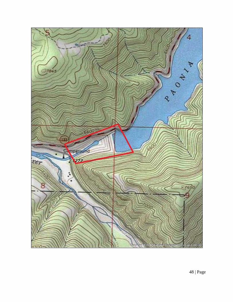
48 | Page

49 | Page
ATTACHMENT B – UNANTICIPATED DISCOVERY PLAN
PLAN AND PROCEDURES FOR THE UNANTICIPATED DISCOVERY OF CULTURAL RESOURCES
PAONIA DAM INTAKE STRUCTURE MODIFICATION PROJECT,
GUNNISON COUNTY, COLORADO
1. INTRODUCTION
The Bureau of Reclamation (Reclamation) and the North Fork Water Conservancy District (NFWCD) plan to stabilize the Paonia Dam Intake Structure (Project). The following Unanticipated Discovery Plan (UDP) outlines procedures to follow, in accordance with state and federal laws, if archaeological materials are discovered.
2. RECOGNIZING CULTURAL RESOURCES
A cultural resource discovery could be prehistoric or historic. Examples include, but are not limited to:
● An accumulation of shell, burned rocks, or other food related materials
● An area of charcoal or very dark stained soil with artifacts,
● Stone tools or waste flakes (i.e. an arrowhead, or stone chips),
● Clusters of tin cans or bottles, logging or agricultural equipment that appears to be older than 50 years,
● Buried railroad tracks, decking, or other industrial materials.
When in doubt, assume the material is a cultural resource. 3. ON-SITE RESPONSIBILITIES
STEP 1: STOP WORK. If any Reclamation/NFWCD employee, contractor or subcontractor believes that he or she has uncovered a cultural resource at any point in the project, all work adjacent to the discovery must stop. The discovery location should be secured at all times.
STEP 2: NOTIFY MONITOR. If there is an archaeological monitor for the project, notify that person. If there is a monitoring plan in place, the monitor will follow its provisions. If there is not an archaeological monitor, notify the project manager.
STEP 3: NOTIFY BUREAU OF RECLAMATION. Contact the Project Overseer at the Bureau of Reclamation:
50 | Page
Project Manager:
Reclamation Project Overseer:
Thomas Alvey 970-712-4030 [email protected]
Ernest Rheaume 970-385-6521 [email protected]
The Project Manager or the Reclamation Project Overseer will make all other calls and notifications.
If human remains are encountered, treat them with dignity and respect at all times. Cover the remains with a tarp or other materials (not soil or rocks) for temporary protection in place and to shield them from being photographed. Do not call 911 or speak with the media.
4. FURTHER CONTACTS AND CONSULTATION
A. Project Manager’s Responsibilities:
● Protect Find: The Reclamation / NFWCD Project Manager is responsible for taking appropriate steps to protect the discovery site. All work will stop in an area adequate to provide for the total security, protection, and integrity of the resource. Vehicles, equipment, and unauthorized personnel will not be permitted to traverse the discovery site. Work in the immediate area will not resume until treatment of the discovery has been completed following provisions for treating archaeological/cultural material as set forth in this document.
● Direct Construction Elsewhere On-site: The Reclamation / NFWCD Project Manager may direct construction away from cultural resources to work in other areas prior to contacting the concerned parties.
● Contact CR Manager: If there is a CR Program Manager, and that person has not yet been contacted, the Project Manager will do so.
● Contact Project Overseer: If the Project Overseer at the Bureau of Reclamation has not yet been contacted, the Project Manager will do so.
● Identify Find: The Project Manager will ensure that a qualified professional archaeologist examines the find to determine if it is archaeological.
o If it is determined not archaeological, work may proceed with no further delay.
o If it is determined to be archaeological, the Project Manager will continue with notification.

51 | Page
o If the find may be human remains or funerary objects, the Project Manager will ensure that a qualified physical anthropologist examines the find. If it is determined to be human remains, the procedure described in Section 5 will be followed.
B. Project Overseer’s Responsibilities
● Notify SHPO: The Project Overseer will notify the Colorado State Historic Preservation Office (SHPO).
Colorado State Historic Preservation Office: Mr. Steve Turner, AIA State Historic Preservation Officer Colorado Historical Society 1200 Broadway Denver CO, 80203 (303)-866-2776
C. Further Activities
● Archaeological discoveries will be documented as described in Section 6.
● Construction in the discovery area may resume as described in Section 7.
5. SPECIAL PROCEDURES FOR THE DISCOVERY OF HUMAN SKELETAL MATERIAL
Any human skeletal remains, regardless of antiquity or ethnic origin, will at all times be treated with dignity and respect. Because the project is a Federal undertaking, the provisions of the Native American Graves Protection and Repatriation Act of 1990 apply, and the Project Overseer will follow their provisions. If the project extends off of Federal lands, the requirements under State Law Colorado Revised Statute (CRS) 24-80 part 13 apply. If the remains are not modern, NAGPRA and ARPA apply if they are found to be Native American. ARPA and the Unmarked Human Graves Colorado Statute (CRS 24-80-1301-1305) apply if the human remains are Native American and/or determined to be of archaeological interest.
In the event possible human skeletal remains are discovered, Reclamation / NFWCD will comply with applicable state and federal laws, and the following procedure:
A. Notify Law Enforcement Agency or Coroner’s Office:
In addition to the actions described in Sections 3 and 4, the Project Manager will immediately notify the local law enforcement agency or coroner’s office.

52 | Page
The coroner (with assistance of law enforcement personnel) will determine if the remains are human, whether the discovery site constitutes a crime scene, and will notify SHPO.
Gunnison County Coroner (970)-641-9213
B. Further Activities:
When consultation and documentation activities are complete, construction in the discovery area may resume as described in Section 7.
6. DOCUMENTATION OF ARCHAEOLOGICAL MATERIALS
Archaeological deposits discovered during construction will be assumed eligible for inclusion in the National Register of Historic Places under Criterion D until a formal Determination of Eligibility is made.
The Project Manager will ensure the proper documentation and assessment of any discovered cultural resources in cooperation with the Bureau of Reclamation, SHPO, affected tribes, and a contracted consultant (if any). All prehistoric and historic cultural material discovered during project construction will be recorded by a professional archaeologist in accordance with all state and federal laws.
7. PROCEEDING WITH CONSTRUCTION
Project construction outside the discovery location may continue while documentation and assessment of the cultural resources proceed. A professional archaeologist must determine the boundaries of the discovery location. In consultation with SHPO and affected tribes, the Project Manager and Project Overseer will determine the appropriate level of documentation and treatment of the resource.
Construction may continue at the discovery location only after the process outlined in this plan is followed and Reclamation has determined that compliance with state and federal laws is complete.