environmental assessment for the proposed sbinet ajo … · tca-ajo-189 is located within cabeza...
TRANSCRIPT

ENVIRONMENTAL ASSESSMENTFOR THE PROPOSED SBINET AJO-1 TOWER PROJECT
AJO STATION’S AREA OF RESPONSIBILITYU.S. BORDER PATROL,
TUCSON SECTOR
U.S. Department of Homeland SecurityU.S. Customs and Border Protection
SBInet
December 2009
ENVIRONMENTAL ASSESSMENT
FINAL


FINDING OF NO SIGNIFICANT IMPACT Environmental Assessment
for the Proposed SBInet Ajo-1 Tower Project Ajo Station’s Area of Responsibility
U.S. Border Patrol, Tucson Sector, Arizona
FONSI - 1
PROJECT HISTORY: The following description of the project history is incorporated by reference from the Environmental Assessment for the Proposed SBInet Ajo-1 Tower Project Ajo Station’s Area of Responsibility, U.S. Border Patrol Tucson Sector. TheSecure Border Initiative (SBI) is a comprehensive, multi-year plan established by the Department of Homeland Security (DHS) in November 2005 to secure America’s borders and reduce illegal immigration. SBI was created to bring clarity of mission, effective coordination of DHS assets, and greater accountability in securing the Nation’s borders. The SBI mission is to promote border security strategies that protect against and prevent terrorist attacks and other transnational crimes. Additionally, SBI will coordinate DHS efforts to ensure the legal entry and exit of people and goods moving across our borders, and improve the enforcement of immigration, customs, and agriculture laws at our borders, within the country, and abroad.
SBInet is the component of SBI charged with developing and installing technology and attendant tactical infrastructure (TI) solutions to help United States (U.S.) Customs and Border Protection (CBP) gain effective control of our Nation’s borders. The goal of SBInet is to field the most effective, proven technology and response platforms, and integrate them into a single, comprehensive border security system for DHS. CBP is the agent for SBInet, carrying out the program to better execute this vital mission.
CBP implements the National Border Patrol Strategy with the goal of establishing and maintaining effective control of the borders. The U.S. Border Patrol (USBP) maximizes border security with an appropriate balance of personnel, technology, and infrastructure.Effective control exists when CBP is consistently able to: (1) detect illegal entries into the U.S. when they occur; (2) identify the entry and classify its level of threat; (3) efficiently and effectively respond to these entries; and, (4) bring each event to an appropriate law enforcement resolution.
This Environmental Assessment (EA) was prepared in compliance with provisions of the National Environmental Policy Act (NEPA) of 1969 as amended (42 U.S. Code [U.S.C.] 4332 et seq.), the Council on Environmental Quality’s (CEQ) NEPA implementing regulations at 40 Code of Federal Regulations (CFR) Part 1500, and the DHS Management Directive 023-01, Environmental Planning Program (71 Federal Register [FR] 16790).
The EA analyzes various aspects of a proposed project that would be carried out under SBI and be implemented as a part of the SBInet program. It addresses the potential direct and indirect effects, beneficial and adverse, of the proposed construction, operation, and maintenance of 10 sensor and communication towers, which creates a communications network in support of a Common Operating Picture (COP) among components of CBP and other Federal, state, and local partners outside CBP. Further, it analyzes the construction of access roads; construction of a new road; repair and improvement of authorized roads; repair and improvements to an authorized corridor;

FINDING OF NO SIGNIFICANT IMPACT Environmental Assessment
for the Proposed SBInet Ajo-1 Tower Project Ajo Station’s Area of Responsibility
U.S. Border Patrol, Tucson Sector, Arizona
FONSI - 2
maintenance of authorized roads and a corridor; deployment of two towers with the use of a helicopter; deployment and maintenance of remote sensors; relocation and operation of a forward operating base (FOB); and implementation of conservation measures to avoid, minimize, and offset effects to protected species and other Department of the Interior (DOI) trust resources within the USBP, Tucson Sector, Arizona.
PROJECT LOCATION: The affected area for this EA covers approximately 517 square miles of southwest Arizona in the area between Why and Lukeville, Arizona and approximately 30 linear miles of U.S. border. All activities included as part of the Proposed Action are within Pima County.
PURPOSE AND NEED: The purpose of the proposed project is to improve CBP’s efficiency and probability of detection, identification, and apprehension of cross border violators (CBV). Achieving effective control of the borders of the U.S is a key mission of CBP. The objective of this SBInet project is to maximize surveillance along approximately 30 linear miles of U.S. border within Organ Pipe Cactus National Monument (OPCNM) in the USBP Tucson Sector. Meeting this purpose would provide more efficient and effective interdiction while reducing impacts to the natural environment in the Ajo Station’s area of responsibility.
The frequency and nature of illegal cross border activities and the geographic area over which these activities occur, create a need for a technology-based solution that can effectively collect, resolve, and distribute the information among CBP agents. The SBInet system is expected to allow CBP to spend less time locating CBVs and focus efforts on interdiction of those involved in illegal cross border activities.
This SBInet Ajo-1 Tower Project is needed to: 1) provide more efficient and effective means of assessing border activities;2) provide rapid detection and accurate characterization of potential threats (e.g.,
illegal aliens [IA], smugglers and other CBVs); 3) provide coordinated deployment of resources in the apprehension of CBVs; 4) reduce crime in border communities and improve the quality of life and
economic vitality of border regions through provision of the tools necessary for effective law enforcement; and
5) increase surveillance and interdiction efficiency, reduce environmental impacts, and enhance restoration efforts.
ALTERNATIVES: Nine alternatives were identified and considered during the planning stages of the proposed project. However, only the No Action Alternative and Proposed Action were carried forward for analysis in the EA. Other alternatives considered but rejected and not further analyzed in this EA were the use of:

FINDING OF NO SIGNIFICANT IMPACT Environmental Assessment
for the Proposed SBInet Ajo-1 Tower Project Ajo Station’s Area of Responsibility
U.S. Border Patrol, Tucson Sector, Arizona
FONSI - 3
Unmanned aircraft systems; Remote sensing satellites; Unattended ground sensor; Increased CBP workforce; and Increased aerial reconnaissance/operations.
No Action Alternative: The No Action Alternative describes future circumstances if the proposed tower construction does not take place, and can be characterized as the continuation of current practices and procedures. While the No Action Alternative does not satisfy the stated purpose and need, its inclusion in this EA is required by NEPA regulations as a basis of comparison to the anticipated effects of the proposed action.
Proposed Action: The Proposed Action includes the construction, operation, and maintenance of 10 sensor and communication towers, which creates a communications network in support of a COP among components of CBP and other Federal, state, and local partners outside CBP. The Proposed Action also includes the construction of seven access roads (0.07 linear mile); construction of a new road to proposed tower site TCA-AJO-310 (1.2 linear miles); repair of four authorized roads (3.9 linear miles); improvement of four authorized roads (0.22 linear mile); improvements of an authorized corridor (1.7 linear miles); repair of an authorized corridor (4.4 linear miles); maintenance of access and approach roads (38.2 linear miles); deployment of two towers with the use of a helicopter (TCA-AJO-189 and 204); deployment and maintenance of remote sensors; relocation and operation of a FOB; and implementation of conservation measures to avoid, minimize, and offset effects to protected species and other DOI trust resources.
In general, a typical new tower in the SBInet Ajo-1 Tower project would:
be 30 to 180 feet high; have a permanent tower site footprint of 14- x 14-foot, 50- x 50-foot, or 80- x 80-
foot depending on type of tower structure; have a temporary construction buffer of 35- x 35-foot or 100- x 100-foot; have an equipment shelter with an approximately 8-foot X 12-foot footprint; have perimeter fencing; not have guy wires; and consist of one of the three power systems: commercial grid power, where
available; hybrid propane-solar generator system and a 1,000-gallon propane fuel tank; or a solar panel.
Three types of tower structures are proposed for this project: self standing towers (SST), rapidly deployed towers (RDT), and a remote access tower (RAT). A RAT is designed for remote sites that have limited or no access by standard wheeled vehicles and their

FINDING OF NO SIGNIFICANT IMPACT Environmental Assessment
for the Proposed SBInet Ajo-1 Tower Project Ajo Station’s Area of Responsibility
U.S. Border Patrol, Tucson Sector, Arizona
FONSI - 4
construction would require helicopter deployment. RDTs and RATs are temporary structures than can be disassembled and relocated, as necessary.
Access roads would need to be improved or constructed in order to install, operate, and maintain the proposed SSTs and RDTs. Access roads would be short road segments from authorized roads to the tower site. The access roads would be constructed to provide a 12-foot wide driving surface with 2-foot wide shoulders on each side (16 feet total). Road and corridor repair would include minor grading, leveling, and installation of nuisance drainage structures, while road and corridor improvements would include reconstruction of the existing road, and installation of major drainage structures.
As part of the Proposed Action, the towers would require bi-monthly maintenance, although some communication towers and those towers connected to commercial grid power may require less maintenance visits. This necessitates vehicle travel to each of the proposed tower sites for propane delivery, maintenance, and operations of the towers. However, RAT (TCA-AJO-189 and 204) towers would require maintenance four times per year and one RAT tower (TCA-AJO-189) would require helicopter lifts for maintenance personnel access.
The USBP Ajo Station currently maintains and operates a FOB on OPCNM at the Bates Well historic site. FOBs allow the USBP to forward deploy agents closer to the U.S border for the purpose of detecting and responding to IA, smuggler, and CBV activities. This forward deployment decreases travel and response time to CBV activities. The USBP proposes to move the FOB at Bates Well to a 1-acre site near proposed tower site TCA-AJO-302 and disassemble the existing FOB infrastructure at Bates Well historic site.
ENVIRONMENTAL CONSEQUENCES: Implementation of the Proposed Action would permanently affect 18.8 acres for the construction of all towers and roads, road repairs and improvements, and relocation of the FOB. Of this, 15.8 acres have been previously disturbed (i.e., only 3 acres of new ground disturbance). Additionally, approximately 6.5 acres would be temporarily disturbed during construction activities. The proposed project has been thoroughly coordinated with National Park Service (NPS), U.S. Fish and Wildlife Service (USFWS), and Bureau of Land management (BLM) and these land management agencies are cooperating agencies for the proposed project. The issuance of special use permits and right-of-way grants would be required from these land management agencies for the construction of the proposed project.
The Proposed Action would require the conversion of 18.8 acres of NPS, USFWS, BLM, and Arizona State Trust Lands primarily for CBP enforcement and would have a long-term, negligible impact on land use. Although none of the towers are located in designated wilderness on OPCNM, the towers would be readily visible from adjacent Organ Pipe Cactus Wilderness and Cabeza Prieta Wilderness. Further, proposed tower TCA-AJO-189 is located within Cabeza Prieta Wilderness and would be readily visible

FINDING OF NO SIGNIFICANT IMPACT Environmental Assessment
for the Proposed SBInet Ajo-1 Tower Project Ajo Station’s Area of Responsibility
U.S. Border Patrol, Tucson Sector, Arizona
FONSI - 5
from Cabeza Prieta Wilderness and Organ Pipe Cactus Wilderness. The towers’ generators would also be audible at a level of 35 dBA at a distance of 492 feet, thus affecting a portion of the designated wilderness areas. The generators would not operate continuously. The Proposed Action would also adversely affect other wilderness characteristics such as a sense of solitude and unconfined recreation. Adverse effects on designated wilderness characteristics would be localized and the Proposed Action would have a long-term, moderate adverse effect on designated wilderness. However, the Proposed Action would have an indirect beneficial impact on land use, including designated wilderness, as a result of enhanced detection capabilities, improved interdiction capabilities, increased deterrence of cross-border violators, and a reduced enforcement footprint for interdiction activities. Implementation of the Proposed Action is also expected to result in the long-term benefit of allowing OPCNM to reopen areas that are currently closed due to high CBV traffic.
The proposed construction of towers and roads and repair and improvement of roads would have a long-term, moderate adverse effect on soils, and long-term, minor adverse effects on floodplains as a result of increased erosion and sedimentation. Potential effects on hydrology and groundwater would be short-term and minor. Tower and road construction would have both short-term and long-term minor to moderate impacts on surface waters as a result of sedimentation. A total of 69 potential Waters of the U.S. would be impacted as a result of the proposed project. Construction and other road improvements within these washes are authorized under a Nationwide Permit 14. The permanent loss of approximately 3 acres of vegetation would have a long-term, minor adverse effect on the total amount of similar Sonoran Desert vegetation on Cabeza Prieta National Wildlife Refuge (CPNWR) and BLM lands, and vegetation types on OPCNM. Loss of habitat and disturbance from construction activities and tower operations would have a long-term, minor adverse effect on wildlife. Additionally, the Proposed Action would have negligible to minor impacts on air quality, roadways and traffic, radio frequency, and utilities and infrastructure. Impacts to cultural resources would be minor from the implementation of the Proposed Action. Construction of the proposed towers and roads would have a long-term, moderate adverse effect on aesthetics.
Seven proposed tower sites are located within the current range of Sonoran pronghorn (Antilocarpa americana sonoriensis) and all towers are located with foraging habitat for lesser long-nosed bat (Leptonycteris curasoae yerbabuenae), both Federally endangered species. CBP has determined the proposed project may affect and is likely to adversely affect Sonoran pronghorn, lesser long-nosed bat, and desert pupfish (Cyprinodon macularius). However, the proposed project would have a long-term, indirect beneficial affect on vegetation communities used by Sonoran pronghorn and lesser long-nosed bat through the reduction in IA, smuggler, and other CBV traffic. Additionally, the relocation of the FOB would move the existing Bates Well site from a narrow migration corridor use by Sonoran pronghorn. This would allow Sonoran

FINDING OF NO SIGNIFICANT IMPACT Environmental Assessment
for the Proposed SBInet Ajo-1 Tower Project Ajo Station’s Area of Responsibility
U.S. Border Patrol, Tucson Sector, Arizona
FONSI - 6
pronghorn unimpeded movement into habitat historically used by Sonoran pronghorn and result in a permanent, indirect beneficial effect on Sonoran pronghorn. Further, conservation measures to be implemented as part of the Proposed Action would have a beneficial effect on the recovery of Sonoran pronghorn and restoration of its habitat.
Noise generated by heavy construction equipment and helicopters would be intermittent and last up to 8 weeks to excavate and prepare the foundation to install each tower, after which, noise levels would return to pre-construction levels. Noise impacts from construction activities would be temporary and minor. Noise generated by generators and air-conditioning associated with the operation of the proposed towers, with the exception of tower TCA-AJO-189, would have a long-term, moderate impact to the noise environment, including designated wilderness. Adverse impacts associated with the operations of the proposed project would be localized to the tower sites.
The proposed project would result in overall beneficial impacts within the region through a reduction in illegal activities and the resulting decreased human activity in sensitive areas such as designated wilderness and protected species habitat. A reduction in illegal activities and resulting law enforcement efforts would reduce adverse impacts to the natural and human environment and allow currently disturbed areas to rehabilitate through natural processes or management efforts. In addition, areas within OPCNM that are currently closed due to CBV activity could be reopened upon completion of the Proposed Action and a reduction in CBV activity. Long-term, minor benefits to socioeconomics could occur as a result of propane purchase for generators. No significant adverse effects to the natural or human environment, as defined in 40 CFR Section 1508.27 of the CEQ’s Regulations for Implementing NEPA, are expected upon implementation of the Proposed Action.
OFFSETTING MEASURES: Through coordination with NPS, USFWS and BLM, and as part of formal Section 7 consultation pursuant to the ESA, the following offsetting measures were identified and are included as part of USFWS’s Biological Opinion for the SBInet Ajo-1 Tower Project. These measures were developed to offset potential impacts to Sonoran pronghorn and lesser long-nosed bat resulting from implementation of the Proposed Action.
Offsetting Measures for Sonoran Pronghorn 1) Unauthorized Vehicle Route (UVR) Assessment and Restoration
a. UVR ASSESSMENT: SBInet will provide $200,000 to DOI by the initiation of the SBInet Ajo-1 Tower Project construction to assess and map the number and extent of unauthorized, repetitively used vehicle routes (UVR) in Sonoran pronghorn habitat or potential habitat on CPNWR, OPCNM, and BLM lands within the Ajo-1 project area. This assessment will locate, record, and map UVR occurrences throughout pronghorn habitat within the project area. The

FINDING OF NO SIGNIFICANT IMPACT Environmental Assessment
for the Proposed SBInet Ajo-1 Tower Project Ajo Station’s Area of Responsibility
U.S. Border Patrol, Tucson Sector, Arizona
FONSI - 7
assessment will also quantify UVR dimensions and severity as well as determine restoration potential and needs. The assessment will be conducted by DOI in years one and two (from the initiation of project construction). Additionally, CBP and DOI will investigate the possibility of using existing remote sensing technology to supplement or replace a portion of SBInet’s funding for this assessment. Further, CBP and DOI will work together to improve the reporting of off-road incursions that occur within Sonoran pronghorn habitat and wilderness.
b. UVR CLOSURE AND RESTORATION: SBInet will provide funding to DOI to close and restore UVRs documented as a result the UVR assessment. DOI will prioritize areas to close and restore based on importance of the areas to Sonoran pronghorn and on CBP information regarding anticipated continued use of UVRs (i.e., UVRs that will likely continue to be used by USBP due to emergency and exigent circumstances will receive a lower restoration priority as restoration in continuously used areas will not likely be successful). DOI will conduct the restoration work between years 2 through 5 (from the initiation of project construction) or beyond, depending on the feasibility of restoration determined by the land management agencies. Total Funding: $1,750,000
c. UVR REASSESSMENT: CBP and DOI will cooperatively reassess the issue of UVRs within Sonoran pronghorn habitat and wilderness after 5 years (2014) and will resume discussions concerning evaluation of success of these efforts.
2) Vehicular use of the pole-line road (TCA-AJO-170) will continue to be only for exigent circumstances as per the 2006 Memorandum of Understanding (MOU). Routine patrols will occur along State Route 85 (SR 85). Additionally, a horse staging area will be established outside of wilderness in the 66 Hills/Alamo Canyon wash area of OPCNM. DOI will work with CBP to establish this horse staging area, the exact size and location of which, along with any associated infrastructure, will be mutually agreed upon in writing prior to its establishment. The intent of this horse staging area is to support CBP horse patrol operations in and around the Valley of the Ajo. Every effort will be made to limit the overall area of disturbance while maximizing safety and the adequacy of the site towards meeting its intended purpose.
3) Consistent with 2006 MOU, USBP will conduct patrol activities by horseback to the greatest extent practicable within the Sonoran pronghorn range, particularly from March 15 to July 31 (the Sonoran pronghorn closure season). DHS will follow all horse patrol BMPs coordinated with resource agencies (i.e., feed horses weed free pellets).

FINDING OF NO SIGNIFICANT IMPACT Environmental Assessment
for the Proposed SBInet Ajo-1 Tower Project Ajo Station’s Area of Responsibility
U.S. Border Patrol, Tucson Sector, Arizona
FONSI - 8
4) CBP will fund a portion of Arizona Game and Fish Department (AGFD) Sonoran pronghorn aerial monitoring efforts for 5 years. Funding will be provided for one full-time employee for 5 years, the purchase of collars and collaring costs for five Sonoran pronghorn, and 100 tracking flights (20 per year for 5 years). Total Funding: $346,000.
5) CBP will contract for cultural surveys at two proposed forage enhancement sites for Sonoran pronghorn on BLM lands. One site is located at UTM 0320443 x 3564606 and the second is located at Cameron Tank. The sites are approximately 12 acres each. Total Cost: $17,000.
6) CBP will provide funding for three full-time personnel (1 at $70,000 per year for 4 years [USFWS will fund the 5th and final year] and two at $60,000 per year for 5 years) to: 1) monitor the effects of human activities on Sonoran pronghorn; 2) conduct surveys for and monitoring of Sonoran pronghorn; and 3) implement other Sonoran pronghorn recovery activities. Employees will implement the aforementioned activities within the project area. CBP will also provide funding for Sonoran pronghorn recovery projects (i.e., collars and collaring costs for 25 pen raised Sonoran pronghorn ($137,000), three water tanks ($60,000), and one forage enhancement plot ($215,000). Total Funding: $1,292,000.
7) CBP will provide funding ($20,000) to move pronghorn back into the Valley of the Ajo if they do not move on their own within 3 years (by September 2012). Total Funding: $20,000.
8) CBP will provide funding to assist with the establishment of a second Arizona Sonoran pronghorn population in southern Arizona. Funding will be for purchase of pen materials and construction, transport of Sonoran pronghorn from CPNWR (from captive breeding pen) to the identified second population area, and other establishment projects needs as determined by the Sonoran Pronghorn Recovery Team. Total Funding: $470,000.
9) CBP will provide funding to AGFD to conduct weekly aerial surveys for Sonoran pronghorn throughout the fawning season of 2010. AGFD will conduct aerial surveys to assist CBP monitor Sonoran pronghorn at sites where project work will be conducted during the fawning season. Total Funding: $14,000 (plus USFWS or National Fish and Wildlife Foundation [NFWF]).
10) CBP will provide funding to OPCNM to develop and operate five temporary/emergency food and water plots for Sonoran pronghorn for 6 months. The purpose of these plots is to lure pronghorn away from tower sites and to buffer effects of disturbance on Sonoran pronghorn. If range conditions are

FINDING OF NO SIGNIFICANT IMPACT Environmental Assessment
for the Proposed SBInet Ajo-1 Tower Project Ajo Station’s Area of Responsibility
U.S. Border Patrol, Tucson Sector, Arizona
FONSI - 9
determined by the Sonoran Pronghorn Recovery Team to be good, these measures would not be necessary. Cost Estimate: $1,000 per site ($5,000 total) and $18,000 for one GS-5 employee for 6 months. Total Funding: $23,000 (plus USFWS or NFWF overhead).
Lesser Long-nosed Bat
1) CBP will provide funding for monitoring Copper Mountain and Bluebird Mine lesser long-nosed bat maternity roosts. Total Funding: $35,000 (3,500 for each site for 5 years.
2) CBP will provide funding for a study to identify unknown roosts and to determine roost occupancy patterns of all roosts in the Action Area. Total Funding: $140,000 ($70,000 per year for two years).
3) CBP will develop and implement a monitoring plan and program to document and assess tower related mortality of lesser long-nosed bats beginning once tower construction is completed (this will likely correspond to the 2010 lesser long-nosed bat season) and continuing 5 years after the towers are fully operational. Monitoring will be conducted at an appropriate sample of tower sites where it does not conflict with Sonoran pronghorn conservation measures; these sites will be determined by USFWS and the land management agencies. The monitoring plan will be developed with and approved by USFWS and the land management agencies before construction is completed. If lesser long-nosed bat mortality is documented at tower sites, CBP shall a) notify USFWS and the land management agencies in writing (via electronic mail) within 48 hours, b) work with USFWS and the land management agencies to develop site-specific measures to reduce bat mortality, and c) continue monitoring beyond the 5 years until project related mortality and injury is reduced as described below. CBP will, in coordination with USFWS, use information gained from monitoring to develop tower retrofits to reduce lesser long-nosed bat mortality and injury, if collisions are documented, and incorporate the bat mortality and injury monitoring associated with the Proposed Action into an annual report for a minimum of 5 years. If no take is documented, as stated above, monitoring will no longer be required 5 years after the towers are operational. If take occurs at or below authorized levels within year 1 through 3, DHS will implement measures to reduce mortality and injury the same year take is documented and will continue to monitor until the end of the original 5-year period. If take occurs during year 4 or 5, DHS will implement measures to reduce mortality the same year take is documented and will continue to monitor for 2 years after the take is documented and measures implemented. If at any point, take exceeds the amount anticipated in this Biological Opinion, DHS shall reinitiate formal consultation as stated in the Reinitiation Notice in USFWS’s Biological Opinion.

FINDING OF NO SIGNIFICANT IMPACT Environmental Assessment
for the Proposed SBInet Ajo-1 Tower Project Ajo Station’s Area of Responsibility
U.S. Border Patrol, Tucson Sector, Arizona
FONSI - 10
MITIGATION: Measures to avoid, minimize, or mitigate potential impacts to natural and cultural resources were identified in Section 5 of the EA. Many of the best management practices (BMP) detailed in the EA have been incorporated as standard operating procedures by CBP in similar past projects and will be included as requirements in construction contracts associated with the SBInet Ajo-1 project. Additionally, project specific BMPs were developed through coordination with NPS, USFWS, and BLM to avoid or minimize impacts to trust resources managed by these agencies. The following project specific management and mitigation measures are incorporated from the EA and are incorporated to this FONSI.
Project Planning/Design – Communication Towers
The following measures were adapted from the Interim Guidance on Siting, Construction, Operation, and Decommissioning of Communication Towers (USFWS 2000).
CBP will minimize bird perching and nesting opportunities for new towers.
CBP will not site towers in or near wetlands, other known bird concentration areas (e.g., state or Federal refuges, staging areas, rookeries), in known migratory or daily movement flyways, or in habitat of threatened or endangered species. If this is not an option, mitigation will be required.
Where CBP will be constructing taller (>199 feet above ground level) towers requiring lights for aviation safety, the minimum amount of pilot warning lights and obstruction avoidance lighting required by the Federal Aviation Administration (FAA) will be used (FAA 2000). Unless otherwise required by the FAA, CBP will use only white (preferable) or red strobe lights at night, and these will be the minimum number, minimum intensity, and minimum number of flashes per minute (longest duration between flashes) allowable by the FAA. CBP will not use solid red or pulsating red warning lights at night.
CBP will not use tower designs that require guy wires for tower support to reduce the probability of bird and bat collisions.
CBP will use security lighting for on-ground facilities and equipment that is down-shielded to keep light within the boundaries of the site.
CBP will site, design, and construct towers and appendant elements to avoid or minimize habitat loss within and adjacent to the tower “footprint.” CBP will minimize road access and fencing to reduce or prevent habitat fragmentation and disturbance, and to reduce above-ground obstacles to birds in flight.
Where feasible, CBP will place electric power lines underground or on the surface as insulated, shielded wire to avoid electrocution of birds and bats. CBP will use recommendations of the Avian Power Line Interaction Committee (APLIC

FINDING OF NO SIGNIFICANT IMPACT Environmental Assessment
for the Proposed SBInet Ajo-1 Tower Project Ajo Station’s Area of Responsibility
U.S. Border Patrol, Tucson Sector, Arizona
FONSI - 11
[1994, 1996]) for any required above-ground lines, transformers, or conductors. CBP will use raptor protective devices on above ground wires.
For upgrading towers, CBP will follow the guidelines for new construction as closely as possible. CBP will retro-fit sites with high bird or bat mortality.
Once CBP has determined that towers are no longer needed, CBP will remove them within 12 months. CBP will restore footprint of towers and associated facilities to natural habitat.
Wildlife Resources
The Migratory Bird Treaty Act (16 U.S.C. 703-712, [1918, as amended 1936, 1960, 1968, 1969, 1974, 1978, 1986 and 1989]) requires that Federal agencies coordinate with the USFWS if a construction activity would result in the take of a migratory bird. If construction or clearing activities are scheduled during nesting seasons (February 15 through August 31); surveys will be performed to identify active nests. If construction activities will result in the take of a migratory bird; then CBP will coordinate with the USFWS and AGFD and applicable permits would be obtained prior to construction or clearing activities. Another mitigation measure that would be considered is to schedule all construction activities outside nesting seasons negating the requirement for nesting bird surveys. The proposed sensor and communication towers would also comply with USFWS guidelines for reducing fatal bird strikes on communication towers (USFWS 2000) to the greatest extent practicable. Guidelines recommend co-locating new antennae arrays on existing towers whenever possible and to build towers as short as possible, without guy wires or lighting, and to use white strobe lights whenever lights are necessary for aviation safety. CBP will use the most recent bird and bat strike avoidance guidance during tower design.
Towers, light poles, and other pole-like structures will be designed and constructed to discourage roosting and nesting by birds, particularly ravens or other raptors that may use the poles for hunting perches. Tubular supports with pointed tops will be used rather than lattice supports to minimize bird perching and nesting opportunities. Tower designs will avoid placing external ladders and platforms on tubular towers to minimize perching and nesting.
To prevent entrapment of wildlife species during construction, CBP will cover all excavated, steep-walled holes or trenches more than 2 feet deep at the end of each working day with plywood or provide these holes with escape ramps of earth fill or wooden planks. Ramps will be located at no less than 1,000 feet apart and provide slopes less than 45 degrees. Biological monitors will thoroughly inspect all holes and trenches for trapped animals, and if animals are present, no construction can resume until the animals are out of the pit or trench.
FINDING OF NO SIGNIFICANT IMPACT Environmental Assessment
for the Proposed SBInet Ajo-1 Tower Project Ajo Station’s Area of Responsibility
U.S. Border Patrol, Tucson Sector, Arizona
FONSI - 12
No more than 10 percent of vegetation will be removed from suitable nesting or migration habitat or reduce it to less than 10 acres in size. CBP will avoid the removal of dense understory or midstory vegetation from breeding and migration habitat to the extent possible.
Biological monitors will check under construction equipment for wildlife species (e.g., desert tortoise) prior to moving equipment that has sat idle for more than 1 hour.
Protected Species
CBP will minimize impacts to listed species and their habitats by adhering to the standard BMPs detailed in Section 5 of the EA and will further implement the following species specific measures to avoid, minimize, or mitigate potential impacts.
Lesser Long-nosed Bat
If results of the Ajo-1 lesser long-nosed bat telemetry study or the Tucson-West Tower Project bat and bird monitoring studies indicate that towers result in significant disturbance to bats or birds, with the guidance of USFWS and the land management agencies, CBP will modify and update bird and bat strike avoidance equipment on the Ajo-1 towers and implement techniques that reduce the disturbance to birds and bats.
CBP will avoid disturbing areas containing columnar cacti (saguaro, organ pipe, senita) or agaves to the extent reasonable. If they cannot be avoided, columnar cacti and agaves will be salvaged and transplanted. When salvage is not possible, columnar cacti and agaves will be purchased and planted at a 3:1 ratio. Salvage, transplantation, and container planting will be done in accordance with a restoration plan, approved by the land manager and USFWS, that includes success criteria and monitoring.
CBP will avoid construction and maintenance activities within 4 miles of lesser long-nosed bat roosts between May 1 and September 30.
CBP will avoid entering lesser long-nosed bat maternity roosts (except in emergency/exigent circumstances).
Sonoran Pronghorn
CBP will minimize to the greatest extent possible the number of roads, detection and communication towers, and other infrastructure in Sonoran pronghorn habitat, particularly in movement corridors and areas important to Sonoran pronghorn during the fawning season (March 15 to July 31).

FINDING OF NO SIGNIFICANT IMPACT Environmental Assessment
for the Proposed SBInet Ajo-1 Tower Project Ajo Station’s Area of Responsibility
U.S. Border Patrol, Tucson Sector, Arizona
FONSI - 13
CBP will minimize the number of construction and maintenance trips to all tower sites, particularly those in important Sonoran pronghorn areas.
CBP will provide for an on-site biological monitor to be present during work activities for all construction activities in Sonoran pronghorn and lesser long-nosed bat habitats. At a time interval (i.e., daily, weekly) determined by the land management agency, the monitor will check in and out of the land management unit (with the land manager or his/her representative). The biological monitor will have the following duties: ensure and document that agreed upon BMPs (both those relating to construction and protection of individuals of Sonoran pronghorn and lesser long-nosed bat on or adjacent to the project site) are properly implemented. The monitor will use a daily BMPs monitoring checklist. The monitor will additionally ensure a copy of this information as well as a weekly summary report is sent via electronic mail to the DOI land managers and USFWS Arizona Ecological Services Office (AESO) every Friday. The biological monitor will notify the construction manager who has the authority to temporarily suspend activities not in compliance with all agreed upon BMPs. This authority will be provided to the biological monitor by the construction manager during worker orientation training. The biological monitor will be notified 5 days in advance of any ground-breaking activity.
CBP will ensure a qualified Sonoran pronghorn monitor is on-site during tower construction (and maintenance where specified) in Sonoran pronghorn habitat. Land management agencies within Sonoran pronghorn habitat and USFWS-AESO will work with DHS to define “qualified Sonoran pronghorn monitor”. DOI will develop Sonoran pronghorn monitoring and communication protocols for each tower site and provide them to CBP; protocols may vary among tower sites depending on various factors including the location of the tower in relation to Sonoran pronghorn use and time period (i.e., within or outside of the fawning season). Unless otherwise detailed in the tower-specific protocols, before any construction work commences in Sonoran pronghorn habitat, the monitor will conduct hilltop surveys (visual and telemetry, if appropriate) for Sonoran pronghorn at sunrise in close coordination with land managers and AGFD. If Sonoran pronghorn are detected within 2 miles of proposed daily project activities, no construction work will begin until Sonoran pronghorn move on their own volition to a distance greater than 2 miles from the activities (note: monitoring method and buffer distance is project specific; 2 miles is for tower construction, see criteria for project maintenance below). The Sonoran pronghorn monitoring protocols will include procedures to be followed if and when Sonoran pronghorn are detected within the 2-mile radius around work activities, including CBP Sonoran pronghorn monitor communications with DOI land manager, cessation of construction, and egress from the construction site. Additionally, the protocol will require the Sonoran pronghorn monitor to contact AGFD on a weekly basis to obtain the results of the telemetry surveys (note these are different than fawning season aerial surveys) and use the information to aid in weekly monitoring. A communication protocol regarding these surveys will be

FINDING OF NO SIGNIFICANT IMPACT Environmental Assessment
for the Proposed SBInet Ajo-1 Tower Project Ajo Station’s Area of Responsibility
U.S. Border Patrol, Tucson Sector, Arizona
FONSI - 14
developed as part of the overall monitoring protocol. Daily Sonoran pronghorn monitoring reports will be provided (electronically mailed) to USFWS and DOI land managers on a weekly basis (due the following Monday). Sonoran pronghorn detections (with coordinates and time of detection) will be reported by electronic mail or phone call to the land managers with 24 hours of the detection. CBP and their environmental monitors, DOI, and AGFD will meet at least two weeks prior to the initiation of any tower construction activities to discuss Sonoran pronghorn monitoring protocols.
DOI will develop a protocol that will include procedures to be followed if and when Sonoran pronghorn are detected within a 1-mile radius around maintenance activities, including CBP Sonoran pronghorn monitor communications with DOI land manager, cessation of maintenance, and egress from the maintenance site. Unless otherwise detailed in the aforementioned protocol, for project maintenance and maintenance access, CBP and their contractors will cease all work that may disturb a Sonoran pronghorn if one is seen within 1 mile of the project site or any access road to the site. For vehicle operations, this entails stopping the vehicle until the animal moves away on its own volition. Vehicles may then continue on at no more than 15 miles per hour. Maintenance crews and personnel in vehicles will wait up to 3 hours from the initial sighting from the animal to move beyond 1 mile. If the animal has not moved the required distance, all personnel will retreat back away from the animal. CBP will ensure all maintenance-related personnel are trained to identify Sonoran pronghorn. CBP will report pronghorn detections (with coordinates and time of detection) by electronic mail or phone call to land managers within 24 hours of the detection.
For sensor payload installation and tower testing during the Sonoran pronghorn fawning season, CBP will conduct Sonoran pronghorn monitoring at all tower sites in Sonoran pronghorn habitat per the USFWS Biological Opinion. However, during sensor payload installation and testing during the fawning season at towers TCA-AJO-302 and 003, CBP will provide two monitors. During sensor payload installation and testing during the fawning season at other towers in Sonoran pronghorn habitat, CBP will provide a minimum of one and up to two monitors, depending on whether or not Sonoran pronghorn are detected by aerial surveys. During the testing phase only, Sonoran pronghorn monitors could also serve as environmental monitors.
Apart from site security, sensor payload installation, tower, testing, and maintenance, CBP will avoid Ajo-1 Tower Project work activities from March 15 to July 31 (i.e., the Sonoran pronghorn fawning season) in Sonoran pronghorn habitat (towers TCA-AJO-301 and 310 are outside of Sonoran pronghorn habitat). Sensor payload installation will be conducted on towers TCA-AJO-302 and 003 prior to March 15. CBP will also make every attempt possible to complete sensor payload installation and testing of other towers in Sonoran pronghorn habitat prior to March 15.
FINDING OF NO SIGNIFICANT IMPACT Environmental Assessment
for the Proposed SBInet Ajo-1 Tower Project Ajo Station’s Area of Responsibility
U.S. Border Patrol, Tucson Sector, Arizona
FONSI - 15
CBP will place restrictions on construction vehicle activity during the Sonoran pronghorn fawning season (March 15 to July 31) to avoid disturbance to females and fawns.
CBP will minimize animal collisions, particularly with Sonoran pronghorn, by not exceeding construction and maintenance speed limits of 25 miles per hour on all unpaved roads.
CBP and contractors will significantly minimize the level of construction and maintenance noise of tower project within Sonoran pronghorn and lesser long-nosed bat habitat. If helicopters must be used, CBP will work with USFWS and the land manager(s) to ensure measures are implemented to significantly minimize the potential for the maintenance work/access to result in adverse effects to Sonoran pronghorn (e.g., access the site outside of the Sonoran pronghorn closure period, and before any work commences in Sonoran pronghorn habitat, a qualified Sonoran pronghorn monitor will conduct hilltop surveys [visual and telemetry, if appropriate] for Sonoran pronghorn at sunrise in close coordination with land managers). If Sonoran pronghorn are detected within 2 miles of maintenance and maintenance access activities that require helicopters, no work will begin until Sonoran pronghorn move on their own volition to a distance greater than 2 miles from the activities. Hilltop surveys will be required if helicopters are to be used for maintenance activities. If helicopters are not used for maintenance, hilltop surveys are not required and the distance restriction will be reduced to 1 mile.
CBP will minimize noise levels for day and night operations of towers and associated infrastructure within Sonoran pronghorn and lesser long-nosed bat habitat by using either baffle boxes (a sound-resistant box that is placed over or around a generator, air-conditioning unit, or any other sound producing equipment) or other noise-abatement methods for all generators, air-conditioning units, or any other sound producing equipment. Specifically, for Sonoran pronghorn, CBP will limit operational noise emissions from each tower so as not to exceed 35 dBA (measured ambient noise) at 492 feet distance from the noise source. CBP will use an acoustical professional consultant to ensure that building and/or sound barrier design details are sufficient to achieve the aforementioned criteria. CBP will provide acoustic professional’s findings to USFWS-AESO, OPCNM, CPNWR, Ajo Station Tower Project, and BLM.
CBP will design and locate new access roads in a manner that minimizes impacts to Sonoran pronghorn and lesser long-nosed bats and their habitats. Corrective maintenance will be provided as needed.
CBP will develop and implement site restoration plans for Sonoran pronghorn and lesser long-nosed bats and habitat during project planning and provide an achievement goal to be met by the restoration activity. The site restoration plan will be approved by the USFWS and appropriate DOI land management agencies. The need for and extent
FINDING OF NO SIGNIFICANT IMPACT Environmental Assessment
for the Proposed SBInet Ajo-1 Tower Project Ajo Station’s Area of Responsibility
U.S. Border Patrol, Tucson Sector, Arizona
FONSI - 16
of site restoration will be determined on a project-by-project basis. The Erosion Control Plan will include provisions to re-contour the site, replace soils and provide proper drainage; replant native plants salvaged prior to construction and provide for re-seeding with native, locally adapted plant species. The plan will also address monitoring of establishment of non-native plants and appropriate control measures. Training to identify non-native plants will be provided to contractor personnel as needed. The plan will also identify success criteria and monitoring and reporting requirements.
Post-Construction – Tower Implementation and Patrol Activities
CBP will provide a report including a complete description of the action (construction component) implemented (including photographs; total acres impacted; total acres of Sonoran pronghorn habitat impacted; total number of lesser long-nosed bat food plants impacted; length of time to complete the project; all environmental design [i.e., BMPs] and conservation measures implemented, including all Sonoran pronghorn daily and other biological monitoring reports; etc.) to USFWS and DOI land management agencies within 90 days of project construction completion. As implementation of some measures will continue after project construction is completed, the report will also identify environmental design and conservation measures still under implementation or proposed for implementation and a timeframe for completing the measures. Until all environmental design and conservation measures are fully implemented, CBP will provide reports annually by February 1 to the USFWS and DOI land management agencies that describe implementation of the measures. In both the initial and the annual reports, CBP will provide a description of the performance of environmental design and conservation measures, suggestions for improvements to the measures, and implementation of any restoration plan and monitoring post-construction.
CBP will avoid the spread of non-native plants by feeding horses that are housed or ridden near natural areas weed-free feed.
If horses are housed anywhere within OPCNM, CPNWR, or BLM lands, CBP will avoid contamination of ground and surface waters by removing animal waste from areas where horses are housed and disposing of it at an appropriate waste facility.
Per the 2006 MOU between DHS, DOI, and U.S. Department of Agriculture, if USBP agents pursue or apprehend suspected CBVs in wilderness areas or off-road in an area not designated for such use, USBP will use the lowest impact mode of travel practicable to accomplish its mission and operate all motorized vehicles in such a manner as will minimize the adverse impacts on threatened or endangered species and on the resources and values of the particular Federal lands. Officer safety is not to be compromised by the type of conveyance selected.


FINAL
ENVIRONMENTAL ASSESSMENT FOR
THE PROPOSED SBInet AJO-1 TOWER PROJECT AJO STATION’S AREA OF RESPONSIBILITY U.S. BORDER PATROL, TUCSON SECTOR
December 2009
Lead Agency: U.S. Department of Homeland Security U.S. Customs & Border Protection SBInet1901 S. Bell Street, Room 7-090 Arlington, VA 22202
Points of Contact: Mr. Charles H. McGregor, Jr. U.S. Army Corps of Engineers
Engineering and Construction Support Office 819 Taylor Street, Room 3B10 Fort Worth, TX 76102
Ms. Patience E. Patterson, RPA U.S. Department of Homeland Security
SBInet Program Management Office 1901 S. Bell Street, Room 7-090
Arlington, VA 22202


ES-1
SBInet Ajo-1 Tower Project EA Final
EXECUTIVE SUMMARY
INTRODUCTION
The Secure Border Initiative (SBI) is a comprehensive, multi-year plan established by the Department of Homeland Security (DHS) in November 2005 to secure America’s borders and reduce illegal immigration. The SBI mission is to promote border security strategies that protect against and prevent terrorist attacks and other transnational crimes. Additionally, SBI will coordinate DHS efforts to ensure the legal entry and exit of people and goods moving across our borders and improve the enforcement of immigration, customs, and agriculture laws at our borders, and within the country.
SBInet is the component of SBI charged with developing and installing technology and attendant tactical infrastructure (TI) solutions to help United States (U.S.) Customs and Border Protection (CBP) gain effective control of our Nation’s borders. The goal of SBInet is to field the most effective, proven technology and response platforms, and integrate them into a single, comprehensive border security system for DHS. The proposed SBInet project would enhance CBP’s detection capabilities, interdiction efficiency, and deterrence of illegal cross border activities, thus resulting in reduced impacts to natural resources.
CBP implements the National Border Patrol Strategy with the goal of establishing and maintaining effective control of the borders. The U.S. Border Patrol (USBP) maximizes border security through an appropriate balance of personnel, technology, and infrastructure. Effective control exists when CBP is consistently able to: (1) detect illegal entries into the U.S. when they occur; (2) identify the entry and classify its level of threat; (3) efficiently and effectively respond to these entries; and, (4) bring each event to an appropriate law enforcement resolution.
This Environmental Assessment (EA) addresses proposed project alternatives developed to assist CBP in their goal of establishing and maintaining effective control of the border.
PURPOSE AND NEED
The purpose of the proposed project is to improve CBP’s efficiency and probability of detection, identification, and apprehension of illegal aliens (IAs), smugglers, and other cross border violators (CBV). Achieving effective control of the borders of the U.S is a key mission of CBP. The objective of this SBInet project is to maximize surveillance along approximately 30 linear miles of U.S. border within the National Park Service’s (NPS) Organ Pipe Cactus National Monument (OPCNM) in the U.S. Border Patrol (USBP) Tucson Sector, encompassing border zones in and around the Ajo Station Area of Responsibility (AOR).

ES-2
SBInet Ajo-1 Tower Project EA Final
This SBInet Ajo-1 Tower Project is needed to: 1) provide more efficient and effective means of assessing border activities;2) provide rapid detection and accurate characterization of potential threats
(e.g., IA, smugglers and other CBVs);3) provide coordinated deployment of resources in the apprehension of CBVs;4) reduce crime in border communities and improve the quality of life and
economic vitality of border regions through provision of the tools necessary for effective law enforcement; and
5) increase surveillance and interdiction efficiency, reduce environmental impacts, and enhance restoration efforts.
DESCRIPTION OF ATERNATIVES
Nine alternatives were identified and considered during the planning stages of the proposed project. However, only two alternatives, Proposed Action and No Action alternatives, were carried forward in the analysis of alternatives.
Proposed Action The Proposed Action includes the construction, operation, and maintenance of 10 sensor and communication towers, which creates a communications network in support of a common operating picture (COP) among components of CBP and other Federal, state, and local partners outside CBP. The Proposed Action also includes the construction of seven access roads (0.07 linear mile); construction of a new road to proposed tower site TCA-AJO-310 (1.2 linear miles); repair of four authorized roads (3.9 linear miles); improvement of four authorized roads (0.22 linear mile); improvements of an authorized corridor (1.7 linear miles); repair of an authorized corridor (4.4 linear miles); maintenance of access and authorized roads (38.2 linear miles); deployment of two towers with the use of a helicopter (proposed tower sites TCA-AJO-189 and 204); deployment and maintenance of remote sensors; conduct of USBP operations, including relocation and operation of a forward operating base (FOB); and implementation of conservation measures to avoid, minimize, and offset effects to protected species and other U.S. Department of the Interior (DOI) trust resources. Information gathered from the proposed towers and placement of remote sensors would further contribute to the comprehensive operability of the COP. The COP would also provide mechanisms to communicate comprehensive situational awareness, including information to incorporate intelligence-driven capabilities at all operational levels and locations.
No Action Alternative Under the No Action Alternative, no towers would be constructed as part of the SBInetAjo-1 Tower Project. The No Action Alternative serves as a baseline against which the impacts of the Proposed Action are evaluated.
ES-3
SBInet Ajo-1 Tower Project EA Final
AFFECTED ENVIRONMENT AND CONSEQUENCES
The Proposed Action would have a direct permanent impact on 18.8 acres, of which only 3 acres would be previously undisturbed areas. The Proposed Action would also temporarily disturb approximately 6.5 acres. Adverse and beneficial indirect impacts would also occur throughout the project area as a result of the Proposed Action.
Five of the proposed tower sites (TCA-AJO-003, 170, 204, 302, and 303) and the proposed FOB, are located on NPS (i.e., OPCNM) lands which are all undeveloped lands used primarily for the protection of the Sonoran Desert Ecosystem, and recreational and educational purposes. Proposed tower sites TCA-AJO-004, and 216 are located on Bureau of Land Management (BLM) lands; however, access and approach roads to proposed tower site TCA-AJO-004 are located on BLM and OPCNM lands, respectively. Authorized land uses on BLM lands include roads, utility right-of-way (ROW), pipeline ROWs, livestock grazing, recreation, water encatchments, highway ROWs, USBP facilities, and fences. Proposed tower site TCA-AJO-189 is located on Cabeza Prieta National Wildlife Refuge (CPNWR) which is undeveloped lands established for the recovery of the desert bighorn sheep. Proposed tower sites TCA-AJO-301 is located on CBP leased lands at the Lukeville Port of Entry and proposed tower site TCA-AJO-310 is located on Arizona State Trust Lands with approach roads on OPCNM lands.
Currently, none of the 10 towers proposed as part of the Proposed Action are located in Organ Pipe Cactus Wilderness. However, proposed tower site TCA-AJO-170 and its associated approach roads and the proposed approach road to proposed tower site TCA-AJO-310 are located within potential wilderness. Under the Proposed Action, one proposed tower site, TCA-AJO-189, is located in Cabeza Prieta Wilderness and would require a Minimum Requirements Analysis (MRA) from the refuge manager at CPNWR. Adverse effects on designated wilderness would be localized and the Proposed Action would have a long-term, moderate adverse effect on designated wilderness. However, the Proposed Action would have an indirect beneficial impact on the remaining designated wilderness as a result of enhanced detection capabilities, improved interdiction capabilities, increased deterrence of CBVs, and a reduced enforcement zone for required interdiction activities. The decrease in illegal traffic and a reduced enforcement footprint would reduce adverse impacts to designated wilderness and allow the conduct of restoration activities.
The installation of towers would detract from the aesthetic resources of the project area. Infrastructure components would be located primarily within undeveloped areas, the majority of which are located adjacent to designated wilderness. The Proposed Action would have a long-term, moderate adverse effect on aesthetic qualities within the immediate vicinity of the proposed towers and FOB. Additionally, the Proposed Action would have an indirect beneficial impact on land use as a result of enhanced detection capabilities, improved interdiction capabilities, increased deterrence of CBVs, and a reduced enforcement footprint for required interdiction activities.

ES-4
SBInet Ajo-1 Tower Project EA Final
Under the Proposed Action there would be direct and indirect effects to threatened and endangered species and their habitats. The Proposed Action would have a long-term, moderate adverse effect on Sonoran pronghorn (Antilocapra americana sonoriensis)and lesser long-nosed bat (Leptonycteris curasoae yerbabuenae). USBP operations may affect and are likely to adversely affect the desert pupfish (Cyprinodon macularius)and Sonoyta mud turtle (Kinosternon sonoriense longifemorale). Acuna cactus (Echinomastus erectocentrus var. acunensis) may be affected, but these effects would not be adverse. Long-term, beneficial effects would occur by lessening impacts of CBV activity and consequent law enforcement actions on habitats throughout the project area and surrounding areas. The restoration of unauthorized vehicle routes as part of the Proposed Action would restore Sonoran pronghorn habitat and assist the recovery of Sonoran pronghorn.
A total of 14 recorded archaeological sites are located within the project site. Impacts to 11 previously recorded archaeological sites from the Proposed Action would be avoided through a combination of project design and monitoring. Three newly recorded sites would potentially be impacted by ground disturbance within the archeological site. These impacts would not affect the integrity of the sites and are considered long-term and minor. Long-term, moderate adverse effects on soils, as a result of accelerated erosion, would be expected under the Proposed Action. The Proposed Action would result in increased short-term sediment production from construction and would have a minor to moderate adverse effect on surface waters. However, long-term, minor impacts from sedimentation would also be expected from road construction and maintenance. Additionally, the Proposed Action would have a long-term, minor adverse effect on floodplains as a result of road construction prior to the development of engineering plans and mitigation. Engineering solutions and mitigation included as part of the engineering plans would decrease erosion and sedimentation. Overall, the Proposed Action would have long-term, minor adverse effects on floodplains in the project area.
A total of 69 waters of the U.S. (WUS) were observed crossing either the access or approach roads associated with the proposed tower sites. Construction and repair activities within the potential WUS would be authorized under Nationwide Permit 14. Additionally, the Proposed Action would have minor short-term, minor impacts to air and long-term minor impacts to roadways and traffic. The Proposed Action would result in 18.8 acres of permanent and 6.5 acres of temporary impact to vegetation in the project area. However, only 3 acres of undisturbed vegetation would be permanently affected and the remainder of the permanent impacts would occur on previously disturbed areas (i.e., roads). Increased noise emissions associated with the construction, operation and maintenance of the proposed towers and construction, repair, or maintenance of associated access roads would have a long-term, moderate adverse effect on the soundscape and designated wilderness. No utilities would be impacted as a result of the Proposed Action, although long-term benefits to socioeconomics could occur.
No significant adverse effects to the natural or human environment, as defined in 40 Code of Federal Regulations Section 1508.27 of the Council on Environmental Quality’s
ES-5
SBInet Ajo-1 Tower Project EA Final
Regulations for Implementing National Environmental Policy Act, are expected from implementation of any of the action alternatives.
FINDINGS AND CONCLUSIONS
Based upon the analyses of the EA and the environmental design and mitigation measures to be implemented, the Proposed Action would not have a significant adverse effect on the environment. Therefore, no additional environmental evaluation is warranted.

ES-6
SBInet Ajo-1 Tower Project EA Final
THIS PAGE LEFT INTENTIONALLY BLANK

- i -
SBInet Ajo-1 Tower Project EA Final
TABLE OF CONTENTS
1.0 BACKGROUND ................................................................................................... 11.1 INTRODUCTION ....................................................................................... 1
1.1.1 Program Background ...................................................................... 31.1.2 Cooperating Agencies ..................................................................... 41.1.3 Legislative Background ................................................................... 4
1.1.3.1 Department of Homeland Security ...................................... 41.1.3.2 National Park Service .......................................................... 51.1.3.3 U.S. Fish and Wildlife Service ............................................. 61.1.3.4 Bureau of Land Management .............................................. 7
1.1.4 Framework for Analysis ................................................................... 71.2 PURPOSE AND NEED .............................................................................. 81.3 PUBLIC INVOLVEMENT ......................................................................... 12
1.3.1 Agency Coordination ..................................................................... 122.0 PROPOSED ALTERNATIVES ........................................................................... 13
2.1 ALTERNATIVES AND ALTERNATIVES SELECTION ............................ 132.2 CRITERIA FOR TOWER SITE SELECTION ........................................... 132.3 PROPOSED ACTION .............................................................................. 15
2.3.1 Tower Characteristics ................................................................... 152.3.2 Construction of Communication and Sensor Towers .................... 362.3.3 Operation and Maintenance of Communication and Sensor
Towers .......................................................................................... 432.3.4 Road and Corridor Construction, Repair, Improvement, and
Maintenance ................................................................................. 442.3.5 Forward Operating Base ............................................................... 512.3.6 USBP Operations .......................................................................... 522.3.7 Conservation Measures ................................................................ 62
2.4 NO ACTION ALTERNATIVE ................................................................... 652.5 ALTERNATIVES ELIMINATED FROM ANALYSIS ................................. 66
2.5.1 Full Build Out Alternative ............................................................... 662.5.2 Fiber Optics Alternative ................................................................. 662.5.3 Unmanned Aircraft Systems Alternative ........................................ 672.5.4 Remote Sensing Satellites Alternative .......................................... 672.5.5 Remote Sensors Alternative ......................................................... 672.5.6 Increased CBP Workforce Alternative ........................................... 672.5.7 Increased Aerial Reconnaissance/Operations Alternative ............ 68
2.6 SUMMARY .............................................................................................. 683.0 AFFECTED ENVIRONMENT AND CONSEQUENCES ..................................... 75
3.1 PRELIMINARY IMPACT ANALYSIS ....................................................... 753.2 LAND USE ............................................................................................... 77
3.2.1 Affected Environment .................................................................... 77
- ii -
SBInet Ajo-1 Tower Project EA Final
3.2.2 Environmental Consequences ...................................................... 793.2.2.1 No Action Alternative ......................................................... 793.2.2.2 Proposed Action ................................................................ 79
3.3 WILDERNESS ......................................................................................... 803.3.1 Affected Environment .................................................................... 803.3.2 Environmental Consequences ...................................................... 84
3.3.2.1 No Action Alternative ......................................................... 843.3.2.2 Proposed Action ................................................................ 84
3.4 GEOLOGY AND SOILS........................................................................... 903.4.1 Affected Environment .................................................................... 903.4.2 Environmental Consequences ...................................................... 92
3.4.2.1 No Action Alternative ......................................................... 923.4.2.2 Proposed Action ................................................................ 93
3.5 HYDROLOGY AND GROUNDWATER .................................................... 953.5.1 Affected Environment .................................................................... 953.5.2 Environmental Consequences ...................................................... 96
3.5.2.1 No Action Alternative ......................................................... 963.5.2.2 Proposed Action ................................................................ 96
3.6 SURFACE WATERS AND WATERS OF THE U.S.................................. 983.6.1 Affected Environment .................................................................... 98
3.6.1.1 Surface Waters ................................................................. 983.6.1.2 Waters of the U.S. and Wetlands .................................... 100
3.6.2 Environmental Consequences .................................................... 1013.6.2.1 No Action Alternative ....................................................... 1013.6.2.2 Proposed Action .............................................................. 101
3.7 FLOODPLAINS ...................................................................................... 1033.7.1 Affected Environment .................................................................. 1033.7.2 Environmental Consequences .................................................... 105
3.7.2.1 No Action Alternative ....................................................... 1053.7.2.2 Proposed Action .............................................................. 105
3.8 VEGETATIVE HABITAT ........................................................................ 1063.8.1 Affected Environment .................................................................. 1063.8.2 Environmental Consequences .................................................... 108
3.8.2.1 No Action Alternative ....................................................... 1083.8.2.2 Proposed Action .............................................................. 108
3.9 WILDLIFE AND AQUATIC RESOURCES ............................................. 1103.9.1 Affected Environment .................................................................. 1103.9.2 Environmental Consequences .................................................... 111
3.9.2.1 No Action Alternative ....................................................... 1113.9.2.2 Proposed Action .............................................................. 111
3.10 PROTECTED SPECIES AND CRITICAL HABITATS ............................ 1133.10.1 Affected Environment .................................................................. 1133.10.2 Federal ........................................................................................ 114
3.10.2.1 Sonoran Pronghorn ....................................................... 1173.10.2.2 Lesser Long-nosed Bat ................................................. 1213.10.2.3 Desert Pupfish............................................................... 122
- iii -
SBInet Ajo-1 Tower Project EA Final
3.10.2.4 Acuna Cactus ................................................................ 1253.10.2.5 Sonoyta Mud Turtle ....................................................... 1253.10.2.6 Critical Habitat ............................................................... 125
3.10.3 State............................................................................................ 1263.10.4 Environmental Consequences .................................................... 126
3.10.4.1 No Action Alternative..................................................... 1263.10.4.2 Proposed Action ............................................................ 129
3.11.1 Affected Environment .................................................................. 1333.11.1.1 Previous Archaeological Investigations ......................... 1343.11.1.2 Current Investigations ................................................... 134
3.11.2 Environmental Consequences .................................................... 1353.11.2.1 No Action Alternative..................................................... 1353.11.2.2 Proposed Action ............................................................ 135
3.12 AIR QUALITY ........................................................................................ 1363.12.1 Affected Environment .................................................................. 1363.12.2 Environmental Consequences .................................................... 137
3.12.2.1 No Action Alternative..................................................... 1373.12.2.2 Proposed Action ............................................................ 137
3.13.1 Affected Environment .................................................................. 1403.13.2 Environmental Consequences .................................................... 141
3.13.2.1 No Action Alternative..................................................... 1413.13.2.2 Proposed Action ............................................................ 141
3.14 RADIO FREQUENCY ENVIRONMENT ................................................. 1473.14.1 Affected Environment .................................................................. 1473.14.2 Environmental Consequences .................................................... 148
3.14.2.1 No Action Alternative..................................................... 1483.14.2.2 Proposed Action ............................................................ 148
3.15 UTILITIES AND INFRASTRUCTURE .................................................... 1493.15.1 Affected Environment .................................................................. 149
3.15.1.1 Utility Commercial Grid Power ...................................... 1493.15.1.2 Ambient and Artificial Lighting ....................................... 150
3.15.2 Environmental Consequences .................................................... 1513.15.2.1 No Action Alternative..................................................... 1513.15.2.2 Proposed Action ............................................................ 151
3.16 ROADWAYS AND TRAFFIC ................................................................. 1513.16.1 Affected Environment .................................................................. 1513.16.2 Environmental Consequences .................................................... 152
3.16.2.1 No Action Alternative..................................................... 1523.16.2.2 Proposed Action ............................................................ 152
3.17 AESTHETIC AND VISUAL RESOURCES ............................................. 1523.17.1 Affected Environment .................................................................. 1523.17.2 Environmental Consequences .................................................... 153
3.17.2.1 No Action Alternative..................................................... 1533.17.2.2 Proposed Action ............................................................ 153
3.18 HAZARDOUS MATERIALS ................................................................... 1543.18.1 Affected Environment .................................................................. 154

- iv -
SBInet Ajo-1 Tower Project EA Final
3.18.2 Environmental Consequences .................................................... 1553.17.2.1 No Action Alternative..................................................... 1553.18.2.2 Proposed Action ............................................................ 155
3.19 SOCIOECONOMICS ............................................................................. 1563.19.1 Population and Demographics .................................................... 1563.19.2 Employment and Income ............................................................ 1563.19.3 Housing ....................................................................................... 1573.19.4 Environmental Consequences .................................................... 157
3.19.4.1 No Action Alternative..................................................... 1573.19.4.2 Proposed Action ............................................................ 158
3.20 ENVIRONMENTAL JUSTICE AND PROTECTION OF CHILDREN ...... 1583.20.1 Affected Environment ................................................................. 158
3.20.1.1 Executive Order 12898, Environmental Justice ............. 1583.20.1.2 Executive Order 13045, Protection of Children ............. 159
3.20.2 Environmental Consequences ................................................... 1593.20.2.1 No Action Alternative..................................................... 1593.20.2.2 Proposed Action ............................................................ 159
3.21 SUSTAINABILITY AND GREENING ..................................................... 1593.21.1 Affected Environment .................................................................. 1593.21.2 Environmental Consequences .................................................... 160
3.21.2.1 No Action Alternative..................................................... 1603.21.2.2 Proposed Action ............................................................ 160
4.0 CUMULATIVE IMPACTS................................................................................. 1614.1 HISTORICAL IMPACTS TO THE SONORAN DESERT ........................ 1614.2 REASONABLY FORESEEABLE CBP PROJECTS WITHIN AND NEAR
THE TUCSON SECTOR ........................................................................ 1614.3 OTHER AGENCY/ORGANIZATIONS PROJECTS ............................... 1644.4 IDENTIFICATION OF CUMULATIVE EFFECTS ISSUES ..................... 165
4.4.1 Land Use .................................................................................... 1654.4.2 Wilderness .................................................................................. 1664.4.3 Soils ............................................................................................ 1664.4.4 Hydrology and Groundwater ....................................................... 1674.4.5 Surface Waters and Waters of the U.S. ...................................... 1684.4.6 Floodplains .................................................................................. 1684.4.7 Vegetation ................................................................................... 1694.4.8 Wildlife and Aquatic Resources................................................... 1704.4.9 Protected Species ....................................................................... 170
4.4.9.1 Sonoran Pronghorn ......................................................... 1704.4.9.2 Lesser Long-nosed Bat ................................................... 172
4.4.10 Cultural Resources ...................................................................... 1724.4.11 Air Quality ................................................................................... 1734.4.12 Noise ........................................................................................... 1734.4.13 Radio Frequency Environment .................................................... 1734.4.14 Utilities and Infrastructure ........................................................... 1734.4.15 Roadways and Traffic ................................................................. 1744.4.16 Aesthetics ................................................................................... 174
- v -
SBInet Ajo-1 Tower Project EA Final
4.4.17 Hazardous Waste ........................................................................ 1744.4.18 Socioeconomics .......................................................................... 174
5.0 MITIGATION MEASURES ............................................................................... 1775.1 PROJECT PLANNING/DESIGN COMMUNICATION TOWERS ........... 1775.2 PROJECT PLANNING/DESIGN – GENERAL CONSTRUCTION ......... 1785.3 GENERAL CONSTRUCTION ACTIVITIES ........................................... 1795.4 SOILS .................................................................................................... 1815.5 VEGETATION ........................................................................................ 1825.6 WILDLIFE RESOURCES ....................................................................... 1835.7 PROTECTED SPECIES ........................................................................ 1845.8 WATER RESOURCES .......................................................................... 1895.9 CULTURAL RESOURCES .................................................................... 1905.10 AIR QUALITY ........................................................................................ 1915.11 NOISE.................................................................................................... 1915.12 HAZARDOUS MATERIALS ................................................................... 1915.13 POST-CONSTRUCTION – TOWER IMPLEMENTATION AND PATROL
ACTIVITIES ........................................................................................... 1936.0 REFERENCES ................................................................................................. 1957.0 ACRONYMS AND ABBREVIATIONS ............................................................. 2058.0 LIST OF PREPARERS .................................................................................... 209

- vi -
SBInet Ajo-1 Tower Project EA Final
LIST OF FIGURES Figure 1-1. Vicinity Map .................................................................................................. 2Figure 2-1. Growler Mountain Alternative Location Map .............................................. 17Figure 2-2. Self Standing Tower (SST) Schematic ....................................................... 19Figure 2-3. Typical Profile of SST Tower ...................................................................... 20Figure 2-4. Rapidly Deployed Tower (RDT) Schematic................................................ 21Figure 2-5. Typical Profile of RDT Tower ..................................................................... 22Figure 2-6. Remote Access Tower (RAT) Schematic................................................... 24 Figure 2-7. Typical Profile of RAT Tower ..................................................................... 25 Figure 2-8. Tower Construction Footprint ..................................................................... 37Figure 2-9. Road Maintenance Associated with the Proposed SBInet Ajo-1 Tower
Project ....................................................................................................... 49Figure 3-1. Organ Pipe Cactus National Monument and Cabeza Prieta National
Wildlife Refuge Wilderness Areas ............................................................. 81Figure 3-2. Viewshed Analysis Observation Points on the Organ Pipe Cactus
National Monument ................................................................................... 85Figure 3-3. Perennial and Interment Streams within Organ Pipe Cactus National
Monument ................................................................................................. 99Figure 3-4. Historical Sonoran Pronghorn Sitings Telemetry Data ............................. 117Figure 3-5. Lesser Long-nosed Bat Roosting Sites .................................................... 121Figure 3-6. Short-term Construction Noise Contours for Tower Sites (57 dBA) ......... 142Figure 3-7. Long-term Noise Contours for the Sonoran Pronghorn Habitat (35dBA) . 145

- vii -
SBInet Ajo-1 Tower Project EA Final
LIST OF TABLES Table 1-1. Summary of Guidance, Statutes, and Relevant Regulations Including
Compliance Requirements ......................................................................... 9Table 2-1. Alternate Sites Proposed but Eliminated .................................................. 14Table 2-2. Proposed Action Tower Site Data and Configuration ............................... 27Table 2-3. Helicopter Lift Sequence for Proposed Tower Site TCA-AJO-189 ........... 40 Table 2-4. Summary of Annual Vehicle Trips Required for Tower Maintenance
and Refueling for the Proposed Action .................................................... 44 Table 2-5. Alternative Matrix of Purpose and Need to Alternatives ........................... 69Table 2-6. Summary Matrix ....................................................................................... 71Table 3-1. Temporary and Permanent Impacts Resulting from the Proposed
Action ....................................................................................................... 76Table 3-2. Proposed Tower and Access Road Land Ownership ............................... 78Table 3-3. Organ Pipe Cactus National Monument Viewshed Affected by the
Proposed Ajo-1 Towers ........................................................................... 87Table 3-4. Characteristics of Soils Within the Project Corridor .................................. 91Table 3-5. Groundwater Basins Municipal, Industrial, and Agriculture Use and
Recharge Rate ......................................................................................... 95Table 3-6. Road Construction Water Use Segregated by Groundwater Basins ......... 97Table 3-7. Vegetation Coverage Type Within the Project Area on OPCNM ............. 107Table 3-8. Vegetation Impacts on Organ Pipe Cactus National Monument
Associated with the SBInet Ajo-1 Tower Project .................................... 109 Table 3-9. Federally Listed and Proposed Species Potentially Occurring Within
Pima County, Arizona ............................................................................ 115Table 3-10. Potentially and Observed Occurrences of Arizona WSC and BLM
sensitive species at Proposed Tower Sites ............................................ 127Table 3-11. National Ambient Air Quality Standards ................................................. 137Table 3-12. Total Air Emissions (tons/year) from Construction Activities vs.
de minimis Levels .................................................................................. 138 Table 3-13. Total Air Emissions (tons/year) from Propane Generators and
Bi-Monthly Maintenance Visits vs. de minimis Levels ............................ 139 Table 3-14. Noise contour (57 dBA) from short-term noise sources ......................... 144Table 3-15. Noise Contour (35 dBA) from Long-term Noise Sources........................ 145 Table 3-16. Power Company Service Areas ............................................................. 150Table 3-17. 3-Year Census Ending in 2007 Population and Race Estimates ............ 156 Table 3-18. Total Number of Jobs and Unemployment Rate .................................... 156Table 3-19. Income and Median Household Income for the Nation, Arizona, and
Pima County .......................................................................................... 157Table 3-20. Housing Units by Location (3-year Census Ending 2007) ...................... 157 Table 3-21. 2007 Poverty Data for the Nation, Arizona, and the ROI ........................ 159Table 4-1. Recently Completed or Reasonably Foreseeable CBP projects within
and near the Tucson Sector ................................................................... 162

- viii -
SBInet Ajo-1 Tower Project EA Final
LIST OF PHOTOGRAPHS Photograph 3-1. Trash deposited by illegal aliens ........................................................ 78 Photograph 3-2. Illegal Road on OPCNM .................................................................... 92 Photograph 3-3. Sonoran Pronghorn ......................................................................... 117 Photograph 3-4. Lesser Long-nosed Bat .................................................................... 121 Photograph 3-5. Desert Pupfish ................................................................................. 122 Photograph 3-6. Acuña Cactus .................................................................................. 125 Photograph 3-7. Sonoyta Mud Turtle ......................................................................... 125
LIST OF APPENDICES Appendix A. Public Scoping Meeting Minutes Appendix B. CorrespondenceAppendix C. Tower Site Maps Appendix D. Biological Evaluation of 14 Proposed Customs and Border Protection
Tower Locations Appendix E. Viewshed Maps Appendix F. Soil Maps Appendix G. Waters of the U.S. Appendix H. Federal and State Protected Species ListsAppendix I. Air Quality Calculations

SECTION 1.0
BACKGROUND


- 1 -
SBInet Ajo-1 Tower Project EA Final
1.0 BACKGROUND
1.1 INTRODUCTION
This Environmental Assessment (EA) analyzes various aspects of a proposed project that would be carried out under the United States (U.S.) Customs and Border Protection (CBP) Secure Border Initiative (SBI) and be implemented as a part of the SBInetprogram. It addresses the potential direct and indirect effects of the proposed construction, installation, operation, and maintenance of a system of up to 10 sensor and communication towers; construction, improvements, repairs, and maintenance of roads; and relocation of an U.S. Border Patrol (USBP) forward operating base (FOB) within the USBP Ajo Station’s area of responsibility (AOR) in southwest Arizona (Figure 1-1). The proposed project is known as the SBInet Ajo-1 Tower Project. An 11th tower, TCA-AJO-305, and communication facility (C2 Facility) would be constructed as part of the SBInet Ajo-1 Tower Project; however, TCA-AJO-305 is located at the Ajo Station and has been previously assessed in the EA for the SBInet Tucson West Project for Ajo, Tucson, Casa Grande, Nogales, and Sonoita Stations’ Areas of Operations, U.S. Border Patrol, Tucson Sector, Arizona (CBP 2008a); thus, it will not be addressed in this EA. The C2 Facility, also located at the Ajo Station, was assessed in a 2009 Categorical Exclusion in accordance with U.S. Department of Homeland Security’s (DHS) Environmental Planning Management Directive 023-01 (Federal Register [FR] 16790).
This EA was prepared in compliance with provisions of the National Environmental Policy Act (NEPA) of 1969 as amended (42 U.S. Code [U.S.C.]. 4321 et seq.), the Council on Environmental Quality’s (CEQ) NEPA implementing regulations at 40 Code of Federal Regulations (CFR) Part 1500, and DHS’s Environmental Planning Management Directive 023-01.
Consistent with 40 CFR 1508.28, this EA analyzes direct and indirect site-specific and cumulative environmental impacts of the proposed project. The affected area for this EA covers approximately 517 square miles of southwest Arizona in the area between Why and Lukeville, Arizona and 30 linear miles of U.S. border within Organ Pipe Cactus National Monument (OPCNM). In connection with earlier border infrastructure projects, much of this area and similar actions were analyzed in previous NEPA documents prepared by CBP and the legacy Immigration and Naturalization Service (INS). Accordingly, this EA tiers from a July 2001 INS and Joint Task Force-Six (JTF-6) NEPA document entitled, Supplemental Programmatic Environmental Impact Statement, INS and JTF-6 Activities on the Southwest U.S.-Mexico Border (INS and JTF-6 2001) and the Programmatic Environmental Assessment for the Proposed Installation and Operation of Remote Video Surveillance Systems in the Western Region of Immigration and Naturalization Service (INS 2003). Where this EA incorporates previously documented information, the appropriate NEPA document is cited and the incorporated content is summarized in this EA, such as from the 2008 and 2007 CBP documents
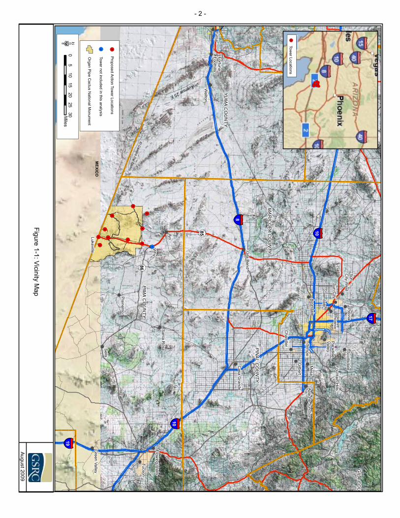
!(!(
!(
!(!(
!(!(
!(
!(!(
!(!(
!(
!(
!(
!(
!(
!(
!(
!(
!(
!(
!(
!(
!(
!(
!(
!(
!.
!.
!.
!.
!.
!.
!.
!.
!.
!.!.
River
ElCam
inoD
elDiablo
¬« 85
Avenue25E
¬« 86
§̈¦ 10
§̈¦ 19
§̈¦8
§̈¦ 10
§̈¦ 17
PIMA
CO
UN
TY
MA
RIC
OPA
CO
UN
TY
YUM
AC
OU
NTY
PINA
LC
OU
NTY
GILA
CO
UN
LAPA
ZC
OU
NTY
Why
Ajo
Yuma
Mesa
Sells
Tempe
Tucson
Peoria
Wellton
Gilbert
Phoenix
Pisinemo
Chandler
Avondale
Glendale
Gila
Bend
Lukeville
SantaR
osa ScottsdaleCasa
Grande
Green
Valley
Flowing
Wells
SunC
ityW
est
FountainH
illsApacheJunction
ParadiseValley
FortunaFoothills
SunC
ity
August2009
05
1015
2025
30Miles
·
Figure1-1:Vicinity
Map
MEXIC
O
Organ
Pipe
Cactus
NationalM
onument
!.P
roposedA
ctionTow
erLocations
!. !.!.!.!. !.!.!.
!.!.
!.!.!.
TowerLocations
!.
!.Tow
ernotincludedin
thisanalysis
- 2 -

- 3 -
SBInet Ajo-1 Tower Project EA Final
entitled, Environmental Assessment For The Proposed Installation, Operation, and Maintenance of Primary Pedestrian Fence Near Lukeville, Arizona, U.S. Border Patrol (USBP), Tucson Sector (CBP 2008a) and Environmental Assessment For The Installation of Permanent Vehicle Barrier on the Cabeza Prieta National Wildlife Refuge, Office of Border Patrol, Tucson and Yuma Sectors, Arizona (CBP 2007a), respectively. Where previous NEPA documents do not provide sufficient information for the analysis required in this EA, new surveys for sensitive resources and tower site characterization were completed. That information is included in this EA.
USBP Tucson Sector provides law enforcement support for the Arizona counties of Maricopa, Pima, Santa Cruz, Pinal, and Cochise. Only one USBP station (Ajo) would be affected by the proposed project. CBP proposes to design, develop, and deploy technology-based solutions to decrease illegal cross border activities and deter and detect illegal entries in the Ajo Station’s AOR. This project would support the CBP’s mission by strengthening National security between ports of entry (POE) to prevent illegal entry of illegal aliens (IA), smugglers, and other cross border violators (CBV) into the U.S.
The SBInet project described and analyzed in this EA is anticipated to achieve CBP operational requirements and CBP’s mission of improving land border security. This EA describes the project goals that SBInet is required to support and analyzes the potential environmental impacts of the proposed tower construction, installation, operation, and maintenance of its component structures and facilities.
1.1.1 Program Background The U.S. experiences substantial cross border traffic of CBVs, illegal drugs, and other contraband every year. These illegal cross border activities not only violate U.S. law, but adversely affect natural resources on public and private lands through the creation of illegal roads and trails, the degradation and loss of habitat resulting from fires set by CBVs, the deposition of trash and human waste, and destruction of fences. Additionally, CBVs pose a threat to public safety from high speed vehicle chases on public roads, smuggling, and all degrees of crime. For example, the land manager has closed a majority of the western portion of OPCNM to the public as a result of the high levels of illegal activity in this portion of OPCNM (National Park Service [NPS] 2009a).
SBI is a comprehensive, multi-year program established by DHS in November 2005 to provide the tools necessary to CBP to secure the U.S. borders and reduce illegal immigration. SBI was created to bring effective coordination of DHS assets and greater accountability in securing the U.S. borders. The SBI mission is to promote border security strategies that protect against and prevent terrorist attacks and other transnational crimes. Additionally, SBI will coordinate DHS efforts to ensure the legal entry and exit of people and goods moving across U.S. borders, and improve the enforcement of immigration, customs, and agriculture laws at U.S. borders and within the U.S.
- 4 -
SBInet Ajo-1 Tower Project EA Final
SBInet is the component of SBI charged with developing and installing technology and attendant tactical infrastructure (TI) solutions to help CBP gain effective control of the U.S. borders. The goal of SBInet is to field the most effective, proven technology and response platforms, and integrate them into a single, comprehensive border security system for DHS. SBInet is the CBP program charged with carrying out the program to better execute this vital mission. The proposed SBInet Ajo-1 Tower Project would enhance CBP’s detection capabilities and interdiction efficiency, and provide a deterrence to illegal cross border activities, thus resulting in reduced impacts to natural resources.
CBP implements the National Border Patrol Strategy (NBPS) with the goal of establishing and maintaining effective control of the borders. USBP maximizes border security with an appropriate balance of personnel, technology, and infrastructure. SBInet is a part of the NBPS and this proposed action helps to achieve aspects of the NBPS within the Tucson Sector. Effective control exists when CBP is consistently able to: (1) detect illegal entries in to the U.S. when they occur; (2) identify the entry and classify its level of threat; (3) efficiently and effectively respond to these entries; and, (4) bring each event to an appropriate law enforcement resolution.
1.1.2 Cooperating Agencies The U.S. Department of the Interior (DOI) is a cooperating agency (40 CFR § 1502.14(d)) on SBI projects including the SBInet proposed project included in this EA. A Memorandum of Understanding (MOU) was entered into in March 2006 between DHS, DOI and U.S. Department of Agriculture (USDA). The MOU outlines the cooperative efforts between DOI and USDA agencies’ land managers and DHS agencies with operations in the southwest border region when planning and negotiating project details to best meet each agency’s goals and objectives. Additionally, a Memorandum of Agreement (MOA) entered into in January 2008 between CBP and DOI for SBI projects formalized the commitment among CBP and DOI to coordinate the review of projects subject to NEPA and CEQ regulations implementing NEPA. Further, DOI agencies’ actions, such as issuance of special use permits and right-of-way (ROW) grants, associated with this proposed action are included as part of this NEPA analysis.
1.1.3 Legislative Background Several documents, legislative acts, and policies provide guidance to ensure the proposed action described in this EA satisfies the purpose and need state below. All applicable legislation was considered during the preparation of this EA.
1.1.3.1 Department of Homeland Security Among its many functions, DHS is charged with enforcing the Immigration and Naturalization Act, which includes the authority and duty to control and guard the boundaries and borders of the U.S. against the illegal entry of aliens (8 U.S.C. 1103). Pursuant to Section 1502 of the Homeland Security Act (Public Law (P.L.) 107-296, 116 Stat. 2135 [2002]), the President’s reorganization plan of January 30, 2003, established CBP, which has responsibility for the resources and missions of the legacy Customs
- 5 -
SBInet Ajo-1 Tower Project EA Final
Service and USBP relating to borders and POEs. CBP’s core mission is to defend U.S. borders against all threats while facilitating legitimate trade and travel.
As a component of DHS that is responsible for border security, CBP shares DHS’ mandate from Congress to achieve and maintain effective control of the U.S. borders (8 U.S.C. 1701). Pursuant to Section 102 of the Illegal Immigration Reform and Immigrant Responsibility Act, as amended, Congress provided DHS with authorities necessary to accomplish this mandate. Section 102(a) provides that the Secretary of Homeland Security shall take such actions as may be necessary to install additional physical barriers and roads in the vicinity of the U.S. borders to deter illegal crossings in areas of high illegal entry. SBInet is also working to design, develop, and deploy the technology-based solutions that will help DHS meet Congress’ mandate to achieve and maintain effective control of the U.S. borders.
1.1.3.2 National Park Service NPS was established by the Organic Act of 1916 (16 U.S.C. 1 2 3 and 4), which directs DOI and NPS to manage units of the National Park system, “to conserve the scenery and the natural and historic objects and the wildlife therein and to provide for the enjoyment of the same in such manner and by such means as will leave them unimpaired for the enjoyment of future generations” (16 U.S.C. 1). The Redwood National Park Expansion Act of 1978 iterates this mandate by stating that NPS must conduct its actions in a manner that will ensure no “derogation of the values and purposes for which these various areas have been established, except as may have been or shall be directly and specifically provided by Congress” (16 U.S.C. 1a-1).
Organ Pipe Cactus National MonumentOPCNM was established by Presidential Proclamation on April 13, 1937. The proclamation states that OPCNM has been reserved under NPS management and control. The purpose and objectives for OPCNM are described below:
Perpetuate for future generations a representative sample of the natural and cultural resources and processes of the Sonoran Desert and provide for public understanding, use, and enjoyment;
Preserve for future use and enjoyment the character and values of the designated wilderness within OPCNM under the Wilderness Act;
Serve as a natural outdoor laboratory for understanding and managing Sonoran Desert Ecosystems;
Serve as a baseline indicator against within environmental changes can be identified; and
Establish a mutually agreeable relationship with the Tohono O’odham Nation to ensure perpetuation of their participation in and with OPCNM, and to preserve and continue their important relationship with this ecosystem.
The National Parks and Recreation Act of 1978 (P.L. 95-625) designated more than 94 percent (approximately 312,600 acres) of OPCNM as Organ Pipe Cactus Wilderness. Additionally, 1,240 acres of Arizona State Trust Lands (ASTL) within OPCNM were

- 6 -
SBInet Ajo-1 Tower Project EA Final
designated potential wilderness. The potential wilderness areas are managed to preserve wilderness values under a cooperative arrangement between NPS and the State of Arizona.
1.1.3.3 U.S. Fish and Wildlife Service U.S. Fish and Wildlife Service (USFWS) was created under the Fish and Wildlife Act of 1956 (16 U.S.C. 742a-742J). The USFWS is “the principal Federal agency responsible for conserving, protecting and enhancing fish, wildlife, and plants, and their habitats for the continuing benefit of the American people”. USFWS enforces Federal wildlife laws, administers the Endangered Species Act (ESA) of 1973 (16 U.S.C. 1531-1544), as amended, manages migratory bird populations, restores nationally significant fisheries, and helps foreign governments with their conservation efforts (USFWS 1999).
National Wildlife Refuge SystemThe National Wildlife Refuge System Administration Act of 1966 (16 U.S. Code [U.S.C.] 668dd-668ee) provided guidelines and directives for administration and management of the National Wildlife Refuge System. In October 1997, the National Wildlife Refuge System Improvement Act (P.L. 105-57) clarified and formalized the mission of the National Wildlife Refuge System. The National Wildlife Refuge System Improvement Act provides an “organic act” in that it designates the fundamental guiding principles of the National Wildlife Refuge System. It ensures that the National Wildlife Refuge System is effectively managed as a National system of lands, waters, and interests for the protection and conservation of our Nation’s wildlife resources. The National Wildlife Refuge System Improvement Act defines the mission of the National Wildlife Refuge System as, “To administer a national network of lands and waters for the conservation, management, and where appropriate, restoration of the fish, wildlife, and plant resources and their habitats within the United States for the benefit of present and future generations of Americans.”
Cabeza Prieta National Wildlife Refuge (CPNWR)CPNWR was established in 1939 as a “Game Range” by President Franklin Roosevelt for the recovery of desert bighorn sheep (Executive Order [EO] 8038). The CPNWR encompasses over 800,000 acres of Sonoran Desert along the U.S./Mexico border (USFWS 2005). Four subsequent EOs signed by President Franklin Roosevelt and two public orders signed by the Secretary of Agriculture between 1941 and 1943 withdrew nearly 3 million acres including the “Game Range” for military flight training needs for World War II (USFWS 2005). Most of the air space above the “Game Range” was used as a bombing and aerial gunnery range during World War II (1941-1946) and the Korean Conflict (activated in 1951). Public Land Order 5493 of March 21, 1975, amended the EO 8039 and changed the name of the Game Range to CPNWR. Further, Public Land Order 5493 gave sole jurisdiction of CPNWR to the USFWS. The Game Range Bill amendments to the National Wildlife Refuge Administration Act (P.L. 94-223) affirmed the Secretary of the Interior’s responsibility to protect the integrity of the former Cabeza Prieta Game Range as part of the National Wildlife Refuge System and the integrity of the original purposes for which the refuge was established. Until 1999, the CPNWR was included as part of the U.S. Air Force’s Barry M. Goldwater Range (BMGR).

- 7 -
SBInet Ajo-1 Tower Project EA Final
The Arizona Desert Wilderness Act of 1990 (P.L. 101-628) designated approximately 93 percent (approximately 803,418acres) of CPNWR as Cabeza Prieta Wilderness. The refuge’s wildlife management responsibilities remain unchanged, but must be implemented within the context of legal requirements set forth in the Wilderness Act of 1964 (P.L. 88-577).
1.1.3.4 Bureau of Land Management The Federal Land Policy Management Act (FLPMA [P.L. 94-579]) established the guidelines for the administration and management of public lands by Bureau of Land Management (BLM). FLMPA is BLM’s “organic act” in that it establishes the agency’s multiple-use mandate to serve present and future generations. Multiple use management is defined as the management of public lands and their various resource values so that they are utilized in the combination that will best meet the present and future needs of the American people.
1.1.4 Framework for Analysis NEPA is the Federal statute that requires agencies to identify and analyze the potential impacts of the proposed Federal action to the natural and human environment before those actions are taken. NEPA also established the CEQ as the executive agency charged with administering and interpreting NEPA’s intent and ensuring agencies’ compliance with NEPA. The NEPA regulations mandate that all Federal agencies use a systematic, interdisciplinary approach to environmental planning and evaluation of actions that might affect the human or natural environment. The NEPA process evaluates potential environmental consequences associated with a proposed action and considers alternative courses of action. The intent of NEPA is to protect, restore, or enhance the environment through well-informed Federal decision-making.
The process for implementing NEPA is codified at 40 CFR 1500–1508, Regulations for Implementing the Procedural Provisions of the National Environmental Policy Act, and forms the basis for DHS’s Management Directive 023-01, Environmental Planning Program (71 FR 16790). The NEPA regulations specify that the following must be accomplished when preparing an EA:
Briefly provide evidence and analysis for determining whether to prepare an Environmental Impact Statement (EIS) or a Finding of No Significant Impact (FONSI);
Aid in an agency’s compliance with NEPA when an EIS is unnecessary; and
Facilitate preparation of an EIS when one is necessary (40 CFR 1501.3, 1501.4).
As noted earlier, NEPA requires an interdisciplinary approach to environmental analysis. Table 1-1 summarizes some of the applicable laws and regulations that were considered in the development of this EA. An interdisciplinary team of environmental scientists, biologists, planners, economists, engineers, archaeologists, and historians analyzed the proposed alternatives, regarding existing conditions of the region and specific tower sites and existing structures, and has identified relevant beneficial and

- 8 -
SBInet Ajo-1 Tower Project EA Final
adverse effects associated with the action. In addressing these effects, numerous guidelines, regulations, and EOs were considered (Table 1-1).
1.2 PURPOSE AND NEED
The purpose of the proposed project is to improve CBP’s efficiency and probability of detection, identification, and apprehension of CBVs. Achieving effective control of the borders of the U.S is a key mission of CBP. The objective of this SBInet project is to maximize surveillance along approximately 30 linear miles of U.S. border within OPCNM in the USBP Tucson Sector. Meeting this purpose would provide more efficient and effective interdiction while reducing impacts to the natural environment in the Ajo Station’s AOR.
The implementation of this proposed SBInet Ajo-1 Tower Project would support CBP’s mission and activities of predicting, detecting, identifying, classifying, tracking, and responding to illegal cross border activities at and between POEs and within the Tucson Sector. The project would provide necessary decision support information to assist CBP officers and agents in the resolution of all border incursions. Additionally, information gathered from all technology would further contribute to the comprehensive operability of the common operating picture (COP). The COP would also provide mechanisms to communicate comprehensive situational awareness, including information to incorporate intelligence-driven capabilities at all operational levels and locations.
The frequency and nature of illegal cross border activities and the geographic area over which these activities occur, create a need for a technology-based solution that can effectively collect, resolve, and distribute the information among CBP agents. The SBInet system is expected to allow CBP to spend less time locating CBVs and focus efforts on interdiction of those involved in illegal cross border activities.
This SBInet Ajo-1 Tower Project is needed to: 1) provide more efficient and effective means of assessing border activities;2) provide rapid detection and accurate characterization of potential threats (e.g.,
IA, smugglers and other CBVs);3) provide coordinated deployment of resources in the apprehension of CBVs; 4) reduce crime in border communities and improve the quality of life and
economic vitality of border regions through provision of the tools necessary for effective law enforcement; and
5) increase surveillance and interdiction efficiency, reduce environmental impacts, and enhance restoration efforts.

SBInet Ajo-1 Tower Project EA
Final
- 9 -
Table 1-1. Summary of Guidance, Statutes, and Relevant Regulations Including Compliance Requirements
Issue Acts Requiring Permit, Approval, or Review Agency Permit, License, Compliance, or
Review/Status
Wilderness
Wilderness Act of 1964, 16 United States Code (U.S.C.) § 1131-1136, Public Law [P.L.] 88-577)
Land administrating agency Approval from land administrating agency that action is minimum necessary to manage an area as Wilderness
Arizona Desert Wilderness Act of 1990 (P.L. 101-628) Land administrating agency
Approval from land administrating agency that action is minimum necessary to manage an area as Wilderness
National Parks and Recreation Act of 1978 (P.L. 95-625) NPS
Approval from land administrating agency that action is minimum necessary to manage an area as Wilderness
Soils
Resource Conservation and Recovery Act of 1976, 42 U.S.C. § 6901 et seq., as amended
U.S. Environmental Protection Agency (EPA)
Proper management, and in some cases, permit for remediation
Comprehensive, Environmental Response, Compensation, Liability Act of 1980, 42 U.S.C. § 9601et seq., as amended
EPA Development of emergency response plans, notification, and cleanup
Farmland Protection Policy Act of 1981, 7 U.S.C. §4201 et seq.7 CFR 657-658 Prime and unique farmlands
Natural Resource Conservation Service (NRCS)
NRCS determination via Form AD-1006, if prime or unique farmlands are present
Natural Resources
Endangered Species Act of 1973, 16 U.S.C. § 1531 et seq., as amended USFWS
Compliance by lead agency and/or consultation to assess impacts and, if necessary, develop mitigation measures
Migratory Bird Treaty Act of 1918, 16 U.S.C. § 703 et seq. USFWS
Compliance by lead agency and/or consultation to assess impacts and, if necessary, develop mitigation measures
National Wildlife Refuge System Administration Act of 1966, 16 U.S.C. § 668dd-668ee, and amendments
USFWS Compliance by lead agency to ensure the protection and conservation of National wildlife resources
National Wildlife Refuge Improvement Act of 1997, 16 U.S.C. § 668dd et seq., P.L. 105-57 USFWS
Administer a National network of lands and waters for the conservation, management and restoration of the fish, wildlife, and plant resources and their habitats within the U.S. for the benefit of present and future generations. Compliance by lead agency

SBInet Ajo-1 Tower Project EA
Final
- 10 -
Issue Acts Requiring Permit, Approval, or Review Agency Permit, License, Compliance, or
Review/Status
Natural Resources, continued
Organic Act of 1916 (U.S.C. 1 2 3 and 4) NPS
Manage units of the NPS system “to conserve the scenery and the natural and historic objects and the wildlife therein and to provide for the enjoyment of the same in such manner and by such means as will leave them unimpaired for the enjoyment of future generations.” Compliance by lead agency
Federal Land Policy Management Act (P.L. 94-579) BLM
Administer and manage public lands and their various resource values so that they are utilized in the combination that will best meet the present and future needs of the American people. Compliance by lead agency
Cultural/Archaeological
National Historic Preservation Act of 1966 (16 U.S.C. § 470a et seq.)
Advisory Council on Historic Preservation (ACHP) through State Historic Preservation Officer (SHPO)
Section 106 Consultation
Archaeological Resources Protection Act of 1979 (16 U.S.C. § 470aa et seq.)
Affected land-managing agency
Permits to survey and excavate/ remove archaeological resources on Federal lands; Native American tribes with interests in resources must be consulted prior to issue of permits
Native American Graves Protection and Repatriation Act of 1990
Affected land-managing agency Compliance by lead agency
Indian Sacred Sites of 1996 (EO 13007) Affected land-managing agency and affected Native American tribe
Compliance by lead agency
Consultation and Coordination with Indian Tribal Governments of 2000 (EO 13175)
Affected land-managing agency and affected Native American tribe
Compliance by lead agency
Government-to-Government Relations with Native American Tribal Governments of 1994 (Presidentail Memorandum)
Affected land-managing agency and affected Native American tribe
Compliance by lead agency
Table 1-1, continued

SBInet Ajo-1 Tower Project EA
Final
- 11 -
Issue Acts Requiring Permit, Approval, or Review Agency Permit, License, Compliance, or
Review/Status
Air
Clean Air Act, and amendments of 1990 (42 U.S.C. § 7401 et seq.) EPA and Arizona
Department of Environmental Quality (ADEQ)
Compliance with National Ambient Air Quality Standards (NAAQS) and emission limits and/or reduction measures; Conformity to de minimis thresholds; preparation of a Record of Non-Applicability (RONA)
Water
Federal Water Pollution Control Act of 1977 (also known as the Clean Water Act [CWA]) (33 U.S.C. § 1251 et seq.)
EPA
Section 402(b) National Pollutant Discharge Elimination System General Permit for Storm Water Discharges for Construction Activities-Storm Water Pollution Prevention Plan (SWPPP)
Executive Order 11988 (Floodplain Management), 42 Federal Register (FR) 26,951 (May 24, 1997), as amended.
Water Resources Council, Federal Emergency Management Agency (FEMA), CEQ
Compliance
Executive Order 11990 (Protection of Wetlands), 42 FR 26,691(May 24, 1977), as amended
U.S. Army Corps of Engineers (USACE) and U.S. Fish and Wildlife Service (USFWS)
Compliance
CWA of 1977 (33 U.S.C. § 1341 et seq.)
USACE and Arizona Department of Water Resources
Section 401/404 Permit
Social/Economic
Executive Order 12898 (Federal Actions to Address Environmental Justice in Minority Populations and Low-Income Populations) of 1994, 59 FR 7629 (February 11, 1994)
EPA
Compliance
Sound/ Noise Noise Control Act of 1972, 42 U.S.C. § 4901 et seq., as amended EPA Compliance with surface carrier noise emissions
Health and Safety
Occupational Health and Safety Act of 1970, 29 U.S.C. §651 et seq.
Occupational Safety and Health Administration
Compliance with guidelines including Material Safety Data Sheets
Table 1-1, continued
- 12 -
SBInet Ajo-1 Tower Project EA Final
1.3 PUBLIC INVOLVEMENT
SBInet initiated public involvement and scoping activities as directed by 40 CFR Section 1501.7, 1503, and 1506.6 to identify any significant issues related to this proposed project. A public scoping meeting was held on July 17, 2007, in Tucson to present and discuss plans for this proposed project and to explain how this action would be analyzed in this EA. Members of the public in attendance were invited to provide comments and questions about the proposed project after the presentation. A transcript of this public scoping meeting is included in Appendix A.
The draft EA and draft FONSI were released to the public and Federal, state, and local agencies for 30-day public review and comment period on September 11, 2009 and comments were received until October 10, 2009. The Notice of Availability (NOA) announcing the availability of the draft EA and draft FONSI for public review and comment was published in the Arizona Daily Star, Copper News, and Arizona Republic News newspapers. Proof of Publication of the NOA is provided in Appendix B. Two comments letters, one from NPS and one signed by Defenders of Wildlife, National Parks Conservation Association, and Sierra Club were received. These letters, as well responses to these letters, are provided in Appendix B. The final EA and FONSI will be released to the public.
1.3.1 Agency Coordination Coordination and consultation with stakeholder agencies and other potentially affected parties occurred at the initial preparation stages of this EA. This began in June 2007 through the issuance of 47 agency coordination letters to potentially affected Federal, state, and local agencies and Indian tribes, inviting their participation and input regarding the proposed project. Six responses were received. In February 2009, 11 agency coordination letters specifically addressing the proposed SBInet Ajo-1 Tower Project were issued to potentially affected Federal, state, and local agencies and Indian tribes, inviting their participation and input regarding this project. Three responses to the February 2009 coordination letters were received by SBInet. Copies of correspondence generated during the preparation of this EA are presented in Appendix B. Formal and informal coordination was conducted and is on-going with the following agencies:
U.S. Department of the Interior (DOI) National Park Service (NPS), OPCNM Bureau of Land Management (BLM) U.S. Fish and Wildlife Service (USFWS), Arizona Ecological Service Office
(AESO) and CPNWR U.S. Section, International Boundary and Water Commission (USIBWC) U.S. Army Corps of Engineers (USACE) U.S. Environmental Protection Agency (EPA) Arizona Game and Fish Department (AGFD) Arizona State Historic Preservation Officer (SHPO) Arizona Department of Environmental Quality (ADEQ) Arizona Department of Transportation (ADOT)

SECTION 2.0
PROPOSED ALTERNATIVES


- 13 -
SBInet Ajo-1 Tower Project EA Final
2.0 PROPOSED ALTERNATIVES
Nine alternatives were identified and considered during the planning stages of the proposed project: the Full Build Out, Proposed Action, Fiber Optics, Unmanned Aircraft Systems, Remote Sensing Satellites, Remote Sensors, Increased CBP Workforce, Increase Aerial Reconnaissance/Operations, and No Action alternatives. However, only two alternatives, Proposed Action and No Action alternatives, were carried forward in the analysis of alternatives. The following paragraphs describe the alternative selection process and the alternatives considered.
2.1 ALTERNATIVES AND ALTERNATIVES SELECTION
As the proponent agency preparing this EA, CBP developed a range of alternatives with consideration of the purpose and need outlined above and of the potential effects to the environment. CBP considered various technological systems and equipment capable of providing spatially and temporally continuous surveillance across the entire 30-mile border region of this project. Each of these alternatives was fully evaluated in terms of the purpose and need, as well as costs, operability, and potential impacts to the environment. Alternatives which did not fully meet the purpose of this project were eliminated from further analysis and are discussed in Section 2.5, below. The Proposed Action described in Sections 2.3 fully meets the purpose and need of this project within the constraints of environmental and operational considerations. The No Action Alternative, described in Section 2.4, is assessed as required by NEPA and CEQ regulations (40 CFR §.1508.5).
The towers planned for the SBInet Ajo-1 Tower Project comprise a single system designed to enhance CBP’s detection and deterrence of IAs in the Ajo Station’s AOR. Geographic features such as mountain ranges isolate the project from other stations’ AORs. The proposed SBInet Ajo-1 Station Tower Project is considered a stand alone project that could function independently of other SBInet Tucson Sector projects. However, future SBInet projects could be designed to communicate with the SBInet Ajo-1 Tower Project towers to enhance the COP within the Tucson Sector.
2.2 CRITERIA FOR TOWER SITE SELECTION
The sensor and communications tower site selection process identifies potential suitable site locations and their alternatives. Key tower site evaluation considerations take into account constructability, operability, and environmental factors. The site selection process began with multiple conceptual field laydowns, where maximum surveillance capability is achieved with a minimum number of tower sites using mapping programs and a modeling and analysis process. Operationally preferred site locations were selected by CBP personnel based on their knowledge of the terrain, environment, land ownership, and operational needs. Selected tower sites were screened for constructability, operability, and environmental constraints. The selection process was iterated until full surveillance and communications capabilities were deemed achievable.

- 14 -
SBInet Ajo-1 Tower Project EA Final
The site selection team first employed a Boeing proprietary Wide Area Surveillance Sensor Placement Tool (WASSPT), which is a four-stage, integrated analysis, and visualization tool for cost-effective placement of towers across areas of interest. The WASSPT helps determine the minimum number of towers needed for maximum coverage of a given area. After a conceptual field laydown of prospective tower sites was agreed to by CBP, the project’s environmental, construction, and operational team personnel conducted site visits and completed site visit reports with site ranking matrices for each site. During site visits, project team personnel used site ranking criteria to establish whether sites exhibit exclusionary, restrictive, and/or selective characteristics from constructability, operability, and/or environmental criteria perspectives.
The SBInet Ajo-1 Tower Project preliminary site surveys were conducted in July 2007, following comprehensive map reviews of terrain types and achievable surveillance coverage requirements with CBP and DHS personnel. Detailed environmental and cultural resources surveys followed, beginning in October 2007. During those surveys, 25 sites were evaluated by additional team personnel for both sensor and communication efficiencies and overall compatibility with SBInet network design and connectivity. Of the sites surveyed, 15 sites were eliminated as unsuitable for tower construction due to terrain or access considerations, the presence of cultural and/or sensitive resources, or technical requirements that could not be met in a particular location. These sites are summarized in Table 2-1 with the reasons for their elimination as proposed tower sites.
Table 2-1. Alternate Sites Proposed but Eliminated
Tower ID Station Reason for Elimination*
TCA-AJO-006 Ajo O, T, C TCA-AJO-008 Ajo T, E TCA-AJO-088 Ajo CTCA-AJO-091 Ajo T, E TCA-AJO-155 Ajo C, E TCA-AJO-173 Ajo CTCA-AJO-188 Ajo R TCA-AJO-200 Ajo O, T TCA-AJO-203 Ajo O, T TCA-AJO-205 Ajo O, T TCA-AJO-209 Ajo E TCA-AJO-218 Ajo O, T TCA-AJO-296 Ajo O, T TCA-AJO-304 Ajo T TCA-AJO-308 Ajo E
O—operational, T—technical, C—constructability, E—environmental, R-real estate

- 15 -
SBInet Ajo-1 Tower Project EA Final
2.3 PROPOSED ACTION
The Proposed Action includes the construction, operation, and maintenance of 10 sensor and communication towers, which creates a communications network in support of a COP among components of CBP and other Federal, state, and local partners outside CBP. The Proposed Action also includes the construction of seven access roads (0.07 linear mile); construction of a new road to proposed tower site TCA-AJO-310 (1.2 linear miles); repair of four authorized roads (3.9 linear miles); improvement of four authorized roads (0.22 linear mile); improvements of an authorized corridor (1.7 linear miles); repair of an authorized corridor (4.4 linear miles); maintenance of access and approach roads (38.2 linear miles); deployment of two towers with the use of a helicopter (TCA-AJO-189 and 204); deployment and maintenance of remote sensors; relocation and operation of a FOB; and implementation of conservation measures to avoid, minimize, and offset effects to protected species and other DOI trust resources.
The Proposed Action described in this EA represents CBP’s plan to develop a combination of technology, infrastructure, transportation assets, and deployment of CBP personnel to achieve effective control of 30 miles of border in the Tucson Sector. Technology to be considered in the design includes: sensors and other surveillance assets, and communications, command and control systems along the border, within command centers within vehicles and among CBP personnel. Infrastructure to be considered within CBP’s plan includes roadways to/from communication and sensor towers, and support utilities. As part of the COP, the 10 towers would be able to communicate with the Ajo Station. This would provide an overall network system of communications and surveillance along the 30 linear miles of border region (Figure 2-1).
2.3.1 Tower Characteristics Three types of tower structures are proposed for this project: self standing towers (SST), rapidly deployed towers (RDT), and remote access towers (RAT). These towers are described in the following paragraphs. None of the proposed tower types would require guy wires. SSTs are steel, lattice style structures which that have three circular concrete pilings approximately 4 feet in diameter, and would be placed at each site to anchor the tower legs in the ground (Figure 2-2). A typical profile of a SST tower is provided as Figure 2-3. Depth of the pilings is dependent on tower height and geotechnical characteristics at each tower site, but would not be expected to be greater than 60 feet below ground surface (bgs). SSTs would typically be up to 180 feet high.
RDTs are lattice style structures which use pre-cast modular stacked slabs for the foundation and are typically 8- x 8-foot x 6 inches, 8- X 8-foot X 6 inches and 10- x 10-foot x 6 inches or 12- x 12-foot x 6 inches depending upon tower height (Figures 2-4). A typical profile of a RDT tower is provided as Figure 2-5. The lowermost foundation slab rests on top of approximately 2 feet of crushed stone at the base of the excavated area. The depth of each tower foundation is dependent on tower height and geotechnical characteristics at each tower site. Tower foundations would be placed at a depth of 3 to 5 feet bgs depending on tower height and geotechnical characteristics at each tower site. The uppermost tower foundation slab may potentially extend from 7 to 26 inches above the existing surface grade. RDTs will range in height from 80 feet to 120 feet.
- 16 -
SBInet Ajo-1 Tower Project EA Final
THIS PAGE LEFT INTENTIONALLY BLANK
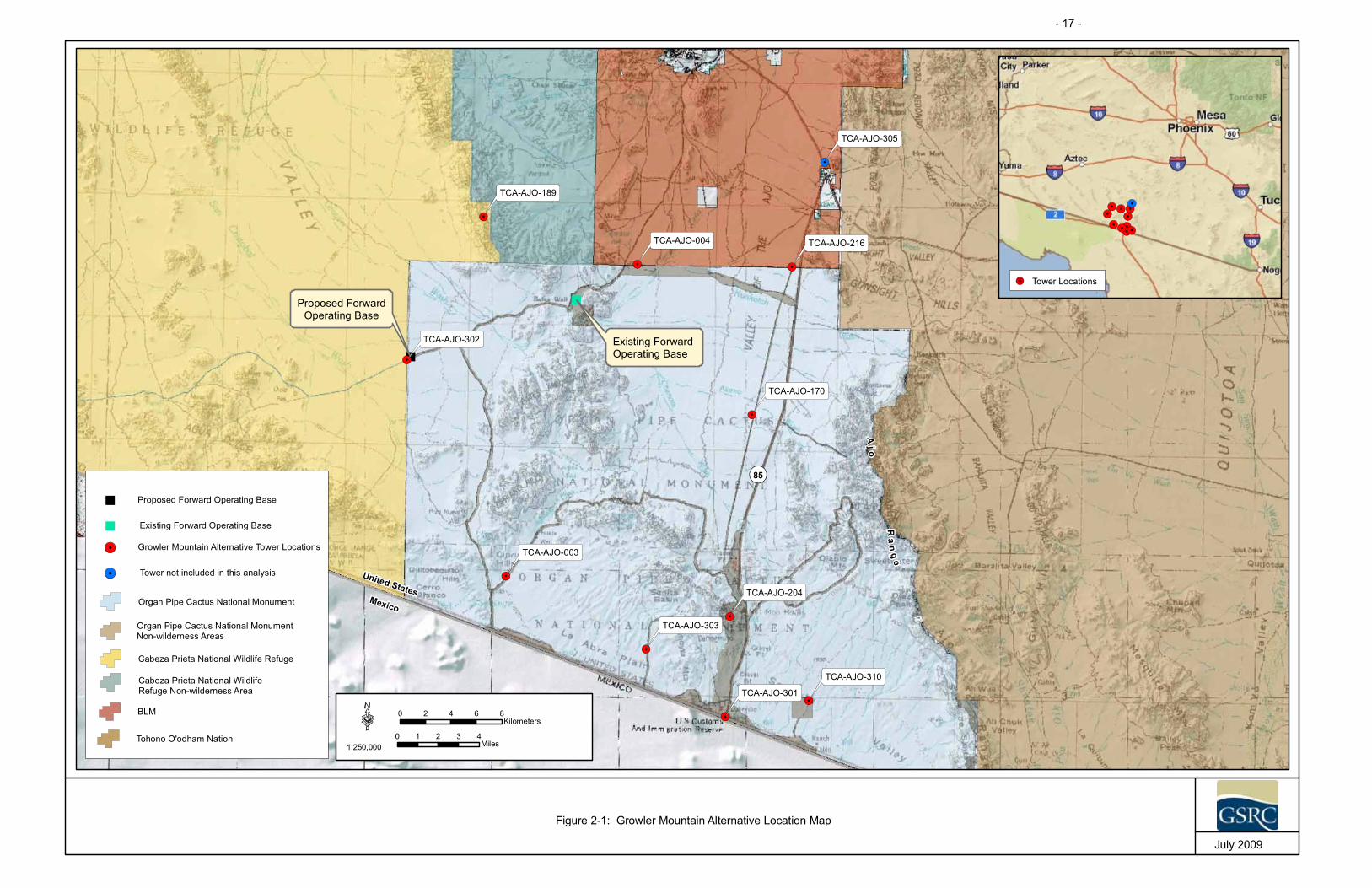
"
"
!.
!.
!.
!.
!.
!.
!.
!.
!.
!.
!.
¬«85
¬«86
Aj o
Ra
ng
e
Existing ForwardOperating Base
Proposed ForwardOperating Base
TCA-AJO-310
TCA-AJO-305
TCA-AJO-303
TCA-AJO-302
TCA-AJO-301
TCA-AJO-216
TCA-AJO-204
TCA-AJO-189
TCA-AJO-170
TCA-AJO-004
TCA-AJO-003
·1:250,000
0 1 2 3 4Miles
0 2 4 6 8Kilometers
July 2009
Figure 2-1: Growler Mountain Alternative Location Map
Organ Pipe Cactus National Monument
!.
!.!.
!.
!.
!.
!.
!.
!.
!.
!.
Tower Locations!.
United StatesMexico
Organ Pipe Cactus National MonumentNon-wilderness Areas
Cabeza Prieta National Wildlife Refuge
Cabeza Prieta National WildlifeRefuge Non-wilderness Area
BLM
Tohono O'odham Nation
!. Growler Mountain Alternative Tower Locations
!. Tower not included in this analysis
" Proposed Forward Operating Base
" Existing Forward Operating Base
- 17 -

- 18 -
SBInet Ajo-1 Tower Project EA Final
THIS PAGE LEFT INTENTIONALLY BLANK

}}}}}}}}}}}}}}}}
}}
}}
}}
}}
}}
}}
}}
} } } } } } } } } } } } } } } } }}
}}
}}
}}
}}
}}
}}
}
3'-0
"x6'
-0"G
ENE
RAT
OR
FOU
ND
ATIO
N
10'-0
"x20
'-0"S
HE
LTER
FOU
ND
ATIO
N
(3)S
ELF
SU
PPO
RTI
NG
TOW
ERFO
UN
DAT
ION
PIER
S
(2)3
'-0"X
6"-0
"PR
OPA
NE
TAN
KFO
UN
DAT
ION
80'
80'
100'
x10
0'C
ON
STR
UC
TIO
NFO
OTP
RIN
T
SBIN
ET
TYP
ICA
LSO
LAR
PAN
EL
Figu
re2-
2:Se
lfSt
andi
ngTo
wer
(SST
)Sch
emat
ic
July
2009
GR
OU
ND
LIN
E(1
6)#9
GR
60X
30'-0
"VE
RTI
CAL
BAR
SEQ
UA
LLY
SPAC
ED
INSI
DE
THE
CIR
CU
LAR
TIES
(20)
#4G
R40
X40
'O.D
.C
IRC
ULA
RTI
ES
30'-60'6"
9"
4'-0
"
SID
EVI
EW(O
NE
PIER
ON
LY)
- 19 -

Figure 2-3: Typical Profile of SST Tower
July 2009
Source: Boeing 2009
- 20 -
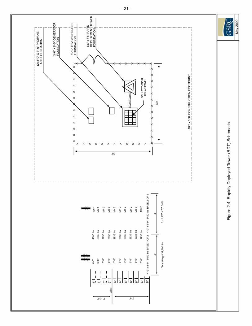
}}}}}}}}}}}}}}}
}}
}}
}}
}}
}}
}
} } } } } } } } } } } } }
}}
}}
}}
}}
}}
}}
}
3'-0
"x6'
-0"G
ENE
RAT
OR
FOU
ND
ATIO
N
10'-0
"x12
'-0"S
HE
LTER
FOU
ND
ATIO
N
6'6"
x6'
6"R
APID
DEP
LOY
ME
NT
TOW
ERFO
UN
DAT
ION
(2)3
'-0"X
6"-0
"PR
OPA
NE
TAN
KFO
UN
DAT
ION
50'
50'
100'
x10
0'C
ON
STR
UC
TIO
NFO
OTP
RIN
T
SBIN
ET
TYP
ICA
LSO
LAR
PAN
EL
Figu
re2-
4:R
apid
lyD
eplo
yed
Tow
er(R
DT)
Sche
mat
ic
May
2009
4'4'
3'-8"
6" 6" 6" 6" 6" 6" 6" 6" 6" 6" 8"4'
-0"x
8'-0
"34
50lb
sBA
SE
1O
F2
4'-0
"x8'
-0"
3450
lbs
BAS
E2
OF
2
2936
lbs
2936
lbs
2936
lbs
2936
lbs
2936
lbs
2936
lbs
2936
lbs
2936
lbs
2936
lbs
4000
lbs
TOP
MK
2
MK
2
MK
2
MK
2
MK
2
MK
2
MK
2
MK
2
MK
26'
-6"
6'-6
"
6'-6
"
6'-6
"
6'-6
"
6'-6
"
6'-6
"
6'-6
"
6'-6
"
6'-6
"
Tota
lWei
ght3
7,80
0lb
s6
-11/
2"x
78"B
olts
* ** *
**
7"-26"
Gra
de
- 21 -
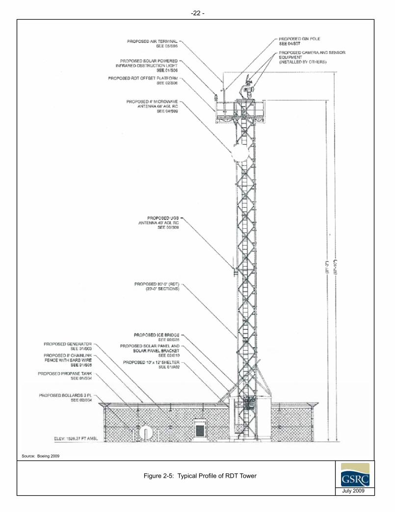
Figure 2-5: Typical Profile of RDT Tower
July 2009
Source: Boeing 2009
-22 -
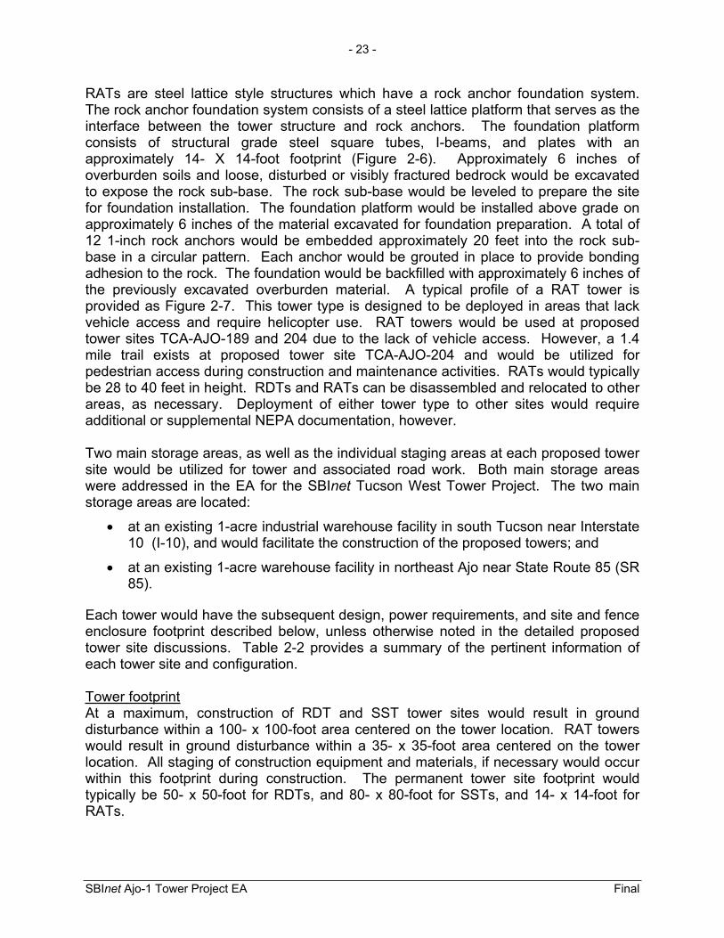
- 23 -
SBInet Ajo-1 Tower Project EA Final
RATs are steel lattice style structures which have a rock anchor foundation system. The rock anchor foundation system consists of a steel lattice platform that serves as the interface between the tower structure and rock anchors. The foundation platform consists of structural grade steel square tubes, I-beams, and plates with an approximately 14- X 14-foot footprint (Figure 2-6). Approximately 6 inches of overburden soils and loose, disturbed or visibly fractured bedrock would be excavated to expose the rock sub-base. The rock sub-base would be leveled to prepare the site for foundation installation. The foundation platform would be installed above grade on approximately 6 inches of the material excavated for foundation preparation. A total of 12 1-inch rock anchors would be embedded approximately 20 feet into the rock sub-base in a circular pattern. Each anchor would be grouted in place to provide bonding adhesion to the rock. The foundation would be backfilled with approximately 6 inches of the previously excavated overburden material. A typical profile of a RAT tower is provided as Figure 2-7. This tower type is designed to be deployed in areas that lack vehicle access and require helicopter use. RAT towers would be used at proposed tower sites TCA-AJO-189 and 204 due to the lack of vehicle access. However, a 1.4 mile trail exists at proposed tower site TCA-AJO-204 and would be utilized for pedestrian access during construction and maintenance activities. RATs would typically be 28 to 40 feet in height. RDTs and RATs can be disassembled and relocated to other areas, as necessary. Deployment of either tower type to other sites would require additional or supplemental NEPA documentation, however.
Two main storage areas, as well as the individual staging areas at each proposed tower site would be utilized for tower and associated road work. Both main storage areas were addressed in the EA for the SBInet Tucson West Tower Project. The two main storage areas are located:
at an existing 1-acre industrial warehouse facility in south Tucson near Interstate 10 (I-10), and would facilitate the construction of the proposed towers; and
at an existing 1-acre warehouse facility in northeast Ajo near State Route 85 (SR 85).
Each tower would have the subsequent design, power requirements, and site and fence enclosure footprint described below, unless otherwise noted in the detailed proposed tower site discussions. Table 2-2 provides a summary of the pertinent information of each tower site and configuration.
Tower footprintAt a maximum, construction of RDT and SST tower sites would result in ground disturbance within a 100- x 100-foot area centered on the tower location. RAT towers would result in ground disturbance within a 35- x 35-foot area centered on the tower location. All staging of construction equipment and materials, if necessary would occur within this footprint during construction. The permanent tower site footprint would typically be 50- x 50-foot for RDTs, and 80- x 80-foot for SSTs, and 14- x 14-foot for RATs.

Figure2-6:
Rem
oteAccess
Tower(R
AT)Schematic
Novem
ber2009
-24 -

Figure 2-7: Typical Profile of RAT Tower
November 2009
Source: Boeing 2009
-25 -

- 26 -
SBInet Ajo-1 Tower Project EA Final
THIS PAGE LEFT INTENTIONALLY BLANK

- 27 -
SBInet Ajo-1 Tower Project EA Final
Table 2-2. Proposed Action Tower Site Data and Configuration
Tower Name TCA-AJO-003 TCA-AJO-004 TCA-AJO-170 TCA-AJO-189 TCA-AJO-204 TCA-AJO-216 TCA-AJO-301 TCA-AJO-302 TCA-AJO-303 TCA-AJO-310
Tower Type Type: RRVS Type: RRVS-CRT
Type: RRVS-CRT Type: CRT Type: CRT Type: RRVS-
CRT Type: CRT Type: RRVS Type: CRT Type: RRVS
Basic Site Conditions Construction staging/footprint area (temporary)
100' X 100' (0.17 acre)
100' X 100’ (0.17 acre)
143.5’ X 50’ (0.10 acre)
35’ X 35’ (0.03 acre)
35’ X 35’ (0.03 acre)
100’ X 100’ (0.23 acre)
100' X 100' (0.08 acre)
100' X 100' (0.23 acre)
100' X 100' (0.08 acre)
100’ X100’ (0.23 acre)
Tower site footprint (permanent) 50' X 50' (0.06 acre)
50' X 50' (0.06 acre)
93.5’ X 30’ (0.06 acre)
14’ x 14’ (0.004 acre)
14’ x 14’ (0.004 acre)
50’ X 50’ (0.06 acre)
80’ X 80’ (0.15 acre)
50' X 50' (0.06 acre)
80’ X 80’ (0.15 acre)
50’ X50’ (0.06 acre)
Access road improvements and construction (length/width and surface treatment)
Access road construction
(89’ X16’)
Access road construction (75’ X16’),
authorized road repair
(3,197’ X 12'); authorized road improvements (50’ X 12’) and
install double gate
Authorized road improvement (50’ X 12’),authorized
corridor repair (23,358’ X 12), and authorized
corridor improvements (8,850’ X 12’), installation of several 36’’
culverts would be required
None needed None needed
Access road construction
(50’ X 16’), and authorized road
repair (350’ X 12’), and authorized
roadimprovements
(50’ x 12’)
Access road construction (50’ X 16’)
Access road construction (99' x 16')
Access road construction
(15' x 16') and road repair
(9,061 x 12')
Access road construction
(28’ X 16’), new road construction
(6,435’ x 16), authorized road
repair (8,090’ X 12’)and authorized road improvements (1,010’ X 12’), install three
culverts at small washes
Impact area associated with road construction, repair and improvement
Access road construction (0.03 acre)
Access road construction (0.03 acre),
authorized road repair (0.88 acre),
and authorized road improvement
(0.01 acre)
Authorized Road Improvement
(0.01 acre) and Authorized
corridor repair and improvement (8.8 acres)
None needed None needed
Access road construction
(0.02 acre), and authorized road
repair (0.10 acre), and authorized
roadimprovements
(0.01 acre)
Access road construction (0.02 acre)
Access road construction needed for (0.04 acre)
Access road construction
(0.006 acre) and authorized road
repair (2.5 acres)
Access road construction
(0.01 acre), new road construction
(2.4 acres), authorized road
repair (2.2 acres), and authorized
roadimprovements
(0.28 acre) Drainage structure requirements None needed None needed None needed None needed None needed None needed None needed None needed None needed None needed
Dimension, height, and type of security fence for this site
50' X 50' X 8' chainlink
50' X 50' X 8' chainlink w/barb
wire
93.5’X30’X8’chainlink NA 14’ X 14’ X 12’
Chainlink 50' X 50' X 8'
chainlink 80' X 80' X 8'
chainlink
50' X 50' X 8' chainlink w/barb
wire
80' X 80' X 8' chainlink
50' X 50' X 8' chainlink w/barb
wire
Current land use at site NPS BLM NPS USFWS NPS BLM GSA (CBP leased (POE)) NPS NPS ASTL
Tower Description Tower construction type RDT RDT RDT RAT RAT RDT SST RDT SST RDT Tower height Up to 120' Up to 120' Up to 120' 30’ 40’ Up to 120’ 180' Up to 120' 180' Up to 120’’ Guy wires requirements None needed None needed None needed None needed None needed None needed None needed None needed None needed None needed
Recommended foundation for site Stacked slabs Stacked slabs Stacked slabs None needed Stacked slabs at grade Stacked slabs 3 concrete piers Stacked slabs 3 concrete piers Stacked slabs
Power Description Distance to commercial power or type of primary power Generator-Solar Generator-Solar Grid
Generator-Solar Solar Grid Solar
Grid Generator-Solar
Grid Generator-Solar Generator-solar Generator-Solar Generator-Solar
Commercial power right-of-way None needed None needed None needed NA NA None needed Existing None needed None needed None needed

- 28 -
SBInet Ajo-1 Tower Project EA Final
Tower Name TCA-AJO-003 TCA-AJO-004 TCA-AJO-170 TCA-AJO-189 TCA-AJO-204 TCA-AJO-216 TCA-AJO-301 TCA-AJO-302 TCA-AJO-303 TCA-AJO-310 Generator fuel type Propane Propane Propane NA NA Propane Propane Propane Propane Propane Fuel tank capacity for generator, if required 1,000 1,000 1,000 NA NA 1,000 1,000 1,000 1,000 1,000
Amount of energy consumption from each tower site? (Anticipated percentage of generator use, percentage power from existing utility, alternate energy sources).
3,650 Kilowatt (kW)-hours/month
3,650 kW-hours/month
3,650 kW-hours/month
400 W-hours/month
400 W-hours/month
3,650 kW-hours/month
3,650 kW-hours/month
3,650 kW-hours/month
3,650 kW-hours/month
3,650 kW-hours/month
ASTL - Arizona State Trust Lands NPS – National Park Service BLM – Bureau of Land Management GSA – Government Services Administration
Table 2-2, continued

- 29 -
SBInet Ajo-1 Tower Project EA Final
The tower footprint would adhere to dimensions mentioned whenever possible at each proposed tower site, unless otherwise noted in the detailed proposed tower site discussion in Table 2-2. Proposed tower site TCA-AJO-170 would have a permanent tower site footprint of 93.5- x 30-foot per OPCNM requirements.
Tower Perimeter Fence EnclosureThe fence surrounding each tower site would be 80- x 80-foot x 8-foot high or 50- x 50-foot x 8-foot high chainlink with six strands of barbed wire, in a v-shape, at the top of the perimeter security fence enclosure surrounding the tower and its associated equipment shelter. However, proposed tower site TCA-AJO-204 would have a 35- x 35-foot x 12-foot high perimeter fence.
Perimeter fence footprint would be confined to dimensions previously stated for each tower site, unless otherwise noted in the detailed proposed tower site discussion (see Table 2-2). Per OPCNM requirements, the perimeter fence footprint at TCA-AJO-170 would be 93.5- x 30-foot. Perimeter fence would not be constructed at TCA-AJO-189 per DOI recommendations. Additionally, barbed wire would not be installed on the perimeter fences at proposed tower sites TCA-AJO-003, 170, 204, 216, 303, and 301 per DOI’s recommendations.
Tower Equipment ShelterA 10- x 12-foot equipment shelter would be within the perimeter fencing of each proposed tower site. The shelter would be installed on a precast concrete pad. The shelters would be air conditioned with an 18,000 British Thermal Unit system that would only operate when temperatures exceed 120 degrees Fahrenheit (expected less than 100 days per year). The equipment shelters would also be equipped with an air blower (130 watts) that forces filtered ambient air through the shelter for electronics cooling during normal tower operation.
Tower Power SourcesAll towers would operate from a battery system and the batteries would be recharged by either commercial grid power (where available) with a propane fueled generator backup, a hybrid propane fueled generator-solar system, or solar powered. The type of power source used to maintain the battery system depends on the availability of commercial grid power and vehicular access to the proposed tower site. A 1,000 gallon propane fuel tank would be located at sites utilizing propane fueled generators. Generator-solar hybrid systems are expected to operate twice per day for up 2 to 4 hours for each start. Backup generators for towers connected to grid system should be limited to 1 hour twice a month for system conditioning, plus off-grid operational schedules if grid power is interrupted. Generators would be housed within an enclosure equipped with noise baffles and would have a spill containment basin with a volume five times that of the total engine fluids.
Commercial Grid PowerCommercial grid power would be utilized at proposed tower sites 170, 204, 216, and 301. All power lines would be installed either overhead or in buried cables from the

- 30 -
SBInet Ajo-1 Tower Project EA Final
main trunk line to the tower site shelter1. The length of the overhead power lines from the existing main trunk line to the tower compounds would be no greater than approximately 65 feet. Where commercial power is utilized, the installation of overhead or buried lines would be placed within surveyed road construction buffer areas, all of which would be verified to identify potential impacts to biological and cultural resources along access roads.
Typical designs for the sensor and communications towers consist of the following components:
Sensor Towers
Multiple cameras Radar Data receiving antennas
Communication Towers
Parabolic dishes Microwave relays; and/or Data receiving antennas
The exact number and type of equipment would depend on the number and types of cameras used, the area to be monitored, and other design variables. Cameras, antennas, and parabolic antennas would be installed at heights that would ensure satisfactory line-of-sight and provide clear pathways for transmission of information to relay towers and the Ajo Station. Towers generally require line-of-sight (LOS) to ensure unobstructed microwave transmission signals from tower to tower. Currently, it is anticipated that the transmitters and sensors associated with the SBInet Ajo-1 Tower Project Supplement would operate below 30 gigaHertz (GHz).
Camera systems on SBInet towers would incorporate IZLID 200D and 200P Class IIIB infrared zoom laser illuminators. The use of this laser technology supports Office of Border Patrol’s (OBP) strategic goal of incorporating “Smart Border” technology into its operations, to support apprehension and deterrence of smugglers of humans, drugs, and other contraband into the U.S. Laser illuminators would be used in USBP operations to enhance the use of night-time surveillance cameras on SBInet towers. Utilizing laser illuminator technology, agents can respond more quickly to night-time border incursions and assess specific CBV activity through enhanced situational awareness that the lasers provide.
The lasers would be used in accordance with a February 22, 2006 user variance and user restrictions letter (Food and Drug Administration [FDA] Docket No. 00V-1410)
1 Although four of the proposed tower sites, TCA-AJO-170, 204, 216, and 301, would be powered by commercial grid power there may be instances when commercial power may not be available immediately upon tower deployment. In that case, the power source would be supplied by a 35 kW generator hybrid system until the commercial power infrastructure is in place.
- 31 -
SBInet Ajo-1 Tower Project EA Final
issued by the FDA’s Department of Health and Human Services, and a June 4, 2008 CBP/OBP Information and Technology Branch’s “Authorization for Class IIIB Lasers”, which sets forth laser illuminator use parameters, restrictions, and conditions. Use of laser illuminators by CBP is currently undergoing further safety review and approval procedures with the FDA and would not be deployed until FDA approval is completed.
All proposed towers would have infrared lighting installed for aviation safety and lighting would be compatible with night vision goggle usage. All proposed tower sites, with the exception of TCA-AJO-189 and 204, would be lighted for security purposes. Lighting would consist of a “porch light” on the tower shelter and would be controlled by a motion detector. The light would be shielded to avoid illumination outside the footprint of the tower site and low sodium bulbs would be used. None of the towers currently planned would be constructed at heights greater than 180 feet; therefore, Federal Aviation Administration (FAA) lighting requirements do not apply to the proposed project. USFWS (2000) Guidance on the Siting, Construction, Operation and Decommissioning of Communications Towers would be implemented to reduce night-time atmospheric lighting and the potential adverse effects of night-time lighting to migratory bird and nocturnal flying species.
The following discussion is a summary description of each of the proposed 10 towers. Maps for each of the proposed tower sites are provided in Appendix C.
Tower ID: TCA-AJO-003 Type of Tower: Radar and Remote Video System (RRVS)Tower Foundation: RDT Tower Height: Up to 120 feet Land Use: NPS (i.e., OPCNM) Location Description: The proposed tower site for TCA-AJO-003 is located within
the OPCNM in southwestern Pima County, approximately 3 miles north of the U.S.-Mexico border, and 13 miles northwest of the Lukeville POE (see Figure 2-1). The proposed tower compound is approximately 0.2 mile east ofAguajita Wash.
Tower Access: Access to the proposed tower site is via South Puerto Blanco Drive. Approximately 89 feet of access road construction is needed to facilitate tower installation andmaintenance.
Type of Primary Power: Generator-Solar hybrid Lighting: Security lighting with motion detector and infrared
obstruction lighting.

- 32 -
SBInet Ajo-1 Tower Project EA Final
Tower ID: TCA-AJO-004 Type of Tower: RRVS-CRT (communications relay tower; combined radar
and communications tower ) Tower Foundation: RDT Tower Height: Up to 120 feet Land Use: BLMLocation Description: The proposed tower site for TCA-AJO-004 is located on BLM
land immediately north of the OPCNM border. The site isapproximately 20 miles north of the U.S.-Mexico border and 23 miles northwest of the Lukeville POE (see Figure 2-1) at the western edge of the Valley of the Ajo, east of Scarface Mountain and west of the Cuerda de Lena Wash.
Tower Access: Access to the proposed site is via Darby Well Road south from Ajo and then east on 59.4 Cross Over Road on the OPCNM. Approximately 3,197 feet of authorized road repair, approximately 50 feet of authorized road improvements, and approximately 75 feet of access road construction is needed to facilitate tower installation andmaintenance. Additionally, a double gate would be installedto limit access.
Type of Primary Power: Generator-Solar hybridLighting: Security lighting with motion detector and infrared
obstruction lighting.
Tower ID: TCA-AJO-170 Type of Tower: RRVS-CRT Tower Foundation: RDT Tower Height: Up to 120 feetLand Use: NPS (i.e., OPCNM) Location Description: The proposed tower site for TCA-AJO-170 is located within
the OPCNM approximately 15 miles north of the U.S.-Mexico border and the Lukeville POE (see Figure 2-1).
Tower Access: Access to the site would be via an unpaved, unmaintained road that branches off SR 85 about 15 miles north of Lukeville. Approximately 23,358 feet of authorized corridor repair, approximately 8,850 feet of authorized corridor improvements, and 50 feet of authorized road improvements are needed for tower installation and maintenance.
Type of Primary Power: Grid and Generator-Solar hybrid backup Lighting: Security lighting with motion detector and infrared
obstruction lighting.

- 33 -
SBInet Ajo-1 Tower Project EA Final
Tower ID: TCA-AJO-189 Type of Tower: CRT Tower Foundation: RAT Tower Height: 30 feet Land Use: CPNWR (Cabeza Prieta Wilderness) Location Description: The proposed tower site for TCA-AJO-189, is located in the
CPNWR, approximately 17 miles west of SR 85 (see Figure 2-1).
Tower Access: The proposed tower site requires helicopter access as the steepness and ruggedness of the terrain precludes accessby vehicles.
Type of Primary Power: SolarLighting: Infrared obstruction lighting.
Tower ID: TCA-AJO-204 Type of Tower: CRT Tower Foundation: RAT Tower Height: Approximately 40 feet Land Use: NPS (i.e., OPCNM) LocationDescription:
The proposed tower site for TCA-AJO-204, is located in the OPCNM, approximately 5 miles north of the Lukeville POE (see Figure 2-1).
Tower Access: The proposed tower, TCA-AJO-204 is currently planned to be installed via helicopter airlift. Construction, biological monitoring, and maintenance personnel will access theproposed tower site via a foot trail.
Type of Primary Power: Grid and Solar panels Lighting: Infrared obstruction lighting.

- 34 -
SBInet Ajo-1 Tower Project EA Final
Tower ID: TCA-AJO-216 Type of Tower: RRVS-CRT Tower Foundation: RDT Tower Height: Up to 120 feet Land Use: BLMLocation Description: The proposed tower site for TCA-AJO-216 is located
approximately 14 miles south of Ajo, Arizona, and can be reached from SR 85 and is adjacent to OPCNM (see Figure 2-1).
Tower Access: Access to the proposed site is via an existing unimprovedboundary road adjacent to the OPCNM. Approximately 350 feet of authorized road improvements, approximately 50 feet of road improvements, approximately 50 feet of access road construction, and approximately 350 feet of authorized roadrepair are needed to facilitate tower installation and maintenance.
Type of Primary Power: Grid and Generator-Solar hybridLighting: Security lighting with motion detector and infrared
obstruction lighting.
Tower ID: TCA-AJO-301 Type of Tower: CRTTower Foundation: SST Tower Height: Approximately 180 feet Land Use: CBP leased land at the Lukeville POE Location Description: The proposed tower site for TCA-AJO-301 is located at the
Lukeville POE at the southern border of the OPCNM (seeFigure 2-1). The proposed tower compound is within adisturbed open area surrounded by ornamental hedges.
Tower Access: TCA-AJO-301 is approached from the town of Why via SR 85 to the Lukeville POE and is accessed via a paved road that winds through the existing facility buildings. Approximately 50 feet of access road construction is needed to facilitate tower installation and maintenance.
Type of Primary Power: Grid and Generator-Solar hybrid Lighting: Security lighting with motion detector and infrared
obstruction lighting.

- 35 -
SBInet Ajo-1 Tower Project EA Final
Tower ID: TCA-AJO-302 Type of Tower: RRVS Tower Foundation: RDT Tower Height: Up to 120 feet Land Use: NPS (i.e., OPCNM) Location Description: The proposed tower site for TCA-AJO-302 is located at the
western border of the OPCNM, adjacent to the CPNWR. Tower Access: Approach to TCA-AJO-302 would be via Bates Well Road
(El Camino del Diablo), an unpaved OCPNM-maintained road that is reached from SR 85. Approximately 99 feet ofaccess road construction is needed for tower installation andmaintenance.
Type of Primary Power: Generator-Solar hybridLighting: Security lighting with motion detector and infrared
obstruction lighting.
Tower ID: TCA-AJO-303 Type of Tower: CRT Tower Foundation: SST Tower Height: Approximately 180 feet Land Use: NPS (i.e., OPCNM) Location Description: The proposed tower site for TCA-AJO-303 is located within
OPCNM approximately 2 miles north of the U.S.-Mexico border and 5 miles northwest of the Lukeville POE (seeFigure 2-1).
Tower Access: The site may be approached from the Lukeville POE via theSouth Puerto Blanco Road, and is accessed via amaintained NPS road approximately 4.1 miles west of theLukeville POE. Approximately 9,061 feet of authorized road repairs and approximately 15 feet of access roadconstruction within the tower compound may be necessary for tower installation and maintenance.
Type of Primary Power: Generator-Solar hybrid Lighting: Security lighting with motion detector and infrared
obstruction lighting.

- 36 -
SBInet Ajo-1 Tower Project EA Final
Tower ID: TCA-AJO-310 Type of Tower: RRVS Tower Foundation: RDT Tower Height: Approximately 80 feet Land Use: NPS (i.e., OPCNM) and ASTL Location Description: The proposed tower site for TCA-AJO-310 is located within
OPCNM and ASTL 2.4 miles north of the U.S.-Mexico borderand 3.8 miles east of SR 85 (see Figure 2-1).
Tower Access: The site may be approached from the Lukeville POE via theexisting border road, and is accessed by an existing jeeptrail. Approximately 28 feet of access road construction, approximately 6,435 feet of new road construction,approximately 8,090 feet of authorized road repair, and approximately 1,010 feet of authorized road improvementsare needed for tower installation and maintenance.
Type of Primary Power: Lighting:
Generator-Solar hybrid Security lighting with motion detector and infrared obstruction lighting.
2.3.2 Construction of Communication and Sensor Towers RDTs and SSTsThe permanent tower site footprints of 50- x 50-foot or 80- x 80-foot would be mechanically cleared of vegetation and graded for the construction of RDT and SST sites, respectively. Precast concrete pads would be installed for the equipment shelter foundation, propane gas tank foundation, and generator foundation. A 100- x 100-foot temporary construction buffer site, including the permanent tower footprint, would be established around the permanent site footprint and all materials and construction equipment would be staged in this area during construction activities (Figure 2-8). All construction vehicle and equipment parking would be done within the 100- x 100-foot temporary construction buffer. Additional construction vehicles would be parked along authorized roads near the proposed tower sites. Every effort would be made to reduce personnel and vehicle traveling to the sites. Car pools would be staged from Ajo and Why, if necessary. The buffer may be cleared, but would not be graded. If it is cleared, following construction activities, the construction buffer would be revegetated at the discretion and under the direction of the land manager with a mixture of native plant seeds or nursery planting (or both) derived from acceptable sources as determined by the corresponding land manager per the Erosion and Sediment Control Plan provided in the construction plans for each tower site.
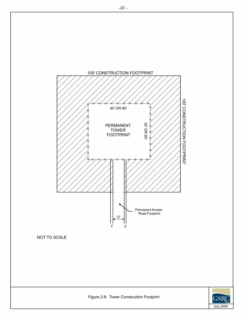
100' CONSTRUCTION FOOTPRINT
100'CO
NS
TRU
CTIO
NFO
OTPR
INT
Permanent AccessRoad Footprint
12'
}}
}}
}}
}}
}} } } } } } } } } } }
}}
}}
}}
}}
}
}}}}}}}}}}
PERMANENTTOWER
FOOTPRINT
50' OR 80'
50'OR
80'
2' 2'
Figure 2-8: Tower Construction Footprint
July 2009
NOT TO SCALE
-37 -
- 38 -
SBInet Ajo-1 Tower Project EA Final
The following is a list of heavy equipment and vehicles expected to be used during each phase of RDT and SST tower construction:
Civil Phase (Installation of tower, shelter, generator, etc.) Front-end loader or equivalent (1) Drill Rig (1) Excavator (1) Water truck (1) Crane (1) Bulldozer (1, as needed) Dump trucks (up to 3, as needed)
Flatbed delivery truck (up to 3 and trailers): The type of truck required varies with site conditions, material needs (i.e., shelter, tower, LP tanks, solar panels, microwave dishes, etc.)
Fence and Parking Area Construction Phase Small Excavator (1) Post pole digger (1) Crew trucks (approximately 6)
Tower Site Construction Check-out Phase Crew trucks (approximately 8)
Sensor Installation Phase Crew trucks (approximately 6)
Integrated Site Functional Check-out Phase Crew trucks (approximately 3)
Radar Characterization and System Checkout Phase Crew trucks (approximately 4)
System Acceptance Test Phase Crew trucks (approximately 4)
Site Security (All Phases) Crew trucks (approximately 1)
RATsClearing, grading, and leveling would be required to install RAT sites. The RAT sites would have a permanent site footprint of 14- x 14-foot and a 35- x 35-foot temporary construction buffer around the permanent site footprint. Vegetation in the permanent tower footprint and temporary construction buffer would be removed if required for construction purposes. The temporary construction buffer would be revegetated.
- 39 -
SBInet Ajo-1 Tower Project EA Final
Deployment of proposed tower sites TCA-AJO-189 and 204 would require helicopter use. A Kaman K-Max helicopter with a lift capacity of 6,000 pounds would be used to transport construction materials, equipment, and supplies and a Bell Jet Ranger helicopter (1,000 pound payload) would be used to transport construction and biological monitoring personnel. Helicopter lift locations would be at the Ajo airport for proposed tower site TCA-AJO-189 and the Tiger Pit on OPCNM for proposed tower site TCA-AJO-204. A 5-week build cycle is anticipated for each proposed RAT tower site. CBP estimates that construction of proposed tower sites TCA-AJO-204 and 189 would require up to 22 total lifts for equipment and materials per tower and approximately 63 total lifts for personnel during build cycle at proposed tower site TCA-AJO-189. Thus, a total of approximately 85 lifts would be required to construct proposed tower site TCA-AJO-189 and approximately 22 lifts would be required to construct proposed tower site TCA-AJO-204. A helicopter lift sequence for proposed tower site TCA-AJO-189 is provided in Table 2-3.
The following is a list of equipment and power tools expected to be used during the construction of RAT towers:
Small excavator or Bobcat type vehicle Air compressor Jack hammer Portable generator Small rock drill rig Electric drill Electric grinder Electric saw Jumping jack
The total time for all phases of construction, including testing, for each proposed tower site is expected to be approximately 26 to 80 days depending on the tower type and would occur during daylight hours. Generally, RDTs would require up to 40 days, SSTs would require up to 80 days (this includes a 28 day concrete set), and RATS would require up to 26 days to be constructed. Construction activities are anticipated to begin in January 2010. It is anticipated that up to five vehicle trips per day would occur during tower construction. Currently, it is anticipated that sensor payload installation on the proposed towers would occur in Sonoran pronghorn (Antilocapra americana sonoriensis) habitat during the Sonoran pronghorn closure season (March 15 to July 31). The installation of the sensor payload would require 2 days per tower site and include up to 12 people, and delivery truck and personnel vehicles.
Following the completion of the sensor payload installation, testing and system acceptance testing would be conducted as part of construction activities to check the operability of the sensor and communication system. Sensor and communication acceptance testing would require 2 days each per tower site and would include 6 to 12 people. Site functional check out would require 2 days per tower site and would include

SBInet Ajo-1 Tow
er Project E
A
Final
- 40 -
Table 2-3. Helicopter Lift Sequence for Proposed Tower Site TCA-AJO-189
Construction Phases Activities Duration
in Days
Minimum Number of Lifts Construction/Equipment/Material
Personnel Lifts * Description Purpose Weight Duration
on site Lift
Civil Layout
A&B work, Flag/tag
1 Toilet, Survey Equipment, Install SWPPP measures
Lay out and set up the site
forconstruction.
1000 20 days 1 3
Establish site with basics (toilet, some tools)
SWPPP measures
Civil 1
Lift required tools to site
3
Mini Excavator Earthwork and assembly 6000 20 days
3 9 Clear ground
Air Compressor (Atlas Copco 18 CFM), Rock Saw, Rock Drill, Chipping Hammers, Core Drill, Misc Tools
Prepare site, assembly 3000 12 days
Drill anchor points Jobox, Generator, Fuel, Gin Pole, Grounding Equipment Assembly 3000 20 days
Tower Installation
Equipment foundation blocks
2
Base Foundation Wafer #1 w/ Anchor Bolts Assembly 6000 Permanent
4 6
Locate and anchor equipment
Base Foundation Wafer #2 w/ Anchor Bolts Assembly 6000 Permanent
Erect Tower
30' RDT Assembly, Climbing Ladder w/ Safety Climb, Transmission Line Brackets, Antenna Mount, Air Terminal Kit Mounting Hardware
Assembly 3000 Permanent
Set Tower Assembly 2000 Permanent

SBInet Ajo-1 Tow
er Project E
A
Final
- 41 -
Construction Phases Activities Duration
in Days
Minimum Number of Lifts Construction/Equipment/Material
Personnel Lifts * Description Purpose Weight Duration
on site Lift
Grounding System Installation
Dig trench
3 No Equipment Lifts Needed Assembly N/A N/a 0 9
lay grounding ring
Makewelds/preliminary connections Grounding Inspections
Backfill trench
ETPs for grounding
Power System Installation
Install and test batteries
5
Battery Cabinet #1 (assembled), Installation Materials
Assembly 5000 Permanent
9 15
Install solar panels Battery Cabinet #2 (assembled), Installation Materials
Assembly 5000 Permanent
Install controls 8 Solar Panel Frames, 12 Solar Panel Frames Assembly 2500 Permanent
Run cables Water Tank (with Water) Assembly 5000 Permanent
Connect to grounding Carmanah Light, Air Terminal Kit (hardware already installed on tower), 8 Solar Panels, 12 Solar Panels, Electronics Rack
Assembly 1500 Permanent
ETPs for power Set Battery Cabinet #1 Assembly 5000 Permanent
Set Battery Cabinet #2 Assembly 5000 Permanent
Set Equipment Foundation #1 Assembly 6000 Permanent
Set Equipment Foundation #2 Assembly 6000 Permanent
Table 2-3, continued

SBInet Ajo-1 Tow
er Project E
A
Final
- 42 -
Construction Phases Activities Duration
in Days
Minimum Number of Lifts Construction/Equipment/Material
Personnel Lifts * Description Purpose Weight Duration
on site Lift
Communications System
Installation
Hang dishes
3 2 Microwave Dishes (6 inch), 2 Radios, 2 Cables Assembly 1000 Permanent 1 9
Connect waveguides Terminate connections Preliminary alignments ETP testing procedures
Civil 2
Clean site
1
Remove Mini Excavator Move earth 6000 20 days
4 3
Air Compressor (Atlas Copco 18 CFM), Rock Saw, Rock Drill, Chipping Hammers, Core Drill, Misc Tools
RemoveTools 3000 12 days
Remove equipment, parts, packaging
Jobox, Generator, Fuel, Gin Pole, Package Material, Remaining Site Tools
RemoveTools 3000 20 days
Remove SWPPP Measures, Remove Toilet
Removeequipment 1000 20 days
Restoration, Test, and Acceptance
Power up all components
3 No Equipment Lifts Needed Acceptance of site N/A N/A 0 9
Align dishes
ETPs
Boeing walkthrough
Punch list
Remove SWPPP measuresRevegetate, return site to natural state per contract
TOTAL 21 22 63
TOTAL HELO LIFTS FOR CONSTRUCTION 85
Table 2-3, continued

- 43 -
SBInet Ajo-1 Tower Project EA Final
12 people. System acceptance testing would require personnel walking multiple routes near different towers for a 2- to 3-hour period. Testing personnel would walk individually and as a group. System acceptance testing would occur during a 28-day period for all sites. Testing personnel would use vehicles on authorized roads to travel to walking routes identified by CBP; however, the identified routes would be traveled on foot. It is anticipated that testing and system acceptance testing would occur during the Sonoran pronghorn closure season. CBP will attempt, to the extent practicable, to accomplish testing prior to March 15, especially at proposed tower sites TCA-AJO-003 and 302.
2.3.3 Operation and Maintenance of Communication and Sensor Towers The hybrid propane generator-solar systems are expected to operate a total of 4 to 8 hours per day to bulk charge system batteries. Run times would be shorter on sunny days, when the solar array would provide more of the system operating power. Generator run times for systems connected to the commercial power grid would be limited to 1 hour twice per month for maintenance purposes, system conditioning, and off-grid operational schedules if grid power is interrupted, backup generators would temporarily be operated, as needed, until grid power is again available.
Tower site maintenance would include refueling of propane generators, as well as changing oil, oil filter, and spark plugs. This necessitates vehicle travel to each of the proposed tower sites for propane delivery, maintenance, and operations of the proposed towers. The number of maintenance trips and refueling trips varies depending on tower type (i.e., sensor) and power type (i.e., commercial grid power). Sensor towers require more maintenance and fuel than communication towers as do towers powered by generator/solar systems (Table 2-4). Maintenance personnel would typically use a 0.5 or 0.75 ton four-wheel drive pickup truck with single rear tires to travel to each tower site accessible by road (Boeing 2009). A minimum of four qualified maintenance personnel would attend each maintenance visit. It is anticipated that one vehicle trip to and from each of the proposed tower sites would be required per maintenance visit. Tower sites connected to commercial grid power would require maintenance six or 13 times a year depending on tower function (Table 2-4). Tanker trucks with dual rear tires and/or rear dual axles with a gross vehicle weight (GVW) of 30,000 pounds would be used to deliver fuel to each applicable tower. A total of approximately 191 vehicle trips per year would occur for tower maintenance and refueling (Table 2-4).
- 44 -
SBInet Ajo-1 Tower Project EA Final
Table 2-4. Summary of Annual Vehicle Trips Required for Tower Maintenance and Refueling for the Proposed Action
Tower Type Function Power Source MaintenanceTrips
RefuelingTrips Total
TCA-AJO-003 RDT Sensor Generator/Solar 24 12 36 TCA-AJO-004 RDT Sensor Generator/Solar 24 12 36 TCA-AJO-170 RDT Sensor Grid and Generator/Solar 13 1 14 TCA-AJO-216 RDT Sensor Grid and Generator/Solar 13 1 14 TCA-AJO-301 SST Comm Grid and Generator/Solar 6 1 7 TCA-AJO-302 RDT Sensor Generator/Solar 24 12 36 TCA-AJO-303 SST Comm Generator/Solar 6 6 12 TCA-AJO-310 RDT Sensor Generator/Solar 24 12 36 TOTAL 134 57 191
Boeing 2009 Comm = Communications
RAT sites would require maintenance up to four times per year. Maintenance at proposed tower site TCA-AJO-189 would require four helicopter trips per year. It is anticipated that maintenance personnel would access proposed tower site TCA-AJO-204 on foot via a foot trail. However, maintenance personnel may not be able to carry some equipment necessary for routine maintenance and an occasional helicopter lift may be required for maintenance. Additionally, helicopter lifts would be required at proposed tower site TCA-AJO-204 for battery replacements; however, at this time the frequency of battery replacement is unknown and would depend on tower power requirements and weather conditions. Any helicopter lifts required for maintenance at proposed tower site TCA-AJO-204 would be coordinated with the OPCNM superintendent. Maintenance of all tower sites would be minimized to the extent practicable and conducted in accordance with the maintenance plan for the Ajo-1 Tower Project (Boeing 2009). Currently, CBP’s Office of Information Technology maintains a repeater tower on Growler Mountain. To the extent practicable CBP would conduct maintenance at proposed tower site TCA-AJO-189 and the existing repeater site at the same time to reduce helicopter flights in Cabeza Prieta Wilderness. Helicopter flights for maintenance activities would originate from Tucson. Maintenance flights would be coordinated through the USBP Tucson Sector’s Public Lands Liaison Agent.
2.3.4 Road and Corridor Construction, Repair, Improvement, and Maintenance Repair and improvements of authorized roads and an authorized corridor would be required to move construction equipment, materials, and personnel to and from the proposed tower sites during construction (see Table 2-2). Authorized roads are existing roads used for public access. The authorized corridor is a power line ROW and is not open to the public. Maps depicting authorized road improvements, authorized road repairs, authorized corridor repair, authorized corridor improvements, access roads, and new road segments at each proposed tower site are provided in Appendix C. Access road construction would be required to provide access from authorized roads to the proposed towers sites. All authorized roads and the authorized corridor would be maintained to allow access for routine tower maintenance activities.

- 45 -
SBInet Ajo-1 Tower Project EA Final
SBInet has developed the following road construction and maintenance plan for the authorized road and corridor segments associated with the SBInet Ajo-1 Tower Project.
SBInet will fund OPCNM to repair and/or improve the authorized road to proposed tower site TCA-AJO-310 and authorized corridor to proposed tower site TCA-AJO-170. All other authorized roads associated with the SBInet Ajo-1 Tower Project would be bladed to allow for construction equipment access only when deemed appropriate and necessary by the land manager.
CBP (Facility Management and Engineering) will maintain roads, as determined by OBP, as part of the comprehensive maintenance plan discussed under road and corridor maintenance beginning in the summer of 2010. The purpose of the study is to identify those roads susceptible to degradation and provide methods to upgrade these roads to prevent potential degradation of natural resources.
CBP (Facility Maintenance and Engineering) will conduct an engineering study of roads associated with the SBInet Ajo-1 Tower Project. It is anticipated the engineering study would be completed in the spring of 2010.
Tucson Sector (Project Development Team) and OPCNM will collaborate on what roads are needed to support TI on OPCNM and OBP will prioritize to CBP (Facility Maintenance and Engineering) which roads to upgrade based on the engineering study. CBP will provide OPCNM with a detailed plan for road upgrades for 2010 and beyond.
Road and Corridor RepairsA total of four authorized roads would require repairs along a total of 3.9 linear miles of road segments. These authorized roads are associated with proposed tower sites TCA-AJO-004, 216, 303 and 310 (see Table 2-2 and Appendix C). Additionally, 4.4 linear miles along the authorized corridor to proposed tower TCA-AJO-170 would be repaired. Repairs include minor grading, leveling, and installation of nuisance drainage structures (i.e., graded low water crossings). An archaeologist would be present during ground disturbing activities in previously undisturbed areas to monitor construction activities. All existing authorized roads are currently accessible by four-wheel drive vehicles; thus, repair is only needed to allow passage of heavy construction equipment. All repaired road segments would be graded to a maximum driving surface width of 12 feet within the existing alignment of the road and would include a 2-foot temporary construction easement on each side of the road. Following construction activities, the 2-foot temporary construction easement would be revegetated at the discretion and under the direction of the land manager with a mixture of native plant seeds or nursery planting (or both). Seeds and plants would be obtained from acceptable sources as determined by the corresponding land manager per the Erosion and Sediment Control Plan provided in the construction plans for each tower site. NPS and CBP contractors would assess the need for road surfacing (including aggregate) and drainage structures for each proposed tower site and associated roads to prevent unacceptable impacts to roads, drainages, and adjacent areas. Drainage structures may include, but are not limited to, ditches, culverts, and low water crossings. Road surfacing and drainage structures would be implemented as needed. Repairs to authorized roads would permanently

- 46 -
SBInet Ajo-1 Tower Project EA Final
impact 5.7 acres of existing roads and temporarily disturb 1.9 acres adjacent to authorized roads (see Table 2-2). Additionally, repairs to the authorized corridor would permanently impact 6.4 acres and temporarily disturb 2.1 acres.
Road and Corridor ImprovementsFour existing authorized roads to proposed tower sites TCA-AJO-004, 170, 216, and 310 would require approximately 0.22 linear mile of improvements (see Table 2-2 and Appendix C). Approximately 1.7 linear miles of the authorized corridor to proposed tower TCA-AJO-170 would require improvements. The road sections to be improved are located along 59.4 Road, an unnamed BLM road, and Cement Tank Road. Road improvements include reconstruction, widening, and straightening of authorized roads. All improved roads would have a maximum driving surface of 12 feet and would include a 2-foot temporary construction easement on each side of road. Improvements to authorized roads would permanently impact 0.32 acre of existing roads and temporarily impact 0.11 acre adjacent to existing roads (see Table 2-2). Additionally, improvements to the authorized corridor would permanently impact 2.4 acres and temporarily disturb 0.81 acre.
CBP would fund OPCNM to perform the authorized corridor improvements for proposed tower site TCA-AJO-170. Improvements would include trimming vegetation back from the driving surface throughout the corridor, preparing and installing arched culverts in three specific drainages and contouring slopes on two drainages to the minimum needed to facilitate larger construction vehicle access. OPCNM would monitor the authorized corridor and add A/B aggregate as necessary to prevent road degradation (i.e., blowouts).
Road ConstructionA total of seven access roads totaling 0.07 mile in length would be constructed to provide access to tower sites from authorized roads. The access roads are associated with proposed tower sites TCA-AJO-003, 004, 216, 301, 302, 303, and 310 and would be constructed to provide a 12-foot wide driving surface with 2-foot shoulders on each side (see Table 2-2 and Appendix C). The total width of new access roads would be 16 feet. Additionally, one new road totaling 1.2 miles would be constructed within potential wilderness from the international border north to tie into the existing Concrete Tank Road and provide access to proposed tower site TCA-Ajo-310 (see Table 2-2). Construction equipment would stay within the 16-foot access road and tower site footprints. Any deviation from the 16-foot road footprint would be coordinated with and approved by the land manager prior to disturbance. The construction area would be flagged in coordination with the land managers. Access roads would be constructed by mechanically removing vegetation and grading native soils. Land managers and CBP contractors would assess the need for road surfacing (including aggregate) and drainage structures for each proposed tower site and associated roads to prevent unacceptable impacts to roads, drainages, and adjacent areas. Drainage structures may include but are not limited to ditches, culverts, and low water crossings. Road surfacing and drainage structures would be implemented as needed. Construction of access roads would result in 0.14 acre of permanent impacts and new road construction

- 47 -
SBInet Ajo-1 Tower Project EA Final
associated with proposed tower site TCA-AJO-310 would permanently impact 2.3 acres. Following construction activities, any temporary impact areas would be revegetated at the discretion and under the direction of the land manager with a mixture of native plant seeds or nursery plantings (or both), as describe previously. An archaeologist would be present during ground disturbing activities in undisturbed areas to monitor construction activities.
OPCNM would be responsible for constructing the new road associated with proposed tower site TCA-AJO-310. CBP would provide funding to OPCNM for the new road construction. Road construction activities would include removing vegetation from the proposed road footprint, scarifying the proposed road surface, blending A/B aggregate, grading, and compacting soils. The road base would be constructed in layers and the layers would be compacted to an approximately 95 percent compaction rate. A soil binder would be applied to the finished road surface. The uphill shoulder of the road would be delineated with sediment waddles.
Road and Corridor MaintenanceCBP is implementing a comprehensive maintenance and repair program for all roads and the authorized corridor on OPCNM associated with CBP TI and SBInet projects required to ensure full-time access to the towers and other TI. Specific maintenance requirements and schedules for each road and the authorized corridor will be developed between the USBP Sector and the land manager. Maintenance may be performed by contractors or by the land manager as deemed appropriate between the USBP Sector and land manager. It is anticipated that maintenance activities of authorized roads and the authorized corridor may occur up to six times per year, as necessary. In addition to the authorized road and corridor segments constructed, repaired, and improved as part of the Proposed Action, CBP would maintain additional lengths of roads (38.2 linear miles total) to provide access to the tower sites for maintenance and refueling purposes (Figure 2-9). It is anticipated that maintenance of authorized roads and the authorized corridor could include grading within the existing road or corridor alignment to maintain the condition of the road or corridor surface for tower maintenance access. At the land manager’s discretion, additional aggregate or a soil stabilizer, such as Pennzsuppress™, may be used to improve the driving surface of maintained authorized roads or corridor. Maintenance actions would include necessary erosion control associated with the roads and authorized corridor. Road maintenance activities would be conducted outside the Sonoran pronghorn closure season to the extent practicable. Specific cases (e.g., road impassable) where road or corridor maintenance is required during the Sonoran pronghorn closure season to allow access to a tower site for tower maintenance would be coordinated with and require approval from the land manager and USFWS-AESO. Additionally, biological monitors would be required during authorized road and corridor maintenance activities during the Sonoran pronghorn closure season. If a significant upgrade in road or authorized corridor condition is required, additional environmental documentation would be required.

- 48 -
SBInet Ajo-1 Tower Project EA Final
THIS PAGE LEFT INTENTIONALLY BLANK

!.
!.
!.
!.
!.
!.
!.
!.
!.
!.
!.
¬«85
¬«86
Aj o
Ra
ng
e
Bates Well Road
PozoN
uevoR
oad
NorthPuerto Blanco Drive
AjoMountain
Driv
e
59.4 Road
TCA-AJO-310
TCA-AJO-305
TCA-AJO-303
TCA-AJO-302
TCA-AJO-301
TCA-AJO-216
TCA-AJO-204
TCA-AJO-189
TCA-AJO-170
TCA-AJO-004
TCA-AJO-003
·1:250,000
0 1 2 3 4Miles
0 3 6 9 12Kilometers
August 2009
Figure 2-9: Road Maintenance Associated with the Proposed SBInet Ajo-1 Tower Project
Organ Pipe Cactus National Monument
!.
!.!.
!.
!.
!.
!.
!.
!.
!.
!.
Tower Locations!.
United StatesMexico
Organ Pipe Cactus National MonumentNon-wilderness Areas
Cabeza Prieta National Wildlife Refuge
Cabeza Prieta National Wildlife RefugeNon-wilderness Area
BLM
Tohono O'odham Nation
!. Proposed Action Tower Locations
Maintained Road Segments
Authorized Roads
!. Tower not included in this analysis
- 49 -

- 50 -
SBInet Ajo-1 Tower Project EA Final
THIS PAGE LEFT INTENTIONALLY BLANK
- 51 -
SBInet Ajo-1 Tower Project EA Final
2.3.5 Forward Operating Base The USBP Ajo Station currently maintains and operates a FOB on OPCNM at the Bates Wells historical site (see Figure 1-2). FOBs allow the USBP to deploy agents closer to the U.S.-Mexico border for the purpose of detecting and responding to CBV activities more efficiently and effectively. This forward deployment decreases travel and response time to CBV activities. The USBP proposes to relocate the FOB at Bates Well to a proposed tower site location adjacent to TCA-AJO-302 and disassemble the existing FOB infrastructure at Bates Well historic site. Current equipment at the Bates Well FOB includes, three 8- x 24-foot connex boxes; three portable generators; one diesel fuel trailer; 1,000-gallon water truck; 500-gallon water buffalo on trailer; and one portable light generator. Equipment and facilities (i.e., connex boxes and generators) would be removed from the Bates Well site and the parking area and portable horse corral area would be cleaned up. It is anticipated that all equipment generators and water tanks could be moved within 2 to 3 days after the initiation of disassembly; however, the connex boxes could require up to 1 week to move. The generators and water tanks could be moved with a four-wheel drive pickup but the connex boxes would require a rollback truck. The proposed relocation would eliminate the existing FOB from a narrow travel corridor used by Sonoran pronghorn to access the Valley of the Ajo. Although relocation of the camp may result in impacts to Sonoran pronghorn near the proposed site, it would eliminate potential impacts of the Bates Well FOB on Sonoran pronghorn using this very important and narrow travel corridor. The FOB would be moved outside the Sonoran pronghorn fawning season (March 15 to July 31). It is anticipated the FOB would be moved within 1 year of acceptance of the proposed towers.
The proposed FOB would have a footprint of approximately 1 acre and similar equipment as the current FOB, with the exception of a septic system. A deep-discharge septic system would be installed for waste water and sewage disposal at the proposed FOB site. A portable chemical toilet would be used for processing human waste until the septic system could be installed. The septic system would be of sufficient design and capacity for up to 10 people. The leach field trenches would be excavated to a depth of 16 feet and backfilled with 2-inch diameter gravel to a depth of approximately 6 feet. Perforated pipe would be installed over the gravel and covered with a geotextile fabric and backfilled with excavated soil. The septic system would be constructed to the International Building Code and Arizona Department of Environmental Quality’s (ADEQ) standards for septic systems. Further, an archaeological monitor would be present during ground disturbing activities in previously undisturbed areas. The proposed access road associated with proposed tower site TCA-AJO-302 would also serve as access from El Camino del Diablo to the proposed FOB. There would be no new road construction associated with the proposed FOB. El Camino del Diablo would be maintained up to six times a year to ensure access to proposed tower site TCA-AJO-302 and the FOB. Road maintenance was discussed previously in Section 2.3.4.
A minimum of one vehicle per agent would be parked within the footprint of the proposed FOB. Vehicle trips would vary depending on operational needs. The primary geographic focus would start in the area surrounding the camp. However, agents would

- 52 -
SBInet Ajo-1 Tower Project EA Final
respond as directed to work other areas of the Ajo Station’s AOR as operations dictate. Additionally, horse patrols would be conducted from the proposed FOB when operations dictate. Horses would be housed at the proposed FOB and would either be ridden or trailered to patrol areas. Manure from the horse corral would be collected and disposed of off-site in accordance with the BMPs provided in Section 5.0.
The operation of the proposed FOB may occur 365 days per year, and as long as illegal cross border activities persist, which require its operation. When USBP determines the FOB is no longer needed, it would be dismantled and removed within 1 year of USBP’s determination. The site would be restored to previously existing conditions in coordination with the land manager and the USFWS-AESO. Further, it is anticipated USBP may establish a 2-acre FOB similar to the Papago Farm FOB in the future. Establishment of the larger FOB is dependent on securing funding, coordination with land managers, and development of additional environmental documentation, as appropriate.
2.3.6 USBP Operations Tolerance to Depth of IntrusionUSBP’s operational intent is to compress the primary zone of enforcement as close to the international border as practical. Several factors determine the viability of compressing an enforcement zone, such as access to routes of egress, available infrastructure capable of supporting smuggling activity, viability of checkpoint operations which provide enforcement-in-depth, and accessibility to the border areas. In order to attain border control with the optimal enforcement zone relatively close to the border, significant resources must be applied and effectiveness sustained over time to mitigate illegal activity.
Tolerance to depth of intrusion relates to the time and distance that agents have to effectively interdict illegal traffic. In many urban areas, agents have just seconds to make an interdiction, because it requires only seconds for CBVs to escape into a house, business, or means of transportation. In this environment, the tolerance to depth of intrusion is minimal, because agents do not have the luxury of time or distance in which to effect the arrest. As the operational environment becomes more rural and remote, violators may take days to reach an area where they can load into a vehicle and abscond. In these areas, depending on available resources, tolerance to depth of intrusion may be many miles, or days in the terms of CBVs walking through the hazardous desert terrain. Utilizing technology, agents track incursions and plan their interdictions to effectively interdict all of the traffic flow through a given area. In these remote areas, the ability to move laterally within the area of operation is critical to success. Agents must be able to respond and interdict consistently to create the necessary deterrence through certainty of arrest.
The deployment of technology such as SBInet towers facilitates the effective interdiction of traffic through detection and tracking of multiple targets within a given viewshed. SBInet towers allow USBP agents to control the point of interdiction to locations that are operationally preferred. As enhanced operations are maintained over time, illegal traffic

- 53 -
SBInet Ajo-1 Tower Project EA Final
flow is mitigated within a target area and the tolerance to depth of intrusion is concurrently reduced. This reduction in tolerance to depth of intrusion is based upon increased capacity to apprehend and is less than the tolerance to depth of intrusion determined in the absence of needed technology. Based on current traffic patterns, available resources, and trends observed in Yuma Sector and the Altar Valley a decrease in traffic could be realized within 1 year of the towers becoming operational. With regard to the SBInet current technology, “operationally preferred” refers to points of interdiction that contribute to safety and efficiency. These locations would ideally be on or close to existing roads so that agents do not have to walk long distances to and from the point of interdiction, and transportation can be facilitated quickly and efficiently as close to the point of interdiction as possible. Due to the technological capabilities afforded by the project, agents will be able to manage the point of interdiction, providing operational efficiencies and the ability to make decisions with regard to environmental impacts. This also reduces the need for basic patrol and extended tracking operations where interdictions often occur in remote areas.
Ultimately, as an area comes under effective control, the tolerance to depth of intrusion is contained within the optimal enforcement zone, as close as practical to the international border. As USBP does not control the various independent factors influencing illegal cross-border activity, this distance will vary from place to place within the target area depending on various factors. Given the dynamic nature of law enforcement operations and the fact that USBP will always be responsive to the ever changing threat, it is not feasible to provide exact parameters. The intent is to compress enforcement activities as close to the international border as is operationally appropriate within a given area.
The objective of this enforcement strategy is to maximize interdiction capabilities so that traffic levels are reduced to a level where border control can ultimately be achieved on or as close to the actual border as practical. It should be recognized that in areas where enforcement is not focused on the immediate border for operational reasons, the effect would still be to reduce traffic. Effective enforcement, even a distance off of the border, removes the financial incentive for smuggling organizations to use the area. This provides increased safety and environmental protection in the entire area once the reason for criminal activity to exist in the enforcement area has been removed.
Due to the remote nature of much of the SBInet Ajo-1 Tower Project’s project area, what is critical is that regardless of where an incursion occurs, there is a corresponding law enforcement response. This deterrence through certainty of arrest applies to the geographic area as a whole, and is a well established part of the strategy. This is the primary reason for USBP checkpoints, which address routes of egress. Even if a CBV is successful in passing through the primary enforcement zone, he must still contend with checkpoints. This regional deterrence provided by defense in depth is a significant factor in attaining overall mitigation of illegal traffic.
Tolerance to depth of intrusion is directly related to activity levels and the point at which the existing law enforcement resources are able to resolve known intrusions. As

- 54 -
SBInet Ajo-1 Tower Project EA Final
resources are adjusted and applied to existing activity levels, effectiveness improves over time.
Focused OperationsWhen USBP identifies an area of focus under the NBPS, decisions regarding the deployment of resources into that area are made in accordance with the sector’s existing operational plan. Depending on the operational dynamics of the targeted area, various combinations of manpower, technology, infrastructure, and enforcement programs are designated for application. Within the operational footprint, a baseline level of activity is established; resources are then deployed in an effort to significantly reduce this baseline activity level, notably by disrupting the operations of smuggling organizations.
Resources, including technologies, are deployed based on intelligence and operational data. Technological resources provide an enhanced level of detail regarding real-time activity in an area which enables USBP agents to evaluate and take the appropriate action to respond to and interdict an increased number of the violations already occurring in the area. This increased enforcement effectiveness is due to the enhanced ability to see what is taking place on a large scale, as well as where activity is occurring, thus allowing focused, planned response by agents. As a result, an increased number of the violations in the area are interdicted and the profitability of criminal operations in the area is reduced. Over a relatively short period of time, USBP’s ability to bring identified illegal activity to a satisfactory law enforcement resolution reduces the financial incentives for criminal organizations to operate within the area affected by the technology. Ultimately, the reduction of cross border violations or elimination of illegal activity in identified areas will result in a corresponding reduction of the USBP’s footprint in the area, as enforcement actions can be scaled back in the absence of violations. As previously mentioned, based on current traffic patterns, available resources, and trends observed in Yuma Sector and the Altar Valley, a decrease in traffic could be realized within 1 year of the towers becoming operational. This operational evolution will likely be marked by an initial increase in arrests and seizures as operational effectiveness is markedly increased. An adjustment in operational output appropriate to the level of violations identified would result in further enforcement actions which would then dissipate over time. The level of border control achieved is maintained with an appropriately adjusted lower level of operational output.
Forms of technology, such as SBInet towers and sensors, Mobile Surveillance Systems (MSS), and Remote Video Surveillance Systems (RVSS) are utilized as force multipliers to provide sustained deterrence in a targeted area. These technological assets serve to provide enhanced situational awareness, and also act as deterrents to would-be criminals. Over time, the footprint of illegal traffic is mitigated as well as the operational footprint of the USBP. Two solid examples (Yuma Sector and the Altar Valley in the Tucson Sector) of the evolution of this operational strategy are discussed below.
- 55 -
SBInet Ajo-1 Tower Project EA Final
1. Yuma Sector: When USBP applied this operational strategy to Yuma Sector in 2007, Yuma Sector was one of the busiest crossing places in the country. Within 1 year of applying this strategy, Yuma Sector saw a decrease in activity from 33,405 arrests to 7,077. Since 2005 (when the traffic was highest) there has been a 95 percent decrease in cross border violations (99,491 arrests in 2005 year to date vs. 5,287 in 2009 fiscal year [FY] to date).
Yuma Sector’s strategy involved the balanced deployment of personnel, technology, and infrastructure specific to the operational environment (i.e., urban area versus rural or remote, topography, time allotted for detection and apprehension). Technology included RVSS, mobile scope trucks, sky boxes, remote sensors, and MSS. USBP’s presence was significantly concentrated as opposed to being scattered over a larger area.
Following implementation, illegal entries declined drastically and were effectively confined to the immediate border. USBP presence within rural and remote areas did not decrease significantly initially, but rather was focused on patrolling the immediate border. USBP presence was significantly concentrated as opposed to being scattered over a larger area. This permitted agents to forward deploy, conducting patrol activities in close proximity to the international border. The establishment of all-weather patrol roads coupled with the decreased entries reduced the necessity of off-road travel and decreased agent response time. The compression of the enforcement zone brought interdictions closer to the international border.
The decrease in illegal activity in the Yuma Sector is a result of USBP activities and not economic conditions as the successes in Yuma Sector clearly preceded the economic downturn. Most of the traffic that had been entering in Yuma Sector’s AOR moved elsewhere to areas along the international border that lacked the proper combination of manpower, infrastructure and technology. The overall strategy of incrementally gaining effective control of the international border, maintaining that control, and expanding it into other areas of the international border recognizes and addresses this trend.
Cross-border traffic overall has been decreasing over the past several years, but at much more modest percentages from single digits to 16 percent last year. The results in Yuma Sector are clearly due to the application of the combination of resources required to create the needed deterrence.
2. The Altar Valley within the Tucson Station’s AOR: Traffic decreased from 41,729 arrests in 2007 to 33,099 in 2008. Since 2006 (when traffic was at its peak) there has been a 70 percent decrease in cross border violations (54,031 arrests in 2006 year to date vs. 16,494 in 2009 year to date).
This decrease in illegal activity is generally not due to the economy. Tucson Sector realized a 16 percent reduction of illegal activity as a whole compared to 70 percent in the target area. Anecdotal information from newspaper articles document that the town of Sasabe, Sonora was becoming a “ghost town” prior to the current economic

- 56 -
SBInet Ajo-1 Tower Project EA Final
downturn. This was due to the fact that smugglers and other CBVs were no longer frequenting local establishments, and the significant reduction in smuggling activity had a commensurate impact on associated revenues locally.
Within the Altar Valley, SBInet’s Project 28 introduced nine sensor towers and deployed three MSS into the targeted area. Primary border fencing and patrol roads along the international border were constructed as well within the corridor, and enhanced agent resources were assigned to the corridor. In conjunction with enhanced manpower, technology and infrastructure, focused prosecutions, and other consequence programs were geographically targeted in the area to provide additional deterrence to prospective CBVs. The combination of these resources applied over time created the sustained deterrence needed to mitigate the activity in this area.
As a result, Tucson Station has significantly compressed its zone of enforcement closer to the border, and agents are conducting far fewer patrols across much of the Altar Valley. Currently, the SBInet TUS-1 project is being installed to replace P28, which will provide the sustaining situational awareness for this area. The enforcement footprint has been significantly reduced, and this will continue as control of the border is increased.
Within the Altar Valley, there was a marked decrease in USBP presence and a reduction in patrols in many areas north of the immediate border area. Tucson Sector compressed its enforcement zone significantly closer to the border, as did Yuma Sector. Both of these examples model the NBPS in that, as effective control is achieved, the zone of enforcement trends closer to the international border over time. This reduces the footprint of illegal crossings within the target area, and thereby reduces the overall operational footprint and tolerance to depth of intrusion.
In both cases, although the actual number of patrols may not have changed drastically, the concentration of those patrols is in a much more focused and concentrated area near the international border. In the Altar Valley for example, instead of agents patrolling a 45-mile deep zone from Sasabe to Three Points, the concentration of patrols is now within a much smaller zone which may range from 0 to 10 miles from the international border depending on access and activity levels. Over time, as effective control continues to improve, patrols even within these compressed zones decrease as technology and infrastructure are utilized to maintain gains.
In the context of SBInet, the technology allows that agents do not have to conduct as many basic patrols across vast areas for sign-cutting purposes and other types of manual detection. Based on the established capabilities of the technology being utilized, agents will be able to respond to verified detections as needed and interdict them based upon information provided by the technology. This facilitates a planned response with the technology driven detections providing a suite of options for interdiction unique to each particular detection. This suite of options includes actions in response to the identified level of threat as well as considerations as to ideal potential locations for the interdiction.

- 57 -
SBInet Ajo-1 Tower Project EA Final
Patrol Activities Current detection methodology within the Ajo Station’s AOR includes traditional sign cutting which requires both patrolling and dragging of roads, particularly east-west roads. To ensure timely detection and effective response, patrolling and dragging must take place on a regular basis within each shift. Remote sensors are strategically placed to aid detection and interdiction of illegal activity.
Currently, identification, classification, response, and resolution actions require that agents respond to evidence of illegal entry gained through the previously mentioned tools and techniques as well as through direct observation. Agents, in most cases, follow sign as opposed to the viewed subjects. They follow, flank and interdict using agents on foot. Following sign means that there is an inherent time delay between the responding agents and the suspects. At times, agents respond on horseback, on all terrain vehicles and motorcycles, and with rotary wing aircraft. Generally, fixed-wing aircraft are not used in the Ajo Station’s AOR; however, light, medium, and heavy rotary wing aircraft are available and used based on the activity in the area. These traditional methods would continue to be utilized after the SBInet towers are operational and would serve as a force multiplier. When necessary, agents may respond in motor vehicles under the provisions of the Cooperative National Security and Counterterrorism Efforts on Federal Lands along the United States’ Borders Memorandum of Agreement (MOU) between DHS, DOI, and U.S. Department of Agriculture (USDA) (DHS 2006). The MOU states (page 6, IV.B.4), “Nothing in this MOU is intended to prevent CBP-BP agents from exercising existing exigent/emergency authorities to access lands, including authority to conduct motorized off-road pursuit of suspected CBVs at any time, including in areas designated or recommended as wilderness...” (DHS 2006). The choice of the mode of transportation is based on a variety of factors, including terrain, time of day, availability of low impact modes, and timeliness of the sign, but the deciding factors are always effective and timely interdiction with primary consideration of officer safety. The application of technology allows use of these force multipliers employing direct guidance of USBP agents to CBVs rather than basic patrol techniques. Deployment of the towers and other intrusion detection devices all support the COP. Implementation of the COP will support the USBP National objectives through improved efficiency and effectiveness of operations to reach the goal of effective control of our Nation’s border. The USBP’s National objectives include:
Establish substantial probability of apprehending terrorists who attempt to enter illegally between the ports of entry;
Deter the illegal entries through increased enforcement and apprehensions;
Detect, apprehend and deter smugglers of terrorist weapons, humans, drugs and other contraband;
Leverage “smart border” technology to multiply the effectiveness of enforcement personnel; and
Reduce crime in border communities and consequently improve quality of life, and economic vitality of targeted areas.

- 58 -
SBInet Ajo-1 Tower Project EA Final
Once SBInet towers are installed and operational, agents would respond specifically to detected cross border violations occurring in the project area. The towers would provide constant situational awareness and detection and tracking capabilities that would allow agents to optimize interdiction points. Cameras would be utilized to classify the threat identified by the radar track. This allows deployment of the appropriate response to a given threat, raising operational efficiency and effectiveness. Agents would respond to verified threats and work them in a manner tactically advantageous to the agent.
These tactics are expected to reduce the need for agents to patrol within the radar track to look for signs of illegal activity. This would free up resources and increase efficiency as location of illegal activity is accomplished by use of technology. The Tucson Sector operational strategy identifies areas of focus within its 262 miles of border. These areas are defined primarily by station AORs. The technology and infrastructure resources are tools utilized in conjunction with other resources to achieve effective control of the border. The focus areas are not defined by the towers or their capabilities, but rather by areas of border that would be targeted as a whole. In areas without technology other tactics would be utilized. Effective control is achieved for an entire border area. This means that activity levels would be reduced throughout the focus area.
As operational effectiveness increases over time, illegal traffic would decrease resulting in a reduced need for agents to respond to a given area. Ultimately, the towers would continue to provide deterrence through continual monitoring, and resources can be re-deployed to other operational priorities. The criminal and consequent CBP operational footprint in a targeted area would be significantly reduced over time, thus lessening the impact to habitat and wildlife within the target area. Other areas which receive increased illegal traffic would be addressed using future deployments of technology and resources.
Traffic ShiftsHistorically, as operations within a target area become more effective, CBVs seek alternate routes and avenues of escape. Given the capabilities of the SBInet AJO-1 tower sites, USBP operators would use other technology to act as a force multiplier to the SBInet towers. The utilization of this technology would give agents on the ground the situational awareness needed to respond appropriately to traffic throughout the targeted area.
Interdiction ActivitiesHistorically, USBP agents have performed their enforcement duties through a series of steps. Agents have had to detect illegal activity using their senses. Once detected, the agents have applied their officer experience to identify the type of traffic (verify that the sign such as footprints is made by illegal traffic) then classify its threat. These steps have been subject to use of available resources and are often lacking in sufficient detail for full understanding of the nature and threat posed by the maker of the sign encountered due to variances of weather, time, etc. Agents, upon making judgments based upon experience and ability, then respond as appropriate (for example, agents

- 59 -
SBInet Ajo-1 Tower Project EA Final
will not follow sign believed to be legitimate traffic, but will follow sign believed to be illegal traffic). The final step is resolution of the traffic. Agents would interdict violators assuming success in following the sign encountered and in catching up with the maker of the sign. Provided the encounter is made prior to the subject(s) absconding from the area, agents would then interdict as appropriate, or may discover that what appeared to be illegal traffic was in fact legitimate in nature.
The advent of SBInet technology provides a labor-savings as well as a reduction of impact on the environment. The previously described labor intensive steps (detect, identify, classify, respond and resolve) change markedly under SBInet technology. Detection, identification and classification are performed by a person monitoring signals from the technology. This person is located in a control room and thus does not affect the environment in the same manner as an agent using basic human senses combined with agent experience and skill. Three of the steps required to achieve the requisite satisfactory law enforcement conclusion are performed remotely. The agent is thus freed up from some of the most labor-intensive stages of the process and allowed to focus upon responding to an identified and classified threat. The agent will then encounter the identified threat using the appropriate resources, verify the information received and appropriately bring the traffic to a satisfactory law enforcement conclusion. This scenario allows the agent to optimize factors of the encounter, thus benefiting officer safety and/or gaining efficiency in selection of locations for removal of violators or contraband from the field. Sensitive environments would be taken into account in the decision making process. The identification of sensitive environments and resources are provided as part of agent training. The removal of three of the five required steps to a remote location has the benefit of greatly reducing the necessity for agents to follow sign of the passage of those to be interdicted. This benefits both the efficiency of the agent and the environment in which the agent works. The number of occasions as well as the extent to which the agent would be required by the circumstances to drive a vehicle off of authorized roads is expected to be greatly reduced. In accordance with the 2006 MOU, USBP will provide reports of all off-road vehicle incursions to land management agencies (DHS 2006). Additional reporting criteria were also developed as part of formal Section 7 consultation pursuant to the ESA and are included as part of USFWS’s Biological Opinion.
Forward Operating BaseThe planned move of the FOB from its current location at Bates Well would allow this site to be used by the land managers to tell its story as a part of both past and present ranching history as intended in the OPCNM General Management Plan. The movement of the camp to near proposed tower site TUC-AJO-302 would also facilitate the migration of Sonoran pronghorn into the Valley of the Ajo. Pronghorn have rarely been documented in this area since the establishment of the FOB at Bates Well; however, prior to this, pronghorn extensively used the Valley of the Ajo, particularly during the summer months. USBP has reduced the number of agents and patrols in this area over the past 2 years. The move would concurrently place agents in a more strategically beneficial position to respond to illegal cross border traffic further from existing USBP stations. The benefit is multi-faceted in that it directly benefits Sonoran pronghorn, and
- 60 -
SBInet Ajo-1 Tower Project EA Final
minimizes daily vehicular traffic in the Ajo Station’s AOR and Sonoran pronghorn range by locating the FOB closer to areas to be patrolled daily by USBP agents detailed to the FOB.
Drag, Checkpoint and Observation PostsCurrently a lack of technology for real time location of CBVs exists. This lack of technology requires a large deployment of personnel to address illegal activity in the Ajo Station’s AOR. With implementation of the SBInet Tower Project, real time identification and classification of violators is anticipated. This would allow focused interdiction, thus reducing the size of personnel deployments required to locate violators. Traditional detection methodology of sign cutting and dragging of roads would continue in support of the NBPS, as necessary. The 2006 MOU (page 4, IV.B.2) provides for the dragging of existing public and administrative roads that are unpaved for the purpose of cutting sign (DHS 2006). As the certainty of apprehension is elevated within the Ajo Station’s AOR, the use of dragging operations is expected to be reduced in frequency compared to current levels. To document the success of the SBInet Ajo-1 Tower Project through the potential reduction in dragging operations, additional reporting criteria were also developed as part of formal Section 7 consultation pursuant to the ESA and are included as part of USFWS’s Biological Opinion.
Checkpoint operations are a critical component of the USBP’s defense-in-depth strategy to gaining effective control of the international border and as such, they augment other enforcement activities. Existing USBP checkpoints will be maintained and there is no expectation that they would be directly affected by this project. Ajo Station maintains one checkpoint on SR 85 at Milepost 18. An alternate checkpoint site used in the past is located at Milepost 57. Checkpoints under the COP would benefit by the presence of the project in that attempts to walk around the checkpoints would be identified and the appropriate law enforcement actions would be taken.
Use of high point observation posts will continue as needed, in order to enhance the overall effectiveness of operations throughout the Ajo Station’s AOR. High point observation posts entail USBP agents walking or driving on established roads to an area of higher elevation to achieve an advantage in observing illegal traffic.
Illegal Traffic PatternsThere are multiple factors that impact the flow of illegal cross border traffic into the U.S., most of which are independent of the USBP. The demand for illegal labor and illegal drugs is a primary draw for this illicit traffic, neither of which the USBP can control. Another dynamic impacting where this traffic occurs is the cartel operations within Mexico. This varies in intensity along the international border based upon many factors. All of these factors make it extremely difficult to put a timeline on operational impact. The key to reducing traffic in an area is establishing and maintaining deterrence through certainty of apprehension. Ultimately, the cartels and smuggling organizations operating along the border determine when their operating costs are too high to continue operations in a particular location (due to loss of product and manpower based upon seizures and arrests). In order to measure effectiveness, a timeframe of 1 year to
- 61 -
SBInet Ajo-1 Tower Project EA Final
compare activity levels against a comparable data set is a bare minimum. This allows a full annual cycle of activity which peaks in March each year. Activity levels must be compared against comparable times from one year to the next.
USBP can provide DOI annual briefings on historical and current activity levels as pertinent to the project area. Updates can be provided at the request of DOI land managers through the appropriate USBP Station or Sector Headquarters. Further, to document the success of the SBInet Ajo-1 Tower Project, reporting criteria were developed as part of formal Section 7 consultation pursuant to the ESA and are included as part of USFWS’s Biological Opinion.
Generally, USBP monitors activity levels through a variety of indicators, to include arrests, assaults, third party reporting, intelligence reporting, anecdotal information, and other internal metrics which when combined, paint a relatively accurate picture of illegal cross-border activity. When activity levels are reduced, the requirement for USBP activity is reduced, especially with the advent of SBInet. Technology itself continues to provide the situational awareness that previously required agent patrols and sign cutting operations.
Off-Road Vehicle UseUSBP will conduct field operations within the parameters of the MOU between DHS, DOI, and USDA for Federal lands along the U.S. border. The 2006 MOU states, “Nothing in this MOU is intended to prevent CBP-BP agents from exercising existing exigent/emergency authorities to access lands, including authority to conduct motorized off-road pursuit of suspected CBVs at any time, including in areas designated or recommended as wilderness...” (DHS 2006). Motorized off-road pursuit of suspected CBVs is conducted within the parameters of the MOU. The construction of this project is an attempt to minimize the need for all interdiction efforts through deterrence based upon improved enforcement. CBP recognizes that certain other operational needs, such as turning around drags and trailers, parking along roads, removal of seized vehicles, adverse road conditions, and expeditious emergency response may also result in impacts along authorized roads and unauthorized vehicle routes. Impacts generally consist of disturbances to vegetation and soils from vehicle tires. Through education and supervision, USBP in cooperation with the land managers will increase USBP agents’ awareness to the impacts of these actions and standard methods of minimizing impacts. CBP will work with land managers to facilitate operational needs while making every reasonable effort to reduce impacts. USBP will ensure that current and incoming agents attend environmental and cultural awareness training to be provided by the land management agencies.
USBP will continue tracking and reporting all off-road incursions and work with local land managers in a cooperative effort to capture the necessary data related to this issue.

- 62 -
SBInet Ajo-1 Tower Project EA Final
Patrol Best Management PracticesSome best management practices (BMP) currently employed by USBP in the project area are delineated in the 2006 MOU between DHS, DOI, and USDA (DHS 2006). These BMPs include efforts to be made by USBP to interdict CBVs close to the international border, road maintenance, use of lowest impact modes of travel appropriate for the circumstances, appropriate notifications and consultation, providing new agents environmental training, providing monthly statistics to the land management agencies, early consultation regarding new projects affecting land managers, and notification protocols for operational issues. Appropriate training, as addressed in the MOU, is provided by DOI and USDA and formatted to meet operational constraints.
MonitoringUSBP in coordination with land managing agencies has developed strategies to monitor operations associated with the SBInet Ajo-1 Tower Project. These were developed as part of the formal Section 7 consultation process pursuant to the ESA and are included as part of USFWS’s Biological Opinion (AESO/SE 22410-F-2009-0089 and 22410-1989-0078-R6), dated December 9, 2009. Data collected as part of these strategies would be used to monitor the success of the SBInet Ajo-1 Tower Project. These data are considered law enforcement sensitive information and would not be made available to the public. Further, USBP would continue reporting procedures to land managers per the 2006 MOU (DHS 2006).
2.3.7 Conservation Measures The following offsetting measures were developed through coordination with DOI agencies and land managers, as part of the ESA Section 7 consultation process, to offset potential impacts to Sonoran pronghorn and lesser long-nosed bat (Leptonycteris curasoae yerbabuenae) from the project. These measures were developed to reduce impacts associated with the proposed SBInet Ajo- Tower Project and are a part of the Proposed Action. Avoidance and minimization BMPs are described in Section 5.0.
Offsetting Measures for Sonoran Pronghorn
1) Unauthorized Vehicle Route (UVR) Assessment and Restoration
a. UVR ASSESSMENT: SBInet will provide $200,000 to DOI by the initiation of the SBInet Ajo-1 Tower Project construction to assess and map the number and extent of unauthorized, repetitively used vehicle routes (UVR) in Sonoran pronghorn habitat or potential habitat on CPNWR, OPCNM, and BLM lands within the Ajo-1 project area. This assessment will locate, record, and map UVR occurrences throughout pronghorn habitat within the project area. The assessment will also quantify UVR dimensions and severity as well as determine restoration potential and needs. The assessment will be conducted by DOI in years one and two (from the initiation of project construction). Additionally, CBP and DOI will investigate the possibility of using existing remote sensing technology to supplement or replace a portion of SBInet’s funding for this assessment. Further, CBP and DOI will work

- 63 -
SBInet Ajo-1 Tower Project EA Final
together to improve the reporting of off-road incursions that occur within Sonoran pronghorn habitat and wilderness.
b. UVR CLOSURE AND RESTORATION: SBInet will provide funding to DOI to close and restore UVRs documented as a result the UVR assessment. DOI will prioritize areas to close and restore based on importance of the areas to Sonoran pronghorn and on CBP information regarding anticipated continued use of UVRs (i.e., UVRs that will likely continue to be used by USBP due to emergency and exigent circumstances will receive a lower restoration priority as restoration in continuously used areas will not likely be successful). DOI will conduct the restoration work in between years 2 through 5 (from the initiation of project construction) or beyond, depending on the feasibility of restoration determined by the land management agencies. Total Funding: $1,750,000
c. UVR REASSESSMENT: CBP and DOI will cooperatively reassess the issue of UVRs within Sonoran pronghorn habitat and wilderness after 5 years (2014) and will resume discussions concerning evaluation of success of these efforts.
2) Vehicular use of the pole-line road (TCA-AJO-170) will continue to be only for exigent circumstances as per the 2006 MOU. Routine patrols will occur along SR 85. Additionally, a horse staging area will be established outside of wilderness in the 66 Hills/Alamo Canyon wash area of OPCNM. DOI will work with CBP to establish this horse staging area, the exact size and location of which, along with any associated infrastructure, will be mutually agreed upon in writing prior to its establishment. The intent of this horse staging area is to support CBP horse patrol operations in and around the Valley of the Ajo. Every effort will be made to limit the overall area of disturbance while maximizing safety and the adequacy of the site towards meeting its intended purpose.
3) Consistent with 2006 MOU, USBP will conduct patrol activities by horseback to the greatest extent practicable within the Sonoran pronghorn range, particularly from March 15 to July 31 (the Sonoran pronghorn closure season). DHS will follow all horse patrol BMPs coordinated with resource agencies (i.e., feed horses weed free pellets).
4) CBP will fund a portion of AGFD Sonoran pronghorn aerial monitoring efforts for 5 years. Funding will be provided for one full-time employee for 5 years, the purchase of collars and collaring costs for five Sonoran pronghorn, and 100 tracking flights (20 per year for 5 years). Total Funding: $346,000.
5) CBP will contract for cultural surveys at two proposed forage enhancement sites for Sonoran pronghorn on BLM lands. One site is located at UTM 0320443 x 3564606 and the second is located at Cameron Tank. The sites are approximately 12 acres each. Total Cost: $17,000.

- 64 -
SBInet Ajo-1 Tower Project EA Final
6) CBP will provide funding for three full-time personnel (1 at $70,000 per year for 4 years [USFWS will fund the 5th and final year] and two at $60,000 per year for 5 years) to: 1) monitor the effects of human activities on Sonoran pronghorn; 2) conduct surveys for and monitoring of Sonoran pronghorn; and 3) implement other Sonoran pronghorn recovery activities. Employees will implement the aforementioned activities within the project area. CBP will also provide funding for Sonoran pronghorn recovery projects (i.e., collars and collaring costs for 25 pen raised Sonoran pronghorn ($137,000), three water tanks ($60,000), and one forage enhancement plot ($215,000). Total Funding: $1,292,000.
7) CBP will provide funding ($20,000) to move pronghorn back into the Valley of the Ajo if they do not move on their own within 3 years (by September 2012). Total Funding: $20,000.
8) CBP will provide funding to assist with the establishment of a second Arizona Sonoran pronghorn population in southern Arizona. Funding will be for purchase of pen materials and construction, transport of Sonoran pronghorn from CPNWR (from captive breeding pen) to the identified second population area, and other establishment projects needs as determined by the Sonoran Pronghorn Recovery Team. Total Funding: $470,000.
9) CBP will provide funding to AGFD to conduct weekly aerial surveys for Sonoran pronghorn throughout the fawning season of 2010. AGFD will conduct aerial surveys to assist CBP monitor Sonoran pronghorn at sites where project work will be conducted during the fawning season. Total Funding: $14,000 (plus USFWS or National Fish and Wildlife Foundation [NFWF]).
10) CBP will provide funding to OPCNM to develop and operate five temporary/emergency food and water plots for Sonoran pronghorn for 6 months. The purpose of these plots is to lure pronghorn away from tower sites and to buffer effects of disturbance on Sonoran pronghorn. If range conditions are determined by the Sonoran Pronghorn Recovery Team to be good, these measures would not be necessary. Cost Estimate: $1,000 per site ($5,000 total) and $18,000 for one GS-5 employee for 6 months. Total Funding: $23,000 (plus USFWS or NFWF overhead).
Lesser Long-nosed Bat
1) CBP will provide funding for monitoring Copper Mountain and Bluebird Mine lesser long-nosed bat maternity roosts. Total Funding: $35,000 (3,500 for each site for 5 years.
2) CBP will provide funding for a study to identify unknown roosts and to determine roost occupancy patterns of all roosts in the Action Area. Total Funding: $140,000 ($70,000 per year for 2 years).

- 65 -
SBInet Ajo-1 Tower Project EA Final
3) CBP will develop and implement a monitoring plan and program to document and assess tower related mortality and injury of lesser long-nosed bats beginning once tower construction is completed (this will likely correspond to the 2010 lesser long-nosed bat season) and continuing 5 years after the towers are fully operational. Monitoring will be conducted at an appropriate sample of tower sites where monitoring does not conflict with Sonoran pronghorn conservation measures; these sites will be determined by USFWS and the land management agencies. The monitoring plan will be developed with and approved by USFWS and the land management agencies before construction is completed. If lesser long-nosed bat mortality or injury is documented at tower sites, CBP will: a) notify USFWS and the land management agencies in writing (via electronic mail) within 48 hours, b) work with USFWS and the land management agencies to develop site-specific measures to reduce bat mortality and injury, and c) continue monitoring beyond the 5 years until project-related mortality and injury is reduced as described below. CBP will, in coordination with FWS, use information gained from monitoring to develop tower retrofits to reduce lesser long-nose bat mortality and injury, if collisions are documented; and incorporate the bat mortality and injury monitoring associated with the proposed action into an annual report for a minimum of 5 years. If no take is documented, as stated above, monitoring will no longer be required 5 years after the towers are operational. If take occurs at or below authorized levels within year 1 through 3, DHS will implement measures to reduce mortality and injury the same year take is documented and will continue to monitor until the end of the original 5-year period. If take occurs during year 4 or 5, DHS will implement measures to reduce mortality the same year take is documented and will continue to monitor for 2 years after the take is documented and measures implemented. If at any point, take exceeds the amount anticipated in the USFW’s Biological Opinion (AESO/SE 22410-F-2009-0089 and 22410-1989-0078-R6), DHS shall reinitiate formal consultation as stated in the Reinitiation Notice.
2.4 NO ACTION ALTERNATIVE
The No Action Alternative would not allow the proposed communications and sensor tower installation to occur, and can be characterized as the continuation of current practices and procedures. Under the No Action Alternative, the proposed SBInet Ajo-1 Tower Project would not be constructed and USBP’s ability to detect and interdict CBVs would not be enhanced, thus, operational effectiveness would not be enhanced. In the absence of the proposed SBInet technology USBP agents would continue traditional sign cutting to detect CBVs and would follow sign as opposed to the viewed subjects to interdict the targeted CBVs. Thus, the enforcement footprint would not be reduced as it would be with the focused operations the proposed SBInet Ajo-1 Tower Project would provide. Further, the No Action Alternative would not provide the increased level of deterrence the proposed project would provide and illegal cross border activities and consequent law enforcement actions would continue. Under the No Action Alternative, impacts to natural resources would continue and likely increase in the absence of the proposed SBInet technology. The No Action Alternative serves as a basis of

- 66 -
SBInet Ajo-1 Tower Project EA Final
comparison to the anticipated effects of the other action alternative and its inclusion in this EA is required by NEPA regulations (40 CFR 1502.14(d)).
2.5 ALTERNATIVES ELIMINATED FROM ANALYSIS
Several project elements that included other technology and infrastructure considerations such as unmanned aircraft systems and imaging satellites were considered as alternatives, but were eliminated from further review. Although these alternatives or a combination of these alternatives can be valuable tools which CBP may employ in other instances, they were eliminated because of logistical restrictions, environmental considerations and/or functional deficiencies that would fail to meet the purpose and need for this project. These alternatives and reasons for their exclusion from further analysis are discussed below.
2.5.1 Full Build Out Alternative The Full Build Out Alternative included the construction, operation, and maintenance of 11 sensor and communication towers. These 11 towers do not include TCA-AJO-305, which was analyzed in a previous NEPA document. The Full Build Out Alternative also included the construction of new access roads and repair or improvement to existing approach road associated with construction and operation of the proposed towers. Maintenance of associated access roads and approach road were also included as part of the Full Build Out Alternative. Additionally, the Full Build Out Alternative included the relocation of the USBP forward operating base currently located at Bates Well on OPCNM to an existing disturbed area at the boundary of OPCNM and CPNWR near proposed tower site TCA-AJO-302.
This alternative was eliminated due to environmental considerations. Two proposed towers, TCA-AJO-209 and 308, were located within a narrow migration corridor for the Sonoran pronghorn and through consultation with USFWS and OPCNM it was determined that construction of these two proposed towers could potentially pose a barrier to Sonoran pronghorn migration and prevent them from accessing habitat (i.e., Valley of the Ajo) that had been historically used by pronghorn.
2.5.2 Fiber Optics Alternative The Fiber Optics Alternative was the same as the Proposed Action except proposed tower sites TCA-AJO-004 and 302 and the proposed FOB would potentially be connected to commercial grid power and fiber optics would potentially be installed at proposed tower sites TCA-AJO-004, 302, and 216. The installation of fiber optics for communications at proposed tower site TCA-AJO-004 and 302 would have eliminated the need for a communication tower at proposed tower site TCA-AJO-189 and only nine towers would have been constructed under this alternative. Fiber optics and power lines would have been installed underground in a trench to proposed tower sites TCA-AJO 004, 302, and the proposed FOB. The main trench would have been located within the footprint of 59.4 Road and Bates Well Road to the extent practicable. The trench would have been approximately 54 inches bgs and 18 inches wide. A total of 205 pull boxes would have been installed up to 10 feet from the edge of 59.4 Road and

- 67 -
SBInet Ajo-1 Tower Project EA Final
Bates Well Road at intervals of every 500 to 1,000 feet for commercial grid power and every 4 miles for fiber optics.
This alternative was eliminated due to technical and engineering considerations. Planning and engineering has not been completed for this project and could not be completed within the timeframe of the projected deployment date for the SBInet Ajo-1 Tower Project. If SBInet decides to install commercial grid power and fiber optics to those towers and FOB in the future, additional environmental documentation would be required. Further, if commercial grid power and fiber optics are installed SBInet wouldremove proposed tower site TCA-AJO-189.
2.5.3 Unmanned Aircraft Systems Alternative As a stand-alone alternative, the use of unmanned aircraft systems in lieu of towers was not further evaluated for feasibility or potential impacts because these systems have failed to perform in the past and are not operable in all weather conditions. Additionally, air space over the CPNWR is restricted for military training. This alternative would fail to achieve the goals of SBInet and enhanced surveillance and protection of the U.S.-Mexico border.
2.5.4 Remote Sensing Satellites Alternative Use of remote sensing satellites was not further evaluated for feasibility or potential impacts because the satellites do not provide a reliable system in all weather conditions and would fail to achieve the goals of SBInet, and enhanced surveillance and protection of the U.S.-Mexico. Cloud cover and other atmospheric conditions can limit the satellites’ remote sensing view of the earth and would not provide full-time coverage or acceptable visual resolution of the border areas under consideration for this project.
2.5.5 Remote Sensors Alternative Another alternative that was considered, but eliminated from further evaluation involved remote sensor fields only. The expanse of area required for remote sensor fields to effectively cover a similar area that a single tower surveillance system could, would have been too wide-spread. The number of remote sensor needed would generate an unnecessary large volume of used batteries and require an extensive amount of man-hours to relocated and maintain remote sensors.
2.5.6 Increased CBP Workforce Alternative Another alternative considered during the preparation of this EA was to have no towers, but instead, to simply increase the number of CBP agents to patrol (via vehicles) the targeted area. The targeted area is considered a high intensity area for illegal entries. CBP agents would have to be dedicated to observing these areas 24-hours per day, 7 days a week, and due to local topography and vegetation, would not provide the same level of detection capabilities as the tower systems. Consequently, additional observation points would have to be established to provide the same coverage as the proposed tower systems, which would disturb additional areas along the border. Such efforts would require an enormous commitment of human resources and would require a significant increase in additional agents per each 8-hour shift to obtain a lesser degree

- 68 -
SBInet Ajo-1 Tower Project EA Final
of effectiveness. Funding and staffing requirements could affect the number of agents available to perform monitoring efforts in the future; therefore this alternative would not provide a long-term or permanent solution to deterring illegal cross border activities. This alternative would not meet the purpose and does not provide the same level of enhanced detection as the tower systems.
2.5.7 Increased Aerial Reconnaissance/Operations Alternative Under this alternative, increased aerial reconnaissance would be used for surveillance to support USBP station operations. CBP would use fixed-wing aircraft and helicopters to perform reconnaissance and detection operations and to support ground patrols.
This alternative was eliminated from further consideration because it does not satisfy the purpose and need of the project. The purpose and need calls for a more efficient and effective means of assessing all border activities. Aerial reconnaissance/operations cannot be used on a 24-hour per day basis and cannot operate under all weather conditions. Additionally, aerial reconnaissance/operations also have limited detection capabilities in areas such as deep ravines, at night-time, and in dense vegetation.
Aerial reconnaissance/operations are also limited over or near military installations, National parks and monuments, wilderness areas, and near commercial airports. The FAA and/or the Department of Defense impose flight restrictions on CBP operations missions over or near their facilities. Aerial reconnaissance/operations have restricted flight patterns near endangered species or other sensitive wildlife habitats, at night-time, and over sacred cultural sites.
Aerial reconnaissance/operations have proven to be an effective border enforcement strategy in certain remote regions of the border. For example, aerial operations have proven highly effective in areas where the open terrain, low growing vegetation, and sandy soils allow CBVs and signs of other illegal border traffic to be easily recognized from aircraft. Additionally, aerial reconnaissance/operations have become invaluable to USBP agents when performing search and rescue missions and during vehicle pursuits. Due to their effectiveness in certain situations and specific areas of the border, increasing aerial reconnaissance/operations may be an effective solution in other areas or to meet the purpose and need of other DHS activities. However, aerial reconnaissance as a stand alone alternative does not satisfy the current purpose and need as stated herein, and thus, for this assessment it was eliminated from further consideration.
2.6 SUMMARY
The two alternatives selected for further analysis are the No Action Alternative and Proposed Action. An alternative matrix (Table 2-5) shows how each of these alternatives satisfies the stated purpose and need. Table 2-6 presents a summary matrix of the impacts from the two alternatives analyzed and how they affect the environment and environmental resources in the proposed tower areas.

- 69 -
SBInet Ajo-1 Tower Project EA Final
Table 2-5. Alternative Matrix of Purpose and Need to Alternatives
Purpose and Need No Action Alternative
ProposedAction
Providing more efficient and effective means of assessing all border activities; No Yes
Providing rapid detection and accurate characterization of potential threats; No Yes
Providing coordinated deployment of resources in the apprehension of IAs, smugglers, and CBVs; and No Yes
Reducing crime in border communities and improving the quality of life and economic vitality of border regions through provision of the tools necessary for effective law enforcement
Partial* Yes
* The No Action Alternative would still partially meet the purpose and need of reducing crime due to the continued use of USBP agents in the field
- 70 -
SBInet Ajo-1 Tower Project EA Final
THIS PAGE LEFT INTENTIONALLY BLANK
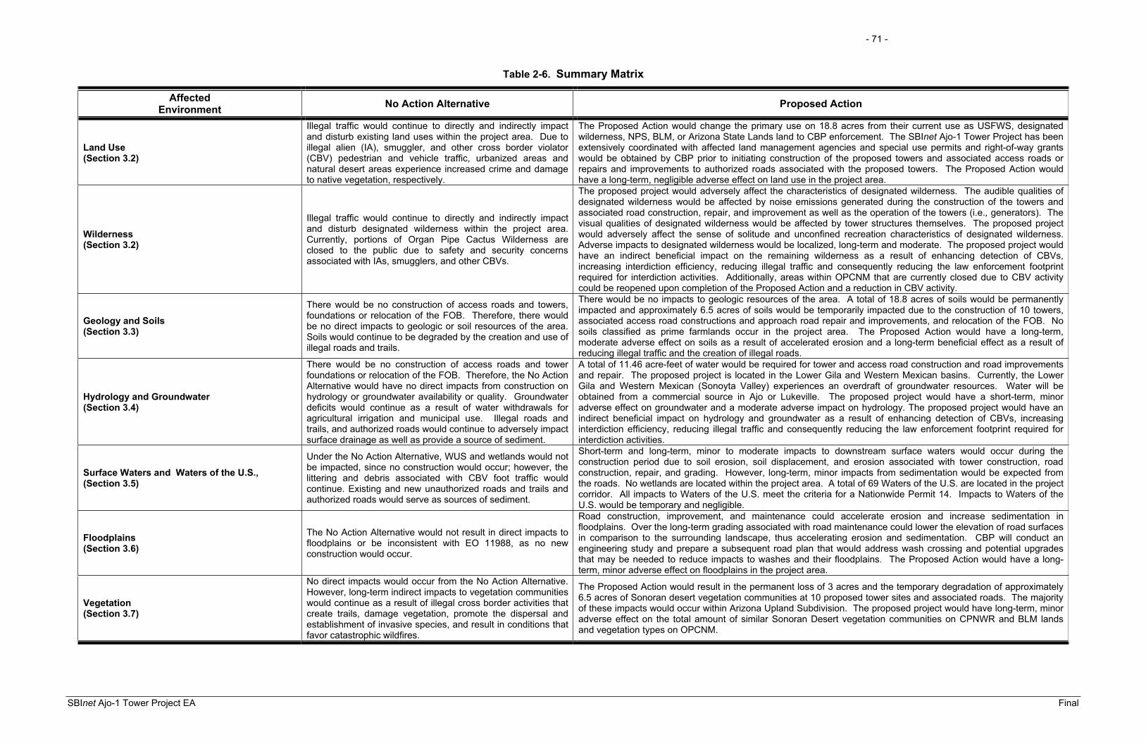
- 71 -
SBInet Ajo-1 Tower Project EA Final
Table 2-6. Summary Matrix
AffectedEnvironment No Action Alternative Proposed Action
Land Use (Section 3.2)
Illegal traffic would continue to directly and indirectly impact and disturb existing land uses within the project area. Due to illegal alien (IA), smuggler, and other cross border violator (CBV) pedestrian and vehicle traffic, urbanized areas and natural desert areas experience increased crime and damage to native vegetation, respectively.
The Proposed Action would change the primary use on 18.8 acres from their current use as USFWS, designated wilderness, NPS, BLM, or Arizona State Lands land to CBP enforcement. The SBInet Ajo-1 Tower Project has been extensively coordinated with affected land management agencies and special use permits and right-of-way grants would be obtained by CBP prior to initiating construction of the proposed towers and associated access roads or repairs and improvements to authorized roads associated with the proposed towers. The Proposed Action would have a long-term, negligible adverse effect on land use in the project area.
Wilderness (Section 3.2)
Illegal traffic would continue to directly and indirectly impact and disturb designated wilderness within the project area. Currently, portions of Organ Pipe Cactus Wilderness are closed to the public due to safety and security concerns associated with IAs, smugglers, and other CBVs.
The proposed project would adversely affect the characteristics of designated wilderness. The audible qualities of designated wilderness would be affected by noise emissions generated during the construction of the towers and associated road construction, repair, and improvement as well as the operation of the towers (i.e., generators). The visual qualities of designated wilderness would be affected by tower structures themselves. The proposed project would adversely affect the sense of solitude and unconfined recreation characteristics of designated wilderness. Adverse impacts to designated wilderness would be localized, long-term and moderate. The proposed project would have an indirect beneficial impact on the remaining wilderness as a result of enhancing detection of CBVs, increasing interdiction efficiency, reducing illegal traffic and consequently reducing the law enforcement footprint required for interdiction activities. Additionally, areas within OPCNM that are currently closed due to CBV activity could be reopened upon completion of the Proposed Action and a reduction in CBV activity.
Geology and Soils (Section 3.3)
There would be no construction of access roads and towers, foundations or relocation of the FOB. Therefore, there would be no direct impacts to geologic or soil resources of the area. Soils would continue to be degraded by the creation and use of illegal roads and trails.
There would be no impacts to geologic resources of the area. A total of 18.8 acres of soils would be permanently impacted and approximately 6.5 acres of soils would be temporarily impacted due to the construction of 10 towers, associated access road constructions and approach road repair and improvements, and relocation of the FOB. No soils classified as prime farmlands occur in the project area. The Proposed Action would have a long-term, moderate adverse effect on soils as a result of accelerated erosion and a long-term beneficial effect as a result of reducing illegal traffic and the creation of illegal roads.
Hydrology and Groundwater (Section 3.4)
There would be no construction of access roads and tower foundations or relocation of the FOB. Therefore, the No Action Alternative would have no direct impacts from construction on hydrology or groundwater availability or quality. Groundwater deficits would continue as a result of water withdrawals for agricultural irrigation and municipal use. Illegal roads and trails, and authorized roads would continue to adversely impact surface drainage as well as provide a source of sediment.
A total of 11.46 acre-feet of water would be required for tower and access road construction and road improvements and repair. The proposed project is located in the Lower Gila and Western Mexican basins. Currently, the Lower Gila and Western Mexican (Sonoyta Valley) experiences an overdraft of groundwater resources. Water will be obtained from a commercial source in Ajo or Lukeville. The proposed project would have a short-term, minor adverse effect on groundwater and a moderate adverse impact on hydrology. The proposed project would have an indirect beneficial impact on hydrology and groundwater as a result of enhancing detection of CBVs, increasing interdiction efficiency, reducing illegal traffic and consequently reducing the law enforcement footprint required for interdiction activities.
Surface Waters and Waters of the U.S., (Section 3.5)
Under the No Action Alternative, WUS and wetlands would not be impacted, since no construction would occur; however, the littering and debris associated with CBV foot traffic would continue. Existing and new unauthorized roads and trails and authorized roads would serve as sources of sediment.
Short-term and long-term, minor to moderate impacts to downstream surface waters would occur during the construction period due to soil erosion, soil displacement, and erosion associated with tower construction, road construction, repair, and grading. However, long-term, minor impacts from sedimentation would be expected from the roads. No wetlands are located within the project area. A total of 69 Waters of the U.S. are located in the project corridor. All impacts to Waters of the U.S. meet the criteria for a Nationwide Permit 14. Impacts to Waters of the U.S. would be temporary and negligible.
Floodplains (Section 3.6)
The No Action Alternative would not result in direct impacts to floodplains or be inconsistent with EO 11988, as no new construction would occur.
Road construction, improvement, and maintenance could accelerate erosion and increase sedimentation in floodplains. Over the long-term grading associated with road maintenance could lower the elevation of road surfaces in comparison to the surrounding landscape, thus accelerating erosion and sedimentation. CBP will conduct an engineering study and prepare a subsequent road plan that would address wash crossing and potential upgrades that may be needed to reduce impacts to washes and their floodplains. The Proposed Action would have a long-term, minor adverse effect on floodplains in the project area.
Vegetation (Section 3.7)
No direct impacts would occur from the No Action Alternative. However, long-term indirect impacts to vegetation communities would continue as a result of illegal cross border activities that create trails, damage vegetation, promote the dispersal and establishment of invasive species, and result in conditions that favor catastrophic wildfires.
The Proposed Action would result in the permanent loss of 3 acres and the temporary degradation of approximately 6.5 acres of Sonoran desert vegetation communities at 10 proposed tower sites and associated roads. The majority of these impacts would occur within Arizona Upland Subdivision. The proposed project would have long-term, minor adverse effect on the total amount of similar Sonoran Desert vegetation communities on CPNWR and BLM lands and vegetation types on OPCNM.

- 72 -
SBInet Ajo-1 Tower Project EA Final
AffectedEnvironment No Action Alternative Proposed Action
Wildlife and Aquatic Resources (Section 3.8)
Under the No Action Alternative, no direct impacts to wildlife habitats would occur. However, illegal cross border activity would continue to disturb wildlife and degrade wildlife habitat.
Tower and access road construction and construction of the FOB would permanently impact 18.8 acres. Only 3 acres of previously undisturbed wildlife habitat would be impacted. The proposed towers could have an adverse impact on migratory birds as a result of bird strikes. However, the number and extent of bird strikes in relation to the size of migratory bird populations and the extent of the migratory flyway would be minor and would not affect sustainability of migratory bird populations in the region. Appropriate mitigation measures would be implemented to reduce migratory bird strikes. The Proposed Action would have a long-term, minor adverse effect on migratory birds. The proposed project would have an indirect beneficial impact on wildlife as a result of enhancing detection of CBVs, increasing interdiction efficiency, reducing illegal traffic and consequently reducing the law enforcement footprint required for interdiction activities.
Protected Species (Section 3.9)
Under the No Action Alternative, there would be no direct impacts to threatened or endangered species or their habitats. However, the indirect and long-term impacts of illegal cross border activity on habitats throughout the project region and surrounding areas would continue to disturb threatened or endangered species and their habitats. Additionally, the FOB at Bates Well would not be relocated and may limit the migration of Sonoran pronghorn into the Valley of the Ajo.
Construction of the proposed towers and access roads, and road repair and improvements associated with the proposed towers is likely to adversely affect the Sonoran pronghorn, lesser long-nosed bat, desert pupfish and Sonoyta mud turtle. Adverse effects on Sonoran pronghorn and lesser long-nosed bat would be long-term and moderate. However, beneficial impacts would also be expected under the Proposed Action. Long-term, beneficial effects would occur by lessening impacts of CBV activities on habitats throughout the project area and surrounding areas. Relocation of the FOB from Bates Well would have a permanent long-term beneficial impact to Sonoran pronghorn. Appropriate conservation measures, best management practices, and off-setting measure would be implemented to minimize potential effects.
Cultural Resources (Section 3.10)
Under the No Action Alternative, no direct impacts to cultural resources would occur. However, cultural resources sites would continue to be impacted by illegal cross border activities.
A total of 14 recorded archaeological sites are located within the project area. Potential impacts to 11 previously recorded sites would be avoided through a combination of project design and monitoring. Impacts to three newly recorded sites would not affect the portions of those sites that are significant to the eligibility of the sites.
Air Quality (Section 3.11)
No construction of towers and roads would occur so no direct impacts would occur. However, air quality in the region would continue to be affected from fugitive dust emissions associated with CBVs travelling off-road and consequent law enforcement actions.
Temporary and minor increases in air pollution would occur from the use of construction equipment and the disturbance of soils during construction of the proposed towers and associated roads. There would be no violations of air quality standards and no conflicts with the state implementation plans; therefore, impacts on air quality from the implementation of the Proposed Action would be minor.
Noise(Section 3.12)
Under the No Action Alternative, the noise receptors near the tower installations would not experience additional noise events.
Noise generated by heavy construction equipment and helicopters would be intermittent and last 1 to 4 weeks to excavate and prepare the foundation to install each tower, after which, noise levels would return to ambient levels. The noise impacts from construction activities would be short-term and minor to moderate. Noise generated by generators and air-conditioning associated with the operation of the proposed tower site would have a moderate, long-term impact to the noise environment. Noise levels from the tower generators would be attenuated to 35 A-weighted decibels at 492 feet. Approximately 175 acres of land would be contained within the 35 dBA contour.
Radio Frequency Environment (Section 3.13)
Under the No Action Alternative, no direct impacts on humans, wildlife or communications would occur.
The proposed towers would emit radio frequency energy and electromagnetic radiation; therefore, some minor potential for adverse effects could occur. However, any adverse effects to human safety and wildlife would be negligible due to the minimal exposure risk and the elevated locations in which the antennae would be positioned.
Utilities and Infrastructure (Section 3.14)
No construction of towers and roads would occur so no direct impacts on utilities and infrastructure would occur. Negligible demands on power utilities would be required as a result of the Proposed Action.
Roadways and Traffic (Section 3.15)
No construction of towers and roads would occur so no direct impacts would occur.
Construction and staging for the access roads, foundations, and towers would create a minor short-term impact to roadways and traffic within the project region. The increase of vehicular traffic would occur to supply materials and work crews at each tower site for a short period of time.
Aesthetics (Section 3.16)
Under the No Action Alternative, the aesthetics of the project region would not be directly affected by installation of towers. However, trash, graffiti, and general vandalism resulting from CBV traffic would be expected to continue to detract from the visual quality of area.
The proposed towers and FOB on OPCNM would be located primarily within undeveloped areas, the majority of which is located adjacent to designated wilderness. The proposed towers and associated infrastructure would be an unnatural element in an undeveloped area visited for its natural setting and visual qualities and would be expected to detract from the visual qualities of the project area. The proposed project would have a long-term, moderate impact on aesthetic qualities within the project area. The Proposed Action would have long-term indirect benefits to the landscape through the reduction or elimination of newly created illegal roads and trails.
Hazardous Waste (Section 3.17)
The No Action Alternative would not contribute any hazardous waste or materials to the project area, as no construction of towers or access roads would take place.
The Proposed Action would not result in the exposures of the environment or public to any hazardous materials. The potential exists for minor releases of petroleum, oil, and lubricant (POL) during construction or operational activities. Best management practices would be put in place to minimize any potential contamination at the proposed sites during construction activities and operation.
Table 2-6, continued

- 73 -
SBInet Ajo-1 Tower Project EA Final
AffectedEnvironment No Action Alternative Proposed Action
Socioeconomics (Section 3.18)
Under the No Action Alternative, no direct impacts on socioeconomics would occur. However, the societal costs associated with IAs, smugglers, and other CBVs would continue and likely increase.
The Proposed Action would not cause any changes to local employment rates, poverty levels, or local incomes. Short-term beneficial impacts would be realized by retail stores, restaurants, hotels, and the purchase of fuel. Long-term beneficial, socioeconomic impacts could be realized from the purchasing of propane for generators.
Environmental Justice (Section 3.19)
Under the No Action Alternative, no impacts to minority and low income populations would occur. Implementation of the Proposed Action would cause no direct impacts to minority and low income populations.
Sustainability and Greening (Section 3.20)
No construction of towers and roads would occur so no direct impacts would occur.
Under the Proposed Action, applicable Federal sustainability and greening practices would be implemented to the greatest extent practicable.
Table 2-6, continued

- 74 -
SBInet Ajo-1 Tower Project EA Final
THIS PAGE LEFT INTENTIONALLY BLANK

SECTION 3.0
AFFECTED ENVIRONMENT AND CONSEQUENCES


- 75 -
SBInet Ajo-1 Tower Project EA Final
3.0 AFFECTED ENVIRONMENT AND CONSEQUENCES
3.1 PRELIMINARY IMPACT ANALYSIS
This section of the EA describes the natural and human environment that exists within the project area of the SBInet Ajo-1 Tower Project, and the potential impacts of the Proposed Action as outlined in Section 2.0 of this document. Only those parameters with the potential to be affected by the Proposed Action are described, per CEQ regulation (40 CFR 1501.7 [3]). Impacts can vary in magnitude from a slight to a total change in the environment. The impact analysis presented in this EA is based upon existing regulatory standards, scientific, and environmental knowledge and best professional opinions.
Some topics are limited in scope due to the lack of direct effect from the proposed project on the resource, or because that particular resource is not located within the project corridor. Resources such as climate and wild and scenic rivers are not addressed for the following reasons:
ClimateThe climate would not be impacted by the construction and operation of the Proposed Action.
Wild and Scenic RiversThe Proposed Action would not affect any designated Wild and Scenic Rivers (16 U.S.C. 551, 1278[c], 1281[d]) because no rivers designated as such are located within or near the study corridor.
Impacts (consequence or effect) can be either beneficial or adverse, and can be either directly related to the action or indirectly caused by the action. Direct impacts are those effects that are caused by the action and occur at the same time and place (40 CFR 1508.8[a]). Indirect impacts are those effects that are caused by the action and are later in time or further removed in distance, but are still reasonably foreseeable (40 CFR 1508.8[b]). As discussed in this section, the No Action and Proposed Action may create temporary (lasting the duration of construction), short-term (up to 3 years), long-term (greater than 3 years) impacts or effects.
Impacts on each resource can vary in degree or magnitude from a slightly noticeable change to a total change in the environment. For the purpose of this analysis the intensity of impacts will be classified as negligible, minor, moderate, or major. The intensity thresholds are defined as follows:
Negligible: A resource would not be affected or the effects would be at or below the level of detection and changes would not be of any measurable or perceptible consequences.

- 76 -
SBInet Ajo-1 Tower Project EA Final
Minor: Effects to a resource would be detectable, although the effects would be localized, small and of little consequence to the sustainability of the resource. Mitigation measures, if needed to offset adverse effects, would be simple and achievable.
Moderate: Effects to a resource would be readily detectable, long-term, localized, and measurable. Mitigation measures, if needed to offset adverse effects, would be extensive and likely achievable.
Major: Effects to a resource would be obvious, long-term, and would have substantial consequences on a regional scale. Mitigation measures to offset the adverse effects would be required, extensive, and success of the mitigation measures would not be guaranteed.
The following discussions describe and, where possible, quantify the potential effects of each alternative on the resources within or near the project area. All impacts described below are considered to be adverse unless stated otherwise. Table 3-1 presents the permanent and temporary (construction) impacts for the construction of the proposed towers, new access roads, approach road repair or improvement, and road maintenance. Each area of construction impact was surveyed by Harris Environmental Group, Inc. (Harris) and the results of these surveys are provided in Appendix D.
Table 3-1. Temporary and Permanent Impacts Resulting from the Proposed Action
Tower Site/Action Permanent Impact (acres)
Temporary Impact (acres)
Site Roads Corridor Site Roads CorridorTCA-AJO-003 0.06 0.03 0.0 0.17 0.0 0.0
TCA-AJO-004 0.06 0.92 0.0 0.17 0.30 0.0
TCA-AJO-170 0.06 0.02 8.8 0.12 0.005 3.2
TCA-AJO-189 0.002 0.0 0.0 0.03 0.0 0.0
TCA-AJO-204 0.002 0.0 0.0 0.03 0.0 0.0
TCA-AJO-216 0.06 0.13 0.0 0.17 0.04 0.0
TCA-AJO-301 0.15 0.02 0.0 0.08 0.0 0.0
TCA-AJO-302 0.06 0.04 0.0 0.17 0.0 0.0
TCA-AJO-303 0.06 2.5 0.0 0.17 0.83 0.0
TCA-AJO-310 0.06 4.8 0.0 0.17 0.84 0.0
FOB 1.0 0.0 0.0 0.0 0.0 0.0
TOTAL 1.57 8.46 8.8 1.3 2.0 3.2

- 77 -
SBInet Ajo-1 Tower Project EA Final
3.2 LAND USE
3.2.1 Affected Environment Pima County is situated on the southwestern border of Arizona and encompasses 9,184 square miles (Arizona Department of Commerce [AZDC] 2008). The majority of the County is located along the U.S./Mexico border. Land use is dependent upon soil characteristics and water availability since the majority of Pima County is desert. Government, tourism, commercial, and Indian reservations are the county’s principal land uses. BLM and U.S. Forest Service (USFS) account for 12.1 percent of land ownership; Indian reservations, 42.1 percent; the State of Arizona, 14.9 percent; private or corporate, 13.8 percent; and other public lands, 17.1 percent (AZDC 2008). Other public lands include those managed by USFWS and NPS.
Five of the proposed tower sites, TCA-AJO-003, 170, 204, 302, and 303 and the proposed FOB, are located on NPS (i.e., OPCNM) lands, which are all undeveloped lands used primarily for the protection of the Sonoran Desert Ecosystem, and recreational and educational purposes. Approximately 95 percent of OPCNM is designated wilderness, which is discussed in detail in Section 3.3 Proposed tower sites TCA-AJO-004, and 216 are located on BLM lands; however, access and approach roads to proposed tower site TCA-AJO-004 are located on BLM and OPCNM lands, respectively. Authorized land uses on BLM lands include roads, utility ROWs, pipeline ROWs, livestock grazing, recreation, water encatchments, highway ROWs, USBP facilities, and fences. Proposed tower site TCA-AJO-189 is located on CPNWR which is undeveloped lands established for the recovery of the desert bighorn sheep. Approximately 93 percent of CPNWR is designated wilderness and is discussed in detail in Section 3.3.
Proposed tower sites TCA-AJO-301 is located on CBP-leased lands at the Lukeville POE. Proposed tower site TCA-AJO-310 is located on ASTL property with approach roads on OPCNM lands.
Some proposed towers would require access roads to be constructed or would require road improvements or repairs to authorized roads associated with the proposed towers. Table 3-2 indicates which access roads would impact specific landowners or land managing agencies. The FOB would be located on OPCNM land.
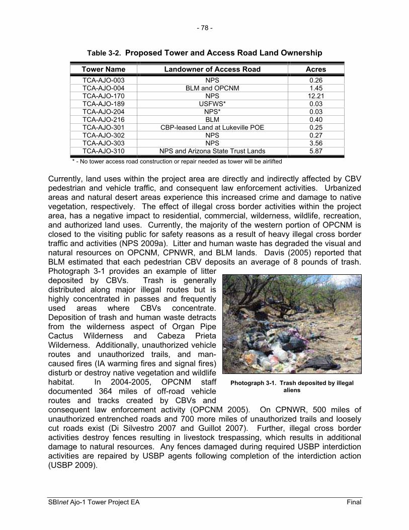
- 78 -
SBInet Ajo-1 Tower Project EA Final
Photograph 3-1. Trash deposited by illegal aliens
Table 3-2. Proposed Tower and Access Road Land Ownership
Tower Name Landowner of Access Road Acres TCA-AJO-003 NPS 0.26 TCA-AJO-004 BLM and OPCNM 1.45 TCA-AJO-170 NPS 12.21 TCA-AJO-189 USFWS* 0.03 TCA-AJO-204 NPS* 0.03 TCA-AJO-216 BLM 0.40 TCA-AJO-301 CBP-leased Land at Lukeville POE 0.25 TCA-AJO-302 NPS 0.27 TCA-AJO-303 NPS 3.56 TCA-AJO-310 NPS and Arizona State Trust Lands 5.87
* - No tower access road construction or repair needed as tower will be airlifted
Currently, land uses within the project area are directly and indirectly affected by CBV pedestrian and vehicle traffic, and consequent law enforcement activities. Urbanized areas and natural desert areas experience this increased crime and damage to native vegetation, respectively. The effect of illegal cross border activities within the project area, has a negative impact to residential, commercial, wilderness, wildlife, recreation, and authorized land uses. Currently, the majority of the western portion of OPCNM is closed to the visiting public for safety reasons as a result of heavy illegal cross border traffic and activities (NPS 2009a). Litter and human waste has degraded the visual and natural resources on OPCNM, CPNWR, and BLM lands. Davis (2005) reported that BLM estimated that each pedestrian CBV deposits an average of 8 pounds of trash. Photograph 3-1 provides an example of litter deposited by CBVs. Trash is generally distributed along major illegal routes but is highly concentrated in passes and frequently used areas where CBVs concentrate. Deposition of trash and human waste detracts from the wilderness aspect of Organ Pipe Cactus Wilderness and Cabeza Prieta Wilderness. Additionally, unauthorized vehicle routes and unauthorized trails, and man-caused fires (IA warming fires and signal fires) disturb or destroy native vegetation and wildlife habitat. In 2004-2005, OPCNM staff documented 364 miles of off-road vehicle routes and tracks created by CBVs and consequent law enforcement activity (OPCNM 2005). On CPNWR, 500 miles of unauthorized entrenched roads and 700 more miles of unauthorized trails and loosely cut roads exist (Di Silvestro 2007 and Guillot 2007). Further, illegal cross border activities destroy fences resulting in livestock trespassing, which results in additional damage to natural resources. Any fences damaged during required USBP interdiction activities are repaired by USBP agents following completion of the interdiction action (USBP 2009).

- 79 -
SBInet Ajo-1 Tower Project EA Final
3.2.2 Environmental Consequences 3.2.2.1 No Action Alternative Under the No Action Alternative, illegal traffic and consequent law enforcement actions would continue to directly and indirectly impact and disturb existing land uses within the project area. Unauthorized roads and trails would continue to be made and used by CBVs attempting to avoid detection and apprehension by law enforcement personnel (e.g., USBP agent and NPS rangers) and law enforcement personnel during required interdiction activities. Furthermore, in the absence of the SBInet Ajo-1 Tower Project illegal traffic and the creation of new unauthorized roads and trails is likely to increase. Illegal cross border activities (e.g., unauthorized roads) would continue to destroy native vegetation, accelerate soil erosion, deposit trash and human waste, vandalize property (e.g., fences) and detract from the landscape recreational values of OPCNM, CPNWR, and BLM. In FY 2008 USBP Ajo Station apprehended 15,462 CBVs. Using BLM’s estimate of 8 pounds of trash per CBV on average, a total of 123,696 pounds may have been deposited in FY 2008. Additionally, illegal cross border activities would continue to pose a threat to the safety of Federal employees and the visiting public on these Federal lands. Under the No Action Alternative, the superintendent of OPCNM would continue to be challenged to provide for the safety and security of staff and visitors to the monument. Further, no road repairs, improvements, or maintenance activities associated with the Proposed Action would occur. Authorized roads would continue to deteriorate and have potential adverse impacts on natural resources.
3.2.2.2 Proposed Action Construction of the proposed towers, access roads, and FOB would require the utilization of 18.8 acres of NPS (i.e., OPCNM), USFWS (i.e., CPNWR), BLM, designated wilderness and ASTL property primarily for CBP enforcement. Construction of the towers and road construction, repairs, and improvements associated with the proposed towers would temporarily impact 6.5 acres of land managed by these same agencies. The SBInet Ajo-1 Tower Project has been extensively coordinated with affected land management agencies. CBP would obtain special use permits, and ROW grants and easement from the affected land management agencies prior to initiating construction of the proposed project. Additionally, a compatibility determination would be completed by USFWS for proposed tower site TCA-AJO-189. The proposed project would change land use on less than 0.01 percent of OPCNM, CPNWR, and BLM lands in the project area and would result in a long-term, negligible adverse effect on land use in the project area.
The SBInet Ajo-1 Tower Project would result in indirect beneficial effects to land use as a result of reducing CBV traffic and focusing law enforcement activities in the project area. Beneficial effects would be noticeable throughout the landscape and not localized near the proposed tower sites. The proposed project would enhance CBP’s detection capabilities and increase the efficiency of interdictions actions. Enhancement of detection capabilities and interdiction efficiency would result in more focused operations by CBP agents and a reduced enforcement footprint within OPCNM and to some extent CPNWR. As the certainty of apprehension increases as a result of the proposed project illegal traffic and consequent law enforcement efforts would decrease, thus reducing

- 80 -
SBInet Ajo-1 Tower Project EA Final
potential impacts to land use and natural resources. Additionally, as apprehension success increases through the use of the proposed towers, the towers would serve as a deterrent to illegal traffic. Operational success as a result of technology has been demonstrated by USBP in the Yuma Sector and Altar Valley in the Tucson Sector. As demonstrated by these operations illegal traffic reductions could be realized within 1 year of the technology being operational and accepted by USBP. Cross border violations were reduced by 70 and 95 percent in the Altar Valley and Yuma Sector, respectively. Although illegal traffic reductions can not be quantified, similar reductions in illegal traffic would be expected as a result of the SBInet Ajo-1 Tower Project. Further, the enforcement footprint was reduced from 45 miles north of the international border to 0 to 10 miles in the Altar Valley. Beneficial effects would include reduced vegetation damage from unauthorized roads and trails, reduced litter and human waste on public lands, increased public safety; decreased damage to authorized land uses (e.g., fences). Decreased illegal activity would eventually allow NPS to evaluate the potential to re-open the currently closed portions of OPCNM for public use under a more secure environment. Further, reduced illegal traffic and consequent law enforcement actions would allow OPCNM to conduct restoration activities in areas previously disturbed by illegal cross border activities and consequent law enforcement activities.
3.3 WILDERNESS
3.3.1 Affected Environment The Wilderness Act of 1964 (P.L. 88-577 [Wilderness Act]) allowed for the establishment of a National Wilderness Preservation System and allows for the establishment of wilderness on Federally owned lands designated by Congress. Areas designated as wilderness are to be administered in such a manner as to leave the lands undisturbed for future use and enjoyment by the public as wilderness and to provide protection of these areas for the preservation of their wilderness character. As defined by the Wilderness Act, wilderness should provide for the opportunities to experience solitude, unconfined recreation, and naturalness. To maintain the wilderness characteristics of designated wilderness areas, certain activities are prohibited, including commercial enterprise and permanent roads and except as necessary to meet minimum requirements for the administration of the area for the purpose of the Wilderness Act (including measures required in emergencies involving the health and safety of persons within the area), there shall be no temporary road, nor use of motor vehicles, motorized equipment or motorboats, no landing of aircraft, no other form of mechanical transport, and no structure or installation (16 U.S.C. 1131-1136).
Organ Pipe Cactus WildernessOrgan Pipe Cactus Wilderness was created within OPCNM by the National Parks and Recreation Act of 1978 (P.L. 95-625). It encompasses 95 percent (312,660 acres designated wilderness and 1,240 acres potential wilderness) of OPCNM (Figure 3-1) and was created to celebrate the life and landscape of the Sonoran Desert (NPS 1997). Organ Pipe Cactus Wilderness pays tribute to the organ pipe cactus (Stenocereus thurberi), a rare, multi-spined cactus found in the U.S. Furthermore, Organ Pipe Cactus Wilderness is a shelter for endangered species (e.g., the Sonoran pronghorn and lesser

!.
!.
!.
!.
!.
!.
!.
!.
!.
!.
!.
Ajo
¬«85
¬«86
Ajo
Ra
ng
e
TCA-AJO-310
TCA-AJO-305
TCA-AJO-303
TCA-AJO-302
TCA-AJO-301
TCA-AJO-216
TCA-AJO-204
TCA-AJO-189
TCA-AJO-170
TCA-AJO-004
TCA-AJO-003
·1:350,000
0 2.5 5 7.5 10Miles
0 2.5 5 7.5 10Kilometers
August 2009
Figure 3-1: Organ Pipe Cactus National Monument and Cabeza Prieta National Wildlife Refuge Wilderness Areas
Organ Pipe Cactus National Monument Wilderness Area
!.
!.!.
!.
!.
!.
!.
!.
!.
!.
!.
Tower Locations!.
United StatesMexico
Organ Pipe Cactus National Monument Non-wilderness Areas
Cabeza Prieta National Wildlife Refuge Wilderness Area
Cabeza Prieta National Wildlife Refuge Non-wilderness Area
!. Proposed Action Tower Locations
!. Tower not included in this analysis
- 81 -

- 82 -
SBInet Ajo-1 Tower Project EA Final
THIS PAGE LEFT INTENTIONALLY BLANK

- 83 -
SBInet Ajo-1 Tower Project EA Final
long-nosed bat), provides a place for the Tohono O’odham people to collect native vegetation, serves as a natural research laboratory for understanding and managing the Sonoran Desert Ecosystem, and serves as a baseline indicator against which environmental changes can be identified. Management of Organ Pipe Cactus Wilderness is consistent with the provision in the Wilderness Act.
Cabeza Prieta National Wildlife Refuge and Cabeza Prieta WildernessThe CPNWR is one of 510 refuges governed by the National Wildlife Refuge System Administration Act of 1966, as amended (Refuge Act; P.L. 106-580) and National Wildlife Refuge System Improvement Act (P.L. 105-57). The Refuge Act consolidated the authorities relating to the areas that are administered by the Secretary of the Interior. The act also provides for the conservation, protection, and propagation of native species of fish and wildlife, including migratory birds that are threatened with extinction and their habitats for the benefit of present and future generations of Americans.
Cabeza Prieta Wilderness was created within CPNWR by the 1990 Arizona Wilderness Act (House Report 2570 Title III) It encompasses 93 percent (803,418 acres) of CPNWR (see Figure 3-1) and was created to preserve the Sonoran Desert Ecosystem. CPNWR and designated Wilderness is a shelter for endangered species (e.g., the Sonoran pronghorn and lesser long-nosed bat), and seeks to protect, maintain and restore Sonoran Desert Ecosystems. Management of the Cabeza Wilderness is consistent with the regulations and prohibitions of the Wilderness Act. One proposed tower site, TCA-AJO-189, is located in Cabeza Prieta Wilderness. Construction and maintenance of the tower would be conducted via helicopter. However, the 1990 Arizona Wilderness Act allows for the maintenance of existing associate ground instrumentation by the military. Proposed tower site TCA-AJO-189 would be located in an area currently used for military ground instrumentation.
Minimum Requirement AnalysisAs specified under Section 4(c) of the Wilderness Act, a Minimum Requirement Analysis (MRA) is a process which helps an agency to determine whether an action should be completed in designated wilderness. A MRA consists of a determination of whether a project or activity is necessary to meet the minimum requirements for the administration of the wilderness and identification of the tool(s) or method(s) which should be used to complete the project that results in the least impact to the physical resource or wilderness values. A MRA also helps to identify, analyze and select management actions that are the minimum necessary for wilderness without compromising safety. A MRA from CPNWR’s manager would be required for the construction, operation, and maintenance of proposed tower TCA-AJO-189, including the use of helicopters in designated wilderness. Installation of proposed tower TCA-AJO-189 would establish a structure in designated wilderness and the proposed tower would be readily observable within designated wilderness.

- 84 -
SBInet Ajo-1 Tower Project EA Final
Existing ConditionsAs previously described in Section 3.2.1, many areas within Organ Pipe Cactus Wilderness and Cabeza Prieta Wilderness have been degraded as a result of illegal vehicle and pedestrian traffic, deposition of trash and human waste, and vandalism that detract from the wilderness qualities that lead to the designation of these as wilderness. Additionally, unauthorized roads have been and continue to be created in designated wilderness as a result of motorized vehicle operations by CBV and law enforcement personnel conducting required CBV interdiction actions. Further, a large portion of Organ Pipe Cactus Wilderness is currently not accessible to the visiting public due to security and safety concerns.
3.3.2 Environmental Consequences 3.3.2.1 No Action Alternative Under the No Action Alternative, there would be no direct effect on designated wilderness as a result of tower construction or noise emissions generated during construction activities and operation of the proposed towers. However, IA and other CBV traffic and consequent law enforcement actions would continue to directly and indirectly impact and disturb designated wilderness. Unauthorized roads and trails, deposition of trash and human waste, and vandalism would continue to distract from the wilderness qualities of designated wilderness in the project area. As stated earlier, based on FY 2008 apprehension figures for Ajo Station, approximately 123,696 pounds of trash was potentially deposited by CBVs in FY 2008 alone. Unauthorized roads and trails would continue to be created and used by CBVs attempting to avoid detection and apprehension by law enforcement personnel (e.g., USBP agents and NPS rangers) and law enforcement personnel conducting required interdiction activities. Furthermore, in the absence of the SBInet Ajo-1 Tower Project, illegal traffic and the creation of new unauthorized roads and trails are likely to increase. The No Action Alternative would have a long-term, moderate adverse effect on designated wilderness.
3.3.2.2 Proposed Action Of the proposed 10 towers and new FOB site, only one tower (TCA-AJO-198) is located in designated wilderness (i.e., Cabeza Prieta Wilderness), as will be discussed later. However, proposed tower site TCA-AJO-170 and its associated approach roads and the proposed approach road to proposed tower site TCA-AJO-310 are located within potential wilderness on the OPCNM. A special use permit would be obtained from the OPCNM superintendent for those towers located on OPCNM.
Six of the proposed towers (TCA-AJO-003, 004, 204, 216, 302, and 303) are located adjacent to Organ Pipe Cactus Wilderness and proposed tower TCA-AJO-302 is also located in proximity to Cabeza Prieta Wilderness. All of the proposed towers would be readily visible from adjacent wilderness. A viewshed analysis was performed from 17 observation points on OPCNM of the 10 proposed towers. The observation points used in this analysis were located along authorized roads, hiking trails, and higher elevation points (i.e., Kino Peak) where the public would visit for a wilderness experience (Figure 3-2). The towers potentially visible from these observation points are presented in Table 3-3. Additionally, a line-of-sight analysis was performed from each of the 17

!.
!.
!.
!.
!.
!.
!.
!.
!.
!.
!.
#*#*
#*
#*
#*
#*
#*
#*
#*
#*#*
#*#*
#*
#*
#*
#*
#*
#*
#*
#*
#*
#*#*
#*
#*#*
#*
¬«85
¬«86
Aj o
Ra
ng
e
Kino Peak
18
19
20
21
22
23
24
25
2627
28
9
8
7
6
5
43
21
16
15
14
13 12
11
10
TCA-AJO-310
TCA-AJO-305
TCA-AJO-303
TCA-AJO-302
TCA-AJO-301
TCA-AJO-216
TCA-AJO-204
TCA-AJO-189
TCA-AJO-170
TCA-AJO-004
TCA-AJO-003
·1:255,000
0 2 4 6 8Miles
0 2 4 6 8Kilometers
August 2009
Figure 3-2: Viewshed Analysis Observation Points on the Organ Pipe Cactus National Monument
Organ Pipe Cactus National Monument Wilderness Area
#* Viewshed Observation Points
!.
!.!.
!.
!.
!.
!.
!.
!.
!.
!.
Tower Locations!.
United StatesMexico
Organ Pipe Cactus National Monument Non-wilderness Areas
Cabeza Prieta National Wildlife Refuge Wilderness Area
Cabeza Prieta National Wildlife Refuge Non-wilderness Area
!. Proposed Action Tower Locations
!. Tower not included in this analysis
BLM
- 85 -

- 86 -
SBInet Ajo-1 Tower Project EA Final
THIS PAGE LEFT INTENTIONALLY BLANK

- 87 -
SBInet Ajo-1 Tower Project EA Final
observation points to verify the viewshed visibility. Both the viewshed and line-of-sight analyses were conducted using a three dimensional Geographic Information System (GIS). Both the height of the tower and observer were used in the viewshed analysis. A height of 6 feet was used for the observer. Maps depicting the viewshed of each proposed tower site are provided in Appendix E.
Table 3-3. Organ Pipe Cactus National Monument Viewshed Affected by the Proposed Ajo-1 Towers
Observation Point Towers 1 TCA-AJO-204 2 TCA-AJO-204, 301 and 310 3 TCA-AJO-204 4 TCA-AJO-170, 004 and 216 5 TCA-AJO-004, 170, 216 and 189 6 None 7 TCA-AJO-189 and 302 8 TCA-AJO- 189 and 302 9 TCA-AJO-189 10 TCA-AJO-303 11 None 12
(Tillotson Peak) TCA-AJO-170, 204, 216, 301 and 310
13 TCA-AJO-170, 004 and 216 14 TCA-AJO-170, 004 and 216 15 TCA-AJO-170, 004 and 216 16 None 17
(Kino Peak) TCA-AJO-170, 302, 004, 216 and 303
At least one proposed tower would be readily visible from 14 of the 17 observation points analyzed and multiple towers would be visible from 10 of the observation points. Proposed towers TCA-AJO-004, 170, and 216, and 189 would be visible from the northern portion of the Valley of the Ajo. Proposed towers TCA-AJO-004, 170, 216, 302, and 303 would be visible from Kino Peak. Kino Peak is located in OPCNM’s second largest wilderness unit. Additionally, the proposed towers are man-made structures that would detract from the natural values of designated wilderness. Thus, construction of the proposed towers would have a long-term, moderate adverse effect on the viewshed and natural values of designated wilderness.
As mentioned previously, one proposed tower, TCA-AJO-189, would be constructed within Cabeza Prieta Wilderness. An existing U.S. Air Force tower is located at the proposed tower site. Construction and maintenance of proposed tower TCA-AJO-189 would require helicopter lifts to transport construction equipment and material, and construction personnel and environmental monitors. Through coordination with CPNWR, helicopter lifts have been reduced to 85 lifts for tower construction. This is the minimum number of helicopter lifts required to transport construction materials and construction personnel. Additionally, four helicopter lifts would be required annually to

- 88 -
SBInet Ajo-1 Tower Project EA Final
transport maintenance personnel to the proposed tower site. Construction and maintenance of proposed tower site TCA-AJO-189 is consistent with the administrative exception that allows activities that meet minimum requirements for the administration of designated wilderness and a MRA would be prepared by the CPNWR manager (16 U.S.C. 1131-1136). Further, the proposed RAT tower is a temporary structure and would not constitute a permanent structure in designated wilderness. RATs can be disassembled and relocated to other areas, as necessary. Deployment of RATs to other sites would require additional or supplemental NEPA documentation, however.
Proposed tower sites TCA-AJO-189 and TCA-AJO-302 would be readily visible from Cabeza Prieta Wilderness. CBP would obtain a MRA from USFWS authorizing the construction, operation, and maintenance of proposed tower site TCA-AJO-189 in Cabeza Prieta Wilderness. The construction of proposed tower TCA-AJO-189 and use of helicopters for construction and maintenance has been extensively coordinated with CPNWR. Construction of the proposed towers would have a long-term, moderate adverse effect on the viewshed and natural values within designated wilderness.
The presence of the proposed towers would adversely affect several of the characteristics of wilderness as defined in the Wilderness Act. Wilderness visitors may no longer have a sense of solitude where towers are present. This sense of solitude would be adversely affected as a result of the monitoring capabilities of the proposed towers, as individuals may feel they are being monitored by the proposed towers. Additionally, the proposed towers would detract from the naturalness of the landscape and could detract from the wilderness experience. Further, the monitoring capabilities of the proposed tower could detract from the unconfined recreation experience. Construction of the proposed towers would have a long-term, moderate adverse effect on designated wilderness.
Noise emissions associated with the construction (e.g., heavy equipment), operation (e.g., generator), and maintenance of the proposed towers could indirectly affect the quality of Organ Pipe Cactus Wilderness and Cabeza Prieta Wilderness which are valued for their solitude and quietness. Construction equipment could produce noise emissions up to 81 dBA during the construction of roads and tower sites, and authorized road and corridor repair and improvement activities. Helicopter lifts at proposed towers TCA-AJO-189 and 204 would produce noise emissions that would adversely affect the quality of designated wilderness. The Federal Highway Administration has established a construction noise abatement criteria of 57 dBA for lands were serenity and quiet are of extraordinary significance (23 CFR 722, Table 1). A total of 353 acres of designated wilderness would be temporarily affected by noise levels above 57 dBA during tower construction. Approximately 2,568 acres of designated wilderness would be temporarily affected during road construction activities. Road construction activities would last 5 to 22 days depending on the road segment. Additionally, approximately 2,124 acres of land would be affected by helicopter generated noise during construction activities. Noise emissions from construction activities would be intermittently produced during the construction of the proposed towers and associated road construction, repair and improvement. Noise emissions during construction activities would have a temporary,
- 89 -
SBInet Ajo-1 Tower Project EA Final
moderate effect on the quality of designated wilderness. A detailed noise analysis is provided in Section 3.12.
Only four proposed towers sites, TCA-AJO-003, 004, 302, and 303, located adjacent to wilderness would have a hybrid generator/solar system as their primary power source. The proposed FOB, also located in a non-wilderness buffer, would also use generators as a power source. Generators at the proposed towers would be expected to operate 4 to 8 hours per day and the generator at the FOB would operate 24 hours per day.
Although OPCNM (Sturm 2009a) has reported that ambient noise on OPCNM is 20 dBA, CBP, OPCNM, and USFWS have agreed that a noise emission at or below 35 dBA should be the goal for long-term noise levels. This is the level at which there should be no effect to Sonoran pronghorn. Long-term noise emissions from the tower and FOB generators would be attenuated to 35 dBA (threshold for impacts to Sonoran pronghorn) within 492 feet of the tower. Therefore, wilderness qualities (e.g., serenity) would be degraded within this noise contour, which encompasses approximately 105 acres. Noise emissions from the operation of the proposed towers would be localized and would have a long-term, moderate impact on designated wilderness.
The SBInet Ajo-1 Tower Project would result in indirect beneficial effects to designated wilderness as a result of reducing CBV traffic and focusing law enforcement activities in the project area. Beneficial effects would be noticeable throughout designated wilderness and not localized near the proposed tower sites. The proposed project would enhance CBP’s detection capabilities and increase the efficiency of interdiction actions. Although interdiction efforts are likely to increase when the proposed towers become functional as a result of the enhanced detection capabilities, these interdiction efforts would be more focused and off-road interdiction activities would not be expected to increase overall; in fact, they would be expected to decrease over time. Enhancement of detection capabilities and interdiction efficiency would result in more focused operations by CBP agents and consequently an increased deterrence effect, resulting in a reduced enforcement footprint within Organ Pipe Cactus Wilderness and to some extent Cabeza Prieta Wilderness. Operational success as a result of technology has been demonstrated by USBP in the Yuma Sector and Altar Valley in the Tucson Sector. Although the reduction in illegal traffic cannot be quantified, the operational success by USBP in Yuma Sector and Altar Valley in the Tucson Sector indicate reductions in illegal traffic could occur as soon as 1 year after the towers are operational and accepted by USBP. Cross border violations were reduced by 70 and 95 percent in the Altar Valley and Yuma Sector, respectively. As illegal traffic decreases, the enforcement footprint of USBP would generally move closer to the border and impacts to designated wilderness would be reduced. In the Altar Valley, USBP observed a 35 to 45 percent reduction in enforcement footprint north of the international border. Beneficial effects would include reduced vehicle traffic within designated wilderness, reduced degradation of the landscape, and reduced litter and human waste that degrade wilderness qualities throughout Organ Pipe Cactus Wilderness. The proposed project would also increase the overall safety to the public and OPCNM staff within Organ Pipe Wilderness. Increased public safety would allow

- 90 -
SBInet Ajo-1 Tower Project EA Final
OPCNM to re-evaluate opening those portions of designated wilderness currently closed to public visitation, thus allowing greater access to wilderness. The Proposed Action would have a long-term, beneficial effect on Organ Pipe Cactus Wilderness as a result of increasing public safety, allowing the opportunity for increased wilderness access, and reducing adverse impacts from IA and other CBV traffic and consequent law enforcement actions on the landscape and natural resources that characterize designated wilderness.
3.4 GEOLOGY AND SOILS
3.4.1 Affected Environment Geology The project area is part of the Basin and Range Physiographic Province as delineated by the U.S. Geological Survey (USGS and California Geologic Survey 2000). This province stretches from southeastern Oregon southward through Nevada and terminates south of the project area in Sonora, Mexico. Most landforms within this province are the result of tectonic and alluvial processes, and the province is characterized by low mountains and deep valleys filled with alluvium (USGS and California Geologic Survey 2000).
SoilsThere are 11 soils associated with the proposed tower locations and road improvements (NPS 2005). A description of each soil type is presented in Table 3-4 and soil maps depicting the proposed tower locations are provided in Appendix F. The majority of the soil associations range from excessively drained to well drained. Erosion hazards for each soil association estimate the potential for soil loss or erosion due to wind or water. These hazards are based on undisturbed soils. To prevent soil loss (especially those with high erosion hazards), BMPs would be implemented, as described in the Stormwater Pollution Prevention Plan (SWPPP) and in Section 5.0 of this document, during construction activities to avoid significant soil loss.
Soils in the project have and continue to be adversely affected by illegal off-road activities and consequent law enforcement actions. Illegal roads and trails created by CBVs destroy vegetation and disturb soils. Use of theses illegal trails and roads promotes erosion and sedimentation in downstream areas. In 2004 to 2005, OPCNM staff documented 364 miles of off-road vehicle routes and tracks created by CBVs and consequent law enforcement activities (OPCNM 2005). Additionally, new road and trails continue to be created as CBVs attempting to avoid detection and apprehension by law enforcement agents (i.e., USBP agents and OPCNM law enforcement officers).
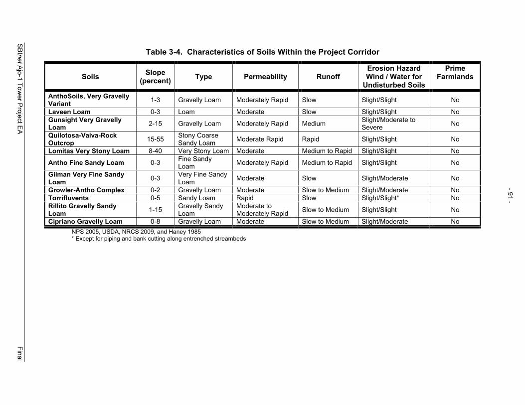
- 91 -
Table 3-4. Characteristics of Soils Within the Project Corridor
Soils Slope(percent) Type Permeability Runoff
Erosion Hazard Wind / Water for
Undisturbed Soils
PrimeFarmlands
AnthoSoils, Very Gravelly Variant 1-3 Gravelly Loam Moderately Rapid Slow Slight/Slight No
Laveen Loam 0-3 Loam Moderate Slow Slight/Slight No Gunsight Very Gravelly Loam 2-15 Gravelly Loam Moderately Rapid Medium Slight/Moderate to
Severe No
Quilotosa-Vaiva-Rock Outcrop 15-55 Stony Coarse
Sandy Loam Moderate Rapid Rapid Slight/Slight No
Lomitas Very Stony Loam 8-40 Very Stony Loam Moderate Medium to Rapid Slight/Slight No
Antho Fine Sandy Loam 0-3 Fine Sandy Loam Moderately Rapid Medium to Rapid Slight/Slight No
Gilman Very Fine Sandy Loam 0-3 Very Fine Sandy
Loam Moderate Slow Slight/Moderate No
Growler-Antho Complex 0-2 Gravelly Loam Moderate Slow to Medium Slight/Moderate No Torrifluvents 0-5 Sandy Loam Rapid Slow Slight/Slight* No Rillito Gravelly Sandy Loam 1-15 Gravelly Sandy
Loam Moderate to Moderately Rapid Slow to Medium Slight/Slight No
Cipriano Gravelly Loam 0-8 Gravelly Loam Moderate Slow to Medium Slight/Moderate No NPS 2005, USDA, NRCS 2009, and Haney 1985 * Except for piping and bank cutting along entrenched streambeds
SBInet Ajo-1 Tow
er Project E
A
Final
- 91 -

- 92 -
SBInet Ajo-1 Tower Project EA Final
Photograph 3-2. Illegal Road on OPCNMCourtesy of OPCNM
An example of an illegal road created near TCA-AJO-310 this year is shown in Photograph 3-2. Further, authorized roads have become degraded in sections and are a source or accelerated soil erosion and downstream sedimentation.
Erosion rates on disturbed soils may be very high for many of these soils (Rutman 2009). On OPCNM, the soils that have had the highest accelerated erosion rates after disturbance are the Antho, Laveen, and Gilman soils that are sometimes combined with other soils types in complexes. As observed by OPCNM personnel, vehicle traffic readily compacts these soils, resulting in the vehicle routes or tracks becoming lower than the surrounding environment. A management issue is the erosion caused by roads in OPCNM. Some are now deeply entrenched or are redirecting water flows away from natural channels. Erosion problems are present nearly everywhere along roads in OPCNM (Rutman 1996). The USDA (2009) lists the Antho, Gunsight (2-15 percent slope), Gilman, and Growler soils as moderately suitable for natural surface roads. Laveen, Gunsight (0-2 percent slope), Rillito, and Cipriano soils are listed as well suited for natural surface roads. Lomitas soils are listed as poorly suited for natural surface roads.
Prime Farmland Prime farmland is protected under the Farmland Protection Policy Act of 1980 and 1995 (FPPA). The FPPA’s purpose is to minimize the extent to which Federal programs contribute to the unnecessary and irreversible conversion of farmland to non-agricultural uses. As required by Section 1541(b) of Act, 7 U.S.C. 4202(b), Federal agencies are: (a) to use the criteria to identify and take into account the adverse effects of their programs on the preservation of farmland; (b) to consider alternative actions, as appropriate, that could lessen adverse effects; and (c) to ensure that their programs, to the extent practicable, are compatible with state and local governments and private programs and policies to protect farmland.
USDA, NRCS did not report any of the 11 soil types as prime farmlands and none of the lands are currently in agricultural production. Furthermore, the soils in this region are not typically irrigated so these soils would fail to meet prime farmland criteria.
3.4.2 Environmental Consequences 3.4.2.1 No Action Alternative Geology Under the No Action Alternative, there would be no construction of access roads and towers, foundations, and associated buildings. Therefore, there would be no impacts on the geologic resources of the area.
- 93 -
SBInet Ajo-1 Tower Project EA Final
SoilsUnder the No Action Alternative, there would be no construction of access roads, towers, foundations, and associated buildings. Direct impacts to soils associated with the creation and use of unauthorized roads and trails by CBVs would continue, and likely increase, without the surveillance and detection technology proposed as part of the SBInet Ajo-1 Tower Project. Disturbed soils and entrenched roads and trails associated with CBV off-road activities and required CBV interdiction actions increase wind and soil erosion. Eroded soils resulting from illegal roads and trails result in a long-term erosion impact to soils. Additionally, degraded authorized roads are susceptible to erosion and soil loss due to unstable road surfaces.
3.4.2.2 Proposed Action Geology The Proposed Action primarily involves disturbances to topsoil layers, or somewhat deeper in the case of SST towers. During construction activities, any holes or excavations for either perimeter fence posts or towers, would impact an area no larger than approximately 38 square feet for the three piers on the larger SST, and would not substantially alter the geology in the project area. Each pier would be no deeper than approximately 30 to 60 feet bgs, and only three of the proposed towers are anticipated to be SSTs. Additionally, all proposed roads would be located in predominately alluvial material and would, therefore, not require substantial modifications to the area’s topography (i.e., road cuts).
SoilsConstruction of the proposed towers and access roads, repairs and improvements to associated approach roads, construction of the FOB would have a direct permanent impact on 18.8 acres and temporarily impact approximately 6.5 acres of soils. The disturbance to 18.8 acres of soils would be minor when examined on a regional scale. Furthermore, many of these impacts are associated with several linear roads distributed over a large geographic area and many different soil types. Thus, impacts associated with road activities would vary with soil type and would be more difficult to mitigate than a single site. Construction of the towers and new access roads would disturb previously undisturbed soils. Road repairs and improvements would occur on existing roads; therefore, these soils have been previously disturbed. Erosion would be expected during and immediately following tower and road construction activities. The potential for erosion would be greatest on Antho, Gilman, and Laveen soils. These soils have a high erosion potential once they are disturbed. Soil maps showing proposed tower sites and associated roads are located in Appendix F.
Approximately 3 acres of Antho, 1.5 acres of Gilman, and 1 acre of Laveen soils would be impacted as a result of the Proposed Action. These impacts are associated with proposed tower sites TCA-AJO-003, 004, 170, 216, 301, and 310. Proposed access and new roads located on these soils would be given careful consideration to ensure soil erosion is minimized. CBP has committed to conducting an engineering study of all roads associated with the SBInet Ajo-1 Tower Project. It is anticipated this study would be completed by the spring of 2010 and roads requiring upgrades would be prioritized in

- 94 -
SBInet Ajo-1 Tower Project EA Final
coordination with OPCNM. CBP would provide OPCNM with a detailed plan for road upgrades for 2010 and beyond. Roads, especially those on Antho, Gilman and Laveen soils, would be upgraded to prevent erosion, incising of the road, and culverts would be installed where identified in the engineering study to prevent or minimize alteration of surface and drainage flows. The installation of culverts and other drainage structures (i.e., low water crossings), where required, and stabilization of the road would prevent future incising of the road from vehicle traffic and maintenance. BMPs (i.e., reseeding disturbed areas with native species) to reduce soil erosion would be employed during construction activities as outlined in Section 5.0. Additionally, a Stormwater Pollution Prevention Plan (SWPPP), including BMPs would be prepared prior to construction. Further, an erosion and sediment control plan, which stipulates measures to minimize erosion and sedimentation during construction, is included as part of the Tower and Road Design Plan for each proposed tower site.
It is anticipated that BMPs would not be sufficient to mitigate soil impacts associated with constructing the new road to proposed tower site TCA-AJO-310. Mitigation measures would have to be designed and included as part of the road upgrades outlined in CBP’s engineering study. It is anticipated that erosion would be accelerated for a period of 1 to 2 years until the roads are upgraded per the engineering study. During the interim period between construction activities and completion of the road upgrades per the engineering study, moderate adverse effects on soils would be anticipated. However, erosion on Antho, Gilman and Laveen could progress long-term once it is initiated by construction activities. Overall, construction of the proposed towers and new access, repair and improvement of approach roads, and road maintenance could have a long-term, moderate adverse effect on soils.
The Proposed Action would have a permanent indirect benefit as a result of reducing CBV traffic within the project area. The Proposed Action would improve the detection of CBV traffic closer to the U.S.-Mexico border thus focusing and improving USBP agents’ apprehension capabilities. The increased detection and apprehension capabilities resulting from the Proposed Action would reduce the amount of illegal off-road traffic and consequent law enforcement actions. Although the reduction in illegal traffic can not be quantified, experience from similar technology enhanced operations (i.e., Yuma Sector and Altar Valley in the Tucson Sector) indicate illegal traffic would be reduced within the operation footprint and this reduction could occur as soon as 1 year after the technology is operational and accepted by USBP. Both of the previous operations showed a reduction in the enforcement footprint. A 35 to 45 mile reduction in enforcement footprint north of the international border was observed in the Altar Valley. Additionally, the creation of new illegal roads and trails would be reduced and existing illegal roads and trails would be able to naturally rehabilitate. Further, as part of ESA Section 7 consultation, CBP has committed funding to the identification and restoration of unauthorized roads in Sonoran pronghorn habitat. BMPs outlined in Section 5.0 and stipulated as part of the SWPPP would be adhered to during construction activities. Additionally, an erosion and sediment control plan would be in place prior to construction for each proposed tower site.

- 95 -
SBInet Ajo-1 Tower Project EA Final
Prime Farmlands No soils classified as prime farmlands occur in the project area. Therefore, no impacts to prime farmlands would occur as part of the Growler Alternative.
3.5 HYDROLOGY AND GROUNDWATER
3.5.1 Affected Environment The proposed tower sites are located in two Arizona Department of Water Resources (ADWR) groundwater basins: Lower Gila and Western Mexican.
The Lower Gila Basin is 7,309 square miles in area and the largest basin in the planning area. The basin is characterized by plains and valleys surrounded by low elevation mountain ranges. Vegetation types include Lower Colorado River and Arizona Upland subdivisions of Sonoran Desertscrub (ADWR 2008). The average annual rainfall ranges between 3.8 to 7.7 inches across the Lower Gila Basin where the greatest annual rainfall occurs near the town of Ajo (7.74 inches).
The Western Mexican Basin lies along the international boundary with Mexico and occupies approximately 610 square miles on the U.S. side of the border. The basin is characterized by desert valleys and low level mountain ranges. The average annual rainfall ranges from 4 inches per year in the western portion of the basin to 14 inches per year in the far eastern portion of the basin. Vegetation types include Lower Colorado River Valley and Arizona Uplands Sonoran Desertscrub (ADWR 2008).
On the U.S. side of the Western Mexican Basin, the land use is almost exclusively Federal lands with no irrigated croplands and, therefore, the recharge rate to the aquifer is greater than the rate of withdraw. On the Mexico side of the border, the basin area (called the Sonoyta Valley aquifer) is 5,000 square miles. Land use on the Mexican side of the basin is primarily agriculture. Agricultural irrigation draws a significant portion of its water needs from the Sonoyta Valley aquifer and overall, the balance of water stored in the Western Mexican Basin experiences an annual deficit and the amount of groundwater stored in the basin is steadily declining (Brown 1991). The annual groundwater recharge and annual municipal, industrial, and agricultural use in each of the two basins in the project region are presented in Table 3-5.
Table 3-5. Groundwater Basins Municipal, Industrial, and Agriculture Use and Recharge Rate
Groundwater Basin Recharge Rate(acre-feet per year)
Municipal, Industrial & Agriculture Water Use
(acre-feet per year) Western Mexican 1,000 300 Sonoyta Valley 28,135 44,839 Lower Gila 9,000 – 88,000 287,900 Source: ADWR 2008 and Brown 1991
- 96 -
SBInet Ajo-1 Tower Project EA Final
3.5.2 Environmental Consequences 3.5.2.1 No Action Alternative The No Action Alternative would not require the use of water because there would be no construction; however, hydrology in the region has been and would continue to be affected under the No Action Alternative. Illegal vehicle and foot traffic and consequent law enforcement actions have created unauthorized vehicle routes and unauthorized trails. Under the No Action Alternative these unauthorized vehicle routes and unauthorized trails would continue to be used by CBVs and new unauthorized vehicle routes and unauthorized trails would likely be created by CBVs while attempting to avoid detection by law enforcement agents. These unauthorized vehicle routes and trails have the potential to alter the natural hydrology in the region as a result of altering runoff patterns, capturing or impounding sheet or drainage flows. Unauthorized vehicle routes and unauthorized trails can become incised over time and when surface water encounters these incised roads and trails, it may become captured or impounded in the incised footprint of these roads and trails. Changes in overland sheet and drainage flows may affect vegetative communities adjacent to unauthorized vehicle routes and unauthorized trails. Areas on the downstream side of the road become drier over time and vegetation communities can change as a result of this change in hydrology. Additionally, increased vehicle travel along authorized roads has increased as a result of CBV activities and required CBV interdiction actions. This increased volume of traffic has necessitated increased maintenance along authorized roads. The increase in road maintenance (e.g., grading) has caused some roads to become incised. These incised roads often act as channels and capture surface flows, thus permanently altering hydrology and potentially vegetation within areas adjacent to the road. This channelization of surface water within the incised roadbed results in accelerated erosion and soil loss. These adverse effects are most prominent on Antho, Gilman, and Laveen soils. The No Action Alternative would have no direct impact on groundwater availability or quality; however, it would have a permanent, moderate effect on hydrology in the project area.
3.5.2.2 Proposed Action Under the Proposed Action, imported water would be required for watering new access road surfaces and fugitive dust suppression during construction and road repair and improvement activities. The water used to compact and construct new access roads typically averages 1.7 acre-foot per mile (554,000 gallons) of new road construction (Miranda 2006). Repairs and improvements to existing roads require approximately 1 acre-foot per mile (325,841 gallons). Table 3-6 segregates the road construction projects by groundwater basin and estimates the total water use for construction within each groundwater basin.

- 97 -
SBInet Ajo-1 Tower Project EA Final
Table 3-6. Road Construction Water Use Segregated by Groundwater Basins
Groundwater Basin
New Road and Construction
(miles)
RoadRepairs/Improvements
(miles)
CorridorRepairs/Improvements
(miles)Water Use(acre-feet)
Western Mexican 0.03 1.72 1.76 Lower Gila 1.2 2.4 6.10 9.70 Total 1.24 4.12 6.10 11.46
Source: Water use per mile was provided by Miranda 2006
While the water requirements of the Proposed Action are limited to the duration of the construction project and small compared to the overall water use in the basins, both the Lower Gila Basin and Western Mexican/Sonoyta Valley Basin experience an annual overdraft of groundwater resources and any increase in the demand would increase the deficit. Therefore, the impacts to groundwater resources would be short-term and minor.
Access and new road construction, repaired and improved authorized roads and corridors may impact the hydrology in areas adjacent to roads following construction. Potential effects associated with the roads and corridors could be the capture of surface or drainage flows and accelerated erosion. However, CBP has committed to conducting an engineering study of all roads associated with the SBInet Ajo-1 Tower Project. It is anticipated this study would be completed by the spring of 2010 and roads requiring upgrades would be prioritized in coordination with OPCNM. CBP would provide OPCNM with a detailed plan for road upgrades for 2010 and beyond. Roads, especially those on Antho, Gilman and Laveen soils, would be upgraded to prevent incising of the road and culverts and other drainage structures (i.e., low water crossings) would be installed where identified in the engineering study to prevent or minimize alteration of surface and drainage flows. Culverts and drainage structures would also maintain the current distribution of surface and drainage flows. Additionally, a SWPPP would be prepared prior to construction and would contain drainage controls at stream crossings to prevent soil erosion. With proper road and drainage upgrades as would be identified in the engineering study, authorized road construction, repair and maintenance, and repair and maintenance of the authorized corridor associated with proposed tower site TCA-AJO-170 would have a short-term, minor adverse impact on hydrology within the project area. However, in the interim period between road construction activities and implementation of road upgrades, road construction, repair and maintenance would have a moderate impact on hydrology.
The Proposed Action would have indirect beneficial impacts on hydrology and natural resource as a result of reducing illegal off-road vehicle and foot traffic. The proposed towers would enhance CBP’s ability to detect CBVs and improve interdiction efficiency. This would allow USBP agents to plan and focus interdiction activities in non-sensitive resource areas (i.e., along roads) and ultimately reduce the enforcement footprint and move it closer to the international border. Additionally, the proposed towers would serve to improve enforcement efficiency, thus providing an increased deterrence to illegal traffic and reducing the volume of illegal traffic on OPCNM and to some extent on
- 98 -
SBInet Ajo-1 Tower Project EA Final
CPNWR in the future. Based on past enhanced operations using technology (i.e., Yuma Sector and Altar Valley), a reduction in illegal cross border traffic could occur within 1 year. Although, it is impossible to quantify the potential reduction in illegal traffic based on past operations illegal cross border traffic is expected to be reduced as a result of the enhanced operations and the primary enforcement footprint would be moved closer to the border. In the Altar Valley illegal cross border traffic was reduced by 70 percent and the general enforcement footprint moved from 45 miles north of the international border to 0 to 10 miles. Further, unauthorized vehicle routes in Sonoran pronghorn habitat would be identified and restored as part off-setting measures for the Sonoran pronghorn as part of the Proposed Action. Road restoration efforts as part of the Proposed Action would improve surface and drainage flows in areas adjacent to restoration efforts.
3.6 SURFACE WATERS AND WATERS OF THE U.S.
3.6.1 Affected Environment The proposed towers sites and associated roads and authorized corridor are located in two ADEQ watersheds: the San Simon and Lower Gila watershed. Only one perennial water source, Quitobaquito Springs, is located within the project area. The closest perennial rivers are the Colorado River mainstream and its reservoirs and the Gila River near Yuma where irrigation return flow provides perennial flow (ADEQ 2008).
Within the OPCNM, surface water drainage originates in the mountainous areas north and east of OPCNM and results in numerous intermittent, braided channels, connecting to larger arroyos or washes that drain into Mexico. These washes are well defined and hold runoff from brief but intense summer rainstorms, or other seasonal rainstorms that are typically less intense and longer in duration. Usually, runoff quickly infiltrates streambeds, and only rarely is it sufficient to cause flooding in the normally dry washes. Figure 3-3 presents the intermittent and ephemeral washes on OPCNM.
3.6.1.1 Surface Waters Currently, the water quality in OPCNM is adversely affected by illegal off-road vehicle and foot traffic and consequent law enforcement interdiction efforts, unauthorized vehicle routes, and authorized roads. Unauthorized vehicle routes and authorized roads are potential sources of sediment. As previously stated, in 2004 through 2005 OPCNM staff documented 364 miles of off-road vehicle routes and tracks created by CBVs and consequent law enforcement actions on OPCNM (OPCNM 2005). These roads are used by IAs, smugglers, and other CBVs attempting to travel north to paved roadways and elude detection and apprehension by law enforcement personnel (e.g.,USBP agents and OPCNM rangers). The illegal roads are often eroded and become incised over time. Once these roads are incised they capture sheet flow and often act as drainages carrying sediments to surface water drainages downstream. Additionally, some of the authorized roads on OPCNM are incised and deteriorated from increased traffic volumes and maintenance activities and serve as a source of sediment. The sediment resulting from these unauthorized vehicle routes and trails, and authorized roads can have a potential adverse effect on water quality downstream.

! .
! .
! .
! .
! .
! .
! .
! .
! .
! .
LOW
ERG
ILA
RIV
ERW
ATE
RSH
ED
SAN
SIM
ON
RIV
ERW
ATE
RSH
ED
Uni
ted
Stat
esM
exic
o
¬ «85
Luke
ville
TCA
-AJO
-189
Qui
toba
quito
Sprin
gs
TCA
-AJO
-310
TCA
-AJO
-303
TCA
-AJO
-302
TCA
-AJO
-301
TCA
-AJO
-216
TCA
-AJO
-204
TCA
-AJO
-170
TCA
-AJO
-004
TCA
-AJO
-003
Kuak
atch
Was
h
Ala
mo
Was
h
Cherioni
Wash
Gu
VoW
ash
SanCris
tobal
Was
h
Siovi Shuatak Wash
Pia
Oik
Was
h
Gro
wler
Was
h
Sikort Chuapo Wash
μ 1:30
0,00
00
24
68 Ki
lom
eter
s
01
23
45
6 Mile
s
US
Bord
erO
rgan
Pip
eC
actu
sN
atio
nalM
onum
ent
Was
hes
! .To
wer
Loca
tion
Figu
re3-
3:Pe
renn
iala
ndIn
term
itten
tStre
ams
with
inO
rgan
Pipe
Cac
tus
Nat
iona
lMon
umen
t
Dec
embe
r200
9
Tow
erA
cces
sR
oad
- 99 -

- 100 -
SBInet Ajo-1 Tower Project EA Final
3.6.1.2 Waters of the U.S. and Wetlands Section 404 of the CWA of 1977 (P.L. 95-217) authorizes the Secretary of the Army, acting through the U.S. Army Corps of Engineers (USACE), to issue permits for the discharge of dredged or fill material into WUS, including wetlands. WUS (Section 328.3[2] of the CWA) are those waters used in interstate or foreign commerce, subject to ebb and flow of tide, and all interstate waters including interstate wetlands. WUS are further defined and may include waters such as intrastate lakes, rivers, streams, mudflats, sandflats, wetlands, sloughs, prairie potholes, wet meadows, playa lakes, natural ponds, or impoundments of waters, tributaries of waters, and territorial seas. Jurisdictional boundaries for WUS are defined in the field as the ordinary high water marks which is that line on the shore established by the fluctuations of water and indicated by physical characteristics such as clear, natural lines impressed on the bank, shelving, changes in the character of soil, destruction of terrestrial vegetation, the presence of litter and debris, or other appropriate means that consider the characteristics of the surrounding areas.
Wetlands are those areas inundated or saturated by surface or groundwater at a frequency and duration sufficient to support, and under normal circumstances do support, a prevalence of vegetation typically adapted for life in saturated soil conditions (USACE 1987). Although no wetlands exist within the project corridor, the unvegetated WUS would be subject to regulations under Section 404 of the CWA.
Activities that result in the dredging and/or filling of WUS are regulated under Section 404 of the CWA. The USACE has established Nationwide Permits (NWP) to efficiently authorize common activities, which do not significantly impact WUS, including wetlands. The NWPs were modified and reissued by the USACE in the Federal Register on March 12, 2007, with an effective date of March 19, 2007. All NWPs have an expiration date of March 19, 2012. The USACE authorizes permitting under a NWP, or requires an Individual Permit. All waterbodies flowing into the U.S. from Mexico or flowing from the U.S. into Mexico are within USACE jurisdiction due to their potential use in foreign commerce. Activities in WUS required for the construction, expansion, modification, or improvement of roads, such as those proposed in this EA, are identified as linear transportation crossings (e.g., highways, railways, trails, etc.) and are authorized under a NWP 14 if they meet the appropriate criteria established for this NWP. The threshold for an NWP 14 is a disturbance equal to or less than 0.5 acre of non-tidal waters or not greater than 1/3 acres in tidal waters.
In April 2009, Gulf South Research Corporation (GSRC) conducted a survey of potentially affected WUS in the project area. There were 69 WUS observed crossing either the access or authorized roads and corridor associated with the 10 proposed tower sites. All washes observed are classified as ephemeral streams and are considered jurisdictional under the CWA for the purpose of this EA. A list of WUS observed during the survey conducted by GSRC is presented in Appendix G.
No potential jurisdictional wetlands were observed at the proposed tower sites, within the footprint of authorized roads, proposed access roads, proposed new road
- 101 -
SBInet Ajo-1 Tower Project EA Final
associated with proposed tower site TCA-AJO-310, or the authorized corridor associated with proposed tower site TCA-AJO-170.
3.6.2 Environmental Consequences 3.6.2.1 No Action Alternative Under the No Action Alternative, WUS would not be directly impacted by the SBInet Ajo-1 Tower Project, since no construction would occur; however, indirect impacts to WUS would continue to occur. In the absence of the SBInet Ajo-1 Tower Project, unauthorized roads and trails would continue to be created and used by CBVs and subsequently by law enforcement personnel in their required interdiction efforts. Erosion and sedimentation associated with authorized roads would also continue because planned road maintenance and upgrades associated with access to proposed tower sites would not be conducted under the No Action Alternative. Sediment from authorized roads affects surface waters. Further, road restoration efforts would not be funded by CBP under the No Action Alternative. Exposed soils on unauthorized roads and trails are susceptible to water erosion, which has the potential to increase the transport of sediment into drainages and washes and degrades the water quality of these waterbodies. The No Action Alternative would have a long-term, moderate adverse effect on water quality as a result of accelerated erosion associated with unauthorized roads and trails.
3.6.2.2 Proposed Action Tower ConstructionSurface waters may experience temporary indirect impacts from tower construction site stormwater runoff during and shortly after rain events. Temporary effects may include a temporary increase in erosion and sedimentation during construction. These effects would be minimized through the use of BMPs included as part of the EA, SWPPP, and an erosion and sediment control site plan included as part of the construction plans for each proposed tower site and associated roads. A General Stormwater Permit would be obtained prior to construction and would require approval of a site-specific SWPPP and Notice of Intent. A site-specific Spill Prevention, Control and Countermeasure Plan (SPCCP) would be in place prior to the start of construction. BMPs outlined in this plan would reduce potential migration of soils, oil and grease, and construction debris into local watersheds. Once the construction project is complete, the tower project sites would be re-vegetated outside of each tower/fenced area with native vegetation, as outlined in the SWPPP, which would mitigate the potential of non-point source pollution to enter local surface waters. However, the success and timeframe of restoring (i.e., revegetating) temporarily disturbed sites would vary depending on soil type and climatic conditions. Additionally, reseeding would not provide complete vegetation coverage of disturb soils and the recovery of biological crusts would be required to stabilize soils. Research has shown that the visual recovery of biological crusts can be complete in 1 to 5 years, given average climatic conditions; however, recovering crust thickness can take up to 50 years. Limiting the size of the disturbed area also increased the rate of recovery, provided that there is a nearby source of inoculum (USGS 2006). Depending on climatic conditions temporarily disturbed areas adjacent to proposed tower sites would be expected to exhibit signs of recovery within 5 years. Additionally, measures
- 102 -
SBInet Ajo-1 Tower Project EA Final
outlined in the erosion and sediment control plans for each proposed tower site would be implemented during and at the completion of construction. Thus, construction of the proposed tower sites would have a short-term, minor to moderate adverse effect on sedimentation and surface water quality in the region.
Road ConstructionAccess and new road construction, authorized road and corridor repairs, and authorized road and corridor improvements would disturb soils and increase the potential for soil erosion and sedimentation. Erosion and sedimentation would be expected during and following access and new road construction, authorized road and corridor repair, and authorized road and corridor improvement activities. Most roads would act as a source of sediment within the project area. If roads are not designed properly on Laveen, Gilman, Antho, and Gunsight soils, they can degrade and become sources of sediment. CBP has committed to conducting an engineering study of all roads associated with the SBInet Ajo-1 Tower Project. It is anticipated this study would be completed by the spring of 2010 and roads requiring upgrades would be prioritized in coordination with OPCNM. CBP would provide OPCNM with a detailed plan for road upgrades for 2010 and beyond. Roads, especially those on Antho, Gilman and Laveen soils, would be upgraded to prevent accelerated erosion and sediment production. The installation of culverts and other drainage structures (i.e., low water crossings), where required, and stabilization of the road would reduce accelerated erosion within the roadbed and thus reduce sediment.
Additionally, road maintenance to be conducted as part of CBP’s road maintenance efforts is currently being coordinated with land managers. After road repairs and improvements, authorized roads and the authorized corridor would be maintained more frequently than they have been in the past. Over the long-term, grading could potentially cause the road surface elevation to become lower than the surrounding landscape. This effect would be most prevalent in Antho, Gilman, Laveen, and Gunsight soils. With upgrades and engineering solutions to be identified in the engineering study, proposed road and corridor activities would have a long-term, minor to moderate adverse effect on water quality as a result of sediment production. However, during the interim period between the completion of proposed road and corridor activities and implementation of road upgrades per the engineering plan, erosion and resulting sedimentation could be accelerated, especially on Antho, Gilman and Laveen soils. Thus, the proposed road and corridor activities would have short-term, moderate impact on water quality as a result of sediment production.
BMPs (i.e., reseeding disturbed areas with native species) to reduce soil erosion and sediment would be employed during construction activities as outlined in Section 5.0 and the SWPPP which would be prepared prior to construction. Further, an erosion and sediment control plan included as part of the Tower and Road Design Plan for each proposed tower site stipulates measures to minimize erosion and sedimentation during construction. As previously mentioned, the success and timeframe of restoring (i.e., revegetating) temporarily disturbed sites would vary depending on soil type and climatic conditions; however, signs of recovery could be noticed within 5 years. Post

- 103 -
SBInet Ajo-1 Tower Project EA Final
construction sediment control measures would be presented in the SWPPP and installed in areas subject to erosion. Control measures would include revegetation of adjacent soils and disturbed stream banks. The control measures installed to control construction erosion would remain in place until post-construction erosion control measures are effective. Construction of the proposed towers and new access, repair and improvement of approach roads, and road maintenance would have a long-term, minor to moderate adverse effect on water quality within the project area. However, in the interim period between road construction activities and implementation of road upgrades, road construction, repair and maintenance could have a short-term moderate impact on water quality.
The implementation of the Proposed Action would require re-grading of existing road using in situ material. However, culverts may be installed in the future as part of the engineering study and subsequent road plan. A Department of the Army Permit from the USACE Los Angeles District Regulatory Division would be required to place fill or operate mechanized equipment in jurisdictional WUS. All road repairs (i.e., grading), improvements, and construction of new road impact less than 0.5 acre per crossing and are authorized under a NWP 14. However, one wash crossing on 59.4 Road would exceed the reporting requirements under NWP 14 and would require a preconstruction notification. As all proposed crossings in WUS are authorized under NWP 14, temporary, negligible effects to WUS are anticipated under the Proposed Action.
The proposed SBInet Ajo-1 Tower Project would have indirect beneficial impacts on water quality within the project area. The enhanced detection capabilities and increased interdiction efficiency would allow USBP agents to focus interdiction efforts, thus reducing off-road travel required for interdiction actions. Additionally, the proposed towers would act as a deterrent to CBVs through the certainty of detection and apprehension, reducing illegal traffic entering OPCNM and to some extent CPNWR and thus reducing the enforcement footprint. Decreases in illegal traffic and the consequent law enforcement footprint would decrease or minimize off-road travel, thus decreasing soil disturbance and consequent erosion and sedimentation. Based on the success of past operations incorporating technology (i.e., Yuma Sector and Altar Valley in the Tucson Sector) a decrease in illegal traffic could be realized within 1 year of the proposed towers being operational and approved by USBP. Additionally, the identification and restoration of unauthorized roads as part of the Proposed Action would have a beneficial effect on water quality in the region. The timeframe of recovery is dependent on soil types, vegetation communities and climatic conditions. Road restoration efforts would eliminate or minimize erosion and, thus, eliminate or minimize sedimentation resulting from unauthorized roads and trails.
3.7 FLOODPLAINS
3.7.1 Affected Environment Pursuant to the National Flood Insurance Act of 1968, as amended (42 U.S.C. 4001, et seq.), and the Flood Disaster Protection Act of 1973 (P.L. 93-234, 87 Stat. 975), EO 11988, Floodplain Management, requires that each Federal agency take actions to reduce the risk of flood loss, minimize the impact of floods on human safety, health and
- 104 -
SBInet Ajo-1 Tower Project EA Final
welfare, and preserve the beneficial values which floodplains serve. EO 11988 requires that agencies evaluate the potential effects of actions within a floodplain and to avoid floodplains unless the agency determines there is no practicable alternative. Where the only practicable alternative is to construct in a floodplain, a planning process is followed to ensure compliance with EO 11988. This process includes the following steps:
Determine whether or not the action is in the regulatory floodplain; Conduct early public notification;; Identify and evaluate practicable alternatives, if any; Identify impacts of the action; Minimize the impacts; Reevaluate alternatives; Present the findings and a public explanation; and Implement the action.
This process is further outlined on the Federal Emergency Management Agency’s (FEMA), Environmental Planning and Historic Preservation Program web site (FEMA 2006). As a planning tool, the NEPA process incorporates floodplain management through analysis and public coordination, ensuring that the floodplain management planning process is followed. Additionally, floodplains are managed at the local municipal level with the assistance and oversight of FEMA. Therefore, any action within these areas would require appropriate coordination and evaluation of the potential effects.
The delineation of the Pima County FEMA floodplain map does not extend south into OPCNM (FEMA 2006). One of the tower sites, TCA-AJO-004 is located on BLM lands immediately north of OPCNM. Flood zone data are available for lands to the north in Pima County immediately adjacent to the proposed TCA-AJO-004 tower site. The Pima County FEMA data indicate that approximately 3,667 feet of 59.4 Road (also known as Armenta Road and North Boundary Road), a OPCNM administrative road, is located in the 100-year floodplain. This road is proposed for repair and maintenance as part of the SBInet Ajo-1 project. Additionally, roads associated with the SBInet Ajo-1 Tower Project crosses 69 washes. Major washes include Kuakatch, Alamo, and Growler washes.
Within OPCNM, NPS’s Procedural Manual #77-2: Floodplain Management provides agency-specific guidance for implementing EO 11988, Floodplain Management. The guideline iterates NPS’s policy of preserving floodplain values, minimizing potentially hazardous conditions associated with flooding, and adhering to all Federal laws and regulations related to activities in flood-prone areas. According to the guidelines, an action class and applicable regulatory floodplain must be identified for a proposed action that is either subject to possible harm from flooding or has the potential for adverse floodplain impacts (OPCNM 2003).
- 105 -
SBInet Ajo-1 Tower Project EA Final
3.7.2 Environmental Consequences 3.7.2.1 No Action Alternative The No Action Alternative would not result in direct impacts to floodplains or be inconsistent with EO 11988, as no new construction would occur. CBV activities that create illegal roads and trails and driving in washes would continue to disrupt soil conditions, contributing to soil instability and adding to accelerated erosion of streambanks during flash flood events. Authorized roads would continue to cause erosion of wash banks at crossings, thus having an adverse effect on drainages and increasing the potential for flooding downstream. The No Action Alternative would continue to have long-term, minor to moderate adverse effects on floodplains.
3.7.2.2 Proposed Action The construction of the proposed towers would have no impacts on the frequency and intensity of flood flows in the drainage systems. Constructing, improving and maintaining roads and an authorized corridor to the proposed tower sites; however, could increase the susceptibility of the watershed to accelerated erosion. Accelerated erosion would be most prevalent on Antho, Gilman, and Laveen soils. Road repair, improvement, and maintenance activities would involve grading within floodplains. After roads are repaired and improved, they would be maintained more frequently than they have been in the past. Over the long-term, grading associated with road maintenance could lower the elevation of road surfaces in comparison to the surrounding landscape. Roads on deep loamy soils would be more susceptible to becoming incised (i.e., lower road surface elevation). In some cases, a lower road elevation could capture runoff during thunderstorms and redirect the runoff to drainages, resulting in some loss of riparian habitat (OPCNM 2003). The construction, repair and improvement of roads could result in sedimentation of floodplains and the alteration of natural drainage patterns in floodplains. For example, construction of the new road associated with proposed tower site TCA-AJO-310 would be located on soils susceptible to erosion. Unmitigated erosion on this road could lead to sedimentation of floodplains and alteration of natural sheet flow patterns in the area. The engineering study and subsequent road plan to be conducted by CBP would address wash crossings and potential upgrades that may be needed to reduce impacts to washes and their floodplains. Upgrades could include culverts, low water crossings, or hardening of some wash crossings. The engineering study and subsequent road plan would give special consideration to roads on soils susceptible to erosion, such as the new road associated with TCA-AJO-310, to mitigate erosion and maintain sheet flow processes. BMPs proposed as part of this EA, the SWPPP, and sediment and erosion control plans would minimize impacts to floodplains from erosion and sedimentation. Overall, potential effects would be localized to the vicinity of the affected floodplain. However, erosion and sedimentation could be accelerated up to 2 years until the road upgrades per the engineering plan are implemented. The Proposed Action would have a short-term, moderate adverse effect on floodplains until the road upgrades are completed. Overall, the Proposed Action would have long-term, minor adverse effects on floodplains in the project area.

- 106 -
SBInet Ajo-1 Tower Project EA Final
The proposed SBInet Ajo-1 Tower Project would also have indirect beneficial impacts on floodplains within the project area. The enhanced detection capabilities and increased interdiction efficiency would allow USBP agents to focus interdiction efforts, thus reducing off-road travel required for interdiction actions. Additionally, the proposed towers would act as a deterrent to CBVs through the certainty of detection and apprehension and reduce illegal cross border traffic entering OPCNM and to some extent CPNWR and thus reducing the enforcement footprint. Decreases in illegal traffic and consequently the primary law enforcement footprint would decrease or minimize off-road travel, thus decreasing soil disturbance and consequent erosion and sedimentation in floodplains. Based on the success of the operation in the Yuma Sector and Altar Valley, a reduction in illegal traffic could be realized in 1 year of the proposed towers being operational and accepted by USBP. Further, cross border violations were reduced by 70 and 95 percent in the Altar Valley and Yuma Sector.
3.8 VEGETATIVE HABITAT
3.8.1 Affected Environment Biological surveys of proposed tower site locations and roads were conducted by Harris in October and November 2007, and January, April, July and November 2008. The area surveyed included a 1-acre area centered on the proposed tower sites and a 120-foot wide corridor along roads. A copy of Harris’ Biological Evaluation Report is included as Appendix D. GSRC conducted surveys of the proposed project tower sites and road sections proposed for construction, repair, or improvement in March 2009. Additionally, GSRC conducted biological surveys along 59.4 Road in June 2009. Within each surveyed area, biologists achieved 100 percent coverage by walking systematic transects. As described by Brown (1994), the vegetative habitats observed within surveyed areas can be grouped into two biotic communities: Sonoran Desertscrub Arizona Upland Subdivision and Sonoran Desertscrub Lower Colorado River Subdivision.
The Sonoran Desertscrub – Arizona Upland Subdivision occurs on the upper bajadas of mountains between Ajo and the Baboquivari Mountains. This vegetation community extends northward from the international border to near Phoenix at its western extent and just north of the Baboquivari Mountains at its eastern extent. Areas of this vegetation community can also be found between the Baboquivari Mountains and Tucson and in a narrow band extending northwest from Tucson towards Needles, Arizona. The Arizona Upland Subdivision of Sonoran Desertscrub is characterized by a low and moderately dense cover of shrubs and large cacti with scattered small cacti, grasses, and herbs. Common species include saguaro (Carnegiea gigantea), organ pipe cactus (Stenocereus thurben), paloverde (Parkinsonia spp.), and several species of cholla (Cylindropuntia spp.), nipple (Mammilaria spp.), and beehive cacti (Coryphantha spp.). Among the wettest of the desert vegetative habitats, the Arizona Upland Subdivision supports a relatively high diversity of plants and animals.
Although cattle grazing and urban development near Ajo and Lukeville have impacted some areas, much of this vegetation community is found on the OPCNM and remains
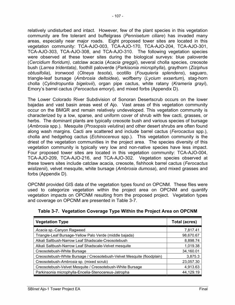
- 107 -
SBInet Ajo-1 Tower Project EA Final
relatively undisturbed and intact. However, few of the plant species in this vegetation community are fire tolerant and buffelgrass (Pennisetum ciliare) has invaded many areas, especially near major roads. Eight proposed tower sites are located in this vegetation community: TCA-AJO-003, TCA-AJO-170, TCA-AJO-204, TCA-AJO-301, TCA-AJO-303, TCA-AJO-308, and TCA-AJO-310. The following vegetation species were observed at these tower sites during the biological surveys: blue paloverde (Cercidium floridum), catclaw acacia (Acacia greggii), several cholla species, creosote bush (Larrea tridentata), foothill paloverde (Parkisonia microphylla), graythorn (Ziziphus obtusifolia), ironwood (Olneya tesota), ocotillo (Fouquieria splendens), saguaro, triangle-leaf bursage (Ambrosia deltoidea), wolfberry (Lycium exsertum), stag-horn cholla (Cylindropuntia bigelovii), organ pipe cactus, white ratany (Krameria grayi), Emory’s barrel cactus (Ferocactus emoryi), and mixed forbs (Appendix D).
The Lower Colorado River Subdivision of Sonoran Desertscrub occurs on the lower bajadas and vast basin areas west of Ajo. Vast areas of this vegetation community occur on the BMGR and remain relatively undeveloped. This vegetation community is characterized by a low, sparse, and uniform cover of shrub with few cacti, grasses, or herbs. The dominant plants are typically creosote bush and various species of bursage (Ambrosia spp.). Mesquite (Prosopsis velutina) and other desert shrubs are often found along wash margins. Cacti are scattered and include barrel cactus (Ferocactus spp.), cholla and hedgehog cactus (Echinocereus spp.). This vegetation community is the driest of the vegetation communities in the project area. The species diversity of this vegetation community is typically very low and non-native species have less impact. Four proposed tower sites are located in this vegetation community: TCA-AJO-004, TCA-AJO-209, TCA-AJO-216, and TCA-AJO-302. Vegetation species observed at these towers sites include catclaw acacia, creosote, fishhook barrel cactus (Ferocactuswislizenii), velvet mesquite, white bursage (Ambrosia dumosa), and mixed grasses and forbs (Appendix D).
OPCNM provided GIS data of the vegetation types found on OPCNM. These files were used to categorize vegetation within the project area on OPCNM and quantify vegetation impacts on OPCNM resulting from the proposed project. Vegetation types and coverage on OPCNM are presented in Table 3-7.
Table 3-7. Vegetation Coverage Type Within the Project Area on OPCNM
Vegetation Type Total (acres)
Acacia sp.-Canyon Ragweed 7,817.41Triangle-Leaf Bursage-Yellow Palo Verde (middle bajada) 98,670.67Alkali Saltbush-Narrow Leaf Shadscale-Creosotebush 8,898.74Alkali Saltbush-Narrow Leaf Shadscale-Velvet mesquite 1,019.38Creosotebush-White Bursage 34,160.01Creosotebush-White Bursage / Creosotebush-Velvet Mesquite (floodplain) 3,875.3Creosotebush-Ambrosia sp. (mixed scrub) 23,057.30Creosotebush-Velvet Mesquite / Creosotebush-White Bursage 4,913.63Parkinsonia microphylla-Encelia-Stenocereus-Jatropha 44,129.19
- 108 -
SBInet Ajo-1 Tower Project EA Final
Illegal cross border activities have adversely impacted vegetation communities found in the project area. Unauthorized roads and trails created by CBVs and consequent required law enforcement activities have directly degraded vegetation within the project area as a result of trampling or changes in hydrology through the interruption of sheet flow from precipitation events. In 2004-2005, OPCNM staff documented 364 miles of off-road vehicle routes and tracks created by CBVs and consequent law enforcement activities (OPCNM 2005). If it is assumed 1 mile of road represents approximately 1 acre and 1 mile of illegal trails represent approximately 0.4 acre, unauthorized vehicle routes and trails have degraded approximately 146 acres of vegetation on OPCNM. This assumption is based on coordination with OPCNM staff. Changes in hydrology can change the vegetation species composition on the downstream side of a road. Additionally, wildland fires resulting from warming or signal fires set by IAs and other CBVs destroy vegetation in these fire intolerant vegetation communities. Further non-native invasive species such as bufflegrass have become established in the project area. These species compete with native vegetation and often replace native vegetation in suitable habitat. CBVs originating in Mexico and vehicles originating outside of OPCNM inadvertently transport non-native invasive species seeds from Mexico into the U.S. on their clothes and vehicles.
3.8.2 Environmental Consequences 3.8.2.1 No Action Alternative No direct impacts would occur from implementation of the proposed project. However, long-term direct and indirect impacts to vegetation communities would continue and likely increase as a result of CBV activities that create unauthorized roads and trails, damage vegetation, and promote the dispersal and establishment of non-native invasive species. Using the previous assumption of 1 mile of road equals approximately 1 acre, the No Action Alternative could potentially result in hundreds of additional acres of impacts to vegetation. The presence of IAs and the damage they cause would result in long-term, moderate impacts to vegetation as a result of disturbance and habitat degradation.
3.8.2.2 Proposed Action The Proposed Action would result in the permanent loss of approximately 3 acres and the temporary disturbance of approximately 6.5 acres of Sonoran Desert vegetation community at 10 tower sites and associated roads. The remaining 15.8 acres of permanent impacts would occur on previously disturbed areas (i.e., authorized roads), which do not support vegetation communities. The Sonoran Desert vegetation community is extremely common and vast areas of similar vegetation are protected to some degree by their inclusion on lands managed by CPNWR, BMGR, Buenos Aires National Wildlife Refuge (BANWR), OPCNM, USFS, and the Tohono O’odham Nation. Potential impacts to vegetation types found within the project area on OPCNM from the proposed project are quantified in Table 3-8.

- 109 -
SBInet Ajo-1 Tower Project EA Final
Table 3-8. Vegetation Impacts on Organ Pipe Cactus National Monument Associated with the SBInet Ajo-1 Tower Project
Vegetation Type Existing Vegetation (acres)
Permanent Impact (acres)
Change(percent)
Acacia sp. Canyon Ragweed 7,817.41 0 0
Triangle-leaf Bursage – Yellow Palo Verde (middle bajada) 98,670.67 0.27 < 0.01
Alka 1: Saltbush – Narrow Leaf Shadscale – Creosotebush 8,898.74 1.01 < 0.01
Creosotebush – Velvet Mesquite (floodplain) 3,875.3 0.156 < 0.01
Creosotebush – White Bursage 34,160.01 0.128 < 0.01 Creosotebush – Ambrosia mixed scrub 23,057.34 0 0 Yellow Palo Verde – Encelia – Stenocereus – Jatraph 44,129.19 .002 < 0.01
The direct permanent effect of degradation and removal of 3 acres of vegetation would have a long-term, negligible adverse effect on the total amount of similar Sonoran Desert vegetation communities on CPNWR and BLM lands, and vegetation types within OPCNM. Efforts to minimize the direct loss of vegetation communities are outlined in Section 5.0. The Proposed Action would not permanently degrade or remove more than 0.01 percent of any vegetation type or OPCNM.
Soil disturbance, road improvements, and the extension of human activity into previously undisturbed areas could result in indirect effects which could occur over a much larger area. Soil disturbance favors the establishment of non-native, invasive species where the disturbance occurs. Many of the existing roads which lead to tower sites are infrequently used due to poor road conditions. Repairs to current roads and the construction of new primitive roads have the potential to lead to recreational use near the tower sites. Direct use in association with construction road operation of towers and indirect use associated with recreational access could favor invasive species already established and result in the spread of invasive species to new areas. Combined, these direct and indirect effects could result in the expansion of non-native, invasive species. These species can compete with native vegetation and result in the displacement of individuals. Over time the replacement of native species with non-native species can result in changes to the environment (e.g., reduced resource availability, increased fuel for wildfire, loss of niche space, etc.) which can ultimately result in permanent changes in or complete loss of a vegetation community. Efforts to reduce the establishment and spread of non-native, invasive species are outlined in Section 5.0. Furthermore, the reduction of CBV activity would benefit these habitats through the reduction of similar impacts over a much greater area. Based on similar technology projects in Yuma Sector and the Altar Valley in the Tucson Sector a reduction in illegal traffic could be realized within 1 year of the proposed towers becoming operational and accepted by USBP. Additionally, the proposed towers would allow USBP agents to focus interdictions, thus improving interdiction efficiency and consequently increasing deterrence. The increased deterrence effect would

- 110 -
SBInet Ajo-1 Tower Project EA Final
consequently result in a decrease of the enforcement footprint and further reduce the affected area. In the Altar Valley the enforcement footprint was reduced from 45 miles north of the international border to 0 to 10 miles north of the international border. Those areas above the primary enforcement zone would naturally rehabilitate over time in the absence of CBV vehicle and pedestrian off-road traffic and required law enforcement activities. The time for these disturbed areas to rehabilitate would depend on the vegetation community, soil type, and climatic conditions. The Proposed Action would have a long-term, minor indirect beneficial effect on vegetation within OPCNM and to some extent CPNWR and BLM lands.
3.9 WILDLIFE AND AQUATIC RESOURCES
3.9.1 Affected Environment Biological surveys of proposed tower site locations and roads were conducted by Harris in October 2007, November 2007, January 2008, and April 2008 (Appendix D). Additionally, GSRC conducted surveys of the proposed project tower sites and road sections proposed for construction, repair, or improvement in March, April, and June 2009. Many of the animals found in Sonoran Desert habitats are found throughout the warmer and drier regions of the southwestern U.S. Due to a lack of available forage and extreme temperatures, all of the mammals of these habitats are small and most are nocturnal. The common mammals include several species of bats, coyote (Canis latrans), black-tailed jack-rabbit (Lepus californicus), desert cottontail (Sylvilagus audubonii), Merriam’s kangaroo rat (Dipodomys merriami), white-throated woodrat (Neotoma albigula), and desert pocket mouse (Chaetodipus penicillatus). Other mammals, such as the desert kangaroo rat (Dipodomys deserti), Bailey’s pocket mouse (Chaetodipus baileyi), and round-tailed ground squirrel (Spermophilus tereticaudus) are more limited in their distribution and, as such, are more characteristic of Sonoran Desert vegetative habitats. Mammals or mammal sign observed during surveys include jackrabbit, desert cottontail, white-throated woodrat (Neotoma albigula), and rodent burrows (Appendix D).
Similar to the mammals, many birds are common throughout the desert regions, including road runner (Geococcyx californianus), mourning dove (Zenaida macroura),lesser nighthawk (Chordeiles acutipennis), cactus wren (Campylorhynchus brunneicapillus), black-tailed gnatcatcher (Polioptila melanura), phainopepla (Phainopepla nitens), and black-throated sparrow (Amphispiza bilineata). Some birds more characteristic of Sonoran Desertscrub include Gambel’s quail (Callipepla gambelii), gilded flicker (Colaptes auratus), and Gila woodpecker (Melanerpesuropygialis). Although less abundant, raptors can be common in Semidesert Grasslands and scavangers can be observed throughout Sonoran Desert habitats. Birds observed during biological surveys include cactus wren, black-tailed gnatcatcher, Gila woodpecker, Gabel’s quail, phainopepla, rock wren (Salpinctes obsoletus), Harris’ hawk (Parabuteo unicinctus), peregrine falcon (Falco peregrinus), raven (Corvus spp.), and turkey vulture (Cathartes aura) (Appendix D).
- 111 -
SBInet Ajo-1 Tower Project EA Final
Reptiles are the most diverse animal group in this vegetative habitat, and many reptiles are also widespread, including the desert tortoise (Gopherus agassizii), chuckwalla (Sauromalus ater), desert iguana (Dipsosaurus dorsalis), rosy boa (Charina trivirgata),and western shovelnose snake (Chionactis occipitalis). Reptiles which are common throughout the desert regions, but have Sonoran Desert subspecies include the banded gecko (Coleonyx variegatus), desert spiny lizard (Sceloporus magister), glossy snake (Arizona elegans), western ground snake (Sonora semiannulata), and western diamondback (Crotalus atrox). Reptiles observed during biological surveys include whiptail (Aspidoscelis spp.), western whiptail (A. tigris), zebra-tailed lizard (Callisaurus draconoides), side-blotched lizard (Uta stansburiana), and tree lizard (Urosaurus sp.) (Appendix D).
Illegal cross border activities and required law enforcement activities have degraded wildlife habitat in the project area through the creation and use of unauthorized roads and trails. CBVs traveling through the project area disturb wildlife and likely cause the avoidance of resources in highly traveled areas. Additionally, wildland fires caused by IA and CBVs have the potential to degrade wildlife habitat.
3.9.2 Environmental Consequences 3.9.2.1 No Action Alternative Under the No Action Alternative, no direct impacts to wildlife habitats would occur. However, off-road CBV activity and required CBV interdiction actions would continue to degrade wildlife habitat as described in Section 3.7.2.1. This degradation of vegetation communities has resulted in wildlife habitat degradation through a loss of cover, forage, nesting, and other opportunities and potentially a loss of suitable habitat over large areas. Off-road vehicle and pedestrian traffic would continue to disturb wildlife species, cause individuals to avoid resources in area of high illegal traffic volume, and disturb or degrade additional acres of wildlife habitat.
3.9.2.2 Proposed Action The permanent loss of up to 3 acres and temporary degradation of approximately 6.5 acres of Sonoran Desert vegetation communities would have a minimal impact on wildlife. Soil disturbance and operation of heavy equipment could result in the direct loss of less mobile individuals such as lizards, snakes, and ground dwelling species such as mice and rats. However, most wildlife would avoid any direct harm by escaping to surrounding habitat. The direct degradation and loss of habitat could also impact burrows and nests, as well as cover, forage, and other important wildlife resources. The loss of these resources would result in the displacement of individuals which would then be forced to compete with other wildlife for the remaining resources. Although this resulting competition for resources could result in a reduction of total population size, this reduction would be extremely minimal in relation to total population size and would not result in long-term effects to the sustainability of any wildlife species. Mitigation measures outlined in Section 5.0 would reduce disturbance and loss of wildlife habitats. The Proposed Action would have a short-term, minor adverse effect on wildlife resources.

- 112 -
SBInet Ajo-1 Tower Project EA Final
There is a possibility that the proposed surveillance and communication towers could pose hazards to migratory birds; however, since none of the three tower types use guy wires, the potential for adverse impacts is greatly reduced. Furthermore, tower construction would adhere to the USFWS interim guidelines and FAA guidelines designed to reduce impacts to migratory birds such as installation of white or red strobe lights and limiting heights of towers (USFWS 2000). However, the electromagnetic field (EMF) associated with radars could disorient migratory species, thus increasing the potential for bird strikes (Nicholls and Racey 2007). Evaluation of the tower arrays shows that adjusted receiver signal strength of the EMF would be attenuated to less than 2 volts per meter (V/m) at distances greater than 180.5 feet from the array (CBP 2009). Similar to the effect of habitat degradation and loss on the sustainability of wildlife populations, the number and extent of bird strikes in relation to the size of migratory bird populations and the extent of the migratory flyway would be minor and would not affect sustainability of migratory bird populations in the region. Therefore, the Proposed Action would have a long-term, minor adverse effect on migratory birds. Measures to reduce bird and mortality include the elimination of barbed wire on the perimeter fences at proposed towers, TCA-AJO-003, 170, 204, 216, 303, and 310 and elimination of a perimeter fence at proposed tower TCA-AJO-189. Other mitigation measures to reduce migratory bird strikes are outlined in Section 5.0.
Noise associated with tower construction and maintenance and road construction, improvements, and maintenance would result in short-term impacts on wildlife. Elevated noise levels associated with short-term construction and maintenance activities would only occur during the duration of these activities. The effects of this disturbance would include temporary avoidance of work areas and competition for unaffected resources. Due to the limited extent and duration of these activities these impacts would be minor. Mitigation measures as outlined in Section 5.0 would reduce noise associated with operation of heavy equipment.
The permanent increase in noise levels associated with operation of the proposed tower sites (i.e., generators and air conditioners) would be sporadic, only occurring when this equipment is operating. Generators would be equipped with mufflers or baffle boxes to reduce their noise, and noise would be attenuated to 35 dBA at a distance of approximately 492 feet. It is anticipated that wildlife would become accustomed to these intermittent and minimal increases in noise, and that subsequent avoidance of tower sites and any adjacent habitats would be minor.
The permanent use of security lights at proposed towers sites would also disturb wildlife adjacent to a proposed tower. However, a security light on each tower shelter would be operated by a motion detector and would only turn on if the detector was triggered. Further, the security light would be mounted and properly shielded to ensure no light extends beyond the perimeter security fence. Sodium lights would be used to lessen the intensity of the light. Similar to impacts associated with the permanent increase in noise, it is anticipated that some wildlife would become accustomed to these intermittent and minimal increases in light. Subsequent avoidance of tower sites and any adjacent habitats would be minimal. Ultimately, the effects of increased noise and light could
- 113 -
SBInet Ajo-1 Tower Project EA Final
displace some individual wildlife specimens and result in localized competition for resources. However, the extent of these impacts would not result in impediments of sustainability of wildlife populations in the region. Adverse effects from lighting on wildlife species would be permanent and minor.
The Proposed Action could result in indirect and long-term beneficial impacts to wildlife by reducing the adverse impacts of CBV activity and resulting law enforcement activities on wildlife habitats in the project area. Beneficial effects would be noticeable throughout OPCNM and to some extent on CPNWR and BLM lands. The proposed project would enhance CBP’s detection capabilities and increase the efficiency of interdictions actions. Enhancement of detection capabilities and interdiction efficiency would increase deterrence of CBVs and thus reduce the enforcement footprint within Organ Pipe Cactus Wilderness and to some extent Cabeza Prieta Wilderness and BLM lands. Although interdiction efforts are likely to increase when the proposed towers become functional as a result of the enhanced detection capabilities, these interdiction efforts would be more focused and off-road interdiction activities would likely decrease over time. As the certainty of apprehension increases and consequent law enforcement efforts decrease, a reduction in potential impacts to wildlife and their habitats would be expected. Additionally, as apprehension success increases through the use of the proposed towers, the towers would serve as a deterrent to illegal traffic. Operational success (effective enforcement) with resulting deterrence as a result of technology has been demonstrated by USBP in the Yuma Sector and Altar Valley in the Tucson Sector. Beneficial effects would include reduced off-road vehicle and foot traffic, a decrease in habitat degradation, and reduced disturbances to wildlife species. A reduction in the degradation of wildlife habitats would result in an increase or improvement to wildlife resources such as forage, cover, and nesting opportunities. Additionally, road restoration efforts in Sonoran pronghorn habitat, to be funded by CBP as part of the Proposed Action, would enhance wildlife habitat.
3.10 PROTECTED SPECIES AND CRITICAL HABITATS
3.10.1 Affected Environment The ESA was enacted to provide a program for the preservation of endangered and threatened species, and to provide protection for the ecosystems upon which these species depend for their survival. All Federal agencies are required to implement protective measures for designated species and to use their authorities to further the purposes of the ESA. The Secretary of the Interior and the Secretary of Commerce (marine species) are responsible for the identification of a threatened or endangered species and development of any potential recovery plan.
USFWS is the primary agency responsible for implementing the ESA, and is responsible for birds and other terrestrial and freshwater species. The USFWS responsibilities under the ESA include: (1) the identification of threatened and endangered species; (2) the identification of critical habitats for listed species; (3) implementation of research on, and recovery efforts for, these species; and (4) consultation with other Federal agencies concerning measures to avoid harm to listed species.

- 114 -
SBInet Ajo-1 Tower Project EA Final
An endangered species is a species officially recognized by the USFWS as being in danger of extinction throughout all or a significant portion of its range. A threatened species is a species likely to become endangered within the foreseeable future throughout all or a significant portion of its range. Proposed species are those that have been formally submitted to Congress for official listing as threatened or endangered. Species may be considered endangered or threatened when any of the five following criteria occur: (1) current/imminent destruction, modification, or curtailment of their habitat or range; (2) overuse of the species for commercial, recreational, scientific, or educational purposes; (3) disease or predation; (4) inadequacy of existing regulatory mechanisms; and (5) other natural or human-induced factors affect continued existence.
In addition, the USFWS has identified species that are candidates for listing as a result of identified threats to their continued existence. The candidate designation includes those species for which the USFWS has sufficient information to support proposals to list as endangered or threatened under the ESA. However, proposed rules have not yet been issued because such actions are precluded at present by other listing activity. Although not afforded protection by the ESA, candidate species may be protected under other Federal or state laws.
Biological surveys of the proposed tower sites were conducted by Harris during October and November 2007, and January and April 2008 (Appendix D). Additionally, biological surveys were conducted at proposed tower TCA-AJO-189 by GSRC in April 2009. These investigations included surveys for all Federal, BLM, NPS, and state protected species potentially occurring in the project area.
3.10.2 Federal The unique and varied array of habitat types found in southwestern Arizona are home to a diverse assemblage of species, but the area is also one of the last places where some habitats and species can be found. Southwestern Arizona is home to many species listed as threatened or endangered. Within Pima County, 14 species are listed as Federally endangered, two are Federally threatened, and three species are candidate species (Table 3-9; Appendix H). Not all of these species occur within the vicinity of the project area. Two endangered species have the potential to occur within or near the project area: lesser long-nosed bat and Sonoran pronghorn. One endangered species, the desert pupfish (Cyprinodon macularius) and two candidate species, the Acuna cactus (Echinomastus erectocentrus var. acunensis) and Sonoyta mud turtle (Kinosternon sonoriense longifemorale), do not occur within the disturbance footprint of the project, but these species occur within the area of enhanced enforcement provided by the COP.
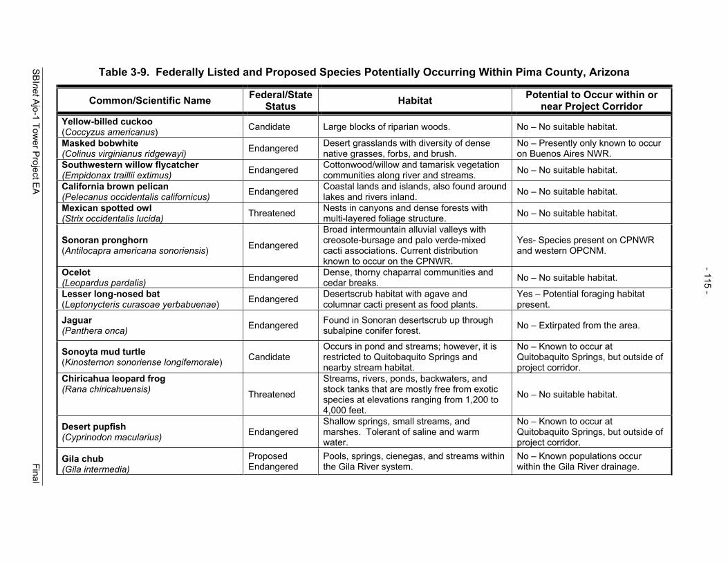
SBInetAjo-1 Tow
er Project E
A
Final
- 115 -
Table 3-9. Federally Listed and Proposed Species Potentially Occurring Within Pima County, Arizona
Common/Scientific Name Federal/StateStatus Habitat Potential to Occur within or
near Project Corridor Yellow-billed cuckoo (Coccyzus americanus) Candidate Large blocks of riparian woods. No – No suitable habitat.
Masked bobwhite (Colinus virginianus ridgewayi) Endangered Desert grasslands with diversity of dense
native grasses, forbs, and brush. No – Presently only known to occur on Buenos Aires NWR.
Southwestern willow flycatcher (Empidonax traillii extimus) Endangered Cottonwood/willow and tamarisk vegetation
communities along river and streams. No – No suitable habitat.
California brown pelican (Pelecanus occidentalis californicus) Endangered Coastal lands and islands, also found around
lakes and rivers inland. No – No suitable habitat.
Mexican spotted owl (Strix occidentalis lucida) Threatened Nests in canyons and dense forests with
multi-layered foliage structure. No – No suitable habitat.
Sonoran pronghorn (Antilocapra americana sonoriensis) Endangered
Broad intermountain alluvial valleys with creosote-bursage and palo verde-mixed cacti associations. Current distribution known to occur on the CPNWR.
Yes- Species present on CPNWR and western OPCNM.
Ocelot(Leopardus pardalis) Endangered Dense, thorny chaparral communities and
cedar breaks. No – No suitable habitat.
Lesser long-nosed bat (Leptonycteris curasoae yerbabuenae) Endangered Desertscrub habitat with agave and
columnar cacti present as food plants. Yes – Potential foraging habitat present.
Jaguar (Panthera onca) Endangered Found in Sonoran desertscrub up through
subalpine conifer forest. No – Extirpated from the area.
Sonoyta mud turtle (Kinosternon sonoriense longifemorale) Candidate
Occurs in pond and streams; however, it is restricted to Quitobaquito Springs and nearby stream habitat.
No – Known to occur at Quitobaquito Springs, but outside of project corridor.
Chiricahua leopard frog (Rana chiricahuensis) Threatened
Streams, rivers, ponds, backwaters, and stock tanks that are mostly free from exotic species at elevations ranging from 1,200 to 4,000 feet.
No – No suitable habitat.
Desert pupfish (Cyprinodon macularius) Endangered
Shallow springs, small streams, and marshes. Tolerant of saline and warm water.
No – Known to occur at Quitobaquito Springs, but outside of project corridor.
Gila chub (Gila intermedia)
Proposed Endangered
Pools, springs, cienegas, and streams within the Gila River system.
No – Known populations occur within the Gila River drainage.

SBInetAjo-1 Tow
er Project E
A
Final
- 116 -
Common/Scientific Name Federal/StateStatus Habitat Potential to Occur within or
near Project Corridor Gila topminnow (Poeciliopsis occidentalis occindentalis) Endangered Small streams, springs, and cienegas within
the Gila River system. No – Known populations occur within the Gila River drainage.
Kearney blue star (Amsonia kearneyana)
Endangered West-facing drainages in the Baboquivari mountains.
No –Project corridor is west of Baboquivari Mountains.
Pima pineapple cactus (Coryphantha scheeri var. robustispina) Endangered
Ridges in semi-desert grassland and alluvial fans in Sonoran desertscrub with elevation ranges from approximately 2,300 to 5,000 feet.
No – Known populations occur in east Pima County at high elevations.
Nichol Turk’s head cactus (Echinocactus horizonthalonius var.nicholii)
Endangered Unshaded microsites in Sonoran desertscrub on dissected limestone mountains.
No – Known populations occur in east Pima and south Pinal counties.
Huachuca water umbel (Liaeopsis schaffneriana var. recurva) Endangered Cienegas, perennial low gradient streams,
wetlands.
No – Known populations found in San Pedro and Santa Cruz River Basins.
Acuña cactus (Echinomastus erectocentrus var.acunensis)
Candidate Acuña cacti are found on granite substrates on rounded small hills at elevations ranging from 1,300-2,000 feet.
Yes– Known populations are located on OPCNM approximately 8 miles north of the U.S.-Mexico border; however, no individual of this species was observed during the biological field surveys.
Source: USFWS 2007
Table 3-9, continued

- 117 -
SBInet Ajo-1 Tower Project EA Final
Photograph 3-3. Sonoran Pronghorn
Courtesy of NPS
3.10.2.1 Sonoran Pronghorn The Sonoran pronghorn (Photograph 3-3) was listed as Federally endangered on March 11, 1967 (32 Federal Register [FR] 4001). Sonoran pronghorn require vast areas of open range to meet their annual needs for survival and reproduction (USFWS 2003). This includes the ability to freely travel long distances in response to localized, seasonally intermittent rainfall which stimulates plant growth and provides forage. The diet of Sonoran pronghorn consists of a variety of plant materials from common desert herbs, shrubs, and cacti. Jumping cholla (Opuntia fulgida) is thought to provide a large portion of food and water requirements. Visibility is a key factor in determining habitat use by Sonoran pronghorn, which prefer more open sandy areas and low hillsides with a variety of palatable forage. Beginning in December and following the winter rains, forage is abundant in the creosote-bursage communities of the alluvial valleys, and animals are commonly found in the Mohawk Valley. From February through May, does are fawning and seek areas of higher cover along wash margins. Following summer storms in July and August, new plant growth is found in the paloverde -mixed cactus vegetation communities on the bajadas of desert mountains in the OPCNM. The breeding season occurs between July and September.
Sonoran pronghorn range from the plains of central and western Sonora, Mexico north to southwestern Arizona (USFWS 2003). In Arizona, Sonoran pronghorn occur on CPNWR, BMGR, the western portion of OPCNM, from SR 85 west to the Cabeza Prieta Mountains and from near the Wellton-Mohawk Canal south to the U.S.-Mexico border (Figure 3-4). Based on radio telemetry data and incidental visual sightings, Sonoran pronghorn most commonly occurred in the Valley of the Ajo, the foothills of the Puerto Blanco Mountains, Acuña Valley, the foothills of the Bates Mountains, Growler Valley and San Cristobal Wash. (USFWS 2004). However, in recent years the pronghorn has not been observed in the Valley of the Ajo (Tibbitts 2009). Critical habitat for Sonoran pronghorn has not been designated (USFWS 2003).
Environmental factors such as drought, predation, and available forage, as well as human factors such as illegal hunting, fencing, and human encroachment, have all been identified as possible reasons for the decline of Sonoran pronghorn. While all of these factors may have historically contributed to the decline, drought has apparently caused most of the population fluctuations in recent time (USFWS 2004).
The USFWS established a recovery plan for the Sonoran pronghorn in 1982, and revised the plan in 1998. The final plan calls for down-listing the Sonoran pronghorn to threatened when there are an estimated 300 adults in one self-sustaining population in the U.S. that remains stable for a minimum of 5 years, or when numbers are determined

- 118 -
SBInet Ajo-1 Tower Project EA Final
THIS PAGE LEFT INTENTIONALLY BLANK
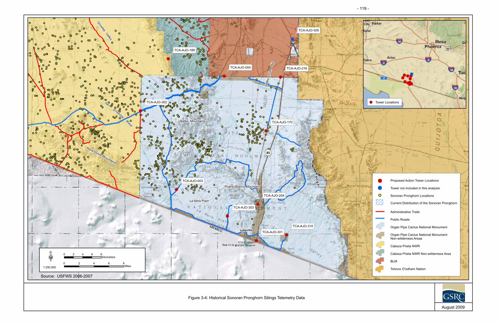
!.
!.
!.
!.
!.
!.
!.
!.
!.
!.
!.
¬«85
¬«86
Aj o
Ra
ng
e
Bates Mountains
Aqua Dulce Mountains
Puerto Blanco Mountains
Valle
yof
the
Ajo
GrowlerValley
SanCristobal
Wash
La Abra Plain
TCA-AJO-310
TCA-AJO-305
TCA-AJO-303
TCA-AJO-302
TCA-AJO-301
TCA-AJO-216
TCA-AJO-204
TCA-AJO-189
TCA-AJO-170
TCA-AJO-004
TCA-AJO-003
·1:250,000
0 2 4 6 8Miles
0 2 4 6 8Kilometers
August 2009
Figure 3-4: Historical Sonoran Pronghorn Sitings Telemetry Data
Organ Pipe Cactus National Monument
!. Tower not included in this analysis
Lukeville
!.
!.!.
!.
!.
!.
!.
!.
!.
!.
!.
Tower Locations!.
Organ Pipe Cactus National MonumentNon-wilderness Areas
Cabeza Prieta NWR
Cabeza Prieta NWR Non-wilderness Area
BLM
Tohono O'odham Nation
!. Proposed Action Tower Locations
Sonoran Pronghorn Locations
Administrative Trails
Public Roads
Current Distribution of the Sonoran Pronghorn
Source: USFWS 2006-2007
- 119 -

- 120 -
SBInet Ajo-1 Tower Project EA Final
THIS PAGE LEFT INTENTIONALLY BLANK

- 121 -
SBInet Ajo-1 Tower Project EA Final
Photograph 3-4. Lesser Long-nosed Bat Courtesy of USFWS
to be adequate to sustain the population through time, and at least one other self-sustaining population is established in the U.S. (USFWS 1998).
In 2003 a semi-captive breeding enclosure was established to aid in the recovery efforts of the Sonoran pronghorn population. The enclosure is located in the non-wilderness portion of the CPNWR. The 640-acre pen is designed to keep predators (e.g., coyotes) out and to provide irrigated forage plots and a free water source in a drinking trough (Defenders of Wildlife 2005 and USFWS 2005). To eliminate or reduce disturbances to nursing Sonoran pronghorns and fawns during fawning season, a time when they are especially sensitive, the USFWS closed the eastern three-quarters of the CPNWR to all public access between March 15 and July 15 during 2002 through 2005 (USFWS 2005). The Sonoran pronghorn population on the CPNWR was estimated to be 33 individuals in 2003 (USFWS 2005). In 2004, the population nearly doubled to 58 individuals (McCasland 2005). This population increase coincided with the record rainfall during the spring. The USFWS estimated the Sonoran pronghorn populations at 75 individuals in 2005 and 70 to 100 individuals in 2006 (Coffeen 2006 and Atkinson 2008). A rangewide assessment is scheduled again to assess the population in the fall of 2008. Currently, the Sonoran pronghorn population is estimated to be 70 individuals (McCasland 2009). Additionally, there is also a breeding enclosure on CPNWR that currently houses 54 individuals. Individuals from this population will be released into the wild herd annually (Atkinson 2009).
3.10.2.2 Lesser Long-nosed Bat Lesser long-nosed bat (Photograph 3-4) waslisted as endangered on September 30, 1988 (53 FR 38456). The lesser long-nosed bat is a nectar, pollen, and fruit foraging species that migrates into southern New Mexico and Arizona seasonally from Mexico (AGFD 2003). They begin migrating in early April, apparently coinciding seasonally with the flowering of columnar cacti and desert agave (Agave deserti simplex), and return to Mexico during sometime in September (USFWS 1995). The lesser long-nosed bat occurs within desert grasslands and scrublands habitat during the summer months. Typical roosting sites include, but are not limited to, caves, abandoned buildings, and mines located at the base of mountains which have also been documented to coincide where bat foraging habitat occurs (AGFD 2003).
The lesser long-nosed bat is a seasonal resident of CPNWR and OPCNM. As early as April continuing through mid-July, female lesser long-nosed bats, most of which are pregnant, arrive at known maternity roosts in southwest Arizona. These maternity colonies begin to disband by September, and both males and females can be found in

- 122 -
SBInet Ajo-1 Tower Project EA Final
transient or maternity roosts from September to as late as early November. The bats eat nectar and fruits of columnar cacti and paniculate agaves and are considered an important dispersal and pollination vector for these species. Lesser long-nosed bats are known to travel up to 36 miles to reach suitable concentrations of forage. There is one known maternity roost within CPNWR non-wilderness area north of OPCNM, and one known maternity roost and one known minor roost within OPCNM (Figure 3-5).
The main threats to this species are the reduction in numbers of maternity colonies and decline in size of remaining colonies due to exclusion and disturbance (AGFD 2003). Additionally, large reductions in acreage of native agaves over large areas of northern Mexico due to excessive harvesting for local manufacture of mescal and tequila are also reasons for the decline of this species.
The recovery plan for the lesser long-nosed bat was completed in March 1997 to provide protective actions needed for the recovery of the bat. Protection of all known roost sites and food plants within a radius of 36 miles around known roosts will help prevent this species from going extinct. In addition, the protection of food resources along migratory pathways may be important to the survival of the species (USFWS 1995). Critical habitat has not been designated for the lesser long-nosed bat.
3.10.2.3 Desert Pupfish The desert pupfish (Photograph 3-5) was listed as an endangered species in March 1986 (51 FR 10842). The Quitobaquito population of the desert pupfish is thought to be a subspecies (Quitobaquito pupfish [Cyprinodon macularis eremus]) of the desert pupfish, but some scientists advise that the Quitobaquito population is sufficiently distinct to be a unique species (Echelle et al. 2000). They are adapted to desert environments and are capable of surviving extreme environmental conditions (USFWS 1993).
The only known natural population of the desert pupfish in Arizona is found at Quitobaquito Springs where critical habitat for the species has been established (USFWS 1993). Desert pupfish habitat is not located at the proposed FOB or any of the proposed tower sites, but Quitobaquito Springs is located within the project area.
Photograph 3-5. Desert Pupfish Courtesy of USFWS/John Rinne

!.
!.
!.
!.
!.
!.
!.
!.
!.
!.
!.
¬«85
¬«86
Ajo
Ra
ng
e
TCA-AJO-310
TCA-AJO-305
TCA-AJO-303
TCA-AJO-302
TCA-AJO-301
TCA-AJO-216
TCA-AJO-204
TCA-AJO-189
TCA-AJO-170
TCA-AJO-004
TCA-AJO-003
·1:250,000
0 2.5 5 7.5 10Miles
0 2.5 5 7.5 10Kilometers
August 2009
Figure 3-5: Lesser Long-nosed Bat Roosting Sites
Organ Pipe Cactus National Monument
!. Tower not included in this analysis
Lukeville
!.
!.!.
!.
!.
!.
!.
!.
!.
!.
!.
Tower Locations!.
Organ Pipe Cactus National MonumentNon-wilderness Areas
Cabeza Prieta NWR
Cabeza Prieta NWR Non-wilderness Area
BLM
Tohono O'odham Nation
!. Proposed Action Tower Locations
Lesser Long-nosed Bat Roosting Sites
Administrative Trails
Public Roads
Source: USFWS 2006
- 123 -

- 124 -
SBInet Ajo-1 Tower Project EA Final
THIS PAGE LEFT INTENTIONALLY BLANK
- 125 -
SBInet Ajo-1 Tower Project EA Final
Photograph 3-6.Acuña Cactus
Courtesy of USFWS
3.10.2.4 Acuna Cactus Acuna cactus (Photograph 3-6) occurs on well drained ridges and hills between major washes in Sonoran desertscrub habitat and is known from six locations on granite substrates at elevations ranging from 1,300 to 2,000 feet (USFWS 2007). Known occurrences of Acuna cactus are located near Florence in Pinal County, near Ajo in Pima County, and near Sonoyta in Mexico. The populations near Ajo are found along the northern drainages of the Batamote Mountains and along the southern drainages between the Cipriano Hills and Sonoyta Mountains. Known threats include habitat destruction, illegal collection, drought, and insects. In recent years, a 50 percent mortality rate has been observed at the known populations near Ajo and is believed to be attributable to drought. Additionally, opuntia borer (Moneilema gigas) has been identified as being responsible for considerable mortality of larger Acuna cactus on OPCNM (Johnson 1991). Illegal border related activities are not known to have affected Acuna cacti; however, vehicle tracks have been observed through the population range of the species within the project area (Sturm 2009b).
3.10.2.5 Sonoyta Mud Turtle The Sonoyta mud turtle (Photograph 3-7) occurs only in pond and stream habitat at Quitobaquito Springs on OPCNM and in the nearby Rio Sonoyta, Sonora Mexico (AGFD 2005). The turtle is highly aquatic and depends on permanent water for survival. Primary threats include loss and degradation of stream habitat from water diversions and groundwater pumping, and it may be vulnerable to spraying of pesticides on nearby agricultural fields. The Sonoyta mud turtle habitat is not located at the proposed FOB or any of the tower sites, but is located at Quitobaquito Springs within the project area.
3.10.2.6 Critical Habitat The ESA also calls for the conservation of what is termed “critical habitat” – the areas of land, water, and air space that an endangered species requires for survival. Critical habitat also includes such things as food and water sources, breeding sites, cover or shelter, and sufficient habitat area to provide for normal population growth and behavior.
Photograph 3-7. Sonoyta Mud TurtleCourtesy of USFWS

- 126 -
SBInet Ajo-1 Tower Project EA Final
One of the primary threats to many species is the destruction, conversion, or modification of essential habitat by uncontrolled land and water development. Designated critical habitat for the desert pupfish is located at Quitobaquito Springs within the project area. None of the proposed tower sites, associated roads, or FOB are located near Quitobaquito Springs.
3.10.3 State AGFD Natural Heritage Program maintains lists of wildlife of special concern (WSC) in Arizona. This list includes fauna whose occurrence in Arizona is or may be in jeopardy, or with known or perceived threats or population declines (AGFD 2007). These species are not necessarily the same as those protected under the ESA. A list of these species is presented in Appendix H. No Arizona WSC, NPS, or BLM sensitive species were observed within the project footprint; however, habitat within the project footprint was determined to be suitable for six Arizona WSC and six BLM sensitive species (Table 3-10).
The Arizona Department of Agriculture (ADA) maintains a list of protected plant species within Arizona. The 1999 Arizona Native Plant Law defined five categories of protection within the state; 1) Highly Safeguarded, no collection allowed; 2) Salvage Restricted, collection only with permit; 3) Export Restricted, transport out of state prohibited; 4) Salvage Assessed, permit required to remove live trees; and 5) Harvest Restricted, permit required to remove plant by-products (ADA 2007). A list of native plants protected by the ADA is included in Appendix H. Only those plants with highly safeguarded and salvage restricted status are discussed here, as other regulated activities would not occur.
Of the 133 highly safeguarded or salvage restricted status species (Appendix H), only four were observed at proposed tower sites or along associated access roads: Organ pipe cactus, Emory’s barrel cactus, desert night-blooming cereus, and stag-horn cholla (Table 3-10).
3.10.4 Environmental Consequences 3.10.4.1 No Action Alternative Under the No Action Alternative, there would be no direct impacts to threatened or endangered species or their habitats as no construction activities would occur. However, the direct and long-term impacts of CBV and consequent law enforcement activities throughout the project area and surrounding areas would continue to disturb threatened or endangered species and their habitats, including desert pupfish critical habitat at Quitobaquito Springs. CBV activities create trails, damages vegetation, promotes the dispersal and establishment of invasive species, and can result in catastrophic wild fires. These actions have an indirect adverse impact on threatened and endangered species by causing harm to individuals and degrading habitats occupied by these species.
Specifically, CBV activities can result in the loss of forage and cover resources for Sonoran pronghorn. The presence of CBVs and resulting law enforcement activities
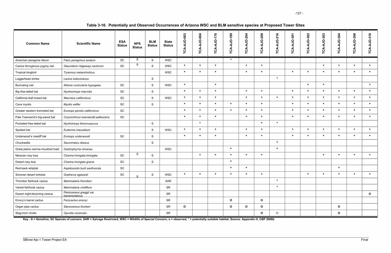
-127 -
SBInet Ajo-1 Tower Project EA Final
Table 3-10. Potentially and Observed Occurrences of Arizona WSC and BLM sensitive species at Proposed Tower Sites
Common Name Scientific Name ESAStatus NPS
Status
BLMStatus
StateStatus
TCA
-AJO
-003
TCA
-AJO
-004
TCA
-AJO
-170
TCA
-AJO
-189
TCA
-AJO
-204
TCA
-AJO
-209
TCA
-AJO
-216
TCA
-AJO
-301
TCA
-AJO
-302
TCA
-AJO
-303
TCA
-AJO
-304
TCA
-AJO
-308
TCA
-AJO
-310
American peregrine falcon Falco peregrinus anatum SC S S WSC *
Cactus ferruginous pygmy owl Glaucidium ridgewayi cactorum SC S S WSC * * * * * * * * *Tropical kingbird Tyrannus melancholicus WSC * * * * * * * * * * *Loggerhead shrike Lanius ludovicianus S * Burrowing owl Athene cunicularia hypugaea SC S WSC * * * * *Big free-tailed bat Nyctinomops macrotis SC S * * * * * * * * * * *California leaf-nosed bat Macrotus californicus SC S WSC * * * * * * * * * * * *Cave myotis Myotis velifer SC S * * * * * * * * * * * *Greater western bonneted bat Eumops perotis californicus SC * * * * * * * * * * * *Pale Townsend’s big-eared bat Corynorhinus townsendii pallescens SC * * * * * * * * * * *Pocketed free-tailed bat Nyctinimops femorosaccus S * * * Spotted bat Euderma maculatum S WSC * * * * * * * * * * *Underwood’s mastiff bat Eumops underwoodi SC S * * * * * * * * * * *Chuckwalla Sauromalus obesus S * Great plains narrow-mouthed toad Gastrophyrne olivacea WSC * * Mexican rosy boa Charina trivirgata trivirgata SC S S * * * * * * * * *Desert rosy boa Charina trivirgata gracia SC S * Red-back whiptail Aspidoscelis burti xanthonota SC * * *Sonoran desert tortoise Gopherus agassizii SC S S WSC * * * * * * * * * * *Thronber fishhook cactus Mammalaria thornberi SAR * Varied fishhook cactus Mammalaria viridiflora SR * Desert night-blooming cereus Peniocereus greggii var.
transmontanus SR O
Emory’s barrel cactus Ferocactus emoryi SR O O
Organ pipe cactus Stenocereus thurberi SR O O O O O
Stag-horn cholla Opuntia versicolor SR O O O
Key - S = Sensitive, SC Species of concern, SAR = Salvage Restricted, WSC = Wildlife of Special Concern, o = observed, * = potentially suitable habitat; Source: Appendix H, CBP 2008b

-128 -
SBInet Ajo-1 Tower Project EA Final
THIS PAGE LEFT INTENTIONALLY BLANK

- 129 -
SBInet Ajo-1 Tower Project EA Final
can disturb pronghorn and result in their temporary displacement from vital resources and potentially result in the loss of individuals due to heightened response and exertion of energy. The degree of this impact would be dependent on environmental stressors (i.e., drought, season), the health of the animal, and the duration and frequency of disturbances. However, disturbance to any Sonoran pronghorn could be considered by ESA definition “take” in the form of harassment and would be an adverse effect on the species.
CBV activity can temporarily degrade foraging habitats utilized by lesser long-nosed bats, and wildfires can result in long-term loss of foraging habitats. Furthermore, the use of bat roosts by CBVs has been documented and can result in the temporary displacement of bats, and potentially the discontinued use of a roost. Roosts are an essential resource for the bats and even a temporary displacement can result in the loss of energy and potentially the loss of individuals. CBV and resulting law enforcement activities in the vicinity of Quitobaquito Springs could deteriorate critical habitat for the desert pupfish and adversely affect the pupfish and Sonoyta mud turtle.
The current location of the USBP FOB at Bates Well would continue to potentially limit Sonoran pronghorn from using the narrow migration corridor at Bates Well to access the Valley of the Ajo. This could potentially decrease the current range of Sonoran pronghorn in the U.S. and have long-term, moderate adverse effects on the U.S. Sonoran pronghorn population.
3.10.4.2 Proposed Action Under the Proposed Action, there would be direct and indirect effects to threatened and endangered species and their habitats. Long-term, beneficial effects would occur by lessening impacts of CBV activity on habitats throughout the project and surrounding areas. CBV activity creates trails, damages vegetation, promotes the dispersal and establishment of invasive species, and can result in catastrophic wild fires. These actions have a long-term, indirect adverse impact on threatened and endangered species by causing harm to individuals and degrading habitats occupied by these species. Species that may be affected and associated tower sites are discussed below.
Thirteen of the 15 protected species listed in Table 3-9, which are known or presumed to occur in Pima County, were not observed by Harris (CBP 2008b) within the project footprint. Based on known occurrences, existing preferred habitat, and potential home range and foraging habitats overlapping with the project footprint, 10 of these species would not be affected by the Proposed Action. Based on known occurrences, existing preferred habitat, and potential home range and foraging habitats overlapping with the project footprint, Sonoran pronghorn, lesser long-nosed bat, desert pupfish, Sonoyta mud turtle and Acuña cactus could occur within the area of potential effects resulting from the project. Therefore, these five species could be affected by the Proposed Action.
SBInet has prepared a biological assessment analyzing potential effects to these five species and has completed Section 7 consultation pursuant to the ESA. A Biological

- 130 -
SBInet Ajo-1 Tower Project EA Final
Opinion (AESO/SE 22410-F-2009-0089 and 22410-1989-0078-R6) was prepared by USFWS and issued to CBP on December 9, 2009. To minimize any adverse effects on sensitive species resulting from degradation or loss of vegetation communities and wildlife habitats, mitigation measures outlined in Section 5.0 and conservation measures developed during Section 7 consultation will be implemented during construction and operation. Potential effects on each of these species from the Proposed Action are discussed in detail below.
Sonoran PronghornTelemetry data and visual records from OPCNM have shown that areas associated with the Valley of the Ajo, Growler Valley and San Cristobal Wash, among others, are or were commonly occupied by Sonoran pronghorn (see Figure 3-3). Based on telemetry data and biological surveys of proposed tower sites and roads, Sonoran pronghorn could occur in the vicinity of proposed tower sites TCA-AJO-003, TCA-AJO-004, TCA-AJO-170, TCA-AJO-204, TCA-AJO-216, TCA-AJO-302, and TCA-AJO-303 and their associated access roads (Appendix D).
The effects of tower site and road construction, operation, and maintenance on the Sonoran pronghorn would be similar to those described for common wildlife species. Specifically, these activities could result in the short- and long-term degradation and loss of resources and subsequent avoidance of impacted areas. However, Sonoran pronghorn population numbers are significantly low and both short-term (i.e., avoidance of construction areas and degradation of vegetation communities) and long-term (i.e., tower operation and maintenance and loss of vegetation communities) reductions in the availability of these resources would have an adverse affect on this population. Furthermore, Sonoran pronghorn are migratory and dependent upon new growth found on the mountain bajadas in the project area only during summer rains. The new growth provides both cover and forage during the breeding season.
Long-term, adverse effects include disturbance to the pronghorn from noise and lights associated with operation of the FOB. However, the relocation of the FOB would also result in beneficial impacts by reducing CBV and resulting required law enforcement activities within Sonoran pronghorn habitat. The relocation of the FOB would reduce human presence and activity along the migratory route from the western portion of the Sonoran pronghorns range into the Valley of the Ajo. The current FOB located on the CPNWR, Camp Grip, has reduced apprehensions on both the CPNWR and OPCNM, which likely resulted in reduced adverse impacts on the Sonoran pronghorn. A reduction in CBV activity and consequent law enforcement actions would provide a long-term beneficial impact by decreasing the enforcement footprint within Sonoran pronghorn habitat and reduction of human presence in Sonoran pronghorn habitat.
Sonoran pronghorn are also highly sensitive to human activity and typically respond by avoidance. The intensity of impacts related to avoidance behavior would depend on many biotic and climatic factors. If an individual is startled during a period of drought and is already under physical stress, the disturbance would further increase the physical stress. A lack of alternative sources of cover and forage could compound these

- 131 -
SBInet Ajo-1 Tower Project EA Final
impacts. Therefore, it has been determined that the Proposed Action may affect and is likely to adversely affect Sonoran pronghorn. Mitigation measures outlined in Section 5.0 and conservation measures included as part of the Proposed Action would reduce potential impacts to Sonoran pronghorn. The Proposed Action would have a long-term, moderate affect on Sonoran pronghorn.
The Proposed Action would reduce CBV activity and resulting CBP apprehension efforts throughout the project area. The proposed towers would allow CBP to detect IAs earlier and concentrate enforcement and apprehension efforts, thus increasing deterrence and consequently reducing the enforcement footprint required for interdiction activities. This reduction in illegal traffic and enforcement area would have a long-term, indirect beneficial effect on Sonoran pronghorn. Additionally, conservation measures included as part of the Proposed Action would enhance Sonoran pronghorn habitat (i.e., restoration of illegal roads in Sonoran pronghorn habitat) and protection of the species. These efforts would have a long-term direct beneficial effect on Sonoran pronghorn.
Lesser Long-nosed BatBased on USFWS occurrence records and biological surveys, three lesser long-nosed bat roosts occur within the project area, although none are located within or adjacent to the footprint of any tower sites. Because lesser long-nosed bat can travel up to 36 miles to obtain resources, the entire project area is within the foraging range of this species.
Lesser long-nosed bat forage plants, such as organ pipe cacti and saguaro cacti, were observed within the footprint of construction disturbance. A total of 20 saguaro cacti and one organ pipe cactus was recorded within the proposed tower or access road footprints. These plants will be salvaged, relocated or replaced outside the construction footprint as mitigation for the loss of the plants. Additionally, saguaro an important forage plant, is abundant throughout the lesser long-nosed bat’s range. Thus, the direct impacts of potential forage habitat degradation would be minimal. Because construction activities would not occur at night, lesser long-nosed bats would not be likely to avoid any forage resources occurring near the construction areas.
Noise generated from helicopter deployment and maintenance at proposed tower site TCA-AJO-204 could encompass up to 16,409 acres, which would include one roost. If the roost is occupied during deployment or maintenance, noise could disrupt roosting bats and result in stress to both mothers and young. The effects associated with noise emissions would be intermittent but adverse and long-term. The presence of the proposed towers is not expected to affect lesser long-nosed bat, as bats would be able to avoid the physical structures at the tower site.
Bats have been shown to avoid EMF produced by radar equipment at levels greater than 2 V/m (Nicholls and Racey 2007). Although Nicholls and Racey showed a statistically significant difference in the number of passes through and number of minutes within areas exposed to EMF greater than 2 V/m when compared to areas with no measurable EMF, the biological significance of this effect remains unknown. Out of

- 132 -
SBInet Ajo-1 Tower Project EA Final
2,979 recorded passes in areas of high, low, and no EMF, approximately 155 more passes occurred in areas of no exposure when compared to areas of high EMF. Similar results were shown for duration of time spent in high- and no-EMF zones. Neither the total number of passes or total duration of time spent at high- and no-radiation sites was reported; thus, a percent difference can not be determined. While this research shows that bat avoidance of high EMF is detectable (i.e., statistically significant) it does not indicate any significant adverse effect on bat behavior or survival or the reasons bats avoid high levels of EMF. In fact, bat activity (i.e., number of passes and duration of time spent) was higher in some high-EMF zones when compared to nearby areas with no EMF. The mechanism of interaction between bats and EMF remains unclear; however, it is likely that EMF causes increased body temperature and possibly even auditory detection. Based on the level of deterrence, Nichols and Racey (2007) suggest that EMF could be an effective tool in mitigation the effects of bat strikes on wind turbines. Because bats have been shown to avoid EMF (Nichols and Racey 2007), EMF produced by the proposed tower could result in avoidance by lesser long-nosed bat, and would be expected to have a long-term, minor adverse effect on the species. There were few forage resources identified within the project footprint and lack of available forage resources is not a threat to this species within the OPCNM. Mitigation measures outlined in Section 5.0 and conservation measures developed during Section 7 consultation would reduce potential impacts to lesser long-nosed bat. The Proposed Action would have a long-term, moderate affect on lesser long-nosed bat.
Implementation of the Proposed Action could reduce CBV activity and consequent CBP apprehension efforts throughout the project area. The proposed towers would allow the CBP to detect IAs earlier and improve interdiction efficiency, thus increasing deterrence of CBVs and consequently reducing the enforcement zone. This reduction in illegal traffic and enforcement area would have a long-term, indirect beneficial effect on vegetation communities used by lesser long-nosed bat and could reduce the frequency of roost disturbance by IAs.
Desert Pupfish and Sonoyta Mud TurtleThe Sonoyta mud turtle and desert pupfish would not be directly affected by the construction of the proposed towers and roads as none are located near Quitobaquito Springs and pond; however, off-road USBP operations could degrade the habitat near Quitobaquito Springs and pond. If vehicles are operated within the riparian habitat around the springs or pond there is a potential for soil erosion and sedimentation, increased water turbidity, and water contamination from vehicle fluids (e.g., motor oil). Thus, USBP operations could adversely affect the Sonoyta mud turtle and desert pupfish. Additionally, indirect adverse impacts to desert pupfish and Sonoyta mud turtle could occur as a result of CBV traffic attempting to avoid detection by the proposed towers. However, these impacts cannot be quantified as CBV routes are unpredictable and can occur anywhere along the southwestern border. The Proposed Action would have a long-term, moderate affect on Desert pupfish and Sonoyta mud turtle. The proposed tower project would allow USBP agents to detect CBVs earlier and concentrate enforcement and apprehension efforts, thus increasing the deterrence of CBVs and consequently reducing the enforcement footprint required for interdiction activities. This

- 133 -
SBInet Ajo-1 Tower Project EA Final
reduction in CBV traffic and the enforcement footprint would have a long-term, indirect beneficial effect on Quitobaquito Springs and the species occurring there.
Acuña cactusIt is anticipated that the Proposed Action would not have an effect on the Acuña cactus. Acuña cacti were not observed at any of the tower or access road sites surveyed. Additionally, CBV activities and consequent law enforcement activities have not been known to directly affect the Acuña cactus; however, evidence of vehicular activity near Acuña cactus populations has been observed (Sturm 2009b). Indirect adverse impacts to Acuña cactus could occur as a result of CBV traffic attempting to avoid detection by the proposed towers. However, these impacts cannot be quantified as CBV routes are unpredictable and can occur anywhere on the landscape. The Proposed Action would have a long-term minor adverse affect on Acuña cactus. However, the Proposed Action would potentially benefit the Acuña cactus. The proposed towers would allow CBP to detect CBVs earlier and improve interdiction efficiency, thus increasing deterrence of CBVs and consequently reducing the enforcement footprint required for interdiction activities. This reduction in illegal traffic and the enforcement footprint would have a long-term, indirect beneficial effect on the Acuña cactus.
3.11 CULTURAL, HISTORICAL, AND ARCHAEOLOGICAL RESOURCES
3.11.1 Affected Environment The process of identifying and evaluating potential impacts to cultural resources was described in detail in several documents. Those discussions are incorporated herein by reference (CBP 2007b and INS and JTF-6 2001). Briefly, the National Historic Preservation Act (NHPA) of 1966 established the Advisory Council on Historic Preservation (ACHP) to advocate full consideration of historic values in Federal decision-making and ensure consistency in national policies. Additionally, the NHPA also established the SHPO to administer national historic preservation programs on a state level, and Tribal Historic Preservation Officers on tribal lands, where appropriate.The NHPA also established the National Register of Historic Places (NRHP), which is the Nation's official list of cultural resources worthy of preservation and protection. The historic preservation review process mandated by Section 106 of the NHPA is outlined in the ACHP regulations, "Protection of Historic Properties” (36 CFR Part 800), which were revised and became effective on January 11, 2001.
The cultural overview of the project region was described in various environmental documents and is incorporated by reference (INS and JTF-6 2001). Briefly, the cultural history of southwestern Arizona is usually discussed in periods: Paleo-Indian (circa11,500 to 8,000 years before present), Archaic (circa 8,000 to 1,400 years before present) which is generally divided into the Early, Middle and Late Archaic periods, Formative Period (1,400 to 550 years before present) which is generally divided into the Pioneer Period, Colonial Period, Sedentary Period, and Classic Period, Protohistoric and Early Historic Periods (A.D. 1540 to 1860), and Late Historic Period (A.D. 1860 to 1950).

- 134 -
SBInet Ajo-1 Tower Project EA Final
Illegal roads and trails created by CBVs have potentially impacted cultural resources throughout the project area. These impacts have varied from minor disturbances to complete destruction and loss of the resource.
3.11.1.1 Previous Archaeological Investigations The archaeological site records on the Arizona State Museum’s (ASM) AZSITE Cultural Resource Inventory were examined prior to the initiation of the field surveys of the 10 proposed tower locations. In addition, both maps and patent records from the General Land Office were examined in order to identify potential historic resources located within the vicinity of the 10 proposed tower locations. Six archaeological surveys were previously conducted within 1-mile of each of the proposed tower locations. These surveys were conducted in support of construction, utility installation, road maintenance and improvements, park improvements, research and other initiatives. A total of 85 archaeological sites were previously recorded within 1-mile of the proposed tower locations. These sites include prehistoric and historic artifacts scatters along with historic-period trails, and mining and ranching sites. Eleven previously recorded archaeological sites (AZ Y:16:9[ASM], AZ Y:16:32[ASM], AZ Z:13:39[ASM], AZ Z:13:42[ASM], AZ Z:13:48[ASM], AZ Z:13:95[ASM], AZ Z:13:127[ASM], SN B:4:9[ASM], SN B:4:16[ASM], SN B:4:17[ASM], and SN C:1:52[ASM]) are either located adjacent to or intersecting the Area of Potential Affect (APE) of the access roads. None of the previously recorded archaeological sites have been evaluated for their inclusion on the NRHP (Harris 2008).
3.11.1.2 Current Investigations Archaeological surveys were conducted at the proposed 10 tower sites and their associated roads between October and December 2007 and during March, April, August, and September 2008 (Harris 2008). A total of 444 acres were surveyed as part of this effort. No remains associated with any of the previously recorded archaeological sites adjacent or bisecting the survey corridors were recorded. The surveys did identify the possible historic structural remains of the Armenta Ranch within the boundary of AZ Z:13:127(ASM). The structural remains were located outside of the APE for the proposed access road (Harris 2008). Additionally, Northland Research, Incorporated (NRI) conducted an archaeological survey at TCA-AJO-189 in April 2009 (NRI 2009). A total of three isolated finds were recorded at proposed tower site TCA-AJO-189 during the survey. No additional archaeological work was recommended for proposed tower site TCA-AJO-189.
Three new archaeological sites (SN B:4:32[ASM], SN C:1:71[ASM], and SN C:1:63[ASM]) were recorded during the cultural resources surveys of the 10 proposed tower locations and their associated access roads. The sites consist of prehistoric artifact scatters, some with associated isolated rock features, and historic berm earthworks. All three archaeological sites are considered eligible for listing on the NRHP.
Site SN B:4:32(ASM) consists of a small prehistoric scatter with three features. Artifacts recorded include a San Pedro serrated projectile point, lithic debitage of basalt, jasper,

- 135 -
SBInet Ajo-1 Tower Project EA Final
chert, chalcedony, and obsidian, shell fragments, prehistoric and historic pottery, and groundstone fragments. The features consisted of bedrock mortars. The site has the potential to provide important information on patterns of site distribution, archaic period use of the area, lithic procurement, prehistoric land use, and subsistence practices.
Site SN C:1:71(ASM) consists of historic earthworks and a prehistoric artifact scatter. The historic earthworks consist of parallel earthen berms constructed of locally available cobbles and fill. The prehistoric component consists of an artifact concentration of lithic flakes and prehistoric pottery along with rock features. The historic berm earthworks located at SN C:1:71(ASM) may have significant associations with important historic events or trends in erosion control, the Gray Ranch Partnership (a locally significant historic ranch), OPCNM land management, important agency projects, or the contributions of the Tohono O’odham laborers to range management or Civilian Conservation Corps work in the area.
Site SN C:1:63(ASM) consists of a fairly large and low density scatter of stone artifacts. Artifacts recorded at the site include lithic debitage, performs, a hammer stone, and a metate. Lithic material at the site included locally available rhyolite, vesicular basalt, and chert. Site SN C:1:63(ASM) has the potential to provide information toward the understanding of human adaptation in the area, period of use and cultural affiliation, and the environmental factors involved in site selection (Harris 2008).
3.11.2 Environmental Consequences 3.11.2.1 No Action Alternative The No Action Alternative would have no effect, either beneficial or adverse, on cultural resources, since construction activities associated with towers would not occur. Beneficial impacts in the form of increased knowledge of the past are realized as a result of surveys conducted in support of this EA. Under the No Action Alternative, both recorded and unrecorded cultural resources would continue to be impacted by illegal traffic through the area and the required interdiction efforts of CBP such as off-road pursuits.
3.11.2.2 Proposed Action Impacts to the 11 previously recorded archaeological sites (AZ Y:16:9[ASM], AZ Y:16:32[ASM], AZ Z:13:39[ASM], AZ Z:13:42[ASM], AZ Z:13:48[ASM], AZ Z:13:95[ASM], AZ Z:13:127[ASM], SN B:4:9[ASM], SN B:4:16[ASM], SN B:4:17[ASM], and SN C:1:52[ASM]) from the implementation of the Proposed Action would be avoided through a combination of project design and monitoring. No additional archaeological work is recommended for these sites. Mitigation measures to avoid impacts to these cultural resources are outlined in Section 5.0.
All three of the newly recorded sites, SN B:4:32[ASM], SN C:1:71(ASM) and SNC:1:63[ASM), are considered eligible for the NRHP under Section 106 of the NHPA, as amended. Potential impacts would include ground disturbance within the archaeological sites. These impacts would occur in portions that would not affect the integrity of the sites or their NRHP eligibility under Section 106 of the NHPA and are

- 136 -
SBInet Ajo-1 Tower Project EA Final
considered minor. Section 106 coordination with the SHPO has been completed and SHPO’s concurrence letter is located in Appendix B. Additional mitigation measures to minimize effects on these cultural resources are outlined in Section 5.0 If previous unidentified cultural resources are encountered during tower construction and related activities, all ground disturbing actions in the vicinity of the discovery will cease until an archaeologist is notified and the nature and significance of the find is evaluated. If human remains are encountered during construction activity, the ASM must be notified and appropriate tribal entities must be consulted.
Beneficial impacts in the form of increased knowledge of the past, including site density and distribution, are realized as a result of surveys conducted as part of this EA. Additionally, both previously recorded and unidentified cultural resource sites located within the project area and regionally would receive increased protection from disturbance through the deterrence of CBV foot and vehicle traffic moving through surrounding areas. Further, focused enforcement operations resulting from tower operations would assist in reducing the enforcement footprint and subsequently reduce potential impacts to cultural resources.
3.12 AIR QUALITY
3.12.1 Affected Environment EPA established National Ambient Air Quality Standards (NAAQS) for specific pollutants. The NAAQS standards are classified as either "primary" or "secondary" standards. The major pollutants of concern, or criteria pollutants, are carbon monoxide (CO), sulfur dioxide (SO2), nitrogen dioxide (NO2), ozone (O3), particulate matter less than 10 microns (PM-10), and lead (Pb). NAAQS represent the maximum levels of background pollution that are considered safe, with an adequate margin of safety, to protect the public health and welfare. The NAAQS are included in Table 3-11.
Areas that do not meet these NAAQS standards are called non-attainment areas or maintenance areas; areas that meet both primary and secondary standards are known as attainment areas. The Federal Conformity Final Rule (40 CFR Parts 51 and 93) specifies criteria or requirements for conformity determinations for Federal projects. The Federal Conformity Rule was first promulgated in 1993 by the EPA, following the passage of Amendments to the Clean Air Act in 1990. The rule mandates that a conformity analysis must be performed when a Federal action generates air pollutants in a region designated as non-attainment or as a maintenance area for one or more NAAQS.
A conformity analysis determines whether a Federal action meets the requirements of general conformity rule. It requires the responsible Federal agency to evaluate the nature of the Proposed Action and associated air pollutant emissions, calculate emissions as a result of the Proposed Action, and mitigate emissions if de minimisthresholds are exceeded. EPA considers Pima County as a moderate non-attainment area for PM-10 (EPA 2009). The de minimis threshold for moderate non-attainment for PM-10 is 100 tons per year (40 CFR 51.853).
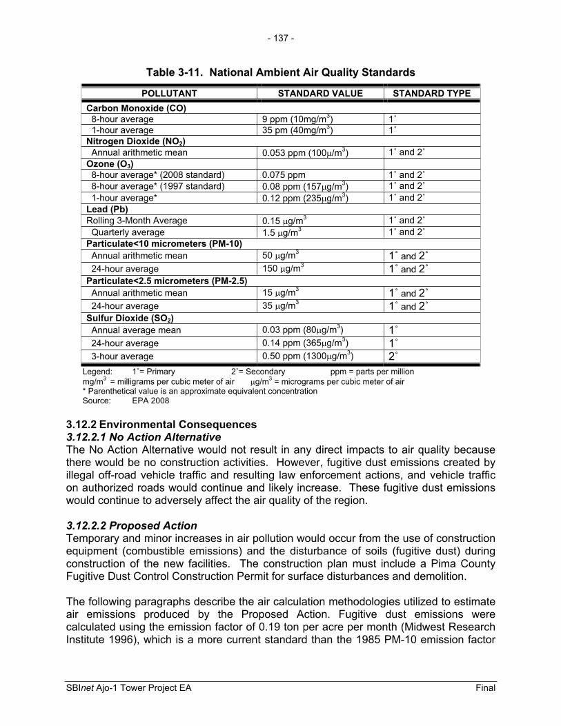
- 137 -
SBInet Ajo-1 Tower Project EA Final
Table 3-11. National Ambient Air Quality Standards
POLLUTANT STANDARD VALUE STANDARD TYPE Carbon Monoxide (CO) 8-hour average 9 ppm (10mg/m3) 1˚ 1-hour average 35 pm (40mg/m3) 1˚Nitrogen Dioxide (NO2) Annual arithmetic mean 0.053 ppm (100 /m3) 1˚ and 2˚Ozone (O3) 8-hour average* (2008 standard) 0.075 ppm 1˚ and 2˚ 8-hour average* (1997 standard) 0.08 ppm (157 g/m3) 1˚ and 2˚ 1-hour average* 0.12 ppm (235 g/m3) 1˚ and 2˚Lead (Pb)Rolling 3-Month Average 0.15 g/m3 1˚ and 2˚ Quarterly average 1.5 g/m3 1˚ and 2˚Particulate<10 micrometers (PM-10) Annual arithmetic mean 50 g/m3 1˚ and 2˚ 24-hour average 150 g/m3 1˚ and 2˚Particulate<2.5 micrometers (PM-2.5) Annual arithmetic mean 15 g/m3 1˚ and 2˚ 24-hour average 35 g/m3 1˚ and 2˚Sulfur Dioxide (SO2) Annual average mean 0.03 ppm (80 g/m3) 1˚ 24-hour average 0.14 ppm (365 g/m3) 1˚ 3-hour average 0.50 ppm (1300 g/m3) 2˚
Legend: 1˚= Primary 2˚= Secondary ppm = parts per million mg/m3 = milligrams per cubic meter of air g/m3 = micrograms per cubic meter of air * Parenthetical value is an approximate equivalent concentration Source: EPA 2008
3.12.2 Environmental Consequences 3.12.2.1 No Action Alternative The No Action Alternative would not result in any direct impacts to air quality because there would be no construction activities. However, fugitive dust emissions created by illegal off-road vehicle traffic and resulting law enforcement actions, and vehicle traffic on authorized roads would continue and likely increase. These fugitive dust emissions would continue to adversely affect the air quality of the region.
3.12.2.2 Proposed Action Temporary and minor increases in air pollution would occur from the use of construction equipment (combustible emissions) and the disturbance of soils (fugitive dust) during construction of the new facilities. The construction plan must include a Pima County Fugitive Dust Control Construction Permit for surface disturbances and demolition.
The following paragraphs describe the air calculation methodologies utilized to estimate air emissions produced by the Proposed Action. Fugitive dust emissions were calculated using the emission factor of 0.19 ton per acre per month (Midwest Research Institute 1996), which is a more current standard than the 1985 PM-10 emission factor

- 138 -
SBInet Ajo-1 Tower Project EA Final
of 1.2 tons per acre-month presented in AP- 42 Section 13 Miscellaneous Sources 13.2.3.3 (EPA 2001).
EPA’s NONROAD Model (EPA 2005a) was used, as recommended by EPA’s Procedures Document for National Emission Inventory, Criteria Air Pollutants, 1985-1999 (EPA 2001), to calculate emissions from construction equipment. Combustible emission calculations were made for standard construction equipment, such as front-end loaders, backhoes, bulldozers, and cement trucks. Assumptions were made regarding the total number of days each piece of equipment would be used, and the number of hours per day each type of equipment would be used (Appendix I).
Construction workers would temporarily increase the combustible emissions in the airshed during their commute to and from the project area. Emissions from delivery trucks would also contribute to the overall air emission budget. The emissions from these two sources were calculated using the EPA MOBILE6.2 Model (EPA 2005b, 2005c and 2005d).
The total air quality emissions were calculated for the proposed construction activities occurring in Pima County to compare to the General Conformity Rule de minimis threshold of 100 tons per year. The de minimis threshold (100 tons per year) is the point at which air emissions are significant; if air emissions exceed that 100-ton threshold, they are considered a “major” impact. Summaries of the total emissions for the Proposed Action are presented in Table 3-12. Details of the analyses are presented in Appendix I.
Table 3-12. Total Air Emissions (tons/year) from Construction Activitiesvs. de minimis Levels
Pollutant Total(tons/year)
de minimis Thresholds (tons/year)1
Carbon Monoxide 13.60 100 Volatile Organic Compounds 2.39 100 Nitrogen Oxides 17.38 100 Particulate Matter <10 microns 19.79 100 Particulate Matter <2.5 microns 3.19 100 Sulfur Dioxide 2.12 100 Source: EPA 2008, 40 CFR 51.853, and GSRC modeled air emissions (Appendix I). 1 Pima County is in moderate non-attainment for PM-10.
Several sources of air pollutants contribute to the overall air impacts of the construction project. The air emission calculations included emissions from:
1. Combustible engines of construction equipment 2. Construction workers commute to and from work site 3. Supply trucks delivering materials to construction site 4. Fugitive dust from job site ground disturbances 5. Bi-monthly commute to towers site for maintenance

- 139 -
SBInet Ajo-1 Tower Project EA Final
As can be seen from the tables above, the proposed construction activities do not exceed de minimis threshold for PM-10 in Pima County and, thus, do not require a Conformity Determination. As there are no violations of air quality standards and no conflicts with the state implementation plans, impacts to air quality would not be consider major in the context of the General Conformity Rule.
During the construction of the proposed project, proper and routine maintenance of all vehicles and other construction equipment would be implemented to ensure that emissions are within the design standards of all construction equipment. Dust suppression methods would be implemented to minimize fugitive dust. In particular, wetting solutions would be applied to construction area to minimize the emissions of fugitive dust. By using these BMPs, air emissions from proposed construction activities would be temporary and minor.
Ongoing Air EmissionsOngoing air emissions refer to air emissions that may occur after the towers have been installed, such as maintenance vehicle trips to the tower site up to twice a month to check and repair equipment, and routine patrols by CBP agents. However, air emissions associated with routine patrols are unquantifiable as the area patrolled changes in response to illegal traffic. In addition, six of the towers would not be connected to the existing electric grid. These towers would be partially powered by solar and backed up by propone fueled generators. Therefore, emissions were calculated for six propane generators operating 8 hours per day 365 days per year. The air emissions from propane generators and bi-monthly maintenance visits are presented in Appendix I and are summarized in Table 3-13 below.
Table 3-13. Total Air Emissions (tons/year) from Propane Generators andBi-Monthly Maintenance Visits vs. de minimis Levels
Pollutant Total(tons/year)
de minimis Thresholds (tons/year)(1)
Carbon Monoxide 30.54 100 Volatile Organic Compounds 2.54 100 Nitrogen Oxides 6.20 100 Particulate Matter <10 microns 0.03 100 Particulate Matter <2.5 microns 0.03 100 Sulfur Dioxide 0.01 100
Source: EPA 2008, 40 CFR 51.853, and GSRC modeled air emissions (Appendix I). 1. Pima County is in moderate non-attainment for PM-10.
As can be seen from the tables above, the proposed construction and operational activities do not exceed Federal de minimis thresholds even when they are combined; thus, do not require a Conformity Determination. As there are no violations of air quality standards and no conflicts with the state implementation plans, the impacts on air quality in Pima County from the implementation of the Proposed Action would be minor.
- 140 -
SBInet Ajo-1 Tower Project EA Final
3.13 NOISE
Noise is often described as unwanted sound. Sound is usually represented on a logarithmic scale with a unit called the decibel (dB). Sound on the decibel scale is referred to as sound level. The A-weighted decibel scale (dBA) takes this into account and emphasizes the frequencies and is a measure of noise at a given, maximum level or constant state level. The threshold of perception of the human ear is approximately 3 dBA, which is considered barely perceptible, and a 5 dBA change is considered to be clearly noticeable. A 10 dBA increase in the measured sound level is typically perceived as being twice as loud.
3.13.1 Affected Environment The tower sites and access roads are located across a wide geographical range which includes designated wilderness areas. Anthropogenic noises can degrade the natural soundscape and adversely affect humans and wildlife. Natural soundscapes are composed completely of natural sounds without the presence of human-made sounds. The project area is located on lands where noise can adversely affect natural soundscapes. The natural ambient back-ground noise levels on OPCNM were measured and averaged 20 dBA over a 20-day period (NPS 2009b).
With the exception of TCA-AJO-301, all the tower sites and access roads are located on or near OPCNM and CPNWR lands which are undeveloped lands used primarily for the protection of the Sonoran Desert Ecosystem, and recreational and educational purposes. Proposed tower sites TCA-AJO-004 and 216 are located on BLM lands adjacent to wilderness areas; however, approach roads to TCA-AJO-004 are located on OPCNM and BLM lands. Proposed tower site TCA-AJO-310 is located on ASTL property adjacent to Organ Pipe Cactus Wilderness, with approach roads on OPCNM lands within an area that is considered potential wilderness. Proposed tower TCA-AJO-189 is located on CPNWR, within designated wilderness.
Wilderness AreasTwo important noise emission thresholds are considered in this noise analysis of wilderness. First, noise emission criteria for construction activities has been published by the Federal Highway Administration which has established a construction noise abatement criteria of 57 dBA for lands, such as National Parks, in which serenity and quiet are of extraordinary significance (23 CFR 722, Table 1). The 57 dBA criteria threshold is used to measure the impacts from short-term noise emissions associated with constructing the proposed towers and access roads.
Secondly, CBP is committed to minimizing long-term noise impacts on wilderness and the Sonoran pronghorn. CBP, CPNWR, OPCNM and USFWS-AESO managers have agreed that a noise emission of 35 dBA is the threshold where there should be no adverse effect to the Sonoran pronghorn. Therefore, CBP used the 35 dBA threshold to measure impacts from long-term operational noise emissions from long-term point sources of noise such as power generators.

- 141 -
SBInet Ajo-1 Tower Project EA Final
Residential AreasProposed tower TCA-AJO-301 is located at the POE in Lukeville, Arizona where residential sensitive noise receptors are located within 300 feet of the proposed tower site. When noise affects humans, it can be based either on objective effects (i.e., hearing loss, damage to structures, etc.) or subjective judgments (e.g., community annoyance). However, operations at the Lukeville POE generate noise emissions that currently affect adjacent residents. A 65 dBA day-night level (DNL) is the impact threshold most commonly used for noise planning purposes near residents, and represents a compromise between community impact and the need for activities like construction (U.S. Department of Housing and Urban Development [HUD] 1984).
3.13.2 Environmental Consequences 3.13.2.1 No Action Alternative Under the No Action Alternative, the sensitive noise receptors and wildlife near the proposed tower sites and associated roads would not experience construction and tower operational noise events. Noise emissions associated with CBV off-road travel and consequent law enforcement actions would be long-term and minor, and would continue under the No Action Alternative.
3.13.2.2 Proposed Action The following analysis segregates noise emissions into two categories: short-term noise emissions which include emissions from construction equipment used to build and install the towers and roads and, in the case of TCA-AJO-189 and 204, helicopter transportation to the construction job site. Secondly, long-term noise emissions which refer to ongoing noise emissions that would occur after the towers have been installed and access roads have been built and improved. The noise analysis modeled noise contours for a variety of sources and summarized the area of impact in acres for short-term noise emissions and long-term noise emissions.
Short-term Tower Construction NoiseIt was assumed all 10 of the towers (RDTs and SSTs) would require the use of general construction equipment, which produces noise emission up to 81 dBA, for 40 days (RDTs) and 57 days (SSTs). The latter does not include the 28 days required for concrete to cure, during which time there would be little or no additional construction at the site. Two of the towers are RATs, which require up to 26 days to install. Assuming the worst case scenario of 81 dBA from general construction equipment, the noise model predicts that noise emissions would have to travel 738 feet before they would be attenuated to acceptable levels equal to or below 57 dBA, which is the criterion for National Monument and Wildlife Refuges (23 CFR 722, Table 1). The 57 dBA construction noise contour would encompass 39 acres for each tower and a total of 353 acres for the nine tower sites located near or within wilderness areas.
Drill rigs, which produce noise emissions at 97 dBA, would be required for tower construction at two sites. Thus, a greater distance (5,002 feet) would be required to attenuate the noise to the 57 dBA level. Approximately, 3,607 acres of OPCNM land would be subjected to noise emissions for 2 days while the drill rig is used to install the
- 142 -
SBInet Ajo-1 Tower Project EA Final
two SST towers (i.e., 1,803 acres affected per site). Figure 3-6 presents the 57 dBA noise contour for the drill rigs and general construction noise emissions at a typical tower site. Noise emissions associated with tower construction would have a temporary, minor adverse effect on the noise environment.
Road Construction Noise Impacts on OPCNMRoad construction equipment would produce noise emissions up to 81 dBA. Assuming a worst case scenario of 81 dBA, the noise model predicts that noise emissions of 81 dBA from construction equipment would have to travel 738 feet before they would attenuate to acceptable levels equal to or below 57 dBA. All road construction included, the noise contour would encompass 2,568 acres. Wilderness lands would be directly exposed to short-term noise emissions for approximately 5 to 22 days, depending on the length of time to build or improve a road in a specific area. Noise emissions would have a temporary, minor adverse effect on the soundscape.
Helicopter Noise EmissionsConstruction of proposed towers TCA-AJO-204 and 189 would require the use of a helicopter. A helicopter would not be required to transport construction workers to TCA-AJO-204; however, TCA-AJO-189 would require helicopter lifts for both materials and personnel. Therefore, CBP estimates that construction of proposed tower sites TCA-AJO-189 and 204 would require up to 22 total lifts for equipment and materials per tower and approximately 63 total lifts for personnel during build cycle at proposed tower site TCA-AJO-189. Thus, a total of approximately 85 lifts would be required to construct proposed tower site TCA-AJO-189 and approximately 22 lifts would be required to construct proposed tower site TCA-AJO-204. A helicopter lift sequence for proposed tower site TCA-AJO-189 was provided previously in Table 2-3.
A Kaman K-MAX cargo helicopter, which has the lowest noise signature in its class, would be used to transport materials to construct the tower. According to the manufacturer’s data, the K-MAX helicopter produces noise emissions of 82 dBA at a distance of 300 feet. The noise model predicted that noise emissions of 82 dBA would have to travel 3,838 feet before they would attenuate to acceptable levels of 57 dBA. All total, the 57 dBA noise contour produced by helicopter noise would encompass approximately 2,124 acres of land. Effects from helicopter noise emissions would be localized and would be considered a temporary, moderate adverse effect on designated wilderness. Table 3-14 summarizes noise emissions from short-term sources used during the construction of the towers and access roads.

GF
738 Ft3,838 Ft
5,002 Ft
Figure 3-6: Short-term Construction Noise Contours for Tower Sites (57dBA)
December 2009
0 290 580 870 1,160Meters
0 1,400 2,800 4,200Feet
·1:24,000
GF Proposed Tower Location
GF
Tower Location
Tower Location
738 Ft General Construction
3,838 Ft Helicopter
5,002 Ft Drill Rig SST Foundation
- 143 -

- 144 -
SBInet Ajo-1 Tower Project EA Final
Table 3-14. Noise contour (57 dBA) from short-term noise sources
Noise Source Emissionlevel (dBA)
Area Included in the 57 dBA Noise Contour
(acres)Duration of Noise
Source
General Construction Equipment-Towers 81 353 40-57 days per tower
Drill Rigs-towers 97 3,607 2 days per tower General Construction Equipment-Roads 81 2,568 5-22 days per site
Helicopter Transportation-Towers 82 2,124
22 Lifts at TCA-AJO-204 85 Lifts at TCA-AJO-189 1 hour per lift
Noise Impacts to Residential ReceptorsProposed Tower TCA-AJO-301 is 120 feet from closest residential noise receptor. Construction activities have the potential to expose residential receptors to noise emissions that are above 65 dBA which are normally unacceptable (HUD 1984). To minimize this impact, construction activities should be limited to daylight hours during the work week when most of the residents are at school or at work. The construction activities from the Proposed Action would have a temporary, minor adverse effect on sensitive noise receptors adjacent to the project sites if the construction activities are limited to 7:30 AM to 5:30 PM on Monday through Friday.
Long-Term Noise Emission from Tower OperationsOngoing tower operations refer to noise emissions that would occur after the towers have been installed and access roads have been improved. CBP is committed to minimizing noise impacts to a 35 dBA at 492 feet threshold, to avoid an adverse impact on the Sonoran pronghorn. Noise emissions from the propane generator were measured in the field by CBP and NPS personnel and were found to be 59 dBA at 49 feet from the enclosure under standard test conditions (NPS 2009b). CBP would incorporate additional noise abatement controls on the generator. These generator noise controls would restrict the 35 dBA noise contour to a maximum of 492 feet from the source.
Generators and air conditioner units at towers sites would produce intermittent noise emissions over an extended period of time. Four of the proposed tower sites would be connected to commercial grid power with a backup power propane generator that would run 1 hour twice a month. The remaining six towers sites are remote and not connected to the electric grid and would be powered by a hybrid propane generator/solar system. The propane generator would be expected to operate 4 to 8 hours a day. Noise emissions from the propane generator produce the dominant noise signature at these tower sites.
The FOB near tower TCA-AJO-302 would serve as a remote USBP agent support facility. Three generators would be located at the FOB site. One of the generators would be used to power the FOB and another two used as a backup; only one generator would be operating at any one time.

- 145 -
SBInet Ajo-1 Tower Project EA Final
The assumptions for noise impacts from propane generators are based on use of a noise abatement control device. Figure 3-7 presents a map of the propane generator noise contour for a typical proposed tower site. Within a radius of 492 feet from the enclosed generator set, approximately 17.4 acres of land per tower site would be exposed to noise emissions greater than 35 dBA. Therefore, collectively for the six towers off the commercial electric grid, approximately 105 acres of land would be exposed to noise emissions greater than 35 dBA on a daily basis. For the towers that would be connected to the electrical grid, approximately 70 acres would be exposed to noise emissions greater than 35 dBA for two hours a month.
These acres would be affected by noise emissions and could potentially affect the activity of Sonoran pronghorn. Noise emissions associated with tower operations would have a long-term, moderate adverse affect on the soundscape. Potential effects would be localized to the proposed tower sites.
Four helicopter trips would be required annually to repair and maintain proposed tower TCA-AJO-189. Since TCA-AJO-240 can be accessed by foot, it is estimated that this tower would require one helicopter trip a year, in case heavy equipment or replacement parts are necessary at the site and they are too heavy to carry by hand.
When the helicopter is hovering above the TCA-AJO-189 and 204 tower site the noise contour would encompass approximately 16,409 acres of land which would be exposed to noise emissions greater than 35 dBA. The long-term operation of TCA-AJO-189 and 204 would produce periodic temporary direct noise impacts to 32,818 acres of CPNWR. Helicopter noise emissions produced as a result of implementing the Proposed Action would have a temporary, moderate adverse affect on wilderness land. Table 3-15 presents the estimated area of noise impacts.
Table 3-15. Noise Contour (35 dBA) from Long-term Noise Sources
Noise Source Emission level (dBA)
Area Included in the 35 dBA Noise
Contour(acres)
Duration of Noise Source
Propane Generators at Towers-Off Grid (six) 59 105 4 to 8 hours per day
Propane Generators at Towers-On Grid (four) 59 70 2 hours per month
FOB 59 17.4 12 hours per day Helicopter Transportation-TCA-AJO-204 82 16,409 1 lift per year
1 hour per lift Helicopter Transportation-TCA-AJO-189 82 16,409 4 lifts per year
1 hour per lift
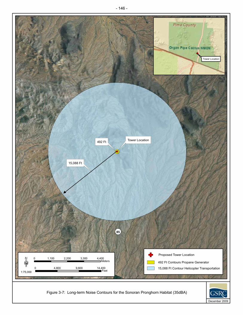
GF
¬«85
Tower Location492 Ft
15,088 Ft
Figure 3-7: Long-term Noise Contours for the Sonoran Pronghorn Habitat (35dBA)
December 2009
0 1,100 2,200 3,300 4,400Meters
0 4,800 9,600 14,400Feet
·1:75,000
GF Proposed Tower Location
GF
Tower Location
492 Ft Contours Propane Generator
15,088 Ft Contour Helicopter Transportation
- 146 -

- 147 -
SBInet Ajo-1 Tower Project EA Final
3.14 RADIO FREQUENCY ENVIRONMENT
3.14.1 Affected Environment The Radio Frequency (RF) environment refers to the presence of electromagnetic (EM) radiation emitted by radio waves and microwaves on the human and biological environment. EM radiations are self propagating waves of electric and magnetic energy that move through space via radio waves and microwaves emitted by transmitting antennas. RF is a frequency or rate of oscillation within the range of about 3 Hertz (Hz) and 300 GHz. This range corresponds to frequency of alternating current and electrical signals used to produce and detect radio waves. The EM radiation produced by radio waves and microwaves carry energy and momentum and can interact with matter. It is currently anticipated that the transmitters and sensors associated with the SBInetOPCNM project would operate below 30 GHz.
The Federal Communications Commission (FCC) is responsible for licensing frequencies and ensuring that the approved uses would not interfere with television or radio broadcasts or substantially affect the natural or human environment. The FCC adopted recognized safety guidelines for evaluating RF exposure in the mid 1980s (Office of Engineering and Technology [OET] 1999). Specifically, in 1985, the FCC adopted the 1982 American National Standards Institute (ANSI) guidelines to evaluate exposure due to RF transmitters that are licensed and authorized by the FCC (OET 1999). In 1992, ANSI adopted the 1991 Institute of Electrical and Electronics Engineers (IEEE) standard as an American National Standard (a revision of its 1982 standard) and designated it as ANSI/IEEE C95.1-1992 (OET 1999). The FCC proposed to update its rules and adopt the new ANSI/IEEE guidelines in 1993, and in 1996, the FCC adopted a modified version of the original proposal.
In addition to ANSI/IEEE standards, the FCC’s guidelines are also based on the National Council of Radiation Protection and Measurements (NCRP) exposure guidelines. The NRCP and ANSI/IEEE exposure criteria identify the same threshold levels at which harmful biological effects may occur. The whole body human absorption of RF energy varies with the frequency of the RF signal. The most restrictive limits on exposure are in the frequency range of 30 to 300 Mega-Hz (MHz) where the human body absorbs RF energy most efficiently when exposed in the air field of an RF transmitting source (ANSI/IEEE C95.1-1992).
There are two tiers or exposure limits; occupational or “controlled” and general or “uncontrolled”. Operational exposure is when people are exposed to RF fields as a part of their employment and they have been made fully aware of the potential exposure and can exercise control over their exposure. Uncontrolled exposure is when the general public is exposed or when persons employed are not made fully aware of the potential for exposure or cannot exercise control over their exposure.
In order for a transmitting facility or operation to be out of compliance with the FCC’s RF guidelines in an area where levels exceed Maximum Permissible Exposure (MPE) limits, it must first be accessible to the public. The MPE limits indicate levels above
- 148 -
SBInet Ajo-1 Tower Project EA Final
which people may not be safely exposed regardless of the location where those levels occur.
Adverse biological effects associated with RF energy are typically related to the heating of tissue by RF energy. This is typically referred to as a "thermal" effect, where the EM radiation emitted by an RF antenna, passes through and rapidly heats biological tissue, similar to the way a microwave oven cooks food. The Health Physics Society indicates that numerous studies have shown that environmental levels of RF energy routinely encountered by the general public are typically far below levels necessary to produce significant heating and increased body temperature and is generally only associated with workplace environments near high-powered RF sources used for molding plastics or processing food products. In such cases, exposure of human beings to RF energy could be exceeded, thus, requiring restrictive measures or actions to ensure their safety (Kelly 2007).
There is also some concern that signals from some RF devices could interfere with pacemakers or other implanted medical devices. However, it has never been demonstrated that signals from a microwave oven are strong enough to cause such interference (OET 1999). Furthermore, electromagnetic shielding has been incorporated into the design of modern pacemakers to prevent RF signals from interfering with the electronic circuitry in the pacemaker (OET 1999).
Other non-thermal adverse effects such as disorientation of passing birds by RF waves are also of concern. Past studies on effects of communication towers were noted by Beason (1999) during the 1999 Workshop on Avian Mortality at Communication Towers (Evans and Manville 2000). During this workshop, Beason (1999) noted that most research on RF signals produced by communication towers have no general disorientation effects on migratory birds. However, more research is needed to better understand the effects of RF energy on the avian brain. Currently, CBP, USFWS, NPS, U.S. Air Force, U.S. Marines, BLM, and local law enforcement agencies use two-way radios as part of their daily operations in the project area. Further, several of these agencies operate and maintain radio repeaters with the project area.
3.14.2 Environmental Consequences 3.14.2.1 No Action Alternative Under the No Action Alternative, the proposed tower sites would not be installed or operated. Daily radio operations by CBP, USFWS, NPS, local law enforcement, and the military would continue within the project area. There would be no impacts to existing RF environment or effect to the human or natural environment.
3.14.2.2 Proposed Action With the implementation of the Proposed Action, the 10 towers equipped with radio wave and microwave communication systems, as well as radar systems, would be installed for use by CBP border security activities. As with any RF transmitter, all of these systems would emit RF energy and EM radiation; therefore, a potential for

- 149 -
SBInet Ajo-1 Tower Project EA Final
adverse effects could occur. However, any adverse effects to human safety and wildlife would likely be negligible due to the minimal exposure limits associated with both the type of equipment used and the elevated locations in which they would be positioned on the towers. The tower sites would also be fenced for security, making human and terrestrial wildlife exposure to RF emitting equipment even less likely.
The potential to exceed MPE limits of RF energy such as those described by Kelly (2007) are far outside the capability limits of data and communications systems in the Proposed Action. Furthermore, communication and radar systems on the proposed towers would be installed a minimum of 20 feet off the ground and would exceed the minimum safe operating distance for these systems (i.e., 17 feet). Thus, maintenance and operational personnel working within the secure tower site would not be exposed to any RF energy that exceeds MPE limits set by the FCC.
Though greater research is required to have a better understanding of the effects of RF energy on the avian brain, the potential effects on passing birds is expected to be negligible as well. Any disorientating effect, if experienced, would be temporary and would occur only at close distances to the antennas.
As part of the overall spectrum management process, the National Telecommunications and Information Administration (NTIA) and the FCC have developed radio regulations to help ensure that the various radio services operate compatibly in the same environment without unacceptable levels of radio frequency interference and emissions. While the communication systems and the frequencies in which they would be operated are considered law enforcement sensitive and cannot be provided to the public, compliance with FCC and NTIA regulations would be required, and would ensure that recognized safety guidelines are not exceeded. All frequencies used by CBP would be coordinated through the FCC and NTIA as required by NTIA regulations. Additionally, transmitters and sensors associated with the SBInet OPCNM project would operate below 30 GHz. Therefore, the RF environment created by the installation, operation and maintenance of the communication and radar systems on the proposed towers would have a long-term, negligible adverse impact on observatories, human safety or the natural environment.
3.15 UTILITIES AND INFRASTRUCTURE
3.15.1 Affected Environment 3.15.1.1 Utility Commercial Grid Power Several commercial utility power companies service the Arizona cities and counties in southwestern Arizona and are shown in Table 3-16.

- 150 -
SBInet Ajo-1 Tower Project EA Final
Table 3-16. Power Company Service Areas
City and or County Power Company City of Ajo Arizona Public Service Company (APS) and Ajo Improvement Company Pima County Tucson Electric Power and San Carlos Irrigation Source: All Business Newsletter 2006 and Tucson Electric Power Company 2008
Currently, four of the proposed towers would potentially derive their power from the local power grid. Existing power line infrastructure is located near proposed tower site TCA-AJO-170, 204, 216, and 301. Powerlines would be extended from the service or secondary pole to each proposed tower site utilizing overhead lines. Within the proposed tower sites power lines would be installed underground. Although power line corridors have not been defined as of yet, coordination is currently underway with the local utility provider within the service area for these proposed four tower sites. It is assumed that new power lines would be installed adjacent to surveyed new or existing access and/or authorized roads. If it is necessary to deviate from access road locations, then new biological and archaeological surveys would be utilized to ensure NHPA Section 106 and environmental compliance.
The proposed towers that are not connected to commercial grid power would typically be powered by a propane fueled hybrid generator system which consists of a common generator system with supplemental photovoltaic capabilities consisting of 18 solar panels, an energy storage battery system, an inverter, and direct current power subsystems. Each proposed tower is not expected to utilize more than 3,650 kW-hours per month from commercial grid power and generator/solar hybrid systems.
For the four towers in which commercial power may be utilized, there may be instances when commercial power may not be available immediately upon tower deployment. If this should occur, the 35 kW hybrid propane generator/solar system would be utilized until commercial grid power is installed and functional.
3.15.1.2 Ambient and Artificial Lighting Ambient or atmospheric light is of concern to many including, most notably, astronomical observatories (International Dark Sky Association 2008). The reduction of man-made or artificial light sources is generally what astronomers would like to see in the southwest and there are light ordinances in place in some cities in the southwest to minimize sky brightness in large population centers. Tucson and Pima County first adopted outdoor lighting ordinances in 1972, to provide standards so that artificial (man-made) lighting did not interfere with nearby astronomical observatories and preserved the relationship of the residents of City of Tucson/Pima County to their unique desert environment through protection of access to the dark night sky (Pima County 2006). Within this ordinance is a mean lumens cap per net acre.
Additionally, when tower facility lighting is deemed necessary due to CBP operational needs, such as the installation of infrared lighting, USFWS (2000) Guidance on the Siting, Construction, Operation and Decommissioning of Communications Towers

- 151 -
SBInet Ajo-1 Tower Project EA Final
would be implemented to reduce night-time atmospheric lighting and the potential adverse effects of night-time lighting to migratory bird and nocturnal flying species, and astronomical observatories. Any infrared lighting installed on the proposed towers would be compatible with night vision goggle usage. If the tower sites are lighted for CBP security purposes then lighting would utilize low sodium bulbs, be shielded to avoid illumination outside the footprint of the tower site, and when possible, be activated by motion detectors.
Currently, it is not anticipated that nighttime construction would occur; however if nighttime construction becomes necessary, use of lights would be minimized.
3.15.2 Environmental Consequences 3.15.2.1 No Action Alternative Under the No Action Alternative, the proposed towers would not be installed and operated. There would be no impacts to local utilities because no additional power demands associated with the SBInet Ajo-1 Tower Project would occur. Ambient lighting conditions would continue to be problematic near large urban areas such as Tucson.
3.15.2.2 Proposed Action Under the Proposed Action, four of the proposed towers would utilize the local commercial power grid. CBP has coordinated extensively with Arizona Public Service (APS) and no adverse significant adverse effects to the local commercial power grid are anticipated. APS would be responsible for constructing commercial grid infrastructure and providing power to each of the tower site proposed for commercial grid power. The Proposed Action would have a long-term, negligible effect on utilities and infrastructure.
If the proposed tower sites are lighted for CBP security purposes, CBP would utilize low sodium bulbs, shield lights to avoid illumination outside the footprint of the tower site, and utilize motion detectors to activate lights when possible. Security lighting at the proposed tower sites would have a permanent, intermittent impact on approximately 0.66 acre (total) and would not be expected to have a major adverse impact on wildlife. Should nighttime construction occur, CBP would ensure that all construction lighting would be shielded to minimize ambient lighting issues and would follow Pima County lighting ordinances to the greatest extent possible. Based on these measures, negligible to minor long-term adverse impacts to the night sky and ambient lighting would occur as a result of the implementation of the Proposed Action.
3.16 ROADWAYS AND TRAFFIC
3.16.1 Affected Environment The proposed tower sites are located on OPCNM, BLM, and CPNWR lands in western Pima County. The project area is extremely remote and the only highway within the project area is SR 85, which extends from Interstate 10 near Buckeye south to the POE at Lukeville. It is a major transportation route for U.S. citizens traveling to Rocky Point, Sonora, Mexico and is the paved access to OPCNM. Rocky Point is a popular vacation area for Arizona residents.

- 152 -
SBInet Ajo-1 Tower Project EA Final
Many of the project sites are located in rural, undeveloped areas with recreation or wilderness as the main land uses for the region. Traffic flow is usually low on these roads because most vehicular movement in the region occurs on the interstates. The average annual daily traffic count for SR 85 from Puerto Blanco Road to the Lukeville POE is 1,500 vehicles (ADOT 2006).
3.16.2 Environmental Consequences 3.16.2.1 No Action Alternative Under the No Action Alternative, the proposed tower sites would not be used. Construction of access roads, towers, foundations, and associated buildings would not occur. There would be no impacts to local vehicular traffic because no construction equipment, materials or construction crews would be needed in the area.
3.16.2.2 Proposed Action With the implementation of the Proposed Action, construction and staging for the access roads, foundations, towers and associated equipment shelters would create a short-term, minor impact to roadways and traffic within the project region. The increase of vehicular traffic would occur to supply materials and work crews at each tower site for a short amount of time. Tower construction would require 26 to 80 days depending on tower type. The initial construction phase would include creation of a staging area for materials and equipment. Once a staging area is established, traffic near the construction site would be from the influx of construction workers and new materials. Staging areas would be set off the main roads and would not disrupt the flow of traffic.
Existing roads would mainly be utilized to access the tower sites and they would be maintained. A total of 1.2 miles of new roads would be constructed to access the proposed tower sites from existing roads. Because the public already has access to the existing approved roads, the creation of an additional 1.2 miles of roads would have a long-term, minor effect on the public’s access to designated wilderness. However, authorized road improvements would potentially increase recreation use on BLM lands.
Once construction work is completed, maintenance visits to each site would be required up to twice a month depending on tower type. Tower maintenance and refueling would require approximately 191 vehicle trips annually. These visits would have a long-term, negligible effect on traffic. However, the proposed project would decrease CBV and resulting required law enforcement traffic on public roads on OPCNM and to some extent CPNWR. Increased deterrence of CBVs resulting from the proposed project would reduce the enforcement footprint generally closer to the international border, thus reducing illegal traffic and moving USBP traffic closer to the border.
3.17 AESTHETIC AND VISUAL RESOURCES
3.17.1 Affected Environment Towers currently exist within the project area and are generally commercial, General Services Administration (GSA), or CBP communications towers. Roads within the

- 153 -
SBInet Ajo-1 Tower Project EA Final
OPCNM and other Federal lands may be maintained by these various entities depending upon land management strategies or plans.
All of the proposed tower sites except five (TCA-AJO-004, TCA-AJO-216, TCA-AJO-301, and 310) are located on OPCNM. However, access to proposed tower site TCA-AJO-004 is on BLM and OPCNM lands. Lands controlled by BLM are assigned visual resource inventory classes. BLM utilizes this inventory for a two-fold purpose. It serves as an inventory tool to portray the relative value of the visual resources and as a management tool that portrays the visual management objectives. Visual resources of the region are divided in four classes: Class I, II, III, and IV. Proposed tower sites TCA-AJO-004 and 216 are located on BLM land with a Visual Resource Management of Class IV. Class IV lands are managed in a way that allows the level of change to be high and major modifications of the existing landscape are allowed. BLM also subdivides landscapes into three distance zones based on relative visibility from observation points. The three zones are: foreground-middleground, background, and seldom-seen. The foreground-middleground zone includes areas seen from highways, rivers, or other viewing locations which are less than 3 to 5 miles away and where management activities might be viewed in detail. This zone is more visible to the public and changes are more noticeable. The background zone includes areas beyond the foreground-middleground zone but usually less than 15 miles away. This does not include areas in the background which are so far distant that the only thing discernible is the form or outline. Areas that are not visible within the foreground-middleground zone or background zone are in the seldom-seen zone (BLM 2009)
There is no development adjacent to the project area, except near the towns of Lukeville and Why and the OPCNM administrative facilities. Aesthetic resources vary throughout the project corridor, which includes vast open areas of arid desert land, lava flows, and areas of unique native vegetation. Areas within the project area visited for their natural setting and aesthetic values include OPCNM and CPNWR and their associated wilderness.
3.17.2 Environmental Consequences 3.17.2.1 No Action Alternative Under the No Action Alternative, the aesthetics of the project region would not be directly affected by installation of towers. However, trash, illegal roads, graffiti, and general vandalism resulting from IA traffic would be expected to continue to detract from the visual quality of area. The No Action Alternative would be expected to have minor, permanent impact on aesthetics in the project area. It has been estimated that each IA leaves an average 8 pounds of trash on U.S. soil per entry (Davis 2005).
3.17.2.2 Proposed Action The proposed towers and FOB on OPCNM would be located primarily within undeveloped areas, the majority of which is located adjacent to designated wilderness. The proposed towers and associated infrastructure would be an unnatural element in an undeveloped area visited for its natural setting and visual qualities and would be expected to detract from the visual qualities of the project area. A viewshed analysis

- 154 -
SBInet Ajo-1 Tower Project EA Final
was conducted for each proposed tower site and depending on the location and elevation of a viewer it is possible that up to five towers could be visible from one site in the western portion of the OPCNM and possibly two towers, TCA-AJO-189 and 302, could be visible at one time in the eastern portion of CPNWR. Viewshed analysis maps for each tower are provided in Appendix E. However, no towers would be visible from portions of the Cipriano Hills, Bates Mountains, and the southwest corner of OPCNM. The Proposed Action would have a long-term, moderate impact on aesthetic qualities within 15 miles or less of the proposed towers and FOB because the impact would be readily apparent. The impacts on the region’s aesthetic quality from the towers would be negligible beyond an observation point of 15 miles because the towers would be within the seldom-seen zone and would not be visibly apparent.
The Proposed Action would have a long-term indirect benefit to the visual quality of the landscape through the reduction or elimination of newly created illegal roads and trails. Implementation of the proposed SBInet Ajo-1 Tower Project would enhance USBP’s ability to detect CBV and enhance the efficiency of interdiction, thus deterring illegal traffic and reducing the enforcement footprint. Based on similar technology operations in Yuma Sector and the Altar Valley in the Tucson Sector a reduction in illegal traffic could be realized within 1 year of the proposed towers becoming operational and accepted by USBP. In the Altar Valley the enforcement footprint was reduced by 35 to 45 miles north of the international border as a result of the technology enhanced operations. A reduction in the enforcement footprint would reduce damage to natural resources that result from CVB activity and consequent law enforcement activities. Additionally, The Proposed Action would reduce the number of illegal roads and trails being created and decrease the amount of human waste and trash deposited on both OPCNM and to some extent on CPNWR. Reducing damage to natural resources, illegal roads and trails, trash associated with illegal cross border activities would enhance the visual quality of the landscape throughout OPCNM and to some extent on CPNWR.
3.18 HAZARDOUS MATERIALS
3.18.1 Affected Environment Solid and hazardous wastes are regulated in Arizona by a combination of laws promulgated by the Federal, state and regional Councils of Government. All proposed tower sites had a search conducted on the EPA’s Comprehensive Environmental Response, Compensation, and Liability Information System (CERCLIS). CERCLIS contains information on hazardous waste sites, potential hazardous waste sites, and remedial activities, including sites that are on the National Priorities List (NPL) or being considered for the NPL. The search found no active NPL sites within a 1-mile radius of any of the proposed tower sites located in Pima County, Arizona. Additionally, during the March, April, and June 2009 biological surveys conducted by GSRC, no evidence of hazardous waste or materials (e.g., drums, soil staining) were observed at the tower sites.

- 155 -
SBInet Ajo-1 Tower Project EA Final
GSRC contracted Environmental Data Resources, Inc. (EDR) to produce radius reports which examine Federal and state environmental databases that track activities associated with hazardous waste and incidents that have resulted in major environmental impairment. These databases are prepared and maintained by various Federal and state environmental agencies, such as the EPA and the ADEQ.
Only one proposed tower site, TCA-AJO-301, had a report of any potentially hazardous materials within a 1-mile radius of the tower site. The Chevron gas station (i.e., Gringo Pass) in Lukeville maintains above ground storage tanks for gasoline and diesel fuel. There were no reported spills or violations on record for the Chevron gas station (EDR 2009).
3.18.2 Environmental Consequences 3.17.2.1 No Action Alternative The No Action Alternative would not contribute any hazardous waste or materials to the project area, as no construction of towers or access roads would take place.
3.18.2.2 Proposed Action Construction Activities During construction of the proposed towers, access roads, and FOB a potential exists for petroleum, oil, and lubricants (POL) contamination at the construction site due to storage of POL material for maintenance and refueling of vehicles and fuel storage tanks. However, these activities would include primary and secondary containment measures. Clean-up materials (e.g., oil mops) would be maintained at each site for appropriate spill response and cleanup in case an accidental spill occurs. Drip pans would be provided for the power generators and other stationary equipment to capture any POL that is accidentally spilled during maintenance activities or leaks from equipment. To ensure oil pollution prevention, the construction contractor would have a SPCCP in place prior to the start of construction activities as outlined in Section 5.0.
Portable sanitary facilities would be provided during construction activities and waste products would be collected and disposed of by licensed contractors. Disposal contractors would use only established roads to transport equipment and supplies, and all waste would be disposed of in compliance with Federal, state, and local regulations, and in accordance with contractors’ permits. The Proposed Action would have a temporary, minor impact to the environment as a result of hazardous materials.
Maintenance and Operations Activities All solid and hazardous wastes and materials, including universal waste (such as batteries, motor oil, fluorescent light bulbs, etc.), would be handled in accordance with applicable Federal and state laws and guidelines governing these items. Additionally, hazardous material handling guidelines would be included as part of the maintenance plan for the SBInet Ajo-1 Tower Project (Boeing 2009). These guidelines would include spill prevention and spill response measures.
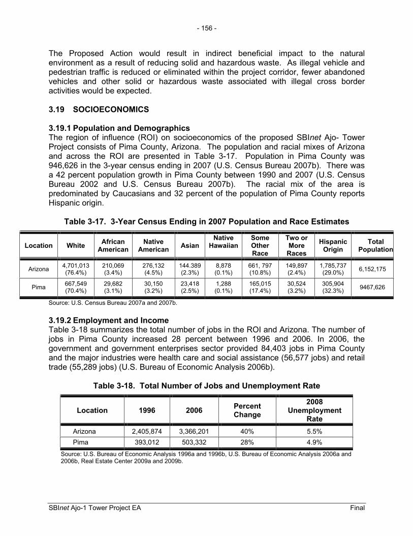
- 156 -
SBInet Ajo-1 Tower Project EA Final
The Proposed Action would result in indirect beneficial impact to the natural environment as a result of reducing solid and hazardous waste. As illegal vehicle and pedestrian traffic is reduced or eliminated within the project corridor, fewer abandoned vehicles and other solid or hazardous waste associated with illegal cross border activities would be expected.
3.19 SOCIOECONOMICS
3.19.1 Population and Demographics The region of influence (ROI) on socioeconomics of the proposed SBInet Ajo- Tower Project consists of Pima County, Arizona. The population and racial mixes of Arizona and across the ROI are presented in Table 3-17. Population in Pima County was 946,626 in the 3-year census ending in 2007 (U.S. Census Bureau 2007b). There was a 42 percent population growth in Pima County between 1990 and 2007 (U.S. Census Bureau 2002 and U.S. Census Bureau 2007b). The racial mix of the area is predominated by Caucasians and 32 percent of the population of Pima County reports Hispanic origin.
Table 3-17. 3-Year Census Ending in 2007 Population and Race Estimates
Location White African American
Native American Asian
Native Hawaiian
SomeOther Race
Two or MoreRaces
HispanicOrigin
TotalPopulation
Arizona 4,701,013 (76.4%)
210,069 (3.4%)
276,132 (4.5%)
144.389 (2.3%)
8,878 (0.1%)
661, 797 (10.8%)
149,897 (2.4%)
1,785,737 (29.0%) 6,152,175
Pima 667,549 (70.4%)
29,682 (3.1%)
30,150 (3.2%)
23,418 (2.5%)
1,288 (0.1%)
165,015 (17.4%)
30,524 (3.2%)
305,904 (32.3%) 9467,626
Source: U.S. Census Bureau 2007a and 2007b.
3.19.2 Employment and Income Table 3-18 summarizes the total number of jobs in the ROI and Arizona. The number of jobs in Pima County increased 28 percent between 1996 and 2006. In 2006, the government and government enterprises sector provided 84,403 jobs in Pima County and the major industries were health care and social assistance (56,577 jobs) and retail trade (55,289 jobs) (U.S. Bureau of Economic Analysis 2006b).
Table 3-18. Total Number of Jobs and Unemployment Rate
Location 1996 2006 PercentChange
2008Unemployment
RateArizona 2,405,874 3,366,201 40% 5.5% Pima 393,012 503,332 28% 4.9%
Source: U.S. Bureau of Economic Analysis 1996a and 1996b, U.S. Bureau of Economic Analysis 2006a and 2006b, Real Estate Center 2009a and 2009b.
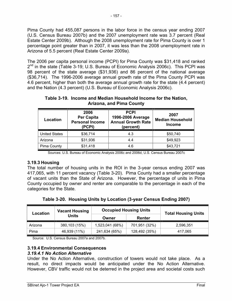
- 157 -
SBInet Ajo-1 Tower Project EA Final
Pima County had 455,087 persons in the labor force in the census year ending 2007 (U.S. Census Bureau 2007b) and the 2007 unemployment rate was 3.7 percent (Real Estate Center 2009b). Although the 2008 unemployment rate for Pima County is over 1 percentage point greater than in 2007, it was less than the 2008 unemployment rate in Arizona of 5.5 percent (Real Estate Center 2009a).
The 2006 per capita personal income (PCPI) for Pima County was $31,418 and ranked 2nd in the state (Table 3-19; U.S. Bureau of Economic Analysis 2006c). This PCPI was 98 percent of the state average ($31,936) and 86 percent of the national average ($36,714). The 1996-2006 average annual growth rate of the Pima County PCPI was 4.6 percent, higher than both the average annual growth rate for the state (4.4 percent) and the Nation (4.3 percent) (U.S. Bureau of Economic Analysis 2006c).
Table 3-19. Income and Median Household Income for the Nation, Arizona, and Pima County
Location2006
Per Capita Personal Income
(PCPI)
PCPI 1996-2006 Average
Annual Growth Rate (percent)
2007Median Household
Income
United States $36,714 4.3 $50,740 Arizona $31,936 4.4 $49,923 Pima County $31,418 4.6 $43,721
Sources: U.S. Bureau of Economic Analysis 2006c and 2006d, U.S. Census Bureau 2007c
3.19.3 Housing The total number of housing units in the ROI in the 3-year census ending 2007 was 417,065, with 11 percent vacancy (Table 3-20). Pima County had a smaller percentage of vacant units than the State of Arizona. However, the percentage of units in Pima County occupied by owner and renter are comparable to the percentage in each of the categories for the State.
Table 3-20. Housing Units by Location (3-year Census Ending 2007)
Location Vacant Housing Units
Occupied Housing Units Total Housing Units
Owner Renter Arizona 380,103 (15%) 1,523,041 (68%) 701,951 (32%) 2,596,351 Pima 46,939 (11%) 241,634 (65%) 128,492 (35%) 417,065
Source: U.S. Census Bureau 2007a and 2007b.
3.19.4 Environmental Consequences 3.19.4.1 No Action Alternative Under the No Action Alternative, construction of towers would not take place. As a result, no direct impacts would be anticipated under the No Action Alternative. However, CBV traffic would not be deterred in the project area and societal costs such
- 158 -
SBInet Ajo-1 Tower Project EA Final
as insurance costs, property losses, law enforcement expenses, and drug rehabilitation, medical expenses, and labor opportunities associated with CBV would continue to burden society. The No Action Alternative would continue to endanger the lives and increase health risks to CBVs attempting to cross the southern border and jeopardize the safety of CBP agents who attempt to apprehend them.
3.19.4.2 Proposed Action The labor for the Proposed Action would be provided by private contractors, resulting in only temporary increases in the population of the project area. When possible, materials and other project expenditures would predominantly be obtained through merchants in the local community resulting in temporary, minor economic benefits. All construction activities, regardless of the area, would be limited to daylight hours only, to the maximum extent practicable. Safety buffer zones would be designated around all construction sites to ensure public health and safety. No displacement of residential or commercial properties would result from this action.
Adequate housing and contracting resources are available in the ROI for private contractor involvement in constructing the proposed towers. Only minor direct impacts to housing or employment in the project areas would result from temporary increases in the tower construction workforce that would last for the approximate 26- to 80-day construction work schedule. No changes to local employment rates, poverty levels, or local incomes would occur as a result of this program. Long-term, but minor, beneficial socioeconomic impacts would be realized from the purchasing of fuel for the backup generators locally to power up to 10 towers and future maintenance of tower projects. Additionally, contractors and government project personnel assigned to the project would represent a short-term, minor to moderate beneficial impact to local retailers, restaurants, and hotels.
The enhanced detection capabilities and improved interdiction efficiency of CBP agents would deter illegal traffic in the project area. Reductions in CBV traffic resulting from increased deterrence would be expected to reduce crimes on OPCNM and nearby lands (e.g., BLM lands and the Tohono O’odham Nation) and enhance the safety of U.S. residents, OPCNM and CPNWR visitors, USBP agents, and OPCNM, CPNWR, BLM and other agencies’ personnel.
3.20 ENVIRONMENTAL JUSTICE AND PROTECTION OF CHILDREN
3.20.1 Affected Environment 3.20.1.1 Executive Order 12898, Environmental JusticeThe fair treatment of all races has been assuming an increasingly prominent role in environmental legislation and implementation of environmental statutes. In February 1994, President Clinton signed EO 12898 titled, Federal Actions to Address Environmental Justice in Minority Populations and Low-Income Populations. This action requires all Federal agencies to identify and address disproportionately high and adverse effect of its programs, policies, and activities on minority and low-income populations. Pima County has approximately 32 percent of their population claiming

- 159 -
SBInet Ajo-1 Tower Project EA Final
Hispanic or Latino origin (see Table 3-19). Furthermore, Pima County has a greater percentage of its population in poverty relative to both Arizona and the Nation (Table 3-21).
Table 3-21. 2007 Poverty Data for the Nation, Arizona, and the ROI
LocationAll Ages in
Poverty, Percentage
United States 13.0 Arizona 14.1 Pima 14.9
Source: U.S. Census Bureau 2007c.
3.20.1.2 Executive Order 13045, Protection of Children EO 13045 requires each Federal agency “to identify and assess environmental health risks and safety risks that may disproportionately affect children”; and “ensure that its policies, programs, activities, and standards address disproportionate risks to children that result from environmental health risks or safety risks.” This EO was prompted by the recognition that children, still undergoing physiological growth and development, are more sensitive to adverse environmental health and safety risks than adults. In Pima County, 226,705 individuals, or 23.9 percent of the population, are children under the age of 18 (U.S. Census Bureau 2007c). The potential for impacts to the health and safety of children would be greater where projects are located near residential areas.
3.20.2 Environmental Consequences 3.20.2.1 No Action Alternative Under the No Action Alternative, construction of towers would not take place. As a result, no impacts would be anticipated under the No Action Alternative for environmental justice issues.
3.20.2.2 Proposed Action The Proposed Action would beneficially affect the ROI, regardless of race and income level. The Proposed Action would not result in disproportionately high or adverse environmental health or safety impacts to minority or low-income populations or children. This conclusion is based on the fact that all proposed tower sites are located on Federal or state lands and there would be no displacement of persons (minority, low-income, children, or otherwise) as a result of implementing the Proposed Action. Further, security would be provided at the proposed tower sites during construction activities to prevent unauthorized entry onto the sites.
3.21 SUSTAINABILITY AND GREENING
3.21.1 Affected Environment In accordance with EO 13423 – Strengthening Federal Environmental, Energy, and Transportation Management (72 FR 3919), CBP would incorporate practices in an
- 160 -
SBInet Ajo-1 Tower Project EA Final
environmentally, economically, and fiscally sound, integrated, continuously improving, efficient and sustainable manner in support of their mission. CBP implements practices throughout the agency to: 1) improve energy efficiency and reduce greenhouse emissions, 2) implement renewable energy projects, 3) reduce water consumption, 4) incorporate sustainable environmental practices such as recycling and the purchase of recycled-content products, and 5) reduce the quantity of toxic and hazardous materials used and disposed of by the agency. Additionally, new facility construction would comply with the Guiding Principles for Federal Leadership in High Performance and Sustainable Buildings set forth in the Federal Leadership in High Performance and Sustainable Memorandum of Understanding. DHS will also reduce total consumption of petroleum products as set forth in the EO and use environmentally sound practices with respect to the purchase and disposition of electronic equipment.
3.21.2 Environmental Consequences 3.21.2.1 No Action Alternative The No Action Alternative would not result in any direct or indirect impacts, as no construction activities would take place.
3.21.2.2 Proposed ActionUnder the Proposed Action, the Federal sustainability and greening practices would be implemented, to the extent practicable. CBP intends to obtain the goal of reducing petroleum-based product use with a Fleet Management Plan facilitated through CBP’s Asset Management Division. This project would adhere to this management plan.

SECTION 4.0
CUMULATIVE IMPACTS


- 161 -
SBInet Ajo-1 Tower Project EA Final
4.0 CUMULATIVE IMPACTS
The NEPA regulations define cumulative impacts as an “impact on the environment which results from the incremental impact of the action when added to other past, present, and reasonably foreseeable future actions regardless of what agency (Federal or non-Federal) or person undertakes such other actions” (40 CFR 1508.7). Cumulative impacts can result from individually minor but collectively significant actions taking place over a period of time by various agencies (Federal, state, and local) or individuals. Informed decision-making is served by consideration of cumulative impacts resulting from activities that are proposed, under construction, recently completed, or anticipated to be implemented in the reasonably foreseeable future.
This cumulative impacts analysis summarizes expected environmental effects from the combined impacts of past, current, and reasonably foreseeable future activities which affected any part of the human or biological environment impacted by the Proposed Action. Activities were identified for this analysis by reviewing CBP and USBP documents, news/press releases and published media reports, and through consultation with planning and engineering departments of local governments, and state and Federal agencies, including DHS/CBP/SBI and SBInet project proponents.
4.1 HISTORICAL IMPACTS TO THE SONORAN DESERT
The Sonoran Desert Ecosystem has been significantly impacted by historical and ongoing activities such as ranching, agricultural, and urban development; Federal land use including military operations and management for recreation and wildlife; CBV activity and resulting law enforcement actions, and climate change. All of these actions have, to a greater or lesser extent contributed to several ongoing threats to the ecosystem including loss and degradation of habitat for both common and rare wildlife and plants and the proliferation of roads and trails. The most substantial impacts of these activities were not or are not regulated by NEPA and did not include efforts to minimize impacts. These include loss of a significant lesser long-nosed bat maternity roosts, restriction of the Sonoran pronghorn range, the establishment of non-native plants, and the proliferation of roads and trails.
4.2 REASONABLY FORESEEABLE CBP PROJECTS WITHIN AND NEAR THE TUCSON SECTOR
USBP has been conducting law enforcement actions along the U.S.-Mexico border since its inception in 1924, and has continually transformed its methods as new missions, CBV modes of operations, agent needs, and national enforcement strategies have evolved. Development and maintenance of training ranges, station and sector facilities, detention facilities, and roads and fences have affected hundreds of acres of resources associated with the Sonoran Desert including the climate and landscapes which support native plants and animals, as well as socioeconomic conditions in border communities.

- 162 -
SBInet Ajo-1 Tower Project EA Final
In recent years, Congress expressed its interest in border security through various legislative enactments and by consistently appropriating significant funds for the construction of fencing, infrastructure, and technology along the border. In FYs 2008 and 2009, CBP completed construction of up to approximately 224 miles of primary fence in the CBP Sectors of Rio Grande Valley, Marfa, Del Rio, and El Paso, Texas; Tucson and Yuma, Arizona; El Centro and San Diego, California (SBI 2009). Approximately 5 miles of primary fence was constructed on OPCNM in 2008.
Another CBP initiative, entitled Vehicle Fence 300 (VF 300), constructed approximately 197 miles of vehicle fence in Arizona and California as of December 2009 (SBI 2009). Approximately, 15 miles of vehicle fence was constructed on CPNWR. Projects recently completed or reasonably foreseeable in the near future in the Tucson Sector are presented in Table 4-1. SBInet tower projects are currently in the planning phase for Arizona and would include tower construction and access roads in the Naco, Douglas and Wilcox stations’ AORs (Tucson East, 29 towers proposed), Tohono O’odham Nation (30 proposed towers), and in the Ajo and Yuma Sector’s Wellton Station AORs (CPNWR, 11 proposed towers). The number of proposed towers for these projects may change based on the development of final planning and analysis designs.
Table 4-1. Recently Completed or Reasonably Foreseeable CBP projects within and near the Tucson Sector
ProjectApproximate
AcresPermanently
ImpactedRecent construction of 36 miles of hybrid barrier and the proposed construction of 35 miles of patrol and drag road, eight water wells, two new temporary staging areas, five existing staging areas, and approximately 7.5 miles of improvements to north-south access roads on the BMGR
189
Proposed expansion of the USBP Ajo Station in Why, Arizona (including one tower) 30
Proposed widening of the El Camino Del Diablo to approximately 18-feet wide. 62 Construction of approximately 15 miles of vehicle fence and north-south access road improvements on the CPNWR (VF 300) 115
Construction of approximately 37 miles of permanent vehicle barrier, improvements to approximately 37 miles of access road, construction of 1-mile of new road, and installation of approximately 1.5 miles of temporary vehicle barriers on the CPNWR.
186
Improvement of 80 miles of all weather patrol road and construction of 50 miles of PVBs on TON as well as a construction access road for the installation and maintenance of the PVBs (construction on-going)
72
SBInet has proposed installing commercial grid power and fiber optics to proposed tower sites TCA-AJO-004, 302, and the proposed FOB near TCA-AJO-302. Fiber optics would also be installed to proposed tower site TCA-AJO-216. The commercial grid power and fiber optics would originate near SR 85. The potential commercial grid power and fiber optic lines would be installed within the driving surfaces of existing roads (e.g., Bates Well Road). If this action comes to fruition, Tower TCA-AJO-189 would be eliminated.
1
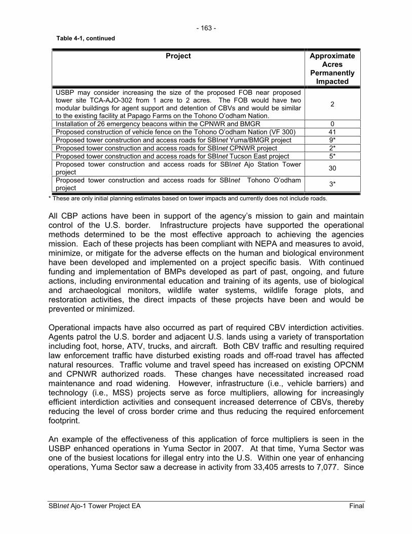
- 163 -
SBInet Ajo-1 Tower Project EA Final
Project Approximate Acres
Permanently Impacted
USBP may consider increasing the size of the proposed FOB near proposed tower site TCA-AJO-302 from 1 acre to 2 acres. The FOB would have two modular buildings for agent support and detention of CBVs and would be similar to the existing facility at Papago Farms on the Tohono O’odham Nation.
2
Installation of 26 emergency beacons within the CPNWR and BMGR 0 Proposed construction of vehicle fence on the Tohono O’odham Nation (VF 300) 41 Proposed tower construction and access roads for SBInet Yuma/BMGR project 9* Proposed tower construction and access roads for SBInet CPNWR project 2* Proposed tower construction and access roads for SBInet Tucson East project 5* Proposed tower construction and access roads for SBInet Ajo Station Tower project 30
Proposed tower construction and access roads for SBInet Tohono O’odham project 3*
* These are only initial planning estimates based on tower impacts and currently does not include roads.
All CBP actions have been in support of the agency’s mission to gain and maintain control of the U.S. border. Infrastructure projects have supported the operational methods determined to be the most effective approach to achieving the agencies mission. Each of these projects has been compliant with NEPA and measures to avoid, minimize, or mitigate for the adverse effects on the human and biological environment have been developed and implemented on a project specific basis. With continued funding and implementation of BMPs developed as part of past, ongoing, and future actions, including environmental education and training of its agents, use of biological and archaeological monitors, wildlife water systems, wildlife forage plots, and restoration activities, the direct impacts of these projects have been and would be prevented or minimized.
Operational impacts have also occurred as part of required CBV interdiction activities. Agents patrol the U.S. border and adjacent U.S. lands using a variety of transportation including foot, horse, ATV, trucks, and aircraft. Both CBV traffic and resulting required law enforcement traffic have disturbed existing roads and off-road travel has affected natural resources. Traffic volume and travel speed has increased on existing OPCNM and CPNWR authorized roads. These changes have necessitated increased road maintenance and road widening. However, infrastructure (i.e., vehicle barriers) and technology (i.e., MSS) projects serve as force multipliers, allowing for increasingly efficient interdiction activities and consequent increased deterrence of CBVs, thereby reducing the level of cross border crime and thus reducing the required enforcement footprint.
An example of the effectiveness of this application of force multipliers is seen in the USBP enhanced operations in Yuma Sector in 2007. At that time, Yuma Sector was one of the busiest locations for illegal entry into the U.S. Within one year of enhancing operations, Yuma Sector saw a decrease in activity from 33,405 arrests to 7,077. Since
Table 4-1, continued

- 164 -
SBInet Ajo-1 Tower Project EA Final
2005 (when the traffic was highest) there has been a 95 percent decrease in cross border violations in the sector (99,491 arrests in 2005 vs. 5,287 in 2009).
In addition to the phased projects listed above, CBP might be required to implement other activities and operations that are currently not foreseen or not within the ROI and therefore not discussed in this document. These actions could be in response to national emergencies or security events like the terrorist attacks on September 11, 2001, or to changes in the mode of operations of CBVs.
4.3 OTHER AGENCY/ORGANIZATIONS PROJECTS
Projects are currently being planned by other Federal entities which could affect areas in use by CBP. CBP should maintain close coordination with these agencies to ensure CBP activities do not conflict with other agencies’ policies or management plans. CBP would consult with applicable state and Federal agencies prior to performing any construction activities and would coordinate operations so that they do not inappropriately impact the mission of other agencies. Other agencies, such as BLM, U.S. Air Force, NPS, and USFWS, routinely prepare or update Resource Management Plans for the resources they manage. The following is a list of projects other Federal agencies and tribes are conducting or have completed within the U.S.-Mexico border region.
OPCNM
Planned installation of fiber optics cable along SR 85 from the northern boundary of the OPCNM to the Visitors Center.
Proposed installation of approximately 2 miles of new water line from the Visitors Center to the Camp Grounds.
There are ongoing efforts to reduce water loss from Quitobaquito Pond.
Ongoing facilities maintenance project include installation of gates along park administrative roads, reconstruction of picnic ramadas, rehabilitation of the campground dump station, and culvert replacement. There are two new office buildings proposed for construction adjacent to the maintenance facility. One would house law enforcement operations and the other the resource division. This construction would involve new ground disturbance, but it would be in the existing administrative site boundaries.
Marine Corps Air Station (MCAS)-YumaMCAS-Yuma conducts military flights over CPNWR and BMGR; operates various training facilities, such as landing strips and a rifle range; and conducts Weapons Tactics Instructor (WTI) courses. The WTI courses are conducted twice a year and involve overflights, and ground based activities such as movement of troops and vehicles at ground-support areas. Ordnance delivery occurs in two locations within the range of Sonoran pronghorn. MCAS-Yuma implements measures to minimize
- 165 -
SBInet Ajo-1 Tower Project EA Final
destruction and degradation of habitat and closely monitors all activities which could disturb or harm pronghorn.
Luke Air Force Base, Barry M. Goldwater Range (BMGR)Military activities within BMGR-east (the area nearest CPNWR and the Sonoran pronghorns range) include: use of airspace, four manned air-to-ground ranges, three tactical air-to-ground target areas, four auxiliary airfields, use of Stoval Airfield, and explosive ordnance disposal burn area. Luke Air Force Base has committed to implementing measures to minimize impacts to Sonoran pronghorn and to implementing recovery projects recommended by the Sonoran Pronghorn Recovery Team.
CPNWRActivities on CPNWR include the construction of forage enhancement plots and waters as part of Sonoran pronghorn recovery efforts. Additionally, a semi-captive breeding pen is maintained on CPNWR as part of an emergency recovery program for Sonoran pronghorn.
4.4 IDENTIFICATION OF CUMULATIVE EFFECTS ISSUES
Impacts on each resource can vary in degree or magnitude from a slightly noticeable change to a total change in the environment. For the purpose of this analysis the intensity of impacts will be classified as negligible, minor, moderate, or major. These intensity thresholds were previously defined in Section 3.1.
4.4.1 Land Use Construction of tower sites and access roads would directly change the current land use as directed by the policies of the managing agencies, (i.e., USFWS, NPS, BLM, or Arizona State Lands) and have indirect effects on the ability of the managing agencies to implement land use policies. The direct effects of removing small areas of land from their current land use and replacing them with areas of law enforcement land use would be localized and is not part of a trend. Although land use in the southwest has changed dramatically over time, in recent history management of the lands affected by the proposed project has been consistent with the mission of the managing agencies. Thus, the direct cumulative effects of changing land use would be negligible.
Changes in land use on nearby lands, such as changing military training and residential development, could have indirect effects on the lesser long-nosed bat and the Sonoran pronghorn. Although these two species could be directly affected by habitat degradation associated with the proposed project, the effect of changing land use, including the indirect effects of tower operation and subsequent changes in USBP operations is expected to be beneficial over the long-term. A reduction of CBV traffic in the affected area, a reduced enforcement footprint, more efficient interdictions, and a reduced need to track CBVs on the ground would all benefit protected species. These indirect effects of the proposed project would also benefit land use policies which direct agencies to protect and enhance wildlife, not only by reducing impacts to the Sonoran Desert Ecosystem, but by creating a safer environment in which to practice land management policies. Furthermore, a safer environment would benefit recreational

- 166 -
SBInet Ajo-1 Tower Project EA Final
land use on NPS and to some extent on CPNWR and BLM lands. Grazing allotments on BLM lands would also benefit from reduced CBV traffic and consequent law enforcement activities. Additionally, the proposed project would allow the OPCNM superintendent to re-evaluate opening the closed portion of OPCNM to public visitation due to increased security and public safety.
4.4.2 Wilderness As part of the SBInet project, a total of seven towers would be constructed adjacent to designated wilderness, two towers would be constructed in potential wilderness, and one tower would be constructed in designated wilderness. The proposed towers would adversely affect the natural values, sense of solitude, and unconfined recreational characteristics of designated wilderness. These actions when considered with past TI (i.e., NPS and CBP vehicle barriers) and construction projects, and the degradation of designated wilderness associated unauthorized trails created by CBV traffic and consequent law enforcement actions would have a moderate cumulative effect on designated wilderness. However, the proposed project would have a beneficial effect as a result of reducing CBV traffic and the enforcement footprint in designated wilderness.
4.4.3 Soils Construction of tower sites and access roads and the relocation of the FOB would result in disturbance of soils. Soil disturbance could lead to long-term erosion; however, BMPs described in Section 5 and BMPs included as part of the SWPPP and erosion and sediment control plans would minimize construction related erosion. Additionally, the engineering study and resulting road maintenance and upgrade plan committed to by CBP would further reduce erosion associated with road construction, repairs, improvements, and maintenance. Other activities which contribute to the erosion of soils include the establishment and use of unauthorized roads, off-road vehicle and foot traffic, ranching, and fire. Erosion of soils creates opportunities for the establishment of non-native, invasive species and damages biological soil crusts. Non-native, invasive species can increase fuel loads, displace native plants, and degrade wildlife habitats. Biological crusts stabilize soils, increase infiltration of surface flows, and contribute to nutrient uptake of plants. The establishment of non-native, invasive species and damage to large areas of soil crust began with the arrival of the first, non-native American travelers in the southwest. However, direct impacts associated with construction of new roads and use of authorized roads has largely stabilized. Sonoran Desert communities adjacent to authorized roads are likely to be affected by non-native, invasive plants and damage to adjacent soil crust into the foreseeable future. Maintenance of roads and efforts to stop the spread of non-native, invasive plants minimizes adverse effects. Because there are relatively few authorized roads in the Sonoran Desert on Federal lands, and because the authorization of new roads, road widening, or other development typically requires measures to minimize potential impacts, the cumulative effect of all activities associated with authorized roads and land development would be moderate.
- 167 -
SBInet Ajo-1 Tower Project EA Final
Other activities, such as recreational and non-recreational off-road travel and ranching, also result in soil disturbance which promotes the establishment of non-native, invasive plants and damages biological soil crusts. While small disturbances, such as those caused by off-road foot and equestrian traffic not occurring on established routes, can be naturally restored relatively quickly; larger disturbances, such as those caused by off-road vehicle traffic and all traffic on established routes, result in long-term changes in the landscape. CBV traffic and the consequent law enforcement response is the largest contributor to the cumulative effects of soil disturbance in the project area. Past CBV off-road activities and resulting law enforcement responses have disturbed soils that resulted in erosion of soils. In the absence of technology, USBP agents are required to conduct basic patrols off-road to track and interdict CBVs. With implementation of the proposed project, more efficient interdictions, a reduction of CBV traffic and resulting law enforcement actions in the project area, a reduced enforcement footprint, and a reduced need to track CBVs on the ground would all reduce the cumulative effects of soil disturbance. It is anticipated that USBP off-road travel to track and interdict CBV would be reduced and thus the resulting impacts to soils would be reduced. Furthermore, the construction of a vehicle barrier along the OPCNM and CPNWR boundaries and current USBP interdiction efforts limit the extent of off-road CBV vehicle traffic. As off-road traffic and subsequent soil disturbance is reduced, the potential spread of non-native, invasive species would be reduced and soil crusts would begin to naturally regenerate. Because the direct impacts of soil disturbance resulting from all new roads and development are minimized and limited primarily to the Proposed Action and because the largest contributor of soil disturbance (i.e., CBV activity and subsequent enforcement efforts) would ultimately be reduced as a result of the proposed project, the proposed project would have a moderate cumulative effect on soils.
4.4.4 Hydrology and Groundwater As part of the SBInet project, a total of 11.97 acre-feet of water would be obtained from a commercial source in Ajo or Lukeville. Both the Lower Gila and Western Mexican (Sonoyta Valley) basins experience water overdrafts as a result of withdraws for irrigation for agriculture and residential water use. Although water shortage is a substantial issue for those basins within the project area, the one-time use of this relatively small amount of water would not have a major direct effect on water availability in the region. The proposed project would have a moderate cumulative effect on groundwater when combined with other projects.
The repair, improvement, and construction of roads could alter surface water hydrology. Surface water hydrology has been substantially affected throughout the southwest. However, the roads that would be altered or created as a result of the Proposed Action do not intersect major streams and existing roads have been part of the landscape for many years, some likely predating the management of these lands by Federal land management agencies. Road upgrades to be implemented as part of the future engineering plan would be expected to improve current surface water hydrology problems. New road construction, although limited in number and length, would contribute to adverse cumulative impacts on floodplains. However, road upgrades and
- 168 -
SBInet Ajo-1 Tower Project EA Final
maintenance as proposed in the future engineering plan would minimize potential adverse impacts. Illegal roads and trails may continue to divert surface water flows to some extent. However, surface water flows would be restored in portions of the project area as a result of URV restoration activities included as part of the Proposed Action. The proposed project would have a minor cumulative effect on floodplains.
4.4.5 Surface Waters and Waters of the U.S. Past construction projects and existing unimproved roads are sources of sediment that have adversely affected surface waters in the past and continue to serve as a source of sediment in the project area. The SBInet project could lead to long-term erosion of soil into nearby surface waters during storm events. However, the volume of increased sediments in these waters resulting from the project would be minor in comparison to the volume of sediments contributed by natural erosion. BMPs included in Section 5.0, the SWPPP, and erosion and sediment control plans for each proposed tower site would reduce potential erosion and sedimentation. The proposed project would have a minor to moderate cumulative effect on surface waters and WUS from tower construction and a minor to moderate adverse effect on water quality as a result of sediment production form road construction, repair, improvement, and maintenance.
CBV off-road activities and consequent law enforcement activities have created UVRs and disturbed soils within the project area. Continued use of these UVRs has lead to accelerated soil erosion and sedimentation in some areas as well as the disruption of natural drainage patterns. With implementation of the proposed project, more efficient interdictions, a reduction of CBV traffic and resulting law enforcement actions in the project area, a reduced enforcement footprint, and a reduced need to track CBVs off-road cumulative effects to surface waters would be reduced. Further, restoration of UVRs would have a beneficial effect on surface waters as a result of reducing erosion and sedimentation, and restoring natural drainage patterns within the vicinity of UVRs. Cumulative effects on surface water from USBP operations associated with the proposed project would be minor.
4.4.6 Floodplains Road repairs to and maintenance of approach roads would not construct any structures within floodplains. Road repair and maintenance activities would involve grading within floodplains and would not impede the conveyance of flood waters, decrease floodplain capacity, or increase flood elevations, velocities, frequencies, or durations. Floodplains throughout the southwest have been affected by other activities, especially agriculture. Erosion and sedimentation as a result of the proposed project would have a minor cumulative effect on floodplains.
CBV off-road activities and consequent law enforcement activities have created UVRs and disturbed soils with the project area. Continued use and development of UVRs has lead to accelerated soil erosion and sedimentation in some areas as well as the disruption of natural drainage patterns. With implementation of the proposed project, more efficient interdictions, a reduction of CBV traffic and resulting law enforcement actions in the project area, a reduced zone of enforcement, and a reduced need to track CBVs off-road cumulative effects to floodplains would be reduced. Further, restoration

- 169 -
SBInet Ajo-1 Tower Project EA Final
of UVRs would have a beneficial effect on floodplains as a result of reducing erosion and sedimentation associated with UVRs. The proposed project would have a minor cumulative effect on floodplains.
4.4.7 Vegetation The proposed project would remove and degrade vegetation. Although numerous other activities have also resulted in the loss or degradation of vegetation, these direct impacts do not threaten any Sonoran Desert vegetation community as a whole and have resulted in a minor to moderate cumulative effect. Vast areas of similar plant communities remain essentially unaffected by the direct loss and degradation of vegetation. However, these impacts can have substantial effects when the lost or damaged vegetation provides habitat for sensitive plants or animals. Sensitive species which have very specific habitat requirements can be substantially impacted by the removal or degradation of small areas of vegetation. The direct cumulative effects of vegetation removal and degradation on sensitive species are discussed below.
Similar to soil disturbance, the removal and degradation of vegetation results in opportunities for the establishment of non-native, invasive species which can result in impacts to much larger areas. In general, any activity resulting in increased human presence on the landscape results in an increased potential for the colonization, establishment, and spread of non-native, invasive species. Non-native, invasive plants can displace native plants and result in loss or degradation of native habitats. Furthermore, non-native, invasive plants provide fuel for fires. Sonoran Desert plant communities are not adapted to fire, especially when fuel loads are high. Although the SBInet project would result in soil disturbance and loss of vegetation that promotes the establishment of non-native invasive species, these local and direct effects would be minimized or eliminated through BMPs described in Section 5.0. Efforts by other agencies to reduce the presence of these plants would further minimize the cumulative effects of non-native, invasive plants. Operation of the towers or accidents could provide a source of ignition; however, fire management would be coordinated with land managing agencies and this potential would be minimized. Ultimately, the indirect effects associated with a reduction of CBV traffic and consequent law enforcement activities would have a beneficial effect on vegetation resources on the OPCNM and to some extent on CPNWR and BLM lands. The proposed project would have a minor cumulative effect on vegetation resources on OPCNM.
CBV off-road activities and consequent law enforcement activities have created UVRs and disturbed soils with the project area. Continued use and development of these UVRs has lead to accelerated soil erosion and sedimentation in some areas as well as the disruption of natural drainage patterns. With implementation of the proposed project, more efficient interdictions, a reduction of CBV traffic and resulting law enforcement actions in the project area, a reduced enforcement footprint, and a reduced need to track CBVs off-road cumulative effects to floodplains would be reduced. Further, restoration of UVRs would have a beneficial effect on floodplains as a result of reducing erosion and sedimentation associated with UVRs. The proposed project would have a minor cumulative effect on floodplains.

- 170 -
SBInet Ajo-1 Tower Project EA Final
4.4.8 Wildlife and Aquatic Resources The SBInet Ajo-1 Tower Project would remove and degrade wildlife habitats. Numerous activities have resulted in impacts to wildlife habitats throughout the Sonoran Desert. However, common wildlife has not been substantially affected and the cumulative effects would be minor to these species. The proposed towers could have an adverse impact on migratory birds as a result of bird strikes and RF emissions. Similar to other wildlife, numerous activities have affected migratory birds. However, the potentially affected migratory bird populations are stable and the minor impacts of the project would not result in major cumulative effects. Because vast areas of Sonoran Desert are managed for wildlife, and because common wildlife species are not substantially threatened by any ongoing or future actions, the proposed project would have a minor cumulative effect on wildlife resources.
Past and present CBV off-road activities and consequent law enforcement activities have degraded wildlife habitat and disturbed wildlife. With implementation of the proposed project, more efficient interdictions, a reduction of CBV traffic and resulting law enforcement actions in the project area, a reduced enforcement footprint, and a reduced need to track CBVs off-road cumulative effects to wildlife and their habitats would be reduced. Further, restoration of UVRs would have a beneficial effect on wildlife as a result of restoring habitat that has been degrade through the creation and use of UVRs. The proposed project would have a minor cumulative effect on wildlife resources.
4.4.9 Protected Species Two protected species would be affected by the SBInet Ajo-1 Tower Project: the lesser long-nosed bat, and the Sonoran pronghorn. Both of these species have been and are substantially affected by historical and ongoing projects, as evidenced by their protection under the ESA.
4.4.9.1 Sonoran Pronghorn Most lands within the Sonoran pronghorns range in the U.S. are managed by Federal agencies; thus, authorized projects that could potentially affect this population of Sonoran pronghorn are Federal activities that are subject to Section 7 consultation. Illegal cross border activities and the consequent law enforcement actions have adversely affected protected species in and adjacent to the project area. Relatively small parcels of private and state lands occur within the currently-occupied range of Sonoran pronghorn near Ajo and Why, north of the BMGR from Dateland to SR 85, and from the Mohawk Mountains to Tacna. State in-holdings on BMGR were acquired by the U.S. Air Force.
Historically, livestock grazing, hunting or poaching, and development along the Gila River and Rio Sonoyta were all probably important factors in the well-documented Sonoran pronghorn range reduction and apparent population decline that occurred early in the 20th century. The U.S. Sonoran pronghorn sub-population is isolated from other sub-populations in Sonora by Mexico Highway 2 and the barbed wire fence that was erected to demarcate the U.S./Mexico border. Additionally, access to greenbelts of the

- 171 -
SBInet Ajo-1 Tower Project EA Final
Gila River and Rio Sonoyta, which likely were important sources of water and forage during drought periods, has been severed by fencing and roadways (i.e., I-8).
Within its remaining range, continuing rural and agricultural development, increasing recreational activities, vehicle use, grazing, and other activities on private and state lands adversely affect Sonoran pronghorn and their habitat. These activities on state and private lands and the effects of these activities on potential recovery areas currently outside of the current range are expected to occur on lands in and near the project area in the vicinity of Ajo, Why, and Yuma. In 2001, MCAS-Yuma reported that 2,884 acres had been converted to agriculture near Sentinel and Tacna. MCAS-Yuma also reported the extent of current pronghorn range that is affected by various activities as follows: recreation cover 69.6 percent of their range, military training on North and South Tactical Ranges covers 9.8 percent, active air-to-air firing range covers 5.8 percent, proposed explosive ordnance disposal 5-year clearance areas at North and South Tactical Ranges and Manned Range 1 cover 1.0 percent, and MCAS-Yuma proposed ground support areas and zones cover 0.3 percent.
Of particular concern are cross border activities by CBVs. In FY 2005, USBP Yuma Sector apprehended record numbers of CBVs. From October 1, 2005 to May 2006, 96,000 apprehensions were made, which was a 13 percent increase over the prior year. Increased USBP presence in the Douglas, Arizona area, and in San Diego (Operation Gatekeeper) and southeastern California, is associated with increased CBV activities in remote desert areas, such as CPNWR, OPCNM, and BMGR.
Illegal crossings and required law enforcement response to this traffic have resulted in route proliferation, off-road vehicle activity, increased human presence in backcountry areas, discarded trash, abandoned vehicles, cutting of firewood, illegal campfires, and increased chance of wildfire. Habitat degradation and disturbance of Sonoran pronghorn almost certainly result from these illegal cross border activities. Currently, much of the illegal traffic travels through the southern passes of the Growler Mountains and lead either through or by all USFWS forage enhancement plots and the captive rearing pen in the Child's Valley. Increased enforcement presence, construction of a vehicle barrier at CPNWR, and the vehicle barrier at OPCNM have been associated with a significant decrease in all forms of illegal cross border activities except narcotics trafficking in FY 2008 as compared to the same period in FY 2007. Apprehensions for USBP Ajo Station decreased from 22,504 (FY 2007) to 15,462 (FY 2008) (OBP 2009). Additionally, vehicle seizures decreased from 456 (FY 2004) to 248 (FY 2008). It is anticipated that completion of the SBInet Ajo-1 Tower Project would enhance USBP agents’ enforcement efficiency, and thus compressing the primary enforcement footprint closer to the U.S./Mexico border. For example, in the 3-year period that the P-28 Tower Project has been active in the Tucson Sector, apprehensions in the project area have decreased from 114,656 (FY 2006) to 61,923 (FY 2008) (OBP 2009).
The proposed project would result in a minimal contribution to development activities which remove or degrade habitat and result in cumulative adverse affects. Law enforcement actions associated with the Proposed Action would have minor contribution to activities that adversely affect Sonoran pronghorn’s range. However, the beneficial

- 172 -
SBInet Ajo-1 Tower Project EA Final
effects of the proposed project (i.e., a reduction of CBV traffic and consequent interdiction efforts in the affected area, a reduced enforcement footprint, more efficient apprehension, and a reduced need to track CBVs on the ground) would substantially reduce the cumulative adverse effects associated with human presence. Other beneficial effects resulting from the Proposed Action and other USBP actions include: the assessment and restoration of UVRs, funding for Sonoran pronghorn population monitoring, forage enhancement plots, and efforts to expand the current distribution of the pronghorn. Although the proposed project would contribute to the adverse cumulative effects which threaten Sonoran pronghorn, it would not contribute to curtailment of their range, the most substantial of these effects, and would reduce the cumulative effects of increased human presence within their range. The Proposed Action would have a moderate adverse cumulative effect on Sonoran pronghorn.
4.4.9.2 Lesser Long-nosed Bat Development within the range of the lesser long-nosed bat can degrade foraging habitats and has and is likely to continue to adversely affect the species. Development resulting from the proposed project would not directly affect foraging habitat, but could indirectly limit foraging opportunities if towers are located between roosts and foraging areas. However, because lesser long-nosed bats are capable of flying long distances and because they are largely dependent upon visual cues for navigation, it is unlikely that the towers would substantially limit the ability of individuals to locate and travel to and from foraging habitats. A greater cumulative threat to the species is the disturbance of roosts resulting from human disturbance related to both recreational and CBV activity. CBVs have entered lesser long-nosed bat roosts in the past for shelter and concealment from law enforcement officers. Increased development near these roosts and increased accessibility can both result in an increased potential for roost disturbance to occur. Because the length and number of new roads associated with the proposed project is minimal and the new roads do not substantially reduce off-road travel distance to roosts, the proposed project would not result in substantial cumulative effects associated with increased public access of roost sites. Furthermore, the proposed project would reduce CBV activity near roosts and limit the potential for roost disturbance associated with this activity. The proposed project would have a moderate cumulative effect on lesser long-nosed bat.
4.4.10 Cultural Resources Numerous activities have adversely affected cultural resources throughout the southwest; however, the SBInet Ajo-1 Tower Project would not contribute to a loss of these resources. The identification and protection or recordation of significant cultural resources have been coordinated through the Section 106 process.
Much of the land within the immediate vicinity of the tower sites and access roads is located on Federal lands and all actions on these lands will require NEPA and Section 106 compliance. Consequently, the impacts to cultural resources would be avoided and/or impacts to cultural resources would be mitigated through appropriate measures. Future developments are expected to conduct surveys and assess the potential for impacts to cultural resources if a Federal action (including financial aid or assistance,

- 173 -
SBInet Ajo-1 Tower Project EA Final
permits, or land) is required. The proposed project would not contribute to adverse impacts to cultural resources which may result from individuals or private entities that inadvertently damage these resources or intentionally collect these resources. Past and present CBV off-road activity and resulting law enforcement responses have likely adversely affected cultural resources in the project area. It is anticipated that the proposed project would reduce CBV activity in the project area and the resultant enforcement footprint would be reduced as a result of enhanced detection capabilities and more efficient interdiction efforts. Any reduction in CBV activity and subsequent reduction of law enforcement efforts would reduce potential impacts to cultural resources from disturbance. Because the effects of the proposed project on cultural resources would be minimized or mitigated, would not contribute to inadvertent or intentional damage or collection of these resources, and because reduced CBV activity would ultimately benefit these resources, the proposed project would have a minor cumulative effect on cultural resources.
4.4.11 Air Quality Numerous activities have affected air quality throughout the southwest. However, the proposed project would have very local and minimal impacts on air quality. The air quality analysis conducted for this EA considers ambient air quality conditions (i.e., conditions relative to the impact of all activities in the airshed) and determined that the impacts of the project would be temporary and minor. Thus, the proposed project would have a minor cumulative effect on air quality.
4.4.12 Noise The project area is undeveloped except for the town of Lukeville and OPCNM’s headquarters and thus, noise sources are lacking within the project area. Past construction projects have resulted in increased noise emissions at or near project sites; however, these increases in noise emissions have been localized and temporary. The proposed project would increase noise above ambient conditions during construction and long-term, near the tower sites and at the FOB. Noise emissions from the operation of the proposed towers would have a long-term, moderate cumulative effect on the soundscape on OPCNM and, to some extent on CPNWR and BLM lands.
4.4.13 Radio Frequency Environment No other known actions would affect the radio frequency environment impacted by the proposed project, thus the proposed project would have a negligible cumulative effect.
4.4.14 Utilities and Infrastructure Currently, there is a planned project to extend fiber optics along SR 85 to the OPCNM visitor center. The proposed project would have a negligible cumulative effect on utilities and infrastructure. Additionally, CBP may extend commercial grid power and fiber optics to three of the tower sites proposed as part of Proposed Action. Extension of commercial grid power and its use, as part of the proposed project, would have a negligible cumulative effect on utilities and infrastructure.

- 174 -
SBInet Ajo-1 Tower Project EA Final
4.4.15 Roadways and Traffic Minor traffic increases would be expected during the construction and would return to pre-construction conditions following the completion of construction. The proposed project would have a minor cumulative effect on traffic.
4.4.16 Aesthetics The placement of towers and a FOB adjacent to designated wilderness would undoubtedly result in long-term adverse effects on the aesthetic qualities which contribute to the wilderness value of these lands. Other actions which have affected the aesthetics of these lands within the viewshed of the towers, and thus would constitute cumulative effects, are limited to construction of existing roads, the proliferation of unauthorized roads, and abandoned vehicles and trash left by CBVs. The existing authorized roads constitute approximately 5 percent of these lands and provide the access necessary for most users to realize the benefits of the surrounding aesthetic resources. Although unauthorized roads undoubtedly contribute to adverse aesthetic conditions, the proposed project would not contribute to these effects but would ultimately reduce the proliferation and use of unauthorized roads, and abandoned vehicles and trash left by CBVs. Additionally, some URVs would be restored as part of the Proposed Action. Thus, the proposed project would have a moderate cumulative effect on aesthetics.
4.4.17 Hazardous Waste The proposed project includes measures to reduce the potential effects of pollutants associated with the handling of POLs, volatile organic compounds, and hazardous materials and would have a minor cumulative effect regarding hazardous waste.
4.4.18 Socioeconomics Infrastructure projects have resulted in reductions in illegal drug smuggling and beneficially affected socioeconomic resources within the border area. Increased safety within OPCNM and to some extent CPNWR would also benefit local communities which derive a proportion of their income from tourists visiting OPCNM and CPNWR. Further, short-term economic benefits would be realized by local vendors during tower construction and long-term benefits would be realized through the purchase of fuel for generators. The proposed project would have a minor, beneficial cumulative effect on socioeconomics.
4.5 SUMMARY
No potentially major cumulative effects have been identified for further analysis. While cumulative effects would undoubtedly occur, the contribution of the proposed project to adverse effects would be avoided, minimized, or mitigated to levels that are minor to moderate in intensity. Furthermore, the proposed project would result in a reduction of the activities which are resulting in the most prevalent and damaging effects occurring in Sonoran Desert Ecosystems, specifically those impacts occurring as a result of CBV activities. The proposed project would enhance CBP’s operational efficiency which ultimately reduces the enforcement footprint. While required law enforcement efforts
- 175 -
SBInet Ajo-1 Tower Project EA Final
currently contribute to the disturbance of soils, vegetation, surface water hydrology, and other natural resources, damages resulting from CBV activity would undoubtedly be more severe in the absence of law enforcement efforts. In a cumulative sense, the actions of CBP minimize the adverse effects of current CBV activities and result in cumulatively less impacts than a scenario that does not include law enforcement efforts. The proposed project is expected to substantially reduce illegal traffic in the project area as CBP is able to bring the area into effective control which is the purpose of the project. The beneficial effects of the proposed project would extend beyond the reduction of CBV activity in the form of conservation measures for both protected species and cultural resources. When combined with the beneficial effects of other similar measures, the proposed project would ultimately result in cumulative effects which benefit these resources.

- 176 -
SBInet Ajo-1 Tower Project EA Final
THIS PAGE LEFT INTENTIONALLY BLANK

SECTION 5.0
MITIGATION MEASURES

- 177 -
SBInet Ajo-1 Tower Project EA Final
5.0 MITIGATION MEASURES
It is CBP’s policy to reduce impacts through a sequence of avoidance, minimization, mitigation, and compensation. This chapter describes those measures that would be implemented to reduce or eliminate potential adverse impacts to the human and natural environment. Many of these measures have been incorporated as standard operating procedures by CBP on past projects. Environmental design measures are presented for each resource category potentially affected. These are general mitigation measures; development of specific mitigation measures would be required for certain activities implemented under the Proposed Action. The specific mitigation measures would be coordinated through appropriate agencies and land managers or administrators, as required. Mitigations vary and include activities such as restoration of habitat in other areas, acquisition of lands, implementation of BMPs, and are typically coordinated with the USFWS and other appropriate Federal and state resource agencies.
5.1 PROJECT PLANNING/DESIGN COMMUNICATION TOWERS
The following measures were adapted from the Interim Guidance on Siting, Construction, Operation, and Decommissioning of Communication Towers (USFWS 2000).
CBP will minimize bird perching and nesting opportunities for new poles or towers.
CBP will not site towers in or near wetlands, other known bird concentration areas (e.g., state or Federal refuges, staging areas, rookeries), in known migratory or daily movement flyways, or in habitat of threatened or endangered species. If this is not an option, mitigation will be required.
CBP will not use guy wires for tower support to reduce the probability of bird and bat collisions.
CBP will minimize security and other operations-related lighting impacts at tower sites and any other DHS-related infrastructure sites to the greatest extent practicable by minimizing the number of lights used and selectively placing and pointing lights down toward the ground, with shields on lights to prevent light from going up into sky, or out laterally beyond the tower site footprint.
CBP will site, design, and construct towers and appurtenant elements to avoid or minimize habitat loss within and adjacent to the tower “footprint.” CBP will minimize road access and fencing to reduce or prevent habitat fragmentation and disturbance, and to reduce above-ground obstacles to birds in flight.
Where feasible, CBP will place electric power lines to facilities underground or on the surface as insulated, shielded wire to avoid electrocution of birds and bats. CBP will use recommendations of the Avian Powerline Interaction Committee (1994, 1996) for any required above-ground lines, transformers, or conductors. CBP will use raptor protective devices on all above ground wires.

- 178 -
SBInet Ajo-1 Tower Project EA Final
CBP will control noxious weeds using U.S. Environmental Protection Agency approved herbicides. A NPS Pesticide Use Permit will be obtained prior to applying herbicides on NPS lands.
If rodent populations on the perimeter of the facility are to be controlled, CBP will not use rodenticides.
Once CBP has determined that towers are no longer needed, CBP will remove them within 12 months. CBP will restore footprint of towers and associated facilities to natural habitat.
5.2 PROJECT PLANNING/DESIGN – GENERAL CONSTRUCTION
CBP will develop and provide USFWS and DOI land management agencies a map and the following GIS shapefiles: Sonoran pronghorn locations; lesser long-nosed bat roosts; proposed DHS tower sites and access roads; roads proposed to be maintained; existing and proposed CBP FOBs; border vehicle and pedestrian fence; property boundaries; authorized roads; and other shapefiles as appropriate (i.e., if useful for analyzing the effects of the project on Sonoran pronghorn).
CBP will use disturbed areas or areas that will be used later in the construction period for staging, parking, and equipment storage.
CBP will give particular importance to proper design and locating roads such that the widening of existing or created roadbeds beyond the design parameters due to improper maintenance and use will be avoided or minimized.
Site, design, and construct towers and their associated facilities, including roads, to avoid or minimize habitat loss within or adjacent to the footprint. Minimize access road and fence construction. Minimize the amount of above-ground obstacles associated with the site.
CBP will develop and implement an Erosion and Sediment Control Plan (ESCP) that includes restoration of areas of temporary impact associated with the SBInet Ajo-1 Tower Project. Details of the ESCP are described in Section 5.4 Soils.
CBP will control noxious weeds using EPA approved herbicides. Noxious weed control will be described in greater detail in Section 5.5 Vegetation.
CBP will ensure that all construction will follow DHS Environmental Planning Management Directive 025-01 for waste management.
A CBP-approved spill protection plan (or SPCCP) will be developed and implemented at construction and maintenance sites to ensure that any toxic substances are properly handled and that escape into the environment is prevented. Agency standard protocols will be used. Drip pans underneath equipment, containment zones used when refueling vehicles or equipment, and other measures are to be included.

- 179 -
SBInet Ajo-1 Tower Project EA Final
CBP will incorporate BMPs relating to project area delineation, water sources, waste management, and site restoration into project planning and implementation for road construction and maintenance.
A detailed site plan for each tower site and all associated roads (including construction and maintenance access roads and patrol roads) and staging areas to minimize impacts to natural and cultural resources will be developed. Site plans will be developed with and approved by the land managers and among other items, it will include dimensions of tower footprint, height of the tower, power source for the tower, level of noise generated by each tower, maintenance schedule of each tower and associated roads, construction schedule, etc. The plans will be included in the description of the proposed action of the BA and EA.
All BMPs to be implemented by the project contractor will be included in the contract.
5.3 GENERAL CONSTRUCTION ACTIVITIES
CBP will clearly demarcate project construction area perimeters, including access roads, with land management agency. No disturbance outside that perimeter will be authorized.
CBP will construct and maintain the fewest roads needed, using proper standards.
Maintenance actions will not increase the width of the 12-foot road bed or the amount of permanent disturbance beyond the 12-foot road bed and 2-foot shoulders.
CBP will minimize the number of construction and maintenance vehicles traveling to and from the project site and the number of trips per day to reduce the likelihood of disturbing animals in the area or injuring an animal on the road, or disturbing their habitat.
Within the designated disturbance area, CBP will minimize the area to be disturbed by limiting deliveries of materials and equipment to only those needed for effective project implementation.
CBP will avoid contamination of ground and surface waters by storing concrete wash water, and any water that has been contaminated with construction materials, oils, equipment residue, etc., in closed containers on-site until removed for disposal. This wash water is toxic to wildlife. Storage tanks must have proper air space (to avoid rainfall-induced overtopping), be on-ground containers, and be located in upland areas instead of washes.
CBP will avoid lighting impacts during the night by conducting construction and maintenance activities during daylight hours only. If night lighting is unavoidable: 1) use special bulbs designed to ensure no increase in ambient light conditions, 2) minimize the number of lights used, 3) place lights on poles pointed down toward the ground, with
- 180 -
SBInet Ajo-1 Tower Project EA Final
shields on lights to prevent light from going up into sky, or out laterally into landscape, and 4) selectively place lights so they are directed away from all native vegetative communities.
CBP will use road design and construction specifications appropriate to the local physical conditions and level of use.
CBP will design and construct roads according to engineering standards that avoid or minimize roadbed erosion.
CBP will avoid road bed erosion and increased disturbance (inadvertent widening) along access roads resulting from improper maintenance and use.
CBP will measure and record the width of all access and approach roads that are created, maintained, or closed by CBP using GPS coordinates and integrate these measurements into CBP’s GIS database. The database will be made available to USFWS and the affected land management agencies.
CBP will implement a road maintenance project to avoid making wind rows with the soils once grading activities are complete and use any excess soils on-site to raise and shape the construction site or road surface.
All vehicular traffic associated with construction and maintenance will use designated/authorized roads to access the proposed tower sites and avoiding off-road vehicle activity outside of the project footprint.
CBP will avoid transmitting disease vectors, introducing invasive non-native species, and depleting natural aquatic systems by using wells, irrigation water sources, or treated municipal sources for construction or irrigation purposes instead of natural sources.
CBP will include a configuration to support fire management operations in the design of roads, fences, and other facilities that require land clearing.
CBP will minimize fences and other infrastructures that may be damaged due to periodic wildfire.
Remote sensors will be installed covertly with a minimum number of dedicated and trained personnel. All installation and maintenance will be performed on foot with the absolute minimum of ground disturbance. Once installed only essential maintenance will be conducted and site visits will be limited to the minimum amount practicable.
CBP will notify USFWS and DOI land managers two weeks before any project construction and maintenance activities begin and within one week after project construction and maintenance activities are completed.

- 181 -
SBInet Ajo-1 Tower Project EA Final
5.4 SOILS
Vehicular traffic associated with the tower and access road construction activities and operational support activities will remain on established roads to the maximum extent practicable. Areas with highly erodible soils will be given special consideration when designing the proposed project towers and access roads to ensure incorporation of various erosion control techniques, where possible, to decrease erosion. Site rehabilitation will include re-vegetating or the distribution of organic and geological materials (i.e., boulders and rocks) over the disturbed area to reduce erosion while allowing the area to naturally vegetate. Additionally, erosion control measures and appropriate BMPs will be implemented before, during, and after construction activities as appropriate.
Road repairs or improvements shall avoid, to the greatest extent practicable, creating wind rows with the soils once grading activities are completed. Excess soils from construction activities will be used on-site to raise and shape proposed tower sites and road surfaces.
CBP will obtain materials such as gravel or topsoil that are clean and acceptable to the land management agency from existing developed or previously used sources, not from undisturbed areas adjacent to the project area.
CBP will place drip pans under parked equipment and containment zones when refueling vehicles or equipment.
CBP will salvage the top 4 inches of excavated soils and replace the soil on the surface after excavation.
CBP will quantify the volume and type of spoil material from construction activities. CBP will coordinate with the land management agency to determine disposition and location of spoil material (e.g., spoils from drilling tower footers or related road construction). If requested by the land management agency, haul spoil material to an appropriate off-site disposal area. CBP will remove material brought up from deep below the surface from conservation areas; it may support a different vegetation community than surrounding natural surface soils.
CBP will develop and implement an ESCP that includes restoration of areas of temporary impact associated with the SBInet Ajo-1 Tower Project. The plan will be developed in coordination with the USFWS and appropriate DOI land management agencies. The need for and extent of site restoration will be at the discretion and under the direction of the land manager. The ESCP will include provisions to re-contour the site, replace soils and provide proper drainage; replant native plants salvaged prior to construction; and revegetate with a mixture of native plant seeds or nursery plantings (or both) derived from acceptable sources as determined by the corresponding land manager. The plan will also address monitoring of establishment of non-native plants and appropriate control measures. Training to identify non-native plants will be

- 182 -
SBInet Ajo-1 Tower Project EA Final
provided to contractor personnel as needed. The plan will also identify success criteria and monitoring and reporting requirements. The plan will be finalized before the initiation of project construction.
5.5 VEGETATION
CBP will minimize habitat disturbance by restricting vegetation removal to the smallest possible project footprint. CBP will limit the removal of trees, cacti, and brush to the smallest amount needed to meet the objectives of the project. If vegetation must be removed outside the permanent project footprint, allow natural regeneration of native plants by cutting vegetation with hand tools, mowing, trimming, or using other removal methods that allow root systems to remain intact.
CBP will use natural materials free of non-native plant seeds and other plant parts to limit potential for infestation for on-site erosion control in uninfected native habitats. Natural materials will be certified weed and weed-seed free.
CBP will identify fill material brought in from outside the project area by its source location. Use sources that are clean and weed-free. Outside fill material must be approved prior to use by the land management agency.
CBP will document any establishment of non-native plants and will implement appropriate control measures.
CBP will remove invasive plants that appear on the tower sites, and along sections of repaired, improved, and new road. Removal will be done in ways that eliminate the entire plant and remove all plant parts to a disposal area. Herbicides not toxic to listed species in the area can be used for non-native vegetation control. Application of herbicides will follow Federal guidelines and in accordance with label directions. A NPS Pesticide Use Permit would be received prior to herbicide application on NPS lands. . Removal will be done in a manner that does not affect Sonoran pronghorn or lesser long-nosed bats. Training to identify non-native invasive plants will be provided for CBP personnel or contractors as necessary. Prior to construction, CBP will conduct surveys for non-native, invasive plants within tower sites and roads to be constructed, improved, or repaired to establish a baseline.
CBP will avoid the spread of non-native plants by not using natural materials (e.g., straw) for on-site erosion control. If natural materials must be used, the natural material would be certified weed and weed-seed free. Herbicides not toxic to listed species that may be in the area can be used for non-native vegetation control. Application of herbicides will follow Federal guidelines and can be used according to in accordance with label directions. A NPS Pesticide Use Permit will be obtained prior to applying herbicides on NPS lands.

- 183 -
SBInet Ajo-1 Tower Project EA Final
CBP will collect and stockpile organic material for later use in staging areas for erosion control while those areas naturally revegetate. CBP will use only native plant material for this purposed to avoid introducing invasive plants.
As requested by the land management agency, CBP will remove invasive plants that appear on the tower sites, along sections of repaired and new road. Removal will be done in ways that eliminate the entire plant and remove all plant parts to a disposal area. Herbicides not toxic to listed species that may be in the area can be used for non-native vegetation control. Application of herbicides will follow Federal guidelines and in accordance with label directions. Herbicides can be used according to label directions if they are not toxic to federally listed species that may be in the area. Removal will be done in a manner that does not affect Sonoran pronghorn or lesser long-nosed bats. Training to identify non-native invasive plants will be provided for CBP personnel or contractors as necessary.
5.6 WILDLIFE RESOURCES
The Migratory Bird Treaty Act (16 U.S.C. 703-712, [1918, as amended 1936, 1960, 1968, 1969, 1974, 1978, 1986 and 1989]) requires that Federal agencies coordinate with the USFWS if a construction activity would result in the take of a migratory bird. If construction or clearing activities are scheduled during nesting seasons (February 15 through August 31); surveys will be performed to identify active nests. If construction activities will result in the take of a migratory bird; then coordination with the USFWS and FAA will be required and applicable permits would be obtained prior to construction or clearing activities. Another mitigation measure that would be considered is to schedule all construction activities outside nesting seasons negating the requirement for nesting bird surveys. The proposed sensor and communication towers would also comply with USFWS guidelines for reducing fatal bird strikes on communication towers (USFWS 2000) to the greatest extent practicable. Guidelines recommend co-locating new antennae arrays on existing towers whenever possible and to build towers as short as possible, without guy wires or lighting, and use white strobe lights whenever lights are necessary for aviation safety.
CBP will use the most recent bird and bat strike avoidance guidance during tower design.
Towers, light poles, and other pole-like structures will be designed and constructed to discourage roosting and nesting by birds, particularly ravens or other raptors that may use the poles for hunting perches. Tubular supports with pointed tops will be used rather than lattice supports to minimize bird perching and nesting opportunities. Tower designs will avoid placing external ladders and platforms on tubular towers to minimize perching and nesting.
If rodent populations on the perimeter of the facility are to be controlled, CBP will not use rodenticides.

- 184 -
SBInet Ajo-1 Tower Project EA Final
CBP will avoid or minimize, through proper road design and construction, the potential for entrapment of surface flows within the roadbed to incisement or edging berms created by grading.
To prevent entrapment of wildlife species during construction, CBP will cover all excavated, steep-walled holes or trenches more than 2 feet deep at the end of each working day with plywood or provide these holes with escape ramps of earth fill or wooden planks. Ramps will be located at no less than 1,000 feet apart and provide slopes less than 45 degrees. Biological monitors will thoroughly inspect all holes and trenches for trapped animals, and if animals are present, no construction can resume until the animals are out of the pit or trench.
CBP will cover all hollow vertical fence posts (i.e., those that will be filled with a reinforcing material such as concrete) from the time they are erected to the time they are filled.
CBP will place electric power lines to facilities underground or on the surface as insulated, shielded wire. CBP will shield above ground lines, transformers, or conductors as recommended by the Avian Powerline Interaction Committee. CBP will place raptor protection devices on all above ground wires.
No more than 10 percent of vegetation will be removed from suitable nesting or migration habitat or reduce it to less than 10 acres in size. CBP will avoid the removal of dense understory or midstory vegetation from breeding and migration habitat to the extent possible.
CBP will avoid placing riprap around towers.
CBP will not, for any length of time, permit any pets inside the project area or adjacent native habitats. This BMP does not pertain to law enforcement animals.
Biological monitors will check under construction equipment for wildlife species (e.g., desert tortoise) prior to moving equipment that has sat idle for more than 1 hour.
5.7 PROTECTED SPECIES
CBP will minimize impacts to listed species and their habitats by designating and using the minimal number of roads needed for project implementation. CBP will avoid creating new access routes by using, and improving if necessary, existing roads.
CBP will minimize impacts to Sonoran pronghorn and lesser long-nosed bats and their habitats by using flagging or temporary fencing to clearly demarcate project perimeters, including access roads, with the land management agency. CBP will not disturb soil or vegetation outside of that perimeter.
CBP will minimize impacts to listed species and their habitats by using areas already disturbed by past activities, or those that will be used later in the construction period, for

- 185 -
SBInet Ajo-1 Tower Project EA Final
staging, parking, laydown, and equipment storage. If site disturbance is unavoidable, minimize the area of disturbance by scheduling deliveries of materials and equipment to only those items needed for ongoing project implementation.
CBP will minimize impacts to listed species and their habitats by limiting grading or topsoil removal to areas where this activity is absolutely necessary for construction, staging, or maintenance activities.
CBP will avoid restricting water access by identifying and not creating barriers to natural water sources available to listed species.
CBP will minimize impacts to listed species and their habitats by locating corrals and staging areas for equestrian operations in existing disturbed areas.
CBP will minimize impacts to listed species and their habitats by obtaining materials such as gravel or topsoil that are clean and acceptable to the land management agency, from existing developed or previously used sources, not from undisturbed areas adjacent to the project area.
CBP will develop (in conjunction with USFWS and DOI Land Managers) and implement a training program focusing on Trust Resources for contractors/construction personnel. Training will be provided to all personnel associated with the project before project construction begins and before any new personnel begin work on the project. Information presented in the training program will include occurrence of sensitive species in the project area, their general ecology, and sensitivity to human activities; legal protection afforded the species and the penalties for violation of state or Federal laws; implementation of included conservation actions/best management practices; and reporting requirements. Also included in this training program will be color photos of the listed species and maps of Federally listed species' habitats. Following the training program, the photos and maps will be posted in the contractor and resident engineer's office, where they will remain through the duration of the project. The selected construction manager will be responsible for ensuring that personnel are aware of the listed species. In addition, training in identification of non-native invasive plants and animals will be provided for contracted personnel engaged in post-construction monitoring of construction sites.
For upgrading towers, CBP will follow the guidelines for new construction as closely as possible. CBP will retro-fit sites with high bird or bat mortality.
Lesser Long-nosed BatConstruction activities for towers and associated new roads, and road improvements that are within one mile of a bat roost and occur between May 1 and September 30 will be monitored by a qualified biologist. In some years, bats may arrive earlier and leave later in the year than the May to September time frame. For maternity roosts this will be March through August. For summer roosts, this will be July through October. Any
- 186 -
SBInet Ajo-1 Tower Project EA Final
occurrences and/or disturbances of lesser long-nosed bats will be documented and mitigated.
If results of the Ajo-1 lesser long-nosed bat telemetry study or the Tucson-West Tower Project bat and bird monitoring studies indicate that towers result in significant disturbance to bats or birds, with the guidance of USFWS and the land management agencies, CBP will modify and update bird and bat strike avoidance equipment on the Ajo-1 towers and implement techniques that reduce the disturbance to birds and bats.
CBP will avoid disturbing areas containing columnar cacti (saguaro, organ pipe, senita) or agaves to the extent reasonable. If they cannot be avoided, columnar cacti and agaves should be salvaged and transplanted. When salvage is not possible, columnar cacti and agaves should be purchased and planted at a 3:1 ratio. Salvage, transplantation, and container planting will be done in accordance with a restoration plan, approved by the land manager and USFWS, that includes success criteria and monitoring.
CBP will avoid construction and maintenance activities within 4 miles of lesser long-nosed bat roosts between May 1 and September 30.
CBP will avoid entering lesser long-nosed bat maternity roosts (except in emergency/exigent circumstances).
Sonoran PronghornCBP will minimize to the greatest extent possible the number of roads, detection and communication towers, and other infrastructure in Sonoran pronghorn habitat, particularly in movement corridors and areas important to Sonoran pronghorn during the fawning season (March 15 to July 31).
CBP will minimize the number of construction and maintenance trips to all tower sites, particularly those in important Sonoran pronghorn areas.
CBP will minimize the number of construction vehicles traveling to and from the project site and the number of trips per day. CBP will coordinate construction vehicle activity with land managers at their discretion.
CBP will provide for an on-site biological monitor to be present during work activities for all construction activities in Sonoran pronghorn and lesser long-nosed bat habitats. At a time interval (i.e., daily, weekly) determined by the land management agency, the monitor will check in and out of the land management unit (with the land manager or his/her representative). The biological monitor will have the responsibility to ensure and document that agreed upon BMPs (both those relating to construction and protection of individuals of Sonoran pronghorn and lesser long-nosed bat on or adjacent to the project site) are properly implemented. The monitor will use a daily BMP monitoring checklist (two checklists, a construction BMP list and maintenance BMP list) to record BMP adherence and will input information from this checklist into the USFWS IPaC

- 187 -
SBInet Ajo-1 Tower Project EA Final
system every Friday (providing construction or maintenance activities occur that week). The monitor will additionally ensure a copy of this information as well as a weekly summary report is sent via electronic mail to the DOI land managers and AESO every Friday. The biological monitor will notify the construction manager who has the authority to temporarily suspend activities not in compliance with all agreed upon BMPs. The biological monitor will be notified 5 days in advance of any ground-breaking activity.
CBP will ensure a qualified Sonoran pronghorn monitor is on-site during tower construction in Sonoran pronghorn habitat. Land management agencies within Sonoran pronghorn habitat and USFWS-AESO will work with DHS to define “qualified Sonoran pronghorn monitor”. Before any construction work commences in Sonoran pronghorn habitat, the monitor will conduct hilltop surveys (visual and telemetry, if appropriate) for Sonoran pronghorn at sunrise in close coordination with land managers. If Sonoran pronghorn are detected within 2 miles of proposed daily project activities, no project work will begin until Sonoran pronghorn move on their own volition to a distance greater than 2 miles from the activities (note: monitoring method and buffer distance is project specific; 2 miles is for tower construction, see criteria for project maintenance below under "species-specific"). Daily Sonoran pronghorn monitoring reports will be provided (electronically mailed) to USFWS and DOI land managers on a weekly basis (due the following Monday). Sonoran pronghorn detections (with coordinates and time of detection) will be reported by electronic mail or phone call to the land managers with 24 hours of the detection.
CBP will report detections (i.e., detected construction or maintenance personnel, etc.) of Sonoran pronghorn via electronic mail to FWS-AESO and the corresponding DOI land manager within 48 hours of the detection. The electronic mail will include the following details: a) if known, the coordinates and a description of the location of the where the Sonoran pronghorn was detected, b) the date and time of the detection, c) the method used to make the detection, and d) as available, other pertinent details, such as the behavior of the Sonoran pronghorn (i.e., was it standing, foraging, running, etc.)
CBP will avoid and minimize animal collisions, particularly with Sonoran pronghorn, and fragmentation of Sonoran pronghorn populations by using proper road design techniques.
CBP will avoid constructing towers and associated infrastructure (i.e., roads) in Sonoran pronghorn habitat from March 15 to July 31.
CBP will place restrictions on construction vehicle activity during the Sonoran pronghorn fawning season (March 15 to July 31) to avoid disturbance to females and fawns.
CBP will minimize animal collisions, particularly with Sonoran pronghorn, by not exceeding construction and maintenance speed limits of 35 mph on major unpaved roads (i.e., graded with ditches on both sides) and 25 mph on all other unpaved roads. During periods of decreased visibility (e.g., night, weather, and curves), CBP and contractors will not exceed speeds of 25 mph.

- 188 -
SBInet Ajo-1 Tower Project EA Final
During project maintenance and maintenance access, cease all work that may disturb a Sonoran pronghorn if one is seen within 1 mile of the project site or any access road to the site. For vehicle operations, this entails stopping the vehicle until the animal moves away on its own volition. Vehicles may then continue on at no more than 15 miles per hour. Maintenance crews and personnel in vehicles will wait up to 3 hours from the initial sighting for the animal to move beyond 1 mile. If the animal has not moved the required distance, all personnel will retreat back away from the animal. CBP will ensure all maintenance-related personnel are trained to identify Sonoran pronghorn. Biological monitors will report pronghorn detections (with coordinates and time of detection) by electronic mail or phone call to land managers within 24 hours of the detection.
CBP will minimize duration of noise exposure during maintenance activities in Sonoran pronghorn habitat. If helicopters must be used, work with USFWS and the land manager(s) to ensure measures are implemented to significantly minimize the potential for the maintenance work/access to result in adverse effects to Sonoran pronghorn (i.e., access the site outside of the Sonoran pronghorn closure period; before any work commences in Sonoran pronghorn habitat, a qualified Sonoran pronghorn monitor will conduct hilltop surveys (visual and telemetry, if appropriate) for Sonoran pronghorn at sunrise in close coordination with land managers. If Sonoran pronghorn are detected within 2 miles of maintenance and maintenance access activities, no work will begin until Sonoran pronghorn move on their own volition to a distance greater than 2 miles from the activities; etc.).
Efforts to minimize the level of construction and maintenance noise of tower projects (from construction, maintenance, and operations) within Sonoran pronghorn and lesser long-nosed bat habitat will be implemented by CBP and contractors.
CBP will minimize noise levels for day and night operations of towers, associated infrastructure, and FOB within Sonoran pronghorn and lesser long-nosed bat habitat by using either baffle boxes (a sound-resistant box that is placed over or around a generator, air-conditioning unit, or any other sound producing equipment) or other noise-abatement methods for all generators, air-conditioning units, or any other sound producing equipment. Specifically, for Sonoran pronghorn, limit noise emissions from each tower so as not to exceed 35 dBA (measured ambient noise) at 492 feet distance from the noise source. CBP will use an acoustical professional consultant to ensure that building and/or sound barrier design details are sufficient to achieve the aforementioned criteria. CBP will provide acoustic professional’s findings to USFWS-AESO & CPNWR, Ajo Station Tower Project, and BLM.
CBP will design and locate new access roads in a manner that minimizes impacts to Sonoran pronghorn and lesser long-nosed bats and their habitats. Corrective maintenance will be provided as needed.
CBP will develop and implement site restoration plans for Sonoran pronghorn and lesser long-nosed bats and habitat during project planning and provide an achievement goal to be met by the restoration activity. The site restoration plan will be approved by
- 189 -
SBInet Ajo-1 Tower Project EA Final
the USFWS and appropriate DOI land management agencies. The need for and extent of site restoration will be determined on a project-by-project basis. The Erosion Control Plan will include provisions to re-contour the site, replace soils and provide proper drainage; replant native plants salvaged prior to construction and provide for re-seeding with native, locally adapted plant species. The plan will also address monitoring of establishment of non-native plants and appropriate control measures. Training to identify non-native plants will be provided to contractor personnel as needed. The plan will also identify success criteria and monitoring and reporting requirements.
CBP will provide a report including a complete description of the action (construction component) implemented (including photographs; total acres impacted; total acres of Sonoran pronghorn habitat impacted; total number of lesser long-nosed bat food plants impacted; length of time to complete the project; all environmental design [i.e., BMPs] and conservation measures implemented, including all Sonoran pronghorn daily and other biological monitoring reports; etc.) to USFWS and DOI land management agencies within 90 days of project construction completion. As implementation of some measures will continue after project construction is completed, the report will also identify environmental design and conservation measures still under implementation or proposed for implementation and a timeframe for completing the measures. Until all environmental design and conservation measures are fully implemented, provide reports annually by February 1 to the USFWS and DOI land management agencies that describe implementation of the measures. In both the initial and the annual reports, provide a description of how well the environmental design and conservation measures worked, suggestions for improvements to the measures, and implementation of any restoration plan and monitoring post-construction.
5.8 WATER RESOURCES
Standard construction procedures will be implemented to minimize potential for erosion and sedimentation during construction. All work shall cease during heavy rains and would not resume until conditions are suitable for the movement of equipment and material. All fuels, waste oils, and solvents will be collected and stored in tanks or drums within secondary containment areas consisting of an impervious floor and bermed sidewalls capable of holding the volume of the largest container stored therein. The refueling of machinery will be completed following accepted guidelines, and all vehicles will have drip pans during storage to contain minor spills and drips. No refueling or storage will take place within 100 feet of drainages.
CBP will design new roads to minimize the risk of erosion to aquatic habitats. CBP will avoid road placement that requires a crossing of seasonally or perennially flowing streams. If not avoidable, CBP will design crossings to minimize effects to stream banks and the channel to protect natural substrates and flows.
CBP will avoid contaminating natural aquatic and wetland systems with runoff by limiting all equipment maintenance, staging, laydown, and dispensing of fuel, oil, etc., to designated upland areas.

- 190 -
SBInet Ajo-1 Tower Project EA Final
CBP will avoid or minimize the potential for entrapment of surface flows within the roadbed due to incisement or edging berms created by grading.
CBP will avoid irreparable damage to streams by not locating stream crossings near or at bends or meanders; rather, design road to cross at straight stream reaches where channel stability is enhanced.
A Construction Stormwater General Permit will be obtained prior to construction, and this would require approval of a site-specific SWPPP and NOI. A site-specific SPCCP will also be in place prior to the start of construction. Other environmental design measures will be implemented such as straw bales, silt fencing, aggregate materials, wetting compounds, and re-vegetation with native plant species, where possible, to decrease erosion and sedimentation.
CBP will avoid impacts to groundwater by obtaining treated water from outside the immediate area for construction use.
CBP storage tanks containing untreated water will be of a size that if a rainfall event were to occur, the tank (assuming open), will not be overtopped and cause a release of water into the adjacent drainages. Water storage on the project area will be in on-ground containers located on upland areas not in washes.
Prior to the start of construction activities, the construction contractor will review the most up-to-date version of the ADEQ 305(b) and 303(d) report. Additionally, road repair or improvement activities in wash or drainage crossings will not impede the flow of affected water courses.
5.9 CULTURAL RESOURCES
An archaeologist will be present to monitor all ground disturbance activities in previously undisturbed areas.
The site boundaries of all previously recorded sites along with a 98 foot buffer would be flagged around each of the sites to ensure that they are avoided. In addition, archaeological monitoring would be conducted during construction to ensure that activities in these areas would remain confined to the surveyed right-of-way.
The limits of the newly recorded sites would be included on engineering drawings and an archaeologist would accompany the engineer in the field to assist in staking a new route that avoids adverse impacts to these archaeological resources. During construction the perimeters of all NRHP eligible archaeological sites would be flagged to ensure all construction activities would avoid inadvertent impacts to cultural resources. Additionally, an archaeologist would also monitor the transport of materials used to construct the tower, tower installation, and all associated road improvement activities.

- 191 -
SBInet Ajo-1 Tower Project EA Final
Should any archaeological artifacts be found during construction, notify the appropriate land management archaeologist immediately. All work will cease until an evaluation of the discovery is made by the authorized officer to determine appropriate actions to prevent the loss of significant cultural or scientific values.
5.10 AIR QUALITY
Mitigation measures will be incorporated to ensure that fugitive dust and other air quality constituents emission levels do not rise above the minimum threshold as required per 40 CFR 51.853(b)(1). Measures will include dust suppression methods such as road watering to minimize airborne particulate matter created during construction activities. Standard construction BMPs such as routine watering of the construction site as well as access roads to the site will be used to control fugitive dust and thereby assist in limiting potential PM-10 excursions during the construction phase of the proposed project. Additionally, all construction equipment and vehicles will be required to be maintained in good operating condition to minimize exhaust emissions.
5.11 NOISE
During the construction phase, short-term noise impacts are anticipated. All applicable Occupational Safety and Health Administration regulations and requirements will be followed. On-site activities would be restricted to daylight hours to the greatest extent practicable although night-time construction could occur if the construction schedule requires it. Construction equipment will possess properly working mufflers and would be kept properly tuned to reduce backfires. Implementation of these measures will reduce the expected short-term noise impacts to an insignificant level in and around tower construction sites.
CBP will avoid noise impacts during the night by conducting construction and maintenance during daylight hours only. If construction or maintenance must occur during non-daylight hours, minimize the duration and frequency of these activities to the greatest extent possible.
5.12 HAZARDOUS MATERIALS
BMPs will be implemented as standard operating procedures during all construction activities, and will include proper handling, storage, and/or disposal of hazardous and/or regulated materials. To minimize potential impacts from hazardous and regulated materials, all fuels, waste oils and solvents will be collected and stored in tanks or drums within a secondary containment system that consists of an impervious floor and bermed sidewalls capable of containing the volume of the largest container stored therein. The refueling of machinery will be completed in accordance with accepted industry and regulatory guidelines, and all vehicles will have drip pans during storage to contain minor spills and drips. Although it is unlikely that a major spill would occur, any spill of reportable quantities will be contained immediately within an earthen dike, and the application of an absorbent (e.g., granular, pillow, sock, etc.) will be used to absorb and contain the spill.

- 192 -
SBInet Ajo-1 Tower Project EA Final
To ensure pollution prevention, a SPCCP will be in place prior to the start of construction activities and all personnel will be briefed on the implementation and responsibilities of this plan as is typical in CBP/SBI projects. All spills will be reported to the designated CBP point of contact for the project. Furthermore, a spill of any petroleum liquids (e.g., fuel) or material listed in 40 CFR 302 Table 302.4 of a reportable quantity must be cleaned up and reported to the appropriate Federal and state agencies.
CBP will contain non-hazardous waste materials and other discarded materials, such as construction waste until removed from the construction and maintenance sites. This will assist in keeping the project area and surroundings free of litter and reduce the amount of disturbed area needed for waste storage.
Minimize site disturbance and avoid attracting predators by promptly removing waste materials, wrappers, and debris from the site. Any waste that must remain more than 12 hours should be properly stored until disposal.
All waste oil and solvents will be recycled. All non-recyclable hazardous and regulated wastes will be collected, characterized, labeled, stored, transported, and disposed of in accordance with all applicable Federal, state, and local regulations, including proper waste manifesting procedures.
Solid waste receptacles will be maintained at construction staging areas. Non-hazardous solid waste (trash and waste construction materials) will be collected and deposited in on-site receptacles. Solid waste will be collected and disposed of by a local waste disposal contractor.
Avoid contamination of ground and surface waters by storing concrete wash water, and any water that has been contaminated with construction materials, oils, equipment residue, etc., in closed containers on-site until removed for disposal. This wash water is toxic to wildlife. Storage tanks must have proper air space (to avoid rainfall-induced overtopping), be on-ground containers, and be located in upland areas instead of washes.
Disposal of used batteries or other small quantities of hazardous waste will be handled, managed, maintained, stored, and disposed of in accordance with applicable Federal and state rules and regulations for the management, storage, and disposal of hazardous materials, hazardous waste and universal waste. Additionally, to the extent practicable, all batteries will be recycled, locally.
CBP will avoid contamination of ground and surface waters by developing and implementing stormwater management plans for each tower site and associated roads.
CBP will avoid soil contamination by using drip pans underneath equipment and containment zones when refueling vehicle or equipment.
All construction will follow DHS Management Directive 025-01 for waste management.
- 193 -
SBInet Ajo-1 Tower Project EA Final
5.13 POST-CONSTRUCTION – TOWER IMPLEMENTATION AND PATROL ACTIVITIES
CBP will provide a report including a complete description of the action (construction component) implemented (including photographs; total acres impacted; total acres of Sonoran pronghorn habitat impacted; total number of lesser long-nosed bat food plants impacted; length of time to complete the project; all environmental design [i.e., BMPs] and conservation measures implemented, including all Sonoran pronghorn daily and other biological monitoring reports; etc.) to USFWS and DOI land management agencies within 90 days of project construction completion. As implementation of some measures will continue after project construction is completed, the report will also identify environmental design and conservation measures still under implementation or proposed for implementation and a timeframe for completing the measures. Until all environmental design and conservation measures are fully implemented, provide reports annually by February 1 to the USFWS and DOI land management agencies that describe implementation of the measures. In both the initial and the annual reports, CBP will provide a description of how well the environmental design and conservation measures worked, suggestions for improvements to the measures, and implementation of any restoration plan and monitoring post-construction.
CBP will avoid the spread of non-native plants by feeding horses that are housed or ridden near natural areas weed-free feed.
If horses are housed anywhere within OPCNM, CPNWR, or BLM lands, CBP will avoid contamination of ground and surface waters by removing animal waste from areas where horses are housed and disposing it at an appropriate waste facility.
If USBP agents pursue or apprehend suspected CBVs in wilderness areas or off-road in an area not designated for such use, CBP will use the lowest impact mode of travel practicable to accomplish its mission and operate all motorized vehicles in such a manner as will minimize the adverse impacts on threatened or endangered species and on the resources and values of the particular Federal lands (MOU, page 6, IV.B.4). Officer safety is not to be compromised by the type of conveyance selected.
Once remote sensors are installed, only essential maintenance will be conducted and site visits will be limited to the minimum amount practicable. All maintenance will be performed on foot with the absolute minimum of ground disturbance.
Appropriate training for USBP agents focusing on Trust Resources, as addressed in the MOU (page 7, IV.B.7), will be provided by DOI agencies and formatted to meet operational constraints.
CBP will minimize duration of noise exposure during maintenance activities in Sonoran pronghorn habitat. If helicopters must be used, work with USFWS and the land manager(s) to ensure measures are implemented to significantly minimize the potential for the maintenance work/access to result in adverse effects to Sonoran pronghorn (i.e., access the site outside of the Sonoran pronghorn closure period; before any work

- 194 -
SBInet Ajo-1 Tower Project EA Final
commences in Sonoran pronghorn habitat, a qualified Sonoran pronghorn monitor will conduct hilltop surveys [visual and telemetry, if appropriate] for Sonoran pronghorn at sunrise in close coordination with land managers. If Sonoran pronghorn are detected within 2 miles of maintenance and maintenance access activities, no work will begin until Sonoran pronghorn move on their own volition to a distance greater than 2 miles from the activities; etc.).
CBP will avoid flying over lesser long-nosed bat roosts to the extent possible during the time of year in which bats are present. CBP will avoid flying over sensitive Sonoran pronghorn areas (i.e., the captive breeding pen, pronghorn waters and forage enhancement plots, fawning areas, and areas of concentrated pronghorn use during the fawning season) to the extent practicable.
CBP will report detections (i.e., detected by tower sensors, agents, construction or maintenance personnel, etc.) of Sonoran pronghorn via electronic mail to USFWS-AESO and the corresponding DOI land manager within 48 hours of the detection. The electronic mail will include the following details: a) if known, the coordinates and a description of the location of the where the Sonoran pronghorn was detected, b) the date and time of the detection, c) the method used to make the detection, and d) as available, other pertinent details, such as the behavior of the Sonoran pronghorn (i.e., was it standing, foraging, running, etc.).
CBP will report all vehicular collisions with Sonoran pronghorn to USFWS-AESO and the corresponding DOI land manager via telephone and electronic mail as soon as practicable but no later than 12 hours after the collision. Information relayed will include the following details: a) coordinates and a description of the location where the collision occurred, including whether it occurred on or off an authorized road, b) the date and time of the collision, c) the type of vehicle, d) a photograph of the pronghorn, if available and authorized, e) if known, a description of the outcome of the collision with regard to the pronghorn (i.e., did the pronghorn die, run-off, etc.). To avoid conflict with ongoing USBP apprehensions, pursuits, or investigations, USFWS-AESO will coordinate with the USBP Patrol Agent in Charge, Ajo Station, prior to visiting sites of reported collisions with Sonoran pronghorn.

SECTION 6.0
REFERENCES


- 195 -
SBInet Ajo-1 Tower Project EA Final
6.0 REFERENCES
23 CFR 722. Code of Federal Regulations Title 23 Part 722 Table 1 “Noise Abetment Criteria”.
All Business Newsletter. 2006. San Carlos Irrigation Project. Northwest Public Power Association. June 1 2006. Internet URL: : http://www.allbusiness.com/utilities/electric-power-generation/1183651-1.html. Last accessed: March 2008.
Arizona Department of Agriculture (ADA). 2007. Status Definitions. Available online at http://www.azgfd.com/w_c/edits/hdms_status_definitions_shtml.
Last accessed 7 April 2009.
Arizona Department of Commerce (AZDC). 2008. Pima County. Internet URL:http://www.azcommerce.com/doclib/COMMUNE/Pima%20County.pdf. Last accessed: March 2008.
Arizona Department of Environmental Quality (ADEQ). 2008. 2006/2008 Status of Ambient Surface Water Quality in Arizona. Arizona’s Integrated 305(b) Assessment and 303(b) Listing Report. November 2008 Chapter II, Page CL-1.
Arizona Department of Water Resources (ADWR). 2008. Arizona Water Atlas: Volume 1. Internet URL: http://www.azwater.gov/dwr/Content/Find_by_Program/Rural_Programs/content/water_atlas/default.htm. Last accessed: May 2008.
Arizona Game and Fish Department (AGFD). 2003. Leptonycteris curasoae yerbabuenae.Unpublished abstract compiled and edited by the Heritage Data Management System, Arizona Game and Fish Department, Phoenix, AZ. 8pp.
AGFD 2005. Kinosternon sonoriense longifemorale Unpublished abstract compiled andedited by the Heritage Data Management System, Arizona Game and Fish Department, Phoenix, AZ. 4 pp.
AGFD. 2007. Arizona’s Natural Heritage Program. http://www.azgfd.gov/w_c/edits/species_concern.shtml.
Atkinson, Jim. 2009. Data presented at Barry M. Goldwater Intergovernmental Executive Meeting. March 2009.
Atkinson, Jim. 2008. Personal phone communication between Jim Atkinson (Acting CPNWR Manager) and Shanna McCarty (GSRC) on 27 June 2008.

- 196 -
SBInet Ajo-1 Tower Project EA Final
Beason, Robert. 1999. The bird brain: magnetic cues, visual cues, and radio frequency (RF) effects. Robert C. Beason, Ph.D., Biology Department, State University of New York, Geneseo, NY 14454. Ph. 716/ 245-5310. Internet website: http://www.fws.gov/migratorybirds/issues/towers/beason.html. Last accessed: December 7, 2007.
Boeing. 2009. Secure Border Initiative (SBI) Integrated Logistics Support (ILS), Tucson Sector (TUS 1, AJO 1, CAG, Nogales, Sonoita, Douglas, Naco, Willcox), Maintenance Plan. Baseline.01. May 14, 2009
Brown, B. 1991. Land Use Trends Surrounding Organ Pipe cactus National Monument. Technical Report No. 39. Cooperative Ntional Park Resources Studies Unit.
Brown, D.E. 1994. Biotic Communities: Southwestern United States and Northwestern Mexico. University of Utah Press, Salt Lake City, Utah.
Bureau of Land Management (BLM). No date. Manual H-8410-1 – Visual Resource Inventory. Internet URL: http://www.blm.gov/nstc/VRM/8410.html. Last accessed: August 5, 2009.
Coffeen, Mike. 2006. Personal communication between Mr. Mike Coffeen (CPNWR) and Mr. Howard Nass (GSRC) on 3 May 2006.
Davis, Tony. 2005. Trash Woes Piling Up. Arizona Daily Star. Tucson, Arizona.August 24, 2005. Internet URL: http://www.azstarnet.com/sn/related/90016.php. Last accessed: May 2, 2007.
Defenders of Wildlife. 2005. Sonoran Pronghorn: Prairie Ghost About to Disappear webpage. Internet Address: www.defenders.org/wildlife/pronghorn/overview.html. Last accessed: 10 January 2005.
Department of Homeland Security (DHS). 2006. Memorandum of Understanding Among U.S. Department of Homeland Security and U.S. Department of the Interior and U.S. Department of Agriculture Regarding Cooperative National Security and Counterterrorism Efforts on Federal Lands along United States’ Borders. 10pp.
Di Silvestro, R. 2007. Cabeza Prieta National Wildlife Refuge Manager Roger Di Rosa as cited in, “Illegal immigrants, drug trafficking and theft rings are making U.S. protected lands along the border with Mexico hazardous for both wildlife and people.” National Wildlife Magazine Dec/Jan 2007:45:1. Internet URL: http://www.nwf.org/NationalWildlife/article.cfm?issueID=112&articleID=1415 Last accessed 6 April 2009.
- 197 -
SBInet Ajo-1 Tower Project EA Final
Environmental Data Resources, Inc. 2009. Environmental Data Resources Radius Map Report with GeoCheck for TCA-AJO-301. Lukeville, AZ 00014
Evans, W. R., and A. M. Manville, II (eds.). 2000. Avian mortality at communication towers. Transcripts of Proceedings of the Workshop on Avian Mortality at Communication Towers, August 11, 1999, Cornell University, Ithaca, NY. Internet URL: http://migratorybirds.fws.gov/issues/towers/agenda.html.
Federal Emergency Management Agency (FEMA). 2006. FEMA's Environmental Planning and Historic Preservation (EHP) Program. Floodplain Management.Internet URL: http://www.fema.gov/plan/ehp/ehplaws/eo11988.shtm. Last Modified: Thursday, 17-Aug-2006. Last accessed: April 2008.
Gipe, Paul. 2001. Noise from small wind turbines: an un-addressed issue. WindStats News Letter, Summer 2001, Volume 14 No.14.
Guillot, C. 2007. Prieta National Wildlife Refuge Manager Roger Di Rosa and Organ Pipe Cactus National Monument Chief Fred Patton as cited in, “U.S. – Mexico Barrier Spurring More Illegal Foot Traffic, Enviro Damage.” NationalGeographic News. 22 June 2007. Internet URL: http://news.nationalgeographic.com/news/2007/06/070622-immigration.html Last accessed 6 April 2009.
Haney, R.A. (ed.). 1985. Arizona Soils Online. URL Address: http://southwest.library.arizona.edu/azso. Last accessed July 30, 2009.
Harris Environmental Group, Inc. (Harris). 2008. A Class III Cultural Resources Survey of 11 Proposed Customs and Border Protection Tower Locations Within the Organ Pipe Cactus National Monument, Pima County, Arizona. Report submitted to The Boeing Company, Huntsville Alabama by Harris Environmental Group, Inc., Tucson, Arizona.
Hastings, Brian. 2009. Personal comment for Brian Hastings (USBP) during a planning meeting for the SBInet Ajo-1 Tower Project. August 12, 2009.
Immigration and Naturalization Service (INS). 2003. Programmatic Environmental Assessment for the Proposed Installation and Operation of Remote Video Surveillance Systems in the Western Region of the Immigration and Naturalization Service.
Immigration and Naturalization Service and Joint Task Force-6 (INS and JTF-6). 2001. Supplemental Programmatic Environmental Impact Statement (PEIS), Immigration and Naturalization Service and JTF-6 Activities on the. Southwest U.S.-Mexico Border, Final PEIS July 2001.

- 198 -
SBInet Ajo-1 Tower Project EA Final
International Dark Sky Association. 2008. Internet URL: http://www.darksky.org/mc/page.do?sitePageId=58823. Last accessed: July 2008.
Johnson, R.A. 1991. Reproduction Ecology and Natural History of Acuna Cactus, Echinomastus erctocentrus var. acunensis. Final Report to Southwestern Parks and Monuments Association and the National Park Service.
Kelly, C. 2007. Health Physics Society, Radiofrequency (RF) Radiation. http://hps.org/hpspublications/articles/rfradiation.html. Last accessed 10 December 2007.
Landon D., Krausman P., Koenen K., and Harris L. Pronghorn Use of Areas with Varying Sound Pressure Levels. The Southwestern Naturalist, Volume 48, Number 4. pp 725 to 728.
McCasland, Curtis. 2009. Personal communication between Mr. Curtis McCasland (USFWS) and Mr. Howard Nass (GSRC) in February 2009.
McCasland, Curtis. 2005. Personal communication between Mr Curtis McCasland (USFWS) and Mr. Josh McEnany (GSRC) on 13 May 2005.
Midwest Research Institute. 1996. Improvement of Specific Emission Factors (BACM Project No. 1) Prepared for South Coast Air Quality Management District. SCAQMD Contract 95040, Diamond Bar, CA. March 1996.
Miranda, Chris. 2006. Personal Communication via electronic mail from Mr. Chris Miranda (Carter Burgess) to Mr. Josh McEnany (GSRC) on October 11, 2006.
National Park Service (NPS). 1997. Final General Management Plan, Development Concept Plans, and Environmental Impact Statement for Organ Pipe Cactus National Monument, Pima County, Arizona. National Park Service, Ajo, Arizona. 1997.
NPS. 2005. Soil Survey Map for Organ Pipe Cactus National Monument. National Park Service Data Store Website. URL Address: http://science.nature.nps.gov/nrdata/datastore.cfm?ID=36344. Last accessed 31 March 2009.
NPS. 2009a. Organ Pipe Cactus National Monument Website, Road Closures. URL Address: www.nps.gov/orpi/planyourvisit/road-closure.htm. Last accessed 29 July 2009.
NPS. 2009b. Noise Roughness Calculations Distribution Model. Personal email from Randy Stanley, Acoustics Specialist, NPS Natural Sounds Program.

- 199 -
SBInet Ajo-1 Tower Project EA Final
Nicholls, B. and P.A. Racey. 2007. Bats Avoid Radar Installations: Could Electromagnetic Fields Deter Bats from Colliding with Wind Turbines? Available Online:http://www.plosone.org/article/info:doi%2F10.1371%2Fjournal.pone.0000297. Last accessed: 18 June 2008.
Northland Research Incorporated (NRI). 2009. Cultural Resources Survey for Customs and Border Protection Tower Location TCA-AJO-189, Pima County, Arizona. NRI Project Number 09-07. Flagstaff, Arizona
Office of Border Patrol. 2009. Operational Statistics provided by Office of Border Patrol.
Office of Engineering and Technology (OET). 1999. Questions and Answers about Biological Effects Potential Hazards of Radiofrequency Electromagnetic Fields.OET, Federal Communications Commission Bulletin Number 56, Fourth Edition, August 1999. Available online Internet URL: http://www.fcc.gov/Bureaus/Engineering_Technology/Documents/bulletins/oet56/oet56e4.pdf.
Organ Pipe Cactus National Monument (OPCNM). 2003. Proposed Vehicle Barrier Environmental Assessment: Organ Pipe Cactus National Monument/Coronado National Memorial, Arizona. Ajo and Hereford, Arizona. June 2003.
OPCNM. 2005. Documenting Off-Road Vehicle Travel. Chapter 2 in A Foundation for Collecting, Managing and Integrating Information on U.S./Mexico International Border Activities. Unpublished report, Organ Pipe Cactus National Monument, Ajo, AZ.
Pima County. 2006. Pima County Outdoor Lighting Code, Ordinance 2006-91 Exhibit H. Internet URL: http://www.dsd.pima.gov/Building/PDFs/2007/2006%20Outdoor%20Lighting%
Real Estate Center. 2009a. State of Arizona Employment Information from 1978through 2008. URL: http://recenter.tamu.edu/Data/emps/emps04.htm Last accessed 18 March 2009.
Real Estate Center. 2009b. Pima County, Arizona Employment Information from1978 through 2008. Internet URL: http://recenter.tamu.edu/Data/empc/LAUCN040190.htm Last accessed 17 March 2009.
Rutman, Sue. 2009. Personal Communication between Sue Rutman (OPCNM) and Gary Tourtellotte (GSRC). August 2009

- 200 -
SBInet Ajo-1 Tower Project EA Final
Rutman, Sue. 1996. An Assessment of Accelerated Erosion and Its Management at Organ Pipe Cactus National Monument. August 1996
Secure Border Initiative (SBI). 2009. Tactical Infrastructure Master Data File. Last accessed October 21, 2009.
Sturm, Mark. 2009a. Information provide by Mark Sturm during a project coordination teleconference regarding soundscape study on Organ Pipe Cactus National Monument.
Sturm, Mark. 2009b. Personal Communication between Mark Sturm (OPCNM) and Howard Nass (GSRC). May 2009.
Tibbitts, Tim. 2009. Information Presented at an Interagency Meeting for the SBInetAjo-1 Tower Project. Phoenix, Arizona. February 2009.
Tucson Electric Power Company. 2008. Internet URL: http://www.tucsonelectric.com/Company/Overview/history.asp. Last accessed: February 2008.
U.S. Army Corps of Engineers (USACE). 1987. Wetlands Delineation Manual, Technical Report Y-87-1. Environmental Laboratory. U.S. Army Engineer Waterways Experiment Station, Vicksburg, Mississippi.
U.S. Border Patrol. 2009. Personal communication between USBP Ajo Station’s Patrol Agent in Charge and Mr. Howard Nass (GSRC).
U.S. Bureau of Economic Analysis. 2006a. 2006 Total Employment by Sectorfor the State of Arizona. Available at http://www.bea.gov. Last accessed 13 March 2009.
U.S. Bureau of Economic Analysis. 2006b. 2006 Total Employment by Sectorfor Pima County, Arizona. Internet URL: http://www.bea.gov. Last accessed 13 March 2009.
U.S. Bureau of Economic Analysis. 2006c. BEARFACTS 1996-2006 for theState of Arizona. Internet URL: http://www.bea.gov/regional/BEARFACTS/lapipdf.cfm?yearin=2006&fips=04000&areatype=04000. Last accessed 13 March 2009.
U.S. Bureau of Economic Analysis. 2006d. BEARFACTS 1996-2006 for thePima County, Arizona. Available online at:http://www.bea.gov/regional/BEARFACTS/lapipdf.cfm?yearin=2006&fips=04019&areatype=04000. Last accessed 13 March 2009.
- 201 -
SBInet Ajo-1 Tower Project EA Final
U.S. Bureau of Economic Analysis. 1996a. 1996 Total Employment by Sectorfor the State of Arizona. Available at http://www.bea.gov. Last accessed 13 March 2009.
U.S. Bureau of Economic Analysis. 1996b. 1996 Total Employment by Sectorfor Pima County, Arizona. Available at http://www.bea.gov. Last accessed 13 March 2009.
U.S. Census Bureau. 2007a. 2005-2007 American Community Survey 3-Year Estimates for the State of Arizona. Available online: http://www.factfinder.census.gov Last accessed 13 March 2009.
U.S. Census Bureau. 2007b. 2005-2007 American Community Survey 3-Year Estimates for Pima County, Arizona. Available online: http://www.factfinder.census.gov Last accessed 13 March 2009.
U.S. Census Bureau. 2007c. Small Area Income and Poverty Estimates for the United States, the State of Arizona, and Pima County, Arizona. Available online: http://www.census.gov//did/www/saipe/ Last accessed 17 March 2009.
U.S. Census Bureau. 2002. Table CO-EST2001-12-04 Time Series of Arizona Intercensal Population Estimates by County: April 1, 1990 to April 1, 2000.Release date 17 April 2002.
U.S. Customs and Border Protection (CBP). 2007a. Environmental Assessment for the Installation of Permanent Vehicle Barrier on the Cabeza Prieta National Wildlife Refuge, Office of Border Patrol, Tucson and Yuma Sectors, Arizona. January 2007.
CBP. 2007b. Environmental Assessment SBInet Project 28, Pima County, Arizona.U.S. Customs and Border Protection, U.S. Border Patrol, Tucson Sector. Final April 2007.
CBP. 2008a. Environmental Assessment for the Proposed Installation, Operation, and Maintenance of Primary Pedestrian Fence Near Lukeville, Arizona, U.S. Border Patrol, Tucson Sector. January 2008.
CBP. 2008b. A Biological Evaluation of 60 Proposed Tower Locations; Customs and Border Protection, Tucson West, Tucson Sector. Prepared by Harris Environmental Group, Inc. Submitted January 11, 2008.
CBP. 2009. Electromagnetic Field Data for Adjusted Receiver Signal Strength Radars Associated with the SBInet Ajo-1 Tower Project. Data provided by Dorion Watkins in an e-mailed dated October 5, 2009.
- 202 -
SBInet Ajo-1 Tower Project EA Final
U.S. Department of Agriculture (USDA), NRCS. 2009. Natural Resource Conservation Service. Soil Data Mart. Internet URL: http://soildatamart.nrcs.usda.gov/Report.aspx?Survey=AZ646&UseState=AZ. Last accessed: 18 August 2009. U.S. Department of Agriculture (USDA), NRCS. 2009. Natural Resource Conservation Service. Soil Data Mart. Internet URL:http://soildatamart.nrcs.usda.gov/Report.aspx?Survey=AZ646&UseState=AZ. Last accessed: 18 August 2009.
U.S. Environmental Protection Agency (EPA). 2001. Procedures Document for National Emission Inventory, Criteria Air Pollutants 1985-1999. EPA-454/R-01-006. Office of Air Quality Planning and Standards Research Triangle Park NC 27711.
EPA. 2005a. User’s Guide for the Final NONROAD2005 Model. EPA420-R-05-013 December 2005.
EPA. 2005b. Emission Facts: Average In-Use Emissions from Heavy Duty Trucks. EPA 420-F-05-0yy, May 2005.
EPA. 2005c. Emission Facts: Average In-Use Emission Factors for Urban Buses and School Buses. Office of Transportation and Air Quality EPA420-F-05-024 August 2005.
EPA. 2005d. Emission Facts: Average Annual Emissions and Fuel Consumption for Gasoline-Fueled Passenger Cars and Light Trucks. EPA 420-F-05-022.
EPA. 2008. National Ambient Air Quality Standards (NAAQS). Available online at: http://epa.gov/air/criteria.html. Last accessed November 22, 2009.
EPA. 2009. Welcome to the Green Book Nonattainment Areas for Criteria Pollutants. Internet URL: www.epa.gov/oar/oaqps/greenbk.
U.S. Fish and Wildlife Service (USFWS). 1993. Desert Pupfish Recovery Plan. Phoenix, Arizona. 67pp.
USFWS. 1995. Lesser Long-nosed Bat Recovery Plan. U.S. Fish and Wildlife Service, Albuquerque, New Mexico. 45pp.
USFWS. 1998. Final Revised Sonoran Pronghorn Recovery Plan, Albuquerque, New Mexico. 70pp.
USFWS. 2000. Service Interim Guidelines for Recommendations on Communications Tower Siting, Construction, Operation, and Decommissioning. Memorandum to Regional Directors from Director Jamie Rappaport Clark. 14 September 2000.

- 203 -
SBInet Ajo-1 Tower Project EA Final
USFWS. 2003. Supplement and Amendment to the 1998 Final Revised Sonoran Pronghorn Recovery Plan (Antilocapra americana sonoriensis). U.S. DOI Fish and Wildlife Service, Albuquerque, New Mexico. 60pp.
USFWS. 2007. Endangered and Threatened Wildlife and Plants; Review of Native Species That Are Candidates for Listing as Endangered or Threatened; Annual Notice of Findings on Resubmitted Petitions; Annual Descriptions of Progress on Listing Actions; Proposed Rule. Federal Register 72(234):69033.
USFWS. 2004. Draft: Reinitiation of Biological Opinion on the Office of Border Patrol, Yuma Sector Activities within Arizona, and Emergency Consultation on Operation Desert Grip. USFWS Ecological Field Office, Phoenix, Arizona, 28 July 2004.
USFWS. 2005. Cabeza Prieta National Wildlife Refuge Draft Comprehensive Conservation Plan Wilderness Stewardship Plan and Environmental Impact Statement. U.S. Fish and Wildlife Service, Region 2, Albuquerque, New Mexico. January 2005.
U.S. Geological Survey (USGS). 2006. An Introduction to Biological Soil Crusts. Available online at http://www.soilcrust.org/crust101.htm Updated April 24, 2006.
USGS and California Geologic Survey. 2000. Geology in the Parks. Internet URL: http://www2.nature.nps.gov/geology/usgsnps/province/basinrange.html. Last Updated: 10 October 2000.
Wyle. 2008. Wyle Report, Noise Analysis for the Inner Harbor Navigation Canal Lock Replacement Project New Orleans, Louisiana. WR 08-29. September 2008. Page A-27.

- 204 -
SBInet Ajo-1 Tower Project EA Final
THIS PAGE LEFT INTENTIONALLY BLANK

SECTION 7.0
ACRONYMS AND ABBREVIATIONS

- 205 -
SBInet Ajo-1 Tower Project EA Final
7.0 ACRONYMS AND ABBREVIATIONS
1˚ Primary 2˚ Secondary AC Advisory Circulars ACHP Advisory Council on Historic Preservation ADA Arizona Department of Agriculture ADEQ Arizona Department of Environmental QualityADOT Arizona Department of Transportation ADWR Arizona Department of Water Resources AESO Arizona Ecological Services Office AGFD Arizona Game and Fish Department ANSI American National Standards Institute AOR area of responsibility APE Area of Potential Effect APS Arizona Public Service ASM Arizona State Museum ASTL Arizona State Trust Lands AZDC Arizona Department of Commerce bgs below ground surface BLM Bureau of Land Management BMGR Barry M. Goldwater Range BMP best management practices C constructability CBP U.S. Customs and Border Protection CBV cross border violator CEQ Council on Environmental Quality CERCLIS Comprehensive Environmental Response, Compensation, and Liability
Information System CFR Code of Federal Regulations CO carbon monoxide COP Common Operating Picture CPNWR Cabeza Prieta National Wildlife Refuge CRT communications relay tower CWA Clean Water Act dB decibel dBA A-weighted decibel DHS Department of Homeland Security DOI Department of Interior E environmental EA Environmental Assessment EDR Environmental Data Resources, Inc. EIS Environmental Impact Statement EM electromagnetic EMF electromagnetic field

- 206 -
SBInet Ajo-1 Tower Project EA Final
EO Executive Order EPA U.S. Environmental Protection Agency ESA Endangered Species Act ESCP Erosion and Sediment Control Plan FAA Federal Aviation Administration FCC Federal Communications Commission FEMA Federal Emergency Management Agency FOB Forward Operating Base FONSI Finding of No Significant Impact FPPA Farmland Protection Policy Act FR Federal Register GHz gigaHertz GSA General Services Administration GSRC Gulf South Research Corporation HARRIS Harris Environmental Group, Incorporated HUD U.S. Department of Housing and Urban Development Hz Hertz IA illegal alien IEEE Institute of Electrical and Electronics Engineers INS Immigration and Naturalization Service JTF-6 Joint Task Force-Six kW Kilowatt MCAS Marine Corps Air Station MHz Mega-Hertz MOU Memorandum of Understanding MPE Maximum Permissible Exposure MRA Minimum Requirement Analysis MSS Mobile Surveillance Systems NAAQS National Ambient Air Quality Standards NBPS National Border Patrol Strategy NCRP National Council of Radiation Protection and Measurements NEPA National Environmental Policy Act NFWF National Fish and Wildlife Federation NHPA National Historic Preservation Act NO2 nitrogen dioxide NOA Notice of Availability NPL National Priorities List NPS National Park Service NRCS Natural Resource Conservation Service NRCP National Council of Radiation Protection and Measurements NRHP National Register of Historic Places NRI Northland Research Incorporated NTIA National Telecommunications and Information Adminstration NWP Nationwide Permit O3 ozoneO operational

- 207 -
SBInet Ajo-1 Tower Project EA Final
OET Office of Engineering and Technology OPCNM Organ Pipe Cactus National Monument UGS unattended ground sensors USBP U.S. Border Patrol P primary PCPI per capita personal income Pb lead PM-10 particulate matter measuring less than 10 microns P.L. Public Law POE port of entry POL petroleum, oil, and lubricants ppm parts per million RAT remote access towers RDT rapidly deployed tower Refuge Act National Wildlife Refuge System Administration Act of 1966 RF radio frequency ROI region of influence ROW right-of-way RRVS radar and remote video system RRVS-CRT combined radar and communication tower S sensitive Santa Cruz Santa Cruz-Rio Magdalena-Rio Sonoyta SBI Secure Border Initiative SC species of concern SHPO State Historic Preservation Office SO2 sulfur dioxide SPCCP Spill Prevention Control and Countermeasure Plan SR salvage restricted SR 85 State Route 85 SST self standing tower SUV Sport Utility vehicle SWPPP Stormwater Pollution Prevention Plan T technical TI tactical infrastructure TON Tohono O’odham Nation UGS unattended ground sensors U.S. United States U.S.C. U.S. Code USACE U.S. Army Corps of Engineers USBP U.S. Border Patrol USDA U.S. Department of Agriculture USFS U.S. Forest Service USFWS U.S. Fish and Wildlife Service USGS U.S. Geological Service USHUD U.S. Department of Housing and Urban Development USIBWC U.S. Section, International Boundary and Water Commission

- 208 -
SBInet Ajo-1 Tower Project EA Final
UVR Unauthorized Vehicle Route V/m volts per meter WASSPT Wide Area Surveillance Sensor Placement Tool WTI Weapons Tactics Instructor WUS waters of the U.S. WSC wildlife of special concern

SECTION 8.0
LIST OF PREPARERS


- 209 -
SBInet Ajo-1 Tow
er Project E
A
Final
- 209 -
8.0 LIST OF PREPARERS
The following people were primarily responsible for preparing this Environmental Assessment. NAME AGENCY/ORGANIZATION DISCIPLINE/EXPERTISE EXPERIENCE ROLE IN PREPARING EA
Patience E. Patterson, RPA
Customs and Border Protection, SBInet Archaeology
30 years professional archaeologist/cultural resource and NEPA manager
EA Review
Glenn Bixler Customs and Border Protection, SBInet Biologist 10 years of NEPA
compliance EA review
Chris Ingram GSRC Biology/Ecology 32 years EA/EIS studies EA review
Suna Adam Knaus GSRC Forestry/Wildlife 20 years of natural resources studies and NEPA
EA review
Howard Nass GSRC Forestry/Wildlife 19 years of natural resources studies and NEPA
Project Manager (EApreparation and review)
Denise Rousseau Ford GSRC Environmental Engineering Over 15 years of
environmental experience Hazardous Waste and EA review
John Lindemuth GSRC Archaeology 16 years professional archaeologist/cultural resources
EA preparation (Cultural Resources)
Steve Kolian GSRC Environmental Studies 10 years experience environmental science
EA preparation (Noise, Water Resources, Floodplains, Air Quality, Roadways and Traffic)
Maria Bernard Reid GSRC Environmental Studies 5 years NEPA and natural resources EA review
Shanna McCarty GSRC Forestry 3 years natural resource studies, 2 years NEPA
EA preparation (Socioeconomics, Aesthetics, Land Use, Radio Frequency, Sustainability and Greening)

- 210 -
SBInet Ajo-1 Tow
er Project E
A
Final
- 210 -
NAME AGENCY/ORGANIZATION DISCIPLINE/EXPERTISE EXPERIENCE ROLE IN PREPARING EA
Michael Hodson GSRC Ecology/Botany 5 years botanical surveys and natural resources
EA preparation (Vegetation, Wildlife, and Protected Species) and biological surveys
Greg Lacy GSRC Biology/Wildlife 10 years NEPA and natural resources EA preparation (soils)
Sharon Newman GSRC GIS/graphics 17 years GIS/graphics experience GIS/graphics
List of Preparers, continued