the loma prieta earthquake
TRANSCRIPT
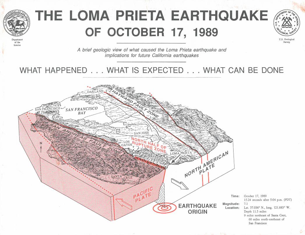
THE LOMA PRIETA EARTHQUAKEOF OCTOBER 17, 1989
A brief geologic view of what caused the Loma Prieta earthquake and implications for future California earthquakes
U.S. Geological Survey
WHAT HAPPENED . . . WHAT IS EXPECTED . . . WHAT CAN BE DONE
'--rSS^^I -;6AKLAND4:^V
SAN FRANCISCO ^.^ pRANCISCO
EARTHQUAKE ORIGIN
Time: October 17, 198915.24 seconds after 5:04 p.m. (PDT)
Magnitude: 7.1Location: Lat. 37.036° N., long. 121.883° W.
Depth 11.5 miles 9 miles northeast of Santa Cruz,
60 miles south-southeast of San Francisco

THE LOMA PRIETA EARTHQUAKE WAS EXPECTED.
The San Andreas fault, in California, is the primary boundary between the North American plate and the Pacific plate. Land west of the fault has been moving northwestward relative to land on the east at an average rate of 2 inches per year for millions of years. This motion is not constant but occurs typically in sudden jumps during large earthquakes. This motion is relentless; therefore earthquakes in California are inevitable.
A Look at the Earthquake
Surface cracksshowing direction
of movementSAN ANDREAS FAULT
Fault slip'at depth in
this earthquake
rupture
' Hypocenter
Changes in elevation and horizontal strain meas ured along the surface of the Earth after the Loma Prieta earthquake show that the Pacific plate moved 6.2 feet to the northwest and 4.3 feet upward over the North American plate. This motion was not observed along a single fault break at the surface but occurred in a complex series of cracks and fractures. The upward motion is related to deforma tion of the plate boundary at a bend in the San Andreas fault.
122°
37°
San Juan Bautistav,
Location of the Loma Prieta mainshock and aftershocks are shown in relation to the San Andreas fault. The distribution of the after shocks indicates that the fault slipped along a 25-mile segment from southwest of Los Gatos to north of San Juan Bautista. The size of the symbols is relative to the magnitude of the aftershock. Black lines show faults, dashed where inferred.
SOUTHWEST ^ NORTHEAST
A Surface of the earth B
V>uid 5
Q. LJ Q
10
5 10 15 DISTANCE, IN MILES
20
When the locations of the aftershocks are plotted on a vertical cross section oriented from southwest to northeast across the San Andreas fault, the fault is shown to dip 70 degrees to the southwest. The origin of the mainshock is the point where fault slip origi nated, from which it propagated upward and laterally both to the northwest and to the southeast.
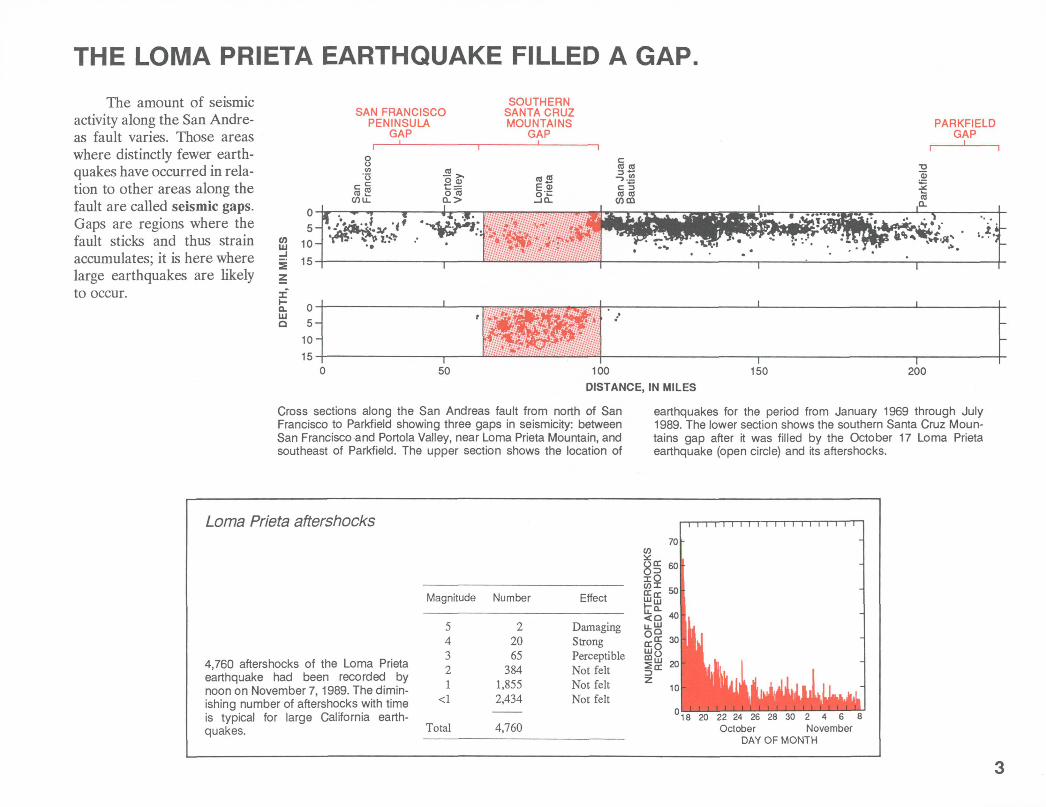
THE LOMA PRIETA EARTHQUAKE FILLED A GAP.
The amount of seismic activity along the San Andre- as fault varies. Those areas where distinctly fewer earth quakes have occurred in rela tion to other areas along the fault are called seismic gaps. Gaps are regions where the fault sticks and thus strain accumulates; it is here where large earthquakes are likely to occur.
05-
OT «/-,_ HI 1U
£ 15
SAN FRANCISCOPENINSULA
GAP
SOUTHERNSANTA CRUZMOUNTAINS
GAPPARKFIELD
GAP
8 S,-cra 2
OTLL
2® o"reQ->
-4r
««E.®O' 1-
CO CO
3|c=(0 (0
r- f =tT! ,-« i - .
PffWf^ljp^ife, '* !;
o-5-
10-15-
C
if
) 50 1C
1 1 "
K> 150 200
DISTANCE, IN MILES
Cross sections along the San Andreas fault from north of San Francisco to Parkfield showing three gaps in seismicity: between San Francisco and Portola Valley, near Loma Prieta Mountain, and southeast of Parkfield. The upper section shows the location of
earthquakes for the period from January 1969 through July 1989. The lower section shows the southern Santa Cruz Moun tains gap after it was filled by the October 17 Loma Prieta earthquake (open circle) and its aftershocks.
Loma Prieta aftershocks
4,760 aftershocks of the Loma Prieta earthquake had been recorded by noon on November 7,1989. The dimin ishing number of aftershocks with time is typical for large California earth quakes.
Magnitude Number
Total
22065
3841,8552,434
4,760
Effect
Damaging Strong Perceptible Not felt Not felt Not felt
'18 20 22 24 26 28 30 2 4 6 8 October November
DAY OF MONTH
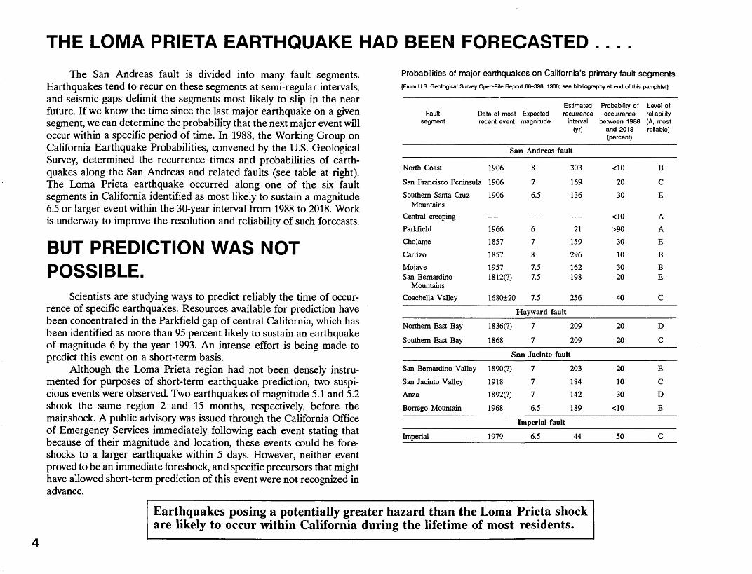
THE LOMA PRIETA EARTHQUAKE HAD BEEN FORECASTED .. . .
The San Andreas fault is divided into many fault segments. Earthquakes tend to recur on these segments at semi-regular intervals, and seismic gaps delimit the segments most likely to slip in the near future. If we know the time since the last major earthquake on a given segment, we can determine the probability that the next major event will occur within a specific period of time. In 1988, the Working Group on California Earthquake Probabilities, convened by the U.S. Geological Survey, determined the recurrence times and probabilities of earth quakes along the San Andreas and related faults (see table at right). The Loma Prieta earthquake occurred along one of the six fault segments in California identified as most likely to sustain a magnitude 6.5 or larger event within the 30-year interval from 1988 to 2018. Work is underway to improve the resolution and reliability of such forecasts.
BUT PREDICTION WAS NOT POSSIBLE.
Scientists are studying ways to predict reliably the time of occur rence of specific earthquakes. Resources available for prediction have been concentrated in the Parkfield gap of central California, which has been identified as more than 95 percent likely to sustain an earthquake of magnitude 6 by the year 1993. An intense effort is being made to predict this event on a short-term basis.
Although the Loma Prieta region had not been densely instru mented for purposes of short-term earthquake prediction, two suspi cious events were observed. Two earthquakes of magnitude 5.1 and 5.2 shook the same region 2 and 15 months, respectively, before the mainshock. A public advisory was issued through the California Office of Emergency Services immediately following each event stating that because of their magnitude and location, these events could be fore- shocks to a larger earthquake within 5 days. However, neither event proved to be an immediate foreshock, and specific precursors that might have allowed short-term prediction of this event were not recognized in advance.
Probabilities of major earthquakes on California's primary fault segments[From U.S. Geological Survey Open-File Report 88-398, 1988; see bibliography at end of this pamphlet]
Estimated Fault Date of most Expected recurrence
segment recent event magnitude interval(yO
San Andreas fault
North Coast 1906 8 303
San Francisco Peninsula 1906 7 169
Southern Santa Cruz 1906 6.5 136 Mountains
Central creeping -- -- --
Parkfield 1966 6 21
Cholame 1857 7 159
Carrizo 1857 8 296
Mojave 1957 7.5 162 San Bemardino 1812(?) 7.5 198
Mountains
Coachella Valley 1680±20 7.5 256
Hayward fault
Northern East Bay 1836(?) 7 209
Southern East Bay 1868 7 209
San Jacinto fault
San Bemardino Valley 1890(?) 7 203
San Jacinto Valley 1918 7 184
Anza 1892(?) 7 142
Borrego Mountain 1968 6.5 189
Imperial fault
Imperial 1979 6.5 44
Earthquakes posing a potentially greater hazard than the Loma Prieta shock are likely to occur within California during the lifetime of most residents.
Probability of occurrence
between 1988 and 2018 (percent)
<10
20
30
<10
>90
30
10
30 20
40
20
20
20
10
30
<10
50
Level of reliability (A, most reliable)
B
C
E
A
A
E
B
B E
C
D
C
E
C
D
B
C

OTHER LARGE EARTHQUAKES ARE EXPECTED IN CALIFORNIA.
An event of magnitude 7.5 or larger on the San Andreas fault, comparable in size to the great San Francisco earthquake of 1906 (magnitude 8.3), is more likely in southern California than in the northern part of the State. Such an event in the south could occur on the Carrizo, Mojave, San Bernardino Mountains, or Coachella Valley segments. The combined probability of an earthquake rupturing at least one of these segments in the next 30 years is 60 percent.
Events of magnitude 7 or larger, each with a probability of 20 to 30 percent within the next 30 years, are expected at six locations in southern California and three locations in northern California. The locations in northern California are the San Francisco Peninsula segment of the San Andreas fault and the northern and southern segments of the Hayward fault in the East Bay. A magnitude 7 shock on any one of these fault segments will probably cause considerably more damage than the recent Loma Prieta event because of their proximity to larger population centers.
Parkfield 6
Anza
Coachella Valley
Southern Santa Cruz
\ Mountains
6.5
SanBernardino
5 MountainsImperial
6.5
Epicenter of Loma Prieta earthquake
The probability of major earthquakes occurring between 1988 and 2018 is shown for segments of four major faults in California; these probabilities were determined 1 year before the Loma Prieta earthquake and are currently being reevaluated. The expected magnitude for an earthquake on each segment is shown above each box. The height
SANLUIS
OBISPO
of each box is proportional to the probability of the expected earthquake for that segment. The named segments of the faults are listed in the table on the facing page.
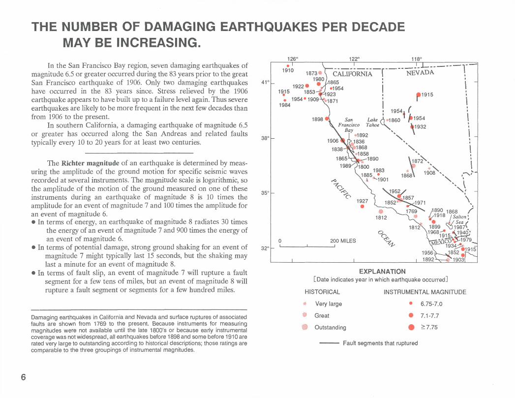
THE NUMBER OF DAMAGING EARTHQUAKES PER DECADE MAY BE INCREASING.
In the San Francisco Bay region, seven damaging earthquakes of magnitude 6.5 or greater occurred during the 83 years prior to the great San Francisco earthquake of 1906. Only two damaging earthquakes have occurred in the 83 years since. Stress relieved by the 1906 earthquake appears to have built up to a failure level again. Thus severe earthquakes are likely to be more frequent in the next few decades than from 1906 to the present.
In southern California, a damaging earthquake of magnitude 6.5 or greater has occurred along the San Andreas and related faults typically every 10 to 20 years for at least two centuries.
The Richter magnitude of an earthquake is determined by meas uring the amplitude of the ground motion for specific seismic waves recorded at several instruments. The magnitude scale is logarithmic, so the amplitude of the motion of the ground measured on one of these instruments during an earthquake of magnitude 8 is 10 times the amplitude for an event of magnitude 7 and 100 times the amplitude for an event of magnitude 6. In terms of energy, an earthquake of magnitude 8 radiates 30 times
the energy of an event of magnitude 7 and 900 times the energy of an event of magnitude 6.
In terms of potential damage, strong ground shaking for an event of magnitude 7 might typically last 15 seconds, but the shaking may last a minute for an event of magnitude 8.
In terms of fault slip, an event of magnitude 7 will rupture a fault segment for a few tens of miles, but an event of magnitude 8 will rupture a fault segment or segments for a few hundred miles.
Damaging earthquakes in California and Nevada and surface ruptures of associated faults are shown from 1769 to the present. Because instruments for measuring magnitudes were not available until the late 1800's or because early instrumental coverage was not widespread, all earthquakes before 1898 and some before 1910 are rated very large to outstanding according to historical descriptions; those ratings are comparable to the three groupings of instrumental magnitudes.
126° 122° 118°
41'
38°
35°
32C
1915
1Q10 \ "~ "" ~ ~ - - -
1873* \ CALIFORNIA 1980)
1922 V1 JSw 1853^ 9^54
^1954.1909^,
1954. f
San Lake A ^ 860 'rancisco Tahoe^\_ kl932
\ *1906 * rk -"""
1898
u^.
200 MILES
EXPLANATION[Date indicates year in which earthquake occurred]
HISTORICAL
® Very large
» Great
H Outstanding
INSTRUMENTAL MAGNITUDE
6.75-7.0
7.1-7.7
>7.75
Fault segments that ruptured

THE LOMA PRIETA EARTHQUAKE WAS ONE OF THE COSTLIEST NATURAL DISASTERS IN U.S. HISTORY.
This earthquake occurred in the remote Santa Cruz Mountains and caused severe damage in San Francisco and Oakland, 50 miles north of the end of the fault segment that slipped.
Deaths: 62 San Francisco Bay bridge unusable for 1 month
Injuries: 3,757 Number of homes damaged: 18,306
Damage: More than $6 billion Number of businesses damaged: 2,575
Persons displaced: 12,053
BUT . .. What will happen when an earthquake of similar magnitude occurs closer to these population centers?
An earthquake of magnitude 7.5 on the eastern Bay Area's Hayward fault (see cover), for example, is likely to be far more destructive than the Loma Prieta event. An Earthquake Planning Scenario developed by the California Division of Mines and Geology (see bibliography at back of this pamphlet) and An Assessment of the Consequences and Prepa rations for a Catastrophic California Earthquake by the Federal Emer gency Management Agency (see bibliography) anticipate the following effects:
Deaths: 1,500-4,500 Injuries: 45,000-135,000 Damage: More than $40 billion One or more hospitals will be destroyed All four bridges to the East Bay will probably
be closed for hours to days
Access to and travel within the East Bay will be difficult and limited to emergency traffic.
Only San Jose International Airport may be available for large aircraft.
The damage in San Francisco is likely to be severe the Embarcadero area is as close to the Hayward fault as it is to the San Andreas fault.

THE TYPES OF DAMAGE CAUSED BY THE LOMA PRIETA EARTHQUAKE WERE EXPECTED.
The primary damage from earthquakes results from ground shaking. Shaking generally decreases with distance from the fault segment that slips during the earthquake but can be locally amplified by sedimentary deposits or fill. Strong shaking of unstable soils can lead to permanent deformation of the ground surface that typically results in failure of foundations and major damage. Loosely compacted, water- saturated sediments, especially in landfills, can "liquefy" and lose their strength, causing major subsidence, fracturing and horizontal sliding of the ground surface. On steep slopes, landslides are common. In fault zones, shifting of the ground may distort and tear apart structures.
Recordings of a magnitude 5.0 aftershock of the Loma Prieta earthquake illustrate intense local amplification of ground shaking in the Marina district of San Francisco.
GROUND ISPLACEMENT
IN INCHES
+0.02
0
-0.02(
BEDROCK
\/«v
i i) 10 20 a
TIME, IN SECONDS
The major damage in the Marina district (see map at right) was caused by locally amplified shaking and by permanent deformation of the ground due to liquefaction of the sands and debris used to fill the former lagoon for the 1915 Panama-Pacific International Exposition. During the 1906 earthquake, locally violent ground shaking was expe rienced along the margins of the lagoon. Similar shaking was expected to recur during subsequent large earthquakes. The potential for lique faction in the Marina was indicated on maps adopted by the city in 1974.
The parts of the Cypress Street freeway structure (see map at right) that collapsed in Oakland are located in a region where seismic shaking was expected to be greater than to the south, where the elevated freeway did not collapse.
The Pacific Garden shopping mall in Santa Cruz was damaged severely by amplified ground shaking and ground deformation. The mall lies on river deposits that shook excessively and liquefied in the 1906 shock.
Landslides triggered by the mainshock occurred in those regions previously mapped as most landslide prone and commonly along slopes cut for roads or development.
. LUC/J +0.02
-0,2
A^A^l/\jy|^10 20
TIME, IN SECONDS30
The amplitude and duration of shaking was several times greater on filled land than on nearby bedrock. The motion during the mainshock is estimated to have been about 100 times greater at each site. Little damage occurred on bedrock, but damage on filled land was severe.
8
The greatest loss of life and damage to prop erty during the Loma Prieta earthquake oc curred in areas where geologic hazards had been clearly identified and mapped as early as 15 years ago.

THE AREAS MOST LIKELY TO BE DAMAGED HAD BEEN IDENTIFIED.37° 122°30' 122°15'
BERKELEY; B
Cypress structure
Marina district
SEAL ROCKS STA|TE \ "° . , Point
MAXIMUM PREDICTED EARTHQUAKE SHAKING
' dashed line) and Hayward fault (heavy solid line). Areas marked A apply to an earthquake on the Hayward fault but not to the more distant Loma Prieta earthquake. Damage will be influenced not only by shaking but also by ground failure and the design and construction quality of structures.
Much of the potential for damage from such earthquakes as the Loma Prieta event had been mapped as early as 1975, the release date of the map (U.S. Geological Survey Miscellaneous Field Studies Map MF-709) from which this illustration was
taken. This map and other similar maps are available for review (see bibliography at the back of this pamphlet).

EARTHQUAKE HAZARDS CAN BE REDUCED.
Deaths, injuries, property damage, and socio-economic disruption can be greatly reduced through careful consideration of earthquake- hazards information when making decisions regarding land use, struc ture design, and building construction.
Although there is still much to learn, techniques already exist to:
1. Identify which fault segments are most likely to produce large earthquakes.
2. Estimate the probability of a damaging earthquake occurring on a given fault segment over a 30-year period.
3. Map the expected level of shaking, allowing for amplification effects of the local geology.
4. Predict the severity and duration of shaking at specific building sites for a postulated earthquake.
5. Identify the localities where ground is likely to fail through faulting, liquefaction, or landsliding.
6. Identify existing structures that are likely to collapse in a large earthquake.
7. Pinpoint weak links in our transportation network and distribution lines for water, gas, electricity, telephone, and sewer.
Preliminary information on potential hazards has been compiled at various scales by scientists working for Federal, State, and local governments, regional associations, educational institutions, and private companies. Such information has been widely distributed among spe cialists in California. This information has been used for preparing and implementing emergency response plans and regional, local, and site- specific development plans. Some examples are described in the bibliography at the end of this pamphlet.
Although techniques exist and have been used effectively to identify earthquake hazards, detailed studies have been carried out in only a few sample areas. Considerable work is required to focus on the most severe hazards. Research is also underway to try to refine forecasts of the occurrence and effects of future damaging earthquakes.
Once earthquake hazards have been identified, they can be mitigated through existing techniques for regional planning and struc tural engineering. Taking action to reduce earthquake hazards involves setting financial priorities. Sufficient information exists to face such difficult decisions now. Through continued research, more detailed information may become available in the future to help local leaders focus more clearly on the most effective and economic courses of action.
The Loma Prieta earthquake was one of the largest shocks to occur in the United States during recent decades. Although there were no major surprises, this event has presented numerous questions for which answers are not yet available. Research underway will produce a wealth of new and valuable detail for improving our understanding of earthquakes and for mitigating earthquake hazards.
10
WHAT CAN YOU DO?
Although the Loma Prieta earthquake killed 62 people, an earth quake of the same magnitude in Soviet Armenia during December 1988 killed 25,000 people. Clearly, we have made major advances in the United States in reducing the loss of life and the damage from earthquakes. Informed regional planning, strictly enforced current building codes, strengthening existing structures, and effective emer gency preparedness are the proven cornerstones for an earthquake- hazard-reduction program. We now know enough about earthquakes and their effects that we can delineate and weigh the hazards, deciding what action is most appropriate.
One way to approach earthquake hazards is to ignore them. Following 1906, the people of San Francisco were eager to prove to the world that earthquakes were not a long-term problem for them. A lagoon located in an area that had shaken particularly violently during the earthquake was filled in with sand and the rubble of destroyed buildings to make a fairground to celebrate the recovery from the disaster. This fairground later became the Marina district. Ignoring the lessons from 1906 left our generation with a major problem: expensive real-estate development in the Marina district was heavily damaged, people were killed, and San Franciscans are now faced with a difficult financial, social, and political problem in deciding how this region should be rebuilt.
Earthquake risk is not uniform throughout any one State, county, town, or even district. The risk at each location depends primarily on the distance from and the size of potential earthquakes, the ground conditions, and the age and construction type of any structures. Damage usually decreases rapidly with distance from the earthquake but increas es on soft ground. It can be catastrophic when the ground subsides, shifts, tilts, or fractures from liquefaction, landsliding, or faulting. Structures not properly engineered for horizontal shaking during earth quakes, particularly older structures, are most hazardous.
Informed land-use planning and zoning require that hazards in each region be identified. Critical facilities such as schools and hospitals can then be built in safe regions. Potentially hazardous facilities such as powerplants, dams, fuel depots, and chemical plants can also be located in safe regions. The most hazardous areas might be dedicated to low-occupancy uses, such as parks, farmland, or low-density housing all with special considerations to deal with potential shaking or ground failure. In California, many of these issues are addressed in the "Seismic
Safety Element" which is part of a city or county General Plan. Residents may consult their planning department to see if this plan is up-to-date and adhered to in zoning and development. The technical information in the "Seismic Safety Element" should allow citizens to determine the hazards at any specific location in their county and provide a basis for prudent decisions on land use and construction practice.
Earthquake hazards, because they are so pervasive, cannot be avoided entirely by selective land use. All structures and facilities must be designed to resist some level of shaking. Furthermore, extended facilities, such as pipelines, powerlines, and transportation corridors, often must cross regions of known high hazard. Thus, effective building codes and design codes are essential. Such codes must be regularly revised to incorporate new knowledge about earthquakes and the seismic behavior of structures as well as new design principles and construction trends.
The most difficult issues in reducing earthquake hazards involve existing structures that are subject to collapse and life loss, either because of their location or because of their design. Tens of thousands of these buildings, particularly unreinforced masonry structures, have been identified in California. Reinforcing may be appropriate in some cases. In others, rebuilding may be the only economical solution. In time, these buildings will all be replaced through normal development, but what if the earthquake comes first?
Reducing earthquake hazards involves setting economic priorities. A dollar spent now may save many in the future, but the choice between allocating funds to avert a potential hazard or filling more immediate demands will be difficult. Scientists are working on ways to forecast the occurrence and effects of future earthquakes with increasing precision to aid communities in setting priorities. But in the meantime, tech niques exist to identify the greatest hazards and to reduce them.
Citizens concerned about the safety of their homes, schools, workplaces, and communities should contact city and county planners and engineers, elected officials, geological and engineering consultants, and earth scien tists to be sure that relevant geologic hazard information is being considered for both personal and community decisions regarding acceptable levels of earthquake risk.
11
12
SOME SOURCES FOR INFORMATION IN CALIFORNIAThe Community Access Pages of Your Local Telephone Book
Your Local Realtor in many counties has maps showing zones susceptible to faulting and flooding
Your Community Library
Your County or City Planning Office
Earth Science Department of local colleges or universities
BAREPP, Bay Area Regional Earthquake Preparedness Project, MetroCenter, 101 8th Street, Suite 152, Oakland, California 94607, (415) 540-2713. Publications, videotapes, scripted slide shows, and lecturers on earthquake preparedness.
SCEPP, Southern California Earthquake Preparedness Project, 6850 Van Nuys Boulevard, Suite 110, Van Nuys, California 91405^660, (213) 787-5103. Publications, videotapes, scripted slide shows, and lecturers on earthquake preparedness.
ABAG, Association of Bay Area Governments, MetroCenter, 101 8th Street, Suite 152, Oakland, California 94604-2050, (415) 464-7900.Maps that show ground-shaking probabilities, technical assistance in planning, publications on preparedness, and training courses for businesses.
Earth Science Information Centers, U.S. Geological Survey,Los Angeles, California 90012, 7638 Federal Building, 300 North Los Angeles Street, (213)894-2850.
Menlo Park, California 94025, 345 Middlefield Road, (415) 329-4390.
San Francisco, California 94111, 555 Battery Street, Room 504 Custom House, (415)705-1010.
U.S. Geological Survey Earthquake Hotline, updated daily, (415) 329-4025.
FEMA, Federal Emergency Management Agency, Building 105, The Presidio, San Francisco, California 94129, (415) 923-7100. Pamphlets on how to prepare for an earthquake and what to expect.
California Department of Conservation, Division of Mines and Geology, P.O. Box 2980, Sacramento, California 95812-2980, (916) 445-5716; also, 380 Civic Drive, Pleasant Hill, California 94523, (415) 646-5920.Earthquake Planning Scenarios, maps, and other publications. Monthly publication California Geology describes earth science issues for non-specialists.
California Office of Emergency Services, 2800 Meadowview Road, Sacramento, Cali fornia, (916) 427-4990.
California Seismic Safety Commission, 1900 K Street, Suite 100, Sacramento, California 95814-4186, (916)356-6329.
Earthquake Engineering
EERI, Earthquake Engineering Research Institute, 6431 Fairmount Avenue, Suite 7, El Cerrito, California 94530-3624, (415) 525-3668.
Applied Technology Council, 3 Twin Dolphin Drive, Redwood City, California 94065
NISEE, Earthquake Engineering Research Center, University of California Berkeley, 1301 South 46th Street, Richmond, California 94804, (415) 231-9554.
NISEE, Earthquake Engineering Research Laboratory, California Institute of Technol ogy, Mail Code 104-44, 1201 East California Boulevard, Pasadena, California 91125, (818)356-6329.
John A. Blume Earthquake Engineering Center, Department of Civil Engineering, Stanford University, Stanford, California 94305, (415) 723-3415
FURTHER READING[Portions of the references and comments were extracted from the Newsletter of the Earthquake Engineering Research Institute, volume 23, number 9, September 1989.]
GeneralEarthquakes, by Bruce Bolt, W.H. Freeman, New York, 282 pages, 1988.
A primer on earthquakes, their causes, measurement, precursors, and effects, written by a leading researcher and teacher at University of California, Berkeley.
Earthquakes, by Don DeNevi, Celestial Arts, Millbrae, California, 230 pages, 1977.An overview of historical earthquakes, earthquake-hazard reduction, and earthquake predic tion.
Earthquakes, by Bryce Walker, Time-Life Books, Alexandria, Virginia, 176 pages, 1982.A superbly illustrated book on earthquakes and man's efforts to understand them and mitigate their hazards.
Earthquakes and volcanoes, A bimonthly publication of the United States Geological Survey available yearly for $6.50 from the Superintendent of Documents, U.S. Government Printing Office, Washington, D.C. 20402, or by credit card at 202-783- 3238. For a sample copy, write to Earthquakes and Volcanoes, USGS, 904 D National Center, Reston, VA 22092.This magazine provides short articles and many illustrations for non-scientists on different aspects of research on earthquakes and volcanoes.
Earthquakes and volcanoes, Readings from Scientific American, W.H. Freeman and Company, San Francisco, California, 154 pages, 1980.Eleven articles on earthquake properties, earthquakes and earth structure, and volcanoes.
Earthquake country, by Robert lacopi, A Sunset Book, Lane Books, Menlo Park, California, 160 pages, 1971. An explanation as to why California has earthquakes and a guide to faults in California.
Elementary seismology, by Charles F. Richter, W.H. Freeman and Company, San Francisco, California, 768 pages, 1958. The classic text book on seismology with excellent descriptions of historic earthquakes.
On shaky ground: America's earthquake alert, by John J. Nance, Avon Books, New York, 440 pages, 1989.A current review of earthquakes and earthquake hazards.
Predicting the next great earthquake in California, by R.L. Wesson and R.E. Wallace, Scientific American, v. 252, no. 2, p.35-^3, 1985.An introduction to earthquake prediction.
Probabilities of large earthquakes occurring in California on the San Andreas fault, bythe Working Group on California Earthquake Probabilities, U.S. Geological Survey Open-File Report 88-398, 62 pages, 1988.
Terra non firma, by J.M. Gere and H.C. Shah, W.H. Freeman, New York, 203 pages, 1984.
Personal PreparednessGetting ready for a big quake, Special Report, Sunset Magazine, March, p. 104-111,
1982.What to check around your house for earthquake safety and to make it more earthquake resistant.
Peace of mind in earthquake country, by Peter Yanev, Chronicle Books, San Francisco, California, 304 pages, 1974.Describes earthquake hazards and practical steps to take before, during, and after earth quakes.
Reducing the risks of nonstructural earthquake damage: A practical guide, by Robert Reitherman, Federal Emergency Management Agency, Earthquake Hazards Re duction Series 1, FEMA 74, 87 pages, 1985.
Overview and Issues for Regional PlanningSeismic hazards and land-use planning, by D.R. Nichols and J.M. Buchanan-Banks,
U.S. Geological Survey Circular 690, 33 pages, 1974.A necessary introduction to earthquake hazards surface fault rupture, ground shaking, liquefaction, landsliding, tectonic subsidence, tsunamis, and seiches. It also includes their implications for land-use planning and implementation. Illustrations of damage, ground effects, fault types and displacements, and development in a fault hazard zone are provided.
Earthquake hazards reduction issues for an implementation plan, Executive Office of the President, U.S. Office of Science and Technology Policy, Washington, D.C., 231 pages, 1978.This unique national plan for reducing earthquake hazards by both public agencies and private organizations is still relevant today. Thirty-seven problems are discussed, including four related to planning: lack of adequate information, lack of understanding, failure to use information, lack of program coordination, and lack of training or experience. Specific actions to correct each problem are recommended.
Geologic principles for prudent land use: A decisionmaker's guide for the San Francisco Bay region, by R.D. Brown, Jr., and WJ. Kockelman, U.S. Geological Survey Professional Paper 946, 97 pages, 1983.This report is written for those who decide how land is to be used: Elected and appointed officials, corporate executives, and those individuals who own or develop land. Its purpose is to remind these people of the intimate relation between geology and land use, and to inform them so that they are better equipped to ask the right questions, to address such questions to those best qualified to answer, and to demand responsive answers that are based on valid technical and scientific evidence.
Geology for decisionmakers Protecting life, property, and resources, by R.D. Brown, Jr., and W.J. Kockelman, Berkeley, Regents of the University of California, Bulletin of the Institute of Governmental Studies, Public Affairs Report, v. 26, no. 1, 11 pages, 1985.Briefly shows how several types of geologic information were used by decisionmakers to affect: an entire state, a nine-county metropolitan area, a bay and shoreline resource protection district, a 1,312-square-mile county, a city of 55,000 people, and individual lots and acreages offered for sale. Practical guidelines, factors outside the control of the decisionmaker, and recommendations to local decisionmakers are provided.
Seismic Zonation
Seismic safety and land-use planning Selected examples from California, by M. L.Blair and W.E. Spangle, U.S. Geological Survey Professional Paper 941-B, 82 pages, 1979.This report was the first to demonstrate how information on seismic hazards can be used effectively for land-use planning and decisionmaking to reduce seismic risk. It demonstrates a method for evaluating seismic risk postulating an earthquake, predicting its effects on the ground, combining the various effects by zone on a map, and then overlaying land use and building occupancy to assess vulnerability and risk.
Planning information for earthquake hazard response and reduction, by Christopher Arnold and R.K. Eisner, San Mateo, California, Building Systems Development, Inc., 79 pages 1984.The authors carefully focus on the information necessary for a city to plan against earthquake disasters. Eleven maps of model planning data including land use, seismically "suspicious" buildings, hazardous materials, and fire potential are presented. The use, dissemination, maintenance, source, and analysis of each map are included.
Reducing earthquake risks A planner's guide, by Martin Jaffe, JoAnn Butler and Charles Thurow, American Planning Association, Chicago, Planning Advisory Service Report 364, 82 pages, 1981.A comprehensive report that illustrates hazard mapping and examines seismic safety programs to be considered by local planners. It sets out a means of reviewing environmental and geological information to assess earthquake hazards, reviews ways to assess earthquake risks, and examines seismic safety options. It discusses regulations that can be used to guide growth away from hazard areas and to meet the problems of existing unsafe buildings.
Examples of seismic zonation in the San Francisco Bay region, by W.J. Kockelman and E.E. Brabb, U.S. Geological Survey Circular 807, p. 73-84, 1979.
13
14
A succinct paper presenting six examples of how seismic zones at various scales have been used by cities and counties to show areas of relative seismic concern, encourage lower intensity of use, recommend hazard abatement, require engineering geology reports, overlay lifelines, amend the general plan, and reduce residential densities according to the type of hazard.
The San Francisco Bay area On shaky ground, by J.B. Perkins, Association of Bay Area Governments, Oakland, California, 32 pages, 1987.Innovative maps showing the expected severity of ground shaking from 30 earthquakes are generated and composited into a maximum ground-shaking intensity map. A computer-based geographic information system was used. This information is then applied to three building types tilt-up concrete, concrete-and-frame, and wood-frame dwellings to form damage "risk" maps. Mitigation strategies for local government are discussed.
Seismic Safety Planning
Disaster planning The preservation of life and property, by H.D. Foster, Springer- Verlag, New York, 275 pages, 1980.A perceptive discussion of the numerous planning factors necessary to reduce disasters. Foster observes that many communities tend to ignore the risk to life and property posed by hazards natural and technological. The book was written to encourage more local authori ties, institutions, and organizations to accept their responsibilities to encourage safety through comprehensive risk management.
Land use planning after earthquakes, by G.G. Mader, W.E. Spangle, M.L. Blair, R.L. Meehan, S.W. Bilodeau, H.J. Degenkolb, G.S. Duggar, and Norman Williams, Jr., William Spangle and Associates, Inc., Portola Valley, California, 158 pages, 1980.A seminal study dealing with those aspects of reconstruction involving land-use planning. Possible responses include changes in land-use plans and regulations, changes in land use or occupancy, relocation of facilities, redevelopment, and land acquisition. A major effort was made to identify situations in which a land-use response is appropriate. Case studies after three recent U.S. earthquakes are included.
Planning for risk Comprehensive planning for tsunami hazard areas, by Jane Preuss, Urban Regional Research, Seattle, Wash., 246 pages, 1988.A thorough and illustrative look at the effects and reduction of one of the earthquake hazards seismic sea waves. The historical nature of damage (and its reasons) in five communities are analyzed. A planning process consisting of three components risk assess ment, risk reduction measures, and risk management is developed. Examples of hazard assessment are presented for Kodiak, Alaska, and Lazaro Cardenas/Zihuatanejo, Mexico.
Pre-earthquake planning for post-earthquake rebuilding, edited by W.E. Spangle, R.L. Meehan, H.J. Degenkolb, and M.L. Blair, Southern California Earthquake Pre paredness Project, Los Angeles, 96 pages, 1987.An interdisciplinary team addresses the feasibility and nature of pre-earthquake planning for post-earthquake rebuilding (PEPPER). Estimates are made of severity of ground shaking, probable ground failure, and probable extent of damage to 700,000 private buildings from each of four scenario earthquakes. A model earthquake recovery program and model ordinance establishing a rebuilding and recovery organization are appended.
Plan Implementation
California at risk Steps to earthquake safety for local government, by G.G. Mader and Martha Blair-Tyler, California Seismic Safety Commission Report SSC 88-01, 56 pages, 1988.Thirty actions that local governments can take to improve seismic safety are described; many of them are drawn from innovative efforts already undertaken. Each action is divided into steps; sources of additional information are given. A brief but comprehensive checklist provides a format for assessing local preparedness. Suggestions for selecting actions and combining them into a multiyear earthquake-safety program are provided.
Using earth-science information for earthquake hazard reduction, by W.J. Kockelman, in Evaluating earthquake hazards in the Los Angeles region an earth-science perspective, edited by J.I. Ziony, U.S. Geological Survey Professional Paper 1360, p. 443-469, 502-505, 1985.Five examples are used to illustrate the range of use of scientific information by planners to reduce hazards: anticipating damage to critical facilities, adapting seismic safety plans, retrofitting highway bridges, regulating development, and strengthening or removing unsafe masonry buildings. Each example includes a summary of the problem, information used, action taken, and brief comments on its impact.
Land use planning for earthquake hazard mitigation A handbook for planners, by P.A. Bolton, S.G. Heikkala, M.R. Greene, P.J. May, and M.R. Wolfe, University of Colorado, Natural Hazards Applications Information Center Special Publication 14, 121 pages, 1986.Skillfully provides a framework for assessing the effectiveness of various land-use planning techniques and for determining the appropriateness of the techniques. The essential steps that a local government needs to take to plan and to implement plans are identified. The handbook enables a community to compare land-use planning techniques in terms of their applicability, costs, and effectiveness in reducing potential losses.
Putting seismic safety policies to work, by Martha Blair-Tyler and P.A. Gregory, Bay Area Regional Earthquake Preparedness Project, Oakland, California, 40 pages, 1988.A handy booklet telling how to move from policies to actions that reduce seismic risk. It describes some measures that can be taken to address many of the issues pertaining to seismic safety. The issues focus on the physical development of a community. The objective is to define those things that a local official can do before the earthquake strikes. Each issue is accompanied by examples of implementation actions taken by local governments.
Evaluating EffectivenessReassessing earthquake hazard reduction measures, by P.J. May and P.A. Bolton,
American Planning Association Journal, v. 52, no. 4, p. 443 451, 1986.Begins with a brief review of the various earthquake hazard reduction measures that planners and other specialists have suggested. Potential difficulties in implementing such measures as they are reflected in experiences to date are introduced. The authors discuss and illustrate ways to assess the potential for successful implementation and how they can be used in evaluating the effectiveness of reduction strategies.
Seismic safety at the local level Does planning make a difference?, by J.L. Mintier and P.A. Stromberg, California Division of Mines and Geology, California Geology, v. 36, no. 7, p. 148-154, 1983.
A rare follow-up examination of the effectiveness of a state mandate for local seismic safety planning. The reader can learn if the seismic safety element has been a useful and effective tool for planning, whether it has made a difference in the attitudes of planners and elected officials, and how successful cities and counties have been in carrying out the policies adopted under their seismic safety elements.
Skopje, Yugoslavia Seismic concerns and land use issues during the first twenty years of reconstruction following a devastating earthquake, by M.R. Greene, Earthquake Engineering Research Institute, Earthquake Spectra, v. 3, no. 1, p. 103-117, 1987.This paper reports on a study of a 20-year reconstruction. The city suffered a catastrophic earthquake in 1963 and then incorporated seismic concerns explicitly in its reconstruction and long-range planning process. Long-term reconstruction is difficult and costly. Despite this, Skopje officials have been able to make seismic safety a concern that has stayed in the forefront in making land-use and development decisions.
The politics and economics of earthquake hazard mitigation, by D J. Alesch and W J. Petak, University of Colorado, Institute of Behavioral Science, Program on Envi ronment and Behavior Monograph 43, 273 pages, 1986.This perceptive monograph includes a summary of the processes involved in developing and enacting hazard mitigation policies for unreinforced masonry buildings. It includes a comparative analysis of three case studies and the political processes involved. Twelve propositions dealing with organizational and political decisionmaking are provided.
Earthquakes and StructuresRapid visual screening of buildings for potential seismic hazards: A handbook, Federal
Emergency Management Agency, FEMA-154, 185 pages, 1988.A practical method developed by the Applied Technology Council to identify buildings likely to be hazardous during an earthquake.
Damage Estimates
An assessment of the consequences and preparations for a catastrophic California earthquake: Findings and actions taken, report of an ad hoc committee for the National Security Council, Federal Emergency Management Agency, M & R-2, January 1981.
San Francisco: Earthquake planning scenario for a magnitude 7.5 earthquake on the Hayward fault in the San Francisco Bay area, California Department of Conser vation, Division of Mines and Geology, Special Publication 78, 260 pages, 1987.
San Francisco: Earthquake planning scenario for a magnitude 8.3 earthquake on the San Andreas fault in the San Francisco Bay area, California Department of Conservation, Division of Mines and Geology, Special Publication 61, 160 pages, 1982.
San Francisco: A study of earthquake losses in the San Francisco Bay area, National Oceanic and Atmospheric Administration, U.S. Government Printing Office: 1973 O-501-299, 220 pages, 1972.
Los Angeles: Planning scenario for a magnitude 8.3 earthquake on the San Andreas fault in southern California, California Department of Conservation, Division of Mines and Geology, Special Publication 60, 128 pages, 1982.
Los Angeles: Planning scenario for a major earthquake on the Newport-Inglewood fault zone, California Department of Conservation, Division of Mines and Geology, Special Publication 99, 213 pages, 1988.
Los Angeles: A study of earthquake losses in the Los Angeles, California, area, National Oceanic and Atmospheric Administration, U.S. Government Printing Office: 0319-00026, 331 pages, 1972.
Puget Sound: A study of earthquake losses in the Puget Sound, Washington, area, U.S. Geological Survey Open-File Report 75-375, 298 pages, 1975.
Salt Lake City: A study of earthquake losses in the Salt Lake City, Utah, area, U.S. Geological Survey Open-File Report 76-89, 357 pages, 1976.
Maps
Maps showing maximum earthquake intensity predicted in the southern San Francisco Bay region, California, for large earthquakes on the San Andreas and Hayward faults, by R.D. Borcherdt, J.F. Gibbs, and K.R. Lajoie, U.S. Geological Survey Miscellaneous Field Studies Map MF-709, 1975.
The following five maps for San Mateo County are prototypes of the kind of detailed work that is now possible and could be carried out by State, county, or local workers or consultants.
Map showing slope stability during earthquakes in San Mateo County, California, by G.F. Wieczorek, R.C. Wilson, and E.L. Harp, U.S. Geological Survey Miscellaneous Investigations Series Map I-1257-E, 1985.
Map showing faults and earthquake epicenters in San Mateo County, California, by E.A. Brabb and J.A. Olsen, U.S. Geological Survey Miscellaneous Investigations Series Map I-1257-F, 1986.
Map showing liquefaction susceptibility of San Mateo County, California, by T.L. Youd and J.B. Perkins, U.S. Geological Survey Miscellaneous Investigations Series Map I-1257-G, 1987.
Map showing predicted seismic-shaking intensities of an earthquake in San Mateo County, California, comparable in magnitude to the 1906 San Francisco earth quake, by J.M. Thomson and J.F. Evernden, U.S. Geological Survey Miscellaneous Investigations Series Map I-1257-H, 1986.
Maps showing cumulative damage potential from earthquake ground shaking, San Mateo County, California, by J.B. Perkins, U.S. Geological Survey Miscellaneous Investigations Series Map I-1257-I, 1987.
Geology and active faults in the San Francisco Bay area, Point Reyes National Seashore Association, Point Reyes, California 94956, (415) 663-1155.An eye-catching map of Bay Area geology emphasizing the effects of geology on ground shaking during an earthquake.
Seismicity Map of California, 1808-1987, 1:1,000,000 scale, U.S. Geological Survey Open-File Report 88-286, available from National Earthquake Information Center, U.S. Geological Survey, 1711 Illinois Avenue, Golden, Colorado 80401.
15
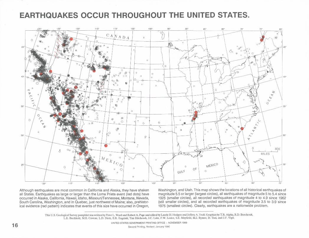
EARTHQUAKES OCCUR THROUGHOUT THE UNITED STATES.
Although earthquakes are most common in California and Alaska, they have shaken all States. Earthquakes as large or larger than the Loma Prieta event (red dots) have occurred in Alaska, California, Hawaii, Idaho, Missouri/Tennessee, Montana, Nevada, South Carolina, Washington, and in Quebec, just northwest of Maine; also, prehistor- ical evidence (red pattern) indicates that events of this size have occurred in Oregon,
Washington, and Utah. This map shows the locations of all historical earthquakes of magnitude 5.5 or larger (largest circles), all earthquakes of magnitude 5 to 5.4 since 1925 (smaller circles), all recorded earthquakes of magnitude 4 to 4.9 since 1962 (still smaller circles), and all recorded earthquakes of magnitude 3.5 to 3.9 since 1975 (smallest circles). Clearly, earthquakes are a nationwide problem.
16
This U.S. Geological Survey pamphlet was written by Peter L. Ward and Robert A. Page and edited by Laurie D. Hodgen and Jeffrey A. Troll. Graphics by T.R. Alpha, R.D. BorcherdI, L.E. Buchholz, M.E. Coveau, L.D. Dietz, E.R. Engdahl, Tim Hitchcock, J.C. Lahr, F.W. Lester, S.E. Mayfield, MJ. Rymer, D. Tsoi, and J.F. Vigil.
UNITED STATES GOVERNMENT PRINTING OFFICE : NOVEMBER 1989
Second Printing, Revised: January 1990