envi 5 & e3de - alphagis | gis · envi 5 & e3de the next generation of image analysis the...
TRANSCRIPT

ENVI 5 & E3De
The Next Generation of Image Analysis
The information contained in this document pertains to software products and
services that are subject to the controls of the Export Administration Regulations
(EAR). The recipient is responsible for ensuring compliance to all applicable U.S.
Export Control laws and regulations.


> Diversified, top-tier global aerospace, defense and information solutions company
with strong positions in enduring and emerging global markets
> Imaging system for next-generation, high-resolution GeoEye-2 satellite
> GammaCam imaging systems to the Japan Ground Self Defense Force


Exelis VIS & ESRI – Strategic Partnership
GIS Lives in this World Imagery Lives in this World
Integrating Mapping and Imagery
Applications for Improved Decision
Making

Today’s global trends are driving the need for more information and data regarding our surrounding world.
> Climate Change
> Population Growth
> Disaster Management
> Scarce Resources
The Growing Need for Geospatial Information
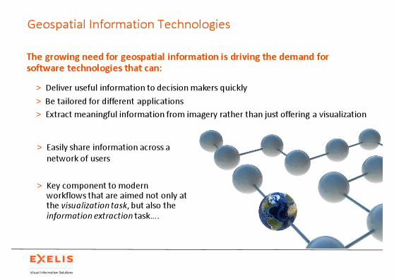
The growing need for geospatial information is driving the demand for software technologies that can:
> Deliver useful information to decision makers quickly
> Be tailored for different applications
> Extract meaningful information from imagery rather than just offering a visualization
Geospatial Information Technologies
> Easily share information across a
network of users
> Key component to modern workflows that are aimed not only at the visualization task, but also the information extraction task….

Multisource Fusion for Multidimensional Analysis
Future Visualization Technologies
> More applications demand the use of
multiple data modalities
> Combining and exploiting multisource
data sets simultaneously will be the new
norm
> Integration of Radar, LiDAR, Optical,
Hyperspectral, Stereo, Thermal and more
is driving how applications consume and
process data
> These modalities will be combined to
create an even richer geospatial context
for decision making

Imagery Is At the Heart of Geospatial Analysis
Imagery is essential for
enabling people to
understand the world.
Imagery is not just a
base map, but a layer
of rich information.
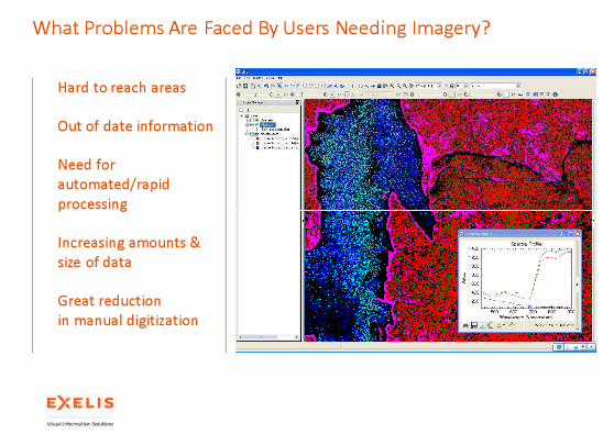
What Problems Are Faced By Users Needing Imagery?
Hard to reach areas
Out of date information
Need for
automated/rapid
processing
Increasing amounts &
size of data
Great reduction
in manual digitization

How Does Imagery Solve Those Problems?
Project Results
> Up to date information
> Automated and faster processing
> Obtain actionable intelligence to make informed
decisions
> More efficient workflow to achieve results
Analysis Results
> Land Cover Analysis
> Change Detection
> Material Identification
> Object Based Analysis/Feature Extraction
> Detect Anomalies
> And many more

ENVI – The Image Processing Solution for Geospatial Data
Extensive > Full end to end solution for data visualization, analysis,
and dissemination.
> The ENVI product family streamlines your image analysis workflows.
Flexible> ENVI’s tight integration with ArcGIS also allows you
export results as map products, using ArcGIS map templates.
> ENVI is built on a powerful development language, IDL, allowing its features and functionality to be easily extended or customized.
Decisive> Image processing and analysis tools based on proven
scientific methods to support image exploitation workflows.
> Advanced tools such as detecting targets, calculating vegetation and forest health, and mapping materials of interest.

ENVI 5.0 – Key Themes…
1. Ability to Handle Large Datasets
> High-speed data display performance
> Optimized to take advantage of modern hardware
2. Intuitive User Interface
> Common (ELT) UI and controls that is easy to learn and
utilize
3. Interoperability with Other Software
> Interoperability with ArcGIS and other applications
> Connections to external software capabilities
4. Rich Set of Analysis Tools
> Support existing and add new functionality
5. Extensibility & Automated Execution
> Customize the software application
> Execute in a headless automated fashion

> High speed display
> Overview Window

ENVI 5.0 – Multi-View
> New linked Multi-view
Display capability

>Multi-view Display
with up to 4 windows
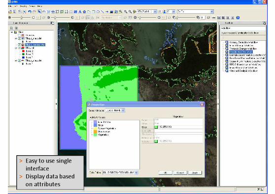
> Easy to use single
interface
> Display data based
on attributes

Ls
> Searchable toolbar
> Rich set of processing
tools in ENVI Toolbox
> Preview window with
fully interactive graphics
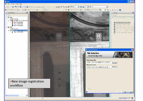
>New image registration
workflow

> Enhanced Object based
Feature Extraction wizard
workflows
> New segmentation and
merge algorithms
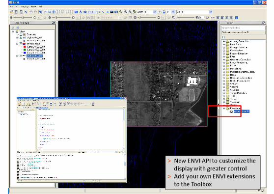
> New ENVI API to customize the
display with greater control
> Add your own ENVI extensions
to the Toolbox

E3De

> Comprehensive LiDAR analysis
> Flexible data ingest
> Photorealistic visualizations
> Automatic feature extraction
> Robust quality assessment tools
> Portable data export
> Intuitive and user-friendly interface
> Multithreaded processing
Key Features
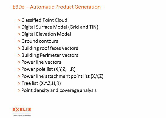
E3De – Automatic Product Generation
> Classified Point Cloud
> Digital Surface Model (Grid and TIN)
> Digital Elevation Model
> Ground contours
> Building roof faces vectors
> Building Perimeter vectors
> Power line vectors
> Power pole list (X,Y,Z,H,R)
> Power line attachment point list (X,Y,Z)
> Tree list (X,Y,Z,H,R)
> Point density and coverage analysis

E3De Workflow
Prepare
> Import LAS / NITF / BIN / ASCII LiDAR datasets
> View LAS/NITF Headers
Process
> Visually – flythrough point clouds
> Interactively – update classification codes
> Automated – parameter driven product/feature creation
Refine
> Innovative QA/QC tools for perfecting automated processing results
Export
> Topographic products, auto-generated features and updated LiDAR point clouds
> Direct link to ENVI

E3De – LiDAR Point Cloud Visualization
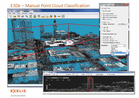
E3De – Manual Point Cloud Classification

E3De – Cross Section Toolset

E3De – Automatic Point Classification
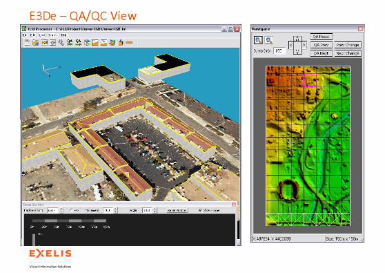
E3De – QA/QC View

E3De – Interactive Building Editing

E3De – Vector Products

E3De – Interactive Tree Editing

E3De – Interactive DEM editing

E3De – Flythrough Flight Controls
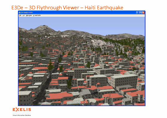
E3De – 3D Flythrough Viewer – Haiti Earthquake
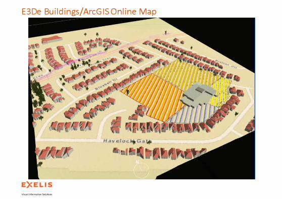
E3De Buildings/ArcGIS Online Map


SARscape

SARscape
The Solution for
SAR Data Processing
SARscape is the world
leading application for processing SAR data
with the help of advanced algorithms.
SARscape – SAR Data Processing
ACCESS
> Spaceborne
Sensors
> Airborne Sensors
> File Format Support
> Data Types
ANALYZE
> Monitoring
> Classification
> DEM Generation
> Land Displacement
> Persistent Scatterers
SHARE
> Imagery
> Maps
> Integration in ArcGISServer & Desktop
Environments
EXTEND
IDL, ENVI
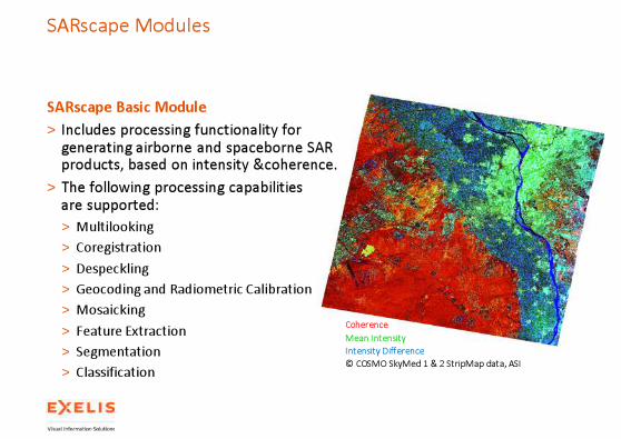
SARscape Basic Module
> Includes processing functionality for generating airborne and spaceborne SAR products, based on intensity &coherence.
> The following processing capabilitiesare supported:
> Multilooking
> Coregistration
> Despeckling
> Geocoding and Radiometric Calibration
> Mosaicking
> Feature Extraction
> Segmentation
> Classification
SARscape Modules
Coherence
Mean Intensity
Intensity Difference
© COSMO SkyMed 1 & 2 StripMap data, ASI

SARscape Modules
Differential interferogram, Bam, Iran. © ENVISAT ASAR data, ESA
DEM based on TerraSAR-X StripMap, Bolivia. © TerraSAR-X data, Infoterra
SARscape Interferometry Module
> Enables the generation of DEMs (InSAR technique) and surface deformation maps (DInSAR technique).
> InSAR generates accurate (up to a vertical resolution of few meters) and detailed surface and terrain height products.
> DInSAR can detect centimeter-scale displacements over time spans of days to years.
> Applications:
> Geophysical monitoring of natural hazards like earthquakes, volcanoes, and landslides.
> Structural engineering, particularly for the monitoring of subsidence and structural stability.
> …
