enr 1. general rules and procedures enr … general rules...aip canada (icao) part 2 en-route (enr)...
TRANSCRIPT
AIP CANADA (ICAO) PART 2 EN-ROUTE (ENR)
Publication Date: 13 NOV 14 ENR 1–1
ENR 1. GENERAL RULES AND PROCEDURES
ENR 1.1 General Rules
For information on the general rules applied within Canada, refer to Part VI – General Operating and Flight Rules on Transport Canada’s Canadian Aviation Regulations (CARs) website:
<http://www.tc.gc.ca/eng/acts-regulations/regulations-sor96-433.htm> Part VI – General Operating and Flight Rules Subpart 0 – General 600.01 – Interpretation
The air traffic rules and procedures applicable to air traffic in Canadian territory conform to Annex 2, “Rules of the Air,” and Annex 11, “Air Traffic Services,” to the Convention on International Civil Aviation and to those portions of the International Civil Aviation Organization’s (ICAO) Procedures for Air Navigation Services–Air Traffic Management (PANS–ATM, Doc 4444) and Air Traffic Services Planning Manual (Doc 9426) that are applicable to aircraft and to those portions of ICAO’s Regional Supplementary Procedures (Doc 7030) that are applicable to the Canadian region, except for the differences listed in GEN 1.7, “Differences from ICAO Standards, Recommended Practices and Procedures.”
ENR 1.2 Visual Flight Rules
For information on the visual flight rules (VFR) applied within Canada, refer to the sections on Transport Canada’s CARs website that are listed in Table 1.2, “Visual Flight Rules.”
Table 1.2, Visual Flight Rules
Section Title
602.114 Minimum Visual Meteorological Conditions for VFR Flight in Controlled Airspace
602.115 Minimum Visual Meteorological Conditions for VFR Flight in Uncontrolled Airspace
602.116 VFR Over the Top 602.117 Special VFR Flight
<http://www.tc.gc.ca/eng/acts-regulations/regulations-sor96-433.htm> Part VI – General Operating and Flight Rules Subpart 2 – Operating and Flight Rules Division VI – Visual Flight Rules
ENR 1.3 Instrument Flight Rules
For information on the instrument flight rules (IFR) applied within Canada, refer to the sections on Transport Canada’s CARs website that are listed in Table 1.3, “Instrument Flight Rules.”

PART 2 EN-ROUTE (ENR)
Table 1.3, Instrument Flight Rules
Section Title
602.121 General Requirements 602.122 Alternate Aerodrome Requirements 602.123 Alternate Aerodrome Weather Minima 602.124 Minimum Altitudes to Ensure Obstacle Clearance 602.125 Enroute IFR Position Reports 602.126 Takeoff Minima 602.127 Instrument Approaches 602.128 Landing Minima 602.129 700.10
Approach Ban – General Approach Bans – Non Precision, APV and CAT I Precision
602.130 700.11
Approach Ban – CAT III Precision Approach Bans – CAT II and CAT III Precision
<http://www.tc.gc.ca/eng/acts-regulations/regulations-sor96-433.htm> Part VI – General Operating and Flight Rules Subpart 2 – Operating and Flight Rules Division VII – Instrument Flight Rules
ENR 1.4 ATS Airspace Classification
Air traffic services (ATS) airspace classes in Canada conform to the ATS airspace classification table in Appendix 4 of Annex 11, “Air Traffic Services,” of the Convention on International Civil Aviation with the differences listed in GEN 1.7, “Differences from ICAO Standards, Recommended Practices and Procedures.”
ENR 1.5 Holding, Approach and Departure Procedures
1.5.1 General
The instrument procedures published in the Canada Air Pilot (CAP), Volumes 1–7, and Restricted Canada Air Pilot (RCAP) are considered to be public procedures. However, the instrument procedures contained in the RCAP do not meet Transport Canada Civil Aviation design criteria. Accordingly, the use of RCAP procedures is restricted to pilots-in-command operating aircraft pursuant to an air operator certificate or a private operator certificate, including the appropriate RCAP operations specification. Authorization is required from Transport Canada Civil Aviation prior to the use of any Restricted Canada Air Pilot procedure.
The intention of the global navigation satellite system (GNSS) overlay program is to allow the operator to use a global positioning system (GPS) navigation sensor to fly the conventional procedures. Therefore, only GPS area navigation (RNAV) compliant Aeronautical Radio, Incorporated (ARINC) 424 Path-Terminator leg types should be used to code any conventional instrument procedure including GNSS in the approach title, and course to fix (CF) legs will not be used.
For information concerning the criteria on which holding, approach and departure procedures are established within Canada, refer to Transport Canada’s Criteria for the Development of Instrument Procedures (TP 308E).
ENR 1–2 Publication Date: 13 NOV 14
AIP CANADA (ICAO) PART 2 EN-ROUTE (ENR)
1.5.2 Arriving Flights
For information on procedures for arriving flights, refer to the following publications:
Canada Air Pilot, Volumes 1–7, or Restricted Canada Air Pilot
Canada Flight Supplement or Water Aerodrome Supplement, Section B, “Aerodrome/Facility Directory – VFR Terminal Procedures Chart”
When important information about an aerodrome cannot be described by the aerodrome sketch or the table, a VFR Terminal Procedures Chart is published. The chart contains information on conventional or area navigation procedures for arriving flights established on the basis of airspace organization at the aerodrome.
The table for each aerodrome in Canada Flight Supplement and Water Aerodrome Supplement, Section B, “Aerodrome/Facility Directory,” may also include the subheading PRO, which contains information on regulations applicable to the traffic at the aerodrome, including circuit patterns and heights, specific VFR routes within control zones, and other similar information.
1.5.3 Departing Flights
For information on procedures for departing flights, refer to the following publications:
Canada Air Pilot, Volumes 1–7, or Restricted Canada Air Pilot
Canada Flight Supplement or Water Aerodrome Supplement, Section B, “Aerodrome/Facility Directory – VFR Terminal Procedures Chart”
When a VFR Terminal Procedures Chart is published for an aerodrome, it contains information on conventional or area navigation procedures for departing flights established on the basis of airspace organization at the aerodrome.
The table for each aerodrome in Canada Flight Supplement or Water Aerodrome Supplement, Section B, “Aerodrome/Facility Directory,” may also include the subheading PRO, which contains information on regulations applicable to the traffic at the aerodrome, including circuit patterns and heights, specific VFR routes within control zones, and other similar information.
ENR 1.6 ATS Surveillance Services and Procedures
Air traffic services (ATS) use surveillance to increase airspace use by reducing separation between aircrafts. In addition, surveillance permits an expansion of flight information services such as traffic information and navigation assistance.
The following types of surveillance systems currently in use: primary surveillance radar (PSR), secondary surveillance radar (SSR), automatic dependent surveillance–broadcast (ADS-B), and multilateration (MLAT).
1.6.1 Primary Radar
Primary radar (PSR) computes target positions by determining the range and azimuth from transmitted and reflected radio frequency energy. It is a passive surveillance system and therefore does not rely on information transmitted from the aircraft.
Primary radar is used in the following applications:
1. Terminal Surveillance Radar
In general, a short-range PSR (80 NM) operating on 1250 to 1350 MHz compliments Secondary Surveillance Radar for terminal operations.
Publication Date: 24 JUL 14 ENR 1–3

PART 2 EN-ROUTE (ENR)
2. Precision Approach Radar
recision approach radar (PAR) is a high-definition, short-range PSR operating on 9000 to 9180 MHz, and is used as an approach aid. The system provides the controller with altitude, azimuth and range information of high accuracy to assist pilots in executing approaches. While basically a military system, PAR is available at some civilian airports and may be used by civilian pilots. Civil aircraft approach limits are published in Canada Air Pilot and Restricted Canada Air Pilot.
3. Airport Surface Detection Equipment
Radar surveillance of surface traffic is provided at airports where traffic warrants. Airport surface detection equipment (ASDE) is a high-definition PSR operating on 16 GHz. Tower controllers use ASDE to monitor the position of aircraft and vehicles on the manoeuvring areas of the airport (runways and taxiways) particularly during conditions of reduced visibility.
For information on radar and radio failure procedures, refer to the following publications:
Canada Air Pilot, Volumes 1–7, or Restricted Canada Air Pilot
Canada Flight Supplement, Section F, “Emergency” or Water Aerodrome Supplement, Section E, “Emergency”
For a map of primary radar coverage in Canada, see Figure 1.6.1, “Primary Radar Coverage.”
Figure 1.6.1, Primary Radar Coverage
ENR 1–4 Publication Date: 24 JUL 14
AIP CANADA (ICAO) PART 2 EN-ROUTE (ENR)
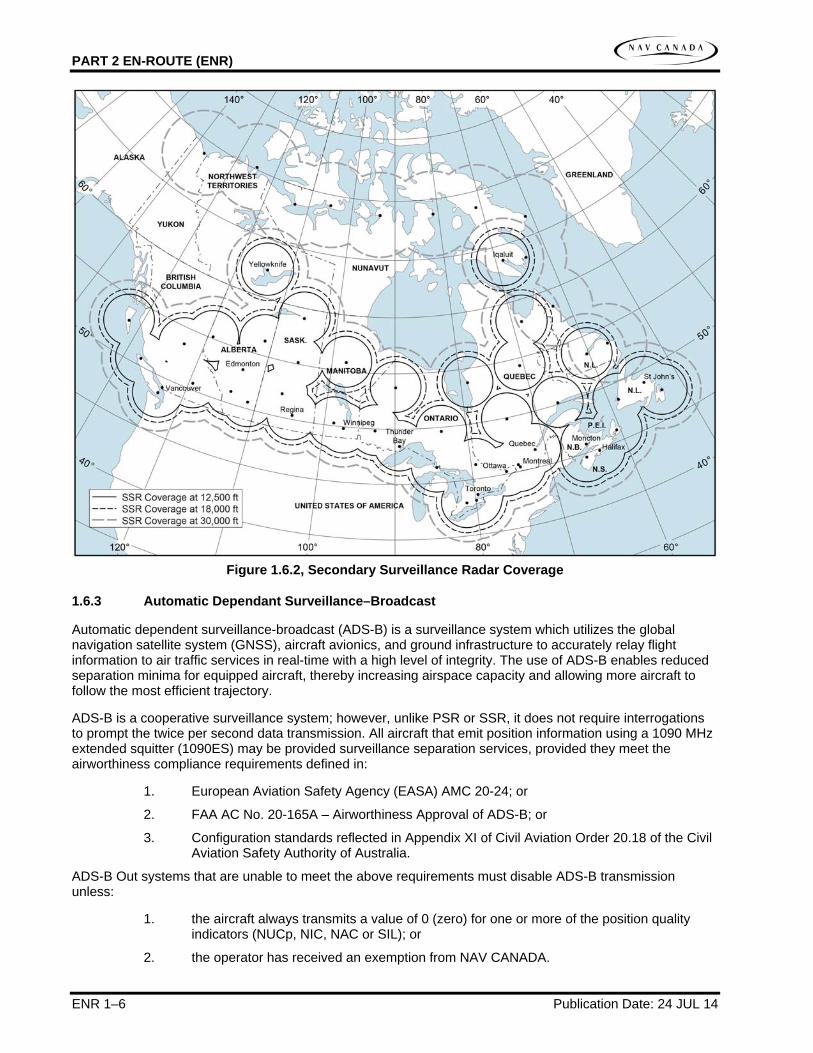
1.6.2 Secondary Surveillance Radar
Secondary surveillance radar (SSR) relies on measurement of the time interval between the interrogation and reply by an airborne transponder to determine aircraft range. The instantaneous direction of the antenna determines contact azimuth.
SSR is a cooperative surveillance system and will not provide a position for aircraft without operating transponders. SSR offers significant operational advantages to air traffic controller (ATC), such as increased range, positive identification and aircraft altitude, when the aircraft has an altitude-encoding transponder.
Secondary surveillance radar is used in the following applications:
1. En route Control
SSR is a long-range radar with a range of 200 nautical miles (NM) or more, transmitting on 1030 MHz and receiving the transponder reply on 1090 MHz. SSR is the main source of en route (airways/RNAV routes) surveillance, normally not combined with PSR.
2. Terminal Control
Terminal surveillance radar (TSR) utilizes SSR equipment similar to en route control and may be used in conjunction with a short-range PSR.
For information on radio communications failure, unlawful interference procedures and other emergency procedures, refer to the following publications:
Canada Air Pilot, Volumes 1–7, or Restricted Canada Air Pilot
Canada Flight Supplement, Section F, “Emergency” or Water Aerodrome Supplement, Section E, “Emergency”
In the Canada Flight Supplement and the Water Aerodrome Supplement, Section B, “Aerodrome/Facility Directory,” the table for an aerodrome may have a subheading PRO, which may contain information on the system of SSR code assignment established at the aerodrome.
For a map of SSR coverage in Canada, see Figure 1.6.2, “Secondary Surveillance Radar Coverage.”
Publication Date: 24 JUL 14 ENR 1–5
PART 2 EN-ROUTE (ENR)
Figure 1.6.2, Secondary Surveillance Radar Coverage
1.6.3 Automatic Dependant Surveillance–Broadcast
Automatic dependent surveillance-broadcast (ADS-B) is a surveillance system which utilizes the global navigation satellite system (GNSS), aircraft avionics, and ground infrastructure to accurately relay flight information to air traffic services in real-time with a high level of integrity. The use of ADS-B enables reduced separation minima for equipped aircraft, thereby increasing airspace capacity and allowing more aircraft to follow the most efficient trajectory.
ADS-B is a cooperative surveillance system; however, unlike PSR or SSR, it does not require interrogations to prompt the twice per second data transmission. All aircraft that emit position information using a 1090 MHz extended squitter (1090ES) may be provided surveillance separation services, provided they meet the airworthiness compliance requirements defined in:
1. European Aviation Safety Agency (EASA) AMC 20-24; or
2. FAA AC No. 20-165A – Airworthiness Approval of ADS-B; or
3. Configuration standards reflected in Appendix XI of Civil Aviation Order 20.18 of the Civil Aviation Safety Authority of Australia.
ADS-B Out systems that are unable to meet the above requirements must disable ADS-B transmission unless:
1. the aircraft always transmits a value of 0 (zero) for one or more of the position quality indicators (NUCp, NIC, NAC or SIL); or
2. the operator has received an exemption from NAV CANADA.
ENR 1–6 Publication Date: 24 JUL 14

AIP CANADA (ICAO) PART 2 EN-ROUTE (ENR)
For information on radio communications failure, unlawful interference procedures and other emergency procedures, refer to the following publications:
Canada Air Pilot, Volumes 1–7, or Restricted Canada Air Pilot
Canada Flight Supplement, Section F, “Emergency” or Water Aerodrome Supplement, Section E, “Emergency”
A Flight ID that is an exact replica of the Aircraft Identification entered in field 7 of the ICAO Flight Plan must be programmed into the transponder or flight management system (FMS) in order to receive surveillance services. Airline aircraft will use the three-letter ICAO airline code, not the two-letter IATA code. In addition, field 10 should indicate ADS-B capability on the ICAO Flight Plan.
For a map of ADS-B coverage in Canada, see Figure 1.6.3, “Automatic Dependant Surveillance–Broadcast Coverage.”
Figure 1.6.3, Automatic Dependant Surveillance–Broadcast Coverage
Publication Date: 24 JUL 14 ENR 1–7
PART 2 EN-ROUTE (ENR)
1.6.4 Other relevant information and procedures
1.6.4.1 Multilateration
Multilateration (MLAT) increases ATS situational awareness of aircraft and vehicles on the ground allowing them to safely manage ground movements, including in low visibility operations, by providing full surveillance coverage of runways, taxiways and terminal apron areas. MLAT uses a system of strategically placed ground stations to send interrogations and receive replies from Mode A, C, or S transponders. It functions on a principle known as Time Difference of Arrival (TDOA), by which the system calculates the time difference of arrival of a transponder response at multiple ground receivers and compares the results to determine a position. Usually three receiving units are required to obtain a horizontal position.
In the Canada Flight Supplement and the Water Aerodrome Supplement, Section B, “Aerodrome/Facility Directory,” the table for an aerodrome may have a subheading PRO, which may contain information on special procedures for code assignment established at the aerodrome. At these aerodromes, aircraft that have a technical limitation associated with the transmission of a transponder code (weight on wheels switch deactivation) must report this condition to ATS and obtain an approval request (APREQ) before commencing ground operations.
1.6.4.2 ADS-B Service in the Gander Oceanic Control Area
ADS-B has been used to provide flight level changes over southern Greenland in scenarios where the availability of ADS-B permits identified aircraft to climb or descend though the flight level of other ADS-B equipped aircraft. In addition, Gander ACC has been able to consider flight level requests that would result in eligible aircraft operating with in-trail spacing of 10 nautical miles.
Because of non-homogeneous aircraft surveillance equipage, all aircraft intending to transit the southern Greenland portion of the Gander OCA are expected to continue to flight plan in accordance with procedures outlined in NAT Doc 007, Guidance concerning Air Navigation in and above the NAT MNPSA, published by the International Civil Aviation Organization (ICAO). As always, flight crews are encouraged to request any changes, including flight level, to optimize their flight profile.
Where it is determined, following a request from the flight crew, that a flight level change can be approved because of the availability of ADS-B, the following steps can be expected:
• A very high frequency (VHF) control frequency will be assigned to the required flights by ATC, either directly via controller-pilot data link communications (CPDLC) or via high frequency (HF) voice through the Gander international flight service station (IFSS) (Gander Radio).
• Once VHF contact has been established, the flights involved will be informed by ATC that identification has been established.
• The requested climb or descent clearance will be issued by ATC either via CPDLC or through the assigned VHF control frequency.
For climb and descend through scenarios, after the flight level change has been completed and vertical separation re-established, flight crews will normally be informed by ATC that surveillance services are terminated and they will subsequently be returned to their previously assigned frequency.
Flight crews are advised that aircraft will not normally be informed of ADS-B identification unless a specific operational advantage, such as a flight level change, can be attained.
ENR 1–8 Publication Date: 24 JUL 14
AIP CANADA (ICAO) PART 2 EN-ROUTE (ENR)
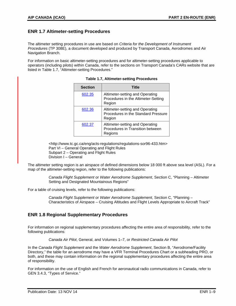
ENR 1.7 Altimeter-setting Procedures
The altimeter setting procedures in use are based on Criteria for the Development of Instrument Procedures (TP 308E), a document developed and produced by Transport Canada, Aerodromes and Air Navigation Branch.
For information on basic altimeter-setting procedures and for altimeter-setting procedures applicable to operators (including pilots) within Canada, refer to the sections on Transport Canada’s CARs website that are listed in Table 1.7, “Altimeter-setting Procedures.”
Table 1.7, Altimeter-setting Procedures
Section Title
602.35 Altimeter-setting and Operating Procedures in the Altimeter-Setting Region
602.36 Altimeter-setting and Operating Procedures in the Standard Pressure Region
602.37 Altimeter-setting and Operating Procedures in Transition between Regions
<http://www.tc.gc.ca/eng/acts-regulations/regulations-sor96-433.htm> Part VI – General Operating and Flight Rules Subpart 2 – Operating and Flight Rules Division I – General
The altimeter setting region is an airspace of defined dimensions below 18 000 ft above sea level (ASL). For a map of the altimeter-setting region, refer to the following publications:
Canada Flight Supplement or Water Aerodrome Supplement, Section C, “Planning – Altimeter Setting and Designated Mountainous Regions”
For a table of cruising levels, refer to the following publications:
Canada Flight Supplement or Water Aerodrome Supplement, Section C, “Planning – Characteristics of Airspace – Cruising Altitudes and Flight Levels Appropriate to Aircraft Track”
ENR 1.8 Regional Supplementary Procedures
For information on regional supplementary procedures affecting the entire area of responsibility, refer to the following publications:
Canada Air Pilot, General, and Volumes 1–7, or Restricted Canada Air Pilot
In the Canada Flight Supplement and the Water Aerodrome Supplement, Section B, “Aerodrome/Facility Directory,” the table for an aerodrome may have a VFR Terminal Procedures Chart or a subheading PRO, or both, and these may contain information on the regional supplementary procedures affecting the entire area of responsibility.
For information on the use of English and French for aeronautical radio communications in Canada, refer to GEN 3.4.3, “Types of Service.”
Publication Date: 13 NOV 14 ENR 1–9
PART 2 EN-ROUTE (ENR)
1.8.1 Contingency Procedures for Oceanic Traffic in the Event of an Evacuation of Gander ACC
1. AIRCRAFT PROCEDURES – Westbound
1.1 Aircraft not in receipt of an oceanic clearance 1.1.1 In the event that Gander ACC must be evacuated, only aircraft with received and acknowledged
oceanic clearances will be permitted to transit the Gander OCA. 1.1.2 If unable to obtain or acknowledge an oceanic clearance, flights should plan to re-route around the
Gander OCA or to land at an appropriate aerodrome. Request the appropriate re-clearance on the current frequency. Frequency congestion is likely.
1.2 Aircraft In receipt of an acknowledged oceanic clearance 1.2.1 Aircraft operating with a received and acknowledged oceanic clearance should proceed in
accordance with the clearance. Flights should not request changes in altitude, speed or route except for reasons of flight safety.
1.2.2 Any flights involved in level changes should complete the manoeuvre as soon as possible in accordance with any restrictions provided with the clearance.
1.3 Contact Procedures 1.3.1 On receipt of an emergency evacuation message, pilots are requested to broadcast to other flights
on 121.5, 243.0 and 123.45. A listening watch on these frequencies and the current frequency should be maintained until the flight exits the Gander OCA and FIR.
1.3.2 All flights within the Gander OCA should transmit position reports on any available HF or VHF frequency to Shanwick Radio either directly or through another agency or flight.
1.3.3 Flights should establish communication with the next agency at the earliest opportunity stating current position, cleared flight level, next position and estimate, and subsequent position. This also applies to flights using automated position reports (ADS/FMC) because those reports may not have been received by the next agency.
1.3.4 Flights within the Gander OCA should initially establish contact with Shanwick Radio. Flights within the Gander FIR should contact Montreal Centre or Moncton Centre, depending on their oceanic exit point as described in 2.3.7. Flights about to exit the Gander OCA into the New York OCA, the Reykjavik Oceanic CTA, the Santa Maria OCA, or the Sondrestrom FIR should contact New York ARINC, Iceland Radio, Santa Maria Radio or Sondrestrom Radio as appropriate.
1.3.5 If unable to establish radio contact, flights may use SATCOM voice or satellite telephone to provide position reports.
Oceanic Centre Telephone Number SATCOM Imarsat Short Code
Gander 001 709 651 5207 431613 Reykjavik 00 354 569 4141 425101 Santa Maria 00 351 296 820 438
00 351 296 886 042 (satellite link) 426305
New York 001 631 468 1413 436623 Ballygirreen
(Shanwick Aeradio) 00 353 61 471 199 425002
1.3.6 Flights may request their flight dispatch offices to forward position reports, if sending position reports to multiple ATS Units or if otherwise unable to forward position reports.
ENR 1–10 Publication Date: 29 MAY 14
AIP CANADA (ICAO) PART 2 EN-ROUTE (ENR)
1. AIRCRAFT PROCEDURES – Westbound
1.3.7 Based on where they exit oceanic airspace, flights shall proceed in accordance with the following table, until communication is established with, and a re-clearance issued by the next agency. Note: the landfall fix is the fix after the oceanic exit point.
IF flight is routed over
The flight shall then proceed: Next control agency and frequency:
6500N 06000W or AVPUT
Via cleared route to the landfall fix or N700A
Montreal ACC 132.800
6400N 06000W or CLAVY
Via cleared route to the landfall fix or N690A
Montreal ACC 132.800
6300N 06000W or EMBOK
Via cleared route to the landfall fix or N680A
Montreal ACC 132.800
6200N 06000W or KETLA
Via cleared route to the landfall fix or N660A
Montreal ACC 134.800
6100N 06000W or MAXAR
Via cleared route to the landfall fix or N640A
Montreal ACC 134.800
6000N 06000W or PIDSO
Via cleared route to the landfall fix or N620A
Montreal ACC 135.800
5900N 06000W or SAVRY
Via cleared route to the landfall fix or N598A
Montreal ACC 132.450
URTAK or MOATT MOATT LOMTA TEALS VANSI Montreal ACC 132.45 AVUTI or PRAWN PRAWN YDP YKL ROUND Montreal ACC 132.45 CUDDY or PORGY PORGY HO YBC ANCER* Moncton ACC 132.95 or Montreal
ACC 132.90 @ 63W
DORYY BORUB YZV* Moncton ACC 132.95 or Montreal ACC 132.90@ 63W
HOIST YYR YRI* Moncton ACC 118.875 or Montreal ACC 132.90 @63W
JANJO QUBIS* Moncton ACC 132.52 or Montreal ACC 132.90 @ 63W
LOMSI TAFFY Moncton ACC 132.52 NEEKO MILLS Moncton ACC 132.52 RIKAL YAY DANOL Moncton ACC 133.55 TUDEP TOPPS Moncton ACC 133.55 ALLRY EBONY Moncton ACC 133.55 ELSIR ALLEX Moncton ACC 132.75 JOOPY TUSKY Moncton ACC 132.75 NICSO YYT BRADD Moncton ACC 125.25 PORTI KANNI Moncton ACC 125.25 SUPRY WHALE Moncton ACC 125.25 VODOR RAFIN NANSO VITOL* Moncton ACC 125.25 BOBTU JAROM LOMPI DOVEY* Moncton ACC 125.25
* Aircraft may not be able to contact next control agency until established on this route.
Publication Date: 13 NOV 14 ENR 1–11

PART 2 EN-ROUTE (ENR)
2. AIRCRAFT PROCEDURES – Eastbound
2.1 Aircraft not in receipt of an oceanic clearance 2.1.1 In the event that Gander ACC must be evacuated, only aircraft with received and acknowledged
oceanic clearances will be permitted to transit the Gander OCA. 2.1.2 If unable to obtain or acknowledge an oceanic clearance, flights should plan to re-route around the
Gander OCA or land at an appropriate aerodrome. Flights may be required to re-route around the Gander FIR as well. Flights should request the appropriate re-clearance from Montreal or Moncton Centre. Frequency congestion is likely.
2.2 Aircraft in receipt of an acknowledged oceanic clearance 2.2.1 Aircraft operating with a received and acknowledged ocean clearance should proceed in
accordance with the clearance. Flights should not request changes in altitude, speed or route except for reasons of flight safety or to comply with the oceanic clearance.
2.2.2 Flights west of 50 west longitude should contact either Montreal or Moncton Centre, depending on which of those was the previous agency, using the previous assigned frequency.
2.2.3 The Eastbound Organized Track System will be extended to begin at fixes on or near the western boundary between the Gander FIR and the Moncton and Montreal FIRs as follows:
Contingency fix Landfall fix Oceanic Entry Point defined in OTS message
KENKI AVPUT MUSVA CLAVY BERUS EMBOK GRIBS KETLA MIBNO MAXAR PEPKI PIDSO LAKES 59/60 SAVRY YKL LOMTA URTAK YWK YDP AVUTI MUNBO HO CUDDY BORUB DORYY TASTI YYR HOIST SERBO JANJO VERTU LOMSI PIKNA NEEKO NAPLO YAY RIKAL MIGLI TUDEP LOPRO ALLRY VINSI YQX ELSIR TAGRA JOOPY SUTKO YYT NICSO
ENR 1–12 Publication Date: 13 NOV 14
AIP CANADA (ICAO) PART 2 EN-ROUTE (ENR)
Publication Date: 5 JUL 07 ENR 1–13
2. AIRCRAFT PROCEDURES – Eastbound
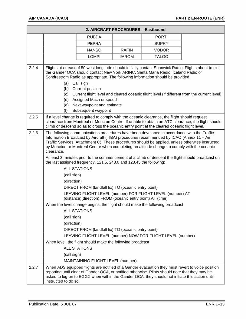
RUBDA PORTI PEPRA SUPRY NANSO RAFIN VODOR LOMPI JAROM TALGO
2.2.4 Flights at or east of 50 west longitude should initially contact Shanwick Radio. Flights about to exit the Gander OCA should contact New York ARINC, Santa Maria Radio, Iceland Radio or Sondrestrom Radio as appropriate. The following information should be provided.
(a) Call sign (b) Current position (c) Current flight level and cleared oceanic flight level (if different from the current level) (d) Assigned Mach or speed (e) Next waypoint and estimate (f) Subsequent waypoint
2.2.5 If a level change is required to comply with the oceanic clearance, the flight should request clearance from Montreal or Moncton Centre. If unable to obtain an ATC clearance, the flight should climb or descend so as to cross the oceanic entry point at the cleared oceanic flight level.
2.2.6 The following communications procedures have been developed in accordance with the Traffic Information Broadcast by Aircraft (TIBA) procedures recommended by ICAO (Annex 11 – Air Traffic Services, Attachment C). These procedures should be applied, unless otherwise instructed by Moncton or Montreal Centre when completing an altitude change to comply with the oceanic clearance.
At least 3 minutes prior to the commencement of a climb or descent the flight should broadcast on the last assigned frequency, 121.5, 243.0 and 123.45 the following:
ALL STATIONS (call sign) (direction) DIRECT FROM (landfall fix) TO (oceanic entry point) LEAVING FLIGHT LEVEL (number) FOR FLIGHT LEVEL (number) AT
(distance)(direction) FROM (oceanic entry point) AT (time) When the level change begins, the flight should make the following broadcast ALL STATIONS (call sign) (direction) DIRECT FROM (landfall fix) TO (oceanic entry point) LEAVING FLIGHT LEVEL (number) NOW FOR FLIGHT LEVEL (number) When level, the flight should make the following broadcast ALL STATIONS (call sign) MAINTAINING FLIGHT LEVEL (number) 2.2.7 When ADS equipped flights are notified of a Gander evacuation they must revert to voice position
reporting until clear of Gander OCA, or notified otherwise. Pilots should note that they may be asked to log-on to EGGX when within the Gander OCA; they should not initiate this action until instructed to do so.
PART 2 EN-ROUTE (ENR)
ENR 1–14 Publication Date: 6 FEB 14
ENR 1.9 Air Traffic Flow Management
Air traffic flow management (ATFM) programs have been developed to ensure that national ATC systems are used to maximum capacity and that the need for excessive en route airborne holding, especially at low altitude, is minimized. ATFM also distributes required delays more equitably among users.
ATFM initiatives in Canada include
• the publication in the Canada Air Pilot and the Restricted Canada Air Pilot of standard instrument departure (SID) and standard terminal arrival (STAR) procedures;
• the rerouting of aircraft because of sector overloading and weather avoidance;
• flow-control metering of arriving aircraft into terminal control areas (TCAs); and
• the implementation of flow-control restrictions whereby aircraft are more economically held on the ground at departure airports to partially absorb calculated arrival delays at a destination airport.
In the Canada Flight Supplement and the Water Aerodrome Supplement, Section B, “Aerodrome/Facility Directory,” the table for an aerodrome may have a subheading RESTRICTIONS that contains information affecting the flow of traffic at the aerodrome.
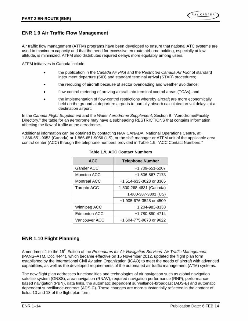
Additional information can be obtained by contacting NAV CANADA, National Operations Centre, at 1 866-651-9053 (Canada) or 1 866-651-9056 (US), or the shift manager or ATFM unit of the applicable area control center (ACC) through the telephone numbers provided in Table 1.9, “ACC Contact Numbers.”
Table 1.9, ACC Contact Numbers
ACC Telephone Number
Gander ACC +1 709-651-5207Moncton ACC +1 506-867-7173Montréal ACC +1 514-633-3028 or 3365
1-800-268-4831 (Canada)1-800-387-3801 (US)
Toronto ACC
+1 905-676-3528 or 4509Winnipeg ACC +1 204-983-8338Edmonton ACC +1 780-890-4714Vancouver ACC +1 604-775-9673 or 9622
ENR 1.10 Flight Planning
Amendment 1 to the 15th Edition of the Procedures for Air Navigation Services–Air Traffic Management, (PANS–ATM, Doc 4444), which became effective on 15 November 2012, updated the flight plan form established by the International Civil Aviation Organization (ICAO) to meet the needs of aircraft with advanced capabilities, as well as the developed requirements of the automated air traffic management (ATM) systems.
The new flight plan addresses functionalities and technologies of air navigation such as global navigation satellite system (GNSS), area navigation (RNAV), required navigation performance (RNP), performance-based navigation (PBN), data links, the automatic dependent surveillance-broadcast (ADS-B) and automatic dependent surveillance-contract (ADS-C). These changes are more substantially reflected in the content of fields 10 and 18 of the flight plan form.

AIP CANADA (ICAO) PART 2 EN-ROUTE (ENR)
Such data shall be considered by the ATM systems, in order to make the necessary air traffic planning information available for the air traffic controller. It also enables alerting, whenever there is a modification to reported data that may have an impact on control planned actions.
For information on restriction, limitation or advisory information related to flight planning within Canada, refer to the sections on Transport Canada’s CARs website that are listed in Table 1.10, “Flight Planning.”
Table 1.10, Flight Planning
Section Title
602.70 Interpretation 602.73 Requirement to File a Flight Plan or
a Flight Itinerary 602.74 Contents of a Flight Plan or a Flight
Itinerary 602.75 Filing of a Flight Plan or a Flight
Itinerary 602.76 Changes in the Flight Plan
<http://www.tc.gc.ca/eng/acts-regulations/regulations-sor96-433.htm> Part VI – General Operating and Flight Rules Subpart 2 – Operating and Flight Rules Division III – Flight Preparation, Flight Plans and Flight Itineraries
ENR 1.11 Addressing of Flight Plan Messages
Flight plans for aircraft flying under IFR in Canada are allocated according to flight information region (FIR) to the message addresses provided in Table 1.11, “Flight Plan Message Addresses.”
Table 1.11, Flight Plan Message Addresses
FIR Message Address
Gander CZQXZQZX Moncton CZQMZQZX Montréal CZULZQZX Toronto CZYZZQZX
Winnipeg CZWGZQZX Edmonton CZEGZQZX Vancouver CZVRZQZX
Flight plans for aircraft flying under VFR are accepted and processed by flight information centers (FICs) in Canada. In the Canada Flight Supplement and the Water Aerodrome Supplement, Section B, “Aerodrome/Facility Directory,” the table for each aerodrome has a subheading FLT PLN (Flight Planning) that may contain the appropriate FIC contact information under the entry FIC.
For more information about Canada’s FICs, refer to Airport Advisory and Flight Information Services on NAV CANADA’s website:
<www.navcanada.ca> About Us What We Do Airport Advisory and Flight Information
Publication Date: 13 NOV 14 ENR 1–15

PART 2 EN-ROUTE (ENR)
ENR 1.12 Interception of Civil Aircraft
For information on interception procedures and visual signals, refer to the following publications:
Canada Flight Supplement, Section F, “Emergency – Interception of Civil Aircraft,” and “Interception Signals,” or Water Aerodrome Supplement, Section E, “Emergency – Interception of Civil Aircraft,” and “Interception Signals”
ENR 1.13 Unlawful Interference
For information on unlawful interference, refer to the following publications:
Canada Flight Supplement, Section F, “Emergency – Interception of Civil Aircraft,” and “Unlawful Interference (HIJACK)” or Water Aerodrome Supplement, Section E, “Emergency – Interception of Civil Aircraft,” and “Unlawful Interference (HIJACK)”
ENR 1.14 Air Traffic Incidents
An aircraft incident, as defined in the Civil Aviation Daily Occurrence Reporting System (CADORS) manual (TP 4044), is any occurrence involving an aircraft where
1. An engine fails;
2. Smoke or fire occurs, other than an engine fire that is contained within the engine and does not result in engine failure or damage to other component parts of the aircraft;
3. Difficulties in controlling the aircraft in flight are encountered due to any aircraft system malfunction, weather phenomena, wake turbulence, operations outside the approved flight envelope or uncontrolled vibrations;
4. The aircraft fails to remain within the landing or takeoff area, lands with one or more landing gear retracted or drags a wing tip or engine pod;
5. Any crew member is unable to perform his or her flight duties as a result of incapacitation;
6. Decompression, explosive or otherwise, occurs that necessitates an emergency descent;
7. A fuel shortage occurs that necessitates a diversion or requires approach and landing priority at the destination of the aircraft;
8. The aircraft is refuelled with the incorrect type of fuel or contaminated fuel;
9. A collision or risk of collision with any other aircraft or with any vehicle, terrain or obstacle occurs, including a collision or risk of collision that may be related to air traffic control procedures or equipment failures;
10. The aircraft receives a Traffic Alert and Collision Avoidance System (TCAS) Resolution Advisory;
11. A flight crew member declares an emergency or indicates any degree of emergency that requires priority handling by an air traffic control unit or the standing by of crash, fire fighting or rescue services; or
12. Toxic gases or corrosive materials leak from any area aboard the aircraft.
The Aviation Incident Report form is available on Transport Canada’s website:
<wwwapps.tc.gc.ca/saf-sec-sur/2/IR-RI/av_i_r.aspx?lang=eng>
ENR 1–16 Publication Date: 6 FEB 14
AIP CANADA (ICAO) PART 2 EN-ROUTE (ENR)
A pilot should proceed as follows regarding an incident in which he or she is or has been involved:
1. During flight, use the appropriate air-ground frequency for reporting an incident of major significance, particularly if it involves other aircraft, so as to permit the facts to be ascertained immediately; and
2. As promptly as possible after landing submit an Aviation Incident Report.
Aviation Incident Reports are used to keep senior Civil Aviation and Transport Canada management advised of critical or high-profile events on a timely basis.
Publication Date: 13 APR 06 ENR 1–17