electrical resistivity tomography for … resistivity tomography for coastal salt water ......
TRANSCRIPT
Fifteenth International Water Technology Conference, IWTC-15 2011, Alexandria, Egypt
ELECTRICAL RESISTIVITY TOMOGRAPHY FOR COASTAL SALT WATER INTRUSION CHARACTERIZATION ALONG THE IONIAN
COAST OF BASILICATA REGION (SOUTHERN ITALY)
A. Satriani, A. Loperte, M. Proto
Institute of Methodologies for Environmental Analysis CNR, Tito (PZ) – Italy [email protected], [email protected], [email protected]
ABSTRACT
The first results of a research activity focused on the characterisation of the salt water intrusion along the Ionian coast of the Basilicata region (Southern Italy) are shown and discussed in this study. Along the coast there are many Sites of Community Interest (SCI) subjected to a strong incidence of human activities mainly linked to agriculture and tourism. Primary and secondary salinity of soil are linked to natural factors such as the climate, natural drainage patterns, topographic features, geological structure, distance to the sea and to the indiscriminate exploitation of the soil and groundwater resources.
The approach based on the Electrical Resistivity Tomography (ERT) has been adopted to obtain high-resolution electrical images which allow to identify and delineate the geometry of litho-stratigraphic limits, by resistivity contrasts. Then, ERT represents an optimal tool for better reconstructing the geometry of the sea water intrusion front and mapping the areas characterized by a high level of salinization. In fact, the presence of seawater strongly reduces the resistivity values. For this reason it is necessary to evaluate if the contrast between the zones affected by saltwater intrusion and the geological layers is significant and if it can be detectable. In this frame, some soil samples have been analyzed using chemical physical techniques in order to validate the geophysical measurements. Five electrical tomographies were performed along the coast close to the rivers Bradano, Basento, Cavone and Agri with multielectrode acquisition system in a Wenner-Schlumberger array configuration with electrodes spacing on the surface of 10.00 meters. Resistivity tomographic images, in general, have shown a decrease of resistivity by going deeper and towards the Ionian Sea coastline, and, in some zones along the coast they have highlighted the presence of a top layer of greater thickness with high resistivity values. These evidences indicate that anyway the process of saline intrusion is present, but it has not yet affected the layer of soil which is generally explored by the roots of plants, and as a matter of the fact, these areas have a good vegetation cover.
On the whole, the results obtained in this study suggest that the ERT can be a suitable support tool for the activities of planning and management, which are fundamental for the preservation of coastal areas of great environmental, economic, social and cultural relevance. Keywords: Coastal area, Seawater intrusion, Resistivity images, Water management
Fifteenth International Water Technology Conference, IWTC-15 2011, Alexandria, Egypt
1. INTRODUCTION The coastal zones are subject to rapid development with growing and conflicting demands on the natural resources, and often they are subject to irreversible degradation. The critical phenomena which mainly affect these areas are coastal erosion, flooding due to river floods or tidal waves or rising sea level, contamination of the aquifers (e.g. salt-wedge intrusion of seawater). Along the coast there are many Sites of Community Interest (SCI) subjected to a strong incidence of human activities mainly linked to agriculture and tourism. According to the Recommendation on Integrated Coastal Zone Management (ICZM) of the European Commission, coastal areas are of great environmental, economic, social and cultural relevance. Therefore, the implementation of suitable monitoring and protection actions is fundamental for their preservation and for assuring the future use of this resource. Such actions have to be based on an ecosystem perspective for preserving coastal environment integrity and functioning and for planning sustainable resource management of both the marine and terrestrial components. Planning and management of natural resources through a dynamic process has to set as its objective the promotion of economic and social welfare of coastal zones. Unfortunately coastal plains are often contaminated by sea water intrusion, and the vulnerability to salinisation is probably the most common and diffused problem in an aquifer. The extent of saline water intrusion in the coastal area is influenced by the nature of geological formations present, hydraulic gradient, rate of withdrawal of groundwater and its recharge (Freeze & Cherry [1]). Many studies have been focused on the seawater intrusion problem, and the estimation of salt intrusion can be made with the classical chemical methods measuring those parameters that best highlight the saline contamination as electrical conductivity, chloride concentration (Demirel [2], Duquet et al [3], Frohlich et al.[4], Petalas et al. [5], Polemio et al. [6], Somay et al. [7]). Many researchers, as an alternative to traditional methods have applied geophysical techniques and in particular geoelectrical surveys in different coastal area around the world, to characterize the hydrogeology of a coastal aquifer and, in particular, to assess seawater intrusion (Balia et al. [8], Batayneh [9], Bauer et al. [10], Cimino et al. [11], Choudhury et al. [12], Ebraheem et al. [13], Khalil [14], Koukadaki et al. [15], Kruse et al. [16], Nassir et al. [17], Nowroozi et al. [18], Pujari et al. [19], Sherif et al. [20], Urish et al. [21]). In this paper we show the first results of a study based on geoelectrical tomographies for the characterization of a coastal area along the Ionian side of the Basilicata region (figure 1). This area is mainly interested by saltwater intrusion phenomena that cause significant ecological and environmental problems . In fact, contamination of fresh water reduces the availability of water for civil and agricultural use and determines salinisation of soil with reduction of soil fertility. The marine intrusion, therefore determines an increase in the volume of underground salt- water and a decrease of volume of underground fresh-water. This phenomenon is not only induced by the natural balance but is exacerbated by the indiscriminate land use by man. The result is a depletion of freshwater reserves along the coast and simultaneously a process of desertification and soil degradation. Proper management of the problem first requires a knowledge of the phenomenon and this study
Fifteenth International Water Technology Conference, IWTC-15 2011, Alexandria, Egypt
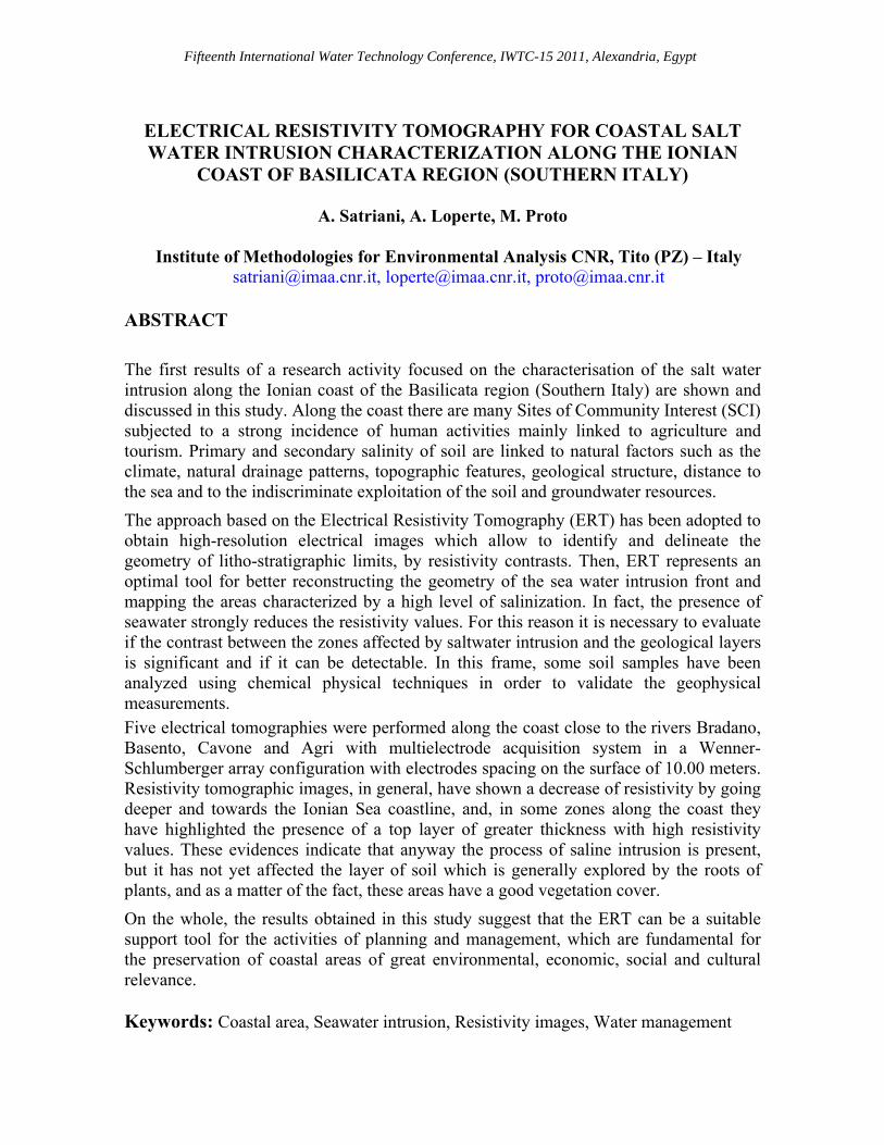
has the first goal of characterizing, through the ERT, the sea water intrusion that goes inland along a stretch of the Ionian coast of Basilicata Region. Specifically, we have investigated the areas close to the mouths of the rivers (Bradano, Basento, Cavone and Agri,) of the Basilicata Region, which with the surrounding forested areas, are protected by the European Community.
Figure 1 Ionian coastal plain of Basilicata Region (Southern Italy).
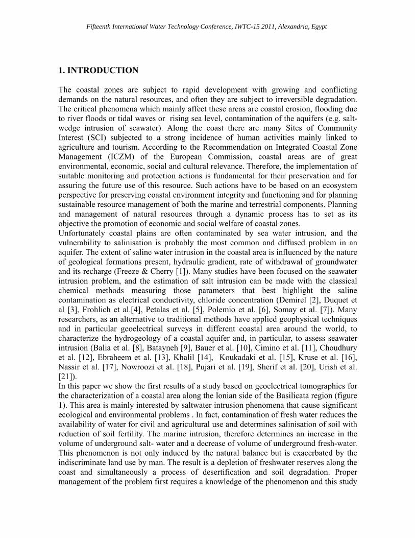
2. STUDY AREA The investigated area falls within the Ionian coastal plain of the Basilicata Region, Southern Italy, bounded between the mouth of the Sinni River at the West and the mouth of the Bradano River at the East (figure 2). The climate of the area is semiarid with hot and dry summers. As regards the geological background, the study area lies in the Bradanic Graben, bordered at NE by the limestones of the Murgian foreland and at SW by the clastic sediments of the Apennine chain. (Ciaranfi et al. [22],Tropeano et al. [23]). The graben is filled by a sedimentary sequence (up to 2-3 Km) which, from top to bottom, is composed by the following geological formations (figure 2): Marine Terraced Deposits (regressive deposits consisting of sands, conglomerates and silts of Middle-Upper Pleistocene in age, outcropping in the southern part of the trough), Argille subappenine Formation (silty-clayey successions of Late Pliocene-Middle Pleistocene in age, widely outcropping).
Fifteenth International Water Technology Conference, IWTC-15 2011, Alexandria, Egypt
Figure 2 Schematic geologica1 map of the study area:l) coastal deposits; 2) alluvial,
transitional and marine deposits; 3) marine terraces; 4) Argille (Clay) subappennine Formation; 5) marine terraced scarps; (Polemio et al. [28], simplified).
As regards the marine terraced deposits, eight orders of terraces have been recognised on the basis of morphological features. The flat top surfaces of these terraces are broken off both by the river valleys and by marked morphological steps representing the marine terraced scarps. These scarps run roughly parallel to the present coastline and should represent the ancient coastline sand so the phases of the sea level standing (Parea [24]). Alluvial, transitional, coastal and marine deposits widely outcrop in the coastal plain which include the mouths and the deltaic systems of the Sinni, Agri, Cavone, Basento and Bradano Rivers, rising in the Apennines. The alluvial and marine deposits with the lower sediment thickness of a transitional environment are thick probably more than 60 m and they mainly consist of silty-clayey layers and sandy strata. The sedimentation of these deposits has been deeply influenced by the glacioeustatic fluctuation and the consequent coastline changes occurred since the end of Tyrrhenian (Cotecchia et al.[25]). Finally, the coastal deposits mainly consist of sandy beaches, from 10 up to 100 m wide, but moving towards the Sinni area, the Ionian beaches become gravely-sandy (Cocco et al.[26]). The beaches are limited inland both by marshy areas and by coastal dunes with the latter, parallel to the coast, made up of sands, packed and weakly cemented, high about 10 m (Polemio [7]).
Fifteenth International Water Technology Conference, IWTC-15 2011, Alexandria, Egypt
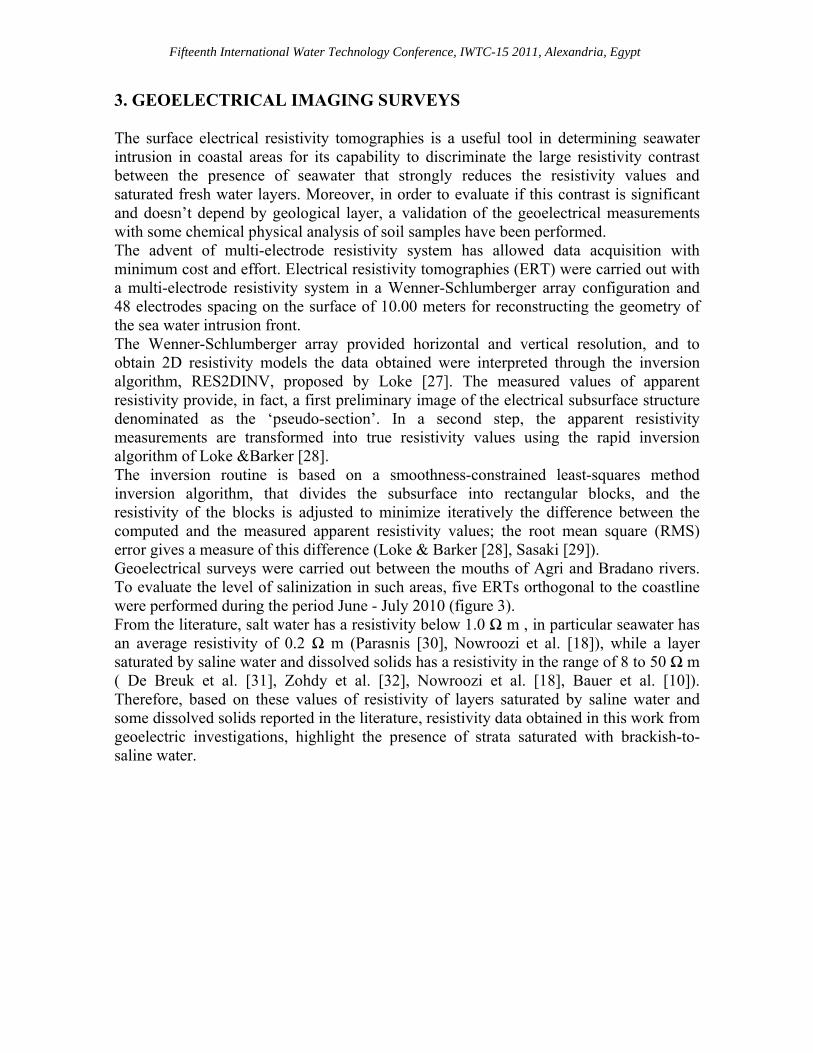
3. GEOELECTRICAL IMAGING SURVEYS The surface electrical resistivity tomographies is a useful tool in determining seawater intrusion in coastal areas for its capability to discriminate the large resistivity contrast between the presence of seawater that strongly reduces the resistivity values and saturated fresh water layers. Moreover, in order to evaluate if this contrast is significant and doesn’t depend by geological layer, a validation of the geoelectrical measurements with some chemical physical analysis of soil samples have been performed. The advent of multi-electrode resistivity system has allowed data acquisition with minimum cost and effort. Electrical resistivity tomographies (ERT) were carried out with a multi-electrode resistivity system in a Wenner-Schlumberger array configuration and 48 electrodes spacing on the surface of 10.00 meters for reconstructing the geometry of the sea water intrusion front. The Wenner-Schlumberger array provided horizontal and vertical resolution, and to obtain 2D resistivity models the data obtained were interpreted through the inversion algorithm, RES2DINV, proposed by Loke [27]. The measured values of apparent resistivity provide, in fact, a first preliminary image of the electrical subsurface structure denominated as the ‘pseudo-section’. In a second step, the apparent resistivity measurements are transformed into true resistivity values using the rapid inversion algorithm of Loke &Barker [28]. The inversion routine is based on a smoothness-constrained least-squares method inversion algorithm, that divides the subsurface into rectangular blocks, and the resistivity of the blocks is adjusted to minimize iteratively the difference between the computed and the measured apparent resistivity values; the root mean square (RMS) error gives a measure of this difference (Loke & Barker [28], Sasaki [29]). Geoelectrical surveys were carried out between the mouths of Agri and Bradano rivers. To evaluate the level of salinization in such areas, five ERTs orthogonal to the coastline were performed during the period June - July 2010 (figure 3). From the literature, salt water has a resistivity below 1.0 Ω m , in particular seawater has an average resistivity of 0.2 Ω m (Parasnis [30], Nowroozi et al. [18]), while a layer saturated by saline water and dissolved solids has a resistivity in the range of 8 to 50 Ω m ( De Breuk et al. [31], Zohdy et al. [32], Nowroozi et al. [18], Bauer et al. [10]). Therefore, based on these values of resistivity of layers saturated by saline water and some dissolved solids reported in the literature, resistivity data obtained in this work from geoelectric investigations, highlight the presence of strata saturated with brackish-to-saline water.
Fifteenth International Water Technology Conference, IWTC-15 2011, Alexandria, Egypt
Figure 3 Location map of geoelectrical surveys
The 2D resistivity models obtained using the Wenner-Schlumberger arrays showed the significant difference in resistivity values between the five resistivity tomographies (figure 4). As you can see by figure 4, the first ERT, profile 1 (figure 4a), performed close to Bradano river mouth runs from SE to NW and the geoelectrical image shows a variation in resistivity distribution, with electrical resistivity values from about 1-10 Ωm in the first part of the section (between 0 and 110 m). Lower electrical resistivity values, with a resistivity range of less 1 Ωm, were observed towards the sea side and these values reduced are maybe due to saturated strata for a subsurface seawater flow zone.

Fifteenth International Water Technology Conference, IWTC-15 2011, Alexandria, Egypt
Figure 4 Two dimensional electrical resistivity tomographies obtained in the study area. The position of each ERT is shown in figure 3, a) profile 1; b) profile 2; c) profile 3; d)
profile 4; e) profile 5. The second ERT, profile 2 (figure 4b) was carried out close Basento river mouth. The inversion results of this profile data indicate the presence of a first layer with the higher

Fifteenth International Water Technology Conference, IWTC-15 2011, Alexandria, Egypt
resistivity values. While, below this first layer the resistivity values are lower, which are determined by saline water intrusion coming from the coast. As in profile 1, however, the upcoming of saline water due to the marine intrusion is remarkable, although in this part of the study area, the layer of soil useful to the survival of vegetation it is still preserved by salt. The third ERT, profile 3 (figure 4c), between Basento and Cavone rivers, is parallel to profile 2. Compared with the first two profiles, the results indicate that the seawater intrusion is less extensive, in fact resistivity values are significantly higher and only towards the sea side they are lower. Then, a reduced intrusion in the acquifer of the salt wedge from the sea is resulted by resistivity image. The fourth ERT, profile 4 (figure 4d) was carried out close to Cavone river mouth. As in the profile 3, the seawater intrusion is less extensive, in fact resistivity values are higher and quite similar to those of the previous profile. The fifth ERT, profile 5 (figure 4e), performed between Agri and Sinni, and close the mouth of the river Agri, shows again the intrusion of the saline wedge in this stretch of coast. In fact, resistivity values are lower and similar to the resistivity values profiles 1 and 2 (figure 4). Finally, figure 4 shows that the soil salinity due to seawater intrusion increases mainly in the coast between Bradano and Basento rivers, it is less critical in the next stretch of coastline where the study area lies, while the seawater intrusion extends again in the remaining last stretch of coast near the Agri river mouth. Probably this difference is due to changes in shoreline. In fact, as reported by Guariglia [33] these changes, between 1949 and 2006, highlight regressions at the mouths of principal rivers and progressions along the inter-river areas with the exception of the coast between Bradano and Basento rivers. Coastline regression is often associated with volume reduction of the seashore, moreover, land cover changes show the fragmentation processes of some forested patterns substituted by less structured vegetation; it is particularly evident between Bradano and Basento rivers where shoreline regression was identified also along the inter-river area (Simoniello [34]). In addition, in Bradano and Basento inter-river areas, some soil samples were taken and chemical analyses were performed. Soil samples were analyzed using standard analytical procedures (Official Gazette of Italy N° 248 of 21 October 1999), for cations (Na, K, Ca and Mg), for chlorurs, for electrical conductivity of a saturated paste extract (ECe) or its inverse electrical resistivity, and for texture (table1).
Fifteenth International Water Technology Conference, IWTC-15 2011, Alexandria, Egypt
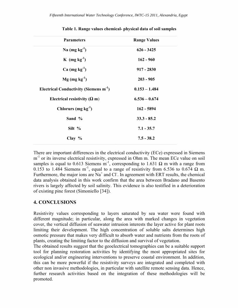
Table 1. Range values chemical- physical data of soil samples
Parameters Range Values
Na (mg kg-1) 626 - 3425
K (mg kg-1) 162 - 960
Ca (mg kg-1) 917 - 2830
Mg (mg kg-1) 203 - 905
Electrical Conductivity (Siemens m-1) 0.153 – 1.484
Electrical resistivity (Ω m) 6.536 – 0.674
Chlorurs (mg kg-1) 162 - 5894
Sand % 33.3 - 85.2
Silt % 7.1 - 35.7
Clay % 7.5 - 38.2
There are important differences in the electrical conductivity (ECe) expressed in Siemens m-1 or its inverse electrical resistivity, expressed in Ohm m. The mean ECe value on soil samples is equal to 0.613 Siemens m-1, corresponding to 1.631 Ω m with a range from 0.153 to 1.484 Siemens m-1, equal to a range of resistivity from 6.536 to 0.674 Ω m. Furthermore, the major ions are Na+ and Cl-. In agreement with ERT results, the chemical data analysis obtained in this work confirm that the area between Bradano and Basento rivers is largely affected by soil salinity. This evidence is also testified in a deterioration of existing pine forest (Simoniello [34]). 4. CONCLUSIONS Resistivity values corresponding to layers saturated by sea water were found with different magnitude; in particular, along the area with marked changes in vegetation cover, the vertical diffusion of seawater intrusion interests the layer active for plant roots limiting their development. The high concentration of soluble salts determines high osmotic pressure that makes very difficult to absorb water and nutrients from the roots of plants, creating the limiting factor to the diffusion and survival of vegetation. The obtained results suggest that the geoelectrical tomographies can be a suitable support tool for planning restoration activities by identifying the most appropriated sites for ecological and/or engineering interventions to preserve coastal environment. In addition, this can be more powerful if the resistivity surveys are integrated and completed with other non invasive methodologies, in particular with satellite remote sensing data. Hence, further research activities based on the integration of these methodologies will be promoted.
Fifteenth International Water Technology Conference, IWTC-15 2011, Alexandria, Egypt
REFERENCES [1] Freeze, A.R. and Cherry, J. A., Groundwater, Prentice Hall Inc., New Jersey, 1979. [2] Demirel, Z., The history and evaluation of saltwater intrusion into a coastal aquifer
in Mersin, Turkey, J. Environ. Manage., Vol 70, pp 275–282. [3] Duque, C. Calvache, M.L. Pedrera, A. Martin-Rosales, W.M. López-Chicano, M.,
Combined time domain electromagnetic soundings and gravimetry to determin marine intrusion in a detrital coastal aquifer (Southern Spain), J. Hydrol., Vol. 349, pp. 536–547.
[4] Frohlich, R.K. Barosh, P.J. and Boving, T., Investigating changes of electrical
characteristics of the saturated zone affected by hazardous organic waste, J. Appl. Geophys., Vol. 64, pp. 25–36.
[5] Petalas, C.P. and Lambrakis, N., Simulation of intense salinization phenomena in
coastal aquifers—the case of the coastal aquifers of Thrace, Journal of Hydrology, Vol. 324, pp. 51–64.
[6] Polemio. M., Limoni, P.P., Mitolo, D., Santaloia, F., Characterisation of the ionian-
lucanian coastal plain aquifer (Italy), Boletín Geológico y Minero, Vol. 114 part 2, pp. 225-236.
[7] Somay, M.A. and Gemici, U., Assessment of the Salinization Process at the Coastal
Area with Hydrogeochemical Tools and Geographical Information Systems (GIS): Selçuk Plain, Izmir, Turkey, Water Air Soil Pollut., Vol.20, pp. 55–74.
[8] Balia, R., Gavaudo, E., Ardau, F. and Ghiglieri, G., Case history: geophysical
approach to the environmental study of a coastal plain, Geophysics, Vol.68, pp. 1446–1459.
[9] Batayneh, A.T., Use of electrical resistivity methods for detecting subsurface fresh and saline water and delineating their interfacial configuration: a case study of the eastern Dead Sea coastal aquifers, Jordan, Hydrogeology Journal, Vol. 14, pp. 1277-1283.
[10] Bauer, P., Supper, R., Zimmermann, S. and Kinzelbach, W., Geoelectrical imaging
of groundwater salinization in the Okavango Delta, Botswana, Journal of Applied Geophysics, Vol.60, pp. 126–141.
. [11] Cimino, A., Cosentino, C., Oieni, A. and Tranchina, L., A geophysical and
geochemical approach for seawater intrusion assessment in the Acquedolci coastal aquifer (Northern Sicily), Environmental Geology, Vol.55, pp. 1473–1482.

Fifteenth International Water Technology Conference, IWTC-15 2011, Alexandria, Egypt
[12] Choudhury, K. and Saha, D. K., Integrated geophysical and chemical study of saline water intrusion, Ground Water,Vol. 42, pp. 671–677.
[13] Ebraheem, A.A.M., Senosy, M.M. and Dahab, K.A., Geoelectrical and
hydrogeochemical studies for delineating ground-water contamination due to salt-water intrusion in the Northern part of the Nile Delta, Egypt, Ground Water, Vol.35, pp. 216–222.
[14] Khalil, M. H., Geoelectric resistivity sounding for delineating salt water intrusion in
the Abu Zenima area, west Sinai, Egypt, Journal. Geophys. Eng., Vol. 3, pp. 243-251.
[15] Koukadaki, M.A., Karatzas, G.P., Papadopoulou, M.P. and Vafidis, A.,
Identification of the Saline Zone in a Coastal Aquifer Using Electrical Tomography Data and Simulation, Water Resource Management, Vol.21, pp. 1881-1898.
[16] Kruse, S.E., Brudzinski, M.R. and Geib, T.L., Use of electrical and electromagnetic
techniques to map seawater intrusion near the Cross-Florida Barge Canal, Environmental and Engineering Geosc. , Vol.4, pp.331- 340.
[17] Nassir, A.S.S., Loke, M.H., Lee, C.Y. and Nawawi, M.N.M., Salt–water intrusion
mapping by geoelectrical imaging surveys, Geophysical Prospecting,Vol. 48, pp. 647–661.
[18] Nowroozi, A.A., Horrocks, S.B. and Henderson, P., Saltwater intrusion into the
freshwater aquifer in the eastern shore of Virginia: a reconnaissance electrical resistivity survey, J. of Applied Geophysics, Vol. 42, pp. 1–22.
[19] Pujari, P.R. and Soni, A.K., Sea water intrusion studies near Kovaya limestone
mine, Saurashtra coast India, Environ. Monit. Assess.,Vol. 154, pp. 93-109. [20] Sherif, M., El Mahmoudi, A., Garamoon, H., Kacimov, A., Akram, S., Ebraheem,
A. and Shetty, A., Geoelectrical and hydrogeochemical studies for delineating seawater intrusion in the outlet of Wadi Ham, UAE, Environmental Geology, Vol. 49, pp. 536–551.
[21] Urish, D.W. and Frohlich, R.K. Surface electrical resistivity in coastal groundwater
exploration, Geoexploration, Vol.26, pp. 267–289. [22] Ciaranfi, N., Maggiore, M., Pieri, P., Rapisardi, L., Ricchetti, G. and Walsh, N.,
Considerazioni sulla neotettonica della Fossa bradanica Progetto Finalizzato Geodinamica del CNR, Vol. 251, pp. 73-95.
[23] Tropeano, M., Sabato, L. and Pieri, P. The Quaternary “Post-turbidite”
sedimentation in the South-Apennines Foredeep (Bradanic Trough-Southern Italy), Italian Journal of Geosciences Bull, Vol. 1, pp. 449-454.

Fifteenth International Water Technology Conference, IWTC-15 2011, Alexandria, Egypt
[24] Parea, G.C., I terrazzi marini tardo-pleistocenici del fronte della catena appenninica
in relazione alla geologia dell’avanfossa adriatica (The Late Pleistocene marine terraces in front of the Apennines in relation to the geology of Adriatic Foredeep), Memorie Società Geologica Italiana, Vol. 35, pp. 913-936.
[25] Cotecchia, V., Dai Pra, G., Magri, G., Morfogenesi litorale olocenica tra Capo
Spulico e Taranto nella prospettiva della protezione costiera (Holocenic morphological evolution of the littoral between Capo Spulico and Taranto with the aim of a coastal protection), Geologia Applicata e Idrogeologia, Vol.6 pp. 65-78.
[26] Cocco, E., Cravero, E., Di Geronimo, S., Mezzadri, G., Parea, G.C., Pescatore, T.,
Valloni, R. and Vinci, A., Lineamenti geomorfologici e sedimentologici del litorale alto ionico (Golfo di Taranto) (Geomorphological and sedimentological features of the Ionian littoral, Taranto Gulf), Bollettino Società Geologica Italiana, Vol. 94, pp. 993-1051.
[27] Loke, M.H., Electrical imaging surveys for environmental and engineering studies,
user manual for Res2dinv Electronic version available from http://www.geometrics.com., 1999.
[28] Loke, M.H. and Barker, R.D., Rapid least-squares inversion of apparent resistivity
pseudosections by a quasi-Newton method, Geophysical Prospecting, Vol. 44, pp.131-15.
[29] Sasaki, Y., Resolution of resistivity tomography inferred from numerical simulation,
Geophys Prospect, Vol.40, pp. 453- 464. [30] Guariglia, A., Buonamassa, A., Losurdo, A., Saladino, R., Trivigno, M.L.
Zaccagnino, A. and Colangelo, A., A multisource approach for coastline mapping and identification of shoreline changes, Annals of Geophysics, Vol. 49, 297-306.
[31] Simoniello, T., Carone, M.T., Satriani, A., Loperte, A., Imbrenda, V., D’emilio, M.
and Guariglia, A.,Integration of remote sensing and geophysical techniques for coastal monitoring, Geophysical Research Abstracts Vol. 11, pp. 13703 EGU 2009.