effect of mesoscale topography over the tibetan...
TRANSCRIPT

Effect of mesoscale topography over the Tibetan Plateau on summer
precipitation in China: A regional model study
Xiaoying Shi,1 Yuqing Wang,2 and Xiangde Xu1
Received 20 May 2008; revised 11 August 2008; accepted 27 August 2008; published 8 October 2008.
[1] The effect of mesoscale topography over the TibetanPlateau (TP) on downstream summer precipitation in Chinawas studied using a regional atmospheric model. Twoensemble simulations with 30 km model resolution wereconducted for the 1998 summer monsoon season in China.The control simulation used the uniform resolution for bothmodel atmosphere and topography. In the sensitivitysimulation, the mesoscale feature in topography over theTP was smoothed out with the use of the 120 km resolutiontopography over the TP. The results show that the controlsimulation reproduced reasonably well but the sensitivitysimulation considerably underestimated the observedprecipitation in the Yangtze River Valley (YRV). It isfound that the mesoscale feature in topography plays animportant role in generating and enhancing mesoscaledisturbances over the TP. These disturbances enhance thesurface sensible heat flux over the TP and propagateeastward to enhance convection and precipitation in theYRV in China. Citation: Shi, X., Y. Wang, and X. Xu (2008),
Effect of mesoscale topography over the Tibetan Plateau on
summer precipitation in China: A regional model study, Geophys.
Res. Lett., 35, L19707, doi:10.1029/2008GL034740.
1. Introduction
[2] The Tibetan Plateau (TP), the largest in size and thehighest in elevation, has significant influence on weatherand climate in east Asia, as well as the globe [Yeh and Gu,1955; Flohn, 1957]. Dynamically, the TP causes the bifur-cation of the westerlies over the Eurasian continent inwinter [Manabe and Terpstra, 1974]. Thermodynamically,diabatic heating over the TP plays an important role inmaintaining the summer monsoon and planetary scalecirculation [Hahnd and Manabe, 1975; Huang, 1985; Heet al., 1987; Kitoh, 2004]. The TP also plays an importantrole in moisture transport from tropical oceans to east China[Xu et al., 2002].[3] The dynamical and thermal forcing of the TP plays
important roles in not only the formation of the monsooncirculation but also the development of weather systemsover east China in summer [Tao and Ding, 1981; Yanai etal., 1992; Wu and Zhang, 1998; Tao et al., 1998; Xu et al.,2001; Yoshikane et al., 2001]. For example, Xu et al. [2001]andWang et al. [2003a] found that cloud systems developed
over the TP could further intensify to form deep andmatured super convective cloud clusters when they propa-gate eastward, contributing to the summer monsoon precip-itation in China. They suggested that the TP be an importantsource of convective cloud systems to the development offloods in the middle and lower reaches of the Yangtze RiverValley (YRV).[4] Despite considerable progress has been made in
understanding the impacts of the TP on the east Asianclimate, current state-of-the-art global general circulationmodels (GCMs) with coarse/moderate horizontal resolu-tions are still poor in simulating the mean and seasonalcycle of precipitation in the east Asian monsoon region[Lau, 1992; Kang et al., 2002]. Regional high-resolutionmodels start to show consistent improvements in simulatingthe regional climate in east Asia [e.g., Wang et al., 2003b,2004]. It is, however, unclear whether the improved simu-lations by regional models are because of the use of moreadvanced model physics or higher horizontal model reso-lution or both. Since high resolution models can betterresolve the mesoscale feature in topography over the TP,we hypothesize that the resolution of the model topographyover the TP contributes significantly to the improvedsimulations of the east Asia climate by regional highresolution models. We will demonstrate that the mesoscaletopography over the TP plays important roles in generating/enhancing mesoscale disturbances, increasing the surfaceheat flux, and triggering convective cloud systems over theTP in summer. They generally propagate eastward andenhance the downstream precipitation systems in the YRVin China.
2. Model and Experimental Design
[5] The model used in this study is the communityregional climate model, RegCM3, which is described indetail by Pal et al. [2007]. RegCM3 is a limited area,hydrostatic, primitive equation model with sigma as thevertical coordinate. The Grell scheme with Fritsch andChappell closure is used for deep convection parameteri-zation [Grell, 1993]. The radiation is adopted from theCommunity Climate Model version 3 (CCM3) [Kiehl etal., 1998]. The subgrid vertical mixing is parameterizedwith the non-local scheme of Holtslag and Boville [1993].The Biosphere-Atmosphere Transfer Scheme (BATS) ofDickinson et al. [1993] is used for the land surfaceprocesses.[6] The RegCM3 was run with 18 vertical levels and at
30 km grid spacing with a domain size of 180 by 120 gridpoints centered at 30.5�N, 100�E. The model domain coversthe shaded areas in Figure 1a, including the TP and thesurrounding areas in east Asia. In the reference run, the
GEOPHYSICAL RESEARCH LETTERS, VOL. 35, L19707, doi:10.1029/2008GL034740, 2008ClickHere
for
FullArticle
1State Key Laboratory for Severe Weather, Chinese Academy ofMeteorological Sciences, China Meteorological Administration, Beijing,China.
2International Pacific Research Center and Department of Meteorology,School of Ocean and Earth Science and Technology, University of Hawaiiat Manoa, Honolulu, Hawaii, USA.
Copyright 2008 by the American Geophysical Union.0094-8276/08/2008GL034740$05.00
L19707 1 of 5
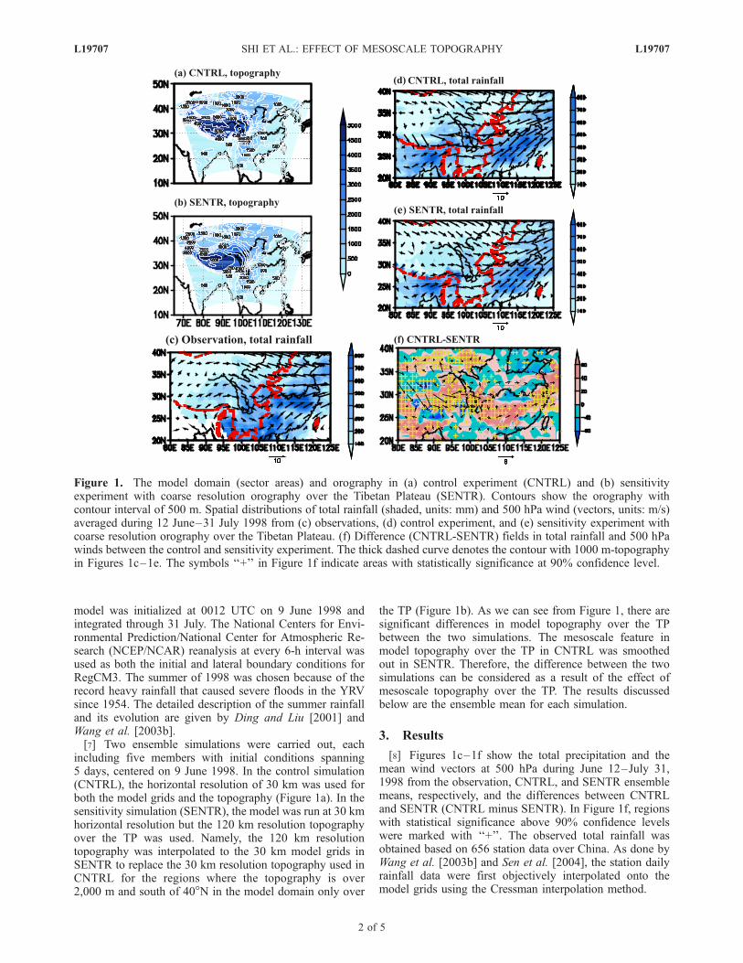
model was initialized at 0012 UTC on 9 June 1998 andintegrated through 31 July. The National Centers for Envi-ronmental Prediction/National Center for Atmospheric Re-search (NCEP/NCAR) reanalysis at every 6-h interval wasused as both the initial and lateral boundary conditions forRegCM3. The summer of 1998 was chosen because of therecord heavy rainfall that caused severe floods in the YRVsince 1954. The detailed description of the summer rainfalland its evolution are given by Ding and Liu [2001] andWang et al. [2003b].[7] Two ensemble simulations were carried out, each
including five members with initial conditions spanning5 days, centered on 9 June 1998. In the control simulation(CNTRL), the horizontal resolution of 30 km was used forboth the model grids and the topography (Figure 1a). In thesensitivity simulation (SENTR), the model was run at 30 kmhorizontal resolution but the 120 km resolution topographyover the TP was used. Namely, the 120 km resolutiontopography was interpolated to the 30 km model grids inSENTR to replace the 30 km resolution topography used inCNTRL for the regions where the topography is over2,000 m and south of 40�N in the model domain only over
the TP (Figure 1b). As we can see from Figure 1, there aresignificant differences in model topography over the TPbetween the two simulations. The mesoscale feature inmodel topography over the TP in CNTRL was smoothedout in SENTR. Therefore, the difference between the twosimulations can be considered as a result of the effect ofmesoscale topography over the TP. The results discussedbelow are the ensemble mean for each simulation.
3. Results
[8] Figures 1c–1f show the total precipitation and themean wind vectors at 500 hPa during June 12–July 31,1998 from the observation, CNTRL, and SENTR ensemblemeans, respectively, and the differences between CNTRLand SENTR (CNTRL minus SENTR). In Figure 1f, regionswith statistical significance above 90% confidence levelswere marked with ‘‘+’’. The observed total rainfall wasobtained based on 656 station data over China. As done byWang et al. [2003b] and Sen et al. [2004], the station dailyrainfall data were first objectively interpolated onto themodel grids using the Cressman interpolation method.
Figure 1. The model domain (sector areas) and orography in (a) control experiment (CNTRL) and (b) sensitivityexperiment with coarse resolution orography over the Tibetan Plateau (SENTR). Contours show the orography withcontour interval of 500 m. Spatial distributions of total rainfall (shaded, units: mm) and 500 hPa wind (vectors, units: m/s)averaged during 12 June–31 July 1998 from (c) observations, (d) control experiment, and (e) sensitivity experiment withcoarse resolution orography over the Tibetan Plateau. (f) Difference (CNTRL-SENTR) fields in total rainfall and 500 hPawinds between the control and sensitivity experiment. The thick dashed curve denotes the contour with 1000 m-topographyin Figures 1c–1e. The symbols ‘‘+’’ in Figure 1f indicate areas with statistically significance at 90% confidence level.
L19707 SHI ET AL.: EFFECT OF MESOSCALE TOPOGRAPHY L19707
2 of 5

[9] The observed heavy rainfall occurred along the YRV(26–32�N), South China, and Indochina Peninsula (Figure 1c).Except for a slightly southeastward shift of the heavyrainfall area in the YRV and a significant underestimationof rainfall over South China and the Indochina Peninsula,the control simulation reproduced the rainfall distributionand low-level circulation downstream of the TP reasonablywell (Figure 1d). To have a quantitative assessment for theoverall performance of the CNTRL simulation in the regiondownstream of the TP, statistics similar to those of Wang etal. [2003b] were conducted for the simulated precipitationin the area of 25�–35�N, 110�–120�E (Table 1).[10] The model estimated mean daily rainfall in the
CNTRL is slightly higher than the observed (10.5 versus9.7 mm d�1). Spatial and temporal correlation coefficientsare high at 49% and 72% (with confidence level above95%), respectively, indicating that the model not onlyreproduced the spatial pattern reasonably but also capturedwell the temporal evolution of precipitation events in theregion. We can thus consider that the control simulationreproduced reasonably well the precipitation downstream ofthe TP and the results can be compared with those from thesensitivity simulation to understand how the mesoscaletopography over the TP affects the downstream precipita-tion in the middle and lower reaches of the YRV.[11] In the SENTR simulation with the coarse resolution
topography over the TP, the rainfall amount was reduced inmost areas of the model domain, especially over the easternTP and the YRV (Figure 1e). Except for a significantreduction of rainfall over the western TP and north China,rainfall over the eastern part and downstream of the TP wassignificantly increased due to the presence of the mesoscaletopography over the TP (Figure 1f) in the CNTRL simula-tion. In addition, the southwesterly monsoon flow was alsostronger over the central and east China in the CNTRLsimulation than in the SENTR. The area averaged dailymean rainfall during the whole simulation period in themiddle and lower reaches of the YRV in the SENTR wasconsiderably lower than in the CNTRL (Table 1). The meanrainfall rate was reduced by 16.3% in SENTR compared tothe CNTRL. Compared with observations, although theCNTRL simulation overestimated the mean precipitationby 8%, the SENTR simulation underestimated the meanprecipitation by about 10%. Both spatial and temporalcorrelation coefficients with the observation in SENTRwere considerably lower than in the CNTRL (Table 1),indicating the overall degraded performance of the modelwith coarse resolution topography in the SENTR.[12] The above results demonstrate that high model
resolution to resolve the mesoscale topography over the
TP is very important for the realistic simulation of precip-itation in east Asia. To understand how the mesoscalefeature in topography over the TP affects the downstreamprecipitation in the YRV, we have examined the differencein the high-frequency synoptic and sub-synoptic scaleactivities in the two simulations. Ding and Liu [2001]showed the contribution by the eastward propagating me-soscale and sub-synoptic disturbances initiated over the TPto the 1998 summer precipitation over the YRV. As we cansee from the temporal evolution of the cloud top tempera-ture (TBB, blackbody temperature) averaged in the latitudeband between 25�–35�N based on 6 hourly satellite obser-vations (Figure 2a), the convective cloud clusters originatedover the TP moved eastward to enhance the rainstorms inmiddle and lower reaches of the YRV. Figures 2b and 2cshow the vertical cyclonic relative vorticity (only positivevalues included in the average) at 500 hPa averaged in thesame latitude band from the CNTRL and SENTR simula-tions, respectively. The positive relative vorticity in themiddle-lower troposphere generally corresponds to cycloniccirculation and low pressure systems. The positive relativevorticity and eastward propagation signal were clearly seenin the CNTRL simulation (Figure 2b). They, however, weremuch weaker in SENTR (Figure 2c) both over the TP anddownstream in the YRV. This suggests that the cyclonicdisturbances and low pressure systems were suppressed inthe SENTR due to the lack of mesoscale topographictriggering over the TP compared to those in the CNTRL.[13] The activities of high frequency mesoscale and sub-
synoptic disturbances can be measured by the eddy kineticenergy (EKE) in the simulations. The EKE is defined as
EKE ¼ 1
2u� �uð Þ2þ v� �vð Þ2
h i;
where u, v are zonal and meridional wind components at500 hPa, �u, �v are their time mean during June 12–July 31,1998. Figure 3 shows the time-mean EKE during the
Table 1. Statistics of the Model Simulated Precipitation in the
Area of 25�–35�N, 110�–120�E for the Control and the Sensitivity
Experimentsa
Mean Rainfall(mm)
SpatialCorrelation
TemporalCorrelation Bias
OBSb 9.70CNTRL 10.49 0.49 0.72 0.79SENTR 8.78 0.39 0.58 0.92
aPrecipitation in mm d�1; CNTRL, control; SENTR, sensitivity.bOBS, observed.
Figure 2. (a) Time-longitude sections of cloud toptemperature TBB (unit: �C) averaged between 25�–35�Nfrom Satellite observation, and cyclonic relative vorticity(units: 10�5 s�1) averaged between 25�–35�N at 500 hPafrom (b) the control experiment and (c) the sensitivityexperiment during 12 June–31 July 1998.
L19707 SHI ET AL.: EFFECT OF MESOSCALE TOPOGRAPHY L19707
3 of 5

simulation period from NCEP reanalysis, the CNTRL, andthe SENTR simulations, respectively. Because of therelative coarse resolution, NCEP reanalysis largely under-estimated the EKE (Figure 3a). In the CNTRL simulation,there was a zonally elongated high EKE band between 30�–36�N over the TP and extended eastward to the YRV andsouthwest China (Figure 3b), indicating active high-frequency mesoscale and sub-synoptic disturbances duringthe simulation period. In contrast, although a similar highEKE band appeared in the SENTR simulation (Figure 3c),the absolute values are much smaller, indicating a suppres-sion of the mesoscale and sub-synoptic activities. Compar-ing Figure 3 with Figure 1, one can see that the high EKEband is collocated with the high topography with consider-able mesoscale variability over the TP in the CNTRLsimulation. This indicates that mesoscale topography overthe TP contributed significantly to the generation of high-frequency mesoscale and sub-synoptic disturbances over theTP. These disturbances on one hand produced precipitationover the TP, and on the other hand enhanced theprecipitation systems over the YRV when they propagateddownstream to east China.[14] The high frequency, mesoscale and sub-synoptic
disturbances may also enhance the surface heat flux dueto the increased near surface wind speed. As shown inFigure 3, the total time-mean surface (sensible and latent)
heat flux was generally larger in the CNTRL than in theSENTR, especially over the central and southern TP and inthe middle and lower reaches of the YRV (Figure 3d). Theincreased surface sensible heat flux (Figure 3e) dominatesthe enhanced total surface heat flux, especially over the TP(Figure 3d). The changes in surface latent heat flux over theTP were generally small except for the negative areas westof the 90�E over the TP and positive areas along the southflank of the TP (Figure 3f). The larger latent heat flux overthe western TP was consistent with the increased precipita-tion in the SENTR (Figure 1f). Overall, the presence ofmesoscale topography over the TP in the CNTRL enhancedthe high-frequency disturbances and increased the surfaceheat flux over the TP. These may enhance the convectivesystems both over the TP and downstream over the YRV inChina. This could explain why the precipitation over themiddle-lower reaches of the YRV was higher in the CNTRLthan in the SENTR.
4. Conclusions
[15] Previous observational and modeling studies havedemonstrated that both thermal and mechanical effects ofthe TP play important roles in the onset and evolution ofAsian and east Asian monsoon and the moisture transportand precipitation in summer in China. Observational studieshave also shown that mesoscale convective cloud systems
Figure 3. Spatial distributions of eddy kinetic energy (EKE, m2 s�2) at 500 hPa averaged during 12June–31 July 1998 from (a) NCEP reanalysis, (b) control experiment, and (c) sensitivity experiment withcoarse resolution topography over the Tibetan Plateau. Differences (W m–2) in (d) total surface (sensible+ latent heat) fluxes, (e) sensible heat flux, and (f) latent heat flux between the control and sensitivityexperiments averaged during 12 June–31 July 1998.
L19707 SHI ET AL.: EFFECT OF MESOSCALE TOPOGRAPHY L19707
4 of 5

that are initiated over the TP and propagate eastward maycontribute significantly to downstream precipitation overthe YRV in China. The heterogeneous sensible heat fluxover the TP is proposed as a triggering mechanism for theconvective cloud systems [Tao and Ding, 1981]. In thisstudy, results from the regional climate model simulationsdemonstrate that mesoscale feature of topography over theTP plays an important role in triggering and enhancing theactivities of mesoscale and sub-synoptic disturbances overthe TP. These disturbances increase the surface heat fluxover the TP and propagate eastward and enhance thedownstream convective systems and precipitation over themiddle-lower reaches of the YRV in China. Since this studyonly performed one summer simulations, the robustness ofthe finding yet to be confirmed with multi-year simulationsin the future. Xie et al. [2006] demonstrated that the coastalmesoscale mountains in South Asia play critical roles inorganizing monsoon convection and large-scale summermonsoon circulation in Asia and east Asia. The results fromthis study strongly suggest the need of high-resolutionmodel to better resolve the topography not only in coastalSouth Asia but also over the TP for the realistic simulationsof the east Asian summer climate and seasonal prediction ofeast Asian summer rainfall.
[16] Acknowledgments. This work has been supported by China andJapan intergovernmental cooperation program (JICA), the social common-wealth research program of Ministry of Science and Technology of thePeople’s Republic of China under grant 2005DIB3J057, and the ChineseNational Natural Science Foundation under grant 90502003. YW has beensupported by JAMSTEC of Japan, US NASA, and NOAA through theirsponsorships of the International Pacific Research Center (IPRC) in Schoolof Ocean and Earth Science and Technology (SOEST) at University ofHawaii.
ReferencesDickinson, R. E., A. Henderson-Sellors, and P. J. Kennedy (1993), Bio-sphere-Atmosphere Transfer Scheme (BATS) version 1e as coupled to theNCAR Community Climate Model, NCAR Tech. Note NCAR/TN-387+STR, 72 pp., Natl. Cent. Atmos. Res., Boulder, Colo.
Ding, Y.-H., and Y. Liu (2001), Onset and the evolution of the summermonsoon over the South China Sea during SCSMEX Field Experiment I1998, J. Meteorol. Soc. Jpn., 79, 255–276.
Flohn, H. (1957), Large-scale aspects of the ‘‘summer monsoon’’ in southand east Asia, J. Meteorol. Soc. Jpn., 75, 180–186.
Grell, G. A. (1993), Prognostic evaluation of assumptions used by cumulusparameterization, Mon. Weather Rev., 121, 764–787.
Hahnd, G., and S. Manabe (1975), The role of mountains in the south Asianmonsoon circulation, J. Atmos. Sci., 77, 1515–1541.
He, H.-Y., J. W. McGinnis, Z. Song, and M. Yanai (1987), Onset of theAsian summer monsoon in 1979 and the effect of the Tibetan Plateau,Mon. Weather Rev., 115, 1966–1995.
Holtslag, A. A. M., and B. A. Boville (1993), Local versus nonlocal boundary-layer diffusion in a global climate model, J. Clim., 6, 1825–1842.
Huang, R.-H. (1985), Numerical simulation of three-dimensional telecon-nections in the summer circulation over the northern hemisphere, Adv.Atmos. Sci., 2, 81–92.
Kang, I.-S., et al. (2002), Intercomparison of the climatological variationsof Asian summer monsoon precipitation simulated by 10 GCMs, Clim.Dyn., 19, 383–395.
Kiehl, J. T., J. J. Hack, G. B. Bonan, B. A. Boville, D. L. Williamson, andP. J. Rasch (1998), The National Center for Atmospheric Research Com-munity Climate Model: CCM3, J. Clim., 11, 1307–1326.
Kitoh, A. (2004), Effects of mountain uplift on east Asian summer climateinvestigated by a coupled atmosphere-ocean GCM, J. Clim., 17, 783–802.
Lau, K.-M. (1992), East Asian summer monsoon rainfall variability andclimate teleconnection, J. Meteorol. Soc. Jpn., 70, 211–242.
Manabe, S., and T. B. Terpstra (1974), The effects of mountains on thegeneral circulation of the atmosphere as identified by numerical experi-ments, J. Atmos. Sci., 31, 3–42.
Pal, J. S., et al. (2007), RegCM3 and RegCNET: Regional climate modelingfor the developing world, Bull. Am. Meteorol. Soc., 88, 1395–1409.
Sen, O. L., Y. Wang, and B. Wang (2004), Impact of Indochina deforesta-tion on the east Asian summer monsoon, J. Clim., 17, 1366–1380.
Tao, S.-Y., and Y.-H. Ding (1981), Observational evidence of the influenceof the Qinghai-Xizang (Tibet) Plateau on the occurrence of heavy rainand severe convective storms in China, Weather Forecast., 2, 89–112.
Tao, S.-Y., Q.-Y. Zhang, and S.-L. Zhang (1998), The great floods in theChangjiang River Valley in 1998, Clim. Environ. Res., 3, 158–167.
Wang, J.-Z., Y.-Q. Yang, X.-D. Xu, and G.-Z. Zhang (2003a), A monitoringstudy of the 1998 rainstorm along the Yangtze River of China by usingTIPEX data, Adv. Atmos. Sci., 20, 425–436.
Wang, Y., O. L. Sen, and B. Wang (2003b), A highly resolved regionalclimate model (IPRC–RegCM) and its simulation of the 1998 severeprecipitation event over China. Part I: Model description and verificationof simulation, J. Clim., 16, 1721–1738.
Wang, Y., L. R. Leung, J. L. McGregor, D.-K. Lee, W.-C. Wang, Y.-H.Ding, and F. Kimura (2004), Regional climate modeling: Progress, chal-lenges and prospects, J. Meteorol. Soc. Jpn., 82, 1599–1628.
Wu, G.-X., and Y.-S. Zhang (1998), Tibetan Plateau forcing and the Asianmonsoon onset over south Asia and South China Sea,Mon. Weather Rev.,126, 913–927.
Xie, S.-P., H.-M. Xu, N. H. Saji, Y. Wang, and W. T. Liu (2006), Role ofnarrow mountains in large-scale organization of Asian monsoon convec-tion, J. Clim., 19, 3420–3429.
Xu, X.-D., et al. (2001), Synthetic physical image of the dynamic andthermal structure of Tibetan Plateau land-air processes (in Chinese),Sci. China, Ser. D, 31, 429–440.
Xu, X.-D., S.-Y. Tao, and J.-Z. Wang (2002), The relationship betweenmoisture transport features of Tibetan Plateau-monsoon ‘‘large triangle’’affecting region and drought-flood abnormality of China (in Chinese),Acta Meteorol. Sin., 60, 257–266.
Yanai, M., C.-Y. Li, and Z. Song (1992), Seasonal heating of the TibetanPlateau and its effects on the evolution of the Asian summer monsoon,J. Meteorol. Soc. Jpn., 70, 189–221.
Yeh, T.-C., and Z.-C. Gu (1955), On the influence of the Qinghai-XizangPlateau on east Asian circulation and weather in China (in Chinese), Sci.Sin., 4, 29–33.
Yoshikane, T., F. Kimura, and S. Emori (2001), Numerical study on the Baiufront genesis by heating contrast between land and ocean, J. Meteorol. Soc.Jpn., 79, 671–686.
�����������������������X. Shi and X. Xu, State Key Laboratory for Severe Weather, Chinese
Academy ofMeteorological Sciences, ChinaMeteorological Administration,46 Zhongguangchun South Street, Beijing 100081, China.Y. Wang, International Pacific Research Center, School of Ocean and
Earth Science and Technology, University of Hawaii at Manoa, Honolulu,HI 96822, USA. ([email protected])
L19707 SHI ET AL.: EFFECT OF MESOSCALE TOPOGRAPHY L19707
5 of 5