earth science: unequal - · pdf filean online guide to air pressure and winds from the...
TRANSCRIPT


Earth Science: UnequalHeating of the Earth
Penny Christensen
Say Thanks to the AuthorsClick http://www.ck12.org/saythanks
(No sign in required)

www.ck12.org
To access a customizable version of this book, as well as otherinteractive content, visit www.ck12.org
CK-12 Foundation is a non-profit organization with a mission toreduce the cost of textbook materials for the K-12 market bothin the U.S. and worldwide. Using an open-content, web-basedcollaborative model termed the FlexBook®, CK-12 intends topioneer the generation and distribution of high-quality educationalcontent that will serve both as core text as well as provide anadaptive environment for learning, powered through the FlexBookPlatform®.
Copyright © 2014 CK-12 Foundation, www.ck12.org
The names “CK-12” and “CK12” and associated logos and theterms “FlexBook®” and “FlexBook Platform®” (collectively“CK-12 Marks”) are trademarks and service marks of CK-12Foundation and are protected by federal, state, and internationallaws.
Any form of reproduction of this book in any format or medium,in whole or in sections must include the referral attribution linkhttp://www.ck12.org/saythanks (placed in a visible location) inaddition to the following terms.
Except as otherwise noted, all CK-12 Content (including CK-12Curriculum Material) is made available to Users in accordancewith the Creative Commons Attribution-Non-Commercial 3.0Unported (CC BY-NC 3.0) License (http://creativecommons.org/licenses/by-nc/3.0/), as amended and updated by Creative Com-mons from time to time (the “CC License”), which is incorporatedherein by this reference.
Complete terms can be found at http://www.ck12.org/terms.
Printed: April 10, 2014
AUTHORPenny Christensen
iii

Contents www.ck12.org
Contents
1 Heat, Air Pressure, and Wind 1
2 Land versus Water 2
3 Land Breeze, Sea Breeze 3
4 Wind Blows: High to Low Pressure 4
5 Air Movement 5
6 H AP W Study Guide for Students 16
iv

www.ck12.org Concept 1. Heat, Air Pressure, and Wind
CONCEPT 1 Heat, Air Pressure, andWind
Vocabulary Words
rotation, revolution, air mass, front, air pressure, unequal, absorb, reflect, hemisphere, equaltor, axis
1

www.ck12.org Concept 3. Land Breeze, Sea Breeze
CONCEPT 3 Land Breeze, Sea Breeze
3

www.ck12.org Concept 5. Air Movement
CONCEPT 5 Air Movement
Lesson Objectives
• List the properties of the air currents within a convection cell.• Describe how high and low pressure cells create local winds and explain how several types of local winds
form.• Discuss how global convection cells lead to the global wind belts.
Points to Consider
• How do local winds affect the weather in an area?• How do the global wind belts affect the climate in an area?• What are the main principles that control how the atmosphere circulates?
Introduction
A few basic principles go a long way toward explaining how and why air moves: Warm air rising creates a lowpressure zone at the ground. Air from the surrounding area is sucked into the space left by the rising air. Air flowshorizontally at top of the troposphere; horizontal flow is called advection . The air cools until it descends. Where itreaches the ground, it creates a high pressure zone . Air flowing from areas of high pressure to low pressure createswinds. Warm air can hold more moisture than cold air. Air moving at the bases of the three major convection cellsin each hemisphere north and south of the equator creates the global wind belts.
Air Pressure and Winds
Within the troposphere are convection cells ( Figure 5.1 ).
FIGURE 5.1Warm air rises, creating a low pressure zone; cool air sinks, creating ahigh pressure zone.
Air that moves horizontally between high and low pressure zones makes wind. The greater the pressure differencebetween the pressure zones the faster the wind moves.
Convection in the atmosphere creates the planet’s weather. When warm air rises and cools in a low pressure zone,it may not be able to hold all the water it contains as vapor. Some water vapor may condense to form clouds or
5

www.ck12.org
precipitation. When cool air descends, it warms. Since it can then hold more moisture, the descending air willevaporate water on the ground.
Air moving between large high and low pressure systems creates the global wind belts that profoundly affect regionalclimate. Smaller pressure systems create localized winds that affect the weather and climate of a local area.
An online guide to air pressure and winds from the University of Illinois is found here: http://ww2010.atmos.uiuc.edu/%28Gh%29/guides/mtr/fw/home.rxml .
Local Winds
Local winds result from air moving between small low and high pressure systems. High and low pressure cells arecreated by a variety of conditions. Some local winds have very important effects on the weather and climate of someregions.
Land and Sea Breezes
Since water has a very high specific heat, it maintains its temperature well. So water heats and cools more slowlythan land. If there is a large temperature difference between the surface of the sea (or a large lake) and the land nextto it, high and low pressure regions form. This creates local winds.
• Sea breezes blow from the cooler ocean over the warmer land in summer. Where is the high pressure zoneand where is the low pressure zone? ( Figure 5.2 ). Sea breezes blow at about 10 to 20 km (6 to 12 miles) perhour and lower air temperature much as 5 to 10 o C (9 to 18 o F).
• Land breezes blow from the land to the sea in winter. Where is the high pressure zone and where is the lowpressure zone? Some warmer air from the ocean rises and then sinks on land, causing the temperature overthe land to become warmer.
Land and sea breezes create the pleasant climate for which Southern California is known. The effect of land and seabreezes are felt only about 50 to 100 km (30 to 60 miles) inland. This same cooling and warming effect occurs to asmaller degree during day and night, because land warms and cools faster than the ocean.
Monsoon Winds
Monsoon winds are larger scale versions of land and sea breezes; they blow from the sea onto the land in summerand from the land onto the sea in winter. Monsoon winds are occur where very hot summer lands are next to the sea.Thunderstorms are common during monsoons ( Figure 5.3 ).
The most important monsoon in the world occurs each year over the Indian subcontinent. More than two billionresidents of India and southeastern Asia depend on monsoon rains for their drinking and irrigation water. Backin the days of sailing ships, seasonal shifts in the monsoon winds carried goods back and forth between India andAfrica.
Mountain and Valley Breezes
Temperature differences between mountains and valleys create mountain and valley breezes. During the day, air onmountain slopes is heated more than air at the same elevation over an adjacent valley. As the day progresses, warmair rises and draws the cool air up from the valley, creating a valley breeze . At night the mountain slopes cool morequickly than the nearby valley, which causes a mountain breeze to flow downhill.
6

www.ck12.org Concept 5. Air Movement
FIGURE 5.2How do sea and land breezes moderatecoastal climates?
FIGURE 5.3In the southwestern United States rela-tively cool moist air sucked in from theGulf of Mexico and the Gulf of Californiameets air that has been heated by scorch-ing desert temperatures.
Katabatic Winds
Katabatic winds move up and down slopes, but they are stronger mountain and valley breezes. Katabatic windsform over a high land area, like a high plateau. The plateau is usually surrounded on almost all sides by mountains.
7

www.ck12.org
In winter, the plateau grows cold. The air above the plateau grows cold and sinks down from the plateau through gapsin the mountains. Wind speeds depend on the difference in air pressure over the plateau and over the surroundings.Katabatic winds form over many continental areas. Extremely cold katabatic winds blow over Antarctica andGreenland.
Chinook Winds (Foehn Winds)
Chinook winds (or Foehn winds ) develop when air is forced up over a mountain range. This takes place, forexample, when the westerly winds bring air from the Pacific Ocean over the Sierra Nevada Mountains in California.As the relatively warm, moist air rises over the windward side of the mountains, it cools and contracts. If the air ishumid, it may form clouds and drop rain or snow. When the air sinks on the leeward side of the mountains, it formsa high pressure zone. The windward side of a mountain range is the side that receives the wind; the leeward side isthe side where air sinks.
The descending air warms and creates strong, dry winds. Chinook winds can raise temperatures more than 20 o C(36 o F) in an hour and they rapidly decrease humidity. Snow on the leeward side of the mountain disappears meltsquickly. If precipitation falls as the air rises over the mountains, the air will be dry as it sinks on the leeward size.This dry, sinking air causes a rainshadow effect ( Figure 5.4 ), which creates many of the world’s deserts.
FIGURE 5.4As air rises over a mountain it cools andloses moisture, then warms by compres-sion on the leeward side. The resultingwarm and dry winds are Chinook winds.The leeward side of the mountain experi-ences rainshadow effect.
Santa Ana Winds
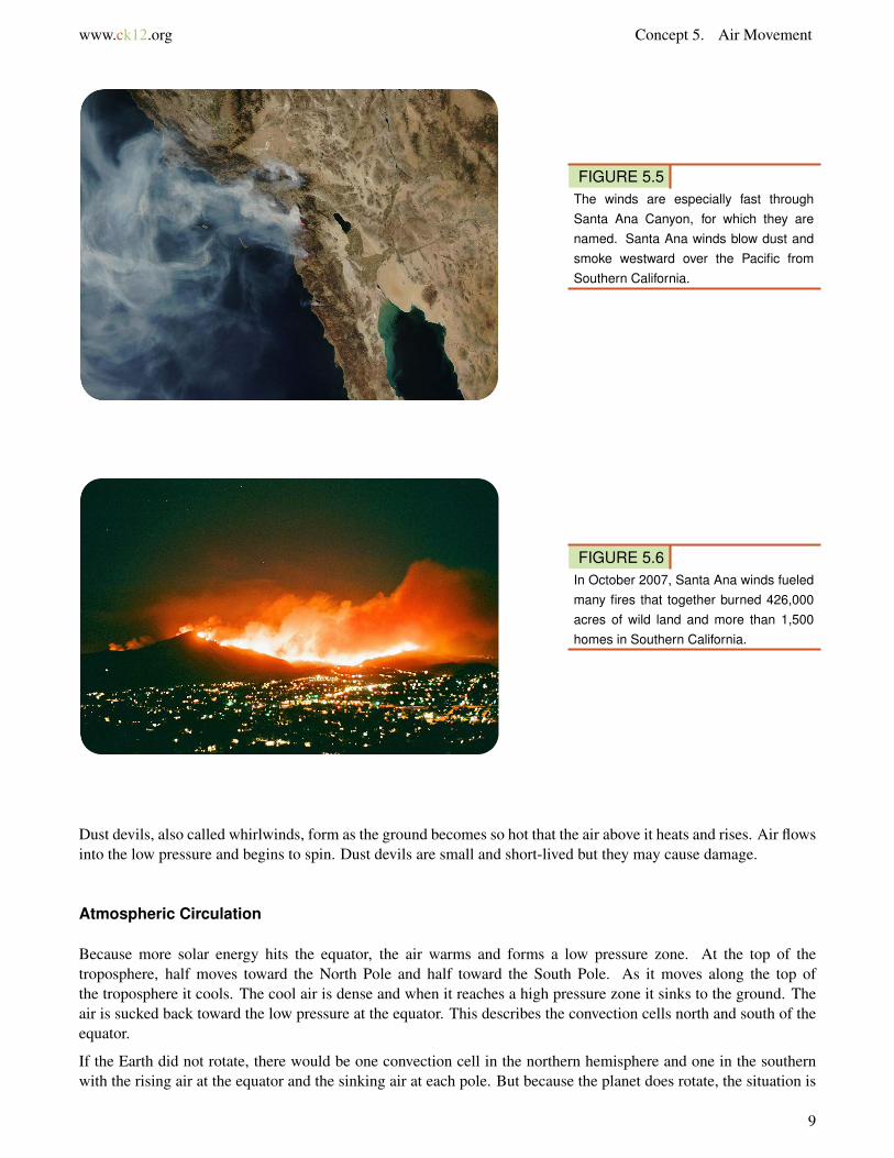
Santa Ana winds are created in the late fall and winter when the Great Basin east of the Sierra Nevada cools,creating a high pressure zone. The high pressure forces winds downhill and in a clockwise direction (because ofCoriolis). The air pressure rises, so temperature rises and humidity falls. The winds blow across the Southwesterndeserts and then race downhill and westward toward the ocean. Air is forced through canyons cutting the San Gabrieland San Bernardino mountains. ( Figure 5.5 ).
The Santa Ana winds often arrive at the end of California’s long summer drought season. The hot, dry winds dryout the landscape even more. If a fire starts, it can spread quickly, causing large-scale devastation ( Figure 5.6 ).
Desert Winds
High summer temperatures on the desert create high winds, which are often associated with monsoon storms. Desertwinds pick up dust because there is not as much vegetation to hold down the dirt and sand. ( Figure 5.7 ). A haboobforms in the downdrafts on the front of a thunderstorm.
8
www.ck12.org Concept 5. Air Movement
FIGURE 5.5The winds are especially fast throughSanta Ana Canyon, for which they arenamed. Santa Ana winds blow dust andsmoke westward over the Pacific fromSouthern California.
FIGURE 5.6In October 2007, Santa Ana winds fueledmany fires that together burned 426,000acres of wild land and more than 1,500homes in Southern California.
Dust devils, also called whirlwinds, form as the ground becomes so hot that the air above it heats and rises. Air flowsinto the low pressure and begins to spin. Dust devils are small and short-lived but they may cause damage.
Atmospheric Circulation
Because more solar energy hits the equator, the air warms and forms a low pressure zone. At the top of thetroposphere, half moves toward the North Pole and half toward the South Pole. As it moves along the top ofthe troposphere it cools. The cool air is dense and when it reaches a high pressure zone it sinks to the ground. Theair is sucked back toward the low pressure at the equator. This describes the convection cells north and south of theequator.
If the Earth did not rotate, there would be one convection cell in the northern hemisphere and one in the southernwith the rising air at the equator and the sinking air at each pole. But because the planet does rotate, the situation is
9

www.ck12.org
FIGURE 5.7A haboob in the Phoenix metropolitanarea, Arizona.
more complicated. The planet’s rotation means that the Coriolis Effect must be taken into account. Coriolis Effectwas described in the Earth’s Oceans chapter.
Let’s look at atmospheric circulation in the Northern Hemisphere as a result of the Coriolis Effect ( Figure 5.8 ). Airrises at the equator, but as it moves toward the pole at the top of the troposphere, it deflects to the right. (Rememberthat it just appears to deflect to the right because the ground beneath it moves.) At about 30 o N latitude, the airfrom the equator meets air flowing toward the equator from the higher latitudes. This air is cool because it has comefrom higher latitudes. Both batches of air descend, creating a high pressure zone. Once on the ground, the air returnsto the equator. This convection cell is called the Hadley Cell and is found between 0 o and 30 o N.
FIGURE 5.8The atmospheric circulation cells, show-ing direction of winds at Earth’s surface.
There are two more convection cells in the Northern Hemisphere. The Ferrell cell is between 30 o N and 50 o to
10

www.ck12.org Concept 5. Air Movement
60 o N. This cell shares its southern, descending side with the Hadley cell to its south. Its northern rising limb isshared with the Polar cell located between 50 o N to 60 o N and the North Pole, where cold air descends.
There are three mirror image circulation cells in the Southern Hemisphere. In that hemisphere, the Coriolis Effectmakes objects appear to deflect to the left.
Global Wind Belts
Global winds blow in belts encircling the planet. The global wind belts are enormous and the winds are relativelysteady ( Figure 5.9 ). These winds are the result of air movement at the bottom of the major atmospheric circulationcells, where the air moves horizontally from high to low pressure.
FIGURE 5.9The major wind belts and the directionsthat they blow.
Global Wind Belts
Let’s look at the global wind belts in the Northern Hemisphere.
• In the Hadley cell air should move north to south, but it is deflected to the right by Coriolis. So the air blowsfrom northeast to the southwest. This belt is the trade winds, so called because at the time of sailing ships theywere good for trade.
• In the Ferrel cell air should move south to north, but the winds actually blow from the southwest. This belt isthe westerly winds or westerlies. Why do you think a flight across the United States from San Francisco toNew York City takes less time than the reverse trip?
• In the Polar cell, the winds travel from the northeast and are called the polar easterlies
The wind belts are named for the directions from which the winds come. The westerly winds, for example, blowfrom west to east. These names hold for the winds in the wind belts of the Southern Hemisphere as well.
This video lecture discusses the 3-cell model of atmospheric circulation and the resulting global wind belts andsurface wind currents (5a) : http://www.youtube.com/watch?v=HWFDKdxK75E&feature=related (8:45).
11

www.ck12.org
MEDIAClick image to the left for more content.
Global Winds and Precipitation
Besides their effect on the global wind belts, the high and low pressure areas created by the six atmosphericcirculation cells determine in a general way the amount of precipitation a region receives. In low pressure regions,where air is rising, rain is common. In high pressure areas, the sinking air causes evaporation and the region isusually dry. More specific climate effects will be described in the chapter about climate.
Polar Fronts and Jet Streams
The polar front is the junction between the Ferrell and Polar cells. At this low pressure zone, relatively warm,moist air of the Ferrell Cell runs into relatively cold, dry air of the Polar cell. The weather where these two meet isextremely variable, typical of much of North America and Europe.
The polar jet stream is found high up in the atmosphere where the two cells come together. A jet stream is afast-flowing river of air at the boundary between the troposphere and the stratosphere. Jet streams form where thereis a large temperature difference between two air masses. This explains why the polar jet stream is the world’s mostpowerful ( Figure 5.10 ).
FIGURE 5.10A cross section of the atmosphere withmajor circulation cells and jet streams.The polar jet stream is the site of ex-tremely turbulent weather.
Jet streams move seasonally just as the angle of the Sun in the sky moves north and south. The polar jet stream,known as “the jet stream,” moves south in the winter and north in the summer between about 30 o N and 50 o to75 o N.
Lesson Summary
• Winds blow from high pressure zones to low pressure zones. The pressure zones are created when air near theground becomes warmer or colder than the air nearby.
• Local winds may be found in a mountain valley or near a coast.• The global wind patterns are long-term, steady winds that prevail around a large portion of the planet.• The location of the global wind belts has a great deal of influence on the weather and climate of an area.
12

www.ck12.org Concept 5. Air Movement
Review Questions
1. Draw a picture of a convection cell in the atmosphere. Label the low and high pressure zones and where the windis.
2. Under what circumstances will winds be very strong?
3. Given what you know about global-scale convection cells, where would you travel if you were interested inexperiencing warm, plentiful rain?
4. Describe the atmospheric circulation for two places where you are likely to find deserts, and explain why theseregions are relatively warm and dry.
5. How could the Indian monsoons be reduced in magnitude? What effect would a reduction in these importantmonsoons have on that part of the world?
6. Why is the name “snow eater” an apt description of Chinook winds?
7. Why does the Coriolis Effect cause air to appear to move clockwise in the Northern Hemisphere? When doesCoriolis Effect cause air to appear to move counterclockwise?
8. Sailors once referred to a portion of the ocean as the doldrums. This is a region where there is frequently no wind,so ships would become becalmed for days or even weeks. Where do you think the doldrums might be relative to theatmospheric circulation cells?
9. Imagine that the jet stream is located further south than usual for the summer. What is the weather like in regionsjust north of the jet stream, as compared to a normal summer?
10. Give a general description of how winds form.
Further Reading / Supplemental Links
High and Low Pressure Systems animations, Bureau of Meteorology, Australian Government http://www.bom.gov.au/lam/Students_Teachers/pressure.shtml
Opening image courtesy of NASA’s Earth Observatory, http://eol.jsc.nasa.gov/scripts/sseop/photo.pl?mission=ISS013&roll=E&frame=54329 , and is in the public domain.
Vocabulary
advectionHorizontal movement of a fluid or the transport of a substance in the flow.
Chinook winds (Foehn winds)Winds that form when low pressure draws air over a mountain range.
haboobDesert sandstorms that form in the downdrafts of a thunderstorm.
high pressure zoneA region where relatively cool, dense air is sinking.
jet streamA fast-flowing river of air high in the atmosphere, where air masses with two very different sets of temperatureand humidity characteristics move past each other.
13
www.ck12.org
katabatic windsWinds that move down a slope.
land breezeA wind that blows from land to sea in winter when the ocean is warmer than the land.
low pressure zoneA region where relatively warm, lower density air is rising.
monsoonHot land draws cool air off a nearby sea creating large winds and often rain.
mountain breezeA wind that blows from a mountain to a valley at night when mountain air is cooler.
polar frontThe meeting zone between cold continental air and warmer subtropical air at around 50 o N and 50 o S.
rainshadow effectA location of little rain on the leeward side of a mountain range due to descending air.
Santa Ana windsHot winds that blow east to west into Southern California in fall and winter.
sea breezeA wind that blows from sea to land in summer when the land is warmer than the ocean.
valley breezeAn uphill airflow.
advectionHorizontal movement of a fluid or the transport of a substance in the flow.
Chinook winds (Foehn winds)Winds that form when low pressure draws air over a mountain range.
haboobDesert sandstorms that form in the downdrafts of a thunderstorm.
high pressure zoneA region where relatively cool, dense air is sinking.
jet streamA fast-flowing river of air high in the atmosphere, where air masses with two very different sets of temperatureand humidity characteristics move past each other.
katabatic windsWinds that move down a slope.
14

www.ck12.org Concept 5. Air Movement
land breezeA wind that blows from land to sea in winter when the ocean is warmer than the land.
low pressure zoneA region where relatively warm, lower density air is rising.
monsoonHot land draws cool air off a nearby sea creating large winds and often rain.
mountain breezeA wind that blows from a mountain to a valley at night when mountain air is cooler.
polar frontThe meeting zone between cold continental air and warmer subtropical air at around 50 o N and 50 o S.
rainshadow effectA location of little rain on the leeward side of a mountain range due to descending air.
Santa Ana windsHot winds that blow east to west into Southern California in fall and winter.
sea breezeA wind that blows from sea to land in summer when the land is warmer than the ocean.
valley breezeAn uphill airflow.
References
1. CK-12 Foundation. . CC-BY-NC-SA 3.02. Jesús Gómez Fernández. http://en.wikipedia.org/wiki/File:Diagrama_de_formacion_de_la_brisa-breeze.png
. GNU-FDL 1.23. RyanW124. http://en.wikipedia.org/wiki/File:Azmonsoon.jpg . Public Domain4. Courtesy of US Federal Aviation Administration. http://en.wikipedia.org/wiki/File:Chinook_wind.jpg .
Public Domain5. Courtesy of NASA. http://en.wikipedia.org/wiki/File:AERONET_La_Jolla.2007297.aqua.250m.jpg . Public
Domain6. David S. Roberts (Everyguy). http://en.wikipedia.org/wiki/Image:Harris_fire_Mount_Miguel.jpg . GNU-
FDL 1.27. Junebug172. http://en.wikipedia.org/wiki/File:Haboob2.jpg . Public Domain8. Hastings. http://en.wikipedia.org/wiki/File:AtmosphCirc2.png . CC-BY-SA 1.09. Courtesy of NASA. http://en.wikipedia.org/wiki/File:Earth_Global_Circulation.jpg . Public Domain
10. Courtesy of National Weather Service. http://en.wikipedia.org/wiki/File:Jetcrosssection.jpg . Public Domain
15

www.ck12.org
CONCEPT 6 H AP W Study Guide forStudents
Name: _ __________ _____ __
Due Date: 2 / 14 Period: ___
Heat, Air Pressure, Wind, Seasons Climate Study Guide
This study guide , and all work that should be in the notebook according to the Table of Contents, must becompleted in order to earn a retest opportunity .
Fill in the Blanks :
There are _______ molecules of air at high elevations, so air pressure is less.
The air above the equator _______ because it has low density and low pressure.
Not all areas of Earth receive the same amount of radiation because the Earth’s surface is ________ .
Air pressure is ________ at sea level because there are more molecules of air pushing down from above.
Cold air has more molecules of air in one cubic centimeter than warm air; cold air has ________ pressure thanwarm air.
______ in the Southern Hemisphere happens at the same time as Spring in the ______ Hemisphere.
The properties of ______ air: Low pressure and low density.
The properties of ______ air: High pressure and high density.
When cool, dense air from over water flows inland is called a ___ ________ .
Air over the sea is ________ than air over land.
Be able to . . . : check the boxes when you explain these to another person and write the other answers on asheet of notebook paper to staple to this study guide .
[U+206D] Know dates of the Summer & Winter Solstice, the Spring & Fall Equinox. How do the “lengths” of theday(light) compare to each other?
[U+206D] Sketch the movement of air in the atmosphere. In the sketch you need to show air moving from a warmerto a cooler surface (ground) and know which has a greater or lesser density.
Which two types of air produce global winds?
What makes wind?
Compare the heating of land to water (remember the beach field trip?):
Know what the tilt of Earth’s axis looks like.
Review the sketch (from your notes) on the movement of global winds.
Review your sketch of sea/land breezes – be able to explain the reason for such breezes.
16