e journal of coastal zone management paradigm of marine geopark concept and information system based...
TRANSCRIPT

New Paradigm of Marine Geopark Concept and Information System Basedof Webserver at Bangka Belitung Islands, IndonesiaAgus Hartoko1*, Eddy Jajang Jaya Atmaja2, Ghiri Basuki Putra3, Irvani Fachruddin4, Rio Armanda Agustian5 and M Helmi6
1Department of Fisheries, Diponegoro University, Indonesia2Department of Agribisnis, University of Bangka Belitung, Indonesia3Department of Electronic Engineering, University of Bangka Belitung, Indonesia4Department of Mining, University of Bangka Belitung, Indonesia5University of Bangka Belitung, Indonesia6Department of Marine Science, Diponegoro University, Indonesia*Corresponding author: Agus Hartoko, Department of Fisheries, Faculty of Fisheries and Marine Science University of Diponegoro, Indonesia, Tel: +62-24-8452560; E-mail: [email protected]
Received Date: October 25, 2018; Accepted Date: November 15, 2018; Published Date: November 23, 2018
Copyright: © 2018 Hartoko A, et al. This is an open-access article distributed under the terms of the Creative Commons Attribution License, which permits unrestricteduse, distribution, and reproduction in any medium, provided the original author and source are credited.
Abstract
Based on UNESCO, Geopark is a defined area with a series of specific geological features, variety of endemicflora and fauna aimed for local and regional educational and economic development. Several areas in Indonesia hadbeen designated as geopark and one of them is at Bangka Belitung Province by Indonesian Geopark Authority in2017. Potential development of Bangka Belitung Geopark based on the uniqueness of its million years old graniterocks, but mostly were located and land-based and none referred to coastal and islands oriented. This paper willfocused to explore and develop the uniqueness of coastal areas and islands into a new concept of Marine Geoparkparadigm as a cluster of geological uniqueness of granite rocks, its endemic coastal flora and fauna, maritimeanthropology as well as many type of sunken war-ship and merchant treasures. Aims of the study were to exploreand develop as pioneer step of new paradigm and concept of Marine Geopark for educational and tourism purposesespecially Geo Tourism and its management. The study reveals the uniqueness of underwater coral uplift ontocoastal land at north Bangka and islands granite rock types on Mindanau, Kelapan, Begadung islands, manyendemic orchids such as Gammato phylum speciosum, Dillenia. sp, Hoya. spp, herbal vegetation’s in somemarginal sandy coastal areas, endemic fauna of Tarsius bancanus, Rasbora bankanensis, old ethnic house forhomestay, the Hinduism maritime anthropological sites of Kota Kapur, many sites of sunken merchant and war-shipat Mindanau islands and the specific of the Gaspar strait oceanographic phenomenon. Ancient tribes of Suku Lum,Bubungtujuh at north Bangka and Suku Sekak of Belitung. The designated site for marine geopark then wasprotected legally with a community based village law. Information system based Webserver will be design anddeveloped to speed and strengthen for regional and global access of the Bangka Belitung marine geoparkinformation and management using PhP and MySQL and the information system that can be access via Internet inall over the world by people using the computer and smartphone.
Keywords: Marine-Geopark; Information System; Webserver;Bangka-Belitun
IntroductionIndonesia as an archipelagic country with about 17,000 islands
defined as the largest archipelagic country. Coastline with about 81,000km with beautiful beaches. Present day nine National Geopark havebeen designated in Indonesia and later on has been InternationalGlobal Network (Global Geopark Network) administrated byUNESCO. Indonesia with thousands of its islands should then developthe concept of Marine Geopark with more focus on discovering ofmany characters of coastal and small islands with its endemic marineand coastal ecosystem, granite rock, maritime anthropology of ethnic,ancien tribes, flora fauna other than of its beauty. Supported with thepresence of many sunken ships and warship aircraft with thousandspieces of Chinese and European ceramics. The need for new concept ofMarine Geopark to be developed in Indonesia is inavitable. Ineconomic point of view means as a new marine ecotourismdestinations with its many multiplier effects. As well as a pioneering
step in developing the concept of Marine Geopark to be in the GlobalNetwork as the largest archipelagic state in the world. The Province ofBangka Belitung Island is a province with 700 small islands which ofthem inhabited and uninhabited [1], had declared developing Geoparkconcept to be the first and one in Indonesia [2]. Marine Geoparkwould be defined as the other concept of the land geopark with morestrength on coastal, the sea, coastal geology on small islands. As in theconcept of Integrated Coastal Zone Management that series of coastalthematic spatial data base such as basic map, coastal land use,ownership and suitability, coastal infrastructure, ecosystem and naturalresources, potential risk and hazards, zonation, strategic planning andaction plan should be prepared and used [3]. The major problem ofsmall islands remoteness, information database, new concept ofmarine geopark, shifting of mind, local community awareness, activeparticipation and income should be set in a such integratedinformation system that could fill in the gap between the resources topotential tourist so that can be easy and widely accessed.
Aim of the study is to explore the coastal and marine naturalresources, socio-cultural and economic potentials for sustainable
Jour
nal o
f Coastal Zone Managem
ent
ISSN: 2473-3350
Journal of Coastal Zone Management Hartoko et al., J Coast Zone Manag 2018, 21:2 DOI: 10.4172/2473-3350.1000464
Research Article Open Access
J Coast Zone Manag, an open access journalISSN:2473-3350
Volume 21 • Issue 2 • 1000464
ecotourism by means of an integrated information system based onoptimum use of multi-media in the internet system of webserversystem using PhP and MySQL. All kind of Marine Geopark dataalready collected, would be stored and managed using the informationsystem based on webserver that can be accessed by Internet. As thefundamental concept of information system is to make it easy themanagement and development the Marine Geopark in the future.According to O’Brien et al. [4] information system can be anyorganized combination of people, hardware, software, communicationnetworks, data resources, and policies or procedures that had beenstores, retrieves, transforms and disseminate information in anorganization. Information System [5] as a compilation of componentand its subsystem of information and computer system including theinteractive input-process-output for an open community use.Webserver as the supporting unit of the information system is theincreasing dependence on the internet services emphasizes importanceof stable underlying web server architecture [6]. Multithreadedarchitecture is a natural way of programming a server and is the mostcommon approach for implementing web servers [7].
MethodologyField observation and exploration to discover new marine and
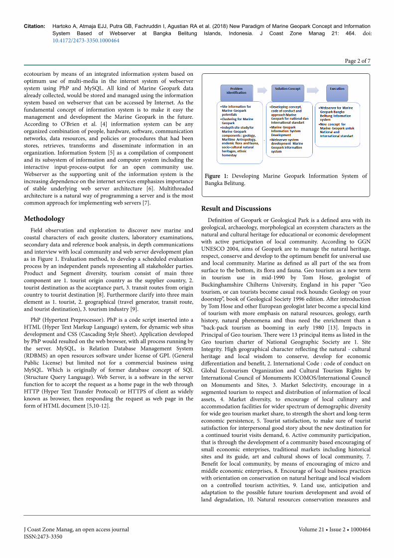
coastal characters of each geosite clusters, laboratory examinations,secondary data and reference book analysis, in depth communicationsand interview with local community and web server development planas in Figure 1. Evaluation method, to develop a scheduled evaluationprocess by an independent panels representing all stakeholder parties.Product and Segment diversity, tourism consist of main threecomponent are 1. tourist origin country as the supplier country, 2.tourist destination as the acceptance part, 3. transit routes from origincountry to tourist destination [8]. Furthermore clarify into three mainelement as 1. tourist, 2. geographical (travel generator, transit route,and tourist destination), 3. tourism industry [9].
PhP (Hypertext Preprocessor). PhP is a code script inserted into aHTML (Hyper Text Markup Language) system, for dynamic web situsdevelopment and CSS (Cascading Style Sheet). Application developedby PhP would resulted on the web browser, with all process running bythe server. MySQL, is Relation Database Management System(RDBMS) an open resources software under license of GPL (GeneralPublic License) but limited not for a commercial business usingMySQL. Which is originally of former database concept of SQL(Structure Query Language). Web Server, is a software in the serverfunction for to accept the request as a home page in the web throughHTTP (Hyper Text Transfer Protocol) or HTTPS of client as widelyknown as browser, then responding the request as web page in theform of HTML document [5,10-12].
Figure 1: Developing Marine Geopark Information System ofBangka Belitung.
Result and DiscussionsDefinition of Geopark or Geological Park is a defined area with its
geological, archaeology, morphological an ecosystem characters as thenatural and cultural heritage for educational or economic developmentwith active participation of local community. According to GGNUNESCO 2004, aims of Geopark are to manage the natural heritage,respect, conserve and develop to the optimum benefit for universal useand local community. Marine as defined as all part of the sea fromsurface to the bottom, its flora and fauna. Geo tourism as a new termin tourism use in mid-1990 by Tom Hose, geologist ofBuckinghamshire Chilterns University, England in his paper “Geotourism, or can tourists become casual rock hounds: Geology on yourdoorstep”, book of Geological Society 1996 edition. After introductionby Tom Hose and other European geologist later become a special kindof tourism with more emphasis on natural resources, geology, earthhistory, natural phenomena and thus need the enrichment than a“back-pack tourism as booming in early 1980 [13]. Impacts inPrincipal of Geo tourism. There were 13 principal items as listed in theGeo tourism charter of National Geographic Society are 1. SiteIntegrity. High geographical character reflecting the natural - culturalheritage and local wisdom to conserve, develop for economicdifferentiation and benefit, 2. International Code : code of conduct onGlobal Ecotourism Organization and Cultural Tourism Rights byInternational Council of Monuments ICOMOS/International Councilon Monuments and Sites, 3. Market Selectivity, encourage in asegmented tourism to respect and distribution of information of localassets, 4. Market diversity, to encourage of local culinary andaccommodation facilities for wider spectrum of demographic diversityfor wide geo tourism market share, to strength the short and long-termeconomic persistence, 5. Tourist satisfaction, to make sure of touristsatisfaction for interpersonal good story about the new destination fora continued tourist visits demand, 6. Active community participation,that is through the development of a community based encouraging ofsmall economic enterprises, traditional markets including historicalsites and its guide, art and cultural shows of local community, 7.Benefit for local community, by means of encouraging of micro andmiddle economic enterprises, 8. Encourage of local business practiceswith orientation on conservation on natural heritage and local wisdomon a controlled tourism activities, 9. Land use, anticipation andadaptation to the possible future tourism development and avoid ofland degradation, 10. Natural resources conservation measures and
Citation: Hartoko A, Atmaja EJJ, Putra GB, Fachruddin I, Agustian RA et al. (2018) New Paradigm of Marine Geopark Concept and InformationSystem Based of Webserver at Bangka Belitung Islands, Indonesia. J Coast Zone Manag 21: 464. doi: 10.4172/2473-3350.1000464
Page 2 of 7
J Coast Zone Manag, an open access journalISSN:2473-3350
Volume 21 • Issue 2 • 1000464

practices on the tourist development for sustainable natural andcommunity benefit with good code of conduct for the wastetreatments, 11. Continuous evaluation and planning with respect tothe sustainability of natural resources based on the local geo tourismcharacters, 12. Good management practices by means of controllingthe number of tourist to the capacity of the natural resources, 13.Encouragement for local community in promoting local heritage andinteractive interpretation of host and tourist [14-17]. It has beenhundred years long period, since the Dutch colonization the two mainresources of Bangka Belitung islands known as Muntok White Piperand tin had been heavily exploited and become the main economy[18]. The new concept of Marine Geopark, scientifically need to bestudied and developed to comply for national and internationalgeopark standard. Ultimately, with the setting as new concept of
Bangka Belitung Marine Geopark should be a new specific educationtourism destination and brings a new of economic value. This wouldbe a new adaptation of the islands economic recovery of the long lasttin post mining era.
Map of the overall Bangka Belitung Marine Geopark developmentplan as in Figure 2. The main concept of the study was development ofmarine geopark based on the integration of each geosite developmentplan that should have its different and characters of its natural graniterock types, endemic flora (many types of herbal flora), coastal andmarine fauna, ancient tribe, maritime anthropology or socio-culturalheritages (such as old-spell or the ‘Mantra’, songs, Dam-bus musicinstruments, the ‘Kedidi’ dances), old wooden houses.
Figure 2: Map of Bangka Belitung Marine Geopark Development Plan.
Tuning costal area is a village at Belinyu district of Bangka regencyof the main island, about 70 km from Sun gailiat city (Figure 3).Marine geosite of Tuning coastal village were characterized with thepresence and the only can be found of the entire island the evidence ofgeological coral uplift process. Where the underwater coral reefecosystem, complete with its abundance animal associated such asbevel via, gastropods and foraminifer community in the biotic carbonsediments undergone of heat and solidify was uplifted on to the abovehigh tide coastal area. This specific coastal area would be very
important field example for an educational tourism with its completelyrecorded . The abundance species of endemic flora such as Hoya. sp aswidely recognized as the specific of Bangka flora, many species ofendemic orchids in a marginal sandy coastal area. Beside the existenceof endemic squid (Loligo. sp) spawning site, sandy crab (Crustacean),the Lump (animism) ancient tribe, old Chinese community, oldwooden houses and old Chinese ceramics make it as perfect marinegeosite.
Page 3 of 7
J Coast Zone Manag, an open access journalISSN:2473-3350
Volume 21 • Issue 2 • 1000464
Citation: Hartoko A, Atmaja EJJ, Putra GB, Fachruddin I, Agustian RA et al. (2018) New Paradigm of Marine Geopark Concept and InformationSystem Based of Webserver at Bangka Belitung Islands, Indonesia. J Coast Zone Manag 21: 464. doi: 10.4172/2473-3350.1000464

Figure 3: Marine Geopark for Tuning coastal village.
Figure 4: Marine Geopark of Begadung islands – west coast of Central Bangka.
Marine geopark of Begadung islands (Figure 4), central west coast ofBangka was characterized with unique type of Ancient vertical layeringreddish sedimentary-low grade meomorphic rock types. Sedimentaryrocks caves going to below sea water level, make it very challenging to
explore. The existence of very old natural and undisturbed Bruguier spmangrove community, with its specific adaptive root system to thegranite rock trajectory at the coastal area. The presence of Europeanand Japanese warship underwater wreck.
Page 4 of 7
J Coast Zone Manag, an open access journalISSN:2473-3350
Volume 21 • Issue 2 • 1000464
Citation: Hartoko A, Atmaja EJJ, Putra GB, Fachruddin I, Agustian RA et al. (2018) New Paradigm of Marine Geopark Concept and InformationSystem Based of Webserver at Bangka Belitung Islands, Indonesia. J Coast Zone Manag 21: 464. doi: 10.4172/2473-3350.1000464

Figure 5: Marine geopark cluster for Seliu Island – Bangka Belitung.
Marine geopark for Seliu island had found a very strong kind ofislands life style, boats, fisherman houses and most specific is thepresence of many type of old wooden stage-houses.
Figure 6: Marine geopark cluster of ‘Kota Kapur’ MaritimeAnthropology – Bangka.
‘Kota-Kapur’ site is known as part of the Sriwijaya kingdom with itsmain capital at nowadays known as Palembang, south Sumateraprovince and later on the site was designated and to be developed asmaritime anthropological marine geopark (Figures 5 and 6). At thissite were found some maritime art fact such as old wooden boat, stonejetty. The most valuable of all is inscription-stone of ‘Kota-Kapur’ witha Sanskrit Hinduism character, stone statue of the Whisnu and oldChinese ceramics, swords, spears and others.
In general, the geomorphological feature of Bangka and Belitungisland is a gently slope surface. The geological description of the tin-islands Bangka-Billiton [19] and Pre-tertiary formations. Crystallineschist’s were supposed to be the oldest formation, older than theTriassic flysch [20]. The oldest formation of Bangka is represented bylimestone’s, proving their perm-carboniferous age. Followed withphyletic shale’s and quartzite’s refer to the upper-Triassic flyshformation and intercalations of radiolarian-bearing cherts in theformation. The radiolarian bearing cherts were cut by veinlet’s of
quartz with some arsenopyrite and chalcopyrite. Most of granites arepost-Triassic, presumably Jurassic in age. Microscopically biotitegranite in most cases consisting of quartz, orthoclase, oligoclase andsubordinate amount of zircon, apatite and orthite. The granite alongthe coast sometimes contains dark streaks of biotite alternating withleucocratic bands. This flow structure or a relic of the meta somaticallyreplaced sediments. Black tourmaline schorl and fluorite aresometimes very abundant in the granite. In the Holocene, after a longperiod of denudation and pen planation, during which secondary ageswere formed, the relative rise of the sea has caused the transgression ofthe sea over the part of the Sunda land. Regional physiography ofBangka - Belitung island physio graphically is the biggest island in theSunda-Shelf, and as the Sunda Pen plain [22]. Its geological order ispart of Tin Island sat Sunda land Craton of Eurasia plate [21] and partof the Southeast Asia tin-belt [22]. The Sunda plate to form therelatively stable Sunda land, as the amalgamated of some terrane Perm[23]. Granite rocks of Bangka Belitung of Tries Jura age as composite ofgranite, granodorit, Adam alit, diorite and diorite quartz with a plitand pegmatite breaks [24,25]. Texture of granite with variations wheresome sesars tin-granite as the youngest to form monadnocks. Whileolder granite observed at low plain [26]. Intrusion of granite werefound of largest granite at Klabat, Plangas, Menumbing, Mangkol,Tempilang and Toboali [27]. In general that granite texcture ofBelitung are almost the same of Bangka, but with some variation of itscomposites [28]. Batholit distributed as in Tanjungpandan, AdamelitBaginda, Granodiorit Burungmandi and Batubesi quartz. Based ongeochemical and granite isotope of the tin island age of 220 millionyears, example of Belinyu about (251 ± 10) million years and Penangasof (252 ± 8) million or Late of Trias [22,24]. Belitung granite of Trias-Kapur of (245 ± 115) million of age [30] but about 193–2251 millionyears of age according [29]. Geomorphological type of geosite theMenumbing granite rocks of West Bangka island is a part of BatolithGranit hilly landscape. The adjacent of the Bukit Kukus withpredominantly steep slope hill. Lithology of Bukit Kukus rocks geositewith light greyish, faneritic texture, holo crystalline, relatively equigranular, massive structure with predominant mineral of plagioclase,quarts and small portion of K-Feldspar, muscovite and biotit. Based onthe above characters later on as mega scopicaly grouped into the‘granitic’ solid rock. According to Mangga AS, et al. [24] was grouped
Page 5 of 7
J Coast Zone Manag, an open access journalISSN:2473-3350
Volume 21 • Issue 2 • 1000464
Citation: Hartoko A, Atmaja EJJ, Putra GB, Fachruddin I, Agustian RA et al. (2018) New Paradigm of Marine Geopark Concept and InformationSystem Based of Webserver at Bangka Belitung Islands, Indonesia. J Coast Zone Manag 21: 464. doi: 10.4172/2473-3350.1000464

as Klabat granites of Trias – Jura age [30]. Geological structure of BukitKukus as sheeting joints to form a solid block of rocks with a certaindimensions. The main sheeting joint was caused by previous tectonicprocess and some by pressure release. The formation of sheeting jointsare compressed, tensile and scour sheets by pressure release of therocks, characterized with capilar of quarts 0.5 cm thickness.Geomorphology of Mendanau island in general is relatively flat terraincomposed by sediment rocks. Lithology of its part known as Suak Gualwhere sediment rock was found. Sediment rock was formed of sandyrocks with insertion of silt and clay rock. Characterized with yellowishgrey and reddish color, medium and fine grain size, fine andmoderately sorted, laminated structure with main quarts mineralcomposition. Sheeted with relatively close spat ion and dominantquarts capilar of less than 1 cm thickness. Slate rocks or clay rocks withbrownish grey and red, smooth surface. Based on the above characterscompatible into sediment rock of Kelapakampit formation with Perm-carbon age sediment in a coastal and sea environment [28]. Geologicalstructure of Suak Gual at Mindanau island is mainly sheeting jointswith insertion of mineral secunfer (capilar). Sheeting joints is in blockformation systematically, caused by tectonic process. Layer slope ofrocks was found in dimension of N250oE/16o and N15oE/20o. Whichis classified as gentle slope and topographically according to the slopeof sedimentary rocks. Tectonic activity since Perm carbon with theformation of flysch sediment in ‘Kelapakampit’ formation, followed bycollision process to became ‘Siantu’ formation. Magmatic activityduring Tries period to form Tanjungpandan granite. Beginning of Jurafollowed by magmatic activity to the‘Adamalit Baginda’ formation andended at late carbon with the insertion of granodiorit rocks. Since latecarbon quarter, erosion process and sedimentation to form a sandycarbon and alluvium [28].
Marine ecotourism. Based on the definition of geopark, is a specificneed/driven tourism on natural resources, geological characters orearth history and thus need to be enriched with those natural geo-information’s to drive motivation of tourist. As compared with cultural,culinary or historical and heritages tourist destinations. According toMohamed B, et al. [8] there were two main model of tourist types, thatis cognitive-normative model and interactive model. These classifytourist types based on their intention for a unique, remote, unpopularas well as tourist type to specific geosite or geo tourism and the waythey manage the trip, individual, group or tour-package by agent.Drifter tourist and explorer to specific destinations, different withpopular tourist or mass tourist. The cognitive-normative model classifyinto alocentric- tourist and mid centric tourist rather than psychocentric ones. The interaction model classify into drifter tourist,explorer tourist, mass tourist and regular mass tourist. Flow of tourist[8] as a form of spatial interaction from supply site and destination.The supply site as the beginning of a tourist activity, whereas inmarketing aspect as the supplier of the tourist demand. The touristdestination have some icon or characters that the supplier do not have.While alocentric tourist as demanding activity tourist type, tend to doany kind of exploring activity especially the new and challenging ones[15,31,32].
The new developed marine geopark at Bangka Belitung islands suchas at Tuning coastal village, Begadung island, Kota Kapur andMindanao island and some others would imply to this alocentrictourism as the target of marketing and also developing the informationsystem for marine geopark. The development of new concept onmarine geopark at Bangka Belitung islands in the study would drivethe emergence of geosite novelties integration such as geology,morphology, socio-cultural heritages in one information system. Some
new perspective and innovations had been developed where oldbuildings of fishermen wooden houses had been designated as homestays, heritage seafood culinary added with scientific touch such ascollagen and chondroitin rich seafood good for health, and many othercoastal village products. These had a direct impact to the increasingincome and active participative and involvement of local people. Newspecific coastal community events had been developed socio-culturallysuch as alms sea celebration. Overnight light fishing and seafoodexplore with many type of local wooden boat, mangrove lagoon eco-green, turtle and squid conservation round trip. Development of localbased new product such as natural mangrove pigment for ‘batiks’, freshdrink from mangrove fruits, natural mangrove honey-bee culture in aneco-developed mangrove ecosystems. In turn, this development willrise new sectors in geo tourism activity such as local hand-madehandicraft, travel agents and specific tour guides opportunities andprevent to a decline of tourism phase. As comparable example of theLangkawi geopark case try to rehabilitate the decline after undergonelife cycle [33-35].
Figure 7: Information System for Marine Geopark at BangkaBelitung Islands.
As in Figure 7, the developed webserver based Information Systemfor the new concept of Marine Geopark at Bangka Belitung islands.The kind of information system developed specifically the use ofinternet and accessed on smartphone with consideration on limitedislands condition and telecommunication facilities, even the worst isthe very limited of power supply. The information system of MarineGeopark at Bangka Belitung based on PHP and MySQL with focus topromote the specific information on each marine geosite, mainlyphotograph and short video with support of general information suchas transportation and local accommodations. Information Systemmake the access of Marine Geopark data by many people at all over theworld will be easily using the Internet.
SummaryThe new concept of marine geopark as developed not just of coastal
geological or geomorphological character but also additioninformation of the rare and the least known of Bangka Belitung islandsspecially and many other small islands of Indonesia. The integrationwith time anthropological and socio-cultural heritages, coastal andmarine resources, other local food, product, homestay. Based on someyear’s experiences, the local community awareness, socialization foractive participation thus the need to educate and train localcommunity was inevitable. Such as to be tourist guide, give otherperspective, new knowledge, with key word “the usual for local is the
Page 6 of 7
J Coast Zone Manag, an open access journalISSN:2473-3350
Volume 21 • Issue 2 • 1000464
Citation: Hartoko A, Atmaja EJJ, Putra GB, Fachruddin I, Agustian RA et al. (2018) New Paradigm of Marine Geopark Concept and InformationSystem Based of Webserver at Bangka Belitung Islands, Indonesia. J Coast Zone Manag 21: 464. doi: 10.4172/2473-3350.1000464

unusual/ extraordinary fo tourist”. Developed some new geosite, eventsin a year, product, how to promote, manage the local resources forsustainable use. Some geosite had been successfully developed areTuning coastal village, Begadung Island, Toboali South Bangka regencymangrove tracking and local products, the Hinduism ‘Kota Kapur’maritime anthropology site of Bangka main island, Mindanao andSeliu island at Belitung. Information system webserver based on PHPand MySQL with focus to promote the specific information on eachmarine geosite for national and international network to make MarineGeopark will be known by all over the world. The next target is to gainfor a UNESCO accreditation for the new developed Marine Geopark ofBangka Belitung specially and other small islands of Indonesia ingeneral. The designated site for marine geopark then was protectedlegally with a community based village law.
AcknowledgementThe authors would like to thanks to Institute of Research and
Development of Diponegoro University on Contract no. 474-81/UN7.P4.3/PP/2018 and the Office of Planning and Development(BAPPEDA) of South Bangka Regency for the funding and also all staffof the both institutions, especially to Dr. Arief Febrianto.
References1. Ministry of Internal Affairs (Depdagri) (2007) Verification and Toponimi
of Bangka Belitung Islands (Verifikasi Penamaan Pulau di KepulauanBangka Belitung). Jakarta: Direktorat Jenderal Pemerintahan Umum.
2. Culture and Tourism Office of Bangka Belitung (Budpar ProvinsiKepulauan Bangka Belitung) (2010) Visit Bangka Belitung Archipelago2010. Tourist Destination of Bangka Belitung. Pangkalpinang: BudparBabel.
3. Hartoko A, Helmi M, Hariadi, Rukmi U, Wibowo A, et al. (2004) Supplyof Thematic Spatial Data Sets of West Sumatera Coastal Zone. ResearchReport (Unpublish). Ministry of Fisheries and Marine Affairs and AsianDevelopment Bank.
4. O’Brien JA, Marakas GM (2007) Management information systems.(10thedn) McGraw- Hill/Irwin, a business unit of The McGrawHillCompanies.
5. Yogiyanto (2005) Strategic Information System. Andi Publishing,Yogyakarta.
6. Aaqib SM, Sharma L (2012) Analysis of Compute Vs Retrieve IntensiveWeb Applications and Its Impact on the Performance of a Web Server.International Journal Advanced Networking and Applications 3: 1233-39.
7. http://www.apache.org/8. Mohamed B, Nordin NA (2007) Tourism Planning (Perancangan
Pelancongan), Kuala Lumpur: Dewan Bahasa dan Pustaka. pp 33-34.9. I GP, I KSD (2009) Introduction of Tourism. Andi Publishing,
Yogyakarta.10. Hakim L (2013) Website Super Wow PHP and Jquery Project. Yogyakarta,
Lokomedia.11. Kadir A (2006) Introduction of Information System (Pengenalan Sistem
Informasi). Andi Publishing, Yogyakarta.12. Utami E, Hartanto AD (2012) Database System Using Microsoft SQL
Server 2005 (Sistem Basis Data menggunakan Microsoft SQL Server2005) Andi Publishing, Yogyakarta.
13. Kim H, Richardson SL (2003) Impacts of a Popular Motion Picture onDestinations Perceptions. Annals of Tourisms Research. 30: 216–237.
14. Busby G, O’Neill K (2006) Cephallonia and Captain Corelli’s Mandolin :the Influence of Literature and Film on British Visitors. Acta Turistica, 18:30–51.
15. Connell J (2005) Toddlers, Tourism and Tobermory : DestinationMarketing Issues and Television Induced Tourism. Tourism Management.26: 228–255.
16. http://www.executive.govt.nz/minister/clark/lor/lor.htm.17. Tooke N, Baker M (1996) Seeing is believing: the effect of film on visitor
numbers to screened locations. Tourism Management 17: 87–94.18. Marry F, Somers H (2008) Bangka Tin and Muntok Pipper : The Role of
Chinese Community in the Developement of Bangka Island XVIII – XXCentury (Timah Bangka dan Lada Mentok: Peran Masyarakat Tionghoadalam Pembangunan Pulau Bangka Abad XVIII - XX). Jakarta: YayasanNabil.
19. Verbeek (1897) The Geology of Indonesia. In: Bemmelen RW (editor).The Hague Martinus Nijhoff, IA.
20. Zwierzycki (1897) The Geology of Indonesia. In: Bemmelen RW (editor)The Hague, Martinus Nijhoff, IA.
21. Bemmelen RW (1970) The Geology of Indonesia. The Hague, MartinusNijhoff: IA.
22. Barber AJ, Crow MJ, Milsom JS (2005) Sumatra : Geology, Resources andTectonic Evolution. In: Cobbing EJ(editor) Geological Society Memoir,pp. 54-62.
23. Van Gorsel JT (2012) Sundaland : Bibliography of The Geology ofIndonesia and Surrounding Areas. (4.1thedn) Bibliography of IndonesianGeology, Indonesia.
24. Mangga AS, Djamal B (1994) Geological Map of North Bangka (PetaGeologi Lembar Bangka Utara, Sumatra). Centre for Research andDevelopment of Geology (Pusat Penelitian dan Pengembangan Geologi)Bandung.
25. Katili JA (1967) Structure and Age of The Indonesian Tin Belt WithSpecial Reference to Bangka. Tectonophysics 4: 403-418.
26. Margono U, Supandjono RJB, Partoyo E (1995) Geology Map of SouthBangka-Sumatera (Peta Geologi Lembar Bangka Selatan, Sumatra).Centre of Research and Development for Geology (Pusat Penelitian danPengembangan Geologi) Bandung.
27. Cobbing EJ, Mallick DIJ, Pitfield PEJ, Teoh LH (1986) The Granites of TheSoutheast Asian Tin Belt. J of Geological Society 143: 537-550.
28. Baharudin, Sidarto (1995) Geological Map of Belitung, Sumatra. Centerfor Geology Research and Development, Bandung.
29. Schwartz MO, Rajah SS, Askury AK, Putthapiban P, Djaswadi S (1995)The Southeast Asian Tin Belt. Earth-Sci Reviews 38: 95-293.
30. Crow MJ (2005) Pre-Tertiary Volcanic Rocks. In: Barber AJ, Crow MJ,Milsom JS (editors) Resources and Tectonic Evolution. Sumatra: Geology,Geological Society Memoir 31.
31. Yoeti OA (2008) Economic Tourist :Introduction Information andImplementation (Ekonomi Pariwisata: Introduksi, Informasi danImplementasi, Jakarta: Penerbit Buku Kompas.
32. Noelle OC, Sheila F, David G (2008) The Integration of Film-inducedTourism and Destination Branding in Yorkshire . Int J Tourism Res 10:423–37.
33. Andrea H (2010) Lasykar Pelangi. In: Malay Language (editor) Selangor :PTS Litera Utama Sdn Bhd.
34. Eddy JAA (2001) Bangka in the Malay Imperium Trajectory (BangkaDalam Lintasan Emperium Melayu). Seminar Internasional di PWTCKuala Lumpur, Penyelenggara Gabungan Penulis Nasional Malaysia,Gappena.
35. Eddy JJA, Hamed MA, Tan WH (2010) The Influence Novel and FilmLaskar Pelangi to the Tourism Industry at Belitong Island.Dipresentasikan dalam Seminar Internasional Hubungan Malaysia-Indonesia di Universiti Malaya, Kuala Lumpur.
Page 7 of 7
J Coast Zone Manag, an open access journalISSN:2473-3350
Volume 21 • Issue 2 • 1000464
Citation: Hartoko A, Atmaja EJJ, Putra GB, Fachruddin I, Agustian RA et al. (2018) New Paradigm of Marine Geopark Concept and InformationSystem Based of Webserver at Bangka Belitung Islands, Indonesia. J Coast Zone Manag 21: 464. doi: 10.4172/2473-3350.1000464