dundee creek paddle trail - marshy point nature center · use this map and interpretive guide to...
TRANSCRIPT

DUNDEE CREEK PADDLE TRAIL
MARSHY POINT NATURE CENTER

Experience Marshy Point from Baltimore County’s first aquatic trail...
Photograph courtesy of Mark Moody
Paddling along the creeks surrounding Marshy Point Nature Center is an exciting way to become immersed in the local environment. “Getting out on the water” lends uncommon opportunities to interact with wildlife and gain new perspectives on the Upper Chesapeake. Use this map and interpretive guide to supplement your journey along Dundee Creek. As you paddle along, take time at each of the points of interest or “trail stops”, which have been plotted on the adjacent trail map. Each stop is outlined in the guide with additional information and a corresponding picture, to aid in identifying features of this trail. Please take the time to reflect on the past, present, and future of our nation’s great estuary, the Chesapeake, as you paddle along it.
“Everyone must believe in something. I believe I’ll go canoeing.”
-Henry David Thoreau


Stop 1: Osprey (Pandion Haliaetus) Platform
GPS: 39°20’56.3’’N 76°22’10.0’’W
PLEASE STAY AT LEAST 100 FEET FROM THE PLATFORM WHILE THE BIRDS ARE PRESENT.
Also known as “seahawks,” ospreys are a native migratory raptor species whose diet consists almost entirely of fish (99%). For this reason ospreys can be found near most bodies of fresh, salt, and brackish water. Their impressive “dive-bomb” fishing behavior can be recognized as it is typically preceded by hovering in the air. A successful dive will result in the bird taking a fish up to twice its own body weight (the same weight that the much larger bald eagle can lift). The catch is then held in a powerful set of talons efficiently and aerodynamically (head forwards) during flight. Although ospreys are usually monogamous the birds undertake their migration alone each fall before returning to their life partners in the spring. Once facing extinction, these aquatic hunters have made an impressive comeback since the banning of the dangerous pesticide DDT in 1972. Now, ospreys can be found almost anywhere along the Chesapeake Bay and its tributaries, including right here at Marshy Point.

Stop 2: Common Reed (Phragmites australis)
GPS: 39°20’55.5’’N 76°22’05.7’’W
Originally introduced from Europe, phragmites is an invasive reed which can be found over large areas on the east coast of the United States as well as in other wetlands throughout the country. Phragmites out-competes native plants such as cattails, wild rice, pickerel weed, and marsh hibiscus. It contributes to a lack of biodiversity and low productivity in wetland ecosystems. Its dense aggressive growth displaces native animals. Furthermore, its underground root system or rhizomes make it extremely difficult to exterminate this plant by burning or cutting. Just like other invasive species, Phragmites is especially threatening to native habitats because of its ability to rapidly reproduce, combined with a lack of natural controls or predators to regulate the population.

Stop 3: Cattail (Typha latifolia)
GPS: 39°20’56.7’’N 76°21’59.4’’W
Cattails are native perennial plants that grow in fresh and brackish wetlands throughout the Chesapeake Bay watershed. This plant is named from the tail-like hairy, brown cylinder near the top of the stalk. The cattail is actually a cluster of downy seeds, which gradually loosen, unpack and disperse during autumn. Cattails provide an excellent habitat as well as food source for native fauna and the soft, fluffy seed was even used by humans as pillow stuffing during colonial times. Additionally, cattail stalks and roots are a viable food source for humans—with a celery like texture but a much more pungent flavor. They were eaten extensively by the Algonquin Indians who historically inhabited the Chesapeake.

Stop 4: Duck Blind
GPS: 39°21’00.7’’N 76°21’50.1’’W
Blinds have long been used as a form of camouflage for waterfowl hunters in the Chesapeake. The bay region has a rich history deeply rooted in waterfowl hunting culture. U.S. President Benjamin Harrison, baseball legend Babe Ruth, and sharpshooting icon Annie Oakley are among the noteworthy hunters who frequented Marshy Point. Over time, some of the organizations and individuals involved in hunting the Bay would take on important leadership roles in promoting Chesapeake Bay preservation and restoration efforts. The blind and surrounding structures are privately owned: please maintain a respectful distance as you admire from the water.
Stop 5: Submerged Aquatic Vegetation (SAV)
GPS: 39°20’59.8’’N 76°21’45.3’’W
SAV beds provide important habitat for many fish and shellfish, including juvenile blue crabs and finfish species such as menhaden, herring, shad, spot, croaker, weakfish, red drum, striped bass, and white perch. The habitat value of SAV is well known to crabbers, and in fact, juvenile blue crabs can be 30 times more abundant in SAV beds than in adjacent non-vegetated areas. On your paddle along Dundee Creek it is likely you’ll spot several types of SAV such as wild celery, widgeon grass, coontail and Eurasian watermilfoil. Like plants on land, SAV needs sunlight in order to survive and carry out photosynthesis. You’ll find SAV growing in the photic zone, or the area in water where light is able to penetrate. On top of that, SAV produces dissolved oxygen (DO) in the water which is essential to aquatic organisms.

Stop 6: C. P. Crane Generating Station
GPS: 39°20’53.5’’N 76°21’40.8’’W
At this point on the Paddle Trail, two red and white striped smoke-stacks are visible to the west beyond the peninsula. The stacks are a part of the Charles P. Crane electric generating station in Bowley’s Quarters. Situated approximately 14 miles East of Baltimore City on the Gunpowder River, the generating station receives coal by rail car which it burns in order to produce 399MW of electricity for nearby consumers. Coal has historically been a very important fossil fuel for power generation and industry. Today, the negative environmental impacts of burning coal and the availability of cheaper forms of energy mean that this plant is only used as a reserve plant during periods of the highest demand for electricity.
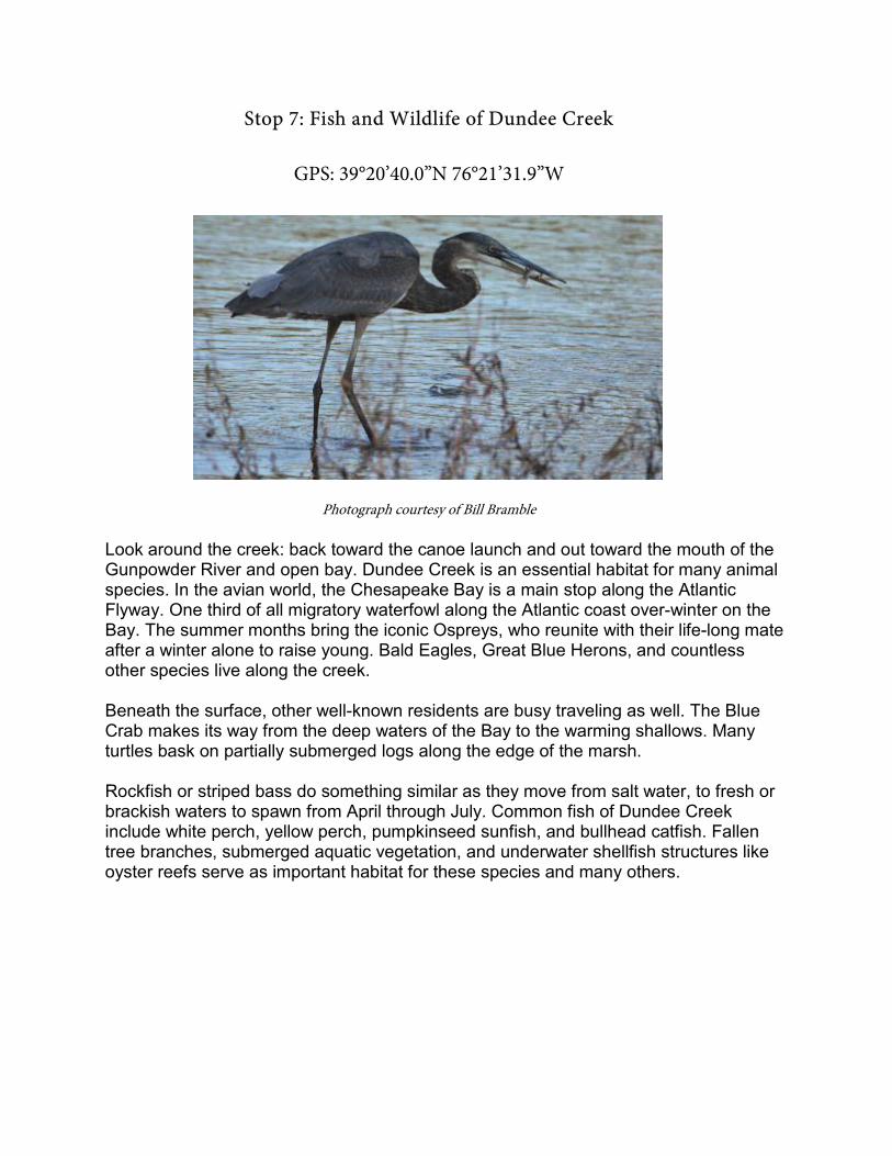
Stop 7: Fish and Wildlife of Dundee Creek
GPS: 39°20’40.0’’N 76°21’31.9’’W
Photograph courtesy of Bill Bramble
Look around the creek: back toward the canoe launch and out toward the mouth of the Gunpowder River and open bay. Dundee Creek is an essential habitat for many animal species. In the avian world, the Chesapeake Bay is a main stop along the Atlantic Flyway. One third of all migratory waterfowl along the Atlantic coast over-winter on the Bay. The summer months bring the iconic Ospreys, who reunite with their life-long mate after a winter alone to raise young. Bald Eagles, Great Blue Herons, and countless other species live along the creek. Beneath the surface, other well-known residents are busy traveling as well. The Blue Crab makes its way from the deep waters of the Bay to the warming shallows. Many turtles bask on partially submerged logs along the edge of the marsh. Rockfish or striped bass do something similar as they move from salt water, to fresh or brackish waters to spawn from April through July. Common fish of Dundee Creek include white perch, yellow perch, pumpkinseed sunfish, and bullhead catfish. Fallen tree branches, submerged aquatic vegetation, and underwater shellfish structures like oyster reefs serve as important habitat for these species and many others.

Stop 8: Weiskittel Family Boathouse
GPS: 39°20’30.9’’N 76°21’34.6’’W
Marshy Point is situated on land acquired by Baltimore County in 1982 from the Weiskittel and Zielinski families. The Weiskittels, who still have their residence on Marshy Point Peninsula, were important figures in the historical Marshy Point Ducking Club. The club of waterfowl hunters have been responsible for refining and setting the standard for Maryland’s state dog: the Chesapeake Bay Retriever.

Stop 9: Iron Point
GPS: 39°20’46.4’’N 76°21’59.5’’W
Iron Point is a great habitat for wildlife and a significant geological location because it is abundant in the iron rich mineral hematite. Hematite is one of the most abundant minerals on the earth’s surface and is located in the shallow crust. The iron oxide is a common rock-forming mineral found in sedimentary, metamorphic, and igneous rocks in regions throughout the world. Hematite has an ancient history including a variety of important uses by humans. The name hematite is derived from the Greek word “haimatitis” which means “blood red”. In fact, cave paintings or “pictographs” dating back 40,000 years ago were created with hematite pigments. Hematite is also the world’s most important ore of iron for industrial production. Iron ore is primarily used to produce iron, and then steel which will ultimately be used in the production of automobiles, locomotives, ships, bicycles and many others. More recently, hematite has been discovered in abundance in Martian rocks and surface materials, which is what gives the landscape a reddish brown color. Therefore, the same red-streaking rock which gives “Iron Point” its name here at Marshy Point is the same mineral responsible for the origin of Mars’ “Red Planet” nickname.

Stop 10: Wood Duck Box
GPS: 39°20’46.0’’N 76°22’08.2’’W
Photograph courtesy of Bill Bramble Wood ducks are among the most brightly colored waterfowl. Males have iridescent green, brown, and ornately patterned feathers while females have a distinct profile and a gentle white coloration near the eye. These birds are medium sized dabbling ducks and are notably smaller than mallards. Wood ducks are cavity nesters but do not excavate a nest area. They live in wooded swamp, river, or lake areas and make homes in holes in trees or boxes put up around the water’s perimeter. Wood ducks are one of the only duck species possessing strong claws helping them grip onto tree branches and other perches. Young wood ducks jump from their nest cavities shorty after hatching and parachute to the ground. From there, like other ducks, they follow their mother to find food and safety.
Sources:
Cattails. Chesapeake Bay Program. (n.d.). Retrieved April 5, 2017, from http://www.chesapeakebay.net/fieldguide/critter/cattails Chesapeake Bay Retriever Breed Standard. (n.d.). Retrieved April 5, 2017, from http://www.amchessieclub.org/standard/standard.html C.P. Crane: Coal-fired power plant in Baltimore County. Baltimore Sun. (n.d.). Retrieved April 5, 2017, from http://www.baltimoresun.com/business/bs-bz-coal-plant-sold-20151023-story.html Hematite: A primary ore of iron and a pigment mineral. (n.d.). Retrieved April 5, 2017, from http://geology.com/minerals/hematite.shtml Osprey: Species Profile, Everglades National Park (U.S. National Park Service). (n.d.). Retrieved April 5, 2017, from https://www.nps.gov/ever/learn/nature/osprey.htm Phragmites: Questions and Answers: Fish and Wildlife Service.pdf. (n.d.). Retrieved from https://www.fws.gov/gomcp/pdfs/phragmitesqa_factsheet.pdf Submerged Aquatic Vegetation as Fisheries Habitat, Submerged Aquatic Vegetation, chesapeakebay.noaa.gov. (n.d.). Retrieved April 5, 2017, from https://chesapeakebay.noaa.gov/submerged-aquatic-vegetation/submerged-aquatic-vegetation-as-fisheries-habitat The Estuary System. Chesapeake Bay Program. (n.d.). Retrieved April 5, 2017, from http://www.chesapeakebay.net/discover/bayecosystem/estuarysystem
