dry run creek watershed improvement project black hawk ...publications.iowa.gov/21330/1/5046_017 dry...
TRANSCRIPT

Dry Run Creek Watershed Improvement Project
Black Hawk Soil and Water Conservation District
Final Report
Project Timeframe: March 1, 2006 – January 31, 2009
Submission Date of Final Report: December 1, 2010
Prepared By: Phil Schuppert, Watershed Conservationist

2
Introduction
The Dry Run Creek Watershed Improvement Project was begun in 2006 to treat
the biological impairment designated for Dry Run Creek in 2002. Primary stressors
identified by the Department of Natural Resources (DNR) included hydrologic alteration
of both urban and rural areas of the stream, increased urban stormwater inputs, and
excessive sedimentation stemming from bank erosion, agricultural field runoff, and
construction site erosion. In order to mitigate these influences the Dry Run Creek project
was established to provide information and education to the local stakeholders in the
form of educational workshops, newsletters, events, and the establishment of structural
best management practices (BMP) throughout the watershed. The attitudes of the
stakeholders within the watershed were also assessed through the use of surveys
coordinated in cooperation with the University of Northern Iowa. Information regarding
the condition of the creek water as well as the pollutants contained in urban runoff was
also gathered through the projects monitoring program.
Information and Education
Several components were included in the information and education portion of the
Dry Run Creek Project. Among these were classroom education projects conducted with
the assistance of the Hartman Reserve Nature Center (HRNC) staff, newsletters and
direct mailings sent out by the district, educational signage placed at BMP sites, and
annual workshops held to educate local developers, contractors, and officials on
stormwater and erosion control.
The classroom education program held in cooperation with HRNC staff held two
camps on the Hartman State Preserve, as well as 19 school programs held at Southdale
and North Cedar Elementary Schools. All together, there were 286 children involved in
the programs. HRNC continues to be a partner in the promotion of watershed
management, helping promote Dry Run Creek monitoring programs and the
implementation of raingardens throughout the City of Cedar Falls.
During the timeline of the WIRB sponsorship of the Dry Run Creek Project there
were numerous publications helping to draw attention to the project and the practices it
promoted. Seven newspaper articles were published about Dry Run Creek in local
newspapers including the Waterloo-Cedar Falls Courier and the Cedar Falls Times. The
project also drew national attention when a piece about the streambank stabilization and
habitat enhancement project with the University of Northern Iowa was published in
Stormwater Magazine. In addition, the Black Hawk Soil and Water Conservation District
releases an annual newsletter in which articles about the project were written and
published by Watershed Coordinator Rebecca Kauten, in total four newsletters were
released over the course of the grant period.
Three annual workshops were held from 2006 through present day using
numerous funding sources including WIRB, local sponsors, door fees, and vendor
presentation fees. During the grant period of 2006 – 2009 a total of 146 people attended
the workshops to see the various speakers from state and local organizations as well as
professionals in the field of stormwater management and erosion control. The topics
shifted from year to year but focused primarily on the policies, technical processes, and

3
programs associated with stormwater management and low impact development (LID).
The Dry Run Creek’s partnership with the University of Northern Iowa allowed these
workshops to be held without building rental fees, while other contributing partners such
as the City of Cedar Falls and Lockard Companies donated funding to help support
parking fees, catering costs, and the cost of promotion.
Educational signage was placed at the most visible practice sites of the Dry Run
Creek Project, some of this signage was funded through WIRB and 319 funding while
other were paid for entirely through sponsor (UNI) funds. Recently, bridge crossing
signs have also been put up around town to help increase awareness of the creek by local
stakeholders.
Monitoring and Assessment
The monitoring portion of the Dry Run Creek Project was a collaborative effort
that included the efforts of many different groups. Among these were volunteer
monitors, student monitoring from both Hawkeye Community College and the University
of Northern Iowa, Iowa Department of Natural Resources monitoring, and independent
monitoring efforts conducted by the Black Hawk Soil and Water Conservation District.
Volunteer monitoring came in the form of IOWATER volunteers and participants
in the Dry Run SNAPSHOT program, which held bi-annual, watershed-wide
SNAPSHOTS twice a year during the grant period. Some of these volunteers were
students who would participate once or twice during their college career and others were
certified IOWATER volunteer monitors who would participate on a more regular basis.
This effort allowed us to collect valuable data, but also to get the local community
involved and to educate many of them on the issues facing the creek.
During the timeframe of the WIRB grant, student monitoring was coordinated
with the Natural Resource Management Class at Hawkeye Community College. This
class, under the supervision of instructor Terri Rogers, conducted weekly sampling
throughout the watershed for several months in 2007 sampling for IOWATER parameters
and visual watershed assessment (water color, bank stability, evidence of land use).
This type of partnership has continued in recent years with student monitoring
projects conducted by University of Northern Iowa students using funds provided by the
University and the Community Foundation of Northeast Iowa. Also, a $500 grant was
received from the Waterloo Exchange Club to fund the training of local school teachers
in the use of IOWATER equipment and technique. It is the intent of the grant that these
teachers will then use this knowledge to develop monitoring projects with their students.
The Iowa Department of Natural Resources monitoring efforts are especially
important as it is this data that determines the status of the impairment designation on the
creek. DNR monitoring assigned the original impairment for Dry Run Creek in 2002
citing a deficiency in the diversity and abundance of aquatic life. This original
impairment was assigned to the urban reach of the creek’s Southwest Branch. Since then,
the urban areas of all branches have been designated with a second impairment for high
bacteria levels in accordance with DNR findings.
The district continues to its monitoring efforts through ongoing partnerships with
the University of Northern Iowa and the Iowa Department of Natural Resources. The
results from the monitoring conducted during the WIRB grant and in the years leading up

4
to it has been combined into an aggregate spreadsheet and the results have been analyzed.
Due to the relatively short timeframe and the extreme conditions, most notably the floods
of 2008, these results do little to show significant trends in the progress of the variables
measured; this issue is illustrated in the graphs below for e. coli and chlorine.
The above graph shows the annual averages for e. coli throughout the watershed.
The state standard for a stream with the designated uses assigned to Dry Run Creek is
126 colonies/100 mL sample, all of these branch averages exceed that standard and
reinforce the Department of Natural Resources Bacteriological Impairment findings on
Dry Run Creek. While the data was collected throughout the year and in different
locations, large fluctuations were seen making it impossible to draw any statistically
significant conclusions from the data. In the case of the e. coli data, the fluctuations seem
to have no observable connections with annual weather patterns.

5
This graph shows the yearly chloride averages collected in the Dry Run Creek
watershed. Note the major gap between the values seen in 2008 and those seen in
previous years. It is believed that this difference is caused by the high levels of
precipitation seen in 2008. As with the e. coli data, no statistically significant
conclusions can be drawn due to the high levels of variability within the data and the
limited amount of data collected.
In addition to the water quality monitoring, a series of public surveys were
conducted in coordination with Kathleen Scholl of the University of Northern Iowa’s
Department of Leisure Services. Surveys were sent to 348 randomly selected
stakeholders within the watershed. The same landowners were surveyed in 2005 and in
2008, in total the survey had a response rate of 56%, though only 44.7% of individuals
surveyed responded in both 2005 and 2008. Public knowledge of water quality-related
issues was assessed as well as values assessments and general opinion about who is
responsible for helping to fix watershed related problems in urban and rural areas. Since
part of the goal of the project is to change the public perception and educate the local
stakeholders about water quality, the assessment of public attitude and awareness of the
local watershed problems is essential to the assessment of the success of the watershed
project.
The differences between the answers given in the 2008 survey and the 2005
survey were varied and were likely impacted by any number of external influences. Most
notably, the percentage of respondents who stated that they were aware of the issues
facing Dry Run Creek increased by 27% from 2005 to 2008, moving from 25.9% to 52.8.
More specifically, there was an increase in the number of respondents who believed that

6
runoff from impervious surfaces effects water quality. However, there was a decrease
seen in the percentage of landowners expressing interest in specific practices on their
land and an increase in the percentage of landowners who believed that it is the
responsibility of taxpayers to resolve the issues facing Dry Run Creek. There was also an
increase in the percentage of landowners who felt that regulations protecting local water
bodies limited their personal freedoms. Much of this is likely a negative reaction to the
recent implementation of storm-water utility fees which were added onto the utility bills
of all Cedar Falls residents as part of the city’s NPDES program. In addition, the
economic conditions of 2008 likely had an impact on the willingness of landowners to
contribute personal funds to stormwater practices on their property, or it could be an
indication that landowners who had previously expressed interest had done further
research on the practices and deemed them inappropriate for their particular parcel.
Financial Accountability
Budget Line Item Total
Allocated
Amended
Allocation
Total
Expended
Remaining
Balance
Information/education $18,000.00 $18,000.00 $13,982.66 $4,017.34
Guest Speaker $2,000.00 $2,000.00 $1,851.55 $148.45
Salary/Benefits $75,000.00 $75,000.00 $77,254.29 (-$2254.29)
Supplies $15,000.00 $15,000.00 $3,888.79 $11,111.21
WQ Monitoring $70,000.00 $70,000.00 $60,775.79 $9,224.21
Permeable Pavement $28,000.00 $28,000.00 $28,500.00 (-$500.00)
Infiltration Cell $41,400.00 $23,078.19 $16,210.00 $6,868.19
Streambank
Stabilization $46,875.00 $96,875.00 $96,875.00 $0.00
Rain Garden – Com. $5,000.00 $0.00 $0.00 $0.00
Stormwater Ponds $10,000.00 $10,000.00 $10,000.00 $0.00
Pool/Riffle $11,000.00 $11,000.00 $6,252.75 $4,747.25
Urban Erosion
Control $78,000.00 $28,000.00 $26,020.19 $1,979.81
Bio-Retention Cell $51,750.00 $51,750.00 $53,435.00 (-$1,685.00)
Asphalt, Porous $45,402.00 $45,402.00 $47,625.00 (-$2,223.00)
Streetscape BMPs $0.00 $23,321.81 $8,400 $14,921.81
Totals $497,427.00 $497,427.00 $451,071.02 $46,355.98

7
Funding
Sources
Cost-Share Contributions Project Contributions Total
Approved
Application
Budget
Actual
Expenditures
Approved
Application
Budget
Actual
Expenditures
Approved
Application
Budget
Actual
Expenditures
WIRB $497,427.00 $451,071.02 $0.00 $0.00 $497,427.00 $451,071.02
City of Cedar
Falls $521,000.00 $2,050,000.00 $0.00 $2,400.00 $521,000.00 $2,052,400.00
Meadows
Homeowners
Association
$0.00 $340.06 $0.00 $0.00 $0.00 $340.06
UNI $26,625.00 $75,625.00 $0.00 $35,650.00 $26,625.00 $107,703.00
Weicher’s
Construction $20,000.00 $208,270.92 $0.00 $0.00 $20,000.00 $208,270.92
Prairie Lakes
Church $40,848.00 $4,620.00 $0.00 $0.00 $40,848.00 $4,620.00
Community
Foundation $0.00 $0.00 $5,000.00 $5,000.00 $5,000.00 $5,000.00
319 Grant $0.00 $13,125.00 $0.00 $0.00 $0.00 $13,125.00
Total $1,105,900.00 $2,278,479.90 $5,000.00 $43,050.00 $1,110,900.00 $2,842,529.90
WIRB Funding Contribution
Actual: 15.8%
Approved: 45.0%
Further Explanation
Funding by Line Item
Administrative Funds
The original allocation of $20,000 provided for Information and Education
(hereinafter referred to as I&E) proved to be excessive due to the abundance of sponsors
who chose to partner with the district on these projects. The city of Cedar Falls chose to
sponsor the district’s annual workshops in order to complete the information/education
portion of their National Pollutant Discharge Elimination System (hereinafter referred to
as NPDES) requirements. The University of Northern Iowa also agreed to provide
facilities for the workshops at no cost to the district. In addition, corporate sponsorships
were received in exchange for the sponsor’s opportunity to present information regarding
their services or products to the attendees. Additional funding for the annual workshops
was provided through attendance fees charged to attendees to cover such expenses as
catering and parking. The funding provided for I&E was also used to partner with the
people at Hartman reserve to fund a classroom outreach program with local elementary
schools. Further information about this partnership will be presented in the proceeding
sections of this report.

8
Funds allocated to the Guest Speaker line item was not fully utilized as a result of
many of the speakers volunteering their time free of charge through cooperative
partnerships, many of these speakers were employees of state and local government
agencies. Much of the funding expended in this line item was used to cover transportation
and lodging of out-of-town speakers. As was true of the information/education line item
the funding for these speakers was supplemented with moneys from sponsorships,
contributing partners and attendance fees.
Practice Funds
The original allocation of $70,000 for urban erosion control was reallocated when
the proposed prairie lakes church project was cancelled by the landowner. The funding
was originally reallocated for the stormwater detention pond structure as part of the
Hudson Rd. and 18th
street wetland project. It was later reallocated again to the
streambank stabilization line item to be used for the streambank stabilization projects on
the University Branch in partnership with the University of Northern Iowa.
All proposed structures were completed for the wetland project, however the total
area of land included in this project was significantly overestimated. The majority of the
funding for this project was provided by the City of Cedar Falls with WIRB funding
being allocated to specific practices within the wetland structure including riffle
structures and seeding.
The College Hill Streetscape project had an allotted total of $18,321 for the
streetscape best management practices while only $8,400.00 was requested by the partner
upon completion of the project. An additional $5,000 was dedicated to the construction of
a neighborhood raingarden in partnership with the College Hill Neighborhood
Association, this project was not completed, however, as the partner was unable to begin
construction before the end of the grant term.
Funding by Source:
The purpose of this section is to discuss the partner contributions to the project
within the timeframe of the grant period.
Weicher’s Construction Wildhorse Ridge
The total incurred cost for raw materials used to install the BMP’s on this land
was $63,409, of which the WIRB grant funded $60,000. However, as part of the
proposed BMP’s the developer installed an extensive stormwater and erosion
management system. This includes the tiling and storm sewer system that allows the
development to drain into the sediment control basin, the installation of erosion control
stones along the banks of the basin, seeding and mulching, and silt fencing during
construction. The developer also provided the designs and labor as part of its
contribution. The total cost of the BMP’s and the further stormwater and erosion
management system, not including labor, was $262,999. This leaves the Weichers
contribution at over $200,000.

9
City of Cedar Falls:
The city of Cedar Falls has invested a great deal of money installing stormwater
management practices. The total cost of the Hudson Rd. & 18th
St. wetland project
exceeded $730,000, to which $16,252.75 in WIRB funding was applied, leaving the
city’s contribution for this project at approximately $713,000. Another project
coordinated with the city is the College Hill Streetscape project. The total city budget for
this project exceeded $1,050,000. This project is dual purpose: it is first designed to
improve stormwater management and
reduce pollution and runoff from the
College Hill area. However, the
project is also designed to create an
appealing area for public use. Due to
the dual purpose of the project it is
very difficult to delineate between
expenses incurred for stormwater
management and those incurred for
commercial benefit. For example, the
infiltration tree grates installed along
the sidewalk serve to beautify the area
and also to infiltrate stormwater, the
paving on the sidewalks serves as a walking space, but is also essential to stormwater
management as special grading was installed to ensure it’s proper drainage into the
installed BMP’s. Contributions from the WIRB grant to this project totaled $8,400.
University of Northern Iowa:
The partnership with UNI has been extensive and we have worked with them on a
great many projects. Some of these projects, including the pervious pavement project,
and the streambank stabilizations were not included as part of the original grant
application. In addition to their $72,053 matching contributions they have contributed
over $35,000 in in-kind contributions to enhance and extend the WIRB funded projects.
Aside from their financial contributions the university has partnered with the
project in many other ways. Numerous university staff have given their time to consult
with the District on various projects, both on and off of the UNI campus. UNI students
also regularly participate in monitoring activities (greater detail given in proceeding
sections), and the university has donated use of their facilities to store and mount
monitoring equipment, as well as housing our annual Stormwater workshops.
Prairie Lakes Church:
As mentioned in the preceding section of the report the Prairie Lakes Church
project was cancelled by the landowner. Some of the practices that were to be installed
on this site including soil amendments and native seeding, as well as an erosion control
rock chute. The cost of these practices, estimated at $4,620, was paid entirely by the land
owner. The WIRB funding intended for this site was reallocated to different line items
Infiltration tree grates installed as
part of the College Hill Streetscape

10
and ultimately was used for the streambank stabilization projects on the university
campus.
319 Grant:
A grant agreement was entered into by the District and EPA Sec. 319/Watershed
Protection Fund (hereinafter referred to as WSPF) to conduct watershed improvements
in the Dry Run Creek Watershed. Funding from the streambank stabilization line item of
this grant was used to stabilize a section of streambank directly adjoining the 18th
St. and
Hudson Rd. Wetland.
A 25% match was also contributed by the University of Northern Iowa to this
extension, these funds were included as part of their in-kind contributions in the
preceding section.
Environmental Accountability
Practice Units Proposed
Amount
Implemented
Amount
Impact Percentage
Permeable
Pavement*1 Ft
2 12,240
5516 ft2 McLoed
2500 ft2 WRC
62,524.8 gallons/day 66%
Bio-Retention
Cell*1 Acres
As-needed
surrounding
Prairie
Lakes
Church
1.5 acres 50,965 gallons/day NA
Bio-Detention and
Erosion Control Acres 80*4 40 acres 9,360 gallons/day 50%
Infiltration Cell Ft2 2180 1,605 ft
2 12,519 gallons/day 74%
Streambank
Stabilization Ft 500 1800ft
2*2 92 tons/year 360%
Raingarden –
Commercial Count 1 1
5,850 gallons/day 100%
Retention Basin*3 Acres 100 23
Flood
prevention/habitat 23%
Riffle Pool Count 6 9 Habitat 150%
Landscape/Erosion
Control Site*1
Count 1 0 N/A 0%
Kwik Star
Skimmer Box Count 0 1
Filtration of runoff
from parking lot NA
*1 – Implementation reduced due to cancellation of Prairie Lakes Church Project, funding reallocated to other
projects/line items
*2 – 700 ft. of the 1800 ft. listed was stabilized on an as needed basis *3 – smaller total area used for project, funding reduced and reallocated to streambank stabilization
*4 – initial estimate was square footage for entire development, all practices completed, half the development
drains to BMPs
Further Explanation by Line Item
11
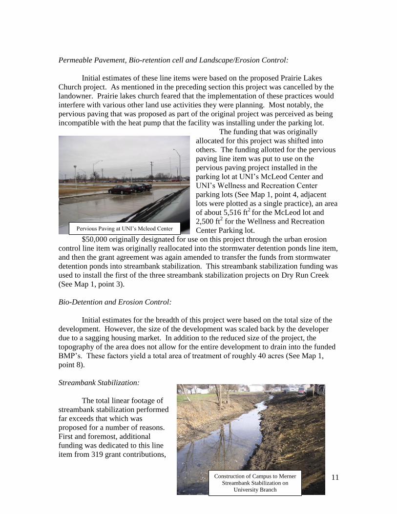
Permeable Pavement, Bio-retention cell and Landscape/Erosion Control:
Initial estimates of these line items were based on the proposed Prairie Lakes
Church project. As mentioned in the preceding section this project was cancelled by the
landowner. Prairie lakes church feared that the implementation of these practices would
interfere with various other land use activities they were planning. Most notably, the
pervious paving that was proposed as part of the original project was perceived as being
incompatible with the heat pump that the facility was installing under the parking lot.
The funding that was originally
allocated for this project was shifted into
others. The funding allotted for the pervious
paving line item was put to use on the
pervious paving project installed in the
parking lot at UNI’s McLeod Center and
UNI’s Wellness and Recreation Center
parking lots (See Map 1, point 4, adjacent
lots were plotted as a single practice), an area
of about 5,516 ft2
for the McLeod lot and
2,500 ft2 for the Wellness and Recreation
Center Parking lot.
$50,000 originally designated for use on this project through the urban erosion
control line item was originally reallocated into the stormwater detention ponds line item,
and then the grant agreement was again amended to transfer the funds from stormwater
detention ponds into streambank stabilization. This streambank stabilization funding was
used to install the first of the three streambank stabilization projects on Dry Run Creek
(See Map 1, point 3).
Bio-Detention and Erosion Control:
Initial estimates for the breadth of this project were based on the total size of the
development. However, the size of the development was scaled back by the developer
due to a sagging housing market. In addition to the reduced size of the project, the
topography of the area does not allow for the entire development to drain into the funded
BMP’s. These factors yield a total area of treatment of roughly 40 acres (See Map 1,
point 8).
Streambank Stabilization:
The total linear footage of
streambank stabilization performed
far exceeds that which was
proposed for a number of reasons.
First and foremost, additional
funding was dedicated to this line
item from 319 grant contributions,
Construction of Campus to Merner
Streambank Stabilization on
University Branch
Pervious Paving at UNI’s Mcleod Center

12
additional in-kind contributions from UNI, and from other line items within the WIRB
grant as previously described.
One additional reason for the increase in project size was the method used to
perform the stabilizations. In the initial streambank stabilization (Map 1, point 8) the
practice was not installed in a continuous stretch; instead the stabilization occurred as
needed along a 700 ft reach of stream along the University Branch. This method allowed
us to achieve the desired water quality results while maximizing the area of treatment,
removing . In total, streambank stabilization projects successfully removed 92 tons of
sediment from the stream annually, and created or preserved habitat in key areas of the
University Branch. Campus to Merner stretch of the University Branch (See Map 1,
point 5) and the extension west of the 18th
St. Wetland (Map 1, point 1) added a
considerable amount of lineal footage to the project total.
Retention Basin:
The estimated area of this project was based on the 28-E land use agreement
between the City of Cedar Falls and
the University of Northern Iowa.
The agreement allows the city to
perform development functions on
an area of land owned by the
university; the proposed area
consisted of roughly 100 acres.
However, much of this land was
developed for other public and
university purposes including
athletic fields. All together, an area
of roughly 23 acres was used to
create the wetland park area (Map 1,
point 2).
Riffle Pool:
In addition to the 6 riffle pools proposed as part of the Hudson Rd. & 18th
St.
wetland project (Map 1, point 2), an additional 3 riffle pools were installed along the
initial stretch of streambank stabilization on the university branch (Map 1, point 3).
These were installed along with fish hides to create habitat along the stabilized reach of
stream. The stones were provided and installed by the university.
Kwik Star Skimmer Box:
The Kwik Star parking lot was the original proposed site for the pervious paving
to be installed as part of the College Hill Streetscape project. The Kwik Star corporation
expressed interest in the project but eventually rejected the idea because they were
uncomfortable allowing hydrocarbons (namely oil and gas) to infiltrate the soil for fear of
groundwater contamination.
18th St. Wetland Detention Basin

13
The pervious paving was moved to a different location as part of the College Hill
Streetscape Project (Map 1, point 6) and the runoff from the Kwik Star was treated using
a skimmer box (Map 1, point 7). This box was installed at the storm sewer inlet and
serves to filter out contaminants from stormwater before the runoff is allowed to enter the
storm sewer.
Bioretention Cell
Originally, bioretention cells were meant to be
installed around the Prairie Lakes Church build.
However, because of the cancellation of this project and
the reallocation of the funding, this line item was
largely eliminated from the project except for the
addition of a biocell treating approximately 1.5 acres of
impervious surface at the University of Northern Iowa’s
Business Communications Center (Map 1, point 9).
Bioretention Cell at UNI’s Business
Communications Center

14
Map 1: Urban Best
Management Practices
A
B
C
C
D
Branch Identification
A – University Branch
B – West Branch
C – Southwest Branch
D – East Branch
Practices
1 – Streambank Stabilization West of 18th
St. Wetland
2 – 18th
St. Wetland
3 – Tennis Court Streambank Stabilization
4 – McLeod Center and Wellness and Recreation Center Permeable Paving
5 – Campus to Merner Streambank Stabilization
6 – College Hill Streetscape
7 – Kwik Star Skimmer Box
8 – Wild Horse Ridge
9 – BCS Biocell
10 – Meadows Homeowners Association