drought status update #29 october 16,...
TRANSCRIPT

Drought Status Update #29 October 16, 2015
Note: This material is intended for, and contains elements of special interest to, WDFW agency staff. Non-agency readers or anyone having questions about the context, clarity, or content for items in this update should contact the author, WDFW Drought Response Lead Teresa Scott at (360) 902-2713 [email protected]
It’s a beautiful autumn in the Pacific Northwest. Salmon are returning, and fall colors can now be attributed to leaves actually turning color instead of just the bright orange of dead conifers everywhere. Significant precipitation events have occurred in Western Washington in October, and flows are up in some eastside creeks as well. But let’s not call off this drought thing too soon! The best quote seen by this author about our current status comes from Port Townsend City Manager David Timmons on October 15, saying “ [water Our ability to get through this shortage] .” Indeed! depends on when the rains start
But forget lingering concerns for just a minute and check out this final-draft hot off the press video by Danny Garrett about Box Canyon Creek bull trout. Danny, you make it all look so glamorous; Jon, you’re a born educator and outreach specialist!
Temperature Forecasts The 6-to-10 day temperature outlook shows HIGHER-THAN-NORMAL temperatures throughout Washington, as does the 8-to-14 day temperature outlook. 6-10 day forecast on 10/15 for Oct 21-25 8-14 day forecast on 10/15 Oct 23-29
NOAA’s weeks 3 and 4 outlook hasn’t changed much. The legend is the same as above.
Week 3-4 Experimental Outlook for Temperature Created on 10/9 for the period October 24-Nov 6

WDFW Drought Status Update for October 16, 2015 Page 2
Precipitation Forecasts The 6-to-10 day probability of precipitation (below) is for above-normal precipitation statewide, and this carries through to the 8-to-14-day precipitation probability outlook.
6-10 day precipitation forecast for Oct 21-25 8-14 day precipitation forecast for Oct 23-29
NOAA’s experimental outlook for weeks 3 and 4 precipitation is presented below. Week 3-4 Experimental Outlook for Precipitation Created on 10/9 for the period October 24- Nov 6
At right is NOAA’s weather forecast for precipitation (right) in most of Washington over the coming week. It’s difficult to see Washington - it’s covered in precip. Still, conditions don’t look great in eastern Washington in terms of water falling from the sky - still under one-tenth inch at most.
Get local weather forecasts by clicking the map at Weather.Gov. Satellite images are available by scrolling down the forecast page to “Additional Resources.”

WDFW Drought Status Update for October 16, 2015 Page 3
Precipitation History
Below is a chart showing the history of precipitation at nine Washington weather stations for October to-date (10/15/2015) and September 2015. The October chart is misleading, though, because it compares oranges (Oct 1-15) to grapes (Oct 1-31). I’m still working out the kinks with the available data.
I’m continuing to search for that one federal report that can help us guess where problems might be occurring in real time. It depends, as always, on the question. Western Regional Climate Center provides a wealth of ways to look at climate anomalies in the recent past; here is one interesting map showing the number of days with more than one-quarter-inch precipitation since August 16. It tells us what we already know, but it’s got pretty colors! The UW Drought Monitoring System builds maps representing soil moisture content and percentage change in the recent past.
Below left is a map of total soil moisture expressed as percentile compared to the historical soil moisture values from 1920-2010. Below right is a map showing percentage change in soil moisture in the last two weeks (10/14/2015). Soil Moisture Percentile on 10/14/2015 (1920-2010 base period)
Change in soil moisture in the past 2 weeks 10/14/2015

WDFW Drought Status Update for October 16, 2015 Page 4
El Niño Update The October 8th El Niño/Southern Oscillation Diagnostic Discussion tells us that there is an approximately 95% chance that El Niño will continue through Northern Hemisphere winter 2015-16, gradually weakening through spring 2016. This is consistent with previous forecasts, and I guess consistency can be comforting. The next ENSO Diagnostics Discussion is scheduled for 12 November 2015.
Federal Drought Status North coast and north central Cascades headwaters areas, representing about 9% of total land area, were upgraded to “Moderate Drought” status this week! The rest of Western Washington remains in “Severe Drought” status, while everything east of the Cascade Crest remains in “Extreme Drought” status. The U.S. Drought Portal provides the weekly drought status for the nation.
Climate Predictions Nothing has changed with the seasonal climate outlooks except that we have advanced to the November, December, and January (NDJ) forecast period.
November, December, January Outlook Temperature
November, December, January Outlook Precipitation
Stream Flows The USGS figure showing stream gauges with below normal streamflow for 7 days or more shows westside streamflows mostly “recovered” to normal conditions, but many eastern Washington basins are still below normal.

WDFW Drought Status Update for October 16, 2015 Page 5
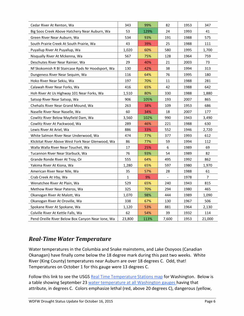
Selected Washington Streamflows Table
No locations show record low flows for this date in the record for October 15. Yee haw!
This Statewide Streamflows tables from USGS gives a quick visual reference for daily flows as a percent of normal for this date in the historic record. We selected 43 out of a total of 254 flow gauges in Washington as a subjectively representative sample of Washington conditions. Colors in the table emphasize flows less than 100% of average (orange-yellow) and less than 50% (red) for this day in the record. Flows at 100% or more of average are green.
SELECTED WASHINGTON STREAMFLOWS FOR 43 OUT OF 254 GAUGES IN WASHINGTON
10/15 FLOW (CFS)
PERCENT OF
AVERAGE FOR THIS DATE IN
THE RECORD
MIN FLOW (CFS)
YR OF MIN
FLOW
MEAN FLOW (CFS)
Mf Nooksack River Near Deming, Wa 220 48% 95 1967 459 Nooksack River At Ferndale, Wa 1,520 62% 586 2010 2,470 Skagit River Near Concrete, Wa 9,330 93% 2,800 1926 9,990 Sauk River At Darrington, Wa 753 58% 286 1926 1,300 Cascade River At Marblemount, Wa 433 63% 184 2007 690 Nf Stillaguamish River Near Arlington, Wa 569 46% 155 2007 1,250 Snoqualmie River Near Carnation, Wa 1,640 81% 401 1988 2,020 Skykomish River Near Gold Bar, Wa 1,530 67% 346 1988 2,280 Issaquah Creek Near Mouth Near Issaquah, Wa 37 84% 18 2003 44 Cedar River Below Diversion Near Landsburg, Wa 288 83% 245 1995 346
Below-normal 7-day average stream flow October 14, 2015
Below-normal 7-day average stream flow October 1, 2015
WDFW Drought Status Update for October 16, 2015 Page 6
Cedar River At Renton, Wa 343 99% 82 1953 347 Big Soos Creek Above Hatchery Near Auburn, Wa 53 129% 24 1993 41 Green River Near Auburn, Wa 534 93% 191 1988 575 South Prairie Creek At South Prairie, Wa 43 39% 25 1988 111 Puyallup River At Puyallup, Wa 1,020 60% 580 1995 1,700 Nisqually River At Mckenna, Wa 567 75% 128 1964 759 Deschutes River Near Rainier, Wa 29 40% 21 2003 73 Nf Skokomish R Bl Staircase Rpds Nr Hoodsport, Wa 130 42% 38 1994 313 Dungeness River Near Sequim, Wa 116 64% 76 1995 180 Hoko River Near Sekiu, Wa 197 70% 11 1988 281 Calawah River Near Forks, Wa 416 65% 42 1988 642 Hoh River At Us Highway 101 Near Forks, Wa 1,510 80% 330 1988 1,880 Satsop River Near Satsop, Wa 906 105% 193 2007 865 Chehalis River Near Grand Mound, Wa 263 38% 109 1953 686 Naselle River Near Naselle, Wa 60 34% 18 2007 177 Cowlitz River Below Mayfield Dam, Wa 3,560 102% 990 1943 3,490 Cowlitz River At Packwood, Wa 289 46% 221 1988 630 Lewis River At Ariel, Wa 886 33% 552 1946 2,720 White Salmon River Near Underwood, Wa 474 77% 377 1993 612 Klickitat River Above West Fork Near Glenwood, Wa 86 77% 59 1994 112 Walla Walla River Near Touchet, Wa 17 25% 6 1989 69 Tucannon River Near Starbuck, Wa 76 93% 54 1989 82 Grande Ronde River At Troy, Or 555 64% 495 1992 862 Yakima River At Kiona, Wa 1,280 65% 597 1980 1,970 American River Near Nile, Wa 35 57% 28 1988 61 Crab Creek At Irby, Wa 1 9% - 1978 7 Wenatchee River At Plain, Wa 529 65% 240 1943 815 Methow River Near Pateros, Wa 325 70% 294 1980 465 Okanogan River At Malott, Wa 1,070 98% 444 1989 1,090 Okanogan River At Oroville, Wa 338 67% 130 1967 506 Spokane River At Spokane, Wa 1,120 53% 881 1964 2,130 Colville River At Kettle Falls, Wa 62 54% 39 1932 114 Pend Oreille River Below Box Canyon Near Ione, Wa 23,800 113% 7,600 1953 21,000
Real-Time Water Temperature Water temperatures in the Columbia and Snake mainstems, and Lake Osoyoos (Canadian Okanagan) have finally come below the 18 degree mark during this past two weeks. White River (King County) temperatures near Auburn are over 18 degrees C. Odd, that! Temperatures on October 1 for this gauge were 13 degrees C.
Follow this link to see the USGS Real Time Temperature Stations map for Washington. Below is a table showing September 23 water temperature at all Washington gauges having that attribute, in degrees C. Colors emphasize lethal (red, above 20 degrees C), dangerous (yellow,

WDFW Drought Status Update for October 16, 2015 Page 7
above 18 degrees), and acceptable (green) temperatures for salmon. Note that this sample of gauges is heavily weighted by stations at Columbia-Snake hydropower facilities, so statistics like percent-of-Washington-gauges would not be representative of overall status in Washington.
WATER TEMPERATURE FOR 65 GAUGES IN WASHINGTON
10/15/2015
Nf Skokomish R Bl Staircase Rpds Nr Hoodsport, Wa 9 White River At Headworks Ab Flume Nr Buckley, Wa 10.1 White River At R Street Near Auburn, Wa 18.8 Lake Tapps Diversion At Dieringer, Wa 12 Ysi 6920v2-2 At Wsu 2 At Puyallup, Wa 10.6 Clarks Creek At Tacoma Road Near Puyallup, Wa 10.8 Duwamish River At Golf Course At Tukwila, Wa 13.3 Cedar River Near Cedar Falls, Wa 11 Cedar River At Cedar Falls, Wa 12.9 Cedar River Below Diversion Near Landsburg, Wa 11.5 Cedar River At Renton, Wa 12.6 South Fork Sultan River Near Sultan, Wa 8.9 Sultan River Below Diversion Dam Near Sultan, Wa 7.6 North Fork Tolt River Near Carnation, Wa 9.3 South Fork Tolt River Near Index, Wa 9 South Fork Tolt River Near Carnation, Wa 12.7 Sf Tolt River Bl Regulating Basin Nr Carnation, Wa 11.5 Nf Stillaguamish East Pooled Slide Area Nr Oso, Wa 6.4 Skagit River At Newhalem, Wa 10.3 Skagit River At Marblemount, Wa 10.7 Nf Nooksack River Bl Cascade Creek Nr Glacier, Wa 7.5 Sf Nooksack River At Saxon Bridge, Wa 9.7 Nooksack River At North Cedarville, Wa 9.4 Boundary Reservoir At Forebay Nr Metaline Falls 14.2 Pend Oreille River At International Boundary 14.4 Columbia River At Bridgeport, Wa 16.3 Osoyoos Lake Near Oroville, Wa 16.4 Okanogan River At Oroville, Wa 15.2 Similkameen River Near Nighthawk, Wa 11.4 Okanogan River Near Tonasket, Wa 12.6 Okanogan River At Malott, Wa 13.8 Okanogan River Nr Wakefield Br South Of Malott, Wa 13.2 Andrews Creek Near Mazama, Wa 7.3 Methow River Near Mouth Near Pateros, Wa 11.2 Wells Powerplant Headwater Near Pateros, Wa 16.3 Snake River Near Anatone, Wa 17.4 Snake River (Right Bank) Bl Lower Granite Dam, Wa 17.4 Snake River Bl Goose Island Bl Ice Harbor Dam, Wa 17.6 Columbia River At The Dalles, Or 17.7
WDFW Drought Status Update for October 16, 2015 Page 8
Ecology’s Flow Monitoring Network provides water temperature monitoring at several Ecology and co-op stations. Definitely check out whether there is an Ecology gauge in your area and spend a little time looking at the information. Data for the Lake Washington Ship Canal can be found here.
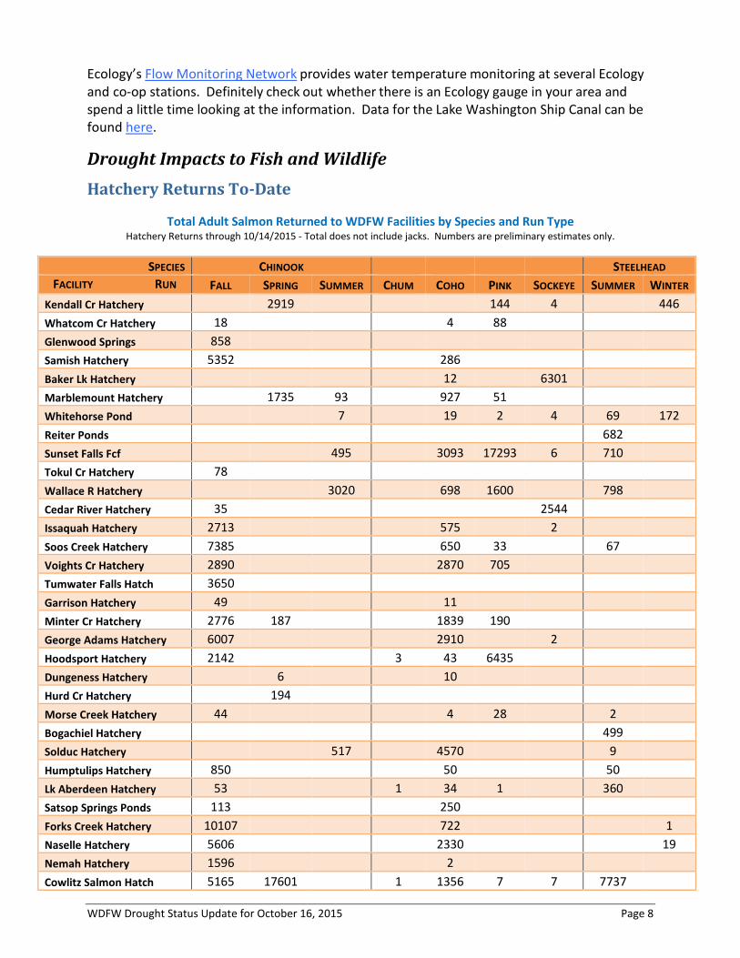
Drought Impacts to Fish and Wildlife Hatchery Returns To-Date
Total Adult Salmon Returned to WDFW Facilities by Species and Run Type Hatchery Returns through 10/14/2015 - Total does not include jacks. Numbers are preliminary estimates only.
SPECIES CHINOOK STEELHEAD FACILITY RUN FALL SPRING SUMMER CHUM COHO PINK SOCKEYE SUMMER WINTER
Kendall Cr Hatchery 2919 144 4 446 Whatcom Cr Hatchery 18 4 88 Glenwood Springs 858 Samish Hatchery 5352 286 Baker Lk Hatchery 12 6301 Marblemount Hatchery 1735 93 927 51 Whitehorse Pond 7 19 2 4 69 172 Reiter Ponds 682 Sunset Falls Fcf 495 3093 17293 6 710 Tokul Cr Hatchery 78 Wallace R Hatchery 3020 698 1600 798 Cedar River Hatchery 35 2544 Issaquah Hatchery 2713 575 2 Soos Creek Hatchery 7385 650 33 67 Voights Cr Hatchery 2890 2870 705 Tumwater Falls Hatch 3650 Garrison Hatchery 49 11 Minter Cr Hatchery 2776 187 1839 190 George Adams Hatchery 6007 2910 2 Hoodsport Hatchery 2142 3 43 6435 Dungeness Hatchery 6 10 Hurd Cr Hatchery 194 Morse Creek Hatchery 44 4 28 2 Bogachiel Hatchery 499 Solduc Hatchery 517 4570 9 Humptulips Hatchery 850 50 50 Lk Aberdeen Hatchery 53 1 34 1 360 Satsop Springs Ponds 113 250 Forks Creek Hatchery 10107 722 1 Naselle Hatchery 5606 2330 19 Nemah Hatchery 1596 2 Cowlitz Salmon Hatch 5165 17601 1 1356 7 7 7737

WDFW Drought Status Update for October 16, 2015 Page 9
SPECIES CHINOOK STEELHEAD FACILITY RUN FALL SPRING SUMMER CHUM COHO PINK SOCKEYE SUMMER WINTER
Cowlitz Trout Hatch 893 Kalama Falls Hatchery 4158 2674 139 5289 North Toutle Hatchery 2132 287 72 Fallert Cr Hatchery 33 1 294 6 Lewis River Hatchery 542 218 2862 1 100 Merwin Dam Collection 545 690 408 30 4029 Merwin Hatchery 339 Modrow Trap 28310 1598 1559 Speelyai Hatchery 863 1146 Skamania Hatchery 1723 Washougal Hatchery 4094 168 Washougal River Fish Weir 11164 1 340 Lyons Ferry Hatchery 1732 478 Tucannon Hatchery 622 Priest Rapids Hatchery 21293 2 12 Ringold Springs Hatchery 7388 1 228 Chiwawa Hatchery 450 2 Chelan Hatchery Methow Hatchery 3353 Omak Hatchery Eastbank Hatchery 291 768 950 64 Wells Hatchery 0 1939 377 Spokane Hatchery
Fisheries Changes
‘Hoot-Owl’ fishing restrictions were removed on Peshastin Creek and all its tributaries effective October 13, 2015. Recent rain and cooling temperatures have increased water levels, allowing fish to move more freely upriver and alleviating the need for additional protection.
Coho non-retention was announced on the Green River along with closure of the uppermost section of the river; these closures are effective October 16 until further notice. Coho broodstock collection efforts at Soos Creek Hatchery are well behind the goal. Non-retention of coho (adults and jacks) is needed to protect returning coho. Additionally, the uppermost reaches of the Green River (upstream of Flaming Geyser State Park) is closed to all fishing to protect chinook redds.
Fishing on the Skagit River (Skagit County) from the mouth upstream to the Cascade River Road (Marblemount) Bridge and the Stillaguamish River from Marine Drive (south of Stanwood) upstream to the confluence of the North and South Forks is closed effective Oct. 19, 2015. The rule is necessary to protect returning coho runs to the Skagit and Stillaguamish rivers. Coho run sizes are significantly below pre-season forecasts in these rivers.
Information about status of fisheries changes can be found HERE. The drought page at http://wdfw.wa.gov/conservation/drought/ is no longer being maintained.

WDFW Drought Status Update for October 16, 2015 Page 10
Nooksack
New this week are points showing dates with “major” rain events. It’s difficult to define “major!” As a native Washingtonian, “major” to me is something above 3 inches in a day; the NWS only counts greater than 1 inch in a day, and increments smaller. We’re looking for the level at which stream flows show a response.
Skagit
To depict “precipitation events” for Western Washington, I’ve defined this level as any daily precipitation totals over .25 Inches. I’m using a single data set for western Washington because most stations are surprisingly consistent with respect to rainfall days.

WDFW Drought Status Update for October 16, 2015 Page 11
Stillaguamish
Lake Washington
Chester Morse Reservoir
Photos taken 10/14/2015 and contributed by Frank Urabeck

WDFW Drought Status Update for October 16, 2015 Page 12
Dungeness
We have a new low flow for 2015: 77 cfs on October 7. While rain occurred elsewhere in western Washington September 18-22, whatever fell in the Dungeness basin barely registers a blip in downstream flow. Today’s (10/16/2015) most recent flow value of 108 continues the downward trend after the 10/10-11 peak of 390 cfs, which is well above average for this period. Recall that 2015 plots the minimum of daily means.
Hoko
Hoko is showing a marvelous recovery to its customary fall upward trend. It’s been all uphill since a low-flow value of 8 cfs on August 28th. The Hoko is a problem child between May and September, even in a normal year. But even this year is behaving as expected for a Washington north coastal stream starting in September.

WDFW Drought Status Update for October 16, 2015 Page 13
Calawah
Calawah, too, is right on schedule!
Skookumchuck
Rain events for the southern Cascades aren’t as consistent as more northerly stations, so precipitation events aren’t shown for these southwest streams.

WDFW Drought Status Update for October 16, 2015 Page 14
Naselle
Speelyai

WDFW Drought Status Update for October 16, 2015 Page 15
Klickitat
Yakima
Keechelus is 9% full; Kachess 17%; Cle Elum 6%; Bumping 34%; Rimrock 11%.
Compared to “average”:
Storage is 43.8%; October prorationing is 47% (up from 44%) Roza forebay is being drawn down for maintenance, and Chandler is generating 5.9MW.

WDFW Drought Status Update for October 16, 2015 Page 16
Box Canyon Creek bull trout
After two weeks in operation, the Box Canyon Creek flume was largely bypassed by high creek flows. A crew removed the flume on Thursday 10/15 so no non-biodegradable materials would be lost in the rising creek flows and lake level. Here are more photos of the working flume, as well as the de-construction.
Bull trout upstream from flume on 10/7/2015 Bull trout pair upstream from flume on 10/7/2015
Mouth of flume from underwater in Lake Kachess on 10/7 Full flume looking downstream on 10/8/2015
Breached flume looking downstream on 10/12/2015 Removing plastic sheeting on 10/15/2015

WDFW Drought Status Update for October 16, 2015 Page 17
Removing baling twine 10/15/2015 Moving & dispersing straw 10/15/2015
Wenatchee
Below are snapshots of the Wenatchee on October 8, 2015, running at about 274 cfs; many thanks to Amanda Barg!!

WDFW Drought Status Update for October 16, 2015 Page 18
Methow
Yep, that’s a season record low flow on 10/15 at 129 cfs. The most recent 10/15 instantaneous value is 241, so maybe the 129 is an anomaly? Because I am expecting flow increases as we move through October (see Okanogan), the 129 value is troubling. If anyone has information on the cause of this dramatic dip, or just wants to tell me not to worry about it, please let me know.
Okanogan
That lovely spike on 10/15 is hopefully a sign of improvement: 1,070 cfs!

WDFW Drought Status Update for October 16, 2015 Page 19
Colville
Those weird dips are back. Kevin Wright from the USGS Upper Columbia Field Office tells us this gauge is below the hydroelectric power-plant at Meyers Falls, and explains that these dips occur when the turbines turn off and on.
Kettle
October 15 flow is 121 cfs.

WDFW Drought Status Update for October 16, 2015 Page 20
Drought-related impacts to fish at hatcheries
Mortalities are shown for drought-caused losses only. “% Production” represents the % lost of the total production of the identified species at that facility. There have been no changes to this table since the last publication. REGION FACILITY (SPECIES) JUVENILE
MORTALITY (% PRODUCTION)
TRANSFERS & RELEASES
3 Naches Hatchery -0- Two new wells have been drilled at this facility to replace the previous unreliable water supply.
4 Bellingham (Rainbow Trout) 5,760 (80%) 4 Issaquah (Coho) 6,728 (1%) 4 Soos Creek (Summer Steelhead) 41,308 (60%) 4 Soos Creek (Coho) 172,963 (21%) Transferred 480,000 coho to Keta Creek
Complex (Muckleshoot). This is a normal activity that was executed early this year.
4 Icy Creek (chinook) -0- 107,000, or 33%, of the population was released early into the Green River on 7/29.
5 Grays River (Steelhead) 150,300 (93%) 450k type S coho were transferred to Cowlitz Trout Hatchery on July 28th and 29th due to low water supply at Grays.
5 North Toutle (Coho) 101,746 (76%) On July 14, the remaining 33,600 Type S Toutle Stock Coho were transferred to Cowlitz Trout Hatchery. The move was prompted by the losses due to columnaris (left).
5 Lewis (chinook) -0- On Mon. Aug. 3rd 500k Spring were released (~38% of the Lewis Spring program); standard release in Oct.
5 Speelyai (kokanee) -0- Fall Kokanee program released early due to construction of new intake at facility.
5 Vancouver -0- Well level is dropping so plans are underway to plant 15K brown trout early.
5 Washougal (Coho) 37,000 (2%) 6 Elwha 0 (0%) Staff is working to develop a replacement
well at this facility 6 Forks Creek (Steelhead) 14,489 (24%) 6 Lake Aberdeen (Steelhead) 64,903 (22%) Naselle (Chinook) 2,700 fall chinook adults have been lost
on-station, and an additional 1,400 (minimum estimate) lost in the Naselle River within 4,000 feet downstream of the hatchery weir. The loss is due to Ich which is elevated due to low flow conditions; some loss was expect but not at this level.
6 Naselle (Steelhead) 64,989 (22%) 6 Naselle (Coho) 639,646 (44%) 6 Voights Creek (Coho) 347,000 (44%)

WDFW Drought Status Update for October 16, 2015 Page 21
News Clips Today’s Cliff Mass Weather Blog presents his post-drought scorecard for Washington’s performance: Even with a D- in wildfires and C in air quality, the state pulls through our “climate stress test” with an overall passing grade of B-. Mass did not grade the impacts on salmon, which he deems as “economically unimportant.” NOAA: El Nino Means More Drought For Eastern Washington Kuow - October 15, 2015 Roza Irrigation District to pursue $60M pump system Yakima Herald 16 October 2015 Baker River Sockeye Run Sets New Record Northwest Sportsman - October 15, 2015 Port Townsend water fears ease with rains, but concerns for resource continue Peninsula Daily News 15 October 2015 Why The Kalama Turned White Northwest Sportsman - October 14, 2015 Thousands of fish rescued after being stranded by low flows on Deschutes River Daily Reporter - October 15, 2015 The Kalama River is running white, and scientists don't know why The Daily News - October 13, 2015 Scientists Try Radical Move To Save Bull Trout From A Warming Climate OPB - October 09, 2015 Revised KID drought plan makes trees, gardens a priority Tri-City Herald 10 October 2015 Dead or dying deer in the neighborhood? Here are your options Spokesman Review - October 09, 2015 OUTDOORS: Warm water blob may be cause of smaller salmon Peninsula Daily News (AP) - October 08, 2015 Warm weather, low water wreak havoc on salmon SnoValley Star - October 07, 2015 Despite rain, Seattle utility wrestles with drought and fish King 5 - October 08, 2015 Inslee asks for federal wildfire aid Seattle Times - October 08, 2015 Amid drought, Rattlesnake Lake reveals its roots Seattle Times - October 07, 2015 Cliff Mass Knows Climate Change Is Real, So Why Are Activists and Scientists So Mad at Him? Seattle Weekly - October 06, 2015 Image of bluetongue-inflicted deer worth 1,000 words, but explanation still needed Spokesman Review - October 05, 2015 Skagit streams included in six-state drought study Goskagit.com - October 03, 2015
Links WDFW’s drought web page is no longer being maintained
WDFW’s 2015 Drought Status Updates web page
Ecology’s “Washington Drought 2015”
Washington State Climatologist weekly drought update for Washington State.
Drought web pages for State departments of Health and Agriculture
National Integrated Drought Information System Pacific Northwest Drought Portal
NOAA Climate.gov ENSO Blog
NOAA El Nino Portal
NOAA’s Climate Prediction Center and North American Multi-Model Ensemble

WDFW Drought Status Update for October 16, 2015 Page 22
Northwest River Forecast Center Water Supply
USGS Real time stream data for Washington
WRCC Washington Climate Anomaly Maps and Tables
Fire incidents maps from Northwest Interagency Coordination Center
NWS Severe Weather Hazards predictions
Inciweb reports active wildfires in the U.S.
U.S. Army Corps of Engineers Seattle District Reservoir Control Center
Rich Landers Outdoors Blog Spokesman Review – ongoing
Concerns mount as drought deepens Columbian Special Project July 11, 2015
Washington Wildfire Resources
Ecology Dam Safety web page Wildfire Impacts on Dams
Social media fire updates are available on #waWILDFIRE
Get Everett water supply information.
Get Seattle water supply information.
Get Tacoma water supply information.
Saving Water Partnership
For Further Information: Drought-related staff resources are available on WDFW shared drive at S:\All Agency\Shared Projects\DROUGHT 2015. Contact WDFW Drought Coordinator Teresa Scott at [email protected] or (360) 902-2713 with questions, suggestions, and reports or observations.
The next WDFW status update will be distributed in mid-November to capture information through the end of October. Between mid-November, and February 2016, drought news will be distributed only as needed (i.e. major surprises). It’s currently anticipated that regular drought status updates will resume in February 2016.
Please take a moment to complete a survey about the content of these status update documents. Your responses will help us shape this tool for the coming drought season.
Survey link: https://www.surveymonkey.com/r/W9PGB6P