drivers of forest change in the greater mekong subregion of timber, shifting cultivation, and...
TRANSCRIPT

Drivers of Forest Change in the Greater Mekong Subregion
Myanmar Country Report

i
USAID Lowering Emissions in Asia’s Forests (USAID
LEAF)
Drivers of Deforestation in the Greater Mekong Subregion Myanmar Country Report
Maung Maung Than
September 2015
ii
The USAID Lowering Emissions in Asia’s Forests (USAID LEAF) Program is a five-year regional project (2011-2016) focused on achieving meaningful and sustainable reductions in greenhouse gas (GHG) emissions from the forest-land use sector across six target countries: Thailand, Laos, Vietnam, Cambodia, Malaysia and Papua New Guinea.

iii
Contents
EXECUTIVE SUMMARY ................................................................................................................IV
1 OVERVIEW OF TRENDS IN FOREST AND LAND USE SECTOR .................................... 1
1.1 LAND ..................................................................................................................................................... 1 1.2 FOREST .................................................................................................................................................. 2
2 DRIVERS OF DEFORESTATION AND DEGRADATION ................................................... 4
2.1 LOGGING FOR DOMESTIC CONSUMPTION AND EXPORT ........................................................................... 4 2.2 EXPANSION OF AGRICULTURE AND TREE PLANTATIONS ......................................................................... 4 2.3 SHIFTING CULTIVATION ......................................................................................................................... 5 2.4 INFRASTRUCTURE DEVELOPMENT .......................................................................................................... 6 2.5 POVERTY ............................................................................................................................................... 6 2.6 ECONOMIC GROWTH AND INCREASING CONSUMPTION ........................................................................... 8 2.7 CAPACITY CONSTRAINTS ....................................................................................................................... 8 2.8 LACK OF ENVIRONMENTAL SAFEGUARDS ............................................................................................... 8 2.9 UNCLEAR LAND TENURE AND WEAK ENFORCEMENT OF LAND LAWS ..................................................... 8 2.10 UNDERVALUATION OF BIODIVERSITY .................................................................................................... 9 2.11 LACK OF GRASSROOTS PARTICIPATION IN DECISION MAKING PROCESS FOR CONSERVATION .................. 9 2.12 CLIMATE CHANGE .................................................................................................................................. 9
3 DRIVERS OF SUSTAINABLE FOREST MANAGEMENT, FOREST CONSERVATION, AFFORESTATION AND REFORESTATION ............................................................................... 10
4 POLICIES AND MEASURES (PAMS) ADDRESSING DEFORESTATION AND PROMOTING SUSTAINABLE FOREST MANAGEMENT, FOREST CONSERVATION, AND AFFORESTATION AND REFORESTATION ..................................................................... 10
4.1 POLICIES AND MEASURES ADDRESSING DEFORESTATION/DEGRADATION ............................................. 10 4.1.1 Community forestry......................................................................................................................... 11 4.1.2 Reducing Emissions from Deforestation and Degradation (REDD+) ............................................ 11 4.1.3 Establishment of forest plantations ................................................................................................. 13
4.2 POLICIES AND MEASURES PROMOTING SUSTAINABLE FOREST MANAGEMENT, FOREST CONSERVATION AND AFFORESTATION AND REFORESTATION ...................................................................................................... 14
4.2.1 Watershed management programs ................................................................................................. 14 4.2.2 Establishment of Permanent Forest Estate (1985 - 2014) .............................................................. 15 4.2.3 Timber Legality System and FLEGT of Myanmar .......................................................................... 16 4.2.4 Land use policy and planning ......................................................................................................... 17
5 ANALYSIS/LESSONS LEARNED ........................................................................................... 18
5.1 PLANTATIONS ...................................................................................................................................... 18 5.2 TIMBER EXTRACTION, ILLEGAL LOGGING AND OVER-EXPLOITATION IN CONFLICT AREAS ................... 19 5.3 ENERGY SUPPLY................................................................................................................................... 19 5.4 LAND USE CHANGE, ENCROACHMENT AND LAND GRABBING ............................................................... 19 5.5 MINING AND EXTRACTIVE INDUSTRIES ................................................................................................ 20
6 PROPOSED ACTION PLAN INCLUDING PRIORITY INTERVENTIONS AND TIMING ............................................................................................................................................... 20
6.1 DETAILED FOREST RESOURCES MAPPING INCLUDING ASSESSMENT OF ECOSYSTEM VALUES ................ 20 6.2 A DECISION SUPPORT TOOL FOR DECISION MAKERS ............................................................................. 21 6.3 STRATEGIC ENVIRONMENTAL ASSESSMENT FOR THE FORESTRY SECTOR ........................................... 22
REFERENCES .................................................................................................................................... 23

iv
Executive Summary
According to the draft 2015 Myanmar report for the FAO Forest Resources Assessment, forest cover in Myanmar decreased from 58% in 1990 to 47% in 2010 and is projected to further decline to 43% in 2015. The main drivers of deforestation originating from within the forestry sector include over-exploitation of timber, shifting cultivation, and overharvesting of wood for fuelwood and charcoal production. The main drivers of deforestation outside the forestry sector include agricultural expansion, mining, hydropower development, infrastructure construction, establishment of military settlements, urbanization and resettlement, and aquaculture development. Underlying drivers include poverty, economic growth and increasing consumption, capacity constraints, lack of environmental safeguards, unclear land tenure and weak enforcement of land laws, undervaluation of biodiversity, and lack of grassroots participation in conservation-related decision making processes.
The Government of Myanmar is implementing several policies and measures to combat deforestation and forest degradation, including community forestry, REDD+, establishment of forest plantations, watershed management, establishment of permanent forest estate, FLEGT, and land use planning and land policy formulation. For future interventions the following are priorities: (i) detailed forest resources mapping to help understand the current situation and status; (ii) efforts to assess and address drivers of deforestation and degradation; (iii) and Strategic Environmental Assessment for the forestry sector.

1
1 Overview of trends in forest and land use sector
1.1 Land1 A large part of Myanmar falls within the Hindu Kush Himalayan Region, characterized by steep mountain slopes, upland plateaus, undulating areas, valleys and lowland deltaic area. Most of the ranges stretch from North to South and the country’s drainage system comprises four major rivers, the Ayeyawady, Chindwin, Sittaung and Thanlwin which also flow from North to South in association with the complex terrain. The Ayeyawady River and its major tributary, the Chindwin River, constitute the greatest river system in Myanmar and in general the country has abundant water resources and watershed management is given high priority.
With a total land area of more than 67.66 million hectares, a population of 51.419 million (2014 Census) and resulting land area of 1.32 hectares per head, Myanmar is relatively free from population pressure. However, the distribution of population and the agricultural workforce is not aligned with the available arable land. Although most land in Myanmar has good soil for agriculture and horticulture, there are increasing soil fertility and land degradation problems in the dry zone and upland areas.
Land degradation is an increasing problem in Myanmar, especially in the upland agricultural areas and dry zone. Land degradation in the country is caused by water erosion, wind erosion, soil fertility depletion, salinization, alkalization, and water logging. In upland areas and the dry zone, soil erosion is common and is primarily a natural process but aggravated by human interventions such as excessive forest harvesting, mono-cropping and shifting cultivation. Mining is another important cause of land degradation in Myanmar. As a result of land degradation, land productivity declines and the land ultimately becomes unproductive. For an agrarian country like Myanmar, decrease in the productivity of agricultural land is critical and immediate action is required to conserve and restore land.
According to national statistics, about half of the country is registered as forest, including reserved forest and other wooded land. Of the total land area, 18.11% was under agriculture in 2010/2011with fallows covering 0.34%. The net sown area of 17.77% increased from 12.04% in 1990/1991. During the same period, cultivatable waste land as a percentage of the national land area decreased from 12.34% to 7.97% while other wooded land fell from 32.88% to 23.10%. Land use changes in Myanmar over a twenty-year period are shown in Figure 1.2.
1
Draft State of Environment Report of Myanmar, Environmental Conservation Department, Ministry of Environmental Conservation and Forestry (2015)

2
Figure 1.2 Proportion of land area allocated to different uses by legal definition, 1990/1991 and 2010/2011
Source: Central Statistics Organization, Statistical Yearbook 2011.
The data shown in Figure 1.2 do not, however, reflect the situation on the ground where forest reserves are being converted for agriculture. For example, three out of nine forest reserves in the Ayeyarwaddy Delta are now completely under agriculture and only 26% of the area is covered by forest in the remaining six.
1.2 Forest Myanmar Forest Department uses the same forest and forest-related land use definitions as FAO, which include the following:2
Closed Forest Under forestry or no land use, spanning more than 0.5 hectares; with trees higher than 5 meters and a canopy cover of more than 40 percent, or trees able to reach these thresholds in situ.
Degraded Forest Under forestry or no land use, spanning more than 0.5 hectares; with trees higher than 5 meters and a canopy cover between 10 and 40 percent, or trees able to reach these thresholds in situ.
Mangrove Area covered by mangrove tree species as interpreted from satellite imagery and aerial photographs
Agriculture Permanent agriculture areas, mostly from plains and valleys. In some cases it is mixed with shifting cultivation
2 FRA 2015 working documents, Forest Department, Ministry of Environmental Conservation and Forestry
15.0%
2.8%
12.0%
14.9% 12.3%
32.9%
24.9% 26.5%
0.3%
17.8% 18.1%
8.0%
23.1% 24.3%
0%
5%
10%
15%
20%
25%
30%
35%
Reservedforests
Currentfallows
Net areaSown
OccupiedArea
CulturableWaste
Other thanFallows
OtherWood Land
Others
1990-1991
2010-2011

3
Shifting Cultivation Shifting cultivation in the forested areas and mountain areas
Other Wooded Lands (Scrub and Grass Land)
Areas mostly covered by grassland and stunted trees, shrub forests, lower that 10% crown density.
Water Inland water bodies, lakes, reservoirs, large streams and rivers
Others Other areas (snow, rock, bareland, sandbanks)
According to Forest Department statistics, forest cover decreased from 58% in 1990 to 51.5% in 2000, 49.3% in 2005 and 47% in 2010 (Figure 1.1). Annual losses of forested area averaged approximately 108,000 hectares per year prior to 1990 but then increased four-fold to 435,000 hectares for the period 1990-2000, then 309,000 hectares for 2000-2005 and 310,000 hectares for 2005-2010 (FAO 2010). Following Myanmar’s adoption of an open market economy in 1988 and subsequent approval of private sector timber exportation, timber extraction also increased sharply, particularly between 1990 and 2000.
Figure 1.1 Forest Cover Change in Myanmar
Source: FRA 2015 base data (Forest Department), FRA assessments of FAO (1990, 2000, 2005, 2010)
The 2010 FAO Global Forest Resource Assessment’s country report for Myanmar indicated that only about 20% of the total land area was covered with closed forest (Figure 1.1). However, this figure was projected from the 2005-2006 satellite images and the actual 2010 satellite imagery survey shows that closed forest accounted for 23.79% of the total land area in 2010 (Table 1.1). The area of closed forest is projected to decline to 21.56% by 2015 (Figure 1.1).
1990 2000 2005 2010 2015Closed forest 45.65% 34.74% 27.31% 19.87% 21.56%Open forest 12.32% 16.80% 21.94% 27.09% 21.37%Forest 57.97% 51.54% 49.25% 46.96% 42.92%
0.58
0.52 0.49 0.47 0.43
0%
10%
20%
30%
40%
50%
60%
70%
Closed forest
Open forest
Forest

4
Table 1.1 National forest cover and land use in 2010
Forest Cover Class Area
(000 ha) % of total country
area
Closed forest (Needle Leaved) 1,366.88 2.02
Closed forest (Mixed) 3,018.04 4.46
Closed forest (Broad Leaved) 11,711.88 17.31
Open forest (Needle Leaved) 879.67 1.30
Open forest (Mixed) 3,261.51 4.82
Open forest (Broad Leaved) 9,910.22 14.65
Total forest 30,148.19 44.56
Other wooded land 15,558.06 22.99
Other land 19,769.06 29.22
Water body 2,184.07 3.23
Total 67,659.39 100.00
Source: FRA 2015 (base data from 2010 satellite imagery)
2 Drivers of deforestation and degradation3
2.1 Logging for domestic consumption and export Myanmar has had a long history of logging, much of it on a commercial scale, and this has had a massive impact on forest extent and condition. Historically, mixed deciduous forests rich in teak were the principal focus of commercial logging but harvestable teak has become increasingly scarce. According to an Environmental Performance Assessment conducted by the National Commission for Environmental Affairs (NCEA) in 2006, rates of wood removal per thousand hectares of forest doubled from 624 cubic meters in 1975 to 1,232 cubic meters in 2000. The more recent levels of forest extraction in Myanmar are alarming and, combined with extraction of wood for fuelwood and charcoal, have contributed greatly to the four-fold increase in annual forest loss between 1990 and 2000.
2.2 Expansion of agriculture and tree plantations Agricultural expansion in Myanmar has included unplanned and unrestricted agricultural conversion by rural populations as well as clear-cutting for commercial crop plantations including agricultural tree crops such as rubber and oil palm. In southern Taninthayi region, for example, lowland forest is being converted to oil palm plantation. Conversion of forests to tree plantations has also been a major
3 Forest Department, MOECAF, information note for State of Environment Report of Myanmar 2015
5
cause of habitat loss. In central Myanmar, for instance, there has been extensive replacement of natural forest with teak.
Visual inspection of forest loss patterns suggests that agricultural expansion is predominantly taking place along the fringes of large forested areas. Agricultural expansion is driven in part by population growth and exacerbated by lack of comprehensive land use policies and planning, unclear land tenure and weak enforcement of land laws.
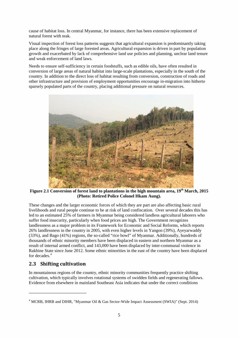
Needs to ensure self-sufficiency in certain foodstuffs, such as edible oils, have often resulted in conversion of large areas of natural habitat into large-scale plantations, especially in the south of the country. In addition to the direct loss of habitat resulting from conversion, construction of roads and other infrastructure and provision of employment opportunities encourage in-migration into hitherto sparsely populated parts of the country, placing additional pressure on natural resources.
Figure 2.1 Conversion of forest land to plantations in the high mountain area, 19th March, 2015 (Photo: Retired Police Colonel Hkam Aung).
These changes and the larger economic forces of which they are part are also affecting basic rural livelihoods and rural people continue to be at risk of land confiscation. Over several decades this has led to an estimated 25% of farmers in Myanmar being considered landless agricultural laborers who suffer food insecurity, particularly when food prices are high. The Government recognizes landlessness as a major problem in its Framework for Economic and Social Reforms, which reports 26% landlessness in the country in 2005, with even higher levels in Yangon (39%), Ayeyarwaddy (33%), and Bago (41%) regions, the so-called “rice bowl” of Myanmar. Additionally, hundreds of thousands of ethnic minority members have been displaced in eastern and northern Myanmar as a result of internal armed conflict, and 143,000 have been displaced by inter-communal violence in Rakhine State since June 2012. Some ethnic minorities in the east of the country have been displaced for decades.4
2.3 Shifting cultivation In mountainous regions of the country, ethnic minority communities frequently practice shifting cultivation, which typically involves rotational systems of swidden fields and regenerating fallows. Evidence from elsewhere in mainland Southeast Asia indicates that under the correct conditions
4 MCRB, IHRB and DIHR, "Myanmar Oil & Gas Sector-Wide Impact Assessment (SWIA)" (Sept. 2014)
6
shifting cultivation can be both a productive and an environmentally sustainable way of using land in lightly populated areas. However, while shifting cultivation may not necessarily result in net forest loss, it may result in an increase in fragmentation and an overall decrease in forest condition. The situation is especially true when rotations are short.
There is little detailed information available on the impacts of shifting cultivation on forests in Myanmar, although a spatial analysis of forest cover change between 1990 and 2000 conducted by Leimgruber et al. (2005) revealed high rates of net forest loss in northern Chin State and Nagaland (northern Sagaing Region), which they attributed to intense shifting cultivation. The impact of shifting cultivation in southern Chin State is precipitating an environmental crisis where high population growth and dependency on natural resources have led to farming in increasingly marginal lands, resulting in deforestation and land degradation. In southern Chin State, shifting cultivation has destroyed most of the forests below 2,000 m above sea level, and is threatening Natmataung National Park. There is a need for further studies of the relationship between upland agricultural systems and forests in Myanmar in order to determine how different systems can be integrated with conservation.
2.4 Infrastructure development Most countries in mainland Southeast Asia are experiencing high rates of economic growth, which are fueling a boom in infrastructure development. In many cases, the absence of adequate environmental impact mitigation measures has meant that these developments have had severe impacts on the region’s forests. Road developments, for example, can cause fragmentation and loss of forests, encourage human settlement in previously remote areas, and facilitate extraction of forest resources. In Myanmar, road development has been prioritized by the present government and substantial investment has been made in construction of major highways as well as a road network connecting districts. As of 2007, the total length of the national road network was 51,000 kilometers and the total net increase during the last two decades was 44% higher than in 1988. In addition, hydropower development has also had major negative impacts on forests in the country.
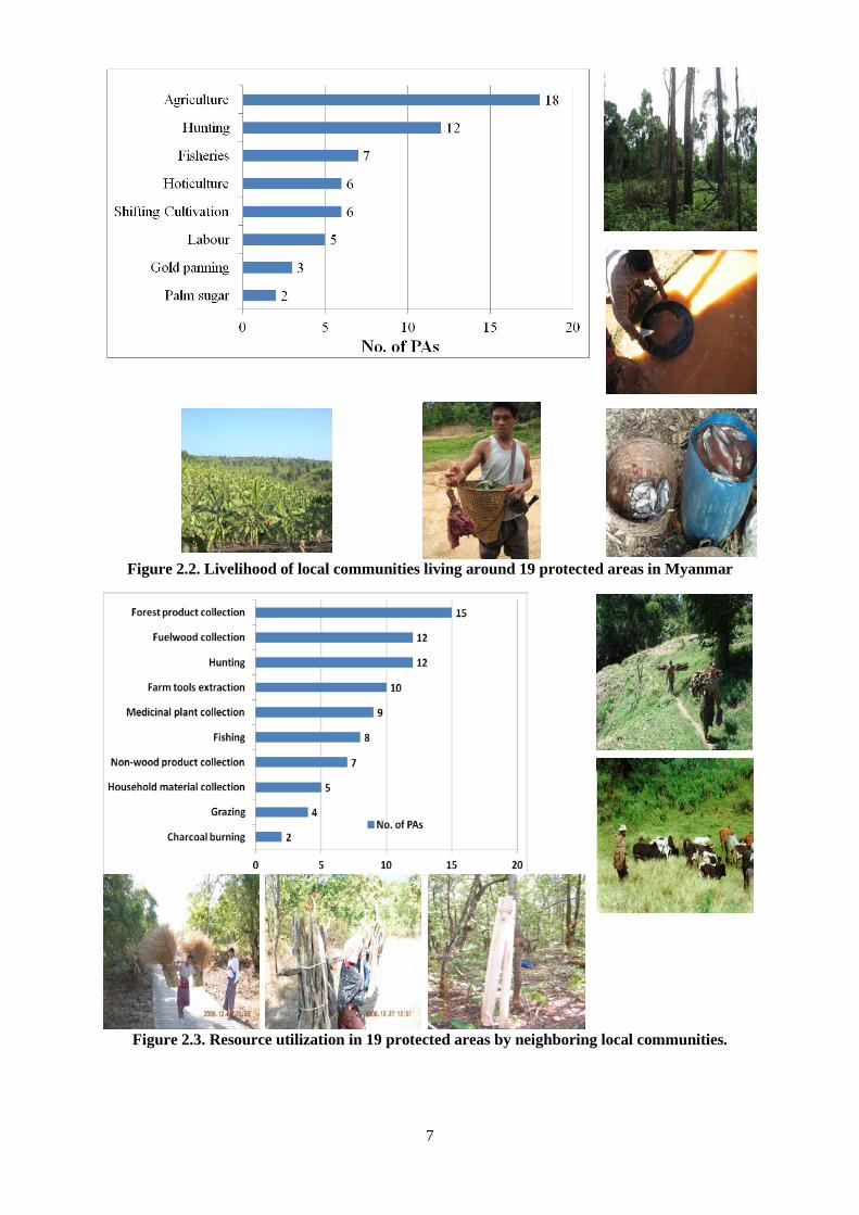
2.5 Poverty Natural resource based livelihoods are often associated with extreme poverty and the predominantly rural population of Myanmar is generally highly reliant on natural resources for subsistence. A recent census revealed that several protected areas are surrounded by communities with natural resource based livelihoods (Figures 2.2 and 2.3). In upland areas, there are particularly high levels of dependency on natural resources and poverty and land degradation are linked in a mutually reinforcing cycle that is difficult to break (Eberhardt 2003). As such, poverty is a major underlying driver of deforestation and forest degradation. Various factors, including external economic forces, population growth and loss of access to land have increased unsustainable natural resource use and exacerbated degradation and loss of natural habitats and forests. The problems have been compounded by decades of armed conflict which have led to the abandonment of land by thousands of people.
7
Figure 2.2. Livelihood of local communities living around 19 protected areas in Myanmar
Figure 2.3. Resource utilization in 19 protected areas by neighboring local communities.

8
2.6 Economic growth and increasing consumption Economic growth together with increasing consumption is another major underlying cause of forest loss. This pressure is compounded by economic growth and increasing demand for resources in neighboring countries. In 2000, consumption in Myanmar was significantly below global average capacity, creating an ecological remainder of 0.24 global hectares per capita (Venetoulis et al. 2004). However, rather than being kept in reserve such remainders are typically taken by other countries through exportation and this is very much the case in Myanmar with its exports of natural gas, wood products and other natural resources. However, while economic growth in Myanmar’s could contribute to further pressure on the country’s natural resources, it could also generate more resources for nature conservation.
2.7 Capacity constraints Government institutions have the principal responsibility for conserving natural resources but are often severely constrained by shortages of financial resources and technical expertise. For instance, the Nature and Wildlife Conservation (NWCD) of the Forest Department has insufficient financial, human and material resources to fulfill its mandate to manage protected areas (Clarke 1999). Government institutions responsible for conservation often suffer from low staff morale, lack of performance incentives and lack of training. These limitations have been somewhat filled by NGOs and academic institutions which have strengthened national capacity to conserve forests.
2.8 Lack of environmental safeguards Integration of forest conservation considerations into government decision making is urgently needed, particularly in the agriculture, forestry, fisheries, mining and energy sectors. In the absence of other sources of foreign exchange, the Government of Myanmar views natural resource exploitation as its best option for maintaining hard currency reserves (Eberhardt 2003). In connection, the Government is pursuing a number of export-oriented policies, including commercial logging, hydroelectricity generation and aquaculture development. In implementing these policies and for all major projects, thorough environmental impact assessments should be conducted and appropriate mitigation measures for forest conservation should be applied. However, although the Environmental Conservation Law was enacted in 2012, enforcement is still weak due to a lack of rules necessary for its implementation.
2.9 Unclear land tenure and weak enforcement of land laws All land in Myanmar belongs to the state and land-use rights are granted for specific periods, dependent upon use (Eberhardt 2003). The recent OECD Investment Policy Review of Myanmar notes that “tenure remains insecure for most smallholder farmers for a wide range of reasons: i) a complex and long registration process resulting in low land registration rates; ii) rigid land classifications that do not reflect the reality of existing land use; iii) lack of recognition of customary land use rights; iv) weak protection of registered land use rights; v) inefficient land administration; and vi) active promotion of large-scale land allocations without adequate safeguards.”5
In most upland areas, land-tenure systems are based on customary rights under local institutions (Eberhardt 2003). These rights are, however, not upheld by national law and as a result rural communities are vulnerable to losing access to land through such processes as establishment of commercial plantations by agribusinesses or appropriation of land for other use under the Government’s self-reliance policy. The situation is further compounded by the lack of a specific land-use policy to guide settlement of land tenure disputes (Eberhardt 2003). Loss of land can force communities to shorten fallow cycles or cultivate steeper, less productive slopes that are more susceptible to environmental degradation (Eberhardt 2003). Moreover, unplanned expansion of commercial plantations, such as oil palm and cassava, itself leads to large-scale conversion of forest.
5
OECD Investment Policy Review of Myanmar
9
Given the current situation, introduction of comprehensive land-use policies and land-use planning, consistent with sustainable rural livelihoods and biodiversity conservation, is a pressing need.
2.10 Undervaluation of biodiversity In general, natural resources, and biodiversity in particular, tend to be severely undervalued in Myanmar and natural resource use decisions are typically based only on direct use values, such as revenues from sale of timber or hydroelectricity. Generally, the immediate benefits of exploiting a natural resource are perceived as more attractive than the long-term benefits accrued from resource conservation, such as water catchment protection, soil erosion control or other ecological services.
Many of the most important values associated with natural resources, particularly existence values, are not easily quantifiable. However, a number of initiatives in Asia have assessed the broad economic values of natural resources, including a review of the role of protected areas in development in Cambodia, Lao PDR, Thailand and Vietnam (ICEM 2003), and a review of the roles of natural vegetation in China (MacKinnon et al. 2001). Such approaches could be adopted in Myanmar to promote a fuller accounting of the values of natural resources in decision-making processes. In particular, opportunities may exist to ensure that existing and future foreign investors compensate for the full costs of their investments, for instance through a natural resources tax or through appropriate mitigation measures. Additionally, financial mechanisms could be developed to enable the beneficiaries of ecosystem services to contribute to their conservation, such as through carbon offset payments, payment for ecosystem services, or debt-for-nature swaps.
2.11 Lack of grassroots participation in decision making process for conservation
Although the people of Myanmar are generally supportive of conservation, rural populations living in close proximity to protected areas may not be sufficiently supportive of conservation efforts, such as protected area management (Clarke 1999). Reasons may include lower awareness of the objectives of conservation, lack of mechanisms for local communities to benefit or lack of opportunities for grassroots participation in conservation activities.
There are several ways through which NGOs and academic institutions could build grassroots support for conservation, including:
(i) Changing public perceptions towards conservation through awareness raising;
(ii) promoting conservation approaches that deliver benefits to rural livelihoods without detriment to the biodiversity;
(iii) acting as a bridge between government conservation initiatives (such as protected areas) and local communities;
(iv) developing non-formal approaches to site-based conservation that maximize grassroots participation; and
(v) strengthening the capacity of protected area managers in community outreach and participation.
2.12 Climate change There have been no studies on the impacts of climate change on forest ecosystems in Myanmar. However, the nation’s ecosystems are likely to be faced with temperature rises and other changes in several areas. According to the climate scenario analysis conducted for the Initial National Communication to the UNFCCC, temperature is likely to increase by over 1 degree Celsius in most parts of the country within the next 30 years. This will have potential adverse effects on agriculture, forestry, biodiversity, water resources, natural disasters and human health.
Cyclone Nargis, which hit the lower part of Myanmar in 2008 causing over 138,000 deaths, illustrates the potential devastating impacts of climate change. Mangrove forests in the Ayeyarwaddy delta were

10
also severely affected and the biological balance was seemingly destroyed. For example, rat populations in storm-affected villages increased and damaged paddy fields which reduced food security. Therefore, precautionary approaches and measures are required to ensure mangrove conservation and increase levels of adaptation to climate change. More generally, climate change should be considered an emerging threat with potentially severe implications for forest ecosystems.
3 Drivers of sustainable forest management, forest conservation, afforestation and reforestation
No specific influences that have driven actual positive outcomes in forestry (e.g. reduced deforestation, degradation and other elements included in the definition of REDD+) were found during efforts made as a part of this study, which included interviews with forest officers and heads of NGOs and CSOs, and reviews and assessments of literature and data, including spatial data.
4 Policies and measures (PAMs) addressing deforestation and promoting sustainable forest management, forest conservation, and afforestation and reforestation
The Government of Myanmar is implementing a range of policies and measures to address deforestation and forest degradation, including:
• Community forestry;
• Reducing Emission from Deforestation and Degradation (REDD+); and
• Establishment of forest plantations.
In addition the Government is carrying out the following activities to promote sustainable forest management (SFM), forest conservation and afforestation and reforestation:
• Watershed management programs;
• Establishment of permanent forest estate;
• Myanmar Timber Legality System and FLEGT; and
• Land use planning and land policy formulation.
4.1 Policies and measures addressing deforestation/degradation Attempts to respond to the threat of forest depletion and loss in Myanmar have a long history dating back to 1856, the development of sustainable management regimes for the teak forests of Bago, and the Myanmar Selection System which was built around the concepts of allowable cut, forest working plans, decentralized management and “local supply working circles”
6 (Saw El Dah, 2004). Under the
Myanmar Selection System, teak forests of Myanmar sustained their production over three felling cycles, i.e. almost a century.
Decentralized forest management was replaced by a centralized national planning system between 1962 and 1988. The basic planning unit shifted from forest ecosystem to an administration unit, disrupting operations within the same ecological unit. As a result, the quality and execution of forest working plans declined and the ecological stability of the forest became harder to establish and enforce.
6 “Local supply working circles”, designed to ensure supply of forest products to the population living in the vicinity of forest, pre-date the current discussion about buffer zone management by almost hundred years.

11
A major change took place in 1988, when the state-run timber industry was opened to private sector participation. Accompanying efforts were made reinforce forest management: the Forest Law was revised in 1992, national forest policy formulated in 1995, community forestry given a legislative basis (1995) and Dry Zone Greening Department created in 1997.
The 1995 Forest Policy set the target of expanding the reserve forest to 30% of the total land area and setting aside no less than 5% of total land as protected area system (10% for the long term). Annual reforestation target of 20,000 hectares was also announced to restore degraded lands and meet rural needs (MOF 1996, pp: 4-5).
Forest conservation and reforestation for both environmental protection and rural development has become the centerpiece of forest management in recent years while the Myanmar Selection System has been retained to regulate exploitation of non-plantation forest. Through the activities of the Dry Zone Greening Department, reforestation was expanded and law enforcement intensified in the neediest areas such as the heavily deforested parts of Magwe, Mandalay and Sagaing Divisions. Community forestry legislation is also providing for the right of local people to manage nearby forests for own use. A comprehensive Forestry Master Plan for 2001-2031 reinforced the policy support for sustainable forest management.
Details of specific initiatives are outlined in the following sections.
4.1.1 Community forestry
The Forest Department set a goal of establishing up to one million hectares of community plantations by 2030-2031 in its 30-year plan. However, by 2015 only around 8,093 hectares had been established. A Community Forestry National Working Group (CFNWG) is the latest response by the Forest Department, CSOs, and CBOs including RECOFTC and FAO’s Forest and Farm Facility to promote community forestry in Myanmar.
Following the latest government directive the Forest Department is addressing encroachment of human settlements into forest reserves through:
(i) De-reservation of agricultural areas and conversion to human settlements; and
(ii) Establishment of agroforestry systems and implementation of community forestry practices on farmland.
However, these endeavors face significant challenges, mainly because farmers are granted complete ownership of agricultural land instead of a 30 year lease under the current Forest Department community forestry rules. Such complete ownership of agricultural land gives farmers the right to sell land or use land as collateral. Adjustments are therefore likely to be needed for successful community forestry development in Myanmar.
4.1.2 Reducing Emissions from Deforestation and Degradation (REDD+)
Myanmar aspires to maintain at least 30% of the total national area as Reserved Forests (RF) and Protected Public Forest (PPF) while increasing Protected Areas to 10%. The country aims to achieve this ambition partly through results-based finance from REDD+. REDD+ targets not only reduce negative changes in forests but also enhance positive changes through afforestation and reforestation and forest regeneration and rehabilitation (Table 4.1).
Table 4.1. Potential REDD+ activities in Myanmar
Changes in: Reduced negative change Enhanced positive change
Forest area Avoided deforestation Afforestation and reforestation (A/R)
Carbon density
(carbon per hectare)
Avoided degradation Forest regeneration and rehabilitation (carbon stock enhancement)

12
Myanmar has been implementing activities associated with all five REDD+ activities as summarized in the following table.
Table 4.2 Current REDD+ activities in Myanmar
REDD+ activity Myanmar’s efforts Indicators
Reducing emissions from deforestation
- Banning log export - Reducing logging - Annual Allowable CutHarvesting within (AAC)
Reduced rate of forest loss
Reducing emissions from forest degradation
- Regulating AAC - Ensuring felling cycle and girth limits
Reduced rate & volume of timber extraction
Conservation of forest carbon stocks
- Permanent Forest EstatePolicy targets of - Permanent Forest EstateExtending (including protected areas)
Expansion of protected area network
Sustainable management of forests
- Strengthening SFM - Timber certification process - FLEGT - Land-use policy
Increased land under sustainable management
Enhancement of forest carbon stocks
- Large scale reforestation program (government, private, community)
Increase in reforestation & afforestation
Additionally, the Government of Myanmar is implementing the following activities and policies to create enabling conditions for REDD+:
• The Forest Department is making every effort to achieve the policy target of increasing the Permanent Forest Estate to reach 30% of the total land cover of the country;
• To reduce deforestation and forest degradation from excessive logging the MOECAF has issued a degree banning the exporting of timber in log form starting from 1st April 2014;
• The Forest Department is reducing timber harvesting targets to be in line with the latest calculation of Annual Allowable Cut;
• The Timber Certification Committee has been working on the criteria and indicators of sustainable forest management;
• FLEGT initiatives have been started with the help of the European Commission;
• Establishment of a Timber Legality and Assurance System is under way under the FLEGT initiative;
• Myanmar is preparing to establish an EU Voluntary Partnership Agreement (VPA);
• Environmental Impact Assessment (EIA) and Social Impact Assessment (SIA) guidelines that can support REDD+ Safeguard Information System are being prepared;
• Private sector investment in forestry sector is being promoted and encouraged;
• stakeholder engagement in forest conservation activities is being accelerated;
• A land-use policy and National Land Law are being prepared; and
• Development of a green economy is being encouraged promoting ecosystem services are being promoted.

13
REDD+ activities in Myanmar have also focused on awareness raising and capacity building. Several workshops and trainings have been held, including national level workshops in cooperation with UNDP; regional level workshop on the development of REDD+ national strategies in cooperation with Korea’s Forest Service, with participation from ASEAN countries, local NGOs, UN-REDD Programme, UN Agencies, line ministries, and academic institutions; and a series of trainings for government and local communities. Myanmar has also developed a REDD+ Readiness Roadmap through a multi-stakeholder process that contributed to raising awareness on REDD+. The REDD+ Readiness Roadmap was completed in July 2013.
4.1.3 Establishment of forest plantations
With the abundance in natural forests during the colonial period, establishment of forest plantations was not a priority (Slebbing E.P. 1962). It also remained a low priority during the early years of independence. A major change took place in 1988, when the state-run timber industry was opened to private sector participation. Accompanying efforts were made reinforce forest management: the Forest Law was revised in 1992, national forest policy formulated in 1995, community forestry given a legislative basis in 1995 and Dry Zone Greening Department created in 1997.
The 1995 Forest Policy set a reforestation target of 20,000 hectares to restore degraded lands and meet rural needs (MOF 1996, pp: 4-5). The profile of plantation forestry, especially teak, has also increased over time. From modest compensatory planting during the 1960s it progressed to an annual average of around 32,375 hectares (MOI 2002) between 1985 and 2005 (Figure 4.1). Among others, the World Bank and Asian Development Bank supported forest plantation establishment during the period 1979-1987 through the East Pegu Yoma project (Ohn U 1999).
Figure 4.2 Plantation establishment of Forest Department, 1981-2014
Since 2006 Forest Department plantations have, however, decreased considerably to only ~3237 hectares over the whole country in 2014. On the other hand, the area of privately owned plantations, establishment of which began in 2007, has surpassed the area of public plantations. The total area of plantations has nevertheless decreased to 10,230 hectares in 2014.
The Forest Department’s annual forest conservation and development expenditure adjusted for price inflation using World Bank CPI values, fell by 16% between 1988 and 2014. Forest plantation accounted for 26.1% of annual budget in 1988 and reached a peak of 46.8% in 1999 before falling to 17.3% in 2014. In connection, the Forest Department is switching to private plantation ownership. However, the private sector will likely only be interested in commercial plantations and not plantations established for conservation. In 2007, commercial and fuelwood plantations comprised 87% of the total plantation area while only 13% were for conservation. Current plantation activities
0
5000
10000
15000
20000
25000
30000
35000
40000
1981
1983
1985
1987
1989
1991
1993
1995
1997
1999
2001
2003
2005
2007
2009
2011
2013
Area
Hec
tare
s FD Total
Private Total

14
also need careful considerations, since there is strong although unverified evidence that failed plantations have been a major cause of forest loss and degradation in Myanmar.
4.2 Policies and measures promoting sustainable forest management, forest conservation and afforestation and reforestation
4.2.1 Watershed management programs
To conserve Myanmar’s watersheds systematically, the Forest Department has carried out watershed management programs with the aid of UNDP/FAO since 1990s. In addition, the Forest Department has been implementing Watershed Conservation Action Plans based on five year intervals to conserve watershed areas of major dams and reservoirs including Inle Lake. The programs detailed in the following sections are being implemented in Myanmar to conserve its watersheds:
4.2.1.1 Bago Yoma Greening Project (2004 - present)
The Forest Department has carried out the Bago Yoma Greening Project (BYGP) with the approval of Cabinet since 2004 to sustainably grow teak, conserve watershed areas of constructed dams and reservoirs, and enhance community participation in forest management in the Bago Yoma region. The total area covered by BYGP is about 5.07 million hectares, of which 2.08 million hectares are situated in the Reserved Forest and Protected Public Reserved Forest. Currently, the 2nd Five Year Action Plan (2009-10 to 2013-14) is being implemented and major activities include establishing forest plantations; conducting natural forest protection and silvicultural practices such as natural regeneration, enrichment planting, gap planting, and forest fire protection; and conducting law enforcement programs.
Moreover, under the BYGP, an additional six supportive activities are being conducted to reduce the deforestation rate in the Bago Yoma area. These include establishing community forests, conducting forest conservation awareness campaigns, encouraging use of alternative fuels instead of fuelwood, establishing Teak Reserved Forests, implementing water supply programs and conducting research programs. The total area of 0.65 million ha would be conserved after implementing the 2nd Five Year Action Plan.
4.2.1.2 Sustainability of Inle Lake and Environmental Conservation Five Year Action Plan (2010-11 to 2014-15)
Inle Lake, the second largest freshwater lake in Myanmar, is situated in Southern Shan State. The lake is located at about 844 meter above sea level and its watershed spans approximately 5,612 square kilometers. It attracts hundreds of thousands of domestic and international visitors every year. In addition, Inle Lake is a vital part of the broader economic, social and environmental systems and provides multiple goods and services for surrounding communities. It is also a source of water for the Law-Pi-Ta hydropower plant which supplies electricity to the national grid. Due to its importance, the Government has made utmost efforts to conserve and restore Inle Lake and associated ecosystems.
As a result of unsustainable agricultural practices and deforestation in the Inle Lake watershed, sedimentation in the lake has accelerated over the last two decades. The overuse of pesticides and inorganic fertilizers in floating gardens and the direct discharge of wastewater and solid waste from tourism facilities and cottage industries in the lake’s vicinity have caused water quality to gradually deteriorate. In addition, the water level in the lake has reached its lowest level for 50 years due to prolonged drought in 2010. These environmental impacts are compounded by climate change impacts resulting in acute health problems, dramatic water level fluctuations between dry and wet season, and ecosystem and habitat disintegration and degradation. Consequently, the long term socio-economic development of local communities is likely to be seriously affected.
To respond to the environmental issues, the Sustainability of Inle Lake and Environmental Conservation Five Year Action Plan (2010-11 to 2014-15) has been formulated and is being implemented. The Forest Department is taking a leading role and relevant line ministries and stakeholders are also involved. The Action Plan includes the following main activities:

15
(i) Watershed conservation, maintaining stream flow conditions and preserving the open water body area of Inle Lake;
(ii) Preventing soil erosion and sedimentation;
(iii) Conducting activities for extension, capacity building and technical cooperation;
(iv) Biodiversity conservation; and
(v) Conducting activities to improve the socio-economic status of local communities.
4.2.1.3 Inle Lake Conservation and Rehabilitation Project (2012 - 2013)
To conserve and restore the Inle Lake, UNDP has implemented the Inle Lake Conservation and Rehabilitation Project with the approval of MOECAF. The project was co-funded by the Norwegian Government and UNDP with a total budget of US$2.56 million and aimed to restore the environmental stability of Inle Lake and improve the quality of life of local communities. The outputs of the project included:
(i) A conservation and management plan for Inle Lake;
(ii) A small grant facility for CBOs and NGOs established with relevant partners to form a “trust fund” for implementation of environmental activities;
(iii) A knowledge sharing platform and information disseminated among stakeholders; and
(iv) Environmental activities included in the national and regional development plans.
4.2.1.4 The 3rd Five Year Action Plan on Establishing Watershed Plantation in Watershed Area of Major Dams, Reservoirs and Water Sources (2011-12 to 2015-16)
Watershed management is of paramount importance to Myanmar since the Government has made great strides in constructing dams and reservoirs for hydropower generation and irrigation for national economic development and poverty reduction. In this context, the Forest Department has endeavored to conserve and rehabilitate forested areas in watersheds to ensure sustainability of watersheds and prevent sedimentation in dams and reservoirs. This involves formulation and implementation of Action Plans for Establishing Watershed Plantation in Watershed Area of Major Dams, Reservoirs and Water Sources every five years.
Currently, the 3rd Five Year Action Plan (2011-12 to 2015-16) is being implemented by the Forest Department. The Action Plan not only establishes the watershed plantation, but also conducts natural forest conservation and soil and water conservation activities over the watershed area of 53 dams/reservoirs throughout the country. The targets in the 3rd Five Year Action Plan include establishment of 1,618 ha of watershed plantation and conservation of 303,187 ha of natural forest by the end of 2016. In addition, a series of soil and water conservation training will be conducted to improve the capacity of staff and local people.
4.2.2 Establishment of Permanent Forest Estate (1985 - 2014)
In Myanmar, different typologies of forests and differences in their legal status are found. Forest Reserve is the best known category that is fully protected by existing forestry related laws. Establishing a Forest Reserve is normally a lengthy official process during which potential conflicts of interest and tenure claims of different parties and the State need to be reconciled. Designation of an area as a Protected Public Forest is a simpler alternative to protect trees and place limits on activities allowed. Other forested areas are normally in the category of either (1) public forest (“other wooded lands”) where forest cover might still be good and access to trees and land is open to local communities or (2) “wasteland” where natural vegetation is sparse or very poor. Forest Reserve and Protected Public Forest are termed Permanent Forest Estate (PFE) and the 1995 Forest Policy has set a target of 30% of total land to be managed under PFE.
Before the policy target was announced, the total percentage of PFE was about 15% (Figure 4.3). The Forest Department data show no or very little change in PFE area from 1985 to 1997 (15.48%).

16
Between 1998 and 2014, the total area of PFE increased to 24.06% of the total land area. The additional 6.89% of total land placed under PFE was lower than half of the projected increase of 14.51%. The official target is likely to be difficult to achieve as new land laws of the Ministry of Agriculture have placed unreserved forest areas under juristic powers.
Figure 4.3 Permanent Forest Estate Area percent to Total Land
Source: Forest Department 2015
4.2.3 Timber Legality System and FLEGT of Myanmar
To support sustainable forest management MOECAF has started a timber certification process with participation of all relevant stakeholders. The Ministry is also currently formulating the Myanmar Timber Legality Assurance System, which will provide licenses/permits and certificates for the exporting of legal timber. For the purpose of export, legal timber is defined as ''timber harvested by authorized agency from approved areas and timber and timber products extracted, transported, manufactured and exported in accordance with the laws, regulations and procedures pertaining to forestry, timber industry and trade of Myanmar.''
Myanmar has also started implementation of the European Union Forest Law Enforcement, Governance and Trade (EU FLEGT) process since July 2013. The current objectives of FLEGT in Myanmar include capacity building, development of a Voluntary Partnership Agreement (VPA) with stakeholder involvement, and development of a work plan for preparations prior to VPA negotiation.
The following future steps will need to be taken to advance FLEGT efforts in Myanmar:
(i) Awareness raising among stakeholder groups concerned with the VPA process;
(ii) Mapping the key stakeholders who will proceed with the VPA process;
(iii) Developing communication strategies to communicate among stakeholders;
(iv) Step by step implementation of the VPA process with support from EU Member States, European Forest Institute EU FLEGT Facility and EU Delegation, and consideration of experiences and lessons learned from other countries involved in the EU FLEGT process.
Given the active participation of all stakeholders and the Government's current reform processes, Myanmar believes that it can develop an effective Myanmar Timber Legality Assurance System, which is critical to the VPA process, to meet the requirements of the EU Timber Regulation.
0.0%
5.0%
10.0%
15.0%
20.0%
25.0%
30.0%
-
2,000
4,000
6,000
8,000
10,000
12,000
14,000
16,000
18,00019
85-8
619
86-8
719
87-8
819
88-8
919
89-9
019
90-9
119
91-9
219
92-9
319
93-9
419
94-9
519
95-9
619
96-9
719
97-9
819
98-9
919
99-2
000
2000
-200
120
01-2
002
2002
-200
320
03-2
004
2004
-200
520
05-2
006
2006
-200
720
07-2
008
2008
-200
920
09-2
010
2010
-201
120
13-2
014
% o
f Tot
al la
nd
Thou
sand
hec
tare
s
PFE area % of Total Land Area
17
4.2.4 Land use policy and planning
Land management and land use planning are of great importance to communities vulnerable to climate change, natural disasters and food insecurity, and also for biodiversity, ecosystem services, forest conservation, emissions reduction and desertification prevention.
According to the 2014 census, the total population of Myanmar is currently around 51 million and the country has over 100 ethnic groups with different cultures, customs and land use traditions. Land related issues are among the most critical in Myanmar and the Government recognizes several key areas in which attention is needed: land use administration, land tenure security, land use rights, land dispute resolution, foreign investment, sustainable economic growth, effective environmental protection, and social harmonization.
The 2009 FAO-Myanmar Forestry Outlook Study (Tun, 2009) stated that:
The second driving force (in the forestry sector) is national land-use policy. Although forest policy includes statements about land-use, a nationwide land-use policy in Myanmar needs to be formulated and implemented in order to allocate the land area of the country. […] the government targeted PFE to meet 30% of total land. On the other hand, it aimed at increasing investment to develop the cultivable land, fallow land and waste land to carry out agriculture, livestock breeding, aquaculture or other affiliated economic activities. But there is no definition given of these lands. Thus, agriculture including plantation of such perennial crops as oil palm and rubber encroached not only cultivable, fallow and waste land but also lands inside PFE (Kyaw, 2003). Within 2004/2005 alone, 2766 square miles of reserved forest area which included protected public forest were written off. Not only agricultural expansion but also other offensives such as canal and dam construction in forest and watershed areas, inclusion of mangrove forests as fishing grounds, and establishment of new military compounds in PFE explain lack of coordination among concerned institutions on proper land use.
Since the above study, a Land Use Policy has been drafted through a series of working group meetings and stakeholder consultations under the auspices of The Land Use Allocation and Scrutinizing Committee (LUASC). The LUASC is chaired by the Union Minister for MOECAF and consists of 25 members from concerned government ministries and agencies.
The Land Use Policy was developed in response to a range of needs outside of demands for forest conservation. These included the need for investment and economic growth, citizens’ demand for recognition and protection of all legitimate existing land use rights, and investors’ demand for land tenure security are the main drivers of land use policy. There had also been an increasing number of land disputes due to inconsistent laws and lack of concrete land use management planning.
The draft National Land Use Policy provides a blueprint for long-term management of the land sector and links to land administration reform efforts. Essential steps following development of a National Land Use Policy include National Land Law development, Law Harmonization, National Land Inventory, National Land Use Plan development, and Sectoral Policy and Land Use Planning Processes.
The objectives of the National Land Use Policy are to:
(i) Benefit the people and country, harmonize land use systems and balance between development and conservation;
(ii) Protect the land use right of the citizens; and
(iii) Improve the land administration system.
The National Land Use Policy applies to all land resources, improvements, uses and tenure in the country, and in both rural and urban areas. It guides the development of new land legislation, including the National Land Law, as well as harmonization and implementation of all existing land use and land tenure laws. It also guides and integrates all branches of government and ministries involved in land use and land tenure decision making matters, including regional, state and local

18
government. The Policy will address current land use management and land tenure issues for a five-year period and will be updated at least every five years to reflect changing circumstances.
The development of the National Land Use Policy has incorporated international standards into the national context to balance competing needs, increase community participation and accountability, establish consistent guiding principles for legislation and implementation methodologies, and pilot these methodologies in district level projects.
4.2.4.1 Opportunities and Challenges
There is currently strong political support for the Land Use Policy and the LUASC is applying the principles of transparency, accountability, good governance and inclusiveness in formulating the policy. It is taking into account all existing sectoral laws, procedures, rules, regulations and practices as well as institutions related to land. The most important elements are considered to be engagement of multiple stakeholders, promotion of international cooperation and providing a foundation for emerging economic development.
There are currently many land disputes in the country and long term plans need to be developed with good participation and coordination. Additionally, unbalanced development of the national land market, instability in the national economy and in land prices, inappropriate investment, land grabbing, land speculation, and inappropriate land tax systems hinder the land valuation process. As such, key challenges to land use planning and policy processes in different areas include the following:
• Lack of a simplified yet comprehensive National Land Law; weakness in harmonization of land related laws, rules and regulations; existence of various customary rights among ethnic groups; and lack of systematic land use planning and management including in urban areas.
• Challenges to the development sectors include strategic planning and implementation, low inputs for land management, the need for stakeholder consultation, weak coordination between stakeholders and lack of monitoring systems.
• Social challenges include limited livelihood opportunities and poverty, issues related to illegal farming and habitation, ongoing land related disputes and limited knowledge and awareness.
• Technical challenges include weakness in institutional capacity, limited remote sensing/GIS capacity, limited land use related information, and inconsistency of land use maps and land records systems among different ministries.
• Other challenges include land grabbing, land speculation and the high price of land leading to loss of foreign investment and business opportunities.
5 Analysis/Lessons Learned
5.1 Plantations The Forest Department began using the Myanmar Selection System during the British colonial period. The forest is managed on a sustained yield basis with scientific management plans drawn up periodically and approved by not only the Forest Department but also administrative authorities. Forest cover analysis using the early satellite imagery from 1974 confirmed good forest conditions in the country. At that time, plantations of 5-10 acres and maximum 50 acres were established, often using taungya methods, with no negative impact on the natural environment. The final thinning was done at 30 years and the remaining plantation was treated as normal forest. Extraction also followed the Myanmar Selection System’s girth limit control.
However, in 1974 the State Timber Corporation (now Myanmar Timber Enterprise) borrowed money from ADB and the World Bank to modernize its extraction machinery. The loan agreement included a clause that for every 100 acres equivalent of extraction 10% should be replanted. This would not be a problem in temperate areas where timber is generally produced in plantations. In Myanmar, however,
19
natural forests were in excellent conditions and high-yielding fuelwood producing forests were clear-felled and converted to plantation that subsequently failed.
While the Forest Department has not published any data on the survival percentage or success rate of its plantations, one set of statistics for Dry Zone plantations shows that the survival rate is very low at under 20%. A conservative guess of the success rate can be made at around 30%. The main cause of failed plantations is insufficient budget, especially for maintenance activities.
Currently, plantations account for about 1.4% of the total national land area and as this proportion is small it may be considered that plantation failure is not a serious problem. However, forest plantations, especially commercial ones, are established only in Reserved Forest Area in Myanmar, which account for around 24% of the total land area. As such, around 4% of the Forest Estate has been converted to failed plantation. This has led to encroachments as well as requests to convert land to other crops such as rubber.
5.2 Timber extraction, illegal logging and over-exploitation in conflict areas
A large amount of illegal logging occurs in conflict areas, including clear-felling by both sides – the armed local governments as well as companies holding legal concessions with the Union Government. The lowering of exploitable girth limits in conflict areas has led to clear-felling. Still worse are cases where lower girth limits, or shortened rotation periods or felling cycles, etc. are requested by contracted companies in peaceful areas of Myanmar.
Currently, a total ban on log exports has been declared, but if sustainable forest management procedures are followed there is no log size timber available and as such, Myanmar’s forests a period of recovery. There also needs to be a shift in focus from timber value to marketing forest carbon or environmental services.
5.3 Energy supply In 2010 industry and transport accounted for only a small proportion of energy use in comparison with other sectors in Myanmar, including households and small and medium enterprises. Biomass from forests accounted for over 60% of total national energy consumption and contributed significantly to domestic energy use. The situation largely resulted from energy shortages that were indirectly related to economic sanctions imposed on the country during the last military government. The foreign currency deficit caused by the sanctions was addressed by exceeding the national annually allowable cut and raising timber exports, and also by exporting energy. Oil and gas were exported to Thailand, although this was also limited by sanctions, and most of the renewable energy produced, including hydropower, was exported to China. The impacts of the foreign currency deficit and energy shortages on forests were compounded by unsystematic extraction of fuelwood and by fuelwood plantation failure. Satellite images commonly show a gradual disappearance of woody vegetation followed by land encroachment.
In responding to this threat, Myanmar needs to address household and industrial energy use by diverting electricity and gas exports to meet domestic demand. Calculation of ecosystem service values should also be included in energy development projects involving foreign partners. Ecosystem service valuation should help increase the share of energy output directed towards domestic usage above the current average of 10% (with additional amounts having to be bought back) and reduce pressure on forests for fuelwood.
5.4 Land use change, encroachment and land grabbing Population pressure and over-exploitation of forests for timber and fuelwood have, among other factors, led to deforestation and forest degradation. Affected forest areas are subject to land grabbers from other sectors and even the forest sector itself is converting forest lands to monoculture plantations. For example, although there is currently no policy to clear cut plantations, old plantations

20
on an 80-year rotation that were to be harvested under the Myanmar Selection System are now being clear felled at 30 years.
Land grabbing often initially appears as well-intentioned policy such as development of private hardwood plantations and rubber plantations. However, lands nominally destined for such purposes often fall into the hands of land grabbers and end up as being developed as golf courses or industrial zones. Clear land laws and strict governance to control land grabbing can reduce conversion of forest areas to other land uses.
5.5 Mining and extractive industries Many mining concessions, especially for gold, have been allocated over forest areas in the far north of the country and rehabilitation of affected areas is almost non-existent. Contracts have also been signed for oil and other mineral extraction. Environmental impact assessments and environmental management plans together with MRV systems are badly needed to address the negative impacts of mining on forests.
6 Proposed action plan including priority interventions and timing
Discussion with forest officers, NGOs and presidential advisers suggests that the following interventions should be prioritized:
(i) Detailed forest resources mapping including ecosystem value assessment to aid understanding of status and trends in forest resources;
(ii) A decision support tool for the policy makers; and
(iii) Strategic Environmental Assessment for the forestry sector.
6.1 Detailed forest resources mapping including assessment of ecosystem values
The Forest Department uses the Myanmar Selection System which is legally based on the principle of sustained yield and includes inventory methods which enumerate all trees over a certain girth. However, 100% enumeration was replaced in the 1980s by methods based on sampling. Additionally, only large scale inventories have been undertaken, while management level inventories have been performed only in specific pilot townships. In the meantime, forest compositions and extraction and utilization practices have changed significantly.
Although there has been great improvement in Remote Sensing/GIS systems in the Forest Department, capacity building is needed in relation to inventory skills and techniques. In relation, it is essential to measure and monitor not only the status of forest resources but also other important socio-economic and environment-related factors including biodiversity.
To date there has been no project focusing on Payments for Ecosystem Services (PES) in Myanmar and assessment and valuation of PES in relation to investments in e.g. irrigation and hydro power projects are lacking as are related budgets to pay for the environmental services obtained. Additionally, the current Forest Department budget for wildlife conservation and research and training is highly inadequate and further financial resources are needed (Figure 6.1).

21
Figure 6.1. Expenditure trend of Forest Department adjusted according to Consumer Price Index (CPI)
Source: Forest Department 2015
Current natural resources mapping in the Forest Department lacks comprehensive mapping of stocking density due to in-sufficient sampling areas and frequency, and inadequate budget and manpower.
The following steps are necessary to attain comprehensive information on forest resources in the country:
(i) Review current information, techniques and constraints;
(ii) Prioritize resource data;
(iii) Design inventory and survey plans;
(iv) Implement the surveys;
(v) Monitor and evaluate the success of the surveys and their implementation and adjust the overall strategy accordingly
The focal agencies for this activity should be the Planning and Statistics Division of Forest Department (MOECAF), Forest Research Institute (MOECAF), the University of Forestry (soon to be moved to Ministry of Education) and FAO as international partner.
6.2 A decision support tool for decision makers7 The ASEAN Regional Knowledge Network on Forest and Climate Change (ARKN-FCC) Decision Support Tool on Identifying and Addressing Drivers of Deforestation and Forest Degradation is a
7
ASEAN Regional Knowledge Network on Forest and Climate Change (2014) Decision Support Tool, Identifying and Addressing Drivers of Deforestation and Forest Degradation. ARKN-FCC/USAID LEAF.
0
1000
2000
3000
4000
5000
6000
7000
Kyat
s mill
ions
Year
Natural Regeneration
Forest Plantation
Forestry Research
Forestry Training
Wildlife Conservation
Administration
Total
22
useful document outlining processes to assess and tackle negative drivers in the forest sector. It includes five main steps, namely:
(i) Information gathering phase that includes an assessment of drivers;
(ii) Prioritization of which drivers are most feasible to address;
(iii) Designing interventions strategies to address the selected drivers;
(iv) Implementation phase of selected drivers; and
(v) Monitoring and evaluation phase.
Current drivers of deforestation and forest degradation have been identified in Myanmar but implementation of steps relating to (ii) to (v) above is lacking although some strategies to address drivers are being implemented, such as the new Foreign Investment Law which mandates Environmental Impact Assessment (EIA) for all land investments.
The focal point for this activity should be the Planning and Statistics Division of the Forest Department of MOECAF. This Division is responsible for Forest Department planning and policy formulation and also has strong remote sensing/GIS and IT and inventory sections. Partners should include the Forest Research Institute and the University of Forestry with FAO as the international counterpart.
6.3 Strategic Environmental Assessment for the Forestry Sector8 Strategic Environmental Assessment (SEA) is a systematic decision support process, aiming to ensure that environmental values and sustainability are effectively considered in policy, plan and program development. An SEA can help lay down a framework to formulate and implement measures that to control environmental impacts so that they do not exceed a target level. The Myanmar Oil & Gas Sector-wide Impact Assessment (SWIA) developed by the Myanmar Centre for Responsible Business, the Institute for Human Rights and Business, and the Danish Institute for Human Rights in September 2014 provides a good example of an SEA.
The agency to perform SEA or SWIA should be the Environmental Conservation Department of the Ministry of Environmental Conservation and Forestry (MOECAF) in partnership with Forest Department and Planning and Statistics Department of MOECAF. The international partners should include FAO and UNEP.
8
SEA may be seen as: a structured, rigorous, participative, open and transparent environmental impact assessment (EIA) based process, applied particularly to plans and programs, prepared by public planning authorities and at times private bodies, a participative, open and transparent, possibly non-EIA-based process, applied in a more flexible manner to policies, prepared by public planning authorities and at times private bodies, or a flexible non-EIA based process, applied to legislative proposals and other policies, plans and programs in political/cabinet decision-making

23
References
ASEAN Regional Knowledge Network on Forest and Climate Change (2014). Decision Support Tool, Identifying and Addressing Drivers of Deforestation and Forest Degradation. ARKN-FCC/USAID LEAF.
Myanmar Central Statistical Organization (2011). Statistical Yearbook 2011.
Clarke, J.E. (1999). Biodiversity and protected areas: Myanmar. Unpublished report to the Regional Environmental Technical Assistance 5771 Poverty Reduction and Environmental Management in Remote Greater Mekong Subregion Watershed Project (Phase I).
Eberhardt, K. (2003). A review of challenges to sustainable development in the uplands of Myanmar. In: Landscapes of Diversity: Indigenous Knowledge, Sustainable Livelihood and Resource Governance in Montane Mainland Southeast Asia. Proceedings of the III Symposium on MMSEA 25–28 August 2002, Lijiang, P.R. China, ed. Xu Jianchu & S. Mikesell, pp. 101 –111. Kuming, P.R. China: Yunan Science and Technology Press.
Tun, K. (2009). Myanmar forestry outlook study. Bangkok, Forest Department Myanmar/FAO Regional Office for Asia and the Pacific.
Food and Agriculture Organization of the United Nations (FAO) (2010). Global forest resources assessment 2010. Rome, FAO.
FAO (2015). FRA 2015 Myanmar Country Report, Forest Department, Myanmar. Rome, FAO.
International Centre for Environmental Management (ICEM) (2003). Regional report on protected areas and development. Review of protected areas and development in the Lower Mekong river region. Indooroopilly, Queensland, Australia. 197 pp.
MacKinnon, J, Xie, Y, Fellowes, J, et al. (2001). Restoring China's degraded environment: The role of natural vegetation. China: China Forestry Publishing House.
Ministry of Forestry (MOF). 1996. Myanmar Forest Policy, 1995, Policy Statement, Ministry of Forestry, the Government of the Union of Myanmar, Yangon,
Ministry of Information (MOI) (2002). Myanmar Facts and Figures 2002, Ministry of Information, the Government of the Union of Myanmar, Yangon.
Myanmar Centre for Responsible Business, Institute for Human Rights and Business, and Danish Institute for Human Rights (2014). The Myanmar Oil & Gas Sector-wide Impact Assessment (SWIA)
Leimgruber, P., Kelly, D.S., Steininger, M.K., Brunner, J., Müller, T. and Songer, M. (2005). Forest cover change patterns in Myanmar (Burma) 1990–2000. Environmental Conservation, pp 356-364.
Ohn, U.(1999). The Promotion of Private Initiative for Forest Sector Development, Technical Paper – No.15, Forest Resource Environment Development and Conservation Association, Yangon.
Saw El Dah. (2004). Teak and Forest Management in Myanmar, ITTO Tropical Forest Update 14 (1), ITTO Yokohama. Available at: http://www.itto.or.jp
Slebbing, E.P. (1962). Forest of India, Volume IV - quoted in Forestry Situation in Myanmar, Forest Department, 1989.
Venetoulis, J., Chazan, D., & Gaudet, C. (2004). Ecological Footprint of Nations. Oakland, CA: Redefining Progress. Available at: http://www.globalchange.umich.edu/globalchange2/current/labs/ecofoot/footprintnations2004.pdf
Ministry of Environmental Conservation and Forestry (2015). State of Environment Report Myanmar, Environmental Conservation Department, Ministry of Environmental Conservation and Forestry, Myanmar.